developing a framework for a … · developing a framework for a comprehensive marine multi-use...
TRANSCRIPT

DEVELOPING A FRAMEWORK FOR A COMPREHENSIVE
MARINE MULTI-USE ZONING PLAN FOR
THE GRENADINE ISLANDS
Final Report for NOAA federal grant: NA10NOS4630054
Sustainable Grenadines Inc. October 2012

Sustainable Grenadines Inc. (SusGren). 2012 Report of the “Developing a Framework for a Comprehensive Marine Multi-use Zoning Plan” Project, SusGren, Clifton, Union Island, St. Vincent and the Grenadines, 106 pp.
2
We are pleased to submit this publishable final report to meet the funding requirements for
the National Oceanic and Atmospheric Administration’s Coral Reef Conservation
Program.
Prepared by: Sustainable Grenadines Inc. October 2012
Written by: Martin Barriteau, Dr. Kimberly Baldwin (Centre for Resource Management and
Environmental Studies), Sandra Nichols (Environmental Law Institute), Maria Pena (CERMES.
The University of the West Indies) and SusGren interns Molly Brewis, Katherine McLean,
Valerie Francella and Jennifer Jew.
Contact:
Martin Barriteau
Executive Director
Sustainable Grenadines Inc
Front St. Clifton, Union Island
Funding and support for this project was kindly provided by:

Sustainable Grenadines Inc. (SusGren). 2012 Report of the “Developing a Framework for a Comprehensive Marine Multi-use Zoning Plan” Project, SusGren, Clifton, Union Island, St. Vincent and the Grenadines, 106 pp.
3
Acknowledgements
First and foremost we would like to thank our funders: NOAA Coral Reef Conservation
Program, GEF Small Grants Program, The Nature Conservancy and in-kind contribution made
by Marine Resource Users (MRU). Without their contribution to this project, we would not be
able to accomplish the workshops, maps, legislative reviews and the overall community building
that resulted from this project for the Grenadines. This project could also not have been
accomplished without the consistent help from Dr. Kimberly Baldwin who actively conducted
the surveys, community meetings, provision of GIS maps and facilitation of the workshops.
Martin Barriteau, the Project Manager, ensured that the project objectives and goals were
achieved. Special thanks to Orisha Joseph for the production of the video documentary and many
thanks to the governments of Grenada and St. Vincent and the Grenadines for their unwavering
support. Special recognition must also be given to the following people:
Ruth Blyther (The Nature Conservancy)
John Knowles (The Nature Conservancy)
Sandra Nichols (Environmental Law Institute)
Krista Kavanaugh (Coady International Institute)
Alison DeGraff (Compton Fellowship Programme)
Katherine McLean (Dalhousie University – CIDA Intern)
Michele Megannety (Dalhousie University – CIDA Intern)
Molly Brewis (Dalhousie University – CIDA Intern)
Jennifer Jew (Dalhousie University – CIDA Intern)
Pauline Beaupre (Coady International Institute)
Juliana Coffey (Dalhousie University – CIDA Intern)
Lastly we would like to appreciate the generous contribution of time and input from the people
of the Grenadines.

Sustainable Grenadines Inc. (SusGren). 2012 Report of the “Developing a Framework for a Comprehensive Marine Multi-use Zoning Plan” Project, SusGren, Clifton, Union Island, St. Vincent and the Grenadines, 106 pp.
4
List of Abbreviations CBD Convention on Biological Diversity CERMES Centre for Resource Management and Environmental Studies CIDA Canadian International Development Agency EBM Ecosystem-Based Management GEF Global Environment Facility GIS Geographic Information Systems IMCC2 International Marine Conservation Congress MPA Marine Protected Area MarSIS Marine Resource and Space-use Information System MRU Marine Resource User MSP Marine Spatial Planning NISP National Implementation Support Partnership NOAA National Oceanic and Atmospheric Administration OAS Organization of American States OECS Organization of Eastern Caribbean States PoWPA Program of Work on Protected Areas SGP Small Grants Programme SIDS Small Island Developing States SusGren Sustainable Grenadines Inc SVG St. Vincent and the Grenadines UNCLOS United Nations Convention on the Law of the Sea

Sustainable Grenadines Inc. (SusGren). 2012 Report of the “Developing a Framework for a Comprehensive Marine Multi-use Zoning Plan” Project, SusGren, Clifton, Union Island, St. Vincent and the Grenadines, 106 pp.
5
Contents Acknowledgements ....................................................................................................................................... 3
List of Abbreviations ..................................................................................................................................... 4
Executive Summary ....................................................................................................................................... 7
Introduction .................................................................................................................................................. 8
The Need for a Marine Multi-use zoning plan for the Grenadines ........................................................... 8
Marine Spatial Planning and Multiuse Zoning .......................................................................................... 9
Objectives of the Project ........................................................................................................................... 9
The Grenadine Islands................................................................................................................................. 11
Geography ............................................................................................................................................... 11
Ecology .................................................................................................................................................... 11
Human Uses ............................................................................................................................................ 13
Governance ............................................................................................................................................. 13
Generating a Draft Multi-use Zoning Design .............................................................................................. 15
Engaging stakeholders ............................................................................................................................ 15
Data Review ............................................................................................................................................ 16
Defining objectives and appropriate multi-use zones ............................................................................ 16
Decision-support tools and Discussions with ‘Marxan with Zones’........................................................ 19
Drafting a Marine Multiuse Zoning Design ................................................................................................. 24
Planning for the Sustainable Development of the Coastal and Marine Resources of the Grenadine Islands ..................................................................................................................................................... 24
Zone Definitions and Case Studies .......................................................................................................... 24
Refining the definition of each zone ....................................................................................................... 24
Marine Resource User and Island Community Feedback Meetings ....................................................... 28
Final Products and Accessibility of Information...................................................................................... 30
Recommendations .................................................................................................................................. 30
Next Steps ............................................................................................................................................... 31
Recognizing Policy and Legislative Gaps ..................................................................................................... 32
The Need for a New Management Strategy in the Grenadine Islands ................................................... 32
Beyond Multiuse Marine Zoning: Marine Spatial Planning and Ecosystem-Based Management.......... 33
Authorizing the Use of MSP .................................................................................................................... 34
International Commitments to MSP Principles ...................................................................................... 35
Sustainable Use of Ecosystem Services............................................................................................... 36
Collaborative Management ................................................................................................................ 36
Cumulative Impact Analysis ................................................................................................................ 37

Sustainable Grenadines Inc. (SusGren). 2012 Report of the “Developing a Framework for a Comprehensive Marine Multi-use Zoning Plan” Project, SusGren, Clifton, Union Island, St. Vincent and the Grenadines, 106 pp.
6
Education and Information Enhancement .......................................................................................... 37
Scientific and Technological Information Sharing............................................................................... 38
National Legal Authority for MSP Principles ........................................................................................... 38
A. Grenada ....................................................................................................................................... 39
B. St. Vincent & the Grenadines ...................................................................................................... 45
Recommendations for Establishing a Legal Framework for MSP in the Grenadines ............................. 50
Recommended revisions to existing laws and policies ....................................................................... 50
Recommended elements to include in legislation authorizing MSP .................................................. 51
Awareness and Education Campaign .......................................................................................................... 56
Outreach ................................................................................................................................................. 56
Evaluation ................................................................................................................................................... 59
Evaluation Method ................................................................................................................................. 59
Surveys and key informant interviews ................................................................................................ 59
Data analysis ....................................................................................................................................... 59
Results ..................................................................................................................................................... 60
Project process for incorporating indigenous knowledge from stakeholders .................................... 60
Stakeholder awareness of marine zone planning and support for the marine zoning project .......... 61
Population demographics ................................................................................................................... 65
Key informant interviews ........................................................................................................................ 65
Knowledge of the SusGren Inc. marine zoning project....................................................................... 66
Project relevance to key informants and involvement in the project ................................................ 66
Project process for incorporating stakeholder knowledge ................................................................. 66
Population demographics ................................................................................................................... 70
Comparison between survey and key informant data ........................................................................... 70
DISCUSSION ............................................................................................................................................. 71
Evaluations success ............................................................................................................................. 71
Project success .................................................................................................................................... 72
Discussion.................................................................................................................................................... 73
Developing a Framework for a Multiuse Zoning Plan: Lessons Learned ............................................... 74
References .................................................................................................................................................. 75
Appendices .................................................................................................................................................. 80
Sustainable Grenadines Inc. (SusGren). 2012 Report of the “Developing a Framework for a Comprehensive Marine Multi-use Zoning Plan” Project, SusGren, Clifton, Union Island, St. Vincent and the Grenadines, 106 pp.
7
Executive Summary “Developing a draft marine multiuse zoning plan for the Grenadines” is a regional trans-boundary initiative to promote sustainable development on the Grenada Bank. The project involves using a participatory process to evaluate human activities and resource use in the marine environment to create a blueprint for future use. Marine spatial planning supports an integrated approach to decision-making by taking into account multiple management objectives (social, ecological and economic). Sustainable Grenadines Inc. (SusGren) worked towards bringing this approach to fruition. SusGren staff, interns and partners contributed many hours to project implementation; planning, organizing and facilitating workshops and preparing summary documents, reports for the project and associated activities. In addition SusGren leveraged support for the project from two other major sources besides NOAA, the Global Environmental Facility (GEF) Small Grants Programme (SGP) and The Nature Conservancy. These supports provided for technical support in the development of the zoning plan, extending the workshops from one day to two days, held a Marine Resource User project subcommittee workshop, training and running the Grenadines Multi-use data based in Marxan GIS tools, travels and incorporating marines resources users in 14 community meetings. This project builds on pre-existing initiatives in the Grenadine islands of St. Vincent and the Grenadines and Grenada, namely: the Grenadines Marine Resource and Space-use Information System (MarSIS) geodatabase (www.grenadinesmarsis.com) and the Protected Area Systems Plans developed by both countries of St. Vincent and the Grenadines and Grenada to increase the effectiveness of marine protected areas (MPAs). Moreover, the project aims to ensure broad public buy-in, self-enforcement, and long-term sustainability of the plan through the engagement of Grenadine MRUs (e.g. fishers, divers, ferry companies, day tour operators, yacht operators, water taxi operators and the wider Grenadine island communities) from the project inception. As such, SusGren retained the services of Kimberly Baldwin as both the GIS consultant and the community facilitation consultant as well as consultant Sandra Nichols of the Environmental Law Institute to achieve the project objectives. The project is based on three overarching objectives. First the development of a draft multiuse zoning plan for the Grenadines using new and existing information in order to increase Grenada and St. Vincent and the Grenadines capacity to protect, manage and sustainably use the resources of the Grenadines. Second the identification and documentation of policy and legislative gaps in order to help draft policies for multiuse zoning collaboration and coastal zone management for the Grenadines and third the design and creation of an awareness and education campaign to support multiuse zone planning on the importance and economic values of the Grenadines’ coastal and marine resources to politicians, the wider public, local community, business community and resources users. This report is divided into five main sections. The first presents our work in drafting and implementing the Marine Zoning Plan. The second describes the results of the research into existing legislative and policy gaps in the development of a zoning plan. The third section lays out our work in creating awareness and education throughout the Grenadines with the creation of our communication strategy that helps to improve visibility for the project which is highlighted with the creation of our video documentary. The fourth section is an evaluation of our project from an independent contractor. Our last section describes our lessons learned in working on this project.

Sustainable Grenadines Inc. (SusGren). 2012 Report of the “Developing a Framework for a Comprehensive Marine Multi-use Zoning Plan” Project, SusGren, Clifton, Union Island, St. Vincent and the Grenadines, 106 pp.
8
Photo by: Jennifer Jew
Introduction
The Need for a Marine Multi-use zoning plan for the Grenadines The people of the Grenada Bank are highly dependent on the marine environment for livelihoods, national income and foreign exchange. Fishing and other marine harvesting provides a dietary staple as well as being a large employer. Tourism is especially linked to yachts, diving, beach resorts, and Marine Parks, and has a high potential to expand into other nature activities, such as turtle or bird watching. Marine shipping remains the principle form of transportation and connection between islands. Despite this intimate connection with the marine environment, the Grenada bank has suffered from overfishing, near shore habitat destruction and degradation, unplanned development on the coastal ecosystem, terrestrial deforestation and overgrazing, sedimentation, solid waste disposal from land and boat sources, sewage disposal from land and boat sources and recreational abuse of coral reefs. Such ongoing and intensifying stressors threaten the Grenadine peoples’ livelihoods and the marine system’s overall resilience to future challenges, such as sea level rise, ocean acidification, climate change, and reef disease. Currently, there is no integrated plan to coordinate and balance the seemingly competing demands for development, conservation, and marine exploitation. Such efforts occur haphazardly and in isolation throughout the Grenadines. Both Grenada and St. Vincent and the Grenadines have committed to conserve at least 10% of their coasts by 2012 under their Convention on Biological Diversity Program of Work on Protected Areas (CBD PoWPA), and 25% by 2020 under the Caribbean Challenge. In response, both governments have developed their National Parks and Protected Areas System Plans. Both countries have also endorsed a regional project that will establish protected area trust funds with an initial endowment of three million US dollars, funded via the country’s Global Environment Facility Biodiversity Funds, the German Development Bank KfW and The Nature Conservancy.
Sustainable Grenadines Inc. (SusGren). 2012 Report of the “Developing a Framework for a Comprehensive Marine Multi-use Zoning Plan” Project, SusGren, Clifton, Union Island, St. Vincent and the Grenadines, 106 pp.
9
However, there is a lack of capacity among government and NGOs to develop, coordinate and implement integrated marine plans. There is also a history of poor implementation of such policies. Given the size of the Grenada Bank, the amount of activity in its marine jurisdictions, and the limited capacity of the governments to oversee activities, a strictly top-down approach would be highly ineffective to marine protection. Management thus far, which has taken this conventional command-and-control approach and has not been integrated among disciplines, or between nations and knowledge systems, has failed to prevent environmental degradation. A shift towards a participatory approach for marine resource management, where quantitative and qualitative knowledge from a diverse range of stakeholders is used to better guide decision-making and management initiatives, will allow for more interactive governance and stakeholder empowerment. Not only will the participation of critical stakeholders such as marine resource users (MRUs) allow for the input of local knowledge, but credible buy-in among these stakeholders is needed for the effective compliance with and enforcement of any integrated marine plan.
Marine Spatial Planning and Multiuse Zoning In the Caribbean and around the world, human use of coastal and marine resources including tourism, fishing, recreation and other activities, is placing increasing and often conflicting demands on natural resources. As a result, important coastal areas are under increasing pressure that is threatening the health of coral reefs, wetlands, mangroves and seagrass beds, and the environmental services they provide, such as coastal protection from storms, food security and tourism-based economies. As place-based activities continue to increase, the "space" of the ocean is becoming more limited and conflicts among users are increasing. It is clear that there is an urgent need for a process to guide sustainable uses of the marine environment; one that provides for a diversity of uses while maintaining and protecting biodiversity, resilience and adaptation to climate change, and the services people depend on. Using an ecosystem approach to help identify the right balance between social and economic demands for development, and protecting the health and resilience of ecosystems is a difficult task, particularly in the marine environment (McLeod and Leslie 2009). Marine spatial planning (MSP) and the development of a multi-use zoning design has recently emerged as a tool that can help people better manage multiple activities taking place in the ocean and achieve the goals of sustainable development. Analogous to land-use planning in the terrestrial environment, MSP is a comprehensive multidisciplinary planning process which lays out a spatially focused, multi-objective, integrated vision to be developed for an area in which ecological, economic and social objectives can be simultaneously accommodated (Crowder and Norse 2008, Douvere and Ehler 2009). A further tenet of MSP is that stakeholder engagement is central to the process. Providing a transparent framework that can accommodate a wide diversity of multi-disciplinary information in an accessible format can serve to improve stakeholder understanding and involvement in decision-making and governance (Pomeroy and Douvere 2008, Carocci et al. 2009, Mackinson et al. 2011).
Objectives of the Project The project goal is to engage Grenadines marine resource users in the development of an ecosystem-based, holistic multiple-use marine zoning plan to facilitate effective management of marine resources,

Sustainable Grenadines Inc. (SusGren). 2012 Report of the “Developing a Framework for a Comprehensive Marine Multi-use Zoning Plan” Project, SusGren, Clifton, Union Island, St. Vincent and the Grenadines, 106 pp.
10
reduce existing or possible conflicts between multiple marine uses/users and ensure ecological connectivity of MPAs in order to achieve the goals of sustainable development. A multi-use zoning plan will bring together marine, policy and planning experts to define the overall framework. Such a framework is multi-criteria and multi-objective, and attempts to optimize the boundaries of different zones to maximize benefit for all stakeholders and minimize conflict. Such a framework consists of a) defining desired marine zones, such as fully-protected areas, restricted-harvest zones, transportation corridors, etc.; b) defining zoning criteria and objectives, such as protecting biodiversity, protecting ecosystem function and connectivity, enhancing fish stocks, protection of heritage, developing recreational sites, facilitating appropriate development, diversification of tourism, research interests, and transportation needs; c) collecting spatial data about the biophysical environment, marine human activities and interests, such as the MarSIS project, and d) a computer-assisted method (e.g., the MARXAN, weighted-overlays), to best allocate zones to meet the multiple criteria and objectives. Including marine resource users in the marine planning process will assist with achieving broader public acceptance of the process and aid in the ownership and self-enforcement of the marine zoning plan. Equitably addressing the various sectors of resource use, including conservation, in a coordinated manner will help ensure the long-term sustainability of the plan that is developed. The project includes three primary objectives each with associated deliverables. The three project objectives are: Objective 1: The development of a draft multiuse zoning plan for the Grenadines using new and existing information in order to increase the capacity of Grenada and St. Vincent and the Grenadines to protect, manage and sustainably use the resources of the Grenadines. Sub-objectives included: Objective 2: The Identification and documentation of policy and legislative gaps and draft policies for multiuse zoning collaboration and coastal zone management for the Grenadines. Objective 3: The design and creation of an awareness campaign to support multiuse zone planning on the importance and economic values of the Grenadines’ coastal and marine resources to politicians, the wider public, local community, business community and resources users

Sustainable Grenadines Inc. (SusGren). 2012 Report of the “Developing a Framework for a Comprehensive Marine Multi-use Zoning Plan” Project, SusGren, Clifton, Union Island, St. Vincent and the Grenadines, 106 pp.
11
Photo by: Jennifer Jew
The Grenadine Islands
Geography The Grenadine Islands provide an example of a complex transboundary marine management environment. The Grenadine Islands lie atop the Grenada Bank, an area of approximately 2,000 km2, and are shared between the small island developing states of St. Vincent and the Grenadines in the north, and Grenada in the south (Figure 1). Seven of the inhabited Grenadine Islands (Bequia, Mustique, Canouan, Mayreau, Union, Palm and Petite St. Vincent) belong to St. Vincent and the Grenadines, and the remaining two (Carriacou and Petite Martinique) are a part of the tri-island state of Grenada. The project area includes the Grenadine Islands seascape and extends to the 50- 60 metre depth contour of the Grenada Bank but does not include the mainland of St. Vincent or Grenada.
Ecology The Grenadine Island seascape is recognized for its beautiful natural scenery consisting of rolling hills, spectacular beaches, clear blue waters and diverse marine habitats (ECNAMP 1980, CCA 1991a). Three quarters of the Grenada Bank is less than 50 m deep and supports the most extensive coral reef and related habitat in the south-eastern Caribbean (CCA 1991a, CCA 1991b). All reef-related habitats are represented including: seagrass and lagoon, areas of mangrove, and a variety of patch, fringing and bank barrier reefs (ECNAMP 1980, ECLAC 2004). These habitats provide many commercially important marine resources such as conch, lobster and reef fish as well as several ecosystem goods and services for the coastal communities of the Grenadine Islands.

Sustainable Grenadines Inc. (SusGren). 2012 Report of the “Developing a Framework for a Comprehensive Marine Multi-use Zoning Plan” Project, SusGren, Clifton, Union Island, St. Vincent and the Grenadines, 106 pp.
12
Figure 1. Geographic location of the countries of St. Vincent and the Grenadines and the tri-island state of Grenada and detail of the Grenadine Islands of the transboundary Grenada Bank (60 m isobath).

Sustainable Grenadines Inc. (SusGren). 2012 Report of the “Developing a Framework for a Comprehensive Marine Multi-use Zoning Plan” Project, SusGren, Clifton, Union Island, St. Vincent and the Grenadines, 106 pp.
13
Human Uses As the Grenadine Islands are an archipelago with a strong maritime culture, marine transportation historically has been and remains today an indispensable livelihood. Ships, ferries and water-taxis are fundamental to the movement of cargo and passengers, and comprise a substantial portion of the total transportation sector (Clive 1976, Adams 1996, Cooke et al. 2007, Baldwin et al. 2008). Marine-based tourism is a key sector for employment and revenue and tourism development is proceeding apace with the number of visitors to the Grenadines increasing steadily in recent years (ECLAC 2004, CTO 2010). The marine-based tourism sector includes onshore accommodation and restaurants (resorts, hotels, guesthouses, rental villas), ferries, cruise-ships and yachts (including bareboat, charter and live-aboard cruisers), and recreation/entertainment (water-sports including SCUBA and snorkel trips, sport-fishing, day boat charters). Fishing is the other main source of employment and livelihood (CCA 1991a, CCA 1991b). Fisheries resources consist of shallow-shelf reef fishes and deep-water (slope and bank) demersal fishes, lobsters, conchs, coastal pelagics, offshore pelagics and sea turtles (Mahon 1990, Gill et al. 2007). Fisheries in the Grenadines are small-scale, with fishers typically operating independently without formal organisations, such as cooperatives or associations (Chakalall et al. 1994, Staskiewicz and Mahon 2007). The picturesque and biodiverse marine ecosystem, entwined with a rich maritime culture, has cultivated the belief within the culture that the entire Grenadine archipelago should be declared a World Heritage Conservation Site (Mahon et al. 2004, SusGren 2005).
Governance Ownership of the Grenadine Island chain is by two nations which share a similar population size and structure; St. Vincent and the Grenadines has a total estimated population of 103,869 and Grenada has a total estimated population of 108,419 (CIA 2011). Likewise, each country’s Grenadine Island citizens make up less than 10% of the national populace (Table 1). Although the international boundary between Grenada and St. Vincent and the Grenadines runs east to west across the Grenada Bank between Petite Martinique and Petite St. Vincent (Figure 1), linkages among all of the Grenadine Islands are historically strong and continue to be active in the areas of fishing, informal trading, tourism and social life, with little attention to the jurisdictional boundary. Many people consider these connections among the people of the Grenadines to be stronger than connections with their respective mainland (Susgren 2005). Although there is legislation relevant to various aspects involved in the management of the coastal marine resources of Grenada and St. Vincent and the Grenadines, marine and coastal zone management thus far is limited both within and between the two countries; each having largely administered management in an ad-hoc top-down sectoral fashion that has failed to adequately protect and conserve the transboundary marine resources and biodiversity of the Grenada Bank (FAO 2002, Culzac-Wilson 2003, Mahon et al. 2004, SusGren 2005, Gardner 2007, Lee 2009).

Sustainable Grenadines Inc. (SusGren). 2012 Report of the “Developing a Framework for a Comprehensive Marine Multi-use Zoning Plan” Project, SusGren, Clifton, Union Island, St. Vincent and the Grenadines, 106 pp.
14
Table 1 The approximate land area and estimated population for each of the inhabited Grenadine Islands listed by mainland country
Mainland country Island Area (km2) Population Data source
St. Vincent Bequia 16.1 4,420 SusGren (2005)
& the Grenadines Mustique 5.6 1,290
Canouan 7.5 1,830
Mayreau 1.8 170
Union I. 8.6 1,900
Palm I. 0.4 Resort I.
Petit St. Vincent 0.4 Resort I.
Grenada Petit Martinique* 2.1 800 OECS (2005)
Carriacou* 32.0 6,081
Total 74.5 17,371

Sustainable Grenadines Inc. (SusGren). 2012 Report of the “Developing a Framework for a Comprehensive Marine Multi-use Zoning Plan” Project, SusGren, Clifton, Union Island, St. Vincent and the Grenadines, 106 pp.
15
Generating a Draft Multi-use Zoning Design
Engaging stakeholders With a heavy reliance on marine resources and increasing numbers of marine resource users in the Grenadine Islands, there is a clear need for integrated marine resource management. In order to augment management effectiveness, it is well recognized that the resource users themselves must be a part of the data gathering and planning process and that their resource space-use profiles must be clearly understood (Walters et al. 1998; Bunce and Pomeroy 2003; Rambaldi et al. 2005; Corbett et al. 2006, Baldwin and Mahon 2011c). This information can provide more appropriate information for marine spatial planning and management initiatives. Furthermore, multi-sectoral collaboration and meaningful community participation involving a range of stakeholders in the information gathering, research and evaluation processes can maximize management efforts by allowing for equity in decision-making. By meaningfully including and considering both sectoral and community interests, mutual respect and understanding for management initiatives can allow for a participatory framework for co-management (McConney et al. 1998; Renard and Krishnarayan 2000; Chuenpagdee et al. 2004; Sayer and Campbell 2004; Wiber et al. 2004). In addition, stakeholder engagement in management can provide for better compliance with rules, increased stakeholder capacity in problem solving and decision-making, local empowerment and community cohesion and ultimately build a more sustainable future (IIRR 1998; Cumberbatch 2001; Sayer and Campbell 2004; Wiber et al. 2004). A range of participatory and communication techniques were used to engage stakeholders in the development of the Grenadines MarSIS geodatabase (Baldwin et al. 2007). Several of these techniques were maintained in the implementation of this project. The project objectives, the role of stakeholder involvement, and the progress of the project, including issues encountered and possible solutions, were communicated to stakeholders through both one-way and two-way channels. One-way channels included the distribution of regular newsletters, emails, flyers and technical reports. Two-way channels included the development of an internet-based SusGren Yahoo e-group, our Facebook page and a website (www.GrenadinesMarSIS.yahoogroups.com; www.grenadinesmarsis.com). All stakeholders with internet access are encouraged to join this e-group and there are currently more than 400 members. Other two-way channels included three workshops and a series of two MRU and community stakeholder meetings in each inhabited Grenadine island. Workshops and meetings were used to introduce the project, review and refine the objectives, share and validate information collected by stakeholders, as well as to allow for feedback of the project and information produced. Moreover, all stakeholder meetings and field research activities were documented in a series of summary reports and informational brochures that were shared through both the e-group/website as well as distributed in hard copy format. An initial ‘Visioning Workshop 1’ was held January 27 - 28, 2011 in Hillsborough, Carriacou. A total of 35 persons from 20 organizations attended this workshop. The objectives of this multi-stakeholder workshop were to: introduce and provide context for the project; introduce the concept of marine spatial planning and zoning; provide a background on efforts related to marine spatial planning and zoning that have been undertaken in the region to date; kick-off discussions amongst stakeholders on marine spatial planning in the Grenadine Islands; and devise an action plan to develop a multi-use marine zoning design for the Grenadines, build awareness strategies, and discuss legal and policy issues. A presentation on the importance of sustainable development and role MSP can play as well as a review of the Grenadines MarSIS research and the existing information contained in the MarSIS geodatabase was given (Appendix I).

Sustainable Grenadines Inc. (SusGren). 2012 Report of the “Developing a Framework for a Comprehensive Marine Multi-use Zoning Plan” Project, SusGren, Clifton, Union Island, St. Vincent and the Grenadines, 106 pp.
16
Data Review In February 2012, MarSIS GIS data and the Protected Areas Systems Plans for the two countries were reviewed to identify information and data gaps. Several data gaps were identified including information on: • Areas of beauty or scenic value (identified for no development) • Kite-boarding/windsurfing areas • Potential mariculture sites (seamoss/fish farming) • Areas of conflict or multiple uses • Validation of priority fishing banks by MRUs Marine spatial planning, zoning, and decision-support GIS tools literature was also reviewed. From 28th February – 2nd March 2011 a trip was undertaken to St. Croix to meet with TNC’s marine planning and GIS experts to review the Grenadines MarSIS geodatabase, other MSPs and zoning projects (methodologies applied) to help determine an appropriate and feasible workplan for the Grenadines MSP initiative. This workplan was approved by SusGren.
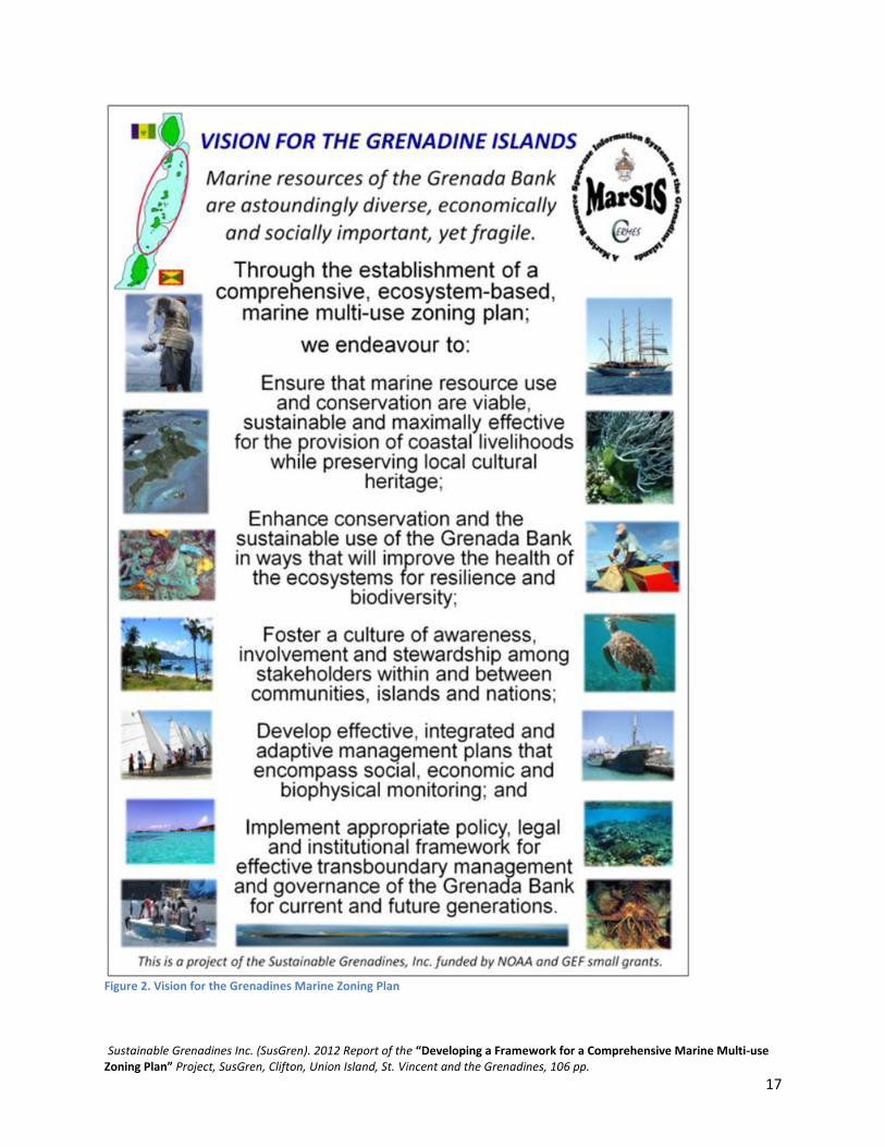
Defining objectives and appropriate multi-use zones The Visioning Workshop 1 notes were reviewed to: (a) develop a clearly defined overall vision (Figure 2.); (b) identify the objectives for the Grenadines MSP initiative (Table 2.); (c) extract the stakeholder’s identified existing and future uses in order to propose appropriate zones (Table 3.); and (d) draft clear objectives for each of the identified zones (Table 3.). Table 2 Proposed overall objectives of the Grenadine Islands MSP
Proposed Objectives
Fishery production
Environmental conservation
Sustainable marine livelihoods
Cultural and historical preservation
Tourism income
Transportation access
Sustainable Grenadines Inc. (SusGren). 2012 Report of the “Developing a Framework for a Comprehensive Marine Multi-use Zoning Plan” Project, SusGren, Clifton, Union Island, St. Vincent and the Grenadines, 106 pp.
17
Figure 2. Vision for the Grenadines Marine Zoning Plan

Sustainable Grenadines Inc. (SusGren). 2012 Report of the “Developing a Framework for a Comprehensive Marine Multi-use Zoning Plan” Project, SusGren, Clifton, Union Island, St. Vincent and the Grenadines, 106 pp.
18
Table 3 Proposed zones and objectives developed for each zone
Zone Objective Fishing - Manage Grenada Bank as one area (and harmonized
regulations across the entire bank) - Maintain access to landing facilities for fishers - Managed access to baitfish & coastal pelagic fish - Ensure undersized fish are not caught & nursery areas protected - Multi-use zoning areas to include closed areas, open access and other areas where selected gear or access restrictions apply
Tourism/Recreation - Healthy coastal and submerged ecosystems, clean water & beaches for swimming, sailing, diving, picnicking, etc. - Adequate areas for swimming and other activities (snorkelling/diving, sailing, wind-surfing/kite-boarding) - Areas designated for future sustainable tourism infrastructure - Areas where development is not allowed - Ample facilities for recreational boating (beach and pier access, moorings) - Free access for all beaches for locals/tourists
Transportation / Industrial
- Distinct identification and demarcation of ferry and shipping lanes - Marina development plan—identify locations where seaports & marinas may be developed in the future (for both commercial, local & tourism purposes)
Conservation - Identify and protect submerged marine resources (critical habitats and species, nursery areas & breeding grounds) - Identify and protect coastal resources (beaches, mangroves, salt-ponds, whelks, oysters, seabird & turtle nesting) - Identify and protect culturally important marine areas - Provide healthy natural resources for everyone - Integrated land and sea management - Build resilience to natural and man-made disasters
Mariculture - Identify areas of current and potential for mariculture activities - Well managed environmentally sound mariculture industry livelihoods
A series of community meetings were held from June 5-20, 2011 in each of the seven inhabited islands to share project objectives, gather information on the identified data gaps and obtain feedback on the ‘Developing a Framework for a Comprehensive Marine Multi-use Zoning Plan for the Grenadine Islands’ project from the Grenadine MRUs and island communities. To advertise the meetings, flyers were posted, the SusGren and Grenadines MarSIS egroups were used, and press releases were sent to Grenada and St. Vincent and the Grenadines media houses (i.e. newspaper, radio and television). Furthermore, seven female notetakers were hired and trained to assist with publicizing, organizing and

Sustainable Grenadines Inc. (SusGren). 2012 Report of the “Developing a Framework for a Comprehensive Marine Multi-use Zoning Plan” Project, SusGren, Clifton, Union Island, St. Vincent and the Grenadines, 106 pp.
19
general note-taking responsibilities for each of the island community meetings. As such, a brief training session and an initial evaluation of each of the note-takers was undertaken. A total of 212 persons attended the 11 meetings. All additional data collected was spatially translated into GIS and incorporated into the MarSIS database. Meetings generally lasted approximately two hours and comprised of a presentation on the project, followed by time for group discussion to allow community feedback on the project, objectives and draft zones. In conclusion, time was provided for participatory mapping exercises to collect information on the identified data gaps. All new data collected during MRU meetings were digitized and incorporated into the MarSIS geodatabase. Next all GIS data was prepared for input in the ‘Marxan with Zones’ software application. Progress Report 1 and new mapping products were produced and shared with stakeholders via MarSIS and SusGren egroups and posted on MarSIS website in July 2011.
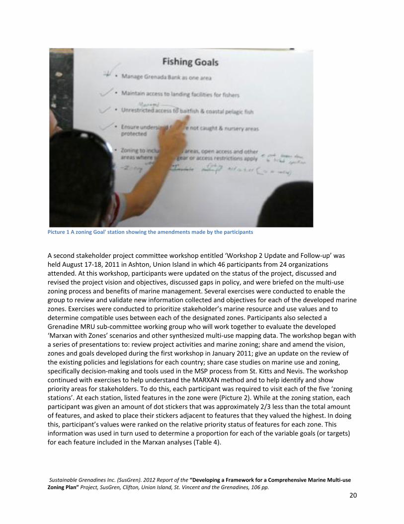
Decision-support tools and Discussions with ‘Marxan with Zones’ The International Marine Conservation Congress (IMCC2) conference in Victoria, Canada was attended by Kimberly Baldwin on May 13-18th 2011 to: present the Grenadines MSP project; further explore the GIS decision-support tools; and discuss planning strategies and lessons learned with other technical experts. Additionally, a meeting was held with TNC’s Global Marine Team to discuss lessons learned from their experiences with MSP globally and in St. Kitts and Nevis as well as further refine the developed workplan and methodologies to be applied for the Grenadines MSP initiative. The possibility of obtaining technical assistance from TNC with the Marxan decision-support tool for the Grenadine MSP project was discussed and agreed upon. As a result, a two day ‘Introduction to Marxan’ training session was undertaken May 19-20th at the University of Victoria to better understand the Marxan decision-support tool and aid the preparation of existing Grenadines MarSIS GIS data for input to the Marxan with Zones decision-support tool. ‘Marxan with Zones’ is an extension of one of the most popular conservation planning decision-support tools - ‘Marxan’ developed by the University of Queensland (www.uq.edu.au/marxan provides a detailed review of the decision-support tool). This free software application allows users to incorporate multiple social and ecological objectives or priorities when designing a portfolio of management areas. Below is a description of how Marxan with Zones was implemented for the Grenada Bank. The software and various input parameters (based on Agostini et al. 2010) were discussed and explained in workshop meetings and used to help create priority zones for participants. They were asked to review and amend specific management goals for each zone (Picture 1). To do this, participants were divided into four break-out groups in which every individual visited a station for each zone and were asked to review and amend the listed goals. These clearly defined goals were used to guide the marine zoning decision-making process as well as to assist the consultants with decisions involved to run the Marxan decision-support software appropriately.
Sustainable Grenadines Inc. (SusGren). 2012 Report of the “Developing a Framework for a Comprehensive Marine Multi-use Zoning Plan” Project, SusGren, Clifton, Union Island, St. Vincent and the Grenadines, 106 pp.
20
Picture 1 A zoning Goal' station showing the amendments made by the participants
A second stakeholder project committee workshop entitled ‘Workshop 2 Update and Follow-up’ was held August 17-18, 2011 in Ashton, Union Island in which 46 participants from 24 organizations attended. At this workshop, participants were updated on the status of the project, discussed and revised the project vision and objectives, discussed gaps in policy, and were briefed on the multi-use zoning process and benefits of marine management. Several exercises were conducted to enable the group to review and validate new information collected and objectives for each of the developed marine zones. Exercises were conducted to prioritize stakeholder’s marine resource and use values and to determine compatible uses between each of the designated zones. Participants also selected a Grenadine MRU sub-committee working group who will work together to evaluate the developed ‘Marxan with Zones’ scenarios and other synthesized multi-use mapping data. The workshop began with a series of presentations to: review project activities and marine zoning; share and amend the vision, zones and goals developed during the first workshop in January 2011; give an update on the review of the existing policies and legislations for each country; share case studies on marine use and zoning, specifically decision-making and tools used in the MSP process from St. Kitts and Nevis. The workshop continued with exercises to help understand the MARXAN method and to help identify and show priority areas for stakeholders. To do this, each participant was required to visit each of the five ‘zoning stations’. At each station, listed features in the zone were (Picture 2). While at the zoning station, each participant was given an amount of dot stickers that was approximately 2/3 less than the total amount of features, and asked to place their stickers adjacent to features that they valued the highest. In doing this, participant’s values were ranked on the relative priority status of features for each zone. This information was used in turn used to determine a proportion for each of the variable goals (or targets) for each feature included in the Marxan analyses (Table 4).

Sustainable Grenadines Inc. (SusGren). 2012 Report of the “Developing a Framework for a Comprehensive Marine Multi-use Zoning Plan” Project, SusGren, Clifton, Union Island, St. Vincent and the Grenadines, 106 pp.
21
Picture 2 A zoning station and its' associated features; dots represent a ranking of priorities as expressed by participants

Sustainable Grenadines Inc. (SusGren). 2012 Report of the “Developing a Framework for a Comprehensive Marine Multi-use Zoning Plan” Project, SusGren, Clifton, Union Island, St. Vincent and the Grenadines, 106 pp.
22
Table 4. Results of participant prioritization of features identified by zone (N.B. Numbers indicate the amount of stickers placed adjacent to a feature)
Proposed Zone Priority Feature Fishing Fish (line, net, towing, pot) – 38
Lobster (diving/traps) – 27 Conch – 17 Bait and coastal pelagic – 17
Tourism/Recreation Traditional boat building – 31 Mooring areas – 28 Birding/turtle watching/nature tourism – 25 Diving/snorkelling – 23 Anchoring – 22 Swimming/bathing – 19 Vending – 15 Kite-boarding/windsurfing – 1
Transportation/Industrial Landing site (fishers, water taxis, dive shops, day tours, etc.) – 35 Seaport/marina – 23 Shipping lane/ferry route – 14
Conservation Nursery area (fish/conch/lobster) – 34 Turtle nesting site – 32 Important bird areas – 18 Oyster beds – 20 Wetlands (mangrove/salt pond) – 33 Coral reefs – 43 Mixed-live (algal) bottom – 2 Hard bottom – 0 Sea grass – 19 Sand – 16
Mariculture Conch/lobster/shellfish – 13 Fish farming – 12 Seamoss – 10
N.B. Many people did not understand the mixed-live (algal) bottom category. When it was explained to the group, participants felt that it should have been placed a higher priority status.
Marine resource use may operate in varying degrees of conflict or compatibility. Specifically, certain types of marine resource uses can be conducted in conjunction with, or within the same geography as other uses, while some may be entirely incompatible. Participants took part in a group exercise to determine the relative compatibility of marine resource uses in an overlapping spatial context. Table 5 lists the results of the consensus built final incompatibility matrix. Information obtained from this exercise was used to determine appropriate input variables for the incompatibility matrix or the ‘cost’ layer of the Marxan with Zones analyses. Discussion topics included: that mariculture and conservation zones were determined to be compatible, but only if it was strictly limited to seamoss and conch mariculture. However, it was agreed that large-scale fish farming could potentially threaten compatibility with conservation, as it has potential to adversely affect ecosystems. Therefore, it was determined to be compatible in the current context, but with caution for future management. Although there was some debate regarding the compatibility of mariculture and fishing, it was agreed that if the two were operating in an overlapping geography, they would be essentially incompatible. Reasons were based on the fact that mariculture is usually a private endeavor in a set area, and that fishing activity in

Sustainable Grenadines Inc. (SusGren). 2012 Report of the “Developing a Framework for a Comprehensive Marine Multi-use Zoning Plan” Project, SusGren, Clifton, Union Island, St. Vincent and the Grenadines, 106 pp.
23
the same area could cause potential conflict. Participants felt that industry and tourism were somewhat compatible, based mainly on the fact that certain amounts and types of industrial infrastructure and accommodation are required for tourism. Industry and fishing on the other hand were determined to be somewhat incompatible. It was felt that ideally, they would be kept separate, but that they currently are, and may have to continue operating in an overlapping geography. Table 5 Results of the relative compatibility of marine resource use activities
Zones Tourism Fishing Conservation Industrial Mariculture
Tourism
Fishing
Conservation
Industrial
Mariculture

Sustainable Grenadines Inc. (SusGren). 2012 Report of the “Developing a Framework for a Comprehensive Marine Multi-use Zoning Plan” Project, SusGren, Clifton, Union Island, St. Vincent and the Grenadines, 106 pp.
24
Drafting a Marine Multiuse Zoning Design
Planning for the Sustainable Development of the Coastal and Marine Resources of the Grenadine Islands A third workshop entitled ‘Planning for the sustainable development of the coastal and marine resources of the Grenadines’ was held in Carriacou February 16-17, 2012. There were a total of 38 participants from 28 organizations in attendance. The primary goal of this workshop was to collaboratively develop a draft marine multi-use zoning design for the Grenada Bank. Presentations reviewed the project activities thus far, including the Marxan decision-support tool application, and the MRU stakeholder steering sub-committee provided a summary of meeting to the larger stakeholder planning group. The final Marxan with Zones scenario was presented to allow for stakeholder evaluation (Figure 3). This scenario included zones for conservation, tourism, industrial use, fishing and mariculture. Group members were given large maps to review, discuss and provide feedback on the boundaries of proposed zones.
Zone Definitions and Case Studies To gain a better, shared understanding of what is envisioned for each of the proposed zones group discussion on the definition of each zone was solicited. This included the activities that should be permitted or restricted, the types of management measures that might take place, and the goals/objectives of each zone. Breakout groups discussed and shared key points with the larger group. Group consensus was reached that more information was required in relation to specific examples of multi-use zoning designs and activities allowed/prohibited from other countries in which marine zoning was implemented. A review of zoning schemes applied to existing marine reserves and zoning designs including: Columbia’s Seaflower Reserve; Australia’s Great Barrier Reef; and Belize’s South Water Caye Marine Reserve was presented. Information included the types of multi-use zones and what activities are permitted or restricted in each of these zones.
Refining the definition of each zone Break-out groups reviewed the five proposed zones for the Grenadine Islands. Consensus was reached to have a total of seven multi-use zones for the Grenada Bank project area. These include: Conservation; General Use; Low Impact/Ecotourism; Transportation/Industrial; Mariculture; Nearshore Fishing; and Offshore Fishing Zones. The group decided that the Conservation Zone already exists in the form of MPAs with either no-take or limited extraction (e.g. Tobago Cays Marine Park, Sandy Island Oyster Bed MPA). The General Use Zone is an area of planned development with limited restrictions (e.g. Clifton, Hillsborough, Port Elizabeth). The Low Impact / Ecotourism Zone is an area in which there would be very limited land development, yet recreational uses and local fishing would be allowed (e.g. Balliceaux, Petit Canouan, Sail Rock, Diamond Rock). These areas also coincide with existing terrestrial national park and/or wildlife reserve designations.

Sustainable Grenadines Inc. (SusGren). 2012 Report of the “Developing a Framework for a Comprehensive Marine Multi-use Zoning Plan” Project, SusGren, Clifton, Union Island, St. Vincent and the Grenadines, 106 pp.
25
The Mariculture Zone would be designated for the production of seamoss farming only. This zone could occur within the boundary of another zone as it is not seen to have many negative environmental impacts. Alhtough the group was not against the concept of fish farming, it was felt that this activity should occur within one of the fishing zones and would require a special permitting process. The Transportation Zone is an area that consists of shipping lanes, landing sites, seaports and marinas. The Offshore Fishing Zone is an area that would be set aside for use by local Grenadine fishers only. Small-scale fishing would occur in this area, although there would be restrictions to prohibit commercial fishing, dredging and oil drilling in this zone. The Nearshore Fishing Zone would compromise a fisheries management area in which some gear restrictions, seasonal closures, catch limits or a combination of management measure would be implemented to improve the health of the nearshore fishery resources. It was suggested and agreed that fishers would be critical in assisting in the determination of feasible management measures and their involvement would be required for the successful implementation of management measures in this zone. The 1st draft marine multi-use zoning design for the Grenada Bank GIS files and map was developed based on the feedback provided by the project planning stakeholder group and the hardcopy maps that the breakout groups had created (Figure 4)

Sustainable Grenadines Inc. (SusGren). 2012 Report of the “Developing a Framework for a Comprehensive Marine Multi-use Zoning Plan” Project, SusGren, Clifton, Union Island, St. Vincent and the Grenadines, 106 pp.
26
Figure 3 Final Marxan scenario run using reduced variable goals with MPAs and shipping lanes locked in.

Sustainable Grenadines Inc. (SusGren). 2012 Report of the “Developing a Framework for a Comprehensive Marine Multi-use Zoning Plan” Project, SusGren, Clifton, Union Island, St. Vincent and the Grenadines, 106 pp.
27
Figure 4 First draft of the Grenadines marine multi-use zoning design resulting from Workshop 3

Sustainable Grenadines Inc. (SusGren). 2012 Report of the “Developing a Framework for a Comprehensive Marine Multi-use Zoning Plan” Project, SusGren, Clifton, Union Island, St. Vincent and the Grenadines, 106 pp.
28
Marine Resource User and Island Community Feedback Meetings As a follow-up to the regional project committee planning workshop held in Carriacou, a second series of community meetings was conducted to review the drafted marine multi-use zoning plan with Grenadine MRUs (e.g. fishers, cruisers, dive shop operators, day tour operators, water taxi operators, ferries etc.) and community members. A presentation, a flyer of the draft marine multi-use zoning design project with a map (Appendix 2.) and a media press release (Appendix 3) were prepared for the MRU community stakeholder meetings. The Grenada Bank marine multiuse zoning design was presented at these meetings to increase the level of understanding and support for MMZP, the need for a zoning design and to obtain local island feedback to create a further iteration of the zoning design (2nd draft). Thus, the objective of these meetings was to create a zoning design that would be equitable and representative of the interests and values of the wider Grenadine communities. A total of 311 participants attended 11 MRU community meetings held from the 20th February – 5th March 2012. Overall the need for a marine multi-use zoning plan was well received by Grenadine MRUs and the communities. The communities agreed that planning for the future of marine resources is essential to ensure sustainable development of the Grenadine Islands and the marine resources. Furthermore a sense of urgency, in regards to moving forward with this project, resonated in many of the islands. A need to manage coastal inshore fisheries was voiced in every island and fishers expressed a desire to be involved in the determination of possible management solutions for the nearshore fishery resources. Communities realize that enforcement in the Grenadine Islands is minimal and that self-enforcement will be an essential component for the successful management of the draft zoning design. This being said, empowering fishers to be involved in governance and to help determine appropriate and feasible management measures are recommended. Many of the island communities, similar to the project steering committee, expressed an interest to increase in the number and amount of conservation areas as compared to the First Draft of the multi-use zoning design. There was also great support for the limited development (low-impact/ecotourism) zones and communities agreed with the project steering committee that aligning these areas with existing terrestrial national park and wildlife reserve designations can provide for an integrated and supportive land and sea management approach. Based community recommendations the marine multi-use zoning design was updated, and the 2nd draft of the marine multi-use zoning design was created in March 2012 (Figure 5).

Sustainable Grenadines Inc. (SusGren). 2012 Report of the “Developing a Framework for a Comprehensive Marine Multi-use Zoning Plan” Project, SusGren, Clifton, Union Island, St. Vincent and the Grenadines, 106 pp.
29
Figure 5 The 2nd draft of the proposed marine multiuse zoning design

Sustainable Grenadines Inc. (SusGren). 2012 Report of the “Developing a Framework for a Comprehensive Marine Multi-use Zoning Plan” Project, SusGren, Clifton, Union Island, St. Vincent and the Grenadines, 106 pp.
30
Final Products and Accessibility of Information The Grenadines MarSIS geospatial database was expanded with the developed MZP GIS files for each of the proposed zones as well as the Marxan with Zones GIS datasets and mapping products. A further requirement for MZP, particularly for a transboundary area, is that information must not only be accepted by marine resource users but be accessible and shared openly amongst all of the involved stakeholders and between the two countries. Thus, all of the project reports are available on the open-access Grenadines MarSIS website. Additionally, the MarSIS geodatabase was converted to Google Earth (.kml) files and uploaded to the Grenadines MarSIS website to allow for widespread public access to the produced information and data across geographic and jurisdictional scales of nations, islands and communities of the Grenadines.
Recommendations The goal of a MZP framework is to deliver an ecosystem-approach to managing human activities occurring in the marine environment. This may also improve decision-making as it has the potential to support an integrated multi-level management approach that ranges from the Grenadine communities, islands, nations, to the region that comprises the Grenada Bank’s marine resources. The goals of MZP and the implementation of a marine multi-use zoning design are consistent with the stated policies of the Commonwealth, the CRFM, the OECS and the governments of Grenada and St. Vincent and the Grenadines. By allocating space-use for the various sectors, including conservation, in an equitable and harmonized manner MSP can reduce the potential for conflicts. Successful MZP therefore can promote the conservation of biological diversity, the sustainability of marine-based livelihoods, the mitigation of adverse effects of climate change and the maintenance of ecosystem goods and services on which the Grenadine coastal communities rely. The development of a transboundary MZP framework would also help to clarify and rationalize the roles and responsibilities of the involved regional and national marine and environmental agencies as well as maximize efficiency and accountability of transboundary management of marine resources. A framework to allow for the effective implementation of the drafted zoning design is needed. The framework’s principle output, the marine zoning design prescribes zones including no/limited-take conservation areas to multi-use areas providing for a range of recreational, commercial, development and other activities. The successful implementation of a MZP framework will require all relevant sectoral agencies to work together to comply with the drafted zoning design. While existing laws permit the governments to regulate some of the coastal and marine activities that presently occur, it is insufficient to implement a comprehensive, integrated transboundary framework for ecosystem-based marine planning and zoning. Therefore a close examination of the legislations as well as both regional and national governance (i.e. institutional) arrangements to support MZP must be a priority. A further tenet of MZP is that stakeholder engagement is central to the process. Providing a transparent framework that can accommodate a wide diversity of multi-disciplinary information in an accessible format can serve to improve stakeholder understanding and involvement in decision-making and support interactive governance (Pomeroy and Douvere 2008, Carocci et al. 2009, Mackinson et al. 2011). This MSP project, as well as the development of the Grenadines MarSIS, has carefully aimed to engage a wide range of stakeholders from the onset. Information exchange and access has been provided for to strengthen capacity for informed collaborative decision-making. Mechanisms to ensure the continued access to information across such a wide-range of stakeholders will be required for the successful

Sustainable Grenadines Inc. (SusGren). 2012 Report of the “Developing a Framework for a Comprehensive Marine Multi-use Zoning Plan” Project, SusGren, Clifton, Union Island, St. Vincent and the Grenadines, 106 pp.
31
implementation of MZP and the multi-use zoning design, particularly in a complex coastal and marine environment such as the Grenadine Islands.
Next Steps At this stage of the project, there are several recommended next steps. The first is to obtain the political will and commitment to implement the transboundary MZP and the multi-use zoning design. A meeting should be arranged with the relevant marine-related Ministers (i.e. Fisheries, Environment, Tourism, and Planning) of Grenada and St. Vincent and the Grenadines to explain the role of MSP, how it can assist the countries in the achievement of international commitments (i.e. CBD and the Caribbean Challenge), regional commitments (i.e. St. George’s Declaration) and the attainment of sustainable development. Furthermore, the implementation of such a plan would bring the Grenadines, including the two involved countries of Grenada and St. Vincent and the Grenadines, to the forefront of environmental planning and sustainability. The implementation of the MSP will also support the designation of the Grenadines as a transboundary World Heritage Site, in which both countries are signatory to the convention and have expressed interest (Susgren 2005). In tandem, a strong coordinated public outreach and education programme to highlight the importance and role of MSP should be undertaken to increase wide-spread knowledge and build on stakeholder engagement activities of these initiatives and the implementation of a zoning plan. To this end the use of media, including internet, television and radio advertisements, is recommended. The development of management plans will be needed to define and regulate human activities to occur in each of the different zones. Although general objectives for each zone have been developed, the specific management measures for each of the zones will need to be collaboratively developed. For example, a plan for each of the inshore fisheries management zones will need to be developed to regulate fishing and other activities. Considering the diversity of the Grenadine Islands and its communities, it is anticipated that these management plans will need to be developed on an island-specific level to appropriately determine feasibility and to obtain community-level understanding and acceptance of the plan. As throughout the world, MZP and integrated resource management is still in its early stages. Unfortunately, many zoning efforts stop at the planning stage and never move to the implementation stage (Agardy 2010, Agostini et al. 2010) Continued effort and inputs will be required for successful implementation. Moving the transboundary marine zoning design to a fully implemented marine multi-use zoning plan will take a concerted effort on the part of governments, marine resource user groups, NGOs and the international community. Currently the capacities of the two countries’ marine management agencies are limited. In other places in the world, co-management arrangements are one possible mechanism that has been shown to help supplement similar capacity limitations. To this end, the continued role of the regional multi-level stakeholder MSP Steering Committee will be central to achieving these actions and should be carefully evaluated and refined. A tremendous amount of work has been accomplished since 2006, ranging from the collaborative development of a transboundary marine resource and space-use information system (MarSIS) to the drafting a marine multi-use zoning design for the Grenadine Islands. As a result, the people of Grenada and St. Vincent and the Grenadines have laid a solid foundation for sustainable coastal and marine resource management that can incorporate multiple uses and user groups. Every effort should be made to continue to support the interactive governance frameworks and the MZP process that have been developed as a result of these projects.
Sustainable Grenadines Inc. (SusGren). 2012 Report of the “Developing a Framework for a Comprehensive Marine Multi-use Zoning Plan” Project, SusGren, Clifton, Union Island, St. Vincent and the Grenadines, 106 pp.
32
Recognizing Policy and Legislative Gaps SusGren worked with the Environmental Law Institute to help recognize the policy and legislative gaps for marine zoning in St. Vincent and the Grenadines and Grenada. Below is ELI’s report on developing a policy and legal framework for MZP in the Grenadines, prepared for Sustainable Grenadines Inc. A brief summary of this report is located in Appendix 5.
The Need for a New Management Strategy in the Grenadine Islands The Eastern Caribbean marine environment is a resource of tremendous social, economic, and ecological value to the region. In the transboundary Grenadine Islands, marine-based industries are integral to the economies of Grenada and St. Vincent & the Grenadines (SVG). Many of these activities, particularly tourism, are rapidly expanding; however, unplanned development and poor regulation of these activities are contributing to the degradation of the region’s marine environment. As a result of the cumulative effect of these multiple uses of marine resources, the coasts of the Eastern Caribbean are ranked among the most heavily impacted coastal ecosystems in the world (Halpern 2008). Like the majority of the world’s countries, both Grenada and SVG currently implement a sector-specific approach to the management of their marine environment. Major classes of living and nonliving resource uses in the Grenada marine ecosystem include fishing, day tours (including sportfishing and sailing), dive shops, ferries, commercial shipping, yacht chartering, and water taxi operation (Baldwin K. et al 2006). In addition to these coastal and marine-based uses, terrestrial activities including agriculture and waste management also impact the marine ecosystem. These marine and terrestrial activities are governed by three different ministries in Grenada (Ministry of Agriculture, Forestry & Fisheries; Ministry of Environment, Foreign Trade and Export Development; Ministry of Tourism, Civil Aviation & Culture) and by four different ministries in SVG (Ministry of National Security, Air & Sea Port Development; Ministry of Agriculture, Industry, Forestry, Fisheries and Rural Transformation; Ministry of Health, Wellness & The Environment; Ministry of Tourism, Sports and Culture), a division of responsibility that is further complicated by the numerous agencies within each ministry that are charged with implementing the objectives of that ministry. A lack of synchronization between these various sectors has already resulted in very real conflicts among different user groups. For example, in the town of L’esterre, in Carriacou, Grenada, the creation of a new marine protected area has made it illegal for fishermen to leave their village by sea to go fishing, as this would require them to travel through the marine protected area while carrying fishing gear (an action that is not allowed in marine parks). Recognizing the importance of their marine resources and the need to improve their management, both Grenada and SVG have demonstrated an interest in moving toward more holistic management of the marine environment. Grenada’s Draft Land and Marine Management Strategy, released in August 2011, highlights inadequacies in Grenada’s existing terrestrial and marine management efforts and maps a way forward for integrating multiple sectors and adopting a cohesive management strategy for its natural resources (JECO Caribbean 2011). St. Vincent & the Grenadines has recently begun efforts to establish and implement a national ocean governance policy and action plan, with the goal of creating opportunities for holistic decision-making and management of the country’s marine environment (Roberts J.P. Draft).

Sustainable Grenadines Inc. (SusGren). 2012 Report of the “Developing a Framework for a Comprehensive Marine Multi-use Zoning Plan” Project, SusGren, Clifton, Union Island, St. Vincent and the Grenadines, 106 pp.
33
Beyond Multiuse Marine Zoning: Marine Spatial Planning and Ecosystem-Based Management The recent paradigm shift toward holistic marine management is exemplified by a strategy known as marine spatial planning (MSP), which is defined by the Intergovernmental Oceanographic Commission as “a public process of analyzing and allocating the spatial and temporal distribution of human activities in marine areas to achieve ecological, economic, and social objectives that are usually specified through a political process” (Ehler,C. and F. Douvere. 2009) Though the concept of MSP emerged out of the realization that sector-specific marine management does not adequately address the needs of the ecosystem or of the human populations that depend on them, MSP is not intended to replace single-sector planning and management. Rather, the goal of MSP is to guide and to inform single-sector managers and decision-makers in order to ensure that all decisions are made in accordance with the agreed-upon objectives of the marine spatial plan (Ibid). Marine spatial planning is a type of sea use management. Sea use management is analogous to the terrestrial process of land use management, whereby an established process is used to identify, plan, and authorize various uses of the terrestrial environment in order to control development and prevent land use conflicts. Just as the establishment of land use maps with zoning is critical to successful land use management, an important component of MSP is marine zoning. Marine zoning is a regulatory technique used to implement spatial management plans through the use of zoning maps (Ibid). These maps divide the coastal and marine environment into zones, each of which is categorized for particular uses such as commercial fishing, energy development, shipping, and conservation. Regulations govern the type and extent of activities that are allowed in particular marine zones. Marine zoning to plan for multiple uses is thus a key component of a marine spatial plan. More broadly, the concepts of multiuse marine zoning and MSP are key components in an emerging strategy for ocean management known as marine ecosystem-based management (EBM) (ELI 2009). Ecosystem-based management is a holistic approach to coastal and marine management that considers the entire ecosystem, including humans and human uses, and that integrates the management of multiple uses in order to holistically address cumulative impacts. This management strategy also emphasizes the development of a transboundary framework to achieve ecosystem-based goals because ecosystems do not recognize legal or jurisdictional boundaries. Marine spatial planning with marine zoning is a key technique to achieve an ecosystem-based approach to the multiuse management of marine systems. There are a series of basic principles common to ecosystem-based management and other emerging marine management strategies that can be used to guide the development of these strategies in new locations. In developing a framework for multiuse marine zoning in the Grenadine Islands, considering these overarching principles of EBM will be a key to understanding where MSP and MSP-like strategies currently stand in the region.

Sustainable Grenadines Inc. (SusGren). 2012 Report of the “Developing a Framework for a Comprehensive Marine Multi-use Zoning Plan” Project, SusGren, Clifton, Union Island, St. Vincent and the Grenadines, 106 pp.
34
Authorizing the Use of MSP There are a number of critical steps that need to be taken in order to establish a framework for MSP, to give it legal force, and to ensure that it is implemented effectively and successfully. At the broadest scale, a high-level government mandate to pursue MSP is generally considered to be a necessary step for the successful development and implementation of the strategy Beck, M.W., et al. 2009). Such a directive enables agencies to incorporate activities related to MSP into their own mandates and identifies a clear way forward by requiring the use of spatial planning techniques. Legally authorizing the use of MSP is another key early step toward achieving successful implementation of the strategy. Development of a strategy such as MSP requires two types of authority, the authority to develop a plan and the authority to implement it. Most MSP initiatives currently taking place establish a new authority for planning, while existing authorities or institutions are usually tasked with implementation. There are several ways to establish legal authority to implement MSP; these include networking of existing legislation, creating new legislation, reinterpreting or modifying existing legislation, or adding MSP provisions to legislation currently under development. The first option, networking existing legislation, is considered a “soft” approach to undertaking MSP because it does not require any new legislation to be passed. This process involves a commitment to collaboration and the establishment of a networking arrangement among agencies with regulatory responsibility for coastal and marine regions, for example by requiring agencies to collaborate and coordinate their actions to achieve agreed-upon management objectives. This process is essentially a formal agreement among involved agencies to coordinate and integrate their activities to achieve certain objectives. To give the agreement force, the establishment of the networking arrangement would be achieved via the issuance of a policy statement by a high-level authority—something analogous to an Executive Order in the U.S. (Bovino, RJ. 2010) A second option is to establish entirely new legislation for MSP. There are pros and cons to this approach: while the authors of new legislation have a great deal of flexibility in determining the content of the legislation, the process of getting new legislation drafted and passed is often a lengthy one. The United Kingdom, Australia, and the U.S. state of Massachusetts have all developed new legislation to grant legal authority for MSP; the United Kingdom and Australia also used the legislation to establish new authorities charged specifically with developing marine spatial plans (Ehler, C. and F. Douvere. 2009).

Sustainable Grenadines Inc. (SusGren). 2012 Report of the “Developing a Framework for a Comprehensive Marine Multi-use Zoning Plan” Project, SusGren, Clifton, Union Island, St. Vincent and the Grenadines, 106 pp.
35
Thirdly, MSP can be authorized through the use of existing legislation by either reinterpreting the language or by modifying it slightly. Many countries already have legislation addressing the management, use, and protection of marine resources and habitats under national jurisdiction, and often these statutes can be interpreted or revised to provide authority for MSP. This has been done in the Netherlands through their Spatial Planning Act, and in Norway through their Marine Resources Act (derived from an earlier Marine Fisheries Act) (Ibid). Finally, MSP can be authorized by adding on to legislation that is currently being developed or that is being considered for development in the near future. For example, in many countries there is legislation underway to regulate emerging offshore activities like aquaculture and renewable energy production; including in this legislation a provision that mandates MSP is one option for creating authority to implement spatial planning (Ibid). A second important consideration in establishing legal authority for MSP is how to institutionally structure the authority to implement the activities mandated by a marine spatial plan. A new institution could be established exclusively for the purpose of implementing a marine spatial plan. Because MSP seeks to coordinate preexisting single-sector activities, though, several countries’ past experiences with implementing MSP suggest that implementation is best left to the existing institutions that have been established to manage particular sectors or marine resource uses (Ibid) Developing a legal framework for implementing marine zoning and MSP in the Grenadine Islands will require careful attention to the above considerations about creating authority for MSP. However, in order to move forward with marine zoning and MSP in the region, these considerations must be applied in the existing legislative landscape in Grenada and in SVG. On one hand, existing laws and policies in the two countries can provide a foundation upon which specific MSP policies can be built; on the other hand, gaps in legal authority and in other critical MSP principles will need to be closed before MSP can be successfully implemented by either country. In the remaining sections, we examine the international commitments that Grenada and SVG have already made to the principles inherent to MSP, review the existing legislation in both countries that can be used to support MSP, and make recommendations for further policies that will need to be established in order to facilitate the successful development and implementation of MSP in the region.
International Commitments to MSP Principles Neither Grenada nor SVG are members of any international conventions that explicitly require the use of marine zoning or MSP. Both countries, however, are parties to several regional and international agreements that emphasize the same principles inherent to MSP, illustrating the two countries’ commitments generally to improved marine environmental management, and specifically to the basic principles underlying MSP and ecosystem-based management. These principles are sustainable use of ecosystem services, collaborative management, cumulative impact analysis, education and information enhancement, and scientific and technological information sharing. The international agreements through which Grenada and SVG have indicated general commitments to these principles include the Convention for the Protection and Development of the Marine Environment in the Wider Caribbean Region (the Cartagena Convention), the St. George’s Declaration of Principles for Environmental Sustainability in the Organization of Eastern Caribbean States (OECS), the Convention on
Sustainable Grenadines Inc. (SusGren). 2012 Report of the “Developing a Framework for a Comprehensive Marine Multi-use Zoning Plan” Project, SusGren, Clifton, Union Island, St. Vincent and the Grenadines, 106 pp.
36
Biological Diversity (CBD), the Convention Concerning the Protection of the World Cultural and Natural Heritage, the Programme of Action for the Sustainable Development of Small Island Developing States (SIDS), the Agreement Establishing the Caribbean Regional Fisheries Mechanism, Charter of the Organization of American States (OAS), and the United Nations Convention on the Law of the Sea (UNCLOS).
Sustainable Use of Ecosystem Services The states of the Eastern Caribbean, including Grenada and SVG, have expressed their commitment to the conservation of biological diversity and the protection of significant areas through the St. George’s Declaration of Principles for Environmental Sustainability in the Organization of Eastern Caribbean States (OECS), which encourages a collaborative approach to environmental management in the region and also emphasizes the long-term protection and sustained productivity of the region’s natural resources and the ecosystem services provided by those resources. By participating in this declaration, SVG and Grenada have agreed to accomplish each of these goals. Further, as members of the OECS and as parties to the Convention on Biological Diversity (CBD), both countries have expressed their commitment to the conservation and sustainable use of biological diversity. Grenada and SVG have also agreed to cooperate on promoting the sustainable use of fisheries and aquaculture resources with their commitment to the Agreement Establishing the Caribbean Regional Fisheries Mechanism. This agreement rests on a system for sharing migratory marine and aquatic resources. It supports the concept of transboundary marine management with a series of specific objectives, including the establishment of cooperative arrangements for the management of shared, straddling, or highly migratory marine species and the provisioning of technical advisory services to the Member States’ fisheries divisions. Finally, the Preamble to the Programme of Action for the Sustainable Development of SIDS—to which both countries are party—notes the need to establish an ecosystem-based management program that promotes the sustainable development of marine and coastal resources, maintains biodiversity, and improves quality of life.
Collaborative Management A number of international conventions to which both Grenada and SVG are party indicate their commitment to adopting a collaborative approach for the management of transboundary marine resources. Both countries are party to the Convention for the Protection and Development of the Marine Environment in the Wider Caribbean Region (the Cartagena Convention), which serves as the legal mechanism for implementing a transboundary management strategy carried out under the auspices of UNEP’s Caribbean Environment Programme. With their commitment to the Cartagena Convention, Grenada and SVG have agreed to develop a transboundary management strategy to protect the marine environment of the wider Caribbean region against pollution from ships, dumping, land-based activities, seabed activities, airborne pollution, and specially protected areas (Preamble; Art. 5-10). Cooperation with organizations at the local, national, regional, and international level is agreed to be the most effective method for implementing a transboundary management strategy (Art. 4(5)).

Sustainable Grenadines Inc. (SusGren). 2012 Report of the “Developing a Framework for a Comprehensive Marine Multi-use Zoning Plan” Project, SusGren, Clifton, Union Island, St. Vincent and the Grenadines, 106 pp.
37
Grenada and SVG have also agreed to collaborate on governing the oceans and its natural resources by ratifying the United Nations Convention on the Law of the Sea (UNCLOS). Specifically, the two countries have committed to working with other states to protect and preserve the marine environment by increasing communication and promoting equitable utilization of marine resources (Art. 117-119, Part VII, Sec. 2). Further, through the Convention on Biological Diversity, both have recognized that a coordinated transboundary management framework is an effective method of achieving these shared goals (Preamble; Art. 5). The CBD also emphasizes collaboration with local communities and intergovernmental communication (Art. 10) and requires parties to work directly with one another or through an international organization to manage geographic areas that are of mutual interest to multiple parties (Art. 5). Through their participation in the Programme of Action for the Sustainable Development of Small Island Developing States, Grenada and SVG have agreed to working with regional and subregional organizations to enhance environmental law expertise, as well as to improve access to resources and coordination among bodies to implement Agenda 21 of the United Nations. They have also agreed to collaborate on achieving economic, social, and cultural long-term development (Charter of the Organization of American States). As members of the OAS, both SVG and Grenada support cooperative action toward the economic, social, and cultural development of the American States.
Cumulative Impact Analysis In agreeing to the St. George’s Declaration, Grenada and SVG have committed to developing and adopting collaborative environmental management plans to address and mitigate human impacts on the environment. By definition, this process requires assessing and addressing multiple, cumulative impacts. By focusing on the natural resources of the region and the valuable ecosystems services these resources provide, the nations have committed to ensuring the long-term viability of natural resources and promoting their equitable use for economic, social, and cultural development. Recognizing the cumulative effect that multiple impacts can have on the marine environment, the Program of Action for the Sustainable Development of SIDS also calls for participant states to engage in a coordinated effort in conjunction with the international community to develop plans of action related to the cumulative impacts of climate change and sea-level rise, natural and environmental disasters, waste management, coastal and marine resources, freshwater resources, land resources, energy resources, tourism resources, and biodiversity resources.
Education and Information Enhancement The Convention on Biological Diversity emphasizes the importance of increasing public education and information for achieving a transboundary marine management plan, in addition to enhanced public participation at all levels (local, national, regional, and international) (Art. 10, 13). More specific than the general mandate of the CBD, the Programme of Action for the Sustainable Development of SIDS encourages regional bodies to conduct environmental law workshops to educate the public on environmental conventions and treaties, heritage, pollution, civil enforcement, and mitigation efforts (Art. XI(B)).

Sustainable Grenadines Inc. (SusGren). 2012 Report of the “Developing a Framework for a Comprehensive Marine Multi-use Zoning Plan” Project, SusGren, Clifton, Union Island, St. Vincent and the Grenadines, 106 pp.
38
Finally, both countries are party to the Convention Concerning the Protection of the World Cultural and Natural Heritage, which is designed to establish a collaborative and international system for protecting these heritages from potential threats. The Convention specifically promotes increased public education to both inform the public about threats to these heritages and to teach the public to appreciate and respect them (Art. 27). Through a coordinated international system, both Grenada and SVG have agreed to work in collaboration with other states so that all can further their efforts to identify and conserve their cultural and natural heritage.
Scientific and Technological Information Sharing As emphasized in the Cartagena Convention, both Grenada and SVG support reciprocal information sharing (Art. 13). This commitment is also emphasized in the CBD specifically with regard to information about any activities that may affect the achievement of biodiversity conservation (Art. 14(1)(c)). This also includes facilitating access and transfer of technological developments and genetic resources that will enhance biological conservation and diversity (CBD, Art. 16(1); Art. 18)). Both states have agreed to exchange any information that relates to biological diversity and its conservation, such as technical, scientific, and socio-economic research, and particularly the information learned from indigenous populations (CBD, Art. 17). The Programme of Action for the Sustainable Development of SIDS includes an emphasis on the need to increase access to scientific and technological information by providing for a collaborative system of information sharing across national, regional, and international levels (Art. XIII).
National Legal Authority for MSP Principles The development of national legal authority for MSP is an integral step towards creating an enforceable marine management plan. In this section, we provide an overview of existing laws in Grenada and SVG that provide supporting authority for implementing MSP. We also explain the relevant sections of current law, and note any gaps in existing authority within a law that should be filled before MSP authorization can move forward. This section will also help identify laws that can be amended to include MSP provisions. As described above, successfully carrying out MSP requires both the authority to develop a plan and the authority to implement it. While there is no formal authorization of MSP in the existing laws, some ministries and departments already have many of the specific authorities needed to implement a plan. There are provisions scattered throughout the laws regulating ocean uses that can be used to support MSP. Some of this support comes merely in broadly-worded statements expressing a general policy preference in favor of conservation. Other support comes in the form of specific delegations of authority to conduct research and planning to best manage natural resources1.
1 The only provisions that might pose some limited restrictions on moving forward with MSP are a few provisions
within existing laws that prohibit conducting research without receiving prior permission from appropriate authorities. See Fisheries Act and Fisheries Act Regulations §12 (Grenada) and Fisheries Act, No. 25 §22, §23 (SVG). It would be important to ensure that these permissions were obtained, or that exceptions to the prohibitions for the purposes of MSP were incorporated into the relevant statutory sections, prior to implementing any MSP program.

Sustainable Grenadines Inc. (SusGren). 2012 Report of the “Developing a Framework for a Comprehensive Marine Multi-use Zoning Plan” Project, SusGren, Clifton, Union Island, St. Vincent and the Grenadines, 106 pp.
39
Moving forward, the best method to develop legal support for MSP would be to adopt a comprehensive legal provision that provides specific authority for MSP. This language could be inserted into one or into several of the existing laws discussed below or into a new statute that focuses solely on integrating ocean management across the various government ministries. Adopting add-on provisions to existing laws is probably simpler politically and procedurally than developing an entirely new law. However, the challenge in crafting these add-on provisions will be to identify the most appropriate places to add MSP authorizing provisions and where to locate managerial responsibility for MSP given the current fragmented state of the laws. Currently there are multiple authorities and ministers that have some managerial role over ocean activities. Consultations with government officials, representatives from the fishing and tourism industries, and other stakeholders will be needed to identify the most workable approach.
A. Grenada
1. Relevant Constitutional Provisions The Grenadian Constitution does not include specific provisions relating to the management of the marine or terrestrial environment. The Constitution does, however, regulate the taking of private property, and thus could be applied in the context of MSP in the event that a marine spatial plan resulted in recommendations for the Grenadian government to acquire private lands in furtherance of the plan’s goals. In Chapter 1, the Constitution outlines the protections afforded to preserve the fundamental rights and freedoms of the citizens of Grenada. Section 1 of Chapter 1 prevents the taking of private property. Exceptions are provided to this general rule including an exception for work related to conservation of soil or natural resources or work relating to agricultural development or improvement. The Constitution also allows for the passage of laws authorizing the acquisition of land where it is “reasonably required in the interests of… public health, town and country planning, the development and utilization of mineral resources or the development or utilization of any property for a purpose beneficial to the community” (Ch. 1, Sect. 7.2(a)).
2. Relevant Statutory Law Provisions
Fisheries Grenada has two major pieces of fisheries legislation that are of relevance to MSP efforts in the country: the Fisheries Act, Cap. 108 (1986) and the Fisheries Regulations to implement 1986 Fisheries Act (2001). The Fisheries Act establishes a fishery management program in Grenada to be overseen by a Chief Fisheries Officer, thus providing a structure and authority for all fisheries aspects of any MSP efforts in Grenada. The Fisheries Regulations in support of the Act provide legal authority for regulating a number of activities that would be included under a marine spatial plan. The Fisheries Act, Cap. 108 provides authority to appoint a Chief Fisheries Officer who is responsible for developing a management plan to address the specific goals and challenges for each fishery (§4). To develop a specific plan for each fishery, the Chief Fisheries Officer is directed to “consult local fisherman, local authorities and others affected by the plan” (Ibid.). The Act also provides authority to “enter into

Sustainable Grenadines Inc. (SusGren). 2012 Report of the “Developing a Framework for a Comprehensive Marine Multi-use Zoning Plan” Project, SusGren, Clifton, Union Island, St. Vincent and the Grenadines, 106 pp.
40
agreements with other countries and regional organizations to harmonize fisheries assessment,” and to develop regional management systems (§6). In addition to the planning authority, the Chief Fisheries Officer has authority to designate the boundaries of new local fisheries management areas and to establish a Local Fisheries Management Authority where appropriate (§19-20)2. Other relevant authorities granted under this Act include: (1) the ability to designate and govern fishing priority areas that require special protective measures to ensure that authorized fishing uses are not interfered with (§21, §40); (2) the ability to lease land for aquaculture uses in appropriate cases (§21); and (3) the authority to designate and govern marine reserves where protection is needed “to preserve habitats and breeding grounds of marine life – particularly those in danger of extinction; to allow regeneration of depleted marine life; to promote scientific study; to enhance natural beauty” (§23, §40). While this Act is solely directed at fishery management, its broad language encouraging consultation with stakeholders and development of regional management suggests that the Chief Fisheries Officer is already well-positioned to participate in the MSP planning process. Collaboration and consultation is a key factor in successful coastal and marine planning and these values are already codified within the Chief Fisheries Officer’s duties. Additionally, the Chief Fisheries Officer holds some of the authority necessary to implement decisions reached through MSP, such as the ability to designate the boundaries of fisheries management areas and marine reserves; the establishment of place-based designations like these is an important component of the MSP process. The Fisheries Regulations to implement the Fisheries Act govern the management, use, and enforcement of regulations in Marine Protected Areas (MPAs), a category which includes marine parks, marine reserves, marine historical sites, and marine sanctuaries. The regulations control access to and activities allowed3 in marine parks, marine reserves, marine sanctuaries, and marine historical sites (§7-§11). The regulations also establish zoning regulations for approved uses within marine parks and marine reserves (§11). Section 12 of the Act also governs specimen and artifact collection and permits a “bona fide” scientist to collect animal and plant species within a marine reserve or marine sanctuary and artifacts from a marine sanctuary or marine historical site. Overall, these regulations provide a significant portion of the regulatory structure required to effectively implement and police a marine spatial plan. The regulations address zoning, prohibited activities, and access to sensitive marine areas. Also, these regulations clearly show that there is existing legal authority for regulating these activities. For MSP purposes, a simple addition to the Fisheries Act and these regulations commanding the Chief Fisheries Officer to cooperate, participate, and implement MSP should be sufficient to bring the Chief Fisheries Officer into the MSP process.
Land Use Establishing appropriate jurisdiction over and regulations for the marine environment is a critical component of MSP. Several acts in Grenada establish the authority of the Grenadian government over
2 This is also the authority that enables the establishment of collaborative management arrangements.
3 The regulations include a comprehensive list of activities prohibited in the MPAs such as: taking any animal or
plant, except as allowed in designated fishing zones; destroying, damaging, or taking any artifact; removing sand, rock, coral or coral rag or any calcareous substances; anchoring a vessel except in a designated anchoring zone; causing anchor damage; mooring a vessel other than at a buoy; diving without supervision of a qualified diver; using unapproved vehicles; dumping and polluting; and erecting any structure without written permission. §6.
Sustainable Grenadines Inc. (SusGren). 2012 Report of the “Developing a Framework for a Comprehensive Marine Multi-use Zoning Plan” Project, SusGren, Clifton, Union Island, St. Vincent and the Grenadines, 106 pp.
41
the country’s lands and waters and regulate terrestrial, though not marine, land use and development. The Territorial Sea and Maritime Boundaries Act (1991) establishes the authority and jurisdiction of Grenada’s Ministry of Foreign Affairs over its coasts, the outer continental shelf (OCS), and the exclusive economic zone (EEZ). The Physical Planning and Development Control Act (2002) and the Land Development Control Regulations, implementing Land Development Control Cap. 160, guide planning and economic development through land use planning. The Ports Authority Act, Cap. 247, §3, §20 (1981) provides authority to establish ports by declaratory action and through land acquisition. The Territorial Sea and Maritime Boundaries Act can directly support the national government’s efforts to establish a MSP strategy by granting the government authority over all marine-based activities taking place within the country’s EEZ. The Act’s statement of jurisdictional authority supports the legal right of Grenada to manage the areas off of its coast and provides jurisdiction for development of a MSP scheme. The Act asserts that Grenada maintains exclusive jurisdiction to direct and conduct marine research; exclusive jurisdiction to preserve and protect the marine environment and prevent or control marine pollution (Cap. 318, §11). It also asserts Grenada’s rights “of exploration, exploitation, conservation and management of natural resources, whether living or nonliving or the sea bed subsoil and superjacent waters as well as for producing energy from wind, tides and currents” (Cap. 318, §13). It also establishes the jurisdiction of Grenada’s legislative government and courts over all territorial waters, including the EEZ and OCS (Cap. 318, §26). The primary purpose of this Act is to establish Grenada’s sovereignty over its territorial waters, but its effect is to extend the national government’s regulatory authority over all activities that may occur off the coast. This would include authority over any MSP implementation or enforcement activities. The Physical Planning and Development Control Act, though it is terrestrially-focused and as such does not provide any authority for sea use planning or marine zoning, does provide the blueprints from which a similar marine-based spatial management plan could be developed. The Act includes numerous provisions that would also have a place in an analogous marine-based act, including requirements for periodic review of the land use plan, for collaboration with stakeholders when developing the plan, and for completion of an Environmental Impact Assessment for qualifying projects. The Act’s objective is to ensure appropriate and sustainable use of publicly and privately owned land for the public interest by balancing the needs for infrastructure development and services with the protection and conservation of Grenada’s natural and cultural heritage. See Part 1(3). The Act is relevant for development along the coasts; however, it does not appear to extend to planning for offshore uses. The Act establishes a planning authority and puts procedures in place to aid in making planning decisions. In Part 3, the Act requires the development of a land use plan. Part 4 details the authority to grant permission for developments to proceed. Section 17 contains continuing reporting requirements where the plan must be reviewed every 5 years. The official tasked with developing the land use plan must collaborate with any governmental organization or non-governmental organization (NGO) with an interest in the plan, including interests in “water and other natural resources, Crown lands, natural and cultural heritage, environmental protection, economic development, agriculture, industry, tourism, commerce, urban development, and transportation” (§15(1)-(2); §13(2)). There are also provisions allowing public comment prior to ministerial approval and submission of the plan to Parliament for final approval
Sustainable Grenadines Inc. (SusGren). 2012 Report of the “Developing a Framework for a Comprehensive Marine Multi-use Zoning Plan” Project, SusGren, Clifton, Union Island, St. Vincent and the Grenadines, 106 pp.
42
(§16). The level of detail outlined in this planning process as well as the extensive consultation requirements make this a logical place to consider developing a MSP statute that borrows some of these procedures. Or, perhaps a MSP provision could be added on as an extension to the existing authority. Section 25(1) contains a requirement where projects that could “significantly affect the environment” may be required to submit an Environmental Impact Assessment. Section 25(2) requires an Environmental Impact Assessment (unless specifically waived) for certain activities including development of marinas, dredging and filling of ponds, ports and harbors, desalination plants, any coastal zone development, any development in wetlands, marine parks, national parks, conservation areas, environmental protection areas, or other sensitive environmental areas. The Authority cannot grant permission to develop without taking into account the Environmental Impact Assessment (§25(3)). Part 6(40)-(50) designates the Planning Authority established in this Act as the reporters to UNESCO on the protection of world culture and heritage. The section creates a Natural and Cultural Heritage Advisory Committee to advise the Planning Authority on matters relating to the protection of the state’s natural and cultural heritage. The Committee is required to maintain a list of monument sites, take actions to protect important sites (listed and unlisted) as needed, make recommendations for areas in need of protection and other related activities. This Committee would need to be consulted during development of a marine spatial management plan to ensure that any potential impacts upon natural or cultural heritage sites within the plan area are considered. Moreover, this creation of a Planning Authority and the establishment of requirements for consultations regarding the protection of Grenada’s natural and cultural heritage illustrate a practical method of integrating development and conservation considerations in land use planning. Efforts to do this via MSP could be modeled after the strategy in this Act. The Land Development Control Regulations, implementing Land Development Control Cap. 160, restricts the amount of development on given plots of land and requires all development on those plots to occur a specific distance from the road. These regulations restricting development on land have limited effect on MSP; however, a provision could be added to this Act that restricts the amount of development occurring on leased marine spaces. The Ports Authority Act, Cap. 247 would be a logical act to support the use of MSP in the establishment and regulation of shipping and other marine transportation-related activities. The Act establishes authority to regulate, restrict, and otherwise control “the depositing of any liquid substance, solid matter, article or thing polluting or likely to cause pollution of the waters of a port.” To implement MSP, it would be important to involve the government officials who manage the ports and harbors so that they can provide their expertise on shipping channels and the general industry needs. Additionally, they will need to be made aware of the location of sensitive areas to avoid in authorizing any ocean discharges. A provision authorizing the officials to participate in the MSP process could be included in this Act to ensure the necessary participation.
Conservation and Protected Areas Grenada has a series of acts designed to protect its natural resources, an important consideration when establishing a marine spatial plan. These are the National Parks and Protected Areas Act, Cap. 206 (1986), the National Trust Act, Cap. 207, §5 & §7, the National Heritage Protection Act, the Wild Animals and Birds Sanctuary Act, and the Beach Protection Act, Cap. 29 (1979).

Sustainable Grenadines Inc. (SusGren). 2012 Report of the “Developing a Framework for a Comprehensive Marine Multi-use Zoning Plan” Project, SusGren, Clifton, Union Island, St. Vincent and the Grenadines, 106 pp.
43
The purpose of the National Parks and Protected Areas Act, Cap. 206 is to facilitate the creation and maintenance of national parks and protected areas, which would be important components of a marine zoning plane that designated particular areas as protected. The Act is intended to protect land to preserve natural beauty, create recreation areas, and preserve areas of scientific importance, and broad authorities are granted to reach that goal (§5(a)-(d); §13(2)). Although this Act is focused on land and thus is not particularly relevant for MSP purposes in its current form, revisions could be made to the Act to authorize the creation and maintenance of parks and protected areas in the marine environment. In its current form, the Act does touch on some issues, such as protection of water catchment areas, which should be considered during the MSP process. The range of authority granted in the Act—including development of business and infrastructure—also provides a good outline for the breadth of uses that an effective MSP process must consider. The National Trust Act, Cap. 207 provides authority to protect the cultural and natural treasures of Grenada, which can be an important component of a marine spatial plan. The Act allows the government to acquire inalienable title to marine (and non-marine) lands for the public benefit. It also authorizes the retention of professional help, such as scientists, lawyers, and planners to meet conservation goals. In the context of MSP, this Act is most helpful simply as general support for the policy preference in Grenada law which favors conservation and as a tool to acquire land for conservation identified during the MSP process. The National Heritage Protection Act prohibits searching for, excavating, or selling cultural artifacts (Amerindian or other archaeological) without a permit, and thus can support a comparable goal in a marine spatial plan in the event that any cultural artifacts lie within the boundaries of the plan’s area. The Act includes a schedule of protected lands but it is unclear whether the current schedule includes any marine or coastal areas. This Act could be used to protect shipwrecks given their status as cultural resources, and would require that the location of any significant shipwrecks or other cultural resources be considered during the MSP process. The Wild Animals and Birds Sanctuary Act prohibits any actual or attempted taking, killing, or wounding of animals from Grand Etang Forest Reserve. Because the Act only applies to lands located within the reserve, its utility to the MSP process is limited. Given that the reserve is adjacent to the coast, the Act could impact the MSP process. The Act has more generally useful potential, however, given the fact that Grenada does not have a generally applicable animal protection statute to protect marine species. This Act is the only potential source of protection for some marine animals, and its geographic reach is severely limited. To ensure that impacts on marine mammals, birds, and other taxonomic groups are considered during the MSP process, the protections of this law would need to be expanded to cover all marine animals that inhabit the territorial waters of Grenada or a new statute focused directly on marine animal protection would be needed. The Beach Protection Act, Cap. 29 prohibits the removal of sand, shingle or gravel from the seashore without a specific exemption from the relevant Minister (§1-2). When implementing MSP, it will be necessary to be aware of the authority of this minister to authorize sand removal from coastal areas. A provision could be added to this Act that prohibits the Minister from authorizing removals in sensitive areas or habitats identified through the MSP process.

Sustainable Grenadines Inc. (SusGren). 2012 Report of the “Developing a Framework for a Comprehensive Marine Multi-use Zoning Plan” Project, SusGren, Clifton, Union Island, St. Vincent and the Grenadines, 106 pp.
44
Pollution Prevention Two statutes that regulate pollution and sewage disposal in Grenada—the Oil Pollution Damage Compensation Fund (International Convention), Act 6 of 1998 and the National Water and Sewerage Authority Act, Cap. 208 – are of relevance to MSP efforts in the country. The Oil Pollution Damage Compensation Fund (International Convention), Act 6 of 1998 ratifies the 1992 International Convention on the Establishment of an International Fund for Compensation for Oil Pollution Damage (§1). This Act requires any person receiving oil from Grenadian port or terminal installation to contribute to the Fund and submit data on oil consumption (§4). The Fund may be accessed to compensate for the cleanup of oil pollution following an oil spill or efforts made to minimize pollution damage in the area (§9). In the context of MSP, this Act is important to consider in developing emergency response and oil spill contingency plan within the MSP process. The National Water and Sewerage Authority Act, Cap. 208, establishes the National Water and Sewerage Authority to regulate water supplies and sewerage facilities (§3). It constructs works to protect bodies of water—including streams, rivers, natural lakes, swamps, or springs—and to dispose or control flood water (§17). The Minister, by the recommendation of the Authority, may designate an area to be protected and regulate activities thereon (§21). The Authority also designates catchment areas, retained as forest reserves, to preserve, extend, or augment the water supply (§36). In the context of MSP, because this Act does not distinguish between marine and terrestrial environments it would be important to involve the Minister and Authority that designate protected areas. Engaging the Authority would be important if ocean and coastal users require water or sewerage disposal for their operations. Often sewerage disposal may affect marine and coastal environments. A provision could be added to this Act that authorizes the Authority to regulate the development and maintenance of sewerage disposals that impact coastal waters.
Miscellaneous Statutory Provisions The Bathing Places Act, Cap. 28 (1903) reserves certain areas of bays and beaches for public bathing and prohibits bathing of livestock within 100 feet of the areas (§4). This Act establishes some limits on the uses of coastal areas that would need to be considered during the MSP process to ensure that the location of customary bathing areas are taken into account in making use determinations.
3. Relevant Provisions in Carriacou and Petit Martinique Grenada’s constitution allows the islands of Carriacou and Petit Martinique the right to have their own county council. Because these two islands maintain some autonomy through their council, it is necessary to include the Council within any comprehensive MSP program intended to cover all the islands. This inclusion should be complemented by the commitment to participate in a MSP strategy in the region by both Carriacou and Petit Martinique. The authorization for the Council grants them the authority to implement measures addressing coastal facility planning, tourism, and fisheries (Constitution, Part 6). Pursuant to this grant of authority, local land use and planning laws, such as the Carriacou Land Settlement and Development Act, have been adopted that outline the responsibilities for controlling development. This Act addresses topics that are relevant to the MSP process, but in addition, the Council should be encouraged to adopt a provision
Sustainable Grenadines Inc. (SusGren). 2012 Report of the “Developing a Framework for a Comprehensive Marine Multi-use Zoning Plan” Project, SusGren, Clifton, Union Island, St. Vincent and the Grenadines, 106 pp.
45
within this Act or in a new Act that commits them to participating in and implementing MSP through the proper local channels. The Carriacou Land Settlement and Development Act, Cap. 42, establishes the Carriacou Land Settlement and Development Board to regulate development on the island of Carriacou to meet the social and economic requirements of the community while conserving natural resources (§3, 8). The Board may also acquire land for public purposes (§15). This Act has limited impact on broader MSP in Grenada because it applies specifically to the island of Carriacou; however, the Act is helpful as a general support for the policy preference in Grenada law which favors conservation and sustainable development, and could be used as a model on which to base broader Grenadian policy in support of this preference. Further, it would be important to involve the Board in any land development that may affect marine and coastal environments and, consequently, the MSP process.
B. St. Vincent & the Grenadines
1. Relevant Constitutional Provisions Chapter 1 of the Constitution of SVG outlines the protection of fundamental rights and freedoms including the right to be free from deprivation of property interests without the due process of law. This Chapter includes subsection 6(a)(vii) which provides an exception to allow the taking of a property or property interest if it is necessary to conduct work pertaining to the conservation of soil, natural resources, or agricultural development. This constitutional provision provides general support for environmental protection as well as authorizes takings when necessary for conservation. As noted previously, while MSP itself does not require any takings, it could result in recommendations for government to acquire private lands in some instances. This constitutional section provides support for takings identified as necessary by MSP.
2. Relevant Statutory Provisions
Fisheries Several acts, regulations and ordinances in SVG govern fisheries and fishing activities in the country—the Fisheries Act, No. 25 (1989), the High Seas Fishing, Act 26 (2001), the Fisheries (Fish and Fish Products) Regulations, and the Birds and Fish Protection (Amendment) Ordinance—all of which have relevance to any MSP efforts that might be undertaken in the country. The Fisheries Act, No. 25 establishes the governmental structure responsible for managing fisheries, thus providing a structure and authority for fisheries aspects of any MSP efforts in SVG. The Act establishes the position of Chief Fisheries Officer tasked with developing fisheries management and development plans which identify fisheries, identify needs and objectives, and develop licensing procedures. To develop these plans local fisherman and authorities are to be consulted (§4). The head Minister is authorized to appoint a Fisheries Advisory Committee to serve as advisors and is authorized to enter into regional arrangements with regionally-based organizations to ensure harmonization of surveying, statistical collection, licensing and enforcement (§5, §6(1)). The Minister also has the authority to designate the boundaries of local fisheries management areas and may designate local authorities or fisherman’s associations to serve as the management authority for such areas (§18).

Sustainable Grenadines Inc. (SusGren). 2012 Report of the “Developing a Framework for a Comprehensive Marine Multi-use Zoning Plan” Project, SusGren, Clifton, Union Island, St. Vincent and the Grenadines, 106 pp.
46
These local management authorities are tasked with developing by-laws to manage their local management area (§19). The Minister is authorized to lease land area for aquaculture (§21). The Minister may also designate areas as marine reserves where special care is needed to ensure healthy marine life, to promote scientific study or to protect beautiful natural landscapes. Within a marine preserve no fishing, taking of marine flora or fauna or otherwise disturbing the area can occur without permission. Permission may only be granted for proper management of the reserve (§22). Exemptions from the Act can be obtained where a fisheries research plan is submitted and approved by the Chief of Fisheries. However, research cannot be undertaken without permission, and any unauthorized research is subject to penalties (§23). The Minister is further authorized to develop regulations as needed to ensure the purposes of the Act are met including management, licensing, conservation, procedural requirements, fishing procedures and equipment, control of SCUBA gear, rewarding informants, prescription of foreign licenses, governance of marine reserves, taking corals, shells and aquarium fish, aquaculture, protection of endangered species of turtles, lobsters, conches, sea moss, weeds and fish, control of fish import, et cetera (§45). While this Act is directed at fishery management, its regulatory consultation requirements and focus on regional management support MSP. The requirement to consult with stakeholders such as local fishermen and authorities when developing management plans is a critical process that will need to be built into a marine spatial plan, and the authority to designate certain areas for the purposes of protecting resources or encouraging scientific study is an authority that will also need to be allocated via the plan. Further, the establishment of place-based designations like these is an important component of the MSP process. The High Seas Fishing, Act 26 regulates the activity of vessels from SVG operating in the high seas, which is both a responsible and a useful consideration to include in the MSP process. The Act defines the “high seas” as the marine waters beyond the territorial sea, the archipelagic waters, fisheries zone or EEZ. The Act specifically prohibits SVG vessels from engaging in any activity that undermines international conservation and management efforts (§16). The Act also authorizes the Chief Fisheries Officer to collect statistics on fish stocks and fishing on the high seas, to monitor and control fishing vessels and to provide information to international organizations as appropriate (§3(1)), all of which would be important elements to include in a marine spatial plan and could be modeled after the provisions in this Act. This Act is a logical place to add in MSP authorizing authority. Additionally, given the research activities addressed under this Act, it would be important to add a provision requiring the Chief Fisheries Officer to share the collected statistics and otherwise cooperate and participate in the MSP process. The Fisheries (Fish and Fish Products) Regulations require the handling of fish products on board fishing vessels to be conducted in a sanitary manner (§3). The regulations also govern the storage of cleaning compounds, disinfectants, insecticides, and other toxic substances used to clean fishing products (§4(9)). While these regulations apply specifically to handling of fish products, the implications for preventing contamination in the marine environment make these regulations relevant to holistic marine management efforts such as MSP. It would be important to take these regulations into consideration under any marine spatial plan in order to prevent and minimize the spread of disease in marine environments as well as to regulate the discharge of disinfectants off of fishing vessels. A provision on reporting disease could also be added to assist in monitoring efforts as part of a marine spatial plan.

Sustainable Grenadines Inc. (SusGren). 2012 Report of the “Developing a Framework for a Comprehensive Marine Multi-use Zoning Plan” Project, SusGren, Clifton, Union Island, St. Vincent and the Grenadines, 106 pp.
47
The Birds and Fish Protection (Amendment) Ordinance prohibits sale and possession of immature lobsters without specific authorization to farm and harvest immature lobsters (§17(1)). Persons cannot possess, destroy, or sell any female lobster carrying eggs (§17(2)). While this Ordinance is directed at the management of lobster fisheries, information on the location of lobster nurseries and the designation of the lobster fishing season will need to be built into a marine spatial plan.
Land Use St. Vincent & the Grenadines has one Act that establishes the authority of the government over the country’s coastal and offshore waters, the Maritime Areas Act, No. 25 (1989), and one Act that regulates terrestrial land use and development, the Town and Country Act. The Maritime Areas Act, No. 25 defines the geographical boundaries of the EEZ, OCS, and territorial sea (§3-8), and consequently can support the government of SVG in any efforts to establish a MSP strategy by granting the government authority over the activities that take place in the ocean, within the country’s EEZ. The Act authorizes the Minister to make regulations necessary to govern issues such as exploration, exploitation, conservation and management of living and nonliving resources, the establishment of artificial islands, marine scientific research, the prevention, reduction and control of marine pollution, and protection and preservation of the marine environment (§20, §21). The provisions in this act authorizing marine scientific research as well as the protection of the marine environment make this Act a logical place to add in language authorizing MSP. The Town and Country Act is a land use planning Act that creates authority and procedures to encourage economic development. The Act’s provisions are targeted at development on land. The Act establishes boards, instructs them to create regional plans, retain experts and develop a plan for growth. Although the Act is not focused on environmental issues or coastal and marine areas, its detailed planning provisions still provide a useful model for SVG to consider if they choose to draft a standalone MSP law.
Conservation and Protected Areas There are a number of statutes in SVG that exist to protect and conserve the region’s living and non-living resources and habitats. These are the National Parks Act (2002), the Marine Parks, Act 9 (1997), the Wildlife Protection Act, the Forest Resource Conservation Act, No.47 (1992), the National Trust Act, No. 33 (1969), and the Beach Protection, Act 20 (1987). The National Parks Act establishes the National Parks, Rivers and Beaches Authority and appoints a Minister to Act as its head (§4, §2). As coastal areas (beaches) are included under the jurisdiction of the Act, this legislation can be directly used in support of MSP in SVG. The Act is also of interest because it explicitly establishes an authority to manage the region’s parks, rivers, and beaches, illustrating how such authority could be created to manage other aspects of the marine environment. The Minister is given authority to take appropriate measures to promote the establishment of national parks for the preservation, protection, management and development of the national physical and ecological resources and historical and cultural heritage (§3). A national park established under this Act may be a Marine National Park or a Terrestrial National Park (§12). The Authority also has power and control over all riparian areas and beaches (§7(1)). And also, the Act provides that a national park may include in its boundaries fishing priority areas, areas leased for aquaculture, marine reserve areas, and areas in which permission has been given for the undertaking of research under the Fisheries Act (§15).

Sustainable Grenadines Inc. (SusGren). 2012 Report of the “Developing a Framework for a Comprehensive Marine Multi-use Zoning Plan” Project, SusGren, Clifton, Union Island, St. Vincent and the Grenadines, 106 pp.
48
The Authority has an extensive list of enumerated duties to ensure that the Act’s conservation goals are met. These duties include the management of all national parks, to encourage the use of natural and historic resources for recreation and tourism, to ensure protection of species and habitat, to protect renewable natural resources (fish, invertebrates, corals), to balance the various uses and ensure sustainable development in or near national parks, to prepare management plans for each national park, to maintain a list of all riparian and beach features in the state, to promote public awareness and education about conservation, and to advise the Minister on the Authority’s functions and conservation matters generally (§7(2)). To satisfy these duties a National Park Plan is to be developed that addresses the management needs of the national parks. The plan is required to identify each park and its resources and establish appropriate policies tailored to the needs of that park. The plan is required to consider: appropriate limits upon development and use of national parks, maintenance and protection of natural areas, protection and conservation of flora and fauna, protection of cultural heritage resources, and infrastructure needs. The Authority is required to consult with local authorities and community members in developing the plans (§10). Given that this Act grants authority over all riparian and beach areas (§7(1)) and grants the power to create Marine and Terrestrial National Parks, this authority combined with the authority to develop land use plans for those parks and the ability to conduct research makes this a natural fit for inserting additional language authorizing MSP and detailing the steps necessary for implementation. The Marine Parks, Act 9 establishes the Marine Parks Board, which functions to preserve and enhance the natural beauty of marine parks, promote scientific study and research in marine parks, and regulate use and zoning within marine parks. While its provisions apply exclusively to areas that have been designated as marine parks, the objectives of the Act are closely in line with those of MSP. The Act prohibits (with limited exceptions) certain activities within marine parks including fishing, removing any objects, damage or impair the growth of flora or fauna, cause air or water pollution, carry on commercial activities, et cetera (§6). The Act delegates authority to a Chief Surveyor to keep a map delimiting all marine parks (§7). The Act further authorizes a Minister to make additional regulations as needed to: protect flora and fauna; control and manage the parks; enforce the law, regulate public use and enjoyment; obtain public rights of way over private property; mooring and anchoring of boats; and collecting service fees, fines and penalties and maintaining accounts as appropriate (§8). While there is no authorization for MSP, the existence of the surveying responsibilities as well as the scientific research provisions under this Act would be important to include in MSP development. The Wildlife Protection Act prohibits hunting and possession of wildlife unless permitted by the Chief Wildlife Protection Officer (§7). The act has two schedules, which list protected wildlife and terrestrial protected areas. The Chief Wildlife Protection Officer sets hunting limitations and conducts research for the protection of wildlife and establishment of wildlife reserves (§6). The Act protects wildlife reserves and protected wildlife from disturbance, damage, and destruction. Persons cannot import or export any wildlife into or from SVG without permission (§21(1)). Because this Act does not distinguish between marine or terrestrial wildlife, this Act could be used to designate and protect vulnerable marine species during the MSP process. It would be important to involve the Chief Wildlife Protection Officer to

Sustainable Grenadines Inc. (SusGren). 2012 Report of the “Developing a Framework for a Comprehensive Marine Multi-use Zoning Plan” Project, SusGren, Clifton, Union Island, St. Vincent and the Grenadines, 106 pp.
49
regulate the introduction of non-native wildlife species into the marine environment throughout the MSP process. The Forest Resource Conservation Act, No.47 establishes the Forestry Department, which is tasked with conservation, development and management of forests. For MSP purposes, the Act has little to no bearing on marine or coastal areas unless a forest land abuts the coast; however, this is certainly a possibility. However, the Act does provide a model for involving stakeholders in the management process that could inform development of a MSP process. To fulfill its responsibilities the Forestry Department is authorized to develop conservation plans and manage uses including harvesting by the timber industry, protect water resources in forest areas, conduct and promote forest research including gathering statistics, promote soil conservation, conduct surveys and establish forest reserves, protect the natural landscape and maintain biodiversity (§5, §6). In developing conservation plans, the Department is to consult with relevant government agencies, private conservation organizations and the public. They are required to make the plan publicly available for comment (§7). This approach to involving stakeholders and the general public in developing management plans is a useful example to draw from when considering options for such involvement in MSP development. The National Trust Act, No.33 establishes the St. Vincent National Trust, which is charged with locating, restoring, and conserving areas of natural beauty including marine zones within territorial waters and listing the flora and fauna in areas of natural beauty for the purposes of conservation (§3, §4). In furtherance of these goals the Trust can acquire land and raise money (§5). For MSP purposes, the National Trust may be a good source of information about the location of areas worthy of conservation that should be included in a MSP program. This information about important areas can be used to inform the establishment of place-based designations in a marine spatial plan. The Beach Protection, Act 20 prohibits the removal of sand, coral, gravel, and related materials from beach areas (§3). As noted above, the removal of materials from beach areas is a relevant consideration during the MSP process. The addition of a provision within this Act to prohibit removals from sensitive areas identified through the MSP process is warranted.
Pollution Prevention The objective of the Central Water and Sewerage Authority Act is to ensure proper sewage disposal and maintain water quality. Because sewage disposal can substantially effect coastal and marine environments, this Act would relate strongly to any MSP efforts. The Act establishes the Central Water and Sewerage Authority (CWSA) to investigate and monitor water supplies and sewerage requirements (§8). If in the public interest, the Act permits the CWSA to construct works to control and protect bodies of water—groundwater and water in a stream, river, swamp, spring, or natural lake; dispose or control flood water; conserve and store water; and apportion water (§17(1)). The Act also authorizes the Minister of Health, Wellness & The Environment , after consulting with the CWSA, to designate and regulate activities in protected areas to protect water supplies (§20). In the context of MSP, because the Act does not distinguish between marine and terrestrial environments, it would be important to involve the officials charged with designating marine protected areas in order to give those marine areas appropriate protections under this Act. Engaging the CWSA would be important if ocean and coastal users require water or sewerage disposal for their operations.

Sustainable Grenadines Inc. (SusGren). 2012 Report of the “Developing a Framework for a Comprehensive Marine Multi-use Zoning Plan” Project, SusGren, Clifton, Union Island, St. Vincent and the Grenadines, 106 pp.
50
A provision could be added to this Act that authorizes the CWSA to recommend or control development and maintenance of sewerage disposals that impact coastal waters.
Miscellaneous Statutory Provisions Saint Vincent & the Grenadines established the Environmental Health Services Act, 14 (1991), which is directed at maintaining public health by protecting environmental health. As such, it is really a public health statute, not an environmental statute. The Act does contain language about planning and conservation even though this is not the law’s primary focus. While there is no authorization for MSP in this Act, the authority to control the use of beaches is important to note and it would be important to determine whether the Ministry should be involved in MSP development. The Act appoints a Minister who is charged with the responsibility of protecting health and ensuring the conservation and maintenance of the environment (§3). To meet these responsibilities the Minister may delegate responsibilities to local authorities covering discrete geographic areas (§4). The administrative personnel is assigned responsibility to investigate problems and institute remedies for environmental pollution and to promote planning to ensure wise and safe use of the environment (§7). The act contains prohibitions against discharge of pollutants. The act also gives the Minister authority to adopt additional regulations as needed to protect water from pollution, prevent nuisances, control air pollution, control of contamination from land, control the use and regulation of beaches, sanitary waste disposal, and pest and vector control for the control of disease (§31). For a summary of the laws described in this section, please see Appendix
Recommendations for Establishing a Legal Framework for MSP in the Grenadines There are already a number of laws in place that address sector-specific uses of the marine environment in SVG and Grenada. These laws can be grouped into four broad categories—fisheries, land use, conservation, and pollution prevention—and, while none offer explicit authorization of MSP, many have provisions or requirements that can be modified or adapted for application to a marine spatial plan. There are several essential authorities necessary for implementing MSP that are not currently granted under existing laws. These authorities will need to be established, either through new legislation or through the adaption or modification of existing laws. In the following sections, we first consider logical places in existing legislation where MSP provisions can be added, and make recommendations for modifications that should be considered for specific laws. We next consider the broad spectrum of elements that will need to be addressed in a marine spatial plan, and make recommendations for granting legal force to those elements.
Recommended revisions to existing laws and policies These recommendations are derived from the legislative review undertaken in Part III of this analysis. They identify logical pieces of existing legislation that can be modified or revised to address specific gaps in the authority or in the scope of existing laws.

Sustainable Grenadines Inc. (SusGren). 2012 Report of the “Developing a Framework for a Comprehensive Marine Multi-use Zoning Plan” Project, SusGren, Clifton, Union Island, St. Vincent and the Grenadines, 106 pp.
51
1. Grenada
Fisheries Act, Cap. 108: Establish a provision requiring the Chief Fisheries Officer to participate in MSP process and to take decisions in accordance with overall MSP strategy. The Act is also model legislation for encouraging stakeholder involvement and regional collaboration on natural resource management.
Physical Planning and Development Control Act: Expand this Act, or draft a new Act modeled after this Act, to extend planning to offshore uses and to cover sea use planning in Grenada’s coastal and marine areas. Establish a Marine Management Agency analogous to the Land Management Agency that is currently under development in Grenada (JECO Caribbean, 2011 p. 19).
Ports Authority Act, Cap. 247: Establish a provision requiring port authorities to participate in the MSP process and to take decisions in accordance with overall MSP strategy.
National Parks and Protected Areas Act, Cap. 206: Revise the Act to authorize the creation and maintenance of parks and protected areas in the marine environment. Extend the range of authority granted in the Act to marine jurisdictions.
Wild Animals and Birds Sanctuary Act: Expand the protections in this law to cover animals outside of Grand Etang Forest Reserve, with specific inclusion of marine species that inhabit Grenada’s territorial seas.
2. St. Vincent & the Grenadines
Fisheries Act, No. 25: Establish a provision requiring the Chief Fisheries Officer to participate in MSP process and to take decisions in accordance with overall MSP strategy. The Act is also model legislation for encouraging stakeholder consultation and development of new regulations as changing conditions require.
High Seas Fishing, Act 26: Establish a provision requiring the Chief Fisheries Officer to make available and easily accessible the statistics that he/she is required to collect as part of the Act.
Maritime Areas Act, No. 25: Revise the language of this Act to explicitly authorize the use of MSP in accordance with the Act’s goals.
National Parks Act: Revise the language of this Act to explicitly authorize the use of MSP in the creation of national parks in accordance with the Act’s goals.
Recommended elements to include in legislation authorizing MSP The following points and processes are important steps in developing, implementing, and sustaining an effective ecosystem-based, spatially-explicit approach to marine management such as MSP4. As such, they should all be given legal force via inclusion in legislation authorizing the use of MSP. Some of these elements should be specified in the marine spatial plan, and should be referenced in the law simply as a requirement to include in the plan. In other cases, the law should be used to set up or establish those elements.
Establish principles for MSP development in the Grenadine Islands. As a first step in the process toward developing a comprehensive MSP strategy for the region, all involved parties should agree on a series of stewardship principles to guide future management decisions related
4 Elements derived primarily from Ehler & Douvere 2009.

Sustainable Grenadines Inc. (SusGren). 2012 Report of the “Developing a Framework for a Comprehensive Marine Multi-use Zoning Plan” Project, SusGren, Clifton, Union Island, St. Vincent and the Grenadines, 106 pp.
52
to MSP. Management decisions would be made in harmony with these stated principles, thus ensuring that all decisions are consistent with the overall MSP framework. These principles should be established through consultations with relevant government ministries and other stakeholder groups. While the agreed-upon principles should be specific to the general priorities for marine management in the Grenadine Islands as agreed upon by the involved parties, as an example, the U.S. Interagency Ocean Policy Task Force highlighted twelve principles to guide national-level efforts to implement MSP in the U.S. as seen in Table 6. These principles are listed below from the Interagency Ocean Policy Task Force 2010.
Specify desired outcomes to be achieved through MSP in the region. The marine spatial plan for the region should be legally required to specify desired outcomes from the MSP process. These outcomes should be expressed both in terms of broad goals, such as increasing the amount of protected habitat or decreasing fishing bycatch, and in terms of specific objectives, such as a 30% increase in the area of protected habitat. The specific objectives should be measurable to allow an evaluation of whether or not the desired outcomes have been achieved. There must be a high-level mandate—through either a law or a Ministerial declaration or other authorizing instrument—requiring the relevant government institutions to participate in the MSP efforts and strive to reach the desired outcomes in order to effectively initiate the process.
Set end dates for plan development, adoption, and implementation. In addition to specifying desired goals and outcomes of the MSP process, a timeframe for achieving those outcomes, as well as for completing the preceding steps such as plan development, needs to be established. Once a schedule is in place for completing key steps in the MSP process, MSP authorities via adherence to the schedule can help ensure that these steps take place.
Plan for multiple objectives and consider cumulative impacts. The need for marine zoning and MSP stems from the recognition that there are multiple uses of the marine environment that can often conflict with one another, and that multiple human activities can impact the marine system in a cumulative and synergistic manner. Legal language requiring marine managers and decision-makers to consider multiple objectives and their interactions with one another will help facilitate a more holistic approach to marine management. A similar, though not entirely analogous, statute is Saint Kitts and Nevis’ National Conservation and Environmental Management Act, which provides for the development of coastal zone management plans that prohibit or regulate all uses of the marine area, including fishing, wetland drainage, sand mining and dredging, et cetera.
Formalize public input and stakeholder participation channels in the marine planning and decision-making process. Informal opportunities for stakeholder involvement in marine management already exist in both SVG and Grenada’s Fisheries Acts, which each direct the country’s fisheries authority to consult local fishermen and other affected individuals when constructing fishery management plans. Building upon this already-established directive—and expanding it beyond the fisheries sector—could be an effective way to enhance opportunities for the public to weigh in on the development and implementation of marine zoning and MSP. Legislation should require that opportunities for meaningful public input and stakeholder involvement be established for all major planning and decision-making processes associated with MSP.

Sustainable Grenadines Inc. (SusGren). 2012 Report of the “Developing a Framework for a Comprehensive Marine Multi-use Zoning Plan” Project, SusGren, Clifton, Union Island, St. Vincent and the Grenadines, 106 pp.
53
Formalize a system for collaborative management and coordination between separate agencies, including interagency communication and resource-sharing. An MSP strategy needs to have mechanisms for collaboration between all agencies involved in the regulation of marine activities. Collaboration between the various ministries and departments charged with managing different uses of the marine environment is necessary to achieve coordination of objectives between the agencies. Effective collaboration will also facilitate more effective information-sharing between agencies, ensuring that all decisions are made based on a common set of facts available to all decision-making entities. MSP legislation should include a requirement that a system be established in the country for facilitating collaboration and coordination between involved ministries and for divisions within each ministry. Such a system could take the form of third-party body charged with facilitating collaborative management, coordination, and information-sharing. Several high-level coordinating bodies already exist in the Eastern Caribbean, including the Organization of Eastern Caribbean States (OECS) and IOCARIBE (the Sub-Committee of the Intergovernmental Oceanographic Commission for the Caribbean and Adjacent Regions, which is responsible for promoting, developing, and coordinating marine research and monitoring activities as well as training and education in the Caribbean region). While OECS or IOCARIBE could potentially play this coordinating role, a more logical place to seat responsibility for ensuring collaborative management and coordination between agencies in the Grenadine Islands might be a local NGO or government entity. The exact decision of which institution to place in charge will need to be made after careful consideration by involved parties based on administrative, political, and financial factors. In both Grenada and SVG, MPA authorities are already conducting marine management activities and coordinating between various users and institutions. This suggests that Grenada’s Fisheries Department and SVG’s Parks Authority would be appropriately suited to play the role of implementation and coordination for MSP, with support from other entities with appropriate objectives and capacity, such as Sustainable Grenadines, Inc.
Establish methods for data management and information-sharing. Good ecological and socioeconomic data are critical to the initial development of a marine spatial plan as well as to its continuing implementation. In order to create and maintain effective mechanisms for collaborative management and interagency coordination, these data will need to be managed systematically and shared effectively among agencies. To do this, a formal system for consistent data management—including data compilation, labeling, storage, and quality assurance—needs to be established. Along with this system of data management, channels need to be created to facilitate the sharing of this data outside of the agency responsible for its collection; these could include web-based data portals or file-hosting services. If an electronic database is chosen, there should be an easy-to-use mechanism to transform its contents into a hard copy so that stakeholders without reliable computer access can still obtain the information contained in the database. The responsibility to create and maintain a database with national ecological and socioeconomic data could be delegated to one particular agency in both Grenada and SVG through a modification to one of the Acts reviewed in the above analysis, or through the establishment of a new agency regulation. A logical agency in which to seat this responsibility in Grenada would be the Ministry of Agriculture, Forestry and Fisheries or the Ministry of Environment, Foreign Trade and Export Development; in SVG, the Ministry of Agriculture, Industry, Forestry, Fisheries
Sustainable Grenadines Inc. (SusGren). 2012 Report of the “Developing a Framework for a Comprehensive Marine Multi-use Zoning Plan” Project, SusGren, Clifton, Union Island, St. Vincent and the Grenadines, 106 pp.
54
and Rural Transformation would be an appropriate entity to assume the responsibility. Alternatively, a third-party organization could assume the responsibility, but funding considerations suggest that the responsible agency should be institutionalized in the governments of SVG and Grenada to ensure the long-term sustainability of data management.
Establish requirements for Grenada and SVG to engage in transboundary management of the shared marine environment. Marine spatial planning in the region will require international collaboration in addition to interagency collaboration. Engaging in transboundary management is critical to achieving effective marine management in the transnational Grenadine Islands. Elements of this type of transboundary management already exist in Grenada’s Fisheries Act, which provides authority for Grenada to enter into agreements with other countries and regional organizations. Though these agreements are intended exclusively to “harmonize fisheries assessments,” this provision nevertheless authorizes a form of collaborative management that could be expanded upon to facilitate transboundary management between Grenada and SVG throughout all sectors of the marine environment. This type of transboundary management scheme should be legally mandated by both countries in their legislation.
A mechanism for adaptation to changing circumstances by providing for adaptive management. Adaptive management is an approach that recognizes uncertainties in knowledge about environmental systems and that enables flexible decision-making based on the availability of new information. The use of adaptive management is facilitated by continuous monitoring and data collection in the marine environment once the marine spatial plan has already been implemented. The region’s marine spatial plan should be required to incorporate ongoing monitoring and data collection and should include a reopener clause that allows the plan to be revised based on new information obtained through monitoring. Likewise, the plan should also be scheduled for periodic review, at which point decisions can be made based on any new information. Requiring the use of adaptive management when implementing MSP will ensure that the management approach can be effective in the long-term by allowing changes to be made to management techniques, and even to the plan itself, in response to new data and new information.
Provisions for MSP financing. Each sector with a stake in coastal and marine resource management should be encouraged to collect funds where possible and reasonable, for example through the implementation of user fees in marine parks or licensing fees for commercial and recreational fishers. A portion of these funds should then be designated for use in support of MSP activities. The highest levels of government must support implementation of MSP by seeking financial support and channeling it to the appropriate institutions.

Sustainable Grenadines Inc. (SusGren). 2012 Report of the “Developing a Framework for a Comprehensive Marine Multi-use Zoning Plan” Project, SusGren, Clifton, Union Island, St. Vincent and the Grenadines, 106 pp.
55
Table 6 U.S. Interagency Ocean Policy Task Force Principles
U.S. Interagency Ocean Policy Task Force: National Guiding Principles for Coastal and Marine Spatial
Planning
1. MSP would use an ecosystem-based management approach that addresses cumulative effects to ensure
the protection, integrity, maintenance, resilience, and restoration of ocean, coastal, and Great Lakes
ecosystems, while promoting multiple sustainable uses.
2. Multiple existing uses (e.g., commercial fishing, recreational fishing and boating, subsistence uses,
marine transportation, sand and gravel mining, and oil and gas operations) and emerging uses (e.g., off-
shore renewable energy and aquaculture) would be managed in a manner that reduces conflict, enhances
compatibility among uses and with sustained ecosystem functions and services, provides for public access,
and increases certainty and predictability for economic investments.
3. MSP development and implementation would ensure frequent and transparent broad-based, inclusive
engagement of partners, the public, and stakeholders, including with those most impacted (or potentially
impacted) by the planning process and with underserved communities.
4. MSP would take into account and build upon the existing MSP efforts at the regional, State, tribal, and
local level.
5. CMS Plans and the standards and methods used to evaluate alternatives, tradeoffs, cumulative effects,
and sustainable uses in the planning process would be based on clearly stated objectives.
6. Development, implementation, and evaluation of CMS Plans would be informed by sound science and
the best available information, including the natural and social sciences, and relevant local and traditional
knowledge.
7. MSP would be guided by the precautionary approach as reflected in Principle 15 of the Rio Declaration,
“Where there are threats of serious or irreversible damage, lack of full scientific certainty shall not be used
as a reason for postponing cost-effective measures to prevent environmental degradation.”
8. MSP would be adaptive and flexible to accommodate changing environmental conditions and impacts,
including those associated with global climate change, sea level rise, and ocean acidification; and new and
emerging uses, advances in science and technology, and policy changes.
9. MSP objectives and progress toward those objectives would be evaluated in a regular and systematic
manner, with public input, and adapted to ensure that the desired environmental, economic, and societal
outcomes are achieved.
10. The development of coastal and marine spatial plans would be coordinated and compatible with
homeland and national security interests, energy needs, foreign policy interests, emergency response and
preparedness plans and frameworks, and other national strategies, including the flexibility to meet current
and future needs.
11. CMS Plans would be implemented in accordance with customary international law, including as
reflected in the Law of the Sea Convention, and with treaties and other international agreements to which
the U.S. is a party.
12. CMS Plans would be implemented in accordance with applicable Federal and State laws, regulations,
and Executive Orders.

Sustainable Grenadines Inc. (SusGren). 2012 Report of the “Developing a Framework for a Comprehensive Marine Multi-use Zoning Plan” Project, SusGren, Clifton, Union Island, St. Vincent and the Grenadines, 106 pp.
56
Awareness and Education Campaign One problem of getting widespread support for any project is getting the word out there and reaching the population of the Grenadines. SusGren recognized the important need to constantly communicate the goals of efforts of the MMZP project and so throughout the project, through our communication strategy (Appendix 6) we implemented and continue to implement materials through different mediums to reach and inform as many people as possible. SusGren staff developed strategies and tools to enhance understanding and increase public and political support in both St. Vincent and the Grenadines and Grenada for coral reef conservation best practices and sustainable use of fisheries resources. The theme of the education and awareness campaign was conservation awareness for multiuse marine zoning on the Grenada Bank. Maps from the GIS Consultant and Documents from ELI have become part of our outreach materials. As we wrap up this MMZP our outreach work continues to inform people of the information we generated through this project.
Outreach Our outreach plans spanned many different mediums including a video document, focused media coverage, project flyer, news releases, a resource guidebook (work in progress) and constant updates on our Facebook page. The video documentary was developed by our Communication Specialist Ms. Orisha Joeph as a creative medium to help drive awareness for multiuse zoning. This video aims to reach politicians, the wider public, local community, business community and resource users. The video titled: Marine Multi-use Zoning Video is now available on YouTube, one of the largest video hosting sites worldwide accessible to anyone with internet access. Link to the video: http://www.youtube.com/watch?v=DZIJWJ1Dd4I&feature=youtu.be The video highlighted the goals of the MMZP and highlighted the benefits of reducing conflicts between marine resource users with a marine zoning plan that took into account areas that local people found of importance such as fishing, conservation, tourism, mariculture and recreation. The communications specialist travelled to six of the seven Grenadine Islands: Bequia, Canouan, Mayreau, Union Island, Petite Martinique and Carriacou to gather people’s opinions and interests in the MMZP and its impact and importance for the people of the Grenadines. The NISP committees of Grenada and St. Vincent and the Grenadines helped to vet the documentary. We invited media representatives to attend the sub-committee meeting and workshop three, allowing them exposure to the project. The information they obtained helped to spread awareness through news releases and radio/television broadcasts. Several articles were written in the news on the project and these include:
“Mapping the future of Grenadines Marine Space” Searchlight, Friday, November 25, 2011
“Planning the Future of Marine Resources in the Grenadines”, Grenada Informer, Friday, September 2, 2011 (Appendix 3)
“Caribbean ECO-NEWS”, Caribbean Compass, April 2012
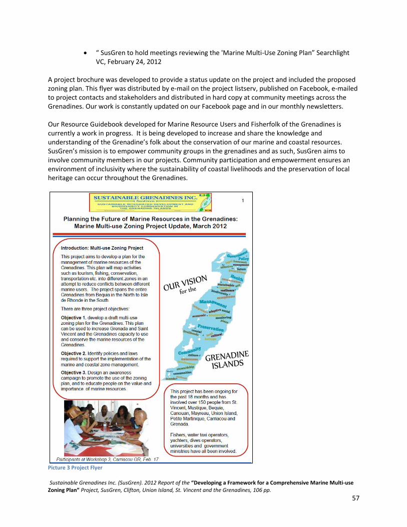
Sustainable Grenadines Inc. (SusGren). 2012 Report of the “Developing a Framework for a Comprehensive Marine Multi-use Zoning Plan” Project, SusGren, Clifton, Union Island, St. Vincent and the Grenadines, 106 pp.
57
“ SusGren to hold meetings reviewing the 'Marine Multi-Use Zoning Plan” Searchlight VC, February 24, 2012
A project brochure was developed to provide a status update on the project and included the proposed zoning plan. This flyer was distributed by e-mail on the project listserv, published on Facebook, e-mailed to project contacts and stakeholders and distributed in hard copy at community meetings across the Grenadines. Our work is constantly updated on our Facebook page and in our monthly newsletters. Our Resource Guidebook developed for Marine Resource Users and Fisherfolk of the Grenadines is currently a work in progress. It is being developed to increase and share the knowledge and understanding of the Grenadine’s folk about the conservation of our marine and coastal resources. SusGren’s mission is to empower community groups in the grenadines and as such, SusGren aims to involve community members in our projects. Community participation and empowerment ensures an environment of inclusivity where the sustainability of coastal livelihoods and the preservation of local heritage can occur throughout the Grenadines.
Picture 3 Project Flyer

Sustainable Grenadines Inc. (SusGren). 2012 Report of the “Developing a Framework for a Comprehensive Marine Multi-use Zoning Plan” Project, SusGren, Clifton, Union Island, St. Vincent and the Grenadines, 106 pp.
58
Sustainable Grenadines Inc. (SusGren). 2012 Report of the “Developing a Framework for a Comprehensive Marine Multi-use Zoning Plan” Project, SusGren, Clifton, Union Island, St. Vincent and the Grenadines, 106 pp.
59
Evaluation As part of an ability to monitor and evaluate the status of our projects and its outcomes we hired an independent consultant, Maria Pena, Project Assistant, Centre for Resource Management and Environmental Studies (CERMES), The University of West Indies (UWI), Cave Hill Campus, Barbados to conduct an evaluation of the project. This opportunity allows us to reflect on our work and greatly improve our future projects.
Evaluation Method
Surveys and key informant interviews The project was evaluated via the use of surveys and key informant interviews. A project evaluation survey targeting workshop, and community and stakeholder committee meeting participants was designed by the consultant (Appendix 7). In addition, a key informant interview was designed specifically targeting government representatives from St. Vincent and the Grenadines and Grenada (Appendix 8). The surveys and key informant interviews addressed six specific areas of interest for evaluation:
• Level of stakeholder awareness of marine spatial planning and the marine zoning project • Effectiveness of the project structure and process in accomplishing project objectives • Effectiveness of content used and/or developed during the project (e.g. clear explanation of
technical components, facilitation of workshops, ease of understanding zoning maps etc.) • Stakeholder support for the project • Suggestions for improving future project endeavours or similar SusGren projects. • How well the project was received by different stakeholders (government officials, community-
based organizations and MRUs). An evaluation team comprising thirteen persons - ten island representatives from Carriacou, Union Island, Bequia, Canouan, Mayreau, and Petite Martinique and supervised by three team leaders responsible for ensuring that surveys were administered on the relevant sets of islands – was formed (Appendix 5). Prior to conducting the surveys and key informant interviews, the team leaders were trained from 9-13 July in interview techniques by Ms. Orisha Joseph, SusGren Inc. Programme Administration Officer and Ms. Jennifer Jew, Management Plan Assistant, SusGren Inc. intern. Training took place at the SusGren Inc. office and over the phone. Team leaders then transferred the training information to the interviewers. Prior to conducting the surveys and interviews, the evaluation team was advised by Pena through SusGren Inc. to pre-test the instruments for ease of understanding in terms of interviewer instructions and questions, ambiguity etc. In the end two hundred and thirty-six surveys and nine key informant interviews were conducted from 1-17 August.
Data analysis The data was entered into an Excel spreadsheet and were analyzed using features of the Pivot Table. Short narratives were prepared from the key informant data. The data from the surveys is presented according to:

Sustainable Grenadines Inc. (SusGren). 2012 Report of the “Developing a Framework for a Comprehensive Marine Multi-use Zoning Plan” Project, SusGren, Clifton, Union Island, St. Vincent and the Grenadines, 106 pp.
60
• Project process for incorporating indigenous knowledge from stakeholders • Stakeholder awareness of marine zone planning and support for the marine zoning project, and • Population demographics
Results
Project process for incorporating indigenous knowledge from stakeholders Greater than half (n = 148 or 63%) of all respondents surveyed had heard about the SusGren Inc. marine zoning project. Word of mouth (n = 82) and community meetings (n = 64) were the most popular means by which people had heard about the project, while the MarSIS e-group was the least popular (n = 9) (Figure 6). Of those who heard about the project, just over a third of them (37%) participated in the project in different ways, with community meetings being the most popular means of doing so (47%) (Figure 7)
Figure 6 Hearing about the Marine Zoning Project
Figure 7 Participation in the Marine Zoning Project
Of those persons who participated in the project, the majority (75%) thought that enough of the right people were targeted by the project. Those who thought this was not the case, provided the following reasons for their response:
• Better representation was needed • People within the community were not involved • Not enough consultation with dive shops and yachters
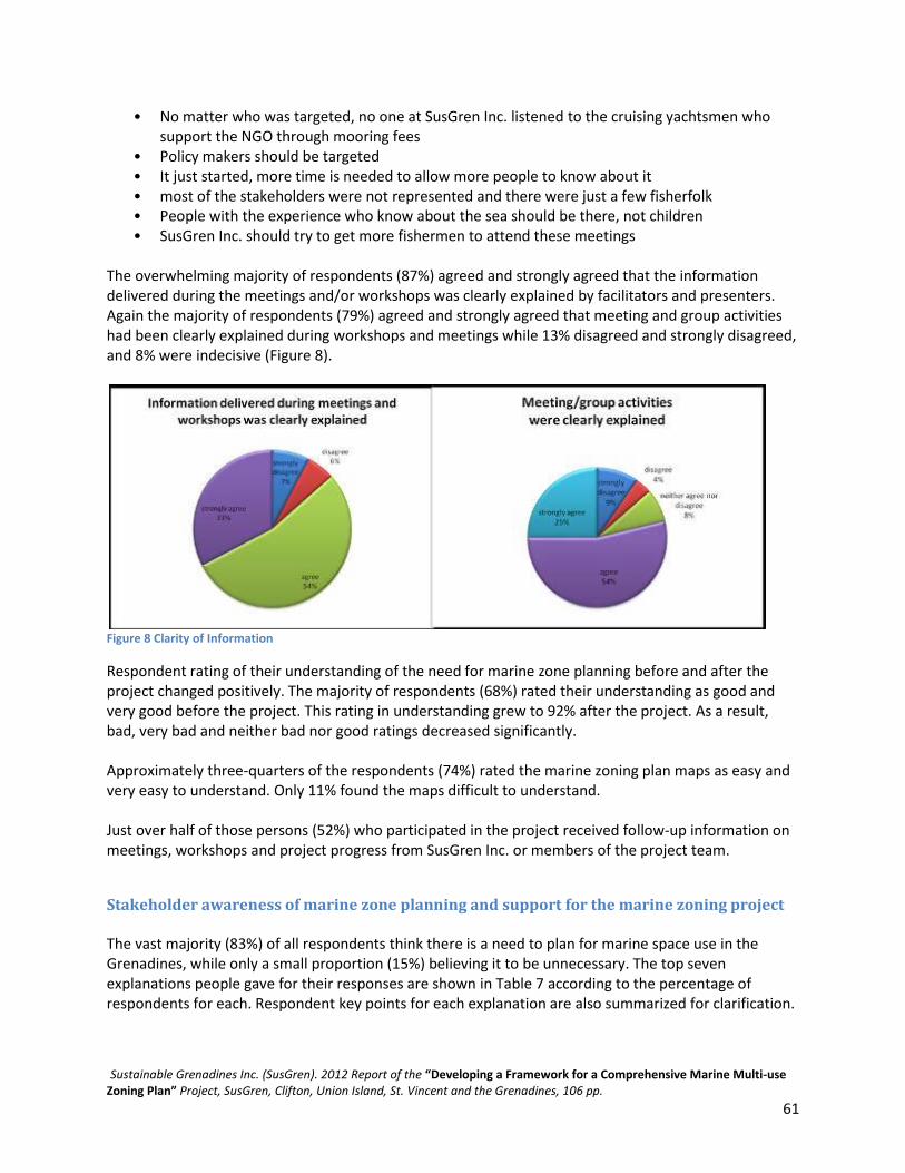
Sustainable Grenadines Inc. (SusGren). 2012 Report of the “Developing a Framework for a Comprehensive Marine Multi-use Zoning Plan” Project, SusGren, Clifton, Union Island, St. Vincent and the Grenadines, 106 pp.
61
• No matter who was targeted, no one at SusGren Inc. listened to the cruising yachtsmen who support the NGO through mooring fees
• Policy makers should be targeted • It just started, more time is needed to allow more people to know about it • most of the stakeholders were not represented and there were just a few fisherfolk • People with the experience who know about the sea should be there, not children • SusGren Inc. should try to get more fishermen to attend these meetings
The overwhelming majority of respondents (87%) agreed and strongly agreed that the information delivered during the meetings and/or workshops was clearly explained by facilitators and presenters. Again the majority of respondents (79%) agreed and strongly agreed that meeting and group activities had been clearly explained during workshops and meetings while 13% disagreed and strongly disagreed, and 8% were indecisive (Figure 8).
Figure 8 Clarity of Information
Respondent rating of their understanding of the need for marine zone planning before and after the project changed positively. The majority of respondents (68%) rated their understanding as good and very good before the project. This rating in understanding grew to 92% after the project. As a result, bad, very bad and neither bad nor good ratings decreased significantly. Approximately three-quarters of the respondents (74%) rated the marine zoning plan maps as easy and very easy to understand. Only 11% found the maps difficult to understand. Just over half of those persons (52%) who participated in the project received follow-up information on meetings, workshops and project progress from SusGren Inc. or members of the project team.
Stakeholder awareness of marine zone planning and support for the marine zoning project The vast majority (83%) of all respondents think there is a need to plan for marine space use in the Grenadines, while only a small proportion (15%) believing it to be unnecessary. The top seven explanations people gave for their responses are shown in Table 7 according to the percentage of respondents for each. Respondent key points for each explanation are also summarized for clarification.

Sustainable Grenadines Inc. (SusGren). 2012 Report of the “Developing a Framework for a Comprehensive Marine Multi-use Zoning Plan” Project, SusGren, Clifton, Union Island, St. Vincent and the Grenadines, 106 pp.
62
Table 7 Respondent Key Points and Explanation
Explanation Explanation key points % respondents
Protection of marine environment and resources Resources in general but emphasis on declining or overfished fish stocks; areas; ecosystems (reefs) and breeding grounds; depletion of resources especially by foreigners; species of interest include fish, turtles, oysters; resilience to global warming
32
Effective and efficient management Management of the fishing industry; management other resources; activities, safety and implementation of best practices. In general, better organization and regulation of the area
10
Impact on livelihoods Focus on fisheries livelihoods and negative impact such as displacement to zones that are not good for fishing; small fishermen will suffer; the Grenadines is too small so there is no need for planning marine space use as it will affect fishermen’s livelihoods
9
Protection and improvement of important industries Fisheries and tourism sectors; good dive sites can boost tourism; increased revenue from increases in tourist visits due to better tourist attractions;
9
For benefit of future generation/sustainability Preservation and planning for future generations
9
Importance to livelihoods Quite a large number of people make their living from the sea, hence planning is good for economic progress of fisherfolk and others; development of livelihoods; no use to plan because fishermen already depend on the sea for a living; protection for preservation of livelihoods
6
Designation of uses or activities to specific areas Multi-purpose area; to inform people (fishermen) on how to make use of the sea space and where to fish; to put restrictions in place to preserve certain areas such as nursery grounds and to control fishing
5
People’s perceptions on the type of effects marine zone planning could have on their ways of making a living varied with 41% thinking the effects would be positive and 30% perceiving that there would be both positive and negative effects. A minority of the respondents (13%) thought there would be only negative effects, while 9% thought marine zone planning would have no effects on the way they make their living. The top four types of perceived effects given by respondents are shown in Table 4 according to percentage of respondents. Respondent key points for each effect are also summarized for clarification.

Sustainable Grenadines Inc. (SusGren). 2012 Report of the “Developing a Framework for a Comprehensive Marine Multi-use Zoning Plan” Project, SusGren, Clifton, Union Island, St. Vincent and the Grenadines, 106 pp.
63
Table 8 Perceived Effect
Perceived effect Effect Key points % respondents
Restricted access Preservation/reservation of areas is needed but this limits where people can make a living (e.g. dive operators, fishermen); fishermen can’t fish as they want; nowhere else to catch fish; too much of the fishing areas are taken away; too many restrictions on fishermen and divers; many of the fishing areas are already prohibited and have been set aside for tourism and attractions;
fishermen will have to go further out to fish and will have to change their fishing grounds; preventative to persons who don’t have boats
24
Improvement in/promotion of tourism Protection of marine life will result in increased attractiveness of the country for tourists, this can bring in income which will help to boost the economy; will lead to better business in terms of selling goods (e.g. craft)
16
Threatened fisheries livelihoods Planning will take away the daily living of fishermen, they will not be able to provide for their families; unemployment will increase; no fisherman’s cooperative to rely on;
11
Protection of marine resources with accompanying decrease in income generation
Specifically with reference to fishermen; fish and turtles will have the opportunity to multiply but fishermen will not be able to fish freely; reduction in income due to restrictions
6
The overwhelming majority of respondents believe that the proposed zones comprising the draft marine zoning plan take into account marine space uses and activities that are important for livelihoods, conservation and protection of marine resources, culture, tourism, industry, recreation etc. Fourteen percent of people were uncertain as to whether these various uses and activities had been accounted for in the draft plan and only 4% thought they had not been considered. The latter respondents came from Union Island, Mayreau, Canouan and Carriacou. Of those respondents who indicated that the proposed zones do not include important marine space uses and activities, reasons for their disagreement are listed below. Reasons provided were similar and primarily focused on zoning extent and livelihoods of fishermen. (N.B. Respondent’s resident island is in parentheses).
• “Need to have meeting” -more consultations required (Union Island) • “Because the fishermen have to face a lot of problems meaning they have special areas in which
they proposed for us to fish and its hard on us” (Union Island) • “Too much area used for marine. Fishermen now have to go further” (Mayreau) • “Where the zones are located is where local fishermen fish, therefore it does affect the
livelihood of the men” (Mayreau) • “Too much areas are use as marine conservation. Fishermen now has to go very far to source
fish even the fishes are moving into the conservation areas where fishermen cannot go” (Mayreau)
• “It does not take into account the way in which people make their living” (Canouan) • “Because they don't seem to know what they want to protect” (Carriacou)

Sustainable Grenadines Inc. (SusGren). 2012 Report of the “Developing a Framework for a Comprehensive Marine Multi-use Zoning Plan” Project, SusGren, Clifton, Union Island, St. Vincent and the Grenadines, 106 pp.
64
• “The size of the marine protected area is too big proportionally to the size of the island” (Carriacou)
• “We don't hold fish in that area so I don't think it would affect our livelihoods” (Carriacou) • “Because in my village for example, the zoning halts fishermen that fish on a small scale in close”
proximity (Carriacou) Almost all of the respondents (95%) stated that the marine zoning plan include their use of the area (Figure 9). Reasons why 5% of respondents did not think this was so included:
• No relevance to their livelihoods (Bequia and Petite Martinique) • There are no assets to dive or fish in the area (Mayreau) • Restrictions on type of fishing, i.e. pots are not allowed in certain areas (Canouan) • Restrictions on areas, i.e. previous dive sites are restricted (Canouan)
Figure 9 Marine Zone Plan Inclusion
Respondent support for the SusGren Inc. marine zoning project was varied but largely very supportive and extremely supportive (55%). A fairly large percentage of people (35%) are moderately and slightly supportive, while only 7% are not at all supportive of the project (Figure 9). Additionally, eighty-four percent of people surveyed stated that they would like to participate in future SusGren Inc. activities and events related to the marine zoning project. Respondent suggestions for ways in which SusGren Inc. could improve projects it will conduct in the Grenadines were limited but the three main recommendations were the need for more education about projects and involvement or targeting of more stakeholders (66%); increase involvement of specific types of stakeholders (5%); and development of similar projects to the marine zoning project (5%). It should be noted that a large proportion of respondents either did not answer this question, provided responses that were not applicable or had no recommendations to provide (51% combined). In terms of the first suggestion, people think that SusGren Inc. could target schools in raising awareness about projects and activities. Additionally, people feel that the number of persons involved in projects should be increased with emphasis on involving more community members. SusGren Inc. has been encouraged to make more use of the media (newspaper, radio, television) for advertising projects and activities, raising general awareness, providing feedback during and after the project, and fostering greater involvement and support from stakeholders. It was further suggested that SusGren Inc. could appoint persons in the different Grenadine Islands to sensitize people about the NGO’s plans. The
Sustainable Grenadines Inc. (SusGren). 2012 Report of the “Developing a Framework for a Comprehensive Marine Multi-use Zoning Plan” Project, SusGren, Clifton, Union Island, St. Vincent and the Grenadines, 106 pp.
65
hosting of more community meetings and workshops to sensitize communities and the general public was also recommended. Education was not only viewed as providing information to communities but also as receiving stakeholder knowledge and ideas to inform development of projects. With respect to involving or targeting more stakeholders, it was suggested that particular attention be paid to those that could and would be affected by projects, and immediate marine users such as fishermen and tour guides. It was suggested that more interaction with fisherfolk was necessary. Just under one-third of all respondents provided other comments, thoughts or suggestions about the marine zoning project. Of these the top three were sensitize people more about the project and similar projects (15%), continue what is being done and keep up the good work (12%), and involve stakeholders (fishermen and others) more in projects (8%). It should be noted that the majority of respondents (68%) either did not provide comments, thoughts or suggestions, did not answer the question or provided responses that were not applicable.
Population demographics The majority of survey respondents were male (69%) as opposed to female (31%). Nearly three-quarters of all respondents (74%) were in the 30-44 (41%) and 45-64 (33%) age groups. Just under half (45%) of those interviewed had last attended secondary school. The majority of respondents surveyed were fishermen (28%), followed by seamen (11%), those with other marine-oriented jobs such as shipwrights, boat builders, sailmakers, divers etc. (8%) and vocational such as carpenters, painters, plumbers, labourers etc. (5%).
Key informant interviews Nine key informants were interviewed in early August. The key informants came from the following government Ministry/ department:
• Information Technology • SVG Fisheries Division • Ministry of Tourism • Grenadines Affairs • Grenada Fisheries Division • Environment Department • Ministry of Health • Fisheries Division
The results of the key informant interviews are presented according to:
• Knowledge of the SusGren Inc. marine zoning project • Project relevance to key informants and involvement in the project • Project process for incorporating stakeholder knowledge • Stakeholder awareness of marine zone planning and support for the marine zoning project • Population demographics

Sustainable Grenadines Inc. (SusGren). 2012 Report of the “Developing a Framework for a Comprehensive Marine Multi-use Zoning Plan” Project, SusGren, Clifton, Union Island, St. Vincent and the Grenadines, 106 pp.
66
Since key informant interviews are generally meant to be exploratory, the information collected from the interviews is presented generally as narratives in the relevant sections.
Knowledge of the SusGren Inc. marine zoning project In general, key informant knowledge of the marine zoning project was very good. 100% of respondents had heard about the SusGren Inc. marine zoning project and all were able to provide information on what they each knew about the project. Key informants knew that the project had been implemented by SusGren Inc. (one KI was misinformed and thought it was implemented by CERMES, UWI). Generally, they stated that the project was concerned with the identification of marine resources and development of zones for different uses/users of the marine space of the Grenadines Banks to facilitate and improve the effective management and use of marine resources in the Grenadines, as well as reduce or mitigate user conflict. Key informant understanding of ‘marine zone planning or marine spatial planning’ was also very sound. They noted that marine zone planning or marine spatial planning is marine space use management planning through mapping of different use areas for sustainable use/development. It involves restricting uses to specific areas. Planning facilitates the designation of multiple uses or activities in an area in an effort to reduce user conflict and promote sustainable development. The process of marine zone planning involves educating the users and determining information about their activities as well as restriction of uses in different areas.
Project relevance to key informants and involvement in the project The project was of relevance to the government agencies/departments of all key informants. It helped to increase stakeholder knowledge and alleviate existing confusion among users. Some government ministries are either focal points of international Multilateral Environmental Agreements (MEA) and therefore have international obligations or have mandates in keeping with the objectives of the SusGren Inc. marine zoning project. All key informant government agencies/departments were involved in the project in numerous ways including: project planning; consultations and workshops; facilitation of meetings; and provision of technical advice into the zoning plan.
Project process for incorporating stakeholder knowledge Seven key informants attended project meetings or workshops and five of them thought that enough of the right people were targeted for such activities. The two key informants who thought that not enough of the right people were targeted for the meetings and workshops noted that more locals should have been involved including people within the communities and that Ministries such as Finance and Planning and the Physical Planning Department were two key central government stakeholders who should have been more ultimately involved in the project to generate greater government buy-in to the project. 85% of key informants either agreed or strongly agreed that the information delivered during meetings and workshops was clearly explained by presenters and facilitators. Greater than half of the key informants (57%) agreed and strongly agreed that the meeting activities and group exercises were clearly explained to participants at meetings and workshops (Figure 11).

Sustainable Grenadines Inc. (SusGren). 2012 Report of the “Developing a Framework for a Comprehensive Marine Multi-use Zoning Plan” Project, SusGren, Clifton, Union Island, St. Vincent and the Grenadines, 106 pp.
67
Figure 10 Level of Clarity
Key informant understanding of the need for marine zone planning prior to the project varied with 14% of the key informants noting their understanding as neither good nor bad, 28% as bad and over half (57%) noting it was good and very good. The majority of respondents (43%) said that their understanding was good. Key informant understanding of the need for marine zoning increased after the project with all key informants noting that their understanding was either good or very good. The percentage of people who had a very good understanding of the need for marine zone planning increased from 14% before the project to 86% after the project. The majority of key informants found that the marine zoning plan maps were either easy or very easy to understand (83%). Only 16% rated the maps as being neither easy nor difficult to understand. Eighty-eight percent of key informants received feedback from SusGren Inc or members of the project team on meetings and workshops, and project progress. All key informants with the exception of one, provided suggestions on things that could have been done better in the project. These included: (1) more stakeholder involvement; (2) increased awareness-raising, especially in communities, and distribution of educational materials; (3) more discussion of the plans at national levels with more engagement of governments of both countries in the consultations; (4) better distribution of workshops and meetings; (5) more ‘low-key’ explanation of the project and (6) better collaboration with government departments to ensure that project activities to be initiated are priorities that would supported. In terms of the stakeholders that were suggested for inclusion, more local people, marine users, involvement of community groups, and government agencies such as the legal department and tourism division, were noted. One-on-one meetings with marine users in informal settings were suggested. The majority of key informants (66%) said that involvement in the project led to collaboration or networking with other government departments/ministries, NGOs etc. that their departments or ministries would not have otherwise engaged. 33% noted there had been no collaboration or networking with groups that they would not otherwise engage. One key informant noted this was so because the organizations that were involved in the project were the same that would have been engaged by their department at some time or another. Stakeholder awareness of marine zone planning and support for the marine zoning project Half of the key informants, in each case, had either seen or not seen the draft marine zoning plan developed during the project. More than a third of the key informants (37%) thought that the marine

Sustainable Grenadines Inc. (SusGren). 2012 Report of the “Developing a Framework for a Comprehensive Marine Multi-use Zoning Plan” Project, SusGren, Clifton, Union Island, St. Vincent and the Grenadines, 106 pp.
68
zoning plan drafted during the project was not the best that could be developed. Equal proportions of key informants (12% each) agreed that it was the best or were unable to say if it was the best that could be developed. Key informants noted that further improvement or refinement of the draft plan was necessary due to a number of reasons: (1) the project has given a loud voice to fisherfolk but other sectors also need equal consideration; (2) due to uncertainty by some people on what the map should comprise, some people's ideas had not be included in the mapping process; (3) people's displacement from activities and alternative livelihoods should be shown on the map and (4) government level policies and the economic considerations need to be factored in the draft plan. All respondents thought that the development of a marine zoning plan would benefit the Grenadines. Reasons for this belief included benefits such as cooperation and greater sense of togetherness between Grenadine Islands and the two nation states; free movement and better interaction; improvement in economy in terms of fishing and diving; resolution of conflicts; development of the tourism industry; increased commercial trade, improvements in fishing; the recovery of depleted areas; provision for sustainable harvesting and other activities that would rejuvenate the eco-infrastructure that currently exists in some areas; sustainable development; building resilience against climate change; increased awareness about the need to conserve and sustainably use marine resources - it has therefore opened the door for more serious discussions at the national level about how this should be done; and development of a better management system for the marine space. The marine zoning plan will be beneficial to the mandates of the majority of key informant departments/ministries (88%; only one respondent did not answer the question) for various reasons: closer working relationship with government; proper identification of areas for use and guidance in implementation of government policies; more effective ecosystem management; as a template for development of an extended larger plan for the entire island of Grenada; coastal zone management, biodiversity management, data sharing, key focus areas, community awareness raising; provision of valuable insight into how the process should take place and provision of valuable information which otherwise could have taken years to develop. It will be a part of a wider coastal and marine zoning plan which will be developed. The majority of respondents (77%) thought that the marine zoning project was very important and extremely important to the Grenadine Islands. Only 22% rated its importance as moderately important. As such the majority of key informants (77%) were very supportive and extremely supportive of the marine zoning project. Only 22% rated their support as moderately supportive. Generally, greater than half of the key informants (55%) are supportive of all of further steps to be taken by the project in order to implement the zoning plan. However, a fairly large proportion of key informants (44%) support only some of the steps (Figure 11).

Sustainable Grenadines Inc. (SusGren). 2012 Report of the “Developing a Framework for a Comprehensive Marine Multi-use Zoning Plan” Project, SusGren, Clifton, Union Island, St. Vincent and the Grenadines, 106 pp.
69
Figure 11 Degree of Importance and Support for the Marine Zoning Project
Those key informants who support all of the next steps for implementation of the marine zoning plan, provided additional comments such as: “I would like to see it [the marine zoning plan] functioning”; “implementing ministries, policy legislation, and the community environment project can be used to raise awareness”; “I support the plan in that I think it is a good basis for future work and refining”; and “a holistic approach is needed and each step mentioned is a key part in the overall puzzle of putting together the final plan.” Those key informants who supported only some of the next steps for implementation noted that (1) more educational materials need to be distributed, community awareness heightened and information explained in ‘low-key’ terms so that persons at every level can understand and make better contributions to the plan as well as to sensitize the public to the impacts (loss vs. gain) of zoning; (2) government has to play a key role in the development of this plan and also its implementation by meeting with stakeholders and reviewing the final draft; and (3) some of these activities would need significant resources to be implemented but are not priorities for governments and thus are not workable. Eight key informants provided suggestions for making the next steps successful. They are listed below:
• Develop a website for communication • Meet with managers/stakeholders • Develop a forum for collaboration with relevant government officials and present the plan • Involve community members more and not just marine users because they also may be able to
make meaningful contributions to the project's implementation • Accumulate information from stakeholders/marine users • Take the proposal to government • Raise awareness in communities • Distribute more educational materials (flyers) and hold more workshops/meetings • Use tv and radio to disperse information • Conduct comparative analyses that are practical, e.g. with the Soufriere Marine Management
Area (SMMA) and Pitons Management Area (PMA), St. Lucia • Start with a test on a trial area for rehabilitation in the Grenadines and expand from there • The plan must be finalized with input from government and include important economic
considerations • Economic valuation should be part of the decision-making process • Re-engage government agencies and NGOs to play their part and

Sustainable Grenadines Inc. (SusGren). 2012 Report of the “Developing a Framework for a Comprehensive Marine Multi-use Zoning Plan” Project, SusGren, Clifton, Union Island, St. Vincent and the Grenadines, 106 pp.
70
• Launch a public outreach campaign Key informant recommendations for SusGren Inc. to improve on projects were provided by seven persons and included: SusGren Inc. has been doing a great job, perhaps they need more permanent staff; target more community groups and include them in projects; provide more feedback during and after implementation of project; provide invitations to meetings at least one week in advance; provide constant feedback to those involved; seek more funding; extend projects to Grenada (mainland); improve collaboration with government departments to ensure that projects to be implemented focus on similar priority areas - this would be ensure favourable collaboration between government departments and SusGren Inc. and could be used to better inform national decision-making. Additional comments were provided by four key informants. These are listed below:
• Have one-to-one communication with fisherfolk • Pull together various marine users from the Grenadines in one place to discuss thoughts and
ideas with the aid of SusGren so they can collaborate and come to a common understanding • SusGren Inc. projects should be more involved with community groups and assist with proposed
projects • Data availability is limited.
Population demographics Just over half (55%) of the key informants interviewed were male and 44% female. The majority of key informants interviewed were in the 30-44 age group (44%), 33% in the 45-64 age group and 22% in the 15-29 age group. All key informants had received tertiary level education with greater than three-quarters (77%) being University graduates and 22% A-Level college graduates.
Comparison between survey and key informant data In general there was good corroboration between data collected by surveys and key informant interviews although some differences were evident. In both instances the majority of respondents and key informants had heard about the SusGren Inc. marine zoning project. The proportion of key informants however was higher than that of the survey respondents. This however may be explained by the fact that all of the key informants had either been informed about the project through their government agencies or departments or had attended project meetings and workshops. This was not the case and reasonably so, for survey respondents. The majority of survey respondents and key informants both thought that enough of the right people had been targeted to attend meetings and workshops. For those who did not agree with this, both survey respondents and key informants indicated that better representation and involvement of community members, policy makers and therefore government agencies was needed. Nearly equal proportions of survey respondents and key informants (87% and 85%, respectively) agreed and strongly agreed that meeting/workshop facilitators and presenters clearly explained the information they were delivering. With respect to explanation of meeting activities and group exercises however, there was some disparity in the degree of agreement that these had been clearly explained with a larger

Sustainable Grenadines Inc. (SusGren). 2012 Report of the “Developing a Framework for a Comprehensive Marine Multi-use Zoning Plan” Project, SusGren, Clifton, Union Island, St. Vincent and the Grenadines, 106 pp.
71
majority of survey respondents (79%) rating this as agree/strongly agree compared with 57% of key informants with the same rating. Significant positive changes in the understanding of the need for marine zone planning after the project were experienced by both survey respondents and key informants (92% and 100%, respectively). Additionally, a high proportion of survey respondents and key respondents found that the marine zoning plan maps were easy and very easy to understand (74% and 83%, respectively). In general, survey respondents lacked follow-up information from SusGren Inc. or members of the project team on meetings, workshops and project progress (52%). This was not the case for key informants, the majority of which (88%) received feedback. While the majority of survey respondents (82%) felt that the proposed zones in the draft marine plan take into account all areas of importance such as livelihoods, conservation and protection of marine resources, culture, industry etc., key informants believe that the draft plan is not the best that could be developed noting that improvement or refinement is needed as well as further input from additional stakeholders and government. The SusGren Inc. project is supported by a larger proportion of key informants (77%) than survey respondents (55%) with degree of support varying more amongst the latter. Survey respondents and key informants both gave very similar suggestions for improving similar projects that SusGren Inc. may implement. Both applauded SusGren Inc. for the work it was doing and encouraged the NGO to continue in the same vein but they both called for the inclusion and involvement of more stakeholders, community groups, and community members in future projects. Additional comments, thoughts and suggestions about the marine zoning project offered by survey respondents and key informants were also very similar calling for more sensitization of stakeholders to the project, and involvement of more and a wider range of stakeholders for greater support and a common understanding.
DISCUSSION
Evaluations success The project evaluation was successful in meeting its objectives. Stakeholder awareness of marine spatial planning and the marine zoning is generally high but should be further aimed at fishermen to further educate them on the importance of the plan, schoolchildren to raise awareness, as well as the general public to ensure wider understanding. The content used and/or developed during the project could be viewed as being successful given the high rating given to facilitators and presenters (by survey respondents and key informants) in their ability to clearly explain the information delivered during meetings and workshops and accompanying activities and group exercises; positive change in the level of understanding of the need for marine zone planning; and ease of understanding marine zoning plan maps. The evaluation was able to determine that stakeholder support for the project is high. Suggestions for improving future project endeavours or similar SusGren projects have been captured. Based on data collected from the preceding evaluation objectives the project has been well-received for the most part by different stakeholders.
Sustainable Grenadines Inc. (SusGren). 2012 Report of the “Developing a Framework for a Comprehensive Marine Multi-use Zoning Plan” Project, SusGren, Clifton, Union Island, St. Vincent and the Grenadines, 106 pp.
72
It is hoped that the data collected in the evaluation may be of assistance in guiding the finalization of the draft marine zoning plan.
Project success Based on the data collected in this evaluation, the SusGren Inc. marine zoning project has made satisfactory efforts towards achieving its project objectives. Efforts at incorporating indigenous technical knowledge from marine resource users into a draft multi-use zoning design have been made with the majority of persons interviewed feeling that enough of the right people (with relevant knowledge) were included in project community meetings and workshops. A more enabling environment for participatory marine and coastal resource management and capacity building has been created based on the fairly wide range of stakeholders who participated in the project and increase in understanding of the need for marine zone planning. Collaboration among some government agencies and between stakeholder groups has been encouraged as a result of the project. Based on the data collected from the surveys and key informant interviews, the SusGren Inc. marine zoning project has been favourably received by those who have heard about it or have been involved in it. Support for the project is high and is relatively high for the draft marine zoning plan. People are generally keen to participate in future activities or spin-offs of the project and would like to see the marine zoning plan implemented since marine space use planning is viewed by the majority to be of importance to Grenadine Islands. This is true even in cases where people believe their livelihoods will be impacted by the implementation of the plan. This in itself shows that people have a good understanding of what marine space use planning is all about and is an indication of SusGren’s efforts at raising project awareness via a number of media including community meetings, project workshops, newspaper and radio. SusGren Inc. should be encouraged by the support for the project and should provide the NGO with impetus to move towards implementation of the draft marine zoning plan. In terms of next steps to be taken to implement the plan – finalizing the marine zoning plan and obtaining government and public support for the plan - SusGren Inc. should pay particular attention to the comments and suggestions provided by the survey respondents and key informants for refinement of the plan through the incorporation of additional stakeholders, including government ministries. This will ensure greater buy-in from all stakeholders and should make the implementation process easier once the plan is aligned with national commitments to international MEAs and local ministry/government department mandates. Additionally, SusGren Inc. should be aware of the potential stakeholder resistance to a marine zoning plan, particularly from fishers, who have already been displaced from certain areas, for example, the Tobago Cays Marine Park (TCMP) and who it seems believe will they suffer the most from implementation of such a plan due to their high dependency on marine resources in the Grenadines. This is a large and important stakeholder group that SusGren should continue to include in the future finalization of the plan. This particular group may require scientific study to determine level of dependence and to determine the need for development of alternative livelihoods for fishermen. With regards to developing and distributing educational materials to raise awareness about the implementation of the marine zoning plan, SusGren Inc. should continue to use the most successful media it has been using for the marine zoning project - community meetings, newspaper and radio – but should also include additional media to the communication pathway such as public service

Sustainable Grenadines Inc. (SusGren). 2012 Report of the “Developing a Framework for a Comprehensive Marine Multi-use Zoning Plan” Project, SusGren, Clifton, Union Island, St. Vincent and the Grenadines, 106 pp.
73
announcements and short documentaries on tv. SusGren Inc. should consider targeting a wider range of stakeholders as suggested by the survey respondents and key informants, including schoolchildren where appropriate. Stakeholders should also be frequently provided with feedback on project progress. This was an area of limitation that was evident from the information collected in the surveys. Educational materials should be designed using the simplest terms to improve the level of understanding (of all stakeholders) of the plan and project.
Sustainable Grenadines Inc. (SusGren). 2012 Report of the “Developing a Framework for a Comprehensive Marine Multi-use Zoning Plan” Project, SusGren, Clifton, Union Island, St. Vincent and the Grenadines, 106 pp.
74
Developing a Framework for a Multiuse Zoning Plan: Lessons Learned We now have a better understanding with the participatory process and with working with communities within the Grenadines in developing a framework for a multiuse zoning plan. This project gave us an opportunity to learn lessons from project planning, hosting meetings and coordinating workshops that will be helpful for the execution of future projects. Our main lessons learned include:
1. Simplify Language-- The need to make language simple. Technical language (common in zone planning) and jargon causes listeners unfamiliar to the subject disinterested in contributing to the project. Making language accessible will ensure the engagement of Marine Resource Users and community members.
2. Encourage Participation—Local participation of marine resource users was crucial to the success of this project. Two ways we found that encouraged MRUs’ participation was to hold meetings in a casual setting and to create small group discussions to increase the amount of conversation and to decrease shyness.
3. Connect with locals—Support for our project is strengthened through building awareness by connecting with community members and talking about our work and creating mediums through which information can be absorbed (i.e. creating a documentary video that involved community members).
4. Connect with Government—Government support is very helpful as it involves creating a space for ownership and this helps create a dialogue where change can happen in a more fluid path which (specific to our project) helps both Grenada and St. Vincent and the Grenadines meet their international and regional commitments (i.e. St. George’s Declaration, CBD and the Caribbean Challenge).
5. Jurisdiction—working as a transboundary project, developing policy and legislation becomes doubly difficult and to ease the disorder, it is necessary to know who and which government will be responsible for the tasks at hand. These include the administration and enforcement.
6. Connect with Organizations—Organizations that developed similar projects like The Nature Conservancy can help with project planning and assisting in the easing the confusion that occurs when executing such a large plan.
7. Be Sustainable—When catering snacks and meals avoid individual Styrofoam plates and boxes as much as possible. This will decrease the amount of garbage generated as well as promote an environmental consciousness.
8. Be Clear and Repeat—Instructions for workshop/meeting participants need to be delivered clearly and repeated multiple times (i.e. activity instructions and scheduling). As well, when working with Note-takers and Caterers, expectations need to be outlined and repeated to ensure a smooth execution of meetings/workshops

Sustainable Grenadines Inc. (SusGren). 2012 Report of the “Developing a Framework for a Comprehensive Marine Multi-use Zoning Plan” Project, SusGren, Clifton, Union Island, St. Vincent and the Grenadines, 106 pp.
75
References Adams, E. 1996. Golden anchor/ silver chain - A historical and socio-economic perspective on shipping in St. Vincent and the Grenadines. St. Vincent and the Grenadines: n.p. Agardy T. 2010. Ocean zoning: Making marine management more effective. Washington, D. C.: Earthscan. Agostini V., S. M. Margles, S. R. Schill, J. E. Knowles, and R. J. Blyther. 2010. Marine zoning in Saint Kitts
and Nevis: A path towards sustainable management of marine resources. St. Criox, USVI: The Nature Conservancy.
Baldwin, K., et al. 2006. A profile of marine resource users in the Grenadines. 59th Gulf and Caribbean
Fisheries Institute. Belize City, Belize. 9 pp. Online: http://grenadinesmarsis.com/uploads/Baldwinetal.GCFI_Poster.pdf.
Baldwin K., R. Mahon, P. McConney and H. Oxenford. 2007. Stakeholder engagement in the development of a participatory GIS for the Grenadine Islands. In Proceedings of the 58th Gulf and Caribbean Fisheries Institute.
Baldwin K., R. Mahon, H. Oxenford, A. Cooke, D. Gill, T. Staskiewicz. 2008. A profile of marine resource users in the Grenadines. In Proceedings of the 59th Gulf and Caribbean Fisheries Institute. Baldwin, K. 2011a. Developing a Framework for a Comprehensive Marine Multi-use Zoning Plan for the Grenadine Islands. Progress Report #1. June 2011. 51pp. Baldwin K. 2011b. Progress report 2: Developing a framework for a comprehensive marine multi-use zoning plan for the Grenadine Islands. Barbados: CERMES. Baldwin K., and R. Mahon. 2011c. A geospatial framework to support ecosystem based management
and marine spatial planning for the transboundary Grenadine Islands. In Proceedings of the 10th CoastGIS conference.
Baldwin K. 2012. Progress report 3: Developing a framework for a comprehensive marine multi-use zoning plan for the Grenadine Islands. Barbados: CERMES. Baldwin, K. 2012a. Developing a Framework for a Comprehensive Marine Multi-use Zoning Plan for the Grenadine Islands. Progress Report #3. March 2012. 60pp. Baldwin, K. 2012b. Developing a Framework for a Comprehensive Marine Multi-use Zoning Plan for the Grenadine Islands. Final Report. May 2012. 129pp. Beck, M.W., et al. 2009. Best Practices for MSP. Advice from a workshop organized by The Nature Conservancy, Arlington, VA. Bovino, R.J. 2010. Building a Legal Framework for Marine Zoning in the Federation of St. Kitts and Nevis, Notes for Policymakers. The Nature Conservancy.

Sustainable Grenadines Inc. (SusGren). 2012 Report of the “Developing a Framework for a Comprehensive Marine Multi-use Zoning Plan” Project, SusGren, Clifton, Union Island, St. Vincent and the Grenadines, 106 pp.
76
Bunce L. and R. Pomeroy. 2003. Socioeconomic monitoring guidelines for coastal managers in the Caribbean: SOCMON Caribbean. Australia: Australian Institute of Marine Science. Caribbean Conservation Association (CCA). 1991a. Grenada country environmental profile. Tortola, BVI: Island Resources Foundation. Caribbean Conservation Association (CCA). 1991b. St. Vincent and the Grenadines country environmental profile. Tortola, BVI: Island Resources Foundation. Caribbean Tourism Organisation (CTO). 2009. Individual country statistics. http://www.onecaribbean.org/statistics/countrystats/. Carocci F., G. Bianchi, P. Eastwood and G. Meaden. 2009. Geographic information systems to support
the ecosystem approach to fisheries: status, opportunities and challenges. FAO Fisheries and Aquaculture Technical Paper No. 532. Rome, Italy: FAO.
Central Intelligence Agency (CIA). 2011. The world factbook 2011. https://www.cia.gov/library/publications/the-world-factbook/. Chakalall Y., R. Mahon, H. Oxenford and R. Ryan. 1994. Fish exporting in the Grenadine Islands: activities of trading vessels and supplying fishers. CARICOM Fishery Research Document 17. Chuenpagdee R., J. Fraga, J. Euan-Avila. 2004. Progressing toward comanagement through participatory research. Society and Natural Resources 17:147-161. Clive A.F. 1976. The Grenadines from Columbus to today -The settlement of St. Vincent and the Grenadines. Bridgetown, Barbados: Cole's Printing. Cooke, A.L., R. Mahon and P. McConney. 2007. A livelihoods analysis of the water taxi operators in the Grenadines. CERMES Technical Report No. 9. Barbados: UWI. Corbett J., G. Rambaldi, P. Kyem, D. Weiner, R. Olson, J. Muchemi, M. McCall and R. Chambers. 2006.
Overview: Mapping for change – the emergence of a new practice. Participatory Learning and Action 54:13-19.
Culzac-Wilson L. 2003. St. Vincent and the Grenadines Report to the Regional Consultation on SIDS Specific Issues. St. Vincent: Government of St Vincent and the Grenadines. Cumberbatch J. 2002. Case study of the Folkstone marine park and reserve, Barbados. St. Lucia: Caribbean Natural Resources Institute (CANARI) Technical Report No. 281. Trinidad: CANARI. Crowder L. and E. Norse. 2008. Essential ecological insights for marine ecosystem-based management and marine spatial planning. Marine Policy 32 (5): 772-778. Douvere F. and C. Ehler. 2009. Ecosystem-based marine spatial management: An evolving paradigm for the management of coastal and marine places. Ocean Yearbook 23:1-26

Sustainable Grenadines Inc. (SusGren). 2012 Report of the “Developing a Framework for a Comprehensive Marine Multi-use Zoning Plan” Project, SusGren, Clifton, Union Island, St. Vincent and the Grenadines, 106 pp.
77
Eastern Caribbean Natural Area Management Program (ECNAMP). 1980. St. Vincent Grenadines: Preliminary data atlas. Survey of conservation priorities in the Lesser Antilles. St. Croix, V.I.: ENCAMP.
Economic Commission for Latin America and the Caribbean (ECLAC). 2004. Yachting in the Eastern Caribbean. N.l.: ECLAC Technical Report LC/CAR/R.75. Ehler, C. and F. Douvere. 2009. MSP: a step-by-step approach toward ecosystem-based management.
Intergovernmental Oceanographic Commission and Man and the Biosphere Programme. IOC Manual and Guides No. 53, ICAM Dossier No. 6. Paris: UNESCO.
Environmental Law Institute. 2009. MSP in U.S. Waters: An Assessment and Analysis of Existing Legal Mechanisms, Anticipated Barriers, and Future Opportunities. Fanning, L., R. Mahon & P. McConney (eds). Towards Marine Ecosystem-based Management in the Wider Caribbean. MARE Publication Series No. 6. Amsterdam: Amsterdam University, 2011. Food and Agriculture Organisation (FAO). 2002. Fishery Country Profile: St. Vincent and the Grenadines. Rome: FAO Fisheries and Aquaculture Department. Accessed December 2010.
http://www.fao.org/fi/fcp/en/SVG/profile.htm. Francella, V. and M. Barriteau. 2011. Developing a framework for a comprehensive marine multi-use
zoning plan: Visioning workshop summary. Sea Waves Upper Level Conference Room, Hillsborough, Carriacou. January 27-28, 2011.
Garner L. 2007. Review of the policy, legal and institutional frameworks for protected areas
management in St. Vincent and the Grenadines. St. Lucia: Environment and Sustainable Development Unit, Organisation of Eastern Caribbean States.
Gill D., P. McConney and R. Mahon. 2007. Socio-economic profiles of fisheries in the Grenadine Islands. CERMES Technical Report No. 11. Barbados: University of the West Indies. Halpern, B.S., et al. 2008. A Global Map of Human Impact on Marine Ecosystems. Science 319(5865):948-952. Interagency Ocean Policy Task Force. 2010. Final Recommendations of the Interagency Ocean Policy Task Force. White House Council on Environmental Quality: July 19, 2010. International Institute of Rural Reconstruction (IIRR). 1998. Participatory methods in community-based coastal resource management. 3 vols. Silang, Cavite, Philippines: IIRR. JECO Caribbean. Draft Land and Marine Management Strategy for Grenada. First Draft. August 2011. 48pp. Kirby-Straker, R. 2003. Fisheries resources and regulations in St. Vincent and the Grenadines. St. Vincent: Ministry of Agriculture, Fisheries and Forestry. Lee, D. 2009. St. Vincent and the Grenadines national parks and protected areas systems plan 2010- 2014. St. Vincent: National Parks, Rivers and Beaches Authority, Ministry of Tourism.
Sustainable Grenadines Inc. (SusGren). 2012 Report of the “Developing a Framework for a Comprehensive Marine Multi-use Zoning Plan” Project, SusGren, Clifton, Union Island, St. Vincent and the Grenadines, 106 pp.
78
Mackinson, S., D. Wilson, P. Galiay and B. Deas. 2011. Engaging stakeholders in fisheries and marine research. Marine Policy 35:18-24. Mahon R. 1990. Fisheries management options for the Lesser Antilles countries. Food and Agriculture Organisation (FAO) Fisheries Technical Paper 313. Rome: FAO. Mahon R., S. Almerigi, P. McConney, C. Ryan and B. Whyte. 2004. Coastal resources and livelihoods in
the Grenadine Islands: Facilitating change in self-organising systems. In Proceedings of the 55th Gulf and Caribbean Fisheries Institute.
McConney P., A. Atapattu and D. Leslie. 1998. Organising fisherfolk in Barbados. In Proceedings of the 51st Gulf and Caribbean Fisheries Institute. McLeod K. and H. Leslie. 2009. Ecosystem-based management for the oceans. Washington, D.C.: Island Press. Organisation of Eastern Caribbean States (OECS). 2005. Macro-Socio-Economic Assessment of the Damage caused by Hurricane Emily, 2005. Castries, St. Lucia: OECS. Pomeroy R. and F. Douvere. 2008. The engagement of stakeholders in a marine spatial planning process. Marine Policy 32 (5): 816-822. Rambaldi G., P. Kwaku Kyem, P. Mobile, M. McCall and D. Weiner. 2005. Participatory spatial information management and communication in developing countries. Paper presented at
Mapping for Change International Conference, Nairobi, Kenya, September 7-10. Renard Y and V. Krishnarayan. 2000. Participatory approaches to natural resource management and
sustainable development: some implications for research and policy. Paper presented at Managing Space for Sustainable Living in Small Island Developing States Regional Conference. Port of Spain, Trinidad, October 16-17.
Roberts, J.P. Draft St. Vincent and the Grenadines National Ocean Policy: Action Plan. Economic and Legal Affairs Section, Commonwealth Secretariat. London. 8pp. Sayer J. and B. Campbell. 2004. The science of sustainable development: Local livelihoods and the global environment. Cambridge, UK: Cambridge University. Staskiewicz T. and R. Mahon. 2007. A livelihoods analyses of fishers in the Grenadine Islands. Barbados: CERMES Technical Report No. 12. Barbados: University of the West Indies. Sustainable Grenadines Inc. 2011. Workshop 2 Summary report: Planning for sustainable development
of the marine and coastal resources of the Grenadines. Resource Centre, Ashton, Union Island. August 18-19, 2011.
Sustainable Grenadines Project (SusGren). 2005. Sustainable Integrated Development and Biodiversity Conservation in the Grenadine Islands - Overview. Union Island, St. Vincent and the Grenadines: SusGren.
Sustainable Grenadines Inc. 2012. Workshop 3. Planning for sustainable development of the marine and

Sustainable Grenadines Inc. (SusGren). 2012 Report of the “Developing a Framework for a Comprehensive Marine Multi-use Zoning Plan” Project, SusGren, Clifton, Union Island, St. Vincent and the Grenadines, 106 pp.
79
coastal and resources of the Grenadines. Marine Multi-use Zoning Project. February 16-17, Hillsborough, Carriacou, Grenada. March 2012.
Walters J., J. Maragos, S. Siar, and A. White. 1998. Participatory coastal resource assessment: A
handbook for community workers and coastal resource managers. Coastal Resource Management Project (CRMP) Document No. 2. Silliman: Silliman University.
Watts M., R. Stewart, D. Segan, L. Kircher, and H. Possingham. 2010. Using the Zonae Cogito decision support system: A manual. www.uq.edu.au/marxan/docs/ZonaeCogitoManual_1April2009.pdf. Wieber M., F. Berkes, A. Charles and J. Kearney. 2004. Participatory research supporting community- based fishery management. Marine Policy 28:459-468.

Sustainable Grenadines Inc. (SusGren). 2012 Report of the “Developing a Framework for a Comprehensive Marine Multi-use Zoning Plan” Project, SusGren, Clifton, Union Island, St. Vincent and the Grenadines, 106 pp.
80
Appendices Appendix 1. Workshop 1 MSP Presentation Given by Kimberly Baldwin

Sustainable Grenadines Inc. (SusGren). 2012 Report of the “Developing a Framework for a Comprehensive Marine Multi-use Zoning Plan” Project, SusGren, Clifton, Union Island, St. Vincent and the Grenadines, 106 pp.
81

Sustainable Grenadines Inc. (SusGren). 2012 Report of the “Developing a Framework for a Comprehensive Marine Multi-use Zoning Plan” Project, SusGren, Clifton, Union Island, St. Vincent and the Grenadines, 106 pp.
82

Sustainable Grenadines Inc. (SusGren). 2012 Report of the “Developing a Framework for a Comprehensive Marine Multi-use Zoning Plan” Project, SusGren, Clifton, Union Island, St. Vincent and the Grenadines, 106 pp.
83
Appendix 2 Project update flyer for the first draft of the marine zoning design for the Grenadine Islands

Sustainable Grenadines Inc. (SusGren). 2012 Report of the “Developing a Framework for a Comprehensive Marine Multi-use Zoning Plan” Project, SusGren, Clifton, Union Island, St. Vincent and the Grenadines, 106 pp.
84
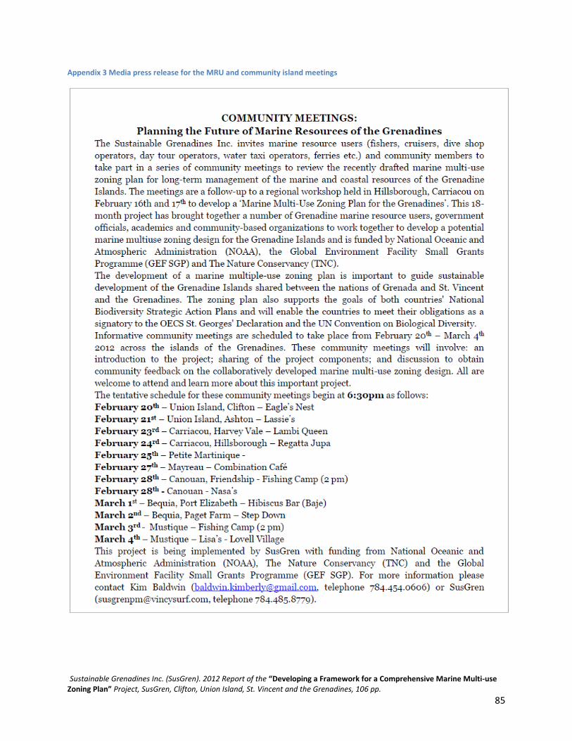
Sustainable Grenadines Inc. (SusGren). 2012 Report of the “Developing a Framework for a Comprehensive Marine Multi-use Zoning Plan” Project, SusGren, Clifton, Union Island, St. Vincent and the Grenadines, 106 pp.
85
Appendix 3 Media press release for the MRU and community island meetings

Sustainable Grenadines Inc. (SusGren). 2012 Report of the “Developing a Framework for a Comprehensive Marine Multi-use Zoning Plan” Project, SusGren, Clifton, Union Island, St. Vincent and the Grenadines, 106 pp.
86
Appendix 4 Summary of Laws Relevant to Marine Spatial Planning in Grenada and St. Vincent & the Grenadines
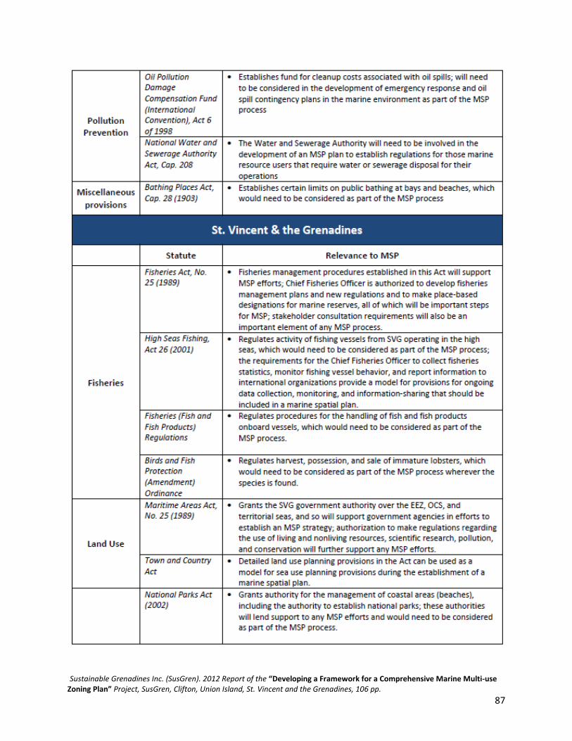
Sustainable Grenadines Inc. (SusGren). 2012 Report of the “Developing a Framework for a Comprehensive Marine Multi-use Zoning Plan” Project, SusGren, Clifton, Union Island, St. Vincent and the Grenadines, 106 pp.
87

Sustainable Grenadines Inc. (SusGren). 2012 Report of the “Developing a Framework for a Comprehensive Marine Multi-use Zoning Plan” Project, SusGren, Clifton, Union Island, St. Vincent and the Grenadines, 106 pp.
88

Sustainable Grenadines Inc. (SusGren). 2012 Report of the “Developing a Framework for a Comprehensive Marine Multi-use Zoning Plan” Project, SusGren, Clifton, Union Island, St. Vincent and the Grenadines, 106 pp.
89
Appendix 5 ELI Summary Policy Document for Stakeholders

Sustainable Grenadines Inc. (SusGren). 2012 Report of the “Developing a Framework for a Comprehensive Marine Multi-use Zoning Plan” Project, SusGren, Clifton, Union Island, St. Vincent and the Grenadines, 106 pp.
90

Sustainable Grenadines Inc. (SusGren). 2012 Report of the “Developing a Framework for a Comprehensive Marine Multi-use Zoning Plan” Project, SusGren, Clifton, Union Island, St. Vincent and the Grenadines, 106 pp.
91

Sustainable Grenadines Inc. (SusGren). 2012 Report of the “Developing a Framework for a Comprehensive Marine Multi-use Zoning Plan” Project, SusGren, Clifton, Union Island, St. Vincent and the Grenadines, 106 pp.
92

Sustainable Grenadines Inc. (SusGren). 2012 Report of the “Developing a Framework for a Comprehensive Marine Multi-use Zoning Plan” Project, SusGren, Clifton, Union Island, St. Vincent and the Grenadines, 106 pp.
93
Appendix 6 Marine Multiuse Zoning Project: Communication Strategy

Sustainable Grenadines Inc. (SusGren). 2012 Report of the “Developing a Framework for a Comprehensive Marine Multi-use Zoning Plan” Project, SusGren, Clifton, Union Island, St. Vincent and the Grenadines, 106 pp.
95

Sustainable Grenadines Inc. (SusGren). 2012 Report of the “Developing a Framework for a Comprehensive Marine Multi-use Zoning Plan” Project, SusGren, Clifton, Union Island, St. Vincent and the Grenadines, 106 pp.
96

Sustainable Grenadines Inc. (SusGren). 2012 Report of the “Developing a Framework for a Comprehensive Marine Multi-use Zoning Plan” Project, SusGren, Clifton, Union Island, St. Vincent and the Grenadines, 106 pp.
97

Appendix 7 Project Evaluation Survey

Sustainable Grenadines Inc. (SusGren). 2012 Report of the “Developing a Framework for a Comprehensive Marine Multi-use Zoning Plan” Project, SusGren, Clifton, Union Island, St. Vincent and the Grenadines, 106 pp.
99

Sustainable Grenadines Inc. (SusGren). 2012 Report of the “Developing a Framework for a Comprehensive Marine Multi-use Zoning Plan” Project, SusGren, Clifton, Union Island, St. Vincent and the Grenadines, 106 pp.
100
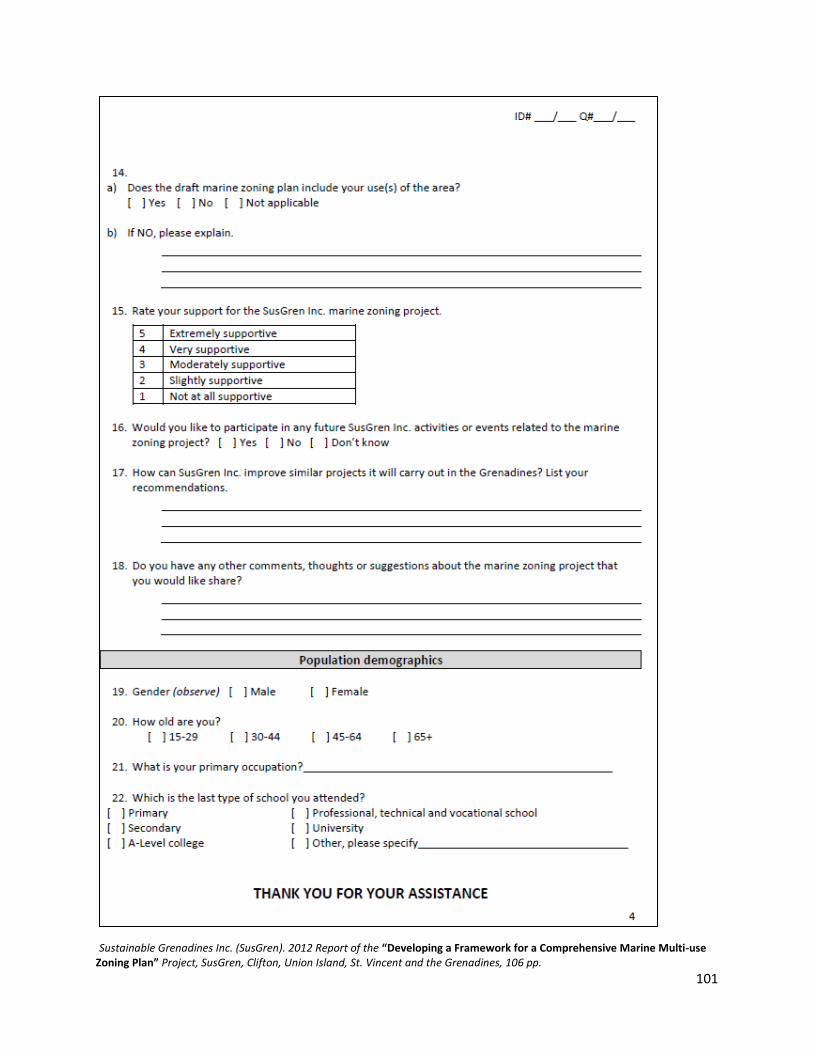
Sustainable Grenadines Inc. (SusGren). 2012 Report of the “Developing a Framework for a Comprehensive Marine Multi-use Zoning Plan” Project, SusGren, Clifton, Union Island, St. Vincent and the Grenadines, 106 pp.
101

Sustainable Grenadines Inc. (SusGren). 2012 Report of the “Developing a Framework for a Comprehensive Marine Multi-use Zoning Plan” Project, SusGren, Clifton, Union Island, St. Vincent and the Grenadines, 106 pp.
102
Appendix 8 Project Evaluation Survey Key Informant Interview

Sustainable Grenadines Inc. (SusGren). 2012 Report of the “Developing a Framework for a Comprehensive Marine Multi-use Zoning Plan” Project, SusGren, Clifton, Union Island, St. Vincent and the Grenadines, 106 pp.
103

Sustainable Grenadines Inc. (SusGren). 2012 Report of the “Developing a Framework for a Comprehensive Marine Multi-use Zoning Plan” Project, SusGren, Clifton, Union Island, St. Vincent and the Grenadines, 106 pp.
104

Sustainable Grenadines Inc. (SusGren). 2012 Report of the “Developing a Framework for a Comprehensive Marine Multi-use Zoning Plan” Project, SusGren, Clifton, Union Island, St. Vincent and the Grenadines, 106 pp.
105
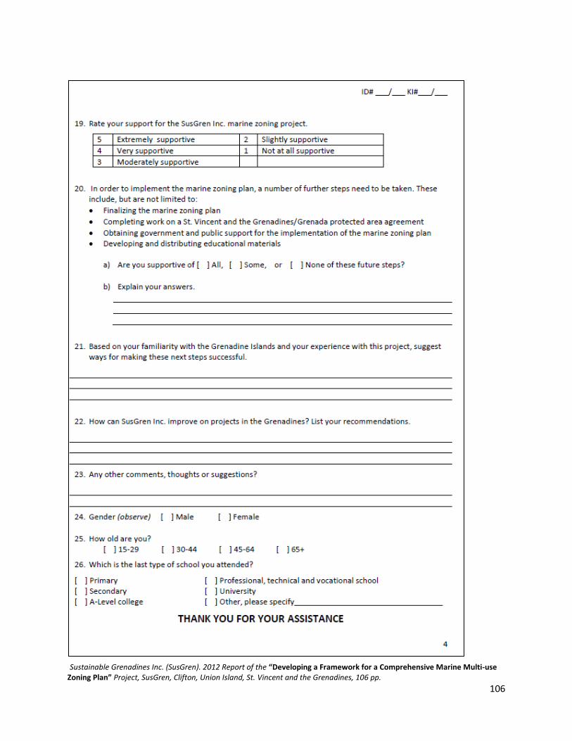
Sustainable Grenadines Inc. (SusGren). 2012 Report of the “Developing a Framework for a Comprehensive Marine Multi-use Zoning Plan” Project, SusGren, Clifton, Union Island, St. Vincent and the Grenadines, 106 pp.
106