determination of optimum site for artificial recharge aided geographical information system (gis)...
TRANSCRIPT
7/31/2019 Determination of Optimum Site for Artificial Recharge Aided Geographical Information System (GIS) & Logical Overl…
http://slidepdf.com/reader/full/determination-of-optimum-site-for-artificial-recharge-aided-geographical-information 1/8
International Journal of Modern Engineering Research (IJMER)www.ijmer.com Vol.2, Issue.6, Nov-Dec. 2012 pp-4111-4118 ISSN: 2249-6645
www.ijmer.com 4111 | Page
Ali Liaghat1
, Karim Hejazi Jahromi2
, Naeem Shahidi3
, Seyed Amir Shamsnia4
1,4 Department of Water Engineering, Shiraz Branch, Islamic Azad University, Shiraz, Iran.2,3 Post Graduate Student of Water Engineering and Member of young researcher’s club, Shiraz Branch, Islamic Azad
University, Shiraz, Iran.
ABSTRACT: In dry and semi-dry regions which face acking of water, using flood is one of the suitable solutions to prevent
destruction of agricultural and pasture lands and recharge of ground water aquifers. In this study, flood distribution which
is the most common in Iran was examined among various methods of artificial recharge. This study has been performed in
Sarpaniran catchment, located in Pasargad in Fars province, considered as one of the important agricultural, industrial and
residential centers. In order to flood distribution site selection, slope, surface infiltration, thickness of alluvium
(geomorphology), geology (formations) and lands application information layers have been used. Information layers werecombined based on intersect logical overlay function with Boolean logic in geographical information system (GIS) and
regions suitable for flood distribution were determined. The results of this study show that 2.3 percent of the total area of the
district is suitable for flood distribution. In examination of relation between using parameters and suitable places showed that geological factor (formations) is the limiting factor. The results indicate that due to the existence of several properties
which are effective in site selection and required analysis with evaluated criteria and their continuous changes,
geographical information system is an efficient tool for management and using site data in this field.
KeyWords: Site location, artificial recharge, Flood Distribution, Sarpaniran Catchment, Intersect Logical Overlay
Function, Geographical Information System (GIS)
I. INTODUCTIONConcerning climatic and geographical conditions, a vast area of Iran includes dry and semi-dry regions in a way that
74% of the country has annual rainfall less than 250mm. In fact, due to lack of precipitation, its unbalanced distributionregarding time and place and also inexistence of permanent rivers to provide water requirement in dry and semi-dry regions,
exploitation From groundwater resources is the most certain resource for water supply in these regions and done in a vastarea (12). Therefore, groundwater resources are considered as economical and social development factors in dry and semi-dry regions (17). Helping the increment of groundwater supplies is one of the useful ways in providing required water of various parts, especially in dry and semi-dry regions and confronting drought crisis.
Recharging ground waters is possible in natural and artificial ways. Physical (natural) recharge of a region is madeby water infiltration resulted from precipitations inside the ground, infiltration through river aquifers or through undergroundflows. Whereas water supply is a main factor of the development of a region and physical supply cannot meet needs, thus
artificial recharge has been developed (8,10, 4). Site selection of artificial recharge systems, specially flood distribution, isthe fundamental principles of making these systems. Selecting the location based on scientific and natural facts plays themost important role in the stability and application of these systems in the way of realizing relevant objectives (3, 19). To
prevent from problems due to the accumulation of sediments and increase of useful life of design and more efficiency of system regarding to the control of flood and achievement of considered objectives, site selection should be precisely madeconsidering return period flood and its mass, size, severity, rainfall distribution, flood quality, soil condition, geology
specifications, land slope, depth of groundwater aquifer, … (12).In a research for the examination of ground waters potential qualitatively and quantitatively by using GIS and RS,simple and weighted models were used. In this study information layers of the land’s shape, geology, faults, waterway,recharge condition map, compaction of materials and soil type were used and finally have determined regions withgroundwater potential and also regions suitable for ground waters artificial recharge. Results of this study show that remotesensing (RS) and GIS have high capability for the qualitative and quantitative examination of ground waters anddetermination of artificial recharge regions (18). In a research the application of Boolean Logic model in geographical
information system with the aim of natural resources management in Eshkanan, Lamerd desert region was done. In thisstudy, AND and OR operators of Boolean model have been used and after combining layers and different programs model of natural resources comprehensive management in deserts, suitable areas were recognized and categorized (6).
In another study capability and advantage of geographical information system and remote sensing emphasized as an
acceptable solution for decreasing expenses in site selection of suitable regions for artificial recharge of aquifers (9). Usingeffective information layers in recharge , such as topography, surface infiltration , alluvium thickness, quality of ground water
and lands usage with Boolean and Fuzzy models, ground water artificial recharges selection in Shoor desert, in geographicalinformation system and far-distance examination were done. The results has been shown that nearly 5 percent of the studiedregion is suitable and 19 percent is almost suitable for groundwater artificial recharge (3). In a research using GIS and RStechniques, uitable site selection for artificial recharge of ground water resources of Semnan desert was examined and theresults showed that using GIS and RS is an efficient tool for finding place for artificial recharge of ground water (9). In a
Determination of Optimum Site for Artificial Recharge Aided
Geographical Information System (GIS) & Logical Overlay
Function (Case Study: Sarpaniran Plain)

7/31/2019 Determination of Optimum Site for Artificial Recharge Aided Geographical Information System (GIS) & Logical Overl…
http://slidepdf.com/reader/full/determination-of-optimum-site-for-artificial-recharge-aided-geographical-information 2/8
International Journal of Modern Engineering Research (IJMER)www.ijmer.com Vol.2, Issue.6, Nov-Dec. 2012 pp-4111-4118 ISSN: 2249-6645
www.ijmer.com 4112 | Page
study, Geo statistical models for estimation of transferability and site selection of flood distribution maps, usingtransferability and special capacity data were compared. Their result indicate that Co Kriging method is a suitable method of
estimation when correlation coefficient is greater than 0.7(7). Using GIS techniques for determining proper regions forartificial recharge of coastal aquifers in the south of Iran a research was done and the results shown that about 12% of theanalyzed region is suitable and 8% is relatively suitable for aquifers artificial recharge (1). In another research capability of
artificial recharges of ground waters was addressed by using GIS and economical and environmental aspects (11). Therefore,the aim of this research is studying and determining the most suitable place for artificial recharge designs and places for
flood distribution and artificial recharge bed as well as studying the relation between different parts of the earth and suitableregions for ground waters artificial recharge.
II. Materials and MethodsStudying Region: The studying limitation is Sarpaniran plain. This region has been located in the distance of 120km. east-
northwards of Shiraz and 12 km. of east-northwards of Saadatshahr in Pasargad, Fars province. Sarpaniran plain is in thelimitation of 53°09´ to 53°30´ east longitude and 29°52´ to 30°09´ north latitude. The area of this region is 47288 hectorsand around 31663.24 m3 in a year water harvesting, is considered as an important agricultural, industrial and residential
center with about 90% water consumption in agriculture (figure 1).
Figure 1: Geographical situation of Studying Region
For physical (natural) and topographic evaluation in the manner of aquifer hydrologic specially temporary water supply dueto rainfall and its speed to the out of catchment through river system, Physical specifications of Sarpaniran catchment isobserved (table 1).
Table 1: Physical Specifications of Sarpaniran Catchment
For site selection of suitable regions for ground water artificial recharge through flood distribution, evaluatingindexes were selected in site selection. In this research 5 parameters (slope, surface infiltration, geomorphology, geology,and lands application) are analyzed and selected among effective factors in site selection of suitable regions for artificial
recharge through flood distribution. Flood distribution site selection operation performed by using GIS and logical commonmethod (common logical overlay) in Sarpaniran plain with the area of 47288 hectors and after throwing on four informationlayers of slope, surface infiltration, geomorphology and geology and suitable sites were identified. Then, corresponded with
lands application information layer and those regions where had application limitation separated and the best regions forflood distribution were determined.Region slope map: To prepare slope map, digital elevation model (dem) was used. In this research elevation contour lines of digital topography maps have been used as a primary data to make digital elevation model. Using digital elevation model,the slope map of catchment plain in GIS environment was prepared based on points’ elevation in the earth digital model and
their distance from each other, slope map of the region on percent (figure 2). The area and percent of slope of each class hasbeen also presented (table 2).
Table 2: Area and percentage of area of each slope class in Sarpaniran plain
Area (Percent)Area (Hectare)Classes range
(Percent)Slope class
23.6111163.40 - 3apt
76.3936117.94> 3inapt
GraveliusForm FactorTimeof
Concentration Circle RatioPhysical
Specifications
1.690.296.350.34level

7/31/2019 Determination of Optimum Site for Artificial Recharge Aided Geographical Information System (GIS) & Logical Overl…
http://slidepdf.com/reader/full/determination-of-optimum-site-for-artificial-recharge-aided-geographical-information 3/8
International Journal of Modern Engineering Research (IJMER)www.ijmer.com Vol.2, Issue.6, Nov-Dec. 2012 pp-4111-4118 ISSN: 2249-6645
www.ijmer.com 4113 | Page
Figure 2: Slope map of Sarpaniran plain
Surface Infiltration Map: To prepare surface infiltration map by field operation, 17 points were selected for measuring thesoil penetration (filtration) and double-ring method was used. The best method for variable interpolation is the one which hasthe least RMS. In this research the best interpolation method is Kriging model of circular type with the RMS equal to 7.876
(table 4). Thus, to convert point map to raster map the same interpolation was used. Surface infiltration map has been shownin figure 3. The extent and percent of area of each infiltration class was presented in table 3.
Table 3: Area and percent of area of each infiltration class Table 4: RMS results, interpolation methods for preparing surface infiltration map
RMS Interpolation methodRMS Interpolation methodRMS Interpolation method
12.67CoKriging
(pent spherical)8.19
Kriging(Gaussian)
10.14Inverse Distance
Weighting
12.61CoKriging
(exponential)8.53
Kriging(rational quadratic)
14.47Global Polynomial
Interpolation
12.67CoKriging(Gaussian)
50.93Kriging
(hole effect)12.69
Local PolynomialInterpolation
12.58CoKriging
(rational quadratic)30.57
Kriging(k - Bessel)
9.19Radial Basis Functions
11.34CoKriging
(hole effect)51.45
Kriging(j - Bessel)
7.18Kriging
(circular)
12.67CoKriging(k - Bessel)
36.3Kriging(stable)
7.98Kriging
(spherical)
11.65CoKriging(j - Bessel)
12.68CoKriging(circular)
8.04Kriging
(tetra spherical)
12.67CoKriging
(stable)12.67
CoKriging(spherical)
8.08Kirging
(pent spherical)
12.67CoKriging(tetraspherical)8.61Kriging(exponential)
Area(Percent)
Area(Hectare)
Classes range(mm/hr)
Infiltration class
87.7441490.270 - 25apt
12.265797.03> 25inapt

7/31/2019 Determination of Optimum Site for Artificial Recharge Aided Geographical Information System (GIS) & Logical Overl…
http://slidepdf.com/reader/full/determination-of-optimum-site-for-artificial-recharge-aided-geographical-information 4/8
International Journal of Modern Engineering Research (IJMER)www.ijmer.com Vol.2, Issue.6, Nov-Dec. 2012 pp-4111-4118 ISSN: 2249-6645
www.ijmer.com 4114 | Page
Figure 3: Surface Infiltration Map of Sarpaniran plain
Geomorphology Map: First, in order to provide the alluvium thickness plan concerning the region’s area 35 well visitedprovided by Fars Regional Water Organization in 2010 were used. Next, for preparing raster plan from point plan, Kriging
method, Gaussian type with RMS equal to 5.105 was chosen (table 6). Alluvium thickness plan has been shown in figure 4.Area extent and percentage of each alluvium thickness class was presented in table 5 as well.
Table 5- Area and area percentage of each alluvium thickness class
Area (Percent)Area (Hectare)Classes range (m)Alluvium thickness class
61.6629157.790 - 8apt
38.3418130> 8inapt
Table 6- RMS results, interpolation methods for preparing alluvium thickness plan
RMS Interpolation methodRMS Interpolation methodRMS Interpolation method
5.62CoKriging
(pent spherical)5.1
Kriging(Gaussian)
6.8Inverse Distance
Weighting
6.02CoKriging
(exponential)5.98
Kriging(rational quadratic)
9.1Global Polynomial
Interpolation
5.26CoKriging
(Gaussian)6.14
Kriging
(hole effect)5.71
Local Polynomial
Interpolation
5.83CoKriging
(rational quadratic)5.19
Kriging(k - Bessel)
5.12Radial Basis
Functions
6.54CoKriging
(hole effect)6.18
Kriging(j - Bessel)
5.63Kriging
(circular)
5.24CoKriging(k - Bessel)
5.22Kriging(stable)
5.59Kriging(spherical)
6.56CoKriging
(j - Bessel)5.56
CoKriging
(circular)5.61
Kriging
(tetraspherical)
5.34CoKriging
(stable)5.59
CoKriging(spherical)
5.63Kirging
(pent spherical)
5.6CoKriging
(tetraspherical)6.1
Kriging(exponential)

7/31/2019 Determination of Optimum Site for Artificial Recharge Aided Geographical Information System (GIS) & Logical Overl…
http://slidepdf.com/reader/full/determination-of-optimum-site-for-artificial-recharge-aided-geographical-information 5/8
International Journal of Modern Engineering Research (IJMER)www.ijmer.com Vol.2, Issue.6, Nov-Dec. 2012 pp-4111-4118 ISSN: 2249-6645
www.ijmer.com 4115 | Page
Figure 4- Sarpaniran desert alluvium thickness class.
Lands Usage Plan: In order to produce this information layer, lands usage plan provided by Agricultural Jihad Departmentof Pasargad, provided for the whole town in 2006 was used. For this purpose, results of combining information layers are
used for determining regions suitable for distribution of flood. The resulted plan was overlaid with lands usage plan toseparate the regions with usage limitations from areas suitable for flood distribution; because flood distribution operationexecution in agricultural lands and other regions with limitation is not possible due to social tensions. Lands usage plan has
been shown in Figure 5 and area and percentage of each usage was presented in table 7.
Table7- Area and percentage of pasture and non-pasture usage of Sarpaniran desert
Area (Percent)Area (Hectare)UserLand class
48.6623011.22Pastureapt
51.3424276.04non-pastureinapt
Figure5- Sarpaniran desert lands usage plan
7/31/2019 Determination of Optimum Site for Artificial Recharge Aided Geographical Information System (GIS) & Logical Overl…
http://slidepdf.com/reader/full/determination-of-optimum-site-for-artificial-recharge-aided-geographical-information 6/8
International Journal of Modern Engineering Research (IJMER)www.ijmer.com Vol.2, Issue.6, Nov-Dec. 2012 pp-4111-4118 ISSN: 2249-6645
www.ijmer.com 4116 | Page
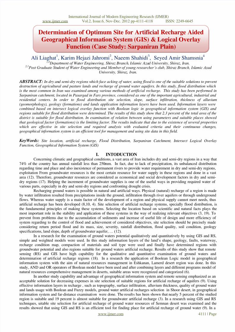
Combining Information Layers & Data Analysis:Slop basic map, surface infiltration, geological and desert’s sediments thickness plans based on logical overlay
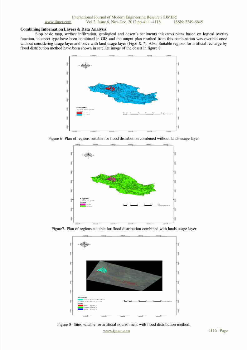
function, intersect type have been combined in GIS and the output plan resulted from this combination was overlaid oncewithout considering usage layer and once with land usage layer (Fig.6 & 7). Also, Suitable regions for artificial recharge byflood distribution method have been shown in satellite image of the desert in figure 8
Figure 6- Plan of regions suitable for flood distribution combined without lands usage layer
Figure7- Plan of regions suitable for flood distribution combined with lands usage layer
Figure 8- Sites suitable for artificial nourishment with flood distribution method.

7/31/2019 Determination of Optimum Site for Artificial Recharge Aided Geographical Information System (GIS) & Logical Overl…
http://slidepdf.com/reader/full/determination-of-optimum-site-for-artificial-recharge-aided-geographical-information 7/8
International Journal of Modern Engineering Research (IJMER)www.ijmer.com Vol.2, Issue.6, Nov-Dec. 2012 pp-4111-4118 ISSN: 2249-6645
www.ijmer.com 4117 | Page
hen results of relation between layers and sites suitable for flood distribution by omission of selected layers, amount of suitable regions changes and the most important limiting factor in the area was determined. Since slop and usage information
layers made the least limitation in the final combining, started to omit other layers one by one and its results was presented infigures 9 to 11.
Figure 9- Plan of regions suitable for flood distribution without geological layerFigure10- Plan of regions suitable for flood distribution without infiltration layer
Figure11- Plan of regions suitable for flood distribution without alluvium thickness layer
III. Discussion & Conclusion Flood distribution site selection studies are of high importance because of being the basis of aquifer and ground
floor waters artificial nourishment studies. Since a group of condition (suitable and non-suitable) was used in this study andbecause the goal is site selection, therefore, logical overlay function, intersect type was used. Flood distribution site selectionoperation was done by using geographic Information System and logical intersect method in Sarpaniran desert with 47288hectares area, after lapping 4 information layer of slop, surface infiltration, alluvium thickness and geology and suitable siteswere determined. It was then combined with lands usage layer and the regions with usage limitation were separated and thebest regions for flood distribution were determined. Geological plan of the region showed that Sarpaniran desert has varietyof formation in a way that the most and the least formation area of the desert related to kk formation equal to 33.79 percent
and Bakhtiari formation with 0.09 percent form total area of the region. Quaternary formation is the important formation forflood distribution which forms 12.05 percent of the district’s area.
The results of this study showed that despite the fact that slop, lands usage and alluvium thickness layers are
suitable for artificial recharge in flood distribution method, since quaternary areas form a percentage of the total district andother formations except Bakhtiari Congolmerate formation is not suitable in flood distribution view, it affects infiltration of the district in a way that 12.26 percent of the district is among regions suitable for infiltration, for executing this operation.
So one could say that, geological factors (formations) and surface infiltration are among limiting factors which face suchplans with limitation. Ghermezcheshmeh (2000), Al-e-Sheikh (2002), Soltani (2002) and Noori (2003) all have determinedsuitable sites for flood distribution using geographical information system which correspond with result of this study.

7/31/2019 Determination of Optimum Site for Artificial Recharge Aided Geographical Information System (GIS) & Logical Overl…
http://slidepdf.com/reader/full/determination-of-optimum-site-for-artificial-recharge-aided-geographical-information 8/8
International Journal of Modern Engineering Research (IJMER)www.ijmer.com Vol.2, Issue.6, Nov-Dec. 2012 pp-4111-4118 ISSN: 2249-6645
www.ijmer.com 4118 | Page
In general, after combining 4 information layers of slop, geology, surface infiltration and alluvium thicknesswithout considering region’s land usage based on figure 6 the amount of suitable regions for flood distribution is 1162.03
hectares that forms around 2.46 percent of total of the district, however after combining plan of sites suitable for flooddistribution with the region’s land usage plan, based on figure 7 amount of suitable regions for flood distribution decreasedabout 0.2 percent, it means reached an amount equal to 1088.32 hectares that forms 2.3 percent of the district. Thus from the
above combination it could be concluded that geological factor is the most limiting layer in determining regions suitable forflood distribution and infiltration and alluvium thickness factors are the next limiting factors. In general, the most important
limiting factor in suitable lands class, related to alluvium thickness factor and in non-suitable lands class is related togeological factor.
Resources1- Arasteh, P.D. and S.R. Vahhadj. Simulation of groundwater flow in an artificial recharge system. Proc. 8th
International Conference on Water Resour. Manage., Isfahan, Iran, 1997. pp. 79 – 87. 2- Asano, Takashi, Artificial recharge of groundwater, California states water resources pp. 69-96.3- Berger. D.L. Ground - water recharge through active sand dunes in northwestern Nevada. Water Resour. Bull. 1992.
28(5) : 959-9654- Ghayoumian, J., Mohseni Saravi, M., Feiznia, S., Nouri, B. and Malekian, A., Application of GIS techniques to
determine areas most suitable for artificial groundwater recharge in a coastal aquifer in southern Iran, Journal of Asian Earth Sciences, Volume 30, Issue 2, 2007. PP 364-374.
5- Ghermezcheshme, B., and etal . Determination of Quaternary deposits of flood-prone areas. Ms C Thesis, (case study :Northeast of Esfahan).2000. pp. 128-131
6- Hatefi Ardekani, A.H., and rezaee Rad, N., 2011. GIS and RS techniques for artificial recharge of groundwater
resources located in Semnan plain. Seventh National Seminar on Watershed Management Sciences and Engineering.7- Hashemi Tangestani, M.,and Raoufat, M.R. Boolean logic models in GIS applications to natural resources management
in arid region Ashknan of Fars. Conference Application of remote sensing and geographic information systems of deserts.2000. Pp 6
8- Heydarpour, J. Artificial recharge of groundwater aquifers. Iran University Press. 1990. pp 226.9 Jalalvand, A., Kallantari, N. and Keshavarzi, M.R.. Locate suitable sites for artificial recharge of groundwater using
remote sensing and GIS. 10th Symposium of Geological Society of Iran. 200610- Kiaheydari, J. The function of the Flood Plain aquifer recharges Moghar in Isfahan. Master thesis Irrigation and
Drainage, College of Agriculture, Isfahan University of Technology.2003.11- Krishnomurthy, J., N. Kumar, V. Jayaraman & M. Manivel. An Approach to Demarcate Ground Water Potential Zones
Thorough Remote Sensing and a Geographical Information System, INT. J. Remote Sensing, 17(10). 1998. 1867-188412- Kousar, A., Artificial recharge of groundwater aquifers in the watershed extension methods. Olive Magazine. Volume
46 & 47. 1985. PP 16-19 & 20-23.13- Mahdian, M.H,. Flooding problem and the need to exploit. First Workshop on management and utilization of water.
Soil Conservatoin and Watershed Management Research Institute.1999.14- Noori, B., Designated areas for groundwater supply using remote sensing data and Geographic Information System.
Master's thesis. University of Tehran.2003.
15- Pedrero, F., Albuquerque, A., Marecos do Monte, A., Cavaleiro, V., Alarcón, A., Application of GIS-based multi-criteria analysis for site selection of aquifer recharge with reclaimed water, Resources, Conservation and Recycling,Volume 56, Issue 1, 2011. PP 105-116
16- Ramalingam, M. and Santhakumar, A.R., Case study on artificial recharge using Remote Sensing and GIS. 2004. 17- Rezaee, M., and Fakhr bahabadi, M.R., Location of the artificial recharge of groundwater using GIS and remote
sensing in the Shurro Plains. 4th Conference of Applied Geology and the Environment. 2008.
18- Salajeghe Tazraji, E.A., Dehloran plain hydrological modeling using remote sensing and GIS. Department of Geography, Tarbiat Modares University. 1998.19- Samani, N. and S. Behrooz. Optimal distribution of artificial recharge and its stability. Proc. 8th International
Conference on Rainwater Catchment Systems, Tehran, Iran, 1997. pp. 182 - 189 .20- Soltani, M.J., Land evaluation in order to locate areas prone to flooding broadcast operations in a GIS environment.
Master's thesis. K.N. Toosi University of Technology. 2002. pp 97.