detailed flora and vegetation assessment
TRANSCRIPT

Prepared for 5 Star Margaret River Pty Ltd May 2021
Detailed Flora and Vegetation Assessment Lot 783 Mitchell Drive, Lots 501, 502 and 504
Reef Drive and Lot 503 Seagrass Place,
Gnarabup Project No: EP20-008(06)

Detailed Flora and Vegetation Assessment Lot 783 Mitchell Drive, Lots 501, 502 and 504 Reef Drive and Lot 503 Seagrass Place, Gnarabup
Prepared for 5 Star Margaret River Pty Ltd Doc No.: EP20-008(06)—005a RAW| Version: A
Project number: EP20-008(06)|May 2021 Page i
Document Control
Doc name: Detailed Flora and Vegetation Assessment
Lot 783 Mitchell Drive, Lots 501, 502 and 504 Reef Drive and Lot 503 Seagrass Place, Gnarabup
Doc no.: EP20-008(06)—005a RAW
Version Date Author Reviewer
1 April 2021 Rachel Weber RAW Tom Atkinson TAA
Submitted for client review
A May 2021 Rachel Weber RAW Tom Atkinson TAA
Minor updates following client review
© 2021 Emerge Associates All Rights Reserved. Copyright in the whole and every part of this document belongs to Emerge Associates and may not be used, sold, transferred, copied or reproduced in whole or in part in any manner or form or in or
on any media to any person without the prior written consent of Emerge Associates.

Detailed Flora and Vegetation Assessment Lot 783 Mitchell Drive, Lots 501, 502 and 504 Reef Drive and Lot 503 Seagrass Place, Gnarabup
Prepared for 5 Star Margaret River Pty Ltd Doc No.: EP20-008(06)—005a RAW| Version: A
Project number: EP20-008(06)|May 2021 Page ii
Executive Summary
5 Star Margaret River Pty Ltd engaged Emerge Associates to conduct a detailed assessment of the
flora and vegetation values within Lot 783 Mitchell Drive, Lots 501, 502 and 504 Reef Drive, Lot 503
Seagrass Place and portions of adjacent public land in Gnarabup (referred to herein as the ‘site’).
As part of the assessment a desktop review of relevant background information was completed and a
field survey was undertaken in September and October 2020. During the field survey an assessment
was made on the type, condition and values of vegetation across the site.
Outcomes of the survey include the following:
• A total of 54 native and 28 non-native (weed) species were recorded in the site.
• No threatened or priority flora species were recorded within the site and none are considered
likely to occur.
• Two plant communities were identified within the site: MhScAlSg and non-native/cleared.
• Plant community MhScAlSg comprises native heathland vegetation and extends over 12.38 ha
(90% of the site).
• Plant community non-native/cleared extends over 1.35 ha (10% of the site).
• Most of the site comprises MhScAlSg vegetation in ‘very good’ condition (11.6 ha/84% of the
site). The remainder of the MhScAlSg vegetation is in ‘good’ (0.21 ha/2% of the site), ‘degraded’
(0.51 ha/4% of the site) and ‘degraded – completely degraded’ (0.06 ha /<1% of the site).
• The non-native/cleared areas were mapped as being in ‘completely degraded’ condition
(1.35 ha/10% of the site).
• No threatened or priority ecological communities were recorded in the site or considered likely
to occur.
• The vegetation within the site contributes to broader ecological linkages but disturbance to the
site would not disrupt these linkages.
Detailed Flora and Vegetation Assessment Lot 783 Mitchell Drive, Lots 501, 502 and 504 Reef Drive and Lot 503 Seagrass Place, Gnarabup
Prepared for 5 Star Margaret River Pty Ltd Doc No.: EP20-008(06)—005a RAW| Version: A
Project number: EP20-008(06)|May 2021 Page iii
This page has been left blank intentionally.
Detailed Flora and Vegetation Assessment Lot 783 Mitchell Drive, Lots 501, 502 and 504 Reef Drive and Lot 503 Seagrass Place, Gnarabup
Prepared for 5 Star Margaret River Pty Ltd Doc No.: EP20-008(06)—005a RAW| Version: A
Project number: EP20-008(06)|May 2021 Page iv
Table of Contents
1 Introduction ......................................................................................................................... 1
1.1 Project background..................................................................................................................................1 1.2 Purpose and scope of work .....................................................................................................................1
2 Environmental Context ........................................................................................................... 2
2.1 Climate......................................................................................................................................................2 2.2 Geomorphology and soils........................................................................................................................2 2.3 Topography ..............................................................................................................................................3 2.4 Hydrology and wetlands..........................................................................................................................3 2.5 Regional vegetation .................................................................................................................................3 2.6 Historical land use....................................................................................................................................4 2.7 Conservation significant flora and vegetation .......................................................................................5
2.7.1 Threatened and priority flora.................................................................................................5 2.7.2 Threatened and priority ecological communities .................................................................5 2.7.3 Local and regional significance...............................................................................................6
2.8 Weeds and pests ......................................................................................................................................6 2.9 Environmentally sensitive areas .............................................................................................................6 2.10 DBCA managed or legislated lands .........................................................................................................7 2.11 Ecological linkages ...................................................................................................................................7 2.12 Previous surveys ......................................................................................................................................8
3 Methods .............................................................................................................................. 9
3.1 Desktop assessment ................................................................................................................................9 3.2 Field survey ..............................................................................................................................................9
3.2.1 Flora and vegetation ...............................................................................................................9 3.3 Mapping and analysis ........................................................................................................................... 10
3.3.1 Conservation significant flora and vegetation ................................................................... 10 3.3.2 Plant community identification and description ............................................................... 11 3.3.3 Threatened and ecological communities ........................................................................... 11 3.3.4 Species accumulation curve ................................................................................................ 11
3.4 Survey limitations ................................................................................................................................. 11
4 Results ............................................................................................................................... 13
4.1 General site conditions......................................................................................................................... 13 4.2 Flora ....................................................................................................................................................... 13
4.2.1 Desktop assessment ............................................................................................................ 13 4.2.2 Species inventory ................................................................................................................. 14 4.2.3 Threatened and priority flora.............................................................................................. 14 4.2.4 Locally and regionally significant flora ............................................................................... 14 4.2.5 Declared pests ...................................................................................................................... 14
4.3 Vegetation ............................................................................................................................................. 14 4.3.1 Desktop assessment ............................................................................................................ 14 4.3.2 Plant communities ............................................................................................................... 15 4.3.3 Vegetation condition ........................................................................................................... 18 4.3.4 Threatened and priority ecological communities .............................................................. 18 4.3.5 Locally and regionally significant vegetation ..................................................................... 18
4.4 Species richness .................................................................................................................................... 18

Detailed Flora and Vegetation Assessment Lot 783 Mitchell Drive, Lots 501, 502 and 504 Reef Drive and Lot 503 Seagrass Place, Gnarabup
Prepared for 5 Star Margaret River Pty Ltd Doc No.: EP20-008(06)—005a RAW| Version: A
Project number: EP20-008(06)|May 2021 Page v
5 Discussion .......................................................................................................................... 20
5.1 Threatened and priority flora .............................................................................................................. 20 5.2 Plant communities ................................................................................................................................ 20 5.3 Vegetation condition ............................................................................................................................ 20 5.4 Threatened and priority ecological communities............................................................................... 21 5.5 Local and regional significance ............................................................................................................ 21
6 Conclusions ........................................................................................................................ 22
7 References ......................................................................................................................... 23
7.1 General references ............................................................................................................................... 23 7.2 Online references.................................................................................................................................. 25
List of Tables
Table 1: Vegetation condition scale applied during the field assessment ............................................................... 10 Table 2: Likelihood of occurrence assessment categories and definitions .............................................................. 11 Table 3: Evaluation of survey methodology against standard constraints outlined in (EPA 2016)........................ 12 Table 4: Conservation significant flora species considered to have potential to occur in the site based on known
habitat preferences ......................................................................................................................................... 13 Table 5: Description and extent of plant communities identified within the site ................................................... 15 Table 6: Extent of vegetation condition categories within the site .......................................................................... 18
List of Plates
Plate 1: Aerial imagery from 1 March 2012 showing evidence of fire within the site, with the general location of site shown by red outline ..................................................................................................................................4
Plate 2: Plant community MhScAlSg in ‘very good’ condition (shrubland form) .................................................... 16 Plate 3: Plant community MhScAlSg in ‘very good’ condition (tall shrubland form) .............................................. 16 Plate 4: Plant community non-native/cleared in ‘completely degraded’ condition (with non-native vegetation)
17 Plate 5: Plant community non-native/cleared in ‘completely degraded’ condition (with bare ground).............. 17 Plate 6: Species accumulation curve derived from sample data (y =7.2745ln(x) + 12.989, ................................... 19
Figures
Figure 1: Site Location Figure 2: Soils and Topography Figure 3: Environmental Features Figure 4: Plant Communities Figure 5: Vegetation Condition

Detailed Flora and Vegetation Assessment Lot 783 Mitchell Drive, Lots 501, 502 and 504 Reef Drive and Lot 503 Seagrass Place, Gnarabup
Prepared for 5 Star Margaret River Pty Ltd Doc No.: EP20-008(06)—005a RAW| Version: A
Project number: EP20-008(06)|May 2021 Page vi
Appendices
Appendix A
Additional Information
Appendix B
Conservation Significant Flora Species and likelihood of Occurrence Assessment
Appendix C
Species List
Appendix D
Conservation Significant Communities and Likelihood of Occurrence Assessment
Appendix E
Sample Data

Detailed Flora and Vegetation Assessment Lot 783 Mitchell Drive, Lots 501, 502 and 504 Reef Drive and Lot 503 Seagrass Place, Gnarabup
Prepared for 5 Star Margaret River Pty Ltd Doc No.: EP20-008(06)—005a RAW| Version: A
Project number: EP20-008(06)|May 2021 Page vii
Abbreviation Tables
Table A1: Abbreviations – Organisations
Organisations
EPA Environmental Protection Authority
DBCA Department of Biodiversity, Conservation and Attractions
DoW Department of Water (now DWER)
DWER Department of Water and Environmental Regulation
DPaW Department of Parks and Wildlife
WALGA Western Australia Local Government Association
Table A2: Abbreviations – General terms
General terms
ESA Environmentally sensitive area
IBRA Interim Biogeographic Regionalisation of Australia
NVIS National Vegetation Inventory System (ESCAVI 2003)
P1 Priority 1
P2 Priority 2
P3 Priority 3
P4 Priority 4
P5 Priority 5
PEC Priority ecological community
T Threatened
TEC Threatened ecological communities

Detailed Flora and Vegetation Assessment Lot 783 Mitchell Drive, Lots 501, 502 and 504 Reef Drive and Lot 503 Seagrass Place, Gnarabup
Prepared for 5 Star Margaret River Pty Ltd Doc No.: EP20-008(06)—005a RAW| Version: A
Project number: EP20-008(06)|May 2021 Page viii
Table A3: Abbreviations –Legislation
Legislation
BAM Act Biosecurity and Agriculture Management Act 2007
EP Act Environmental Protection Act 1986
EPBC Act Environment Protection and Biodiversity Conservation Act 1999
BC Act Biodiversity Conservation Act 2016
BC Regs Biodiversity Conservation Regulations 2018
Table A4: Abbreviations – Units of measurement
Units of measurement
cm Centimetre
ha Hectare
m Metre
m AHD m in relation to the Australian height datum
mm Millimetre

Detailed Flora and Vegetation Assessment Lot 783 Mitchell Drive, Lots 501, 502 and 504 Reef Drive and Lot 503 Seagrass Place, Gnarabup
Prepared for 5 Star Margaret River Pty Ltd Doc No.: EP20-008(06)—005a RAW| Version: A
Project number: EP20-008(06)|May 2021 Page ix
This page has been left blank intentionally.

Detailed Flora and Vegetation Assessment Lot 783 Mitchell Drive, Lots 501, 502 and 504 Reef Drive and Lot 503 Seagrass Place, Gnarabup
Prepared for 5 Star Margaret River Pty Ltd Doc No.: EP20-008(06)—005a RAW| Version: A
Project number: EP20-008(06)|May 2021 Page 1
1 Introduction
1.1 Project background
Emerge Associates (Emerge) were engaged by 5 Star Margaret River Pty Ltd to characterise the flora
and vegetation values within multiple lots in Gnarabup. Specifically, this assessment was undertaken
within Lot 783 Mitchell Drive, Lots 501, 502 and 504 Reef Drive, Lot 503 Seagrass Place (5 Star
Margaret River Pty Ltd landholdings) and portions of the adjacent public land in Gnarabup including
areas previously reserved for recreation purposes (collectively referred to herein as the ‘site’). The
site is located approximately eight kilometres (km) south west of Margaret River town in the south
west of Western Australia within the Shire of Augusta Margaret River.
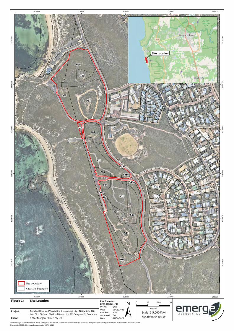
The site is approximately 13.73 hectares (ha) in size and is generally bounded by Wallcliffe Road to
the east, Ocean View Road, Reef Road and Seagrass Place to the west and Breeze Cove to the south.
The location and extent of the site is shown in Figure 1.
1.2 Purpose and scope of work
The scope of work was specifically to undertake a flora and vegetation assessment within the site to
the standard required of a detailed survey with reference to the Environmental Protection
Authority’s (EPA’s) technical guidance (EPA 2016).
As part of this scope of work, the following tasks were undertaken:
• Desktop review of relevant background information pertaining to the site and surrounds,
including database searches for threatened flora species and ecological communities.
• A field survey to record a comprehensive list of flora species and assess vegetation type and
condition.
• Mapping of plant communities, vegetation condition and conservation significant flora and
vegetation.
• Identification of potential habitat for conservation significant flora and vegetation and an
assessment of likelihood of occurrence.
• Documentation of the desktop assessment, methodology, field survey and results into a report.

Detailed Flora and Vegetation Assessment Lot 783 Mitchell Drive, Lots 501, 502 and 504 Reef Drive and Lot 503 Seagrass Place, Gnarabup
Prepared for 5 Star Margaret River Pty Ltd Doc No.: EP20-008(06)—005a RAW| Version: A
Project number: EP20-008(06)|May 2021 Page 2
2 Environmental Context
2.1 Climate
Climate influences the types of vegetation that grow in a region and the life cycles of the flora
present. It is therefore critical for a flora and vegetation survey to respond appropriately to climatic
conditions to ensure that surveys are conducted during times when flora species are easiest to
detect and identify.
The south west of Western Australia experiences a Mediterranean climate of hot dry summers and
cool wet winters. In Mediterranean type climates some flora species will typically spend part of their
lifecycle as either underground storage organs or as seed. This is an adaptation to unfavourable
environmental conditions such as excessive heat and drought that occur over the summer period.
These species, known as ‘geophytes’ or ‘annuals’, tend to re-emerge during winter when favourable
conditions return and are most visible during spring, which is the flowering period for a majority of
plant species. Therefore, spring is the optimal time to complete flora and vegetation surveys in the
south west of WA.
An average of 1122.0 millimetres (mm) of rainfall is recorded annually from the Margaret River
weather station (no. 9574), which is the closest weather station, located approximately 7 km north
east of the site. The majority of this rainfall is received between the months of May and September.
Mean maximum temperatures at the Witchcliffe weather station (no. 9746), which is the nearest
active temperature recording station approximately 10 km south-east of the site, range from 16.4°C
in July to 27.2°C in February, while mean minimum temperatures range from 8.2°C in July to 14.4°C
in February (BoM 2021).
A total of 665.2 mm of rain was recorded from May to August 2020 prior to the survey, which is
approximately 88% of the mean of 753.1 mm for this period (BoM 2021). The amount of rainfall
recorded prior to the survey is similar to the mean and was considered to have been sufficient to
promote the flowering and emergence of native flora.
2.2 Geomorphology and soils
Landform and soils influence fauna habitat and species at regional and local scales. The site lies in the
Warren bioregion and subregion, as defined by the Interim Biogeographic Regionalisation of
Australia (IBRA) (Environment Australia 2000). The Warren bioregion follows the coastline from
Yallingup in the north-west to Albany in the south-east.
The Department of Primary Industries and Regional Development (DPIRD) has compiled data from
various surveys to produce a soil landscape mapping dataset for Western Australia, which places the
site within the ‘Kilcarnup exposed dunes (organic) Phase’ (DPIRD 2019). This soil landscape system is
described as being steep dunes (gradients usually in excess of 20%) exposed to prevailing winds
which come directly off the ocean. It has deep pale calcareous sands with brown topsoil (DPIRD
2019)
The locations of the soil landscapes mapped within and adjacent to the site are shown in Figure 2.

Detailed Flora and Vegetation Assessment Lot 783 Mitchell Drive, Lots 501, 502 and 504 Reef Drive and Lot 503 Seagrass Place, Gnarabup
Prepared for 5 Star Margaret River Pty Ltd Doc No.: EP20-008(06)—005a RAW| Version: A
Project number: EP20-008(06)|May 2021 Page 3
The site is not known to contain any restricted landforms or unique geological features.
2.3 Topography
The elevation of the site ranges from 6 m in relation to the Australian height datum (mAHD) in the
north eastern portion to 30 mAHD in the southern portion of the site (DPIRD 2020) (Figure 2).
2.4 Hydrology and wetlands
Wetlands are areas of seasonally, intermittently or permanently waterlogged land such as poorly
drained soils, ponds, billabongs, lakes, swamps, tidal flats, estuaries, rivers and their tributaries
(Wetlands Advisory Committee 1977). Wetlands can be recognised by the presence of vegetation
associated with waterlogging or the presence of hydric soils such as peat, peaty sand or carbonate
mud (Hill et al. 1996).
Wetlands of national or international significance may be afforded special protection under
Commonwealth or international agreements. The following lists of important wetlands were
checked as part of this assessment:
• Ramsar List of Wetlands of International Importance (DBCA 2017c)
• A Directory of Important Wetlands in Australia (DBCA 2018a).
No Ramsar or listed ‘important wetlands’ are located within or near the site.
Examination of the Department of Water and Environmental Regulation (DWER) hydrography
dataset (DWER 2018) shows no wetland or water related features within the site.
The Department of Biodiversity, Conservation and Attractions (DBCA) has developed the Geomorphic
Wetlands Leeuwin Naturaliste Ridge and Donnybrook to Nannup - Unreviewed dataset (DBCA 2018b).
This dataset maps geomorphic wetland features and classifies them based on their landform shape
and water permanence.
A review of the Geomorphic Wetlands Leeuwin Naturaliste Ridge and Donnybrook to Nannup -
Unreviewed dataset indicated that no wetland features occur within the site. The closest mapped
wetland feature is located approximately 300 m north east of the site.
2.5 Regional vegetation
Native vegetation is described and mapped at different scales in order to illustrate patterns in its
distribution. At a continental scale the Interim Biogeographic Regionalisation of Australia (IBRA)
divides Australia into floristic subregions (Environment Australia 2000).
The site is contained within the Warren IBRA region and ‘WAR01’ subregion. The Warren subregion is
characterised as comprising tall Eucalyptus diversicolor (karri) on deep loams or forest or Eucalyptus
marginata (jarrah) to Corymbia calophylla (marri) on leached sands and extensive Melaleuca
(paperbark) and sedge swamps in valleys (Beard 1990).

Detailed Flora and Vegetation Assessment Lot 783 Mitchell Drive, Lots 501, 502 and 504 Reef Drive and Lot 503 Seagrass Place, Gnarabup
Prepared for 5 Star Margaret River Pty Ltd Doc No.: EP20-008(06)—005a RAW| Version: A
Project number: EP20-008(06)|May 2021 Page 4
DBCA (2019) mapping shows the site as comprising ‘Kilcarnup, KE’ vegetation complex which is
described as a ‘tall shrubland to closed heath of Agonis flexuosa and Spyridium globulosum on
exposed slopes of calcareous dunes’.
Studies have indicated that the loss of biodiversity caused by habitat fragmentation is significantly
greater once a habitat type falls below 30% of its original extent (Miles 2001). The national objectives
and targets for biodiversity conservation established an objective of retaining 30% of the original
extent of each vegetation complex (Environment Australia 2001).
The ‘Kilcarnup, KE’ vegetation complex has 92.66% remaining, of which 63.01% is protected for
conservation purposes (Government of Western Australia 2019). Therefore, the percentage of this
complex protected for conservation lies above the 30% retention objective.
2.6 Historical land use
Review of historical images available from 2004 onwards shows that the majority of the site
supported native vegetation in 2004, with some tracks and small cleared areas (WALIA 2021). Aerial
imagery from 1 March 2012 shows that the site was subject to an intense fire referred to as
‘Blackwood Fire 8’ (Noetic Solutions 2012), with all native vegetation appearing to have been burnt,
as shown in Plate 1. Since the fire the vegetation in the site has regrown and previous tracks/cleared
areas have been maintained with minor clearing for access tracks having occurred.
Plate 1: Aerial imagery from 1 March 2012 showing evidence of fire within the site, with the general location of site shown by red outline

Detailed Flora and Vegetation Assessment Lot 783 Mitchell Drive, Lots 501, 502 and 504 Reef Drive and Lot 503 Seagrass Place, Gnarabup
Prepared for 5 Star Margaret River Pty Ltd Doc No.: EP20-008(06)—005a RAW| Version: A
Project number: EP20-008(06)|May 2021 Page 5
2.7 Conservation significant flora and vegetation
2.7.1 Threatened and priority flora
Certain flora taxa that are considered to be rare or under threat warrant special protection under
Commonwealth and/or State legislation. At a Commonwealth level, flora taxa may be listed as
‘threatened’ under the Environment Protection and Biodiversity Conservation Act 1999 (EPBC Act).
Threatened flora species listed under the EPBC Act are assigned a conservation status according to
attributes such as population size and geographic distribution. Any action likely to have a significant
impact on a taxon listed under the EPBC Act requires Ministerial approval.
In Western Australia flora species may also be classed as ‘threatened’ under the Biodiversity
Conservation Act 2016 (BC Act). Similarly, it is an offence to ‘take’ or ‘disturb’ threatened flora listed
under the BC Act without Ministerial approval.
Flora species that do not currently meet the criteria for listing as threatened but are potentially rare
or threatened may be added to the DBCA’s Priority Flora List. These species are classified into
‘priority’ levels based on threat. Whilst priority species are not under direct statutory protection,
they are considered during State approval processes.
Further information on threatened and priority species and their categories is provided in
Appendix A. An assessment of the likelihood of occurrence of threatened and priority flora within
the site was undertaken (refer to Sections 3.1 and 4.2.1).
2.7.2 Threatened and priority ecological communities
An ecological community is a naturally occurring group of native plants, animals and other organisms
that are interacting in a unique habitat. An ecological community’s structure, composition and
distribution are influenced by environmental factors such as soil type, position in the landscape,
altitude, climate and water availability (DAWE 2020). ‘Threatened ecological communities’ (TECs) are
ecological communities that are recognised as rare or under threat and therefore warrant special
protection.
Selected TECs are afforded statutory protection at a Commonwealth level under the EPBC Act.
Similar to flora species, TECs listed under the EPBC Act are assigned a conservation status. Any action
likely to have a significant impact on a community listed under the EPBC Act requires Ministerial
approval.
TECs are also listed within Western Australia under the BC Act and the BC Regulations. Their
significance is also acknowledged through other state environmental approval processes such as
‘environmental impact assessment’ pursuant to Part IV of the Environmental Protection Act 1986 (EP
Act) and the Environmental Protection (Clearing of Native Vegetation) Regulations 2004.
A plant community that is under consideration for listing as a TEC in Western Australia but does not
yet meet survey criteria or has not been adequately defined may be listed as a ‘priority ecological
community’ (PEC). Listing as a PEC is similarly considered during State approval processes.

Detailed Flora and Vegetation Assessment Lot 783 Mitchell Drive, Lots 501, 502 and 504 Reef Drive and Lot 503 Seagrass Place, Gnarabup
Prepared for 5 Star Margaret River Pty Ltd Doc No.: EP20-008(06)—005a RAW| Version: A
Project number: EP20-008(06)|May 2021 Page 6
Further information on categories of TECs and PECs is provided in Appendix A. An assessment of the
likelihood of occurrence of threatened and priority flora within the site was undertaken (refer to
Sections 3.1 and 4.3.1).
2.7.3 Local and regional significance
Flora species and ecological communities may be significant irrespective of whether they have
special protection under policy or legislation.
Key reasons that vegetation within a site may be significant are listed below:
• The site is part of or connected to a regional or National park.
• The vegetation within the site is associated with wetlands/water courses.
• The vegetation within the site has potential value as habitat for threatened or priority fauna
species.
2.8 Weeds and pests
The term ‘weed’ can refer to any plant that requires some form of action to reduce its effect on the
economy, the environment, human health and amenity. Many non-native flora species and some
native species are considered to be weeds. The likelihood of weeds occurring is higher in disturbed
areas, especially areas that have been agricultural or urban landuse.
A particularly invasive or detrimental weed species may be listed as a ‘declared pest’ pursuant to
Western Australia’s Biosecurity and Agriculture Management Act 2007 (BAM Act), indicating that it
warrants special management to limit its spread.
The Commonwealth government has further compiled a list of 32 Weeds of National Significance
(WoNS) (DAWE 2020c). Whilst the WoNS list is non-statutory, many WoNS are also listed under the
BAM Act. Further information on weeds and declared pests is provided in Appendix A.
2.9 Environmentally sensitive areas
‘Environmentally sensitive areas’ (ESAs) are prescribed under the Environmental Protection (Clearing
of Native Vegetation) Regulations 2004 and have been identified to protect native vegetation values
of areas surrounding values such as significant wetlands, threatened flora, threatened communities
and Bush Forever sites. Within an ESA none of the exemptions under the Environmental Protection
(Clearing of Native Vegetation) Regulations 2004 apply.
The north western portion of the site lies within an ESA which extends to the north and south along
the coast. The location of this ESA is shown in Figure 3, however is not located within 5 Star Margaret
River Pty Ltd landholding.

Detailed Flora and Vegetation Assessment Lot 783 Mitchell Drive, Lots 501, 502 and 504 Reef Drive and Lot 503 Seagrass Place, Gnarabup
Prepared for 5 Star Margaret River Pty Ltd Doc No.: EP20-008(06)—005a RAW| Version: A
Project number: EP20-008(06)|May 2021 Page 7
2.10 DBCA managed or legislated lands
DBCA has tenure of or interests in numerous areas of land across the state for a range of purposes.
Tenure categories include national parks, nature reserves, conservation parks, marine parks, marine
nature reserves, marine management areas, section 5(1)(g) reserves, state forest and timber
reserves. These areas are mapped within the Legislated Lands and Waters (DBCA 2017a) and Lands
of Interest (DBCA 2017b) datasets. The Legislated Lands and Waters (DBCA 2017a) dataset includes
lands subject to the following legislation; the Conservation and Land Management Act 1984 (CALM
Act 1984), Swan and Canning Rivers Management Act 2006 (SCRM Act) and lands identified under
the Land Administration Act 1997 (LA Act). The Lands of Interest (DBCA 2017b) dataset includes all
other lands of which DBCA is recognised as the manager but is not vested under any act. These lands
comprise of crown land and freehold land which DBCA has been acknowledged by the Department of
Lands as the responsible agency.
No DBCA managed or legislated lands occur in the site. The Legislated Lands and Waters dataset
shows the Ngari Capes Marine Park approximately 200 m west of the site and Leeuwin-Naturaliste
National Park approximately 350 m east of the site, as shown in Figure 3.
2.11 Ecological linkages
Ecological linkages are linear landscape elements that allow the movement of fauna, flora and
genetic material between areas of remnant habitat. This exchange of genetic material between
vegetation remnants improves the viability of those remnants by allowing greater access to breeding
partners and food sources, refuge from disturbances such as fire and maintenance of genetic
diversity of plant communities and populations. Ecological linkages are ideally continuous or near-
continuous as the more fractured a linkage is, the less ease flora and fauna have in moving within the
corridor (Alan Tingay and Associates 1998).
The Perth Biodiversity Project, supported by the Western Australia Local Government Association
(WALGA), have identified and mapped regional ecological linkages within the Perth Metropolitan
Region (WALGA and PBP 2004). This study was extended beyond the Perth Metropolitan Region
through the South West Biodiversity Project, resulting in the identification and mapping of the South
West regional ecological linkages (Molloy et al. 2009).
There are no mapped ecological linkages within the site. One regional ecological linkage (no. 109)
occurs approximately 900 m east of the site and extends to the north and south, as shown in
Figure 3.
Review of aerial imagery indicates that the vegetation within the site is connected to extensive areas
of native vegetation within the local area including that associated with mapped linkage no. 109.
Detailed Flora and Vegetation Assessment Lot 783 Mitchell Drive, Lots 501, 502 and 504 Reef Drive and Lot 503 Seagrass Place, Gnarabup
Prepared for 5 Star Margaret River Pty Ltd Doc No.: EP20-008(06)—005a RAW| Version: A
Project number: EP20-008(06)|May 2021 Page 8
2.12 Previous surveys
A flora, vegetation and fauna assessment was undertaken within the northern part of the site in 2015
(Ecosystem Solutions 2015). The previous assessment was undertaken within the northern portion of
the site, bounded by Wallcliffe Road and Ocean View Road. A field survey was undertaken in July
2015 and the site was noted to have been ‘significantly impacted’ by bushfires which occurred in
November 2011.
The site was mapped as comprising ‘vegetation community 1’ which is described as ‘closed shrubland
of Scaevola crassifolia and Melaleuca huegelii over low closed shrubland of Acacia littorea and
Tetragonia implexicoma over open herbs of Carpobrotus virescens with climbers of Muehlenbeckia
adpressa’. Using the Keighery (1994) scale the majority of the site was mapped as being in ‘good’
condition, with some areas in ‘degraded – good’, ‘degraded’ and ‘completely degraded’ condition.
No threatened or priority flora species were recorded within the survey area. However, it was
indicated that Caladenia excelsa, which is listed as endangered under the EPBC Act and EP Act, would
not have been visible at the time of the survey.

Detailed Flora and Vegetation Assessment Lot 783 Mitchell Drive, Lots 501, 502 and 504 Reef Drive and Lot 503 Seagrass Place, Gnarabup
Prepared for 5 Star Margaret River Pty Ltd Doc No.: EP20-008(06)—005a RAW| Version: A
Project number: EP20-008(06)|May 2021 Page 9
3 Methods
3.1 Desktop assessment
A search was conducted for threatened and priority flora that may occur or have been recorded
within a 10 km radius of the site using the Protected Matters Search Tool (DAWE 2020a) and
NatureMap (DBCA 2020). A search of DBCA’s threatened and priority flora database was also
conducted using a 30 km radius, as recommended by DBCA (reference no. 23-0920FL).
A search was also conducted for TECs and PECs that may occur or have been recorded within a 10 km
radius of the site using the Protected Matters Search Tool (DAWE 2020a). A search of DBCA’s
threatened and priority ecological communities’ database was also conducted using a 15 km radius,
as recommended by DBCA (reference no. 03-1020EC).
Prior to undertaking the field survey, information on the habitat preferences of threatened and
priority flora species and communities identified from database searches was reviewed. This was
compared to existing environmental information available for the site, such as geomorphology, soils,
regional vegetation and historic land use, to identify species and communities for which habitat may
occur in the site.
3.2 Field survey
A botanist from Emerge visited the site on 16-17 September and 27-28 October 2020 to conduct the
flora and vegetation field survey.
3.2.1 Flora and vegetation
The site was traversed on foot and the composition and condition of vegetation was recorded.
Detailed sampling of the vegetation was undertaken using non-permanent quadrats. The quadrats
were completed over an approximate 10 x 10 m area without the use of physical markers. The
position of each sample was recorded with a hand-held GPS unit.
The data recorded within each sample included:
• site details (site name, site number, observers, date, location)
• environmental information (slope, aspect, bare-ground, rock outcropping soil type and colour
class, litter layer, topographical position, time since last fire event)
• biological information (vegetation structure and condition, ‘foliage projective cover’ (FPC),
degree of disturbance and species present).
Additional plant taxa not observed within samples were recorded opportunistically as the botanist
traversed the site. Photographs were taken throughout the field visit to show particular site
conditions.
The suitability of habitat within the site for conservation significant species identified in the desktop
assessment was assessed (refer Section 3.1). Where identified, areas of suitable habitat were
traversed to search for conservation significant species.
Detailed Flora and Vegetation Assessment Lot 783 Mitchell Drive, Lots 501, 502 and 504 Reef Drive and Lot 503 Seagrass Place, Gnarabup
Prepared for 5 Star Margaret River Pty Ltd Doc No.: EP20-008(06)—005a RAW| Version: A
Project number: EP20-008(06)|May 2021 Page 10
All plant specimens collected during the field survey were dried, pressed and then named in
accordance with requirements of the Western Australian Herbarium. Identification of specimens
occurred through comparison with named material and through the use of taxonomic keys. Flora
species not native to Western Australia are denoted by an asterisk (‘*’) in text and raw data.
Vegetation condition was assigned at each sample and changes in vegetation condition were also
noted and mapped across the site. The condition of the vegetation was assessed using the Keighery
(1994) scale (Table 1).
Table 1: Vegetation condition scale applied during the field assessment
Condition category Definition (Keighery 1994)
Pristine Pristine or nearly so, no obvious signs of disturbance.
Excellent Vegetation structure intact, disturbance affecting individual species and weeds are non-aggressive
species.
Very good Vegetation structure altered obvious signs of disturbance. For example, disturbance to vegetation
structure caused by repeated fires, the presence of some more aggressive weeds, dieback, logging and grazing.
Good Vegetation structure significantly altered by very obvious signs of multiple disturbances. Retains
basic vegetation structure or ability to regenerate it. For example, disturbance to vegetation structure caused by very frequent fires, the presence of some very aggressive weeds at high density, partial clearing, dieback and grazing.
Degraded Basic vegetation structure severely impacted by disturbance. Scope for regeneration but not to a state approaching good condition without intensive management. For example, disturbance to
vegetation structure caused by very frequent fires, the presence of very aggressive weeds, partial clearing, dieback and grazing.
Completely
degraded
The structure of the vegetation is no longer intact and the area is completely or almost completely
without native species. These areas are often described as ‘parkland cleared’ with the flora comprising weed or crop species with isolated native trees or shrubs.
3.3 Mapping and analysis
3.3.1 Conservation significant flora and vegetation
Based on the information recorded during the field survey, an assessment of the likelihood of
occurrence of threatened and priority flora species and communities within the site was undertaken
using the categories outlined in Table 2.

Detailed Flora and Vegetation Assessment Lot 783 Mitchell Drive, Lots 501, 502 and 504 Reef Drive and Lot 503 Seagrass Place, Gnarabup
Prepared for 5 Star Margaret River Pty Ltd Doc No.: EP20-008(06)—005a RAW| Version: A
Project number: EP20-008(06)|May 2021 Page 11
Table 2: Likelihood of occurrence assessment categories and definitions
Likelihood Definition
Recorded The species was recorded during the current field survey.
Likely The site contains suitable habitat for the species and it is likely the species may occur based on
presence of a recent historical record within or close to the site.
Possible The site contains suitable habitat for the species but there is no other information to suggest that the species may occur within or close to the site.
Unlikely The site does not contain suitable habitat for the species or the site contains suitable habitat for the species within which thorough targeted searches were completed and conclusion has been made
that the species is unlikely to be present.
3.3.2 Plant community identification and description
The local plant communities within the site were identified from the sample data collected during
the field survey. The vegetation was described according to the dominant species present using the
structural formation descriptions of the National Vegetation Inventory System (NVIS) (ESCAVI 2003).
The identified plant communities were mapped on aerial photography from the sample locations and
boundaries were interpreted from aerial photography and notes taken in the field. Vegetation
condition was mapped on aerial photography based on the locations and notes recorded during the
field survey to define areas with differing condition.
3.3.3 Threatened and ecological communities
Areas of native vegetation potentially representing a TEC were assessed against key diagnostic
characteristics and, if available, size and/or vegetation condition thresholds.
3.3.4 Species accumulation curve
A species accumulation curve was plotted from sample data by generating a trendline (log) in
Microsoft Excel. The trendline was forecast to locate the asymptote of the curve (the point at which
the curve flattens), which provides an indication of amount of sampling that would be required
before it can be assumed few species remain undetected. PRIMER v6 also offers a range of
estimators to predict minimum species richness (Clarke and Gorley 2006). Both the Jacknife1 and
Chao2 non-parametric estimators are reported, as these are known to perform well in comparison to
simulated and real data sets and are also recommended for small sample sizes (Gotelli and Colwell
2011). Comparison between actual and estimated species accumulation assists in evaluating the
adequacy of sampling effort.
3.4 Survey limitations
It is important to note the specific constraints imposed on surveys and the degree to which these
may have limited survey outcomes. An evaluation of the survey methodology against standard
constraints outlined in the EPA document Technical Guidance – Flora and Vegetation Surveys for
Environmental Impact Assessment (EPA 2016) is provided in Table 3.

Detailed Flora and Vegetation Assessment Lot 783 Mitchell Drive, Lots 501, 502 and 504 Reef Drive and Lot 503 Seagrass Place, Gnarabup
Prepared for 5 Star Margaret River Pty Ltd Doc No.: EP20-008(06)—005a RAW| Version: A
Project number: EP20-008(06)|May 2021 Page 12
Table 3: Evaluation of survey methodology against standard constraints outlined in (EPA 2016)
Constraint Degree of limitation Details
Availability of contextual information
No limitation The broad scale contextual information described in Section 2 is adequate to place the site and vegetation in context.
A previous survey has been undertaken over part of the site and was reviewed during this assessment.
Experience level of
personnel
No limitation This flora and vegetation assessment was undertaken by a
qualified botanist with over ten years of botanical experience in Western Australia. Technical review was undertaken by a senior environmental consultant with 18 years’ experience in
environmental science in Western Australia.
Suitability of timing No limitation The survey was conducted in September and October and thus
within the main flowering season. High rainfall was recorded from May to August 2020 in the months preceding the site visit. Therefore, it is likely that many plant species would have been in
flower and/or visible at the time of survey. The survey timing was considered adequate to allow the detection of species for which seasonal timing is critical.
Temporal coverage No limitation Comprehensive flora and vegetation assessments can require multiple visits, at different times of year, and over a period of a number of years, to enable observation of all species present.
The site was visited twice in 2020 during the main flowering period. Therefore, according to the EPA guidelines this survey is considered to meet the requirements of a ‘detailed’ survey.
Spatial coverage and access
No limitation Site coverage was comprehensive (track logged).
No limitation All parts of the site could be accessed as required. Some areas
were too densely vegetated to traverse but this was not considered to be a limitation as the shrub species were consistent
Sampling intensity No limitation A total of 83 species were recorded, of which 21 were recorded from three sample locations and 62 were recorded
opportunistically. Minimum species richness within site is estimated at between 27 (Jacknife1) and 28 (Chao2) species (refer species accumulation curve and estimates shown in
Plate 6). The number of species recorded in the site is greater than the estimates which demonstrates that survey effort was adequate to prepare a comprehensive species inventory for the
site.
Influence of disturbance
Minor limitation A fire occurred across the whole site approximately eight years prior to the field survey. Whilst the vegetation has regrown there
may be alterations to attributes such as vegetation structure and species composition that have not returned to pre-fire conditions. However, this was not considered to be a major
constraint on the assessment.
No limitation Aside from fire, the main historical ground disturbance was due
to clearing and maintenance of tracks. The disturbance history of the site was considered when undertaking field sampling.
Adequacy of
resources
No limitation All resources required to perform the survey were available.

Detailed Flora and Vegetation Assessment Lot 783 Mitchell Drive, Lots 501, 502 and 504 Reef Drive and Lot 503 Seagrass Place, Gnarabup
Prepared for 5 Star Margaret River Pty Ltd Doc No.: EP20-008(06)—005a RAW| Version: A
Project number: EP20-008(06)|May 2021 Page 13
4 Results
4.1 General site conditions
The site is undulating with rises in the northern, central and southern portions. Soils are brown to
grey with some outcropping limestone.
The majority of the site supports dense native coastal shrubland (heathland) vegetation. Where the
landform is elevated and more exposed, such as in the northern and central western portions, the
shrub layer is lower. In more protected areas the shrubs are taller. Evidence of disturbance from the
previous fire was recorded, such as dead wood on the ground and dead branches above existing
vegetation.
Multiple unsealed tracks and one sealed path/boardwalk occur in the site. Vegetation regrowth and
subsequent clearing appears to occur periodically within some of the unsealed paths.
4.2 Flora
4.2.1 Desktop assessment
The database search results identified a total of 16 threatened and 66 priority flora species occurring
or potentially occurring within a 30 km radius of the site. Information on these species including their
habitat preferences and flowering period is provided in Appendix B.
Based on background information available for the site, suitable habitat was considered to
potentially occur within the site for one threatened flora species and eight priority flora species as
shown in Table 4.
Table 4: Conservation significant flora species considered to have potential to occur in the site based on known habitat preferences
Species Level of significance Life
strategy
Habitat Flowering period
State EPBC Act
Daviesia elongata T - P Sand, laterite. Sep/Dec-Jan/Feb
Amperea micrantha P2 - P Sandy soils. Oct-Nov
Austrostipa mundula P3 - P Grey sand over limestone. Sept-Nov
Caladenia abbreviata P3 - PG Sand dunes. Nov-Dec
Banksia sessilis var.
cordata
P4 - P White/grey sand. Coastal limestone. Jul-Oct
Drosera fimbriata P4 - P White sand, granite. Sep-Oct
Eucalyptus calcicola subsp. calcicola
P4 - P Red-brown sand over limestone on coastal dunes, calcareous ridges, rocky outcrops.
May-Jun
CR=critically endangered, E=endangered, V=vulnerable, P1-P4=Priority 1-Priority 4, P=perennial, PG=perennial geophyte.

Detailed Flora and Vegetation Assessment Lot 783 Mitchell Drive, Lots 501, 502 and 504 Reef Drive and Lot 503 Seagrass Place, Gnarabup
Prepared for 5 Star Margaret River Pty Ltd Doc No.: EP20-008(06)—005a RAW| Version: A
Project number: EP20-008(06)|May 2021 Page 14
Table 4: Conservation significant flora species considered to have potential to occur in the site based on known habitat preferences (continued)
Species Level of significance Life strategy
Habitat Flowering period
State EPBC Act
Franklandia
triaristata
P4 - P White or grey sand. Aug-Oct
Thysanotus glaucus P4 - P White, grey or yellow sand, sandy
gravel.
Oct-Mar
CR=critically endangered, E=endangered, V=vulnerable, P1-P4=Priority 1-Priority 4, P=perennial, PG=perennial geophyte.
4.2.2 Species inventory
A total of 55 native and 28 non-native (weed) species were recorded within the site during the field
survey, representing 42 families and 73 genera. The dominant families containing native taxa were
Cyperaceae (five native taxa only), Fabaceae (four native taxa and two weed taxa) and Myrtaceae
(five native taxa and one weed taxon). Of the species recorded 21 were recorded in sample locations
and 62 were recorded opportunistically.
A complete species list is provided in Appendix C.
4.2.3 Threatened and priority flora
No occurrences of threatened or priority flora species were recorded within the site.
None of the threatened and priority flora species identified in the desktop assessment are
considered likely to occur in the site due to lack of suitable habitat and/or because they were not
recorded during the field survey. The likelihood of occurrence assessment is provided in Appendix B.
4.2.4 Locally and regionally significant flora
No locally or regionally significant flora species were recorded within the site.
4.2.5 Declared pests
One species listed as a declared pest (C3) pursuant to the BAM Act, *Zantedeschia aethiopica (arum
lily), was recorded within the site. Few arum lily individuals were recorded scattered throughout the
site.
No weeds of national significance (WoNS) were recorded.
4.3 Vegetation
4.3.1 Desktop assessment
The database search results identified four TECs and two PECs occurring or potentially occurring
within a 15 km radius of the site. Information on these communities is provided in Appendix D.

Detailed Flora and Vegetation Assessment Lot 783 Mitchell Drive, Lots 501, 502 and 504 Reef Drive and Lot 503 Seagrass Place, Gnarabup
Prepared for 5 Star Margaret River Pty Ltd Doc No.: EP20-008(06)—005a RAW| Version: A
Project number: EP20-008(06)|May 2021 Page 15
Based geomorphology, soils and regional vegetation patterns, one PEC, Melaleuca lanceolata forests,
Leeuwin Naturaliste Ridge (P2), was considered to have potential to occur in the site.
No TECs were considered to have potential to occur in the site.
4.3.2 Plant communities
A total of three locations were sampled using quadrats, as shown in Figure 4.
Two plant communities were identified within the site: MhScAlSg and non-native/cleared. Plant
community MhScAlSg extends over the majority of the site (90%). This vegetation contains multiple
native shrub species which occur as a mosaic of differing proportions and heights due to differences
in landform and aspect.
The remainder of the site was mapped as non-native/cleared as it comprises weeds, tracks and bare
soil with scattered native plants.
A description and the area of each plant community is provided in Table 5 and representative
photographs of each are provided in Plate 2 to Plate 5. The location of each plant community is
shown in Figure 4. Raw sample data is provided in Appendix E.
Table 5: Description and extent of plant communities identified within the site
Plant
community
Description Area (ha)
MhScAlSg Low closed heathland to tall closed heathland Melaleuca huegelii, Scaevola crassifolia, Acacia littorea and Spyridium globulosum with occasional shrubs Agonis
flexuosa, Thomasia triphylla, Melaleuca systena and Diplolaena dampieri over isolated sedges Lepidosperma squamatum (Plate 2 and Plate 3). Dead branches of Melaleuca huegelii tall shrubs occur within most of this community.
12.38
Non-native/cleared
Heavily disturbed areas comprising weeds such as *Pelargonium capitatum, *Tetragonia decumbens, *Bromus diandrus and *Fumaria capreolata with
occasional native shrubs and forbs and areas of bare ground such as tracks (Plate 4 and Plate 5).
1.35

Detailed Flora and Vegetation Assessment Lot 783 Mitchell Drive, Lots 501, 502 and 504 Reef Drive and Lot 503 Seagrass Place, Gnarabup
Prepared for 5 Star Margaret River Pty Ltd Doc No.: EP20-008(06)—005a RAW| Version: A
Project number: EP20-008(06)|May 2021 Page 16
Plate 2: Plant community MhScAlSg in ‘very good’ condition (shrubland form)
Plate 3: Plant community MhScAlSg in ‘very good’ condition (tall shrubland form)

Detailed Flora and Vegetation Assessment Lot 783 Mitchell Drive, Lots 501, 502 and 504 Reef Drive and Lot 503 Seagrass Place, Gnarabup
Prepared for 5 Star Margaret River Pty Ltd Doc No.: EP20-008(06)—005a RAW| Version: A
Project number: EP20-008(06)|May 2021 Page 17
Plate 4: Plant community non-native/cleared in ‘completely degraded’ condition (with non-native vegetation)
Plate 5: Plant community non-native/cleared in ‘completely degraded’ condition (with bare ground)

Detailed Flora and Vegetation Assessment Lot 783 Mitchell Drive, Lots 501, 502 and 504 Reef Drive and Lot 503 Seagrass Place, Gnarabup
Prepared for 5 Star Margaret River Pty Ltd Doc No.: EP20-008(06)—005a RAW| Version: A
Project number: EP20-008(06)|May 2021 Page 18
4.3.3 Vegetation condition
The majority of plant community MhScAlSg was mapped as being in ‘very good’ condition as it
contains native species diversity and density expected of a coastal heathland community. The tall
dead M. huegelii branches present in this vegetation indicated that the vegetation structure is
altered, likely due to the previous fire (refer Section 2.6).
Small areas of MhScAlSg vegetation comprised lower native species diversity and/or cover and were
mapped as being in ‘good’ or ‘degraded’ condition depending on cover and species present.
Non-native and cleared areas were mapped as being in ‘completely degraded’ condition as they
consist of non-native species such as herbs and grasses with occasional native plants. Bare areas
including tracks were also mapped as being in ‘completely degraded’ condition.
The extent of vegetation by condition category is detailed in Table 6 and shown in Figure 5.
Table 6: Extent of vegetation condition categories within the site
Condition category (Gibson et al. 1994) Size (ha)
Pristine 0
Excellent 0
Very good 11.6
Good 0.21
Degraded 0.51
Degraded – completely degraded 0.06
Completely degraded 1.35
4.3.4 Threatened and priority ecological communities
No TECs or PECs were recorded within the site. The Melaleuca lanceolata forests, Leeuwin
Naturaliste Ridge PEC was not considered to occur due to the lack of Melaleuca lanceolata forest
vegetation. The likelihood of occurrence assessment is provided as Appendix D.
4.3.5 Locally and regionally significant vegetation
The site supports vegetation which has the potential to provide habitat for threatened fauna,
including western ringtail possum (Emerge Associates 2021).
The MhScAlSg vegetation in the site is contiguous with extensive areas of intact native vegetation
outside of the site including Leeuwin-Naturaliste National Park.
4.4 Species richness
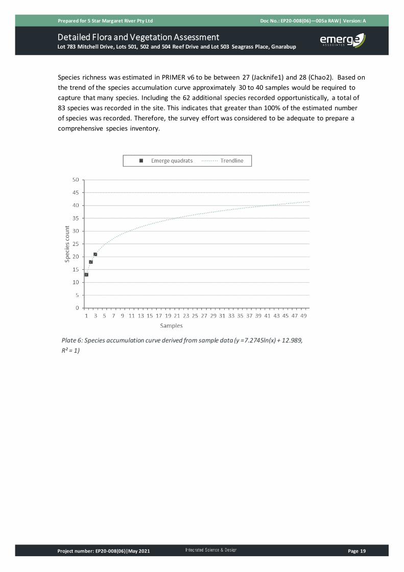
A total of 21 species were recorded from three samples. A species accumulation curve derived from
sample data is presented in Plate 6. After three samples the curve is still increasing and has not
reached its asymptote. This indicates that a proportion of species likely remain undetected by
sampling.
Detailed Flora and Vegetation Assessment Lot 783 Mitchell Drive, Lots 501, 502 and 504 Reef Drive and Lot 503 Seagrass Place, Gnarabup
Prepared for 5 Star Margaret River Pty Ltd Doc No.: EP20-008(06)—005a RAW| Version: A
Project number: EP20-008(06)|May 2021 Page 19
Species richness was estimated in PRIMER v6 to be between 27 (Jacknife1) and 28 (Chao2). Based on
the trend of the species accumulation curve approximately 30 to 40 samples would be required to
capture that many species. Including the 62 additional species recorded opportunistically, a total of
83 species was recorded in the site. This indicates that greater than 100% of the estimated number
of species was recorded. Therefore, the survey effort was considered to be adequate to prepare a
comprehensive species inventory.
Plate 6: Species accumulation curve derived from sample data (y =7.2745ln(x) + 12.989,
R² = 1)

Detailed Flora and Vegetation Assessment Lot 783 Mitchell Drive, Lots 501, 502 and 504 Reef Drive and Lot 503 Seagrass Place, Gnarabup
Prepared for 5 Star Margaret River Pty Ltd Doc No.: EP20-008(06)—005a RAW| Version: A
Project number: EP20-008(06)|May 2021 Page 20
5 Discussion
Intact native vegetation occurs across the majority of the site. The vegetation shows evidence of
alteration from the previous fire but this is not considered to be a sign of degradation. The
surrounding coastal area supports extensive areas of similar vegetation type and condition.
5.1 Threatened and priority flora
Prior to the survey, based on background information, one threatened and eight priority flora species
were considered to potentially occur within the site but none were recorded. The field surveys in
mid-September and late October were considered sufficient to determine that these species are
unlikely to occur. This is because either suitable habitat does not occur or the species were not
recorded during traverses within potentially suitable habitat. The timing of the surveys coincided
with the main flowering period of most of the conservation significant flora identified in the desktop
assessment and therefore they should have been visible, if present.
The orchid Caladenia abbreviata (P3) was considered to potentially occur in the site prior to the
survey. This species flowers in late October to December and so may not have been flowering or
visible at the time of the survey. The Western Australian Herbarium’s Florabase website lists the
habitat for this species as sand and sand dunes (Western Australian Herbarium 2021). However,
other literature sources provide more detail and indicate that C. abbreviata occurs in ‘areas of deep
sandy soil amongst low shrubs in tall peppermint woodland’ (Hoffman and Brown 1998) and ‘open
sandy clearings under tall peppermint and melaleuca species’ (Brown et al. 2008). The dense
heathland in the site does not match these descriptions and is therefore not considered to comprise
suitable habitat for this species.
5.2 Plant communities
Plant community MhScAlSg comprises various structural forms and, on initial inspection, had
potential to represent multiple plant communities. However, during sampling and traverses within
the vegetation it was evident that a few species are consistently dominant across the site. Therefore,
it was considered appropriate to classify the vegetation as one plant community. The structural
forms are likely due to factors such as aspect, elevation and disturbance such as fire intensity.
5.3 Vegetation condition
The MhScAlSg vegetation generally comprises high cover of native species and low cover of weeds.
However, the previous fire altered the vegetation structure and it has regrown into a heathland of
varying height. Tall dead M. huegelii branches which extend above the current vegetation occur
across the site and indicate the vegetation structure was different, and was likely to be taller prior to
the fire. Therefore, most of the MhScAlSg vegetation was mapped as being in ‘very good’ rather than
‘excellent’ condition due to the alterations to structure. It is likely that, over time, the vegetation will
continue to recover and improve in condition.

Detailed Flora and Vegetation Assessment Lot 783 Mitchell Drive, Lots 501, 502 and 504 Reef Drive and Lot 503 Seagrass Place, Gnarabup
Prepared for 5 Star Margaret River Pty Ltd Doc No.: EP20-008(06)—005a RAW| Version: A
Project number: EP20-008(06)|May 2021 Page 21
5.4 Threatened and priority ecological communities
No TECs or PECs were recorded or considered likely to occur within the site.
Four of the six conservation significant communities identified within the desktop assessment are
associated with caves and therefore do not apply to the site. The ‘low shrublands on acidic grey-
brown sands of the Gracetown soil-landscape system’ PEC (P2) is associated with a particular soil-
landscape system which does not occur within the site. The ‘Melaleuca lanceolata forests, Leeuwin
Naturaliste Ridge’ PEC (P2) has been recorded approximately 2.5 km north of the site. A small stand
of Melaleuca lanceolata trees occurs in the southern portion of the site. However, these few trees
are not considered to comprise a separate community and do not occur with understorey species
typically associated with the PEC such as Leucopogon propinquus and Suaeda australis.
5.5 Local and regional significance
The site provides habitat for fauna species including conservation significant species such as western
ringtail possum. However, a recent survey indicates that the vegetation within the site provides sub-
optimal habitat for western ringtail possum and use of the site by western ringtail possum appears to
be low and infrequent (Emerge Associates 2021).
The vegetation is contiguous with extensive areas of vegetation outside of the site which comprise
similar or more intact native vegetation. The vegetation within the site contributes to broad
ecological linkages but disturbance to the site would not disrupt these linkages.

Detailed Flora and Vegetation Assessment Lot 783 Mitchell Drive, Lots 501, 502 and 504 Reef Drive and Lot 503 Seagrass Place, Gnarabup
Prepared for 5 Star Margaret River Pty Ltd Doc No.: EP20-008(06)—005a RAW| Version: A
Project number: EP20-008(06)|May 2021 Page 22
6 Conclusions
No threatened or priority flora species were recorded within the site and none are considered likely
to occur.
One plant community, MhScAlSg, occurs across the majority (90%) of the site. The remainder of the
site comprises non-native vegetation and cleared areas.
The MhScAlSg vegetation was mainly mapped as being in ‘very good’ condition, with small portions
in ‘good’, ‘degraded’, ‘degraded – completely degraded’. The non-native vegetation and cleared
areas were mapped as being in ‘completely degraded’ condition.
No TECs or PECs were recorded in the site or considered likely to occur.
The site is potential habitat for threatened fauna species such as western ringtail possum and the
vegetation contributes to broader ecological linkages. A separate western ringtail possum survey has
been undertaken, and disturbance to the site would not disturb or disrupt ecological linkages.

Detailed Flora and Vegetation Assessment Lot 783 Mitchell Drive, Lots 501, 502 and 504 Reef Drive and Lot 503 Seagrass Place, Gnarabup
Prepared for 5 Star Margaret River Pty Ltd Doc No.: EP20-008(06)—005a RAW| Version: A
Project number: EP20-008(06)|May 2021 Page 23
7 References
7.1 General references
Alan Tingay and Associates 1998, A Strategic Plan for Perth's Greenways - Final Report. December
1998.
Beard, J. S. 1990, Plant Life of Western Australia, Kangaroo Press Pty Ltd., Kenthurst, N.S.W.
Brown, A., Dundas, P., Dixon, K. and Hopper, S. 2008, Orchids of Western Australia, University of
Western Australia Press, Crawley.
Clarke, K. R. and Gorley, R. N. 2006, PRIMER v6: User Manual/Tutorial, PRIMER-E, Plymouth.
Department of Biodiversity, Conservation and Attractions (DBCA) 2017a, DBCA - Legislated Lands and
Waters (DBCA-011).
Department of Biodiversity, Conservation and Attractions (DBCA) 2017b, Lands of Interest (DBCA-
012).
Department of Biodiversity, Conservation and Attractions (DBCA) 2017c, Ramsar Sites (DBCA-010).
Department of Biodiversity, Conservation and Attractions (DBCA) 2018a, Directory of Important
Wetlands in Australia - Western Australia (DBCA-045).
Department of Biodiversity, Conservation and Attractions (DBCA) 2018b, Geomorphic Wetlands
Leeuwin Naturaliste Ridge and Donnybrook to Nannup - Unreviewed (DBCA-043).
Department of Biodiversity Conservation and Attractions (DBCA) 2019, Vegetation Complexes - South
West forest region of Western Australia (DBCA-047), Kensington.
Department of Primary Industries and Regional Development (DPIRD) 2019, Soil Landscape Mapping
- Best Available (DPIRD-027), Perth, WA.
Department of primary Industries and Regional Development (DPIRD) 2020, Contours 2 m and 10 m
(DPIRD-072), Perth.
Department of Water and Environmental Regulation (DWER) 2018, Hydrography Linear (Heirarchy)
(DWER-031), Perth.
Ecosystem Solutions 2015, Lot 783 Wallcliffe Road & Surrounds Margaret River - Significant
Flora/Vegetation & Fauna Assessment.
Emerge Associates 2021, Basic Fauna and Targeted Western Ringtail Possum Assessment - Lot 783
Mitchell Drive, Lots 501, 502 and 504 Reef Drive and Lot 503 Seagrass Place, Gnarabup, EP20-
008(07)--006 MS, Version 1.
Environment Australia 2000, Revision of the Interim Biogeographic Regionalisation for Australia
(IBRA) and Development of Version 5.1 - Summary Report, Department of Environment and Heritage.

Detailed Flora and Vegetation Assessment Lot 783 Mitchell Drive, Lots 501, 502 and 504 Reef Drive and Lot 503 Seagrass Place, Gnarabup
Prepared for 5 Star Margaret River Pty Ltd Doc No.: EP20-008(06)—005a RAW| Version: A
Project number: EP20-008(06)|May 2021 Page 24
Environment Australia 2001, National Objectives and Targets for Biodiversity Conservation 2001-
2005, Commonwealth of Australia, Canberra.
Environmental Protection Authority (EPA) 2016, Technical Guidance - Flora and Vegetation Surveys
for Environmental Impact Assessment Perth.
ESCAVI 2003, Australian Vegetation Attribute Manual: National Vegetation Information System,
Version 6.0, Department of the Environment and Heritage, Canberra.
Gibson, N., Keighery, B., Keighery, G., Burbidge, A. and Lyons, M. 1994, A Floristic survey of the
southern Swan Coastal Plain, Department of Conservation and Land Management and the
Conservation Council of Western Australia, Perth.
Gotelli, N. J. and Colwell, R. K. 2011, Estimating species richness, Oxford University Press, Oxford.
Government of Western Australia 2019, 2018 Statewide Vegetation Statistics incorporating the CAR
Reserve Analysis (Full Report). Current as of March 2019, WA Department of Biodiversity,
Conservation and Attractions, Perth.
Hill, A. L., Semeniuk, C. A., Semeniuk, V. and Del Marco, A. 1996, Wetlands of the Swan Coastal Plain:
Volume 2A - Wetland Mapping, Classification and Evaluation, Water and Rivers Commission and the
Department of Environmental Protection, Perth.
Hoffman, N. and Brown, A. 1998, Orchids of south-west Australia, University of Western Australia
Press, Nedlands.
Keighery, B. 1994, Bushland Plant Survey: A guide to plant community survey for the community,
Wildflower Society of WA (Inc), Nedlands.
Miles, C. 2001, NSW Murray Catchment Biodiversity Action Plan, Nature Conservation Working Group
Inc, Albury, New South Wales.
Molloy, S., Wood, J., Hall, S., Wallrodt, S. and Whisson, G. 2009, South West Regional Ecological
Linkages Technical Report, Western Australian Local Government Association and Department of
Environment and Conservation, Perth.
Noetic Solutions 2012, Post Incident Analysis For Blackwood Fire 8 – Ellensbrook- Gnarabup, 23/24
November 2011, Version 1.
Western Australian Local Government Association and Perth Biodiversity Project (WALGA and PBP)
2004, Local Government Biodiversity Planning Guidelines for the Perth Metropolitan Region, Perth.
Wetlands Advisory Committee 1977, The status of reserves in System Six, Environmental Protection
Authority, Perth.

Detailed Flora and Vegetation Assessment Lot 783 Mitchell Drive, Lots 501, 502 and 504 Reef Drive and Lot 503 Seagrass Place, Gnarabup
Prepared for 5 Star Margaret River Pty Ltd Doc No.: EP20-008(06)—005a RAW| Version: A
Project number: EP20-008(06)|May 2021 Page 25
7.2 Online references
Bureau of Meteorology (BoM) 2021, Climate Averages, viewed 12 March 2021,
<http://www.bom.gov.au/climate/data/>.
Department of Biodiversity, Conservation and Attractions (DBCA) 2020, NatureMap, viewed 30
November 2020, <https://naturemap.dbca.wa.gov.au/>.
Department of Agriculture, Water and the Environment (DAWE) 2020a, Protected Matters Search
Tool, viewed 7 September 2020, <https://www.environment.gov.au/epbc/protected-matters-
search-tool>.
Department of Agriculture, Water and the Environment (DAWE) 2020b, Threatened Ecological
Communities, viewed 20 June 2020,
<http://www.environment.gov.au/biodiversity/threatened/communities/about>.
Department of Agriculture, Water and the Environment (DAWE) 2020c, Weeds of National
Significance, viewed 12 July 2020,
<http://www.environment.gov.au/biodiversity/invasive/weeds/weeds/lists/wons.html>.
West Australian Land Information Authority (WALIA) 2020, Landgate Map Viewer, viewed 29 March
2021, <http://landgate.wa.gov.au>.
Western Australian Herbarium 2021, FloraBase – the Western Australian Flora, Department of
Biodiversity, Conservation and Attractions (DBCA), viewed 29 March 2021
<https://florabase.dpaw.wa.gov.au/>.

Detailed Flora and Vegetation Assessment Lot 783 Mitchell Drive, Lots 501, 502 and 504 Reef Drive and Lot 503 Seagrass Place, Gnarabup
Prepared for 5 Star Margaret River Pty Ltd Doc No.: EP20-008(06)—005a RAW| Version: A
Project number: EP20-008(06)|May 2021 Page 26
This page has been left blank intentionally.

Figure 1: Site Location
Figure 2: Soils and Topography
Figure 3: Environmental Features
Figure 4: Plant Communities
Figure 5: Vegetation Condition
Figures

Georgia.Reuben
While Emerge Associates makes every attempt to ensure the accuracy and completeness of data, Emerge accepts no responsibility for externally sourced data used.5 Star Margaret River Pty LtdDetailed Flora and Vegetation Assessment - Lot 783 Mitchell Dr, Lots 501, 502 and 504 Reef Dr and Lot 503 Seagrass Pl, Gnarabup
Site LocationFigure 1:
Project:Client: ± GDA 1994 MGA Zone 50
Scale: 1:5,000@A4
0 50 100 150
Metres
Plan Number:EP20-008(06)--F39Drawn:Date:Checked: Approved:Date:
GAR16/03/2021RAWTAA01/04/2021
783
501
503
5484
5487
5487
5493
5494
8001
783502
606
605701
502
504
504
702
314400
314400
314600
314600
314800
314800
315000
315000
315200
315200
6236
200
6236
200
6236
400
6236
400
6236
600
6236
600
6236
800
6236
800
6237
000
6237
000
6237
200
6237
200
Site boundaryCadastral boundary
©Landgate (2020). Nearmap Imagery date: 10/01/2020
Site Location


Georgia.Reuben
While Emerge Associates makes every attempt to ensure the accuracy and completeness of data, Emerge accepts no responsibility for externally sourced data used.5 Star Margaret River Pty LtdDetailed Flora and Vegetation Assessment - Lot 783 Mitchell Dr, Lots 501, 502 and 504 Reef Dr and Lot 503 Seagrass Pl, Gnarabup
Soils and TopographyFigure 2:
Project:Client: ± GDA 1994 MGA Zone 50
Scale: 1:4,000@A4
0 50 100
Metres
Plan Number:EP20-008(06)--F40Drawn:Date:Checked: Approved:Date:
GAR16/03/2021RAWTAA01/04/2021
262422
20181614121086
3230
28
34
32302826
2624
22
20
642
3432
22201816
1412
108
3634
86
20
1818
16
42
2
8
30
6
34
30
22
18
18
18
1616
2
2
22
2
22
10
Ocean View Road
Resort Pl ac e
Wallcliffe Road
Reef Drive
Baudin Drive
Breeze
Cove
Seagrass Place
MarmadukePo intDrive
Freycinet Way
Gnarabup Road
Riedle Drive
314400
314400
314600
314600
314800
314800
315000
315000
6236
200
6236
200
6236
400
6236
400
6236
600
6236
600
6236
800
6236
800
6237
000
6237
000
Site boundaryCadastral boundaryTopographic contour (mAHD) (DPIRD 2019)
Soil landscape mapping (DPIRD 2019)Gracetown exposed slopes phaseKilcarnup beach phaseKilcarnup exposed dunes (organic) phaseKilcarnup exposed dunes phase
©Landgate (2020). Nearmap Imagery date: 10/01/2020


Georgia.Reuben
While Emerge Associates makes every attempt to ensure the accuracy and completeness of data, Emerge accepts no responsibility for externally sourced data used.5 Star Margaret River Pty LtdDetailed Flora and Vegetation Assessment - Lot 783 Mitchell Dr, Lots 501, 502 and 504 Reef Dr and Lot 503 Seagrass Pl, Gnarabup
Environmental FeaturesFigure 3:
Project:Client: ± GDA 1994 MGA Zone 50
Scale: 1:12,000@A4
0 100 200 300
Metres
Plan Number:EP20-008(06)--F41Drawn:Date:Checked: Approved:Date:
GAR16/03/2021RAWTAA01/04/2021
Ngari CapesMarine Park
Leeuwin-NaturalisteNational Park
Leeuwin-NaturalisteNational Park
Ocean Vi ew RoadMitchell D rive
Wallcl i ffe RoadReef Drive
Chuditch Pla c e
Breeze CoveFreycinet Way
Lake View Crescent
GeorgetteWay
RiedleDrive
Ga s BayR
oad
Grunters Way
MarmadukePoint D rive
Baudin Drive
109
314000
314000
314500
314500
315000
315000
315500
315500
6235
500
6235
500
6236
000
6236
000
6236
500
6236
500
6237
000
6237
000
6237
500
6237
500
6238
000
6238
000
Site boundaryCadastral boundaryEnvironmentally senstive area (DWER 2020)Biodiversity linkage
DBCA Legislated lands and water (DBCA 2020)Marine ParkNational Park
©Landgate (2020). Nearmap Imagery date: 10/01/2020


Georgia.Reuben
While Emerge Associates makes every attempt to ensure the accuracy and completeness of data, Emerge accepts no responsibility for externally sourced data used.5 Star Margaret River Pty LtdDetailed Flora and Vegetation Assessment - Lot 783 Mitchell Dr, Lots 501, 502 and 504 Reef Dr and Lot 503 Seagrass Pl, Gnarabup
Plant CommunitiesFigure 4:
Project:Client: ± GDA 1994 MGA Zone 50
Scale: 1:4,000@A4
0 50 100
Metres
Plan Number:EP20-008(06)--F42Drawn:Date:Checked: Approved:Date:
GAR16/03/2021RAWTAA01/04/2021
"6
"6
"6
Ocean View Road
Resort Pl ac e
Wallcliffe Road
Reef Drive
Baudin Drive
Breeze
Cove
Seagrass Place
MarmadukePo intDrive
Freycinet Way
Gnarabup Road
Riedle Drive
Q1
Q2
Q3
314400
314400
314600
314600
314800
314800
315000
315000
6236
200
6236
200
6236
400
6236
400
6236
600
6236
600
6236
800
6236
800
6237
000
6237
000
Site boundaryCadastral boundary
"6 QuadratPlant community
MhScAlSgNon-native/cleared
©Landgate (2020). Nearmap Imagery date: 10/01/2020


Georgia.Reuben
While Emerge Associates makes every attempt to ensure the accuracy and completeness of data, Emerge accepts no responsibility for externally sourced data used.5 Star Margaret River Pty LtdDetailed Flora and Vegetation Assessment - Lot 783 Mitchell Dr, Lots 501, 502 and 504 Reef Dr and Lot 503 Seagrass Pl, Gnarabup
Vegetation ConditionFigure 5:
Project:Client: ± GDA 1994 MGA Zone 50
Scale: 1:4,000@A4
0 50 100
Metres
Plan Number:EP20-008(06)--F43Drawn:Date:Checked: Approved:Date:
GAR16/03/2021RAWTAA01/04/2021
"6
"6
"6
Ocean View Road
Resort Pl ac e
Wallcliffe Road
Reef Drive
Baudin Drive
Breeze
Cove
Seagrass Place
MarmadukePo intDrive
Freycinet Way
Gnarabup Road
Riedle Drive
Q1
Q2
Q3
314400
314400
314600
314600
314800
314800
315000
315000
6236
200
6236
200
6236
400
6236
400
6236
600
6236
600
6236
800
6236
800
6237
000
6237
000
Site boundaryCadastral boundary
"6 QuadratVegetation condition
PristineExcellentVery goodGoodDegradedDegraded - completely degradedCompletely degraded
©Landgate (2020). Nearmap Imagery date: 10/01/2020


Appendix A Additional Information


Additional Background Information
Page 1
Version: EMRG_FloraReport_Appendix (V010)
Conservation Significant Flora and Vegetation
Threatened and priority flora
Flora species considered rare or under threat warrant special protection under Commonwealth and/or State legislation. At the Commonwealth level, flora species can be listed under the Environment Protection and Biodiversity Conservation Act 1999 (EPBC Act). Flora species considered ‘threatened’ pursuant to Schedule 1 of the EPBC Act are assigned categories according to their conservation status, as outlined in Table 1. In Western Australia, plant taxa may be classed as ‘threatened’ under the Biodiversity Conservation Act 2016 (BC Act) which is enforced by Department of Biodiversity Conservation and Attractions (DBCA). Threatened flora species are listed under sections 19(1) and 26(2) of the BC Act. It is an offence to ‘take’ or disturb threatened flora without Ministerial approval. Section 5(1)1 of the Act defines to take as including “… to gather, pluck, cut, pull up, destroy, dig up, remove, harvest or damage flora by any means” or to cause or permit the same to be done. The definition of threatened flora under the BC Act is provided in Table 1. Section 43 of the BC Act requires that an occurrence of a threatened species or threatened ecological community is reported to DBCA where the occurrence has been identified as part of field work completed: • as part of an assessment under Part IV of the Environmental Protection Act 1986; or • in relation to an application for a clearing permit under the Environmental Protection Act 1986
section 51E(1)(d). Penalties apply to individuals and organisations that fail to provide accurate reports of threatened species or communities. The Biodiversity Conservation Regulations 2018 (BC Regulations 2018) came into effect on January 1 2019. The BC Regulations include provisions for licencing, charges, penalties and other provisions associated with the BC Act. Flora species that may be threatened or near threatened but lack sufficient information to be listed under the BC Act may be added to the DBCA’s Priority Flora List (DBCA 2018b). Priority flora species are considered during State approval processes. Priority flora categories and definitions are listed in Table 1.

Additional Background Information
Page 2
Version: EMRG_FloraReport_Appendix (V010)
Table 1: Definitions of conservation significant flora species pursuant to the EPBC Act and BC Act and on DBCA’s Priority Flora List (DBCA 2018b)
Conservation code Description
EX† Threatened Flora – Presumed Extinct Taxa which have not been collected, or otherwise verified, over the past 50 years despite thorough searching, or of which all known wild populations have been destroyed more recently, and have been gazetted as such.
T^† Threatened Flora – Extant Taxa which are declared to be likely to become extinct or is rare, or otherwise in need of special protection.
CR^ Threatened Flora – Critically Endangered Taxa which are considered to be facing an extremely high risk of extinction in the wild.
EN^
Threatened Flora – Endangered Taxa which are considered to be facing a very high risk of extinction in the wild.
VU^ Threatened Flora – Vulnerable Taxa which are considered to be facing a high risk of extinction in the wild.
P1�
Priority One – Poorly Known Taxa which are known from one or a few (generally <5) populations which are under threat, either due to small population size, or being on lands under immediate threat e.g. road verges, urban areas, farmland, active mineral leases etc., or the plants are under threat, e.g. from disease, grazing by feral animals etc. May include taxa with threatened populations on protected lands. Such taxa are under consideration for declaration as ‘rare flora’, but are in urgent need of further survey.
P2� Priority Two – Poorly Known Taxa which are known from one or a few (generally <5) populations, at least some of which are not believed to be under immediate threat (i.e. not currently endangered). Such taxa are under consideration for declaration as ‘rare flora’, but urgently need further survey.
P3� Priority Three – Poorly Known Taxa which are known from several populations, and the taxa are not believed to be under immediate threat (i.e. not currently endangered), either due to the number of known populations (generally >5), or known populations being large, and either widespread or protected. Such taxa are under consideration for declaration as ‘rare flora’ but needs further survey.
P4� Priority Four – Rare Taxa which are considered to have been adequately surveyed and which, whilst being rare (in Australia), are not currently threatened by any identifiable factors. These taxa require monitoring every 5-10 years.
^pursuant to the EPBC Act, †pursuant to the BC Act, �on DBCA’s Priority Flora List
Threatened and priority ecological communities
‘Threatened ecological communities’ (TECs) are recognised as ecological communities that are rare or under threat and therefore warrant special protection. Selected TECs are afforded statutory protection at a Commonwealth level under section 181 of the EPBC Act. TECs nominated for listing under the EPBC Act are considered by the Threatened Species Scientific Committee and a final decision is made by the Commonwealth Minister for the Environment. Once listed under the EPBC Act, communities are categorised as either ‘critically endangered’, ‘endangered’ or ‘vulnerable’ as defined in Table 2. Any action likely to have a significant impact on a community listed under the EPBC Act requires approval from the Minister for the Environment.
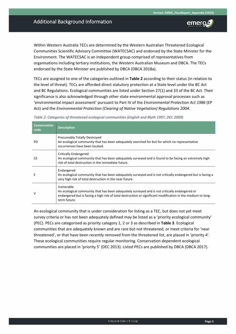
Additional Background Information
Page 3
Version: EMRG_FloraReport_Appendix (V010)
Within Western Australia TECs are determined by the Western Australian Threatened Ecological Communities Scientific Advisory Committee (WATECSAC) and endorsed by the State Minister for the Environment. The WATECSAC is an independent group comprised of representatives from organisations including tertiary institutions, the Western Australian Museum and DBCA. The TECs endorsed by the State Minister are published by DBCA (DBCA 2018a). TECs are assigned to one of the categories outlined in Table 2 according to their status (in relation to the level of threat). TECs are afforded direct statutory protection at a State level under the BC Act and BC Regulations. Ecological communities are listed under Section 27(1) and 33 of the BC Act. Their significance is also acknowledged through other state environmental approval processes such as ‘environmental impact assessment’ pursuant to Part IV of the Environmental Protection Act 1986 (EP Act) and the Environmental Protection (Clearing of Native Vegetation) Regulations 2004. Table 2: Categories of threatened ecological communities (English and Blyth 1997; DEC 2009)
Conservation code Description
PD Presumably Totally Destroyed An ecological community that has been adequately searched for but for which no representative occurrences have been located.
CE Critically Endangered An ecological community that has been adequately surveyed and is found to be facing an extremely high risk of total destruction in the immediate future.
E Endangered An ecological community that has been adequately surveyed and is not critically endangered but is facing a very high risk of total destruction in the near future.
V Vulnerable An ecological community that has been adequately surveyed and is not critically endangered or endangered but is facing a high risk of total destruction or significant modification in the medium to long-term future.
An ecological community that is under consideration for listing as a TEC, but does not yet meet survey criteria or has not been adequately defined may be listed as a ‘priority ecological community’ (PEC). PECs are categorised as priority category 1, 2 or 3 as described in Table 3. Ecological communities that are adequately known and are rare but not threatened, or meet criteria for ‘near threatened’, or that have been recently removed from the threatened list, are placed in ‘priority 4’. These ecological communities require regular monitoring. Conservation dependent ecological communities are placed in ‘priority 5’ (DEC 2013). Listed PECs are published by DBCA (DBCA 2017).

Additional Background Information
Page 4
Version: EMRG_FloraReport_Appendix (V010)
Table 3: Categories of priority ecological communities (DEC 2013)
Priority code Description
P1
Priority One: Poorly known ecological communities Ecological communities that are known from very few occurrences with a very restricted distribution (generally ≤5 occurrences or a total area of ≤ 100ha). Occurrences are believed to be under threat either due to limited extent, or being on lands under immediate threat (e.g. within agricultural or pastoral lands, urban areas, active mineral leases) or for which current threats exist. May include communities with occurrences on protected lands. Communities may be included if they are comparatively well-known from one or more localities but do not meet adequacy of survey requirements, and/or are not well defined, and appear to be under immediate threat from known threatening processes across their range.
P2
Priority Two: Poorly known ecological communities Communities that are known from few occurrences with a restricted distribution (generally ≤10 occurrences or a total area of ≤200ha). At least some occurrences are not believed to be under immediate threat (within approximately 10 years) of destruction or degradation. Communities may be included if they are comparatively well known from one or more localities but do not meet adequacy of survey requirements, and/or are not well defined, and appear to be under threat from known threatening processes.
P3
Priority Three: Poorly known ecological communities (i) Communities that are known from several to many occurrences, a significant number or area of which are not under threat of habitat destruction or degradation or: (ii) communities known from a few widespread occurrences, which are either large or with significant remaining areas of habitat in which other occurrences may occur, much of it not under imminent threat (within approximately 10 years), or; (iii) communities made up of large, and/or widespread occurrences, that may or may not be represented in the reserve system, but are under threat of modification across much of their range from processes such as grazing by domestic and/or feral stock, inappropriate fire regimes, clearing, hydrological change etc. Communities may be included if they are comparatively well known from several localities but do not meet adequacy of survey requirements and/or are not well defined, and known threatening processes exist that could affect them.
P4
Priority Four: Ecological communities that are adequately known, rare but not threatened or meet criteria for Near Threatened, or that have been recently removed from the threatened list. These communities require regular monitoring. (i) Rare. Ecological communities known from few occurrences that are considered to have been adequately surveyed, or for which sufficient knowledge is available, and that are considered not currently threatened or in need of special protection, but could be if present circumstances change. These communities are usually represented on conservation lands. (ii) Near Threatened. Ecological communities that are considered to have been adequately surveyed and that do not qualify for Conservation Dependent, but that are close to qualifying for a higher threat category. (iii) Ecological communities that have been removed from the list of threatened communities during the past five years.
P5
Priority Five: Conservation Dependent ecological communities Ecological communities that are not threatened but are subject to a specific conservation program, the cessation of which would result in the community becoming threatened within five years.
Additional Background Information
Page 5
Version: EMRG_FloraReport_Appendix (V010)
Weeds
A number of legislative and policy documents exist in relation to weed management at state and national levels. The Biosecurity and Agriculture Management Act 2007 (BAM Act) is the principle legislation guiding weed management in Western Australia and lists declared pest species. At a national level, the Australian government has compiled a list of 32 Weeds of National Significance (WoNS) (DoEE 2018), of which many are also listed under the BAM Act.
Declared Pests
Part 2.3.23 of the BAM Act requires a person must not; “a) keep, breed or cultivate the declared pest; b) keep, breed or cultivate an animal, plant or other thing that is infected or infested with the declared pest; c) release into the environment the declared pest, or an animal, plant or other thing that is infected or infested with the declared pest; or d) intentionally infect or infest, or expose to infection or infestation, a plant, animal or other thing with a declared pest”. Under the BAM Act, all declared pests are assigned a legal status, as described in Table 4. Species assigned to the ‘declared pest, prohibited - s12’ category are placed in one of three control categories, as described in Table 5. The Biosecurity and Agriculture Management Regulations 2013 specify keeping categories for species assigned to the ‘declared pest - s22(2)’ category, which relate to the purposes of which species can be kept, as well as the entities that can keep them. The categories are described in Table 6. The Western Australian Organism List (WAOL) provides the status of organisms which have been categorised under the BAM Act (DPIRD 2020). Table 4: Legal status of declared pest species listed under the BAM Act (DPIRD 2020)
Category Description
Declared Pest Prohibited - s12
May only be imported and kept subject to permits. Permit conditions applicable to some species may only be appropriate or available to research organisations or similarly secure institutions.
Declared Pest s22(2)
Must satisfy any applicable import requirements when imported, and may be subject to an import permit if they are potential carriers of high-risk organisms. They may also be subject to control and keeping requirements once within Western Australia

Additional Background Information
Page 6
Version: EMRG_FloraReport_Appendix (V010)
Table 5: Control categories of declared pest species listed under the BAM Act (DPIRD 2020)
Category Description
C1 Exclusion Not established in Western Australia and control measures are to be taken, including border checks, in order to prevent them entering and establishing in the State.
C2 Eradication Present in Western Australia in low enough numbers or in sufficiently limited areas that their eradication is still a possibility.
C3 Management Established in Western Australia but it is feasible, or desirable, to manage them in order to limit their damage. Control measures can prevent a C3 pest from increasing in population size or density or moving from an area in which it is established into an area which currently is free of that pest.
Table 6: Keeping categories of declared pest species listed under the BAM Act (DPIRD 2020)
Category Description
Prohibited Can only be kept under a permit for public display and education purposes, and/or genuine scientific research, by entities approved by the state authority.
Exempt No permit or conditions are required for keeping. Restricted Organisms which, relative to other species, have a low risk of becoming a problem for the
environment, primary industry or public safety and can be kept under a permit by private individuals.

Additional Background Information
Page 7
Version: EMRG_FloraReport_Appendix (V010)
References
General references
Department of Biodiversity Conservation and Attractions (DBCA) 2017, Priority Ecological Communities for Western Australia Version 27, Species and Communities Branch, Department of Biodiversity, Conservation and Attractions. Department of Biodiversity, Conservation and Attractions (DBCA) 2018a, List of Threatened Ecological Communities endorsed by the Western Australian Minister for Environment, Perth. Department of Biodiversity, Conservation and Attractions (DBCA) 2018b, Threatened and Priority Flora List 16 January 2018, Perth. Department of Environment and Conservation (DEC) 2009, Definitions, Categories and Criteria for Threatened and Priority Ecological Communities, Perth. Department of Conservation (DEC) 2013, Definitions, Categories and Criteria for Threatened and Priority Ecological Communities, Perth. English, V. and Blyth, J. 1997, Identifying and Conserving Threatened Ecological Communities in the South West Botanical Province, ANCA National Reserves System Cooperative Program, Project Number N702, Perth.
Online references
Department of Environment and Energy (DoEE) 2018, Weeds of National Significance, <http://www.environment.gov.au/biodiversity/invasive/weeds/weeds/lists/wons.html>. Department of Primary Industries and Regional Development (DPIRD) 2020, The Western Australian Organism List (WAOL), < https://www.agric.wa.gov.au/bam/western-australian-organism-list-waol>.


Appendix B Conservation Significant Flora Species and likelihood of
Occurrence Assessment


Conservation Significant Flora Likelihood of Occurrence
Lot 783 Mitchell Drive, Lots 501, 502 and 504 Reef Drive
and Lot 503 Seagrass Place, Gnarabup
Page 1 of 6
WA EPBC
Act
Caladenia lodgeana CR CR PG Seasonally moist to wet clay/sand soils on the margins of either low granite outcrops or ephemeral wetlands
Oct Unlikely
Calectasia cyanea CR CR P Heathland on white sand or laterite gravel over laterite. Known only from one population near Albany.
Jun‐Oct Unlikely
Grevillea brachystylis
subsp. grandis
CR CR P Sand and loam with lateritic gravel.
Sep‐Dec Unlikely
Caladenia huegelii CR EN PG Well‐drained, deep sandy soils in lush undergrowth in a variety of moisture levels.
Sep‐early Nov
Unlikely
Gastrolobium papilio CR EN P Sandy clay over ironstone and laterite. Flat plains.
Oct‐Dec Unlikely
Lambertia orbifolia
subsp. Scott River Plains
(L.W. Sage 684)
EN CR P Yellow‐brown sandy clay, grey sand, sandy gravel, laterite. Along riverbanks, sand dunes, plains & ridges, seasonally‐inundated areas.
Oct‐Nov or Jan
Unlikely
Reedia spathacea EN CR P Low nutrient, anoxic and highly acidic wetlands usually over peat.
Nov (flowering is rare)
Unlikely
Boronia exilis EN EN P Seasonally wet heath or sedgelands on grey silty sand over ironstone. Restricted to Scott River area.
Sep Unlikely
Banksia nivea subsp.
uliginosa
EN EN P Clay over laterite in thick scrub, in winter wet ironstones.
Aug‐Sep Unlikely
Caladenia excelsa EN EN PG Hilltops, slopes, swales and low plains in deep pale yellow, white or grey sandy soils among dense low shrubs in banksia, jarrah and marri woodlands
Sep‐Oct Unlikely
Caladenia hoffmanii EN EN PG Clay, loam, laterite, granite. Rocky outcrops and hillsides, ridges, swamps and gullies.
Aug‐Oct Unlikely
Species name Level of
significance
Life
strategy
Habitat Flowering
period
Likelihood of
occurrence
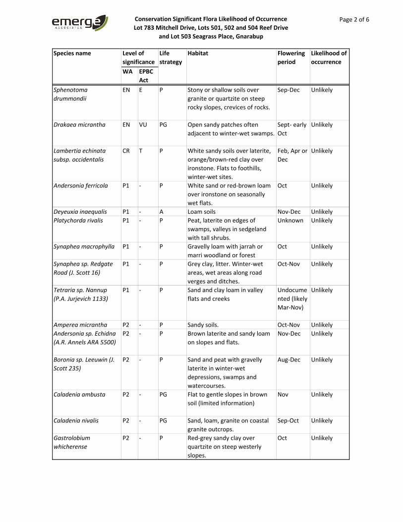
Conservation Significant Flora Likelihood of Occurrence
Lot 783 Mitchell Drive, Lots 501, 502 and 504 Reef Drive
and Lot 503 Seagrass Place, Gnarabup
Page 2 of 6
WA EPBC
Act
Species name Level of
significance
Life
strategy
Habitat Flowering
period
Likelihood of
occurrence
Sphenotoma
drummondii
EN E P Stony or shallow soils over granite or quartzite on steep rocky slopes, crevices of rocks.
Sep‐Dec Unlikely
Drakaea micrantha EN VU PG Open sandy patches often adjacent to winter‐wet swamps.
Sept‐ early Oct
Unlikely
Lambertia echinata
subsp. occidentalis
CR T P White sandy soils over laterite, orange/brown‐red clay over ironstone. Flats to foothills, winter‐wet sites.
Feb, Apr or Dec
Unlikely
Andersonia ferricola P1 ‐ P White sand or red‐brown loam over ironstone on seasonally wet flats.
Oct Unlikely
Deyeuxia inaequalis P1 ‐ A Loam soils Nov‐Dec Unlikely
Platychorda rivalis P1 ‐ P Peat, laterite on edges of swamps, valleys in sedgeland with tall shrubs.
Unknown Unlikely
Synaphea macrophylla P1 ‐ P Gravelly loam with jarrah or marri woodland or forest
Oct Unlikely
Synaphea sp. Redgate
Road (J. Scott 16)
P1 ‐ P Grey clay, litter. Winter‐wet areas, wet areas along road verges and ditches.
Oct‐Nov Unlikely
Tetraria sp. Nannup
(P.A. Jurjevich 1133)
P1 ‐ P Sand and clay loam in valley flats and creeks
Undocume
nted (likely Mar‐Nov)
Unlikely
Amperea micrantha P2 ‐ P Sandy soils. Oct‐Nov Unlikely
Andersonia sp. Echidna
(A.R. Annels ARA 5500)
P2 ‐ P Brown laterite and sandy loam on slopes and flats.
Nov‐Dec Unlikely
Boronia sp. Leeuwin (J.
Scott 235)
P2 ‐ P Sand and peat with gravelly laterite in winter‐wet depressions, swamps and watercourses.
Aug‐Dec Unlikely
Caladenia ambusta P2 ‐ PG Flat to gentle slopes in brown soil (limited information)
Nov Unlikely
Caladenia nivalis P2 ‐ PG Sand, loam, granite on coastal granite outcrops.
Sep‐Oct Unlikely
Gastrolobium
whicherense
P2 ‐ P Red‐grey sandy clay over quartzite on steep westerly slopes.
Oct Unlikely

Conservation Significant Flora Likelihood of Occurrence
Lot 783 Mitchell Drive, Lots 501, 502 and 504 Reef Drive
and Lot 503 Seagrass Place, Gnarabup
Page 3 of 6
WA EPBC
Act
Species name Level of
significance
Life
strategy
Habitat Flowering
period
Likelihood of
occurrence
Hybanthus volubilis P2 ‐ P Clay or sandy clay on river banks.
Sep‐Dec Unlikely
Leptomeria furtiva P2 ‐ P Grey or black peaty sand in winter‐wet flats.
Aug‐Oct Unlikely
Lepyrodia extensa P2 ‐ P Sand and sandy peat in seasonally inundated swamps.
Dec‐Feb Unlikely
Thysanotus sp.
Badgingarra (E.A.
Griffin 2511)
P2 ‐ P Grey sand with lateritic gravel. Dec Unlikely
Xyris maxima P2 ‐ P Black peaty sand on drainage flats.
Nov‐Dec/Jan
Unlikely
Acacia inops P3 ‐ P Black peaty sand, clay. Swamps, creeks.
Sep‐early Nov
Unlikely
Actinotus repens P3 ‐ P Sand, clay or loam in wetlands or low lying areas in scrub, woodland or forest.
Dec‐Mar Unlikely
Austrostipa mundula P3 ‐ P Grey sand over limestone. Sept‐Nov Unlikely
Boronia anceps P3 ‐ P White sand, gravelly laterite in seasonally swampy heaths.
Sep‐Dec/Jan
Unlikely
Boronia capitata subsp.
gracilis
P3 ‐ P White/grey or black sand in winter‐wet swamps, hillslopes.
Jun‐Nov Unlikely
Caladenia abbreviata P3 ‐ PG Sand dunes. Nov‐Dec Unlikely
Calothamnus lateralis
var. crassus
P3 ‐ P Sand, clay or peat in swamps and winter‐wet depressions.
Aug‐Dec Unlikely
Chamaescilla gibsonii P3 ‐ P Clay to sandy clay in winter‐wet flats, shallow water‐filled claypans.
Sep Unlikely
Cyathochaeta teretifolia P3 ‐ P Grey sand, sandy clay in Oct‐Jan Unlikely
Dampiera heteroptera P3 ‐ P Sandy soils, swampy areas. Sep‐Oct Unlikely
Gastrolobium P3 ‐ P Clay loam. Along river banks or Nov Unlikely
Grevillea brachystylis
subsp. brachystylis
P3 ‐ P Black sand, sandy clay in swampy situations.
Aug‐Nov Unlikely
Grevillea bronwenae P3 ‐ P Grey sand over laterite, lateritic Jun‐Dec Unlikely
Grevillea manglesioides
subsp. ferricola
P3 ‐ P Red sandy clay over ironstone on winter wet flats.
Oct Unlikely
Hakea oldfieldii P3 ‐ P Red clay or sand over laterite Aug‐Oct Unlikely

Conservation Significant Flora Likelihood of Occurrence
Lot 783 Mitchell Drive, Lots 501, 502 and 504 Reef Drive
and Lot 503 Seagrass Place, Gnarabup
Page 4 of 6
WA EPBC
Act
Species name Level of
significance
Life
strategy
Habitat Flowering
period
Likelihood of
occurrence
Isopogon formosus
subsp. dasylepis
P3 ‐ P Sand, sandy clay, gravelly sandy soils over laterite, often in swampy areas.
Jun‐Dec Unlikely
Johnsonia inconspicua P3 ‐ P White‐grey or black sand. Low Oct‐Nov Unlikely
Juncus meianthus P3 ‐ P Black sand, sandy clay. Creeks, seepage areas.
Nov‐Dec/Jan
Unlikely
Lasiopetalum laxiflorum P3 ‐ P Sand and/or clay with laterite. Sep‐Dec Unlikely
Leptinella drummondii P3 ‐ A Clay loam, mud along rivers. Nov‐Dec or UnlikelyLepyrodia
heleocharoides
P3 ‐ P Moist peaty sand. Dry or seasonally inundated heath or woodland, swamps.
Dec Unlikely
Leucopogon wheelerae P3 ‐ P Grey/white sand and peaty sand in wetlands and winter wet areas.
Aug‐Oct Unlikely
Loxocarya magna P3 ‐ P Sand, loam, clay, ironstone in seasonally inundated or damp habitats.
Sep or Nov Unlikely
Pimelea ciliata subsp.
longituba
P3 ‐ P Grey sand over clay, loam. Oct‐Dec Unlikely
Pultenaea pinifolia P3 ‐ P Loam or clay. Floodplains, swampy areas.
Oct‐Nov Unlikely
Stylidium lowrieanum P3 ‐ P Sand or sandy loam over limestone. Eucalypt or Agonis woodland, forest.
Oct‐Nov Unlikely
Synaphea decumbens P3 ‐ P Sand over laterite. Sep‐Oct Unlikely
Tetraria sp. Blackwood
River (A.R. Annels 3043)
P3 ‐ P Grey clay and loam in lakes, swamps and waterways.
Nov Unlikely
Thysanotus cymosus P3 ‐ P Shrubland or woodland on clay, granitic or lateritic sand.
Sep‐Oct Unlikely
Acacia flagelliformis P4 ‐ P Sandy soils in winter‐wet areas. May‐Sep Unlikely
Acacia semitrullata P4 ‐ P White/grey sand, sometimes over laterite, clay sometimes in sandplains, swampy areas.
May‐Oct Unlikely
Acacia tayloriana P4 ‐ P Grey or yellow/orange sandy soils, lateritic gravel, clay loam. Winter‐wet areas.
Jan Unlikely
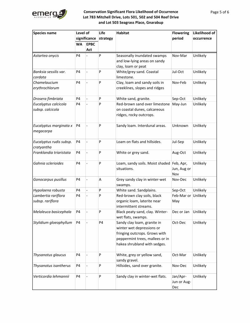
Conservation Significant Flora Likelihood of Occurrence
Lot 783 Mitchell Drive, Lots 501, 502 and 504 Reef Drive
and Lot 503 Seagrass Place, Gnarabup
Page 5 of 6
WA EPBC
Act
Species name Level of
significance
Life
strategy
Habitat Flowering
period
Likelihood of
occurrence
Astartea onycis P4 ‐ P Seasonally inundated swamps and low‐lying areas on sandy clay, loam or peat
Nov‐Mar Unlikely
Banksia sessilis var.
cordata
P4 ‐ P White/grey sand. Coastal limestone.
Jul‐Oct Unlikely
Chamelaucium
erythrochlorum
P4 ‐ P Clay, loam and sandy soils in creeklines, slopes and ridges
Nov‐Feb Unlikely
Drosera fimbriata P4 ‐ P White sand, granite. Sep‐Oct Unlikely
Eucalyptus calcicola
subsp. calcicola
P4 ‐ P Red‐brown sand over limestone on coastal dunes, calcareous ridges, rocky outcrops.
May‐Jun Unlikely
Eucalyptus marginata x
megacarpa
P4 ‐ P Sandy loam. Interdunal areas. Unknown Unlikely
Eucalyptus rudis subsp.
cratyantha
P4 ‐ P Loam on flats and hillsides. Jul‐Sep Unlikely
Franklandia triaristata P4 ‐ P White or grey sand. Aug‐Oct Unlikely
Gahnia sclerioides P4 ‐ P Loam, sandy soils. Moist shaded situations.
Feb, Apr, Jun, Aug or Nov
Unlikely
Gonocarpus pusillus P4 ‐ A Grey sandy clay in winter‐wet swamps.
Nov‐Dec Unlikely
Hypolaena robusta P4 ‐ P White sand. Sandplains. Sep‐Oct Unlikely
Lambertia rariflora
subsp. rariflora
P4 ‐ P Red‐brown clay soils, black organic loam, laterite near intermittent streams.
Feb‐Mar or May
Unlikely
Melaleuca basicephala P4 ‐ P Black peaty sand, clay. Winter‐wet flats, swamps.
Dec or Jan Unlikely
Stylidium gloeophyllum P4 ‐ P4 Sandy clay loam, granite in winter wet depressions or fringing outcrops. Grows with peppermint trees, mallees or in hakea shrubland with sedges.
Oct‐Dec Unlikely
Thysanotus glaucus P4 ‐ P White, grey or yellow sand, sandy gravel.
Oct‐Mar Unlikely
Thysanotus isantherus P4 ‐ P Hillsides, sand over granite. Nov‐Dec Unlikely
Verticordia lehmannii P4 ‐ P Sandy clay in winter‐wet flats. Jan/Apr‐Jun or Aug‐Dec
Unlikely

Conservation Significant Flora Likelihood of Occurrence
Lot 783 Mitchell Drive, Lots 501, 502 and 504 Reef Drive
and Lot 503 Seagrass Place, Gnarabup
Page 6 of 6
WA EPBC
Act
Species name Level of
significance
Life
strategy
Habitat Flowering
period
Likelihood of
occurrence
Daviesia elongata T ‐ P Sand, laterite. Sep/Dec‐Jan/Feb
Unlikely
Banksia squarrosa
subsp. argillacea
VU VU P White/grey sand, gravelly clay or loam predominantly in winter‐wet areas over ironstone in open to tall shrubland.
Jun‐Nov Unlikely
Note: T=threatened, CR=critically endangered, EN=endangered, VU=vulnerable, P1=Priority 1, P2=Priority 2, P3=Priority 3, P4=Priority 4, P=perennial, PG=perennial geophyte, A=annual. Species considered to potentially occur within the site are shaded green

Appendix C Species List


Flora Species List
Lot 783 Mitchell Drive, Lots 501, 502 and 504 Reef Drive and Lot 503 Seagrass Place, Gnarabup
Page 1 of 3
Family Status Species
Aizoaceae
Carpobrotus virescens
* Tetragonia decumbens
Araceae
*DP Zantedeschia aethiopica
Asparagaceae
Acanthocarpus preissii
Asphodelaceae
* Trachyandra divaricata
Asteraceae
* Arctotheca calendula
Gnaphalium indutum
Olearia axillaris
* Osteospermum ecklonis
* Senecio elegans
Senecio pinnatifolius var. maritimus
* Sonchus oleraceus
Brassicaceae
* Brassica tournefortii
Campanulaceae
Isotoma scapigera
Lobelia tenuior
Chenopodiaceae
Rhagodia baccata
Threlkeldia diffusa
Crassulaceae
Crassula colorata
* Crassula glomerata
Cyperaceae
Carex thecata
Ficinia nodosa
Isolepis marginata
Lepidosperma gladiatum
Lepidosperma ?squamatum
DilleniaceaeHibbertia hypericoides
Hibbertia serrata
Droseraceae
Drosera macrantha
Ericaceae
Acrotriche cordata
Leucopogon parviflorus
Fabaceae
Acacia littorea
Acacia saligna
Hardenbergia comptoniana
* Melilotus indicus
Templetonia retusa

Flora Species List
Lot 783 Mitchell Drive, Lots 501, 502 and 504 Reef Drive and Lot 503 Seagrass Place, Gnarabup
Page 2 of 3
Family Status Species
* Trifolium dubium
Gentianaceae
* Schenkia australis
Geraniaceae
* Pelargonium capitatum
* Pelargonium sp.
Goodeniaceae
Scaevola crassifolia
Haemodoraceae
Conostylis aculeata subsp. aculeata
Hemerocallidaceae
Dianella revoluta
Tricoryne elatior
Lauraceae Cassytha racemosa forma racemosa
Malvaceae
Thomasia triphylla
Myrtaceae
Agonis flexuosa
* Eucalyptus utilis
Melaleuca huegelii
Melaleuca lanceolata
Melaleuca preissiana
Melaleuca systena
Orchidaceae
Caladenia latifolia
Orobanchaceae
* Orobanche minor
Oxalidaceae
* Oxalis pes‐caprae
Papaveraceae
* Fumaria capreolata
Phyllanthaceae
Phyllanthus calycinus
Poranthera microphylla
Pittosporaceae
Marianthus candidus
Poaceae
Austrostipa flavescens
* Avena barbata
* Briza maxima
* Bromus diandrus
* Catapodium rigidum
* Ehrharta longiflora
* Lagurus ovatus
Poa sp.
Rytidosperma occidentale
Polygalaceae

Flora Species List
Lot 783 Mitchell Drive, Lots 501, 502 and 504 Reef Drive and Lot 503 Seagrass Place, Gnarabup
Page 3 of 3
Family Status Species
Comesperma confertum
Polygonaceae
Muehlenbeckia adpressa
Primulaceae
* Lysimachia arvensis
Ranunculaceae
Clematis pubescens
Restionaceae
Desmocladus flexuosus
Rhamnaceae
Spyridium globulosum
Rubiaceae
* Galium murale
Rutaceae
Boronia alata
Diplolaena dampieri
Santalaceae Exocarpos sparteus
Sapindaceae
Dodonaea aptera
Scrophulariaceae
* Dischisma arenarium
Myoporum insulare
Myoporum oppositifolium
* Verbascum virgatum
Stylidiaceae
Stylidium adnatum
Thymelaeaceae
Pimelea ferruginea
*=non‐native, Pl=planted, DP=declared pest under BAM Act


Appendix D Conservation Significant Communities and Likelihood of
Occurrence Assessment

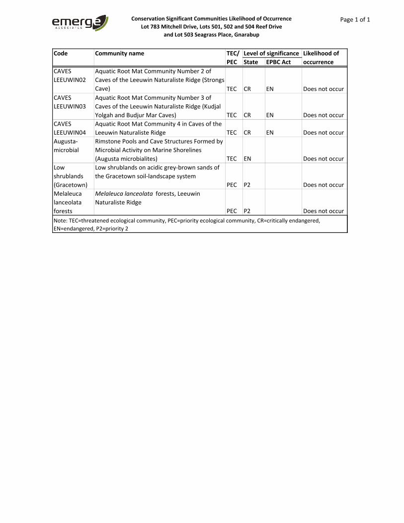
Conservation Significant Communities Likelihood of Occurrence
Lot 783 Mitchell Drive, Lots 501, 502 and 504 Reef Drive
and Lot 503 Seagrass Place, Gnarabup
Page 1 of 1
State EPBC Act
CAVES LEEUWIN02
Aquatic Root Mat Community Number 2 of Caves of the Leeuwin Naturaliste Ridge (Strongs Cave) TEC CR EN Does not occur
CAVES LEEUWIN03
Aquatic Root Mat Community Number 3 of Caves of the Leeuwin Naturaliste Ridge (Kudjal Yolgah and Budjur Mar Caves) TEC CR EN Does not occur
CAVES LEEUWIN04
Aquatic Root Mat Community 4 in Caves of the Leeuwin Naturaliste Ridge TEC CR EN Does not occur
Augusta‐microbial
Rimstone Pools and Cave Structures Formed by Microbial Activity on Marine Shorelines (Augusta microbialites) TEC EN Does not occur
Low shrublands (Gracetown)
Low shrublands on acidic grey‐brown sands of the Gracetown soil‐landscape system
PEC P2 Does not occurMelaleuca lanceolata forests
Melaleuca lanceolata forests, Leeuwin Naturaliste Ridge
PEC P2 Does not occurNote: TEC=threatened ecological community, PEC=priority ecological community, CR=critically endangered, EN=endangered, P2=priority 2
Code Community name TEC/
PEC
Level of significance Likelihood of
occurrence


Appendix E Sample Data


Vegetation Sample Data
Lot 783 Mitchell Drive, Lots 501, 502 and
504 Reef Drive and Lot 503 Seagrass Place, Gnarabup
Page 1 of 6
Sample Name: Q1Project no.: EP20‐008
Date: 16/09/2020 Status Non‐permanent
Author: RAW, Q1: Page 2 of 2
Quadrat and landform details
Sample type: quadrat Size: 10 m x 10 mNW corner easting: 314549 NW corner northing: 6236952
Altitude (m): 16 Geographic datum/zone: GDA94/Zone 50Soil water content: damp Landform: mid‐slope
Time since fire: > 5 yrs Disturbance: low ‐ rabbitsSoil type/texture sand/loam with organic layer Bare ground (%): 0
Rocks (%) and type: 1%, limestone Soil colour: brown/Litter: 100% (leaves,twigs,) Vegetation condition: very good
Insert photograph
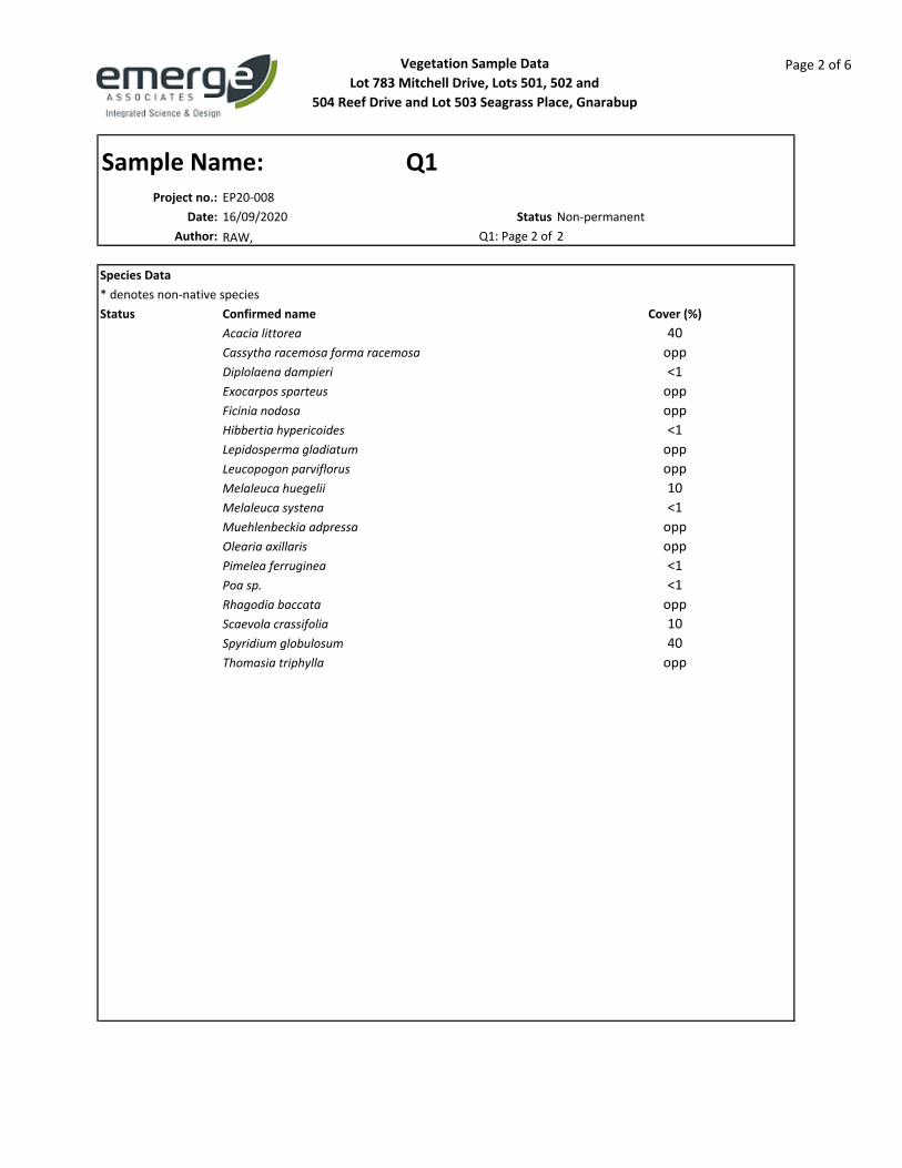
Vegetation Sample Data
Lot 783 Mitchell Drive, Lots 501, 502 and
504 Reef Drive and Lot 503 Seagrass Place, Gnarabup
Page 2 of 6
Sample Name: Q1Project no.: EP20‐008
Date: 16/09/2020 Status Non‐permanent
Author: RAW, Q1: Page 2 of 2
Species Data
* denotes non‐native speciesStatus Cover (%)
Acacia littorea 40
Cassytha racemosa forma racemosa opp
Diplolaena dampieri <1
Exocarpos sparteus opp
Ficinia nodosa opp
Hibbertia hypericoides <1
Lepidosperma gladiatum opp
Leucopogon parviflorus opp
Melaleuca huegelii 10
Melaleuca systena <1
Muehlenbeckia adpressa opp
Olearia axillaris opp
Pimelea ferruginea <1
Poa sp. <1
Rhagodia baccata opp
Scaevola crassifolia 10
Spyridium globulosum 40
Thomasia triphylla opp
Confirmed name

Vegetation Sample Data
Lot 783 Mitchell Drive, Lots 501, 502 and
504 Reef Drive and Lot 503 Seagrass Place, Gnarabup
Page 3 of 6
Sample Name: Q2Project no.: EP20‐008
Date: 16/09/2020 Status Non‐permanent
Author: RAW, Q2: Page 2 of 2
Quadrat and landform details
Sample type: quadrat Size: 10 m x 10 mNW corner easting: 314681 NW corner northing: 6236679
Altitude (m): 20 Geographic datum/zone: GDA94/Zone 50Soil water content: damp Landform: hilltop
Time since fire: > 5 yrs Disturbance: low ‐ Soil type/texture sand/loam with organic layer Bare ground (%): 0
Rocks (%) and type: 1%, limestone Soil colour: brown/Litter: 100% (leaves,twigs,) Vegetation condition: very good

Vegetation Sample Data
Lot 783 Mitchell Drive, Lots 501, 502 and
504 Reef Drive and Lot 503 Seagrass Place, Gnarabup
Page 4 of 6
Sample Name: Q2Project no.: EP20‐008
Date: 16/09/2020 Status Non‐permanent
Author: RAW, Q2: Page 2 of 2
Species Data
* denotes non‐native speciesStatus Cover (%)
Acacia littorea 30
Diplolaena dampieri 1
Hibbertia hypericoides <1
Lepidosperma ?squamatum 5
Melaleuca huegelii 10
Melaleuca systena 5
Olearia axillaris <1
Phyllanthus calycinus <1
Pimelea ferruginea 5
Rhagodia baccata <1
Scaevola crassifolia 30
Spyridium globulosum 10
Thomasia triphylla 10
Threlkeldia diffusa opp
Confirmed name

Vegetation Sample Data
Lot 783 Mitchell Drive, Lots 501, 502 and
504 Reef Drive and Lot 503 Seagrass Place, Gnarabup
Page 5 of 6
Sample Name: Q3Project no.: EP20‐008
Date: 17/09/2020 Status Non‐permanent
Author: RAW, Q3: Page 2 of 2
Quadrat and landform details
Sample type: quadrat Size: 10 m x 10 mNW corner easting: 314828 NW corner northing: 6236299
Altitude (m): 12 Geographic datum/zone: GDA94/Zone 50Soil water content: damp Landform: hilltop
Time since fire: > 5 yrs Disturbance: low ‐ Soil type/texture sand/loam with organic layer Bare ground (%): 0
Rocks (%) and type: 1%, limestone Soil colour: brown/Litter: 100% (leaves,twigs,branches) Vegetation condition: very good
Insert photograph

Vegetation Sample Data
Lot 783 Mitchell Drive, Lots 501, 502 and
504 Reef Drive and Lot 503 Seagrass Place, Gnarabup
Page 6 of 6
Sample Name: Q3Project no.: EP20‐008
Date: 17/09/2020 Status Non‐permanent
Author: RAW, Q3: Page 2 of 2
Species Data
* denotes non‐native speciesStatus Cover (%)
Acacia littorea 80
Cassytha racemosa forma racemosa 1
Diplolaena dampieri 5
Melaleuca huegelii 5
Rhagodia baccata 5
Scaevola crassifolia 10
Thomasia triphylla 10
Confirmed name