design guidelines layout - the province of british columbia - home
TRANSCRIPT

ParkDesign
Guidelines& Data
Province ofBritish Columbia
Ministry ofEnvironment
Lands andParks
A NATURALLANDSCAPE ARCHITECTURE
FOR BRITISH COLUMBIA’SPROVINCIAL PARKS

BC PARKS: PARK DESIGN GUIDELINES & DATA

● The aim of Park Design Guidelines & Data is tohelp BC Parks staff use their park expertise toproduce appropriate facility landscapes.
● A design approach to visitor facilities is definedthat:
blends with, or complements, natural parklandscapes
conserves or restores park environments
● A design and planning process is outlined for BCParks project teams to achieve these objectives.
● Park Design Guidelines & Data were initiated byBC Parks and prepared by landscape architecturalconsultants assisted by staff from BC Parks andother agencies.
● This is a companion volume to the Park FacilityStandards. It will help BC Parks staff with all parkfacility design projects — new, rehabilitation,reconstruction and alteration — as well as withappraising existing facilities.
● Park facility design and planning is a decision-making process. These guidelines are based aroundchecklists to help BC Parks staff steer projects toaddress park facility landscapes and environments— balancing recreation with conservation.
BC PARKS: PARK DESIGN GUIDELINES & DATA Page 1
Overvi ew
Simplicity in design and restraint inconstruction creates park facilities suited towhat attracts visitors in the first place –recreation in the natural park landscape.
These guidelines identify design criteriaand planning processes for BC Parks staffto provide sustainable, appropriate parkrecreation facilities. They promote facilitydesign that requires the least visibledevelopment.
Recognizing the facilities are an integralpart of a park means reducing the impact ofuse and basing planning and designdecisions on local and regionalconsiderations – for the park environment’slong term health. Maintaining natural parklandscapes and environments will helpensure the quality of visitor experiencesnow and in the future.
At neighbouring Bromley Rock ProvincialPark and Stemwinder Provincial Park,illustrated left, natural site elements createfacilities that blend into the natural parklandscapes. These examples show thecareful expenditure of resources and thethoughtful use of native materials. What isnatural, and what has been constructed?
Trees, rocks, grass, and forest litter makeup the natural landscapes of these parks. Inthe site design, trees remain uninterruptedthroughout, allowing facilities to beintroduced with little visible impact on thenatural landscape character. The nativegrasses are part of the natural landscaperather than part of a facility landscape. Thecolour and texture of the forest litter appearto form a continuous cover. Other than thecampground road pavement, rock is theonly visible construction material and hasbeen used to complement naturallyoccurring patterns.

BC Parks protects a catalogue ofspecial landscapes andenvironments for conservation,recreation and education. Some ofthese, for example Haynes PointProvincial Park in Osoyoos, wouldotherwise be under great pressurefrom development. The basis of BCParks’ education role is anawareness of the park environment.By blending facility design withthese special natural landscapes,visitors will continually sense theirinteraction with the specific naturalenvironment.
Canadian Cataloguing in Publication DataMain entry under title:Park design guidelines & data (computer file) — 2nd ed.
CD ROM format.“A natural landscape architecture for British Columbia’s provincial parks.”“Prepared as a BC Institute of Technology and BC Parks Learning Partnership Project.”Acknowledgements.Previously published in printed format: Brown, David D. (David Douglas). 1995 — Parkdesign guidlines & data. 1996.Includes bibliographical references:ISBN O-7726-3580-3
1. Provincial parks and reserves – British Columbia – Designs and Plans. 2. Recreation areas –British Columbia – Designs and Plans. 3. Parks – British Columbia – Designs and Plans. I.Brown, David D. (David Douglas), 1995 — Park design guidelines & data. II. British Columbia.Ministry of environment, Lands and Parks. III. British Columbia Institute of Technology. IV. BCParks.
GV198.L3M34 1998 712’.5’09711 C98-960156-0

These guidelines were initiated by BC Parks, Ministry
of Environment, Lands and Parks, Parks and Ecological
Reserves Management Branch, Recreation Services
Section, to define design quality objectivesfor visitor
facilities within British Columbia’s provincial park
system.
BC PARKS: PARK DESIGN GUIDELINES & DATA Page 3
Acknowledgement
Park Design Guidelines & Datawasdeveloped by BC Parks in conslutation withcurrent and former BC Parks staff, andwith information from park professionalsfrom other agencies:
Cariboo District w East Kootenay Districtw Fraser Valley District w Garibaldi /Sunshine Coast District w South VancouverIsland District w Okanagan District wSkeena District w Strathcona District wThompson River District w VancouverDistrict wWest Kootenay District w PeaceLiard District w Prince George District wProfessional Services Division, ParksCanada w Terrain Development, PublicWorks Canada w Parks Planning,Washington State w Landscape ArchitectureServices, National Park Service w OntarioProvincial Parks w Landscape ArchitectureServices, Oregon State Parks w LandscapeArchitecture Services, Pacific NorthwestRegion, US National Parks Service wHighway Environment Branch, Ministry ofTransportation and Highways.
The first edition, issued in limited printcopies was prepared by David D. Brown,DipArch RIBA and Arlene McIntosh BrownLandscape and Environmental Design andPlanning.
This 2nd edition, based on the McIntoshBrown document design, was prepared as aBC Institute of Technology and BC ParksLearning Partnership project. The CD-ROM version, compiled by PacificByteInformation Management Inc., is designedfor download printing by users in eithercolour or black and white versions.

Objectives of the design guidelinesThis document sets out to define a consistent, province-
wide design approachfor BC Parks’ visitor facilities. It
explains why such an approach is necessary and
indicates what it can achieve.
These guidelines address the process of designing and
planning visitor facilities in park environments. As a
companion to Park Facility Standards, they give BC
Parks’ staff a new set of park facility design and
planning criteria, providing direction as a working
document for reviewing projects from inception to
completion.
Achieving design qualityUsing Park Design Guidelines & Datawill help BC
Parks’ staff manage visitor facility’s design to give a
sense of a park’s natural environments. The guidelines
show how this will enhance visitors’ park use. The
design approach set out can evolve into styles
appropriate for each region of British Columbia that
will be as successful as traditional park architecture,
resulting I a collective and identifiable ambience for the
provincial park system.
This document will help BC Parks staff protect and add
to the value of provincial parks by directing visitor
facility design within each individual park’s natural
context.
Problem solvingQuality is best achieved through recognizing that park
facility design is a problem-solving process. Each
BC PARKS: PARK DESIGN GUIDELINES & DATAPage 4
Introduction
‘Park Design Guidelines & Data’ define anapproach to visitor facility design andplanning and give information on methodsand facts. The ‘Facility Standards’ containsworking drawings and specifications.
Unmistakably traditional park architecture,this designed entrance sign carries a mix ofinformation in a symmetrical, but informal,manner. The sign is handcrafted from woodand appears permanent, robust and in scalewith the forest landscape. Wildlife carvingshelp express to visitors that they areentering a sanctuary from the developedworld.
ParkDesign
Guidelines& Data
ParkFacility
Standards

facility project is park-specific. The guidelines and data
provide background information on park facility design
and planning, so forming a basis from which best to
solve a particular facility problem: gaining information
concerning users’ needs and operational requirements
from other staff, other agencies, contractors and
visitors.
Need for planningThorough design and planning will help staff to get the
best facility for the lowest cost, particularly by
decreasing the need for additional work to correct
omissions, which is likely to be uneconomic and detract
from a project’s final quality. Applying design and
planning criteria to an existing facility will help assess
the facility’s effectiveness and show where it might no
longer be appropriate.
As staff set priorities, Park Design Guidelines & Data
will also help in deciding what is most important and
will save both time and money over the life of park
facilities.
Project ManagementBC Parks’ staff can use this document to help manage
facility projects. It provides outline planning
information, gives an overview of facility requirements,
and will help staff plan for the life of facilities by
including maintenance and management considerations
during initial planning and design stages. It also gives
briefing information for design and planning projects
carried out with consultants as part of a project team.
BC PARKS: PARK DESIGN GUIDELINES & DATA Page 5
Introduction
‘Park Design Guidelines & Data’ arestructured around two issues: design withinthe park landscape and design within thepark environment.
— the park landscapeis a park’s generalappearance.
— the park environmentrefers to theprocesses that affect all life within thepark.
These topics are interdependent.
An appropriate park landscape architecturefor a specific park will be based on thefollowing:
the natural components of the park — itslandforms, vegetation and wildlife
any human influences on the park— forexample: archeological and cultural,previous agricultural or logging activities
its visual quality — which will vary withvisitors’ sensitivity and culture
an understanding of the natural processes— of climate and ecology within the park

How the guidelines are set outA design approach is defined in the guidelines using
checklists and examples of successful existing work
within the provincial park system. A section covering
design principles related to park landscapes and park
environments outlines the strategy of this design
approach.
A facility project planning section contains a checklist
to help a BC Parks team direct project planning for
park landscape and environmental issues. Many design
and environmental issues are specialist and may require
opinion from consultants. This section aims to give
staff some insight into how consultants might
contribute to the BC Parks team.
Specific park facility topics are covered to give BC
Parks staff organized criteria for the design and
planning of specific park topics. These sections include
park site planning, entrances, roads, parking, day-use
areas, campgrounds, trails, signage and structures.
Associated design and planning data provide the basic
information needed to realize the design approach.
Following sections give vegetation, construction and
utilities criteria for planning and carrying out project
construction.
Why checklists are usedBetter design quality is generally achieved by using
more thought rather than using more money. This is
particularly true with introducing park facilities into
natural park landscapes where less construction, which
results in less expenditure, is the aim. A checklist
BC PARKS: PARK DESIGN GUIDELINES & DATAPage 6
Introduction
Visitor facilities in provincial parks need tocater for increasing numbers of visitors andnot detract from the park’s natural qualitiesthat initially attract them. Cathedral Groveat MacMillan Provincial Park providesaccess for 900,000 visitors a year to a rareprotected giant forest landscape.
approach applied to projects should encourage thorough
forethought when designing and planning projects —
particularly necessary when work has to be
accomplished within limited budgets.
The checklists show what is important; they outline an
approach and can adapt to the variety of regions and
parks throughout the province. Checklists also provide
a basis for assessing solutions when projects are carried
out with design consultants. In aiming to guide the
design and planning process, this document will be
useful for briefing consultants when they form part of a
BC Parks project team.
Images of successful BC Parks workCommunicating design quality effectively with
contractors or volunteer groups means visualizing the
final work. This assembly of images, although modest,
will help explain what BC Park is trying to achieve
through building on previous successful BC Parks’
work.
Future additionsPark Design Guidelines & Datais not intended to be a
static document, but to be added to over time through
contribution by district staff. A decimal numbering
system has been used to accommodate future additions.
BC PARKS: PARK DESIGN GUIDELINES & DATA Page 7
Introduction
‘Park Design Guidelines & Data’ providesa design and planning process which aimsto create a natural landscape architecturefor facilities in provincial parks. Its basis ischecklists and illustrations of successfulfacilities in provincial parks.
The contents are structured as follows:
1. Design PrinciplesWhat design approach should be taken forBC Parks visitors facilities, and why?
2. Facility Project PlanningHow might park facility projects be plannedto help achieve the objectives of the DesignGuidelines?
3. Facility PlanningWhat background environmental criteriashould provide the basis of park siteplanning?
4. Facility DesignWhat should be considered when designingand planning visitor facilities?
5. Facility DesignImplementationWhat should be considered when carryingout projects?


Overview 1
Acknowledgements 3
Introduction 4
Objectives – relationship with ‘Facility Standards’ – achieving design quality–problem solving need for planning – park landscape and park environment –project management – how the document is set out – why checklists are used– images of successful BC Parks work
1 Facility Design Principles 13
Continuity – decision making – substance – natural landscape architecture –sanctuary – quality – building with vegetation – park architecture for theregion – building a BC Parks heritage – balancing conservation andrecreation – adding visitors to the park environment – sustainable design –siting for the environment – presenting parks and changing values – economicimportance of provincial parks – public perception of BC Parks – effects ofincreasing use – building on the BC Parks heritage
2 Facility Project Planning 17
Key diagram:main stages of facility design process – checklists – exampleproject types – BC Parks appearances / cost / performance criteria – decisionto use consultants – cost of using consultants – working with consultants –teamwork – BC Parks as informed client – site work design changes –volunteer labour
3 Facility PlanningLandscape inventory:flowchart showing main stages of key process 3—1
Introduction to Environmental Impact: example considerations 3—3
Carrying capacity:flowchart showing outline method—design aid 3—5
Limits of acceptable change:flowchart showing outline method—management aid 3—6
4. Facility Design
4.1 Park Facility Site PlanningDesign References, Checklists, Design Notes:art of arranging facilities — need for order — design for all season — need for site-specific design — park and visitor analysis — site planning considerations — security considerations 4.1—1
Facility Relationships:diagram showing organization of typical park facilities 4.1—7
Space Requirements:data related to park landscape type covering; road corridors; vehicle parking; day-use areas; interpretation areas; campgrounds, marine areas 4.1—8
BC PARKS: PARK DESIGN GUIDELINES & DATA Page 9
Contents
Noise:continuous noise sources: highway, speedboat, groups; separation, noise barriers 4.1—9
Climate: considerations of sun and wind, rain and snow; simple solar geometric data; effects of windspeed on comfort; microclimate checklist 4.1—10
General Data:pedestrian space requirements; human scale; soil classification; materials; grade assessment; grade requirements; angle of repose; steps, ramps; disabled access requirements 4.1—11
4.2 Park EntrancesDesign References, Checklists, Design Notes: importance as park threshold — identity — visibility — siting and setting —landscape and environment criteria 4.2—1
4.3 Park RoadsDesign References, Checklists, Design Notes:character — impact of construction — surface types — traffic calming — engineering design criteria 4.3—1
Design Data: Classification — engineering design criteria 4.3—5
Project Planning:flowchart — road shoulders — traffic calming — design standards — vegetation management — drainage — safety barriers 4.3—6
4.4 Visitor ParkingDesign References, Checklists, Design Notes: relation to landscape — shape and size — planning considerations — landscape and environment criteria 4.4—1
Design Data: stall sizes — layout diagrams 4.4—3
Project Planning:flowchart — crossfalls — layout, mix of stalls — wearingsurfaces — seasonal use — drainage — accessibility 4.4—4
4.5 Day-Use AreasDesign References, Checklists, Design Notes:balancing provision and seasonal use — picnic table layout considerations — interpretation areas —boat launches — day-use design considerations — complexity of day-useareas — landscape and environment criteria 4.5—1
PicnickingDesign Data:planning diagrams — picnic area — group picnic area — densityand services data 4.5—5
Project Planning: flowchart 4.5—6
Interpretation AreasDesign Data: planning diagram — schedule of accommodation — planning criteria — orientation 4.5—7
Project Planning:flowchart — site considerations — acoustics aspect Beaches 4.5—8
BC PARKS: PARK DESIGN GUIDELINES & DATAPage 10
Contents

Design Data: planning diagrams — wet beach — dry beach data 4.5—9
Project Planning:flowchart 4.5—10
Boat LaunchesDesign Data: planning diagram — schedule of accommodation — docks —boating — fishing — 4.5—11
Project Planning:flowchart — site selection — survey criteria 4.5—12
Winter UsePlanning diagram— schedule of accommodation — planning criteria — cross — referencing to boat launch, campgrounds and day use area: picnicking 4.5—13
Marine SitesPlanning diagram — schedule of accommodation — planning criteria — cross — referencing to boat launch, campgrounds and day use area:picnicking 4.5—14
4.6 Park Campgrounds and CampsitesDesign References, Checklists, Design Notes:need for simplicity — landscape and environmental issues — campground location considerations — campsite design considerations 4.6—1
Design Data: planning diagrams — schedules of accommodation — campground entrance and roads — campsite data — campground services 4.6—5
Project Planning:flowchart— drainage — wildlife — vegetation — water source — aspect — soil 4.6—6
Design Data: planning diagrams — schedules of accommodation — campground entrance and roads —campsite data — campground services — group campgrounds 4.6—7
4.7 TrailsDesign References, Checklists, Design Notes: natural landscape to direct route — width considerations — providing structure by linking facilities — landscape and environment criteria 4.7—1
Design Data: trail classification — trail systems diagrams — user profiles 4.7—5
Project Planning:flowchart 4.7—6
4.8 Park SignageDesign References, Checklists, Design Notes: importance of co-ordination and location — landscape criteria 4.8—1
BC PARKS: PARK DESIGN GUIDELINES & DATA Page 11
Contents

4.9 Park StructuresDesign References, Checklists, Design Notes:Need for park architecture — regional factors in design — environmentally sensitive design gatehouses — landscape and environment criteria — buildings and shelters — viewing areas — bridges 4.9—1
5 Facility Design Implementation
5.1 Park Facility VegetationDesign References, Checklists, Design Notes:role of vegetation management — need for understanding of park environment — aims of vegetation maintenance — and environment criteria 5.1—1
5.2 Park Facility VegetationDesign References, Checklists, Design Notes:need to minimize construction — environmental issues — soil erosion — wind damage — landscape and nvironment criteria 5.2—1
5.3 Park UtilitiesChecklists, Design Notes:new technologies — decreasing demand — contribution of ecosystems — landscape and environment criteria 5.3—1
6 Project StatementStandard forms to help structure project planning: project statement: environmental impact worksheet: environmental impact assessment and proposed mitigation 6—1
7 Case StudyStandard form with photographs for distributing completed project information throughout BC Parks 7—1
8 Master Checklists 8—1
9 AppendicesReferences:sources — further reading 9—1Glossary 9—3Conversion Factors 9—5
BC PARKS: PARK DESIGN GUIDELINES & DATAPage 12
Contents

Everything manmade installed within a provincial parkis the result of a BC Parks decision.
Visitor facility design is the manner in which BC Parksprovides access and interpretive information in BritishColumbia’s provincial parks. Visitors’ images of parksare primarily visual. Park facilities form their ownlandscape within the park landscape, and theirappraisal by visitors is often unconscious.
Outlined overleaf is a look from a design perspective atsome issues facing BC Parks in the mid-1990’s. Theseissues have created the facility design approachpromoted by the Design Guidelines.
BC PARKS: PARK DESIGN GUIDELINES & DATA Page 13
Facility Design Principles

PARK LANDSCAPE
Continuity● Can the individual park’s visitor facility be
identified as a single designed entity that is thesum of all the site elements? Do the facilitiesappear to be the creation of one collective mind?
Decision-making● Does the park facility design, from site plan to
details, balance performance, appearance and costcriteria? Does it conform to BC Parks policies,procedures, and the park management plan?
Substance● Does the design appear permanent and robust?
Does it appear timeless, like the park?
A natural landscape architecture● Does park facility design blend with, or
complement, the natural park landscape? Is itspecific to the park, and dominated by the park’slandscape character? Is vegetation around thevisitor facilities managed and maintained to appearnatural?
Sanctuary● Is the park defined as a natural sanctuary for
visitors by the absence of all urbane character? Areall things from the urban or suburban world leftoutside the park?
Quality● Is facility design of sufficient quality to suit the
public — neither commercial nor domestic?
Building with vegetation● Is native vegetation the first choice building
material? Can it be used to create barriers,screening, shading, edging, or for bioengineering?
BC PARKS: PARK DESIGN GUIDELINES & DATAPage 14
Facility Design Principles
Presenting parks to reflect changingvalues
The natural landscapes protected by BCParks contain some of the finest scenery inthe world. These environments are globalsignificance. In many ways they provide theprovince’s worldwide identity, and areimportant enough individually andcollectively to be conserved by society forfuture generations.
Since the late 1970s the concept of natureand the environment has been a centralissue internationally. Nature hasincreasingly been written about, talkedabout, and filmed. The wilderness hasassumed huge value in popular culture.This period has seen such growth in theimportance of the environment to publicthat the knowledge that the wilderness justexists has become significant for manypeople.
BC Parks, with a conservation mandate,needs a natural landscape architecture forpark visitor facilities determined ordominated by the specific park’s naturallandscape.
Economic importance of provincial parks
With visitors numbering around 25 millionper year in the mid-1990s, provincial parksare of enormous value to the economy ofBritish Columbia. Growth in specialistnature and adventure tourism is directed atthe ‘purer’ wilderness environments forwhich British Columbia is world renowned;tourism earned British Columbia $5.82billion during 1994. The importance of thepark system is evident from BritishColumbia tourism marketing of ‘nature’,and it is largely the provincial park systemthat gives access to these areas.
Tourists’ anticipation of this sceneryrequires a facility design approach thatappears as much a part of the naturalsurroundings as possible.
Public perception of BC Parks

Park architecture for the region● Is the architecture recognizable from concept to
details as park architecture? Does the designrespond to the region’s climate? Is the designinformed by the park region’s traditional methodsand materials of construction?
Building a BC Parks heritage● Is the design evolved from, or in keeping with,
traditional BC Parks style? Is it readily identifiableas a BC Parks facility?
Balancing conservation and recreation
● Does planning minimize the number ofconstruction projects? Since conservation andminimizing expenditure are objectives, are thereways of providing for recreation without building,for example, by reviewing existing facilities orredirecting visitor use?
BC PARKS: PARK DESIGN GUIDELINES & DATA Page 15
Facility Design Principles
BC Parks polls show a shift in publicpriority from recreation to conservationduring the early 1990s. The creation of anumber of new parks in resource-rich areasduring the mid-1990s underlines theimportance of conservation to the public.
Facility design in provincial parks needs toreflect this concern, not just by continuingto be more environmentally sensitive, but byreflecting the dominant value of the naturalpark landscape.
Effects of increasing use
Parts of the Lower Mainland, VancouverIsland and the Okanagan have undergonesubstantial population increases from theearly 1990s. Increased numbers of visitsare stressing some provincial parks, inparticular their day-use areas. The naturalenvironments of the most used parks are indanger of being damaged as BritishColumbia’s population increases.
Park facility design and management willshow the public the commitment of BCParks to provide simple, natural parks fromwhich to learn and enjoy. As BC Parksconcentrates resources on providing simplevisitor facilities within conserved naturalareas, a design simplicity and constructionrestraint will enhance visitors’ experiencesas they increasingly become naturalretreats.

PARK ENVIRONMENT
Adding visitors to the park environment
● Do the facilities create a habitat for visitors? Oncewithin the park environment, does the design offacilities aim to accommodate visitors alongsidethe plant and wildlife communities in a simple,natural way?
Sustainable design● Is all design sustainable — directed at conserving
or restoring natural processes? Are the design andprovision of utilities environmentally sensitive?
Siting for the environment● Have facilities been sited so as not to detract from
a park’s primary resources?
BC PARKS: PARK DESIGN GUIDELINES & DATAPage 16
Facility Design Principles
Building on the BC Parks heritage
Rustic design had been traditional beforethe 1960s throughout Canada federal andprovincial park environments. Constructionwas typically wood and stone, withbuildings sited to be dominated by the parkenvironment. Natural materials were usedwhenever possible in scale with the naturalsettings. Many provincial parks, forexample Little Qualicum Falls, havesufficient quality for some of the visitorfacilities to become heritage sites inthemselves.
As population increases in BritishColumbia have led to greater recreationaldemands, and as replacement and repairhas taken place, the original concepts forpark facility design have been eroded. Inthe mid-1990s, as BC Parks takes on astronger conservation role, a landscapearchitecture is needed that builds from thetraditional values. A distinctive park imageis needed that blends facilities into eachindividual park’s setting.
Sustainability
Sustainable design in parks meansproviding visitor facilities andsimultaneously conserving or restoring thenatural park environment. It requires ananalysis of the park environments todetermine how the natural systems willadapt to the changes development brings.
The use of environmentally sensitivecriteria in development decision-making isnow widely documented. The place ofgovernment as a leader is shown indocuments such as the federal “Canada’sGreen Plan’ document.

BC PARKS: PARK DESIGN GUIDELINES & DATA Page 17
Facility Project Planning
his project planning section will help structure theprocess of evaluating and implementing ideas aboutvisitor facilities.
Design quality and cost-effective projects are requiredthroughout the provincial park system. One way ofachieving this is by using a straightforward, butflexible, process suited to the BC Parks organization.
The following view of the project planning process aimsto help achieve the guidelines’ objectives. It should beused to supplement other BC Parks standard documentsand other relevant project-specific information.

Facility Project Planning
High visitor use in Cathedral Grove MacMillan Provincial Park stresses the forestenvironment. Recent forest understorey revegetation and trail redesign has invisibly andinexpensively improved the visitor experience and provided better protection for the forestenvironment.
BC PARKS: PARK DESIGN GUIDELINES & DATAPage 18

This key diagram introduces and outlines the main stages of the park facility design process whichis the basis of the planning methods used in 'Park Design Guidelines & Data'. Designing forsustainability means satisfying many environmental criteria. Of course when constraints occur, sodo opportunities. Sometimes the most successful projects result from situations with mostconstraints.
Review
the 'Park Design G
uidelines & Data' at the m
ain stages of the design and planning process.
Prod
uce
draw
ings
, ske
tche
s, a
nnot
ated
pho
togr
aphs
and
dia
gram
s to
reco
rd d
ecis
ions
.Concept/outline cost estimate
Review park management plan. Establish service level, stakeholder and boundary information.
Establish the site's carrying capacity.
Develop a further understanding of the park
landscape and environment using a landscape inventory
Establish project feasibility planning and design data,
using Park Facility Site Planning section and
preliminary cost estimate.
Review the likelihood of creating a successful facility (e.g. demand, ease of access to
natural/cultural features, length of season), considering user requirements are secondary to
park natural and cultural resources.
Establish detailed planning and design data using Park Design Guidelines & Data and other
sources. Final cost estimate.
Monitor site factors and reevaluate design during construction. Establish limits of
acceptable change.
Establish whether there are any legislative or policy
constraints on the project.
Identify what relationship the proposed facility should have with park resources and any
existing facilities.
Use information gathered during environmental
impact assessment.
BC PARKS: PARK DESIGN GUIDELINES & DATA Page 19
Facility Project Planning

ProjectsIdeas that help carry out a park’s management plan usually come from individual staff within a district.
What generates ideas in the first place? They might come as a solution to an apparent problem, or from an overall review of a park landscape and environment.
Some example situations are as follows:
Maintenance costs are increasingMaintenance tasks are labour intensive resulting in an annual increase in costs. This may be due to the landscape being maintained in a static vegetated condition, such as areas of mown grass.
Intensive recreational use problemsTo allow intensive recreational use, the wear on the landscape is resulting in annual injections of funds to prepare for the busy season. For example, the grass mix might not be hard wearing enough, or suitably drought resistant, for current use.
Facilities may be over-used and landscape degradation make be taking place at an unacceptable level. The use of an area may need to be reviewed.
Aging mechanical plantThe plant is nearing the end of its life. Regular repairs to an irrigation or water system are prohibitively expensive and their replacement cost may be excessive or no longer be appropriate.
Redirection of district resourcesFacilities are under-used and might be better sited elsewhere in the District, e.g. picnic tables.
Quality of the park landscapesDevelopment has been taking place piecemeal over many years and is losing direction and cohesion to the detriment of the park’s visual quality.
Environmental problemsEnvironmental problems are starting, such as soil erosion, and need to be dealt with before
they become irreversible. Facility development is affecting park wildlife and vegetation requiring reassessment of the park objectives.
Facility development was poorly sited and built, such as a campground in grizzly bear habitat, and should for reasons of conservation and visitor safety be removed, the landscape rehabilitated and the facility relocated.
Undersized facilitiesVisitor numbers are increasing due to expanding urban populations of tourism. New facilities have been identified as required, such as fully accessible toilets, and a landscape review is appropriate at this time to fit the new with the existing.
Use conflictsConflicts are increasing between different use groups, such as mountain bikes and hikers. Existing facilities need reassessing.
Availability of volunteer resourcesA volunteer group has offered labour, is willing to enter a legal agreement, and is looking for an opportunity to work in the park.
Restoration and rehabilitationA review of the existing developed areas and an objective assessment of the facilities create a desire to restore an area as far as possible to its natural state (while allowing certain visitor use to continue). This often means looking for primarily low cost methods of reinstating the landscape to appear natural.
Many of these situations will come up for reappraisal during the management plan review process. From there they will need to be addressed as a site planning issue, giving direction to work which will inevitably take place over many years.
Other projects might be initiated by a change in BC Parks policy, or public health and safety issues.
BC PARKS: PARK DESIGN GUIDELINES & DATAPage 20
Facility Project Planning

Facility Project Planning
● Does the original idea meet management planobjectives?
● Does the idea balance performance, BC Parksappearance, and cost criteria?
● Has the problem the idea is intended to solve beenre-appraised and defined?
● Does the idea still solve the problem, within thePark Design Guidelines & Data framework, andbalance conservation and recreation? Or is there abetter option?
● Do any other planned or completed BC Parksprojects province-wide offer useful precedents?
If the idea looks feasible, obtaining a consensuswithin the District Office team...
● Are the problem and the solution clearly stated?
● Has the project’s effect on the park’s landscape andenvironment been evaluated?
● What resources and management are needed todesign and plan the project? Are they availablewithin the BC Parks team, or are consultantsrequired? What degree of site supervision isneeded from BC Parks?
● What is the program for the project? How long isneeded for designing and construction, and whencould each stage start considering fiscal andseasonal issues?
● How will it be funded? How do costs breakdowninto capital, installation and maintenance over thefacility projected life? Is there any effect onrevenue?
BC PARKS: PARK DESIGN GUIDELINES & DATA Page 21
This simple concept uses performance(installation and environmental), BC Parksappearance and cost criteria in makingdesign decisions. The balanced solution liesin the common area.
COST
PERFORMANCEBC PARKS
APPEARANCE

The decision to use consultantsDesign help may be needed on substantial projects, especially to deal with increasingly complex environmental design issues.Consultants working on projects in provincial parks should have demonstrated competence. Such help, properly managed by BC Parks staff as an informed client, should allow less funds to be spent more effectively.Cost of using consultantsFees should range from between 6% and 15% of construction costs, depending on the size and complexity of the project.Working with design consultantsThe checklists should give BC Parks an important aid for effective working with design consultants during briefing and approvals.At the beginning of the project, a discussion with the consultant should be arranged to define responsibilities and the terms of engagement. BC Parks should ensure that no misunderstandings exist about services to be provided.A plan of work should also be agreed with the consultant at this stage. It is worth noting the main project stages (bearing in mind that the process is rarely linear). Each stage should be reviewed in advance:Defining the problemProgram and analysis of site and visitorsSchematic design and preliminary cost estimateDesign development and detailed costingContract documentsBidding or negotiationConstruction/contract administrationPost construction: opening and maintenanceTeamworkThe success of a facility design project requires creating a balanced working team between BC Parks staff and any contracted help. BC Parks, as a client, can contribute knowledge of the park and its visitors, and BC Parks policy and procedures to the project team; the consultant can contribute specialist knowledge or skills. Solutions to design problems in BC Parks, with a wide range of in-house expertise on which to draw, must be a team effort.
BC Parks as an informed clientBriefing is a two-way process. BC Parks and the consultant have a joint responsibility to develop the brief: it is the consultants responsibility to ensure he gets the necessary information from the client to do the work properly, and it is the client’s responsibility to work with the consultant.Site work standardsMinimum quality standards are achieved by clearly stating what is required within contract documents, or for volunteer work, within a Memorandum of Agreement.For construction, approving an area of sample work is an effective way of achieving an appropriate quality. This would be stipulated as an early task, and when agreed as of a suitable standard used as a control for the duration of the construction.Design ChangesChanges may be necessary because of the discovery of unknown site conditions, such as an underground water course or bedrock.It is however important that no license is given for contractors or volunteers to make changes willfully, since it negates the design and planning process.Briefing contractors and volunteers wit the ‘Park Design Guidelines & Data’ will help working relationships and results.Volunteer labourSuccessful and unsuccessful precedents exist for volunteer projects within provincial parks. BC Parks now has working experience of how to use what is likely to be an increasingly important resource.Volunteer work must be directed for the benefit of park. Contractual agreements and indemnities are required.
BC PARKS: PARK DESIGN GUIDELINES & DATAPage 22
Facility Project Planning

following project approval and funding . . . .
● Are any permits required?
● Have arrangements been made with any BC Parksstaff with specialist pertinent knowledge toparticipate in the design process (any lateradditions or subtractions are costly and oftendetract from design quality — the object of thisprocess)?
design and planning . . .
● Has the project been developed and refined usingthese guidelines? Does the project still balanceperformance, appearance and cost criteria?
if selecting consultants . . .
● Has the problem not the solution been clearlystated?
● Is Park Design Guidelines & Data referred to inthe request for proposal documents?
working with design consultants
● Is the design restrained? Is Park Design Guidelines& Data being used throughout the process?
completion . . .
● Are the intentions of the maintenance issuesproperly defined, documented and passed on foroperation? Is there a method for structuredmonitoring to ensure that the quality of the newfacility is not diminished, or the site environmentdegraded?
● Has anything been learned in planning,constructing, or maintaining the work that willhelp other districts or help BC Parks improvepolicies and standards?
BC PARKS: PARK DESIGN GUIDELINES & DATA Page 23
Facility Project Planning


Facility Planning outlines the key concepts for asustainable approach to visitor facility design: theenvironmental impact of development; carryingcapacity used as a limiting factor early in the designprocess; and setting limits of acceptable change toallow monitoring of completed projects.
This section includes an outline of the landscapeinventory process, which is used to assemble thenecessary site information from which detailed facilitydesign proceeds.
BC PARKS: PARK DESIGN GUIDELINES & DATA Page 3—1
Facility PlanningDESIGN REFERENCES

Facility Planning
BC PARKS: PARK DESIGN GUIDELINES & DATAPage 3—2
Beaches are prime attractions in many provincial parks, and can offer simplerecreation in an undeveloped landscape. Here the facilities are provided by nature:the foreshore trees create shade and outdoor spaces, and the gravel beach supplies arobust surface and access to the water for swimmers and boats. This is a peaceful,uncluttered scene.

A landscape inventory can be used to help increase the BC Parks project team’s understanding ofthe park landscape and environment. It is a survey of all the natural and cultural elements makingup the park environment that may affect — or be affected by — the design of a proposed facility.Suggested above are some subject areas that an inventory might address.
The simple method outlined above provides specific background information that will help staffproduce answers throughout the decision-making process. Information is best kept brief and visual,and can be recorded by annotating overlays on maps, site survey photographs, and aerialphotographs.
Some of this information may be gathered during an environmental impact assessment.
VEGETATIONSpecies, composition, successional stage, and healthAreas of rare and endangered plants sensitive to landscape changeAny fire history and effect on vegetation pattern
CULTUREPrehistoric and historic features
LANDSCAPE FEATURESSignificant natural places, views
HAZARDS for exampleBear habitats, people/wildlife conflictsTrees prone to windthrowCliffs and steep slopesAvalanchesStrong water currentsUnstable banks
NOISEAssess noise levels and character
Decide what information to collect based on the proposed facility and the parkís landscape character.
CLIMATERegional patterns and micro-climateSite orientation
TOPOGRAPHYPatterns of landformsSlopes (gently sloping usually best for recreation)Unique features
HYDROLOGYPattern of water movement through the landscape ñ surface and sub-surface (well-drained areas usually best for recreation)Potable water source (and risk to water quality of use)
SOILVulnerability to wear and erosion(deep, medium to coarse texture usually best for recreation)Ability to re-generate vegetation
Wild-LifeSpecies composition, (rare and endangered?) population, densities, habitats, patterns of movement within site area
••
•••
•
•
•
•
•
Assess how visitors might use (or already use) the landscape for recreation
USING THE DATADivide site into units of similar characteristics. Identify key development issues. Assess which areas are developable.
Collect information from relevant mapping, aerial photographs, published material, site, other staff, other agencies (typical topics as follows: avoiding amassing
irrelevant material...)
BC PARKS: PARK DESIGN GUIDELINES & DATA Page 3—3
Facility PlanningLANDSCAPE INVENTORY

This worksheet is intended to help staff record observations and develop an approach to assessingimpacts on a site specific basis.
Possible throughsurface water
runoff
Probable Probable
Probable
Probable
Probable
Inevitable through vehicle collisions,
roadkill – decreased through slow design
speeds, traffic calming
ROADS
VECHCKE PARKING Possible through surface water runoff
SOIL EROSIONPOTENTIAL DURING USE
NATURAL DRAINAGE ALTERED
VEGETATION DAMAGED/DESTROYED
WILDLIFE INJURED/DESTROYED
CAMPGROUNDS AND CAMPSITES
DAY-USE AREAS: PICNICKING
DAY-USE AREAS: BEACH
STRUCTURES – BUILDINGS/SHELTERS
UTILITIES – WIND/WATER TURBINES
UTILITIES – SOLAR POWER
UTILITIES –ENGINEERED WETLANDS
UTILITIES – SEPTIC FIELDS
UTILITIES – VAULT TOILETS
UTILITIES – COMPOSTING TOILETS
UTILITIES – HYDRO/GAS
STRUCTURES – VIEWING PLATFORMS/BOARDWALKS/BRIDGES
STRUCTURES – BOAT LAUNCHES/DOCKS
Probable along circulation routes
Probable along circulation routes
Probable along circulation routes
Possible by circulation routes
Possible by circulation routes
Possible by circulation routes
Probable to bank vegetation
Probable – land-intensive, soils
disturbed
Possible by motor boat use
Possible – consideration might
be given to lines mounted on pedestals
Probable, if overhead (can regenerate if
underground)
Very likely – minimize by keeping buildings
small, and siting where possible
between existing vegetation
As roads, but reduced risk through lower
speeds
ProbableProbable by access roads
As roads, but reduced risk through lower
speeds
Probable – also adjacent, depending on users keeping to
trail route
Probable during construction and below structure
Probable Possible Possible
Probable Possible Possible
Possible
Possible
UnlikelyUnlikely
Unlikely Unlikely Unlikely Unlikely
Unlikely Unlikely Possible Unlikely
Unlikely Unlikely Possible Unlikely
Unlikely Unlikely Unlikely Unlikely
Unlikely Unlikely Probable alteration Unlikely
Unlikely Unlikely Unlikely
Probable
Possible on backshore Possible on backshorePossible Possible
TRAILS
BC PARKS: PARK DESIGN GUIDELINES & DATAPage 3—4
Facility Planning INTRODUCTION TO ENVIRONMENTAL IMPACT

Creation of barriers both to safe wildlife movement and
plant seeds. Possible introduction of exotic species
along the road corridor by vehicles/boats using the road.
Traffic(seasonal variation)
Petroleum products from vehicles through surface water
run-off
As roads above, with more concentrated petroleum
products spillage’s likely. Some littering inevitable.
Noise and pollutants from use of heavy machinery. Erosion
potential near slopes. Possible introduction of non-native fill.
Noise and pollutants from use of heavy machinery. Erosion
potential near slopes. Possible introduction of non-native fill.
VECHCKE PARKING
ROADS
Combined traffic and human noise
Possible, with inevitable detraction
Local deterioration of air quality by traditional campfires.
Cooking odours. Some littering inevitable.
Noise and pollutants from use of heavy machinery. Erosion
potential near slopes. Possible introduction of non-native fill.
Combined traffic and human noise during day,
with some nighttime noise
As roads above – especially when looped
Cooking odours. Some littering inevitable
Some noise and pollution through use of machinery
Human noisePossible, with inevitable detraction
Some littering inevitable Some impactMainly on beachMinimal
Some littering inevitable Some impactYes, depending upon degree of use
To some extent
Possibly by construction materials (particular risk from some wood preservatives). Also possibly by littering.
Noise and pollutants from use of heavy machinery – manage
construction to minimize required access. Erosion
potential near slopes. Vegetation likely destroyed for
access. Possible introduction of non-native fill. Construct
walkways first for construction process.
Inevitable, but seasonalTo some extent
Possibly by construction materials (particular risk from some wood preservatives). Also possibly by littering.
Some noise through use of power tools. Vegetation likely
destroyed for access.
Inevitable, but seasonalPossible
Petroleum products from motor boats. Possibly sewage. Possibly by construction
materials.
Noise and pollutants from use of machinery. Vegetation likely
destroyed for access.
Major problem to wildlife and some visitors
Damage to wetland/marine environments. Siting must not impede natural beach sand movement. Possible
introduction of exotic species from boat
propellers.
Probable Noise and pollutants from use of machinery. Some linear destruction of vegetation.
PossiblePossible introduction of exotic species along corridor if overhead
Probable MinimalSomePossible
NOISE GENERATED BY USE
HABITATS ALTERED/DAMAGED
TOXICS & POLLUTANTS INTRODUCED
IMPACT OFCONSTRUCTION PROCESS
CAMPGROUNDS AND CAMPSITES
DAY-USE AREAS: PICNICKING
DAY-USE AREAS: BEACH
STRUCTURES – BUILDINGS/SHELTERS
UTILITIES – WIND/WATER TURBINES
UTILITIES – SOLAR POWER
UTILITIES –ENGINEERED WETLANDS
UTILITIES – SEPTIC FIELDS
UTILITIES – VAULT TOILETS
UTILITIES – COMPOSTING TOILETS
UTILITIES – HYDRO/GAS
STRUCTURES – VIEWING PLATFORMS/
BOARDWALKS/BRIDGES
STRUCTURES – BOAT LAUNCHES/DOCKS
Possible MinimalMaintenanceUnlikely
Filtration System Varies with methodMaintenanceProbable
Probable soil leaching Noise and pollutants from use of machinery. Destruction of
vegetation.
MaintenanceProbable
Some MinimalSomeWater circulation
From visitor use Dependent on locationSomeWater circulation
TRAILS
BC PARKS: PARK DESIGN GUIDELINES & DATA Page 3—5
Facility PlanningINTRODUCTION TO ENVIRONMENTAL IMPACT

Evaluating carrying capacity establishes how many visitors can use a park area without damagingthe park environment or detracting from visitor satisfaction.
Carrying capacity is a design tool; it is useful for new construction projects and assessing existingfacilities. It should be a key factor in most facility design processes, as indicated in the followingpark specific facility design sections, since it accounts for both conservation and recreation quality.
Define area for assessment
Approximate number of visitors, timing and distribution
Identify desired visitor experience from area zoning in Park
Management Plan: intensive recreation,, natural environment,
special feature, wilderness recreation, wilderness
conservation
Assess ability of landscape to visually absorb proposed use while providing required visitor
experience, i.e. avoiding perception of crowding by
spatial/physical absorption within landscape character, e.g. forested
hilly, or alpine.
Assess capability of site ecology to withstand proposed use using
landscape inventory and environmental impact assessment
information.
BC PARKS: PARK DESIGN GUIDELINES & DATAPage 3—6
Facility Planning CARRYING CAPACITY

Setting limits of acceptable helps manage park facility use and development for the future.
Limits of acceptable change is a management tool that uses site indicators to inform parkmanagement of changes to an environment through visitor use and siting of facilities. Indicatorsmight include: environmental degradation (such as soil erosion) or damage to trees), the creation ofsafety hazards and increases in maintenance costs.
The limits of acceptable change approach is based on the same premises as ‘carrying capacity’: siteecology and visitor experience. Using limits of acceptable change give staff flexibility to use avariety of management responses including limiting use, constructing more facilities, creatingbarriers, or changing maintenance regimes.
Identify site indicators subject to change by visitor use, e.g. trail erosion, stream pollution,
user feedback, use of area by wildlife, soil compaction, increase in site size.
Establish what is acceptable and appropriate change to the site indicators.
Monitor the facility and take mitigating management action if site indicators show the
level of change becoming unacceptable.
BC PARKS: PARK DESIGN GUIDELINES & DATA Page 3—7
Facility PlanningLIMITS OF ACCEPTABLE CHANGE


The following sections provide criteria, commentary,and checklists on specific park facility topics.
Context and the concept of sustainable development arecentral issues; the life of many visitor facilities will lasttwo or more generations.
4.1 Park Site Planning gives background informationchecklists and references to define the design approachand data information on facility relationships, spacerequirements, noise, climate and site planning generaldata.
Following sections on specific park topics giveillustrative references checklists and design notes todefine the design approach, with design data andproject planning information:
4.2 Park Entrances
4.3 Park Roads
4.4 Visitor Parking
4.5 Day-Use Areas
4.6 Park Campgrounds & Campsites
4.7 Trails
4.8 Park Signage
4.9 Park Structures
All the illustrations are of work in provincial parks.
BC PARKS: PARK DESIGN GUIDELINES & DATA Page 4—1
Park Facility Design

BC PARKS: PARK DESIGN GUIDELINES & DATA
Park Facility Site Planning DESIGN REFERENCES
Stemwinder Provincial Park (left).This campground illustrates theimportance of working with the park’snatural landscape. It is laid out withno discernible breaks in the naturalvegetation. The dry native grassesand trees create a natural landscapewith facilities – rather than a facilitylandscape. The site-rock finish to theraised campsite pads will over timeblend the new construction with theexisting landscape. Leaving forestlitter effectively reduces the visiblehard areas.
Stemwinder Provincial Park (above& left). This huge rock is a uniquefeature, which is recognized by itsbeing left in its own space. The rock’sunexpected scale in this landscapedominates this area of the park.Other smaller rocks surround it,some arranged by nature and somearranged by BC Parks. When siteplanning, looking for the landscapepatterns in nature can inform thesimple details required to createappropriate park facilities. Here rockshave been used to define campsitesand so make the facilities appearsecondary to the landscape.

PARK LANDSCAPE
● Do the park’s natural and cultural features dominatethe site planning?
● Does the site plan fit the park’s topography?
● Can the park’s character be reinforced by anythingthat is unique in terms of natural or culturalfeatures, or recreation opportunities?
● Are there any scenic views? Are they maximizedand detractive views reduced?
● Since everything introduced into the park is part ofthe site plan, is it all necessary? Will it all be ofsufficient quality for a provincial park?
● Are there any existing facilities that can be removedto improve the park landscape?
● Are buildings and shelters sited to suit thetopography and reduce alteration or intrusion intothe natural character of the park?
● Has the siting of buildings and shelters made usefuloutside spaces for visitors?
● Can natural barriers be used to control access tohazardous areas?
● Is the site planned to be easy to use, resulting inlimiting sign requirements and avoiding visualclutter?
● Have maintenance requirements been considered asan integral part of the site planning?
Park facility site planning is the art ofarranging facilities in a park.
The aim is to integrate each facility into thepark’s natural landscape as a uniquesolution to specific visitor requirementswithin a particular park landscape andenvironment
An underlying sense of order is required sothat the facility landscape is composedirrespective of the number of visitors.
Site planning is to allow park landscapes tobe used throughout the year withoutimpacting their seasonal landscapecharacter, such as letting a busy summerbeach become a place of solitude in winter.
BC PARKS: PARK DESIGN GUIDELINES & DATA Page 4.1—1
Park Facility Site PlanningCHECKLISTS & DESIGN NOTES

Park Facility Site Planning
BC PARKS: PARK DESIGN GUIDELINES & DATAPage 4.1—2
Goldstream Provincial Park (below).Sited opposite the washroom building,this information shelter lies between twoparallel circulation routes through thepicnicking area and along the river. Thisone element offers many uses: markingand attracting visitors to the necessarycirculation between the two linearroutes, and giving park information tovisitors waiting by the washroom. It isalso well-sited between two maturetrees that give the shelter its own spacethat also provides the connecting trail.
Goldstream Provincial Park (above). The linear layering of thelandscape through the park creates spaces that are well ordered,easy to understand and use, and can happily accommodate manyvisitors. Picnic tables are set out on a gentle curve interrupted bytrees, overhanging limbs and stumps. The diagram belowillustrates the plan’s underlying order. No two areas of facilitiesclash: this makes the day-use area of the park so successful anda pleasure to visit.
Stemwinder ProvincialPark (left). All naturallandscapes have their ownorder. The naturallandscape here is layeredback from the river into thetrees and a steep rockybank, where it flattens tograss, trees and rocks. Thecampground blends happilyinto the picture with itsconsistent ground planesand seeminglyuninterrupted patterns oftrees and rocks. It works byusing the natural materialson site to create thecampsites.
F F F F F
DESIGN REFERENCES

PARK ENVIRONMENT
● Has a clear understanding of natural systems on thesite been established? How will the proposeddevelopment impact these natural systems?
● Has a carrying capacity for the project site beenestablished? Are proposals within the thresholds?
● Are facilities sited to avoid affecting the mostnaturally amenable spots on the site? (These placesare easily identified – people are intuitively drawnto them.)
● Can facilities be sited in already disturbed areas andconfined to their footprint?
● Does the site planning affect neighbouring land use(or does neighbouring land use affect the siteplanning)?
● What do visitors come to see or do? If it fits BCParks management plan goals, is it accommodatedin the site planning? Does the site planning reduceconflict between user groups?
● Are routes to the park’s natural and culturalattractions located to reduce site impact? Can thesite planning help confine visitor use to selectedareas to protect other park environments?
● Does the site planning avoid steep slopes?
As the first ideas for a new, reconstruction,or restoration project are developed, acurrent assessment of the park landscape,park environment and visitor use areneeded. This inventory will help staff decidewhat is required and how facilities might beprovided.
Site planning is essential to achieving theBC Parks goal of balancing recreation andconservation – catering for the needs ofvisitors and the plant and wildlifecommunities already there.
In producing a site plan, considerationneeds to be given to:
n the park management plan
n the needs of the park’s plant andwildlife communities
n the park’s landscape character andidentity
n availability of space for visitor facilities
n the needs of visitors
n climate and microclimate
n natural drainage
n soils
n archaeological and heritage values
n human and cultural elements
n costs
BC PARKS: PARK DESIGN GUIDELINES & DATA Page 4.1—3
Park Facility Site PlanningCHECKLISTS & DESIGN NOTES

DESIGN REFERENCESPark Facility Site Planning
BC PARKS: PARK DESIGN GUIDELINES & DATAPage 4.1—4
Bromley Rock Provincial Park (left).This view from the highway shows a well-sited day-use area on a gentle promontoryabove a bend in the river (also indicated inthe diagram above). The park is barelyvisible apart from its orderly row of tablesand looks a peaceful place to spend sometime. The park facilities have become partof the river environment, without anyunnecessary impact.
Bromley Rock Provincial Park (above). This park workswith the site topography to give another successful exampleof a well-organized site plan. The diagram shows a lineararrangement on different levels. Vehicle parking and aterrace of picnic tables with landscape buffers confine mostnecessary construction to a limited area. New work includessteps down a fragile steep slope to the big attraction – theriver. By providing these routes, the adjacent vegetation willreestablish over time. The trees and level separations createa shady, breezy picnic place with splendid views. The park’squality is its simplicity, which is achieved by the designhaving been completely led by the natural landscape.
Little Qualicum Falls Provincial Park (left). The shelter,stone steps, and their siting in the forest landscape providean appropriate permanence to a provincial park. The leaflitter, moss, salal and unedged steps all contribute toblending the work into the natural landscape. This scenecould be nowhere else but in a park – the developed world isleft outside.
PARK

● Are the effects of sun and wind on visitor comfortconsidered? Is there any shelter? In hot regions, iswind used for cooling of outdoor areas? Are shadyareas provided for comfort, preferably using terrainor vegetation?
● Does the layout reduce fragmentation of the park bypreserving connections with the surroundingenvironment?
● Will the project improve the quality of facilitieswithin the carrying capacity of the park’s naturalenvironment?
Security and vandalism are increasingproblems in provincial parks near thegrowing urban centres in British Columbia.
The following examples are site planningapproaches that may mitigate theseproblems:
n aim to avoid visitor parking areas beingdead-end spaces – make them part of awider pedestrian and vehicularcirculation system to provideunpredictable through and adjacentactivity
n locate trail heads in vehicle parkingareas – horse and cycling trails mightpass by or offer viewpoints to parkingareas providing a deterrent throughgreater likelihood of surprise
n lay out circulation so that marked BCParks or marked contractors’ vehiclespass through visitor parking areas enroute to service yards or a BC Parksoffice – with irregular parking in visitorparking areas
n early warning of approaching vehicles,such as a noisy bridge, should beeliminated
n visitor parking areas need to be largeenough for sufficient activity but smallenough to prevent anonymity
Specialist consultants may be beneficial toprovide advice on security issues.
BC PARKS: PARK DESIGN GUIDELINES & DATA Page 4.1—5
Park Facility Site PlanningCHECKLISTS & DESIGN NOTES

This diagram shows most typical BC Park’s visitor facilities, and how they relate to each other.
Achieving an organized site plan for facilities is of course the basis for the successful use of a park,especially by helping prevent conflicts between user groups.
BoatLaunch
Warm-upShelter
WinterUse AreaParking
BoatLaunchParking
Car topAccess
BeachingArea /
Docking
MarineArea
Day UseArea: Beach
VehicleParking see 2.2
VisitorCentre
WildernessCamping
Day UseArea:
Picnicking
VehicleParking
Inter-pretation
Area
ParkNatural
Resource
ParkEntrance
GroupCamp-ground
ParkNatural
Resource
Camp-groundVisitorParking
Sani-Station
Camp-ground
Entrance
Camp-ground
Walk-inCampingParking
Walk-incamping
Camp-ground
Day UseArea
ShowerBuilding
ShowerVehicleParking
Trails
Trails
Trails
Park Roads
Waterline
BC PARKS: PARK DESIGN GUIDELINES & DATAPage 4.1—6
Park Facility Site Planning FACILITY RELATIONSHIPS

The information above is intended to provide planning information at the early planning stagesof aproject.
Since vehicle parking provision is usually the overriding determinant of visitor numbers, the numberof users catered for by a facility and their service requirements (toilets, firewood, etc.) is easilycalculated. Similarly, space requirements can be worked back from constraints such as availablearea and carrying capacity to provide car park sizes.
Density depends on carrying capacity and the recreational experience required.
This outline data leads to the detailed criteria in the following sections. For area requirements forcomponents such as sani-stations and boat launches see ‘Park Facility Standards’
Approximate space requirements
Road Corridor: 2-way (to edge of shoulders)
Approximate average party size per vehicle(correct using local BC Parks statistics
- 6.1 to 7.3 metres width including shoulders
Road Corridor: 1-way (to edge of shoulders)
- 3.6 metres width including shoulders
Vehicle ParkingCars and manoeuvering
- 20 square metres per vehicle
Vehicle ParkingOversize and manoeuvering
- 30 square metres per vehicle
Day Use Area: Picnicking High Density
3.5 175 square metres per picnic site
Day Use Area: Picnicking Medium Density
3.5 300 square metres per picnic site
Day Use Area: Picnicking Low Density
3.5 500 square metres per picnic site
Day Use Area: Dry Beach High Density
3.2 to 3.5 10 square metres per person
Day Use Area: Dry Beach Medium Density
3.2 to 3.5 20 square metres per person
Day Use Area: Dry Beach Low Density
3.2 to 3.5 30 square metres per person
-Interpretation Area
Campground High Density
825 square metres per campsite including buffer areas
allow 2 square metres per person including circulation space (excluding performance space)
1100 square metres per campsiteincluding buffer areas
1425 square metres per campsiteincluding buffer areas
2 hectares per 50 sites including day use area
3.2
CampgroundMedium Density)
3.2
CampgroundLow Density
3.2
Group campgroundHigh Density
-
Marine ParkCombined day use and
2.75 per boat 825 square metres per party
BC PARKS: PARK DESIGN GUIDELINES & DATA Page 4.1—7
Park Facility Site PlanningSPACE REQUIREMENTS

To be effective:Solid, heavy barrier: no holes or cracks
Most effective are:Long, high berm of earth as close as possible either to the source or the receiverBerm to extend for a minimum of 10 times its distance from either the source or the receiverPlanted belts are of minimal use as they screen out little high pitched noise.
HIGHWAY NOISE BARRIERS
•
•
•
•
Depend on desired visitor experience – see Park Management Plan for site area zoningPreferred maximum sound level outdoors in a medium density recreation area – 55dBAPreferred maximum sound level for sleeping – 35dBA
PARK NOISE STANDARDS
•
•
•
Decrease of noise from a point source, e.g. a generator, or every doubling of distance – 6 dBADecrease of noise from a linear source, e.g. a highway, or every doubling of distance – 3 dBA
NOISE ATTENUATION
•
•
Noise is unwanted sound.Continual noise may be problematic to park users, e.g. highway noise rather than air or rail transport.Other continual noise, such as speed boats, jet-skis, may only be controllable through park management or legislation.
DECIBEL SCALE
10 dBA: quiet rustle of leaves
20 – 30 dBA: soft whisper
60 dBA: light car traffic or normal conversation (noise begins to be annoying)
70 – 80 dBA: highway traffic at 15 metres
90 – 100 dBA: freight, train, heavy truck at 15m (hearing damage begins)
110 – 120 dBA: auto horn
130 dBA: military jet aeroplane
BC PARKS: PARK DESIGN GUIDELINES & DATAPage 4.1—8
Park Facility Site Planning NOISE

north-facing slopelittle direct sunlight
south-facing slopeplentiful direct sunlight
flat low lying landpossibly bad air drainage for smoke, cold air, mist
valleyspossibly impeded air drainage through temperature inversion
hollowspossible frost pockets, damp air pockets
sheltered areasreduced wind speed
exposed areasincreased wind speed
openingspossible wind funnel causing increased wind speed
water bodiespossible fog
coastsonshore and offshore winds
SITE CHECKLIST: SUNBATH
For siting park facilities, an awareness of basic solar geometry will provide a preliminary idea of sunlight and shading on the proposed site throughout the year.
WIND
Day Use Areas, Campgrounds, Interpretation AreasAverage wind speed x 1.5 should not exceed:
4 metres/sec (affects control of walking) for more than approximately 20% of the use time pre year.
•
•
•
•
•
•
•
•
•
•FOOT CIRCULATION
Average wind speed x 1.5 should not exceed:
12 metres/sec (difficult to walk) for more than approximately 5% of the use time per year.
NORTH
SOUTH
EAST
WEST
Site
Dec
NORTH
SOUTH
EAST
WEST
Site
June
BC PARKS: PARK DESIGN GUIDELINES & DATA Page 4.1—9
Park Facility Site PlanningCLIMATE

GENERAL DATAPark Facility Site Planning
BC PARKS: PARK DESIGN GUIDELINES & DATAPage 4.1—10
Trail Widths
FOOT CIRCULATION
n between low vegetation:
– single file 400mm (minimum)
– double file 1200 mm
n between high vegetation:
– single file 700mm
– double file 1800mm
Carrying Capacity: visual
HUMAN SCALE
n Maximum range for detecting a human beingwith the unaided eye: 1200 metres
n Normal distance for recognition of anindividual: 25 metres
Landscape Inventory
SOIL HAND TESTWorking a handful of moist soil in fingers can providean elementary classification of soil types by texture:
n Sand: gritty and does not soil fingers (particlesize: 0.05 to 2mm, gravel- particle size over2mm)
n Sandy loam: gritty, can be pressed roughlyinto a ball and soils fingers
n Clay loam: sticky, easily moulded in fingersand quickly polished by sliding betweenfinger and thumb
n Clay: sticky, becomes polished and stiff, butplastic enough to be rolled into long flexibleworms
Silty loam: not sticky and cannot be polished,feels silky or soapy, is not cohesive, but can be
moulded
Medium loam: not gritty, sticky or silky
Construction
MATERIALS
n 1 tonne of stone, in slabs 50mm thick –covers 9.2 square metres
n 1 tonne of stone, in slabs 60mm think –covers 7.5 square metres
n 1 tonne of gravel, well rolled 50mm thick– covers 12.5 square metres
n 1 tonne of gravel, well rolled 75mm thick– covers 8.3 square metres
GRADE ASSESSMENT
n apparently ‘flat’ grades: 0 to 4%
n apparently ‘easy’ grades: 4 to 10%
n apparently ‘steep’ grades: over 10%
OUTLINE GRADES FOR SITEPLANNING
n drainage, planted or paved area: 1%minimum grade
n building perimeter: 2% minimum grade
n drainage swales and ditches:10% maxgrade – 2% min grade
n mown grassed areas: 25% maximum grade
SLOPESDevelopment costs and environmental degradationrelate directly to site gradients.
0-2%: possible drainage problems, ideal forinsects when low and protected
n 2-5%: least construction and

GENERAL DATA Park Facility Site Planning
BC PARKS: PARK DESIGN GUIDELINES & DATA Page 4.1—11
environmental difficulties
n 5-10%: some construction andenvironmental difficulties
n 10-15%: construction and environmentaldifficulties – limited for facilitydevelopment suitability, probably requiresregrading.
n 10 – 15%: major regrading will be required,cost and environmental penalties.
ANGLE OF REPOSENote: soil materials are not stable if constructedwith steeper slopes than their natural angle ofrepose unless reinforced.
n loose, wet clay or silt: 30%
n compact dry clay:100%
n wet sand: 65%
n cobbles: 70%
STEPS, STEPPED RAMPS, AND RAMPS
Steps
n Risers to be between 80mm and 150mm andtreads a minimum of 150mm
n Projections of treads over risers (nosings)should not exceed 15mm
n Eleven steps make a comfortable distancefor a series of flights with landings 1 to 2metres wide
n Flights should not exceed 19 steps
Stepped Ramps (a mix of ramps and stepsmight be considered for long ascents)
n Inclines should not be steeper than 8%, withrisers of 100mm to accommodate buggies
n If the ramp is only for pedestrian use, 3 or 4
steps can be introduced between rampsections, with clearly defined nosings forsafety.
Pedestrian Ramps
n For short distances may be as steep as 15%.
DISABLED ACCESS REQUIREMENTS
n Well-compacted gravel is usually the mostsuitable surface in a park setting.
n Where boardwalks are planned the gapsshould not exceed 5mm.
n Path edges should generally be flush.Where shoulders are soft, curb edges of75mm high will e necessary to guide users.
n Through marshy and rough areas,boardwalks and footbridges with sturdy andraised edge curbs are required.
n All park information in, areas which arewheelchair accessible, should be set at theappropriate readable height and angle.
n Ramp gradients should approximate 8%
n Surfaces should be non-slip if possible.
n Water should be shed across the width ofthe ramp.
NATIVE PLANTS
n ‘Ecosystems of British Columbia’, 1991.BC Ministry of Forests – in particularchapters 2 and 3 – gives a comprehensivereference to native plant locations.
n ‘Plants of Coastal British Columbia’. 1992.J. Pojar, A. MacKinnon, (eds.). Lone PinePublishing, Vancouver.
n ‘Plants of Northern British Columbia’.1992.J. Pojar, A. MacKinnon, & right. Coupe(eds.). Lone Pine Publishing, Vancouver.

BC PARKS: PARK DESIGN GUIDELINES & DATA
Park Entrances DESIGN REFERENCES
The signs illustrated areimmediately recognizable as BCParks signs: all have reversedwhite lettering, all appearpredominately wood, all have thefeel of craftsmanship. Shown arethe beautiful cougar atEnglishman River Falls (above),the bear at Manning Park (right),and the more modest, but equallyrecognizable sign at BromleyPark (below, right).
At Golden Ears provincial Park(below), the park entrance is asuccessful example of how thenatural landscape can be pulledback to create a setting for theentrance sign. The dense forestbackdrop gives the sign asculptural presence.

CHECKLISTS & DESIGN NOTES Park Entrances
BC PARKS: PARK DESIGN GUIDELINES & DATA Page 4.2—1
PARK LANDSCAPEDoes the park entrance show that visitors are entering aspecial place? Is it a suitable ‘front door’, giving theright first impression of BC Parks – positive andwelcoming?
Is the main park entrance sign either a portal, plaque, ora Type ‘A’?
Are signs placed so the least modification is necessaryto the adjacent natural landscape to give visibility fromthe highway?
Park entrances have been made aspecific topic because they are soimportant – creating the thresholdbetween the developed world and thenatural park landscape.
Provincial parks are special places;visitors can be told this by the parkentrance. The language of BC Parksstandard signs is quickly learned byhighway users and immediately tellsvisitors they are entering a BC Parksproperly – visitors know what they canexpect and the likely service level. Asubtle approach to siting and settingcan reinforce the message that visitorsare entering a natural place.
The space around entrance signsneeded for visibility from the highwayshould be part of the natural parklandscape. The sign itself is highwaysignage, and therefore needs to be seen,read, and recognized at the designspeed.
Having obtained the best possible signfor the park, BC Parks staff need toconsider:
n siting for visibility from the highway
n setting within the natural parklandscape
n managing native vegetation around thesign for low maintenance and visibility
n using native materials where necessaryto prevent vehicle parking next to thesign

BC PARKS: PARK DESIGN GUIDELINES & DATA
Park Roads DESIGN REFERENCES
These three illustrations of ChinaBeach Provincial Park show asuperb example of park road. Theroad is short and twists off thehighway into the parking area. Itillustrates many of the principlesset out in the checklists. Thenarrow road; the forest close tothe edge; the canopy almostarcing over and enclosing theroad; tight bends and slow designspeed – all contribute to a realsense of arrival into a provincialpark. The slow design speedapproaching the tight final curvehas provided a taken opportunityto use an appropriately small,unobtrusive traffic control sign.

CHECKLISTS & DESIGN NOTES Park Roads
BC PARKS: PARK DESIGN GUIDELINES & DATA Page 4.3—1
PARK LANDSCAPE
● Does the road follow the park’s topography andcomplement the natural park landscape?
● Can the road dramatize entry into the park? Doesthe road’s character acclimatize visitors to thenatural park landscape?
● Is vegetation left as undisturbed along and as closeas possible to the road corridor, so that all visitorscan enjoy the natural setting – especially disabledvisitors with limited opportunities to enjoy thepark?
● Does the road have slow design speeds? Havetraffic calming measures been used, such as tightcurves (which will also usually provide moreinterest) or speed bumps?
● Does the park road emphasize leisure and thespecial qualities of the park environment? Is it of adifferent character than public highways? Is theroad engineered to reduce disturbance and costs?
● Can drainageways be integrated into the adjacentlandscape rather than following parallel to the road.
● Are shoulders as narrow as possible with no loosegravel or bare earth?
● Are turnouts curvilinear to follow vehicle paths?
Park roads provide convenience andsometimes an opportunity to relive thepleasures of motoring. Road construction,however, has an impact on natural areasthat is often irreversible.
At best, roads give visitors access furtherinto the park environment. At worst, theyproduce noise and introduce toxicsubstances during construction and byvehicles. Roads may increasesedimentation, disturb soil, and disruptdrainage patterns; they affect biologicalsystems through destroying vegetation, alterthe fragment habitats by creating barriers;endanger wildlife and create corridors forinvasion by exotic species.
Although unpaved roads requiremaintenance, they are environmentallypreferable to pavement for low use, flatter,stable areas. Permeable pavement is betterwearing than unpaved surfaces, whileimpermeable pavement provides forheaviest traffic use.
Over-maintaining the roadside environmentby mowing and clearing leaf litter detractsfrom the natural park landscape.
CHECKLISTS & DESIGN NOTES

DESIGN REFERENCESPark Roads
BC PARKS: PARK DESIGN GUIDELINES & DATAPage 4.3—2
Golden Ears Provincial Park.These two views (left) illustrate thegrand scale of entering the park. Agiant, almost architectural space, iscreated by the scale and solidity ofthe natural forest. The threshold ismarked by a traditional carvedwood sign on stonework; a neatrow of stones; and clearedvegetation. The vegetationmanagement is rigorous with clearedges between pavement, grass,shrub and forest edge. Nativegrasses with wildflowers wouldprovide a more natural option. Thesigns along the approach road arefamiliar, yet distinctive. Once theirpatterns are recognized by visitors,the BC Parks signs are effectivefrom a long distance. This is adramatic entrance road createdthrough using nothing more thanthe majestic scale of the forestlandscape.
Highway 4 through MacMillan Provincial Park (right). This1960s photograph captures a motoring experience stillpossible along the same stretch today. The narrowness ofthe road and the proximity of the large trees to the highwaywould not now be permitted by current public highway designspeed standards. Park roads however can achieve theappeal of this illustration since the design speed is low.

CHECKLISTS & DESIGN NOTES Park Roads
BC PARKS: PARK DESIGN GUIDELINES & DATA Page 4.3—3
PARK ENVIRONMENT
● Is a road really necessary – the impact on the parkenvironment will be practically irreversible?
● Is the corridor sited to limit impact on theenvironment?
● Does the road lie on the landscape, where possiblefollowing contours to reduce cuts and fills?
● Are roads unpaved where ground conditions arestable, slopes low, and traffic low or seasonal?
The concept of traffic calming is to slowtraffic by design:
n use narrow roads and light curves forslow design speeds
n vegetate to the edge of the road toreduce the area of hard surface –making the road look like a park roadand not a highway and implying lightuse
n place speed pumps at strategic positionssuch as: at an entrance information signoffering park directions, before anentrance to a campsite, or before a trailcrossing
n design to keep natural landscapefeatures close to the road edge – largetrees, rocks, and visual obstacles slowdrivers down
n if crossing a trail, consider marking thetrail route across the road with a changeof materials

TYPE SurfaceClass-
ificationClass-
ificationMax.
GradePitchGrade
Max.Curv-ature
Min.Radius
(metres)
DrivingSurface(width in
Shoulders (width in metres)
Clearing (width in metres)
Access
Main pavementM.A. 30-50 7.5% 10% 20 88 6.1 1.2 variable
Secondary 2-way pavementS.A.2 30-50 7.5% 12% 30 59 5.5 0.6 variable
Secondary 1-way pavementS.A.1
Angle of turn
30
45
60
90
Simple Radius Curve for Tracking •
••••
•
Maximum curvature to be used only when sight distance permitsShoulders to be increased by 0.6 metres on hillsMinimum variable clearing to be 1.5 metres beyond earthworksAt viewpoints partial clear beyond R/W to give screened vistasDriving surface at turning points such as campsites to be increased on inside of curve to allow for trackingExcluing above criteria, engineering design should be to Ministry of Transportation and Highways standards
18 metres
15 metres
12 metres
9 metres
30-50 7.5% 12% 40 45 3.0 0.6 variable
Special Use
Campground 2-way gravelC.2 15 10% 14% - 18 5.5 0.61.5 beyond earthworks
1.5 beyond earthworks
1.5 beyond earthworks
1.5 beyond earthworks
1.5 beyond earthworks
1.5 beyond earthworks
Campground 1-way gravelC.1 15 10% 14% - 18 3.0 0.6
Facility 2-way gravelF.2 15 10% 12% 30 30 5.5 0.6
Facility 1-way gravelF.1 15 10% 12% 30 30 3.0 0.6
Service 2-way gravelS.2 30 10% 16% 30 30 5.0 0.6
Service 1-way gravelS.1 30 10% 16% 30 30 3.0 0.6
BC PARKS: PARK DESIGN GUIDELINES & DATAPage 4.3—4
Park Roads DESIGN DATA

Review
the 'Park Design G
uidelines & Data' at the m
ain stages of the design and planning process.
Prod
uce
draw
ings
, ske
tche
s, a
nnot
ated
pho
togr
aphs
and
dia
gram
s to
reco
rd d
ecis
ions
.Concept/outline cost estimate
Review park management plan.Classify proposed park road type; determine preliminary route, considering:
• simplicity of park road system for ease of use and security (control).• routing in an obvious position, eg. physical boundaries.• obtaining required sight lines at highway intersection.
Carry out Landscape Inventory.Reexamine preliminary route and possible alternatives, addressing
environmental, engineering and management considerations.
Identify management strategies.Carry out engineering design;considerations to include . . .
Select route.
Finalize design.
Monitor site factors and reevaluate design during construction, set limits of acceptable
change for adjacent natural areas.
ROAD SHOULDERSnecessary width to accomodate barriers
materials to allow green-up (forest litter, grasses and natural growth, otherwise crushed aggregates)
to facilitate run-off
•
•
•
TRAFFIC CALMING
well-marked trail crossings (safest at 90 degrees)
speed bumps at strategic locations (eg. by activity areas)
variety of edge conditions (eg. vegetation patterns)
curving alignments where appropriate
•
•
•
•
MoTH DESIGN STANDARDSuse slowest practical design speed
apply to intersections (generally perpendicular), sight lines (horizontal and vertical), alignment (generally curvilinear), profile, shoulders, safety barriers
•
•
VEGETATIONMANAGEMENTbrushing back to maintain sight lines
around pull-outs and signs
to underline low speeds through variety
•
•
•
DRAINAGE
maintain existing drainage patterns
avoid poorly drained areas
•
•
SAFETY BARRIERS
for drivers around the park environment
at all hazards
where possible, use boulders, berms, ditches, and vegetation
•
•
•
BC PARKS: PARK DESIGN GUIDELINES & DATA Page 4.3—5
Park RoadsPROJECT PLANNING

BC PARKS: PARK DESIGN GUIDELINES & DATA
Visitor Parking DESIGN REFERENCES
Goldstream Provincial Park(right). Provincial park landscapearchitecture is for the long-term.Projects planned andimplemented now will achievematurity for following generations.The visitor parking at Goldstreamis set in corrals within the largetrees – also dictating the locationof the divisions (diagram below).Though this is a large expanse ofpaving, the natural landscapealways feels dominant because ofthe size of the trees and invisiblevegetation management.
Golden Ears Provincial Park (left). This visitor parking area illustrateshow shape can relieve the scale of a large area (diagram above). Theparking area is serpentine with elegant, effective curves. Clear tree stemshave been maintained as a security measure, which does not preventachieving the same landscape character in the central strip as the forestedges. Varying the clear canopy heights of the trees, encouraging thenative shrub and ground covers to reestablish, and maintaining them at alower height than they might be in nature would similarly address securityconcerns and achieve the same textures on the ground.
Bridal Veil Falls Provincial Park (above). This successful, one-way curved parking layout is effectively awide road (diagram above, right). Stalls are parallel and angled. It is effective both in minimizing pavedsurfaces and reducing the visual impact of the vehicles through not revealing the parking area all at once.
DAYUSE
DAY USE

CHECKLISTS & DESIGN NOTES Visitor Parking
The scale and character of the surroundingnatural park landscapes can be used todecide the shape and size of visitor parkingareas.
To achieve successful visitor parking in apark setting, the following items needconsideration:
nn Shape: always curvilinear, neverrectilinear.
nn Terrain: different levels can providemore economic and more attractiveparking areas.
nn Size:in forested areas, the heights oftrees provide a vertical scale to whichthe size of the parking area shouldcorrespond. In unforested areas, thecomplexity of the terrain sets the scale.
nn Stall size:to suit vehicle size.
nn Seasonal demands:minimal paving,grade surfaces according to use.
Rarely does all natural vegetation in anarea set aside for vehicle parking have tobe cleared. The natural landscape willnearly always provide opportunities tocreate parking areas suited to the specificpark.
Traffic calming measures are described inthe previous section on park roads.
Security considerations are included in thePark Facility Site Planning section.
BC PARKS: PARK DESIGN GUIDELINES & DATA Page 4.4—1
PARK LANDSCAPE
● Has the parking area been designed as an integralpart of the park landscape? Is vegetation left asclose as possible to the edges of the visitor parking?
● Is the parking area’s character suited to a provincialpark rather than a municipal setting?
● Is the parking clearly laid out and easy to use toavoid confusion?
● Has the minimum pavement area been provided, i.e.to satisfy winter use and disabled access withadditional parking provision suited to seasonaldemand (for instance compacted gravel for shoulderseasons and reinforced grass for summer peak use)?
PARK ENVIRONMENT
● Has the layout been designed around themanoeuvering capabilities of vehicles likely to usethe park?
● Have low design speeds been used to reducepavement areas? Have one way systems been fullyconsidered to reduce circulation requirements?
● Does the design take full advantage of maximumcrossfalls and slopes to allow the parking area toblend with the terrain and reduce grading?

45 DEGREE LAYOUT
PARALLEL
PULL-OVER
REGULAR STALL
SMALL CAR STALL
OVERSIZE VEHICLE &TRAILER PULL-THROUGH
90 DEGREE LAYOUT PULL THROUGH : 45 DEGREES
Small car stall 6.1mRegular car stall 7.5m
Small car stall 3.7mRegular car stall 4.6m
Small car stall 3.7mRegular car stall 4.6m
Small car stall 6.1mRegular car stall 7.2m
24.0m
2.4m
3.0m 3.0m
16.0m
4.0m
6.0m
12.0m
4.8m
8.0m 4.0m
11.7m
8.0m
add 1.5m width to a regular car spacereserve a min. of 2% of total number of spaces
•
•
Wheelchair Accessibility
BC PARKS: PARK DESIGN GUIDELINES & DATAPage 4.4—2
Visitor Parking DESIGN DATA

Review
the 'Park Design G
uidelines & Data' at the m
ain stages of the design and planning process.
Prod
uce
draw
ings
, ske
tche
s, a
nnot
ated
pho
togr
aphs
and
dia
gram
s to
reco
rd d
ecis
ions
.Concept/outline cost estimate
Carry out Landscape I nventory.Reexamine preliminary concept and possible alternatives, reviewing centralized/dispersed strategy as
indicated by park environment., and engineering and environmental impact considerations.
Carry out engineering design;considerations to include . . .
Select site(s)
Finalize design.
Monitor site factors and reevaluate design during construction, set limits of acceptable
change for adjacent natural areas.
CROSSFALLS
Ensure layout minimizes amount and speed of run-off by using:
small parking areas
minimum crossfalls (within site planning constraints)
•
•
STALL LAYOUT/MIXLayout stalls to suit statistical user groups efficiently to minimize construction:
safe and coherent vehicular and pedestrian routes
accommodate small cars, disabled, regular vehicles, oversize (RV's, trailers, buses), motor bikes, bicycles
•
•
SURFACE
Specify asphalt/gravel considering:
llife cycle costing
traffic volume
seasonal use
porosity
maintenance availability/cost
•
•
•
•
•
SEASONAL USE
providing summer overflow parking to minimize construction
width of road for summer parking/winter snow storage
closing areas in low season to minimize wear
•
•
•
DRAINAGE
Design to respond to existing drainage patterns
avoid poorly drained areas
consider simple filtering of run-off through seepage pits
porous surface to eliminate run-off
•
•
•
•
ACCESSIBILITY
site disabled spaces for convenient use
provide drop-off areas if use demands
•
•
Review park management plan.Select area(s) for investigation. Adopt
preliminary stategy for Centralized/dispersed area(s) within
park environment.
Estimate:• number of years• rate of turnover• type of user (inc. cyclists)• seasonal use
BC PARKS: PARK DESIGN GUIDELINES & DATA Page 4.4—3
Visitor ParkingPROJECT PLANNING

BC PARKS: PARK DESIGN GUIDELINES & DATA
Day-Use Areas DESIGN REFERENCES
Englishman River FallsProvincial Park (above, leftand right). A simple order isneeded for arranging parkfurniture. These twoillustrations show a continuousarrangement from inside theshelter into the landscape.Tables are lined up against theforest edges – formerly on oneside and following the line ofthe edge on the other – withthe tree as the centre of thespace.
Okanagan Lake Provincial Park(above). The picnic tables are setout following the natural line of thetrees and the beach. As part of alandscape composition, the tablesbecome part of the line of treesseparating the beach from thegrassy banks above. This givessome order to the landscapescene and makes it easier to use,because the function of eachspace is clear and organized.
This 1959 photograph (left) of anunidentified provincial park picnicarea illustrates an example ofworking within a natural landscapeorder. The tables are laid out withinthe pattern of the trees, resulting inan easy, inviting arrangement.

PARK LANDSCAPE
● Are the qualities of the park feature(s) with whichthe day-use area is associated retained as much aspossible?
● Are summer day-use areas designed for winter use,and winter use areas designed for summer use –allowing facilities to be enjoyed and be part of thepark landscape year-round?
● Can the site satisfy seasonal high use withoutimpacting on the park’s landscape quality?
PARK ENVIRONMENT
● To avoid building to accommodate seasonal highuse, has the speed of recovery rate of the parkenvironment been considered with a view tolimiting facility construction?
PICNIC AREAS
● Do tables provide a variety of sites to suite differentvisitors – such as sunny and shady, or open andenclosed sites? Are groups catered for?
● Are tables laid out with an underlying order toprovide a composition in the park landscape?
● Where appropriate is there an open space for freeplan visible from picnic table sites?
● Is the scenic view from the picnic areas toward anatural landscape?
INTERPRETATION AREAS
● Can interpretation areas accommodate bothcontemporary interpretive presentations andtraditional presentations?
BC PARKS: PARK DESIGN GUIDELINES & DATA Page 4.5—1
Day-Use AreasCHECKLISTS & DESIGN NOTES
A key concern in designing day-use areas isthe balance of facility provision andseasonal use.
For instance, can beaches be accessed sothat they may be enjoyed in a simple wayduring high season, yet remain as naturallandscapes off season? To many visitors,beaches are more attractive and interestingin spring, fall, and winter for a range ofother park recreational activities, such aswalking, wildlife viewing and stormwatching.
Each park area has a core activity, but therequirements of the users must be balancedwith the park environment and the park’srole in providing simple, nature-orientedrecreation.
Considerations when designing day-useareas include:
n their relationship with the park’s naturalattraction, visitor parking, trailheadsand other park facilities balancingrecreation with the quality of naturalpark landscapes and environments
n microclimate and provision of shelter
n how to cater for visitor requirements andseasonal use with least construction
n the need for washrooms and waterprovision
The design of day-use areas is complex.The seasonal changes in use and thenatural landscape, and the challenge ofbalancing visitor accommodation with thepark’s natural environments, presentdiverse criteria that a successful designmust attempt to satisfy.

DESIGN REFERENCESDay-Use Areas
BC PARKS: PARK DESIGN GUIDELINES & DATAPage 4.5—2
These two illustrations (left) show how aview of a natural park landscape canmitigate intense recreational use:
At Sun-oka Provincial Park , the naturalscene has been retained on the crescentheadlands. The original lakesidelandscape is always in view from themanaged areas.
Natural edges on the bay headlands atChristie Memorial Provincial Park arealso always in the visitor’s view, somaking the park appear more naturaland giving a spacious feeling to therecreation area. As the headlands are inthe park, this element of the landscape iscontrollable in a region under pressurefrom development.
Bromley Rock Provincial Park (right). This smallscale space is made up of a tiny trail through thedry native grasses, picnic tables on differentelevations, and a few concrete steps and stones. Itis a corner space — well-fitted into the natural parklandscape.
Pyramid Provincial Park (below). The landscapeof trees and grass on gentle undulating banks canabsorb high numbers of day-use visitors. Thedeciduous tree canopy will give ample summershade. Again, the trees mark a territory for visitorsusing the tables.
Sun-oka ProvincialPark (left). Thisstraight rowarrangement issuccessful bacauseit runs parallel to thelake edge. Thetables merge intothe group of treesthrough commoncolour and gravity.

● Are interpretation areas constructed to blend withthe park landscape?
● Are interpretation areas located for easy access butbuffered to avoid potential conflict with adjacentpark uses?
BEACH AREAS
● How is the lake environment impacted byencouraging beach access and use?
● Is there a seasonal and annual pattern of change bywave action and high wind that need to beaccounted for in the facility design?
● Are resources directed at beaches that are sunny formost of the day, i.e. between southeast and westfacing? Is the water suited to swimming? Is it safefor family use?
● In a beach area, is the natural vegetation edgeprotected to prevent erosion?
● Is the back shore area of sufficient carrying capacityto provide beach access?
BOAT LAUNCHES
● Does the siting of the facility allow for use in awide range of local weather conditions?
● Is the boat launch designed not to detract from thewaterfront qualities?
● Has the area round the launch been constructed tosuit seasonal use? If use is mostly during summer,do all surfaces need to be hard? Can construction belimited to gravel and reinforced grass?
BC PARKS: PARK DESIGN GUIDELINES & DATA Page 4.5—3
Day-Use AreasCHECKLISTS & DESIGN NOTES
PICNIC TABLE LAYOUT
Like any group in nature, picnic tablelayouts need an underlying order.Unarranged layouts in natural landscapesare artificial and produce visual chaos.
Layouts need to be a compositionwithinthe day-use area.
A basis for order comes from lines orpatterns within the natural landscape. Inlarge day-use areas, tables may requiregrouping, responding to shapes forming thelandscape elevations of the naturalboundaries to the day-use area.
Reading a landscape to identify thesecharacteristics requires practice and skill.

one picnic table (with or without barbecue)plan using 2.5 metre radius circle space requirement access within 90m of parking lotsmax 90 metres from picnic sites to toiletsmax 90 metres from picnic sites to garbagemax 90 metres from picnic sites to firewood (if provided)max 120 metres from picnic sites to water
••
••••
•
PICNIC SITE DATA
vaults to be minimum 30 metres from water course or water supplyone seat per sex per 100 users
•••
TOILETS
locate standpipes minimum 5 metres from toiletswater wells/handpumps min. 30m from toilet buildings
•
•
WATER
consider ash dumps adjacent to garbage
•
GARBAGE
55 – 60 picnic sites per hectare10 metres min. between sites30% -40% of sites to have two tables
•••
HIGH DENSITY
Picnic sitesDisabled picnic sitesGarbage
May includeFire ringFirewood corralShelter
•••
•••
OUTLINE SCHEDULE OF ACCOMMODATION
Picnic SitesDisabled picnic sitesToiletsDisabled toiletsGarbageWater
May includeDrinking fountainFire ringFirewood corralShelter
••••••
••••
OUTLINE SCHEDULE OF ACCOMMODATION
30 – 35 picnic sites per hectare15 metres min. between sites15% - 25% of sites to have two tables
•••
MEDIUM DENSITY
20 – 25 picnic sites per hectare20 metres min. between sites10% - 15% of sites to have two tables
•••
LOW DENSITY
allow controlled access space for delivery trucks
•
FIREWOOD CORRALone disabled picnic tableplan using 3 metre radius circle space requirementlocate for convenience within picnic area
••
•
DISABLED PICNIC SITE DATA
PICNIC AREA
GROUP PICNIC AREA
Picnic Sitesinc. dsbld.
DrinkingFountain(optional)
Garbage
WaterStandpipe
Toilets(inc.
dsbld)
Fire Ring(optional)
FirewoodCorral
(optional)
Shelter(optional)
Vehicle Parking
Picnic Sitesinc. dsbld.
Garbage
Fire Ring(optional)
FirewoodCorral
(optional)
Shelter(optional)
Vehicle Parking
Interpretation Area
(optional)
BC PARKS: PARK DESIGN GUIDELINES & DATAPage 4.5—4
Day-Use Areas: Picnicking DESIGN DATA

Review
the 'Park Design G
uidelines & Data' at the m
ain stages of the design and planning process.
Prod
uce
draw
ings
, ske
tche
s, a
nnot
ated
pho
togr
aphs
and
dia
gram
s to
reco
rd d
ecis
ions
.Concept/outline cost estimate
Review management planestablish service level
Select site(s) for investigation.,special considerations to include . . .
Assess demand, mix and type of user
Review design process
Select site(s)
Carry out detail designto provide clearly defined and ordered area
Monitor site factors and reevaluate design during construction. Establish limits of
acceptable change.
VEGETATION
mixed vegetation with a variety of tree species and ages, open canopy (mature stands or one age class may deteriorate with high recreational use; shallow rooted stands are subject to windfall if cleared)
•
SITE CONSIDERATIONS
Picnic Area Siterelationship to parking areas for security
site in association with a natural park resource and oriented to views
aim for 25% of area shaded during summer mid-morning to mid-afternoon by shade trees or table shelters
hazard-free location
Group Picnic Arealocated adjacent to picnic area access to open area for organised group social activities
•
•
•
•
•
WATER SOURCE
well/lake/stream (filtered as necessary)
•
ASPECT
east, west and south facing sites are sunnier and drier
•
SOIL
moderate drainage
loam or sandy loam
minimum 150mm topsoil
•
•
•
Establish carrying capacityCarry out landscape inventory,with environmental assessment
BC PARKS: PARK DESIGN GUIDELINES & DATA Page 4.5—5
Day-Use: Interpretation AreasPROJECT PLANNING

Stage & Seatingpark architecture is required - see Design Guidelines
Detailed Planningconsult naturalists who supply programs for facility requirements
Campfirecan be accommodated to one or both sides of stage for illumination and ambience
Dressing Areaconsider if drama productions are proposed
Disabled Accessto be provided throughout facility
Toiletsone seat per sex per 100 users
Existing Treescan be left in seating areas - trim lower branches and interrupt seating to accommodate trees. The will provide shade with often pnly minor obstruction of views
ORIENTATION
Locate stage between north
and east to best avoid late sun for
audience and performers
If film/slide projectors are to be used, consider shading by stage
position or using shading devices, particularly for popular
summer early evenings
•
•
•
•
•
•
•
Stage areaSeating areaInformation board for programme schedulesTrails to campgrounds/day use (main routes to be lit)ToiletsGarbage
Optional
CampfireStorage spaceDressing area
•••
•
••
•••
SCHEDULE OF ACCOMMODATION
South
North
West
East
Seating Area
Toilets(inc. dslbd)
Information DessingArea
Storage
Campfire
VehicleParking
Garbage
Seating Area
BC PARKS: PARK DESIGN GUIDELINES & DATAPage 4.5—6
Day-Use: Interpretation Areas DESIGN DATA

Review
the 'Park Design G
uidelines & Data' at the m
ain stages of the design and planning process.
Prod
uce
draw
ings
, ske
tche
s, a
nnot
ated
pho
togr
aphs
and
dia
gram
s to
reco
rd d
ecis
ions
.Concept/outline cost estimate
Review management planestablish service level
Select site area(s) for investigation.,special considerations to include . . .
Assess demand, calculate approximate area
Review design process
Select site(s)
Carry out detail design
Monitor site factors and reevaluate design during construction. Establish limits of
acceptable change.
SITE CONSIDERATIONS
locate in a natural half-bowl
sight lines from seats
amphitheatre to be encircled by tree for privacy, shelter and shade, physical separation to other park activities
•
•
•
ASPECT
stage to face between south and west
background for stage platform - natural backdrops eg: cliff, dense stand of trees or distant view possibility to build or plant to suit
•
•
ACOUSTICS
check on site for suitable acoustics: absorption of sound by surroundings, and suitable reverberation time
check for disruptive external noise
•
•
Establish carrying capacityCarry out landscape inventory,with environmental assessment
BC PARKS: PARK DESIGN GUIDELINES & DATA Page 4.5—7
Day-Use AreasPROJECT PLANNING

For family use
for safe wading gradient 5% - 8% (smooth and gentle) to a water depth of 0.5m beyond a gradient of 12% to 1.2 metres depth
as found or constructed, e.g. using 200-250mm sand on filter fabric
for safe swimming: buoyed swimming areas to depths of 1.2m, minimum distance of 10 metres from waters edge and 30 metres along shore
•
•
•
WET BEACH
maximum to toilets –120 metres
maximum to drinking water – 150 metres
maximum to garbage – 120 metres
Toilets
locate 30m from shoreline
one seat per sex per 100 people Shower
provide where water quality problems, e.g. swimmers itch
•
•
•
•
•
•
PLANNING DISTANCES: DRY BECH TO SERVICES
surface as found or constructed, e.g. 80% sand / 20% fine gravel, depth 250mm
consider relationship to parking area for security
•
•
DRY BEACH
Wet Beachoptional buoyed swimming area
Dry Beachlifebelts
Back shoreconsider gates to controlinformation signwatertoiletsshowergarbageassociated with vehicle parkingassociated with picnicking area
•
•
••••••••
•
SCHEDULE OF ACCOMMODATION
BackshoreArea
PicnickingArea
VehicleParking
Garbage
Shower
Bouyedswimming
area
LifebeltsInformation
highwatermark
Toilets(inc.
dsbld)
DryBeach
WetBeach
BC PARKS: PARK DESIGN GUIDELINES & DATAPage 4.5—8
Day-Use Areas: Beaches DESIGN DATA

Review
the 'Park Design G
uidelines & Data' at the m
ain stages of the design and planning process.
Prod
uce
draw
ings
, ske
tche
s, a
nnot
ated
pho
togr
aphs
and
dia
gram
s to
reco
rd d
ecis
ions
.Concept/outline cost estimate
Review management planestablish service level
Select site area(s) for investigation.,special considerations to include . . .
Assess demand, calculate approximate area
Review design process
Select site(s)
Carry out detail design
Monitor site factors and reevaluate design during construction. Establish limits of
acceptable change.
SITE CONSIDERATIONS
locate in a natural half-bowl
sight lines from seats
amphitheatre to be encircled by tree for privacy, shelter and shade, physical separation to other park activities
•
•
•
ASPECT
stage to face between south and west
background for stage platform - natural backdrops eg: cliff, dense stand of trees or distant view possibility to build or plant to suit
•
•
ACOUSTICS
check on site for suitable acoustics: absorption of sound by surroundings, and suitable reverberation time
check for disruptive external noise
•
•
Establish carrying capacityCarry out landscape inventory,with environmental assessment
BC PARKS: PARK DESIGN GUIDELINES & DATA Page 4.5—9
Day-Use Areas: BeachesPROJECT PLANNING
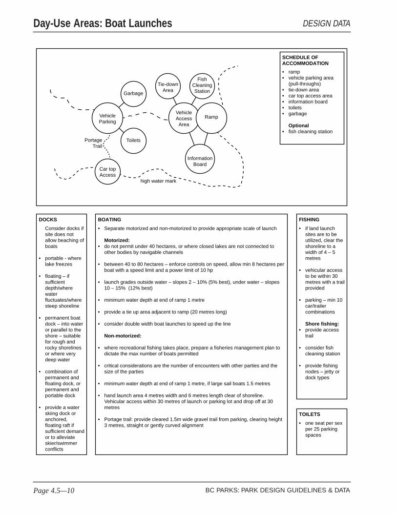
Consider docks if site does not allow beaching of boats
portable - where lake freezes
floating – if sufficient depth/where water fluctuates/where steep shoreline
permanent boat dock – into water or parallel to the shore – suitable for rough and rocky shorelines or where very deep water
combination of permanent and floating dock, or permanent and portable dock
provide a water skiing dock or anchored, floating raft if sufficient demand or to alleviate skier/swimmer conflicts
•
•
•
•
•
DOCKS
if land launch sites are to be utilized, clear the shoreline to a width of 4 – 5 metres
vehicular access to be within 30 metres with a trail provided
parking – min 10 car/trailer combinations
Shore fishing:provide access trail
consider fish cleaning station
provide fishing nodes – jetty or dock types
•
•
•
•
•
•
FISHING
one seat per sex per 25 parking spaces
•
TOILETS
rampvehicle parking area (pull-throughs)tie-down areacar top access areainformation boardtoiletsgarbage
Optionalfish cleaning station
••
•••••
•
SCHEDULE OF ACCOMMODATION
Separate motorized and non-motorized to provide appropriate scale of launch
Motorized:do not permit under 40 hectares, or where closed lakes are not connected to other bodies by navigable channels
between 40 to 80 hectares – enforce controls on speed, allow min 8 hectares per boat with a speed limit and a power limit of 10 hp
launch grades outside water – slopes 2 – 10% (5% best), under water – slopes 10 – 15% (12% best)
minimum water depth at end of ramp 1 metre
provide a tie up area adjacent to ramp (20 metres long)
consider double width boat launches to speed up the line
Non-motorized:
where recreational fishing takes place, prepare a fisheries management plan to dictate the max number of boats permitted
critical considerations are the number of encounters with other parties and the size of the parties
minimum water depth at end of ramp 1 metre, if large sail boats 1.5 metres
hand launch area 4 metres width and 6 metres length clear of shoreline. Vehicular access within 30 metres of launch or parking lot and drop off at 30 metres
Portage trail: provide cleared 1.5m wide gravel trail from parking, clearing height 3 metres, straight or gently curved alignment
•
•
•
•
•
•
•
•
•
•
•
•
BOATING
VehicleParking
VehicleAccessArea
Ramp
Garbage
Tie-downArea
FishCleaningStation
InformationBoard
Toilets
Car topAccess
PortageTrail
high water mark
BC PARKS: PARK DESIGN GUIDELINES & DATAPage 4.5—10
Day-Use Areas: Boat Launches DESIGN DATA

Review
the 'Park Design G
uidelines & Data' at the m
ain stages of the design and planning process.
Prod
uce
draw
ings
, ske
tche
s, a
nnot
ated
pho
togr
aphs
and
dia
gram
s to
reco
rd d
ecis
ions
.Concept/outline cost estimate
Review management planestablish service level
Assess mix and type of boat users and fishing demand
Review preliminary area and select site
Carry out detail design
Survey centre line of proposed launch plus offsets at 5 metre intervalsboth sides extending minimum of 30 metres into the water for obstructions, weed growth
or depositions (wind and wave protection can be provided by floating or solid breakwaters where necessary)
Monitor site factors and reevaluate design during construction. Establish limits of
acceptable change.
Location not prone to siltation, eg. upcurrent from silting river mouths
Ease of launch and docking, eg. sheltering relatively deep bays, shallow beach areas, exposed uniform shorelines
Not detractive from other facilities, eg. downcurrent from swimming
Location not prone to flooding - use local knowledge, or, if available, examine elevation of normal water level and historic water level records(10-30 year period)
•
•
•
•
Establish carrying capacityCarry out landscape inventory,with environmental assessment
Select shore areas for investigation;special considerations to include . . . .
BC PARKS: PARK DESIGN GUIDELINES & DATA Page 4.5—11
Day-Use Areas: Boat LaunchesPROJECT PLANNING

as for Trails and Vehicle Parkingassessment of user demand, based on snow depth and qualityassessment of natural hazards, such as avalanches and frozen water bodiesconsideration of multi-season use of trails and shelters
SITE SELECTION CRITERIA
••
•
•
Roads & parkingallow for safe access and snow removalSignageadjustable, removable, or temporaryToiletsone seat per sex per 25 parking spaces
PLANNING CRITERIA
•
•
•
Trails: cross country skiing and ski touring: snowshoeing and snowmobilingVehicle Parking and turnaroundInformation boardWarm up shelterWater source (hand pump)GarbageToilets (elevated)
SCHEDULE OF ACCOMMODATION•
•
•••••
Vehicle Parkingand
Turnaround
Garbage
Toilets
InformationBoard
Warm-upShelter
WaterHandpump
access road
BC PARKS: PARK DESIGN GUIDELINES & DATAPage 4.5—12
Day-Use Areas: Winter Use DESIGN DATA

Review
the 'Park Design G
uidelines & Data' at the m
ain stages of the design and planning process.
Prod
uce
draw
ings
, ske
tche
s, a
nnot
ated
pho
togr
aphs
and
dia
gram
s to
reco
rd d
ecis
ions
.Concept/outline cost estimate
Review management planestablish service level
Select site(s) for investigation.,special considerations to include . . .
Assess demand, mix and type of user
Review design process
Select site(s)
Carry out detail designto provide clearly defined and ordered area
Monitor site factors and reevaluate design during construction. Establish limits of
acceptable change.
VEGETATION
mixed vegetation with a variety of tree species and ages, open canopy (mature stands or one age class may deteriorate with high recreational use; shallow rooted stands are subject to windfall if cleared)
•
SITE CONSIDERATIONS
Picnic Area Siterelationship to parking areas for security
site in association with a natural park resource and oriented to views
aim for 25% of area shaded during summer mid-morning to mid-afternoon by shade trees or table shelters
hazard-free location
Group Picnic Arealocated adjacent to picnic area access to open area for organised group social activities
•
•
•
•
•
WATER SOURCE
well/lake/stream (filtered as necessary)
•
ASPECT
east, west and south facing sites are sunnier and drier
•
SOIL
moderate drainage
loam or sandy loam
minimum 150mm topsoil
•
•
•
Establish carrying capacityCarry out landscape inventory,with environmental assessment
BC PARKS: PARK DESIGN GUIDELINES & DATA Page 4.5—13
Day-Use AreasPROJECT PLANNING

Stage & Seatingpark architecture is required - see Design Guidelines
Detailed Planningconsult naturalists who supply programs for facility requirements
Campfirecan be accommodated to one or both sides of stage for illumination and ambience
Dressing Areaconsider if drama productions are proposed
Disabled Accessto be provided throughout facility
Toiletsone seat per sex per 100 users
Existing Treescan be left in seating areas - trim lower branches and interrupt seating to accommodate trees. The will provide shade with often pnly minor obstruction of views
ORIENTATION
Locate stage between north
and east to best avoid late sun for
audience and performers
If film/slide projectors are to be used, consider shading by stage
position or using shading devices, particularly for popular
summer early evenings
•
•
•
•
•
•
•
Stage areaSeating areaInformation board for programme schedulesTrails to campgrounds/day use (main routes to be lit)ToiletsGarbage
Optional
CampfireStorage spaceDressing area
•••
•
••
•••
SCHEDULE OF ACCOMMODATION
South
North
West
East
Seating Area
Toilets(inc. dslbd)
Information DessingArea
Storage
Campfire
VehicleParking
Garbage
Seating Area
BC PARKS: PARK DESIGN GUIDELINES & DATAPage 4.5—14
Day-Use: Interpretation Areas DESIGN DATA
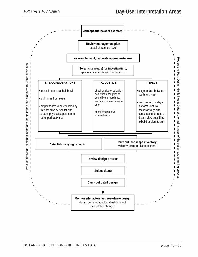
Review
the 'Park Design G
uidelines & Data' at the m
ain stages of the design and planning process.
Prod
uce
draw
ings
, ske
tche
s, a
nnot
ated
pho
togr
aphs
and
dia
gram
s to
reco
rd d
ecis
ions
.Concept/outline cost estimate
Review management planestablish service level
Select site area(s) for investigation.,special considerations to include . . .
Assess demand, calculate approximate area
Review design process
Select site(s)
Carry out detail design
Monitor site factors and reevaluate design during construction. Establish limits of
acceptable change.
SITE CONSIDERATIONS
locate in a natural half-bowl
sight lines from seats
amphitheatre to be encircled by tree for privacy, shelter and shade, physical separation to other park activities
•
•
•
ASPECT
stage to face between south and west
background for stage platform - natural backdrops eg: cliff, dense stand of trees or distant view possibility to build or plant to suit
•
•
ACOUSTICS
check on site for suitable acoustics: absorption of sound by surroundings, and suitable reverberation time
check for disruptive external noise
•
•
Establish carrying capacityCarry out landscape inventory,with environmental assessment
BC PARKS: PARK DESIGN GUIDELINES & DATA Page 4.5—15
Day-Use: Interpretation AreasPROJECT PLANNING

For family use
for safe wading gradient 5% - 8% (smooth and gentle) to a water depth of 0.5m beyond a gradient of 12% to 1.2 metres depth
as found or constructed, e.g. using 200-250mm sand on filter fabric
for safe swimming: buoyed swimming areas to depths of 1.2m, minimum distance of 10 metres from waters edge and 30 metres along shore
•
•
•
WET BEACH
maximum to toilets –120 metres
maximum to drinking water – 150 metres
maximum to garbage – 120 metres
Toilets
locate 30m from shoreline
one seat per sex per 100 people Shower
provide where water quality problems, e.g. swimmers itch
•
•
•
•
•
•
PLANNING DISTANCES: DRY BECH TO SERVICES
surface as found or constructed, e.g. 80% sand / 20% fine gravel, depth 250mm
consider relationship to parking area for security
•
•
DRY BEACH
Wet Beachoptional buoyed swimming area
Dry Beachlifebelts
Back shoreconsider gates to controlinformation signwatertoiletsshowergarbageassociated with vehicle parkingassociated with picnicking area
•
•
••••••••
•
SCHEDULE OF ACCOMMODATION
BackshoreArea
PicnickingArea
VehicleParking
Garbage
Shower
Bouyedswimming
area
LifebeltsInformation
highwatermark
Toilets(inc.
dsbld)
DryBeach
WetBeach
BC PARKS: PARK DESIGN GUIDELINES & DATAPage 4.5—16
Day-Use Areas: Beaches DESIGN DATA

Review
the 'Park Design G
uidelines & Data' at the m
ain stages of the design and planning process.
Prod
uce
draw
ings
, ske
tche
s, a
nnot
ated
pho
togr
aphs
and
dia
gram
s to
reco
rd d
ecis
ions
.Concept/outline cost estimate
Review management planestablish service level
Select beach area for investigation.,special considerations to include . . .
Assess demand, mix and type of user
Review preliminary beach selections
Carry out detail design
Select beach area
Monitor site factors and reevaluate design during construction. Establish limits of
acceptable change.
OFFSHORE
currents in coastal areas or rivers may preclude beach use
water may be too cold for swimmes but potential for other beach activities/park resources may warrant development
in areas of high winds and wave activity, beach characteristics may vary seasonally, eg. drifts, shelf formation
•
•
•
BEACH
Wetbeach surface, gradients, water quality and temperature
Drybeach surface, seasonal changes, eg. from winter storms
•
•
BACKSHORE
robust, mixed vegetation layers with a variety of species and ages, as found or planted where appropriate. (opening up backshore areas can make trees prone to windthrow as the area is likely to be exposed to strong seasonal winds)
assess ability of vegetation to recover from seasonal high use
to be free draining
not liable to compaction, ie. no shallow soils and exposed to roots
avoid backshore wetland areas as intolerant of use
•
•
•
•
•
ASPECT
unshaded from west and south
•
WILDLIFE
effects of development on wildlife should be considered taking into account the seasonal variations in user numbers
•
Establish carrying capacityCarry out landscape inventory,with environmental assessment
BC PARKS: PARK DESIGN GUIDELINES & DATA Page 4.5—17
Day-Use Areas: BeachesPROJECT PLANNING

Consider docks if site does not allow beaching of boats
portable - where lake freezes
floating – if sufficient depth/where water fluctuates/where steep shoreline
permanent boat dock – into water or parallel to the shore – suitable for rough and rocky shorelines or where very deep water
combination of permanent and floating dock, or permanent and portable dock
provide a water skiing dock or anchored, floating raft if sufficient demand or to alleviate skier/swimmer conflicts
•
•
•
•
•
DOCKS
if land launch sites are to be utilized, clear the shoreline to a width of 4 – 5 metres
vehicular access to be within 30 metres with a trail provided
parking – min 10 car/trailer combinations
Shore fishing:provide access trail
consider fish cleaning station
provide fishing nodes – jetty or dock types
•
•
•
•
•
•
FISHING
one seat per sex per 25 parking spaces
•
TOILETS
rampvehicle parking area (pull-throughs)tie-down areacar top access areainformation boardtoiletsgarbage
Optionalfish cleaning station
••
•••••
•
SCHEDULE OF ACCOMMODATION
Separate motorized and non-motorized to provide appropriate scale of launch
Motorized:do not permit under 40 hectares, or where closed lakes are not connected to other bodies by navigable channels
between 40 to 80 hectares – enforce controls on speed, allow min 8 hectares per boat with a speed limit and a power limit of 10 hp
launch grades outside water – slopes 2 – 10% (5% best), under water – slopes 10 – 15% (12% best)
minimum water depth at end of ramp 1 metre
provide a tie up area adjacent to ramp (20 metres long)
consider double width boat launches to speed up the line
Non-motorized:
where recreational fishing takes place, prepare a fisheries management plan to dictate the max number of boats permitted
critical considerations are the number of encounters with other parties and the size of the parties
minimum water depth at end of ramp 1 metre, if large sail boats 1.5 metres
hand launch area 4 metres width and 6 metres length clear of shoreline. Vehicular access within 30 metres of launch or parking lot and drop off at 30 metres
Portage trail: provide cleared 1.5m wide gravel trail from parking, clearing height 3 metres, straight or gently curved alignment
•
•
•
•
•
•
•
•
•
•
•
•
BOATING
VehicleParking
VehicleAccessArea
Ramp
Garbage
Tie-downArea
FishCleaningStation
InformationBoard
Toilets
Car topAccess
PortageTrail
high water mark
BC PARKS: PARK DESIGN GUIDELINES & DATAPage 4.5—18
Day-Use Areas: Boat Launch DESIGN DATA

Review
the 'Park Design G
uidelines & Data' at the m
ain stages of the design and planning process.
Prod
uce
draw
ings
, ske
tche
s, a
nnot
ated
pho
togr
aphs
and
dia
gram
s to
reco
rd d
ecis
ions
.Concept/outline cost estimate
Review management planestablish service level
Assess mix and type of boat users and fishing demand
Review preliminary area and select site
Carry out detail design
Survey centre line of proposed launch plus offsets at 5 metre intervalsboth sides extending minimum of 30 metres into the water for obstructions, weed growth
or depositions (wind and wave protection can be provided by floating or solid breakwaters where necessary)
Monitor site factors and reevaluate design during construction. Establish limits of
acceptable change.
Location not prone to siltation, eg. upcurrent from silting river mouths
Ease of launch and docking, eg. sheltering relatively deep bays, shallow beach areas, exposed uniform shorelines
Not detractive from other facilities, eg. downcurrent from swimming
Location not prone to flooding - use local knowledge, or, if available, examine elevation of normal water level and historic water level records(10-30 year period)
•
•
•
•
Establish carrying capacityCarry out landscape inventory,with environmental assessment
Select shore areas for investigation;special considerations to include . . . .
BC PARKS: PARK DESIGN GUIDELINES & DATA Page 4.5—19
Day-Use Areas: Boat LaunchPROJECT PLANNING

as for Trails and Vehicle Parkingassessment of user demand, based on snow depth and qualityassessment of natural hazards, such as avalanches and frozen water bodiesconsideration of multi-season use of trails and shelters
SITE SELECTION CRITERIA
••
•
•
Roads & parkingallow for safe access and snow removalSignageadjustable, removable, or temporaryToiletsone seat per sex per 25 parking spaces
PLANNING CRITERIA
•
•
•
Trails: cross country skiing and ski touring: snowshoeing and snowmobilingVehicle Parking and turnaroundInformation boardWarm up shelterWater source (hand pump)GarbageToilets (elevated)
SCHEDULE OF ACCOMMODATION•
•
•••••
Vehicle Parkingand
Turnaround
Garbage
Toilets
InformationBoard
Warm-upShelter
WaterHandpump
access road
BC PARKS: PARK DESIGN GUIDELINES & DATAPage 4.5—20
Day-Use Areas: Winter Use DESIGN DATA
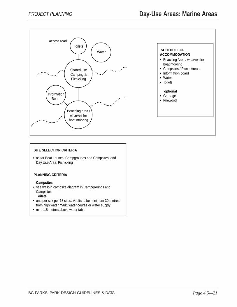
as for Boat Launch, Campgrounds and Campsites, and Day Use Area: Picnicking
SITE SELECTION CRITERIA
•
Campsitessee walk-in campsite diagram in Campgrounds and CampsitesToiletsone per sex per 15 sites. Vaults to be minimum 30 metres from high water mark, water course or water supplymin. 1.5 metres above water table
PLANNING CRITERIA
•
•
•
Beaching Area / wharves for boat mooringCampsites / Picnic AreasInformation boardWaterToilets
optionalGarbageFirewood
SCHEDULE OF ACCOMMODATION•
••••
••
Shared useCamping &Picnicking
Toilets
InformationBoard
Water
access road
Beaching area /wharves for
boat mooring
BC PARKS: PARK DESIGN GUIDELINES & DATA Page 4.5—21
Day-Use Areas: Marine AreasPROJECT PLANNING

DESIGN REFERENCESPark Campgrounds & Campsites
BC PARKS: PARK DESIGN GUIDELINES & DATA
French BeachProvincial Park (left).The siting of thiscampsite within a groupof trees makes a distinctplace in the forest: alarge tree marks theentrance, a tree isretained in the campsite,and the site is enclosedby a mix of differentsized trees and amedium density forestunderstorey. The mixededge implies a naturalforest clearing. Thegrading is gentle. Thiscampsite’s successcomes from its placewithin
Englishman River FallsProvincial Park (right). Thesecampsites are well defined withinthe forest. The dense, evergreenforest understorey vegetation isparticularly good for dividing sitesfor different users and edging thespaces. Again, the forest landscapedominates.
Golden Ears Provincial Park(left). The experience of beingin a natural forest clearing isachieved from the sparseunderstorey of the nativevegetation. The campsites havebeen carefully graded withinthis forest campground. Sitingcampgrounds in a park’ssecondary resource areasprotects the existing primeattractions and will providespectacular campingexperiences for futuregenerations.

PARK LANDSCAPE
● Are facilities kept to the minimum, so that visitorscan gain most from their experiences having chosento spend time in the natural landscape?
● Are the campsites spaced to allow the natural parklandscape to dominate, unlike most commercialcampgrounds?
● Does the design accommodate a variety of campingexperiences by placing sites in a variety oflocations?
● Is each campsite designed to be an individualterritory with natural appearing boundaries?
● Does the layout reduce the changes of conflictbetween different users?
● Do campground roads satisfy the relevant criteriafor park roads?
PARK ENVIRONMENT
● Is the campground design within the carryingcapacity for the park site?
● Can campsites be constructed to suit topography,and so avoid or reduce the need for fill?
● Can campgrounds be divided for seasonal use toreduce campsites and road construction depths insummer and shoulder season use areas?
● If large RVs need to be accommodated, can thelocation of sites be separate since their presencereduces the quality of the park landscape?
BC Parks campgrounds provide an integralpart of provincial culture.
For many people, campgrounds provide aunique opportunity to live temporarily aspart of one of the range of naturalenvironments protected in provincial parks.The value of this experience for manyvisitors, especially children, lies in itssimplicity and educational worth. Thequality of the camping experience relies onthe naturalness of the park landscape, ofwhich the park facilities form a part.
Campground roads and campsites arerelatively small elements. They can beaccommodated in a variety of parklandscapes and not detract from thelandscape character.
Unlike day-use areas, campground use islimited by the availability of spaces. Thisfactor controls stress on the parkenvironment.
The introduction of a campground into anatural park environment requires anappraisal of the vegetation and wildlifecommunities so any necessary clearingscan be made with least impact.
Park Campgrounds & Campsites
BC PARKS: PARK DESIGN GUIDELINES & DATA Page 4.6—1
CHECKLISTS & DESIGN NOTES

DESIGN REFERENCESPark Campgrounds & Campsites
BC PARKS: PARK DESIGN GUIDELINES & DATAPage 4.6—2
Stemwinder ProvincialPark (left). The naturallandscape in thecampground dominates,appearing to flowuninterrupted through thesite. The campsites can beseen through the trees andgrass; their layout followsthe Similkameen River forviews, breezes and accessto the water. Rocks havebeen placed to mark eachsite. The quality of thiscampground is its subtletyand restraint.
Bromley Rock ProvincialPark (right). Natural sitelandscape elements make upthis distinctive campsite. Whatis effectively an outdoor roomwith views has been createdfrom the trees around and inthe site, rock outcrops,adjacent native ground coverand grade changes, and rocksof varying sizes.
Bromley Rock ProvincialPark (left). This illustrationshows campsite elementswithin the natural parklandscape. A row of largerocks creates a simple edgeto the campsite pad, whosesurface blends with theexisting ground.Neighbouring sites can beseen set out in thebackground among trees –discrete in the landscape.

Considerations for a campground locationinclude the following:
n reasonable distance from hazards
n separation from park day-use areas forprivacy, security, and noise separation(with consideration for a day-use areadedicated to the campground)
n healthy vegetation structure with aminimum of hazard trees for recoveryfrom construction processes
The requirements for a successful campsiteinclude:
n establishing clearly defined campsites
n managing vegetation to provide views
n retaining natural landscape featureswithin campsites whenever possible,such as trees and rocks
n siting to allow early morning andevening sun, late morning and afternoonshade
n providing shelter from waterfrontbreezes and prevailing winds bymaintaining enough circulation todiscourage flying insects
n proximity to natural attractions
The traffic calming considerations includedin the section on park roads are applicableto campground roads.
Park Campgrounds & Campsites
BC PARKS: PARK DESIGN GUIDELINES & DATA Page 4.6—3
CHECKLISTS & DESIGN NOTES

WILDERNESS CAMPING
(hike in/primitive boat-in, as part of trail/water system) - maximum 25 sites - unmanned
CampsitesFirepit (where permitted)Food cache (where appropriate)
•••
WildernessCamping
Lockable Gate
VEHICLE CAMPGROUND
Access Road
minimum distance from campground to highway 150 metres
ACCOMMODATION
Entrance GatesFee-Collection Kiosk (for over 50 sites)Campground Road SystemCampsitesFirewood CorralsToiletsWaterGarbage
OptionalDay-Use AreaSani-StationShower Building & ParkingVisitor ParkingWalk-in CampingInterpretation Area
••
••••••
••••••
OUTLINE SCHEDULE OF ACCOMMODATION
Campground
CampgroundDay Use
Area
CampgroundVisitor
Parking
CampgroundEnterance
Walk-inCamping
Walk-inCampingParking
ShowerVehicleParking
ShowerBuilding
Sani-Station
BC PARKS: PARK DESIGN GUIDELINES & DATAPage 4.6—4
Park Campgrounds & Campsites DESIGN DATA

Review
the 'Park Design G
uidelines & Data' at the m
ain stages of the design and planning process.
Prod
uce
draw
ings
, ske
tche
s, a
nnot
ated
pho
togr
aphs
and
dia
gram
s to
reco
rd d
ecis
ions
.Concept/outline cost estimate
Assess demand, mix and type of user from regional/local user statistics;review management plan; establish service level
Classify campground - vehicular / group / wilderness; transient / destinationCalulate preliminary space requirements and outline schedule of accomodation
Select site for investigation.,special considerations to include . . .
Reexamine preliminary concept and possible alternatives
Select site
Carry out detail design
Finalize design
Monitor site factors and reevaluate design during construction. Establish limits of
acceptable change.
DRAINAGE
higher sites
between 2% to 8% slopes so only minor grading required (less than 2% may require drain ditches, greater than 8% may need extensive regrading)
water table
minimum 1300mm below ground
•
•
•
•
WILDLIFE
avoid important wildlife habitats eg: streams, lakeshores, dense tree or bush cover, berry patches, ridge tops, animal trails
low lands may cause users insect problems
•
•
VEGETATION
mixed vegetation with a variety of species and ages (offers the best resistance to fire and insect damage, often has an open canopy to let in light)
mixed species and age (mature stands or one age class may deteriorate with high recreational use; shallow rooted stands are subject to windfall if cleared)
•
•
WATER SOURCE
well/lake/stream (filtered as necessary)
unpolluted natural springs or streams (acceptable for wilderness sites)
•
•
ASPECT
east, west and south facing sites are sunnier and drier (north facing sites are colder and wetter)
open tree canopy for sunlight penetration
•
•
SOIL
moderate to rapid drainage
loam or sandy loam (less that 20% gravel, high clay or organic content can result in compaction and poor drainage
minimum 150mm topsoil (less than this often a high content of stones and rocks)
infrequent outcrops (can limit of facility extent or density and increase construction costs)
•
•
•
•
Establish carrying capacityCarry out landscape inventory,with environmental assessment
BC PARKS: PARK DESIGN GUIDELINES & DATA Page 4.6—5
Park Campgrounds & CampsitesPROJECT PLANNING

appox. 125 square metres (selectively cleared)for disabled users: relatively flat, firm,
••
VEHICLE CAMPSITE
System generally comprises:2 way main campground road (gated entrance), with 1-way loop roads for accessing campsitesplan layoutaim to provide 20 – 40 campsites per loopmain road should not separate campsites from a major featurecamping loops to be gently curvilinear (aids traffic calming)trail crossings at 90 degrees and allow for site lines for pedestrians and vehicles
•••••
CAMPGROUND ROADS
max. to toilets 120mmax. to water 120mmax. to garbage 120mmax. to firewood 120m
••••
CAMPSITE / SERVICES DISTANCES
appox. 75 square metres (selectively cleared)•
WALK-IN CAMPSITE
Fee Collectionvisitors not requiing information need 15 to 20 secondsvisitors requiring information need one minute or more
•
•
to accommodate one family/group (6 persons max)Allow for 10 – 20% of sites to be double sitesfor preliminary planning; campsite spacing 20 – 30mfor detail planning review specific landscape and carrying capacityplan for pull-throughs only when there is substantial user demand
•
•
•
•
•
CAMPSITES
Consider locating facilities to be in close view of entrance to help orientation
50 campsites and over require manned controlgatefee collection kioskstacking lane on entrance road (allow 10m per 20 sites, more if closer to highway)parking at control station for staff and pull-off for campers visible from stationcheck out box (optional)information board (readable by drivers from their vehicles)telephoneexternal lighting
Less than 50 campsites do not require manned controlgateinformation boardconsider telephoneconsider external lighting
•••
••••••
••••
CAMPGROUND ENTRANCE
KIOSK
OptionalVehicle
Drive-upor Walk-up
(addcanopy)
Toilet(if required) View
View
VehicleDrive-up
AmenityArea
TentPad
AmenityArea
TentPad
TrailerParking
VehicleParking
approx. 50 square metres (selectively cleared)picnic tablefirepit
•
••
approx. 5 x 5 metres, max. slope 4%, preferably grass or sand
4.5 x 12metres, max.slope 4%
Number Post
Number Post
approx. 5 x 5 metres, max. slope 4%
approx. 50 square metres (selectively cleared)picnic tablefirepitaccess to water
•
•••
BC PARKS: PARK DESIGN GUIDELINES & DATAPage 4.6—6
Park Campgrounds & Campsites DESIGN DATA

use regional standard design
clear around rear and sides for visibility / safety
consider associating with open play areas
use natural lighting supplimented with artificial for evening use
•
•
•
•
SHOWER BUILDING
1 per sex per 15 campsites (pull-off lane for servicing within 6 metres of pump-out for toilets
vaults to be minimum 30 metres from water course or water supply, and 1.5 metres above water table
consider grouping with wood / garbage / water
•
•
•
TOILETS
allow 2-3 acres per 50 users (base allowance on local demand)use selective clearing or thinning / planting to define areas for sleeping / cooking / amenitiesallow for reserved use by day groups
•
•
•
GROUP CAMPGROUND
consider gravel lot
1 stall per 10 sites
entry visible from campground entrance
garbage
•
•
•
•
VISITOR PARKING
within 10 metres of shower building
allow 1.5 spaces per shower stall
•
•
SHOWER BUILDING PARKING
locate within campground, separate from campsites
provide pressurized water
•
•
SANI-STATION
entrance gatesvehicle/bus parkingopen activity area (min. 0.75 ha, optimum 2% slope)fire circlesleeping areacooking areafirewood corraltoilets (2 per 15 sites)waterconsider shower/building
•••
•••••••
OUTLINE SCHEDULE OF ACCOMMODATION
use standard corral design
allow controlled access space for delivery trucks
•
•
FIREWOOD STORAGE
provide one container per loop or per 40 campsites, by loop entrance or intersection
•
GARBAGE
1 standpipe per 50 sites
standpipes minimum 5 metres from toilets
•
•
WATER
CookingArea
AmenityArea
SleepingArea
Vehicle/busParking Area
ParkNatural
Resource
lockable gate
road in
BC PARKS: PARK DESIGN GUIDELINES & DATA Page 4.6—7
Park Campgrounds & CampsitesDESIGN DATA
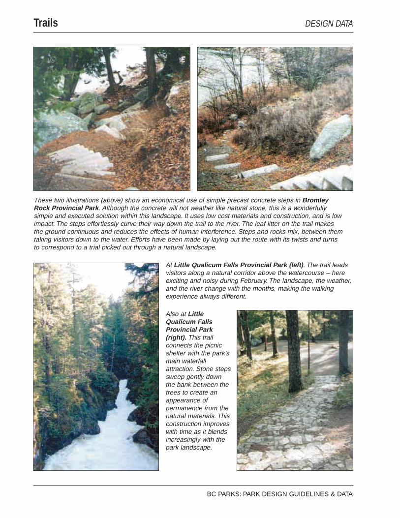
Trails DESIGN DATA
BC PARKS: PARK DESIGN GUIDELINES & DATA
These two illustrations (above) show an economical use of simple precast concrete steps in BromleyRock Provincial Park . Although the concrete will not weather like natural stone, this is a wonderfullysimple and executed solution within this landscape. It uses low cost materials and construction, and is lowimpact. The steps effortlessly curve their way down the trail to the river. The leaf litter on the trail makesthe ground continuous and reduces the effects of human interference. Steps and rocks mix, between themtaking visitors down to the water. Efforts have been made by laying out the route with its twists and turnsto correspond to a trial picked out through a natural landscape.
At Little Qualicum Falls Provincial Park (left) . The trail leadsvisitors along a natural corridor above the watercourse – hereexciting and noisy during February. The landscape, the weather,and the river change with the months, making the walkingexperience always different.
Also at LittleQualicum FallsProvincial Park(right). This trailconnects the picnicshelter with the park’smain waterfallattraction. Stone stepssweep gently downthe bank between thetrees to create anappearance ofpermanence from thenatural materials. Thisconstruction improveswith time as it blendsincreasingly with thepark landscape.

PARK LANDSCAPE
● Are trails built at grade? Do the colour and textureof trail surfaces blend well with the landscape?
● Do the trails offer routes through the variety ofnatural park landscape characters within the park?
● Do trails follow natural routes – such as rivers,contours, or a ridge?
● Is the trail clearly, but discretely, marked?
● Do trails avoid fragile steep slopes?
PARK ENVIRONMENT
● Is trail construction reduced to suit seasonal usepatterns?
● Do routes avoid sensitive environments?
● Are trails located to reduce human/wildlifeconflicts?
● Are short cuts anticipated and obstructed by naturalbarriers – or made into trails?
● After providing access to key areas, can furtherconstruction for wheelchair access be avoided byposting a degree of difficulty (challenge level) forambulant disabled?
BC PARKS: PARK DESIGN GUIDELINES & DATA Page 4.7—1
TrailsCHECKLISTS & DESIGN NOTES
An aim in trail design is to give theimpression that the natural landscape isdirecting the route. Subtle additions of sitematerials, such as logs, rocks andvegetation, can be used to reinforcepatterns of movement and, where necessary,trail edges. The landscape design and itsdetails can often clearly state the directionand attractions on the trail.
Attention to width can make park visitsmore enjoyable. Trails can narrow wherethe route gets steeper, and where visitorsmay walk more slowly and at differentspeeds. Widening the trail as it flattens outwill let visitors walk side by side and talk.Spaces to stop and rest or picnic might alsobe offered en route, and made more usableby placing rocks or logs.
Short cuts can be problematic and are bestanticipated. Natural barriers such asvegetation, boulders and scree slopes canbe used as a deterrent to shortcutting.Where switchbacks are unavoidable,stepping stones or a wood ladder will bepreferable to inevitable disturbance toexisting vegetation and soils – withinmaintenance and liability considerations.
Trails might be designed in tandem withother facility development to link areassuch as car parking, day-use areas andcampgrounds. The arranged movement ofpeople through the park can provide amarshalling and security system.

Trails DESIGN DATA
BC PARKS: PARK DESIGN GUIDELINES & DATAPage 4.7—2
At Little Qualicum Falls Provincial Park (below left), recently constructed trails adjacent to visitor facilitiesuse stones at corners and dispersed along the trail. Whether natural or added, the stones gently directmovement through this fragile environment. In this picture, the colour and texture of the gravel could not bemore complimentary to the tree bark, and make a clear contrast with the mossy forest floor. EnglishmanRiver Falls Provincial Park (below right). Picnic tables along the trail overlooking the river provide a reststop, viewing area and picnic spot. The trail picks its way around the rocks and trees and past the tables,varying in width where appropriate. Grouping facilities in small ways like this helps reduce park construction.
Haynes Point ProvincialPark (right). On anintensively used site, agently curved path edgedwith leaves and nativevegetation heads up towardthe tree as if it were amarker for the space beyond.
Goldstream Provincial Park(left). This is a very high use,year-round trail. It isconstructed accordingly,being wide and well-compacted gravel. Even so, the trail wanders its way quiteinformally to the visitor centre between trees and stumps. Clumpsof ferns and leaves edge the path. The natural park landscapeclearly dominates.
Rathtrevor BeachProvincial Park (right). Thisexample shows how a trailcan involve visitors with apark’s landscape character.
The split log ranch fence edges a hay meadow and refers to the park’sprevious agricultural use. The trail passes the field, allowing visitors toview a historical rural scene. The fence prevents shortcutting, allowingthe field to be used peacefully for day use.

● Are visitors encouraged to use trails to reducepressure on day-use areas?
● Are horse, bike and multi-use trails provided (withconsideration given to crossing points)?
BC PARKS: PARK DESIGN GUIDELINES & DATA Page 4.7—3
TrailsCHECKLISTS & DESIGN NOTES
Some trail design principles are as follows:
n give an overall appreciation of thelandscape character of the route
n take advantage of topographic andbiological variety
n offer a variety of views – panoramic,partial and framed
n align the trail near the park’s naturaland recreational attractions
n use natural changes in vegetation forvariety; for example, through closedcanopies, past meadows, next towetlands
n vary the width of the trail according tonatural features: narrow or divide thetrail to save trees; make a rock form thereason for changing direction; maintainthe forest understorey to edge the trail;widen the trail where there is likely to bewildlife or a good view; widen the trailto fit in a picnic table or a bench.
n make spurs off to toilets
n route the trail to go next to, rather thanover, difficult areas to reduceconstruction, such as streams andmarshes
n consider how close people need to get toview a spectacular natural feature or afish bearing creek – how muchdifference will it make to the parkexperience to be closer and how muchwill the natural environment be alteredin trying to get closer?

Class
hiking - back country
walking - surfaced front country
interpretative trails - information provided
horse trails
bicycle trails
cross-country skiing trails and ski touring
snowshoe trails
snowmobile trails
multi-use trails
interpretive and wildlife viewing trails - special location
barrier free trails
portage trails
Standards
Trail type classification on a 1 (high) to 5 (low) scale is based on:
construction standard
number of users
environmental impact
construction cost
maintenance cost
Refer to national and provincial standards as requiremens for ski trails, bicycle trails and disabled access trails are well understood and established. Other types such as horseback riding and hiking vary according to local conditions
•
•
•
•
•
•
•
•
•
•
•
•
•
•
•
•
•
•
•
BC PARKS TRAIL CLASSIFICATION
for long distance trailsfor goal oriented trails, eg. access to areas, linking facilitiesside trails can allow access to secondary recreation features, special features, interpretive information and viewscan be an adaptation of an existing route, eg. old road
••
•
•
LINEAR
always guides the user to the trailheadno need to retrace steps so can be more interesting to useless physical wear
••
•
LOOP
offers a variety of travel distancescan be used to offer variety of difficulties to suit user abilitycan work at different layers according to the seasons
••
•
STACKED LOOP
can provide wider range of alternatives in experiences and difficultycentral loop connects all users to trailheadallows for trail development where varied terraincan work at different layers according to the seasons
•••
•
SATELLITE LOOP
offers a range of travel distance alternativesusers may turn back to the trailhead from a number of different points
••
SPOKED WHEEL
can make maximum use of an area by letting users explore their own routesprovides a variety of terrain conditions, travel distances and interpretative themesmust be well marked with directions and distances
•
•
•
MAZE
expected ability of usersinterests of usersgroup sizestime allowance for useorigin of user, eg. local, visitor, touristdetermine use patterns by:
convert anticipated number and type of users into visitor days and seasonal use patterns
••••••
TRAIL USER PROFILE
BC PARKS: PARK DESIGN GUIDELINES & DATAPage 4.7—4
Trails DESIGN DATA

Review
the 'Park Design G
uidelines & Data' at the m
ain stages of the design and planning process.
Prod
uce
draw
ings
, ske
tche
s, a
nnot
ated
pho
togr
aphs
and
dia
gram
s to
reco
rd d
ecis
ions
.Concept/outline cost estimate
Review management planestablish service level
Identify management strategies;carry out design, considerations to include . .
Assess demand, type and number of user using:comparisons with similar regional/local facilities; park user
and provincial visitor surveys; local recreation patterns; local outdoor clubs; provincial outdoor recreation
organization
Finalize design
Select primary trail system and routes
Monitor site factors and reevaluate design during construction. Establish limits of
acceptable change.
Establish routes' carrying capacityCarry out landscape inventory,
with environmental assessment; reexamine preliminary routes and possible alternatives
Assess public liability and safety and develop a visitor strategy
Assess signage / marking requirements, including:directionaldistancesroute guidanceinterpretation
••••
Facility Requirementsparking quantity and surfacingsignstrail surfacingmaintenance programwaste managementen-route facilities
•
•••••
BC PARKS: PARK DESIGN GUIDELINES & DATA Page 4.7—5
TrailsPROJECT PLANNING

BC PARKS: PARK DESIGN GUIDELINES & DATAPage 4.7—6
Park Signage DESIGN REFERENCES
Englishman River Falls Provincial Park(left). A routed wood sign, standard in thepark, is set above the height of the salal.Again, this sign shows a consistent scaleand park’s character to the BC Parksstandard Type “A” sign.
China Beach Provincial Park (left). ThisBC Parks entry sign and traffic sign bothhave landscape scale wood posts with thesame finish. All information is important forvisitors, and this is a simple way to achievea unified style for signage.
These two illustrations (below) show howwell suited the standard Type ‘A’ sign is totwo contrasting British Columbia scenes. AtManning Provincial Park , the white routedlettering is easy to read in the snowy scene.At Haynes Point Provincial Park , theentrance is simply marked and the standardfinishes are particularly suited to the coloursin this landscape.

PARK LANDSCAPE
● Are all the signs in a park included in the ParkFacility Standards? (Are there any new signs thatshould be included in the Park Facility Standards?)
● Is site signage coordinated? Can wood routed signswith reverse lettering be used, since they provide aBC Parks identity and are less obtrusive in thelandscape?
● Are the signs kept as low as possible above thepark’s natural ground cover?
● Is a multiplicity of signs avoided as this can lead toconfusion?
● Can the need for signs with negative instructions(such as ‘do not short cut’, or ‘do not park here’) beprevented by design? Can the need for signs bereduced, for example by using a one way trafficsystem, or by slowing traffic with traffic calmingmeasures?
● Are the lettering and symbols as small as possible?Are traffic signs suited to the design speed?
● Do the signs consistently use either text orsymbols? If symbols are used, are they relativelysmaller than text, since symbols are easier to readfrom a distance?
● Wherever possible, are signposts made from woodand designed to be substantial in the parklandscape?
● Are all the sign fixings discrete?
● Are the signs easy to repair locally?
● Does the existence of a sign indicate an oldproblem still waiting to be solved?
BC PARKS: PARK DESIGN GUIDELINES & DATA Page 4.8—1
Park SignageCHECKLISTS & DESIGN NOTES
Site planning can limit the need for signs byorganizing the site in a clear way.
Although signs are generally small,collectively they can become a disruptiveelement in the landscape. Visual problemsgenerally arise when different types ofinformation are required at the same place.

BC PARKS: PARK DESIGN GUIDELINES & DATA
Park Structures DESIGN REFERENCES
Little Qualicum FallsProvincial Park (rightand below). This 1950’sBC Parks standarddesign displaysunmistakeablecharacteristics of ‘parkarchitecture.’ This flattishsite at the top of the bankabove the river, the stonetrail to the stone-basedbuilding, and the treemarking the top of thebank contribute tomaking a simplestructure that is positivelysited in the landscape. The building is a simple form withhorizontal emphasis. It is of heavy construction with avisible structural frame and joints. An open all aroundstructure gives a sense of having been cleaned by theelements.
Cultus Lake Provincial Park (right). This group picnicsite shelter is an appropriate, simple structure of heavyconstruction and overhanging eaves. BC Parks staff areinvestigating lowering the two enclosed wood screensand using native vegetation to achieve the requiredprivacy and wind shelter.

PARK LANDSCAPE
● Is the design simple, so it will be dominated by thepark’s natural landscape?
● Will the design create a permanent facility?
● Does the design leave completely behind the urbanand suburban world?
● Does the design look strong, vigorous and robustenough to withstand the regional climate?
● Are all park structures visually coordinated?
PARK ENVIRONMENT
● Are construction materials and methodsenvironmentally sensitive and, where appropriate,native to the area?
● Does the siting of the structure reduce intrusion intothe park environment, for example, by siting ongentle slopes along contours?
BUILDING & SHELTERS
Visitor centres, toilet facilities, gatehouses andshelters
● Is the design park architecture?
● Does the design reflect the special characteristics ofthe park’s region? Do the materials tie the parkbuilding to the specific park?
Park structure design should be sensitive tothe park environment and continue the parkarchitecture tradition within the context ofthe park region.
Park architectureis unsophisticated;composed of natural local materials thatweather; sited in response to the subtletiesof the park landscape and has an ambienceof craftsmanship. It is void of any referenceto the outside world.
Elements of park architecture include:
n following natural contours of the siten horizontal emphasisn massive appearing construction giving a
robust scalen exposed elements of the structural framen wall composition of base and cladding
to framed upper sectionsn are faced with natural appearing
materials that weathern substantial pitched roofs with overhangsn flexibility to seasonally change the
interior environment
An architect-designed solution for a visitorcentre that expresses a park’s particularcharacter may also be appropriate. It toocan follow the principles of parkarchitecture and siting.
Regional identity comes from climate, thenatural character of areas and patterns ofhuman settlement – the differences betweenregions in British Columbia are wellunderstood within Bc Parks. Thepermanence of public parks requires thatpark buildings and structures support thatidentity. BC Parks staff will not only beable to contribute their knowledge of thepark to the design process, but also theirunderstanding as local people of regionalcharacteristics.
BC PARKS: PARK DESIGN GUIDELINES & DATA Page 4.9—1
Park StructuresCHECKLISTS & DESIGN NOTES

Park Structures DESIGN REFERENCES
BC PARKS: PARK DESIGN GUIDELINES & DATAPage 4.9—2
These illustrations show a huge differencein scale of two provincial park naturalattractions. Safety for visitors and protectionfor environments from visitors is oftenneeded at such sites. Solutions must besite-specific so that the qualities of theseexperiences are unspoiled.

● Can the design’s characteristics be seen in older,modest buildings in the region, such as cabins orcottages, agricultural buildings, or first nationstructures? Does it link to these building designs,which have evolved through many builders’experiences?
● Do park buildings create usable outdoor spaces aspart of the natural park landscape, and direct viewsfrom the entrance toward the landscape so the parkis dominant?
● Do the outdoor spaces immediately around parkbuildings or shelters accommodate people waiting,eating or relaxing?
● Is the design energy-efficient?
● Are roof geometries simple in snow country?
● Is the design barrier-free?
VIEWING AREAS
● What scale is the feature being viewed – is anythinggained by getting visitors a metre or two closer to abig picture?
● Is a platform really required? Can solid groundprovide a viewing space (that has no dead areaunderneath) that will be less intrusive in the naturalpark landscape?
BC Parks can provide build facilities thatuse energy and materials efficiently andeffectively. Design should be led by theneeds of visitors and the natural systemsthat make up the park environment.
Building design needs to address:
n energy conscious and renewablematerial specification
n facings of on-site or regional materialswherever possible
n indoor air quality, to provide healthyinterior conditions
n energy efficient lighting
n site generated power where possible e.g.Solar and turbines
n siting where possible to allow existingtrees to provide shading, sun and shelterfrom wind
n disabled access
Using modern construction technology andcladdings appropriate to park sites canallow park facility design to be affordableover its life.
The checklists address issues ofconstructing facilities that embody therustic and handcrafted feel of traditionalpark architecture suited to provincial parkenvironments.
BC PARKS: PARK DESIGN GUIDELINES & DATA Page 4.9—3
Park StructuresCHECKLISTS & DESIGN NOTES

Park Structures DESIGN REFERENCES
BC PARKS: PARK DESIGN GUIDELINES & DATAPage 4.9—4
Roderick Haig-Brown Provincial Park (left). As a viewing area forthe famous salmon run, this simple wooden deck effectively widens thetrail to provide erosion protection to the bank. The constructionreduces intrusion into the river scene by not extending over the originaledge of the river bank.
Goldstream ParkProvincial Park (right).This illustration showshow even a large utilitystructure, if a simple,single form, isunobtrusive. Thecylindrical wooden watertower with a galvanizedsteel conical roofprovides a corner-lessform within the forestlandscape.
Englishman River Falls Provincial Park (below and right).Viewing the waterfalls from this terrace, rather than a platform,allows simpler, less obtrusive construction and reducesmaintenance. The stone plinth and black metal ails create apermanent appearing facility, which has become part of thepark rather than an addition.

● Is the viewing facility designed to suit its projecteduse patterns: frequency, duration and seasonal?
● Can construction be reduced in hazardous areas byconcentrating and containing visitors at a particularplace?
BRIDGES
● Do finish and colour complement the natural parklandscape?
● Is the bridge at a natural crossing place?
● Can a bridge satisfy the need for a viewingplatform?
Gatehousesare one of the first facilitiesencountered by visitors – often their firstpoint of contact with BC Parks. Materialsmust make the gatehouse appearpermanent. As with other buildings, thedesign needs to appear as park architectureand be suited the region. The designprocess should, if possible, closely involvethe campground staff familiar withoperating requirements. Basic designdecisions include the need for a toilet, awalk-up window and a location to suit thesize of vehicles permitted in the park.
Viewing areasare landscape architecturalspaces and require the appropriate designinput.
As an alternative to viewing platforms,gaining access to viewing positions on solidground might be achieved as follows:
n widen a trail and offer viewingopportunities along its run so spreadingvisitors
n allow visitors to simply access thenatural landscape for viewing wheresafe to do so, and where the landscape isrobust enough to periodically withstandan influx of people
n if necessary, provide temporarymeasures to control access and preventerosion for short duration events
As park structures, long span bridgesrequire design input to allow the use ofefficient forms and materials within apark’s natural setting.
BC PARKS: PARK DESIGN GUIDELINES & DATA Page 4.9—5
Park StructuresCHECKLISTS & DESIGN NOTES


Creating natural appearing facility landscapes withinlimited budgets requires ideas, careful planning, andconsideration of what is available on-site forconstruction and facing materials.
Reducing development reduces impact on the naturalprocesses of the park environment and the park’snatural landscape . . . and is also economic.
One key characteristic that facility design must show inBC Parks is permanence. This underlines that the parkis a timeless place where nature dominates.
BC PARKS: PARK DESIGN GUIDELINES & DATA Page 5.1—1
Facility Design Implementation

BC PARKS: PARK DESIGN GUIDELINES & DATAPage 5.1—2
Park Facility Vegetation DESIGN REFERENCES
French Beach ProvincialPark (left). This place ofarrival, which is located at theedge of the parking area onthe trail to the beach,illustrates what can be donewith what is already there.The information shelter anddrinking fountain are set in atree-enclosed space. Thetrees stand on the space’sedge and stones mark theentrance. A parking area curbedges the forest floor, with itsleaf litter and naturalherbaceous cover.
Bromley Rock Provincial Park(right). Trees, rough grass androcks from the natural landscapeseparation between thesecampsites. The needles andpattern of cones on the ground,combined with the browns of thepicnic table and the trees, createthe scene’s detail in front of thegrey slopes beyond.
Haynes Point ProvincialPark (left). Native shrubs andground covers mark theterritories for the campsites.The leaf litter adds somewelcome colour and textureto the mixed evergreen anddeciduous vegetation.

PARK LANDSCAPE
● Does the design use plants native to the site? Havenative plant mixes been specified according tolocation?
● If vegetation clearance is necessary forconstruction, has it been minimized to retain thenatural park landscape character?
● Have tops and toes of slopes been rounded toachieve a natural appearance and promoterevegetation in the long term?
PARK ENVIRONMENT
● Can changes to the vegetation composition resultingfrom construction be mitigated to maintain thebalance of the ecosystem? Otherwise, can thevegetation be managed for the new composition?
● Does the design reduce disturbance to vegetation,soils, and drainage?
● Has vegetation clearance been reduced to limiterosion?
● Will undisturbed native vegetation be protectedthroughout the construction period? Wherenecessary, have barriers for vegetation protectionbeen erected before starting works?
● If construction substantially alters natural drainagepatterns, has interim drainage or irrigation beenprovided?
BC PARKS: PARK DESIGN GUIDELINES & DATA Page 5.1—3
Park Facility VegetationCHECKLISTS & DESIGN NOTES
Landscapes can absorb development tovarying degrees without damaging scenicvalue.
Two factors can be helpful in making siteplanning decisions during the design andlayout of park facilities:
Vegetation pattern density
Openings in an unbroken forest canopycover are obtrusive. Broken or openlandscapes with colour and species varietygenerally absorb openings better. Planningfor facilities and management decisions canbe directed to blend with the existingnatural patterns.
Classifying vegetation patterns is likely tohelp inform siting decisions:
n Dense cover
n Few openings: colour, species andvariety
n Many openings: colour, species andvariety
Soil Productivity
Where facility construction disturbsvegetation, soil productivity showsregeneration potential. Land of highgrowing capacity revegetates early andthrough quick green-up has less affect onthe landscape.
Other landscape characteristics
Other influences should of course be takeninto account, e.g. Diversity of landforms,soil and rock colour.

BC PARKS: PARK DESIGN GUIDELINES & DATAPage 5.1—4
Park Facility Vegetation DESIGN REFERENCES
Stemwinder ProvincialPark (left). The vegetation inthis park landscape iscontinuous, single speciestrees, which allows the easyinsertion of visitor facilities.This is a simple drylandscape that does notneed any additions orchanges to adapt to use.
Okanagan Falls Provincial Park (right). A continuousdeciduous tree canopy and high levels of maintenance (inprogress here) still create a tranquil scene in this tightlyspaced campground. The flat terrain and good drainagemean that the campsite pads are quite unobtrusive. The leafraking might be less rigorous and still achieve a managed-enough landscape to cope with the pressures of lots ofvisitors.
Englishman River FallsProvincial Park (left). Thisscene is completely inkeeping with a natural styleof construction. Forestvegetation edges the top ofa dry stone wall that runsalong the entrance road.Forest litter edges the base.The wall, topped by salal,collects leaves and moss.

● Can native materials be used to avoid importingmaterials into the natural park environment, e.g.Plants, soil, forest litter, bark / wood chippings?
● Are all exposed soils stabilized and revegetated assoon as possible?
● If replanting cannot take place immediately, has thesite been mulched and seeded with a native mix oncompletion of all construction (including regradingand topsoiling)?
BC PARKS: PARK DESIGN GUIDELINES & DATA Page 5.1—5
Park Facility VegetationCHECKLISTS & DESIGN NOTES
VEGETATION MANAGEMENT
Management of park vegetation aroundfacilities is a continuing part of facilitydesign.
In the natural landscape, changes to thestructure of the existing vegetation may bebeneficial, as shown by the followingexamples of simple management methods:
n where low vegetation growth is required,such as by roadsides, stable shrub andground cover plant communities can becreated by arresting succession throughmanagement
n forest litter may be raked off toregenerate the understorey in a climaxforest landscape
n opening up the closed canopies to let inlight will allow the regeneration of theunderstorey
n controlled periodic burning to retardherbaceous competition will enhancewoody growth in a meadow, as woodyplants out-compete herbaceous speciesfollowing a fire.
The structure of the site vegetation (and theprocesses that form it) needs to beunderstood to make these site managementdecisions.
MAINTENANCE
The aim of maintenance is to retain thecharacter of the park landscape. Programsneed to be based on processes in thenatural park environment.
n When does the vegetation receive itsnatural watering?
n What are the growing months for thevegetation?
n Are there any areas which are naturallymaintained as a herb layer - for examplemeadows by browsing animals?
How are diseases controlled? Whathappens to dead limbs and trees in nature?
Is forest and leaf litter used as a natural

BC PARKS: PARK DESIGN GUIDELINES & DATA
Park Facility Construction DESIGN REFERENCES
Haynes PointProvincial Park(left). The stonestandard drinkingfountain, placedrock, nativevegetation and leaflitter make anentrance featurethat is simple andnatural. Thisillustration showshow work can becompletelyblended into thenatural landscape.
Bromley RockProvincial Park (right).The site here hasprovided the clue formarking territory. This lowstone, rubble edgecreates sufficientseparation between thecampground road andthis campsite. It is asmaller scale version ofthe larger line of rocksbehind.
Vaseux Lake Provincial Park (left). Sitescan direct construction through what theyprovide. This example shows a split levelcampsite: the vehicle high, the picnic tableand fire iron lower, and at natural grade thebeach. The rocks retaining the parking spotsimply join two existing rock outcrops. In thebackground, the rocks set in a curve thatretains the campsite can just be seen. Nativevegetation frames the views and creates thespaces.

PARK LANDSCAPE
● Does the facility appearto be constructed fromnatural materials?
● Does the construction complement the natural orhistoric setting of the individual park?
● Does the construction give the impressionofpermanence and being timeless – like a naturallandscape?
● Is the quality of the construction suited to a publicfacility, rather than a commercial facility?
● Can construction be limited to using natural and/ormanmade landforms in character with the sitetopography?
● Does any new site grading look natural with theexisting terrain?
● Are native materials used for construction wherepossible?
● If stone or gravel is used, does it match the colourand texture of materials native to the parklandscape?
● Has long-term vegetation management been carriedout to mitigate the visual impact of new work? Hasvegetation rehabilitation been planned to take placebefore, during, and after construction?
BC PARKS: PARK DESIGN GUIDELINES & DATA Page 5.2—1
Park Facility ConstructionCHECKLISTS & DESIGN NOTES
mulch that protects in winter and nourishesthe soil for spring?
Keeping construction to a minimum reducesdevelopment impact on the park’s naturallandscape and the park environment – andis also a very economic strategy to carryout. Less, better quality construction isrequired, and this is often a cost-effectivestrategy over a facility’s life.
The challenge of creating visitor facilitiesto last two or more generations requiressimple methods of construction and, inparticular, the use of on-site materials.
Environmental issues concerningconstruction materials are welldocumented. Primary materials arefavoured for visible work, such assustainably harvested wood and stone.
The public will welcome facilities that aresympathetic to the natural environment.They are less likely to be vandalized.
PREPARATION FOR CONSTRUCTION
The vitality of the forest, and its capacity towithstand change resulting fromdevelopment, can be increased. Staff can:
n carry out a forest analysis for pathogens
n arrest succession for safety and visualquality
n selectively clear (up to 30% may beappropriate)
n remove hazard trees
n replant when necessary
Vegetation Protection
Barriers should be erected beforeconstruction around individual trees or anarea of vegetation.
n no operating of equipment (handdigging only)
n no stockpiling of materials (constructionmaterials, stripped topsoil, etc.)
n no burning or disposal of debrisn no parking of construction vehicles

BC PARKS: PARK DESIGN GUIDELINES & DATAPage 5.2—2
Park Facility Construction DESIGN REFERENCES
StemwinderProvincial Park (left).This illustration showsa substantial area offill retained with a verylight touch. The pad’srock edges laid in thisunstructured way –and allowed to collectleaf litter and in timebecome vegetated –will beindistinguishable fromthe natural steepbanks that are part ofthe natural landscapecharacter.
Englishman River Falls Provincial Park (right).The standard drinking fountain from the Park FacilityStandards, however, when was it built? It appearstimeless, like the natural landscape of the park.
Bromley Rock Provincial Park(right). The site here hasprovided the clue for markingterritory. This low stone, rubbleedge creates sufficientseparation between thecampground road and thiscampsite. It is a smaller scaleversion of the larger line of rocksbehind.

● Has vegetation clearance been reduced prior toconstruction, with the need for further clearanceaddressed as work proceeds?
● Have temporary means of revegetating areas beenconsidered to allow native plants to naturallyreestablish?
PARK ENVIRONMENT
● Will any aspect of constructing or maintaining theproject have detrimental effect on the park’sresources?
● Is the construction process planned to reduce siteimpact? Are measures taken during construction toprevent soil erosion by run off and wind? Hasvegetation management been carried out to reducethe effects of wind damage to vegetation?
● Does the project feature construction materials thatare compatible with the park’s region – preferablynative to the site or region? Are they renewable andenvironmentally sensitive?
● Can a multi-use corridor be used during and afterconstruction?
● Has excavation been managed to limit themovement of heavy equipment?
● Does carrying out the work provide any otheropportunities for environmental restoration?
BC PARKS: PARK DESIGN GUIDELINES & DATA Page 5.2—3
Park Facility ConstructionCHECKLISTS & DESIGN NOTES
Soil erosionand wind damageare twomajor problems faced by a parkenvironment during the constructionprocess. Preventing is easier thancontrolling these problems.
n Vegetation can naturally control erosionby:
n the roots mechanically reinforcing thesoil
n organic matter improving the soilstructure
foliage protecting the surface against thedirect effects of rain and wind
Another aim in preventing soil erosion is toreduce the amount and speed of potentialsurface runoff from hard landscape areas.
Reducing potential runoff
n roads and parking areas – use poroussurface materials where possible, andleave forest canopies to intercept rainfall
n impound and recharge runoff fromsurfaced areas: design swales to takerunoff from impermeable surfaces topermeable layers and use check dams tocontrol runoff
n locate impoundments along swales tocreate a series of check dams
n cascades from surface runoff overbedrock will improve the oxygen contentof the water. The water can run towetlands which will filter out majorpollutants and sediments
n utilize wetlands to retard excessiverunoff
Controlling wind damage
n facility development might take placewhere possible, on locally sparsevegetation growth or natural openings
n where openings have to be made,existing edge vegetation can be managedto create a natural forest edge
n root zones should be protected for aslarge an area as possible

BC PARKS: PARK DESIGN GUIDELINES & DATAPage 5.2—4
Park Facility Construction DESIGN REFERENCES
Englishman River Falls Provincial Park (left).The beautiful cougar sign is traditional, historic,and unmistakably part of a park. Theappearance of permanence comes from thescale of the construction and the dry stonefaced plinth. Time, money, and thought werespent here for present and future visitors.
Golden Ears Provincial Park (right). Thisexample provides a reminder that ease ofconstruction is needed in the parklandscape. A standard detail bench is seton a stone plinth and mossy joints, andstones beyond edge the road.

● Is a method in place for monitoring site factorsduring the construction process, so that designs canbe reevaluated and modified if necessary?
● Have walking routes been constructed first to limitfoot traffic over the site?
● Have bioengineering techniques using on-sitematerials been investigated to reduce theintroduction of foreign material and constructionrequirements?
● Has native topsoil in construction areas beenstripped and stockpiled on site for reuse beforestarting construction works? Can native sods besalvaged during site clearance? Can removed nativevegetation be selectively saved for replanting?
BC PARKS: PARK DESIGN GUIDELINES & DATA Page 5.2—5
Park Facility ConstructionCHECKLISTS & DESIGN NOTES
Green-up
Factors to consider in evaluating the timefor natural green-up and establishing newplant material include soil fertility andmoisture content; elevation; latitude;aspect; rainfall; and temperature.
The main considerations for revegetating orrehabilitating a natural area are:
n use only native plant species alreadygrowing on the site, or those whichwould grow if natural conditions existed
n note existing plant cover as a usefulindicator of the soil and weatherconditions for site planning
n look for the order in which similarplants bud out in the spring. These willgive an insight into small microclimaticvariations
n note that existing plant cover is oftenundergoing succession when carryingout a landscape inventory and accountfor this in the design
n choose new plants for a plannedprogram of continuing management
Possible slope failuresalso requireconsideration. Most failures occur duringthe first winter after installation beforevegetation has established.
The most frequent failures from surfaceslippage are caused by:
n water seeping or percolating from aboveinto a porous layer of subsoil (upperslope failure)
n saturation of soil caused by inadequatecompaction (lower slope failure)
Immediate local repairs can arrest erosionuntil the vegetation establishes. Methodsinclude:n backfilling gullies and recultivating old
slopes to make a favourable seed bedn constructing log/brush or wood crib at
the toes of slopes and then backfilling

PARK LANDSCAPE
● Have utility systems and corridors been identifiedthat will least impact the natural park landscape?
● Has terrain or vegetation screening been used whereutilities are intrusive?
● Are recycling and garbage containers necessary? Ifso, are they placed by the parking areas, inconvenient, but not dominant, locations (away fromentrances/exits, interpretive signs, etc.)?
PARK ENVIRONMENT
● Is the utilities provision kept to a minimum toreduce energy and water consumption?
● Within the aims of sustainable development, haveall sources of power been investigated, includingsolar and wind / water turbines? Similarly, simplewater treatment systems, e.g. grey water treatments,potable water filtration?
● Do all utility systems use simple technology?
● Has removal of native vegetation, topsoil, andnatural channels been avoided wherever possible toretain existing drainage patterns?
● Is irrigation used only for plant establishment? Aresystems low volume, of ultraviolet resistantcomponents and surface-laid for reuse?
● Has the use of waterless composting sanitarysystems been fully investigated?
● Have engineered wetlands been investigated as adisposal system?
● If a septic field is to be used, can it be constructedwithin the natural vegetation of the site, forexample, older trees, to help blend the field with thenatural landscape after construction?
BC PARKS: PARK DESIGN GUIDELINES & DATAPage 5.3-1
Park Utilities CHECKLISTS & DESIGN NOTES
Problems of power and water supply andwaste disposal have long histories in BCParks visitor facilities. Technologies nowexist that provide cost-effective alternativesto conventional systems.
By using new systems in hand witheducating visitors to create less demand onsite utilities, BC Parks can aim forsustainable facility development.
Demands on utility systems can bedecreased by:
n siting and design of buildingsincorporating energy and water savingdevices, such as shower heads and lowflush toilets
n grey water treatmentn composting toiletsn on-site energy generation, such as solar,
wind or water
Ecosystems also provide site services. Someexamples are vegetation screening,water/wastewater purification, maintenanceand restoration of beaches, forests, andwildlife. If the ecosystem becomes stressedthrough overloading, these free systems arejeopardized.
Disposal systems
Consider treatment technologies that arebiological, non-mechanical, and do notinvolve soil leaching. Some methods evenresult in useful products, such as fertilizer.Constructed biological systems, such asengineered wetlands, are increasingly beingused to purify wastewater. These systemsare environmentally responsive, non-polluting and cost effective.
Sources of energy
Active solar systems use solar collectorsmounted at optimum heights andorientation to store power in batteries forlater use, or to directly heat a water supply,e.g. in a shower building. Passive solarenergy can be used to heat and coolbuildings as an integral part of the buildingdesign.

BC PARKS: PARK DESIGN GUIDELINES & DATA Page 5.3-2
Park UtilitiesCHECKLISTS & DESIGN NOTES
● If a clearing for a septic field exists, is it blendedwith the natural park landscape by grading andvegetation?
● Can existing septic fields be vegetated with nativeplants such as either ground covers or grasses andwild flowers?
● If a sewage disposal system must be constructed,can it be done without introducing imported soilsfor a field?
● Are sani-stations essential, since they are a largescale impact in the natural park environment?
● Can grey water disposal be separated fromblackwater disposal?
Solar energy availability usually concurswith times of high power demand in parks –often unlike wind power. Wind power canhowever be generated in a minimum windof 13 kmph.
To obtain useful hydro power, the watersource must provide both volume andpressure – a minimum volume of 20 litresper minute and a head of more than 4.5metres. Often availability does not concurwith times of greatest power demand inparks.
Water
Treatment systems might be considered thatdivide water use into primary andsecondary uses and reduce waterconsumption.
n primary water is for drinking andwashing, such as water supplied to ahand basin or a shower
secondary is for flushing toilets, forcleaning and maintenance of facilities, e.g.washing the interior of the shower buildingand possibly for irrigation.
Water consumption can be reduced byinforming users about BC Parks aim toreduce consumption:
n by fitting low flush toilets
n low volume shower heads
n fitting washroom taps that only run ondemand
n reducing the need for irrigation systems


By defining design aims and outlining a design process,these guidelines will help BC Parks staff contributetheir knowledge and experience to park facility designand planning.
The design guidelines will also give future work adirection evolved from successful work carried out byBC Parks that reflects the public’s traditional affectionfor provincial parks.
This form will help organize use of the designguidelines.
BC PARKS: PARK DESIGN GUIDELINES & DATA Page 6—1
Project Statement

FISCAL YEAR: STAFF CONTACT:
DISTRICT: PARK:
PROJECT CATEGORY: o New o Repair o Reconstruction o Alteration
PROJECT TITLE:
Management plan zone:
Problem to be solved:
Description of Proposal:
Effect on Park Landscape:
Effect on Park Environment:
Estimated Life of Proposal:
Design and Planning Program:
Construction Program:
BC PARKS: PARK DESIGN GUIDELINES & DATAPage 6—2
Project Statement

Construction Cost Estimate:
Design and Planning Cost Estimate:
Operating Cost Estimate:
Maintenance Requirements and Cost Estimate:
CHECKLIST:Conformance with Park Design Guidelines & Data (if not appropriate please note):
o 1. Facility Design Principles o 4. Facility Design
o 2. Facility Project Planning o 5. Facility Design Implementation
o 3. Facility Planning o 6. Impact Assessment
o Conformance with Park Facility Standards (if not appropriate please note)
RECOMMENDED BY:
o RECREATION OFFICER o OPERATIONS OFFICER
o RESOURCE OFFICER o EXTENSION OFFICER
o FINANCE & ADMINISTRATION OFFICER
APPROVED BY DISTRICT MANAGER:
SIGNED: DATE:
BC PARKS: PARK DESIGN GUIDELINES & DATA Page 6—3
Project Statement

SOIL EROSIONPOTENTIAL DURING USE
NATURAL DRAINAGEALTERED
VEGETATIONDAMAGED/DESTROYED
WILDLIFEINJURED/DESTROYED
ROADS
VEHICLE PARKING
CAMPGROUNDS ANDCAMPSITES
DAY-USE AREASPICNICKING
DAY-USE AREASBEACH
STRUCTURES -BUILDINGS/SHELTERS
TRAILS
STRUCTURES - VIEWING PLATFORMS/BOARDWALKS/BRIDGES
STRUCTURES - BOATLAUNCHES/DOCKS
UTILITIES -HYDRO/GAS
UTILITIES -WIND/WATER TURBINES
UTILITIES -SOLAR POWER
UTILITIES -ENGINEERED WETLANDS
UTILITIES -SEPTIC FIELDS
UTILITIES -VAULT TOILETS
UTILITIES -COMPOSTING TOILETS
PROJECT TITLE
BC PARKS: PARK DESIGN GUIDELINES & DATAPage 6—4
Project Statement

HABITATS ALTERED/FRAGMENTED
NOISEGENERATED BY USE
TOXICS & POLLUTANTSINTRODUCED
IMPACT OFCONSTRUCTION PROCESS
ROADS
VEHICLE PARKING
CAMPGROUNDS ANDCAMPSITES
DAY-USE AREASPICNICKING
DAY-USE AREASBEACH
STRUCTURES -BUILDINGS/SHELTERS
TRAILS
STRUCTURES - VIEWING PLATFORMS/
BOARDWALKS/BRIDGES
STRUCTURES - BOATLAUNCHES/DOCKS
UTILITIES -HYDRO/GAS
UTILITIES -WIND/WATER TURBINES
UTILITIES -SOLAR POWER
UTILITIES -ENGINEERED WETLANDS
UTILITIES -SEPTIC FIELDS
UTILITIES -VAULT TOILETS
UTILITIES -COMPOSTING TOILETS
BC PARKS: PARK DESIGN GUIDELINES & DATA Page 6—5
Project Statement

PROJECT TITLE:
Assessment (based on worksheet analysis):
Proposed mitigation:
BC PARKS: PARK DESIGN GUIDELINES & DATAPage 6—6
Project Statement

The special nature of much of the field work carried outby BC Parks means that staff have to learn from eachother. Initiatives frequently come at field level, andevery opportunity should be taken to share experience.
This standard case study format with recordphotographs aims to provide a quick, simple method ofsharing experiences between district offices.
BC PARKS: PARK DESIGN GUIDELINES & DATA Page 7—1
Case Study

Case Study
BC PARKS: PARK DESIGN GUIDELINES & DATAPage 7—2
BEFORECONSTRUCTIONNotes:
DURINGCONSTRUCTIONNotes:
AFTERCONSTRUCTIONNotes:
- photograph -(trim or overlap)
- photograph -(trim or overlap)
- photograph -(trim or overlap)

FISCAL YEAR: STAFF CONTACT:
DISTRICT: PARK:
PROJECT TITLE:
PROBLEM:
PERFORMANCE of SOLUTION installation, and effect on park environment
APPEARANCE of SOLUTION effect on park landscape:
COST of SOLUTION life-cycle – initial construction costs, maintenance costs, operating costs:
PROGRAM from initial idea through to completion of construction
MOST IMPORTANT PROJECT EXPERIENCES:
BC PARKS: PARK DESIGN GUIDELINES & DATA Page 7—3
Case Study


Master Checklists
The following section provides an assembly ofthe checklists used throughout the guidelines.
BC PARKS: PARK DESIGN GUIDELINES & DATA Page 8—1

Facility Design PrinciplesPARK LANDSCAPE
Continuity
● Can the individual park’s visitor facility beidentified as a single designed entity that is thesum of all the site elements?
Decision-making
● Does the park facility design, from site to planto details, balance performance, appearanceand criteria? Does it conform to BC Parkspolicies, procedures and the park managementplan?
Substance
● Does the design appear permanent androbust? Does it appear timeless, like the park?
A natural landscape architecture
● Does park facility design blend with, orcomplement, the natural park landscape? Is itspecific to the park, and dominated by thepark’s landscape character? Is vegetationaround the visitor facilities managed andmaintained to appear natural?
Sanctuary
● Is the park defined as a natural sanctuary forvisitors by the absence of all urbane character?Are all things from the urban or suburban worldleft outside the park?
Quality
● Is facility design of sufficient quality to suit thepublic realm – neither commercial nordomestic?
Building with vegetation
● Is native vegetation the first-choice buildingmaterial? Can it be used to create barriers,screening, shading, edging, or forbioengineering?
Park architecture for the region
● Is the architecture recognizable from concept todetails as park architecture? Does the designrespond to the region’s climate? Is the designinformed by the park region’s traditionalmethods and materials of construction?
Building a BC Parks heritage
● Is the design evolved from, or in keeping with,traditional BC Parks style? Is it readilyidentifiable as a BC Parks facility?
Balancing conservation and recreation
● Does planning minimize the number ofconstruction projects? Since conservation andminimizing expenditure are objectives, arethere ways of providing for recreation withoutbuilding, for example by reviewing existingfacilities or redirecting visitor use?
PARK ENVIRONMENT
Adding visitors to the park environment
● Do the facilities create a habitat for visitors?Once within the park environment, does thedesign of facilities aim to accommodate visitorsalongside the plant and wildlife communities ina simple, natural way?
Sustainable design
● Is all design sustainable – directed atconserving or restoring natural processes? Arethe design and provision of utilitiesenvironmentally sensitive?
Siting for the environment
● Have facilities been sited so as not to detractfrom a park’s primary resources?
Facility Project Planning● Does the original idea meet management plan
objectives?
● Does the idea balance performance, BC Parks’appearance, and cost criteria?
● Has the problem the idea is intended to solvebeen reappraised and defined.
● Does the idea still solve the problem, within thePark Design Guidelines & Data framework, andbalance conservation and recreation? Or, isthere a better option?
● Do any other planned or completed BC Parksprojects province-wide offer useful precedents?
If the idea looks feasible, obtaining aconsensus within the District Office team . . .
BC PARKS: PARK DESIGN GUIDELINES & DATAPage 8—2
Master Checklists

● Are the problem and the solution clearlystated?
● Has the project’s effect on the park’slandscape and environment been evaluated?
● What resources and management are neededto design and plan the project? Are theyavailable within the BC Parks’ team, or areconsultants required? What degree of sitesupervision is needed from BC Parks.
● What is the program for the project? How longis needed for designing and construction, andwhen could each stage start considering fiscaland seasonal issues?
● How will it be funded? How do costs breakdown into capital, installation and maintenanceover the facility projected life? Is there anyeffect on revenue?
Following project approval and funding . . .
● Are any permits required?
● Have arrangements been made with any BCParks’ staff with specialist pertinent knowledgeto participate in the design process? (Any lateradditions or subtractions are costly and oftendetract from design quality – the object of thisprocess.)
Design and planning . . .
● Has the project been developed and refinedusing these guidelines? Does the project stillbalance performance, appearance, and costcriteria?
If selecting consultants . . .
● Has the problem, not the solution, been clearlystated?
● Is Park Design Guidelines & Data referred to inthe request for proposal documents?
Working with design consultants . . .
● Is the design restrained? Is Park DesignGuidelines & Data being used throughout theprocess?
Completion . . .
● Are the intentions of the maintenance issuesproperly defined, documented and passed onfor operation? Is there a method for structuredmonitoring to ensure that the quality of the newfacility is not diminished, or the siteenvironment degraded?
● Has anything been learned in planning,constructing, or maintaining the work that willhelp other districts or help BC Parks improvepolicies and standards?
Park Facility Site PlanningPARK LANDSCAPE
● Do the park’s natural and cultural featuresdominate the site planning?
● Does the site plan fit the park’s topography?
● Can the park’s character be reinforced byanything that is unique in terms of natural orcultural features, or recreation opportunities?
● Are there any scenic views? Are theymaximized and detractive views reduced?
● Since everything introduced into the park is partof the site plan, is it all necessary. Will it all beof sufficient quality for a provincial park.
● Are there any existing facilities that can beremoved to improve the park landscape?
● Are buildings and shelters sited to suite thetopography and reduce alteration or intrusioninto the natural character of the park?
● Has the siting of buildings and shelters madeuseful outside spaces for visitors?
● Can natural barriers be used to control accessto hazardous areas?
● Is the site planned to be easy to use, resultingin limiting sign requirements and avoiding visualclutter?
● Have maintenance requirements beenconsidered as an integral part of the siteplanning?
PARK ENVIRONMENT
● Has a clear understanding of natural systemson the site been established? How will theproposed development impact these naturalsystems?
● Has a carrying capacity for the project site beenestablished? Are proposals within thethresholds?
● Are facilities sited to avoid affecting the mostnaturally amenable spots on the site? (Theseplaces are easily identified – people areintuitively drawn to them.)
BC PARKS: PARK DESIGN GUIDELINES & DATA Page 8—3
Master Checklists

● Can facilities be sited in already disturbedareas and confined to their footprint?
● Does the site planning affect neighbouring landuse (or does neighbouring land use affect thesite planning)?
● What do visitors come to see or do? If it fits BCParks’ management plan goals, is itaccommodated in the site planning? Does thesite planning reduce conflict between usergroups?
● Are routes to the park’s natural and culturalattractions located to reduce site impact? Canthe site planning help confine visitor use toselected areas to protect other parkenvironments?
● Does the site planning avoid steep slopes?
● Are the effects of sun and wind on visitorcomfort considered? Is there any shelter? Inhot regions, is wind used for cooling of outdoorareas? Are shady areas provided for comfort,preferably using terrain or vegetation?
● Does the layout reduce fragmentation of thepark by preserving connections with thesurrounding environment?
● Will the project improve the quality of facilitieswithin the carrying capacity of the park’s naturalenvironment?
Park EntrancesPARK LANDSCAPE
● Does the park entrance show that visitors areentering a special place? Is it a suitable ‘frontdoor’, giving the right first impression of BCParks – positive and welcoming?
● Is the main park entrance sign either a portal,plaque or a Type ‘A’?
● Are signs placed so the least modification isnecessary to the adjacent natural landscape togive visibility from the highway?
Park RoadsPARK LANDSCAPE
● Does the road follow the park’s topography andcomplement the natural park landscape?
● Can the road dramatize entry into the park?Does the road’s character acclimatize visitorsto the natural park landscape?
● Is vegetation left as undisturbed along and asclose as possible to the road corridor, so thatall visitors can enjoy the natural setting –especially disabled visitors with limitedopportunities to enjoy the park?
● Does the road have slow design speeds? Havetraffic calming measures been used, such astight curves (which will also usually providemore interest) or speed bumps?
● Does the park road emphasize leisure and thespecial qualities of the park environment? Is itof a different character than public highway? Isthe road engineered to reduce disturbance andcosts?
● Can drainageways be integrated into theadjacent landscape rather than followingparallel to the road?
● Are shoulders as narrow as possible with noloose gravel or bare earth?
● Are turnouts curvilinear to follow vehicle paths?
PARK ENVIRONMENT
● Is a road really necessary – the impact on thepark environment will be practicallyirreversible?
● Is the corridor sited to limit impact on theenvironment?
● Does the road lie on the landscape, wherepossible following contours to reduce cuts andfills?
● Are roads unpaved where ground conditionsare stable, slopes low, and traffic low orseasonal?
Visitor ParkingPARK LANDSCAPE
● Has the parking area been designed as anintegral part of the park landscape? Isvegetation left as close as possible to theedges of the visitor parking?
● Is the parking area’s character suited to aprovincial park rather than a municipal setting?
● Is the parking clearly laid out and easy to useto avoid confusion?
BC PARKS: PARK DESIGN GUIDELINES & DATAPage 8—4
Master Checklists

● Has the minimum pavement area beenprovided, i.e. to satisfy winter use anddisabled access with additional parkingprovision suited to seasonal demand (forinstance compacted gravel for shoulderseasons and reinforced grass for summerpeak use)?
PARK ENVIRONMENT
● Has the layout been designed around themanoeuvering capabilities of vehicles likelyto use the park?
● Have low design speeds been used toreduce pavement areas? Have one waysystems been fully considered to reducecirculation requirements?
● Does the design take full advantage ofmaximum crossfalls and slopes to allowthe parking area to blend with the terrainand reduce grading?
Day-Use AreasPARK LANDSCAPE
● Are the qualities of the park feature(s) withwhich the day-use area is associatedretained as much as possible?
● Are summer day-use areas designed forwinter use, and winter use areas designedfor summer use – allowing facilities to beenjoyed and be part of the park landscapeyear-round?
● Can the site satisfy seasonal high usewithout impacting on the park’s landscapequality?
PARK ENVIRONMENT
● To avoid building to accommodateseasonal high use, has the speed of therecovery rate of the park environmentbeen considered with a view to limitingfacility construction?
PICNIC AREAS
● Do tables provide a variety of sites to suitdifferent visitors – such as sunny andshady, or open and enclosed sites? Aregroups catered for?
● Are tables laid out with an underlying orderto provide a composition in the parklandscape?
● Where appropriate is there an open space forfree play visible from picnic table sites?
● Is the view from the picnic areas toward anatural landscape?
INTERPRETATION AREAS
● Can interpretation areas accommodate bothcontemporary interpretive presentations andtraditional presentations?
● Are interpretation areas constructed to blendwith the park landscape?
● Are interpretation areas located for each accessbut buffered to avoid potential conflict withadjacent park areas?
BEACH AREAS
● How is the lake environment impacted byencouraging beach access and use?
● Is there a seasonal and annual pattern ofchange by wave action and high wind thatneeds to be accounted for in the facility design?
● Are resources directed at beaches that aresunny for most of the day, i.e. betweensoutheast and west facing? Is the water suitedto swimming? Is it safe for family use?
● In a beach area, is the natural vegetation edgeprotected to prevent erosion?
● Is the back shore area of sufficient carryingcapacity to provide beach access?
BOAT LAUNCHES
● Does the siting of the facility allow for use in awide range of local weather conditions?
● Is the boat launch designed not to detract fromthe waterfront qualities?
● Has the area round the launch beenconstructed to suit seasonal use? If use ismostly during summer, do all surfaces need tobe hard? Can construction be limited to graveland reinforced grass?
Park Campgrounds andCampsites
PARK LANDSCAPE
● Are facilities kept to the minimum, so thatvisitors can gain most from their experienceshaving chosen to spend time in the natural
BC PARKS: PARK DESIGN GUIDELINES & DATA Page 8—5
Master Checklists

landscape?
● Are the campsites spaced to allow the naturalpark landscape to dominate, unlike mostcommercial campgrounds?
● Does the design accommodate a variety ofcamping experiences by placing sites in avariety of locations?
● Is each campsite designed to be an individualterritory with natural appearing boundaries?
● Does the layout reduce the chances of conflictbetween different users?
● Do campground roads satisfy the relevantcriteria for park roads?
PARK ENVIRONMENT
● Is the campground design within the carryingcapacity for the park site?
● Can campsites be constructed to suit thetopography, and so avoid or reduce the needfor fill?
● Can campgrounds be divided for seasonal useto reduce campsites and road constructiondepths in summer and shoulder season useareas?
● If large RVs need to be accommodated, canthe location of sites be separate since theirpresence reduces the quality of the parklandscape?
TrailsPARK LANDSCAPE
● Are trails built at grade? Do the colour andtexture of trail surfaces blend well with thelandscape?
● Do the trails offer routes through the variety ofnatural park landscape characters within thepark?
● Do trails follow natural routes – such as rivers,contours, or a ridge?
● Is the trail clearly, but discretely, marked?●
● Do trails avoid fragile steep slopes?
PARK ENVIRONMENT
● Is trail construction reduced to suit seasonaluse patterns?
● Do routes avoid sensitive environments?
● Are trails located to reduce human/wildlifeconflicts?
● Are short cuts anticipated and obstructed bynatural barriers – or made into trails?
● After providing access to keep areas, canfurther construction for wheelchair access beavoided by posting a degree of difficulty(challenge level)for ambulant disabled?
Park SignagePARK LANDSCAPE
● Are all the signs in a park included in the ParkFacility Standards? (Are there any new signsthat should be included in the Park FacilityStandards?)
● Is site signage coordinated? Can wood routedsigns with reverse lettering be used, since theyprovide a BC Parks’ identity and are lessobtrusive in the landscape?
● Are the signs kept as low as possible abovethe park’s natural g round cover?
● Is a multiplicity of signs avoided as this canlead to confusion?
● Can the need for signs with negativeinstructions (such as ‘do not shortcut’; do notpark here’) be prevented by design? Can theneed for signs be reduced, for example byusing a one way traffic system, or by slowingtraffic with traffic calming measures?
● Are the lettering and symbols as small aspossible? Are traffic signs suited to the designspeed?
● Do signs consistently use either text orsymbols? If symbols are used, are theyrelatively smaller than text, since symbols areeasier to read from a distance?
● Wherever possible, are signposts made fromwood and designed to be substantial in thepark landscape?
● Are all the sign fixings discrete?
● Are the signs easy to repair locally?
● Does the existence of a sign indicate an oldproblem still waiting to be solved?
BC PARKS: PARK DESIGN GUIDELINES & DATAPage 8—6
Master Checklists

Park StructuresPARK STRUCTURES
● Is the design simple, so it will be dominated bythe park’s natural landscape?
● Will the design create a permanent facility?
● Does the design leave completely behind theurban and suburban world?
● Does the design look strong, vigorous androbust enough to withstand the regionalclimate?
● Are all park structures visually coordinated?
PARK ENVIRONMENT
● Are construction materials and methodsenvironmentally sensitive and, whereappropriate, native to the area?
● Does the siting of the structure reduceintrusion into the park environment, forexample by siting on gentle slopes alongcontours?
BUILDINGS & SHELTERS
Visitor centres, toilet facilities, gatehouses andshelters
● Is the design park architecture?
● Does the design reflect the specialcharacteristics of the park’s region? Do thematerials tie the park building to the specificpark? Is anything generic about thearchitecture that could place it anywhere otherthan in the park’s region?
● Can the design’s characteristics be seen inolder, modest buildings in the region, such ascabins or cottages, agricultural buildings, orfirst nation structures? Does it link to thesebuilding designs, which have evolved throughmany builders’ experiences?
● Do park buildings create usable outdoorspaces as part of the natural park landscape,and direct views from the entrance toward thelandscape so the park is dominant?
● Do the outdoor spaces immediately aroundpark buildings or shelters accommodatepeople waiting, eating or relaxing?
● Is the design energy-efficient?
● Are roof geometries simple in snow country?
● Is the design barrier-free?
VIEWING AREAS
● What scale is the feature being viewed – isanything gained by getting visitors a metre ortwo closer to a big picture?
● Is a platform really required? Can solid groundprovide a viewing space (that has no dead areaunderneath) that will be less intrusive in thenatural park landscape?
● Is the viewing facility designed to suit itsprojected use patterns: frequency, duration andseasonal?
● Can construction be reduced in hazardousareas by concentrating and containing visitorsat a particular place?
BRIDGES
● Do finish and colour complement the naturalpark landscape?
● Is the bridge at a natural crossing place?
● Can a bridge satisfy the need for a viewingplatform?
Park Facility VegetationPARK LANDSCAPE
● Does the design use plants native to the site?Have native plant mixes been specifiedaccording to location?
● If vegetation clearance is necessary forconstruction, has it been minimized to retain thenatural park landscape character?
● Have tops and toes of slopes been rounded toachieve a natural appearance and promoterevegetation in the long term?
PARK ENVIRONMENT
● Can changes to the vegetation compositionresulting from construction be mitigated tomaintain the balance of the ecosystem?Otherwise, can the vegetation be managed forthe new composition?
● Does the design reduce disturbance tovegetation, soils, and drainage?
● Has vegetation clearance been reduced to limiterosion?
● Will undisturbed native vegetation be protected
BC PARKS: PARK DESIGN GUIDELINES & DATA Page 8—7
Master Checklists

throughout the construction period? Wherenecessary, have barriers for vegetationprotection been erected before starting works?
● If construction substantially alters naturaldrainage patterns, has interim drainage orirrigation been provided?
● Can native materials be used to avoid importingmaterials into the natural park environment,e.g. plants, soil, forest litter, bark/woodchippings?
● Are all exposed soils stabilized and revegetatedas soon as possible?
● If replanting cannot take place immediately, hasthe site been mulched and seeded with anative mix on completion of all construction(including regrading and topsoiling)?
Park Facility ConstructionPARK LANDSCAPE
● Does the facility appear to be constructed fromnatural materials?
● Does the construction complement the naturalor historic setting of the individual park?
● Does the construction give the impression ofpermanence and being timeless – like a naturallandscape?
● Is the quality of the construction suited to apublic facility, rather than a commercial facility?
● Can construction be limited to using naturaland/or manmade landforms in character withthe site topography?
● Does any new site grading look natural with theexisting terrain?
● Are native materials used for constructionwhere possible?
● If stone or gravel is used, does it match thecolour and texture of materials native to thepark landscape?
● Has long-term vegetation management beencarried out to mitigate the visual impact of newwork? Has vegetation rehabilitation beenplanned to take place before, during, and afterconstruction?
● Has vegetation clearance been reduced prior toconstruction, with the need for further clearance
addressed as work proceeds?
● Have temporary means of revegetating areasbeen considered to allow native plants tonaturally reestablish?
PARK ENVIRONMENT
● Will any aspect of constructing or maintainingthe project have a detrimental effect on thepark’s resources?
● Is the construction process planned to reducesite impact? Are measures taken duringconstruction to prevent soil erosion by runoffand wind? Has vegetation management beencarried out to reduce the effects of winddamage to vegetation?
● Does the project feature construction materialsthat are compatible with the park’s region –preferably native to the site or region? Are theyrenewable and environmentally sensitive?
● Can a multi-use corridor be used during andafter construction?
● Has excavation been managed to limit themovement of heavy equipment?
● Does carrying out the work provide any otheropportunities for environmental restoration?
● Has vegetation clearance been reduced priorto construction, with the need for furtherclearance addressed as work proceeds?
● Have temporary means of revegetating areasbeen considered to allow native plants tonaturally reestablish?
Park UtilitiesPARK LANDSCAPE
● Have utility systems and corridors beenidentified that will least impact the natural parklandscape?
● Has terrain or vegetation screening been usedwhere utilities are intrusive?
● Are recycling and garbage containersnecessary? If so, are they placed by theparking areas, in convenient, but not dominant,locations (away from entrances/exits,interpretive signs, etc.)?
BC PARKS: PARK DESIGN GUIDELINES & DATAPage 8—8
Master Checklists

PARK ENVIRONMENT
● Is the utilities provision kept to a minimum toreduce energy and water consumption?
● Within the aims of sustainable development,have all sources of power been investigated,including solar and wind/water turbines?Similarly, simple water treatment systems, e.g.grey water treatments, potable water filtration?
● Do all utility systems use simple technology?
● Has removal of native vegetation, topsoil andnatural channels been avoided whereverpossible to retain existing drainage patterns?
● Is irrigation used only for plant establishment?Are systems low volume, of ultraviolet resistantcomponents and surface-laid for reuse?
● Has the use of waterless composting sanitarysystems been fully investigated?
● Have engineered wetlands been investigatedas a disposal system?
● If a septic field is to be used, can it beconstructed within the natural vegetation of thesite, for example older trees, to help blend thefield with the natural landscape afterconstruction?
● If a clearing for a septic field exists, is itblended with the natural park landscape bygrading and vegetation?
● Can existing septic fields be vegetated withnative plants such as either ground covers orgrasses and wild flowers?
● If a sewage disposal system must beconstructed, can it be done without introducingimported soils for a field?
● Are sani-stations essential, since they are alarge scale impact in the natural parkenvironment?
● Can grey water disposal be separated fromblack water disposal?
BC PARKS: PARK DESIGN GUIDELINES & DATA Page 8—9
Master Checklists


These appendices provide references – both furtherreading and sources used in preparing these guidelines– a glossary of terms used in the text, and ametric/imperial conversion table.
BC PARKS: PARK DESIGN GUIDELINES & DATA Page 9—1
Appendices
Alberta Recreation and Parks, Landscape ArchitectureGuidelines. Province of Alberta, 1986.
Blue, Bonnie, Visual Quality in BC Parks. Ministry ofEnvironment, Lands and Parks, Province of BritishColumbia, 1992.
Canadian Government Office of Tourism, PlanningCanadian Campgrounds. Ottawa, 1978.
Cox, Laurie Davidson, The Design and Development ofPicnic Grounds. New York State College of Forestry, 1940.
Cullen, Gordon, Townscape. London, Architectural Press,1961.
Good, Albert, Park and Recreation Structures. NationalPark Service, US Department of the Interior, 1938.
Jellicoe, Geoffrey, and Susan Jellicoe, The Landscape ofMan. London, Thames & Hudson, 1975.
Lynch, Kevin, and Gary Hack, Site Planning. Cambridge,Massachusetts, MIT Press, 1984.
Neering, Rosemary. A Traveller’s Guide to Historic BritishColumbia. Vancouver, Whitecap Books, 1993.
Ontario Parks and Recreation Areas Branch, Ministry ofNatural Resources, Ontario Provincial Parks LandscapeDesign Principles and Guidelines. Province of Ontario,1980.
Denver Service Center, National Park Service, Guidelinesfor Design of Fee Collection Facilities. United StatesDepartment of the Interior 1987.
Denver Service Center, National Park Service, ManagementPolicies. United States Department of the Interior, 1988.
Denver Service Center, National Park Service, GuidingPrinciples of Sustainable Design. United StatesDepartment of the Interior, 1993.
Denver Service Center, National Park Service, ArchitecturalCharacter Guidelines: Sequoia & Kings Canyon NationalParks. United States Department of the Interior, 1989.
Denver Service Center, National Park Service, RoadCharacter Guidelines, Sequoia & Kings Canyon NationalParks. United States Department of the Interior, 1989.
Denver Service Center, National Park Service, VisualQuality of Built Environments in National Parks. United
BC PARKS: PARK DESIGN GUIDELINES & DATAPage 9—2
References

States Department of the Interior, 1993.
Pacific North West Regional Office, National Park Service,Visual Compatibility Guidelines. United StatesDepartment of the Interior, 1987.
University of British Columbia, Environmental ResearchGroup, Environmental Criteria for Building Design. PublicWorks and Government Services Canada, 1993.
Wilson, Alexander. The Culture of Nature. Toronto, Betweenthe Lines, 1991.
BC PARKS: PARK DESIGN GUIDELINES & DATA Page 9—3
References

Glossary
Bioengineering is the use of material primarily native to thesite for construction – often for soil stabilization of slopes.Materials include plants of various sizes (cuttings andlarger), logs and brush, use of site aggregates and possiblygeotextile products (some biodegradable).
Carrying Capacity is a preliminary assessment of theamount of visitors that can use an area based on the area’secology and the desired visitor experience.
Conservation is the protection of a natural environment thatallows natural processes to continue. Preservation is savingin a static state.
Ecosystem is the unit of a natural community of plants andwildlife and their environment.
Ecology is the study of vegetation and wildlife in relation totheir environment.
Engineering within parks is the science of providingpurposeful facilities, such as roads, bridges, and utilities.
Landscape Architecture is the art and science ofdesigning, planning, and managing the externalenvironment.
Landscape Character is a descriptive term for the individualvisual quality of an area, derived in particular fromvegetation and terrain.
Life-Cycle Cost is made up of a project’s initial constructioncosts, continuing maintenance costs, and operating costs.
Limits of Acceptable Change is a threshold of change setas a management standard for an area based on siteindicators.
Landscape Maintenance describes day-to-day operationscarried out to retain visitor amenities.
Landscape Management is long-term planning for parkvegetation to achieve design objectives within the parklandscape.
Multi-disciplinary team is a collection of BC Parks’ staff,possibly supplemented by consultants, bringing differentexpertise to a project.
Park Architecture is an instantly recognizable, traditionaldesign approach for park structures that is void of anyreference to the outside world. It is unsophisticated,
BC PARKS: PARK DESIGN GUIDELINES & DATAPage 9—4
Glossary

composed of natural local materials that weather, has anambience of craftsmanship, and is sited in response to thesubtleties of the park landscape.
Park Environment is the effect of all external conditionsaffecting the vegetation and wildlife within a park.
Rehabilitation is the adjustment of a park landscape andenvironment by repairing or enhancing the affectedresources to suit new conditions.
Restoration is the reinstatement of a park’s naturallandscape and environment.
Park Site Planning is the art and science of arranging parkfacilities.
Sustainable Design restores or conserves a park’s naturalprocesses. Sustainable construction methods and materialsinclude sustainably harvested lumber, permeable paving,using constructed wetlands for stormwater and greywater,reducing roads, and designing for less use of resources.
Traffic Calming is the slowing of traffic by the design ofroads or parking areas.
BC PARKS: PARK DESIGN GUIDELINES & DATA Page 9—5
Glossary
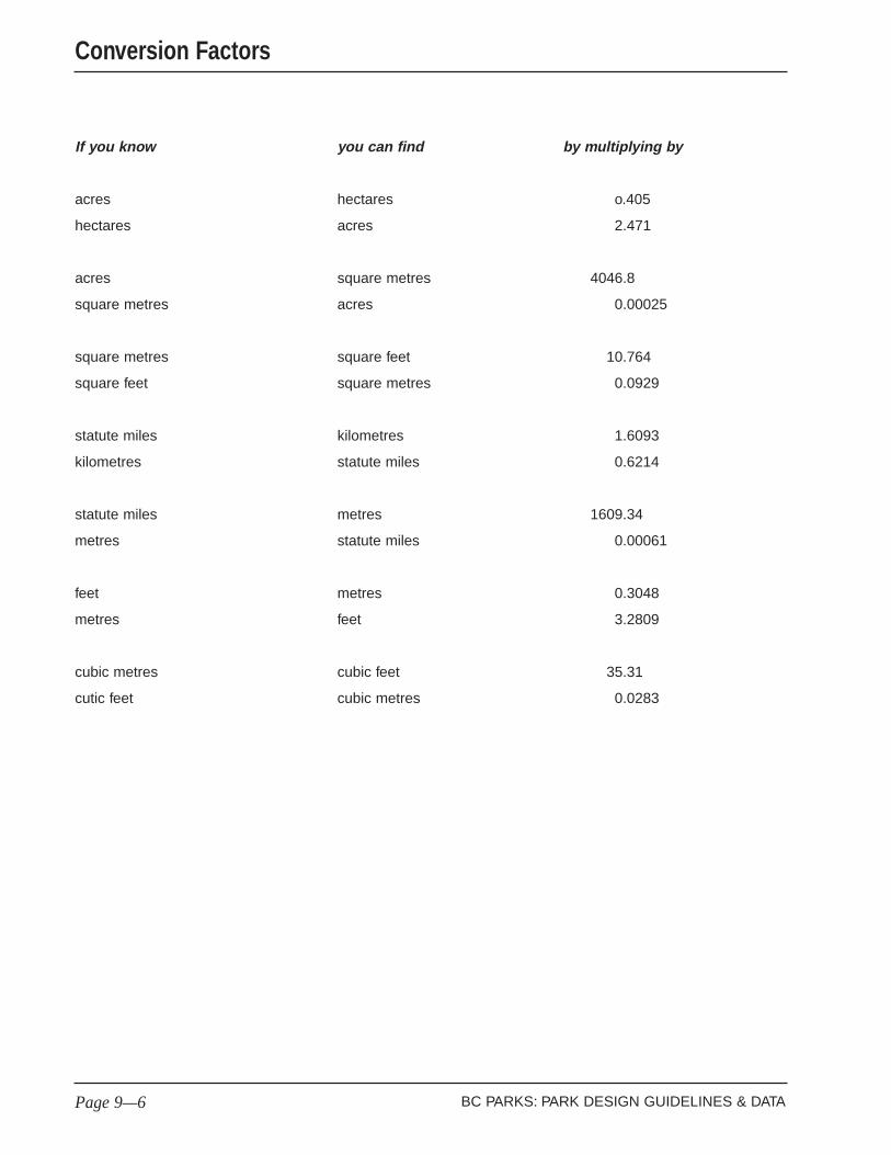
If you know you can find by multiplying by
acres hectares o.405
hectares acres 2.471
acres square metres 4046.8
square metres acres 0.00025
square metres square feet 10.764
square feet square metres 0.0929
statute miles kilometres 1.6093
kilometres statute miles 0.6214
statute miles metres 1609.34
metres statute miles 0.00061
feet metres 0.3048
metres feet 3.2809
cubic metres cubic feet 35.31
cutic feet cubic metres 0.0283
BC PARKS: PARK DESIGN GUIDELINES & DATAPage 9—6
Conversion Factors