design brief and masterplan land between upthorpe … brief and masterplan land between upthorpe...
TRANSCRIPT

D e s i g n B r i e f a n d M a s t e r p l a nL a n d b e t w e e n U p t h o r p e R o a d a n d
H e p w o r t h R o a d

DESIGN BRIEF
The proposed site is ideal for residential development, being closely located to the village localcentre. The site is allocated for residential development in St Edmundsbury Borough Council’sLocal Plan and is well positioned in relation to existing development.
In line with St. Edmundsbury Borough Local Plan and policy DS5, this major development requiresthis Design Brief to outline the underlying principles upon which the proposals are based. ThisDesign Brief aims to illustrate the proposals accord with relevant design guidance and developmentbriefs approved by the Local Planning Authority or other adopted Supplimentary PlanningDocuments.

1.0 INTRODUCTION- Background to Abbey New Homes.
2.0 CONTENTS
3.0 LOCATION- Maps and plans
4.0 CONSTRAINTS & OPPORTUNITIES- Site constraints and oppoptunities
5.0 LANDSCAPE- Landscape, open space and vegetation.
6.0 MOVEMENT- Roads, access and circulation.
7.0 DRAINAGE- Local watercourses and flood plains.
8.0 ARCHITECTURAL STYLE- Walling Materials- Roof Materials- Roof Form and Design- Details- Landmark Buildings- Privacy- Garden Space- Lighting- Security
9.0 CONCEPT- Development Area- Legibility- Green Spaces- Permeability
10.0 HIGHWAY IMPROVEMENT- Hepworth Road- Upthorpe Road
11.0 SUSTAINABILITY- Introduction- Accessibility- Improved Efficiency of Land Use- Reduced Water Generation and Disposal- Addressing the Impact of Climate Change and Reducing the Risk of Flooding- Conserve and Enhance Biodiversity and Geodiversity Within the Surrounding Area.- Promote Sustainable Economic Growth and Competitiveness
12.0 CONSULTATION- Exhibition- Conclusion
13.0 CONCLUSION
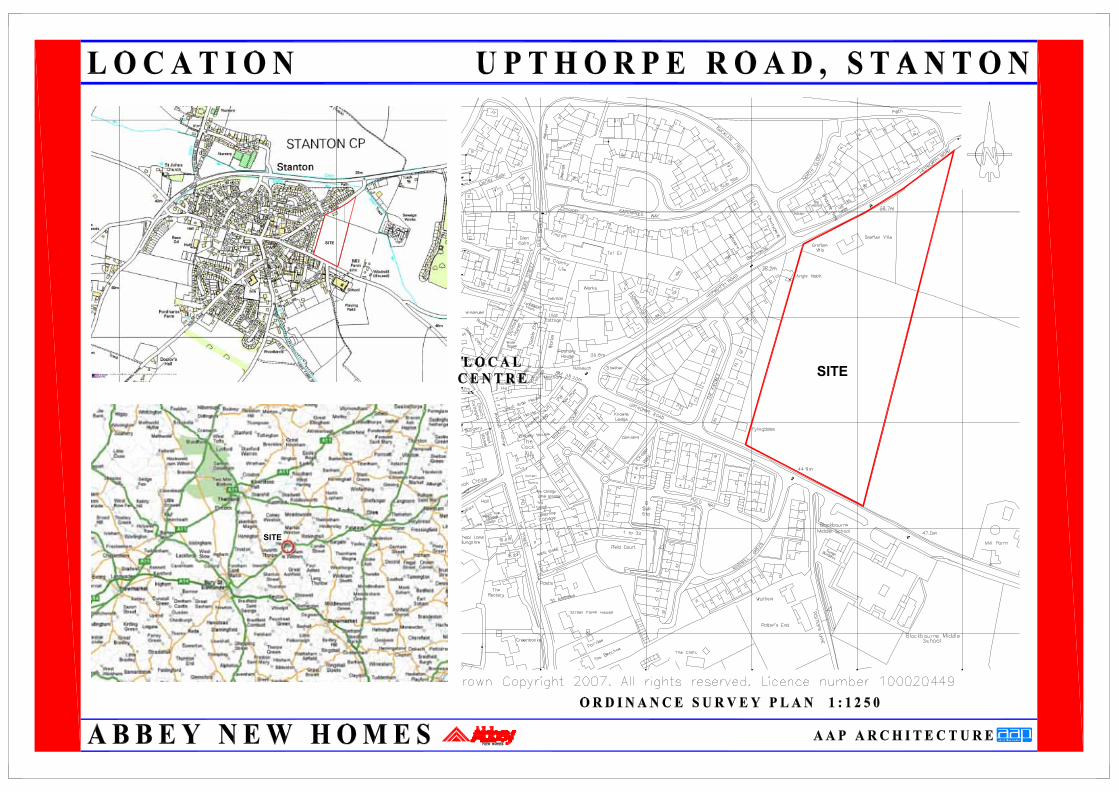
SITE
SITE
SITE
AREAA
1
AREAC1
AREAB
HIGHWAY SITE ACCESS POSITION
POSSIBLE PEDESTRIAN ANDCYCLE ACCESS
VIEWS OUT OF DEVELOPMENTOVER WINDMILL
VIEWS OVER OPEN FARMLAND
AVOID OVERLOOKING TOADJACENT PROPERTIES
LANDMARK BUILDINGS
SUNRISE TO SUNSET
1
ADOPTABLE ROAD TO BOUNDARY
(EXACT LOCATION TO BE AGREED AT DETAILED DESIGN STAGE)
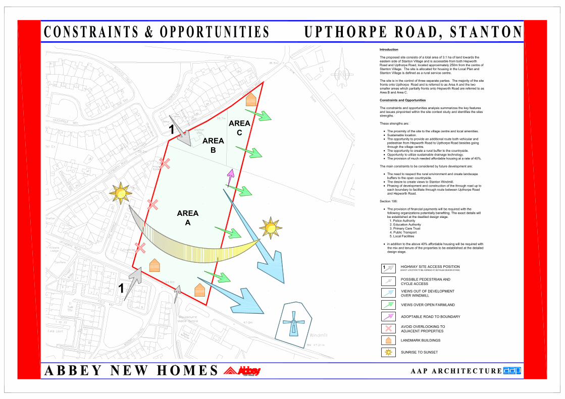
Introduction
The proposed site consists of a total area of 3.1 ha of land towards theeastern side of Stanton Village and is accessible from both HepworthRoad and Upthorpe Road, located approximately 250m from the centre ofStanton Village. The site is allocated for housing in the Local Plan andStanton Village is defined as a rural service centre.
The site is in the control of three separate parties. The majority of the sitefronts onto Upthorpe Road and is referred to as Area A and the twosmaller areas which partially fronts onto Hepworth Road are referred to asArea B and Area C.
Constraints and Opportunities
The constraints and opportunities analysis summarizes the key featuresand issues pinpointed within the site context study and identifies the sitesstrengths.
These strengths are:
• The proximity of the site to the village centre and local amenities.• Sustainable location.• The opportunity to provide an additional route both vehicular andpedestrian from Hepworth Road to Upthorpe Road besides goingthrough the village centre.
• The opportunity to create a rural buffer to the countryside.• Opportunity to utilize sustainable drainage technology.• The provision of much needed affordable housing at a rate of 40%.
The main constraints to be considered by future development are:
• The need to respect the rural environment and create landscapebuffers to the open countryside.
• The desire to create views to Stanton Windmill.• Phasing of development and construction of the through road up toeach boundary to facilitate through route between Upthorpe Roadand Hepworth Road.
Section 106:
• The provision of financial payments will be required with thefollowing organizations potentially benefiting. The exact details willbe established at the deatiled design stage.1. Police Authority2. Education Authority3. Primary Care Trust4. Public Transport5. Local Facilities
• in addition to the above 40% affordable housing will be required withthe mix and tenure of the properties to be established at the detaileddesign stage.
AREAA
AREAC
AREAB
SIGNIFICANT TREES
SIGNIFICANT HEDGES AND HEDGEROWS
AGRICULTURAL AND OPEN GROUND
URBAN AND RESIDENTIAL AREAS
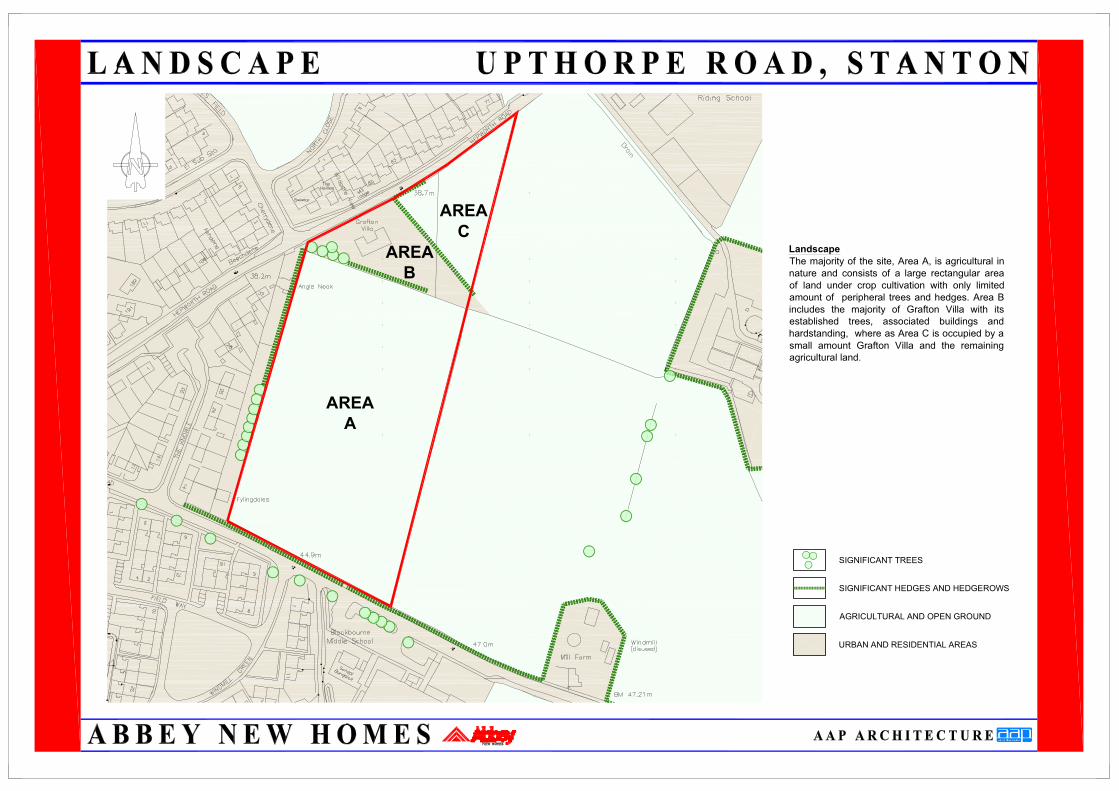
LandscapeThe majority of the site, Area A, is agricultural innature and consists of a large rectangular areaof land under crop cultivation with only limitedamount of peripheral trees and hedges. Area Bincludes the majority of Grafton Villa with itsestablished trees, associated buildings andhardstanding, where as Area C is occupied by asmall amount Grafton Villa and the remainingagricultural land.
PROPOSED SITE ACCESS
A143 BURY ROAD
B1111 BARNINGHAM ROAD
OTHER MAIN ROADS
PUBLIC FOOTPATHS
SITE
Green
Middle School
Green
School
Church
VillageCentre
A
BC
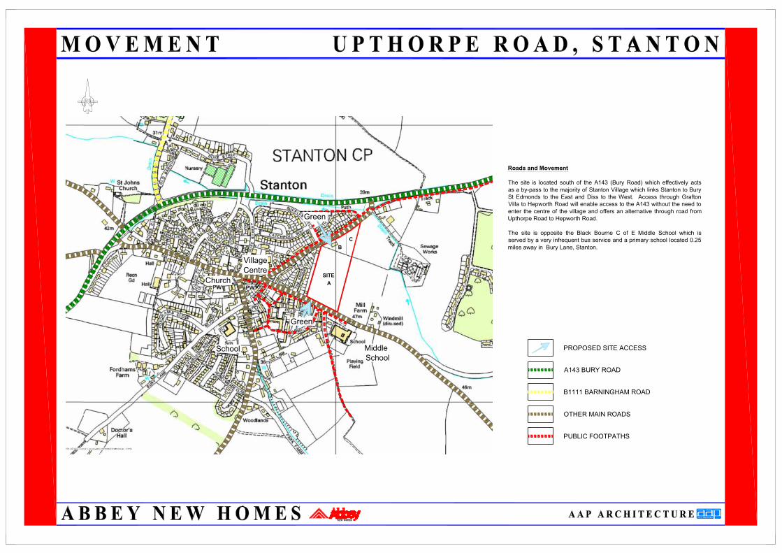
Roads and Movement
The site is located south of the A143 (Bury Road) which effectively actsas a by-pass to the majority of Stanton Village which links Stanton to BurySt Edmonds to the East and Diss to the West. Access through GraftonVilla to Hepworth Road will enable access to the A143 without the need toenter the centre of the village and offers an alternative through road fromUpthorpe Road to Hepworth Road.
The site is opposite the Black Bourne C of E Middle School which isserved by a very infrequent bus service and a primary school located 0.25miles away in Bury Lane, Stanton.

SITE
GRADIENT1:35
AREA OF FLOOD RISK
EXISTING WATERCOURSES
DIRECTION OF SITE SLOPE 1:35
Drainage
The site slopes gently towards Hepworth Road inthe direction indicated on the plan at a gradientof approximately 1:35 giving a total overall falltowards Hepworth Road of around 7m.
No part of the site is near the 1 in 100 year floodplain which comes up to the other side of theA143, but it is recognised that the village is proneto flooding, consequently great care will need tobe taken to ensure that any development doesnot have a detrimental effect on flooding.
Foul WaterAnglian Water have confirmed that the foul waterfrom the development can connect into theexisting sewers in Upthorpe Road and HepworthRoad and that there is capacity within the systemto accommodate the development.
Surface Water
As Anglian Water have confirmed that there areno public surface water sewers in the vicinity ofthe site, attenuation via swales or balancingponds is not considered appropriate. Instead thescheme will incorporate soakaways for theprivate household drainage as well as thehighway drainage which is acceptable to theEnvironment Agency.

ARCHITECTURAL STYLE
The strong local character and architectural traditions of historic Stanton will be reflected in thechoice of materials and details for the development. The materials and details to be used in thedevelopment are described below.
Walling Materials
- A red brick to be the dominant walling material.- Coloured render in pastel shades.- In buildings with a formal treatment, rustication and formal details will be appropriate.
To provide contrast and variety occasional departures from this palette of materials will beacceptable. These departures will need to be justified in design terms and might for exampleinclude the use of random rubble or dressed stone.
Roof Materials
- Roof materials to reflect those found throughout the village, these will include, plain tiles inslate, red & brown colours, with profiled tiles in red & brown.
Roof Form and Design
- Buildings will generaly have a minimum 40° pitched roofs and will predominantly take the formof a straight gable end roof.- Very occasional use of hipped roofs on landmark buildings.- Ridge tiles will match the colour or the primary roofing materials.- Generally gables will have barge boards with barge boards on lipped dormers.- Eaves will generally project from the main face of the building with the occasional use of flusheaves. Where the eaves project the soffits will be flat as typically found in Stanton. Moreelaborate detailing may be appropriate on landmark buildings.- Dormer windows will generally be small in size with a pitched gable roof in tiles matching theremainder of the roof, with lead cheeks and lipped barge boards. Some dormers will berecessed where this suites the elevational form of the dwelling and internal space.- Use will be made of chimneys particularly on landmark buildings and constructed on partywalls to reflect the traditional construction and locations found in Stanton.
Details
- The fenestration used in the buildings will be visually balanced and have good proportions.- Windows with a horizontal emphasis and proportion will be subdivided by strong verticaldivisions. Use of dark brown stain will be avoided. Windows will be recessed from the externalwall face.- In some landmark buildings the window openings may have a strong emphasis. In buildingswith this treatment the elevations will generally be symmetrical and balanced.- Brick detailing in the form of simple brick detailing in non-contrasting brick, corbeled eaves,string courses and projecting plinths and quoins will be used in limited locations.- Window heads will vary from the simple brick on edge through to detail arched brickwork.- Detailing will generally follow traditional styles for arches, lintels, sills and quoins.- Doorways will be particularly prominent elements in landmark buildings.- Porches and canopies will be used in appropriate situations to provide shelter to the front doorand will be integrated into the overall building design.-Architectural styles will be used in modern context and with some flexibility. References will notbe used or interpreted rigidly and in a way which might stifle innovation and individuality.
ENTRANCE FEATURES
ENTRANCE DETAIL TOLANDMARK BUILDING
TRADITIONAL CANOPIES
SMALL PITCHEDGABLE DORMER
ROOF DETAILING
CORBLED EAVES DETAIL
FENESTRATION
TRADITIONAL, BALANCEDAND PROPORTIONED
WINDOWSSTRONG EMPHESIS ON
FEATURE PLOTS
FLAT ROOFEDDORMERS TO KEY
BUILDINGS
TERRACING AND CHIMNEY STYLES

Landmark Buildings
Suggested locations for landmark or key buildings are shown on the constraints plan. Thelandmark buildings will occupy prominent locations within the development helping to create astrong sense of place. The landmark buildings will be of a larger scale than adjoining buildingswith particular attention given to materials, elevational treatment and details. It will beappropriate for some of these buildings to have a formal character in terms of elevationaltreatment.
Privacy
The distances between building frontages will vary in selected locations and could be as closeas 9m particularly to the central streets. Where frontages are closer than 12m the design of thebuildings will need to be carefully considered to minimise overlooking. In these confined spacesorientation of the buildings will be important in terms of sunlight and shadow. The distancebetween the rear of the buildings will normally be a minimum of 25m to provide privacey.Exceptions to this minimum distance may be considered to create surveillance of either carparking areas or open space areas, footpaths and cycle-ways and for villagescape designreasons. Particular attention will be given in these locations to the arrangement of rooms,window location and design, boundary treatment and design of garden space to create internaland external privacy.
Garden Space
Garden dimensions will be commensurate with the size and the location of each dwellingoffering amenity suitable for the accommodation.
Lighting
Careful consideration will be given to design and position of lighting columns and fittings to avoidintrusion. The design of the fittings will compliment the architecture and urban form. Lampswhich give a white light will be preferred in terms of impact and colour rendition.
Security
The development will incorporate Secured by Design Principles. These principles encourage theadoption of crime prevention measures in the design of development. The local Police ServiceArchitectural Liaison Officer will be consulted at the detail design stage to ensure that principlesare properly considered.
STREET SCENE ADJACENTTO GREEN OPEN SPACE
TYPICAL SMALLER SCALEDWELLING
TYPICAL RENDEREDLARGER DWELLING
Upthorpe Road
Hepworth R
oad
VIEWS TO COUNTRYSIDEAND WINDMILL
VIEWS TO COUNTRYSIDEAND WINDMILL
VIEWS TOCOUNTRYSIDEAND WINDMILL
VIEWS TO COUNTRYSIDEAND WINDMILL
Green
ParkingCourt
ParkingCourt
ParkingCourt
ParkingCourt
Play
Play
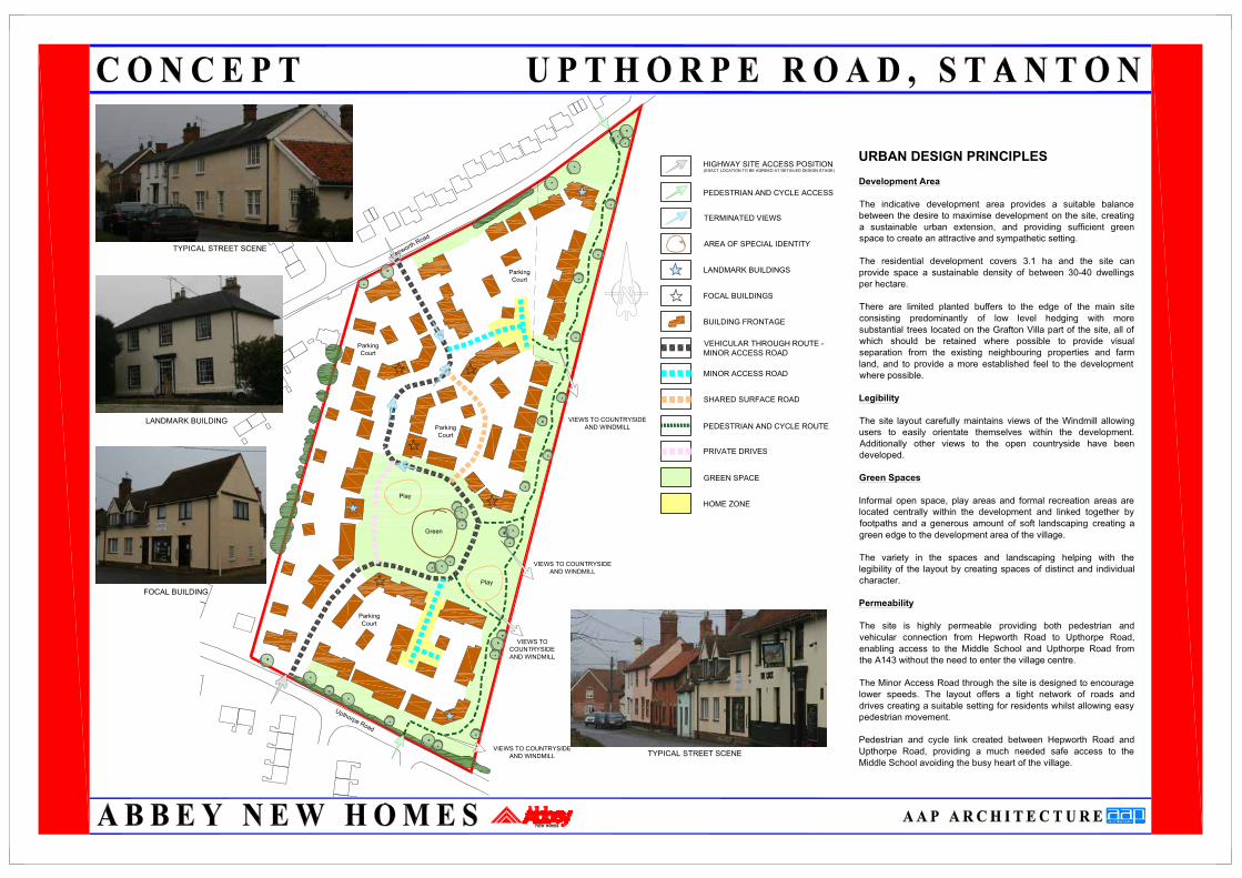
URBAN DESIGN PRINCIPLES
Development Area
The indicative development area provides a suitable balancebetween the desire to maximise development on the site, creatinga sustainable urban extension, and providing sufficient greenspace to create an attractive and sympathetic setting.
The residential development covers 3.1 ha and the site canprovide space a sustainable density of between 30-40 dwellingsper hectare.
There are limited planted buffers to the edge of the main siteconsisting predominantly of low level hedging with moresubstantial trees located on the Grafton Villa part of the site, all ofwhich should be retained where possible to provide visualseparation from the existing neighbouring properties and farmland, and to provide a more established feel to the developmentwhere possible.
Legibility
The site layout carefully maintains views of the Windmill allowingusers to easily orientate themselves within the development.Additionally other views to the open countryside have beendeveloped.
Green Spaces
Informal open space, play areas and formal recreation areas arelocated centrally within the development and linked together byfootpaths and a generous amount of soft landscaping creating agreen edge to the development area of the village.
The variety in the spaces and landscaping helping with thelegibility of the layout by creating spaces of distinct and individualcharacter.
Permeability
The site is highly permeable providing both pedestrian andvehicular connection from Hepworth Road to Upthorpe Road,enabling access to the Middle School and Upthorpe Road fromthe A143 without the need to enter the village centre.
The Minor Access Road through the site is designed to encouragelower speeds. The layout offers a tight network of roads anddrives creating a suitable setting for residents whilst allowing easypedestrian movement.
Pedestrian and cycle link created between Hepworth Road andUpthorpe Road, providing a much needed safe access to theMiddle School avoiding the busy heart of the village.
HIGHWAY SITE ACCESS POSITION
PEDESTRIAN AND CYCLE ACCESS
TERMINATED VIEWS
AREA OF SPECIAL IDENTITY
BUILDING FRONTAGE
FOCAL BUILDINGS
LANDMARK BUILDINGS
VEHICULAR THROUGH ROUTE -MINOR ACCESS ROAD
PEDESTRIAN AND CYCLE ROUTE
MINOR ACCESS ROAD
SHARED SURFACE ROAD
GREEN SPACE
HOME ZONE
PRIVATE DRIVES
(EXACT LOCATION TO BE AGREED AT DETAILED DESIGN STAGE)
LANDMARK BUILDING
TYPICAL STREET SCENE
FOCAL BUILDING
TYPICAL STREET SCENE

Upthorpe Road
Hepworth R
oad
Green
ParkingCourt
ParkingCourt
Play
Play
Highways
The proposed site will be served by two vehicular access points fromHepworth Road & Upthorpe Road. To Facilitate these access points, offsite highways improvements may be required and are likely to include thefollowing:
Hepworth Road
• Localized widening to allow for a new right hand turn lane.• New pedestrian crossing point• Existing footway widened along Hepworth Road as required by theHighways Department.
Upthorpe Road
• New traffic calming.• On street parking created.• Existing footways connected with the new footways to be
constructed on highway land.• New westbound bus stop outside school.
The exact position of these access points will be agreed at a detaileddesign stage and will take into account design advice outlined in a TrafficStatement or T.I.A. together with guidance from the County HighwaysAuthority.

SUSTAINABILITY
Introduction
1. To provide sustainably constructed and affordable new homes
The development would meet the housing needs of the local community. New homes will be constructed sustainably with a high level ofenergy efficiency making use of locally sourced and recycled materials where possible. The development would provide a broad varietyof house types, sizes and levels of affordability, creating provision of housing to meet the needs of local people, many who currentlycannot get into the housing market.
2. Promote a thriving and inclusive community
The sites close proximity to the centre of Stanton will help to support and ensure the survival of the existing village facilities.
3. Maintain a low level of crime
The development would allow for a carefully considered design and layout complying with “Secured by Design” principles at both a broadand detailed level.
Provision of safe streets which are well overlooked with secure private rears within blocks reduces the possibility and perception of crimeallowing residents to feel comfortable with their surroundings.
Accessibility
Many local facilities are within walking distance of the site, hence its allocation for residential development, but the opportunity does existto improve links to other settlements such as Bury St Edmonds and Diss by improving the frequency of the bus service.
Improved efficiency of land use
The development follows guidance set down in PPS3 and would provide new housing at a sustainable density, making efficient use of aGreenfield / previously under developed site. The development offers the opportunity to create a planned urban extension to StantonVillage removing the need for sporadic development in the surrounding area, protecting more sensitive less suitable located rural andagricultural landscapes from future development pressure.
Reduced water generation and disposal
Houses and flats will be designed to incorporate storage of recyclable and compostable waste along with general waste. The extensiveuse of S.U.D.S. solutions will be used for rainwater disposal. Rainwater will also be disposed throughout the site into ground waterthrough the extensive use of soakaways for private and highway areas where ground conditions permit.
Construction waste will be disposed of sustainably or recycled in order to reduce the environmental impact of the development andrecycled materials will be used in the construction process where appropriate.
Energy efficiency
Dwellings will be constructed in accordance with the current, adopted Saint Edmundsbury Borough Council policies . Renewable energywill be promoted in line with national standards, with the use of traditional renewable energy encouraged by the installation of class 1flues and fireplaces for solid fuel burning.
Addressing the impact of climate change and reducing the risk of flooding
The development provides new housing outside the flood plain and allows the opportunity for closely managing water run off within thesite to reduce the impact of future flood events.
Houses will be designed to take advantage of passive solar gain and natural ventilation as the climate becomes warmer.
Storm water soakaways will be used throughout the site where ground conditions permit.
Conserve and enhance biodiversity and geodiversity within the surrounding area.
The development will retain and improve hedge rows, where possible and will provide substantial buffer zones and open space aroundthe perimeter in order to retain the rural setting to the development.
Promote sustainable economic growth and competitiveness
The development will support the village of Stanton and its local facilities and help to ensure its future as a desirable place to live andwork, provide high quality homes for residents and alleviate pressure on the housing market.
The layout and scale of the development, combined with the elevation of the site in relation to Stanton Windmill will not disrupt the flowof air to the mill when the wind veers from the prevailing south westerly direction.

Exhibition
Abbey New Homes held a public exhibition on Wednesday 26 February 2009 to enable the local community to view and comment on its proposed plans for the
above site, prior to the submission of a Master Plan. The exhibition was attended by 40 people, with a total of 13 people completing comment forms during and
after the even. Of these, 15 per cent of respondents were in support of the proposals, 62 per cent supported the proposals with reservations and 23 per cent of all
respondents objected to the proposed development.
The public exhibition took place between 3.00pm and 7.30pm at Stanton Community Village Hall, Off Old Bury Road, Stanton. Additionally, local Councillors
including Ward Members were invited to attend a preview session from 2.00pm to 3.00pm. To ensure maximum attendance from the local community, the event
was publicised through adverts posted at Stanton Stores, Blackthorne Church of England Voluntary Controlled Middle School and St Edmundsbury Borough Council
Offices. Councillors and neighbouring residents received individual formal invite letters. An advert was also posted in the Bury Free Press, Friday paper in the Public
Notices section The posters and invitations highlighted the location and exhibition opening times. Following the exhibition and attendees were sent a thank you
letter for their attendance.
The exhibition illustrated Abbey New Homes' plans for a residential development covering 3.1 hectares at a densityof between 30-40 dwellings per hectare. The
exhibition provided both Councillors and local residents with the opportunity to view and comment on the plans. Attendees were able to meet with representatives
from Abbey New Homes, who were able to answer any specific questions. Attendees were also provided with a handout, outlining the proposal, creating a better
understanding of the exhibition boards on display.
Comment forms were provided for exhibition visitors and could be returned during the event or alternatively by using freepost envelopes provided. Respondents
were asked to indicate whether or not they were in support of Abbey New Homes' proposals. Space was provided on the forms to enable respondents to add any
further comments. In addition, a Freephone telephone number was included on all communication before and after the exhibition to ensure that the local
community and those who were unable to attend the event could request further information or communicate their comments to Abbey New Homes.
The public exhibition provided an opportunity for local residents to view the plans and discuss any thoughts they had on the scheme with representatives from the
development team. Seventy seven per cent of respondents expressed complete or qualified support for the scheme.
Conclusion
Respondents expressed that their primary issues were that of the increase of traffic on Upthorpe Road, road safety around the school and the proposed access
points. At the exhibition residents were shown the plans for the road improvements to help ease the traffic problems and the proposed safety measures.
Along with the issues raised, there were very positive comments with regards the amount of affordable housing planned, answering a perceived need in Stanton.
The pre-application consultation event offered Abbey New Homes the opportunity to engage with the local community at an early stage and for comments and
views to be obtained before a Master Plan is submitted. Abbey New Homes has fully considered and evaluated all the feedback received as a result of the public
consultation.
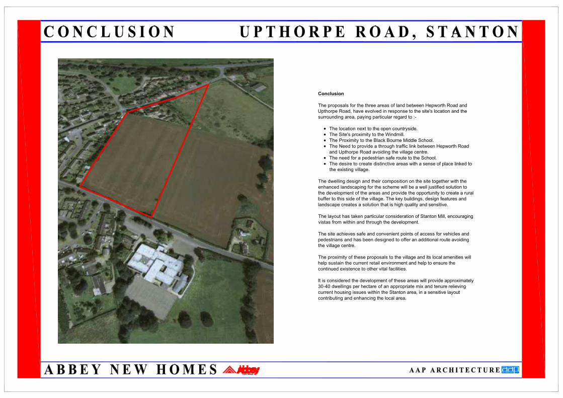
Conclusion
The proposals for the three areas of land between Hepworth Road andUpthorpe Road, have evolved in response to the site's location and thesurrounding area, paying particular regard to :-
• The location next to the open countryside.• The Site's proximity to the Windmill.• The Proximity to the Black Bourne Middle School.• The Need to provide a through traffic link between Hepworth Roadand Upthorpe Road avoiding the village centre.
• The need for a pedestrian safe route to the School.• The desire to create distinctive areas with a sense of place linked tothe existing village.
The dwelling design and their composition on the site together with theenhanced landscaping for the scheme will be a well justified solution tothe development of the areas and provide the opportunity to create a ruralbuffer to this side of the village. The key buildings, design features andlandscape creates a solution that is high quality and sensitive.
The layout has taken particular consideration of Stanton Mill, encouragingvistas from within and through the development.
The site achieves safe and convenient points of access for vehicles andpedestrians and has been designed to offer an additional route avoidingthe village centre.
The proximity of these proposals to the village and its local amenities willhelp sustain the current retail environment and help to ensure thecontinued existence to other vital facilities.
It is considered the development of these areas will provide approximately30-40 dwellings per hectare of an appropriate mix and tenure relievingcurrent housing issues within the Stanton area, in a sensitive layoutcontributing and enhancing the local area.