descriptive geology and three dimensional gocad data integration
TRANSCRIPT

Descriptive Geology and Three Dimensional Gocad Data Integration, Modeling and Projection to Derive Mineralization Controls and
Exploration Targets, Midway Gold Project, Nye County, Nevada, USA
Chevillon, C. V. [1], Stiles, C. [2], Mosch, D. [3] _________________________ 1. Chevillon Exploration Consulting, Reno, Nevada 2. Consulting Geologist, Helena, Montana 3. Midway Gold Corporation, Tonopah, Nevada
ABSTRACT Midway is a range front pediment gold discovery entirely covered by 5m to 300m of transported Quaternary alluvial gravel and active sand dunes. The deposit lies along the NE range front of the San Antonio Mountains about 35 km NE of Tonopah, Nevada. Midway is a quartz-adularia, low sulfidation bonanza gold vein system hosted by silicified Miocene interbedded volcanic/volcaniclastic sequence (Tmv) and metamorphosed Ordovician Palmetto Formation (Op) basement rocks. Over the last two years Midway Gold Corporation, owner, has discovered new bonanza vein zones near the original Discovery Zone and is presently permitting an exploration decline for metallurgical sampling and test stopeing. Midway Gold re logged a number of past drill holes within and near the Discovery Zone and used the information to revise the local geologic model with conventional cross sections and maps. Proximal targets were derived and drill tested. In 2006 new bonanza gold veins were discovered based on the projections from the revised model. The new Dauntless vein discovery is the first bonanza gold vein found within Op basement rocks at Midway and it opens up property-wide, untested gold potential at depth. Results from the Discovery Zone geologic model were used to create a property-wide geologic exploration model from the recently compiled 3D project database. The property-wide model incorporates modeled geology, drill hole gold and inverted geophysical results from aero magnetic, TEM, gravity, CSAMT and IP surveys data utilizing Gocad 3D pattern recognition software. Geologic modeling of the hanging wall (HW) contact surface of Op basement rocks defines a series of NS trending, composite horsts and grabens bounded by interpreted normal faults. Tmv lithofacies transitions and stratigraphic pinch outs against horsts establish that the Tmv basin was tectonically active during volcanism and sedimentation. The NS graben bounding faults appear to have controlled mineralization. Known bonanza gold veins and outlying high grade gold intercepts generally correlate with the interpreted NS graben bounding faults and the crests of the horsts. Remodeling of bonanza vein intercepts in the Discovery Zone to improve exploration decline design, included re logging of each drill hole intercept. The latest vein model establishes that most of the known bonanza gold veins correlate NS among the drill holes. They appear to be NS en echelon veins within the broad, NW trending Midway gold zone. The NS bonanza vein projection are significant in that past exploration grid drilling and interpretation has been on a NW drill grid. The strike extensions of modeled NS veins are generally untested which substantially adds to the proximal exploration potential of the property for bonanza gold veins. Rhyolite dikes are also present along the graben bounding faults in Op basement rocks beneath each of the known Au zones. Drill hole gold intercepts( >1 gpt Au) are present within about 50 m HW and footwall of the Op contact surface.. All known Midway gold mineralization is associated with silicification, both in the bonanza veins and with the silicified disseminated zones that envelope the veins. Resistively highs (CSAMT, TEM and IP) and weak aero mag lows correlate with the gold zones and enclosing silicified rocks. An orientation C02, O2, SO2, H2S, NH3 soil gas survey was run in the transported overburden that covers the deposit and surface CO2, SO2 and NH3 provide remote signatures of bedrock gold. Modeling results were used to define 10 exploration targets for bonanza gold vein zones. Though some past drill holes are present in the targets, in 3D, the past holes are generally too shallow or isolated and do not provide sufficient information to test the targets.
Data Visualization and Integration_________________________________________________________________________________________
Paper 70
___________________________________________________________________________
In "Proceedings of Exploration 07: Fifth Decennial International Conference on Mineral Exploration" edited by B. Milkereit, 2007, p. 923-926

INTRODUCTION
Midway is an advanced stage discovery, exploration project near Tonopah in southern Nevada. It is a classic pediment discovery covered by 10-300+m of transported Quaternary gravel and active sand dunes along the NE range front of the San Antonio Mountains. The deposit is only exposed in drill holes. No mineralized outcrops are exposed through the cover rocks.
Midway is a low sulfidation, quartz-adularia, bonanza gold vein system. Bonanza gold veins (Figure 1) are generally enclosed in lower grade, disseminated gold and gold bearing stockwork veinlets. Gold is hosted by a sequence of Miocene interbedded volcanics and volcaniclastic sediments (Tmv) and by Ordovician metamorphic basement rocks of the Palmetto Formation (Op).
Figure 1: Bonanza native gold vein, Midway project, Discovery Zone, hole MW023D, 37m.
The Midway gold deposit was discovered by Kennecott Exploration in the mid 1990’s by drill holes in pediment gravel near silicified, but not mineralized range front outcrops. The property was explored by several companies, but dropped due to low metal prices. The ground was re staked in 1999 and optioned by Midway Gold Corporation. Midway Gold continued exploration on their own and through a past joint venture with Newmont Mining Corporation. Midway Gold drilling in 2005 and 2006 expanded the original Discovery Zone and discovered several new veins. An exploration decline for bulk sampling and test stopeing is currently being permitted.
LOCATION The Midway project is located 35 km NE of Tonopah, Nevada within a regional, NS trend of major gold districts (Figure 2). The deposit is along state highway 376– at the Belmont cutoff intersection (Figure 2).
APPROACH In the past, the Midway database had been only partially compiled into 2D GIS and was combined with conventional paper cross sections and maps at various scales to consider results and derive targets.
Figure 2: Regional topographic location map: Midway project, Nye County, Nevada
Midway Gold compiled and integrated all the project data
into Gocad (version 2.0.8) 3D pattern recognition software to support 3D exploration modeling and targeting. 3D geologic contact surfaces, correlations, gold modeling and inspection of inverted geophysics were the basis of the modeling. Surpac software was used to design the exploration decline and complete part of the detailed vein orientation assessment. Surface geochemical data is minimal due to the pediment setting. Drill holes were typically analyzed for only Au and Ag. Results from an orientation soil gas survey were incorporated in the targeting.
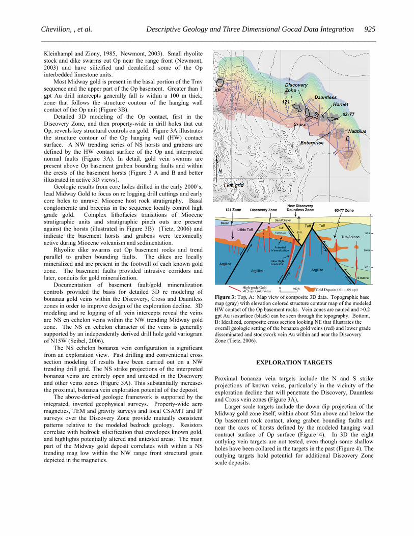
DEPOSIT GEOLOGY The low sulfidation, quart adularia vein and disseminated gold deposit at Midway is within a NW trending zone with 2.3 km of strike length as presently known (Figure 3). The Midway gold zone dips NE away from the range front and is open down dip and on strike. The discovery of the Dauntless vein zone in 2006, which is hosted with Op basement rocks, opens the depth potential of the entire Midway gold zone for similar bonanza gold veins.
Midway gold host rocks are Tmv interbedded rhyolite, rhyolite lithic and tuff and associated volcaniclastic rocks and Op Ordovician basement rocks. Tmv host rocks are exposed only in drill holes beneath the Quaternary gravel. Op is weakly metamorphosed argillite with sparse interbedded basalt and limestone. Op basement comprises much of the exposed bedrock along the range front of the San Antonio Mountains to the SW of the pediment discovery (Davis, et al., 1971,
924 Data Visualization and Integration_________________________________________________________________________________________
Kleinhampl and Ziony, 1985, Newmont, 2003). Small rhyolite stock and dike swarms cut Op near the range front (Newmont, 2003) and have silicified and decalcified some of the Op interbedded limestone units.
Most Midway gold is present in the basal portion of the Tmv sequence and the upper part of the Op basement. Greater than 1 gpt Au drill intercepts generally fall is within a 100 m thick, zone that follows the structure contour of the hanging wall contact of the Op unit (Figure 3B).
Detailed 3D modeling of the Op contact, first in the Discovery Zone, and then property-wide in drill holes that cut Op, reveals key structural controls on gold. Figure 3A illustrates the structure contour of the Op hanging wall (HW) contact surface. A NW trending series of NS horsts and grabens are defined by the HW contact surface of the Op and interpreted normal faults (Figure 3A). In detail, gold vein swarms are present above Op basement graben bounding faults and within the crests of the basement horsts (Figure 3 A and B and better illustrated in active 3D views).
Geologic results from core holes drilled in the early 2000’s, lead Midway Gold to focus on re logging drill cuttings and early core holes to unravel Miocene host rock stratigraphy. Basal conglomerate and breccias in the sequence locally control high grade gold. Complex lithofacies transitions of Miocene stratigraphic units and stratigraphic pinch outs are present against the horsts (illustrated in Figure 3B) (Tietz, 2006) and indicate the basement horsts and grabens were tectonically active during Miocene volcanism and sedimentation.
Rhyolite dike swarms cut Op basement rocks and trend parallel to graben bounding faults. The dikes are locally mineralized and are present in the footwall of each known gold zone. The basement faults provided intrusive corridors and later, conduits for gold mineralization.
Documentation of basement fault/gold mineralization controls provided the basis for detailed 3D re modeling of bonanza gold veins within the Discovery, Cross and Dauntless zones in order to improve design of the exploration decline. 3D modeling and re logging of all vein intercepts reveal the veins are NS en echelon veins within the NW trending Midway gold zone. The NS en echelon character of the veins is generally supported by an independently derived drill hole gold variogram of N15W (Seibel, 2006).
The NS echelon bonanza vein configuration is significant from an exploration view. Past drilling and conventional cross section modeling of results have been carried out on a NW trending drill grid. The NS strike projections of the interpreted bonanza veins are entirely open and untested in the Discovery and other veins zones (Figure 3A). This substantially increases the proximal, bonanza vein exploration potential of the deposit.
The above-derived geologic framework is supported by the integrated, inverted geophysical surveys. Property-wide aero magnetics, TEM and gravity surveys and local CSAMT and IP surveys over the Discovery Zone provide mutually consistent patterns relative to the modeled bedrock geology. Resistors correlate with bedrock silicification that envelopes known gold, and highlights potentially altered and untested areas. The main part of the Midway gold deposit correlates with within a NS trending mag low within the NW range front structural grain depicted in the magnetics.
Figure 3: Top, A: Map view of composite 3D data. Topographic base map (gray) with elevation colored structure contour map of the modeled HW contact of the Op basement rocks. Vein zones are named and >0.2 gpt Au isosurface (black) can be seen through the topography. Bottom, B: Idealized, composite cross section looking NE that illustrates the overall geologic setting of the bonanza gold veins (red) and lower grade disseminated and stockwork vein Au within and near the Discovery Zone (Tietz, 2006).
EXPLORATION TARGETS Proximal bonanza vein targets include the N and S strike projections of known veins, particularly in the vicinity of the exploration decline that will penetrate the Discovery, Dauntless and Cross vein zones (Figure 3A),
Larger scale targets include the down dip projection of the Midway gold zone itself, within about 50m above and below the Op basement rock contact, along graben bounding faults and near the axes of horsts defined by the modeled hanging wall contract surface of Op surface (Figure 4). In 3D the eight outlying vein targets are not tested, even though some shallow holes have been collared in the targets in the past (Figure 4). The outlying targets hold potential for additional Discovery Zone scale deposits.
925Chevillon, , et al. Descriptive Geology and Three Dimensional Gocad Data Integration__________________________________________________________________________________________

Figure 4: Map view of topography and subsurface composite 3D data. Target areas (red) superimposed on structure contour of HW Op contact surface. Collars of drill holes (black squares) show
On a larger scale, interpretation of the inverted TEM data and surface geology within the San Antonio Mountains establishes a conceptual, mineralized gold porphyry target (Figure 5). It appears the NW trending Midway gold zone lies within a large scale conductive annulus surrounding a central conductive high (Figure 5). Rhyolite dikes and a small stock are present in bedrock within the central conductor and Op limestone interbeds are silicified, locally decalcified, prospected and weakly mineralized with Au. A central rhyolite porphyry target is supported too by the presence of mineralized rhyolite dikes beneath each of the vein zones within the main Midway gold zone.
CONCLUSIONS Descriptive geology, detailed 3D modeling from compiled and well integrated project data, even in advanced exploration projects, can lead to new insight into geologic gold controls and upside exploration potential. Current 3D exploration modeling techniques place new demands for descriptive, accurate and precise geology be recorded and used along with numerical data do characterize mineralization controls.
ACKNOWLEDGEMENTS
Alan Branham, President of Midway Gold Corporation, focuses on geologic ore controls to guide the exploration drills. His support of the data compilation and 3D integration and modeling has been key in the drilled expansions of the covered deposit.
Alan Branham and Paul Tietz, past Consultant, re logged much of the core and drill holes in the Discovery Zone. Paul built the conventional cross section model in the Discovery zone that documents facies changes and stratigraphic pinch outs within host rocks and provide key insights into gold mineralization. Jim Wright, Geophysical Consultant compiled and inverted the geophysical data. We gratefully acknowledge their descriptive and interpretive work that is part of the basis of the 3D modeling and projections presented in this summary.
Figure 5: Map view of composite 3D data. Large scale conceptual targets based on 3D inversion of TEM data (slice at mid drill hole elevation), the Midway gold zone and mapped rhyolite dikes within the range front.
REFERENCES Davis, W.E., Kleinhampl, F.J., and Ziony, J.E., 1971, Aeromagnetic and
generalized geologic map of the San Antonio Mountains, Nevada: U.S. Geological Survey Geophysical Investigations Map GP-744, 1:125,000.
Kleinhampl, F.J. and Ziony, J.I., 1985, Geology of Northern Nye County, Nevada: Nevada Bureau of Mines and Geology, Bulletin 99A, scale 1:250000.
Newmont Mining Corporation, 2003, Geologic Map of Midway Project: unpublished GIS exploration map of the Midway Project, Nye County, Nevada.
Tietz, P., 2006, Grid of Geologic Cross Sections Through the Midway Discovery Zone: unpublished maps and cross sections for Midway Gold Corporation, scale 1”=50’.
Seibel, G. 2006, Variogram derived from all gold intercepts in the Midway Deposit: unpublished diagram for Midway Gold Corporation, by AMEC, February, 2006. 1 p.
926 Data Visualization and Integration_________________________________________________________________________________________