deq biennial remedial action plan update for the … michigan department of environmental quality...
TRANSCRIPT

The Michigan Department of Environmental Quality Biennial
Remedial Action Plan Update for the Rouge River Area of Concern
Compiled by:
Michelle D. Selzer Water Bureau
Aquatic Nuisance Control & Remedial Action Unit Michigan Department of Environmental Quality
P.O. Box 30273
Lansing, MI 48909-7773 Ph: 517-241-3731 Fax: 517-373-9958
Last Updated: January 31, 2008

Purpose of the Biennial Remedial Action Plan Update A Michigan Department of Environmental Quality (MDEQ) Biennial Remedial Action Plan (RAP) Update will be prepared at least every 2 years for each Area of Concern (AOC), and will be the primary tool for documenting and communicating progress to the public and agencies. These documents are meant to be brief, user-friendly updates on recent remedial actions and assessments in the AOC. They are prepared by the MDEQ in consultation with the Public Advisory Council (PAC) and the U.S. Environmental Protection Agency (USEPA). These biennial RAP updates will also be posted on the MDEQ AOC web site. The biennial RAP update is one component of the MDEQ’s process for tracking AOC restoration, removing Beneficial Use Impairments (BUIs), and ultimately delisting AOCs. These processes and relevant restoration criteria are described in more detail in the MDEQ’s Guidance for Delisting Michigan’s Great Lakes Areas of Concern (Guidance) (MDEQ, 2006). The purpose of this Rouge River biennial RAP update is to track progress in the AOC by providing an update on those remedial actions completed in recent years. This update will discuss BUI assessment results that are based on the readiness of a BUI removal and subsequent technical committee review and recommendations. Comprehensive background information is provided in the 1989 Rouge River RAP document (Southeast Michigan Council of Governments and Michigan Department of Natural Resources [MDNR], 1990), the 1994 Rouge River RAP Update (MDNR, 1995), the 1999 Rouge River Report Card (Rouge River Advisory Council [RRAC], 1999), and the 2004 Rouge River RAP Revision (RRAC, 2004). How to Use this Document For each of the nine BUIs identified in the Rouge River AOC, this biennial RAP update includes:
• A description of the significance of the BUI based on previous RAP documentation
• A summary of the restoration criteria for the BUI outlined in the Guidance document
• A brief summary of relevant remedial actions, if any, completed in recent years
• A brief summary of the technical committee’s assessment activities and results, if any, completed in recent years
• A list of annotated references and studies that may be used by a technical committee when the MDEQ AOC coordinator, in consultation with the PAC, determines the BUI is ready for formal review of remedial actions and restoration according to the applicable criteria.
2
Introduction
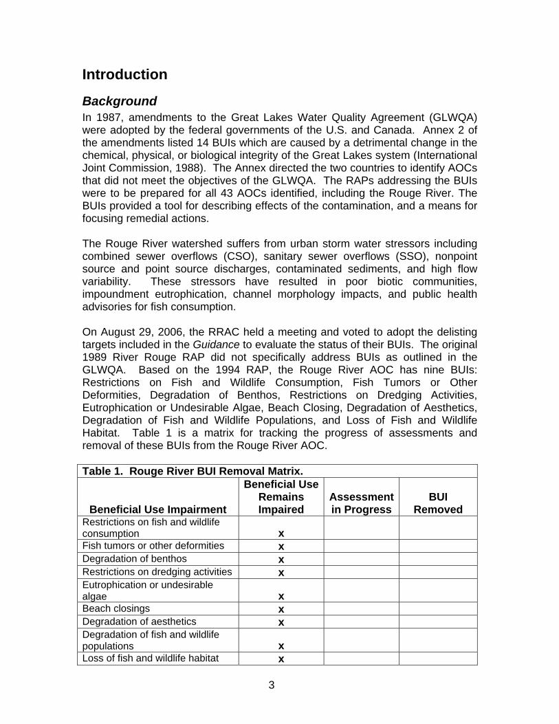
Background In 1987, amendments to the Great Lakes Water Quality Agreement (GLWQA) were adopted by the federal governments of the U.S. and Canada. Annex 2 of the amendments listed 14 BUIs which are caused by a detrimental change in the chemical, physical, or biological integrity of the Great Lakes system (International Joint Commission, 1988). The Annex directed the two countries to identify AOCs that did not meet the objectives of the GLWQA. The RAPs addressing the BUIs were to be prepared for all 43 AOCs identified, including the Rouge River. The BUIs provided a tool for describing effects of the contamination, and a means for focusing remedial actions. The Rouge River watershed suffers from urban storm water stressors including combined sewer overflows (CSO), sanitary sewer overflows (SSO), nonpoint source and point source discharges, contaminated sediments, and high flow variability. These stressors have resulted in poor biotic communities, impoundment eutrophication, channel morphology impacts, and public health advisories for fish consumption. On August 29, 2006, the RRAC held a meeting and voted to adopt the delisting targets included in the Guidance to evaluate the status of their BUIs. The original 1989 River Rouge RAP did not specifically address BUIs as outlined in the GLWQA. Based on the 1994 RAP, the Rouge River AOC has nine BUIs: Restrictions on Fish and Wildlife Consumption, Fish Tumors or Other Deformities, Degradation of Benthos, Restrictions on Dredging Activities, Eutrophication or Undesirable Algae, Beach Closing, Degradation of Aesthetics, Degradation of Fish and Wildlife Populations, and Loss of Fish and Wildlife Habitat. Table 1 is a matrix for tracking the progress of assessments and removal of these BUIs from the Rouge River AOC. Table 1. Rouge River BUI Removal Matrix.
Beneficial Use Impairment
Beneficial Use Remains Impaired
Assessment in Progress
BUI Removed
Restrictions on fish and wildlife consumption x
Fish tumors or other deformities x Degradation of benthos x Restrictions on dredging activities x Eutrophication or undesirable algae x
Beach closings x Degradation of aesthetics x Degradation of fish and wildlife populations x
Loss of fish and wildlife habitat x
3

The Rouge River AOC includes the entire Rouge River watershed (Figure 1). This urban/suburban watershed of 48 communities drains 466 square miles of southeastern Michigan and discharges into the Detroit River. Figure 1. The R
ouge River A
rea of Concern.
4

Rouge River National Wet Weather Demonstration Project
The Alliance of Rouge Communities (ARC) is the watershed management organization under which the majority of the remedial actions, monitoring, and assessments related to the BUIs listed for the Rouge River AOC are accomplished. The ARC is a voluntary organization with membership including local municipal governments, non-profit organizations, and the three counties (i.e., Wayne, Oakland and Washtenaw) in the watershed that have storm water management responsibilities under a state-issued National Pollutant Discharge Elimination System (NPDES) general storm water permit. The ARC collaborates on storm water management planning and permitting obligations. Each community contributes dues for storm water management compliance activities including: physical, chemical, and biological monitoring; various types of water quality and water quantity modeling; a geographic information system (GIS); illicit discharge elimination programs, and public education. The majority of the projects completed in the AOC are implemented and tracked through the Rouge River National Wet Weather Demonstration Project (Rouge Project). The Rouge Project was initiated in 1992 by the Rouge Program Office (RPO), Department of Environment, Wayne County, Michigan. The Rouge Project originally focused on the control of CSOs in the watershed. Although control of pollution from CSOs was identified as a major priority, it was determined that CSO control alone would not provide sufficient improvements to meet water quality standards (WQS) in the watershed. In 1994, the project expanded to consider the impacts from all pollution sources and use impairments in the Rouge River AOC. The primary objective of the Rouge Project is to evaluate the effectiveness of implemented watershed management activities by assessing and documenting remedial actions that have occurred to improve water quality watershed-wide. In an effort to effectively comply with requirements under the NPDES general storm water permit, the watershed was divided into seven subwatersheds (based on the four main branches of the river). Watershed management plans were developed for each subwatershed. Each subwatershed management plan identifies actions needed to address remaining problems associated with impaired uses identified within that particular area within the Rouge River watershed. For the purpose of this RAP Update, examples of watershed management activities that have been implemented or planned in since the 2004 RAP Update are highlighted in the Remedial Action sections. Recent technical reports that may be useful in assessing a particular BUI are highlighted and referenced in the Annotated References and Studies sections. Other remedial actions that have been implemented or planned in recent years are also described in more detail in each of the seven subwatershed management plans and other technical reports, which can be accessed at: http://www.rougeriver.com.
5

Restrictions on Fish and Wildlife Consumption Significance in the Rouge River Area of Concern The Michigan Department of Community Health (MDCH), Michigan Family Fish Consumption Guide, recommends various consumption advisories for portions of all four branches of the Rouge River due to polychlorinated biphenyls (PCBs). In addition to PCBs, all the lakes and impoundments located within the AOC are listed under the statewide mercury fish consumption advisory, which is in effect for all inland lakes, reservoirs, and impoundments in Michigan (MDCH, 2007). Restoration Criteria The RRAC has accepted the state’s criteria for restoring this beneficial use. The fish consumption advisory in the Rouge River AOC is more stringent than Lake Erie, the associated Great Lake. Therefore, this BUI will need to be assessed using either a comparison study or trend analysis. Remedial Actions Many pollution reduction regulations and programs have been instituted since the designation of the AOC. Some have been aimed at reducing pollution in general across the country. Others have been focused on the Rouge River AOC specifically. All have served, directly or indirectly, to improve the water quality conditions in the AOC. Newburgh Lake, an impoundment on the Middle Branch of the River Rouge, had PCB contaminated fish and sediments removed as part of the Rouge Project (USEPA, 1996). This restoration effort involved numerous entities including the Wayne County Department of Environment, the Wayne County Parks Division, the MDEQ, the MDNR, Environmental Consulting & Technology, Inc., and the USEPA. The impoundment was drawn down in 1997 to consolidate and dry out the lake sediments. The fish population was concentrated during the drawdown process and approximately 30,000 pounds of contaminated and undesirable fish were removed. Dredging was completed with a removal of an estimated 400,000 cubic yards of PCB contaminated sediments from the upper third of the lake at a cost of $10 million (Oemke, 1998). Restocking with desirable game fish was completed by 1999. Largemouth bass were collected in 2001 to evaluate the effectiveness of the removal of PCB contaminated sediments from the impoundment. Results indicate a median PCB tissue concentration 20 times lower than in bass collected prior to 2001 (Day, 2003). Accordingly, the PCB fish consumption advisory was relaxed for the general population (men and boys over the age of 15 and women who are beyond child bearing years) for carp, channel catfish, largemouth bass and northern pike caught in Newburgh Lake. Assessment Activities and Results This beneficial use is currently impaired. A technical committee will be convened when the MDEQ and the RRAC determine that this BUI is ready for a formal
6

review and assessment. The technical committee will review the results of all remedial actions completed and other supporting documentation (see below) to provide a decision on whether or not to support a recommendation to formally remove this BUI.
Annotated References and Studies Bohr, J. and J. Zbytowski. 2006. Michigan Fish Contaminant Monitoring
Program: 2006 Annual Report. MDEQ-WB Report # MI/DEQ/WB-7/053.. www.michigan.gov/deq/0,4561,7-135-3313_3681_3686_3728-32393--,00.html
The MDEQ’s fixed station whole fish contaminant trend monitoring project was initiated to measure spatial and temporal trends of certain bioaccumulative contaminants.
MDCH. 2007. Michigan Family Fish Consumption Guide: Important Facts toKnow if You Eat Michigan Fish. www.michigan.gov/mdhhs/0,5885,7-339-71548_54783_54784_54785---,00.html
Certain kinds and sizes of fish from the Great Lakes, and some Michigan lakes and streams, contain levels of toxic chemicals that may be harmful if those fish are eaten too often. The MDCH advises caution about eating Michigan fish for the general population, women of childbearing age, and children under 15 years old.
Fish Tumors or Other Deformities
Significance in the Rouge River Area of Concern In 1995, the MDNR, Fisheries Division, documented the presence of fish tumors and other anomalies in fish throughout the Rouge River (Leonardi, 1996). Fish tumors occur due to natural causes, such as viruses or hereditary weaknesses, in approximately one percent of fish populations. Contaminants in the Rouge River were believed to cause fish tumors or other deformities in more than one percent of the total fish community (MDNR, 1995).
Restoration Criteria The RRAC has accepted the state’s criteria for restoring this beneficial use. According to the Guidance, this BUI will be considered restored when no reports of fish tumors or deformities due to chemical contaminants which have been verified through observation and analysis by the MDNR or MDEQ for a period of five years. Or in cases where any tumors have been reported, a comparison study of resident benthic fish, or of fish species which have historically been associated with this BUI, in the AOC and a non-impacted control site indicates that there is no statistically significant difference (with a 95% confidence interval) in the incidence of liver tumors or deformities.
7

Remedial Actions Many pollution reduction regulations and programs have been instituted since the designation of the AOC. Some have been aimed at reducing pollution in general across the country. Others have been focused on the Rouge River AOC specifically. All have served, directly or indirectly, to improve the water quality conditions in the AOC. Substantial remedial efforts to reduce fish population impacts in the AOC have been ongoing as part of the Rouge Project. For example, see the Remedial Actions section below under the Beach Closing and Aesthetic BUIs for significant remedial actions have occurred related to storm water management and controlling other pollution sources.
Assessment Results This beneficial use is currently considered impaired. However, based on an informal inquiry to MDNR and MDEQ staff it was determined that there have been no reports of fish tumors or deformities reported to these agencies in the last five years. A technical committee will be convened in 2008 to formally assess this use impairment and provide a decision on whether or not to support a recommendation to formally remove this BUI.
Annotated References and Studies Beam, Jennifer D. and Jeffrey J. Braunscheidel. 1998. Rouge River Assessment.
Michigan Department of Natural Resources, Fisheries Division, SpecialReport 22. Ann Arbor, Michigan.
The Rouge River assessment and appendix were prepared to provide a comprehensive reference for citizens and agency personnel seeking information about fisheries resources, fisheries management tools, water quality data, and biological community structure. The assessment identifies opportunities for restoration and provides problem solving recommendations related to aquatic resources in the Rouge River watershed. The Rouge River Assessment is available online at: http://www.michigan.gov/dnr/0,1607,7-153-10364_10951_19056-46270--,00.html
Leonardi, J. 1996. An Assessment of the Rouge River Fish Community, 1995. Michigan Department of Natural Resources, Fisheries Division.
The assessment documented and updated the biological status of the fishpopulations and its aquatic habitat in the Rouge River watershed. http://www.rougeriver.com/techtop/sample/pdfs/FishAssessment.pdf
Degradation of Benthos
Significance in the Rouge River Area of Concern According to the 2004 RAP, with the exception of a few of the headwater areas, benthos populations are considered to be impaired throughout most of the Rouge River watershed (RRAC, 2004). Benthos have been degraded by many factors,
8

including erratic stream flows, point and nonpoint source pollution, storm water discharges, CSOs, SSOs, siltation from upland and stream-bank erosion, illegal spills and discharges, municipal and industrial discharges, and contaminated sediments.
Restoration Criteria The RRAC has accepted the state’s criteria for restoring this beneficial use. According to the Guidance, an assessment of the benthic community will be conducted by either MDEQ’s Surface Water Assessment Section (SWAS) procedures for wadeable or non-wadeable streams (MDEQ, 2002); or, in cases where MDEQ procedures are not applicable (e.g., in the concrete channel) and benthic degradation is caused by contaminated sediments, this beneficial use will be considered restored when all remedial actions for known contaminated sediment sites with degraded benthos are completed (except for minor repairs required during operation and maintenance) and monitored according to the approved plan for the site.
Since 2001, the Friends of the Rouge (FOTR) has been involving volunteers in monitoring the health of the watershed by collecting data on the type, distribution and numbers of benthic macroinvertebrates found in the Rouge River and its tributaries. According to the Guidance, if the RRAC would like to use local monitoring data for the assessment of BUI restoration, the data can be submitted to the MDEQ for review. If the MDEQ determines that the data appropriately address the restoration criteria and meet quality assurance and control requirements, it may be used to demonstrate restoration success.
Remedial Actions Many pollution reduction regulations and programs have been instituted since the designation of the AOC. Some have been aimed at reducing pollution in general across the country. Others have been focused on the Rouge River AOC specifically. All have served, directly or indirectly, to improve the water quality conditions in the AOC. See the Restrictions on Fish and Wildlife Consumption BUI section above for recent remedial actions completed on contaminated sediments and the Beach Closing BUI section below for recent remedial actions completed on point and non-point sources of pollution.
Assessment Activities and Results This beneficial use is currently impaired. A technical committee will be convened when the MDEQ and the RRAC determine that this BUI is ready for a formal review and assessment. The technical committee will review the results of all remedial actions completed and other supporting documentation (see below) to provide a decision on whether or not to support a recommendation to formally remove this BUI.
Annotated References and Studies Catalfio, C, C. Hughes, and S. Rood. 2005. 2005 Rouge River Ecosystem
Monitoring and Assessment Report. Rouge River National Wet WeatherDemonstration Project. RPO-WMGT-TR65. Wayne County, Michigan.
9
Catalfio, C, C. Hughes, and S. Rood. 2004. 2004 Rouge River Ecosystem Monitoring and Assessment Report. Rouge River National Wet Weather Demonstration Project. RPO-WMGT-TR63. Wayne County, Michigan.
Data presented in these reports summarize the physical, chemical, and biological monitoring that has been performed in the Rouge River watershed. Sampling and monitoring data includes bacteria, fish community, stream habitat, benthic macroinvertebrates, frog and toad populations, and other indicators of ecosystem health collected by the ARC, the Rouge Project, FOTR, and state agencies.
Goodwin, K., 2002. Biological Assessment of the Rouge River Oakland, Wayne and Washtenaw Counties, Michigan June-July, 2000. Michigan Department of Environmental Quality, Surface Water Division.
As part of the five year watershed review cycle, staff biologists from the MDEQ, SWAS conducted qualitative biological assessments in the Rouge River watershed. These surveys are conducted using the Procedure #51 (MDEQ, 2002). The survey objectives included: qualitative characterization of the macro-invertebrate community with respect to existing habitat conditions at sites, determine attainment status of the watershed, provide data to support permitting, and provide assistance to existing non-point source activities.
MDEQ. 2007. Total Maximum Daily Load for the River Rouge Watershed, Including Bishop and Tonquish Creeks Washtenaw, Wayne, and Oakland Counties.
The Total Maximum Daily Load (TMDL) process establishes the allowable loadings of pollutants for a water body based on the relationship between pollution sources and in-stream water quality conditions. TMDLs provide a basis for determining the pollutant reductions necessary from both point and nonpoint sources to restore and maintain the quality of their water resources. The purpose of this TMDL is to identify the appropriate actions to achieve the biological (fish and macroinvertebrate) community targets that will result in WQS attainment, specifically through reduction in sediment loadings from sources in the Rouge River watershed, including Bishop and Tonquish Creeks, thereby addressing in-stream habitat loss and hydrologic changes. http://www.michigan.gov/deq/0,1607,7-135-3313_3686_3728-12464--,00.html
Rathbun, J. and Frederick, D., 2000. Results of the 1999 Rouge River CSO Basin Macroinvertebrate Survey. Rouge Program Office Memo to the Michigan Department of Environmental Quality.
10

In 1999, the RPO staff evaluated macroinvertebrate communities at six sites within the vicinity of the Oakland County CSO basin in order to assess the effects of basin discharges on the river.
Restrictions on Dredging Activities Significance in the Rouge River Area of Concern According to the 2004 RAP Update, maintained commercial navigation channels exist only in the lower four miles of the of the Main Branch of the Rouge River (RRAC, 2004). The known remaining contaminated sediment "hot spots" are found in this lower portion of the river downstream of Michigan Avenue. These sediments are known to be contaminated with PCBs, oils, metals, and polycyclic aromatic hydrocarbons (PAHs) (RRAC, 1999). Restoration Criteria The RRAC has accepted the state’s criteria for restoring this beneficial use. According to the Guidance, this beneficial use will be considered restored when either there have been no restrictions on routine commercial or recreational navigational channel dredging by the U.S. Army Corps of Engineers (USACE), based on the most recent dredging cycle; or, in cases where dredging restrictions exist, a comparison of sediment contaminant data from the commercial or recreational navigation channel (at the time of proposed dredging) in the AOC indicates that contaminant levels are not statistically different from other comparable, non-AOC commercial or recreational navigation channels. Remedial Actions Many pollution reduction regulations and programs have been instituted since the designation of the AOC. Some have been aimed at reducing pollution in general across the country. Others have been focused on the Rouge River AOC specifically. All have served, directly or indirectly, to improve the water quality conditions in the AOC. The USACE conducts pre-maintenance survey for metals, PCBs, and organic compounds every five years, and dredges the Rouge River navigational channel every three years. The most recent maintenance dredging activities occurred in 2006. The most recent pre-maintenance survey conducted in 2004 found three areas in the river of the navigational channel where the sediment was contaminated with PCB over 1 part per million (ppm). The sampling effort from 2004 found that 14 out of 15 stations in the river had detectable levels of PCBs, however, only three stations were above 1 ppm. The three locations over 1 ppm were located in the following areas: the turning basin, in front of Morton Salt, and across from Koening Coal & Supply. Mercury levels were detected in eight of the 15 stations sampled. Two stations were above 1 ppm, and these were located in front of Morton Salt, and across from Koening Coal & Supply. The dredging in 2004 was performed by mechanical dredging, and no dredging restrictions were placed on the contract (P. Horner, personal communication, October 30, 2007).
11

Assessment Activities and Results This beneficial use is currently considered impaired. However, based on the pre-maintenance dredging survey information described above, this BUI is ready for a formal review and assessment. A technical committee will be convened in 2008 to review the results of all remedial actions completed and other supporting documentation to provide a decision on whether or not to support a recommendation to formally remove this BUI. Annotated References and Studies Great Lakes Dredging Team. 1999. Decision Making Process for Dredged
Material Management. Draft Final, October 13, 1998, Amendment #1, January 18, 1999.
This document describes how to manage the dredged material,
management options, treatment technologies available, the technical evaluation process, and regulatory information.
STS Consultants, Ltd. 2007. Lower Rouge River Sediment Investigation, Wayne County, Michigan. STS Project No. 200700659.
In 2006, STS Consultants, Ltd. was contracted by the MDEQ, Water Bureau, under the State of Michigan Level of Effort contract to complete a sediment investigation/focused feasibility project for the Rouge River. The area of investigation included a limited investigation at the confluence of each of the three main branches of the Rouge River and a more detailed investigation of the lower Rouge River from its confluence with the Detroit River upstream approximately 8.5 miles to the Michigan Avenue Bridge (M-12).
Eutrophication or Undesirable Algae Significance in the Rouge River Area of Concern According to the 1994 RAP Update, eutrophication or undesirable algae as a result of excessive nutrient loading (especially phosphorus) within the watershed can be found, during both dry and wet weather, in all branches of the Rouge River. In addition, cultural eutrophic conditions and nuisance algal blooms have been observed at least since the 1970s in many lakes throughout the watershed as well as the impoundments along the Middle Branch. Sources of excessive nutrient loading include: nonpoint source pollution, storm sewer discharges, CSOs, SSOs, permitted municipal and industrial discharges, contaminated sediments, stream flow, and illegal discharges (MDNR, 1995). Restoration Criteria The RRAC has accepted the state’s criteria for restoring this beneficial use. According to the Guidance, this beneficial use will be considered restored when there are no waterbodies within the AOC included on the list of impaired waters
12

due to nutrients or excessive algal growths in the most recent Clean Water Act Water Quality and Pollution Control in Michigan: Section 303(d) and 305(b) Integrated Report (Integrated Report), which is submitted to USEPA every two years. In addition, the MDEQ is in the process of developing nutrient criteria for state surface waters which will be adopted into Michigan’s WQS. The MDEQ will evaluate restoration of this BUI consistent with the nutrient criteria once the nutrient criteria are approved by the USEPA and adopted into rule. Remedial Actions Many pollution reduction regulations and programs have been instituted since the designation of the AOC. Some have been aimed at reducing pollution in general across the country. Others have been focused on the Rouge River AOC specifically. All have served, directly or indirectly, to improve the water quality conditions in the AOC. Substantial remedial efforts to reduce eutrophication in the AOC has been ongoing as part of the Rouge Project. Highlighted below are examples of projects that have been implemented or completed since the 2004 RAP to address the point and non-point sources of this use impairment. See below the Beach Closing BUI Remedial Action section for projects that address specific CSO and SSO issues. Actions to remediate fish and wildlife habitat concerns have directly reduced non-point source loadings that contribute to cultural eutrophication. See the Fish and Wildlife Habitat and Populations, Remedial Action section below for examples of non-point source projects that have implemented in recent years (e.g., Grow Zones). Additional watershed management activities that have been implemented or planned in recent years are also described in more detail in each of the seven subwatershed management plans, which are available on the internet at: http://www.rougeriver.com. • The Rouge River Nutrient Reduction Education Campaign is an ongoing
collaboration between the Wayne County Department of Environment and other stakeholders within the Rouge River watershed to encourage river friendly lawn care practices and other mechanisms to reduce loadings of nutrients to the Rouge River. Projects include the development and distribution of a promotional flyers, retailer recruitment and training support, newsprint advertisements, website promotions, billboard ads, and cable TV public service announcements (Catalfio, Huges, and Rood, 2005). The campaign also promotes the use of low phosphorous fertilizer during seminars for golf courses.
• Many communities conduct storm water Best Management Practices such as soil erosion programs, street-sweeping programs, and the use of phosphorus free fertilizers on city-owned property.
• Oakland, Wayne, and Washtenaw counties have developed and are implementing ordinances for regulating storm water, natural features, storm
13

water system use (i.e. what can be discharged to a storm sewer), and reduction of phosphorus from new developments.
Assessment Activities and Results This beneficial use is currently impaired. A technical committee will be convened when the MDEQ and the RRAC determine that this BUI is ready for a formal review and assessment. The technical committee will review the results of all remedial actions completed and other supporting documentation (see below) to provide a decision on whether or not to support a recommendation to formally remove this BUI. Annotated References and Studies Aiello, C. 2008. Michigan Water Chemistry Monitoring: Great Lakes Tributaries 1998-2005 Report. Michigan Department of Environmental Quality, Water Division. Report #MI/DEQ/WB-08/014. Aiello, C. 2002. Michigan Water Chemistry Trend Monitoring 1998-1999 Report. Michigan Department of Environmental Quality, Water Division. Report #MI/DEQ/SQW-02/025.
The Water Chemistry Monitoring Project allows for the calculation of contaminant loadings from key Michigan tributaries. The key goals of this project are to: 1) assess the current status and condition of individual waterbodies and determine whether standards are being met, 2) measure temporal and spatial trends, 3) to detect new and emerging water quality problems, and 4) provide data to support MDEQ water quality programs and evaluate their effectiveness. Water chemistry reports are available at: http://www.michigan.gov/deq/0,1607,7-135-3313_3686_3728-32361--,00.html
Catalfio, C, C. Hughes, and S. Rood. 2005. 2005 Rouge River Ecosystem Monitoring and Assessment Report. Rouge River National Wet Weather Demonstration Project. RPO-WMGT-TR65. Wayne County, Michigan. Catalfio, C, C. Hughes, and S. Rood. 2004. 2004 Rouge River Ecosystem Monitoring and Assessment Report. Rouge River National Wet Weather Demonstration Project. RPO-WMGT-TR63. Wayne County, Michigan.
Data presented in these reports summarize the physical, chemical, and biological monitoring that has been performed in the Rouge River watershed. Sampling and monitoring data includes bacteria, fish community, stream habitat, benthic macroinvertebrates, frog and toad populations, and other indicators of ecosystem health collected by the ARC, the Rouge Project, FOTR, and state agencies.
14

Beach Closings Significance in the Rouge River Area of Concern Recreational contact with surface water contaminated with bacteria is an ongoing concern in the Rouge River AOC. The watershed is comprised of diverse land uses that result in bacterial contamination from various storm water related sources including discharges from wastewater facilities (especially CSOs and SSOs), urban and rural storm water runoff, failing septic systems, and illegal connections to storm sewers. According to the 2006 Integrated Report, the following waterbodies within the Rouge River watershed are impaired due to pathogens: Wilcox Lake beach in Plymouth Townhsip, Wayne County; and the Rouge River from the Detroit River confluence upstream, including the Main Branch (upstream to Big Beaver Road), Upper River Rouge (upstream to Rt. 696), Middle Branch River Rouge (upstream to 8 Mile Road), Lower Branch (upstream to Beck Road), Bell Branch (upstream to 7 Mile Road), Evans Ditch (upstream to Lahser Road), and the Franklin Branch (upstream to Big Beaver Road) (Edly and Wuycheck, 2006). Escherichia coli (E. coli) monitoring performed from May through October in 2005 at 62 locations by the MDEQ for the 303(d) listed reaches of the Rouge River showed that 93 percent of samples exceeded the total body contact 30-day geometric mean WQS of 130 cfu/100 milliliters (ml), 80 percent exceeded the daily geometric mean maximum WQS of 300 cfu/100 ml, and 46 percent exceeded the partial body contact WQS of 1,000 cfu/100 ml. Because the Rouge River AOC does not meet state WQS for full or partial body contact recreation due to elevated E. coli, a TMDL for the entire watershed was developed (MDEQ, 2007a). The TMDL, however, does not include Wilcox Lake beach. In 2006, the ARC applied for and obtained a $50,000 MDEQ Clean Michigan Initiative grant for an E. coli and bacterial source tracking project, its first grant as a public entity. Twenty-four locations were sampled throughout the Rouge River watershed during wet and dry weather conditions. Results confirmed that human sources of bacteria are present throughout the watershed and are more prevalent during wet weather conditions (RPOa, 2006). Restoration Criteria The RRAC has accepted the state’s criteria for restoring this beneficial use. The Guidance criteria for this BUI is currently being revised. The proposed criteria revision outlines a three tiered approach. The first tier requires that no waterbodies within the AOC are included on the 303(d) list of impaired waters due to contamination with pathogens in the most recent Integrated Report. If the waterbody is listed due to the presence of CSOs, or are impacted by upstream CSOs, the second criteria states that this BUI will be considered restored when updated information reveals that the CSOs have been eliminated or are being
15

treated. Or, In cases where CSOs still exist and significant progress has been made towards their elimination or treatment, the third tier states that this BUI will be considered restored when monitoring in the AOC during the recreation period demonstrate that E. coli concentrations are below a 30-day geometric mean of 130 counts per 100 ml; at least 90% of sample results are below the daily geometric mean limits of 300 counts E. coli per 100 ml; no more than 1 of the sample results exceed the partial-body contact WQS of 1,000 counts E. coli per 100 ml based on a daily geometric mean; and DEQ-approved plans in a NPDES permit are in place for addressing any remaining CSOs that are causing the use impairment and the implementation plan is on schedule. Remedial Actions Many pollution reduction regulations and programs have been instituted since the designation of the AOC. Some have been aimed at reducing pollution in general across the country. Others have been focused on the Rouge River AOC specifically. All have served, directly or indirectly, to improve the water quality conditions in the AOC. Selected CSO and SSO control projects, illicit discharge elimination activities, and other watershed projects are summarized in the following subsections to demonstrate the significant activities accomplished by the communities in the watershed to improve water quality and reduce E. coli levels in the Rouge River AOC. Additional watershed management activities are described in more detail in each of the seven subwatershed management plans, which are available on the internet at: http://www.rougeriver.com. CSO and SSO Controls CSO controls are being implemented in the Rouge River watershed through three phases as established by NPDES permits applicable to the entire watershed. Phase I requires the elimination of raw sewage and the protection of public health for approximately 40% of the combined sewer area. Phase II requires the elimination of raw sewage and the protection of public health for the remaining combined sewer area. Phase III requires that the waterbodies within the watershed meet state WQS for dissolved oxygen, physical characteristics, total residual chlorine, and biological health. Several SSO correction programs have been recently established, as required by state and federal law, to eliminate SSOs that occur in the Rouge River watershed (MDEQa, 2007). The following bullets are examples of projects that have been completed or are being planned within the AOC in recent years. • There are approximately 127 miles of river in the watershed. Approximately
89 of those miles are now free of the adverse impacts of uncontrolled CSO discharges (RPO, 2007).
• All 10 of the CSO retention treatment basins planned under Phase I of the Rouge watershed CSO control program were in operation during 2006 and captured most wet weather flows for later conveyance to the Detroit wastewater treatment plant for treatment. From 1995 to 2006, 79 of the 83 CSOs have been controlled under Phase I or have been eliminated (sewer separation) (RPO, 2007). Phase I will be complete when the four CSOs in
16
the city of Dearborn, which are currently under construction, are controlled (RPO, 2007).
• Considerable planning is underway by communities within the watershed to control or eliminate the Phase II CSO outfalls and SSOs (RPO, 2007). Three Phase II CSO outfalls have been controlled by the city of Dearborn Heights (RPO, 2007).
• The Oakland County Drain Commission in the Evergreen Farmington system completed construction of a pump station to transfer flow from one interceptor to another. Melvindale completed an SSO storage facility and Allen Park completed construction of a new pump station. Each of these short-term construction projects will help reduce SSO discharges in the future (MDEQ, 2007b).
Illicit Discharge Elimination Communities within the Rouge River watershed are required to develop and implement Illicit Discharge Elimination Plans (IDEPs) to prohibit and effectively eliminate illicit discharges (including discharges of sanitary wastewater). Most communities in the Rouge River watershed have been implementing their IDEPs for several years. Typical activities include outfall surveys, sampling of storm sewer discharges and receiving waters, dye testing of facilities, inspection of onsite sewage disposal systems (OSDS), inspecting/televising the storm sewer system, inspecting/televising the sanitary sewer system, sanitary sewer lining, review of construction plans to prevent misconnection, and complaint hotlines for reporting suspicious discharges. The following bullets are examples of the types of illicit discharge elimination activities that have occurred or are currently being implemented throughout the watershed. • In 2005, Wayne County inspected 540 facilities in the Rouge River
watershed, resulting in identification of 43 illicit connections and 12 illicit discharges at 11 different facilities. Approximately four million gallons of polluted discharges to the Rouge River will be eliminated when all of the illicit discharges identified in 2005 are corrected (Catalfio, Huges, and Rood, 2005).
• In 2006, Wayne County inspected another 532 facilities in the lower and middle subwatersheds, resulting in the identification of 36 improper connections and 3 illicit discharges at 15 different facilities. It is estimated that over 1.5 million gallons of polluted discharges to the Rouge River will be eliminated when all of the illicit discharges identified in 2006 are corrected (RPO, 2007).
• In 2006, Oakland County received 40 complaints through their 24-hour environmental hotline from locations in 18 communities. Investigation of these complaints resulted in the identification of 17 illicit discharges. Of these, 15 have lead to the identification of a discharge source. Of those discharges, 11 have been corrected and four remain under investigation or corrective action is pending (RPO, 2007).
17

• In 2006, Wayne County received approximately 1,367 calls their 24-hour environmental hotline, resulting in the identification of 49 illicit discharges, 10 of which were resolved (RPO, 2007).
• OSDSs continue to be monitored by Oakland, Washtenaw and Wayne County Health officials. Complaints and inspections found 131 failing OSDS in the watershed and 126 systems were repaired or replaced (RPO, 2007).
• Several communities (e.g., Inkster, Westland, and Southfield) have extended their sanitary sewer lines to areas that were previously on septic systems, resulting in the abandonment of existing failing septic systems.
Other Remedial Actions • Approximately 47,300 pieces of public information materials and information
relating to water pollution issues were distributed to raise awareness at community events, workshops, other events held within the watershed (RPO, 2007).
• Several Rouge River municipalities have instituted unique programs to reduce pathogen input to storm water. For example, the city of Plymouth provides “Mutt Mitts” in public parks to assist with proper disposal of pet waste. A number of municipalities have also passed ordinances that require proper pet waste disposal.
Assessment Activities and Results This beneficial use is currently impaired. A technical committee will be convened when the MDEQ and the RRAC determine that this BUI is ready for a formal review and assessment. The technical committee will review the results of all remedial actions completed and other supporting documentation (see below) to provide a decision on whether or not to support a recommendation to formally remove this BUI. Annotated References and Studies Catalfio, C, C. Hughes, and S. Rood. 2005. 2005 Rouge River Ecosystem Monitoring and Assessment Report. Rouge River National Wet Weather Demonstration Project. RPO-WMGT-TR65. Wayne County, Michigan. Catalfio, C, C. Hughes, and S. Rood. 2004. 2004 Rouge River Ecosystem Monitoring and Assessment Report. Rouge River National Wet Weather Demonstration Project. RPO-WMGT-TR63. Wayne County, Michigan.
Data presented in these reports summarize the physical, chemical, and biological monitoring that has been performed in the Rouge River watershed. Sampling and monitoring data includes bacteria, fish community, stream habitat, benthic macroinvertebrates, frog and toad populations, and other indicators of ecosystem health collected by the ARC, the Rouge Project, FOTR, and state agencies.
CSO & SSO Discharge website: http://www.deq.state.mi.us/csosso/find_event.asp
18

Facilities are required to report that a CSO and SSO discharge event occurred within 24 hours of the initial discharge. Later, after the event ends, a written report is submitted which contains additional information including volume of the discharge, and the start/end date and time. This information is posted on the above website.
MDEQ’s beach website: http://www.deq.state.mi.us/beach/public/default.aspx
The MDEQ awards grants each year to local health departments to monitor E. coli levels at Great Lakes and inland beaches. County health departments use the results to assess whether the total body contact recreation designated use is being attained and whether beach closings are necessary. Results are reported in annual beach monitoring reports and are posted on the MDEQ’s beach website above (Edly and Wuycheck, 2006).
MDEQ. 2007. Total Maximum Daily Load for E. coli for the Rouge River Wayne and Oakland Counties, Michigan.
The TMDL process establishes the allowable loadings of pollutants for a water body based on the relationship between pollution sources and in-stream water quality conditions. TMDLs provide a basis for determining the pollutant reductions necessary from both point and nonpoint sources to restore and maintain the quality of their water resources. The purpose of this TMDL is to identify the allowable levels of E. coli that will result in the attainment of the applicable WQS in the Rouge River, located in Wayne and Oakland Counties, Michigan. http://www.michigan.gov/deq/0,1607,7-135-3313_3686_3728-12464--,00.html
RPO. 2007. 2006 Progress Report. Rouge River National Wet Weather Demonstration Project. RPO. 2006b. 2005 Progress Report. Rouge River National Wet Weather Demonstration Project.
The reports provide an overview of Rouge Project activities that have taken place each year. Projects include numerous watershed restoration projects and watershed-wide activities completed by the ARC communities and other stakeholders. Brief descriptions of all activities implemented are included in this report.
RPO. 2006a. Alliance of Rouge Communities Bacterial Source Tracking Final Report. Rouge River National Wet Weather Demonstration Project. Report URBSW7.27.
The objective of this project was to provide local units of governments with better information about the sources of E. coli contamination to the Rouge River. The bacterial source tracking and E. coli results obtained from this sampling project, along with historical E. coli data and other water quality
19

sampling data will help prioritize the activities local communities and counties implement to restore the river and to comply with their municipal storm water discharge permits.
Degradation of Aesthetics Significance in the Rouge River Area of Concern The aesthetic value of the Rouge River AOC is considered degraded due to unnatural color from turbidity, debris, oil and unnatural odors. The river is considered impaired for aesthetics in all four branches except some headwaters areas. Sources that contribute to this degradation include point source and non-point source pollution, storm sewer discharges, CSOs, SSOs, erratic stream flows, and illegal dumping or discharges. Restoration Criteria The RRAC has accepted the state’s criteria for restoring this beneficial use. The Guidance criteria requires that monitoring data be collected for two successive monitoring cycles to determine whether or not the water bodies in the AOC exhibit persistent, high levels of the following “unnatural physical properties” (as defined by Rule 323.1050 of the Michigan WQS) in quantities which interfere with the state’s designated uses for surface waters:
• turbidity • foams • color • settleable solids • oil films • suspended solids • floating solids • deposits
The MDEQ does not routinely monitor the Rouge River for degraded aesthetic conditions. However, once this BUI is ready to be assessed, the MDEQ biologists will monitor for aesthetic conditions during ongoing monitoring projects and/or work with other local water quality efforts to determine the aesthetic status. For example, the MDEQ’s Water Chemistry Monitoring Project does collect data in the AOC on a routine basis, which includes analysis for turbidity and suspended solids from stations located within the AOC. Remedial Actions Many pollution reduction regulations and programs have been instituted since the designation of the AOC. Some have been aimed at reducing pollution in general across the country. Others have been focused on the Rouge River AOC specifically. All have served, directly or indirectly, to improve the water quality conditions in the AOC. Substantial remedial efforts to improve the aesthetics in the AOC have been ongoing as part of the Rouge Project. Highlighted below are examples of projects that have been implemented or completed since the 2004 RAP to address the point and non-point sources of this use impairment. For other
20

remedial actions completed to address aesthetics related conditions in the AOC are listed above under the Remedial Actions sections of the Eutrophication and Undesirable Algae BUI and Beach Closings BUI. Additional watershed management activities that have been implemented or planned in recent years are also described in more detail in each of the seven subwatershed management plans, which are available on the internet at: http://www.rougeriver.com.
• In 2006, there were 55 Rouge Rescue sites in 39 communities, up from 23 communities in 2005. The number of Rouge Rescue volunteers almost doubled from 1,871 in 2005 to 3,145 in 2006. In 2007, 2,164 Rouge Rescue volunteers cleaned up 43 sites in 23 communities (RPO, 2005 and RPO, 2006b).
• The cities of Romulus, Dearborn, Inskter, Dearborn Heights, and Wayne perform regular street-sweeping activities which reduce the amount of oils, greases and debris from entering storm drains and the lower Rouge River.
Assessment Activities and Results This beneficial use is currently impaired. A technical committee will be convened when the MDEQ and the RRAC determine that this BUI is ready for a formal review and assessment. The technical committee will review the results of all remedial actions completed and other supporting documentation (see below) to provide a decision on whether or not to support a recommendation to formally remove this BUI. Annotated References and Studies Aiello, C. 2002. Michigan Water Chemistry Trend Monitoring 1998-1999 Report. Michigan Department of Environmental Quality, Water Division. Report #MI/DEQ/SQW-02/025.
The Water Chemistry Monitoring Project allows for the calculation of contaminant loadings from key Michigan tributaries. The key goals of this project are to: 1) assess the current status and condition of individual waterbodies and determine whether standards are being met, 2) measure temporal and spatial trends, 3) to detect new and emerging water quality problems, and 4) provide data to support MDEQ water quality programs and evaluate their effectiveness. Water chemistry reports are available at: http://www.michigan.gov/deq/0,1607,7-135-3313_3686_3728-32361--,00.html
Catalfio, C, C. Hughes, and S. Rood. 2005. 2005 Rouge River Ecosystem Monitoring and Assessment Report. Rouge River National Wet Weather Demonstration Project. RPO-WMGT-TR65. Wayne County, Michigan. Catalfio, C, C. Hughes, and S. Rood. 2004. 2004 Rouge River Ecosystem Monitoring and Assessment Report. Rouge River National Wet Weather Demonstration Project. RPO-WMGT-TR63. Wayne County, Michigan.
21
Data presented in these reports summarize the physical, chemical, and biological monitoring that has been performed in the Rouge River watershed. Sampling and monitoring data includes bacteria, fish community, stream habitat, benthic macroinvertebrates, frog and toad populations, and other indicators of ecosystem health collected by the ARC, the Rouge Project, FOTR, and state agencies.
Loss of Fish and Wildlife Habitat Degradation of Fish and Wildlife Populations Significance in the Rouge River Area of Concern According to the 2004 RAP, much of the Rouge River's natural floodplain still exists as parklands, and in certain areas of the headwaters, riparian habitat quality is relatively good. However, loss of fish and wildlife habitat and degraded populations are considered impaired in all four main branches and tributaries. In-stream aquatic population and habitats throughout the watershed have been damaged by high peak flows due, in part, to the significant amount of impervious surfaces, and by stream bank erosion that have resulted in significant sediment loads to the river. Wetlands have also been significantly reduced due to development. Floodwater storage has been reduced while flow volumes and flow velocity have doubled. Excessively high storm water quantities have eroded stream banks, scoured streambeds, and have degraded aquatic habitat by filling in pools and burying riffles. Restoration Criteria Per the Guidance, these two BUIs are considered together in recognition of the integral relationship between them. The restoration criteria outlined in the Guidance provides a process for local PACs to develop locally-derived restoration targets and plans for fish and wildlife habitat and populations. The RRAC has begun the process of developing a restoration plan, and is currently working with the MDEQ and a team of local experts to develop local criteria for the removal of these two BUIs. The finalized restoration plan will be part of future biennial RAP updates, and will contain at least the following components:
• A short narrative on historical fish and wildlife habitat or population issues in the AOC
• Description of the impairment(s) and location for each aquatic habitat or population site(s) to address all habitat or population issues identified in the RAP documents
• A locally derived restoration target for each impacted habitat or population site
• A list of all other ongoing habitat or population planning processes in the AOC
• A scope of work for restoring each impacted aquatic habitat or population site
• A component for reporting on habitat or population restoration implementation action(s) to the MDEQ.
22

Removal of these BUIs will be based on achievement of full implementation of actions described in the restoration plan, including monitoring according to site plans that show consistent improvement in quantity or quality of habitat or populations addressed in the criteria. Habitat values and populations need not be fully restored prior to delisting, as some may take many years to recover after actions are complete. Actions already implemented in the AOC may be reported and evaluated as long as the documentation contains all of the elements above. Remedial Actions Many pollution reduction regulations and programs have been instituted since the designation of the AOC. Some have been aimed at reducing pollution in general across the country. Others have been focused on the Rouge River AOC specifically. All have served, directly or indirectly, to improve the water quality conditions in the AOC. Substantial remedial efforts to improve impacted fish and wildlife habitat and populations in the AOC have been ongoing as part of the Rouge Project. Remedial actions outlined in other BUI sections of this Update have indirectly benefited the fish and wildlife populations that utilize the Rouge River. Highlighted below are examples of other initiatives and projects that specifically address the fish and wildlife use impairments. Additional watershed management activities that have been implemented or planned in recent years are also described in more detail in each of the seven subwatershed management plans, which are available on the internet at: http://www.rougeriver.com. • In 2007, the RRAC passed a motion that advises the MDEQ that allowing
continued wetland mitigation outside of the Rouge River watershed undermines efforts to restore and remove the fish and wildlife BUIs from the AOC.
• The RRAC passed a resolution and designated 2006 as “The Year of the Grow Zone”. Grow zones are planted areas that help to keep the soil from washing into the Rouge River during rain events, thus preventing stream bank erosion and sedimentation pollution. Grow Zones also increase natural floodwater storage capacity, reducing flooding on roads and nearby residential areas. They also provide wildlife habitat. Numerous projects have since been implemented throughout the watershed including the following:
o In September and November 2004, a group of almost 50 volunteers installed over 900 native plants and shrubs in a buffer zone along 75 feet of the upper Rouge River in Shiawassee Park.
o In 2007, Wayne County Parks Department won a 2007 RRAC Habitat and Wildlife Award for implementing Grow Zone projects in the Edward Hines Park, converting approximately 13 acres of turf grass to native grasses and wildflowers.
• In 2007, the FOTR completed the Rouge River Habitat and Database Mapping Project. The data collected serves as the baseline on habitat in the
23

watershed from which restoration targets can be set and progress can be tracked.
• In 1999, the Rouge River Gateway Partnership (Partnership) was established to promote ecosystem restoration, heritage preservation, increased recreation and economic development along the last eight miles of Rouge River. In 2001, the Rouge Gateway Master Plan was developed and includes, among other project concepts, restoring the oxbow at the Henry Ford, Greenfield Village (Phase I of III complete); Kingfisher Bluff stream bank stabilization and habitat restoration at Henry Ford Community College (project design ongoing); and a fish ladder around the dam at the Ford Fair Lane Estate on the University of Michigan, Dearborn campus (feasibility phase ongoing).
• The Wayne County Storm Water Ordinance, adopted in 2000, was updated in 2007 to help minimize flooding problems, stream bank erosion, and other impacts to natural resources downstream of development projects. The ordinance requires that management measures be implemented during the project to reduce peak river flows and ensure removal of pollution from storm water runoff.
• The city of Dearborn continues to work with volunteers from Ford Motor Company who perform river stewardship activities at Ford Field Park, including stream bank stabilization, woody debris management and native plantings.
• Construction of the Fellows Creek Naturalization and Flow Reduction Regional Storm Water Wetland adjacent to the south side of the Fellows Creek and Green Drain in Flodin Park was completed in late 2004. In addition to constructing a wetland, streambank and in-stream habitat was designed and constructed to improve approximately 1000 feet of stream corridor.
• Pebble Creek Tributary Regional Detention and Enhancement Project was completed in 2006. The wetland constructed will reduce peak flows in the creek and help to improve the overall habitat within the Main Branch of the Rouge River.
• In 2004, the city of Southfield began the Carpenter Lake Restoration Project. Once complete, the project will restore the lake to a sustainable fish and wildlife habitat with improved water quality and storm water management.
• Oakland County Parks and Recreation grounds maintenance staff at Glen Oaks Park have maintained and expanded vegetative buffers and planted shade trees along the stream to enhance riparian habitat and provide thermal protection for the stream.
• The Rouge Green Corridor Identity Demonstration Project has been implemented to assist communities in undertaking a community-based planning and communications “branding” approach that will create and promote a unique identity for the distinct riparian greenway corridors along the Rouge River. Such an approach is necessary to engage citizens, riparian businesses, and riparian homeowners in identifying with, and taking ownership of, their local riparian corridor assets.
• Southeast Michigan Greenways is a vision for a regional greenway network for Livingston, Macomb, Monroe, Oakland, St. Clair, Washtenaw, and Wayne Counties. It responds to the urgent need for action to identify and preserve
24
regional greenway opportunities before they disappear. Guided by public involvement, the project has developed a bold vision that calls for the creation of a network of greenways that is easily accessible to 4.5 million people.
Assessment Activities and Results These two beneficial uses are currently impaired. A RRAC Fish and Wildlife Technical Committee has been formed to develop fish and wildlife restoration criteria and a restoration plan, per the process outlined in the Guidance. Once the criteria and all the components of the restoration plan have been implemented and monitored, the same technical committee will be convened to formal review and assess the status of these two use impairments. The technical committee will review all remedial actions completed and other supporting documentation (see below) to provide a decision on whether or not to support a recommendation to formally remove these BUIs. Annotated References and Studies Beam, J. and J. Braunscheidel. 1998. Rouge River Assessment. Michigan Department of Natural Resources, Fisheries Division, Special Report 22. Ann Arbor, Michigan.
The Rouge River assessment and appendix were prepared to provide a comprehensive reference for citizens and agency personnel who desire information about a particular fisheries resource, fisheries management tool, water quality data, and biological community structure. The assessment identifies opportunities for restoration and provides problem solving recommendations related to aquatic resources in the Rouge River watershed. The Rouge River Assessment is available online at: http://www.michigan.gov/dnr/0,1607,7-153-10364_10951_19056-46270--,00.html
Catalfio, C, C. Hughes, and S. Rood. 2005. 2005 Rouge River Ecosystem Monitoring and Assessment Report. Rouge River National Wet Weather Demonstration Project. RPO-WMGT-TR65. Wayne County, Michigan. Catalfio, C, C. Hughes, and S. Rood. 2004. 2004 Rouge River Ecosystem Monitoring and Assessment Report. Rouge River National Wet Weather Demonstration Project. RPO-WMGT-TR63. Wayne County, Michigan.
Data presented in these reports summarize the physical, chemical, and biological monitoring that has been performed in the Rouge River watershed. Sampling and monitoring data includes bacteria, fish community, stream habitat, benthic macroinvertebrates, frog and toad populations, and other indicators of ecosystem health collected by the ARC, the Rouge Project, FOTR, and state agencies.
Leonardi, J. 1996. An Assessment of the Rouge River Fish Community, 1995. Michigan Department of Natural Resources, Fisheries Division. The assessment documented and updated the biological status of the fish populations and its aquatic habitat in the Rouge River watershed.
25
http://www.rougeriver.com/techtop/sample/pdfs/FishAssessment.pdf Michigan Department of Environmental Quality. 2007. Total Maximum Daily Load for the River Rouge Watershed, Including Bishop and Tonquish Creeks Washtenaw, Wayne, and Oakland Counties.
The TMDL process establishes the allowable loadings of pollutants for a water body based on the relationship between pollution sources and in-stream water quality conditions. TMDLs provide a basis for determining the pollutant reductions necessary from both point and nonpoint sources to restore and maintain the quality of their water resources. The purpose of this TMDL is to identify the appropriate actions to achieve the biological (fish and macroinvertebrate) community targets that will result in WQS attainment, specifically through reduction in sediment loadings from sources in the Rouge River watershed, including Bishop and Tonquish Creeks, thereby addressing in-stream habitat loss and hydrologic changes. http://www.michigan.gov/deq/0,1607,7-135-3313_3686_3728-12464--,00.html
Rouge Program Office. 2007. 2006 Progress Report. Rouge River National Wet Weather Demonstration Project. Rouge Program Office. 2006. 2005 Progress Report. Rouge River National Wet Weather Demonstration Project.
The reports provide an overview of Rouge Project activities that have taken place each year. Projects include numerous watershed restoration projects and watershed-wide activities completed by the ARC communities and other stakeholders. Brief descriptions of all activities implemented are included in these reports.
26

References Catalfio, C, C. Hughes, and S. Rood. 2005. 2005 Rouge River Ecosystem Monitoring and Assessment Report. Rouge River National Wet Weather Demonstration Project. RPO-WMGT-TR65. Wayne County, Michigan. Day, R. 2003. Michigan Fish Contaminant Monitoring Program 2002 Annual Report. Michigan Department of Environmental Quality, Water Division. Report #MI/DEQ/WD-03/084. Edly, K. and J. Wuycheck. 2006. Water Quality and Pollution Control in Michigan: 2006 Sections 303(d) and 305(b) Integrated Report. Report MI/DEQ/WB- 6/019.
http://www.michigan.gov/deq/0,1607,7-135-3313_3686_3728-12711--,00.html Horner, Pamela. U.S. Army Corps of Engineers. October 30, 2007. Personal Communication. IJC. 1988. Revised Great Lakes Water Quality Agreement of 1978, as amended by Protocol signed November 18, 1987. Consolidated by the International Joint Commission, United States and Canada. Available at: http://www.ijc.org/rel/agree/quality.html#ann2 Leonardi, J. 1996. An Assessment of the Rouge River Fish Community, 1995. Michigan Department of Natural Resources, Fisheries Division. MDCH. 2007. Michigan Family Fish Consumption Guide: Important Facts to Know if You Eat Michigan Fish. www.michigan.gov/mdhhs/0,5885,7-339-71548_54783_54784_54785---,00.html MDEQ. 2002. Qualitative Biological and Habitat Survey Protocols for Wadable
Streams and Rivers, Great Lakes and Environmental Assessment Section, Procedure #51 (Revised May 2002).
MDEQ. 2006. Guidance for Delisting Michigan’s Great Lakes Areas of Concern. Report MI/DEQ/WB-06-001. http://www.michigan.gov/deq/0,1607,7-135-3313_3677_15430---,00.html MDEQ. 2007a. Total Maximum Daily Load for E. coli for the Rouge River Wayne and Oakland Counties, Michigan. MDEQ. 2007b. Combined Sewer Overflows (CSO) and Sanitary Sewer Overflows (SSO) 2006 Annual Report (January 1, 2006 to December 31, 2006). MDNR. 1995. 1994 Rouge River Remedial Action Plan Update.
27

Oemke, M. 1998. Newburgh Lake PCB Contaminated Clean Up – Progress Report. RPO. 2007. 2006 Progress Report. Rouge River National Wet Weather Demonstration Project. RPO. 2006a. Alliance of Rouge Communities Bacterial Source Tracking Final Report. Rouge River National Wet Weather Demonstration Project. Report URBSW7.27. RPO. 2006b. 2005 Progress Report. Rouge River National Wet Weather Demonstration Project. RRAC. 2004. 2004 Rouge River Remedial Action Plan Revision. RRAC. 1999. Rouge River Report Card. Southeast Michigan Council of Governments and Michigan Department of Natural Resources. 1990. Remedial Action Plan for the Rouge River Basin, Volume 1, Executive Summary. Revised September 1990. USEPA. 1996. Watershed Progress: Rouge River Watershed, Michigan. Office of Wetlands, Oceans, and Watersheds. EPA-840-S-96-001.
28