deposits of the 1992 nicaragua tsunami
TRANSCRIPT
Comp. by: snijam Date:5/12/07 Time:01:10:31 Stage:1st Revises File Path://pchns1301/WOMAT/Production/PRODENV/0000000001/0000006360/0000000016/0000742272.3D Proof by: QC by: ProjectAcronym:bs:TFI Volume:01006
CORRECTEDPROOF
C H A P T E R S I X
Deposits of the 1992 Nicaragua Tsunami
Bretwood Higman and Joanne Bourgeois
Contents
1. Introduction 82
2. 1992 Tsunami Deposits Along the Nicaragua Coast 84
2.1. Site-by-site observations 85
3. Tsunami Deposits Near Playa de Popoyo 88
4. Grading of the Tsunami Deposits 93
4.1. Landward grading 94
4.2. Vertical grading 96
5. Discussion 99
Acknowledgements 101
References 102
Abstract
The 1992 Nicaragua tsunami left a sand sheet that is a few millimetres to about ten
centimetres in thickness, and also cobbles and boulders. Burrows beneath the deposit
filled with coarse sediment record the passage of the steep front of the tsunami. Vertical
grading is usually normal (fining upward) as is horizontal grading (inland fining). Detailed
measurements of horizontal and vertical grading at Playa de Popoyo and nearby areas
show local reversals of these grading trends. Horizontal grading of large clasts shows
complex patterns, including patches and abrupt distal limits to transport. Two locations
where vertical grading was measured along the same shore-perpendicular line include
specific distributions that can be correlated between locations. These locations show
landward fining, resulting in one case from a thinning of the coarser basal section of the
deposit, and in another case from fining of the basal section. Overall, the simple, single
wave of the 1992 Nicaragua tsunami, as recorded on tide gauges, was recorded sedi-
mentologically as a fairly simple, single, normally graded bed.
Key Words: Nicaragua, Tsunami deposit, Sorting, Grading, Sediment transport. � 2008
Elsevier B.V.
Tsunamiites—Features and Implications # 2008 Elsevier B.V.
ISSN 0070-4571, DOI: 10.1016/S0070-4571(07)00006-4 All rights reserved.
Earth and Space Sciences, University of Washington, Seattle, Washington 98195
81
Comp. by: snijam Date:5/12/07 Time:01:10:33 Stage:1st Revises File Path://pchns1301/WOMAT/Production/PRODENV/0000000001/0000006360/0000000016/0000742272.3D Proof by: QC by: ProjectAcronym:bs:TFI Volume:01006
CORRECTEDPROOF
1. Introduction
Following a moment magnitude 7.6–7.7 earthquake, the September 1992Nicaragua tsunami was typified by onshore elevation and run-up of 4–6 m alongabout 200 km of the Nicaraguan coast (Fig. 6.1; Satake et al., 1993). The tsunamioccurred near high tide (Fig. 6.2), which maximised its on-land effects. No co-seismic subsidence or uplift was detected onshore, and most models of the earth-quake place deformation towards the seaward edge of the subduction zone (e.g.Geist, 1999; Ide et al., 1993; Imamura et al., 1993; Kanamori and Kikuchi, 1993;Piatanesi et al., 1996; Satake, 1994, 1995).
The Nicaragua 1992 earthquake was a typical ‘tsunami earthquake’ (Kanamori,1972), meaning that it was anomalously efficient in its tsunami generation (Okal andNewman, 2001). Although some authors have invoked a landslide off Nicaragua toexplain the high run-up (e.g. Herzfeld et al., 1997), models without landsliding canexplain nearly all observed run-up and tsunami-elevation data (Tanioka and Satake,1996; Titov and Synolakis, 1994). Note that tsunami height at the limit of inunda-tion, commonly reported as ‘true run-up’, is partly a function of local topography.The Nicaragua tsunami’s height on land was reduced by about 1% of its penetrationdistance, so areas where the tsunami penetrated farther had a lower ‘true run-up’(Fig. 6.3). Other factors such as topographic focusing and wave sloshing affectedlocal tsunami heights, but the data are coherent overall (Figs. 6.1 and 6.3).
The coastline of Nicaragua is a mix of rocky headlands and sandy beaches. Onaverage, two-third of the southern coastline is rocky and more rugged, projectingsouth-westward into the Pacific; there are local salinas and lagoons, as at PlayaHermosa, Las Salinas, Playa de Popoyo and Huehuete. The northern coastline isrelatively straight, of lower relief and mostly sandy; several navigable estuaries arepresent.
The maximum tsunami elevation along the northern coastline was generally lessthan 4 m; along the central to southern coastline it was typically 4–6 m (Fig. 6.1).The tsunami apparently had only one damaging wave. The tide-gauge record fromCorinto harbour (Fig. 6.2) shows a small retreat and only one large wave (about halfa metre on the tide gauge, 2–4 m at the same latitude on the open coast). Eye-witnesses along the Nicaragua coast typically described a single large wave, consis-tent with the tide-gauge record. Some eyewitnesses described the tsunami as two orthree waves in quick succession, without any retreat of the water in between.
The tsunami occurred during the rainy season (boreal summer), so coastal waterbodies were full and remained full during initial surveys. All later surveys wereconducted in the dry season (boreal winter), when many of these lagoons desiccate;these dry lagoons are called salinas and are commonly mined for salt. Several teamssurveyed the run-up and damage of the tsunami in the fall of 1992 (Abe et al., 1993;Baptista et al., 1993; Fig. 6.1) and interviewed local witnesses. Bourgeois participatedin a reconnaissance survey of the entire coastline (Satake et al., 1993), visiting mostroad-accessible localities in late September, 1992, and noting and photographingdeposits left by the tsunami. In February 1993 (6 months after the tsunami),
82 Bretwood Higman and Joanne Bourgeois

Comp. by: snijam Date:5/12/07 Time:01:10:33 Stage:1st Revises File Path://pchns1301/WOMAT/Production/PRODENV/0000000001/0000006360/0000000016/0000742272.3D Proof by: QC by: ProjectAcronym:bs:TFI Volume:01006
CORRECTEDPROOF
CORRECTEDPROOF
Bourgeois conducted a survey of a single site, Playa de Popoyo. She measured fiveprofiles and sampled the tsunami deposit. In March 1995, a joint US–Nicaraguateam including Bourgeois conducted nearshore bathymetric surveys at El Velero,
87� W 86� W 85� W
12�N
13�N
11�N
COSTA RICA
Playa de PopoyoLas Salinas
Huehuete
Casares
Masachapa
El TransitoPlaya Hermosa
PoneloyaCorinto
Jiquilillo
NICARAGUA
24
6
810
0
Tsuna
mi h
eight
(m)
HONDURAS
Pochomil
Cocos
Caribbean
N. American
30� N
0�70� W110� W
100 km
N
Confidence
ModerateHigh
Figure 6.1 Location map and plot of 1992 Nicaragua tsunami elevations in Nicaragua andnorthernmost Costa Rica, as reported by Abe et al. (1993), Satake et al. (1993) and Baptistaet al. (1993). Note that many of these measurements are not ‘true run-up’ (elevation at inlandlimit of inundation) (see text and Fig. 6.3). Points are coded as ‘high’ or ‘moderate’ confidencedepending on the reliability of the marker for tsunami height that was used.
Deposits of the 1992 Nicaragua Tsunami 83

Comp. by: snijam Date:5/12/07 Time:01:10:33 Stage:1st Revises File Path://pchns1301/WOMAT/Production/PRODENV/0000000001/0000006360/0000000016/0000742272.3D Proof by: QC by: ProjectAcronym:bs:TFI Volume:01006
CORRECTEDPROOF
Playa Hermosa, El Transito and Playa de Popoyo. In March 2003, the Popoyo siteand Las Salinas were revisited, surveyed and sampled by Higman.
2. 1992 Tsunami Deposits Along the Nicaragua Coast
In this section, we describe the general characteristics of the tsunami depositsbased on 1992, 1993, 1995 and 2003 observations. Where the tsunami run-up wasmore than about 2 m, there was some evidence of sediment deposited by thetsunami; at sites with 4 m or more of run-up, the deposits were generally distinctive,of measurable thickness and potentially preservable. Deposits described below as‘thin’ are around 1-cm thick.
Correlations between run-up height and deposit properties may be influenced byfactors such as local topography and sediment source, as can be shown for thePopoyo site, discussed in more detail in Section 3. If we compare the Nicaraguadeposits to those from the 1960s event in Chile (Bourgeois and Reinhart, 1993),they are less extensive, less distinctive and less likely to be preserved.
The Nicaragua 1992 tsunami deposits are composed primarily of sand and shelldebris eroded from the beach or shoreface. The deposits also include larger blocks ofbeachrock (naturally cemented beach sediment), plant debris such as uprootedshrubs and anthropogenic materials such as bricks, cut blocks of tuff (a commonwall material), concrete and roof tiles, as well as clothing and other artefacts.
In most localities, evidence of flow direction (flopped-over plants or fallenstructures) was landward, except in some inlets where flow was parallel to localcontours. Flopped-over plants indicating the backwash current (return flow towardsthe sea) were observed in only one case, at Las Salinas. More detailed paleocurrentobservations are presented in the survey of Playa de Popoyo (see below).
2
1
0
−1
17 18 19 20 21 22 23 0 1 2 3Sept 1, 1992 Sept 2
Nicaragua local time (hr)
Hei
ght (
m)
Main wave
Figure 6.2 Tide-gauge record of the 1992 Nicaragua tsunami from the port of Corinto, withinan embayment. Note the single relatively large positive wave, following initial withdrawal.Tsunami heights on the outer shore at this latitude were 2–4 m (Fig. 6.1).
84 Bretwood Higman and Joanne Bourgeois

Comp. by: snijam Date:5/12/07 Time:01:10:33 Stage:1st Revises File Path://pchns1301/WOMAT/Production/PRODENV/0000000001/0000006360/0000000016/0000742272.3D Proof by: QC by: ProjectAcronym:bs:TFI Volume:01006
CORRECTEDPROOF
2.1. Site-by-site observations
This is a summary, site by site, from north to south, of observations and interviewsmade principally by Bourgeois in 1992 (20 September to 1 October), with a fewadditions from later surveys; localities are on Fig. 6.1.
Ele
vatio
n of
tsun
ami a
bove
dat
um (
m)
Salina
5
0Masachapa
5
10
0
El Transito
5
10
0
Mangrove
5
10
0
Quinta María Rene
5
10
0
10
0250 500
Beach rock
5
10
0
Yellow house
5
10
0
San Juan del Sur
5
10
00
250 500
Distance inland from beach orbeach crest (m)
Height at inland limitHeight on structure or tree
Best fit for 1% slope
Slope of tsunami inundationVertical exaggeration � 60
Ele
vatio
n of
tsun
ami a
bove
dat
um (
m)
Distance inland from beach (m)
Playa de Popoyo
87�
12°
San Juan del SurPlaya de Popoyo
Masachapa
El Transito
NICARAGUA
86�
100 km
Profile
N
Figure 6.3 Plot of tsunami elevation and distance from shore, from Playa de Popoyo (thiscontribution) and El Transito, Masachapa and San Juan del Sur (Abe et al., 1993). Tsunami heightsat the limit of inundation were usually marked by floating debris. Other indicators included watermarks, tree scars, damage to structures and seaweed in vegetation. A best-fit 1% slope is depictedto illustrate that the reduction in height with distance is similar at different sites.
Deposits of the 1992 Nicaragua Tsunami 85

Comp. by: snijam Date:5/12/07 Time:01:10:33 Stage:1st Revises File Path://pchns1301/WOMAT/Production/PRODENV/0000000001/0000006360/0000000016/0000742272.3D Proof by: QC by: ProjectAcronym:bs:TFI Volume:01006
CORRECTEDPROOF
2.1.1. JiquililloThe Jiquilillo/Peninsula Padre Ramos site is located on an estuary, Estero PadreRamos/Estero San Cayetano. Open-coast run-up at this location (about 2 m) barelytopped the low spit south of the estuary entrance, and there was minimal damage.There has been, historically, dramatic coastal erosion of the spit, where the town haslost two streets to erosion that predates the tsunami. Thin sand deposits left by thetsunami will be hard to distinguish from underlying beach-ridge sediment due totheir similar character and potential to be reworked. In the interior of the estuary,run-up was less than 1 m, and most tide flats are mangrove-infested, so the onlyevidence found of the tsunami was washed-up wood and plant debris. We noted notsunami effects on intertidal vegetation on sand flats directly landward of the mouthof the estuary. Local witnesses said that a storm in 1982 generated very high water inthe estuary and did major damage to mangroves.
2.1.2. CorintoThe town and harbour of Corinto are somewhat protected from the open sea by arocky headland and spit; tsunami sand deposits were present but subtle at thesouthern end of the Corinto peninsula. In town, to the north (community of BarrioNuevo), the tsunami over-topped and eroded an artificial sand barrier and depositeda fan delta of sand within the town. This deposit was most extensive 100 m or morelandward of the barrier where flow was unobstructed, down a street perpendicular tothe shoreline; the deposit texture mimicked the source of well-sorted fine sand.About 2 km north of town (community of Barrio La Boya), where there was noartificial barrier, a thin layer of sand was present in the yard of a house proximal tothe beach. The interior of the estuary at Corinto is similar to Estero Padre Ramos,mangrove-infested; the tide gauge in the harbour recorded on the order of a 50-cmfirst-wave amplitude (Fig. 6.2). Observers reported little effect of the tsunami on tideflats.
2.1.3. PoneloyaPoneloya is a small beach resort and has a low sea wall. A thin, mostly continuouslayer of sand was present on the lawns just landward of the sea wall and on floors ofthe first row of houses.
2.1.4. Playa HermosaRun-up at Playa Hermosa was less than 4 m, dramatically less than at El Transito justto the south (Fig. 6.1). At the north and south ends of the embayment, the coastalterrain is upward sloping, and there was little damage to the few, generally well-constructed houses. When observed in 1992, the beach face was eroded slightly intoa low cliff; the tsunami deposit was thin, extending only tens of metres from theshoreline, and is unlikely to be preserved. In 1995, excavations were made in smallsalinas behind the beach ridge in the centre of the embayment, �120 m from theshoreline. The 1992 tsunami deposit (1–8 cm of fine-medium black sand) overlaidgrey mud and was in 1995 overlain by about 3 cm of brown mud.
86 Bretwood Higman and Joanne Bourgeois

Comp. by: snijam Date:5/12/07 Time:01:10:33 Stage:1st Revises File Path://pchns1301/WOMAT/Production/PRODENV/0000000001/0000006360/0000000016/0000742272.3D Proof by: QC by: ProjectAcronym:bs:TFI Volume:01006
CORRECTEDPROOF
2.1.5. El TransitoEl Transito was surveyed in detail by the Japanese team (Abe et al., 1993). Run-up atthis site was as high as, or higher than, any other site measured, typically 6–8 m, withmassive damage to the town. In 1992, Bourgeois visited only the south end of thesite, where most of the terrain is natural topography, including a small stream thatdirected part of the tsunami flow.When observed, a mostly continuous sheet of greysand overlays a hard, brown soil surface to a distance inland of no more than 0.5 km.The sand was typically on the order of 1-cm thick, and thinned inland. This site wassubsequently heavily reworked by people.
2.1.6. MasachapaThe coastal terrain is upward sloping, and in 1992 some parts of the shoreline had alow sea wall. Reported damage was extensive, but bulldozing had already alteredmuch of the near-field area by late September 1992. Landward of the beach, a thinlayer of sand was observed on the lower parts of the slope. It is unlikely thatidentifiable deposits will be preserved at this location.
2.1.7. PochomilThe terrain is relatively flat, including a gently sloping beach profile. A thin sheet ofsand was deposited on the ground, some beach patios and the floor of a hotel.
2.1.8. CasaresThe coastal terrain is overall upward sloping. Some localities had low sea walls. Theflow was directed up an inlet splitting the north and south parts of the town. Thintsunami sand layers were present in both natural settings and on floored structures.
2.1.9. HuehueteA small lake exists landward of Huehuete, separated from the sea by a low ridge ofcompact soil. The tsunami overrode the ridge and flowed into this lake, temporarilyraising its level (based on eyewitness accounts). The level had returned to its normalrainy-season elevation by 22 September; typically this lake dries up in the dry season.A quick reconnaissance in 1992 near the seaward shore of the lake revealed a tsunamisand 1- to 2-cm thick, overlying brown and black mud, and overlain by about 1 mmof mud; the deposit thinned landward. Grading of the tsunami deposit was notobvious.
2.1.10. Punta TeonosteHigman visited a low area between rocky headlands near Punta Teonoste in 2003.He took sand samples from a location about 50 m from the beach and a few metresfrom a mangrove slough that in 2003 was blocked by a beach berm. The deposit isinterpreted to be from the 1992 tsunami because it lies on top of cohesive sandy soiland extends well into the shrubby forest along the mangrove slough. The site is closeenough to the beach, and low enough that a storm-deposit interpretation cannot beruled out.
Deposits of the 1992 Nicaragua Tsunami 87
Comp. by: snijam Date:5/12/07 Time:01:10:33 Stage:1st Revises File Path://pchns1301/WOMAT/Production/PRODENV/0000000001/0000006360/0000000016/0000742272.3D Proof by: QC by: ProjectAcronym:bs:TFI Volume:01006
CORRECTEDPROOF
2.1.11. Las SalinasThe tsunami washed up the side of a large, steeply sloping dune, where possibletsunami sand could not be distinguished from the dune sand. Just south of the dune,a low, flat surface was covered with one to several centimetres of grey sand. A trenchrevealed that this sand was underlain by dark, muddy, soft soil. The deposit wasapparently crudely graded, coarsening again at the surface. This surface coarsening isinterpreted as a lag left by the backwash, which in this case was strong enough toreorient the local stiff grasses towards the sea—the only place where Bourgeoisobserved such seaward-directed flop overs.
Higman visited a small salina NW of the dune in 2003. He sampled on a mudflatbehind a beach ridge; scattered broken mangrove stumps may be remnants of adestroyed 1992 mangrove swamp. The 1992 tsunami deposit on the mudflat overliesan irregular and locally sandy mud surface and contains some beach gravel and evena small beach cobble. The deposit is obviously graded, and in some places verycoarse sand has filled crab burrows in the underlying surface. The location chosen forsampling had a locally more planar base, suggesting it had not been very disturbedsince deposition. The deposit was interpreted as a tsunami deposit because thedepositional agent transported cobbles over a vegetated beach ridge with structureson it.
2.1.12. Playa de PopoyoThis site is discussed in detail below. Reconnaissance in September 1992 wasfocused principally on run-up heights and damage to houses, but tsunami-transported sand and debris were observed to be widespread. This site was visitedagain in 1993, 1995 and 2003. By 2003, several fields behind the beach ridge hadbeen ploughed, destroying the tsunami deposit in those locations.
2.1.13. Northernmost Costa RicaThe terrain at these locales is mostly quite rugged. Run-up was typically less than1 m, and in 1992 Bourgeois observed only transported plant debris and a displacedboat.
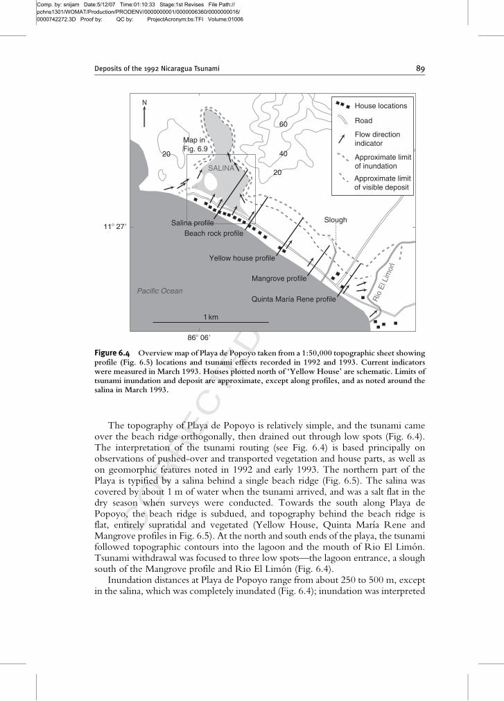
3. Tsunami Deposits Near Playa de Popoyo
Playa de Popoyo (Fig. 6.4) is a 2-km-long, straight beach, at about 11�270latitude, which provides an excellent case history of the effects and deposits of atsunami. Overtopping the beach ridge, the 1992 tsunami reached heights of about5 m, and at the inland limit its elevation was typically 2–3 m above our datum (top ofbeachrock on beach; Fig. 6.3). Sixteen people lost their lives at this site and mostsurvivors have not returned to live on the Playa. All but three houses along Playa dePopoyo were destroyed beyond repair; the tsunami removed most of themcompletely from their foundations. These houses were a major source of large clastsin the tsunami deposit (Fig. 6.5; Table 6.1). The other source of large clasts wasbeachrock, some of which crops out along the beach, except in the far north.
88 Bretwood Higman and Joanne Bourgeois
Comp. by: snijam Date:5/12/07 Time:01:10:33 Stage:1st Revises File Path://pchns1301/WOMAT/Production/PRODENV/0000000001/0000006360/0000000016/0000742272.3D Proof by: QC by: ProjectAcronym:bs:TFI Volume:01006
CORRECTEDPROOF
The topography of Playa de Popoyo is relatively simple, and the tsunami cameover the beach ridge orthogonally, then drained out through low spots (Fig. 6.4).The interpretation of the tsunami routing (see Fig. 6.4) is based principally onobservations of pushed-over and transported vegetation and house parts, as well ason geomorphic features noted in 1992 and early 1993. The northern part of thePlaya is typified by a salina behind a single beach ridge (Fig. 6.5). The salina wascovered by about 1 m of water when the tsunami arrived, and was a salt flat in thedry season when surveys were conducted. Towards the south along Playa dePopoyo, the beach ridge is subdued, and topography behind the beach ridge isflat, entirely supratidal and vegetated (Yellow House, Quinta Marıa Rene andMangrove profiles in Fig. 6.5). At the north and south ends of the playa, the tsunamifollowed topographic contours into the lagoon and the mouth of Rio El Limon.Tsunami withdrawal was focused to three low spots—the lagoon entrance, a sloughsouth of the Mangrove profile and Rio El Limon (Fig. 6.4).
Inundation distances at Playa de Popoyo range from about 250 to 500 m, exceptin the salina, which was completely inundated (Fig. 6.4); inundation was interpreted
86� 06�
11� 27�
20
4020
60
Salina profile
Yellow house profile
Mangrove profile
Quinta María Rene profile
1 km
Approximate limitof visible deposit
Approximate limitof inundation
Beach rock profile
Pacific Ocean
SALINA
Flow direction indicator
House locations
Road
Map in Fig. 6.9
Rio
El L
imon
Slough
Figure 6.4 Overviewmap of Playa de Popoyo taken from a 1:50,000 topographic sheet showingprofile (Fig. 6.5) locations and tsunami effects recorded in 1992 and 1993. Current indicatorswere measured in March 1993. Houses plotted north of ‘Yellow House’ are schematic. Limits oftsunami inundation and deposit are approximate, except along profiles, and as noted around thesalina in March 1993.
Deposits of the 1992 Nicaragua Tsunami 89

Comp. by: snijam Date:5/12/07 Time:01:10:33 Stage:1st Revises File Path://pchns1301/WOMAT/Production/PRODENV/0000000001/0000006360/0000000016/0000742272.3D Proof by: QC by: ProjectAcronym:bs:TFI Volume:01006
CORRECTEDPROOF
based on dead vegetation and on wrack lines observed in March 1993. Tsunamideposits extended for most of this distance, although they were thin and very finetowards the landward limit (Fig. 6.5). The extent of inundation and tsunami depositsincreases towards the north. In general, vegetation is denser in the southern part ofPlaya de Popoyo. By 1995, shrubby vegetation along the entire shoreline hadincreased in density, and even more so by 2003.
Along the profiles that were measured in 1993 (Fig. 6.5), the tsunami depositbecomes finer and thinner landward, and fines upward. In seaward proximal deposits(the term ‘proximal’ is used here to indicate a position relatively close to the ocean,whereas ‘distal’ is used here to indicate a more landward position), a coarse surfacelayer was present in several localities and interpreted as a withdrawal scour lag;outside the salina, some wind deflation was observed in 1993. Proximal deposits onthe beach ridge are typically 5- to 10-cm thick and composed of very coarse sandwith pebbles and shell debris. The body of the deposit, over most of the profiles,comprises 1–5 cm of coarse to fine sand, fining landward (Fig. 6.6). Some deposits
Mangrove
Bricks and cement from houses Beach rocks Floating debris
Tsunami transported material
Distance inland (m)
Yellow house
Salina
Quinta Maríia Rene0 200100 300 400
5
0
5
0
5
0
5
0
100
100
100
100
Sand sheetthickness (cm)
Height abovedatum (m)
Verticalexaggeration � 100
Verticalexaggeration � 10
Figure 6.5 Profiles (mapped in Fig. 6.4) measured and described in March 1993 (excluding‘Beachrock’). See Appendix A for notes on protocol. Tsunami-sand thickness is generalised frompoint observations (small excavations at 10–20 points per profile). Positions of large clasts aregeneralised; see Table 6.1 for some more specific large-clast data.
90 Bretwood Higman and Joanne Bourgeois

Comp. by: snijam Date:5/12/07 Time:01:10:34 Stage:1st Revises File Path://pchns1301/WOMAT/Production/PRODENV/0000000001/0000006360/0000000016/0000742272.3D Proof by: QC by: ProjectAcronym:bs:TFI Volume:01006
CORRECTEDPROOF
Table 6.1 Large clasts surveyed (March 1993) and other basic observations
Material
Distance from
sourcea (m) Dimensions (cm) Notes
Profile 1 (south of Quinta Marıa Rene)
Beachrock 5 230 � 160 � 45 Minimum vertical 1.5 m
Beachrock 65 36 � 15 � 5 Begin field of house
blocks
Beachrock 75 35 � 20 � 5 Last large beachrock
Wall 50 54 � 23 � 18
Wall 50 90 � 54 � 18
Wall 70 112 � 78 � 25
Wall 100 47 � 44 � 11 Last large clast
Field of blocks 25–120 Many 10–20 cm
diameter
Limit of sand �200
Water limit �300
Profile 3 (Mangrove)
Beachrock 20 100 � 75 � 16 First large block
Beachrock 30 124 � 117 � 24
Beachrock 35 120 � 74 � 23 Tilted on tree
Beachrock 50 100 � 72 � 13
Beachrock 60 70 � 50 � 25 Against fence
Beachrock 85 120 � 75 � 15 Clast is very scalloped
Beachrock 90 Last rocks about here
Limit of sand �200
Last debris �250 Floating debris (woody)
Profile 4 (yellow house)
Beachrock
and walls
Not measured Against tree
Wall 40 80 � 65 � 14
Wall 50 120 � 112 � 14
Tuff block 50 43 � 34 � 16
Beachrock 110 75 � 65 � 20
Wall 75 143 � 67 � 14
Beachrock 140 89 � 84 � 17
Field of bricks 100–200 Many clasts of 1–4
bricks
Wall 160 87 � 71 � 14 Large wall blocks near
here
Wall 170 85 � 76 � 14
Wall 200 85 � 58 � 14
Last wall pieces 220 Not measured
Last bricks 240 Not measured
Limit of sand �300
Last debris �300 Less dense than bricks
(roofing, wood,...)
aThe source is generally either the zone of beachrock or a house foundation.In the case of beachrock, the distance is a minimum.
Deposits of the 1992 Nicaragua Tsunami 91

Comp. by: snijam Date:5/12/07 Time:01:10:35 Stage:1st Revises File Path://pchns1301/WOMAT/Production/PRODENV/0000000001/0000006360/0000000016/0000742272.3D Proof by: QC by: ProjectAcronym:bs:TFI Volume:01006
CORRECTEDPROOF
in the salina exhibit flat to low-angle heavy mineral lamination (Fig. 6.7). Thelandward tail of the deposit is less than 1 cm of fine to very fine sand and silt. In mostcases, large clasts are present for over half of the inundation distance (Figs. 6.5 and6.8; Table 6.1).
Distance inland (m)0 100 200 300 400
Meangrainsize
m.s.f.s.
v.f.s.
Hei
ght (
m)
Hei
ght (
m)
Hei
ght (
m)
Hei
ght (
m)
Salina
5
00
Mangrove
5
0
5
0
Yellow house
Quinta María Rene
5
0
v.f.s m.s v.c.s v.f.s m.s v.c.s
v.f.s m.s v.c.sv.f.s m.s v.c.sv.f.s m.s v.c.sv.f.s m.s v.c.sv.f.s m.s v.c.s
v.f.s m.s v.c.s
v.f.s m.s v.c.sv.f.s m.s v.c.s
v.f.s m.s v.c.sv.f.s m.s v.c.s
v.f.s m.s v.c.s
v.f.s m.s v.c.sv.f.s m.s v.c.s
v.f.s m.s v.c.s
v.f.s m.s v.c.s
v.f.s m.s v.c.s
v.f.s m.s v.c.s
v.f.s m.s v.c.s
v.f.s m.s v.c.s
v.f.s m.s v.c.s
v.f.s m.s v.c.s
v.f.s m.s v.c.s
v.f.s m.s v.c.s
v.f.s m.s v.c.s v.f.s m.s v.c.s v.f.s m.s v.c.s v.f.s m.s v.c.s v.f.s m.s v.c.sv.f.s m.s v.c.s
Distance inland (m)
0 100 200 300 400
Distance inland (m)0 100 200 300 400
Meangrainsize
m.s.
f.s.
v.f.s.
Distance inland (m)0 100 200 300 400
Meangrainsize
m.s.f.s.
v.f.s.
Distance inland (m)0 100 200 300 400
Meangrainsize
m.s.f.s.
v.f.s.
Limit oflarge blocks
Limit oflarge blocks
Limit oflarge blocks
Limit oflarge blocks
Figure 6.6 Grain-size distributions of 1992 Nicaragua tsunami deposits sampled in 1993 alongfour measured profiles at Playa de Popoyo (Fig. 6.5). The mean grain size is plotted versusdistance above each profile. On the mean-grain-size plot, the analytical error is less than the sizeof the dot. See Appendix A for comments on sampling.
92 Bretwood Higman and Joanne Bourgeois
Comp. by: snijam Date:5/12/07 Time:01:10:35 Stage:1st Revises File Path://pchns1301/WOMAT/Production/PRODENV/0000000001/0000006360/0000000016/0000742272.3D Proof by: QC by: ProjectAcronym:bs:TFI Volume:01006
CORRECTEDPROOF
4. Grading of the Tsunami Deposits
The grading in the tsunami deposits is a reflection of the transport anddeposition by the tsunami. Differences in vertical grading between proximal anddistal portions of the deposit may help constrain how the tsunami is recorded byits deposit. We structured our interpretation of grading in the 1992 Nicaraguatsunami deposit around several questions:
–How do vertical and horizontal grading trends relate?–At what point(s) in the cycle of erosion, transport and deposition does sortingoccur?
868 069
11� 27�
Mud and sand
Sand
10 cm
Salina surface
Tsunami flow direction
Seaward Landward
Tire tracksGastropod shell
Beach rocks
No vertical exaggeration
Mud
Sand
Mud and sand
Magnetite lamina atbase of sand sheet
Salina surface
Gastropod shellRip up Magnetite laminae10 cm
Vertical exaggeration � 910
cm
1 m
SALINA
Pacific Ocean
Salina profile
Area of scattered blocks-solid line indicatesmapped edge
100 m
NUPLAND
BEACH RIDGE
Rip up clastsMagnetite laminae
1 m
Beach rock
Beach rock
Mud
Strike of cross section-dot shows location
Location for vertical grading data (see text)
Contactobscure
Contactobscure
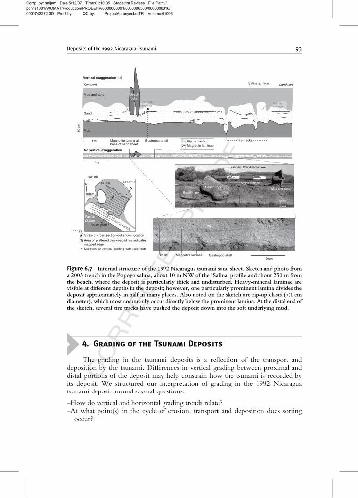
Figure 6.7 Internal structure of the 1992 Nicaragua tsunami sand sheet. Sketch and photo froma 2003 trench in the Popoyo salina, about 10 m NW of the ‘Salina’ profile and about 250 m fromthe beach, where the deposit is particularly thick and undisturbed. Heavy-mineral laminae arevisible at different depths in the deposit; however, one particularly prominent lamina divides thedeposit approximately in half in many places. Also noted on the sketch are rip-up clasts (<1 cmdiameter), which most commonly occur directly below the prominent lamina. At the distal end ofthe sketch, several tire tracks have pushed the deposit down into the soft underlying mud.
Deposits of the 1992 Nicaragua Tsunami 93
Comp. by: snijam Date:5/12/07 Time:01:10:36 Stage:1st Revises File Path://pchns1301/WOMAT/Production/PRODENV/0000000001/0000006360/0000000016/0000742272.3D Proof by: QC by: ProjectAcronym:bs:TFI Volume:01006
CORRECTEDPROOF
–Are laterally similar layers, appearing to be correlative, deposited at the same timefrom a flow, or progressively in time (as in progradation)?
–How are different flow features, such as breaking fronts or surges, recorded in thedeposit?
Grading within tsunami deposits is commonly described in three ways: proximalto distal, bottom to top and along the shore. Only proximal-to-distal gradingand bottom-to-top grading are treated in this analysis of the Nicaragua tsunamideposit.
The 1992 Nicaragua tsunami near Playa de Popoyo transported everything frommud to boulders, so the deposit contains any sediment that was available fortransport. A textural description of such a deposit primarily reflects the sedimentsource rather than the tsunami itself. Therefore, a description of change within adeposit, such as grading, is more likely than the overall grain-size distribution toreflect the processes of erosion, transport and deposition.
The data presented here are grain sizes inferred from terminal-settling-velocitydistributions generated using a settling column. We prefer these data over directlymeasured grain-size data for this study because grains with similar settling velocitybut different grain size are likely to behave more similarly than grains with similarsize but different settling velocity.
4.1. Landward grading
At Popoyo, settling-velocity distributions generally fine landward (Fig. 6.6),although grading is reversed between some sample pairs. Change in mean grainsize is typically around 0.5 f per 100 m, although it is much less on the Quinta MarıaRene profile.
Large-clast grading at Playa de Popoyo is more complex. For example, at theYellow House profile, a lozenge-shaped field of bricks was strewn in a wake-likepattern between 100 and 160 m from the source house (Fig. 6.5). The density ofclast distribution was lower both seaward and landward of this field of bricks. Alsoalong the Salina, Yellow House and Quinta Marıa Rene profiles, the number oflarge clasts decreases abruptly near the limit of their extent. Along the Salina profile,at about 300 m inland, this abrupt termination in the blocks is coincident with atransition in the sand-size settling-velocity distributions (Figs. 6.6 and 6.8).
Along the Salina profile, we counted the number of two different size classes oflarge clasts (Fig. 6.8). Most of these clasts are house fragments, and they appearedto be all of similar density. Overall the ratio between the large (>20 cm) andmedium (<20 cm) classes has no clear trend. If these clasts were graded to finelandward, this ratio would decrease landward. We also mapped two distinctivegroups of bricks, patterned cinderblocks and yellow bricks, coming from onehouse (Fig. 6.9). The cinderblocks had a higher source within the house wallsthan did the yellow bricks. We found that the cinderblocks were less scattereddown flow.
Both of these observations support the idea that the large clasts were distributedthroughout the tsunami rather than concentrated at or near the base. The lack of
94 Bretwood Higman and Joanne Bourgeois

Comp. by: snijam Date:5/12/07 Time:01:10:36 Stage:1st Revises File Path://pchns1301/WOMAT/Production/PRODENV/0000000001/0000006360/0000000016/0000742272.3D Proof by: QC by: ProjectAcronym:bs:TFI Volume:01006
CORRECTEDPROOF
grading in the large clasts (Fig. 6.8C) suggests that their transport in the tsunami wasnot primarily dependent on their size. We think that it is unlikely that the clasts weretransported by sliding or rolling, cases where the size influences the friction with thebed and the degree of coupling to the flow. We interpret the different scattering of
0.1
1.0
100 200 300Distance inland on salina profile (m)
A:B
Tsunamideposit
limit
Ratio of large to medium blocks
A: B
lock
s >
20
cm
0
25
50ALarge blocks
0
40
80
120B
B: B
lock
s <
20
cm
Medium blocks
Salinaedge
C
400
Area of circle isproportional tonumber of blocks
Figure 6.8 Summary of data collected on the distribution of blocks along the Popoyo ‘Salina’profile (Fig. 6.4). Almost all of the blocks along this profile were house fragments, including tuffblocks, reinforced concrete and large sections of intact brick walls. The profile was divided into10-m-long and 15-m-wide rectangles, and all solid blocks larger than a few centimetres withineach section were counted and categorised by median length. Most blocks in the ‘medium’category (<20 cm) were individual bricks, while those in the ‘large’ category (<20 cm) weremultiple bricks connected together, or concrete, or, especially, large bricks. Blocks with veryhigh surface areas, such as tiles and cinderblocks, were not counted. The dots mark the ratiobetween the number of large blocks and the number of medium blocks within each 10-mincrement. Ratios for counts of less than ten blocks are excluded.
Deposits of the 1992 Nicaragua Tsunami 95

Comp. by: snijam Date:5/12/07 Time:01:10:36 Stage:1st Revises File Path://pchns1301/WOMAT/Production/PRODENV/0000000001/0000006360/0000000016/0000742272.3D Proof by: QC by: ProjectAcronym:bs:TFI Volume:01006
CORRECTEDPROOF
the two clast types (Fig. 6.9) to indicate that source height was the characteristic thatdistinguished the two populations in their scattering. If so, this pattern indicates thatthe clasts were distributed throughout the tsunami water column, not concentratedat the base of the flow during their transport. However, these patterns may not berepresentative of cobbles or boulders in natural settings, as the clasts in question were‘entrained’ from standing structures, not from the ground.
4.2. Vertical grading
Vertical grading was measured in tsunami deposits from five trenches where sets ofvertically contiguous samples were collected (Fig. 6.10). Normal grading dominatedin each case, but a small section with inverse grading was present at the base of all butthe proximal Playa de Popoyo deposit. Generally, grading was weaker and sortingbetter (grain-size distributions narrower) at the top of each deposit. These similaritiesin grading pattern occur in spite of differences in the overall distribution of sand sizeamong the locations sampled.
SALINA
Yellow brick
Patterned cinderblock
Source for mapped blocks
Area of scattered blocks
Pacific Ocean
Salina profile
100 m
UPLAND
Blocks moved by the 1992 tsunami
SLOUGH
BEACH RIDGE
86� 06�
11� 27�
SALINA
OUTLET
GPS map
Edge ofwoody vegitation
High tide wrackline
N
Figure 6.9 GPS map (2003) showing distribution of tsunami-transported blocks on the Popoyosalina, approximately along the ‘Salina’ profile (Fig. 6.6). Two different distinctive brick typesfrom a single house are plotted. The patterned cinderblocks appeared to have come from high onthe wall around the bathroom, while the yellow bricks formed complete walls of the house. Solidboundaries are GPS mapped, including the landward limit of scattered blocks, which is abrupt.
96 Bretwood Higman and Joanne Bourgeois

Comp. by: snijam Date:5/12/07 Time:01:10:36 Stage:1st Revises File Path://pchns1301/WOMAT/Production/PRODENV/0000000001/0000006360/0000000016/0000742272.3D Proof by: QC by: ProjectAcronym:bs:TFI Volume:01006
CORRECTEDPROOF
4.2.1. Playa de PopoyoIn the salina at Playa de Popoyo, sets of vertically contiguous samples were taken fromtrenches at two locations at distances of about 200–250 m from the beach. Thesetrenches were along a linewhere the deposit was consistently over three times as thick
V. coarsesand
Coarsesand
Mediumsand
Finesand
V. finesand
v.f.s m.s v.c.s
Overlain distributions
Mean grain size
Individual samples0
10
Dep
th (
cm)
Normalgrading
V. coarsesand
Coarsesand
Mediumsand
Finesand
V. finesand
v.c.sm.sv.f.s
Overlain distributions
Mean grainsize
Individual samples0
10
Dep
th (
cm)
Normalgrading
v.f.s m.s v.c.s
v.f.s m.s v.c.s
v.f.s m.s v.c.s
v.f.s m.s v.c.s
Individual samples (bottom)
Individual samples (middle)
Individual samples (top)
Individual samples
V. coarsesand
Coarsesand
Mediumsand
Finesand
V. finesand
Overlain distributions
Mean grain size
0
10
Dep
th (
cm)
20
Normalgrading
V. coarsesand
Coarsesand
Mediumsand
Finesand
V. finesand
Overlaindistributions
Mean grain size
0
10
Dep
th (
cm)
Normalgrading
Post tsunami mud and disturbed sand (unsampled)
Post tsunami mud and disturbed sand (unsampled)
Punta Teonoste
.
1 km
LasLajas
Pacific Ocean
LasSalinas
Salinas
Playa de Popoyo
11�
27�
11�
30� Localities for vertical grading samples
Map figure 486� 05�86� 10�
Punta Teonoste
Playa de Popoyo (proximal)
Playa de Popoyo (distal)
Las Salinas (proximal)
Las Salinas (distal)
Grain size
Grain size
Grain size
Grain size
Grain size
N
v.f.s m.s v.c.s
Individual samples
V. coarsesand
Coarsesand
Mediumsand
Finesand
V. finesand
Overlain distributions
Mean grain size
0
10
Dep
th (
cm)
Normalgrading
Figure 6.10 Grain-size distributions for five vertically distributed sample sets collected in 2003.For each trench, the mean grain size is plotted versus depth; all the distributions are overlain tomake a composite distribution, and each distribution is plotted separately to the right. For the meangrain size versus depth plot, the height of rectangular marks indicates the depth range that wassampled, while the width is one standard deviation of at least three separate analyses of the samesample (an estimate of standard error). The only exception to this is ‘Las Salinas’ (distal), wheresamples were run only once, in which case a mark that is an estimate of standard error is plotted.
Deposits of the 1992 Nicaragua Tsunami 97

Comp. by: snijam Date:5/12/07 Time:01:10:37 Stage:1st Revises File Path://pchns1301/WOMAT/Production/PRODENV/0000000001/0000006360/0000000016/0000742272.3D Proof by: QC by: ProjectAcronym:bs:TFI Volume:01006
CORRECTEDPROOF
as the usual 3 cm observed in most of the salina. We used detailed measurementsof the samples to correlate grain-size distributions between the proximal and distaltrenches (Fig. 6.11). The distributions are very similar between the upper partof the proximal deposit and two different portions of the base of the distaldeposit We favour the upper of these grain-size correlations because it is additionallyassociated with an abrupt jump in mean grain size and a layer of rip-ups inboth deposits.
The similarity in grain size, grading and relative rip-up concentration between thetwo points is probably a reflection of the sorting process rather than a marker forsimultaneous deposition. At any given moment, the water passing over these locationsis different and is carrying sediment eroded either from different places or at differenttimes. Also, the flow conditions are unlikely to be homogeneous at any given time, astsunami flows are always changing, and it takes time for changes to propagate throughspace. However, the similarity in the material deposited (grain-size distribution andrip-ups) and the similarity in the grading of the deposit (abrupt fining overlain by subtlegrading) suggests that the processmost responsible for the vertical variation in grain-sizedistribution was similar between the two locations. The sorting may occur duringeither erosion or deposition (or both).
v.f.s m.s v.c.sc.s.f.s.
v.f.s m.s v.c.s
v.f.s m.s v.c.s
v.f.s m.s v.c.s
Post-tsunami mudand disturbed sand
(unsampled)
Post-tsunami mudand disturbed sand
(unsampled)
Rip-ups of salina clay
Rip-ups of salina clayand organic flakes
Surface
Surface
Underlying salina clay Underlying salina clay
Dense-mineral lamina
Dense-mineral lamina
Proximal Distal(9 m seaward
of sketch in Fig. 6.7)
~50 metres
Rip-ups of salina clay
Preferred correlation(grain size, rip-ups,and grain size jump)
Possible correlations(grain size only)
A
B
C
Distributions A, B, and Coverlain
0.5 phi
5cm Scale
Figure 6.11 Stratigraphy and interpretation of two trenches in the salina at Playa de Popoyo (seelocation in Fig. 6.7). The grain-size data for these trenches is reported in Fig. 6.10. These trencheswere about 100 m north of the Salina profile and were about 200 (proximal) and 250 (distal) mfrom the ocean. For the stratigraphic sections, the width of the section is related to the mean grainsize of samples collected at different depths (see Appendix A on vertical sampling).Wider parts ofthe stratigraphic section have coarser sediment. The tops of both of these trenches were notsampled. A correlation is noted where the top of the proximal deposit is similar in structure andcomposition to the base of the distal deposit.
98 Bretwood Higman and Joanne Bourgeois

Comp. by: snijam Date:5/12/07 Time:01:10:37 Stage:1st Revises File Path://pchns1301/WOMAT/Production/PRODENV/0000000001/0000006360/0000000016/0000742272.3D Proof by: QC by: ProjectAcronym:bs:TFI Volume:01006
CORRECTEDPROOF
In the case of erosional sorting, the sorting reflects a biased removal of sediment fromthe source. The similar sections in the two deposits reflect sediment deposited fromthe same water at different times. They are similar because little sorting occurredduring transport and deposition, so the sorting processes involved in erosion set thedistribution that a given section of the flow laid down as it propagated inland.
In the case of depositional sorting, the sorting reflects a biased addition of sand to thedeposit. The similar sections in the two deposits reflect sediment eroded from ahomogenised source and then sorted during deposition. When the same processacted to the same extent on the same source sediment, the sediment deposited wouldbe the same.
Our data are insufficient to distinguish these two cases. However, each casemakes different predictions about how different parts of the tsunami flow wouldbe recorded in the deposit. If most sorting occurred during erosion, then it wasthe conditions at the sediment source that controlled grading, except that it was theconditions at the point of deposition that controlled whether deposition occurred.If, instead, most sorting occurred during deposition, then the source only set theoverall distribution of sediment in the deposit, and it was conditions near the pointof deposition that were recorded.
4.2.2. Las SalinasJust north of Playa de Popoyo, in a salina near Las Salinas, wemeasured vertical gradingin two trenches, about 35 m apart, perpendicular to the beach (Fig. 6.10). Correlationsof grain-size distributions, drawn and interpreted in a similar way as in the Playa dePopoyo salina, show little lateral change in the deposit, except for fining of the base ofthe deposit and also of patches of sediment in local depressions (Fig. 6.12).
In this salina, there were burrows and other depressions that were filled with sandbefore the main deposit formed (Fig. 6.12). Sediment in the depressions is coarserthan the main sand sheet. The depressions varied in geometry, but some burrowswere deep enough and it is likely that any grain that reached there was depositedpermanently. Thus burrowed deposits should be a record of the first water inthe flow. Eyewitnesses described the tsunami approaching as a breaking bore, sothe front of the wave probably had greater basal shear stress and turbulence than thewater immediately behind it. High shear and strong mixing is ideal for the entrain-ment and transport of coarse sediment such as what is plugging the depressions alongan otherwise erosive bed.
5. Discussion
Grading in the deposit is similar at all locations studied along the coast,suggesting that this grading reflects sorting processes in the tsunami rather than inthe sediment source. There are variations in sediment source, as reflected in variablegrain-size distributions along the coast. It is unlikely that every location would show
Deposits of the 1992 Nicaragua Tsunami 99

Comp. by: snijam Date:5/12/07 Time:01:10:37 Stage:1st Revises File Path://pchns1301/WOMAT/Production/PRODENV/0000000001/0000006360/0000000016/0000742272.3D Proof by: QC by: ProjectAcronym:bs:TFI Volume:01006
CORRECTEDPROOF
dominantly normal grading that became less strong towards the top if this gradingwere a result of local source conditions.
Discrete, coarse-sediment-filled pockets below a tsunami sand sheet, such as theburrow fillings in this case, may provide distinct records of steep bore-fronted flowssuch as tsunamis and turbidity currents. Storms rarely approach as a breaking bore, sodepressions pluggedwith coarse sedimentmight provide a criterion for distinguishingstorm and tsunami deposits.
The tsunami deposit reflects the tsunami flow on various spatial scales, from tensof metres to kilometres or more. The wave in this area—and probably across muchof Nicaragua—was simple. There was only a single large wave, and at the sitesstudied beach ridges limited the strength of withdrawal. Deposit grading is thereforesimple and consistent from place to place. Some features, such as subtle grading at thetop of the deposit, are consistent all along this section of coast. Other features, such asthe abrupt jump to finer grain size overlain by rip-ups in the Playa de Popoyo salina,are consistent between closely spaced trenches, but do not extend between loca-tions. There are also differences between trenches that are close together. Thesevariations reflect spatial variation in the temporal flow structure of the tsunami and
v.f.s m.s v.c.s
v.f.s m.s v.c.s
v.f.s m.s v.c.s
v.f.s m.s v.c.s
v.f.s m.s v.c.sc.s.f.s.
Surface
Underlying salina mud
Surface
Underlying salina mud
v.f.s m.s v.c.s v.f.s m.s v.c.s
Depression fillDepression fill
Proximal Distal~35 metres
v.f.s m.s v.c.sc.s.f.s.Grain size correlations
0.5 phi
5cm Scale
A
C
B
D
Distributions A and Boverlain
Distributions C and Doverlain
Figure 6.12 Stratigraphy and interpretation of two sections in a salina near Las Salinas (seelocation on insert of Fig. 6.10). both these sections are part of a 50-m-long trench across a portionof a thicker and less disturbed deposit about 200 m from the ocean. No profile was measuredhere; however, it was generally similar to other measured profiles with a beach ridge separatingthe salina from the ocean (e.g. the Popoyo ‘Salina’ profile; Fig. 6.5). Along this long trench, 10depressions and burrows filled with particularly coarse sediment were sampled, and the grain-sizedata for depressions nearest the two sections are reported here. Grain-size correlations betweenthe two sections show little change in the upper two-third of the deposit, but a marked lateralfining of the basal sections and depression fills.
100 Bretwood Higman and Joanne Bourgeois

Comp. by: snijam Date:5/12/07 Time:01:10:37 Stage:1st Revises File Path://pchns1301/WOMAT/Production/PRODENV/0000000001/0000006360/0000000016/0000742272.3D Proof by: QC by: ProjectAcronym:bs:TFI Volume:01006
CORRECTEDPROOF
show that deposits have the fidelity to record both large-scale tsunami structureand local variation.
ACKNOWLEDGEMENTS
We would like to thank Andrew Mattox, Jose Borrero, Costas Synolokis, Harry Yeh, BecquerFernandez and Gordie Harkins for their participation in the post-tsunami surveys, and David Trippettfor assistance with laboratory analysis of samples. Brian Atwater provided critique that led to substantialimprovement in our figures.
Appendix A. Field and Laboratory Protocols
A.1. Sea Level Data
Most of the tsunami elevation data were collected in late September 1992 andcorrected (with tide tables) from tide level on the day of measurement to tide level atthe time of the tsunami, just after high tide on 1 September 1992. In most cases, a handlevel and stadia rod were used, and distances estimated, mapped or measured by GPS.
In March 1993, five profiles were measured across the Playa de Popoyo (Figs. 6.4and 6.5), using a tripod, transit level and stadia rod. On the profiles, the water level atthe time of the 1992 tsunami is estimated and used as datum (¼0). This estimate isbased on local observation of high tide over several days, which typically came to alevel just below the upper beachrock step. This level also corresponds to the limit ofgrassy vegetation in the salina. The tsunami elevation data collected in September1992 are plotted onto the profiles, but only some were remeasured, so theseelevation data may have an error on the order of decimetres.
A.2. Proximal to Distal Sampling
In March 1993, four of the profiles were sampled for tsunami deposits (Fig. 6.8),associated with survey points along the profiles. Because it was dry season, thetsunami deposits were loose, and some wind deflation had taken—and was stilltaking—place. Some of the finer sediments were blown away during sampling.Bourgeois tried to take a representative sample of the entire deposit, top to bottom.The best samples were from the Salina profile because they were damp and cappedby mud, except the most distal cases, which were exposed and dry. During the 2003return trip to Nicaragua, Higman outlined 10-m-long and 15-m-wide rectanglesalong the Salina profile, and counted the number of bricks in each of the twocategories, one with a median diameter between 10 and 20 cm, the other with amedian diameter of over 20 cm.
Deposits of the 1992 Nicaragua Tsunami 101

Comp. by: snijam Date:5/12/07 Time:01:10:37 Stage:1st Revises File Path://pchns1301/WOMAT/Production/PRODENV/0000000001/0000006360/0000000016/0000742272.3D Proof by: QC by: ProjectAcronym:bs:TFI Volume:01006
CORRECTEDPROOF
A.3. Vertical Sampling
No vertical sampling was done during the 1993 or 1995 visits. In 2003, none of thelocations where profiles had been measured in 1993 proved suitable for collectingvertical grading samples. However, in three other locations, one close to the Salinaprofile, Higman collected vertically distributed samples. To sample for verticalgrading, we cleaned the upper surface of the deposit and cut a small tablet of sandout with a knife. When this sample was completely removed, leaving a flat surfacebelow, another tablet was cut out as the next sample. This technique yielded samplesthat were contiguous and minimally mixed with adjacent samples. The top of thesalina deposit, where it is mixed with overlying mud, was not sampled.
A.4. Analysis
For analysis, these samples were split to less than 0.7-g submerged weight and runthrough a 189-cm settling column. Cumulative submerged weight versus time datafrom the settling column were used to estimate equivalent grain size of silica spheres.The plotted distributions have arbitrary proportion units with constant area.
REFERENCES
Abe, K., Tsuji, Y., Imamura, F., Katao, H., Yoshihisa, I., Satake, K., Bourgeois, J., Noguera, E., andEstrada, F. (1993). Field survey of the Nicaragua earthquake and tsunami of September 2, 1992.Bull. Earthquake Res. Inst., Tokyo Daigaku Jishin Kenkyusho Iho 68, 23–70.
Baptista, A. M., Priest, G. R., and Murty, T. S. (1993). Field survey of the 1992 Nicaragua tsunami.Marine Geodesy 16, 169–203.
Bourgeois, J., and Reinhart, M. A. (1993). Tsunami deposits from 1992 Nicaragua event: Implicationsfor interpretation of paleo-tsunami deposits, Cascadia subduction zone. EOS 74(43 Suppl.), 350.
Geist, E. L. (1999). Local tsunamis and earthquake source parameters. In ‘‘Tsunamigenic Earthquakesand Their Consequences’’ (R. Dmowska and B. Saltzman, eds.), 39, pp. 117–209. Advances inGeophysics.
Herzfeld, U. C., Von Huene, R., Kappler, W., and Mayer, H. (1997). Characterization of high-resolution geomorphological processes; slumps on the slope of the Middle America Trench.In ‘‘Proceedings of IAMG ‘97, the Third Annual Conference of the International Association forMathematical Geology (IAMG)’’ (V. Pawlowsky-Glahn, ed.), pp. 585–590.
Ide, S., Imamura, F., Yoshida, Y., and Abe, K. (1993). Source characteristics of the Nicaraguan tsunamiearthquake of September 2, 1992. Geophys. Res. Lett. 20, 863–866.
Imamura, F., Shuto, N., Ide, S., Yoshida, Y., and Abe, K. (1993). Estimate of the tsunami source of the1992 Nicaraguan earthquake from tsunami data. Geophys. Res. Lett. 20, 1515–1518.
Kanamori, H. (1972). Mechanism of tsunami earthquakes. Phys. Earth Planet. Inter. 6, 246–259.Kanamori, H., and Kikuchi, M. (1993). The 1992 Nicaragua earthquake: A slow tsunami earthquake
associated with subducted sediments. Nature 361, 714–716.Okal, E. A., and Newman, A. V. (2001). Tsunami earthquakes: The quest for a regional signal. Phys.
Earth Planet. Inter. 124, 45–70.Piatanesi, A., Tinti, S., and Gavagni, I. (1996). The slip distribution of the 1992 Nicaragua earthquake
from tsunami run-up data. Geophys. Res. Lett. 23, 37–40.Satake, K. (1994). Mechanism of the 1992 Nicaragua tsunami earthquake. Geophys. Res. Lett. 21,
2519–2522.
102 Bretwood Higman and Joanne Bourgeois

Comp. by: snijam Date:5/12/07 Time:01:10:37 Stage:1st Revises File Path://pchns1301/WOMAT/Production/PRODENV/0000000001/0000006360/0000000016/0000742272.3D Proof by: QC by: ProjectAcronym:bs:TFI Volume:01006
CORRECTEDPROOF
Satake, K. (1995). Linear and nonlinear computations of the 1992 Nicaragua earthquake tsunami.In ‘‘Tsunamis; 1992–1994, Their Generation, Dynamics, and Hazard. Pure and Applied Geophysics’’(K. Satake and F. Imamura, eds.), pp. 144, 455–470.
Satake, K., Bourgeois, J., Abe, K., Tsuji, Y., Imamura, F., Iio, Y., Katao, H., Noguera, E., andEstrada, F. (1993). Tsunami field survey of the 1992 Nicaragua earthquake. EOS 74, 145, 156–157.
Tanioka, Y., and Satake, K. (1996). Tsunami generation by horizontal displacement of ocean bottom.Geophys. Res. Lett. 23, 861–864.
Titov, V. V., and Synolakis, C. E. (1994). A numerical study of wave runup of the September 2, 1992Nicaraguan tsunami: Proc. IUGG/IOC International Tsunami Symposium, pp. 627–635.
Deposits of the 1992 Nicaragua Tsunami 103