department of the interior april 7, 2005 part iv department of the interior fish and wildlife...
TRANSCRIPT
Thursday,
April 7, 2005
Part IV
Department of the InteriorFish and Wildlife Service
50 CFR Part 17Endangered and Threatened Wildlife and Plants; Establishment of an Additional Manatee Protection Area in Lee County, Florida; Final Rule
VerDate jul<14>2003 15:30 Apr 06, 2005 Jkt 205001 PO 00000 Frm 00001 Fmt 4717 Sfmt 4717 E:\FR\FM\07APR3.SGM 07APR3

17864 Federal Register / Vol. 70, No. 66 / Thursday, April 7, 2005 / Rules and Regulations
DEPARTMENT OF THE INTERIOR
Fish and Wildlife Service
50 CFR Part 17
RIN 1018–AT65
Endangered and Threatened Wildlife and Plants; Establishment of an Additional Manatee Protection Area in Lee County, FL
AGENCY: Fish and Wildlife Service, Interior.ACTION: Final rule.
SUMMARY: We, the Fish and Wildlife Service (Service), establish an additional manatee protection area in Lee County, Florida (Pine Island-Estero Bay Manatee Refuge). This action is authorized under the Endangered Species Act of 1973, as amended (ESA) and the Marine Mammal Protection Act of 1972, as amended (MMPA), to further recovery of the Florida manatee (Trichechus manatus latirostris) by preventing the taking of one or more manatees. We are designating an area in Lee County as a manatee refuge in which certain waterborne activities will be regulated. Specifically, watercraft will be required to proceed at either ‘‘slow speed’’ or at not more than 25 miles per hour, on an annual or seasonal basis, as described in the rule. We also announce the availability of a final environmental assessment for this action.
DATES: Effective date: April 4, 2005ADDRESSES: The complete file for this rule is available for inspection, by appointment, during normal business hours from 8 a.m. to 4:30 p.m. at the South Florida Field Office, U.S. Fish and Wildlife Service, 1339 20th Street, Vero Beach, Florida 32960.FOR FURTHER INFORMATION CONTACT: Jay Slack or Kalani Cairns (see ADDRESSES section), telephone 772/562–3909; or visit our Web site at http://verobeach.fws.gov.
SUPPLEMENTARY INFORMATION:
Background The West Indian manatee (Trichecus
manatus) is federally listed as an endangered species under the ESA (16 U.S.C. 1531 et seq.) (32 FR 4001) and the population is further protected as a depleted stock under the MMPA (16 U.S.C. 1361–1407). Manatees reside in freshwater, brackish, and marine habitats in coastal and inland waterways of the southeastern United States. The majority of the population can be found in waters of the State of Florida throughout the year, and nearly
all manatees live around peninsular Florida during the winter months. The manatee is a cold-intolerant species and requires warm water temperatures generally above 20° Celsius (68° Fahrenheit) to survive during periods of cold weather. During the winter months, most manatees rely on warm water from natural springs and industrial discharges for warmth. In warmer months, they expand their range and are seen rarely as far north as Rhode Island on the Atlantic Coast and as far west as Texas on the Gulf Coast.
Recent information indicates that the overall manatee population has grown since the species was listed (Service 2001). However, in order for us to determine that an endangered species has recovered to a point that it warrants removal from the List of Endangered and Threatened Wildlife and Plants, the species must have improved in status to the point at which listing is no longer appropriate under the criteria set out in section 4(a)(1) of the ESA.
Human activities, particularly waterborne activities, can result in the take of manatees. Take, as defined by the ESA, means to harass, harm, pursue, hunt, shoot, wound, kill, trap, capture, collect, or to attempt to engage in any such conduct. Harm means an act which kills or injures wildlife (50 CFR 17.3). Such an act may include significant habitat modification or degradation that kills or injures wildlife by significantly impairing essential behavioral patterns, including breeding, feeding, or sheltering. Harass includes intentional or negligent acts or omissions that create the likelihood of injury to wildlife by annoying it to such an extent as to significantly disrupt normal behavioral patterns, which include, but are not limited to, breeding, feeding, or sheltering (50 CFR 17.3).
The MMPA establishes a moratorium, with certain exceptions, on the taking and importation of marine mammals and marine mammal products and makes it unlawful for any person to take, possess, transport, purchase, sell, export, or offer to purchase, sell, or export, any marine mammal or marine mammal product unless authorized. Take, as defined by section 3(13) of the MMPA, means to harass, hunt, capture, or kill, or attempt to harass, hunt, capture, or kill any marine mammal. Harassment is defined by section 3(18) of the MMPA as any act of pursuit, torment, or annoyance which—(i) has the potential to injure a marine mammal or marine mammal stock in the wild; or (ii) has the potential to disturb a marine mammal or marine mammal stock in the wild by causing disruption of behavioral patterns, including, but not limited to,
migration, breathing, nursing, breeding, feeding, or sheltering.
Human use of the waters of the southeastern United States has increased as a function of residential growth and increased visitation. This increase is particularly evident in the State of Florida. The population of Florida has grown by 135 percent from 1970 to 2000 (6.8 million to 15.9 million, U.S. Census Bureau) and is expected to exceed 18 million by 2010 and 20 million by the year 2020. According to a report by the Florida Office of Economic and Demographic Research (2005), it is expected that, by the year 2010, 14.7 million people will reside in the 35 coastal counties of Florida. In a parallel fashion to residential growth, visitation to Florida has also increased. It is expected that Florida will have 83 million visitors annually by the year 2020, up from 48.7 million visitors in 1998. In concert with this increase of human population growth and visitation is the increase in the number of watercraft that travel Florida waters. In 2003, 743,243 vessels were registered in the State of Florida. This represents an increase of more than 26 percent since 1993. The apparent decline in the number of vessels that were registered between 2001 and 2003 is due to a change in the way registrations are counted. The earlier (2001) numbers included all registrations occurring during the year and therefore double-counted vessels that were sold and re-registered during the same year.
The increase in and projected growth of human use of manatee habitat has had direct and indirect impacts on this endangered species. Direct impacts include injuries and deaths from watercraft collisions, deaths and injuries from water control structure operations, lethal and sublethal entanglements with commercial and recreational fishing gear, and alterations of behavior due to harassment. Indirect impacts include habitat destruction and alteration, including decreases in water quality throughout some aquatic habitats, decreases in the quantity of warm water in natural spring areas, the spread of marine debris, and general disturbance from human activities.
Federal authority to establish protection areas for the Florida manatee is provided by the ESA and the MMPA and is codified in 50 CFR, part 17, subpart J. In accordance with 50 CFR 17.106, manatee protection areas may be established on an emergency basis when such takings are imminent. Such was the case for the emergency designation of these areas within Lee County as a manatee refuge. The first of three
VerDate jul<14>2003 15:30 Apr 06, 2005 Jkt 205001 PO 00000 Frm 00002 Fmt 4701 Sfmt 4700 E:\FR\FM\07APR3.SGM 07APR3

17865Federal Register / Vol. 70, No. 66 / Thursday, April 7, 2005 / Rules and Regulations
emergency rules for the establishment of the Pine Island-Estero Bay Manatee Refuge was published in the Federal Register on April 7, 2004 (69 FR 18279). The emergency designation was temporary, lasting only 120 days, and expired on August 5, 2004. On August 6, 2004, we published a proposed rule in the Federal Register (69 FR 48102) to establish the Pine Island-Estero Bay Manatee Refuge by standard rulemaking procedures. In order to provide for continued protection of this area during the rulemaking process and to allow adequate time for a public hearing and comments on the proposed designation, we used our emergency authority to re-establish the temporary Pine Island-Estero Bay Manatee Refuge, effective on August 6, 2004 (69 FR 48115). This second emergency designation lasted another 120 days and expired on December 6, 2004. Due to delays in scheduling the public hearing caused by the hurricanes affecting peninsular Florida (e.g., Charley, Frances, and Jeanne) and to provide for continued protection of this area during the rulemaking process while allowing adequate time for public hearings and comments on the proposed designation, we used our emergency authority, a third time, to re-establish the temporary Pine Island-Estero Bay Manatee Refuge, effective on December 6, 2004 (69 FR 70382). This designation lasted 120 days and expired on April 5, 2005.
Pursuant to 50 CFR 17.103, we may establish two types of manatee protection areas: manatee refuges and manatee sanctuaries. A manatee refuge is an area in which we have determined that certain waterborne activities would result in the taking of one or more manatees, or that certain waterborne activities must be restricted to prevent the taking of one or more manatees, including but not limited to, a taking by harassment. A manatee sanctuary is an area in which we have determined that any waterborne activity would result in the taking of one or more manatees, including but not limited to, a taking by harassment. A waterborne activity is defined as including, but not limited to, swimming, diving (including skin and scuba diving), snorkeling, water skiing, surfing, fishing, the use of water vehicles, and dredge and fill activities (50 CFR 17.102).
Reasons for Designating a Manatee Refuge
In deciding to implement this rule, we assessed the effects of a recent County Court ruling overturning State-designated manatee speed zones in Lee County (State of Florida Fish and Wildlife Conservation Commission vs.
William D. Wilkinson, Robert W. Watson, David K. Taylor, James L. Frock [2 cases], Jason L. Fluharty, Kenneth L. Kretsh, Harold Stevens, Richard L. Eyler, and John D. Mills, County Court of the 20th Judicial Circuit) as well as the best available information to evaluate manatee and human interactions in the former State speed zones affected by the ruling.
In the State of Florida Fish and Wildlife Conservation Commission (FWC) v. Wilkinson et al., boaters, who were issued citations which alleged different violations of Rule 68C–22.005 (Rule), challenged the Rule adopted by the FWC regulating the operation and speed of motorboat traffic in Lee County waters to protect manatees. In its ruling, the court determined that, under Florida law, the FWC can regulate the operation and speed of motorboats in order to protect manatees from harmful collisions with motorboats, however: (1) In the area to be regulated, manatee sightings must be frequent and, based upon available scientific information, manatees inhabit these areas on a regular, periodic, or continuous basis; and, (2) when the FWC adopts rules, it must consider the rights of boaters, fishermen and water-skiers and the restrictions adopted by the FWC must not unduly interfere with those rights. In this instance, the court found that the Rule for four of the regulated areas did not meet the State standard for the frequency of sightings and the rule unduly interfered with the rights of boaters. Thus, the designated manatee protection zones were invalidated, and the citations were dismissed. The absence of zones and enforcement in these areas increases the potential for manatees to suffer injury and death from watercraft collisions. The court’s ruling does not affect Federal speed zones in Lee County. The Service established Shell Island as a manatee refuge in November 2002 (67 FR 68450) and the Caloosahatchee River-San Carlos Bay as a manatee refuge in August 2003 (68 FR 46870).
The legal basis for the action to be taken by the Service differs markedly from that in the FWC v. Wilkinson et al. case. The Service’s action is not based on State law, but rather is based upon a Federal regulation, 50 CFR 17.103, which provides the standard for designation of a manatee protection area.
Manatees are especially vulnerable to fast-moving power boats. The slower a boat is traveling, the more time a manatee has to avoid the vessel and the more time the boat operator has to detect and avoid the manatee. Nowacek et al. (2000) documented manatee
avoidance of approaching boats. Wells et al. (1999) confirmed that, at a response distance of 20 meters, a manatee’s time to respond to an oncoming vessel increased by at least 5 seconds if the vessel was required to travel at slow speed. Therefore, the potential for take of manatees can be greatly reduced if boats are required to travel at slow speed in areas where manatees can be expected to occur.
The waterbodies encompassed in this proposed designation receive extensive manatee use either on a seasonal or year-round basis as documented in radio telemetry and aerial survey data (FWC 2003). The areas contain feeding habitats and serve as travel corridors for manatees (FWC 2003). Although residents are likely accustomed to the presence of speed zones in the area, which existed as State regulations since 1999, some of these regulations are no longer in effect. Therefore, without this Federal designation, watercraft can be expected to travel at high speeds in areas frequented by manatees, which would result in the take of one or more manatees. Also, while the County Court invalidated State-designated speed limits in the areas adjacent to navigation channels, it did not invalidate the 25-miles per hour speed limit in the navigation channels that traverse the affected area. Therefore, the speed limit in the navigation channel is now lower than that of the surrounding, shallower areas. As a result, shallow-draft high-speed boats capable of traveling outside the navigation channels can be expected to operate at high speeds (greater than 25 miles per hour) in the areas more likely to be frequented by manatees. In the areas encompassed by this designation that receive more seasonal use by manatees, the slow speed requirements would begin on April 1.
There is a history of watercraft-related manatee mortality in the area. At least 18 manatees killed in collisions with watercraft have been recovered in or immediately adjacent to the designated areas since 1999 (http://www.floridamarine.org), with four carcasses recovered in 2004 from the sites that were former State speed zones eliminated by the court’s ruling. Necropsies revealed that these animals died of wounds from boat collisions.
Manatees make extensive use of these areas, there is a history of take at these sites, future take will occur without protection measures, protection measures will be insufficient upon expiration of the current emergency designation, and we do not anticipate any alternative protection measures being enacted by State or local government in sufficient time to reduce
VerDate jul<14>2003 15:30 Apr 06, 2005 Jkt 205001 PO 00000 Frm 00003 Fmt 4701 Sfmt 4700 E:\FR\FM\07APR3.SGM 07APR3

17866 Federal Register / Vol. 70, No. 66 / Thursday, April 7, 2005 / Rules and Regulations
the likelihood of take occurring. For these reasons, we believe that establishment of a manatee refuge is necessary to prevent the take of one or more manatees in these areas.
Definitions The following terms are defined in 50
CFR 17.102. We present them here to aid in understanding this rule.
‘‘Planing’’ means riding on or near the water’s surface as a result of the hydrodynamic forces on a watercraft’s hull, sponsons (projections from the side of a ship), foils, or other surfaces. A water vehicle is considered on plane when it is being operated at or above the speed necessary to keep the vessel planing.
‘‘Slow speed’’ means the speed at which a water vehicle proceeds when it is fully off plane and completely settled in the water. Due to the different speeds at which watercraft of different sizes and configurations may travel while in compliance with this definition, no specific speed is assigned to slow speed. A watercraft is not proceeding at slow speed if it is: on a plane, in the process of coming up on or coming off of plane, or creating an excessive wake. A water vehicle is proceeding at slow speed if it is fully off plane and completely settled in the water, not creating an excessive wake.
‘‘Wake’’ means all changes in the vertical height of the water’s surface caused by the passage of a watercraft, including a vessel’s bow wave, stern wave, and propeller wash, or a combination thereof.
Summary of Comments and Recommendations
In the August 6, 2004, proposed rule (69 FR 48102), we requested all interested parties to submit factual reports or information that might contribute to the development of a final rule. We published legal notices announcing the proposal, inviting public comment, and announcing the schedule for the public hearing in the Fort Myers News-Press and Cape Coral Daily Breeze. We held the public hearing at the Harborside Event Center in Fort Myers, Florida, on January 12, 2005, between 6:30 and 9:30 p.m. Approximately 250 people attended the public hearing. We received oral comments from 30 individuals. The comment period closed on February 2, 2005. Their comments and our responses are summarized below.
During the comment period, we received approximately 4,100 written and oral comments concerning the proposal. The majority of written comments were form letters expressing
support for the proposed designation. Most of the substantive comments recommended additional protection measures to the proposed action. Conversely, many of the oral comments expressed opposition to the proposed manatee refuge. The following is a summary of all comments received and our responses. Comments of a similar nature have been grouped together.
Comment 1: Several commentors recommended that the seasonal zones be replaced with year-round zones in the final rule.
Response 1: The waterbodies encompassed in this designation receive extensive manatee use either on a seasonal or year-round basis as documented in radio telemetry and aerial survey data (FWC 2003). These areas contain feeding habitat or serve as travel corridors for manatees. During the colder months (late November through March), manatees were found less frequently in Estero Bay and the York Island area; whereas, they use these same waterbodies to forage during the remainder of the year. Based on these data, seasonal speed zones were established for these areas in 1999 (slow speed during the warmer months, 25 miles per hour or unregulated during the colder months). We considered this information in establishing the Pine Island-Estero Bay Manatee Refuge. As such, we believe these seasonal zones are an appropriate protective measure and, provided the regulations are appropriately enforced, future take in these zones is unlikely.
Comment 2: Several commentors recommended that we establish year-round slow speed zones for the east-west and north-south channels that run through San Carlos Bay, waterways that are outside the boundaries of the proposed Pine Island-Estero Bay Manatee Refuge.
Response 2: Designation of manatee protection areas involves both scientific and practical considerations. The boundaries for the east-west channel, known as Miserable Mile, and the north-south channel were excluded during the configuration of the final rule for the Caloosahatchee River-San Carlos Bay Manatee Refuge to avoid creating a boating safety issue in the bay while protecting the shallow water seagrass beds where the manatees occur. This final rule reflects the results of indepth analysis of the areas, including careful evaluation of manatee and watercraft use information, site visits, coordination with State and local regulatory experts, and review of public comments. We believe that the current designation boundary is sufficient to prevent the take of one or more manatees.
Comment 3: Several commentors recommended that we establish the Pine Island-Estero Bay Manatee Refuge even if the FWC re-establishes the previous State speed zones.
Response 3: Manatee protection area designations serve different purposes in different areas. The purpose of this manatee refuge, which is to establish slow speed zones where none currently exist, is to minimize the risk of high-speed collisions between watercraft and manatees in areas where collisions are likely to occur. It should be noted that if the State and Lee County are able to enact protective measures comparable to FWC’s assessment of the recommendations cited within the Local Rule Review Committee’s Report, we would consider withdrawing our Federal designation. We are committed to continuing the protection of the manatee through a cooperative effort with our management partners at the State and county level, as well as efforts involving private entities and members of the public. We encourage State and local measures to improve and maintain manatee protection.
Comment 4: One commentor recommended reducing the current 25-miles per hour speed limit in the marked channels to a speed slower than 25 miles per hour.
Response 4: We believe that the 25-miles per hour speed zone is sufficient to prevent the taking of one or more manatees, based on the establishment of speed zones in other areas. Twenty-five miles per hour in the channel seems to be a reasonably effective management alternative in areas where manatee use is well documented and there is a well defined, marked channel. We have also made our 25-miles per hour designations consistent with the former State speed zone regulations in order to minimize the boating public’s confusion and to facilitate signage, enforcement, and compliance, while ensuring appropriate protection for manatees.
Comment 5: Some commentors stated that the economic effects of the proposed manatee refuge would be the same as the previously designated State manatee protection zones since the proposed speed zones are identical to the former State speed zones.
Response 5: We believe that economic effects would be the same.
Comment 6: Several commentors suggested that we accept the recommendations in the Local Rule Review Committee’s Report and allow the State and local authorities to provide for manatee protection.
Response 6: We are the Federal agency responsible for manatee management and protection activities
VerDate jul<14>2003 15:30 Apr 06, 2005 Jkt 205001 PO 00000 Frm 00004 Fmt 4701 Sfmt 4700 E:\FR\FM\07APR3.SGM 07APR3

17867Federal Register / Vol. 70, No. 66 / Thursday, April 7, 2005 / Rules and Regulations
under both the ESA and the MMPA. As such, we must take an active role in regulatory activities involving the manatee. This in no way diminishes the important role that the State and Lee County play or the role of the private sector. Recognition is given to both State and local efforts to establish manatee protection, and we are committed to supporting these efforts. We have stated that the State should have leadership in establishing additional manatee protection areas. With this final rule, we have focused on the sites where there is evidence at this time showing that these measures are necessary to prevent take of one or more manatees, and where we determined that Federal action can effectively address the needs in the particular area. If the State is successful in implementing their pending rules for Lee County, we will consider withdrawing the Federal designation of these sites.
Comment 7: A few commentors suggested establishing a 25-miles per hour speed limit zone around the Shell Island Manatee Refuge.
Response 7: We carefully considered this comment in light of the increased travel time that would result from our proposed designation. However, this area represents the confluence between the Caloosahatchee River and San Carlos Bay. Manatees use this area as a travel corridor that connects important habitat features in San Carlos Bay and Matlacha Pass. This area also has a high density of boat traffic and high diversity of boating activities. In light of the available information, we have concluded that a year-round slow speed designation should be applied to this waterway in order to effectively improve manatee protection in this area.
Comment 8: One commentor stated that the Service does not have the resources to enforce the additional speed zones associated with the proposed manatee refuge.
Response 8: We are fully committed to implementing these protection areas, including enforcement of these areas upon posting. However, we are very aware of the fact that compliance is critical to the effectiveness of manatee protection area regulations and that compliance is facilitated, in large part, by enforcement. We are also aware that enforcement resources are limited at all levels of government, and that cooperation among law enforcement agencies is needed to maximize effectiveness of limited resources. We know that State and local law enforcement agencies have many enforcement mandates in addition to manatee protection and that it may be difficult for these agencies to make
enforcement of Federal manatee protection areas a high priority. We believe that local and State law enforcement improves compliance with Federal designations and leads to more effective Federal rules. The final rule has been designed to reflect the best available information regarding manatee and boating use of these waters and is also intended to address (to the extent possible) State and local concerns regarding the rule. Again, we have made our designations consistent with the former regulations in order to minimize the boating public’s confusion and to facilitate signage, enforcement, and compliance, while ensuring appropriate protection for manatees.
Comment 9: Some commentors stated that the final rule establishing a Federal manatee refuge infringes on State and local rights and self-government.
Response 9: As it was presented in the ‘‘Background’’ section, the Service’s action is not based on State law, but on a Federal regulation (50 CFR 17.103) which provides the standard for designation of a manatee protection area. The Service made the decision to establish this manatee refuge after carefully assessing the impacts the recent court rulings had on manatee protection as well as the best available information to evaluate manatee and human interactions at these former State speed zone sites in Lee County. If the State is successful in implementing its pending rules for Lee County, we will consider withdrawing the Federal designation of these sites.
Comment 10: One commentor stated that the proposed manatee refuge poses a burden to boaters and to the county’s economy.
Response 10: We acknowledge that the speed limits would restrict boater’s ability to travel at higher speeds and could result in some negative effect on recreational boaters and commercial fishermen. We have not been able to quantify the negative economic effects resulting from this rule, although we believe they would be small. The regulations associated with the manatee refuge are identical to the regulations associated with the former State speed zones which were established in 1999.
Comment 11: One commentor stated that there are no data that speed zones protect manatees.
Response 11: While no empirical studies specifically address this issue, we did consider the effects of speed zones on watercraft-related manatee mortality in the Caloosahatchee River, where similar restrictions (State and Federal) have been in place since 2003, to draw some conclusions regarding their potential effectiveness in the
absence of data. The speed zones coupled with enforcement have so far been effective in protecting manatees. Our assessment indicates that the existing zones and the associated enforcement do in fact provide appropriate protection over most of the areas on the river where manatees and watercraft are likely to interact. For example, watercraft-related manatee mortality decreased in the Caloosahatchee River from 7 manatees in 2002, to 1 manatee in 2003 and 2004, respectively. Similarly, other areas have experienced the same trend; for instance, there have been no manatee deaths in the Barge Canal Federal Manatee Protection Area in Brevard County, Florida, since this area was posted.
Comment 12: One commentor stated that slower boat speeds increase the risk of watercraft collisions with manatees.
Response 12: As noted in our response to question 11, there have been no formal studies to date addressing this issue, however, similar restrictions on the Caloosahatchee River appear to have significantly reduced watercraft-related manatee mortalities.
Comment 13: One commentor stated that carcass recovery does not equate to where manatees are killed or injured by watercraft.
Response 13: Carcass recovery location does not necessarily correspond with the exact location of death and almost certainly does not correspond exactly with the point of contact for watercraft related injuries that result in mortality. However, there is a history of manatee mortalities in the manatee protection area as a result of collisions with watercraft. At least 18 manatees killed in collisions with watercraft have been recovered in the designated areas since 1999, with four carcasses recovered in 2004 from the sites that were former State speed zones eliminated by the court’s ruling.
Comment 14: One commentor stated that there is no evidence that protecting manatees will increase tourism.
Response 14: To the extent that some portion of Florida’s tourism is due to the existence of the manatee in Florida waters, the protection provided by this rule may result in an economic benefit to the tourism industry. However, we are not able to make an estimate of this benefit based on the available information.
Comment 15: Two commentors stated that there is no evidence that slower boat speeds will result in economic benefits to waterfront property homeowners by reducing the costs to maintain and/or repair their seawalls.
VerDate jul<14>2003 15:30 Apr 06, 2005 Jkt 205001 PO 00000 Frm 00005 Fmt 4701 Sfmt 4700 E:\FR\FM\07APR3.SGM 07APR3

17868 Federal Register / Vol. 70, No. 66 / Thursday, April 7, 2005 / Rules and Regulations
Response 15: Due to reduction in boat wake associated with speed zones, property owners may experience some economic benefits related to decreased expenditures for maintenance and repair of shoreline stabilization structures (i.e., seawalls along the water’s edge). Bell and McLean’s study (1997) of shoreline property values in Broward County indicate that, with all other factors being equal, shoreline property values went up by as much as 15 percent when there was a manatee slow speed zone adjacent to the property. However, we are not able to make an estimate of this benefit based on available information.
Comment 16: One commentor stated that speed zones force boaters to other non-restricted areas that may not be as enjoyable or as suitable as the original destinations.
Response 16: Some boaters may have to travel farther to participate in certain activities or they may choose to forgo some activities. However, the speed zone restrictions imposed by the rule do not prohibit any boating activities.
Comment 17: One commentor stated that adding slow speed zones crowds more boats into areas where boating safety becomes an issue.
Response 17: We were very cognizant of human safety issues when we designated these former State speed zones as emergency manatee protection areas and the manatee refuge. Human safety while boating has always been and will continue to be the responsibility of the vessel operator. The manatee refuge measures described in this final rule require vessels to proceed at slow speed and, as such, should enhance boater safety in these areas. At no site does the designation of these manatee protection areas place mariners in a position of encountering high-speed vessel traffic with no alternative safe route (what about crowding in the navigational channels?). We believe that our final designation should result in little or no adverse impacts on the boating public.
Comment 18: One commentor stated that adding slow speed zones deters boaters from using their boats and encourages them towards other non-boating activities resulting in decreased spending by recreational boaters.
Response 18: Please refer to the response to Comment 10.
Comment 19: One commentor stated that speed zone posts and signs are a navigational hazard.
Response 19: When we propose to designate a Federal manatee protection area, we must do so in accordance with the provisions of the United States Aids to Navigation System, part 62 of title 33
of the Code of Federal Regulations. The primary objective of the aids to navigation system is to mark navigable channels and waterways, obstructions adjacent to these waterways, and obstructions in areas of general navigation which may not be anticipated. Other waters, even if navigable, are generally not marked. Furthermore, we consider and assess all options for making the requisite postings safe for the boating public. Chapter 68D–23 Florida Administrative Code prescribe the procedures by which the State of Florida permits and regulates the placement of markers in, on, and over the waters of the state. These provisions also provide for the design, construction, characteristics and coloring of all such markers. These regulatory markers noticing boating restricted areas (speed zones) are authorized only for the purposes of protecting human life and limb, vessel traffic safety and maritime property, and manatees. Despite these requirements and precautions, there may be some waterbodies (e.g., physical configuration, intensity of boating activities) where the placement of posts and signs could pose a navigational hazard. Under such circumstances, the use of buoys instead of posts is a satisfactory alternative and meets the necessary marking requirements to define a manatee protection area.
Comment 20: One commentor stated that speed zones force boats to travel outside of channels increasing the likelihood of groundings and motor/propeller damage.
Response 20: Boaters in these waterways should be familiar with the proposed speed zones since they are identical to the former State speed zones which were in effect from 1999 to 2004. It should be noted that, while the County Court invalidated State-designated speed limits in the areas adjacent to navigation channels, it did not invalidate the 25-miles per hour speed limit in the navigation channels that traverse the affected area. Thus, the speed limit in the navigation channel was lower than that of the surrounding, shallower areas. As a result, shallow-draft high-speed boats capable of traveling outside the navigation channels could operate at speeds greater than 25 miles per hour in the areas more likely to be frequented by manatees. This was one of several factors in our decision to emergency designate a manatee protection area.
Comment 21: One commentor stated that slow speed zones increase the likelihood of carbon monoxide poisoning among boaters.
Response 21: To date, we know of no reports citing the occurrence of carbon monoxide poisoning among Lee County boaters traveling in these former slow speed zones which were established in 1999 nor do we have any data or reports of this potential hazard occurring among boaters statewide.
Comment 22: Two commentors stated that the Service has ignored a local court’s decision which ruled that the former State speed zones were invalid and failed to adequately consider boaters’ rights.
Response 22: The court’s decision in FWC vs. Wilkinson et al. was based on its review of a State statute and administrative code, as stated in our response to Comment 9. Our action is based on Federal law.
Comment 23: Two commentors stated that the proposed rule threatens marine contractors with future moratoriums if Federal interests are not satisfied.
Response 23: There is no language in the proposed or final rule that threatens to impose a moratorium on marine-related activities. This rule does not intend to suspend any activities, simply to modify speeds at which vessels travel in the areas outline in this rule.
Comment 24: Many commentors recommended that sound science should be used in establishing manatee speed zones.
Response 24: Designation of manatee protection areas involves both scientific and practical considerations. This final rule reflects the results of in-depth analysis of the best available scientific and commercial data, including careful evaluation of manatee and watercraft use information. In addition, we have conducted site visits, coordinated with State and local regulatory experts, and reviewed public comments.
Comment 25: Some commentors recommended educating the boating public as a better alternative to implementing more boating rules and regulations.
Response 25: Education and public awareness are important elements in the ongoing efforts to protect manatees; however, our analysis of the best available information indicates that speed zones and their requisite enforcement are equally important components in the comprehensive approach toward manatee protection.
Comment 26: Some commentors suggest that the data do not warrant or support establishing additional manatee speed zones.
Response 26: The Service has conducted an in-depth analysis of the best available data and evidence at this time has shown that establishing speed
VerDate jul<14>2003 15:30 Apr 06, 2005 Jkt 205001 PO 00000 Frm 00006 Fmt 4701 Sfmt 4700 E:\FR\FM\07APR3.SGM 07APR3

17869Federal Register / Vol. 70, No. 66 / Thursday, April 7, 2005 / Rules and Regulations
zones is necessary to prevent the taking of one or more manatees.
Comment 27: Some commentors believe that Save the Manatee Club will seek court action if the Service does not establish the Pine Island-Estero Bay Manatee Refuge.
Response 27: The judicial process is available to all persons or entities seeking to enforce a legal right or obtain a legal remedy. The Service cannot dictate the actions of these persons or entities. In designating the Pine Island-Estero Bay Refuge, the Service was guided by the provisions of 50 CFR 17.103.
Comment 28: Some commentors suggest eliminating the warm water discharge from Florida Power and Light’s power plant will do more to protect manatees than establishing additional speed zones.
Response 28: A task force has been established to address issues related to warm-water discharge. However, this rule deals directly with mortality resulting from waterborne activities. The areas within the Pine Island-Estero Bay Manatee Protection Area have significant potential for ‘‘take’’ based on both manatee use and boating use. Additionally, without Federal protection these areas lack protective regulations at this time. Therefore, we are establishing this manatee protection area to prevent further take of manatees resulting from waterborne activities.
Comment 29: Some commentors stated that, with the manatee population increasing, there is no need for establishing a Federal manatee refuge in Lee County.
Response 29: The MMPA sets a general moratorium for the taking of marine mammals, including manatees. While there are provisions for incidental take of listed species under the ESA and the MMPA, authorization for incidental take of manatees under the MMPA has not been requested, nor have regulations to provide this authorization been developed. Incidental take of manatees without authorization is unlawful. Preventing the take of manatees as a result of watercraft collisions is a top priority in manatee recovery and management programs. The areas addressed in this rule have a significant potential for ‘‘take’’ based on the amount of manatee use as well as boating use and are characterized by the lack of current protective regulations. After evaluating the best available data, we have determined that designation is warranted pursuant to 50 CFR 17.103.
Comment 30: One commentor expressed concerns with the effects of the proposed regulations on seaplane operations and recommended that
seaplanes, in general, be excluded from the regulations associated with the proposed Pine Island-Estero Bay Manatee Refuge.
Response 30: According to our regulations, the terms ‘‘Water vehicle, watercraft, and vessel’’ are defined to include, but are not limited to, ‘‘boats (whether powered by engine, wind, or other means), ships (whether powered by engine, wind, or other means), barges, surfboards, personal watercraft, water skis, or any other device or mechanism the primary or an incidental purpose of which is locomotion on, or across, or underneath the surface of the water.’’ This definition is sufficiently broad to include seaplanes, and the slow speed zones associated with this manatee refuge would effectively preclude the use of seaplanes on these waterways. We reviewed a similar comment for the Caloosahatchee River-San Carlos Bay Manatee Refuge and concluded that the seaplane business operating on the Caloosahatchee River, at that time, posed an insignificant and discountable threat to manatees (August 6, 2003; 68 FR 46870; see response to Comment 54). As far as we knew, there were no other seaplane operations in other parts of the county that would be affected by the regulations established in the Caloosahatchee, so we did not adopt a broader exclusion for seaplanes at the time. However, the aerial survey and telemetry data indicate the areas encompassing the Pine Island-Estero Bay manatee refuge receive significant manatee use although the use in Estero Bay is more seasonal. Given what we know about the distribution of manatees throughout the refuge, we conclude it is possible that a seaplane could encounter manatees in the refuge. In addition, during takeoff and landing, seaplanes operate at speeds in excess of 25 miles per hour over a distance of approximately 1,500 feet. Therefore, the final rule effectively prohibits seaplanes from landing or taking off throughout the Pine Island-Estero Bay Manatee Refuge year-round, although they may transit Estero Bay at speeds up to 25 miles per hour during the winter months.
Area Designated as a Manatee Refuge
Pine Island-Estero Bay Manatee Refuge The Pine Island-Estero Bay Manatee
Refuge encompasses waterbodies in Lee County including portions of Matlacha Pass and San Carlos Bay south of Green Channel Marker 77 and north of the Intracoastal Waterway, portions of Pine Island Sound in the vicinity of York and Chino Islands, portions of Punta Rassa Cove and Shell Creek in San Carlos Bay
and the mouth of the Caloosahatchee River, and portions of Estero Bay and connecting waterways. These waterbodies are designated, as posted, as either slow speed or with a speed limit of 25 miles per hour, on either a seasonal or annual basis. Legal descriptions and maps are provided in the ‘‘Regulation Promulgation’’ section of this notice.
Effective Date
Under the Administrative Procedure Act, our normal practice is to publish rules with a 30-day delay in effective date. However, for this rule, we are using the ‘‘good cause’’ exemption under 5 U.S.C. 553(d)(3) to make this rule effective immediately upon publication because the data indicate manatees utilize these areas year-round, there is a history of take at these sites, and we do not anticipate any alternative protection measures being enacted by State or local governments in sufficient time to reduce the likelihood of take from occurring. The evidence leading to the imminent danger of taking one or more manatees is such that the Service established these areas as a Federal manatee refuge using the emergency rule process on April 7, 2004; August 6, 2004; and December 6, 2004. Future take is imminent if the effective date of the rule is delayed.
Required Determinations
Regulatory Planning and Review
In accordance with the criteria in Executive Order 12866, the Office of Management and Budget has determined that this rule is a significant regulatory action, as it may raise novel legal or policy issues The Office of Management and Budget has reviewed this rule.
a. This rule will not have an annual economic impact of over $100 million or adversely affect an economic sector, productivity, jobs, the environment, or other units of government. It is not expected that any significant economic impacts would result from the establishment of a manatee refuge (approximately 30 miles of waterways) in Lee County in the State of Florida.
The purpose of this rule is to establish a manatee refuge in Lee County, Florida. We are preventing the take of manatees by controlling certain human activity in this county. For the manatee refuge, the areas are year-round slow speed, seasonal slow speed or seasonal speed limits of 25 miles per hour. Affected waterborne activities include, but are not limited to, transiting, cruising, water skiing, fishing, marine construction, and the use of all water vehicles. This rule
VerDate jul<14>2003 15:30 Apr 06, 2005 Jkt 205001 PO 00000 Frm 00007 Fmt 4701 Sfmt 4700 E:\FR\FM\07APR3.SGM 07APR3

17870 Federal Register / Vol. 70, No. 66 / Thursday, April 7, 2005 / Rules and Regulations
will impact recreational boaters, commercial charter boats, and commercial fishermen, primarily in the form of restrictions on boat speeds in specific areas. We will experience increased administrative costs due to this rule. Conversely, the rule may also produce economic benefits for some parties as a result of increased manatee protection and decreased boat speeds in the manatee refuge areas.
Regulatory impact analysis requires the comparison of expected costs and benefits of the rule against a ‘‘baseline,’’ which typically reflects the regulatory requirements in existence prior to the rulemaking. For purposes of this analysis, the baseline assumes that the Pine Island-Estero Bay area has no regulating speed limits other than the 25 miles per hour in the navigation channels. The State-designated speed zones, other than in the navigation channels, have been lifted by a County Court decision. However, residents and other waterway users have lived with speed restrictions in these areas since 1999 and have established business and recreational patterns on the water to accommodate their needs and desires for water-based recreation. The actual economic effects may very well be insignificant because almost all users have been previously subject to these restrictions. Thus, the rule is expected to have only an incremental effect. As discussed below, the net economic impact is not expected to be significant, but cannot be monetized given available information.
The actual economic impacts of this rule are expected to be insignificant and would be due to the changes in speed zone restrictions in the manatee refuge area. These speed zone changes are summarized in the proposed and final rules.
In addition to speed zone changes, the rule no longer allows for the speed zone exemption process in place under State regulations. Currently, Florida’s Manatee Sanctuary Act allows the State to provide exemptions from speed zone requirements for certain commercial activities, including fishing and events such as high-speed boat races. Under State law, commercial fishermen and professional fishing guides can apply for permits granting exemption from speed zone requirements in certain counties. Speed zone exemptions were issued to 27 permit holders in the former State zones that comprise the proposed manatee refuge area.
In order to gauge the economic effect of this rule, both benefits and costs must be considered. Potential economic benefits related to this rule include increased manatee protection and
tourism related to manatee viewing, increased number of marine construction permits issued, increased fisheries health, and decreased seawall maintenance costs. Potential economic costs are related to increased administrative activities related to implementing the rule and affected waterborne activities. Economic costs are measured primarily by the number of recreationists who use alternative sites for their activity or have a reduced quality of the waterborne activity experience at the designated sites. In addition, the rule may have some impact on commercial fishing because of the need to maintain slower speeds in some areas. The extension of slower speed zones in this rule is not expected to affect enough waterborne activity to create a significant economic impact (i.e., an annual impact of over $100 million).
Economic Benefits We believe that the designation of the
Pine Island-Estero Bay Manatee Refuge in this rule will increase the level of manatee protection in the area. A potential economic benefit is increased tourism resulting from an increase in manatee protection. To the extent that some portion of Florida’s tourism is due to the existence of the manatee in Florida waters, the protection provided by this rule may result in an economic benefit to the tourism industry. We are not able to make an estimate of this benefit given available information.
In addition, due to reductions in boat wake associated with speed zones, property owners may experience some economic benefits related to decreased expenditures for maintenance and repair of shoreline stabilization structures (i.e., seawalls along the water’s edge). Speed reductions may also result in increased boater safety. Another potential benefit of slower speeds is that fisheries in these areas may be more productive because of less disturbance. These types of benefits cannot be quantified with available information.
Based on previous studies, we believe that this rule produces some economic benefits. However, given the lack of information available for estimating these benefits, the magnitude of these benefits is unknown.
Economic Costs The economic impact of the
designation of a manatee refuge results from the fact that, in certain areas, boats are required to go slower than they would under certain conditions. Some impacts may be felt by recreationists who have to use alternative sites for
their activity or who have a reduced quality of the waterborne activity experience throughout the designated site because of the rule. For example, the extra time required for anglers to reach fishing grounds could reduce onsite fishing time and could result in lower consumer surplus for the trip. Consumer surplus, in this case, could be defined as the difference between what consumers are willing to pay for the trip and the amount consumers actually pay for the trip. Other impacts of the rule may be felt by commercial charter boat outfits, commercial fishermen, and agencies that perform administrative activities related to implementing the rule.
Affected Recreational Activities For some boating recreationists, the
inconvenience and extra time required to cross additional slow speed areas may reduce the quality of the waterborne activity or cause them to forgo the activity. This will manifest in a loss of consumer surplus to these recreationists. In addition, to the extent that recreationists forgo recreational activities, this could result in some regional economic impact. In this section, we examine the waterborne activities taking place in each area and the extent to which they may be affected by designation of the proposed manatee refuge. The resulting potential economic impacts are discussed below. These impacts cannot be quantified because the number of recreationists and anglers using the designated sites is not known.
Recreationists engaging in cruising, fishing, and waterskiing may experience some inconvenience by having to go slower or use undesignated areas; however, the extension of slow speed zones is not likely to result in a significant economic impact.
Currently, not enough data are available to estimate the loss in consumer surplus that water skiers will experience. While some may use substitute sites, others may forgo the activity. The economic impact associated with these changes on demand for goods and services is not known. However, given the number of recreationists potentially affected, and the fact that alternative sites are available, it is not expected to amount to a significant economic impact. Until recently, speed zones were in place in this area and recreationists have adjusted their activities to accommodate them.
Affected Commercial Charter Boat Activities
Various types of charter boats use the waterways in the affected counties,
VerDate jul<14>2003 15:30 Apr 06, 2005 Jkt 205001 PO 00000 Frm 00008 Fmt 4701 Sfmt 4700 E:\FR\FM\07APR3.SGM 07APR3

17871Federal Register / Vol. 70, No. 66 / Thursday, April 7, 2005 / Rules and Regulations
primarily for fishing and nature tours. The number of charter boats using the Pine Island-Estero Bay area is currently unknown. For nature tours, the extension of slow speed zones is unlikely to cause a significant impact, because these boats are likely traveling at slow speeds. The extra time required for commercial charter boats to reach fishing grounds could reduce onsite fishing time and could result in fewer trips. The fishing activity is likely occurring at a slow speed and will not be affected. Added travel time may affect the length of a trip, which could result in fewer trips overall, creating an economic impact. According to one professional guide with a State permit, the exemption is important to him financially. The exemption allows him to take clients to areas where they spend more time fishing instead of traveling to fish, an important requirement for paying customers. Without the exemption, he doesn’t take clients on a half-day charter to fish an area with an idle or slow speed zone at the risk of losing the charter. As his primary source of income, the loss of a charter has a significant affect on his ability to make a living. Instead, he travels to areas where there are no speed zones in order for his clients to fish.
Affected Commercial Fishing Activities Several commercial fisheries will
experience some impact due to the regulation. To the extent that the regulation establishes additional speed zones in commercial fishing areas, this will increase the time spent on the fishing activity, affecting the efficiency of commercial fishing. While limited data are available to address the size of the commercial fishing industry in the manatee refuge, county-level data generally provide an upper bound estimate of the size of the industry and potential economic impact.
Given available data, the impact on the commercial fishing industry of extending slow speed zones in the Pine Island-Estero Bay area cannot be quantified. The designation will likely affect commercial fishermen by way of added travel time, which can result in an economic impact. Some of the 27 active permit holders with speed limit exemptions are commercial fishermen. According to one commercial mullet fisherman with a State permit, the exemption is worthless to him. The State’s permit exempts him from the speed zones restrictions in Matlacha Pass; however, the schools of mullet which he targets are primarily in the Caloosahatchee River, an area where he cannot get an exemption because of the Caloosahatchee River-San Carlos Bay
Manatee Refuge established in 2003. Nevertheless, because the manatee refuge designation will not prohibit any commercial fishing activity and because there is a channel available for boats to travel up to 25 miles per hour in the affected areas, the Service believes that it is unlikely that the rule will result in a significant economic impact on the commercial fishing industry. It is important to note that, in 2001, the total annual value of potentially affected fisheries was approximately $8.3 million (2001$); this figure represents the economic impact on commercial fisheries in these counties in the unlikely event that the fisheries would be entirely shut down, which is not the situation associated with this rule.
Agency Administrative Costs The cost of implementing the rule has
been estimated based on historical expenditures by the Service for manatee refuges and sanctuaries established previously. The Service expects to spend approximately $600,000 (2002$) for posting and signing 15 previously designated manatee protection areas (an average of $40,000 per area). This represents the amount that the Service will pay contractors for creation and installation of manatee refuge signs. While the number and location of signs needed to post the manatee refuge is not known, the cost of manufacturing and posting signs to delineate the manatee refuge in this rule is not expected to exceed the amount being spent to post previously designated manatee protection areas (Service 2003a). Furthermore, there are unknown additional costs associated with the semi-annual requirement for seasonal conversion (flipping) of regulatory signs as well as routine maintenance of these posts and signs. In addition, the Service anticipates that it will spend additional funds for enforcement of a newly designated manatee refuge once the final rule is passed. These costs, including the cost of fuel, cannot be accurately estimated at this time. The costs of enforcement may also include hiring and training new manatee enforcement officers and special agents as well as the associated training, equipment, upkeep, and clerical support (Service 2003b). Finally, there are some costs for education and outreach to inform the public about this new manatee refuge area.
While the State of Florida has 12,000 miles of rivers and 3 million acres of lakes, this rule will affect approximately 30 waterway miles. The speed restrictions in this rule will cause inconvenience due to added travel time for recreationists and commercial
charter boats and fishermen. As a result, the rule will impact the quality of waterborne activity experiences for some recreationists and may lead some recreationists to forgo the activity. This rule does not prohibit recreationists from participating in any activities. Alternative sites are available for all waterborne activities that may be affected by this rule. The distance that recreationists may have to travel to reach an undesignated area varies. The regulation will likely impact some portion of the charter boat and commercial fishing industries in these areas as well. The inconvenience of having to go somewhat slower in some areas may result in changes to commercial and recreational behavior, resulting in some regional economic impacts. Given available information, the net economic impact of designating the manatee refuge is not expected to be significant (i.e., an annual economic impact of over $100 million). While the level of economic benefits that may be attributable to the manatee refuge is unknown, these benefits would cause a reduction in the economic impact of the rule.
b. This rule will not create inconsistencies with other agency actions. The precedent to establish manatee protection areas has been established primarily by State and local governments in Florida. We recognize the important role of State and local partners and continue to support and encourage State and local measures to improve manatee protection. We are designating the Pine Island-Estero Bay area, where previously existing State designations have been eliminated, to protect the manatee population in that area.
c. This rule will not materially affect entitlements, grants, user fees, loan programs, or the rights and obligations of their recipients. Minimal restriction to existing human uses of the sites would result from this rule. No entitlements, grants, user fees, loan programs or effects on the rights and obligations of their recipients are expected to occur.
d. OMB has determined that this rule may raise legal and policy issues. Therefore, OMB has reviewed the rule pursuant to E.O. 12866.
Regulatory Flexibility Act
We certify that this rule will not have a significant economic effect on a substantial number of small entities as defined under the Regulatory Flexibility Act (5 U.S.C. 601 et seq.). An initial/final Regulatory Flexibility Analysis is not required. Accordingly, a Small
VerDate jul<14>2003 15:30 Apr 06, 2005 Jkt 205001 PO 00000 Frm 00009 Fmt 4701 Sfmt 4700 E:\FR\FM\07APR3.SGM 07APR3

17872 Federal Register / Vol. 70, No. 66 / Thursday, April 7, 2005 / Rules and Regulations
Entity Compliance Guide is not required.
In order to determine whether the rule will have a significant economic effect on a substantial number of small entities, we utilize available information on the industries most likely to be affected by the designation of the manatee refuge. Currently, no information is available on the specific number of small entities that are potentially affected. However, 27 permit holders were exempt from the speed limits in the former State-designated speed zones. Since these speed zones have been in place since 1999 and boaters have adjusted to their presence and there were no other permit holders, it is reasonable to expect that the proposed rule will impact only the 27 permit holders. They are primarily commercial fishing boats and fishing guides. Both would be considered small businesses. The 27 permit holders had State exemptions from the speed restrictions based on an application that stated they would suffer at least a 25 percent income loss without the permit.
The usual income level for these businesses is not known; however, a 25 percent loss of business income is significant regardless of the level of business income. We acknowledge that there could be a significant loss of income to those permit holders that rely on speed to carry out their business activities; however, the Service believes that the 27 permit holders do not constitute a substantial number.
Except for the former 27 permit holders, this rule will not really affect the travel time for recreational boating and commercial activities. Because the only restrictions on recreational activity result from added travel time and alternative sites are available for all waterborne activities, we believe that the economic effect on small entities resulting from changes in recreational use patterns will not be significant. The economic effects on most small businesses resulting from this rule are likely to be indirect effects related to reduced demand for goods and services if recreationists choose to reduce their level of participation in waterborne
activities. Similarly, because the only restrictions on commercial activity result from the inconvenience of added travel time, and boats can continue to travel up to 25 miles per hour in the navigation channels, we believe that any economic effect on small commercial fishing or charter boat entities (other than the 27 permit holders) will not be significant. Also, the indirect economic impact on small businesses that may result from reduced demand for goods and services from commercial entities is likely to be insignificant.
The employment characteristics of Lee County are shown in Table 1 for the year 1997. We included the following SIC (Standard Industrial Classification) categories, because they include businesses most likely to be directly affected by the designation of a manatee refuge:
Fishing, hunting, trapping (SIC 09) Water transportation (SIC 44) Miscellaneous retail (SIC 59) Amusement and recreation services
(SIC 79) Non-classifiable establishments (NCE)
TABLE 1.—EMPLOYMENT CHARACTERISTICS OF LEE COUNTY IN FLORIDA—1997 [Includes SIC Codes 09, 44, 59, 79, and NCEa]
County
TotalMid-March
employ-ment b (All industries)
Mid-March employ-
ment b (se-lect SIC codes)
Total estab-lishments (all indus-
tries)
Total estab-lishments
Select SIC codes(includes SIC codes 09, 44, 59, 79, and NCE a)
Number of establish-
ments (1–4 employees)
Number of establish-
ments (5–9 employees)
Number of establish-
ments (10–19 employ-
ees)
Number of establish-
ments (20+ employees)
Lee ................................... 135,300 7,734 11,386 974 602 193 92 87
Source: U.S. Census County Business Patterns (http://www.census.gov/epcd/cbp/view/cbpview.html). a Descriptions of the SIC codes included in this table as follows: SIC 09—Fishing, hunting, and trapping. SIC 44—Water transportation. SIC 59—Miscellaneous retail service division. SIC 79—Amusement and recreation services. NCE—non-classifiable establishments division. b Table provides the high-end estimate whenever the Census provides a range of mid-March employment figures for select counties and SIC
codes.
As shown in Table 1, the vast majority (over 80 percent) of these business establishments in Lee County have fewer than 10 employees, with the largest number of establishments employing fewer than 4 employees. Any economic impacts associated with this rule will affect some proportion of these small entities.
Since the designation is for a manatee refuge, which only requires a reduction in speed, we do not believe the designation would cause significant economic effect on a substantial number of small businesses. Currently, available information does not allow us to quantify the number of small business entities such as charter boats or
commercial fishing entities that may incur direct economic impacts due to the inconvenience of added travel times resulting from the rule, but it is safe to assume that the former 27 permit holders may constitute the parties affected by the final rule. The Service does not believe the 27 permit holders constitute a substantial number. In addition, the inconvenience of slow speed zones may cause some recreationists to change their behavior, which may cause some loss of income to some small businesses. The number of recreationists that will change their behavior, and how their behavior will change, is unknown; therefore, the impact on potentially affected small
business entities cannot be quantified. However, because boaters will experience only minimal added travel time in most affected areas and the fact that speed zones were in place until recently, we believe that this designation will not cause a significant economic impact on a substantial number of small entities.
Small Business Regulatory Enforcement Fairness Act
This rule is not a major rule under 5 U.S.C. 804 (2). This rule:
a. Does not have an annual effect on the economy of $100 million or more. As shown above, this rule may cause some inconvenience in the form of
VerDate jul<14>2003 15:30 Apr 06, 2005 Jkt 205001 PO 00000 Frm 00010 Fmt 4701 Sfmt 4700 E:\FR\FM\07APR3.SGM 07APR3
17873Federal Register / Vol. 70, No. 66 / Thursday, April 7, 2005 / Rules and Regulations
added travel time for recreationists and commercial fishing and charter boat businesses because of speed restrictions in manatee refuge areas, but this should not translate into any significant business reductions for the many small businesses in the affected county. An unknown portion of the establishments shown in Table 1 could be affected by this rule. Because the only restrictions on recreational activity result from added travel time, and alternative sites are available for all waterborne activities, we believe that the economic impact on small entities resulting from changes in recreational use patterns will not be significant. The economic impacts on small business resulting from this rule are likely to be indirect effects related to a decreased demand for goods and services if recreationists choose to reduce their level of participation in waterborne activities. Similarly, because the only restrictions on commercial activity result from the inconvenience of added travel time, and boats can continue to travel up to 25 miles per hour in the navigational channels, we believe that any economic impact on most small commercial fishing or charter boat entities will not be significant. Also, the indirect economic impact on small businesses that may result from reduced demand for goods and services from commercial entities is likely to be insignificant.
b. Will not cause a major increase in costs or prices for consumers, individual industries, Federal, State, or local government agencies, or geographic regions. It is unlikely that there are unforeseen changes in costs or prices for consumers stemming from this rule. The recreational charter boat and commercial fishing industries may be affected by lower speed limits for some areas when traveling to and from fishing grounds. However, because of the availability of 25 miles per hour navigational channels, this impact is likely to be limited. Further, only 27 active permit holders were exempt from the former State speed zones. The impact will most likely stem from only these permit holders.
c. Does not have significant adverse effects on competition, employment, investment, productivity, innovation, or the ability of U.S.-based enterprises to compete with foreign-based enterprises. As stated above, this rule may generate some level of inconvenience to recreationists and commercial users due to added travel time, but the resulting economic impacts are believed to be minor and will not interfere with the normal operation of businesses in the affected counties. Added travel time to traverse some areas is not expected to be
a major factor that will impact business activity.
Unfunded Mandates Reform Act
In accordance with the Unfunded Mandates Reform Act (2 U.S.C. 1501 et seq.):
a. This rule will not ‘‘significantly or uniquely’’ affect small governments. A Small Government Agency Plan is not required. The designation of manatee refuges and sanctuaries, while imposing regulations for at least a limited period, will not impose obligations on State or local governments that have not previously existed.
b. This rule will not produce a Federal mandate of $100 million or greater in any year. As such, it is not a ‘‘significant regulatory action’’ under the Unfunded Mandates Reform Act.
Takings
In accordance with Executive Order 12630, this rule does not have significant takings implications. A takings implication assessment is not required. The manatee protection areas are located over State-owned submerged lands.
Federalism
In accordance with Executive Order 13132, this rule does not have significant Federalism effects. A Federalism assessment is not required. This rule will not have substantial direct effects on the State, in the relationship between the Federal Government and the State, or on the distribution of power and responsibilities among the various levels of government. We coordinated with the State of Florida to the extent possible on the development of this rule.
Civil Justice Reform
In accordance with Executive Order 12988, the Office of the Solicitor has determined that this rule does not unduly burden the judicial system and meets the requirements of sections 3(a) and 3(b)(2) of the Order.
Paperwork Reduction Act
This regulation does not contain any collections of information that require approval by the Office of Management and Budget under the Paperwork Reduction Act of 1995 (44 U.S.C. 3501 et seq.). The regulation will not impose new record keeping or reporting requirements on State or local governments, individuals, businesses or organizations. A Federal agency may not conduct or sponsor, and a person is not required to respond to, a collection of
information unless it displays a currently valid OMB control number.
National Environmental Policy Act
We have analyzed this rule in accordance with criteria of the National Environmental Policy Act. This rule does not constitute a major Federal action significantly affecting the quality of the human environment. An Environmental Assessment has been prepared and is available for review by written request to the Field Supervisor (see ADDRESSES section).
Government-to-Government Relationship With Tribes
In accordance with the President’s memorandum of April 29, 1994, ‘‘Government-to-Government Relations with Native American Tribal Governments’’ (59 FR 22951), Executive Order 13175, and the Department of the Interior’s manual at 512 DM 2, we readily acknowledge our responsibility to communicate meaningfully with federally recognized Tribes on a Government-to-Government basis. We have evaluated possible effects on federally recognized Indian tribes and have determined that there are no effects.
Energy Supply, Distribution or Use
On May 18, 2001, the President issued Executive Order 13211 on regulations that significantly affect energy supply, distribution, and use. Executive Order 13211 requires agencies to prepare Statements of Energy Effects when undertaking certain actions. Because this rule is not a significant regulatory action under Executive Order 12866 and it only requires vessels to continue their operation as they have in the past, it is not expected to significantly affect energy supplies, distribution, and use. Therefore, this action is a not a significant energy action and no Statement of Energy Effects is required.
References Cited
A complete list of all references cited in this rule is available upon request from the South Florida Field Office (see ADDRESSES section).
Author
The primary author of this document is Kalani Cairns (see ADDRESSES section).
Authority
The authority to establish manatee protection areas is provided by the Endangered Species Act of 1973, as amended (16 U.S.C. 1531 et seq.), and the Marine Mammal Protection Act of
VerDate jul<14>2003 15:30 Apr 06, 2005 Jkt 205001 PO 00000 Frm 00011 Fmt 4701 Sfmt 4700 E:\FR\FM\07APR3.SGM 07APR3

17874 Federal Register / Vol. 70, No. 66 / Thursday, April 7, 2005 / Rules and Regulations
1972 (16 U.S.C. 1361–1407), as amended.
List of Subjects in 50 CFR Part 17 Endangered and threatened species,
Exports, Imports, Reporting and recordkeeping requirements, Transportation.
Regulation Promulgation
� Accordingly, we amend part 17, subchapter B of chapter I, title 50 of the Code of Federal Regulations, as follows:
PART 17—[AMENDED]
� 1. The authority citation for part 17 continues to read as follows:
Authority: 16 U.S.C. 1361–1407; 16 U.S.C. 1531–1544; 16 U.S.C. 4201–4245; Pub. L. 99–625, 100 Stat. 3500; unless otherwise noted.
� 2. Amend § 17.108 by revisng paragraph (c)(13) as follows:
§ 17.108 List of designated manatee protection areas.
* * * * *(c) * * * (13) The Pine Island-Estero Bay
Manatee Refuge. (i) Watercraft are required to proceed at slow speed all year in all waters of Matlacha Pass, south of a line that bears 90° and 270° from Matlacha Pass Green Channel Marker 77 (approximate latitude 26°40′00″ North, approximate longitude 82°06′00″ West), and north of Pine Island Road (State Road 78), excluding:
(A) The portion of the marked channel otherwise designated in paragraph (c)(13)(iii) of this section;
(B) All waters of Buzzard Bay east and northeast of a line beginning at a point (approximate latitude 26°40′00″ North, approximate longitude 82°05′20″ West) on the southwest shoreline of an unnamed mangrove island east of Matlacha Pass Green Channel Marker 77 and bearing 219° to the northeasternmost point (approximate latitude 26°39′58″ North, approximate longitude 82°05′23″ West) of another unnamed mangrove island, then running along the eastern shoreline of said island to its southeasternmost point (approximate latitude 26°39′36″ North, approximate longitude 81°05′09″ West), then bearing 115° to the westernmost point (approximate latitude 26°39′34″ North, approximate longitude 82°05′05″ West) of the unnamed mangrove island to the southeast, then running along the western shoreline of said island to its southwesternmost point (approximate latitude 26°39′22″ North, approximate longitude 82°04′53″ West), then bearing 123° to the northwesternmost point (approximate latitude 26°39′21″ North, approximate longitude 82°04′52″ West)
of an unnamed mangrove island, then running along the western shoreline of said island to its southeasternmost point (approximate latitude 26°39′09″ North, approximate longitude 82°04′44″ West), then bearing 103° to the northwesternmost point (approximate latitude 26°39′08″ North, approximate longitude 82°04′41″ West) of a peninsula on the unnamed mangrove island to the southeast, then running along the southwestern shoreline of said island to its southeasternmost point (approximate latitude 26°38′51″ North, approximate longitude 82°04′18″ West), then bearing 99° to the southernmost point (approximate latitude 26°38′50″ North, approximate longitude 82°04′03″ West) of the unnamed mangrove island to the east, then bearing 90° to the line’s terminus at a point (approximate latitude 26°38′50″ North, approximate longitude 82°03′55″ West) on the eastern shoreline of Matlacha Pass; and
(C) All waters of Pine Island Creek and Matlacha Pass north of Pine Island Road (State Road 78) and west and southwest of a line beginning at a point (approximate latitude 26°39′29″ North, approximate longitude 82°06′29″ West) on the western shoreline of Matlacha Pass and bearing 160° to the westernmost point (approximate latitude 26°39′25″ North, approximate longitude 82°06′28″ West) of an unnamed island, then running along the western shoreline of said island to its southernmost point (approximate latitude 26°39′18″ North, approximate longitude 82°06′24″ West), then bearing 128° to the northernmost point (approximate latitude 26°39′12″ North, approximate longitude 82°06′17″ West) of an unnamed mangrove island to the south, then running along the eastern shoreline of said island to its southeasternmost point (approximate latitude 26°39′00″ North, approximate longitude 82°06′09″ West), then bearing 138° to a point (approximate latitude 26°38′45″ North, approximate longitude 82°05′53″ West) on the northern shoreline of Bear Key, then running along the northern shoreline of Bear Key to its easternmost point (approximate latitude 26°38′44″ North, approximate longitude 82°05′46″ West), then bearing 85° to the westernmost point (approximate latitude 26°38′45″ North, approximate longitude 82°05′32″ West) of Deer Key, then running along the northern shoreline of Deer Key to its easternmost point (approximate latitude 26°38′46″ North, approximate longitude 82°05′22″ West), then bearing 103° to the northwesternmost point (approximate latitude 26°38′45″ North, approximate longitude 82°05′17″ West)
of the unnamed mangrove island to the east, then running along the western shoreline of said island to its southernmost point (approximate latitude 26°38′30″ North, approximate longitude 82°05′04″ West), then bearing 106° to the westernmost point (approximate latitude 26°38′30″ North, approximate longitude 82°04′57″ West) of the unnamed island to the southeast, then running along the northern and eastern shorelines of said island to a point (approximate latitude 26°38′23″ North, approximate longitude 82°04′51″ West) on its eastern shoreline, then bearing 113° to the northernmost point of West Island (approximate latitude 26°38′21″ North, approximate longitude 82°04′37″ West), then running along the western shoreline of West Island to the point where the line intersects Pine Island Road (State Road 78).
(ii) Watercraft are required to proceed at slow speed all year in all waters of Matlacha Pass, St. James Creek, and San Carlos Bay, south of Pine Island Road (State Road 78), north of a line 500 feet northwest of and parallel to the main marked channel of the Intracoastal Waterway, west of a line that bears 302° from Intracoastal Waterway Green Channel Marker 99 (approximate latitude 26°31′00″ North, approximate longitude 82°00′52″ West), and east of a line that bears 360° from Intracoastal Waterway Red Channel Marker 10 (approximate latitude 26°29′16″ North, approximate longitude 82°03′35″ West), excluding:
(A) The portions of the marked channels otherwise designated in paragraphs (c)(15)(iv) and (v) of this section;
(B) All waters of Matlacha Pass south of Pine Island Road (State Road 78) and west of the western shoreline of West Island and a line beginning at the southernmost point (approximate latitude 26°37′25″ North, approximate longitude 82°04′17″ West) of West Island and bearing 149° to the northernmost point (approximate latitude 26°37′18″ North, approximate longitude 82°04′12″ West) of the unnamed mangrove island to the south, then running along the eastern shoreline of said island to its southernmost point (approximate latitude 26°36′55″ North, approximate longitude 82°04′02″ West), then bearing 163° to the line’s terminus at a point (approximate latitude 26°36′44″ North, approximate longitude 82°03′58″ West) on the eastern shoreline of Little Pine Island;
(C) All waters of Matlacha Pass, Pontoon Bay, and associated embayments south of Pine Island Road (State Road 78) and east of a line beginning at a point (approximate
VerDate jul<14>2003 15:30 Apr 06, 2005 Jkt 205001 PO 00000 Frm 00012 Fmt 4701 Sfmt 4700 E:\FR\FM\07APR3.SGM 07APR3

17875Federal Register / Vol. 70, No. 66 / Thursday, April 7, 2005 / Rules and Regulations
latitude 26°38′12″ North, approximate longitude 82°03′46″ West) on the northwestern shoreline of the embayment on the east side of Matlacha Pass, immediately south of Pine Island Road and then running along the eastern shoreline of the unnamed island to the south to its southeasternmost point (approximate latitude 26°37′30″ North, approximate longitude 82°03′22″ West), then bearing 163° to the northwesternmost point of the unnamed island to the south, then running along the western shoreline of said island to its southernmost point (approximate latitude 26°37′15″ North, approximate longitude 82°03′15″ West), then bearing 186° to the line’s terminus at a point (approximate latitude 26°37′10″ North, approximate longitude 82°03′16″ West) on the eastern shoreline of Matlacha Pass;
(D) All waters of Pine Island Creek south of Pine Island Road (State Road 78); and all waters of Matlacha Pass, Rock Creek, and the Mud Hole, west of a line beginning at a point (approximate latitude 26°33′52″ North, approximate longitude 82°04′53″ West) on the western shoreline of Matlacha Pass and bearing 22° to a point (approximate latitude 26°34′09″ North, approximate longitude 82°04′45″ West) on the southern shoreline of the unnamed island to the northeast, then running along the southern and eastern shorelines of said island to a point (approximate latitude 26°34′15″ North, approximate longitude 82°04′39″ West) on its northeastern shoreline, then bearing 24° to a point (approximate latitude 26°34′21″ North, approximate longitude 82°04′36″ West) on the southern shoreline of the large unnamed island to the north, then running along the southern and eastern shorelines of said island to a point (approximate latitude 26°34′31″ North, approximate longitude 82°04′29″ West) on its eastern shoreline, then bearing 41° to the southernmost point (approximate latitude 26°34′39″ North, approximate longitude 82°04′22″ West) of another unnamed island to the northeast, then running along the eastern shoreline of said island to its northwesternmost point (approximate latitude 26°35′22″ North, approximate longitude 82°04′07″ West), then bearing 2° to the southernmost point (approximate latitude 26°35′32″ North, approximate longitude 82°04′07″ West) of the unnamed island to the north, then running along the eastern shoreline of said island to its northernmost point (approximate latitude 26°35′51″ North, approximate longitude 82°03′59″ West), then bearing 353° to the line’s terminus
at a point (approximate latitude 26°36′08″ North, approximate longitude 82°04′01″ West) on the eastern shoreline of Little Pine Island; and
(E) All waters of Punta Blanca Bay and Punta Blanca Creek, east of the eastern shoreline of Matlacha Pass and east and north of the eastern and northern shorelines of San Carlos Bay.
(iii) Watercraft may not exceed 25 miles per hour, all year, in all waters within the main marked channel in Matlacha Pass south of Green Channel Marker 77 (approximate latitude 26°40′00″ North, approximate longitude 82°06′00″ West) and north of a line perpendicular to the channel at a point in the channel 1⁄4 mile northwest of the Pine Island Road Bridge (State Road 78).
(iv) Watercraft may not exceed 25 miles per hour, all year, in all waters within the main marked channel in Matlacha Pass south of a line perpendicular to the channel at a point in the channel 1⁄4 mile southeast of the Pine Island Road Bridge (State Road 78), and north of a line 500 feet northwest of and parallel to the main marked channel of the Intracoastal Waterway (just north of Green Channel Marker 1).
(v) Watercraft may not exceed 25 miles per hour, all year, in all waters within the marked channel in Matlacha Pass that intersects the main Matlacha Pass channel near Green Channel Marker 15 (approximate latitude 26°31′57″ North, approximate longitude 82°03′38″ West) and intersects the main marked channel of the Intracoastal Waterway near Green Channel Marker 101 (approximate latitude 26°30′39″ North, approximate longitude 82°01′00″ West).
(vi) Watercraft are required to proceed at slow speed from April 1 through November 15 in all canals and boat basins of St. James City and the waters known as Long Cut and Short Cut; and all waters of Pine Island Sound and San Carlos Bay south of a line beginning at the southernmost tip (approximate latitude 26°31′28″ North, approximate longitude 82°06′19″ West) of a mangrove peninsula on the western shore of Pine Island approximately 2200 feet north of Galt Island and bearing 309° to the southeasternmost point (approximate latitude 26°31′32″ North, approximate longitude 82°06′25″ West) of another mangrove peninsula, then running along the southern shoreline of said peninsula to its southwesternmost point (approximate latitude 26°31′40″ North, approximate longitude 82°06′38″ West), then bearing 248° to a point (approximate latitude 26°31′40″ North, approximate longitude 82°06′39″ West) on the eastern shoreline of an unnamed mangrove island, then running along the
southern shoreline of said island to its southwesternmost point (approximate latitude 26°31′39″ North, approximate longitude 82°06′44″ West), then bearing 206° to the line’s terminus at the northernmost point of the Mac Keever Keys (approximate latitude 26°31′09″ North, approximate longitude 82°07′09″ West), east of a line beginning at said northernmost point of the Mac Keever Keys and running along and between the general contour of the western shorelines of said keys to a point (approximate latitude 26°30′27″ North, approximate longitude 82°07′08″ West) on the southernmost of the Mac Keever Keys, then bearing 201° to a point (approximate latitude 26°30′01″ North, approximate longitude 82°07′19″ West) approximately 150 feet due east of the southeasternmost point of Chino Island, then bearing approximately 162° to Red Intracoastal Waterway Channel Marker 22 (approximate latitude 26°28′57″ North, approximate longitude 82°06′55″ West), then bearing approximately 117° to the line’s terminus at Red Intracoastal Waterway Channel Marker 20 (approximate latitude 26°28′45″ North, approximate longitude 82°06′38″ West), north of a line beginning at said Red Intracoastal Waterway Channel Marker 20 and bearing 86° to a point (approximate latitude 26°28′50″ North, approximate longitude 82°05′48″ West) 1⁄4 mile south of York Island, then running parallel to and 1⁄4 mile south of the general contour of the southern shorelines of York Island and Pine Island to the line’s terminus at a point on a line bearing 360° from Red Intracoastal Waterway Channel Marker 10 (approximate latitude 26°29′16″ North, approximate longitude 82°03′35″ West), and west and southwest of the general contour of the western and southern shorelines of Pine Island and a line that bears 360° from said Red Intracoastal Waterway Channel Marker 10, excluding the portion of the marked channel otherwise designated in paragraph (c)(13)(vii) of this section.
(vii) Watercraft may not exceed 25 miles per hour from April 1 through November 15 in all waters of the marked channel that runs north of the power lines from the Cherry Estates area of St. James City into Pine Island Sound, east of the western boundary of the zone designated in 17.108(c)(13)(vi), and west of a line perpendicular to the power lines that begins at the easternmost point (approximate latitude 26°30′25″ North, approximate longitude 82°06′15″ West) of the mangrove island on the north side of the power lines approximately 1,800 feet southwest of the Galt Island Causeway.
VerDate jul<14>2003 15:30 Apr 06, 2005 Jkt 205001 PO 00000 Frm 00013 Fmt 4701 Sfmt 4700 E:\FR\FM\07APR3.SGM 07APR3
17876 Federal Register / Vol. 70, No. 66 / Thursday, April 7, 2005 / Rules and Regulations
(viii) Watercraft are required to proceed at slow speed all year in all waters of San Carlos Bay and Punta Rassa Cove east of a line that bears 352° from the northernmost tip of the northern peninsula on Punta Rassa (approximate latitude 26°29′44″ North, approximate longitude 82°00′33″ West), and south of a line that bears 122° from Intracoastal Waterway Green Channel Marker 99 (approximate latitude 26°31′00″ North, approximate longitude 82°00′52″ West), including all waters of Shell Creek and associated waterways.
(ix) Watercraft are required to proceed at slow speed all year in all waters of San Carlos Bay and the Caloosahatchee River, including the residential canals of Cape Coral, northeast of a line that bears 302° and 122° from Intracoastal Waterway Green Channel Marker 99 (approximate latitude 26°31′00″ North, approximate longitude 82°00′52″ West), west of a line that bears 346° from Intracoastal Waterway Green Channel Marker 93 (approximate latitude 26°31′37″ North, approximate longitude 81°59′46″ West), and north and northwest of the general contour of the northwestern shoreline of Shell Point and a line that bears approximately 74° from the northernmost tip (approximate latitude 26°31′31″ North, approximate longitude 81°59′57″ West) of Shell Point to said Intracoastal Waterway Green Channel Marker 93, excluding the Intracoastal Waterway between markers 93 and 99 (which is already designated as a Federal manatee protection area, requiring watercraft to proceed at slow speed, and is not impacted by this rule).
(x) Watercraft are required to proceed at slow speed from April 1 through November 15 and at not more than 25 miles per hour the remainder of the year in all waters of Hell Peckney Bay southeast of Hurricane Bay, northeast of the northern shorelines of Julies Island and the unnamed island immediately northwest of Julies Island and a line that bears 312° from the northwesternmost point of Julies Island (approximate latitude 26°26′37″ North, approximate longitude 81°54′57″ West), northwest of Estero Bay, and southwest of a line beginning at the southernmost point (approximate latitude 26°27′23″ North, approximate longitude 81°55′11″ West) of an unnamed mangrove peninsula in northwest Hell Peckney Bay and bearing 191° to the northernmost point (approximate latitude 26°27′19″ North, approximate longitude 81°55′11″ West) of an unnamed mangrove island, then running along the northern shoreline of said island to its southeasternmost point (approximate latitude 26°27′11″ North, approximate longitude 81°55′05″ West), then bearing 115° to a point
(approximate latitude 26°27′03″ North, approximate longitude 81°54′47″ West) on the northwest shoreline of an unnamed mangrove island, then running along the northern shoreline of said island to its northeasternmost point (approximate latitude 26°27′02″ North, approximate longitude 81°54′33″ West), and then bearing 37° to the line’s terminus at the westernmost point of an unnamed mangrove peninsula in eastern Hell Peckney Bay.
(xi) Watercraft are required to proceed at slow speed from April 1 through November 15 and at not more than 25 miles per hour the remainder of the year in all waters of Hendry Creek south of a line that bears 270° from a point (approximate latitude 26°28′40″ North, approximate longitude 81°52′56″ West) on the eastern shoreline of Hendry Creek; and all waters of Estero Bay southeast and east of Hell Peckney Bay, a line that bears 340° from a point (approximate latitude 26°25′56″ North, approximate longitude 81°54′25″ West) on the northern tip of an unnamed mangrove peninsula on the northeastern shoreline of Estero Island, and the northern shoreline of Estero Island, south of Hendry Creek and a line that bears 135° and 315° from Red Channel Marker 18 (approximate latitude 26°27′46″ North, approximate longitude 81°52′00″ West) in Mullock Creek, and north of a line that bears 72° from the northernmost point (approximate latitude 26°24′22″ North, approximate longitude 81°52′34″ West) of Black Island, including the waters of Buccaneer Lagoon at the southern end of Estero Island, but excluding:
(A) The portions of the marked channels otherwise designated in paragraph (c)(13)(xiii) of this section;
(B) The Estero River; and (C) To waters of Big Carlos Pass east
of a line beginning at a point (approximate latitude 26°24′34″ North, approximate longitude 81°53′05″ West) on the eastern shoreline of Estero Island and bearing 36° to a point (approximate latitude 26°24′40″ North, approximate longitude 81°53′00″ West) on the southern shoreline of Coon Key, south of a line beginning at a point (approximate latitude 26°24′36″ North, approximate longitude 81°52′30″ West) on the eastern shoreline of Coon Key and bearing 106° to a point (approximate latitude 26°24′39″ North, approximate longitude 81°52′34″ West) on the southwestern shoreline of the unnamed mangrove island north of Black Island, and west of a line beginning at a point (approximate latitude 26°24′36″ North, approximate longitude 81°52′30″ West) on the southern shoreline of said unnamed
mangrove island north of Black Island and bearing 192° to the northernmost point (approximate latitude 26°24′22″ North, approximate longitude 81°52′34″ West) of Black Island.
(xii) Watercraft are required to proceed at slow speed from April 1 through November 15 and at not more than 25 miles per hour the remainder of the year in all waters of Estero Bay and Big Hickory Bay south of a line that bears 72° from the northernmost point (approximate latitude 26°24′22″ North, approximate longitude 81°52′34″ West) of Black Island, east of the centerline of State Road 865 (but including the waters of the embayment on the eastern side of Black Island and the waters inshore of the mouth of Big Hickory Pass that are west of State Road 865), and north of a line that bears 90° from a point (approximate latitude 26°20′51″ North, approximate longitude 81°50′33″ West) on the eastern shoreline of Little Hickory Island, excluding Spring Creek and the portions of the marked channels otherwise designated under 17.108(c)(13)(xiii) and the portion of Hickory Bay designated in paragraph (c)(13)(xiii) of this section.
(xiii) Watercraft may not exceed 25 miles per hour all year in:
(A) All waters of Big Hickory Bay north of a line that bears 90° from a point (approximate latitude 26°20′51’’ North, approximate longitude 81°50′33″ West) on the eastern shoreline of Little Hickory Island, west of a line beginning at a point (approximate latitude 26°20′48″ North, approximate longitude 81°50′24″ West) on the southern shoreline of Big Hickory Bay and bearing 338° to a point (approximate latitude 26°21′39″ North, approximate longitude 81°50′48″ West) on the water in the northwestern end of Big Hickory Bay near the eastern end of Broadway Channel, south of a line beginning at said point on the water in the northwestern end of Big Hickory Bay and bearing 242° to the northernmost point (approximate latitude 26°21′39″ North, approximate longitude 81°50′50″ West) of the unnamed mangrove island south of Broadway Channel, and east of the eastern shoreline of said mangrove island and a line beginning at the southernmost point of said island (approximate latitude 26°21′07″ North, approximate longitude 81°50′58″ West) and bearing 167° to a point on Little Hickory Island (approximate latitude 26°21′03″ North, approximate longitude 81°50′57″ West);
(B) All waters of the main marked North–South channel in northern Estero Bay from Green Channel Marker 37 (approximate latitude 26°26′02 North, approximate longitude 81°54′29″ West)
VerDate jul<14>2003 15:30 Apr 06, 2005 Jkt 205001 PO 00000 Frm 00014 Fmt 4701 Sfmt 4700 E:\FR\FM\07APR3.SGM 07APR3
17877Federal Register / Vol. 70, No. 66 / Thursday, April 7, 2005 / Rules and Regulations
to Green Channel Marker 57 (approximate latitude 26°25′08″ North, approximate longitude 81°53′29″ West);
(C) All waters of the main marked North-South channel in southern Estero Bay south of a line beginning at a point (approximate latitude 26°24′36″ North, approximate longitude 81°52′30″ West) on the southern shoreline of the unnamed mangrove island north of Black Island and bearing 192° to the northernmost point (approximate latitude 26°24′22″ North, approximate longitude 81°52′34″ West) of Black Island, and north and east of Red Channel Marker 62 (approximate latitude 26°21′31″ North, approximate longitude 81°51′20″ West) in Broadway Channel;
(D) All waters within the portion of the marked channel leading to the Gulf of Mexico through New Pass, west of the North-South channel and east of State Road 865; all waters of the marked channel leading to Mullock Creek north of a line beginning at a point (approximate latitude 26°24′36″ North, approximate longitude 81°52′30″ West)
on the eastern shoreline of Coon Key and bearing 106° to a point (approximate latitude 26°24′39″ North, approximate longitude 81°52′34″ West) on the southwestern shoreline of the unnamed mangrove island north of Black Island, and south of Red Channel Marker 18 (approximate latitude 26°27′46″ North, approximate longitude 81°52′00″ West);
(E) All waters of the marked channel leading from the Mullock Creek Channel to the Estero River, west of the mouth of the Estero River. (This designation only applies if a channel is marked in accordance with permits issued by all applicable State and federal authorities. In the absence of a properly permitted channel, this area is as designated under paragraph (c)(13)(xi) of this section);
(F) All waters of the marked channel commonly known as Alternate Route Channel, with said channel generally running between Channel Marker 1 (approximate latitude 26°24′29″ North, approximate longitude 81°51′53″ West) and Channel Marker 10 (approximate
latitude 26°24′00″ North, approximate longitude 81°51′09″ West);
(G) All waters of the marked channel commonly known as Coconut Channel, with said channel generally running between Channel Marker 1 (approximate latitude 26°23′44″ North, approximate longitude 81°50′55″ West) and Channel Marker 23 (approximate latitude 26°24′00″ North, approximate longitude 81°50′30″ West);
(H) All waters of the marked channel commonly known as Southern Passage Channel, with said channel generally running between Channel Marker 1 (approximate latitude 26°22′58″ North, approximate longitude 81°51′57″ West) and Channel Marker 22 (approximate latitude 26°23′27″ North, approximate longitude 81°50′46″ West); and
(I) All waters of the marked channel leading from the Southern Passage Channel to Spring Creek, west of the mouth of Spring Creek.
(xiv) Maps of the Pine Island-Estero Bay Manatee Refuge follow: BILLING CODE 4310–55–P
VerDate jul<14>2003 15:30 Apr 06, 2005 Jkt 205001 PO 00000 Frm 00015 Fmt 4701 Sfmt 4700 E:\FR\FM\07APR3.SGM 07APR3

17878 Federal Register / Vol. 70, No. 66 / Thursday, April 7, 2005 / Rules and Regulations
VerDate jul<14>2003 15:30 Apr 06, 2005 Jkt 205001 PO 00000 Frm 00016 Fmt 4701 Sfmt 4725 E:\FR\FM\07APR3.SGM 07APR3 ER
07A
P05
.002
</G
PH
>
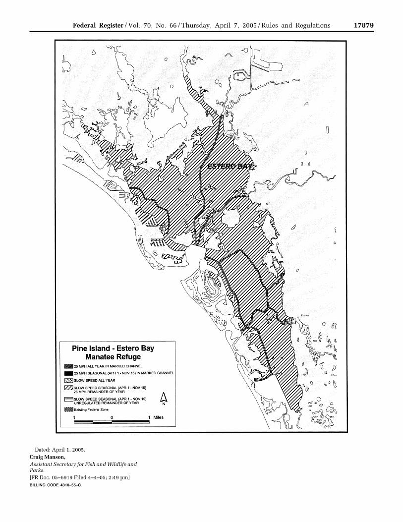
17879Federal Register / Vol. 70, No. 66 / Thursday, April 7, 2005 / Rules and Regulations
Dated: April 1, 2005. Craig Manson, Assistant Secretary for Fish and Wildlife and Parks.[FR Doc. 05–6919 Filed 4–4–05; 2:49 pm] BILLING CODE 4310–55–C
VerDate jul<14>2003 15:30 Apr 06, 2005 Jkt 205001 PO 00000 Frm 00017 Fmt 4701 Sfmt 4700 E:\FR\FM\07APR3.SGM 07APR3 ER
07A
P05
.003
</G
PH
>