department of commerce $ national oceanic ...department of commerce • national oceanic &...
TRANSCRIPT
Department of Commerce • National Oceanic & Atmospheric Administration • National Weather Service
NATIONAL WEATHER SERVICE INSTRUCTION 10-813
NOVEMBER 21, 2016
Operations and Services
Aviation Weather Services, NWSPD 10-8
TERMINAL AERODROME FORECASTS
NOTICE: This publication is available at: http://www.nws.noaa.gov/directives/.
OPR: W/AFS24 (C. Sims) Certified by: W/AFS24 (W. Bauman)
Type of Issuance: Routine
SUMMARY OF REVISIONS: This directive supersedes NWS Instruction 10-813, Terminal
Aerodrome Forecasts, dated October 2, 2014. Changes made to reflect the NWS Headquarters
reorganizations effective April 1, 2015.
/s/ 11/7/2016
Andrew D. Stern Date
Director
Analyze, Forecast and Support Office

2
NWSI 10-813 NOVEMBER 21, 2016
Table of Contents Page 1. General…................................................................................................................................. 2
2. Background............................................................................................................................... 2
3. Responsibility............................................................................................................................ 2
4. Terminal Aerodrome Forecast.................................................................................................. 3 4.1 Coordination.................................................................................................................... 3 4.2 Composing the TAF.......................................................................................................... 3
4.3 TAFs for Automated Systems ........................................................................................ 4
4.4 Format…………............................................................................................................. 4
4.5 Contractions.................................................................................................................... 4
4.6 TAF Corrections ............................................................................................................ 4
4.7 TAF Amendments.......................................................................................................... 4
4.8 TAF Collectives.............................................................................................................. 4
4.9 Issuance Times................................................................................................................ 5
4.10 Time References.............................................................................................................. 5
4.11 Update Frequency............................................................................................................ 5
4.12 Length of TAF Change Groups…………………………………….…………………... 5
4.13 Sites with Scheduled Part-Time Observations…………………….…………………… 5
5. Forecaster Liability……………………………………………………..……………………. 6
6. Records Retention ................................................................................................................... 6
7. Quality Assurance of TAFs…….............................................................................................. 6
Appendices:
A. Contractions Used In NWS TAFs..................................................................................... 7
B. TAF Code Elements……………………………………………………………………… 9
C. Unscheduled TAFs............................................................................................................. 25
D. New TAF Service, Observation Requirements and Terminating TAF Service................ 31
E. TAF Code Format, Terminology, and Significant Weather Matrices.................................. 35
1 General. This instruction describes Terminal Aerodrome Forecast (TAF) preparation by
National Weather Service (NWS) Weather Forecast Offices (WFOs). TAFs, also known as
Aerodrome Forecasts, are a critical element of NWS aviation weather services because they are a
key product in decisions for flight planning and for aircraft movement within the National
Airspace System (NAS).
2 Background. TAFs are used by a variety of aviation users, including domestic and
international commercial airlines, general aviation (GA), civilian, and military operators. TAFs
will be prepared, issued, and distributed on a timely basis to meet requirements of the U.S.
Aviation Meteorological Authority, the Federal Aviation Administration (FAA), and the
International Civil Aviation Organization (ICAO) using a code format designed by the World
Meteorological Organization (WMO) for both domestic and international use.
3 Responsibility. WFO Meteorologists in Charge (MICs) are responsible for maintaining a
consistent and accurate aviation forecast program for their offices. TAFs are prepared by

3
NWSI 10-813 NOVEMBER 21, 2016
designated NWS offices for the sites listed here.1 TAF sites are listed alphabetically by region,
by WFO within each region, and by TAF sites, indicated by the 4-letter ICAO identifier and the
location (city, town, or airport). The Analyze, Forecast and Support Office (AFSO), NWS
Headquarters (NWSH) will update this list as needed.
4 Aerodrome Forecast. A NWS TAF consists of the expected meteorological conditions
significant to aviation at an airport for a specified time period. For the U.S., this is the area
within five (5) statute miles (SM) of the center of an airport's runway complex. Forecasters will
prepare and monitor TAFs using the best professional judgment to optimize timeliness and
representativeness, with an awareness of the potential operational impact of each forecast
element. TAFs should remain as concise as possible to describe changes in flight conditions and
not exceed 6 lines (excluding a TEMPO group) except when absolutely necessary to describe
relevant weather conditions.
TAFs in the U.S. are prepared in the international standard for TAF code, with U.S.
modifications, described in WMO Manual on Codes, WMO No. 306, Volume I.l, Part A, FM 51-
X Ext. TAF, Aerodrome Forecast. U.S. modifications will be held to a minimum.
4.1 Coordination. Forecasters coordinate with the servicing Center Weather Service Unit
(CWSU) in accordance with NWSI 10-803, Support to Air Traffic Control Facilities to ensure
consistency between the TAF and the IDSS provided by the CWSU. Forecasters should
coordinate with adjacent NWS offices to prevent inconsistencies between TAFs. TAFs should
be consistent with public and other aviation products.
4.2 Composing the TAF. A complete TAF includes a forecast of surface wind (speed and
direction), surface visibility, weather, obstructions to vision (if any), clouds (or vertical visibility
into a surface-based obscuration), Low Level Wind Shear (LLWS), and any expected significant
change(s) to one or more of these elements during the specified time period, ordinarily 24 hours.
However, specified International airports require 30-hour TAFs.
Forecasters should keep the following in mind when composing a TAF:
Be aware of operationally significant weather for the airport.
Be aware of amendment criteria when formulating the forecast, but do not forecast to
satisfy criteria.
Include more detail in the first 12 hours of the TAF. The latter hours in the TAF may
contain less detail and highlight significant events, as this is used for strategic planning.
TAFs may also include specified significant meteorological phenomena expected to occur in the
airport's vicinity (VC) during any part of the valid period as VC weather codes (VCFG, VCSH,
VCTS). In the United States, vicinity is defined as an area between 5 and 10 statute miles (SM)
from the center of the runway complex of an airport.
The forecaster will maintain a watch of weather conditions for all pertinent TAF sites, including
sites with scheduled part-time observations, automated observing sites requiring part-time
1 http://www.nws.noaa.gov/os/aviation/cac/asb_cac_thresholds_09-15-2016.htm

4
NWSI 10-813 NOVEMBER 21, 2016
augmentation, and non-augmented automated observing sites.
4.3 TAFs for Automated Systems. TAFs for Automated Surface Observing System (ASOS)
and Automated Weather Observing System (AWOS) sites have limitations, and forecast TAFs
for these sites should take the limitations into consideration. For example, if the forecaster
expects clouds above 12,000 feet and/or zero visibility, or ice pellets, the TAF should reflect
these conditions even when an automated system reports clear skies (below 12,000 feet) and/or
visibility of M1/4SM (which indicates visibility of LT 1/4 SM).
4.4 Format. The format of the TAF follows ICAO standards as outlined in Appendix B.
The length of a line will not exceed 69 spaces, including typed characters, spaces, returns, and
the end-of-report separator.
4.5 Contractions. The only contractions used in NWS TAFs are those terms defined in this
instruction and its appendices, which are derived from the WMO Codes Manual and from the
ICAO document ICAO Abbreviations and Codes. In a very few cases, plain language English
terms may be used. All valid contractions for TAFs are included in Appendix A.
4.6 TAF Corrections. Corrections to the TAF should be issued as soon as the forecaster
becomes aware of the error. Normally a correction is issued within a half hour of the issuance of
the original forecast. Corrections made later than one hour after a TAF has been issued should be
sent as an amendment, with forecast conditions updated as the original mistake is corrected.
4.7 TAF Amendments. The decision to amend the TAF relies on the forecaster's assessment
of existing conditions and expectations. If conditions change earlier or later than forecast but the
TAF shows the expected trend and will soon recover, an amendment may not be needed.
Additionally, small fluctuations in the observation should not result in a minor adjustment to the
TAF (chasing the observation). However, if improving weather conditions occur sooner than
forecast, then an amended TAF is necessary.
TAF amendments are issued promptly when:
a. Conditions meeting amendment criteria are expected or have occurred and those
conditions will, in the forecaster’s estimation, persist, or
b. New guidance/information indicates future conditions are expected to be in a different
category than originally forecast, especially in the 1-12 hour time-period.
Forecasters should maintain a weather watch and amend forecasts prior to weather
conditions meeting amendment criteria. Additionally, forecasters should issue TAF AMDs
for significant forecast changes immediately rather than waiting for the next regularly
scheduled TAF release time, even if that release time is within a half hour after the
amendment time.
4.8 TAF Collectives. When a WFO transmits more than one TAF in a collective, each
forecast is started on the line immediately following the previous TAF with the location
identifier at the left margin. Each complete TAF is followed by an end-of-report separator (an

5
NWSI 10-813 NOVEMBER 21, 2016
equal sign [=]), which denotes the end of a complete TAF for each location. The end-of-report
separator is followed by a return. The TAF order should be decided by the respective Regional
Headquarters and remain unchanged as much as possible. Newly added airports should
generally be placed at the end of the bulletin.
4.9 Issuance Times. Scheduled TAFs prepared by NWS offices are issued at least four
times a day, every six (6) hours, according to the following schedule:
Scheduled Issuance Valid Period 30 Hour Issuance Window
0000 UTC 0000 to 0000 UTC 0600 UTC 2320 to 2340 UTC
0300 UTC (AMD) 0300 to 0000 UTC 0600 UTC
0600 UTC 0600 to 0600 UTC 1200 UTC 0520 to 0540 UTC
0900 UTC (AMD) 0900 to 0600 UTC 1200 UTC
1200 UTC 1200 to 1200 UTC 1800 UTC 1120 to 1140 UTC
1500 UTC (AMD) 1500 to 1200 UTC 1800 UTC
1800 UTC 1800 to 1800 UTC 0000 UTC 1720 to 1740 UTC
2100 UTC (AMD) 2100 to 1800 UTC 0000 UTC
4.10 Time References. The times in TAFs are stated in Universal Time Coordinated (UTC).
Time references should be as detailed and specific as supporting data and present science allow
and do not need to begin at the top of an hour. The letter Z is appended to the end of the date-
time group of forecast origin. The contraction UTC does not appear in either the WMO
abbreviated heading or the forecast text.
4.11 Update Frequency. Each WFO may choose to routinely issue TAFs more frequently
than every six hours as a method of keeping the TAF as representative as possible. Those
offices providing TAFs for the FAA’s core airports provide TAFs every 3 hours. These
intermediate TAFs are issued as amendments using the TAF AMD header though they will
actually be issued on a scheduled basis. Offices not issuing for these airports may issue more
frequent updates after coordinating the change with their Regional Headquarters.
4.12 Length of TAF Change Groups. To forecast a change in weather conditions starting at
a particular time, the FM (from) contraction is used and is always a single time, to the nearest
minute if the expected change can be forecast to that degree of accuracy. Temporary (TEMPO)
groups do not exceed four (4) hours. Probability (PROB) groups are six (6) hours or less.
More information on Change Groups can be found in the appendices.
4.13 Sites With Scheduled Part-Time Observations. For TAFs with LT 24-hour observational
coverage, the TAFs are valid to the end of the routine scheduled forecast period even when
observations end prior to that time. The time observations are scheduled to end and/or resume is
indicated by expanding the AMD NOT SKED statement. Expanded statements include:
a. Observation ending time (AFT Y1Y1HHmm, e.g., AFT 120200),
b. Scheduled observation resumption time (TIL Y1Y1HHmm, e.g., TIL 171200Z) or

6
NWSI 10-813 NOVEMBER 21, 2016
c. Period of observation unavailability (Y1Y1HH/YeYehh, e.g., 2502/2512).
TIL is used only when the beginning of the scheduled TAF valid period coincides with the time
of the last observation or when observations are scheduled to resume prior to the next scheduled
issuance time. When used, these remarks immediately follow the last forecast group. If a routine
TAF issuance is scheduled to be made after observations have ceased, but before they resume,
the remark AMD NOT SKED immediately follows the valid period group of the scheduled
issuance. After sufficient data using the total observation concept has been received, the AMD
NOT SKED remark is removed.
Examples:
TAF AMD
KRWF 150202Z 1502/1600 {TAF
text} AMD NOT SKED
1505/1518=
TAF AMD
KPSP 190230Z 1903/1924 {TAF
text} AMD NOT SKED=
5 NWS Forecaster Liability. NOAA’s Office of General Counsel, Weather, Satellite and
Research Section has advised that NWS forecasters are generally protected from liability when
utilizing their discretion:
NWS forecasters employ their discretion in issuing forecasts, including utilizing the
"total observation concept" for writing and issuing TAFs. In the performance of their
jobs, where NWS forecasters utilize their discretion, they are covered under the
discretionary function exemption of the Federal Tort Claims Act, 28 U.S.C. §§ 2671 et
seq.
6 Records Retention. Records of disseminated TAFs, including amendments, corrections,
and delayed issuances, will be maintained in accordance with NWSI 10-2003, Records Retention.
7 Quality Assurance of TAFs. Performance reports to the office staff and stakeholders
(airport managers/individual airlines) are encouraged to let them know how the office is
supporting their mission. In aviation forecasting, the goal is to continually improve forecast
service by identifying forecasting weaknesses and developing methods to strengthen those
weaknesses. NWS uses Stats-on-Demand as the primary program for performing verification on
TAFs and WFOs verify their respective TAFs in this manner. The Aviation Focal Points (AFPs)
may view individual stats for their forecasters. See NWSI 10-1601, Section 6.1.3. (NOTE:
Verification is covered by two documents: NWSI 10-1601, Verification Process, and NWSM 10-
1609, Verification Procedures and Methods.) Forecast and verification results tracked using the
Stats-on-Demand verification program should never be used against forecasters.

7
NWSI 10-813 NOVEMBER 21, 2016
Appendix A
Contractions Used in NWS TAFs AAx Code used in the WMO abbreviated heading to indicate an amended TAF, where x is the letter A
through X (see Appendix D, Section 1.1). NOTE: AAx is not used in the forecast text.
AFT After
AMD Amended TAF. Used in the forecast text only. AMD is not used in the WMO abbreviated heading.
BC Patches
BKN Broken cloud layer [five (5) to seven (7) oktas cloud amount]. Clouds may be transparent or opaque.
Lowest broken layer is implied to be the ceiling.
BL Blowing
BR Mist
CB Cumulonimbus cloud
CCCC Generic WMO format code group for a four-letter location identifier. Four-letter location identifiers
for specific airports are listed in ICAO document 7910, Location Identifiers.
CCx Code used in the WMO abbreviated heading to indicate a corrected forecast, where x is the letter A
through X (see Appendix D, Section 1.3). CCx is not used in the forecast text.
CLD Cloud
DR Low drifting
DS Dust Storm
DU Dust
DZ Drizzle
FC Funnel Cloud
FEW Few clouds [greater than zero (0) oktas to two (2) oktas cloud amount]
FG Fog
FM From the date (YY) and time (UTC) indicated by GGgg. Generic WMO format code group, indicating
a significant and rapid (in less than one hour) change to a new set of prevailing conditions. GG is in
whole hours, gg is in minutes. See Appendix C, Section 1.2.9.1.
FU Smoke
FZ Freezing
G (Gust) Defined as rapid fluctuations in wind speed with a variation of 10 knots or more between peaks and
lulls within a 10 minute time period.
GR Hail (largest hailstone diameter GTE 1/4 inch)
GS Small hail and/or snow pellets (largest hailstone diameter LT 1/4 inch)
GT Greater than
GTE Greater than or equal to
HZ Haze
IC Ice crystals
KT Knots
LT Less than
LTE Less than or equal to
LTD Limited
MI Shallow
NSW No Significant Weather. An indication that significant weather conditions, as expressed by WMO
Code Table 4678, are forecast to end. See Appendix C, Section 1.2.6.
OVC Overcast cloud layer [eight (8) oktas cloud amount]
P6SM Visibility forecast greater than six (6) statute miles
PL Ice pellets
PO Well-developed dust/sand whirls
PR Partial
PROBC2C2 Probability of occurrence of a thunderstorm (and associated precipitation) or precipitation event,
along with associated weather elements (wind, visibility, and/or sky condition) directly related to the
thunderstorm or precipitation event. C2C2 refer to the probability of the event. Only PROB30 is
allowed. See Appendix C, Section 1.2.9.4.
PY Spray

8
NWSI 10-813 NOVEMBER 21, 2016
RA Rain
RRx Code used in the WMO abbreviated heading to indicate a delayed TAF, where “x” is the letter A
through X (Appendix D, Section 1.2). RRx is not used in the TAF text.
SA Sand
SCT Scattered cloud layer [three (3) to four (4) oktas cloud amount]
SH Showers
SKED Scheduled
SM Statute miles
SN Snow
SQ Squall
SS Sandstorm
TAF Aerodrome Forecast code format. The international standard for the TAF code, FM 51-X Ext. TAF,
is included in WMO Manual on Codes, WMO No. 306, Volume I.1, Part A.
TEMPO Temporarily. Indicator of temporary fluctuations to forecast conditions which are expected to last LT
1 hour in each instance and, in the aggregate, to cover LT half of the indicated period. The period of
time covered by a TEMPO group should be the minimum necessary, not exceed four (4) hours. See
Appendix C, Section 1.2.9.2.
TIL Until
TS Thunderstorm
VA Volcanic Ash
VC Vicinity - it has two definitions:
NWS: A donut-shaped area encompassed between circles with radii of 5 and 10 SM, respectively,
from the center of the runway complex of an airport. VC will only be used in the initial time period or
in FM groups, all of which forecast prevailing conditions, and will only be used in combination with
fog (FG), shower(s) (SH), and thunderstorm(s) (TS).
WMO: (An area encompassed) within eight (8) kilometers [five (5) statute miles] of the aerodrome
but not at the aerodrome (Words in parentheses inferred. See Note 1 under WMO Regulation
15.8.10). Only used in METARs/SPECIs.
VIS Visibility
VRB Variable wind direction. Wind direction is considered variable when it is impossible to forecast a
mean wind direction due to its expected variability, e.g., for very light winds [LTE six (6) knots] or
during convective activity.
VV Vertical Visibility
Z Indicator letter (an abbreviated symbol for Coordinated Universal Time - UTC) appended to the date-
time of forecast origin group.

9
NWSI 10-813 NOVEMBER 21, 2016
Appendix B
TAF Code Elements
Table of Contents Page
1. Terminal Forecast Coding……................................................................................................. 10
1.1 Bulletin Headings.............................................................................................................. 10
1.2 Forecast Text...................................................................................................................... 11
1.2.1 Location Identifier................................................................................................... 11
1.2.2 Date/Time of Forecast Origin Group........................................................................ 11
1.2.3 Valid Period and Routine Issuances......................................................................... 12
1.2.4 Wind Group.............................................................................................................. 12
1.2.4.1 Wind Gusts……………………………………………………………….. 12
1.2.4.2 Wind Direction…………………………………………………………… 12
1.2.4.3 Variable Wind…………………………………………………………….. 12
1.2.4.4 Squalls…………………………………………………………………….. 13
1.2.5 Visibility Group....................................................................................................... 13
1.2.5.1 Tall Tower..................................................................................................... 14
1.2.6 Significant Weather Group...................................................................................... 14
1.2.6.1 Examples of Encoding Multiple Precipitation Types……………………. 15
1.2.6.2 Qualifiers........................................................................................................ 16
1.2.6.3 Visibility as Significant Weather…………………………………………. 17
1.2.6.4 Vicinity……………………………………………………………………. 18
1.2.7 Cloud and Vertical Obscuration Groups................................................................... 19
1.2.7.1 Cloud Group................................................................................................ 19
1.2.7.2 Vertical Obscuration Group........................................................................ 20
1.2.7.3 Cloud Type................................................................................................. 20
1.2.8 Non-Convective LLWS Group................................................................................ 21
1.2.9 Forecast Change Indicator Groups........................................................................... 22
1.2.9.1 Special Thunderstorm Consistency Guidance……………………………. 22
1.2.9.2 FMYYGGgg............................................................................................... 23
1.2.9.3 TEMPO Y1Y1GG/YeYeGeGe................................................................... 24
1.2.9.4 PROBC2C2 Y1Y1GG/YeYeGeGe............................................................ 25
1 Terminal Forecast Coding. Each group of the TAF code used in NWS TAFs is described
in the following sections. Each section includes partial or complete examples of one or more
TAFs to clarify descriptions in the text.
1.1 Bulletin Headings. TAF bulletins begin with a WMO heading where the four letter ICAO
identifier is the issuing office. For example:
FTUS42 KMFL 141100 AAx
TAFFLL
TAF (AMD) or (COR)
KFLL 141123Z 1412/1512 etc…

10
NWSI 10-813 NOVEMBER 21, 2016
FT TAF whose valid period exceeds 12 hours
US Denotes CONUS airport location
42 CONUS group location (usually by geographical area)
KMFL Issuing WFO
141100 First 2 digits are issuance date; the last four are cardinal hour prior to forecast
valid hour, required to meet international requirements for scheduled TAFs.
AAx Used to identify a non-scheduled TAF (corrections, delayed TAFs, amendments,
etc.). If not used, simply omit (as in regularly scheduled TAFs). The indicators
used are AAx for TAF amendments, RRx for delayed routine TAFs, and CCx for
corrections of previously transmitted TAFs. The x is the letter A through X, used
sequentially which indicate the subsequent use of the heading. For example, the
first correction would be CCA, the second CCB, etc.
TAFFLL First three (3) letters identify a TAF, the last three are the site the TAF is for (this
line is deleted during dissemination for disbursement as a group).
TAF (AMD/COR) Identifies TAF as the product (AMD indicates an amendment/COR
indicates correction)
KFLL ICAO identifier of the TAF site
141123Z Time of preparation
1412/1512 Valid time of new TAF
ICAO location identifiers in the CONUS begin with the letter K, those in the North Pacific
(Hawaii, Alaska, and Guam) begin with a P, those in the Caribbean (Puerto Rico, Virgin Islands,
etc.) begin with a T, and those in the South Pacific begin with an N.
1.2 Forecast Text. The first line of text in a TAF consists of the contraction TAF or TAF
AMD or TAF COR. This indicates if the product is scheduled, amended, or corrected. This
information appears only once, on a separate line at the beginning of the product, regardless of
how many TAFs it contains. Delayed TAFs are not identified in the text; that information is
included at the end of the first line on the WMO header.
The format of text in a NWS TAF is comprised of code groups shown below. Each term and
group is described in Sections 1.2.1 through 1.2.9 below and in the same sequence as they are
required to appear in each forecast group.
GENERIC FORMAT OF THE FORECAST TEXT OF A NWS-PREPARED TAF
{TAF or TAF AMD or TAF COR}
CCCC YYGGggZ YlY1G1G1/Y2Y2G2G2 dddffGfmfmKT VVVV w'w' (NSW) VVhshshs
(SKC)
WShwshwshws/dddftKT TTGGgg
FMY1Y1GGGeGe TEMPO Y1Y1GG/YeYeGeGe PROB30Y1Y1GG/YeYeGeGe
1.2.1 Location Identifier (CCCC). After the line containing either TAF or TAF AMD or TAF
COR, each TAF will begin with its four-letter ICAO location identifier. ICAO Document 7910
contains a complete list of all identifiers.

11
NWSI 10-813 NOVEMBER 21, 2016
1.2.2 Date/Time of Forecast Origin Group (YYGGggZ). The date/time of forecast origin group
follows the terminal's location identifier. It contains the day of the month in two (2) digits (YY)
and time in four (4) digits (GGgg in hours and minutes) the forecast is completed and ready for
transmission, with a Z appended to denote UTC. This time is entered by the forecaster. Section
4.9 of this instruction contains a table of issuance time windows for scheduled TAFs.
1.2.3 Valid Period and Routine Issuances (Y1Y1G1G1/Y2Y2G2G2). The TAF valid period is
the next group. The first two digits (Y1Y1) are the day of the month for the start of the TAF.
The next two digits (G1G1) are the starting hour. Y2Y2 is the day of the month for the end of
the TAF, and the last two digits (G2G2) are the ending hour of the valid period. A forecast
period that begins at midnight UTC will be annotated as 00. If the end time of a valid period is
at midnight UTC, it is annotated as 24. For example, a 00Z TAF issued on the 9th
of the month
would have a valid period of 0900/0924.
A TAF issued at one of the airports designated to have a 30-hour valid period will also be
formatted Y1Y1G1G1/Y2Y2G2G2. For example, a 00Z TAF issued on the 11th
of the month for
30 hours would have a valid period of 1100/1206.
1.2.4. Wind Group (dddffGfmfmKT). The initial time period and any subsequent FM groups
will begin with a mean surface wind forecast for that period. Wind forecasts are expressed as the
mean three-digit direction (ddd - relative to true north) rounded to the nearest ten degrees and the
mean wind speed in knots (ff) for the time period.
The forecaster should strive to forecast a mean wind direction with low wind speeds if weather is
expected to, or has already, impacted the TAF site. Wind direction forecasts, even at low speeds,
can be critical if the runway(s) are contaminated by ice, snow, or water, creating tighter tailwind
and crosswind aircraft tolerances. There are no amendment criteria for low wind speed
conditions.
1.2.4.1 Wind Gusts (G). If wind gusts, defined as rapid fluctuations in wind speeds with a
variation of 10 knots or more between peaks and lulls, are forecast, they are indicated
immediately after the mean wind speed by the letter G, followed by the peak gust speed
expected. KT is appended to the end of the wind forecast group. Any wind speed of 100
knots or more will be encoded in three digits. Encode calm winds as 00000KT.
1.2.4.2 Wind Direction (ddd). The prevailing wind direction will be forecast for any speed
greater than or equal to seven (7) knots.
1.2.4.3 Variable Wind (VRBffKT). The forecast wind direction will be encoded when
forecasting a prevailing surface wind direction is not possible due to its expected variability
(variations in wind direction GTE 30 degrees). Meteorologists should avoid using VRB and
provide the best forecast direction possible. This enables users to use the wind group for
planning purposes. If necessary, two conditions where this can occur are very light winds and
convective activity. Variable wind direction for very light winds should have a wind speed of
one (1) through six (6) knots inclusive. For convective activity, the wind group may be encoded
as VRBffGfmfmKT, where Gfmfm is the maximum expected wind gusts. VRB is not used in
the non-convective LLWS group (refer to Section 1.2.8).

12
NWSI 10-813 NOVEMBER 21, 2016
When forecasting variable wind direction, there is no requirement to specify direction variability
limits in remarks.
1.2.4.4 Squalls (SQ). Squalls are forecast in the wind group as gusts (G), but should be
identified in the significant weather group with the code SQ (Appendix B, Section 4, Footnote
19).
EXAMPLES:
TAF
KPIT 231732Z 2318/2418 23010KT 4SM -SHRA BKN030
FM232200 28020G35KT P6SM OVC020
FM232330 30015KT P6SM SCT060
FM240500 30004KT P6SM SCT080=
The above example demonstrates rapid changes in wind associated with a frontal passage. Also
note the correct format for gusts.
TAF
KCSG 060537Z 0606/0706 VRB03KT etc=
This example above shows the correct format and use of variable wind direction with light winds
at the beginning of the valid period (0600 UTC).
TAF
KROW 021726Z 0218/0318 30008KT 5SM HZ BKN030 PROB30
0304/0306 27020G45KT 1SM TSRA OVC012CB etc=
This example above depicts using high winds in an organized event.
TAF
KAMA 171130Z 1712/1812 00000KT etc=
This example above shows the correct format for calm winds.
TAF
PASN 010530Z 0106/0206 080100G140KT etc=
This example above shows the correct format of wind speed of 100 knots or more with the wind
from 80 degrees at 100 knots gusting to 140 knots.
TAF
KORD 161725Z 1618/1718 27020G35KT P6SM TS FEW020CB
TEMPO 1618/1619 29040G56KT SQ
FM161930 30015G25KT P6SM etc=
This example shows the correct format for squalls.
13
NWSI 10-813 NOVEMBER 21, 2016
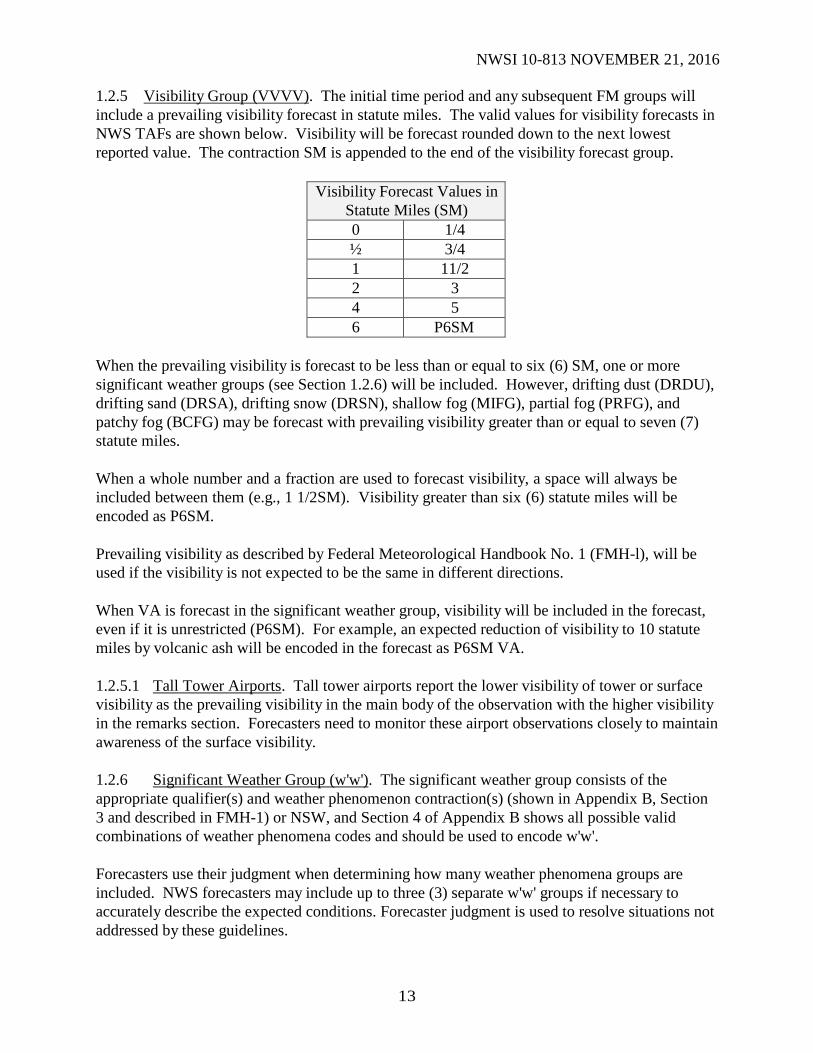
1.2.5 Visibility Group (VVVV). The initial time period and any subsequent FM groups will
include a prevailing visibility forecast in statute miles. The valid values for visibility forecasts in
NWS TAFs are shown below. Visibility will be forecast rounded down to the next lowest
reported value. The contraction SM is appended to the end of the visibility forecast group.
Visibility Forecast Values in
Statute Miles (SM)
0 1/4
½ 3/4
1 11/2
2 3
4 5
6 P6SM
When the prevailing visibility is forecast to be less than or equal to six (6) SM, one or more
significant weather groups (see Section 1.2.6) will be included. However, drifting dust (DRDU),
drifting sand (DRSA), drifting snow (DRSN), shallow fog (MIFG), partial fog (PRFG), and
patchy fog (BCFG) may be forecast with prevailing visibility greater than or equal to seven (7)
statute miles.
When a whole number and a fraction are used to forecast visibility, a space will always be
included between them (e.g., 1 1/2SM). Visibility greater than six (6) statute miles will be
encoded as P6SM.
Prevailing visibility as described by Federal Meteorological Handbook No. 1 (FMH-l), will be
used if the visibility is not expected to be the same in different directions.
When VA is forecast in the significant weather group, visibility will be included in the forecast,
even if it is unrestricted (P6SM). For example, an expected reduction of visibility to 10 statute
miles by volcanic ash will be encoded in the forecast as P6SM VA.
1.2.5.1 Tall Tower Airports. Tall tower airports report the lower visibility of tower or surface
visibility as the prevailing visibility in the main body of the observation with the higher visibility
in the remarks section. Forecasters need to monitor these airport observations closely to maintain
awareness of the surface visibility.
1.2.6 Significant Weather Group (w'w'). The significant weather group consists of the
appropriate qualifier(s) and weather phenomenon contraction(s) (shown in Appendix B, Section
3 and described in FMH-1) or NSW, and Section 4 of Appendix B shows all possible valid
combinations of weather phenomena codes and should be used to encode w'w'.
Forecasters use their judgment when determining how many weather phenomena groups are
included. NWS forecasters may include up to three (3) separate w'w' groups if necessary to
accurately describe the expected conditions. Forecaster judgment is used to resolve situations not
addressed by these guidelines.

14
NWSI 10-813 NOVEMBER 21, 2016
The following guidance should be used for this group:
If the initial forecast period and subsequent FM groups do not contain an explicit
significant weather group, the significant weather group will be omitted.
Do not use NSW in the initial forecast time period or FM groups.
Tornadic activity, including tornadoes, waterspouts, and funnel clouds, should only be
included in TAFs when absolutely necessary. Although the probability of occurrence at a
specific site is low, it is possible.
One or more significant weather group(s) is (are) required when the visibility is forecast to
be 6SM or less (see Section 1.2.5).
With the exception of VA, DRDU, DRSA, DRSN, MIFG, PRFG, and BCFG, obstructions
to vision are only forecast when the prevailing visibility is less than 7 statute miles or, in
the judgment of the forecaster, is considered operationally significant.
VA is always forecast when expected. When VA is included in the significant weather
group, visibility is included in the forecast as well, even if the visibility is unrestricted
(P6SM).
NSW is used in place of w’w’ in a TEMPO group (Section 1.2.9.2) to indicate when
significant weather included in a previous subdivided group is expected to end. This
includes vicinity.
o After NSW is used in a significant weather group, any subsequent significant
weather groups will either be omitted or selected from the phenomena listed in
Appendix B, Section 4.
o No two consecutive TEMPO groups can contain NSW as the significant weather
group.
o P6SM NSW is used together in a TEMPO group when the significant weather is
forecast to end and the visibility is forecast to be greater than 6 statute miles after,
regardless of visibility before the TEMPO event.
When more than one type of significant weather is forecast in the same forecast time
period, the order is:
o Thunderstorms with/without associated precipitation.
o Significant weather in order of decreasing dominance based on intensity.
o Left to right in Appendix B, Section 3 (columns 1 through 5.
Non-precipitation significant weather elements are encoded after any precipitation, in their
own group, separated by a space (e.g., -SHSN BLSN BR). The same is true for encoding
w'w' groups: first, the appropriate qualifier for intensity or proximity, then the appropriate
contraction for the descriptor, and finally the contraction for the observed weather
phenomenon or combinations thereof, all without any spaces.
Multiple precipitation elements are encoded in a single group (e.g., -TSRASN).
o Up to three (3) appropriate precipitation contractions can be combined in a single
group (with no spaces) with the predominant type of precipitation being first.
o In this single group, the intensity will refer to the total precipitation and be used
with either one or no intensity qualifier.
The intensity qualifiers (light, moderate, and heavy) refer to the intensity of
the precipitation and not to the intensity of any thunderstorms associated
with the precipitation.
15
NWSI 10-813 NOVEMBER 21, 2016
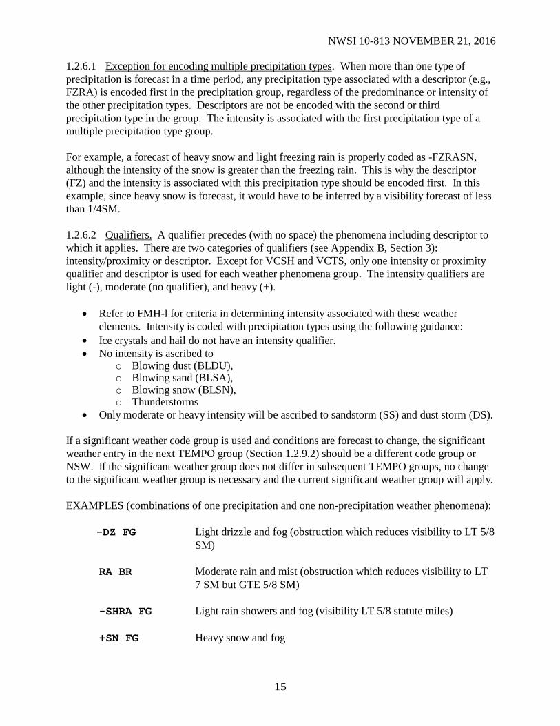
1.2.6.1 Exception for encoding multiple precipitation types. When more than one type of
precipitation is forecast in a time period, any precipitation type associated with a descriptor (e.g.,
FZRA) is encoded first in the precipitation group, regardless of the predominance or intensity of
the other precipitation types. Descriptors are not be encoded with the second or third
precipitation type in the group. The intensity is associated with the first precipitation type of a
multiple precipitation type group.
For example, a forecast of heavy snow and light freezing rain is properly coded as -FZRASN,
although the intensity of the snow is greater than the freezing rain. This is why the descriptor
(FZ) and the intensity is associated with this precipitation type should be encoded first. In this
example, since heavy snow is forecast, it would have to be inferred by a visibility forecast of less
than 1/4SM.
1.2.6.2 Qualifiers. A qualifier precedes (with no space) the phenomena including descriptor to
which it applies. There are two categories of qualifiers (see Appendix B, Section 3):
intensity/proximity or descriptor. Except for VCSH and VCTS, only one intensity or proximity
qualifier and descriptor is used for each weather phenomena group. The intensity qualifiers are
light (-), moderate (no qualifier), and heavy (+).
Refer to FMH-l for criteria in determining intensity associated with these weather
elements. Intensity is coded with precipitation types using the following guidance:
Ice crystals and hail do not have an intensity qualifier.
No intensity is ascribed to o Blowing dust (BLDU), o Blowing sand (BLSA), o Blowing snow (BLSN), o Thunderstorms
Only moderate or heavy intensity will be ascribed to sandstorm (SS) and dust storm (DS).
If a significant weather code group is used and conditions are forecast to change, the significant
weather entry in the next TEMPO group (Section 1.2.9.2) should be a different code group or
NSW. If the significant weather group does not differ in subsequent TEMPO groups, no change
to the significant weather group is necessary and the current significant weather group will apply.
EXAMPLES (combinations of one precipitation and one non-precipitation weather phenomena):
-DZ FG Light drizzle and fog (obstruction which reduces visibility to LT 5/8
SM)
RA BR Moderate rain and mist (obstruction which reduces visibility to LT
7 SM but GTE 5/8 SM)
-SHRA FG Light rain showers and fog (visibility LT 5/8 statute miles)
+SN FG Heavy snow and fog

16
NWSI 10-813 NOVEMBER 21, 2016
EXAMPLES (showing combinations of more than one type of precipitation):
-RASN FG HZ Light rain and snow (light rain predominant), fog and haze
TSSNRA Thunderstorm with moderate snow and rain (moderate snow
predominant)
FZRASNPL Moderate freezing rain, snow, and ice pellets (freezing rain
mentioned first due to the descriptor, followed by other
precipitation types in order of predominance)
SHSNPL Moderate snow showers and ice pellets
EXAMPLE TAF:
TAF
KFAR 091739Z 0918/1018 21030G60KT 1/4SM +TSRAGR BKN050CB...
Winds southwest at 30 knots, with gusts to 60 knots. Visibility 1/4 SM, thunderstorm (severe
because of 60KT gusts) with heavy rain and hail. NOTE: the + qualifier is associated with the
precipitation (RA) and not the thunderstorm. Broken cumulonimbus (CB) clouds (ceiling) at
5,000 feet.
In the following cases the TS descriptor is treated differently than other descriptors:
1. When dry thunderstorms are forecast, TS may be encoded as the sole significant
weather phenomenon; and
2. When forecasting thunderstorms with freezing precipitation (FZRA or FZDZ),
include the TS descriptor first, followed by the intensity and weather phenomena.
See the following example:
TAF
KMCI 252335Z 2600/2700 31015KT 1 1/2SM TS -FZRA BKN010CB...
Winds northwesterly at 15 knots. Visibility 1 1/2 SM, thunder with light freezing rain, broken
CB clouds (ceiling) at 1,000 feet.
When a TS is included in the significant weather group (even in vicinity - VCTS), the cloud
group (NsNsNshshshs) includes a forecast cloud type of CB. See the following example for
encoding VCTS:
TAF
KMCI 252335Z 2600/2700 31015KT 1 1/2SM -FZRA VCTS
BKN010CB...

17
NWSI 10-813 NOVEMBER 21, 2016
Winds northwesterly at 15 knots. Visibility 1 1/2 SM and light freezing rain, broken CB clouds
(ceiling) at 1,000 feet, TS in the vicinity.
1.2.6.3 Visibility as Significant Weather. When forecasting a fog-restricted visibility from
5/8SM to 6SM, the phenomena is coded as BR (mist). When forecasting a fog-restricted
visibility that is LT 5/8SM, use code FG. Never encode weather obstruction as mist (BR) when
the forecast visibility is GT 6 statute miles (P6SM).
The following fog-related terms are used as described below:
Freezing Fog (FZFG): Any fog (visibility LT 5/8 SM) consisting predominantly of water
droplets at temperatures LTE 32oF/0
oC, whether or not rime ice is
expected to be deposited. FZBR is not a valid significant weather
combination and is not used in TAFs.
Shallow Fog (MIFG): The visibility at 6 feet above ground level is GTE 5/8 SM and the
apparent visibility in the fog layer is LT 5/8 SM.
Patchy Fog (BCFG): Fog patches covering part of the airport. The apparent visibility in
the fog patch or bank is LT 5/8 SM, with the foggy patches
extending to at least 6 feet above ground level.
Partial Fog (PRFG): A substantial part of the airport is expected to be covered by fog
while the remainder is expected to be clear of fog (e.g., a fog bank).
NOTE: MIFG, PRFG and BCFG may be forecast with prevailing visibility of P6SM.
EXAMPLES:
TAF
KLWS 020530Z 0206/0306 27010KT 1/2SM FG VV008
FM021100 27010KT 3SM BR BKN010...
This example shows the proper use of FG and BR. When significant weather is not expected in a
FM group, the significant weather group is omitted.
TAF
KBIL 211140Z 2112/2212 04005KT 1SM -RA BR OVC008
FM211715 34008KT 3SM -RA BKN050 etc.=
Change is expected at 1715Z. NOTE: The light rain is repeated in the FM211715 group to
indicate that light rain remains in the forecast. The mist is omitted from the FM211715 group,
which indicates it is forecast to end at 1715Z.
TAF
KMPV 021130Z 0212/0312 04006KT 3SM -DZ OVC008
FM021800 36010KT P6SM SCT025...

18
NWSI 10-813 NOVEMBER 21, 2016
Conditions improve at 1800Z to winds from 360 degrees at 10 knots, visibility GT 6SM
(unrestricted), and no significant weather.
1.2.6.4 Vicinity (VC). In the United States, vicinity is defined as a donut-shaped area between
5SM and 10SM from the center of the airport’s runway complex. NWS TAFs include prevailing
condition forecasts of fog, showers and thunderstorms in the airport's vicinity (GTE 50%
probability and expected to occur for more than ½ of the sub-divided forecast time period) in the
significant weather section of the TAF. Prevailing conditions are forecast in the initial time period
and FM groups. Significant weather in the vicinity is not included in TEMPO or PROB groups.
The following significant weather phenomena are valid for use in prevailing portions of NWS
TAFs in combination with VC:
Phenomenon Coded as**
Fog* VCFG
Shower(s) VCSH
Thunderstorm VCTS
*Always coded as VCFG regardless of visibility in the obstruction, and without qualification as
to intensity or type (frozen or liquid)
**The VC group, if used, should be the last entry in any w'w' group.
1.2.7 Cloud and Vertical Obscuration Groups (NsNsNshshshs/VVhshshs). The initial forecast
period and any subsequent FM groups includes a cloud group to indicate the cumulative amount
(NsNsNs) of all cloud layers in ascending order and height (hshshs) or to indicate a clear sky
(SKC) and an obscuration if appropriate to indicate vertical visibility into a surface-based
obstructing medium.
All cloud layers and obscurations are considered opaque, defined as when more than 50% of the
sky is hidden by the clouds at any layer.
1.2.7.1 Cloud Group (NsNsNshshshs). The cloud group is used to forecast cloud amount for
the airport and its vicinity out to 10 SM as follows:
Sky Cover Contraction Sky Coverage
SKC 0 oktas
FEW 1 to 2 oktas
SCT 3 to 4 oktas
BKN 5 to 7 oktas
OVC 8 oktas
When zero (0) oktas is forecast, the cloud group is replaced by SKC. The contraction CLR,
which is used in the METAR code, is not used in TAFs.

19
NWSI 10-813 NOVEMBER 21, 2016
Height of cloud (hshshs) is forecast in hundreds of feet AGL at the following resolution:
Range of Height Values Reportable Increment
LT 3,000 To nearest 100
GTE 3,000 but LT 5,000 To nearest 500
GTE 5,000 To nearest 1,000
In general, the number of cloud layers in each sub-divided time period should not exceed three.
Additionally, scattered cloud layers are not forecast at a higher level than broken or overcast
cloud layers, and broken cloud layers are not forecast at a higher level than overcast layers.
Using the principle of at/below, the lowest level at which the cumulative cloud cover equals 5/8
or more of the celestial dome is understood to be the forecast ceiling. For example, VV008,
BKN008 or OVC008 all indicate an 800 foot ceiling.
1.2.7.2 Vertical Obscuration Group (VVhshshs). The vertical obscuration group is used to
forecast, in hundreds of feet AGL, the vertical visibility (VV) into a surface-based total
obscuration. VVhshshs is the ceiling at the height indicated in the forecast. TAFs do not include
forecasts of partial obscurations (i.e., FEW000, SCT000, or BKN000).
EXAMPLE:
TAF
KCPR 110537Z 1106/1206 24015KT P6SM SKC
FM110820 24015KT 1SM BR VV008...
Note that the wind in the FM group is the same as in the initial forecast period, but is repeated
since all elements are required to be included in a FM group.
1.2.7.3 Cloud Type. The only cloud type included in the TAF is CB. CB follows cloud or
obscuration height (hshshs) without a space. Whenever TS are included in w’w’, even if TS are
only forecast in the vicinity (VCTS), CB should be included in NsNsNshshshs or VVhshshs. CB
may only be mentioned in the TAF when TS or VCTS is mentioned. CB may not be used alone,
as it can be confusing to the users and cause difficulty in air traffic planning.
EXAMPLES:
TAF
KORD 110537Z 1106/1206 06008KT P6SM FEW050 SCT100
FM111115 11010KT 2SM -RA OVC012...
Note the initial forecast period (beginning at 0600Z) does not contain w’w’. When significant
weather is not expected in the initial period of an FM group, w’w’ is omitted.
TAF
KDAY 221730Z 2218/2318 19010G25KT P6SM BKN040
FM222230 26025G45KT 1/2SM TSSN OVC010CB...

20
NWSI 10-813 NOVEMBER 21, 2016
Significant change at 2230Z to wind from 260 degrees at 25 knots gusting to 45 knots, visibility
½SM in a thunderstorm with moderate snow, overcast clouds (ceiling) at 1,000 feet, including CB.
TAF
KSYR 230532Z 2306/2406 29012KT 1/2SM SHSN FZFG OVC003
TEMPO 2306/2309 29014G28KT 1/4SM +TSSNPL BLSN VV004CB
FM231445 36011KT P6SM FEW008 BKN025
FM232300 VRB03KT P6SM SKC...
Significant change at 1445Z to wind from 360 degrees at 11 knots, visibility GT 6 SM
(unrestricted), few clouds at 800 feet and broken clouds at 2,500 feet. Change at 2300Z to
variable wind direction (light winds), wind speed 3 knots, and clear skies.
1.2.8 Non-Convective Low Level Wind Shear Group (WShwshwshws/dddffKT). Forecasts of
LLWS in the TAF refer only to non-convective LLWS from the surface up to and including
2,000 feet AGL (LLWS is always assumed to be present in convective activity). It is included in
TAFs on an as-needed basis to focus the aircrew’s attention on LLWS problems which currently
exist or are expected. Non-convective LLWS may be associated with the following: frontal
passage, inversion, low-level jet, lee side mountain effect, sea breeze front, Santa Ana winds, etc.
Mentioning LLWS whenever conditions are present or possible to occur is highly encouraged as
it provides the TAF user with valuable information.
Wind Shear (WS) is defined in NOAA Technical Memorandum NWS FCST-23, as "...a change
in horizontal wind speed and/or direction, and/or vertical speed with distance, measured in a
horizontal and/or vertical direction." Wind shear is a vector difference, composed of wind
direction and wind speed, between two wind velocities. A sufficient difference in wind speed,
wind direction, or both, can severely impact airplanes, especially within 2,000 feet AGL because
of limited vertical airspace for recovery. The following, emphasizing the importance of wind
shear, is taken from ICAO Circular 186-AN/122:
"Wind shear cannot be calculated by simple scalar subtraction of the wind speeds, except in the
specific case where the directions of the two winds concerned are exactly the same or are exact
reciprocals...The scalar shear (i.e., direct subtraction of wind speeds taking no account of their
directions) is always less than or equal to the vector shear and thus for most cases underestimates
the actual shear magnitude.” Forecasters may use NOAA Technical Memorandum NWS FCST-
23 as a reference for non-convective LLWS forecasting. The procedures described below are
based on that study.
LLWS should be included in the TAF if a value of 30kts or greater is determined. The height of
the WS should be encoded in the TAF as follows; Example WS018/27055kts, thus, inferring that
the LLWS starts at 1,800 feet and persists to the surface.
If LLWS is not in the TAF, but one or more of the PIREPs are received of non-convective LLWS
within 2000 feet of the surface, causing an indicated air speed loss or gain of 20 knots or more,
the forecast should be amended to include LLWS.

21
NWSI 10-813 NOVEMBER 21, 2016
If meteorological conditions are such that non-convective LLWS of intensities similar to those
described above are expected and/or could be inferred from less detailed PIREPs or other
sources, the forecaster should include a WS group in either the initial time period, or a FM
group of the TAF.
When LLWS conditions are expected, the non-convective LLWS code WS is included in the TAF
as the last group (after cloud forecast). Once in the TAF, the WS group remains the prevailing
condition until the next FM change group or the end of the TAF valid period. Forecasts of non-
convective LLWS are not included in TEMPO or PROB groups.
The format of the non-convective low-level wind shear group is WShwshwshws/dddffKT,
where:
WS Indicator for non-convective LLWS
hwshwshws Height of the top of the WS layer in hundreds of feet AGL
ddd True direction in ten degree increments at the indicated height (see Note
below)
ff Speed in knots of the forecast wind at the indicated height
KT Unit indicator for wind
NOTE: VRB is not used for direction in the non-convective LLWS forecast group.
EXAMPLE:
TAF
KPUB 181122Z 1812/1912 13012KT 5SM -RA SCT010 OVC035
WS020/27055KT
FM181400 32010KT P6SM FEW008 BKN045
In this forecast, the wind shear is a prevailing condition from 1200Z until the beginning of the
next FM group. The same is true for the following example, except it’s prevailing from 0600Z
until the beginning of the next FM group.
TAF
KDFW 220539Z 2206/2306 21010KT 3SM BR SCT030 WS015/29065KT
FM221100 24015KT 1SM TSRA BR OVC010CB
FM221830...
In both examples above, the indicator “WS” is followed by a three-digit number which is the top
of the wind shear layer (KPUB - 020, KDFW - 015). LLWS is forecast to be present from the
surface to this level. After the solidus (/), the five digit wind group is the wind direction and
speed at the top of the wind shear layer. It is not a value for the amount of shear. 1.2.9 Forecast Change Indicator Groups (FMYYGGgg/TEMPO YYGG/YeYeGeGe). Forecast
change indicator groups, FMYYGGgg and TEMPO YYGG/YeYeGeGe, are contractions which
are used to sub-divide the forecast period (24 or 30-hours for scheduled TAFs; less for amended
or delayed forecasts) according to significant changes in the weather. Forecasters should

22
NWSI 10-813 NOVEMBER 21, 2016
remember the lowest meteorological condition contained in a TAF, regardless of any conditional
language, including those forecasted in the PROB or TEMPO groups drive user operational
decisions. PROB30 and TEMPO should describe short duration forecast weather changes and
should be used as sparingly as possible.
1.2.9.1 Special Thunderstorm Consistency Guidance. To ensure consistency between forecasts,
forecasters use the following guidance:
When the CDM Convective Forecast Planning (CCFP) forecasts thunderstorms with high
confidence and medium coverage at an FAA Core Airport, thunderstorms are mentioned in the
TAFs. TEMPO can be used in the first 9 hours of the TAF and PROB30 for thunderstorms can
be used in the later periods. Consider adding thunderstorms to the TAF, as prevailing conditions
or TEMPO, when the CCFP forecasts high confidence and/or high coverage at the FAA Core
Airports.
When the National Digital Forecast Database (NDFD) has 60% or greater chance of precipitation
and/or thunderstorms (in the likely category or higher), forecasters should include the
phenomenon (rain, snow, thunder, etc) at applicable TAF sites for the appropriate period(s) of
time.
1.2.9.2 FROM Change Group Indicator (FMYYGGgg). The FM change indicator group
(FMYYGGgg) is used to indicate when prevailing conditions are expected to change
significantly over a period of less than one hour. In these instances, the forecast is sub-divided
into time periods using the contraction FM followed, without a space, by four digits indicating
the time (in hours and minutes in UTC) the change is expected to occur. While the use of a four-
digit time in whole hours (e.g., 2100) is acceptable, a forecaster should make every effort to
forecast changes with higher temporal resolution. All forecast elements following FMYYGGgg
relate to the period of time from the indicated time (GGgg) to the end of the valid period of the
terminal forecast, or to the next FMYYGGgg if the terminal forecast valid period is divided into
additional periods.
The FM group is followed by a complete description of the weather and all forecast conditions
given before the FMYYGGgg group are superseded by those following the group. All elements
of the TAF (surface wind, visibility, significant weather, clouds, obscurations, and when
expected, non-convective LLWS) are included in each FM group, regardless if they are forecast
to change or not. The only exception to this involves significant weather. If no significant
weather is expected in the FM time period group, then significant weather is omitted. For
example, if forecast cloud and visibility changes warrant a new FM group but the wind does not,
the new FM group will include a wind forecast, even if it is the same as the most recently
forecast wind.
One or more FM groups may be included depending on the prevailing weather conditions
expected. In the interest of clarity, each FM group starts on a new line of forecast text, indented
five spaces.

23
NWSI 10-813 NOVEMBER 21, 2016
EXAMPLES:
TAF
KDSM 022336Z 0300/0400 20015KT P6SM BKN015
FM030230 29020G35KT 1SM +SHRA OVC005
TEMPO 0303/0304 30030G45KT 3/4SM -SHSN
FM030500 31010G20KT P6SM SCT025...
Note that significant weather is omitted from the initial forecast period, beginning at 0000Z,
since none was expected.
TAF
KAPN 312330Z 0100/0200 13008KT P6SM SCT030
FM010320 31010KT 3SM -SHSN BKN015
FM010500 31010KT 1/4SM +SHSN VV007...
Note the wind in the FM010500 group is the same as the previous FM group, but is repeated
since all elements are required to be included in a FM group.
1.2.9.3 TEMPO Change Indicator (TEMPO YYGG/YeYeGeGe). The TEMPO change-
indicator group (TEMPO YYGG/YeYeGeGe) is used to indicate temporary fluctuations to
forecast meteorological conditions which are expected to:
a. Have a high percentage (greater than 50%) probability of occurrence;
b. Last for one hour or less in each instance; and,
c. In the aggregate, to cover less than half of the period YYGG to YeYeGeGe.
Temporary changes described by TEMPO groups occur during a period of time defined by a two-
digit beginning and two-digit ending time, both in whole hours (GMT or Zulu). If the TEMPO
condition is expected to last more than one (1) hour, a FMYYGGgg group should be used to
forecast conditions different from those forecast prior to GG. If the TEMPO condition is
expected to last more than half the time period indicated (YYGG/YeYeGeGe), then the TEMPO
condition is considered predominant and should instead be entered in the initial forecast period,
or following a FM group. TEMPO groups do not exceed four hours.
The TEMPO group is placed on a new line in the TAF within the first nine hours of the TAF,
indented six (6) spaces from the left margin. The TEMPO identifier is followed by a description
of all the elements in which a temporary change is forecast. A previously forecast element which
has no change during the TEMPO period is understood to remain the same. Only those weather
elements forecast to temporarily change are required to be included in the TEMPO group.
However, when a significant reduction in visibility is forecast in a TEMPO group, the significant
weather causing the deterioration is also included. If a significant change is expected in the cloud
forecast, all cloud layers, including any significant layer not expected to change is given.

24
NWSI 10-813 NOVEMBER 21, 2016
Consecutive TEMPO groups are not used during the initial forecast period or following any
subsequent FM group(s). TEMPO groups do not include forecasts of either significant weather
in the vicinity (VC) or non-convective LLWS.
EXAMPLES:
TAF
KDDC 221130Z 2212/2312 29010G25KT P6SM SCT025
TEMPO 2215/2217 30025G35KT 1 1/2SM SHRA BKN010...
TAF
KSEA 091125Z 0912/1012 19008KT P6SM SCT010 BKN020 OVC090
TEMPO 0912/0915 -RA SCT010 BKN015 OVC040...
Note the TEMPO 0912/0915 group. All three cloud layers are included though the lowest layer
is not forecast to change from the initial time period.
TAF
KBOI 091735Z 0918/1018 24007KT P6SM SCT025 BKN040
TEMPO 0918/0922 -SHSN BKN025 BKN040...
1.2.9.4 Probability Group (PROB30 YYGG/YeYeGeGe). The PROB30 group (PROB30
YYGG/YeYeGeGe) is used to forecast a 30 percent chance of occurrence of a thunderstorm or
precipitation event and its associated weather and obscuration elements (wind, visibility and/or
sky condition) when occurrence of those elements are directly related to the thunderstorm or
precipitation event. Although the TAF area is limited to a 5SM mile radius from the center of a
runway complex, forecasters should maintain forecast consistency between the TAF and other
aviation and public products to reduce confusion for the users.
The PROB30 group is not used within in the first nine (9) hours of the TAF valid period. Only
one PROB30 group is used in the initial forecast period and in any subsequent FM group.
PROB30 is followed by a space, then eight digits (YYGG/YeYeGeGe) stating the beginning and
ending time (in hours) of the expected condition. PROB30 is the only PROB group used in
NWS TAFs.
The PROB30 group is located within the same line of the prevailing condition group, continuing
on the line below if necessary.
PROB30 groups do not include forecasts of significant weather in the vicinity (VC) or non-
convective LLWS.
The PROB30 group is not used by NWS offices as a direct modifier of TEMPO. Similarly,
TEMPO groups are not used by NWS offices as a direct modifier of the PROB30 group e.g.,
TEMPO PROB30 YY23/YeYe24.

25
NWSI 10-813 NOVEMBER 21, 2016
Appendix C
Unscheduled TAFs Table of Contents Page
1. Unscheduled TAFs.................................................................................................................. 25
1.1 Amended TAFs................................................................................................................ 25
1.2 Amendment Coding........................................................................................................ 26
1.3 Amendment Criteria........................................................................................................ 27
1.3.1 Categorical Amendment Criteria............................................................................... 27
1.3.2 Additional U.S. TAF Amendment Criteria................................................................ 27
2. Delayed TAFs.......................................................................................................................... 28
3. Corrected TAFs....................................................................................................................... 28
3.1 Correcting Amended or Delayed Forecasts....................................................................... 29
1 Unscheduled TAFs. Unscheduled TAFs are issued on an as-needed basis as amended,
delayed, or corrected messages. They contain the same elements and use the same format as
scheduled issuances. The only differences are the date and time of forecast origin (YYGGgg)
and beginning valid times (for amended and delayed forecasts only). The entire text of each
individual TAF which has not yet expired, not just the amended, corrected, or delayed
portion, are transmitted.
Amended, delayed, and corrected forecasts include the appropriate BBB group in the WMO
abbreviated heading. Amended (AAx), delayed (RRx), and corrected (CCx) forecasts are
counted (lettered) independently. For example, the first correction to a scheduled forecast
would be CCA. If that same corrected forecast needed to be amended, the amendment would be
AAA, indicating it is the first amendment of the scheduled TAF, etc. The following table
demonstrates the procedures for multiple combinations of corrected, amended and delayed
TAFs:
Time (UTC) Forecast Issued BBB Indicator
0615 First delayed terminal forecast RRA
0714 First amendment to terminal forecast AAA
1042 Second amendment to terminal forecast AAB
1045 First correction to terminal forecast CCA
1.1 Amended TAFs. Amendments (AMDs) are an effective method to optimize the quality
of the TAF. Forecasters should remember the TAF is designed for the end user. The sooner the
forecaster provides an amended TAF to the end user, the better. Unforeseen weather changes
can have a rippling effect with delays in the NAS. The decision to amend the TAF relies on the
forecaster's assessment of existing conditions and expectations. If conditions change earlier or
later than forecast but the TAF shows the expected trend and will soon recover, an amendment
may not be needed. Additionally, small fluctuations in the observation should not result in a
minor adjustment to the TAF (chasing the observation). However, if improving weather
conditions occur sooner than forecast, then an amended TAF is recommended. Further,

26
NWSI 10-813 NOVEMBER 21, 2016
forecasters should exercise good judgment when using automated observations. Because of their
sensitivity, AWOS/ASOS observation data are more likely to fall outside the forecast
amendment ranges.
TAF amendments are issued promptly when:
a. Conditions meeting amendment criteria are imminent or have occurred and those
conditions will, in the forecaster’s estimation, persist for 30 minutes or longer, or
b. New guidance/information indicates future conditions are expected to be in a different
category than originally forecast, especially in the 1-6 hour time-period.
Forecasters may use application programs designed to notify them when a TAF does not meet
current criteria. Forecasters should issue TAF AMDs for significant forecast changes
immediately rather than update at the next regularly scheduled TAF release time, even if that
release time is within a half hour after the amendment time.
1.2 Amendment Coding. An amended TAF is identified in the WMO abbreviated heading by
the contraction AAx following the date/time group, where x is the letter A through X. For
example, AAA would indicate the first amendment of a particular scheduled terminal forecast,
AAB, the second amendment of the same scheduled forecast, etc. An amended forecast is also
identified by TAF AMD (in place of TAF) on the first line of the forecast text. The date/time
group in the WMO abbreviated heading of an amended terminal forecast is the whole hour of
issuance.
The amended TAF covers all of the remaining valid period of the original scheduled forecast.
Expired portions of the amended forecast or references to weather occurring before the issuance
time is omitted from the amendment.
In an amended forecast, the date and time of the forecast origin group (YYGGggZ) reflects the
time the amended forecast was prepared. In the forecast valid period group
(Y1Y1G1G1/Y2Y2G2G2), the first four digits (Y1Y1G1G1) reflect the UTC date and time of
the beginning of the valid period of the amended TAF. With an issuance time (YYGGggZ) of
H+00 to H+29, use the current hour (based on UTC) to denote the beginning valid time; for
H+30 to H+59, use the next hour (based on UTC). In either case the forecast is valid from the
time of forecast origin (YYGGgg) to the valid period ending time of the original scheduled
terminal forecast.
Example of amended TAF:
Original Amended FTAK31 PAFC 030500 FTAK31 PAFC 030500
AAA TAF TAF AMD
PAEN 030540Z 0306/0406... PAEN 031012Z 0310/0406...
The scheduled forecast was sent, and 4 ½ hours later, the forecaster prepared the first amendment
to that forecast (indicated by AAA), at 1012Z on the 3rd day of the month. The amended TAF

27
NWSI 10-813 NOVEMBER 21, 2016
shows the time of the original scheduled TAF in the WMO abbreviated header (0500Z).
1.3 Amendment Criteria. Amendment criteria values are operationally significant to aircraft
and airports. Discrete flight category value changes for VFR, MVFR, IFR and LIFR have
significant operational impact (i.e., fuel requirements, alternates) and the TAF should be
especially accurate regarding those values. Further, specific airports may have other values
which are locally important to operations. Forecasters should be aware of these values when
amendments are required and issued.
1.3.1 Categorical Amendment Criteria (CAC). WFOs utilize CAC for ceiling and visibility
thresholds. NWS TAF Locations by responsible WFO and CAC Thresholds so they can be
updated on a regular basis, and can be viewed here. CAC Thresholds are updated on a 56-day
update cycle per the FAA. WFOs should work with their RAMs and CAC Subject Matter
Experts (SMEs) to ensure CAC thresholds are updated as needed, and match the published FAA
criteria. See Table 1 for specific CAC categories.
Table 1 Categorical Amendment Criteria
Forecast Element/ TAF Ceiling and Visibility
Occurrence Amendment Criteria
• Ceiling or Visibility observed
to decrease to less than, or if
below, when both elements
increase to equal or exceed
• See notes for specific details
Category Limits
A (note 2) 200’ – 1/2SM
B (note 3) 600’ – 2SM
C 1,000’ – 3SM
D 3,000’ – 5SM
E See note 4
F See note 5
NOTES:
1. Forecast category is determined by the lowest ceiling or
visibility value
2. Or the lowest published airfield minimum, where higher
minimums apply
3. Or higher thresholds as determined by specific airport
requirements
4. Amendments required for ceiling <2,000’ when visibility
>3SM.
5. Higher limits locally determined by air traffic management
requirements.
1.3.2 Additional U.S. TAF Amendment Criteria. The following are recommended
amendment thresholds for NWS TAFs in addition to the CAC thresholds.
a. Weather. If thunderstorms, freezing precipitation or ice pellets occur and are not
forecasted, or, if forecasted, do not occur.

28
NWSI 10-813 NOVEMBER 21, 2016
b. Wind Direction, Speed and Gusts. Forecast mean refers to the mean wind
direction or speed expected for the specified forecast group time period.
(1) Mean wind direction: differs by 30 degrees or more, with an accompanying
mean wind speed of GTE 12 knots.
(2) Forecast mean wind speed: actual mean wind speed will differ from
forecast group mean speed by GTE 10 knots, and:
(a) The original mean wind speed was GTE 12 knots, or
(b) The newly expected mean wind speed is GTE 12 knots.
(3) Forecast peak gust (or forecast of no gust): GTE 10 knots above observed
gust (or above the observed mean wind speed if no gusts are forecast) occur
or are expected.
c. Non-Convective LLWS (up to 2,000 feet). Amend the TAF if non-convective
LLWS is forecasted and does not occur, or if LLWS occurs and is not forecast. 2 Delayed TAFs. Delayed TAFs are issued as soon as possible after correction of the
problem (electrical, mechanical or other) that caused the delay.
A delayed TAF is identified in the WMO abbreviated heading by the contraction RRx following
the date/time group, where x is the letter A through X, as described in Section 1. For example,
RRA indicates the first delayed issuance of a particular scheduled TAF. Only offices issuing
TAFs in collectives need to issue a second (or greater) delayed TAF. No contraction in the TAF
text indicates a TAF is delayed; the contraction RRx only appears in the WMO abbreviated
heading line.
The delayed TAF is valid from the UTC date/time of actual forecast origin (YYGGggZ) until the
end of the previously scheduled TAF valid period. The date and time of actual forecast origin is
determined by the UTC date/time of issue of the delayed TAF. With an issuance time of H+00 to
H+29, use the current hour (based on UTC) to denote the beginning valid time; for H+30 to
H+59, use the next hour (based on UTC). The TAF is valid from the time of forecast origin to the
end of the valid period of the original scheduled TAF. Example of delayed TAF:
Original Delayed FTPA31 PHFO 030500 FTPA31 PHFO 030500 RRA
TAF TAF RTD
PHMK 030540Z 0310/0406... PHMK 030555Z 0306/0406...
The forecaster prepared the first delayed TAF (indicated by RRA) at 1012Z on the 3rd day of the
month (as shown in the date/time of forecast origin in the text of the TAF). The delayed terminal
shows the time of the original scheduled forecast in the WMO abbreviated header (0500 UTC).
3 Corrected TAFs. Corrected TAFs are issued as soon as possible after discovery of an
error (typographical or other mistake). A corrected TAF is identified in the WMO abbreviated
29
NWSI 10-813 NOVEMBER 21, 2016
heading by the contraction CCx, which follows the date/time group (x is the letter A through X,
as described in Section 1). CCA would indicate the first correction of a scheduled TAF, CCB
the second correction of the same TAF, etc. There is no contraction in the forecast text to
indicate a TAF is corrected; the contraction CCx only appears in the WMO abbreviated
heading.
The date/time group in the WMO abbreviated heading of a corrected TAF is the same as that of
the original TAF unless the date/time group in the WMO abbreviated header contained the error.
Refer to the example below.
Example of corrected TAF:
Original Corrected FTAK31 PAFG 030500 FTAK31 PAFG 030500
CCA TAF TAF COR
PAOM 030540Z 0306/0406... PAOM 030551Z 0306/0406...
The scheduled TAF was sent and 11 minutes later, the forecaster discovered an error and
prepared the first corrected TAF (indicated by CCA), at 0551Z on the 3rd day of the month
(typed in by the forecaster). The corrected TAF shows the time of the original scheduled TAF in
the WMO abbreviated header (0500Z).
3.1 Correcting Amended or Delayed Forecasts. If an amended or delayed TAF contains an
error, it should be corrected following the same procedures described in Section 1. An example
of a corrected amendment is shown below:
Example of corrected amendment:
Amendment (containing an error): FTUS43 KTOP 271100 AAA TAF AMD
KMHK 271522Z 2715/2812 VRB03KT P6SM SCT012
TEMPO 2715/2717 BKN012
FM271700 11000KT P6SM SCT035
FM280100 10003KT P6SM SKC
Corrected amendment: FTUS43 KTOP 271100 CCA
TAF COR
KMHK 271602Z 2715/2812 VRB03KT P6SM SCT012
TEMPO 2715/2717 BKN012
FM271700 11005KT P6SM SCT035
FM280100 10003KT P6SM SKC
The amended TAF was prepared on the 27th day of the month at 1522Z (date/time of forecast
origin in the forecast text of the amended TAF), and valid from 1500Z on the 27th until 1200Z
the next day (the 28th). The amendment contains an error in the FM1700 group: winds

30
NWSI 10-813 NOVEMBER 21, 2016
incorrectly encoded as 110 degrees at 00 knots. The forecaster notices the error, and prepares the
first correction (CCA) of the TAF at 1602Z (date/time of forecast origin in the forecast text of the
corrected TAF). Note the following in the corrected amendment: 1) the CCA replaces the AAA
in the WMO abbreviated heading which appeared in the first amendment; 2) the first line of the
forecast text becomes TAF COR; 3) the TAF valid period in the forecast text is the same as the
original amendment (1500Z-1200Z); 4) the error in the FM1700 group has been corrected.

31
NWSI 10-813 NOVEMBER 21, 2016
Appendix D
New TAF Service, Observation Requirements and Terminating TAF Service
Table of Contents Page
1. Requests for Preparation of New TAF Service/Changing Existing Part-Time TAF Service… 31
1.1 Observation Requirement to Initiate New TAF Service................................................... 31
1.2 Minimum Observational Requirements for Routine TAF Issuance and Continuation… 31
1.3 TAFs with Incomplete or Missing Observations............................................................... 32
1.3.1 NIL TAFs….......................................................................................................... 32
1.3.2 Automated Observing Sites Requiring Part-Time Augmentation......................... 32
1.3.3 Non-augmented Automated Observing Sites........................................................ 34
2. Terminating TAF Service ............................................................................................................ 34
1 Requests for Preparation of New TAF Service/Changing Existing Part-Time TAF
Service. Requests to establish new TAF service should be sent to the appropriate Regional
Aviation Meteorologist (RAM) (or equivalent) for evaluation. The Region Headquarters (RH)
evaluates the request based on availability of data and NWS resources to support the newly
requested TAF(s). Upon endorsement, the RAM forwards the RH recommendation to AFSO, If
AFSO approves the TAF recommendation, then the RH completes a request for change (RC) and
forwards it to the Data Review Group Change Management (DRGCM). Upon
DRGCM approval of the RC, or concurrent with the RC approval process, the RH prepares a
National Technical Information Notice (TIN) and forward to AFSO for processing and
transmission. The TIN is prepared according to instruction in NWSI 10-1805, Service Outreach.
The RC is prepared according to NWSI 10-101 Change Management Process.
Part-time TAF service increases to 24 hours after RH prepares a TIN and forwards it to AFSO for
processing and transmission. An RC to expand TAF service to 24 hours is not required because
the TAF identifier and communications nodes already exist.
1.1 Observation Requirement to Initiate New TAF Service. The following elements, at a
minimum, are required for NWS approval of new TAF locations: wind (speed and direction),
visibility, sky condition, temperature, dew point, and altimeter setting. Weather and obstructions
to vision are desired to initiate new TAF requests, but a TAF may be produced upon coordination
with National and Regional Headquarters if those elements are not available. Section 5.2.2
provides guidance for these situations.
These elements can be obtained from commissioned ASOS or AWOS-III observation sites or
manual observer sites with equipment. Augmentation is provided in accordance with the agency
agreements with augmenters (refer to FAA document 7900.5B, Surface Weather Observing -
METAR.
1.2 Minimum Observations Requirements for Routine TAF Issuance and Continuation. The
aviation forecaster should have certain information for the preparation and issuance of each TAF.
Although integral to the TAF writing process, the complete observation is not required.
Forecasters should use the "total observation concept" to write TAFs with data including nearby

32
NWSI 10-813 NOVEMBER 21, 2016
observations, radar, satellite, radiosonde, model data, ACARS, MDCRS, and other sources.
When communication problems prevent receiving observations into AWIPS, forecasters should
call the ASOS/AWOS to get observation data.
1.3 TAFs with Incomplete or Missing Observations. If information sources, such as surface
observations, are missing, unreliable, or not complete, forecasters should append AMD NOT
SKED to the end of a TAF. The use of AMD NOT SKED indicates the forecaster has enough
data, using the total observation concept, to issue a forecast but will not provide updates. This
allows airport operations to continue using a valid TAF. Use of the total observation concept,
and AMD NOT SKED as needed, is strongly encouraged. No documentation is necessary for the
use of AMD NOT SKED.
1.3.1 NIL TAF. A NIL TAF should not be issued except in rare situations. In cases where
observations are missing for extended periods of time (i.e., more than one TAF cycle of six
hours), and the total observation concept cannot provide sufficient information to construct a
TAF, then a NIL TAF may be used. Upon issuance of a NIL TAF, the WFO forecast team
should provide written documentation on the circumstances leading to the decision to issue a
NIL TAF. The documentation should include:
a. Station Location, time of NIL TAF, and expected duration of NIL TAF;
b. The condition of the total observation;
c. Which systems or elements were not available;
d. Actions taken to resolve the situation before using NIL TAF;
e. Synoptic or mesoscale events affecting the site, or forecast to do so; and
f. The overall reasoning used to make the NIL TAF decision.
The report should be forwarded to the RAM via the MIC.
NIL TAF disrupts airline operations, causes inconvenience to the traveling public, forces users to
seek weather information from other sources, and should only be used as an “instrument of last
resort.”
1.3.2 Automated Observing Sites Requiring Part-Time Augmentation. Each NWS office with
TAF responsibility maintains the latest copy of FAA document 7900.5X, (Surface Weather
Observing – METAR), where “X” is the current version. Chapter Four (4) of this document is
entitled "General Procedures at Automated Weather Stations" and Chapter Five (5) is entitled
“Augmentation at Automated Weather Stations”.
TAFs for AWOS-III sites which have part-time augmentation are prepared using the procedures
for part-time manual observation sites detailed in the previous section, with one exception. This
exception is the remark used when the automated system is unattended. Specifically, the time an
augmented automated system is scheduled to go into unattended operation and/or the time

33
NWSI 10-813 NOVEMBER 21, 2016
augmentation resumes is included in a remark unique to automated observing sites: AMD LTD
TO CLD VIS AND WIND (AFT YYHHmm, or TIL YYhhmm, or YYHH/YYhh), where YY is
the date, HHmm is the time, in hours and minutes, of the last augmented observation and hhmm
is the time, in hours and minutes, the second complete observation is expected to be received.
This remark, which does not preclude amendments for other forecast elements, is appended to
the last scheduled TAF issued prior to the last augmented observation. It is also appended to all
subsequent amendments until augmentation resumes.
The AMD LTD TO (elements specified) remark is a flag for users and differs from the AMD
NOT SKED AFT Z remark for part-time manual observation sites. AMD LTD TO (elements
specified) means users should expect amendments only for those elements and the times
specified. The AMD LTD TO (elements specified) remark may also be used without any
specified times upon coordination with the region headquarters. In this form the remark flags
that certain elements may not be amended at the AWOS-III site. The remark should be by itself
as a separate last line of text in the TAF so the forecast user does not overlook it.
Example:
TAF AMD
KCOE 150202Z 1502/1600 text
AMD LTD TO CLD VIS AND WIND 1505/1518=
The amended forecast indicates that amendments will only be issued for wind, visibility and
clouds, between 0500Z and 1800Z.
Example:
TAF
KTVL 160520Z 1606/1706 text
AMD LTD TO CLD VIS AND WIND=
The forecast indicates that amendments are only issued for wind, visibility, and clouds. Other
elements are included, as noted in the next paragraph, when the forecast is updated for changes in
wind, visibility, or clouds.
An amendment includes forecasts for all appropriate TAF elements, even those not reported
when the automated site is not augmented. If unreported elements are judged crucial to the
representativeness of a TAF and cannot be adequately determined (e.g., fog versus moderate
snow), TAF amendments should be suspended (i.e., issue an amended TAF stating "AMD NOT
SKED").
AWOS-III systems with part-time augmentation, which the forecaster suspects are providing
unreliable information when not augmented, should be reported for maintenance and treated the
same as part-time manual observation sites. In such cases, the AMD NOT SKED AFT YYaaZ
remark is used.

34
NWSI 10-813 NOVEMBER 21, 2016
1.3.3 Non-augmented Automated Observing Sites. TAF amendments issued for a non-
augmented ASOS site may be suspended in the event the forecaster is notified of, or strongly
suspects, an outage or unrepresentative data. Forecasters may also consider suspension of TAF
amendments when an element the forecaster judges to be critical is missing from the observation
and cannot be obtained using the total observation concept. The term AMD NOT SKED is
appended, on a separate line and indented five spaces, to the end of an amendment to the existing
TAF when appropriate.
2 Terminating TAF Service. If a TAF site experiences a drastic, permanent reduction in
aviation services, the MIC may evaluate whether TAF service should continue for that site. If the
MIC believes the TAF service should be terminated, the MIC forwards a recommendation with
justification through the RAM and RH to AFSO. The Aviation and Space Weather Services
Branch (ASWSB) of AFSO coordinates TAF termination with the FAA, and also with other
interested agencies as needed. ASWSB coordinates a TIN and RC as the final step in terminating
TAF service.

35
NWSI 10-813 NOVEMBER 21, 2016
Appendix E
TAF Code Format, Terminology, and Significant Weather Matrices
Table of Contents
Page
1. Generic International TAF Code Format.................................................................................. 35
2. International Terminology and Forecast Groups Not Used in NWS TAFS.............................. 35
3. Significant Weather: WMO Code Table 4678.......................................................................... 36
4. Significant Weather Phenomena Matrix................................................................................... 37
1 Generic International TAF Code Format. The NWS forecaster should be familiar with
the International TAF Code Format shown below.
TAF or TAF AMD or TAF COR
CCCC YYGGggZ YlYlGlGl/Y2Y2G2G2 dddffGfmfmKT
[Location [Date/time of [Valid period] [Wind forecast]
identifier] forecast origin]
VVVV or CAVOK w'w' or NSW NsNsNshshshs, Vvh,h,h, or SKC (NSC)
[Visibility forecast] [Significant weather [Cloud and obscuration forecast]
forecast]
6IcchlhlhltL 5BhBhBhBtL TTFTF / GFGFZ QNHPIPIPIPIINS
[Icing [Turbulence [Temperature [Lowest altimeter
forecast] forecast] forecast] setting]
TTYYGGgg or TTTTT Y1Y1GG/YeYeGeGe PROBC2C2 Y1Y1GG/YeYeGeGe
[Forecast change indicators] [Probability forecast]
2 International Terminology and Forecast Groups Not Used in NWS TAFs.
a. CAVOK: Ceiling and Visibility OK
b. NSC: No Significant Clouds
c. BECMG: Becoming
d. PROBC2C2 Y1Y1GG/YeYeGeGe in combination with TEMPO
e. Optional Groups: 6I (Icing), 5B (Turbulence), TT (Temperature), and QNH
(Altimeter). There is no requirement for NWS WFOs to use these groups in NWS
TAFs

36
NWSI 10-813 NOVEMBER 21, 2016
3 Significant Weather: WMO Code Table 4678.
The w'w' groups are constructed by considering columns 1 to 5 from the following table in
sequence. For example, heavy rain shower(s) are coded as +SHRA.
Footnotes for Code Table 4678 above
1. The NWS definition of VC applied to the terminal forecast is: A donut-shaped area
encompassed between circles with radii of 5 and 10 statute miles, respectively, from the
center of the airport's runway complex.
2. Diameter of largest hailstone GTE 1/4"
3. Diameter of hailstones LT 1/4"
4. UP is not used in NWS-prepared terminal forecasts
5. Tornadic activity, including tornadoes, waterspouts, and funnel clouds, should only be
included in TAFs when absolutely necessary. Although the probability of occurrence at a
specific site is low, it is possible.

37
NWSI 10-813 August xx, 2016
4 Significant Weather Phenomena: Matrix for NWS-issued TAFs

38
NWSI 10-813 November XX, 2016
Footnotes for Weather Phenomena Matrix for NWS TAFs
1. Only one descriptor is used for each weather phenomena group, e.g., BCFG.
2. In NWS TAFs, vicinity (VC) is defined as a donut-shaped area 5SM to 10SM
from the center of the runway complex of an airport. In NWS TAFs, vicinity is
combined only with fog (VCFG), showers (VCSH), or thunderstorms (VCTS),
and only when forecasting prevailing conditions (i.e., initial time period, or FM
groups).
3. Raised by wind to LT six (6) feet above the ground.
4. TS may be forecast by itself, if no precipitation is associated with the
thunderstorm.
5. No intensity is ever given to hail (GR/GS [snow pellets]) or ice crystals (IC).
6. Largest forecast hailstone has a diameter of GTE 1/4 inch.
7. Forecast hailstone diameter is LT 1/4 inch.
8. VCTS is a valid combination for all airports with TAFs. [In the METAR code,
VCTS is only reported by automated stations connected to FAA ALDARS].
9. VCSH is used to forecast showers 5-10SM from the center of the airport. The type
and intensity of showers in the vicinity is not be specified, i.e., +VCSHRA is not
allowed.
10. BR is only used when the visibility is forecast to be GT 1/2SM, but LTE 6SM.
11. For FG to be forecast with any qualifiers, visibility is LTE 1/2SM.
12. VCFG may be used to forecast fog at any visibility value between 0 and 6SM in
the vicinity (5-10SM) of the airport.
13. For MIFG to be forecast, the visibility at 6 feet above ground level is GT 1/2SM
and the apparent visibility in the fog layer is expected to be LTE 1/2SM.
14. PRFG indicates that a substantial part of the airport is forecast to be covered by
fog (visibility LTE 1/2SM) while the remainder of the airport is expected to be
clear of fog.
15. BCFG indicates that patches of fog (visibility LTE 1/2SM) are forecast to
randomly cover the airport.
16. FZFG is fog (visibility LTE 1/2SM) consisting predominately of water droplets at
temperatures LTE 0C, whether or not the fog is expected to deposit rime ice.

39
NWSI 10-813 November XX, 2016
17. Volcanic Ash (VA) is always included in the forecast when expected. Visibility is
not a factor.
18. SN BLSN indicates a combination of snow falling from clouds and blowing snow.
19. SQ (squall) is a sudden increase in wind speed of GTE 16 knots, the speed rising
to 22 knots or more and lasting for GTE one minute.
20. Generally, Funnel Clouds should not be forecast.
21. Tornadoes and Waterspouts should rarely be forecast.
22. SS is forecast if visibility is GT 1/4SM and LTE 1/2SM. Forecast +SS if visibility
is expected to be LTE 1/4SM.
23. DS is forecast if visibility is GT 1/4SM and LTE 1/2SM. Forecast +DS if
visibility is expected to be LTE 1/4SM.
No more than three significant weather groups are used to forecast weather phenomena at
or near the airport. If more than one significant weather phenomena is expected in the
forecast, separate weather groups are included. If more than one form of precipitation is
forecast, the appropriate contractions are combined in a single group with the
predominant type of precipitation included first. One exception to this is in Appendix C,
Section 1.2.6. In such a single precipitation group, the intensity will refer to the total
precipitation and be used with one or no intensity qualifier, as appropriate.