denise l. balukas, elizabeth a. ritchie and kimberly m. wood department of atmospheric sciences, the...
TRANSCRIPT
Denise L. Balukas, Elizabeth A. Ritchie and Kimberly M. Wood Department of Atmospheric Sciences, The University of Arizona,
Tucson, Arizona
A Global Investigation of the Impacts of Landfalling Tropical Cyclones on Societies
www.businessinsider.com.au

1980 2013 Landfalling Tropical Cyclone Tracks
Blue: < 34 knt Green: 34-63 knt Orange: 64-96 knt Red: > 97 knt

2013 Landfalling Tropical Cyclone Tracks
Blue: < 34 knt Green: 34-63 knt Orange: 64-96 knt Red: > 97 knt

2013 Landfalling Tropical Cyclone Tracks
Blue: < 34 knt Green: 34-63 knt Orange: 64-96 knt Red: > 97 knt
Impacts of Landfalling Tropical Cyclones 2013
Fatalities: 8042Persons Injured: 29,866Persons Directly Affected: 44 millionDamages (USD 2013): $ 30.4 million

EXCEL plot of EMDAT impacts time series global
Starting Global, then going to regional later in the talk

Vulnerability is a result of many factors, including:
• Age of population• Proximity to the coast• History with previous events• Wealth and infrastructure• Access to information• Access to emergency support• Frequency of landfalling TC events

Using SEDAC data from 1990, 2000, 2010 for population living within 100 km of the coast. Important metric for vulnerability due to landfall frequency and intensity.

Using World Bank data for percentage of population ages 0-14 and 65+ (not shown). Population age is an important determinant in vulnerability to TC landfall impacts.

GDP data is sourced from World Bank. All values have been converted into 2010 US dollars. We are looking at GDP as an indicator of both wealth and infrastructure potential.

One Degree Grid, Hourly Interpolated TC Tracks, Initial Landfall Only


Hourly Interpolated Landfall Frequency TRMM Precipitation Associated with TC Tracks
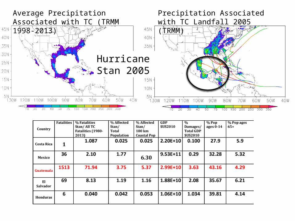
Hurricane Stan 2005
Average Precipitation Associated with TC (TRMM 1998-2013)
Precipitation Associated with TC Landfall 2005 (TRMM)


Future Research Goals:
• Investigate precedent and antecedent soil moisture conditions to assess flooding potential
• Investigate topography of impacted regions to assess potential for landslide and flooding impacts
• Develop a method to account for the size of the windfield during the duration of the TC track
• Further work with investigation of impacts with respect to socio-demographic data

Questions??
References:Centre for Research on the Epidemiology of Disasters (CRED), Emergency Events Database (EM-DAT): D. Guha-Sapir, R. Below, Ph. Hoyois - EM-DAT: International Disaster Database – www.emdat.be – Université Catholique de Louvain – Brussels – Belgium.Socioeconomic Data and Applications Center (SEDAC): Center for International Earth Science Information Network - CIESIN - Columbia University: National Aggregates of Geospatial Data Collection: Population, Landscape, And Climate Estimates, Version 3 (PLACE III), 2012. World Bank Data: http://web.worldbank.org/WBSITE/EXTERNAL/0,,contentMDK:22547097~pagePK:50016803~piPK:50016805~theSitePK:13,00.html Davidson, Rachel A., and Kelly B. Lambert. "Comparing the hurricane disaster risk of US coastal counties." Natural Hazards Review 2.3 (2001): 132-142.Raghavan, S., and S. Rajesh. "Trends in tropical cyclone impact: A study in Andhra Pradesh, India." Bulletin of the American Meteorological Society 84.5 (2003): 635-644.Center, Canadian Hurricane, et al. "SEVENTH INTERNATIONAL WORKSHOP ON TROPICAL CYCLONES.”Mallick, Bishawjit, Khan Rubayet Rahaman, and Joachim Vogt. "Coastal livelihood and physical infrastructure in Bangladesh after cyclone Aila." Mitigation and Adaptation Strategies for Global Change 16.6 (2011): 629-648.