deir al 'asal al fauqa - applied research institute ...vprofile.arij.org/hebron/pdfs/deir al...
TRANSCRIPT
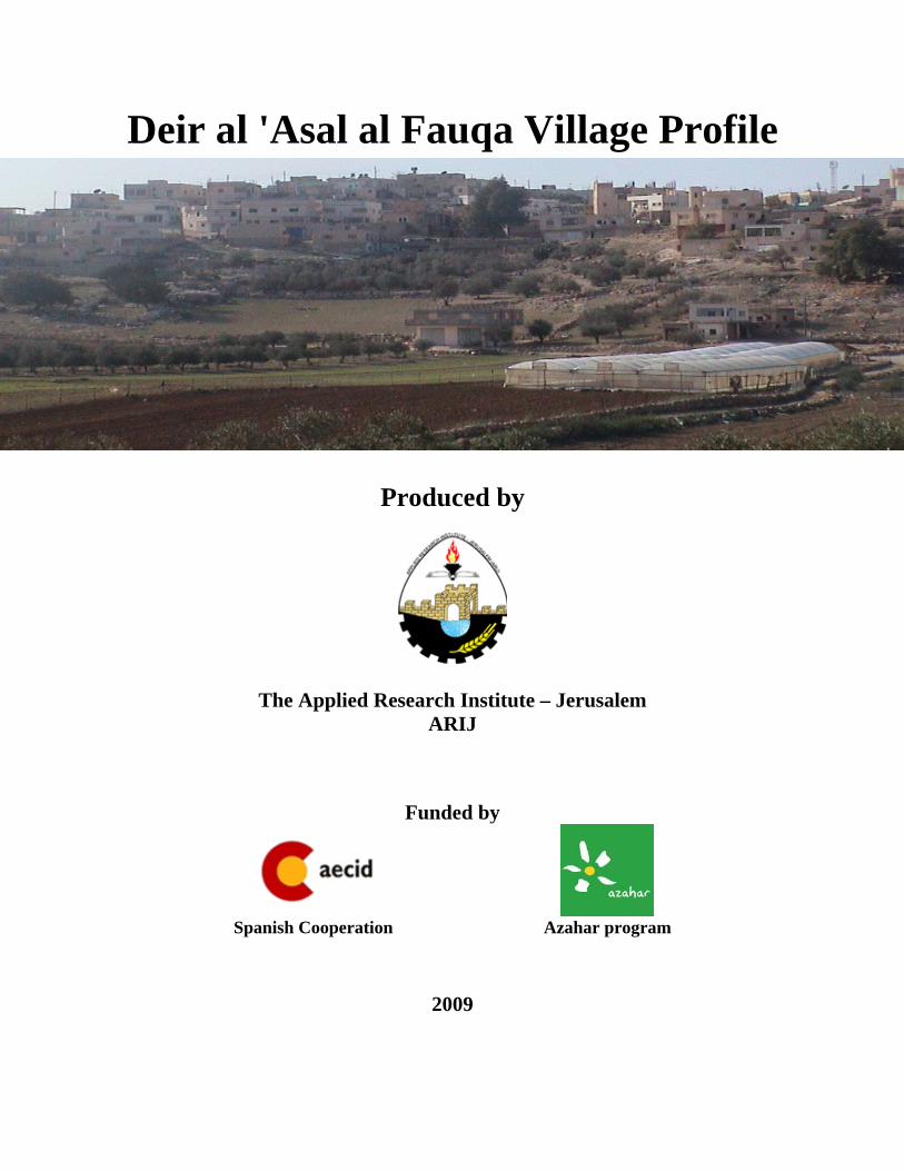
Deir al 'Asal al Fauqa Village Profile
Produced by
The Applied Research Institute – Jerusalem ARIJ
Funded by
Spanish Cooperation Azahar program
2009
Palestinian Localities Study Hebron Governorate
1
Acknowledgments ARIJ hereby expresses its deep gratitude to the Spanish Agency for International Cooperation for Development (AECID) for their funding of this project through the Azahar Program. ARIJ is grateful to the Palestinian officials in the ministries, municipalities, joint services councils, village committees and councils, and the Palestinian Central Bureau of Statistics (PCBS) for their assistance and cooperation with the project team members during the data collection process.
ARIJ also thanks all the staff who worked throughout the past couple of years towards the accomplishment of this work.
Palestinian Localities Study Hebron Governorate
2
Background
This booklet is part of a series of booklets, which contain compiled information about each city, town, and village in Hebron Governorate. These booklets come as a result of a comprehensive study of all localities in Hebron Governorate, which aims at depicting the overall living conditions in the governorate and presenting developmental plans to assist in developing the livelihood of the population in the area. It was accomplished through the 'Village Profiles and Azahar Needs Assessment'; a project funded by the Spanish Agency for International Cooperation for Development (AECID) and the Azahar Program. The 'Village Profiles and Azahar Needs Assessment' was designed to study, investigate, analyze and document the socio-economic conditions and the needed programs and activities to mitigate the impact of the current unsecure political, economic and social conditions in Hebron Governorate with particular focus on the Azahar program objectives and activities concerning water, environment, and agriculture. The project's objectives are to survey, analyze and document the available natural, human, socioeconomic and environmental resources, and the existing limitations and needs assessment for the development of the rural and marginalized areas in Hebron Governorate. In addition, the project aims at preparing strategic developmental programs and activities to mitigate the impact of the current political, social, and economic instability with the focus on the agricultural sector. All locality profiles in Arabic and English are available online at http://proxy.arij.org/vprofile/

Palestinian Localities Study Hebron Governorate
3
Table of Contents
Location and Physical Characteristics _____________________________________________4
History_______________________________________________________________________5
Religious and Archaeological Sites ________________________________________________5
Demography and Population _____________________________________________________6
Education ____________________________________________________________________7
Health Status _________________________________________________________________8
Economy _____________________________________________________________________8
Agricultural Sector_____________________________________________________________9
Institutions and Services _______________________________________________________11
Infrastructure and Natural Resources ____________________________________________11
Impact of the Israeli Occupation _________________________________________________12
Development Plans and Projects _________________________________________________12
Locality Development Priorities and Needs ________________________________________13
References___________________________________________________________________14

Palestinian Localities Study Hebron Governorate
4
Deir al 'Asal al Fauqa Village Profile
Location and Physical Characteristics Deir al ‘Asal al Fauqa is a village in the Dura area which is located 30 kilometers southwest of the City of Hebron, in the southern part West Bank. It is bordered by Deir al ‘Asal at Tahta and Iskeik to the east and north, Beit ar Rush at Tahta village to the south and 1949 Armistice Line (the Green Line) and Segregation Wall to the west.
Map 1: Deir al ‘Asal al Fauqa location and borders
The total area of Deir al ‘Asal al Fauqa village is approximately 5,500 dunums, of which 550 dunums are Palestinian built-up areas, 1,900 dunums are agricultural land, 40 dunums are forest and 2000 dunums are open spaces.300 dunums also include areas confiscated by the Israeli Forces for construction of the segregation wall. The village council has instigated a plan for the use of approximately 90 dunums of the village land.

Palestinian Localities Study Hebron Governorate
5
Deir al ‘Asal al Fauqa lies at an elevation of 462 m above sea level. The mean annual rainfall in Deir al ‘Asal al Fauqa village is 436 mm; the average annual temperature is 16 oC, and the average annual humidity is 61 % (ARIJ GIS). Deir al ‘Asal al Fauqa is considered to be a rural area. The village is governed by a village council, consisting of seven members, established in 1998. The council was established to offer infrastructural services including, water, electricity, solid waste disposal, and the surfacing of roads. This was coupled with educational services including school restoration. In addition, the council is responsible for the administration of plans and projects for the village.
History Deir al ‘Asal al Fauqa is an ancient village , the name of the village is derived from the word “Honey”, as historically, village residents used to keep bees and produce honey. Village officials remark that most of the families in the village have roots to the Arabian Peninsula from the Shamar tribe.
Photo of Deir al Asal al ‘Fauqa
Religious and Archaeological Sites There is one mosque in the village: Al Farouq - Deir al ‘Asal al Fauqa Mosque. In term of archaeological sites, Al Bayara region dates back to the Roman era.
Palestinian Localities Study Hebron Governorate
6
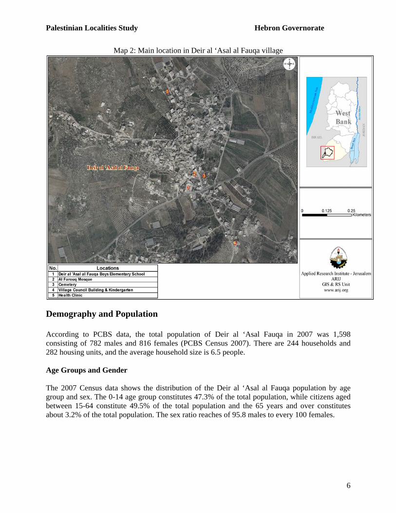
Map 2: Main location in Deir al ‘Asal al Fauqa village
Demography and Population According to PCBS data, the total population of Deir al ‘Asal Fauqa in 2007 was 1,598 consisting of 782 males and 816 females (PCBS Census 2007). There are 244 households and 282 housing units, and the average household size is 6.5 people. Age Groups and Gender The 2007 Census data shows the distribution of the Deir al ‘Asal al Fauqa population by age group and sex. The 0-14 age group constitutes 47.3% of the total population, while citizens aged between 15-64 constitute 49.5% of the total population and the 65 years and over constitutes about 3.2% of the total population. The sex ratio reaches of 95.8 males to every 100 females.
Palestinian Localities Study Hebron Governorate
7
Families The residents of Deir al ‘Asal al Fauqa village consist of eight families, these families are: Al Dardoun, ‘Elyan, Abu Hashem, Musleh, Ba’ra, Al ‘Urqan, Al ‘Awawda, Qteyna. Migration According to data collected from Deir al ‘Asal al Fauqa village council, there have been 10 cases of emigration as a result of the existing political and economic situation.
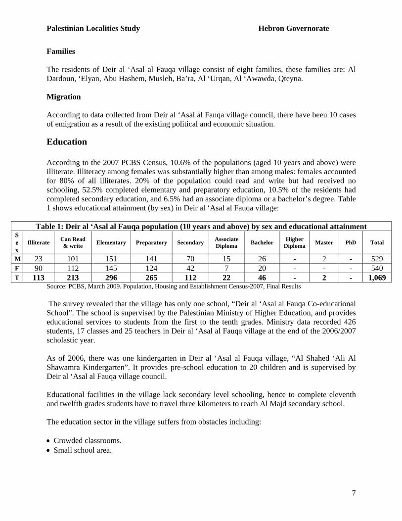
Education According to the 2007 PCBS Census, 10.6% of the populations (aged 10 years and above) were illiterate. Illiteracy among females was substantially higher than among males: females accounted for 80% of all illiterates. 20% of the population could read and write but had received no schooling, 52.5% completed elementary and preparatory education, 10.5% of the residents had completed secondary education, and 6.5% had an associate diploma or a bachelor’s degree. Table 1 shows educational attainment (by sex) in Deir al ‘Asal al Fauqa village:
Table 1: Deir al ‘Asal al Fauqa population (10 years and above) by sex and educational attainment Sex
Illiterate Can Read & write Elementary Preparatory Secondary Associate
Diploma Bachelor Higher Diploma Master PhD Total
M 23 101 151 141 70 15 26 - 2 - 529 F 90 112 145 124 42 7 20 - - - 540 T 113 213 296 265 112 22 46 - 2 - 1,069
Source: PCBS, March 2009. Population, Housing and Establishment Census-2007, Final Results The survey revealed that the village has only one school, “Deir al ‘Asal al Fauqa Co-educational School”. The school is supervised by the Palestinian Ministry of Higher Education, and provides educational services to students from the first to the tenth grades. Ministry data recorded 426 students, 17 classes and 25 teachers in Deir al ‘Asal al Fauqa village at the end of the 2006/2007 scholastic year. As of 2006, there was one kindergarten in Deir al ‘Asal al Fauqa village, “Al Shahed ‘Ali Al Shawamra Kindergarten”. It provides pre-school education to 20 children and is supervised by Deir al ‘Asal al Fauqa village council. Educational facilities in the village lack secondary level schooling, hence to complete eleventh and twelfth grades students have to travel three kilometers to reach Al Majd secondary school. The education sector in the village suffers from obstacles including: • Crowded classrooms. • Small school area.
Palestinian Localities Study Hebron Governorate
8
Health Status Deir al ‘Asal al Fauqa is served by a governmental health clinic and two private physician clinics. In addition, there is one pharmacy and medical laboratory centre providing services for patients. Village residents are forced to travel 30 kilometers to reach Hebron City or 15 kilometers to reach Dura City so as to access hospitals or health centers. The health services in the village are suffering from many problems including: • Shortage of health services. • Lack of ambulances. • Distance from the Hebron city
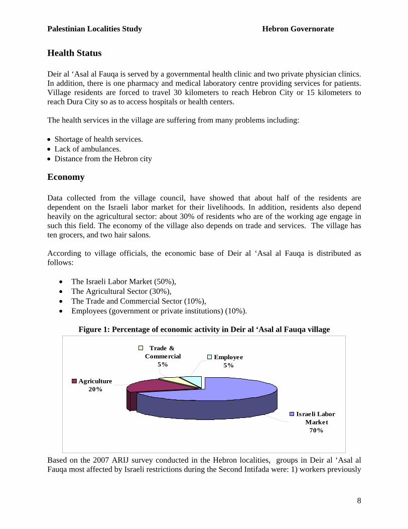
Economy Data collected from the village council, have showed that about half of the residents are dependent on the Israeli labor market for their livelihoods. In addition, residents also depend heavily on the agricultural sector: about 30% of residents who are of the working age engage in such this field. The economy of the village also depends on trade and services. The village has ten grocers, and two hair salons. According to village officials, the economic base of Deir al ‘Asal al Fauqa is distributed as follows:
• The Israeli Labor Market (50%), • The Agricultural Sector (30%), • The Trade and Commercial Sector (10%), • Employees (government or private institutions) (10%).
Figure 1: Percentage of economic activity in Deir al ‘Asal al Fauqa village
Employee5%
Trade & Commercial
5%
Agriculture20%
Israeli Labor Market
70%
Based on the 2007 ARIJ survey conducted in the Hebron localities, groups in Deir al ‘Asal al Fauqa most affected by Israeli restrictions during the Second Intifada were: 1) workers previously
Palestinian Localities Study Hebron Governorate
9
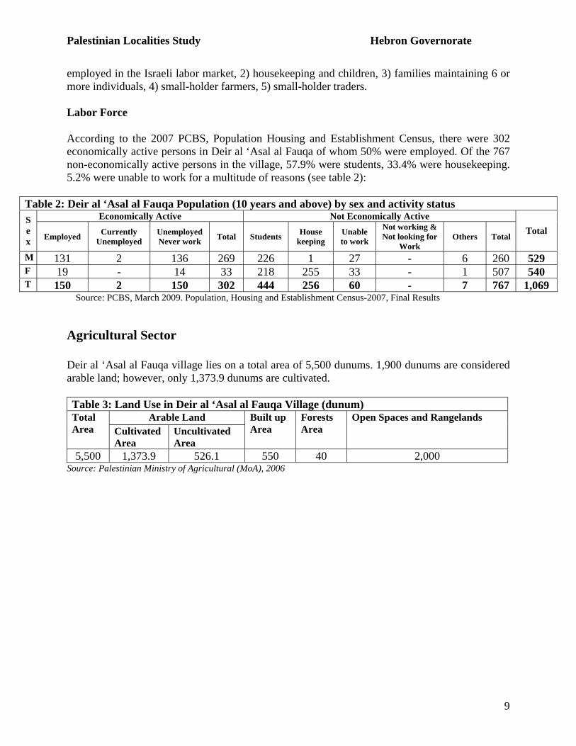
employed in the Israeli labor market, 2) housekeeping and children, 3) families maintaining 6 or more individuals, 4) small-holder farmers, 5) small-holder traders. Labor Force According to the 2007 PCBS, Population Housing and Establishment Census, there were 302 economically active persons in Deir al ‘Asal al Fauqa of whom 50% were employed. Of the 767 non-economically active persons in the village, 57.9% were students, 33.4% were housekeeping. 5.2% were unable to work for a multitude of reasons (see table 2):
Table 2: Deir al ‘Asal al Fauqa Population (10 years and above) by sex and activity status Economically Active Not Economically Active S
ex Employed Currently
Unemployed Unemployed Never work Total Students House
keeping Unable to work
Not working & Not looking for
Work Others Total
Total
M 131 2 136 269 226 1 27 - 6 260 529 F 19 - 14 33 218 255 33 - 1 507 540 T 150 2 150 302 444 256 60 - 7 767 1,069
Source: PCBS, March 2009. Population, Housing and Establishment Census-2007, Final Results
Agricultural Sector Deir al ‘Asal al Fauqa village lies on a total area of 5,500 dunums. 1,900 dunums are considered arable land; however, only 1,373.9 dunums are cultivated. Table 3: Land Use in Deir al ‘Asal al Fauqa Village (dunum)
Arable Land Total Area Cultivated
Area Uncultivated Area
Built up Area
Forests Area
Open Spaces and Rangelands
5,500 1,373.9 526.1 550 40 2,000 Source: Palestinian Ministry of Agricultural (MoA), 2006
Palestinian Localities Study Hebron Governorate
10
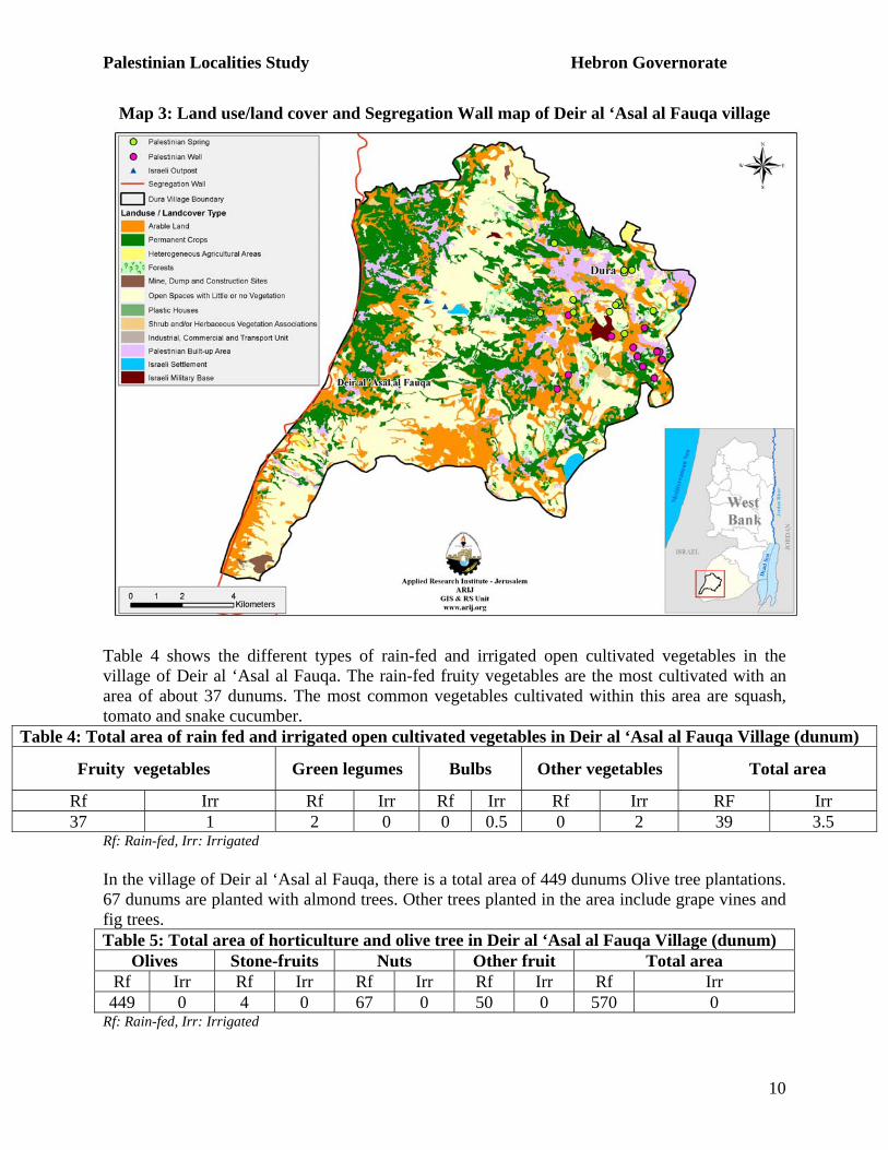
Map 3: Land use/land cover and Segregation Wall map of Deir al ‘Asal al Fauqa village
Table 4 shows the different types of rain-fed and irrigated open cultivated vegetables in the village of Deir al ‘Asal al Fauqa. The rain-fed fruity vegetables are the most cultivated with an area of about 37 dunums. The most common vegetables cultivated within this area are squash, tomato and snake cucumber.
Table 4: Total area of rain fed and irrigated open cultivated vegetables in Deir al ‘Asal al Fauqa Village (dunum)
Fruity vegetables Green legumes Bulbs Other vegetables Total area
Rf Irr Rf Irr Rf Irr Rf Irr RF Irr 37 1 2 0 0 0.5 0 2 39 3.5
Rf: Rain-fed, Irr: Irrigated In the village of Deir al ‘Asal al Fauqa, there is a total area of 449 dunums Olive tree plantations. 67 dunums are planted with almond trees. Other trees planted in the area include grape vines and fig trees. Table 5: Total area of horticulture and olive tree in Deir al ‘Asal al Fauqa Village (dunum)
Olives Stone-fruits Nuts Other fruit Total area Rf Irr Rf Irr Rf Irr Rf Irr Rf Irr 449 0 4 0 67 0 50 0 570 0
Rf: Rain-fed, Irr: Irrigated
Palestinian Localities Study Hebron Governorate
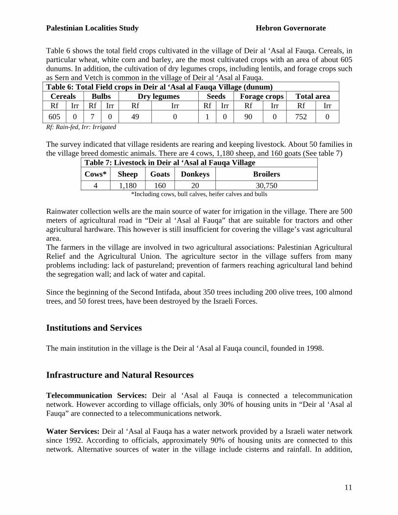
11
Table 6 shows the total field crops cultivated in the village of Deir al ‘Asal al Fauqa. Cereals, in particular wheat, white corn and barley, are the most cultivated crops with an area of about 605 dunums. In addition, the cultivation of dry legumes crops, including lentils, and forage crops such as Sern and Vetch is common in the village of Deir al ‘Asal al Fauqa. Table 6: Total Field crops in Deir al ‘Asal al Fauqa Village (dunum)
Cereals Bulbs Dry legumes Seeds Forage crops Total area Rf Irr Rf Irr Rf Irr Rf Irr Rf Irr Rf Irr 605 0 7 0 49 0 1 0 90 0 752 0
Rf: Rain-fed, Irr: Irrigated The survey indicated that village residents are rearing and keeping livestock. About 50 families in the village breed domestic animals. There are 4 cows, 1,180 sheep, and 160 goats (See table 7)
Table 7: Livestock in Deir al ‘Asal al Fauqa Village Cows* Sheep Goats Donkeys Broilers
4 1,180 160 20 30,750 *Including cows, bull calves, heifer calves and bulls
Rainwater collection wells are the main source of water for irrigation in the village. There are 500 meters of agricultural road in “Deir al ‘Asal al Fauqa” that are suitable for tractors and other agricultural hardware. This however is still insufficient for covering the village’s vast agricultural area. The farmers in the village are involved in two agricultural associations: Palestinian Agricultural Relief and the Agricultural Union. The agriculture sector in the village suffers from many problems including: lack of pastureland; prevention of farmers reaching agricultural land behind the segregation wall; and lack of water and capital. Since the beginning of the Second Intifada, about 350 trees including 200 olive trees, 100 almond trees, and 50 forest trees, have been destroyed by the Israeli Forces.
Institutions and Services The main institution in the village is the Deir al ‘Asal al Fauqa council, founded in 1998.
Infrastructure and Natural Resources Telecommunication Services: Deir al ‘Asal al Fauqa is connected a telecommunication network. However according to village officials, only 30% of housing units in “Deir al ‘Asal al Fauqa” are connected to a telecommunications network. Water Services: Deir al ‘Asal al Fauqa has a water network provided by a Israeli water network since 1992. According to officials, approximately 90% of housing units are connected to this network. Alternative sources of water in the village include cisterns and rainfall. In addition,

Palestinian Localities Study Hebron Governorate
12
there is spring in the village of “Al Bayara”, used solely for domestic purposes. A further water reservoir has an additional capacity of 400 cubic meters. The village suffers from water deficit. Electricity Networks: The Israeli National Power Electricity Company (Qutria) supplies approximately 95% of the village’s housing units, and has done so since 1993. Problems include weak current as well as the need for repair for the aging system. Sewage Disposal Facilities: The village is not connected to the mains sewage disposal network. Wastewater is disposed of in cesspits. Solid Waste Collection Services: There are no solid waste management services in the village. Each family is responsible for its own garbage disposal. Transportation Facilities: The village is served by ten taxis, and one bus belonging to the Front Line Transportation Company. The bus serves many of the villages in the west of the Hebron Governorate. Village officials cite the primary obstacle to village transportation as a lack of maintained main roads. In terms of road quality: 1,000 meters of main roads are surfaced and in good condition; 2,000 meters are unpaved internal roads; 500 meters of agricultural roads are unpaved.
Impact of the Israeli Occupation Though the village of Deir al ‘Asal al Fauqa is free from settlement developments, it nevertheless suffers from many of the effects of the occupation that plague other villages throughout the West Bank. Four metal gates have been installed that prevent access to agriculture lands and there has been many incidents of the uprooting of fruiting trees (especially the olive trees). In addition, there are two bypass roads. Village estimates suggest that about 120 families have experienced substantial loss or damage to their agricultural productivity. The construction of the segregation wall to the north and west of the village began in 2004. A five kilometer portion (wire and concrete type) has been constructed and further 10 kilometers awaits construction. The path of wall has resulted in the confiscation of 300 dunums of village land. Approximately 20 dunums of land has been isolated behind the wall. 200 trees have already been destroyed by the Israeli Forces to construct the segregation wall. One house has already been demolished and three houses, near the wall, have been served with military demolition orders.
Development Plans and Projects Deir al ‘Asal al Fauqa village council has implemented many projects since 2004, these include:
Table 8: Development plans and projects in Deir al ‘Asal al Fauqa village No. Project name Type Funded by 1 Rehabilitation of water network Infrastructure UNDP 2 Paved new roads Infrastructure PECDAR 3 Construct water reservoir Infrastructure OXFAM
Palestinian Localities Study Hebron Governorate
13
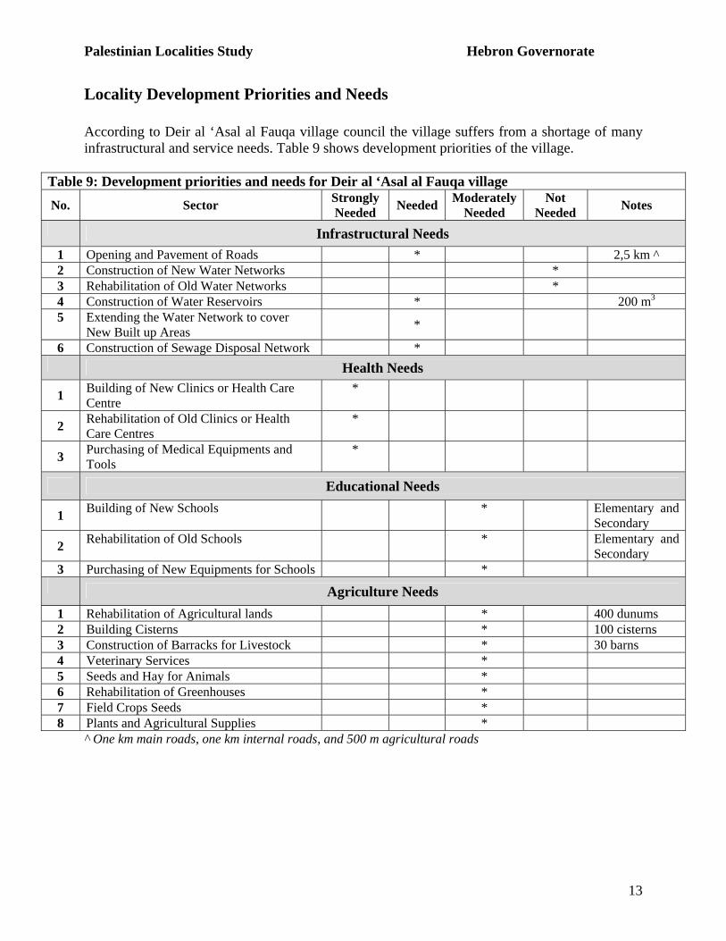
Locality Development Priorities and Needs According to Deir al ‘Asal al Fauqa village council the village suffers from a shortage of many infrastructural and service needs. Table 9 shows development priorities of the village.
Table 9: Development priorities and needs for Deir al ‘Asal al Fauqa village No. Sector Strongly
Needed Needed Moderately Needed
Not Needed Notes
Infrastructural Needs 1 Opening and Pavement of Roads * 2,5 km ^ 2 Construction of New Water Networks * 3 Rehabilitation of Old Water Networks * 4 Construction of Water Reservoirs * 200 m3 5 Extending the Water Network to cover
New Built up Areas *
6 Construction of Sewage Disposal Network * Health Needs
1 Building of New Clinics or Health Care Centre
*
2 Rehabilitation of Old Clinics or Health Care Centres
*
3 Purchasing of Medical Equipments and Tools
*
Educational Needs
1 Building of New Schools * Elementary and Secondary
2 Rehabilitation of Old Schools * Elementary and Secondary
3 Purchasing of New Equipments for Schools * Agriculture Needs
1 Rehabilitation of Agricultural lands * 400 dunums 2 Building Cisterns * 100 cisterns 3 Construction of Barracks for Livestock * 30 barns 4 Veterinary Services * 5 Seeds and Hay for Animals * 6 Rehabilitation of Greenhouses * 7 Field Crops Seeds * 8 Plants and Agricultural Supplies *
^ One km main roads, one km internal roads, and 500 m agricultural roads
Palestinian Localities Study Hebron Governorate
14
References:
- Applied Research Institute – Jerusalem (ARIJ). GIS Database. 2006-2009. - Ministry of Agriculture. Agricultural Status Database in Hebron Governorate. 2006.
- Ministry of Higher Education. Educational Status Database. 2006-2007.
- Palestinian Central Bureau of Statistics. Population, Housing and Establishment
Census- Final Results. Ramallah, Palestine. 1997 -2007.