decision support system for forest fire protection … › publication ›...
TRANSCRIPT

ORIGINAL PAPER
Decision support system for forest fire protectionin the Euro-Mediterranean region
Kostas Kalabokidis • Gavriil Xanthopoulos •
Peter Moore • David Caballero • George Kallos •
Juan Llorens • Olga Roussou • Christos Vasilakos
Received: 5 March 2009 / Revised: 27 October 2010 / Accepted: 20 May 2011
� Springer-Verlag 2011
Abstract This paper describes the development of a
decision support system (DSS) for prevention planning and
emergency management of forest fire events that incorpo-
rates weather data management, a geographical data
viewer, a priori danger forecasting and fire propagation
modeling, automatic fire detection, and optimal resource
dispatching. Collection, input, storage, management, and
analysis of the information rely on advanced and auto-
mated methodologies using remote sensing, GPS, digital
mapping, and geographic information systems. The results
included short-term dynamic fire danger indices developed
for improved and realistic prevention and pre-suppression
planning. An automatic fire detection technology based on
infrared video was developed and successfully tested on
site. Several models for understanding fire propagation on
forest fires have been proposed for practical application.
Additionally, a DSS was developed with the innovation of
covering wildland fire hazard management entirely, pro-
viding a complete coverage of technical and administrative
activities that support decision makers in real time. The
DSS was tested for high fire seasons in two different sites
in South Europe.
Keywords Forest fire management � Risk management �Decision support systems � Geographic information
systems � Natural disasters
Introduction
Forest fires constitute one of the most devastating natural
disasters in South Europe, North America, and Australia
where large areas are affected annually with very large
variations in fire seasons–such as occurred from 2003
through 2008. Difficulties in confronting such natural
phenomena, especially in the Euro-Mediterranean region,
include assessment of biophysical causes, spatial distribu-
tion, damage inflicted and also the influence of human
socioeconomic activities (e.g., Gonzalez and Pukkala 2007;
Sebastian-Lopez et al. 2008). Regional civil protection
agencies require the efficient combination of interdisci-
plinary research, technology and development of system-
atic risk, hazard and vulnerability assessment (Chen et al.
2003), along with prompt and reliable forecasting and
In memoriam: Forestry Professor Nikolaos I. Stamou, Greece.
Communicated by W. Warkotsch.
K. Kalabokidis (&) � O. Roussou � C. Vasilakos
Department of Geography, University of the Aegean,
81100 Mytilene, Greece
e-mail: [email protected]
G. Xanthopoulos
NAGREF, Institute of Mediterranean Forest Ecosystems
and Forest Products Technology, Terma Alkmanos,
11528 Athens, Greece
P. Moore
Climate, Fire and Natural Resources Consulting,
14 Jeanette Street, East Ryde, NSW 2113, Australia
D. Caballero
TECNOMA S.A., Area of Forest Ecosystems, Isla del Hierro 7,
San Sebastian de los Reyes, 28700 Madrid, Spain
G. Kallos
Department of Physics, National & Kapodistrian
University of Athens, 15784 Athens, Greece
J. Llorens
Department of Informatics, University Carlos III of Madrid,
Leganes, 28911 Madrid, Spain
123
Eur J Forest Res
DOI 10.1007/s10342-011-0534-0

management systems (Deeming et al. 1977; Hoffmann
et al. 1999; Taylor and Alexander 2006; Van Wagner
1987). New technologies of geo-informatics (e.g., global
positioning systems, digital mapping, geographic infor-
mation systems, and spatial decision support systems) and
electronic data capture and transmission of information
from remote locations (e.g., remote sensing, remote auto-
matic weather stations, automated detection sensors, etc.)
have strong potential to contribute to more effective
organization for environmental protection. Benefits include
prompt detection and risk assessment, methodical obser-
vation of biophysical and socioeconomic parameters, and
decision support management (Bonazountas et al. 2007;
Kaloudis et al. 2005; Lee et al. 2002; Morehouse et al.
2006).
The Automated Fire and Flood Hazard Protection
System (AUTO-HAZARD PRO)–a European Union-funded
research project–has been designed to improve the level of
technological development on forest fire risk management
in Europe and help authorities in taking appropriate action
to protect the built and natural environment (Kalabokidis
2004). The main objective of our research was to integrate
real-time and on-line wildland fire hazard management
approaches into a geographic information system (GIS)
platform. The specific evolution reported in this article is
the development of a decision support system (DSS) that
incorporates proactive planning, weather data manage-
ment, a geographical data viewer, a priori risk forecasting
and fire propagation modeling, automatic fire detection,
optimal resource dispatching governed by the pertinent
principles, and emergency management of real-time fire
episodes (Fig. 1).
Software application, data integration, and network
infrastructure
Development of the AUTO-HAZARD PRO (AHP) DSS
prototype was conducted on two study areas in Greece and
Spain, with the potential to later encompass whole regions
of EU countries on an operational basis (Kalabokidis et al.
2005). One of the most important applications of the DSS,
when assisting managers on duty, is to help organizing on
site human and technical resources (firemen, civil protec-
tion staff, volunteers, airplanes, trucks, etc.), assigning
responsibilities, and communicating to them. The AHP
DSS was designed to support these communication capa-
bilities. Central SMS sending platforms, e-mail sending
and local area network (LAN) sending facilities were
integrated. The MobileNetControl communications plat-
form (MNC 2007) from Mobile Net Control Scandinavia
AB was integrated within the DSS. In an advancement
beyond the classical DSSs, the system included this
resource managing and dispatching module as an ‘‘Alert
Manager.’’ Most of the information managed by the pro-
gram was stored in a GIS-compatible format (maps and
layers), using standards defined by the ArcGIS software
v. 8.3 (ESRI 2007) and also used to generate, read, and
display geographical information. More specifically,
ArcObjectsTM
components were integrated into the DSS.
This solution was considered as an optimum alternative
instead of customizing the ArcGIS platform, since the
whole DSS was built from scratch with other third parties’
components also included.
Implementation, calibration, and validation of data sets,
algorithms, and software were carried out. Validation was
Fig. 1 Graphical presentation
of the AUTO-HAZARD PRODSS’s components
Eur J Forest Res
123

accomplished by selecting a combination of existing, pro-
ven models, data sets and algorithms for comparison;
testing of new algorithms and meteorological operational
activities; and systematic data gathering of real data about
different elements throughout the running of field cam-
paigns, including:
• field sampling for digital maps acquired through remote
sensing;
• actual atmospheric and weather data gathering (histor-
ical records);
• actual data of forest fire detection (experimentation);
and
• actual data of forest fires (historical, real, and exper-
imental burning).
Forest fire protection requires the use of large volumes
of data that change continuously over time and space,
creating both the need and the opportunity to automate the
tasks. Within the DSS, satellite and ground technologies
were integrated and applied using advanced geo-infor-
matics tools and models for the inventory, mapping and
monitoring of geomorphology, land cover and uses, fire
occurrence, atmospheric and physical processes, and
anthropogenic influences. Multi-spectral QuickBird satel-
lite images (2.5-m resolution) for the whole island of
Lesvos, Greece, and for the forest area within the Province
of Madrid, Spain, were used to extract useful geographical
information to study and monitor forest fires (e.g., vege-
tation and fuel types, topography, fire history, road net-
works, land-use boundaries). A database was developed
and integrated into the DSS. The database was also used as
input to various simulation models and for mapping
purposes.
The philosophy followed within the AHP project was to
create a DSS system that supports effectively its end-users
throughout the fire management process by means of a fast
and easy to use interface (Fig. 2). The interface takes
advantage of the capabilities of the diverse technologies,
models, and systems it integrates (i.e., GIS, communication
software, automatic fire detection, and fire risk index gen-
eration). This user-friendly and efficiently designed appli-
cation allows the user to view the meteorological conditions,
check the fire risk for different time horizons, simulate the
propagation of a fire or send messages to fire-fighting
resources through different communication technologies
(SMS, e-mail, and network sending). The applied method-
ology followed the standard software development guide-
lines that divide the software process into analysis, design,
implementation, and testing phases, establishing different
links and ‘‘tunnels’’ between them.
Fig. 2 A snapshot of the AUTO-HAZARD PRO DSS
Eur J Forest Res
123

Analysis
The goal was to collect and analyze the minimum
requirements necessary to be able to start designing an
application. For achieving this goal, different techniques
were used:
• personal interviews with the users/partners (person-to-
person, by phone, or by e-mail);
• documentation of requirements sent to the users/part-
ners to be completed and returned to the computer
scientists.
The result of this stage within the AHP DSS application
was a set of more than 120 requirements that the system
should comply with.
Design
Once sufficient and consistent requirements had been
identified, collected, and understood, a design was gener-
ated prior to the implementation. The design was then
optimized and checked for possible failures or flaws in the
analysis (that could lead back to the analysis phase). A set
of models containing the design of the application was
generated in UML–a standard object-oriented and multi-
purpose modeling language (UML 2007).
Implementation
Based on the design, the implementation or coding was
performed at different stages. First, prototypes were gen-
erated to be evaluated by the users. In AHP, the prototypes
were empty (without functionality) graphical user inter-
faces. These prototypes lead again to the analysis of
requirements and, in some cases, to the design phase. After
the users had validated the prototypes, the implementation
began using them as starting point. In large applications
like AHP, the program is divided into modules for the
application of one or a combination of development tech-
niques to each module in turn. A mixture between cascade
(one module is done entirely, then the next one) and
incremental (modules are completed incrementally, flow-
ing several times from the first to the last one, and
improving them in every iteration) procedures were used
during the coding of the application. If there was a test
phase after the implementation, working of modules was
evaluated and significant failures or flaws were detected
and corrected at this stage.
Testing
After the designed application was coded, different tests
were performed as follows:
• individual module tests;
• inter-module tests;
• working mode tests;
• communication with devices tests;
• graphical user interface tests; and
• overall application working tests.
The AHP DSS can be run in emergency and training
modes that are focused on dealing with real-fire cases and
training the end-users, respectively. The system was
designed in such a way that the two modes cannot be the
origin of any conflict or information inconsistency for they
work with separate sets of data. There is no overlap that
might confuse ‘‘false’’ with ‘‘real’’ alarms. Functioning of
the system has been designed to switch automatically from
training mode to emergency mode when an alert happens.
The software application offers functionalities to cover
different aspects of both pre-fire and fire event manage-
ment stages as follows:
• In the pre-fire stage, it is possible to obtain and/or
generate actual and predicted meteorological informa-
tion and fire danger indices.
• For the fire event stage, there is the automatic reception
of fire alarm information, the possibility of simulating
the evolution of a fire, getting particular dispatching
advice for each alarm, and sending messages to other
electronic devices (computers and mobile phones)
through different communication technologies.
AHP: a DSS for forest fire protection
The AHP DSS is divided into five main modules that
represent to the user different kinds of information and
perform different tasks providing support during the whole
fire management process. These modules are the: fire
weather module, fire detection module, fire danger rating
module, fire propagation simulation module, and resource
dispatching module. The final application provides capa-
bilities of simultaneous visualization of different informa-
tion (fire danger indices, available resources, and active
fires), fire alarm information management, and resource
information management.
Weather module
The weather module is based on a high-resolution limited
area weather forecasting system. Within this module, both
current and predicted meteorological maps can be created.
These maps can be displayed by clicking on the corre-
sponding link at the meteorological information tab of the
DSS. The source data for current meteorological maps can
Eur J Forest Res
123

be obtained either from FTP servers (2-D meteorological
fields) and/or remote automatic weather stations (RAWS)–
that continuously record and transmit in situ weather data.
Alternatively, data can be supplied manually through an
appropriate interface. In the current application, the pre-
dicted meteorological maps are generated from data
downloaded from the FTP server of the operational center
of the Atmospheric Modeling and Weather Forecasting
Group of the University of Athens. The weather predictions
are made with the use of a high-resolution non-hydrostatic
modeling system called SKIRON (http://forecast.uoa.gr).
The forecasting horizon is 5 days.
Figure 3 shows an example of the 72nd-hour SKIRON
forecasted wind field over Greece, together with the
meteograms (time plots of predicted variables: wind speed
and direction, temperature, relative humidity, atmospheric
pressure, and accumulated precipitation) for our study
areas. For example, the model has predicted high wind
speeds over the Aegean Sea reaching 12 and 16 m/s in
Lesvos Island (Fig. 3). Such wind conditions are often
related to severe forest fire intensity and spread (Pyne et al.
1996). Accurate predictions of forest fire behavior depend
on the spatiotemporal accuracy of wind and precipitation
forecasts provided by numerical weather prediction models
such as the SKIRON. Sensitivity analyses performed,
showed that SKIRON forecasting accuracy remained high
even during the 5th-day of forecast. Discrepancies, sys-
tematic or not, from the observations always do exist. To
remove systematic temperature and wind errors, Kalman
filtering techniques have been applied (Galanis et al. 2006).
The use of a 3rd-order polynomial in Kalman filtering gave
the best improvement in wind strength forecasting. These
corrections were done for the study areas. The forecasts
were also validated from RAWS observations.
Fire detection module
A ground-based forest fire detection (FFD) system was
developed and demonstrated in Lesvos Island, Greece, and
in Buitrago de Lozoya, Sierra de Guadarrama, Madrid,
Spain, by the TNO Physics and Electronics Laboratory of
the Netherlands (den Breejen et al. 1998; Tettelaar 2004).
The detection system consists of a multi-spectral camera on
a scanning pan-tilt unit that detects smoke via its near-
infrared channel. It also provides on-line and real-time
normalized difference vegetation index (NDVI) images
that help assess the condition of vegetation which, in turn,
is related to the level of fire risk. Within the AHP DSS,
field sensors of the fire detection system can be linked to
operational centers, where the manager evaluates the alarm
signal and the image to initiate proper response (Fig. 4).
When an alarm is raised by the system, as a result of smoke
detection, the operator can request a false color image for
visual confirmation of the fire starting. True-color images
can also be used to monitor the fire incident. The system
also has the option to provide an NDVI image real-time
and on-line for vegetation monitoring. The operations
center can then use the FFD outputs to make decisions on
Fig. 3 72nd-h SKIRON forecast of the wind field over Greece on September 6, 2004 at 12UTC (left); and meteograms for the whole 120-h
forecasting period for Lesvos (right)
Eur J Forest Res
123

dispatch them when a fire starts, to adjust patrol/control
when fire behavior changes, and to manage resources
according to fire risk.
The software and hardware of the FFD system were
tested in detail for its continuous operation and function-
ality. Initially, alarms were simulated in the TNO Physics
and Electronics Laboratory by introducing simulated smoke
into the image with various ‘‘noise’’ levels to test the alarm
detection and reduce false alarms by setting the correct
thresholds. Then, the FFD system was set up and tested
operationally on Lesvos Island, Greece in the summer of
2003 and near Madrid, Spain in the fall of 2004. Controlled
fires were lit to create smoke columns in both areas. The
distances at which fires were lit ranged from 3 to 12 km.
The Greek and Spanish end-users participated in planning
and setting up the fire experiments and were present at the
system demonstration. The trial tests were successful with a
number of fires that were detected and registered as alarms,
validating the FFD system in regard to spatial accuracy,
time detection lag, and false alarm proportion.
The DSS fire detection module demonstrated that cam-
era scanning is feasible for FFD with accurate results.
There are four main outputs with regard to the detection
accuracy of the system in the FFD system validations
(Tettelaar 2004). Firstly, detection is very accurate for
distances up to 12 km as registered in test trials. Secondly,
positional accuracy of the camera is sufficient to create a
good overlap between consecutive images. Thirdly, in
some cases, the detection is limited by the speed of the pan
and tilt unit, increasing the detection time as the system has
to scan a full round. Finally, the system generates some
false alarms in certain circumstances such as sunsets,
passing clouds, road traffic, and camera alignment and
detection grid. These problems are to be solved in future
versions of the detection algorithm.
An interesting observation is that the main challenge to
commercially exploiting the results of the FFD will not
probably be the detection accuracy of the system, although
it is important. The principle hurdle is probably the lack of
infrastructure in remote areas, especially communicating
Fig. 4 The AUTO-HAZARD PRO fire detection module: in emer-
gency mode, a process called ‘‘AlarmDetection.exe’’ is running in the
background that downloads periodically the information from the
forest fire detection system FTP server, checks the existence of
previously unregistered alarms and displays a window with the main
information and associated images for each new detection alarm
Eur J Forest Res
123

data to a control center. In our research study, this problem
was recognized and new wireless technologies, particularly
3-G mobile telephony, were proposed to bring the possi-
bility of large bandwidth communication at an affordable
price in remote areas. Such telephony allows for remotely
monitoring other sensors, like weather stations, as well.
This information could then be used to improve predictions
and risk forecasts within the context of the AHP DSS.
Fire danger module
An innovative large-scale wildfire danger rating system
(WDRS) was also developed in the frame of AHP. The
main output of the WDRS is a dynamic fire danger index
(FDI) that is composed of five other indices. The FDI is
used for determining preparedness levels and also as a
critical element of the decision-making process for dis-
patching resources to a forest fire. The five indices are as
follows:
1. Fire weather index (FWI): It contains the correlation
between fire weather parameters and fire ignition and
includes meteorological conditions such as air tem-
perature, relative humidity, wind speed, and rainfall
during the previous 24 h from the time the index is
calculated. It is based on data received by RAWS and
the SKIRON weather forecasting system.
2. Fire hazard index (FHI): It is based on topography and
vegetation and includes fuel models, 10-h fuel mois-
ture content, terrain elevation, and aspect.
3. Fire risk index (FRI): It refers to the fire risk at a
particular area due to human presence. It is based on
the distance from anthropogenic structures and activ-
ities. The role of this index is to predict human-caused
fires by accident or arson.
4. Fire ignition index (FII) is a composite index repre-
senting the accumulated ignition risk of an area that is
the probability of a fire starting based on the fire
weather, hazard and risk indices.
5. Fire behavior index (FBI) is based on topography,
weather, and forest fuel of the study areas. The role of
this index is to characterize the probability of a fire to
spread after ignition.
These indices are not a relative probability for fire
occurrence but a cumulative analysis for fire danger
appraisal in a systematic manner. The parameters have
been chosen in a defined and measured way to be easily
included in an operational system. The functional mapping
of the FWI, FHI, and FRI was accomplished with artificial
neural networks (ANN) (Rosenblatt 1958; Vasilakos et al.
2007). Training of ANN was based on historical fire
data and was performed using an error back-propagation
algorithm (Rumelhart and McClelland 1986). These
methodologies have been proven useful for classification
and function approximation/mapping problems that are
tolerant of some imprecision and have been used in spatial
prediction of fire ignition probabilities (e.g., Chuvieco et al.
1999; Vasconcelos et al. 2001; Vega-Garcia et al. 1996).
The FII is composed of the FWI, FHI, and FRI by using
multi-criteria analysis (Vasilakos et al. 2007). More spe-
cifically, the analytical hierarchy process is used to retrieve
the weights by pair-wise comparisons between indices
using a relative importance scale (Saaty 1980). Validation
of the FII was performed during the summer of 2004 in the
study area of Lesvos Island to verify its effectiveness under
operational conditions. The validation included interpreta-
tion of the outputs by the end-users, operation of the system
by non-expert staff, the processing time and communica-
tion reliability among the system, the meteorological sta-
tions via cellular GPRS connections, and the FTP server
that stored the weather forecast data. During this phase,
validation of the output provided satisfying results
regarding fire problems in the study area (Vasilakos et al.
2007) including:
• Fire occurrence depended mainly on human factors
(i.e., FRI), regardless of the size of burned area. This
was also confirmed by actual fire data of the local Fire
Department.
• Operational use resulted in 12 out of 28 actual fires
ignited in areas classified as medium danger and 16
actual fires ignited in high danger areas–no areas were
actually classified as having extreme danger during the
tested summer fire season.
• The FII has been suitable for mid-term forecast of
wildfire danger.
The FBI is based on topography, weather, and forest
fuels of the study area. The methodology applied for the
calculation of this index relies, first, on the estimation of
intrinsic components of potential fire that are relevant to
the potential destruction capacity and the difficulty of fire
fighting. Then, a code is developed for the calculation of
the intrinsic components of fire and the ranking of the
resulting values into broad categories. To have an inte-
grated FBI, a combination of linear intensity mapping and
rate of spread mapping was done according to criteria
obtained from fire managers and firefighters. The integrated
FDI is obtained from the estimation of the FII and the
consideration of the FBI. Within the DSS, six maps of
indices are generated for both the current day and the
following 4 days based on meteorological data: FWI, FHI,
FRI, FII, FBI, and FDI maps. The maps of fire indices can
be displayed by clicking on the corresponding link at the
Risk indices tab.
Eur J Forest Res
123
Fire propagation module
The propagation module allows the user of this DSS to
estimate the growth of a fire in a fixed amount of time and
under a set of customized meteorological and other fire
environmental factors. A ‘‘wizard’’ interface guides the
user through the steps where necessary information for the
simulation is defined. The starting point of a simulation
must be the information regarding one of the alarms stored
by the application, and the output of the simulation is in the
form of GIS-formatted layers. As new data are fed into the
system, the simulation of the initial fire front is constantly
updated. Both maps of the initial fire front and final fire
propagation are displayed simultaneously to allow the
analysis of the propagation progress.
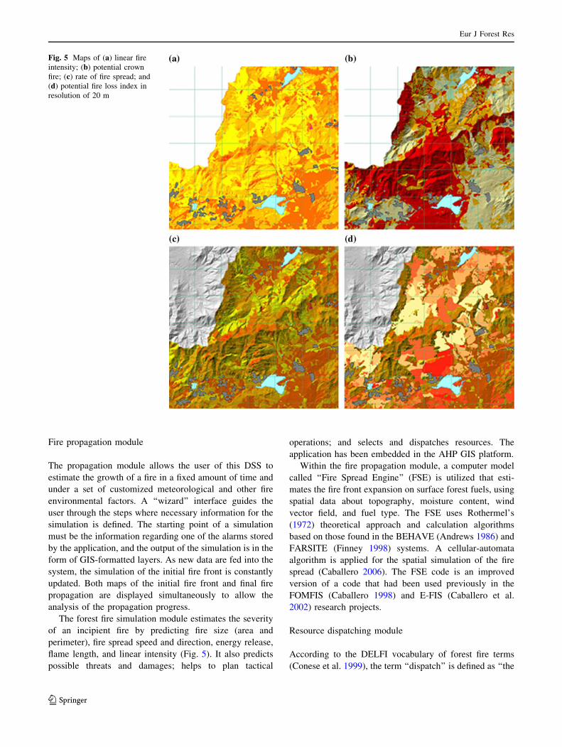
The forest fire simulation module estimates the severity
of an incipient fire by predicting fire size (area and
perimeter), fire spread speed and direction, energy release,
flame length, and linear intensity (Fig. 5). It also predicts
possible threats and damages; helps to plan tactical
operations; and selects and dispatches resources. The
application has been embedded in the AHP GIS platform.
Within the fire propagation module, a computer model
called ‘‘Fire Spread Engine’’ (FSE) is utilized that esti-
mates the fire front expansion on surface forest fuels, using
spatial data about topography, moisture content, wind
vector field, and fuel type. The FSE uses Rothermel’s
(1972) theoretical approach and calculation algorithms
based on those found in the BEHAVE (Andrews 1986) and
FARSITE (Finney 1998) systems. A cellular-automata
algorithm is applied for the spatial simulation of the fire
spread (Caballero 2006). The FSE code is an improved
version of a code that had been used previously in the
FOMFIS (Caballero 1998) and E-FIS (Caballero et al.
2002) research projects.
Resource dispatching module
According to the DELFI vocabulary of forest fire terms
(Conese et al. 1999), the term ‘‘dispatch’’ is defined as ‘‘the
Fig. 5 Maps of (a) linear fire
intensity; (b) potential crown
fire; (c) rate of fire spread; and
(d) potential fire loss index in
resolution of 20 m
Eur J Forest Res
123

act of ordering attack units and/or support units to respond
to an emergency.’’ The aim of the dispatching module of
AHP was to provide decision support for this response. It is
the part of the DSS that helps the user to determine the size
and type of resources to be sent to a particular fire. This is
the most advanced ‘‘direct’’ functionality (meaning that it
can make direct suggestions about the use of resources)
that can be offered by such a DSS. Beyond this, the
complexity and the risks involved in firefighting itself
preclude direct ‘‘decision support’’ suggestions about fire-
fighting per se. Only data and predictions (such as pre-
dicted fire behavior and fire spread simulations) can be
offered as support information from that point on. The
stakeholders are the officers at the coordination center
where the system is installed. One of their most important
tasks is to make decisions on what resources to send to
each reported or detected fire. The dispatching module of
AHP can be used operationally in support of dispatching
but can also be used for dispatcher training and for ‘‘what-
if’’ scenarios testing as part of pre-suppression planning.
Within the analysis phase of the AHP DSS, the need for
a resources management and communication module was
expressed by the end-users. The resource management and
dispatching module was designed to cope with these basic
needs of the managers. The first version of the module was
based on a stable and simple algorithm dealing with the
delimitation and identification of resources, which was
derived from expert opinion and experience of the AHP
research team. The algorithm was then adapted to the
already developed AHP information (fire indices, etc.) and
fitted to the DSS’s architecture. Eventually, the DSS
included a communication module that allowed the man-
agers to define communication channels between the
resources (every single resource defined in the system) and
the emergency management team, operating the AHP DSS
(Fig. 6). The defined communication channels were as
follows:
• SMS (mobile/cellular telephone message dispatching)
• LAN sending.
A GSM/GPRS modem attached (or equivalent mobile
phone connected through the serial port) to the computer
where the application is installed is required and makes the
system independent of third parties.
The module obtains, from the user, some information on
the conditions related to a newly reported or detected fire.
These conditions are then evaluated through a specially
developed, relatively simple algorithm (Xanthopoulos
2002). The size of ground and aerial forces needed for fire
control within a given time are then suggested by the
model, and it proposes combinations of fire trucks and
aerial means that can achieve extinction within this time.
This allows the dispatcher to select a combination that is
convenient under the existing conditions (location and
status of resources, other simultaneous fires, etc.). The
dispatcher may choose a different time-to-extinction if the
required size of resources is not available at the moment
and get a different set of combinations of resources.
Module outputs include:
• An assessment of the seriousness of the fire, on a scale
of 1–100, which can be used in tandem with general
organization protocols for specific actions that need to
be taken. For example, ‘‘if SERIOUSNESS [ 70, then
send aerial forces.’’
• An assessment of the average perimeter growth rate
(km/h).
• An assessment of effectiveness of aerial forces for the
particular topography, wind, and distance-from-water-
source conditions, as a guide for the dispatcher for
choosing the appropriate mix of resources to dispatch.
• An assessment of average fire truck effectiveness,
expressed through the fire perimeter extinction rate per
hour, under the existing fire, topography, and road
conditions.
• An estimate of the number of fire trucks needed to
control the fire without aerial support.
• An assessment if the fire can be extinguished by the
ground means in the vicinity of the fire and the length
of time needed for that. Further to this, the dispatcher is
informed if aerial means that will be dispatched at the
time of the analysis will get to the fire before it is
extinguished by the ground forces in the vicinity of the
fire performing initial attack.
• A set of potential combinations of resources that can
control the fire, in a pre-specified length of time
(hours).
Fig. 6 The AUTO-HAZARD PRO communication scheme
Eur J Forest Res
123

Discussion and conclusion
Development of the AHP system was pragmatic from the
conception phase. The system relied mainly on proven,
published models that were improved for the particular
needs where required. Exceptions were the fire danger
module (Vasilakos et al. 2007, 2009) and, to some extent,
the forest fire detection system. By using and improving
existing models, our research consortium guided its efforts
toward developing a high quality, well-designed, and
practical system that meets end-user requirements. To the
fire scientists and the experienced firefighting officers in
the consortium, it was clearly obvious that, for example,
the fire behavior prediction accuracy offered by the Fire
Spread Engine which is based on the widely used fire
spread model of Rothermel (1972) is adequate for the
intended purposes. Instead of trying to develop a new
model that would only receive limited testing, the con-
sortium opted for using this well-documented and widely
tested model for fire behavior simulation.
Similarly, the AHP weather module is based on an
existing high-resolution limited area weather forecasting
system (SKIRON). Instead of trying drastic changes in this
operational system, significant but incremental improve-
ments offered the desired accuracy without jeopardizing
AHP timely development. The upgraded SKIRON system
includes non-hydrostatic dynamics and detailed surface
energy exchange parameterization based on high resolution
land-use, vegetation cover, and soil texture. Such realistic
improvements and the use of a horizontal grid increment of
0.1� (*10 km 9 10 km) and 38 vertical layers spread up
to 50 hPa (*20 km) greatly improved SKIRON predic-
tions and better suited it for meteorological predictions
over an island such as Lesvos. Introduction of Kalman
filtering was another innovation that further improved
predictions by removing systematic temperature and wind
errors. Even the development of the new and advanced
FFD system did not start from scratch. It was built on
previous research (de Vries and Kemp 1994) and experi-
ence. These factors and the overall resources of the spe-
cialized team working on the FFD meant that the objective
to have a functional and effective FFD system at the stage
of AHP system integration was not a concern for the
consortium.
As a result, the emphasis in the development of the AHP
system was on identifying the true user requirements,
designing cleverly a system that would help in both train-
ing and operations, and producing a prototype that, through
extensive testing and demonstration, would convince the
users about its reliability and usefulness. In particular, the
incremental procedure used during the coding of the AHP
application helped in guiding the development successfully
toward the above goals.
Comparing AHP with other fire management informa-
tion systems (e.g., Butler et al. 2006; Lee et al. 2002), it is
quite clear that there are many significant differences. The
reason is mainly that fire management is a very broad
subject and includes many diverse functions. The emphasis
on which functions are needed in a fire management
information system depends a lot on the specific objectives
set by the users, which often vary significantly between
countries with different conditions.
The AHP system has been developed with Southern
European users in mind. This is where the user require-
ments were obtained, where most of the consortium part-
ners come from and where the cooperating users work. As
the AHP system is a state-of-the-art system that has
undergone significant testing in cooperation with opera-
tional users, it is believed that it has the potential to be
adopted for practical use. The consortium is making efforts
to advance in this direction, making where needed neces-
sary modifications such as translation of the user interface
in the native language of each interested organization.
Adoption of a DSS like AHP by an operational orga-
nization may initially appear as a burden to people
immediately involved because setting-up the system
necessitates additional effort to obtain the needed data and
develop the corresponding databases and GIS data layers.
However, the results can quickly prove overwhelmingly
positive as the system can greatly facilitate pre-suppression
planning and improve alertness, fire detection, and appro-
priate response. In practice, the contacts developed
between the researchers and the operational officers while
developing and testing the AHP DSS revealed an equally
important aspect of such a system. The officers learn a lot
about the problem they have to manage just by partici-
pating in the analysis procedure for system development,
by examining the information they have to collect, and
finally by evaluating the responses of the system in com-
parison to the actual evolution of incidents they handle. In
this case, the AHP DSS also worked as an effective
learning tool. Key points that led to the positive response of
the operational users who tested the AHP DSS were as
follows:
• a relatively simple and user-friendly interface;
• a manageable level of complexity;
• obvious usefulness of the functionalities offered by the
AHP DSS (pre-incident analysis, detection, and dis-
patching support); and
• efficient communication of alerts (SMS, etc.) according
to predefined rules.
Acknowledgments This research was funded by the European
Union within the RTD project ‘‘Automated Fire and Flood Hazard
Protection System/AUTO-HAZARD PRO’’ (EVG1-CT-2001-00057).
Eur J Forest Res
123

The authors would like to thank the colleagues at their respective
academic and research institutions for collaboration and the end-users
of civil protection authorities in Greece and Spain for their cooper-
ation with test and validation efforts of the system.
References
Andrews PL (1986) BEHAVE: Fire behavior prediction and fuel
modeling system–BURN Subsystem, Part 1. Gen. Tech. Rep.
INT-194. Ogden, UT: US Department of Agriculture, Forest
Service, Intermountain Forest and Range Experiment Station
Bonazountas M, Kallidromitou D, Kassomenos P, Passas N (2007) A
decision support system for managing forest fire casualties.
J Environ Manage 84:412–418
Butler BW, Finney M, Bradshaw L, Forthofer J, McHugh C, Stratton
R, Jimenez D (2006) WindWizard: a new tool for fire
management decision support In: Proceedings of the conference
on fuels management–How to measure success, Portland,
Oregon, USA. Andrews PL, Butler BW, (Comps.). RMRS-P-
41, Ogden, UT: US Department of Agriculture, Forest Service,
Rocky Mountain Research Station, pp 787–796
Caballero D (1998) FOMFIS: A computer-based system for forest fire
prevention planning. In: Viegas DX (ed) Proceedings of the 3rd
international conference on forest fire research, Luso-Coimbra,
Portugal. ADAI, Coimbra, Portugal, pp 2643–2652
Caballero D (2006) Taxicab geometry: some problems and solutions
for square grid-based fire spread simulation. In: Viegas DX (ed)
Proceedings CD of the 5th international conference on forest fire
research, Figueira da Foz, Portugal. Elsevier Publishers, Amster-
dam, p 15
Caballero D, Viegas DX, Xanthopoulos G (2002) E-FIS: an electronic
on-line decision support system for forest fires. In: Xanthopoulos
G (ed) Proceedings of the international workshop on improving
dispatching for forest fire control, Chania, Greece. Mediterra-
nean Agronomic Institute of Chania, Greece, pp 121–131
Chen K, Blong R, Jacobson C (2003) Towards an integrated approach
to natural hazards risk assessment using GIS: with reference to
bushfires. J Environ Manage 31(4):546–560
Chuvieco E, Salas J, Carvacho L, Rodrıguez-Silva F (1999)
Integrated fire risk mapping. In: Chuvieco E (ed) Remote
sensing of large wildfires in the European Mediterranean Basin.
Springer, Berlin, pp 61–100
Conese C, Eftichidis G, Guarnieri F, Lockwood FC, Moreno JM,
Vallejo R, Viegas DX, Lymberopoulos N (1999) The DELFI
vocabulary of forest fire terms. CINAR S.A, Athens, Greece
de Vries JS, Kemp RAW (1994) Results with a multi-spectral
autonomous wildfire detection system. In: Viegas DX (ed)
Proceedings of the 2nd international conference on forest fire
research, Coimbra, Portugal, pp 779–791
Deeming JE, Robert EB, Jack DC (1977) The national fire-danger
rating system–1978. Gen. Tech. Rep. INT-167. Ogden, UT: US
Department of Agriculture, Forest Service, Intermountain Forest
and Range Experiment Station
den Breejen E, Breuers M, Cremer F, Kemp R, Roos M, Schutte K, de
Vries JS (1998) Autonomous forest fire detection. In: Viegas DX
(ed) Proceedings of the 3rd international conference on forest
fire research, Luso-Coimbra, Portugal. ADAI, Coimbra, Portu-
gal, pp 2003–2012
Environmental Systems Research Institute (ESRI) (2007) Available
via ArcGIS home page http://www.esri.com/ Accessed Sept
2007
Finney MA (1998) FARSITE: fire area simulator–model develop-
ment and evaluation. Res. Pap. RMRS-RP-4, Ogden, UT: US
Department of Agriculture, Forest Service, Rocky Mountain
Research Station
Galanis G, Louka P, Katsafados P, Pytharoulis I, Kallos G (2006)
Applications of Kalman filters based on non-linear functions to
numerical weather predictions. Ann Geophys 24(10):2451–2460
Gonzalez JR, Pukkala T (2007) Characterization of forest fires in
Catalonia (north-east Spain). Eur J Forest Res 126:421–429
Hoffmann AA, Schindler L, Goldammer JG (1999) Aspects of a fire
information system for East Kalimantan, Indonesia. In: Proceed-
ings of the 3rd international symposium on Asian tropical forest
management. Samarinda, East-Kalimantan, Indonesia, pp 176–185
Kalabokidis KD (2004) Automated forest fire and flood hazard
protection system. Disaster management: linking people and the
environment. GeoInformatics Mag 7(2):14–17
Kalabokidis K, Kallos G, Karavitis C, Caballero D, Tettelaar P,
Llorens J, Vasilakos C (2005) Automated fire and flood hazard
protection system. In: De la Riva J, Perez-Cabello F, Chuvieco E
(eds) Proceedings of the 5th international workshop on remote
sensing and GIS applications to forest fire management: fire
effects assessment. Universidad de Zaragoza, Spain, pp 167–172
Kaloudis S, Tocatlidou A, Lorentzos NA, Sideridis AB, Karteris M
(2005) Assessing wildfire destruction danger: a decision support
system incorporating uncertainty. Ecol Model 181:25–38
Lee BS, Alexander ME, Hawkes BC, Lynham TJ, Stocks BJ,
Englefield P (2002) Information systems in support of wildland
fire management decision making in Canada. Comput Electron
Agr 37:185–198
MobileNetControl Platform (MNC) (2007) Available at home page
http://www.mnc.ax/ Accessed Sept 2007
Morehouse B, Christopherson G, Crimmins M, Orr B, Overpeck J,
Swetman T, Yool S (2006) Modeling interactions among
wildland fire, climate and society in the context of climatic
variability and change in the southwest US. In: Ruth M,
Donaghy K, Kirshen P (eds) Regional climate change and
variability: impacts and responses. Edward Elgar Publishing,
Northampton, pp 58–78
Pyne SJ, Andrews PL, Laven RD (1996) Introduction to wildland fire,
2nd edn. Wiley, New York
Rosenblatt F (1958) The perceptron: a probabilistic model for
information storage and organization in the brain. Psychol Rev
65:386–408
Rothermel RC (1972) A mathematical model for predicting fire
spread in wildland fuels. Res. Pap. INT-115. Ogden, UT: US
Department of Agriculture, Forest Service, Intermountain Forest
and Range Experiment Station
Rumelhart DE, McClelland JL (1986) Parallel distributed processing:
explorations in the microstructure of cognition. The MIT Press,
USA
Saaty T (1980) The analytic hierarchy process. McGraw-Hill, USA
Sebastian-Lopez A, Salvador-Civil R, Gonzalo-Jimenez J,
San-Miguel-Ayanz J (2008) Integration of socio-economic and
environmental variables for modelling long-term fire danger in
Southern Europe. Eur J Forest Res 127:149–163
Taylor SW, Alexander ME (2006) Science, technology and human
factors in fire danger rating: the Canadian experience. Int J
Wildland Fire 15:121–135
Tettelaar P (2004) Personal communication. TNO Physics and
Electronics Laboratory, Hague, Netherlands
Unified Modeling Language UML (2007) Available at home page
http://www.uml.org/ Accessed Sept 2007
Van Wagner CE (1987) Development and structure of the Canadian
Forest Fire Weather Index System. Forestry Tech. Rep. 35.
Canadian Forest Service, Ottawa
Vasconcelos MJP, Silva S, Tome M, Alvim M, Pereira JMC (2001)
Spatial prediction of fire ignition probabilities: comparing
Eur J Forest Res
123

logistic regression and neural networks. Photogramm Eng Rem S
67(1):73–81
Vasilakos C, Kalabokidis K, Hatzopoulos J, Kallos G, Matsinos I
(2007) Integrating new methods and tools in fire danger rating.
Int J Wildland Fire 16(3):306–316
Vasilakos C, Kalabokidis K, Hatzopoulos J, Matsinos I (2009)
Identifying wildland fire ignition factors through sensitivity
analysis of a neural network. Nat Hazards 50(1):125–143
Vega-Garcia C, Lee B, Wooddard T (1996) Applying neural network
technology to human-caused wildfire occurrence prediction. AI
Applications 10(3):9–18
Xanthopoulos G (2002) The DISPATCH program for the dispatching
of Canadair CL-215 and fire trucks in Greece. In: Xanthopoulos
G (ed) Proceedings of the international workshop on improving
dispatching for forest fire control, Chania, Greece. Mediterra-
nean Agronomic Institute of Chania, Greece, pp 133–141
Eur J Forest Res
123