deadline 4 submission - planning inspectorate · pdf filelabelled keyplans (submitted at...
TRANSCRIPT

Deadline 4 Submission

North Wales Wind Farm Connections
Photomontage Amendments
November 2015
The following revisions have been undertaken to amend vegetation removal not shown in the previously submitted photomontages. Where these re-visions have been undertaken within the photomontages, we have highlighted any changes in the following figures. The specific trees that have been removed have been highlighted in red and a brief description of the changes has been provided. This information has been presented ontop of the labelled keyplans (submitted at Deadline One), to provide a further layer of locational information.
For the related baseline photographs and wirelines for each viewpoints, please refer to the original photomontages (Appendix 7.3, parts A, B and C). As the wirelines show baseline topography and proposed pole locations only, these do not require to be updated.

Location Plan - 1:20,000
Reproduced from the Ordnance Survey map with the permission of Ordnance Survey ® on behalf of the Controller of Her Majesty’s Stationery Office, © Crown copyright Licence No. AR 100017362
Grid Reference: 302491, 361977Elevation: 315mViewer Height: 1.7mDistance to Nearest Pole: 654mDate & Time of Photograph: 06/02/2014 @ 14:02Horizontal Field of View: 90°Recommended viewing distance when page printed at 297 x 810mm:
400mm
Camera & Lens: Canon SLR & 50mm lens
Project Title:North Wales Wind Farms Connection
Drawing Title:Viewpoint 03: View from the junction of the B4501 east of Foel Gasyth near Bron HaulPage Size:841mm x 297mm
Date: Revision:05-12-14 001
Created:WF
Checked:KL
Approved:JC
43 42 41 40 39 38 37 36 35 34 33 32 30 28 26 24 22 20
31 29 27 25 23 21*
Labelled PhotomontageMarch 2015 Info
Distant boundary hedgerow tree removed
* There is no pole numbered 89 in the proposed scheme**60 is over 3.2km away from the viewpoint. Subsequent poles have not been numbered
Photomontage Rev 001

69
686766
58
646362616059
57 56 55 54
65
Location Plan - 1:20,000
Reproduced from the Ordnance Survey map with the permission of Ordnance Survey ® on behalf of the Controller of Her Majesty’s Stationery Office, © Crown copyright Licence No. AR 100017362
Photograph
Grid Reference: 303322, 363322Elevation: 186mViewer Height: 1.7mDistance to Nearest Pole: 91mDate & Time of Photograph: 06/02/2014 @ 09:59Horizontal Field of View: 90°Recommended viewing distance when page printed at 297 x 810mm:
400mm
Camera & Lens: Canon SLR & 50mm lens
Project Title:North Wales Wind Farms Connection
Drawing Title:Viewpoint 05: View from the B4501 south of Plas Captain, heading to PenielPage Size:841mm x 297mm
Date: Revision:05-03-15 001
Created:WF
Checked:KL
Approved:SN
Photomontage Rev 001
Labelled PhotomontageMarch 2015 Info
3Nr boundary trees removed
Location Plan - 1:20,000
Reproduced from the Ordnance Survey map with the permission of Ordnance Survey ® on behalf of the Controller of Her Majesty’s Stationery Office, © Crown copyright Licence No. AR 100017362
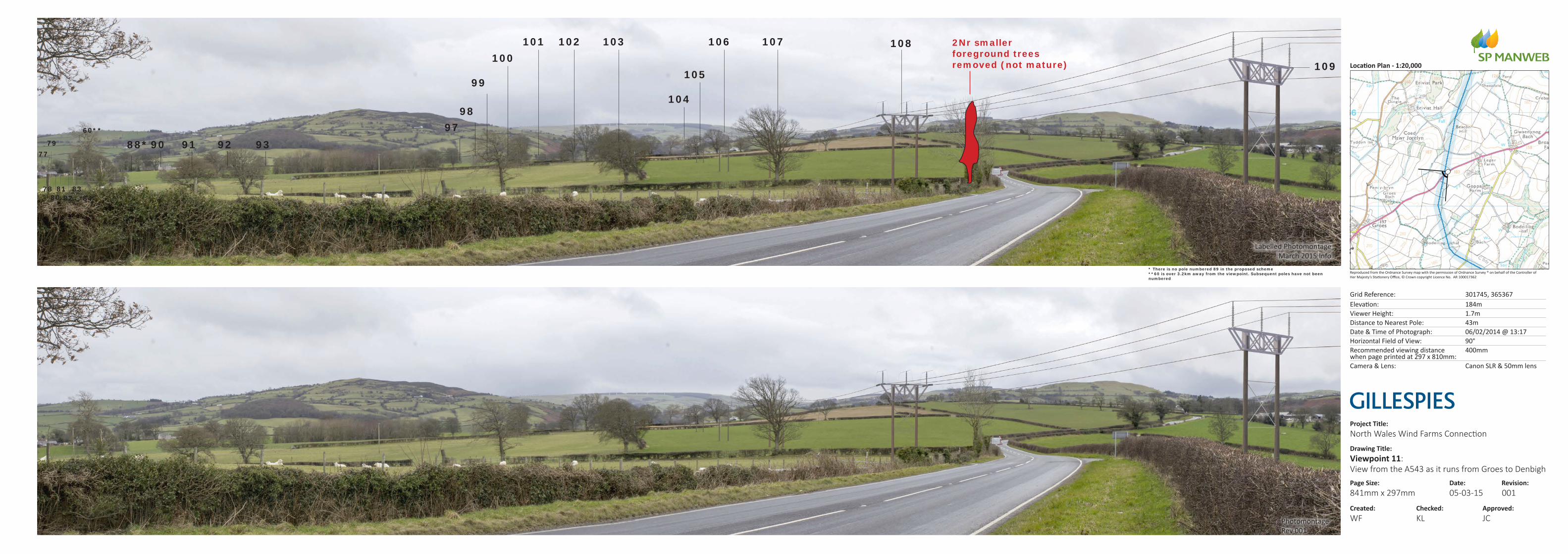
Grid Reference: 301745, 365367Elevation: 184mViewer Height: 1.7mDistance to Nearest Pole: 43mDate & Time of Photograph: 06/02/2014 @ 13:17Horizontal Field of View: 90°Recommended viewing distance when page printed at 297 x 810mm:
400mm
Camera & Lens: Canon SLR & 50mm lens
Project Title:North Wales Wind Farms Connection
Drawing Title:Viewpoint 11: View from the A543 as it runs from Groes to DenbighPage Size:841mm x 297mm
Date: Revision:05-03-15 001
Created:WF
Checked:KL
Approved:JC
108107106103102101100
99
9897
9392919088*60**
8482808381
7977
78
105
104
109
* There is no pole numbered 89 in the proposed scheme**60 is over 3.2km away from the viewpoint. Subsequent poles have not been numbered
Labelled PhotomontageMarch 2015 Info
2Nr smaller foreground trees removed (not mature)
Photomontage Rev 001