dead horse point state parkstatic.stateparks.utah.gov/plans/dhp_plan.pdf · dead horse point state...
TRANSCRIPT

Dead Horse Point State Park
Resource Management PlanApril 2007


iii

This page intentionally left blank
iiiii
Dead Horse Point State Park Resource Management Planning Team
Karl Bentley – Citizen Member, Board of Utah State Parks and Recreation
Judy Carmichael – Grand County Council Jeff Davis – Business Owner, Moab City Council, Director Grand County EMS
Marion Delay – Director, Moab Area Travel Council Cindy Hardgrave – Director, Canyonlands Natural History Association
Evan Lowry – Planner, San Juan County Kim Schappert – Business Owner, Moab Trail Alliance Lee Sjoblom – Manager, Dead Horse Point State Park
Tim Smith – SE Region Manager, Utah Division of State Parks and Recreation Russ von Koch- Recreation Branch Chief, Moab Field Office, Bureau of Land Management
Rick York – Moab Operation Manager, Intrepid Potash
Other Participants
Kim Clawson – Naturalist, Dead Horse Point State Park Jamie Dalton – Planning and Development Manager, Utah Division of State Parks and Recreation
John Good – Information Technician, Utah Division of State Parks and Recreation Vickie Houser – Publications Coordinator, Utah Division of State Parks and Recreation
Deena Loyola – Public Affairs Coordinator, Utah Division of State Parks and Recreation Bill Maughan – Planning and Development Section, Utah Division of State Parks and Recreation
Shannon Peterson – Planner, Utah Division of State Parks and Recreation Rock Smith – Research Consultant, Utah Division of State Parks and Recreation
Edie Trimmer – Planner, Utah Division of State Parks and Recreation
Administration
Mary Tullius, Director, Utah Division of State Parks and Recreation Bruce Hamilton, Deputy Director for Operations, Utah Division of State Parks and Recreation Mark Forbes, Deputy Director for Administration, Utah Division of State Parks and Recreation
Michael R. Styler, Executive Director, Utah Department of Natural Resources Robyn Pearson, Deputy Director, Utah Department of Natural Resources
Darrin Bird, Deputy Director, Utah Department of Natural Resources
iv
Acknowledgements
iii

This page intentionally left blank
viv

Figures Figure 1 Dead Horse Point State Park Visitation 1990-2005 Page 9 Figure 2 Average Monthly Visitation 1999-2005 Page 9 Figure 3 Dead Horse Point Area Geological Formations Page 11 Figure 4 Visit Description Page 17 Figure 5 Length of Stay in Park Page 17 Figure 6 Where Money was Spent Page 18
Maps Map 1 Utah State Parks and Dead Horse Point RMP Page i Map 2 Dead Horse Point State Park and Vicinity Page 35 Map 3 Dead Horse Point State Park Detail Page 37 Map 4 Potential Mountain Bike Trail Route Page 39
vi
List of Figures and Maps
v

This page intentionally left blank
viivi

Acknowledgements ...................................................................................................................... iii
List of Figures and Maps...............................................................................................................v
Executive Summary .......................................................................................................................1
Mission and Vision Statements .....................................................................................................3 Mission Statement......................................................................................................................3 Vision Statement........................................................................................................................3
Resource Management Plan Purpose and Process .....................................................................5 Purpose of the Plan ....................................................................................................................5 The Planning Process.................................................................................................................5
About the Park ..............................................................................................................................7 Park History ...............................................................................................................................7 Physical Setting and Facilities ...................................................................................................8 Climate.......................................................................................................................................8 Park Visitation ...........................................................................................................................9 Relationship to the Community and Surrounding Areas .........................................................10 Demographics and Socioeconomic Impact..............................................................................10
Park Resources.............................................................................................................................11 Visual Resources......................................................................................................................11 Geological Resources...............................................................................................................11 Biological Resources ...............................................................................................................12 Cultural Resources ...................................................................................................................14 Natural Hazards Analysis ........................................................................................................14
Visitor Survey...............................................................................................................................17 Summary of Results.................................................................................................................17
Issues and Recommendations .....................................................................................................19 Facilities and Development to Enhance Visitor Opportunities................................................19 Resource Management.............................................................................................................22 Revenue, Funding and Concessions ........................................................................................24 Marketing.................................................................................................................................26 Interpretation/Education ..........................................................................................................28
Conclusion ....................................................................................................................................29
References .....................................................................................................................................31
Maps ..............................................................................................................................................33 Dead Horse Point State Park and Vicinity...............................................................................35 Dead Horse Point State Park Detail .........................................................................................37 Potential Mountain Bike Trail Route.......................................................................................39
Appendices....................................................................................................................................41 Appendix A - Summary of Public Comments and Responses ................................................43 Appendix B - Zoological and Botanical Checklists for Dead Horse Point State Park ............47
viii
Table of Contents
vii

This page intentionally left blank
ixviii

In November 2005, representatives from the Utah Division of State Parks and Recreation met with community stakeholders from southeastern Utah to initiate a resource management planning effort for Dead Horse Point State Park. The planning process was based on public input and involvement. The Dead Horse Point State Park Resource Management Planning Team - a citizen-based team representing community leaders, interested users, local residents, neighbors, and agency representatives – was at the core of the process. The recommendations contained in this document represent several months of work by the Team as well as direct public input. The Plan provides recommendations founded upon six primary vision elements that will guide the future management of Dead Horse Point State Park. These elements focus on the following:
• Developing and maintaining facilities that offer safe and suitable recreation opportunities for visitors.
• Providing management that maintains traditional experiences, while also allowing for other appropriate types of non-traditional activities to occur in the park.
• Working with local government, businesses, citizens and other agencies to maximize the contribution of the park and staff to the State and local community.
• Protecting and preserving park resources by exercising good stewardship practices.
• Offering engaging and interesting interpretive and educational programs that enhance the visitor’s experience and appreciation of the park and surrounding landscape.
• Ensuring the Park has adequate and appropriate staff, equipment, and support.
Executive Summary
These objectives are geared towards improving and expanding the Park’s recreational opportunities, protecting its resources and providing the visitor with a safe, enjoyable experience. Achievement of these vision elements will require the continued support of users, legislative and community leaders, and the Division of State Parks and Recreation. The Planning Team issued a number of specific recommendations in support of the Plan’s vision elements. Five issue areas form the basis of the Team’s recommendations. Each issue area with its accompanying recommendations is outlined as follows: Facilities and Development to Enhance Visitor Opportunities • Improve/Expand Existing Facilities.
- Improve parking. - Replace or renovate aging facilities
and infrastructure. - Expand campground.
• Provide New Opportunities and Facilities for Visitors. - Expand and improve trail system for
hikers and bicyclists. - Consider backcountry camping and
additional group campsites. Resource Management • Protect Park Viewshed.
- Facilitate a cooperative interagency visual management plan for the viewshed area.
- Act to minimize visual impacts. - Support land trades and acquisition
to protect viewpoints. - Work with counties to put in place
light ordinances for viewshed. - Blend development into natural
setting.
1

• Protect and Manage Resources. - Minimize impact of IPS beetle on
pinion trees. Maintain range values and habitat conditions and reduce risk of wildfire.
- Inventory resources as necessary. - Acquire landlocked BLM areas in
Park. - Work with State Institutional Trust
Lands Administration (SITLA) to develop cooperative management plans for SITLA-owned mineral rights in Park.
Revenue, Funding and Concessions • Improve Revenue and Operational
Funding. - Enhance revenue in visitor center
gift shop/book store. - Develop a business plan for the Park. - Analyze impacts on staffing and
operational funding, and consider potential revenue prior to initiating new development, services, or programs.
- Investigate raising fees. - Allow the Park to keep and use a
portion of the revenue collected above the Park’s operating cost.
- Consider concession opportunities. - Determine Park’s impact on local
and state economies. - Consider alternative funding sources. - Park resources and visitor
experiences should not be compromised to increase revenue.
Marketing • Market the Park and Surrounding Area.
- Participate in the Dead Horse Mesa Scenic Byway corridor management plan.
View from Visitor Center - Develop a movie for the Park that can be used for interpretation/orientation, as well as resale and marketing.
- Create local partnerships for marketing.
- Take part in state and regional marketing efforts.
- Actively participate in Moab Information Center.
- Promote unique identity for Park. - Develop marketing plan for Park. - Support travel industry
familiarization tours to Park. - Develop reciprocating links on Park
and other websites. Interpretation/Education • Improve Existing and Offer Additional
Interpretive, Educational and Informational Programs, Exhibits, Signs, Electronic and Printed Materials. - Improve existing and provide
additional exhibits. - Improve park webpage. - Evaluate current programs, exhibits
and printed material for effectiveness.
- Conduct more “outdoor classroom” programs.
2

Mission Statement
Team Members developed the mission statement recognizing that the Park is an important provider of recreational opportunities in southeastern Utah. The Team also recognized that the Park has many unique and irreplaceable resources that need to be protected and preserved for the future, while being enjoyed by visitors. Vision Statement A vision statement is like a compass; it charts a destination, sets the Team and Park on the correct course of action, and provides the means to determine how closely the team recommendations will follow that charted course. Utilizing the basic principles developed in the mission statement, the Team developed a vision to guide the development of the Plan’s recommendations and park management for the next few years. The vision statement provides the foundation for recommendations that balance recreational demands with preservation of the Park’s natural and cultural resources, offer new and varied opportunities, and encourage community involvement.
Mission Statement
The mission of Dead Horse Point State Park is to provide a variety of quality recreational and educational opportunities to visitors, have a positive impact on the local and state economies, and promote and ensure the protection of park resources, viewshed, and environment
Vision Statement Dead Horse Point State Park will accomplish its mission by:
Developing and maintaining facilities that offer safe and suitable recreation opportunities for visitors
Providing management that maintains traditional experiences, while also allowing for other appropriate types of non-traditional activities to occur in the Park
Working with local government, businesses, citizens and other agencies to maximize the contribution of the Park and staff to the state and local community
Protecting and preserving park resources by exercising good stewardship practices
Offering engaging and interesting interpretive and educational programs that enhance the visitor’s experience and appreciation of the Park and surrounding landscape
Ensuring the Park has adequate and appropriate staff, equipment, and support
3
Mission and Vision

4
This page intentionally left blank

Purpose of the Plan This resource management plan (RMP) is intended to help guide the Utah Division of State Parks and Recreation’s (Division) stewardship obligations for Dead Horse Point State Park. Planning is essential, given the large numbers of visitors to the park, and the unique and fragile nature of the natural and cultural resources, and viewshed.
View to the East from DHP Visitor Center
Dead Horse Point State Park is located at the end of State Highway 313, an important tourist/visitor route and scenic byway that also services Canyonlands National Park. Dead Horse Point is positioned in the middle of a vast area offering a multitude of recreation sites and activities. The Park is situated within easy access of numerous national parks, monuments and recreation areas, as well as national forests, wilderness areas, other state parks, recreation sites, and attractions. In fact, the vast majority of park visitors also visit nearby Arches and Canyonlands National Parks, as well as Bureau of Land Management recreation sites. A number of issues ranging from viewshed and resource management to park operation and funding were identified by various sources. Sources include input from the Planning Team members and general public
through a public meeting and a visitor survey. Team members aggregated the issues into five distinct categories or issue areas addressing: facility and development to enhance visitor opportunities; resource management; revenue, funding and concessions; marketing; and interpretation/education. This plan and its recommendations address each of the issue areas. It provides guidelines for the management and development of the Park over the next five to ten years. More importantly, the Plan is based on a foundation of public input and consensus of the key stakeholders rather than the unilateral direction of the Division of State Parks and Recreation. The Planning Process Planning for an outstanding natural and scenic resource such as Dead Horse Point State Park is required for the protection of this unique area and to ensure the efficient and effective expenditure of state and local funds. It is necessary for the long-term protection and public enjoyment of the Park’s many opportunities and resources. This RMP is required by the Utah State Legislature and the Board of the Utah Division of State Parks and Recreation to guide short and long-term management and capital development. The Utah Division of State Parks and Recreation’s long-range strategic plan, Vision 2010, outlines the required planning actions needed to effectively meet customer recreational and leisure needs for the next five to 10 years. Vision 2010 identifies resource management planning as essential to the effective administration and operation of all parks in the agency’s system. Under the guidance of Vision 2010, each RMP is developed around one core concept: meeting
Resource Management Plan Purpose and Process
5
the needs and expectations of customers, visitors, and the citizens of the state of Utah, while protecting each park’s unique resource base. In short, the process is “customer driven and resource-based.”
Visitors on walkway to the “Point”
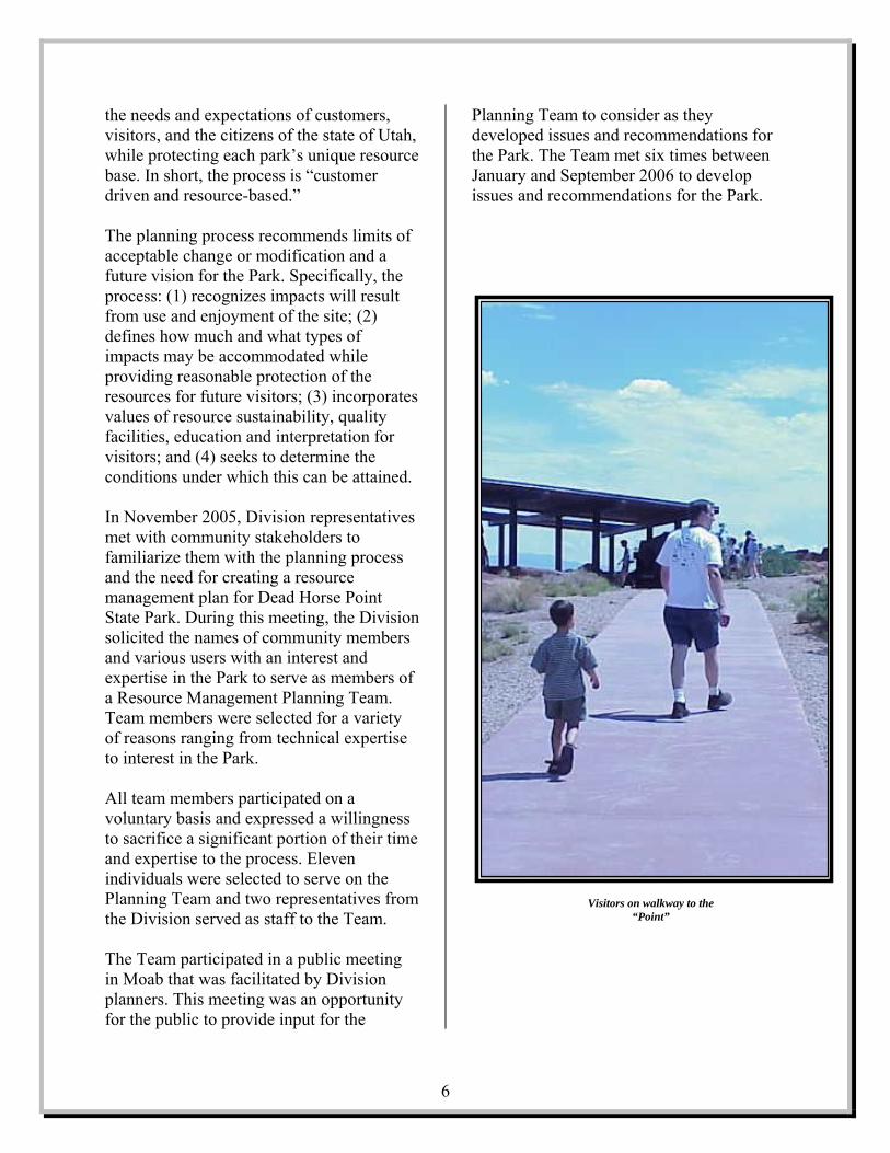
The planning process recommends limits of acceptable change or modification and a future vision for the Park. Specifically, the process: (1) recognizes impacts will result from use and enjoyment of the site; (2) defines how much and what types of impacts may be accommodated while providing reasonable protection of the resources for future visitors; (3) incorporates values of resource sustainability, quality facilities, education and interpretation for visitors; and (4) seeks to determine the conditions under which this can be attained. In November 2005, Division representatives met with community stakeholders to familiarize them with the planning process and the need for creating a resource management plan for Dead Horse Point State Park. During this meeting, the Division solicited the names of community members and various users with an interest and expertise in the Park to serve as members of a Resource Management Planning Team. Team members were selected for a variety of reasons ranging from technical expertise to interest in the Park. All team members participated on a voluntary basis and expressed a willingness to sacrifice a significant portion of their time and expertise to the process. Eleven individuals were selected to serve on the Planning Team and two representatives from the Division served as staff to the Team. The Team participated in a public meeting in Moab that was facilitated by Division planners. This meeting was an opportunity for the public to provide input for the
Planning Team to consider as they developed issues and recommendations for the Park. The Team met six times between January and September 2006 to develop issues and recommendations for the Park.
6

Park History There is evidence that humans have used the area that includes Dead Horse Point for at least 10,000 years. The earliest inhabitants, the Paleo-Indian culture, followed by the nomadic Archaic people, are known by stone tools and rock art found in the area. By 500 A.D., both the Ancestral Puebloan and Fremont peoples had settled in the area, remaining until the widespread exodus of the region by both cultures in the 1300s. These peoples foraged for native plants, hunted game such as bighorn sheep, deer, and rabbits, and grew crops of maize and beans. They used the Dead Horse Point area for hunting. The Ute and Paiute cultures may have arrived in the area as early as A.D. 800. The Navajo migrated to the area after 1300A.D. These cultures were still using the area when the first Europeans entered southeastern Utah, and are still in the general area today. The first Europeans to explore southeastern Utah were Spaniards. They entered the area searching for travel routes to the Spanish missions in California. The Old Spanish Trail that linked Santa Fe and Los Angeles traversed the Moab Valley and Moab Canyon, past the current entrance to Arches National Park. The first European settlement in the area was a result of the Mormon Church’s colonization efforts. The Mormons attempted to establish the Elk Mountain Mission in 1855, but conflicts with the Utes led them to abandon their efforts. It took until 1878 for settlers to return and establish the farming and ranching community of Moab (the gateway community for Dead Horse Point State Park). The area’s economy was based on farming, ranching and fruit growing until the uranium
boom of the 1950s brought in thousands of prospectors, miners, workers, and speculators. This boom brought new motels, stores, restaurants, schools and businesses to the area. The demand for uranium decreased, and by the 1980s this industry ceased to be an important part of the economy. The mining of potash (used as fertilizer) has been an important part of the local economy since the early 1960s. Potash is mined just east of Dead Horse Point using a solution process. The mine’s evaporation ponds are visible from the Park. Since the mid-1980s, tourism has been the area’s largest (and arguably, most important) industry. The outdoor recreation possibilities of the area have been promoted as early as 1906. The establishment of Arches National Monument in 1929 (designated a national park in 1971) brought national interest to the area. Interest in river running, and the designation of Canyonlands National Park in 1964 further enhanced the area’s notoriety. Since 1949, the region has been a popular location for filming movies, commercials and advertisements. All of these factors, plus the boom in mountain biking (starting in the mid-1980s), led to increasing numbers of visitors to the area. Dead Horse Point State Park, located southwest of Moab, Utah, and straddling the Grand/San Juan County line, was established in 1959 with land donated to the State by San Juan County. The County recognized that the scenic qualities of Dead Horse Point should be preserved while being enjoyed by visitors. They decided that the newly formed state park system would offer proper management for the area. The Park has grown from the original 628-acre gift to more than 5,300 acres through acquisitions from the Bureau of Land Management and other state agencies.
7
About the Park
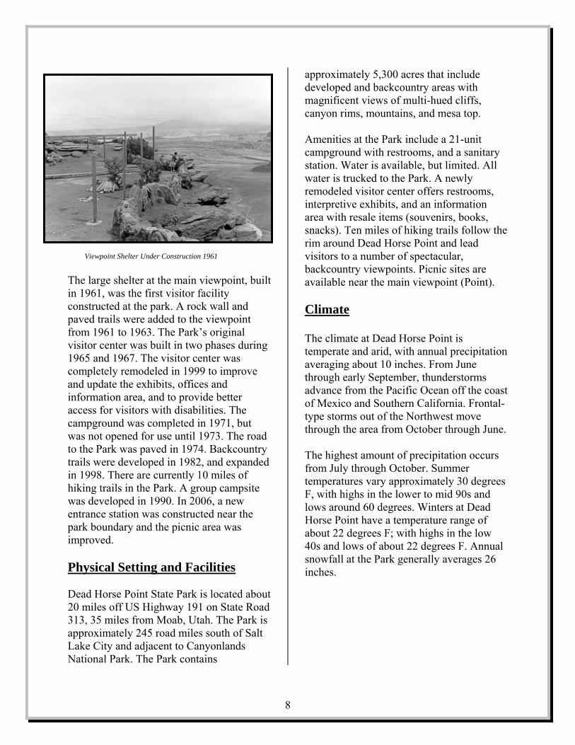
Viewpoint Shelter Under Construction 1961 The large shelter at the main viewpoint, built in 1961, was the first visitor facility constructed at the park. A rock wall and paved trails were added to the viewpoint from 1961 to 1963. The Park’s original visitor center was built in two phases during 1965 and 1967. The visitor center was completely remodeled in 1999 to improve and update the exhibits, offices and information area, and to provide better access for visitors with disabilities. The campground was completed in 1971, but was not opened for use until 1973. The road to the Park was paved in 1974. Backcountry trails were developed in 1982, and expanded in 1998. There are currently 10 miles of hiking trails in the Park. A group campsite was developed in 1990. In 2006, a new entrance station was constructed near the park boundary and the picnic area was improved. Physical Setting and Facilities Dead Horse Point State Park is located about 20 miles off US Highway 191 on State Road 313, 35 miles from Moab, Utah. The Park is approximately 245 road miles south of Salt Lake City and adjacent to Canyonlands National Park. The Park contains
approximately 5,300 acres that include developed and backcountry areas with magnificent views of multi-hued cliffs, canyon rims, mountains, and mesa top.
All
the ad
vailable near the main viewpoint (Point).
limate
Amenities at the Park include a 21-unit campground with restrooms, and a sanitary station. Water is available, but limited.water is trucked to the Park. A newly remodeled visitor center offers restrooms,interpretive exhibits, and an information area with resale items (souvenirs, books, snacks). Ten miles of hiking trails followrim around Dead Horse Point and levisitors to a number of spectacular, backcountry viewpoints. Picnic sites are a C
tation
tal-
rough the area from October through June.
ccurs
es
l at the Park generally averages 26
ches.
The climate at Dead Horse Point is temperate and arid, with annual precipiaveraging about 10 inches. From June through early September, thunderstorms advance from the Pacific Ocean off the coast of Mexico and Southern California. Frontype storms out of the Northwest move th The highest amount of precipitation ofrom July through October. Summer temperatures vary approximately 30 degreF, with highs in the lower to mid 90s and lows around 60 degrees. Winters at Dead Horse Point have a temperature range of about 22 degrees F; with highs in the low 40s and lows of about 22 degrees F. Annualsnowfalin
8

Figure 2: Dead Horse Point State Park Average Monthly Visitation 1999-2005
0
10000
20000
30000
Jan Mar May Jul Sep Nov
Park Visitation Visitation to Dead Horse Point State Park increased dramatically in the 1980s and 90s, peaking at 205,769 visitors in 1995. After 1995, visitation to the park decreased until another peak (204,367) in 1999. After 1999, visitation decreased, but has flattened out since 2001 at around 150,000 visitors per year (figure 1). Between 1999 and 2005, the Park averaged 163,464 visitors each year.
Figure 1: Dead Horse Point State Park Visitation 1990-2005
5000075000
100000125000150000175000200000225000
90 92 94 96 98 00 02 04
Year
# Vi
sito
rs
As shown in figure 2, for 1999-2005, most visits (91.5 percent) to Dead Horse Point occur during the Park’s long, main recreation season of March through October. The four winter months, November through February, account for just 8.5 percent of the total visitation. June is the busiest month with 13.4 percent of yearly visitation (averaging 21,859 visitors). January is the slowest averaging just 2,552 visitors
The number of visitors climbs sharply in March. There is a definite visitation plateau in the warmer months of May through September. These months all average above 20,000 visitors, and together they account for 72.3 percent of visits. There is a steep decrease in numbers of visitors after October.
9

Relationship to the Community and Surrounding Area Dead Horse Point State Park is located approximately 15 air miles southeast of Moab, Utah. The Park is in both San Juan and Grand Counties. The City of Moab, located in Grand County, is the Park’s gateway community. Access to the Park is from the Grand County side via State Road 313, a scenic byway. SR 313 also provides access to the Island in the Sky District of Canyonlands National Park. Demographic and Socioeconomic Information According to the 2000 census report, Grand County had a population of 8,485. The City of Moab, with a population of 4,800, accounts for 57 percent of Grand’s population, and is the largest city in the county. While Grand County is Utah’s ninth-largest county in terms of land area, it ranks only 20th in terms of population. The County has a population density of 2.3 persons per square mile, and a housing density of 1.1 housing units per square mile. In 2000, the U.S. Bureau of Census reported that Grand County had a per capita income of $17,356, Moab City $16,228, compared to $18,185 for Utah as whole. The unemployment rate in Grand County was 6.1 percent, compared to 3.4 percent for the entire state. Grand County’s largest employers include the County itself, Allen Memorial Hospital, Grand County School District, Quintstar (hotel/motel accommodations), and the National Park Service. The largest industry segment providing employment was the arts, entertainment, recreation, accommodation, and food services segment providing 26.3 percent of employment in the County. The
education, health and social services segment was next providing 17.1 percent of jobs. Retail trade accounted for 13.8 percent of total employment. The 2000 census showed that San Juan County had a population of 14,413. San Juan County’s largest city, Blanding, had a population of 3,162, accounting for 22 percent of the county’s total population. San Juan is Utah’s largest county by area, but only ranks 16th in population. The County has a population density of 1.8 persons per square mile, and a housing density of 0.7 housing units per square mile. In 2000, San Juan County had a per capita income of $10,229, while Blanding City’s was $12,160. The unemployment rate in San Juan County was 8 percent. The County’s largest employers are the San Juan School District, Aramark Services Management, College of Eastern Utah, San Juan County, San Juan Hospital, and the State of Utah. The largest industry segment identified in the 2000 census was the education, health and social services segment accounting for 28.1 percent of total employment. The arts, entertainment, recreation, accommodation, and food services segment provided 13.2 percent. Retail trade accounted for 10.8 percent, with construction next at 10.1 percent of total employment.
10
Studies conducted at area parks indicated that most visitors (up to 91 percent) came from outside of Utah. Thirty to 36 percent of all visitors came from outside the United States. Of foreign countries, Germany had the most respondents with 10 percent of the total.
Park ResourcesOne of the Dead Horse Point Planning Team’s primary vision elements is to protect and preserve the Park’s visual, geological, biological, and cultural attributes. To do this, the planning process calls for an analysis of park resources. It is essential that management decisions affecting the Park’s natural environment be based on reliable scientific information. This section provides an analysis of Dead Horse Point’s geological, biological, and cultural resources. A natural hazards analysis is also included. Visual Resources The Park’s primary resource is the spectacular viewshed. In fact, the Park owes its existence to the incredible panoramic views that it provides to visitors. The scenery has been attracting visitors to Dead Horse Point long before the Park existed. Dead Horse Point State Park is unique in that the majority of its most valuable resource is located outside of its boundary and direct control. The landscape viewed from the Park is managed by a number of state and federal agencies, as well as some private landowners. These include the National Park Service (NPS), Bureau of Land Management (BLM), United States Forest Service, Utah State Institutional Trust Lands Administration (SITLA), Utah Division of Forestry, Fire and State Lands, and Intrepid Potash. The activities on any of these lands have the potential to impact the view from Dead Horse Point. A number of mountain ranges can be seen from the Park. These include the La Sal, Abajo and Henry Mountain ranges in Utah, and on clear days, the peaks of the San Juan Mountains in southwestern Colorado (20, 30, 60 and 90 miles away respectively). While these distant views are spectacular, it is the more immediate viewshed, including the Colorado River and its intricate canyon
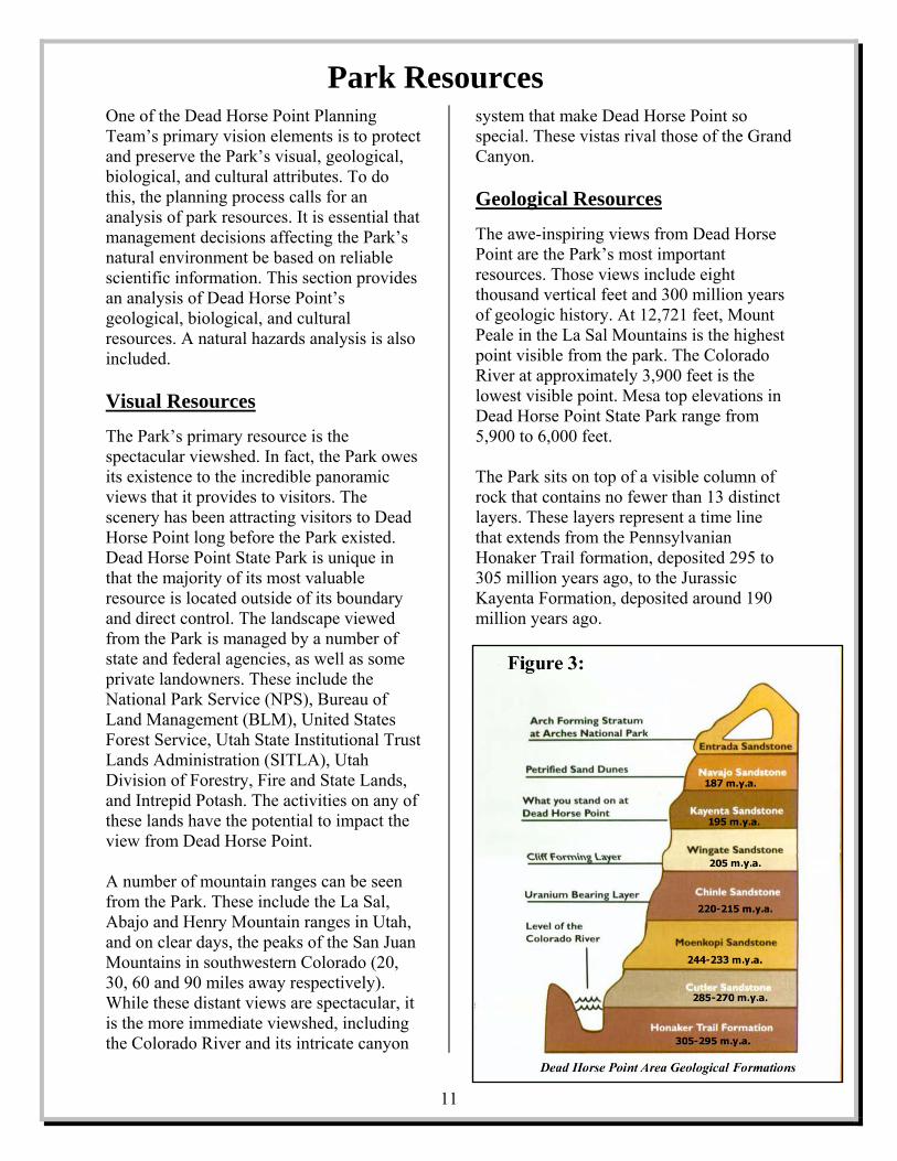
system that make Dead Horse Point so special. These vistas rival those of the Grand Canyon. Geological Resources The awe-inspiring views from Dead Horse Point are the Park’s most important resources. Those views include eight thousand vertical feet and 300 million years of geologic history. At 12,721 feet, Mount Peale in the La Sal Mountains is the highest point visible from the park. The Colorado River at approximately 3,900 feet is the lowest visible point. Mesa top elevations in Dead Horse Point State Park range from 5,900 to 6,000 feet. The Park sits on top of a visible column of rock that contains no fewer than 13 distinct layers. These layers represent a time line that extends from the Pennsylvanian Honaker Trail formation, deposited 295 to 305 million years ago, to the Jurassic Kayenta Formation, deposited around 190 million years ago.
11
Beginning in Pennsylvanian times, erosion of a series of uplifts located west of Dead Horse Point provided the material that makes up the rock strata at the park. Faults associated with these uplifts, caused an accompanying depression. In this depression several thousand feet of evaporative salts were deposited. This salt, part of the Paradox Formation, was covered by many thousands of feet of material eroded from the highlands and deposited as layers of marine and alluvial sediment, interspersed with layers of windblown material. As the deposits piled up and hardened into rock, they compressed the salt causing it to flow like a paste to areas of weakness or less confining pressure. In these areas, the salt has caused bulges in the earth’s surface. Dead Horse Point sits on top of one of these bulges, the Shafer Anticline. Around 24 million years ago, a regional uplift created the Colorado Plateau, of which Dead Horse Point is a part. As the Plateau rose, the rivers flowing through the area from the adjacent highlands, began to cut down into the uplifting land. The rivers became entrenched in the uplifting plateau. River cutting and erosion have created deep canyon systems, such as the Grand Canyon and the intricate canyons seen from Dead Horse Point. Paleontological The Kayenta Formation (lower Jurassic) forms the bedrock layer for most of mesa top portions of the Park. The Kayenta Formation has the potential for both micro and macro-fauna fossil resources. The only known paleontological resources in the Park are some three-toed tracks, probably from theropod dinosaurs, found in the Kayenta formation just south of the visitor center. As with cultural resources, paleontological inventories/surveys for affected areas must
be completed before any new activity or development is allowed.
Biological Resources The Park supports a variety of desert plant and animal life. The plants and animals that thrive in the Park have adapted to the area’s harsh, dry climate. The Park’s plant and animal checklists are found in Appendix B. Flora The Park supports more than 90 different species of desert plants including juniper, pinion, single-leaf ash, live oak, sagebrush, rabbitbrush, buffaloberry, squawbush, cactus, yucca, as well as native grasses and many seasonal wildflowers that have adapted to the high desert climate. No plant species of special concern have been identified in the Park.
Fauna Over 100 species of animals potentially inhabit or visit the Park. Like the plant life, many of the animals at Dead Horse Point have adapted to living in the harsh desert environment. Resident mammals include desert bighorn sheep, mule deer, black-tailed jackrabbit, desert cottontail, and rock squirrel. Birds are the most numerous animals by species. Golden eagles, peregrine falcons, and ravens are among the 63 species of birds listed on the Park’s bird list. Many bird species nest in the Park, others are transient or seasonal visitors. Sagebrush lizards, eastern fence lizards, gopher snakes and other reptiles inhabit the Park, along with two amphibians, the red spotted and Great Basin spadefoot toads.
12
The Park has identified seven animal species from the State of Utah Sensitive Species List that may be located in the Park. The

Mexican spotted owl is federally listed as threatened. The ferruginous hawk, burrowing owl, Townsend’s big-eared bat, big free-tailed bat, spotted bat, and the kit fox are all listed by the state as wildlife species of concern. Threatened Species: Mexican Spotted Owl, Strix occidentallis lucida
Several Mexican spotted owl-nesting sites have been identified in the canyons below the park. The loss and/or change of habitat, causing decreases in population, has led to this species being listed as threatened by the U.S. Fish and Wildlife Service. Recovery plans for this species primarily seek to protect critical habitat on federal lands. However, these owls have been seen perching in the Park, and managers should consider the effect of any development or park activity on this species. Species of Concern: Ferruginous Hawk, Buteo regalis
This large soaring hawk is an uncommon visitor to the Park. This species relies heavily on jackrabbits. The cyclic nature of jackrabbit populations may cause crashes in the number of hawks, and if additional prey is not abundant, ferruginous hawk populations may not recover from declines. Current estimates indicate that ferruginous hawk productivity in Utah is insufficient to support stable long-term populations.
Burrowing Owl, Athene cunicularia This owl nests in the ground burrows of other animals. Populations of the owl have been in decline due to loss of habitat due to development. The large-scale culling of prairie dogs as agricultural pests has reduced the availability of nesting burrows.
Townsend’s Big-eared Bat, Corynorhinus townsendi
This bat’s distribution is correlated with the availability of caves and abandoned mines for roost sites. Populations are localized
around roost sites. The loss of roost habitat is the major threat to populations in Utah. Abandoned mine closure has been responsible for the loss of roost sites in Utah. The Park should make efforts to minimize disturbances to roosting sites of these bats. Big Free-tailed Bat, Nyctinomops macrotis
This species roosts in rock crevices, and occasionally in caves, buildings and tree holes. Due to unusual wing morphology this bat requires an extensive vertical drop to achieve flight. This unique roost requirement causes highly fragmented distribution. This unique requirement, along with limited reproductive potential, has caused this species to decline in numbers. Spotted Bat, Euderma maculatum
The spotted bat occupies a wide variety of habitats, but has been sighted most often in dry, rough, desert terrain. Roosts are most often in rock crevices or under loose rocks or boulders. This bat, though widespread in distribution, is rare in numbers. It has a very low reproduction potential, so once populations are reduced in number, they are slow to rebuild. For these reasons, the spotted bat is designated as a species of concern.
13
Kit Fox at Dead Horse Point

Kit Fox, Vulpes macrotis This small desert fox, though declining in population throughout the state, is frequently seen at Dead Horse Point. Invasive weeds may be reducing the diversity and abundance of prey species, and water development for game and livestock may be increasing the number of coyotes (a predator of the kit fox) in areas previously only suitable for kit foxes. The Utah Division of Wildlife Resources (DWR) encourages thoughtful management to prevent these species of concern from being listed federally. To protect park wildlife and critical habitat, Park Managers will consult with division biologists, DWR, and other resource management agencies, as necessary, when planning new development. Cultural Resources Dead Horse Point State Park is located in an area known for cultural resources, particularly the indigenous prehistoric cultures. Humans first visited the area surrounding Dead Horse Point over 10,000 years ago. Nomadic hunter-gatherers roamed through southeastern Utah from 8,000 B.C. to 500 B.C. They exploited wild plants in addition to hunting big and small game. They left little
in the way of artifacts or structures, but did make intriguing petroglyphs and pictographs on the canyon walls of the area. The Park is located on the boundary of the contemporaneous Fremont and Ancestral Puebloan cultures. These people were agriculturalists and developed unique settlements. There are numerous Fremont and Ancestral Puebloan sites in the area. There is evidence that the historic Utes moved into the area approximately 1,000 years ago. The Park does contain significant archeological resources including remnants of rock shelters, some rock art, stone tools, and lithic scatter. Few of the Park’s 5,300 acres have been inventoried for cultural resources. With the wealth of information already recorded in and around Dead Horse Point State Park, it can be assumed that there are many unknown cultural resources to be found in the areas of the Park that have yet to be surveyed. Cultural inventories/surveys for affected areas must be completed before any new activity or development is allowed. Natural Hazards Analysis The Utah Division of Emergency Services and Homeland Security conducted a natural hazards analysis during the summer of 2006. This study discussed the risks associated with flooding, earthquake activity, landslides, wildfire, severe weather, drought, and recreational activities. Flooding to Dead Horse Point State Park facilities would be minimal as a direct result of localized flash flood events. The current campground has small drainage channels that assist in routing floodwater away from campsites and structures. In a severe thunderstorm/flash flood event,
14

campers and park officials should monitor the area and watch for high water levels and debris flows associated with such events. Although an earthquake threat is not necessarily a concern in this area, such an event would increase the risk of rock falls. Earthquake activity on the Wasatch Front could have considerable financial impact to Dead Horse Point State Park. Repairing earthquake damage reduces financial resources often lessening the amount spent on recreation. There are no commercial or residential structures at risk from landslide within the boundaries of Dead Horse Point.
Dead Horse Point State Park is located in an area defined as a medium to high risk for wildfire. There are areas near the Park that are identified as high risk for wildfire. Thunderstorms start many of rural Utah’s wildfires, but humans are the ignition source for most wildfires. Campgrounds and campfires increase the number of ignition sources. Within the park, lightning generated wildfires have burned a limited number of acres. Wildfires could also affect visitation to the Park and visibility. The Park should monitor State and Federal wildfire mitigation and/or response activities and enforce burn restrictions.
Extreme heat and thunderstorms that include lightning, cloudbursts and hail, have the potential to impact park facilities and park visitors. Park visitors and park staff are also in danger of extreme heat, summer lightning, and thunderstorms. There has been one lightning caused death at the Park and several non-fatal strikes. Drought may increase insect infestation and reptile migration. The forests of southern Utah are infested with several species of
beetles and other insect pests. Trees that are weakened by drought are more susceptible to insect damage. West Nile Virus has been identified in the area and is spread by mosquitoes. Visitors and park staff should follow Center for Disease Control mosquito bite prevention techniques when participating in outdoor activities in the area. Dead Horse Point sits on a plateau overlooking the Colorado River. The trails system runs close to the edge of 300-500 foot vertical drop-offs. While the Park has only reported two falling fatalities, there is the possibility of future accidents. New extreme sports are being developed and Dead Horse Point is an attractive location for some of them. These activities (such as B.A.S.E. jumping) are inherently dangerous. Currently, the Park does not allow these activities. Natural hazards can create safety concerns for visitors and staff, damage park facilities, and have detrimental effects on the economy of the Park and area by interrupting access and use of the Park.
View from the “Point”
15
Thoughtful management can reduce the potential damage from these hazards.

16
This page intentionally left blank
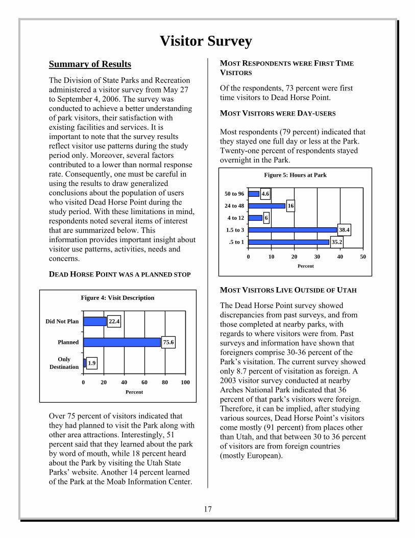
Summary of Results The Division of State Parks and Recreation administered a visitor survey from May 27 to September 4, 2006. The survey was conducted to achieve a better understanding of park visitors, their satisfaction with existing facilities and services. It is important to note that the survey results reflect visitor use patterns during the study period only. Moreover, several factors contributed to a lower than normal response rate. Consequently, one must be careful in using the results to draw generalized conclusions about the population of users who visited Dead Horse Point during the study period. With these limitations in mind, respondents noted several items of interest that are summarized below. This information provides important insight about visitor use patterns, activities, needs and concerns.
DEAD HORSE POINT WAS A PLANNED STOP
Over 75 percent of visitors indicated that they had planned to visit the Park along with other area attractions. Interestingly, 51 percent said that they learned about the park by word of mouth, while 18 percent heard about the Park by visiting the Utah State Parks’ website. Another 14 percent learned of the Park at the Moab Information Center.
MOST RESPONDENTS WERE FIRST TIME VISITORS Of the respondents, 73 percent were first time visitors to Dead Horse Point.
MOST VISITORS WERE DAY-USERS Most respondents (79 percent) indicated that they stayed one full day or less at the Park. Twenty-one percent of respondents stayed overnight in the Park.
MOST VISITORS LIVE OUTSIDE OF UTAH The Dead Horse Point survey showed discrepancies from past surveys, and from those completed at nearby parks, with regards to where visitors were from. Past surveys and information have shown that foreigners comprise 30-36 percent of the Park’s visitation. The current survey showed only 8.7 percent of visitation as foreign. A 2003 visitor survey conducted at nearby Arches National Park indicated that 36 percent of that park’s visitors were foreign. Therefore, it can be implied, after studying various sources, Dead Horse Point’s visitors come mostly (91 percent) from places other than Utah, and that between 30 to 36 percent of visitors are from foreign countries (mostly European).
Visitor Survey
Figure 5: Hours at Park
35.2
38.4
6
16
4.6
0 10 20 30 40 50
.5 to 1
1.5 to 3
4 to 12
24 to 48
50 to 96
Percent
Figure 4: Visit Description
1.9
75.6
22.4
0 20 40 60 80 100
OnlyDestination
Planned
Did Not Plan
Percent
17

The Arches survey showed that 10 percent of that park’s visitation came from Germany, and eight percent from France. The states, other than Utah, that produced the largest amount of visitors were California and Colorado, with 10 and six percent of total visitation, respectively. SIGHTSEEING, PHOTOGRAPY, CAMPING AND HIKING WERE THE TOP RECREATION ACTIVITIES Fifty-six percent of survey respondents listed sightseeing as their primary activity while visiting the park. Another 15.3 percent indicated photography was their major activity, while 12 percent said camping, and 6.7 percent hiking.
MOST RESPONDENTS SPENT MONEY IN NEARBY COMMUNITIES
Note: The category of “other” includes Arches RV Resort, Price, Torrey, Zion, and Cortez and Grand Junction, CO. Multiple responses may total over 100 percent. Respondents provided information on expenditures by their entire group for motels/hotels, campgrounds, restaurants, vehicles, activities, and supplies. More than 98.7% indicated that they made such purchases in nearby towns. The vast
majority of respondents spent money in Moab (96.2 percent). Other towns where respondents spent money included Green River, Monticello, Blanding, and Thompson Springs.
ECONOMIC IMPACT With information gleaned from the visitor survey, the Utah State Park’s planning staff used IMPLAN Professional Version 2.01.1025 software to estimate the economic impacts of annual visitation to Dead Horse State Park. IMPLAN is software used to assist in estimating economic impacts of land and resource management activities using data supplied by counties and states. The IMPLAN model measured the direct, indirect and induced impacts of park visitor expenditures for lodging, restaurants, vehicle operation, and other associated recreation activities and supplies. Figure 6: Where Money Was Spent
96.2
20.9
0.6
10.8
7.6
1.9
5.7
1.3
5.1
0 20 40 60 80 100
Moab
Green River
Thompson Springs
Monticello
Blanding
Live In Town
Don't Know Name
Didn't Spend Money
Other
Percent
The model showed that Dead Horse Point added an estimated $7.8 million to the State and local economies last year (in 2003 dollars). According to the model, the Park accounts for as many as 143 jobs in a variety of industries. The Park also generated nearly $2 million in total tax revenue. Because of the small sample size of the Dead Horse Point visitor survey, the planning staff compared results to economic impact studies completed for nearby Arches National Park, and visitors to southern Utah in general. The Dead Horse Point model proved to be conservative, with each visitor spending approximately $47 per visitor per day. The Arches study, completed by Michigan State University (Stynes, Daniel J. and Sun, Ya-Yen) in 2005, showed each visitor spent $84 per day. A 2001 study completed for the Utah Office of Tourism (Shifflet, D.K. and Associates Ltd.), showed visitors to southern Utah spent $81 per person/day.
18

A number of issues ranging from developing new visitor opportunities and facilities, to resource management and protection, are addressed in the Plan. Issues relating to improving and adding facilities and development to enhance visitor opportunities, natural and cultural resource management, funding and budget concerns, marketing, revenue enhancement, and interpretation and education are addressed. Each of these issues was identified by various means including input from planning team members, the public-at-large through a public meeting, and by a visitor survey. Team members and the public identified seven major issues that were aggregated into five distinct categories. An analytical technique used to determine the Park’s strengths, weaknesses, opportunities and future threats (known as a “SWOT” analysis) helped in the development of these issues. A specific description or statement summarizing each issue was constructed to clearly identify and articulate each problem or challenge. A number of constraints (i.e.: available funding, sufficiency of staff, facility location and design, and federal regulations, etc.) will need to be addressed prior to issue resolution. Team members, planning staff and division experts identified some of the limiting factors that may hinder implementation of a specific team recommendation. The Planning Team developed specific recommendations for the identified issues. The Team’s recommendations were arrived at by consensus of opinion. The Team also emphasized that recommendations be consistent with the mission and vision statements.
The five issue areas forming the basis of the Team’s recommendations include: (1) facilities and development to enhance visitor opportunities; (2) resource management; (3) revenue, funding and concessions; (4) marketing; (5) interpretation and education. Facilities and Development to Enhance Visitor Opportunities The public and Planning Team identified a number of facility and development improvements and additions to enhance visitor opportunities. All facility and development improvements should utilize appropriate design to minimize negative visual impacts, and should include positive visual elements such as native landscaping and vegetative screening.
Issue: Improve Existing Facilities Most of the Park’s facilities and infrastructure elements were developed in the 1970s or earlier. Some have outlived their useful life, while others were built to accommodate fewer visitors than the Park
Issues and Recommendations
19
Issue Area: Facilities and Development to Enhance Visitor Opportunities Key Issues:
Improve Existing Facilities. • Improve parking in Park. • Replace or renovate aging facilities
and infrastructure. • Expand the campground.
Provide New Opportunities and Facilities for Visitors. • Expand and improve the trail system
for hikers and bicyclists. • Consider backcountry camping and
additional group campsites.

now attracts. The Park’s visitor center was remodeled in 1999, but the parking area was not enlarged or improved. The visitor center parking lot is frequently full, causing many visitors to bypass the center. Because of this, many visitors do not get needed and desired information, and the Park loses revenue in retail sales. The parking lot at the Point is also frequently full causing visitors to drive around waiting for sites to open or park outside of designated parking areas damaging native vegetation and soil crusts. Existing restrooms at the Point and in the campground are not Americans with Disabilities Act (ADA) compliant (and cannot be made so), and have utility systems that are too obsolete for repair. The Park has no local water supply, so the staff must truck in all of the water used at the Park. Because of this, water should be conserved where possible, and the Park’s four water delivery systems maintained in good repair. The Park’s campground has one of the highest occupancy rates in the Utah State Park system. The campground fills early on most days during the recreation season, and frequently, potential campers are turned away.
Recommendations 1. Expand parking at the visitor center
and Point A. Parking expansion at the visitor
center should use the old road scar to the north of the current parking lot to minimize new impacts.
B. Any parking expansion should be designed to lie lightly on the land and blend in as much as possible by leaving buffers of natural area and by using landscaped areas with a natural look.
2. Renovate and Expand or Replace Existing Restrooms at the Campground and Point. A. Determine if old buildings can be
renovated to be ADA compliant, with upgraded water supply, electrical, and heating systems. The necessary size and capacity for each building should be determined. If renovation is not feasible, the buildings should be replaced.
B. Any new construction should match the rustic, park-type look of the older buildings.
3. Replace aging waterlines throughout
the Park. Examine and, if necessary, replace the water storage tanks.
4. Consider and use water-saving
fixtures or features whenever new facilities are developed, or old facilities renovated.
5. Remove obsolete light poles in
campground. 6. Upgrade campsite electrical service to
30 amps to provide for demand from modern recreation vehicles and trailers.
7. Expand the campground with
additional camp loop and restroom to meet demand.
8. Consider shuttle system between
visitor center (or other location) and Point if traffic volume and congestion dictates.
Issue: Provide New Opportunities and Facilities for Visitors
20
The Planning Team recognized that there is a current need for more visitor opportunities, as well as a need to plan for future growth in

visitation by providing more opportunities and facilities. The Team identified a number of enhancements to the Park’s trail system. The Team recommended a paved non-motorized trail be constructed connecting the visitor center, campground and Point to get pedestrians and bicycle riders safely off the narrow park road. The team also recommended developing an easy mountain bike trail in the park to offer an additional opportunity to visitors, and to attract new visitors. The Park should support efforts to extend the existing bike lanes on State Road 313 (park entrance road) to Dead Horse Point (eight miles). They also suggested that the Park expand hiking opportunities and develop trailheads with vehicle parking where trail development indicates. The Team suggests that the Park consider opportunities for backcountry camping and developing more group campsites of varying size. To help with congestion at the main features and to enhance opportunities, the Park should develop some small vehicle pull-offs with scenic views. The Park should also conduct a long-range study to possibly increase vehicular access to canyon rims and additional viewpoints. Recommendations 1. Trail enhancements
A. Construct a paved, non-motorized trail connecting the visitor center, campground and Point.
B. Develop an easy, family-friendly mountain bike trail. Study the impacts of the trail on park resource for two years before considering additional mountain bike trails. Potential trail route is shown on Map 4, page 39.
C. Build a bicycle trail from the group campsite to the visitor center.
D. Support the development of bicycle lanes on the first eight miles of State Road 313, as well as a bicycle trail from Moab to the Park.
E. Construct trailheads with parking, where feasible, for new and existing trails.
F. Develop a trail through the BLM R.&P.P. lease to provide more trail opportunities and meet conditions to acquire title to the leased property.
2. Investigate providing limited
backcountry camping. 3. Provide several more group campsites
of varying sizes. 4. Develop additional parking and
viewing sites. A. Conduct a long-range study to
possibly increase vehicular access to canyon rims and additional viewpoints.
B. Develop smaller view areas with pullout parking between the visitor center and Point.
5. Engineer fire control systems for
facilities. 6. Provide wireless Internet access at the
visitor center and/or campground for public use, if feasible.
7. Place signs along park road warning
vehicles that pedestrians and bicycle may be on roadway.
21

Resource Management The Park was established because of the superb panoramic views available from Dead Horse Point. The viewshed is the Park’s most important resource, but is almost entirely outside of the Park’s boundary and management control. Some activities on the lands surrounding Dead Horse Point could adversely affect the view from the Park. The Planning Team recognized this possibility and developed recommendations to cooperatively minimize impacts. Recommendations were also created for the management of natural and cultural resources, and to deal with noxious weeds and insect pests.
View from Dead Horse Point – “Utah’s Grand Canyon”
Issue: Protect Park Viewshed Because the Park’s most important resource, the viewshed, is so large and managed by a variety of entities, its management must be a cooperative effort between the Park, other
agencies, and private landowners and lessees.
Recommendations: 1. Facilitate a cooperative visual
management agreement with all agencies that manage portions of the viewshed.
2. Foster good relationship with
neighboring land managers. Monitor management plans and actions relating to viewshed lands, and act to minimize visual impacts.
3. Work with SITLA and BLM to trade
or purchase lands to protect viewpoints. A. Support the SITLA – Federal land
trades now being considered. B. Consider surcharge addition to fees
or other creative means to purchase lands, development rights, and/or conservation easements from SITLA.
4. Work with San Juan and Grand
Counties to put in place light ordinances for viewshed.
5. Use proper colors, design and native plants and screening to blend development into the natural setting.
22
Issue Area: Resource Management Key Issues:
Protect Park Viewshed. • Cooperative interagency visual
management plan for viewshed area. • Act to minimize visual impacts. • Support land trades and acquisition to
protect viewpoints. • Work with counties to put in place light
ordinances for viewshed. • Blend development into natural setting.
Protect and Manage Resources. • Minimize impact of IPS beetle on pinion
trees. • Maintain range values and habitat
conditions and reduce risk of wildfire. • Inventory resources as necessary. • Acquire landlocked BLM areas in Park. • Work with SITLA to develop
cooperative management plans for SITLA owned mineral rights in Park.

Issue: Protect and Manage Resources Dead Horse Point is rich in natural and cultural resources. Natural and man-caused threats can impact these resources negatively. Park managers should be proactive in protecting park resources from natural threats, such as the IPS beetle that is killing pinion trees throughout the Southwest, and impacts from visitors and park management activities. Recommendations: 1. Minimize the impact of the IPS beetle
on pinion trees. A. Spray trees in high value areas. B. Remove recently killed trees. C. Consult with Division of Forestry,
Fire and State Lands (DFFSL). 2. Maintain range and habitat condition
and reduce risk of wildfire. A. Consult with DFFSL to determine
how to limit cheat grass fire risk. B. Monitor range conditions and review
research on converting areas of cheat grass to native vegetation.
C. Reseed areas disturbed by development and/or wildfire with native plants.
D. Continue to monitor for and treat noxious weed infestations.
E. Maintain habitat for mule deer and other wildlife species, and consider impacts on habitat when planning new development.
3. Expand current inventory of
resources in Park as needed and opportunity dictates. A. Inventory for nesting raptors in cliff
areas. B. Complete archeological clearances
prior to development as required by law and cooperative agreement with Division of State History.
C. Conduct range trend inventories to identify impacts, noxious weeds, etc.
4. Move to get patent/ownership of
landlocked BLM lands currently managed by park via recreation and public purposes lease.
5. Work with SITLA to develop
cooperative management plans for SITLA owned mineral rights in Park.
6. Though hunting is not allowed in most
of the Park, the limited hunting of desert bighorn sheep will continue to be allowed in the portions of the Park below the Wingate cliffs.
23

Revenue, Funding and Concessions The Division of State Parks and Recreation has been challenged by the legislature, Governor and Department of Natural Resources to operate more efficiently and to maximize its revenue to reduce its dependence on the State’s general fund. Vision 2010, the Division’s long-range strategic plan, echoes these goals, and also suggests that parks should consider ways to increase their impact on local and state economies. The RMP also suggests that when new development is considered, its potential to increase revenue should be a consideration. The Planning Team was adamant that it be recognized that making a profit is not the only responsibility or goal for the Park.
Issue: Improve Revenue and Operational Funding Dead Horse Point is one of only a few Utah state parks to collect more than their operating costs in revenue. The Park also has one of the most successful retail sales operations in the Utah State Parks system. The Planning Team thought that even this successful operation could be improved upon. The Team also felt that the Park should complete a business plan that includes a staffing and budget analysis.
Recommendations 1. Enhance revenue in visitor center gift
shop/book store. A. Increase dollar to visitor ratio
through item placement, inventory control, and improved layout and design.
B. Consider adding a gift shop manager position.
C. Increase gift shop revolving account amount to allow for adequate inventory size during critical summer months.
2. Develop a business plan for the Park.
A. Include a staffing and budget analysis.
3. Analyze impacts on staffing and
operational funding, and consider potential revenue prior to initiating new development, services, and/or programs. A. New development or programs
should come with operational funding or produce revenue that can be used to fund operation.
B. The ability to generate revenue or cost-savings should be a factor when considering potential development.
C. Traditional programs and services should not suffer because of cost of new development and programs.
24
Issue Area: Revenue, Funding and Concessions Key Issues:
Improve revenue and operational funding. • Enhance revenue in visitor center gift
shop/book store. • Develop a business plan for the Park. • Analyze impacts on staffing and
operational funding, and consider potential revenue prior to initiating new development, services, or programs.
• Investigate raising fees. • Allow the Park to keep and use a
portion of the revenue collected above the Park’s operating cost.
• Consider concession opportunities. • Determine Park’s impact on local and
state economies. • Consider alternative funding sources. • Park resources and visitor experiences
should not be compromised to increase revenue.

4. Carry out a comparability analysis to determine if camping and entrance fees could be increased, and decide if fees could/should be different for RVs and tents.
5. The Division of State Parks and
Recreation should allow the Park to keep and use a portion of the revenue collected above the Park’s operating cost.
6. Consider
concessionaire to provide any services that cannot be provided by the Park.
7. Complete study
to measure the Park’s value to the local and state economies, and quantify how the requested improvements in this Plan will add to that value. DHP Visitor Center Retail Sales Area
8. Investigate donation-raising activities
through local businesses. For example, at private campground or hotels, customers could round up bills to the next dollar, with the extra change collected going to the Park.
9. Remember that increasing revenue, or
making a profit are not the only goals for the Park. Resources and visitor experiences must be maintained.
25

Marketing Dead Horse Point is a popular recreation destination, averaging between 150,000 and 200,000 visitors during the past 15 years. The Park could accommodate more visitors, however, especially during certain times of day and during the shoulder and off-seasons. The improvements suggested in this Plan would also increase the Park’s visitor capacity by increasing parking and providing more activities to physically spread out use. Effective marketing would increase visitation to the Park, and would increase the economic value of the Park to local and state economies.
Issue: Market the Park and Surrounding Area The Park could be promoted and marketed more actively to advertise its attractions to draw more visitors and enhance the local economy. The Team felt that the Park should develop a unique identity to promote. Additional visitor opportunities need to be developed and advertised or marketed.
Potential customers need to be identified and reached through marketing efforts. Attractive publications need to be created and distributed through various means to the public. The Division website needs to be updated to provide more information about the Park and surrounding area in an enticing manner. It should also provide links to other sites offering information about the area and state.
Recommendations 1. Participate in the Dead Horse Mesa
Scenic Byway Corridor Management Plan.
2. Develop a movie for Dead Horse Point
that can be shown at the visitor center, and can be sold at the Park and other locations.
3. Investigate local and other partners
for marketing. A. Provide matching funds to the Moab
Area Travel Council to market the Park.
B. Attend Moab Area Travel Council meetings on a quarterly basis to report on park activities and conditions and participate in Travel Council promotions.
C. Help to develop joint interpretive brochure/booklet for all scenic byways in area.
D. Work with a commercial venture to develop site-specific products, such as a souvenir book, for resale at the park and other locations for revenue and promotion.
4. Take part in state and regional
promotion efforts to ensure that Dead Horse Point is prominently featured in regional ads and printed materials. (Example: Utah’s Life Elevated campaign).
26
Issue Area: Marketing Key Issues:
Market the Park and Surrounding Area. • Participate in the Dead Horse Mesa
Scenic Byway Corridor Management Plan. • Develop a park movie for park use, resale
and marketing. • Local partnerships for marketing. • Take part in state and regional marketing
efforts. • Actively participate in Moab Information
Center. • Promote unique identity for Park. • Develop marketing plan for Park. • Support FAM tours to Park. • Develop reciprocating links on the Park
and other websites.
5. Actively participate in the Moab Information Center (possibly provide staff, money for staff, or help in developing brochures and/or posters).
6. Promote a unique identity (icon
image) for the Park. A. “Utah’s Grand Canyon.” B. Reverse logic: “When you are in
Southern Utah visiting Dead Horse Point State Park, be sure to visit Delicate Arch.”
7. List Park services, programs and
special events in publications such as newspapers and local commercial tourist information publications.
8. Develop marketing plan for the Park. 9. Consider getting Park
information/footage on the local promotional television station.
10. Encourage and support
familiarization tours of travel industry representatives to the Park.
11. Place links to the Park webpage on
other sites, and, where possible place reciprocating links (such as the local travel council, BLM and National Park Service) on the Park’s page. Place a web cam at the park with a link from the Park’s webpage.
12. Place an official weather station at the
Park, so statewide television news shows will report on the Park’s weather conditions.
13. Improve/replace UDOT signs leading
to the Park.
27

Interpretation/Education Though Dead Horse Point already offers a wide variety of interpretive programs and information, more needs to be done to provide visitors with the information that they need to plan their visit, enjoy the Park, and appreciate and protect park resources.
Issue: Improve Existing and Offer Additional Interpretive, Educational and Informational Programs, Exhibits, Signs, Electronic and Printed Materials Besides the recommendations listed under the marketing issue area, improvements to the Park’s webpage could get more information to potential visitors before they arrive at the Park. Improvements to exhibits and signing would enhance visitors’ enjoyment of the area and help to protect resources. Recommendations 1. Update existing and provide
additional interpretive exhibits at visitor center, Point, campground, and trailheads.
2. Use Dibond photos that hold up better
in UV conditions for exhibits.
3. Improve the Park’s webpage.
A. Occasionally put new information on the Park’s webpage as incentive for return visits to the site.
B. Provide current condition information on the site (including construction activities, web cam, and weather conditions).
C. List upcoming programs and special events.
D. Provide downloadable maps and brochures.
E. Include area information (such as the Dead Horse Mesa Scenic Byway) and links to other area websites.
3. Evaluate current park programs and
exhibits for effectiveness with peer evaluations and visitor feedback.
4. Conduct more outdoor classroom
programs that explain concepts such as geology, nature, multiple-use (as seen from the Park), and night sky.
5. Provide wireless Internet at the Park.
28
Issue Area: Interpretation/Education Key Issues:
Improve Existing and Offer Additional Interpretive, Educational and Informational Programs, Exhibits, Signs, Electronic and Printed Materials. • Improve existing and provide additional
exhibits. • Improve park webpage. • Evaluate current programs, exhibits and
printed material for effectiveness. • Conduct more “outdoor classroom” type
programs.

Conclusion
This Plan is a blueprint to help implement the Planning Team’s recommendations. As such, it outlines the initial steps to be taken in concert with park visitors, local communities and other interested users to: properly develop facilities to meet diverse visitor needs; ensure adequate staffing and funding; protect the scenic and natural resources of the Park; enhance the Park’s impact on the community, and state and local economies; and educate visitors and community members about the Park and its resources. The recommendations contained in this Plan conform to the Team’s mission of providing visitors a wide variety of safe and satisfying recreation experiences. The Plan’s recommendations effectively address the current needs for facility development, resource protection, park operations, land management, and cooperative efforts. However, it is crucial that adequate funding be received to implement these goals and accommodate visitor needs. The Plan’s success is dependent upon the continued support of sStakeholders must continue their efforts to support park improvements,preserve park resources, interalocal communities and strive tthe expectations of park visitors in the midst of a rapidly growing community of recreation-oricitizens. The recommendations contained within this Plan were bupon an open and collaborative process. It is imperative that thiscollaborative spirit continues as thPlan’s components are implemented.
It is also imperative that the document be reviewed on a regular basis to ensure its viability, relevance and usefulness. This document has sufficient flexibility to be amended in response to changing resource conditions, visitor needs and expectations, community needs, and agency priorities. Such amendments may occur under the auspices of the Division of State Parks and Recreation. Any such changes will include input from park visitors, local citizens, community leaders, park management, and other stakeholders with interests relevant to the operation and maintenance of the Park.
takeholders.
ct with o meet
ented
ased
e
29

30
This page intentionally left blank

City of Moab. History. (City of Moab, Grand County, Utah). Internet Website:
http://www.moabcity.org/visitors/history.cfm Dead Horse Point State Park. Dead Horse Point State Park Flora and Fauna Checklists. (Dead Horse Point State
Park, Department of Natural Resources. Division of State Parks and Recreation). Dead Horse Point State Park. Dead Horse Point State Park Interpretive Manual. (Dead Horse Point State Park,
Department of Natural Resources. Division of State Parks and Recreation). Evans, Sonja. (2003). Utah State Parks Cultural Resource Overview Dead Horse Point State Park. (Salt Lake City,
UT: Antiquities Section. Utah Division of State History). National Park Service. Arches National Park Internet Website: http://www.nps.gov/arch/ National Park Service. Canyonlands National Park Internet Website: http://www.nps.gov/cany/ Shifflet, D.K., and Associates Ltd (2001). Southern Utah Visitor Profile. (Utah Office of Tourism) Internet Website.
http://travel.utah.gov/research_and_planning/visitor_profiles/documents/SouthernUtah2002.pdf
Sprinkel, Douglas A., et al. (2000). Geology of Utah’s Parks and Monuments. (Salt Lake City: Utah Geological Association).
State of Utah. (2006). Dead Horse Point State Park Hazard Mitigation Plan. (Salt Lake City, UT: Division of
Emergency Services and Homeland Security). State of Utah. (2006). Dead Horse Point State Park Visitor Survey Results. (Salt Lake City, UT: Department of
Natural Resources. Division of State Parks and Recreation). State of Utah. (2000). Profile of General Demographic Characteristics: 2000, Geographic Area: Grand County.
(Governors Office of Planning and Budget). Internet Website. http://www.governor.state.ut.us/dea/census/CountiesSF3/Grand%20.pdf
State of Utah. (2000). Profile of General Demographic Characteristics: 2000, Geographic Area: San Juan County.
(Governors Office of Planning and Budget). Internet Website. http://www.governor.state.ut.us/dea/census/CountiesSF3/SanJuan.pdf
State of Utah (2004). Grand County’s Largest Employers Annual Average 2004. (Utah Department of Workforce
Services). Internet Website: http://jobs.utah.gov/opencms/wi/regions/eastern/grand/grandme.pdf State of Utah (2004). San Juan County’s Largest Employers Annual Average 2004. (Utah Department of Workforce
Services). Internet Website: http://jobs.utah.gov/opencms/wi/regions/eastern/sanjuan/sanjuanme.pdf State of Utah. (2005). Vision 2010, A Strategic Plan for the Utah Division of State Parks and Recreation. (Salt Lake
City, UT: Department of Natural Resources. Division of State Parks and Recreation). State of Utah. Utah Conservation Data Center. Internet Website. http://dwrcdc.nr.utah.gov/ucdc/ (Salt
Lake City, UT: Department of Natural Resources. Division of Wildlife Resources).
Stynes, Daniel J., and Sun, Ya-Yen (2005). Impacts of Visitor Spending on the Local Economy: ArchesNational Park, 2003. National Park Service/Michigan State University.
31
References

32
This page intentionally left blank

Map 2: Dead Horse Point State Park and Vicinity Map 3: Dead Horse Point State Park Detail
Map 4: Potential Mountain Bike Trail Route for DHP
33
Maps

34
This page intentionally left blank

35
Map 2: Dead Horse Point State Park and Vicinity

36
This page intentionally left blank

Map 3: Dead Horse Point State Park Detail Map 3: Dead Horse Point State Park Detail
Map 3: Dead Horse Point State Park Detail Map 3: Dead Horse Point State Park Detail
37 37

38
This page intentionally left blank
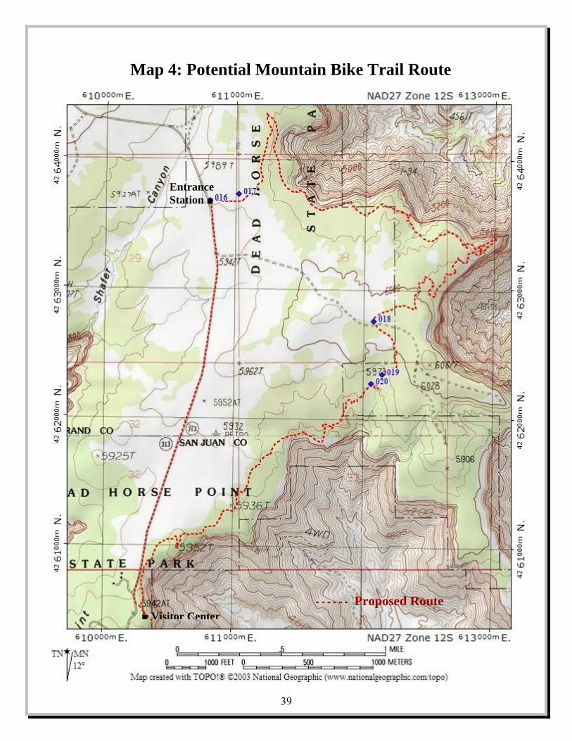
39
------------ Proposed Route ■ Visitor Center
Entrance Station ■
Map 4: Potential Mountain Bike Trail Route

40
This page intentionally left blank

Appendix A: Summary of Public Comments and Responses Appendix B: Zoological and Botanical Checklists for Dead Horse
Point State Park
41
Appendices

42
This page intentionally left blank
Summary of Public Comments and Responses In December 2006, this Plan was released to the public for review and comment. During December 2006 and January 2007, the Plan was made available by placing an electronic version on the Utah Division of State Parks and Recreation website. Hardcopies were made available to the public at Dead Horse Point State Park, Utah State Parks SE Region office, and the Department of Natural Resources building in Salt Lake City. Comments were accepted by e-mail or in writing to the Division’s planning section. One comment was delivered by telephone. A total of eight comments were received. Four were from other governmental agencies, one from a community trail advocacy group, and three from individuals. The following is a summary of comments received in response to the Draft Plan. Each comment is summarized below and is followed by the Division’s corresponding response. Comment: Non-motorized Trails (six total comments) The three individual public comments, as well as the one from the trail advocacy group, support the Plan’s proposed mountain bike trail. One of these comments would like the bike trail to stay on the eastern side of the Park. The respondent feels that the west side of the park (west of the park entrance road) has wilderness-type qualities that should be maintained by allowing only hiking in that area. The same respondent would like the bike trail routed to not interfere with a Mexican spotted owl nesting site (a federally listed threatened species) and associated critical habitat. A telephone comment from the BLM, Moab Field Office also requested that the trail avoid impacting the spotted owl site. A written comment from the Utah Division of Wildlife Resources (DWR) requested consulting DWR, or other wildlife specialists, when planning any developments, including the bike trail, to minimize impacts to wildlife and critical habitat. Two of the individual public comments and the trail advocacy group’s comment also voice support for the other non-motorized trail recommendations in the Plan. One individual comment suggests more promotion for the existing hiking trails in the Park. Response: Park managers have consulted with a BLM biologist about routing the proposed mountain bike trail to avoid conflicts with the owls. Language has been added to the plan to address consulting with wildlife experts when planning development (Page 14). Park Managers will take into account protecting park resources and traditional/historic recreational activities (such as hiking and opportunities for solitude) in the Park, when considering new opportunities such as mountain bike trails.
43
Appendix A

Comment: Visual Resource Management (two comments) One comment from an individual states that the Park’s greatest resource is its viewshed, much of which is outside of the Park’s boundaries. The respondent suggests the Park acquire outright, the State Institutional Trust Lands Administration properties adjacent to the park. Or at least, acquire development rights to these lands. The comment also suggests actively working with Federal land managing agencies to conserve the viewshed of the Park. The second comment is from the State Institutional Trust Lands Administration (SITLA). SITLA completed a viewshed analysis using existing viewpoints in the Park and determined that at least parts of over 30 sections administered by SITLA are visible from one or more of the Park’s viewpoints. Most of these sections are leased for subsurface minerals, typically, oil and gas and/or Potash. There is also at least one surface lease that may be visible from the Park. SITLA currently administers the mineral estate of approximately 600 acres within the Park, and over 3,000 acres of surface and mineral estate adjacent to the Park. The mineral estate of the lands within the Park is currently leased for oil and gas, and lands adjacent to the park are currently leased for oil and gas, and potash. In response to the RMP goal to work with SITLA to develop cooperative management plans for SITLA owned mineral rights in the Park, SITLA reports that they have only a limited ability to require lessees to perform or accommodate action not provided for in the leases. They also state that SITLA mineral lease agreements allow for as much surface use of the leased lands as is reasonably necessary for the development of the mineral estate. SITLA goes on to says that the lands in the viewshed have been leased numerous times for various purposes and the visual impact from these land uses has been virtually nonexistent, and when an impact is perceived, the lessees have been more than willing to minimize any visual impact. In response to the RMP recommendation to purchase SITLA lands in the viewshed, SITLA states that by Utah state statute, the mineral rights cannot be sold and are therefore subject to continued management by SITLA. SITLA reminds park management that it must understand the fiduciary duty imposed upon SITLA, as trustee, to manage the trust lands in the most prudent and profitable manner possible, and not for any purpose inconsistent with the best interest of the trust beneficiaries. Response: The suggestions from the individual respondent are specifically addressed in the Plan’s resource management recommendations (Page 22).
44
The Planning Team was told about SITLA’s fiduciary responsibilities, but because as SITLA points out in their comment, they have management over critical lands in the Park’s viewshed, the Team felt there should be better cooperation between SITLA and the Park. It is hoped that SITLA will consult with park management when activities on the lands they have management responsibilities for might affect the viewshed. This would include, consultation when issuing new leases or renewing current leases, or when lessees are planning activities that might impact the viewshed. As SITLA states in their comment, lessees of SITLA lands have been willing to minimize visual impacts. Consultation with the park managers should help to minimize or eliminate the impacts to one of the State’s greatest natural wonders.
Comment: Paleontological Resources (one comment) The Utah Geological Survey commented that the Plan did not address identifying and protecting paleontological resources. Response: A section was added to address paleontological resources and their protection (Page 14). Comment: Hunting Bighorn Sheep (one comment) The Utah Division of Wildlife Resources commented that the Plan did not address the limited hunting of desert bighorn sheep in the areas of the Park below the Wingate cliffs. This hunting activity has been allowed for the past twenty years. Response: A recommendation was added to the Plan allowing for the continued hunting of desert bighorn sheep in the areas of the Park below the Wingate cliffs (Page 23). Comment: Park Promotion (one comment) One comment was received that encourages the Park to work more closely with organizations that promote tourism in the area. The comment specifically mentions working with the Moab Information Center to promote the existing hiking trails in the Park. Response: The recommendations of the Plan’s marking section (Pages 26 and 27) specifically address the suggestions made in this comment.
45

46
This page intentionally left blank

Appendix B MAMMALS BATS Townsend’s Big-eared Bat—Corynorhinus townsendi Mexican Freetail Bat—Tadarida brasiliensis Big Freetail Bat—Nyctinomops macrotisSpotted Bat—Euderma maculatum Silver Haired Bat—Lasionycterus noctivagans Red Bat—Lasiurus borealis Hoary Bat—Lasiurus cinereus Western Pipistrelle Bat—Pipistrellus herperus Little Brown Myotis—Myotis lucifugas Pallid Bat—Antrozous pallidus Big Brown Bat—Eptesicus fuscus UNGULATES Desert Bighorn Sheep—Ovis Canadensis nelsoni Rocky Mountain Mule Deer—Odocoileus hemionus LAGOMORPHS Blacktail Jackrabbit—Leupus californicus Desert Cottontail—Sylvilagus audubonii RODENTS Deer Mouse—Peromyscus maniculatus Canyon Mouse—Peromyscus crinitus Brush Mouse—Peromyscus boylei Pinyon Mouse—Peromyscus truei Apache Pocket Mouse—Perognathus apache Bushytail Woodrat—Neotoma cinerea Desert Woodrat—Neotoma lepida Ord’s Kangaroo Rat—Dipodomys ordi Valley Pocket Gopher—Thomomys bottae Porcupine—Erethizon dorsatum Rock Squirrel—Spermaphilus variegates White Tailed Antelope Squirrel—Ammospermophilus leucurus Colorado Chipmunk—Eutamias quadrivittatus Antelope Ground Squirrel—Citellus leucurus FELINES Mountain Lion (Cougar)—Felis concolor Bob Cat—Lynx rufus CANINES Coyote—Canis latrans Kit Fox—Vulpes macrotis Gray Fox—Urocyon cinereroargenteus MUSTELIDS (WEASLE-LIKE) Longtail Weasle—Mustela frenata Spotted Skunk—Spilogale putorius Striped Skunk—Mephitis mephitis Badger—taxidea taxus
MISCELLANEOUS MAMMALS Ringtail Cat—bassariscus astutus REPTILES Collared Lizard—crothophytus collaris Leopard Lizard—crothophytus wislizeni Short Horned Lizard—phyrnosoma douglassi Sagebrush Lizard—Sceloporus graciousus Desert Spiny Lizard—Sceloporus magister Eastern Fence Lizard—Sceloporus undulates Tree Lizard—Uta ornate Side Blotched Lizard—Uta stansburiana Western Whiptail—Cnemidophorus tigris Racer—coluber constrictor Spotted Night Snake—Hypsiglena torquata Common Whipsnake—Masticophis flagellum Desert Striped Whipsnake—Masticophis taeniatus Gopher Snake—Pituophis melanoleuvus Midget Faded Rattlesnake—Cortalus viridis concolor AMPHIBIANS Great Basin Spadefoot Toad—Scaphiopus intermontanus Red-spotted Toad—Bufo punctatus POTHOLE LIFE Tadpole Shrimp Fairy Shrimp Clam Shrimp Great Basin Spadefoot Toad Tadpoles BIRDS HAWKS American Kestrel (Sparrow Hawk)—Falco sparverius Bald Eagle—Haliaeetus leucocephalus Cooper’s Hawk—Accipiter cooperii Ferruginous Hawk—Buteo regalis* Golden Eagle—Aquila chrysaetos Merlin (Pigeon Hawk)—Falco columbarius Northern Harrier (Marsh Hawk)—Circus cyaneus Osprey—Pandion haliaetus* Peregrine Falcon—Falco peregrinus Prairie Falcon—Falco mexicanus Red-Tailed Hawk—Buteo jamaicensis Sharp-shinned Hawk—Accipiter striatus* Swainson’s Hawk—Buteo swainsoni Turkey Vulture—Cathartes aura
47
Appendix B DEAD HORSE POINT ANIMAL & PLANT CHECKLISTS

OWLS Barn Owl—Tyto alba Burrowing Owl—Speotyto cunicularia Great Horned Owl—Bubo virginianus Long-eared Owl—Asio otus Mexican Spotted Owl—Strix occidentalis var. mexicanus* JAYS AND CROWS Black-billed Magpie—Pica pica Common Raven—Corvus corvax Pinyon Jay—Gymnorhinus cyanocephalus Scrub Jay—Aphelocoma coerulescens SWIFTS AND HUMMINGBIRDS Black-chinned Hummingbird—Archilochus alexandri Broad-tailed Hummingbird—Selasphorus platycercus White-throated Swift—Aeronautes saxatalis TYRANT FLYCATCHERS Ash-throated Flycatcher—Myiarchus cinerascens* Gray Flycatcher—Empidonax wrightii Say’s Phoebe—Sayornis saya Western Kingbird—Tyrannus verticalis Willow (Traill’s) Flycatcher—Empidonax traillii SWALLOWS Cliff Swallow—Petrochelidon pyrrhonota Rough-winged Swallow—Stelgidopteryx ruficollis* Violet-green Swallow—Tachycineta thalassina WARBLERS Audubon’s Warbler—Dendroica aduboni Black-throated Gray Warbler—Dendrocia nigrescens Yellow Warbler—Dendroica petechia* Yellow-breasted Chat—Icteria virens* Yellowthroat—Geothylpis trichas* SPARROWS Black-throated Sparrow—Amphispiza bilineata Chipping Sparrow—Spizella Passerina Lark Sparrow—Chondestes grammacus Vesper Sparrow—Pooecestes gramineus WRENS Canyon Wren—Caltherpes mexicanus Rock Wren—Caltherpes palustris MISCELLANEOUS PERCHING BIRDS American Robin—Turdus migratorius Blue-Grey Gnatcatcher—Polioptila caerulea Brewer’s Blackbird—Euphagus cyanocephalus Common Bushtit—Psaltriparius minimus Dark-eyed Junco (Oregon Race)—Junco oreganos Grey Vireo—Vireo vicinior
Horned Lark—Erempilia alpestris House Finch—Carpodacus mexicanus Loggerhead Shrike—Lanius ludovicianus Plain Titmouse—Parus inoratus Western Meadowlark—Sturnella neglecta Western Bluebird—Sialia mexicana MISCELLANEOUS BIRDS Chukar Partridge—Alectoris graeca Common Nighthawk—Chordeiles minor Great Blue Heron—Ardea herodias* Mourning Dove—Zenaidura macroura Poor Will—Phalaenoptilus nuttallii Red Shafted Flicker—Colaptes auratus * = not commonly seen at Dead Horse Point PLANTS WHITE FLOWERS Aster—Aster sp. Bastard Toadflax—Comandra umbellata var. pallida Cliff Dweller’s Candlestick—Cryptantha elata Creeping Primrose—Oenothera runcinata Desert Pepperweed—Lepidium fremontii Eaton Daisy—Erigeron eatonii Evening Primrose—Oenothera caespitosa Hairy Evening Primrose—Oenothera trichocalyx Milkvetch—Astragalus sp. Pale Evening Primrose—Oenothera pallida Round-leaved Eriogonum—Eriogonum ovalifolium Sand Verbena—Abronia fragrans Sego Lily—Calochortus nuttallii Thompson Eriogonum—Eriogonum thomponsae abliflorum Wooly Plantain—Plantago patagonica YELLOW FLOWERS Common Sunflower—Helianthus annuus Desert Dandelion—Malcothrix sonchoides Desert Trumpet—Eriogonum inflatum Goldenweed—Haplopappus sp. Newberry Twinpod—Physaria newberryi Prairie Sunflower—Helianthus petiolaris Prickly Pear Cactus—Opuntia polyacantha Prince’s Plume—Stanleya pinnata Snakeweed (Matchweed)—Gutierrezia microcephala Soneseed Puccoon—Lithospermum incisum Uinta Groundsel—Senecio multilobatus Yellow Cryptantha (Borage)—Cryptantha flava Yellow Bee Plant—Cleome lutea Wild Parsley—Cymopterus purpureus RED AND PINK FLOWERS Claret Cup Cactus—Echinocerus triglochidiatus Cliff Dweller’s Candlestick—Cryptantha elata Early Indian Paintbrush—Castilleja chromosa Eaton’s Penstemon—Penstemon eatonii
48
Fish Hook Cactus—Sclerocactus whipplei
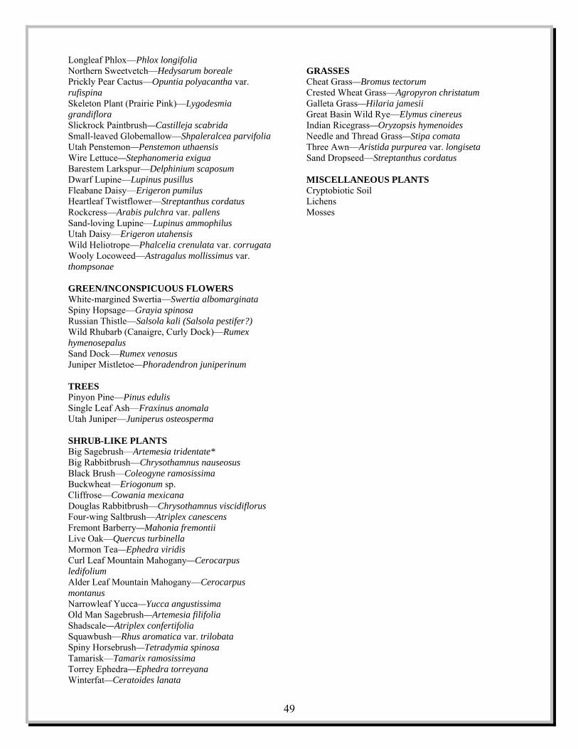
Longleaf Phlox—Phlox longifolia Northern Sweetvetch—Hedysarum boreale Prickly Pear Cactus—Opuntia polyacantha var. rufispina Skeleton Plant (Prairie Pink)—Lygodesmia grandiflora Slickrock Paintbrush—Castilleja scabrida Small-leaved Globemallow—Shpaleralcea parvifolia Utah Penstemon—Penstemon uthaensis Wire Lettuce—Stephanomeria exigua Barestem Larkspur—Delphinium scaposum Dwarf Lupine—Lupinus pusillus Fleabane Daisy—Erigeron pumilus Heartleaf Twistflower—Streptanthus cordatus Rockcress—Arabis pulchra var. pallens Sand-loving Lupine—Lupinus ammophilus Utah Daisy—Erigeron utahensis Wild Heliotrope—Phalcelia crenulata var. corrugata Wooly Locoweed—Astragalus mollissimus var. thompsonae GREEN/INCONSPICUOUS FLOWERS White-margined Swertia—Swertia albomarginata Spiny Hopsage—Grayia spinosa Russian Thistle—Salsola kali (Salsola pestifer?) Wild Rhubarb (Canaigre, Curly Dock)—Rumex hymenosepalus Sand Dock—Rumex venosus Juniper Mistletoe—Phoradendron juniperinum TREES Pinyon Pine—Pinus edulis Single Leaf Ash—Fraxinus anomala Utah Juniper—Juniperus osteosperma SHRUB-LIKE PLANTS Big Sagebrush—Artemesia tridentate* Big Rabbitbrush—Chrysothamnus nauseosus Black Brush—Coleogyne ramosissima Buckwheat—Eriogonum sp. Cliffrose—Cowania mexicana Douglas Rabbitbrush—Chrysothamnus viscidiflorus Four-wing Saltbrush—Atriplex canescens Fremont Barberry—Mahonia fremontii Live Oak—Quercus turbinella Mormon Tea—Ephedra viridis Curl Leaf Mountain Mahogany—Cerocarpus ledifolium Alder Leaf Mountain Mahogany—Cerocarpus montanus Narrowleaf Yucca—Yucca angustissima Old Man Sagebrush—Artemesia filifolia Shadscale—Atriplex confertifolia Squawbush—Rhus aromatica var. trilobata Spiny Horsebrush—Tetradymia spinosa Tamarisk—Tamarix ramosissima Torrey Ephedra—Ephedra torreyana Winterfat—Ceratoides lanata
GRASSES Cheat Grass—Bromus tectorum Crested Wheat Grass—Agropyron christatum Galleta Grass—Hilaria jamesii Great Basin Wild Rye—Elymus cinereus Indian Ricegrass—Oryzopsis hymenoides Needle and Thread Grass—Stipa comata Three Awn—Aristida purpurea var. longiseta Sand Dropseed—Streptanthus cordatus MISCELLANEOUS PLANTS Cryptobiotic Soil Lichens
49
Mosses

50
This page intentionally left blank

