dating caddo indian habitation at the hughes site (3sa11)
TRANSCRIPT

Academic Forum 24 2006-07
28
Dating Caddo Indian Habitation at the Hughes Site (3SA11)
Mary Beth Trubitt, Ph.D.
Sociology, Human Services, Arkansas Archeological Survey, HSU Research Station
and
Matthew Reynolds, M.A.
Arkansas Archeological Survey, HSU Research Station
Abstract
The 2002 Henderson State University Archeological Field School took place at the
Hughes site (3SA11), a significant Caddo mound site in Saline County, Arkansas. Students in
this course took part in a research project, directed by Dr. Mary Beth Trubitt, designed to
document spatial patterns of activity at the site, to investigate residential features, and to obtain
samples for dating the site’s inhabitation. Trubitt is the Arkansas Archeological Survey’s HSU
station archeologist and also teaches in HSU’s Sociology/Human Services Department.
Funding from an HSU Faculty Research Committee grant awarded to Trubitt in January, 2006,
has been used for radiocarbon dating of three charcoal samples obtained from the site during
the 2002 field season. The resulting dates fix the timing of the use of the Hughes site by
ancient Caddo Indians to at least the 14th
-15th
centuries A.D. and serve to clarify the
relationship between portions of burned structures found there.
The Research Project
The Hughes site (designated 3SA11 in the Arkansas site file database maintained by the
Arkansas Archeological Survey) is an important ancient mound site located near the Saline
River near Benton, Arkansas. Archeologists – and artifact collectors – have known about the
site for over a hundred years. It was visited by Edward Palmer in 1883 as part of the
Smithsonian Institution’s Mound Survey (Jeter 1990; Thomas 1894). Palmer’s description of
daub and charcoal/ash deposits from his excavations indicate there must have been at least one
structure on the main mound that burned. In the Caddo area, special structures were often
collapsed and burned after their use and earth mounded over them before a new building was
constructed. In 1982, Dr. Ann Early (then the Survey’s archeologist at HSU) did some
mapping and reconnaissance at Hughes, leading to the site’s placement on the National
Register of Historic Places. Shell-tempered ceramic sherds and novaculite tools found at the
site pointed to a late Caddo period occupation dating between about A.D. 1400-1700 (Jeter and
Early 1999; Schambach and Early 1982).
Hughes was a local population center used by late prehistoric/protohistoric Caddo
Indians that has the potential to contribute to our understanding of social and ceremonial
systems, settlement patterning, and economic organization. Our knowledge of Caddo lifeways
in southwest Arkansas is formed mainly from collections and archeological research in the
middle Ouachita River drainage (e.g., Early 1993) and the Red River drainage (e.g., Trubowitz
1984). How was the Caddo period occupation in the Saline River drainage similar to or
Academic Forum 24 2006-07
29
different from these areas?
Archeological field work at Hughes was undertaken in the summer of 2002 as part of an
Archeological Field School course offered through the HSU Sociology and Human Services
Department (that year it was also offered as a University of Arkansas course). The
archeological research at the Hughes site had several specific objectives: (1) to map the site’s
topography and surface features to document the main mound and identify remnants of any
other mounds; (2) to identify differences in activity patterning at the site, both around and away
from the main mound; (3) to investigate residential features such as houses, hearths, and pits
that can inform us about the people who lived at the site and their relationships with others
beyond the local region; and (4) to obtain samples (artifacts, charred wood) that can be used to
date the site occupation(s) and build a Caddo period chronology in this area.
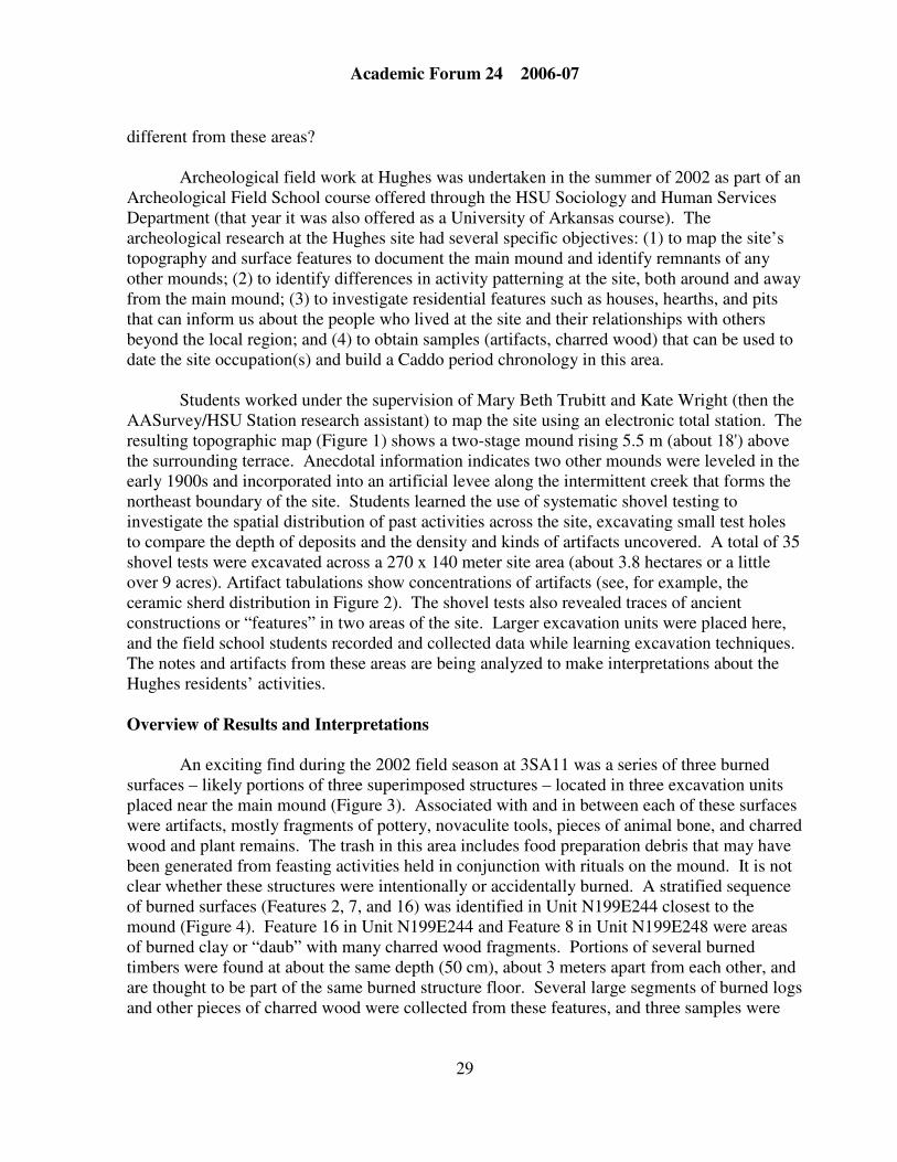
Students worked under the supervision of Mary Beth Trubitt and Kate Wright (then the
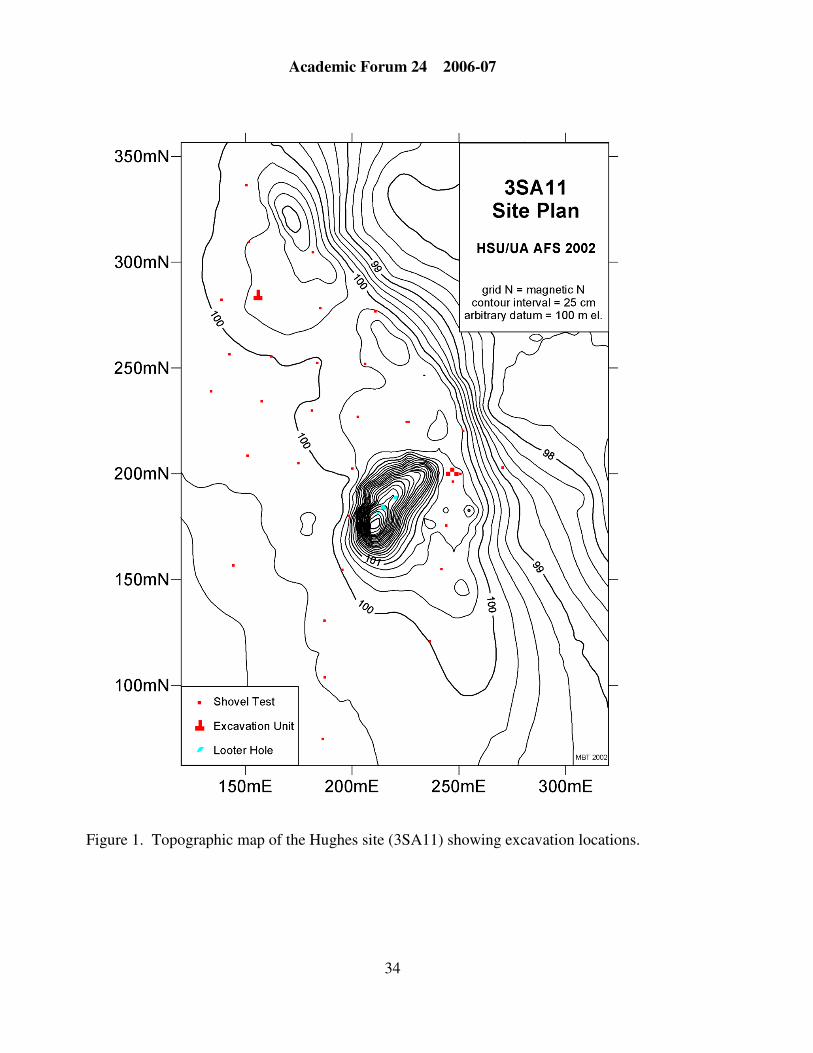
AASurvey/HSU Station research assistant) to map the site using an electronic total station. The
resulting topographic map (Figure 1) shows a two-stage mound rising 5.5 m (about 18') above
the surrounding terrace. Anecdotal information indicates two other mounds were leveled in the
early 1900s and incorporated into an artificial levee along the intermittent creek that forms the
northeast boundary of the site. Students learned the use of systematic shovel testing to
investigate the spatial distribution of past activities across the site, excavating small test holes
to compare the depth of deposits and the density and kinds of artifacts uncovered. A total of 35
shovel tests were excavated across a 270 x 140 meter site area (about 3.8 hectares or a little
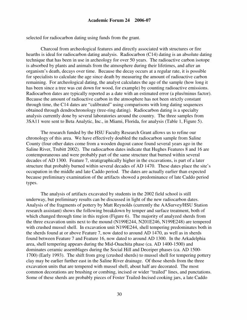
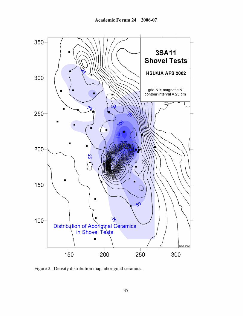
over 9 acres). Artifact tabulations show concentrations of artifacts (see, for example, the
ceramic sherd distribution in Figure 2). The shovel tests also revealed traces of ancient
constructions or “features” in two areas of the site. Larger excavation units were placed here,
and the field school students recorded and collected data while learning excavation techniques.
The notes and artifacts from these areas are being analyzed to make interpretations about the
Hughes residents’ activities.
Overview of Results and Interpretations
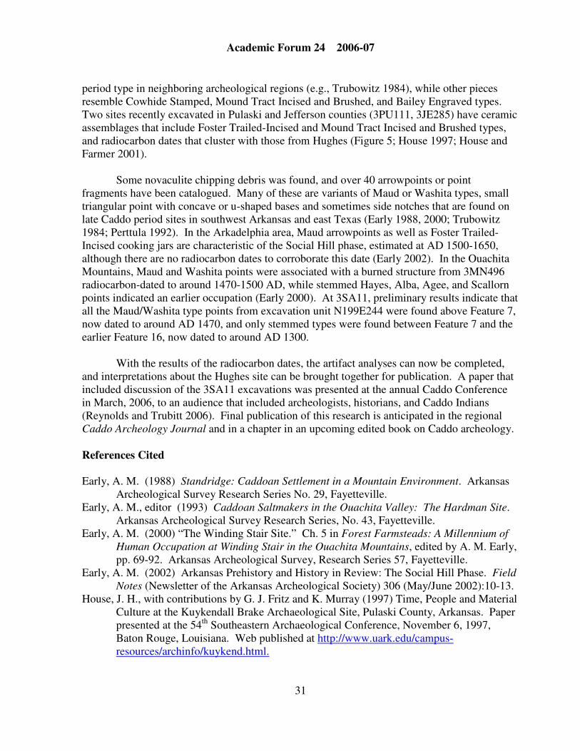
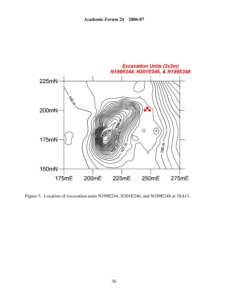
An exciting find during the 2002 field season at 3SA11 was a series of three burned
surfaces – likely portions of three superimposed structures – located in three excavation units
placed near the main mound (Figure 3). Associated with and in between each of these surfaces
were artifacts, mostly fragments of pottery, novaculite tools, pieces of animal bone, and charred
wood and plant remains. The trash in this area includes food preparation debris that may have
been generated from feasting activities held in conjunction with rituals on the mound. It is not
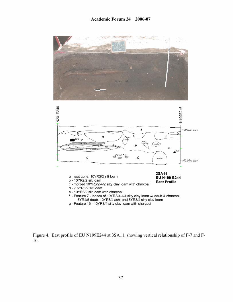
clear whether these structures were intentionally or accidentally burned. A stratified sequence
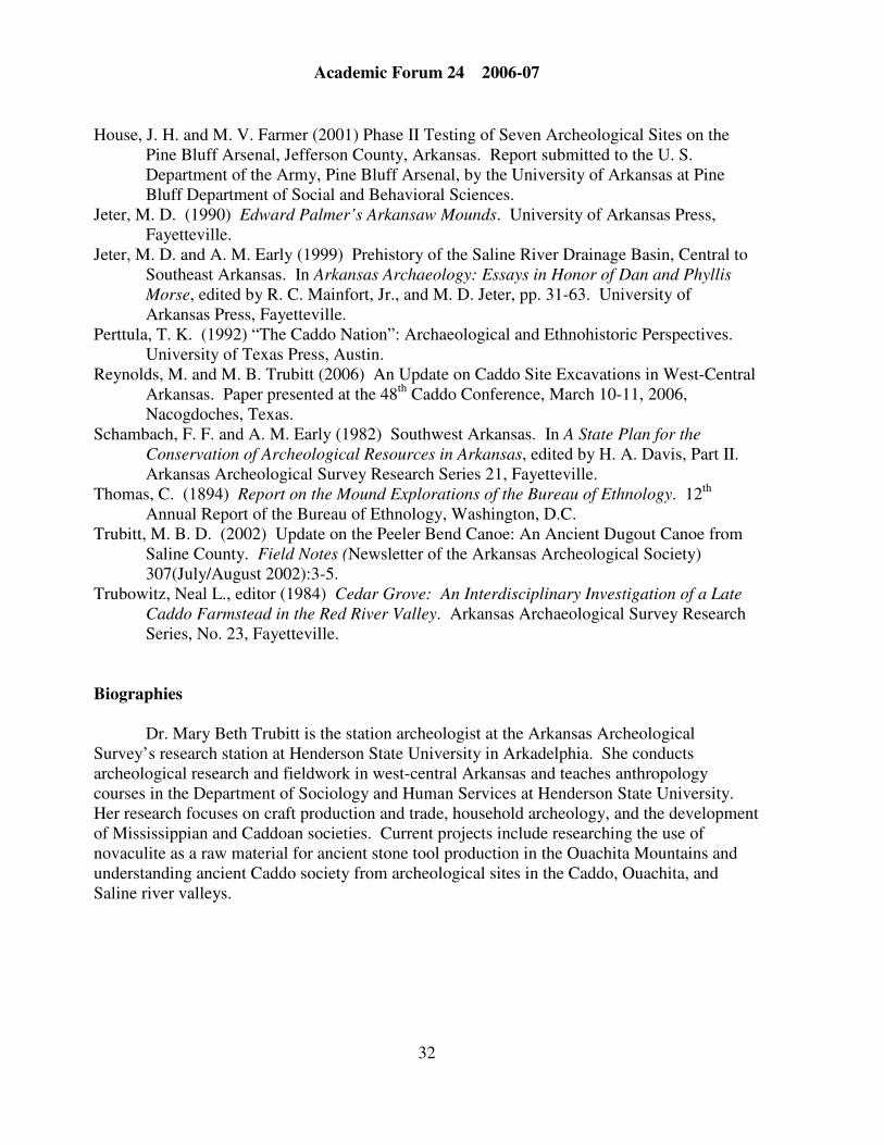
of burned surfaces (Features 2, 7, and 16) was identified in Unit N199E244 closest to the
mound (Figure 4). Feature 16 in Unit N199E244 and Feature 8 in Unit N199E248 were areas
of burned clay or “daub” with many charred wood fragments. Portions of several burned
timbers were found at about the same depth (50 cm), about 3 meters apart from each other, and
are thought to be part of the same burned structure floor. Several large segments of burned logs
and other pieces of charred wood were collected from these features, and three samples were
Academic Forum 24 2006-07
30
selected for radiocarbon dating using funds from the grant.
Charcoal from archeological features and directly associated with structures or fire
hearths is ideal for radiocarbon dating analysis. Radiocarbon (C14) dating is an absolute dating
technique that has been in use in archeology for over 50 years. The radioactive carbon isotope
is absorbed by plants and animals from the atmosphere during their lifetimes, and after an
organism’s death, decays over time. Because the decay occurs at a regular rate, it is possible
for specialists to calculate the age since death by measuring the amount of radioactive carbon
remaining. For archeological dating, the analyst calculates the age of the sample (how long it
has been since a tree was cut down for wood, for example) by counting radioactive emissions.
Radiocarbon dates are typically reported as a date with an estimated error (a plus/minus factor).
Because the amount of radioactive carbon in the atmosphere has not been strictly constant
through time, the C14 dates are “calibrated” using comparisons with long dating sequences
obtained through dendrochronology (tree-ring dating). Radiocarbon dating is a specialty
analysis currently done by several laboratories around the country. The three samples from
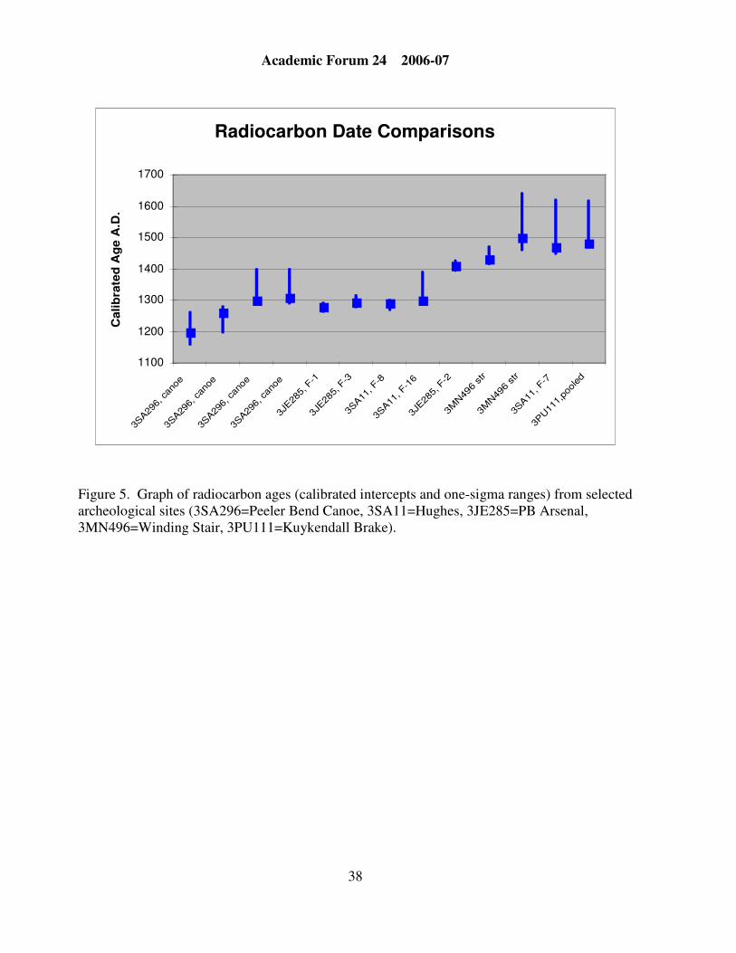
3SA11 were sent to Beta Analytic, Inc., in Miami, Florida, for analysis (Table 1, Figure 5).
The research funded by the HSU Faculty Research Grant allows us to refine our
chronology of this area. We have effectively doubled the radiocarbon sample from Saline
County (four other dates come from a wooden dugout canoe found several years ago in the
Saline River, Trubitt 2002). The radiocarbon dates indicate that Hughes Features 8 and 16 are
contemporaneous and were probably part of the same structure that burned within several
decades of AD 1300. Feature 7, stratigraphically higher in the excavations, is part of a later
structure that probably burned within several decades of AD 1470. These dates place the site’s
occupation in the middle and late Caddo period. The dates are actually earlier than expected
because preliminary examination of the artifacts showed a predominance of late Caddo period
types.
The analysis of artifacts excavated by students in the 2002 field school is still
underway, but preliminary results can be discussed in light of the new radiocarbon dates.
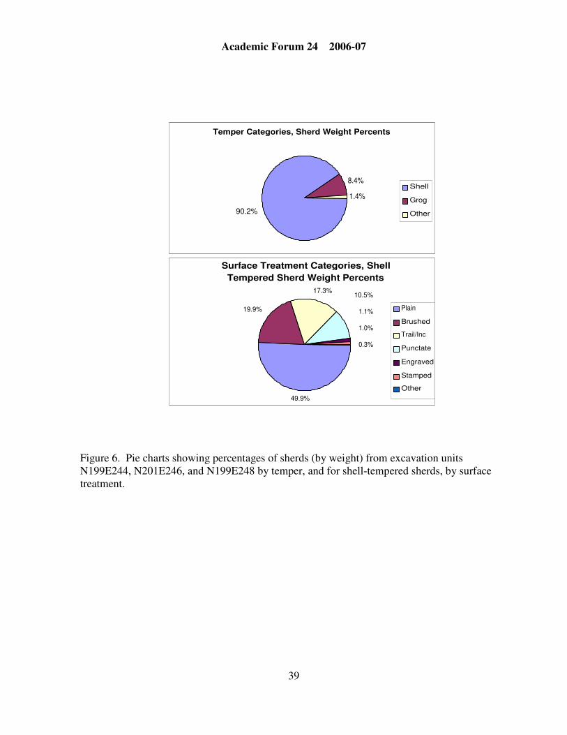
Analysis of the fragments of pottery by Matt Reynolds (currently the AASurvey/HSU Station
research assistant) shows the following breakdown by temper and surface treatment, both of
which changed through time in this region (Figure 6). The majority of analyzed sherds from
the three excavation units next to the mound (N199E244, N201E246, N199E248) are tempered
with crushed mussel shell. In excavation unit N199E244, shell tempering predominates both in
the sherds found at or above Feature 7, now dated to around AD 1470, as well as in sherds
found between Feature 7 and Feature 16, now dated to around AD 1300. In the Arkadelphia
area, shell tempering appears during the Mid-Ouachita phase (ca. AD 1400-1500) and
dominates ceramic assemblages during the Social Hill and Deceiper phases (ca. AD 1500-
1700) (Early 1993). The shift from grog (crushed sherds) to mussel shell for tempering pottery
clay may be earlier further east in the Saline River drainage. Of those sherds from the three
excavation units that are tempered with mussel shell, about half are decorated. The most
common decorations are brushing or combing, incised or wider “trailed” lines, and punctations.
Some of these sherds are probably pieces of Foster Trailed-Incised cooking jars, a late Caddo
Academic Forum 24 2006-07
31
period type in neighboring archeological regions (e.g., Trubowitz 1984), while other pieces
resemble Cowhide Stamped, Mound Tract Incised and Brushed, and Bailey Engraved types.
Two sites recently excavated in Pulaski and Jefferson counties (3PU111, 3JE285) have ceramic
assemblages that include Foster Trailed-Incised and Mound Tract Incised and Brushed types,
and radiocarbon dates that cluster with those from Hughes (Figure 5; House 1997; House and
Farmer 2001).
Some novaculite chipping debris was found, and over 40 arrowpoints or point
fragments have been catalogued. Many of these are variants of Maud or Washita types, small
triangular point with concave or u-shaped bases and sometimes side notches that are found on
late Caddo period sites in southwest Arkansas and east Texas (Early 1988, 2000; Trubowitz
1984; Perttula 1992). In the Arkadelphia area, Maud arrowpoints as well as Foster Trailed-
Incised cooking jars are characteristic of the Social Hill phase, estimated at AD 1500-1650,
although there are no radiocarbon dates to corroborate this date (Early 2002). In the Ouachita
Mountains, Maud and Washita points were associated with a burned structure from 3MN496
radiocarbon-dated to around 1470-1500 AD, while stemmed Hayes, Alba, Agee, and Scallorn
points indicated an earlier occupation (Early 2000). At 3SA11, preliminary results indicate that
all the Maud/Washita type points from excavation unit N199E244 were found above Feature 7,
now dated to around AD 1470, and only stemmed types were found between Feature 7 and the
earlier Feature 16, now dated to around AD 1300.
With the results of the radiocarbon dates, the artifact analyses can now be completed,
and interpretations about the Hughes site can be brought together for publication. A paper that
included discussion of the 3SA11 excavations was presented at the annual Caddo Conference
in March, 2006, to an audience that included archeologists, historians, and Caddo Indians
(Reynolds and Trubitt 2006). Final publication of this research is anticipated in the regional
Caddo Archeology Journal and in a chapter in an upcoming edited book on Caddo archeology.
References Cited
Early, A. M. (1988) Standridge: Caddoan Settlement in a Mountain Environment. Arkansas
Archeological Survey Research Series No. 29, Fayetteville.
Early, A. M., editor (1993) Caddoan Saltmakers in the Ouachita Valley: The Hardman Site.
Arkansas Archeological Survey Research Series, No. 43, Fayetteville.
Early, A. M. (2000) “The Winding Stair Site.” Ch. 5 in Forest Farmsteads: A Millennium of
Human Occupation at Winding Stair in the Ouachita Mountains, edited by A. M. Early,
pp. 69-92. Arkansas Archeological Survey, Research Series 57, Fayetteville.
Early, A. M. (2002) Arkansas Prehistory and History in Review: The Social Hill Phase. Field
Notes (Newsletter of the Arkansas Archeological Society) 306 (May/June 2002):10-13.
House, J. H., with contributions by G. J. Fritz and K. Murray (1997) Time, People and Material
Culture at the Kuykendall Brake Archaeological Site, Pulaski County, Arkansas. Paper
presented at the 54th
Southeastern Archaeological Conference, November 6, 1997,
Baton Rouge, Louisiana. Web published at http://www.uark.edu/campus-
resources/archinfo/kuykend.html.
Academic Forum 24 2006-07
32
House, J. H. and M. V. Farmer (2001) Phase II Testing of Seven Archeological Sites on the
Pine Bluff Arsenal, Jefferson County, Arkansas. Report submitted to the U. S.
Department of the Army, Pine Bluff Arsenal, by the University of Arkansas at Pine
Bluff Department of Social and Behavioral Sciences.
Jeter, M. D. (1990) Edward Palmer’s Arkansaw Mounds. University of Arkansas Press,
Fayetteville.
Jeter, M. D. and A. M. Early (1999) Prehistory of the Saline River Drainage Basin, Central to
Southeast Arkansas. In Arkansas Archaeology: Essays in Honor of Dan and Phyllis
Morse, edited by R. C. Mainfort, Jr., and M. D. Jeter, pp. 31-63. University of
Arkansas Press, Fayetteville.
Perttula, T. K. (1992) “The Caddo Nation”: Archaeological and Ethnohistoric Perspectives.
University of Texas Press, Austin.
Reynolds, M. and M. B. Trubitt (2006) An Update on Caddo Site Excavations in West-Central
Arkansas. Paper presented at the 48th
Caddo Conference, March 10-11, 2006,
Nacogdoches, Texas.
Schambach, F. F. and A. M. Early (1982) Southwest Arkansas. In A State Plan for the
Conservation of Archeological Resources in Arkansas, edited by H. A. Davis, Part II.
Arkansas Archeological Survey Research Series 21, Fayetteville.
Thomas, C. (1894) Report on the Mound Explorations of the Bureau of Ethnology. 12th
Annual Report of the Bureau of Ethnology, Washington, D.C.
Trubitt, M. B. D. (2002) Update on the Peeler Bend Canoe: An Ancient Dugout Canoe from
Saline County. Field Notes (Newsletter of the Arkansas Archeological Society)
307(July/August 2002):3-5.
Trubowitz, Neal L., editor (1984) Cedar Grove: An Interdisciplinary Investigation of a Late
Caddo Farmstead in the Red River Valley. Arkansas Archaeological Survey Research
Series, No. 23, Fayetteville.
Biographies
Dr. Mary Beth Trubitt is the station archeologist at the Arkansas Archeological
Survey’s research station at Henderson State University in Arkadelphia. She conducts
archeological research and fieldwork in west-central Arkansas and teaches anthropology
courses in the Department of Sociology and Human Services at Henderson State University.
Her research focuses on craft production and trade, household archeology, and the development
of Mississippian and Caddoan societies. Current projects include researching the use of
novaculite as a raw material for ancient stone tool production in the Ouachita Mountains and
understanding ancient Caddo society from archeological sites in the Caddo, Ouachita, and
Saline river valleys.

Academic Forum 24 2006-07
33
Mr. Matthew Reynolds is the research assistant at the Arkansas Archeological Survey’s
research station at Henderson State University in Arkadelphia. He received his BA in
anthropology from Ripon College in Wisconsin in 1994 and his MA in anthropology from the
University of Mississippi in 2002. His archeological field work has taken him to sites across
the southeastern United States and to Costa Rica. His research specializations are ceramics
analysis and geophysical surveying.
Table 1. Results of Radiocarbon Dating of 3SA11 Samples.
Sample ID
and Provenience
Conventional Radiocarbon
Age Before Present
Calibrated Age
Intercept
Calibrated Age
Range (1 sigma)
Beta-214276
2002-414-191, F-8
710 + 40 BP
Cal AD 1290
Cal AD 1270-1300
Beta-214277
2002-414-234, F-16
640 + 40 BP
Cal AD 1300
Cal AD 1290-1320
and Cal AD 1340-1390
Beta-214275
2002-414-188, F-7
390 + 40 BP
Cal AD 1470
Cal AD 1450-1510
and Cal AD 1600-1620
Academic Forum 24 2006-07
34
Figure 1. Topographic map of the Hughes site (3SA11) showing excavation locations.
Academic Forum 24 2006-07
35
Figure 2. Density distribution map, aboriginal ceramics.
Academic Forum 24 2006-07
36
Figure 3. Location of excavation units N199E244, N201E246, and N199E248 at 3SA11.
Academic Forum 24 2006-07
37
Figure 4. East profile of EU N199E244 at 3SA11, showing vertical relationship of F-7 and F-
16.
Academic Forum 24 2006-07
38
Radiocarbon Date Comparisons
1100
1200
1300
1400
1500
1600
1700
3SA29
6, can
oe
3SA29
6, c
anoe
3SA29
6, can
oe
3SA29
6, c
anoe
3JE28
5, F
-1
3JE28
5, F
-3
3SA11
, F-8
3SA11
, F-1
6
3JE28
5, F
-2
3MN49
6 str
3MN49
6 str
3SA11
, F-7
3PU11
1,po
oled
Cali
bra
ted
Ag
e A
.D.
Figure 5. Graph of radiocarbon ages (calibrated intercepts and one-sigma ranges) from selected
archeological sites (3SA296=Peeler Bend Canoe, 3SA11=Hughes, 3JE285=PB Arsenal,
3MN496=Winding Stair, 3PU111=Kuykendall Brake).
Academic Forum 24 2006-07
39
Figure 6. Pie charts showing percentages of sherds (by weight) from excavation units
N199E244, N201E246, and N199E248 by temper, and for shell-tempered sherds, by surface
treatment.
Surface Treatment Categories, Shell
Tempered Sherd Weight Percents
49.9%
19.9%
17.3%10.5%
1.1%
1.0%
0.3%
Plain
Brushed
Trail/Inc
Punctate
Engraved
Stamped
Other
Temper Categories, Sherd Weight Percents
90.2%
8.4%
1.4%
Shell
Grog
Other