date: february 2, 2018 (last update) subject: wrangell ... memo to file 1529.38.006 date: february...
TRANSCRIPT

1
Memo to File 1529.38.006
Date: February 2, 2018 (last update)
Subject: Wrangell Monofill Site Selection
From: Sally Schlichting, Unit Manager, DEC Contaminated Sites
Monofill Site Selection This briefing document provides an overview of the 15 sites that have been evaluated by ADEC and its contractors, the City and Borough of Wrangell, The Wrangell Cooperative Association, ADNR, and EPA for housing the treated lead soil monofill from the Wrangell Junkyard cleanup. These included several sites that were suggested by the Wrangell Cooperative Association. The sites are identified on the following aerial map, and a brief summary of the key issues, challenges or positive attributes of each site is provided. Landownership is in parentheses after the site name.

2
1. Spur road rock pit (CBW) Although DEC’s contractor felt this site could potentially work for housing a monofill, the pit size is fairly small, which may require the contaminated material to be piled as much as 30 feet high. The exposed face of the monofill must have a 3:1(H:V) graded slope which further limits available space. The pit is currently full of debris and wood waste that would need to be cleared out. The access road to the site would need to be rebuilt and possibly re-aligned. The site itself is in an area that is heavily used by recreators and residents for off-road vehicles, dog-walking, berry-picking, and other activities. It is very close to the road and therefore highly visible. It is also in an area where future residential development may occur, and along a road currently used to access private properties. The road accessing to and beyond the pit will be part of a Federal Land Access Program project, to grade and improve the road to access a popular USFS Trail head a mile further up the road. Trucking material to this site would require driving through town. When discussed in detail with the City Assembly on May 2, 2016, this location for the monofill was rejected for the above reasons.
2. Running Track (CBW) This site is a closed wood waste fill site located next to the school. The site is currently a large vacant lot that is underutilized as it was never completely finished to serve as a recreational facility. It is commonly known as the “running track” where a variety of unmonitored activities occur. Feature-wise, it is large, flat and square and is very accessible from the road system. Its attractiveness for the monofill is its size – approximately 4.77 acres –allowing the material to be piled about 3.75 feet high not including the base and the cover material, and then sloped 3:1 on all sides. However, it is located in downtown Wrangell and is adjacent to schools and is popular for recreational activities. During a
special assembly meeting on May 2, 2016, some assembly members voiced their objection to this option due their

3
concern about the long-term stability of the EcoBond- treated lead soil, and maintenance and monitoring requirements they might be burdened with, and perceived concerns about health risks to children. Furthermore, there are potential permitting issues with placing the monofill on a closed woodwaste monofill, as well as potential settling that may continue to occur as the woodwaste decays over time. In addition, there are reports of uncontrolled leachate emanating from the closed disposal site.
View of the running track toward school and downtown Wrangell.

4
3. Overburden monofill site near the shooting range (CBW)
The City rejected this site during a special assembly meeting on May 2, 2016 because of the continued need for a monofill disposal site for overburden and debris from local development projects. Recent discussions with the WCA and the City to revisit this alternative indicate that the City will be using the remaining space at this site for the disposal of 7,000 cubic yards of dredge spoils from a harbor dredging project. City staff stated that in order to dispose of any additional material, a permit modification to expand the site would need to be sought from DEC.
4. Shotgun firing range (CBW) This site was suggested by the WCA. The informal shooting area is adjacent to the existing firing range. It is located on muskeg, which is a wetland. Construction of a monofill in a wetland is prohibited by the Solid Waste regulations unless no other viable alternative is available. Filling a wetland requires a 404 Corps of Engineers permit/401 water quality certification to fill the
wetland area. An evaluation of the existing lead contamination likely present at the site would also need to occur and be addressed. Local gun enthusiasts are interested in develop this area into a formal skeet range. Image left shows site conditions.

5
5. Rock pit #1 1 mile Pat’s Creek Road (DNR/State Forest) Approximately eight miles south of the Wrangell Junkyard site, and one mile Pat’s Creek Road is a designated material sale site under AS 38.05.550(b) on State Forest land. The designation means the pit is managed by DMLW and uses of the pit are permitted by the Division of Mining Land and Water (DMLW). The pit is located up an unmaintained road off of Pat’s Creek Road. The pit itself has adequate space, is located out of the way and access to the site could be controlled with a gate or other barricade. The access road would require improvement to support truck traffic. Indications are that this pit is not frequented by the public for any recreational activity. Discussions with DNR’s Mining, Lands and Water Southeast Regional Office indicated this site could potentially be used for the monofill. However, both the site and the access road to it are densely overgrown with alders and would require considerable prep work with heavy equipment. Additionally, there is a large volume of deep standing water in the floor of the pit that may require some management. The site is also significantly closer to Pats Creek and Pats Lake than other sites. Image below shows the pit in summer forested with alders.
6
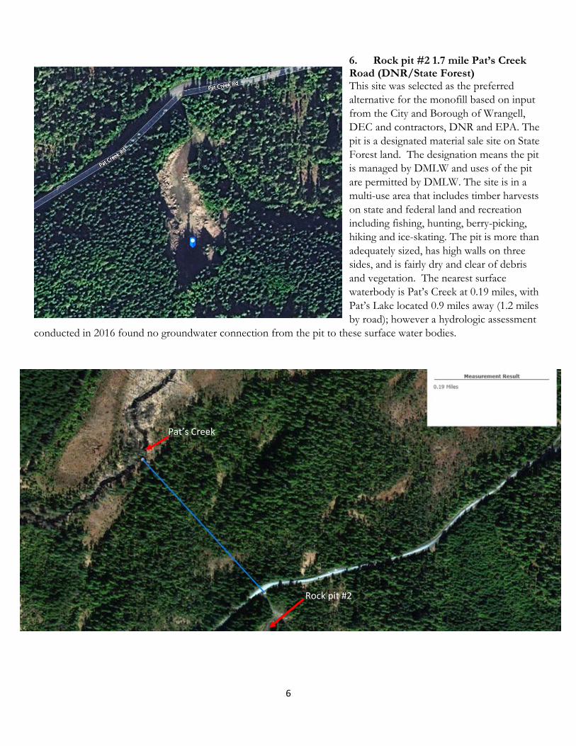
6. Rock pit #2 1.7 mile Pat’s Creek Road (DNR/State Forest) This site was selected as the preferred alternative for the monofill based on input from the City and Borough of Wrangell, DEC and contractors, DNR and EPA. The pit is a designated material sale site on State Forest land. The designation means the pit is managed by DMLW and uses of the pit are permitted by DMLW. The site is in a multi-use area that includes timber harvests on state and federal land and recreation including fishing, hunting, berry-picking, hiking and ice-skating. The pit is more than adequately sized, has high walls on three sides, and is fairly dry and clear of debris and vegetation. The nearest surface waterbody is Pat’s Creek at 0.19 miles, with Pat’s Lake located 0.9 miles away (1.2 miles by road); however a hydrologic assessment
conducted in 2016 found no groundwater connection from the pit to these surface water bodies.
Pat’s Creek
Rock pit #2

7
The pit is adjacent to Pat’s Creek Road and the access does not require improvements other than basic maintenance, but a USFS permit to use the road is required. There is adequate space for truck turnaround to limit congestion, and the narrow entrance is easily blocked off to limit access. The site required the least prep work of any of the sites. Although this pit is located within the State Forest, it was designated as a material sale site in 2012. As such, the material sale pit is managed by DNR/DMLW. In fall of 2017, site preparation work was completed and the product of this work is shown above right. The next page shows the engineered layout of the repository inside the pit, followed by a cross section of the repository design.

ecol
ogy
and
envi
ronm
ent,
inc.
Glob
al En
viron
menta
l Spe
cialis
ts
C-3
1
C-5
1
C-5
·
·
·
·
·
·
·
·
·
·
2
C-5
2
C-5
0
+
5
0
C
-4
1
+
0
0
C
-
4
1
+
5
0
C
-
4
2
+
0
0
C
-
4
2
+
5
0
C
-
4
A
-
A
'
C
-
4
5
C-5
Thomas C. Campbell06-09-17
No. EV14234
REGISTERED PROFESSIONA L ENGINEER


8
7. Rock pit #3 4 mile Pat’s Creek Road (DNR/DOF)
Although this site, located within the State Forest, was a potential candidate, it was not preferred because it is full of very large boulders that were covering running water through site, making assessment of its suitability (leachability/hydrologic analysis) and preparation of the site much more challenging than the other available sites. The pit is not a designated material site, so use would be subject to the Division of Forestry. The site was revisited in January 2018 with staff from WCA.

9
8. Rock pit #4 - 5.3 miles out Pat’s Creek Road (DNR/DOF with SW portion having adjacent owner) This pit was suggested by WCA and is located further out Pat’s Creek Road, approximately 5.3 miles from the turnoff from Zimovia Highway. The pit is not a designated material site. The pit is too small both lengthwise and depth-wise, and has uncontrolled access along the entire front of the pit where it abuts Pat’s Creek Road.
View of the pit from Pats Creek Road

10
9. Rock pit #5 past the Pats Creek Road turnoff on an unidentified road (DNR/USFS split ownership) Also known as Wrangell Quarry No. 1, the DNR portion is a designated material site located partially in the State Forest. This site was proposed by members of the City assembly early on and later by WCA, but due to the split ownership between DNR and the USFS right down the middle of the pit, this site was rejected. Image at right shows approximate boundary. In addition, this pit is closer to Pat’s creek than DNR rock pit #2 which makes it less favorable. Image below shows the entrance to the pit.
USFS
DNR

11
10. Overlook Rock Pit, 22 miles from City of Wrangell on USFS Road 6265. (DNR/DOF, possibly w/USFS easement)
This site was proposed by the WCA in early October 2017 based on input aired at DEC-led public meeting on August 21 in Wrangell. DEC investigated this site with DNR and found that the ownership is in the state forest, but it has not been designated as a material site. The entrance to the pit is exposed where it is located adjacent to the
USFS road. This side would require barricades or fencing to secure the site once a monofill is constructed. It is also immediately across the road from a small picnic area, indicating that the area is used for recreation. Division of Forestry staff state this is the only material site (rock pit) available on this side of the island, and prefer the chosen site on Pats Creek Road. Additionally, the USFS may have an easement for this pit as part of the patent conveyance. The distance from town would further increase the cost of the project due to increased travel for trucks to prepare the pit and construct the monofill, along with increased costs for road maintenance and permitting required by USFS for receiving access.

12
State Parcel, Mile 2.2 Zimovia Highway (MHLT) Parcels on Mental Health Trust land require purchase. This involves seeking an appraisal, performing a survey, a public notice period and consent of the MHLT board. This parcel is shown in the large red rectangle. It is accessible from Zimovia Highway and is less than two miles from the Byford property. This area is steeply sloped, with wetland areas and some large drainages, making it unsuitable for a monofill under the solid waste regulations. Siting the monofill here also poses a potential concern for surrounding residences and is less than ¼ mile from intertidal areas in Zimovia Strait where traditional, commercial, and recreational harvesting of fish and shellfish occur. The shaded light blue area is designated for purchase by the USFS with the exception of the developed area within the small red rectangle and small blue square which are currently leased to a third party.
11. Cleared Area off Spur Road (CBW)
City and Borough of Wrangell staff suggested a small cleared area on city land north of town. This is shown in the areal below. It is designated by the red arrow in the photo left. It is located up a steep pioneer road, which levels out onto a small plateau. Unfortunately the developable area for a monofill is small due to being bounded on either side by creeks, one of which runs under the access road via a culvert.
13
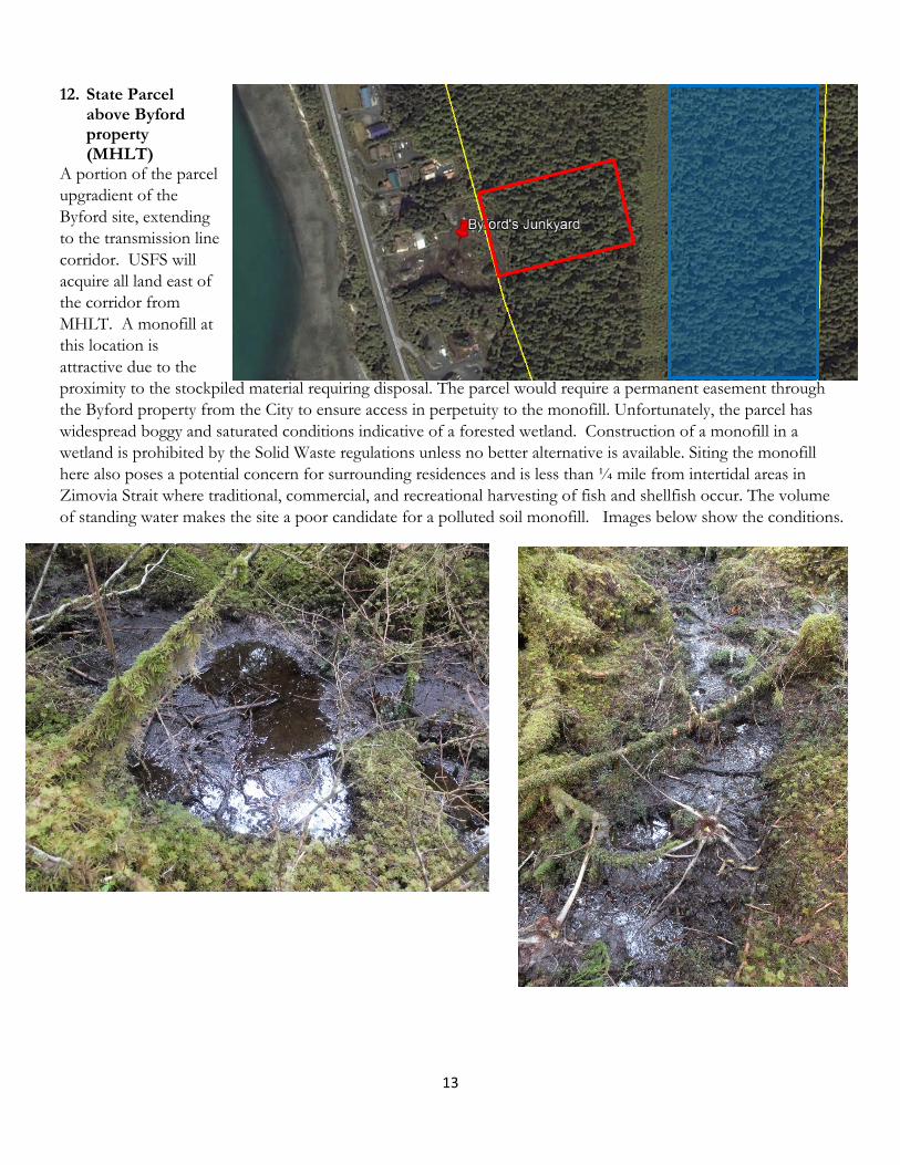
12. State Parcel above Byford property (MHLT)
A portion of the parcel upgradient of the Byford site, extending to the transmission line corridor. USFS will acquire all land east of the corridor from MHLT. A monofill at this location is attractive due to the proximity to the stockpiled material requiring disposal. The parcel would require a permanent easement through the Byford property from the City to ensure access in perpetuity to the monofill. Unfortunately, the parcel has widespread boggy and saturated conditions indicative of a forested wetland. Construction of a monofill in a wetland is prohibited by the Solid Waste regulations unless no better alternative is available. Siting the monofill here also poses a potential concern for surrounding residences and is less than ¼ mile from intertidal areas in Zimovia Strait where traditional, commercial, and recreational harvesting of fish and shellfish occur. The volume of standing water makes the site a poor candidate for a polluted soil monofill. Images below show the conditions.

14
13. State parcel with small rock pit across from the Wrangell Golf course (MHLT) The small roadside material pit was identified by MHLT staff as a potential site for the monofill. This site is immediately adjacent to a recreational site – the Muskeg Meadows Golf Course --which is heavily used by recreators. However, the pit itself is too small to allow for a 3:1 slope from the top of the monofill toward the road. Standing water was present among large boulders along the back side. The land above and behind the pit rises steeply. Expanding the size of the pit by blasting would increase project costs and could worsen unknown hydrologic conditions by creating new fractures for water to travel. This could make the pit ultimately unsuitable for housing a monofill. In addition, the entire front of the pit is adjacent to the road, and may encroach on the ADOT right of way.
View from near the back of the pit to the road, showing the shallowness of the pit
View from the far edge of the pit, road to the left.

15
Land on the same parcel, adjacent to this pit was also inspected. The parcel is characterized by steep rocky nobs interspersed with deep gullies. A cleared mounded area (possibly imported fill) was identified to the right of the pit (from the road), but was not of sufficient size or sufficient distance from drainages. Extensive work would be required to blast rock, remove significant material and develop a road to access the property to both do a leachability/hydrologic analysis as well as to create a site suitable for a monofill.
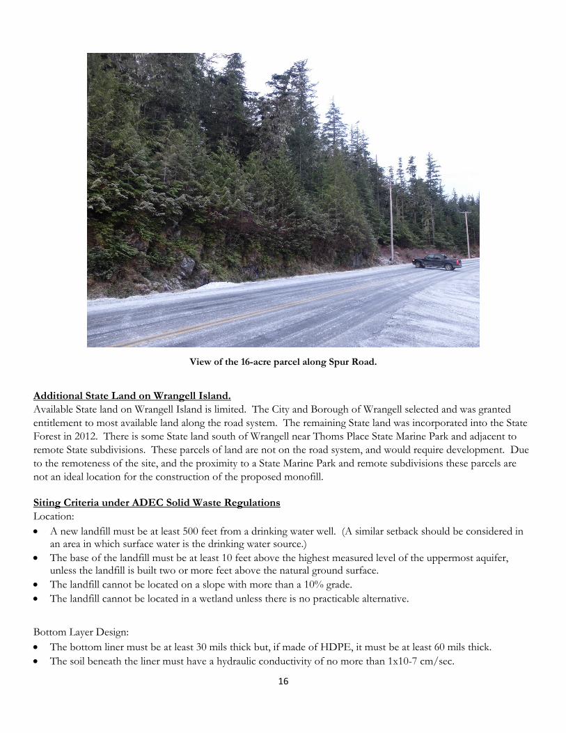
14. 16-acre State parcel on Spur Road (MHLT) Although only a portion would be required, MHLT prefers purchase for development of a monofill include all 16 acres, due to concern that construction of a monofill would devalue remaining acreage slated for residential use. No road access from Spur Road to this parcel currently exists. The property is characterized by a steep rise from Spur
Road, large rock knobs, and steep drainages and would require a road be constructed before a hydrologic study could be conducted due to access needed for a drill rig. To develop a monofill on this property, it would have to be logged, cleared of overburden, and removal of a volume of material roughly equivalent to the volume of soil requiring disposal. The image below shows the steepness along Spur Road.
16-Acre parcel
Small Rock Pit site near golf course
16
View of the 16-acre parcel along Spur Road.
Additional State Land on Wrangell Island. Available State land on Wrangell Island is limited. The City and Borough of Wrangell selected and was granted entitlement to most available land along the road system. The remaining State land was incorporated into the State Forest in 2012. There is some State land south of Wrangell near Thoms Place State Marine Park and adjacent to remote State subdivisions. These parcels of land are not on the road system, and would require development. Due to the remoteness of the site, and the proximity to a State Marine Park and remote subdivisions these parcels are not an ideal location for the construction of the proposed monofill.
Siting Criteria under ADEC Solid Waste Regulations Location: • A new landfill must be at least 500 feet from a drinking water well. (A similar setback should be considered in
an area in which surface water is the drinking water source.) • The base of the landfill must be at least 10 feet above the highest measured level of the uppermost aquifer,
unless the landfill is built two or more feet above the natural ground surface. • The landfill cannot be located on a slope with more than a 10% grade. • The landfill cannot be located in a wetland unless there is no practicable alternative.
Bottom Layer Design: • The bottom liner must be at least 30 mils thick but, if made of HDPE, it must be at least 60 mils thick. • The soil beneath the liner must have a hydraulic conductivity of no more than 1x10⁻⁷ cm/sec.
17
• The leachate control system must not allow more than 12 inches of liquid to accumulate on the bottom liner. This requires ongoing monitoring and maintenance in perpetuity to ensure this liquid is managed which raises costs.
• Division of Solid Waste can approve a monofill without a liner based on site conditions, a hydrologic and leachability assessment, and adjustments to the monofill design.
Final Cover Design: • The surface of the landfill cannot be sloped more steeply than 3:1 (H:V). • The final cover must be at least two feet thick, sloped to drain without erosion, and must include two distinct
layers: o An infiltration layer that is at least 18 inches thick and has a maximum hydraulic conductivity of 1x10⁻⁵
cm/sec; and o An erosion layer that is at least 6 inches thick that is capable of sustaining plant growth (i.e. allows for
revegetation of the cover). • In the absence of leachate collection, the final cover should not be more permeable than the bottom liner to
minimize the potential for water to accumulate within the waste. • The final cover should also be revegetated with native vegetation unless the planned post-closure use requires a
different surface.