data repository
TRANSCRIPT

DATA REPOSITORY: RETRODEFORMATION OF CROSSBED DATA TO DETERMINE PALEOCURRENT
DIRECTION
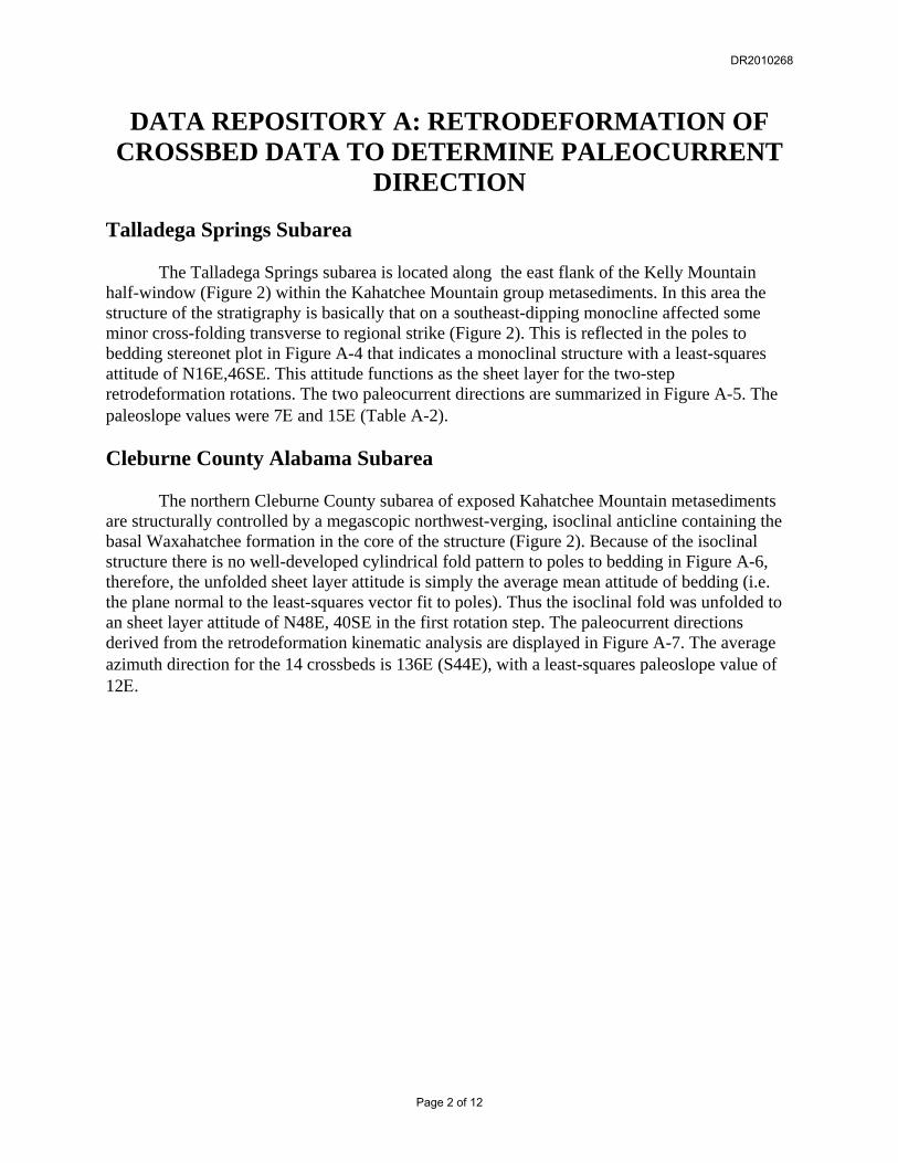
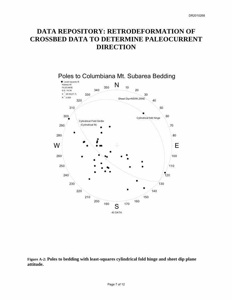
The procedure for determining the paleocurrent direction indicated by cross-bedding in the current study consisted of a two-step retro-deformation that initially “unfolds” megascopic fold structures into a tabular plane that is tangent to the anticlinal and synclinal hinge lines referred to as the sheet dip plane (Whitten, 1966). The dip of the sheet dip plane is subsequently removed by a second rotation about its strike line until the original depositional horizontal attitude of primary bedding is attained. In both rotation steps, foreset crossbeds that occur within primary bedding are rotated in the same manner to retro-deform them into their original depositional attitude. The paleocurrent direction is assumed to be in the azimuth direction of the true dip of the foreset. It is important to note that in general the first-step rotation is unique for each top/bottomset and foreset pair because this rotation occurs around the hinge line of the dominant megascopic folding, therefore, each top/bottomset bed will have a different rotation angular amount and sense depending on its position on the fold profile. The geometrical relationships of the first-step rotation used to generate a tabular sheet from the folded strata is depicted in Figure A-1. Note that the individually unique rotations (∀1 and ∀2) that are required to rotate primary bedding around the hinge to become parallel to the unfolded sheet layer. The second-step rotation affects all data equally, and is shown as the angle ∗. Because of the many permutations of the first-step rotation large data sets are best processed by programming a calculator or computer. A Windows®-compatible program with supporting documentation useful for processing 2-step rotations may be downloaded at: “http://www.usouthal.edu/geography/allison/w-netprg.htm”. The data files used with the crossbed analysis program (“W-xbed.exe”) for this project are listed in tables A-1 through A-3. The Kahatchee Mountain Group cross-bedding used for this study is distributed into three separate subareas: 1) Columbiana Mountain on the northeast plunging portion of the Columbiana Mountain syncline, 2) Talladega Springs along the east flank of the Kelly Mountain window, and 3) northern Cleburne County (Figure 2). Bedding readings from Kahatchee Mountain Group units (Waxahatchee, Brewer, Wash Creek formations) were selected and plotted to define the geometry and attitude of megascopic folding that affects the subarea. The least-squares statistical hinge or mean vector to poles to bedding were used to define the attitude of the unfolded sheet layer (Figure A-1). Columbiana Mountain Subarea The Columbiana Mountain subarea is structurally controlled by a northeast plunging syncline exposed along the northwest flank of the Kelly Mountain half-window (Figure 2). Poles to bedding from Kahatchee Mountain Group metasediments (Figure A-2; Table A-1) define a least-squares cylindrical fold hinge (25,N40E; R2=0.83), therefore, the unfolded sheet layer attitude is N50W, 25SW for this subarea. A two-step retro-deformation of foreset crossbeds from the subarea (Table A-1) results in a an average paleocurrent bearing of 137Ε and an average paleoslope dip of 32Ε (Figure A-3).
DR2010268
Page 1 of 12
DATA REPOSITORY A: RETRODEFORMATION OF CROSSBED DATA TO DETERMINE PALEOCURRENT
DIRECTION
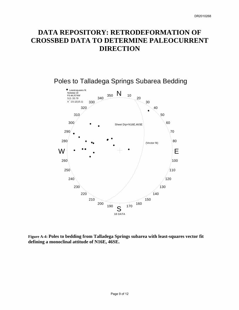
Talladega Springs Subarea The Talladega Springs subarea is located along the east flank of the Kelly Mountain half-window (Figure 2) within the Kahatchee Mountain group metasediments. In this area the structure of the stratigraphy is basically that on a southeast-dipping monocline affected some minor cross-folding transverse to regional strike (Figure 2). This is reflected in the poles to bedding stereonet plot in Figure A-4 that indicates a monoclinal structure with a least-squares attitude of N16E,46SE. This attitude functions as the sheet layer for the two-step retrodeformation rotations. The two paleocurrent directions are summarized in Figure A-5. The paleoslope values were 7Ε and 15Ε (Table A-2). Cleburne County Alabama Subarea The northern Cleburne County subarea of exposed Kahatchee Mountain metasediments are structurally controlled by a megascopic northwest-verging, isoclinal anticline containing the basal Waxahatchee formation in the core of the structure (Figure 2). Because of the isoclinal structure there is no well-developed cylindrical fold pattern to poles to bedding in Figure A-6, therefore, the unfolded sheet layer attitude is simply the average mean attitude of bedding (i.e. the plane normal to the least-squares vector fit to poles). Thus the isoclinal fold was unfolded to an sheet layer attitude of N48E, 40SE in the first rotation step. The paleocurrent directions derived from the retrodeformation kinematic analysis are displayed in Figure A-7. The average azimuth direction for the 14 crossbeds is 136Ε (S44E), with a least-squares paleoslope value of 12Ε.
DR2010268
Page 2 of 12

DATA REPOSITORY: RETRODEFORMATION OF CROSSBED DATA TO DETERMINE PALEOCURRENT
DIRECTION
Table A-1: Columbiana Mt. Subarea Data Sample Top/Bottomset Foreset Paleocurrent azimuth Paleoslope 41 N 50 W 52 E N 50 W 52 E 159.0 (S21.0E) 25.6 42 N 42 W 45 E N 42 W 45 E 135.2 (S44.8E) 23.2 42 N 75 W 40 E N 75 W 40 E 143.0 (S37.0E) 34.0 73 N 65 W 42 E OT N 65 W 42 E 061.7 (N61.7E) 36.9 CO099 N 00 E 45 E CO043 N 19 E 30 E CO042 N 13 E 30 E CO044 N 00 E 30 E CO045 N 27 W 30 E CO050 N 07 E 50 E CO057 N 00 E 30 E CO089 N 32 E 45 W CO092 N 50 E 25 W CO095 N 69 E 30 E CO094 N 43 E 20 W GE562 N 00 E 23 E GE506 N 50 W 67 E CO091 N 76 E 70 W CO093 N 09 E 30 E GE509 N 67 E 17 W CO135 N 17 E 70 E GE511 N 60 E 62 W GE537 N 48 W 22 E GE538 N 49 E 36 E GE539 N 58 E 37 W CO050 N 07 E 50 E CO049 N 00 E 25 E CO056 N 32 W 40 E CO058 N 66 W 35 E CO059 N 56 W 40 E CO060 N 69 W 35 E CO063 N 57 E 80 W CO068 N 40 E 30 E CO062 N 48 W 35 E GE560 N 17 W 56 E GE561 N 43 W 13 E GE559 N 42 W 23 E GE558 N 39 E 50 W GE557 N 06 E 51 E GE553 N 29 E 90 E
DR2010268
Page 3 of 12
DATA REPOSITORY A: RETRODEFORMATION OF CROSSBED DATA TO DETERMINE PALEOCURRENT
DIRECTION
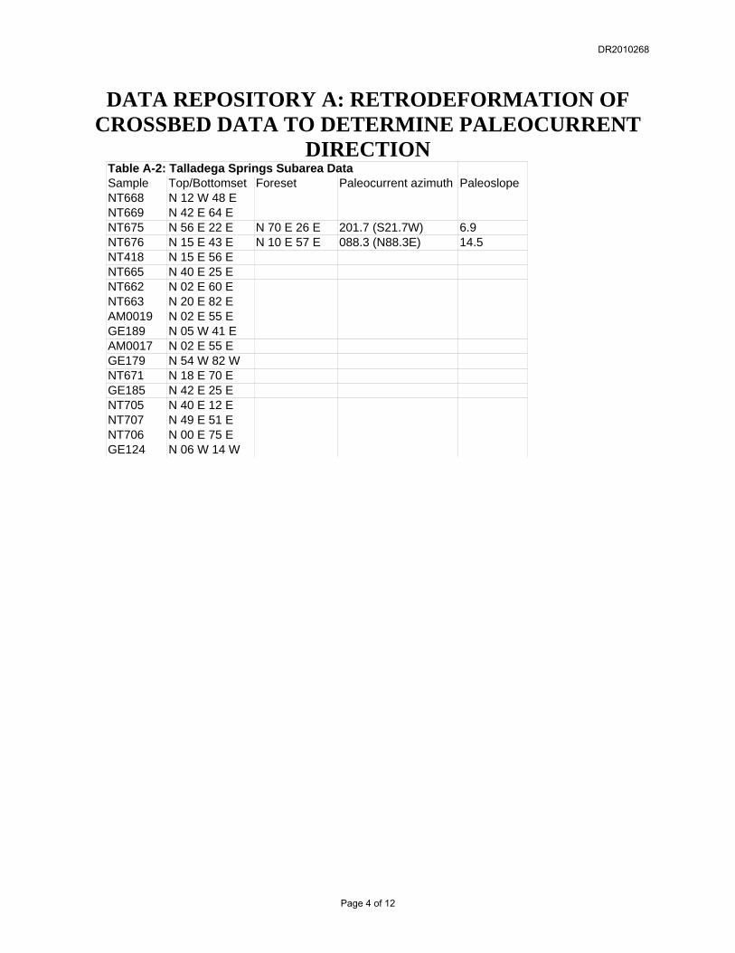
Table A-2: Talladega Springs Subarea Data Sample Top/Bottomset Foreset Paleocurrent azimuth Paleoslope NT668 N 12 W 48 E NT669 N 42 E 64 E NT675 N 56 E 22 E N 70 E 26 E 201.7 (S21.7W) 6.9 NT676 N 15 E 43 E N 10 E 57 E 088.3 (N88.3E) 14.5 NT418 N 15 E 56 E NT665 N 40 E 25 E NT662 N 02 E 60 E NT663 N 20 E 82 E AM0019 N 02 E 55 E GE189 N 05 W 41 E AM0017 N 02 E 55 E GE179 N 54 W 82 W NT671 N 18 E 70 E GE185 N 42 E 25 E NT705 N 40 E 12 E NT707 N 49 E 51 E NT706 N 00 E 75 E GE124 N 06 W 14 W
DR2010268
Page 4 of 12

DATA REPOSITORY: RETRODEFORMATION OF CROSSBED DATA TO DETERMINE PALEOCURRENT
DIRECTION
Table A-3: Cleburne County Subarea Data Sample Top/Bottomset Foreset Paleocurrent azimuth Paleoslope RA1247 N 70 E 66 E RA1204 N 20 E 60 E RA1301 N 19 E 58 E RA1300 N 15 E 60 E RA1259 N 47 E 71 E RA1085 N 55 E 36 E N 47 E 42 E 100.3 (S79.7E) 7.8 RA1079 N 52 E 31 E N 51 E 40 E 133.4 (S46.6E) 14.2 RA1079 N 55 E 26 E RA1080 N 39 E 35 E N 35 E 45 E 104.9 (S75.1E) 10.3 EB090 N 35 E 25 E N 46 E 37 E 157.1 (S22.9E) 13.2 EB091 N 52 E 30 E N 50 E 39 E 134.3 (S45.7E) 9.1 EB202 N 56 E 30 W N 64 E 39 W 182.2 (S02.2W) 10.1 EB104 N 81 W 37 W ER003 N 75 E 26 E N 70 E 38 E 156.3 (S23.7E) 12.3 ER001 N 15 E 05 W N 21 E 16 W 247.4 (S67.4W) 11 ER010 N 60 E 15 E ER018 N 70 E 75 W EO037 N 72 E 50 E ER139 N 54 E 47 E ER138 N 31 E 67 E ER125 N 61 E 41 E N 57 E 49 E 127.0 (S53.0E) 8.5 ER140 N 39 E 41 E N 42 E 55 E 151.2 (S28.8E) 14.2 ER040 N 25 E 53 E N 21 E 61 E 098.1 (S81.9E) 8.7 ER041 N 39 E 44 E N 35 E 55 E 114.5 (S65.5E) 11.4 ER042 N 62 E 48 E N 67 E 58 E 171.4 (S08.6E) 10.8 RA1086 N 52 E 31 E N 58 E 39 E 167.0 (S13.0E) 8.7
DR2010268
Page 5 of 12

DATA REPOSITORY A: RETRODEFORMATION OF CROSSBED DATA TO DETERMINE PALEOCURRENT
DIRECTION
foreset bedα1
δ
α2
Figure A-1: Geometry of two-step retrodeformation to remove the deformation effects of folding.
DR2010268
Page 6 of 12
DATA REPOSITORY: RETRODEFORMATION OF CROSSBED DATA TO DETERMINE PALEOCURRENT
DIRECTION
Poles to Columbiana Mt. Subarea Bedding
N
S
W E
10
170
350
190
20
160
340
200
30
150
330
210
40
140
320
220
50
130
310
230
60
120
300
240
70
110
290
250
80
100
280
260
Least-squares fitN(data):40
Fit:25,N40E
S.D.:16.34
X2
:25.53(27.7)
R2
:0.830
40 DATA
Cylindrical Fold Girdle
(Cylindrical fit)
Cylindrical fold hinge
Sheet Dip=N50W,25NE
Figure A-2: Poles to bedding with least-squares cylindrical fold hinge and sheet dip plane attitude.
DR2010268
Page 7 of 12

DATA REPOSITORY A: RETRODEFORMATION OF CROSSBED DATA TO DETERMINE PALEOCURRENT
DIRECTION
Columbiana Mt. Paleocurrent
N
S
W E
10
170
350
190
20
160
340
200
30
150
330
210
40
140
320
220
50
130
310
230
60
120
300
240
70
110
290
250
80
100
280
260
Least-squares fitN(data):4
Fit:32,S43E
S.D.:37.33
X2
:57.16(15.1)
4 DATA
1
1
1
1
Figure A-3: Rose diagram for paleocurrent direction trends in the Columbiana Mt. subarea.
DR2010268
Page 8 of 12
DATA REPOSITORY: RETRODEFORMATION OF CROSSBED DATA TO DETERMINE PALEOCURRENT
DIRECTION
Poles to Talladega Springs Subarea Bedding
N
S
W E
10
170
350
190
20
160
340
200
30
150
330
210
40
140
320
220
50
130
310
230
60
120
300
240
70
110
290
250
80
100
280
260
Least-squares fitN(data):18Fit:44,N74WS.D.:33.79X
2:23.12(15.1)
18 DATA
Sheet Dip=N16E,46SE
(Vector fit)
Figure A-4: Poles to bedding from Talladega Springs subarea with least-squares vector fit defining a monoclinal attitude of N16E, 46SE.
DR2010268
Page 9 of 12

DATA REPOSITORY A: RETRODEFORMATION OF CROSSBED DATA TO DETERMINE PALEOCURRENT
DIRECTION
Talladega Springs Subarea PaleocurrentN
S
W E
10
170
350
190
20
160
340
200
30
150
330
210
40
140
320
220
50
130
310
230
60
120
300
240
70
110
290
250
80
100
280
260
2 DATA
1
1
Figure A-5: Paleocurrent direction rose diagram derived from Talladega Springs subarea (paleoslope = 7 & 15).
DR2010268
Page 10 of 12

DATA REPOSITORY: RETRODEFORMATION OF CROSSBED DATA TO DETERMINE PALEOCURRENT
DIRECTION
Poles to Cleburne Co. Subarea Bedding
N
S
W E
10
170
350
190
20
160
340
200
30
150
330
210
40
140
320
220
50
130
310
230
60
120
300
240
70
110
290
250
80
100
280
260
Least-squares fitN(data):25Fit:50,N42WS.D.:29.52X
2:10.81(15.1)
25 DATA
Isoclinal Sheet=N48E,40SE
(Vector Fit)
Figure A-6: Poles to bedding from Cleburne Co. subarea data yielding a least-squares isoclinal sheet attitude of N48E, 40SE.
DR2010268
Page 11 of 12

DATA REPOSITORY A: RETRODEFORMATION OF CROSSBED DATA TO DETERMINE PALEOCURRENT
DIRECTION
Cleburne Co. Subarea PaleocurrentN
S
W E
10
170
350
190
20
160
340
200
30
150
330
210
40
140
320
220
50
130
310
230
60
120
300
240
70
110
290
250
80
100
280
260
Least-squares fitN(data):14Fit:12,S44E
S.D.:33.49
X2
:23.68(15.1)
14 DATA
3
2
1
Figure A-7: Rose histogram of paleocurrent azimuths from the retrodeformed Cleburne County subarea (mean paleoslope = 12).
DR2010268
Page 12 of 12