data interoperability best practices and common uses · 2018. 7. 31. · -feature classes are...
TRANSCRIPT

Data InteroperabilityBest Practices and Common UsesBruce Harold
Dale Lutz

Dale & Bruce
The Basics

What is the Data Interoperability Extension?All About Moving Data From A to B
• What formats?
• From A,B,C… to D,E,F… at once?
• Local data or web too?
• What can I do on the way?
• Is this part of Geoprocessing?
• Can I automate this on a schedule?
• Does it understand OAuth2?
• Do I have to code?
• Can I work with FME?

Where is the Data Interoperability Extension?ArcGIS Desktop, ArcGIS Enterprise
• Desktop means ArcGIS Pro, ArcMap, ArcCatalog…
• Licensed like any other extension
- Named user, concurrent, single user
- Don’t forget to install it
• Analysis Tools includes Quick Tools
• Author Spatial ETL workspaces
- Directly from the ribbon
- Within a toolbox
• Import a Spatial ETL or FME source FMW file

How can I use the Data Interoperability Extension?
• Traditionally three workflows – Direct Read, Quick Conversion, Spatial ETL
• Web GIS and the API economy adds the requirement for Services
Emergent themes: Connectivity, Transformation, Automation
1: Use Workbench 2: It’s Coming!
Capability ArcGIS 10.x ArcGIS Pro 2.2
Direct Read of Formats✓ 1
Quick Format
Conversion ✓ ✓
Spatial ETL Tools✓ ✓
FMW Integration ✓
Publish ETL GP Service✓ 2

How Do We See People Using Data Interoperability?Top Use Cases
• Migration
- Adoption of ArcGIS, Working with ArcGIS
• Connection
- Apps with an API
• Collaboration
- Generate data in a business-friendly format
• Validation
- Feature-Level Business Rule Enforcement
• Detection
- Cross-Format Feature Interaction
• Synchronization
- Feature Services and other repositories
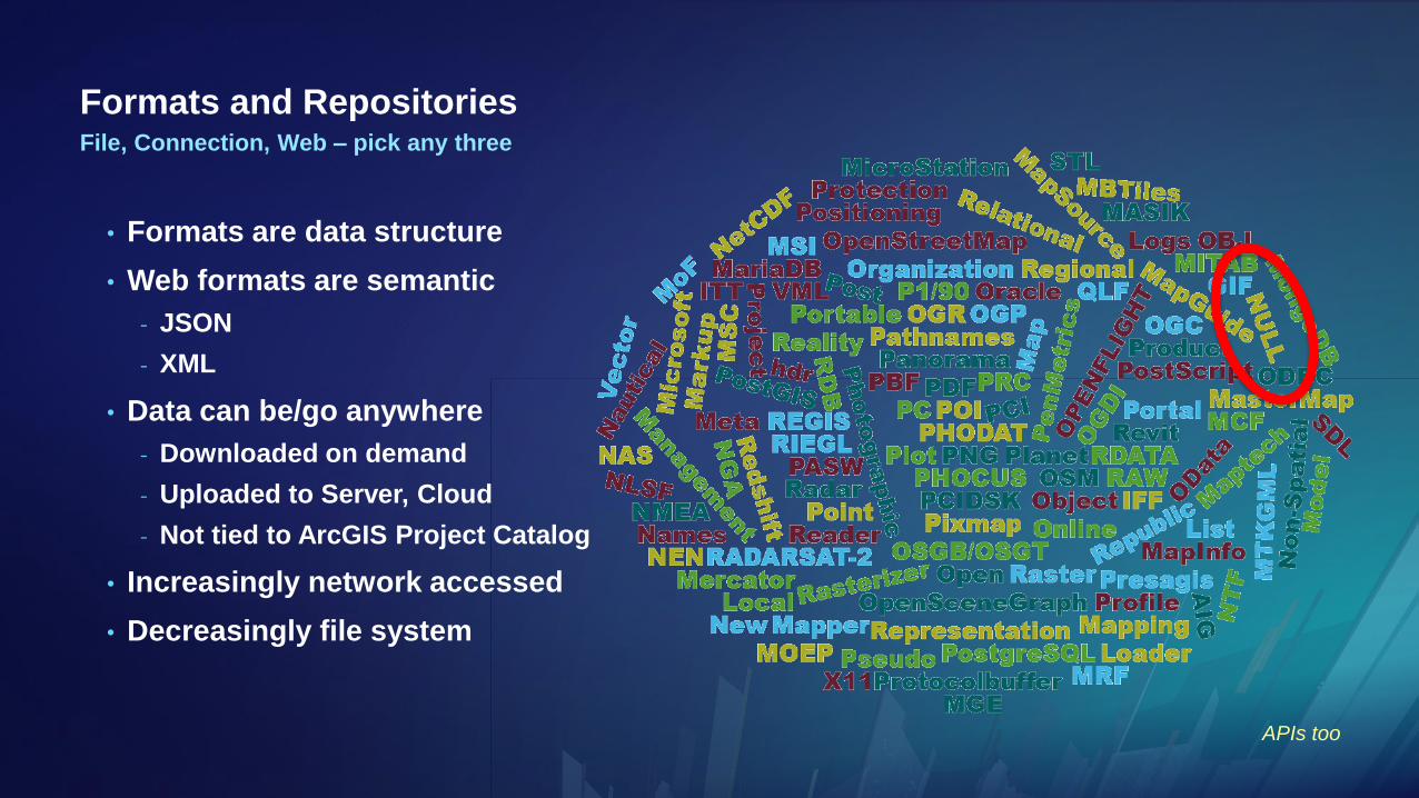
Formats and Repositories
• Formats are data structure
• Web formats are semantic
- JSON
- XML
• Data can be/go anywhere
- Downloaded on demand
- Uploaded to Server, Cloud
- Not tied to ArcGIS Project Catalog
• Increasingly network accessed
• Decreasingly file system
File, Connection, Web – pick any three
APIs too

Direct Format ReadDesktop 10.x Experience
• ArcGIS is Geo-Relational
- Feature classes are database tables with an ObjectID and a geometry column
- Tables have ObjectID but no geometry
• Some file formats can be automatically interpreted this way
- Recognized by file extension (.gml, .geojson, .kml, .gpx, .xlsx, .osm, .xyz….)
- Default behavior assumed
• Many data sources are out of scope for Direct Read
- Not visible in the Catalog
- Interpretation is required
- Custom formats are an option (advanced topic)
• Not feasible in a fully Web GIS
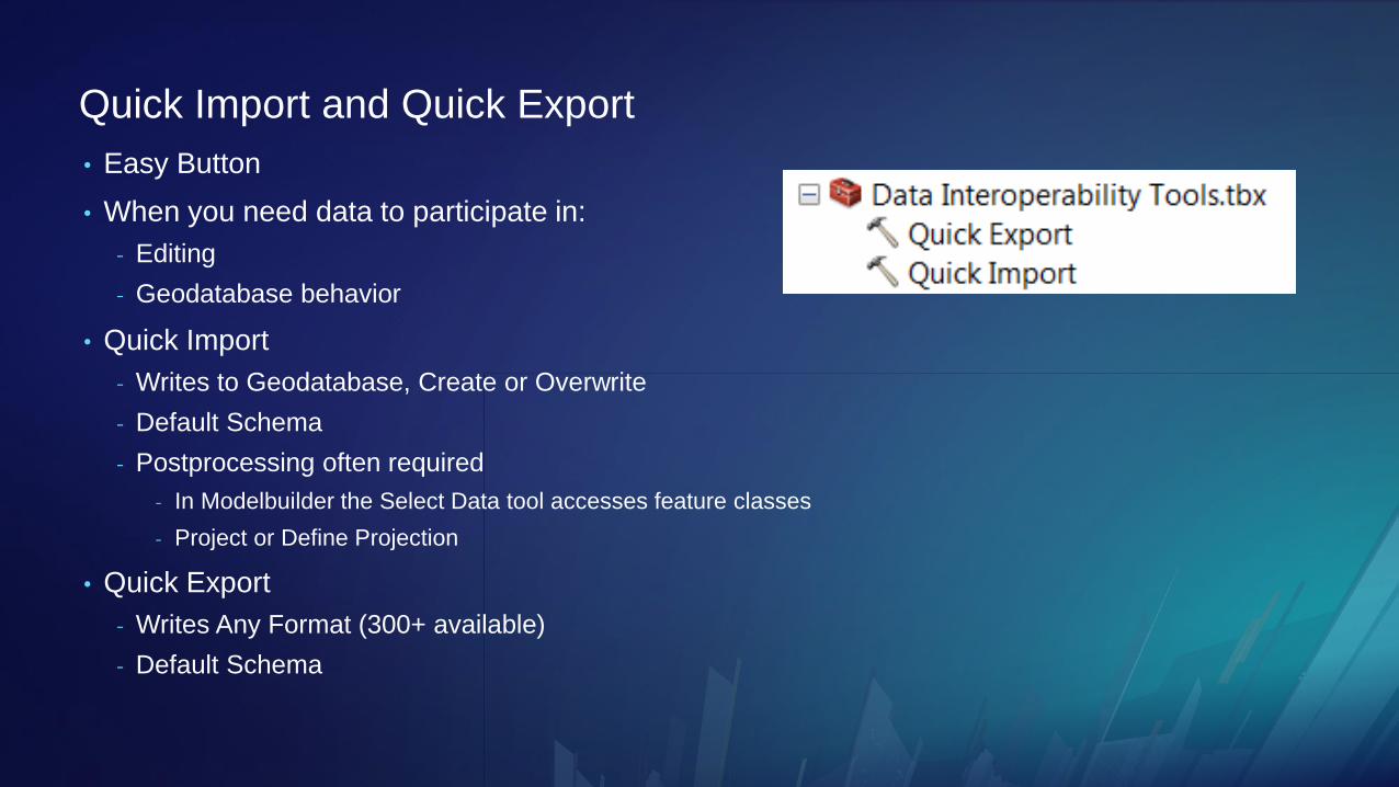
Quick Import and Quick Export
• Easy Button
• When you need data to participate in:
- Editing
- Geodatabase behavior
• Quick Import
- Writes to Geodatabase, Create or Overwrite
- Default Schema
- Postprocessing often required
- In Modelbuilder the Select Data tool accesses feature classes
- Project or Define Projection
• Quick Export
- Writes Any Format (300+ available)
- Default Schema

Multiple FormatsSometimes intermediate data is read or written
• Read Many
• SQL Interact Many
• Spatial Interact Many
• Expression Interact Many
• Write Many
GMLMIFCSVKMLXLSX

Bruce
Best Practices for
Direct Read versus
Quick Tools versus
Spatial ETL Tools

Dale & Bruce
Connect, Transform, Automate
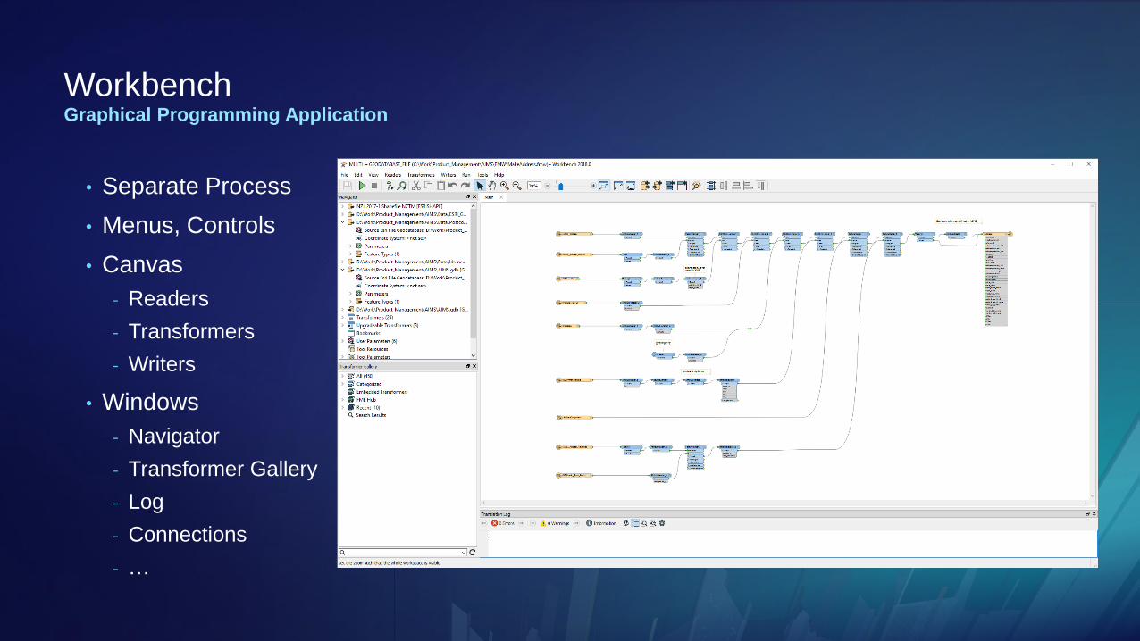
WorkbenchGraphical Programming Application
• Separate Process
• Menus, Controls
• Canvas
- Readers
- Transformers
- Writers
• Windows
- Navigator
- Transformer Gallery
- Log
- Connections
- …

What’s a Transformer?Extract Transform Load
• Transformers are analogous to a geoprocessing tool in ModelBuilder
- Can be grouped, nested, iterated
• Have input and output port(s)
• May read & write filesystem, database, web
• May operate per feature, per group of features or whole dataset
• May operate on attributes and/or geometry
• May operate with parallel concurrency
• Show Me

Bruce
Transformer Basics

Bruce (but I bet Dale chimes in)
Authoring Workspaces

Environment & Options
• FME 2018.0.0.2 Engine
- 300+ Formats
- Feature Caching
- FME Compatible FMW Source
- Database Connections
- Web Connections
- FME Hub Connectivity
• Python Compatibility
- Inherit Pro’s Conda Environment
- Custom Interpreter can be set
Data Interoperability
We could argue all day about how many formats…
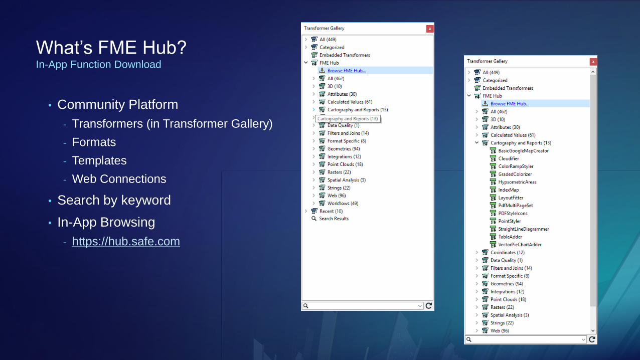
What’s FME Hub?In-App Function Download
• Community Platform
- Transformers (in Transformer Gallery)
- Formats
- Templates
- Web Connections
• Search by keyword
• In-App Browsing
- https://hub.safe.com
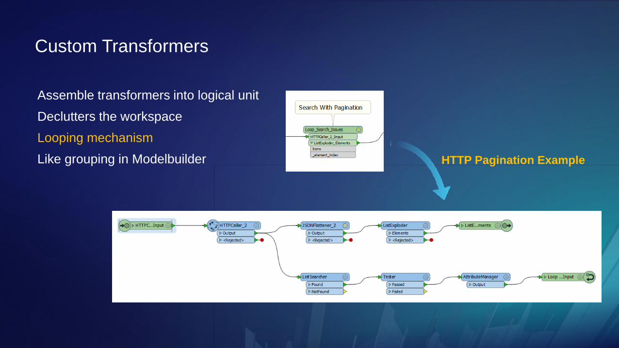
Custom Transformers
Assemble transformers into logical unit
Declutters the workspace
Looping mechanism
Like grouping in Modelbuilder HTTP Pagination Example

Bruce
Custom
Transformers

Ad Hoc Analysis WorkspacesData Interoperability
• Launch From Ribbon
• Prototype Workflows
- Author
- Open
- Drag In Data or FMW
- Save As Template
- Export As Custom Format
• Send To Email

PythonParameters available as a dictionary
Startup Scripts
Run first
Scripted Parameters
Runtime logic
PythonCreator
Make features
PythonCaller
Operate on features
Shutdown Scripts
Run last
In-App Script Editor

Multiprocessing
Group By Attribute
• Up to 4 processes
WorkspaceRunner
• Up to 7 processes
• Process recycling

Working With PortalsArcGIS Online and ArcGIS Enterprise
• Make Connections to Portals
• Get Background Maps
• Work With Feature Services
- Existing Feature Service
- Create New Feature Service
- Add, Delete Features
- Update Features
- Truncate Services
• Coming in 2019
- ArcGISOnlineConnector
- File upload & download

Integrating ETL Tools and Geoprocessing
• ArcPy access is the same as core geoprocessing
- ImportToolbox
- arcpy.<toolname>_<alias> or arcpy.<alias>.<toolname>
• Wrap ETL tools in ModelBuilder
- Interaction with GP environment and processes
• ETL tool parameters may not match geoprocessing parameter types
- Cast the type in ModelBuilder
A Tool is a Tool
Automation within Geoprocessing

Bruce
Using ETL Tools in
Python &
Modelbuilder


Please Take Our Survey on the App
Download the Esri Events
app and find your event
Select the session
you attended
Scroll down to find the
feedback section
Complete answers
and select “Submit”

See Us Here
• Best Practices and Common Uses
• Best Practices and Common Uses
DATA INTEROPERABILITY WORKSHOP LOCATION
• SDCC 30C
• SDCC 29C
TIME FRAME
• Wed 8:30 – 9:30
• Thur 1:00 – 2:00
