dana desonie, ph.d. - iredell- · pdf filean online guide to the hydrologic cycle from the...
TRANSCRIPT

Earth’s Fresh Water
Dana Desonie, Ph.D.
Say Thanks to the AuthorsClick http://www.ck12.org/saythanks
(No sign in required)

To access a customizable version of this book, as well as otherinteractive content, visit www.ck12.org
CK-12 Foundation is a non-profit organization with a mission toreduce the cost of textbook materials for the K-12 market both inthe U.S. and worldwide. Using an open-source, collaborative, andweb-based compilation model, CK-12 pioneers and promotes thecreation and distribution of high-quality, adaptive online textbooksthat can be mixed, modified and printed (i.e., the FlexBook®textbooks).
Copyright © 2016 CK-12 Foundation, www.ck12.org
The names “CK-12” and “CK12” and associated logos and theterms “FlexBook®” and “FlexBook Platform®” (collectively“CK-12 Marks”) are trademarks and service marks of CK-12Foundation and are protected by federal, state, and internationallaws.
Any form of reproduction of this book in any format or medium,in whole or in sections must include the referral attribution linkhttp://www.ck12.org/saythanks (placed in a visible location) inaddition to the following terms.
Except as otherwise noted, all CK-12 Content (including CK-12Curriculum Material) is made available to Users in accordancewith the Creative Commons Attribution-Non-Commercial 3.0Unported (CC BY-NC 3.0) License (http://creativecommons.org/licenses/by-nc/3.0/), as amended and updated by Creative Com-mons from time to time (the “CC License”), which is incorporatedherein by this reference.
Complete terms can be found at http://www.ck12.org/about/terms-of-use.
Printed: August 9, 2016
AUTHORDana Desonie, Ph.D.
CONTRIBUTORErik Ong

www.ck12.org Chapter 1. Earth’s Fresh Water
CHAPTER 1 Earth’s Fresh WaterCHAPTER OUTLINE
1.1 Water on Earth
1.2 Surface Water
1.3 Groundwater
1.4 References
This unusual view of the world is oriented on the Arctic around summer solstice, June 2010, when the region isbathed in daylight 24 hours a day. The Arctic Circle is marked by a faint circle in the image.
Water appears in several forms in this image: as solid ice, liquid water, and atmospheric gases. Greenland has thehighest albedo (that is, it appears the brightest) because it is covered with an ice cap. Sea ice, found west and northof Greenland, appears as a pale gray-blue. Clouds are water vapor and appear throughout the area. Through theclouds, oceans, and possibly even lakes - liquid water - is visible.Courtesy o f Je f f Schmaltz/NASA′s Earth Observatory. earthobservatory.nasa.gov/IOT D/view.php?id=44524. Public Domain.
1

1.1. Water on Earth www.ck12.org
1.1 Water on Earth
Lesson Objectives
• Describe how water is distributed on Earth.• Describe what powers the water cycle and how water moves through this cycle.
Vocabulary
• condensation• evaporation• fresh water• groundwater• hydrologic (water) cycle• precipitation• reservoir• residence time• sublimation• transpiration• water vapor
Introduction
Water is simply two atoms of hydrogen and one atom of oxygen bonded together. Despite its simplicity, water hasremarkable properties. Water expands when it freezes, has high surface tension (because of the polar nature of themolecules, they tend to stick together), and others. Without water, life might not be able to exist on Earth and itcertainly would not have the tremendous complexity and diversity that we see.
Distribution of Earth’s Water
Earth’s oceans contain 97% of the planet’s water, so just 3% is fresh water, water with low concentrations of salts(Figure 1.1). Most fresh water is trapped as ice in the vast glaciers and ice sheets of Greenland. A storage locationfor water such as an ocean, glacier, pond, or even the atmosphere is known as a reservoir. A water molecule maypass through a reservoir very quickly or may remain for much longer. The amount of time a molecule stays in areservoir is known as its residence time.
How is the 3% of fresh water divided into different reservoirs? How much of that water is useful for living creatures?How much for people?
2

www.ck12.org Chapter 1. Earth’s Fresh Water
FIGURE 1.1The distribution of Earth’s water.
The Hydrologic Cycle
Because of the unique properties of water, water molecules can cycle through almost anywhere on Earth. Thewater molecule found in your glass of water today could have erupted from a volcano early in Earth history. In theintervening billions of years, the molecule probably spent time in a glacier or far below the ground. The moleculesurely was high up in the atmosphere and maybe deep in the belly of a dinosaur. Where will that water molecule gonext?
Three States of Water
Water is the only substance on Earth that is present in all three states of matter –as a solid, liquid or gas. (And Earthis the only planet where water is present in all three states.) Because of the ranges in temperature in specific locationsaround the planet, all three phases may be present in a single location or in a region. The three phases are solid (iceor snow), liquid (water), and gas (water vapor). See ice, water, and clouds (Figure 1.2).
FIGURE 1.2(a) Ice floating in the sea. Can you find all three phases of water in this image? (b) Liquid water. (c) Water vaporis invisible, but clouds that form when water vapor condenses are not.
3

1.1. Water on Earth www.ck12.org
The Water Cycle
Because Earth’s water is present in all three states, it can get into a variety of environments around the planet. Themovement of water around Earth’s surface is the hydrologic (water) cycle (Figure 1.3).
FIGURE 1.3Because it is a cycle, the water cycle hasno beginning and no end.
The Sun, many millions of kilometers away, provides the energy that drives the water cycle. Our nearest star directlyimpacts the water cycle by supplying the energy needed for evaporation.
Most of Earth’s water is stored in the oceans where it can remain for hundreds or thousands of years. The oceans arediscussed in detail in the chapter Earth’s Oceans.
Water changes from a liquid to a gas by evaporation to become water vapor. The Sun’s energy can evaporate waterfrom the ocean surface or from lakes, streams, or puddles on land. Only the water molecules evaporate; the saltsremain in the ocean or a fresh water reservoir.
The water vapor remains in the atmosphere until it undergoes condensation to become tiny droplets of liquid. Thedroplets gather in clouds, which are blown about the globe by wind. As the water droplets in the clouds collide andgrow, they fall from the sky as precipitation. Precipitation can be rain, sleet, hail, or snow. Sometimes precipitationfalls back into the ocean and sometimes it falls onto the land surface.
For a little fun, watch this video. This water cycle song focuses on the role of the sun in moving H2O from onereservoir to another. The movement of all sorts of matter between reservoirs depends on Earth’s internal or externalsources of energy (7c): http://www.youtube.com/watch?v=Zx_1g5pGFLI (2:38).
MEDIAClick image to the left or use the URL below.URL: https://www.ck12.org/flx/render/embeddedobject/1623
This animation shows the annual cycle of monthly mean precipitation around the world: http://en.wikipedia.org/wiki/File:MeanMonthlyP.gif
4

www.ck12.org Chapter 1. Earth’s Fresh Water
When water falls from the sky as rain it may enter streams and rivers that flow downward to oceans and lakes. Waterthat falls as snow may sit on a mountain for several months. Snow may become part of the ice in a glacier, whereit may remain for hundreds or thousands of years. Snow and ice may go directly back into the air by sublimation,the process in which a solid changes directly into a gas without first becoming a liquid. Although you probably havenot seen water vapor sublimating from a glacier, you may have seen dry ice sublimate in air.
Snow and ice slowly melt over time to become liquid water, which provides a steady flow of fresh water to streams,rivers, and lakes below. A water droplet falling as rain could also become part of a stream or a lake. At the surface,the water may eventually evaporate and reenter the atmosphere.
A significant amount of water infiltrates into the ground. Soil moisture is an important reservoir for water (Figure1.4). Water trapped in soil is important for plants to grow.
FIGURE 1.4The moisture content of soil in the UnitedStates varies greatly.
Water may seep through dirt and rock below the soil through pores infiltrating the ground to go into Earth’sgroundwater system. Groundwater enters aquifers that may store fresh water for centuries. Alternatively, the watermay come to the surface through springs or find its way back to the oceans.
Plants and animals depend on water to live and they also play a role in the water cycle. Plants take up water fromthe soil and release large amounts of water vapor into the air through their leaves (Figure 1.5), a process known astranspiration.
An online guide to the hydrologic cycle from the University of Illinois is found here: http://ww2010.atmos.uiuc.edu/%28Gh%29/guides/mtr/hyd/home.rxml
People also depend on water as a natural resource. Not content to get water directly from streams or ponds, humanscreate canals, aqueducts, dams, and wells to collect water and direct it to where they want it (Figure 1.6).
TABLE 1.1: Water Use
Use United States GlobalAgriculture 34% 70%Domestic (drinking, bathing) 12% 10%Industry 5% 20%Power plant cooling 49% small
5

1.1. Water on Earth www.ck12.org
FIGURE 1.5Clouds form above the Amazon Rainfor-est even in the dry season because ofmoisture from plant transpiration.
FIGURE 1.6The Pont du Gard aqueduct in France was constructed during the RomanEmpire.
Table 1.1displays water use in the United States and globally.
It is important to note that water molecules cycle around. If climate cools and glaciers and ice caps grow, there isless water for the oceans and sea level will fall. The reverse can also happen.
KQED: Tracking Raindrops
How the water cycle works and how rising global temperatures will affect the water cycle, especially in California,are the topics of this Quest video. Learn more at:http://www.kqed.org/quest/television/tracking-raindrops
MEDIAClick image to the left or use the URL below.URL: https://www.ck12.org/flx/render/embeddedobject/60926
Lesson Summary
• Although Earth’s surface is mostly water covered, only 3% is fresh water.• Water on Earth is found in all three phases: solid, liquid, and gas.
6

www.ck12.org Chapter 1. Earth’s Fresh Water
• Water travels between phases and reservoirs as part of the hydrologic (water) cycle.• The major processes of the water cycle include evaporation, transpiration, condensation, precipitation, and
return to the oceans via runoff and groundwater supplies.
Review Questions
1. About what percent of the Earth’s water is fresh water?
2. About what percent of all of Earth’s water is found in groundwater, streams, lakes, and rivers?
3. In what states does water appear on Earth and on other planets?
4. What powers the water cycle? How?
5. In which of the states of matter would water be at 130oC? At 45oC?
6. Define the words condensation and evaporation.
7. Give a detailed summary of the water cycle.
8. What is transpiration? How is it like evaporation?
9. Why is the atmosphere so important to the water cycle?
10. If the sun grew much stronger in intensity, how would the water cycle be affected?
Further Reading / Supplemental Links
Thorough and updated information on the water cycle from NASA: http://earthobservatory.nasa.gov/Features/Water/
An introduction to life in fresh water: http://www.freshwaterlife.org/
The US Geological Survey website has lots of information about fresh water: http://www.usgs.gov/
Points to Consider
• How does precipitation affect the topography of the Earth?• What natural disasters are caused by the water cycle?• How might building dams disrupt the natural water cycle?• As Earth’s temperature warms, how might the water cycle be altered?
7

1.2. Surface Water www.ck12.org
1.2 Surface Water
Lesson Objectives
• Compare streams and rivers and their importance.• Describe what ponds and lakes are, and why they are important.• Explain why wetlands are significant in the water cycle, and describe their biodiversity.• Describe the causes of floods and their effects.
Vocabulary
• brackish• confluence• continental divide• divide• estuary• flood• lake• levee• limnology• marsh• mouth• pond• pool• stream• swamp• tributary• wetland
Introduction
Fresh water in streams, ponds, and lakes is an extremely important part of the water cycle if only because of itsimportance to living creatures. Along with wetlands, these fresh water regions contain a tremendous variety oforganisms.
Streams and Rivers
Streams are bodies of water that have a current; they are in constant motion. Geologists recognize many categoriesof streams depending on their size, depth, speed, and location. Creeks, brooks, tributaries, bayous, and rivers might
8

www.ck12.org Chapter 1. Earth’s Fresh Water
all be lumped together as streams. In streams, water always flows downhill, but the form that downhill movementtakes varies with rock type, topography, and many other factors. Stream erosion and deposition are extremelyimportant creators and destroyers of landforms and were described in the Erosion and Deposition chapter.
Parts of a Stream
A stream originates at its source. A source is likely to be in the high mountains where snows collect in winter andmelt in summer, or a source might be a spring. A stream may have more than one source.
Two streams come together at a confluence. The smaller of the two streams is a tributary of the larger stream(Figure 1.7).
FIGURE 1.7The largest band of blue, from left to right across the image, is the RioNegro in Brazil. The other streams are tributaries of that river. Theirconfluence is near the bottom right.
A stream may create a pool where water slows and becomes deeper (Figure 1.8).
FIGURE 1.8A stream pool in Maui.
The point at which a stream comes into a large body of water, like an ocean or a lake is called the mouth. Where
9

1.2. Surface Water www.ck12.org
the stream meets the ocean or lake is an estuary (Figure 1.9).
FIGURE 1.9The Parana River drains South Americaand enters the Atlantic Ocean.
The mix of fresh and salt water where a river runs into the ocean creates a diversity of environments where manydifferent types of organisms create unique ecosystems (Figure 1.10).
FIGURE 1.10The Klamath River enters the Pacific atRedwood National Park.
Rivers
Rivers are the largest types of stream, moving large amounts of water from higher to lower elevations (Figure 1.11).The Amazon River, the world’s river with the greatest flow, has a flow rate of nearly 220,000 cubic meters persecond!
People have used rivers since the beginning of civilization as a source of water, food, transportation, defense, power,recreation, and waste disposal.
10

www.ck12.org Chapter 1. Earth’s Fresh Water
FIGURE 1.11The famous Horseshoe Falls at NiagaraFalls drops over 1,800 cubic meters ofwater per second, down a cliff nearly 50meters (170 feet) in height. The falls arefed by Lake Erie and the Niagara River.
Divides
A divide is a topographically high area that separates a landscape into different water basins (Figure 1.12). Rainthat falls on the north side of a ridge flows into the northern drainage basin and rain that falls on the south side flowsinto the southern drainage basin. On a much grander scale, entire continents have divides, known as continentaldivides.
FIGURE 1.12(a) The divides of North America. In the Rocky Mountains in Colorado, where does a raindrop falling on thewestern slope end up? How about on the eastern slope? (b) At Triple Divide Peak in Montana water may flow tothe Pacific, the Atlantic, or Hudson Bay depending on where it falls. Can you locate where in the map of NorthAmerica (above) this peak sits?
11

1.2. Surface Water www.ck12.org
Ponds and Lakes
Ponds and lakes are bordered by hills or low rises, so that the water is blocked from flowing directly downhill. Pondsare small bodies of fresh water that usually have no outlet (Figure 1.13); ponds are often are fed by undergroundsprings.
FIGURE 1.13Ponds are small, enclosed bodies of wa-ter.
Lakes are larger bodies of water. Lakes are usually fresh water, although the Great Salt Lake in Utah is just oneexception. Water usually drains out of a lake through a river or a stream and all lakes lose water to evaporation.
Large lakes have tidal systems and currents, and can even affect weather patterns. The Great Lakes in the UnitedStates contain 22% of the world’s fresh surface water (Figure 1.14). The largest them, Lake Superior, has a tidethat rises and falls several centimeters each day. The Great Lakes are large enough to alter the weather system inNortheastern United States by the “lake effect,” which is an increase in snow downwind of the relatively warm lakes.The Great Lakes are home to countless species of fish and wildlife.
Lakes form in a variety of different ways: in depressions carved by glaciers, in calderas (Figure 1.14), and alongtectonic faults, to name a few. Subglacial lakes are even found below a frozen ice cap.
As a result of geologic history and the arrangement of land masses, most lakes are in the Northern Hemisphere. Infact, more than 60% of all the world’s lakes are in Canada —most of these lakes were formed by the glaciers thatcovered most of Canada in the last Ice Age (Figure 1.15).
Limnology is the study of bodies of fresh water and the organisms that live there. The ecosystem of a lake is dividedinto three distinct sections (Figure 1.16):
1. The surface (littoral) zone is the sloped area closest to the edge of the water.
2. The open-water zone (also the photic or limnetic zone) has abundant sunlight.
3. The deep-water zone (also the aphotic or profundal zone) has little or no sunlight. There are several life zonesfound within a lake:
• In the littoral zone, sunlight promotes plant growth, which provides food and shelter to animals such as snails,insects, and fish.
• In the open-water zone, other plants and fish, such as bass and trout, live.• The deep-water zone does not have photosynthesis since there is no sunlight. Most deep-water organisms are
scavengers, such as crabs and catfish that feed on dead organisms that fall to the bottom of the lake. Fungi andbacteria aid in the decomposition in the deep zone.
12

www.ck12.org Chapter 1. Earth’s Fresh Water
FIGURE 1.14(a) Crater Lake in Oregon is in a volcanic caldera. Lakes can also form in volcanic craters and impact craters. (b)The Great Lakes fill depressions eroded as glaciers scraped rock out from the landscape. (c) Lake Baikail, icecoated in winter in this image, formed as water filled up a tectonic faults.
Though different creatures live in the oceans, ocean waters also have these same divisions based on sunlight withsimilar types of creatures that live in each of the zones.
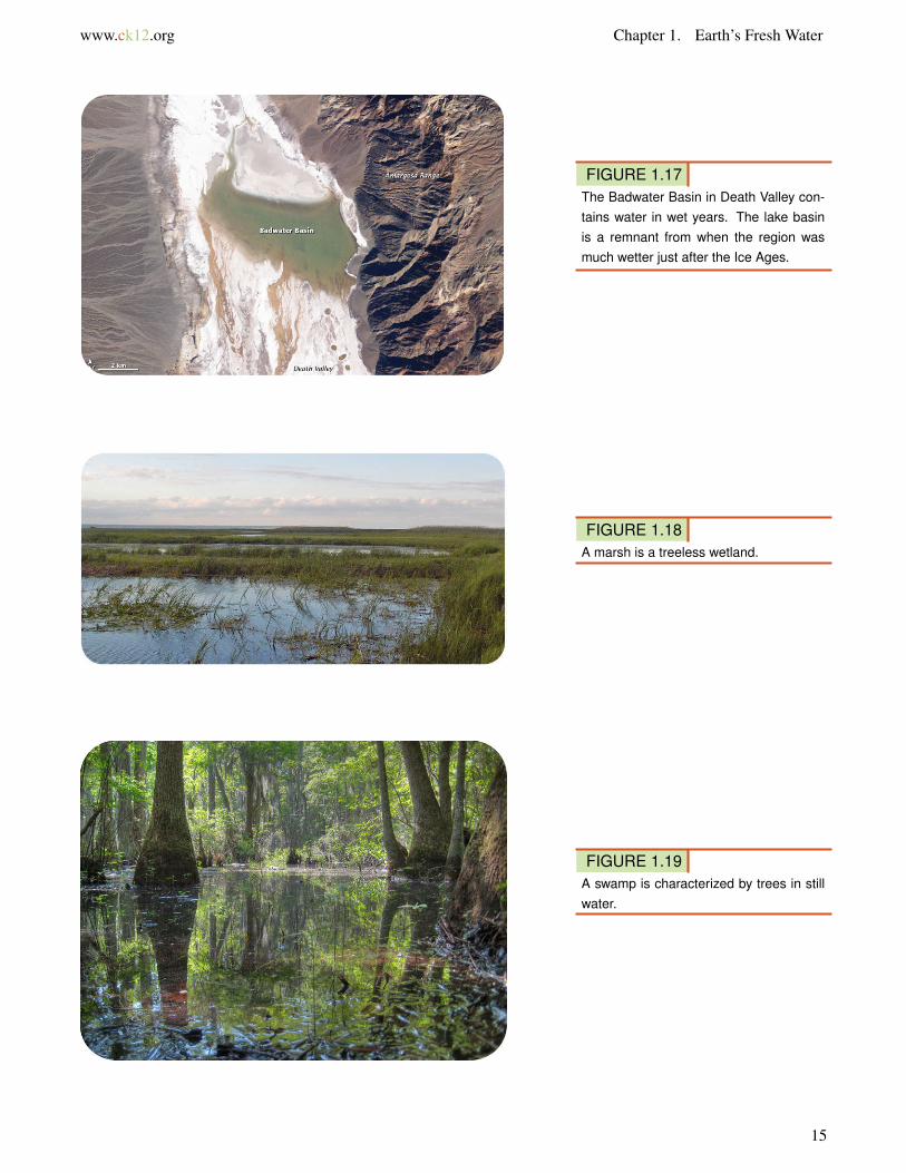
Lakes are not permanent features of a landscape. Some come and go with the seasons, as water levels rise and fall.Over a longer time, lakes disappear when they fill with sediments, if the springs or streams that fill them diminish,or if their outlets grow because of erosion. When the climate of an area changes, lakes can either expand or shrink(Figure 1.17). Lakes may disappear if precipitation significantly diminishes.
Wetlands
Wetlands are lands that are wet for significant periods of time. They are common where water and land meet.Wetlands can be large flat areas or relatively small and steep areas.
Wetlands are rich and unique ecosystems with many species that rely on both the land and the water for survival.Only specialized plants are able to grow in these conditions. Wetlands tend have a great deal of biological diversity.Wetland ecosystems can also be fragile systems that are sensitive to the amounts and quality of water present withinthem.
Types of Wetlands
Marshes are shallow wetlands around lakes, streams, or the ocean where grasses and reeds are common, but trees
13

1.2. Surface Water www.ck12.org
FIGURE 1.15Lakes near Yellowknife were carved byglaciers during the last Ice Age.
FIGURE 1.16The three primary zones of a lake arethe littoral, open-water, and deep-waterzones.
are not (Figure 1.18). Frogs, turtles, muskrats, and many varieties of birds are at home in marshes.
A swamp is a wetland with lush trees and vines found in a low-lying area beside slow-moving rivers (Figure 1.19).Like marshes, they are frequently or always inundated with water. Since the water in a swamp moves slowly,oxygen in the water is often scarce. Swamp plants and animals must be adapted for these low-oxygen conditions.Like marshes, swamps can be fresh water, salt water, or a mixture of both.
In an estuary, salt water from the sea mixes with fresh water from a stream or river (Figure 1.20). These semi-enclosed areas are home to plants and animals that can tolerate the sharp changes in salt content that the constantmotion and mixing of waters creates. Estuaries contain brackish water, water that has more salt than fresh water butless than sea water. Because of the rapid changes in salt content, estuaries have many different habitats for plantsand animals and extremely high biodiversity.
14
www.ck12.org Chapter 1. Earth’s Fresh Water
FIGURE 1.17The Badwater Basin in Death Valley con-tains water in wet years. The lake basinis a remnant from when the region wasmuch wetter just after the Ice Ages.
FIGURE 1.18A marsh is a treeless wetland.
FIGURE 1.19A swamp is characterized by trees in stillwater.
15

1.2. Surface Water www.ck12.org
FIGURE 1.20Chesapeake Bay, surrounded by Mary-land and Virginia, is the largest estuary inthe United States.
Ecological Role of Wetlands
As mentioned above, wetlands are home to many different species of organisms. Although they make up only 5%of the area of the United States, wetlands contain more than 30% of the plant types. Many endangered species livein wetlands, so wetlands are protected from human use.
Wetlands also play a key biological role by removing pollutants from water. For example, they can trap and usefertilizer that has washed off a farmer’s field, and therefore they prevent that fertilizer from contaminating anotherbody of water. Since wetlands naturally purify water, preserving wetlands also helps to maintain clean supplies ofwater.
Floods
Floods are a natural part of the water cycle, but they can be terrifying forces of destruction. Put most simply, a floodis an overflow of water in one place. Floods can occur for a variety of reasons, and their effects can be minimized inseveral different ways. Perhaps unsurprisingly, floods tend to affect low-lying areas most severely.
“Floods 101” is a National Geographic video found in Environment Video, Natural Disasters, Landslides, and more:http://video.nationalgeographic.com/video/player/environment/
Causes of Floods
Floods usually occur when precipitation falls more quickly than that water can be absorbed into the ground or carriedaway by rivers or streams. Waters may build up gradually over a period of weeks, when a long period of rainfall or
16

www.ck12.org Chapter 1. Earth’s Fresh Water
snowmelt fills the ground with water and raises stream levels.
Extremely heavy rains across the Midwestern U.S. in April 2011 led to flooding of the rivers in the Mississippi Riverbasin in May 2011 (Figures 1.21 and 1.22).
FIGURE 1.21This map shows the accumulated rainfallacross the U.S. in the days from April 22to April 29, 2011.
FIGURE 1.22Record flow in the Ohio and Mississippi Rivers has to go somewhere. Normal spring river levels are shown in2010. The flooded region in the image from May 3, 2011 is the New Madrid Floodway, where overflow water ismeant to go. 2011 is the first time since 1927 that this floodway was used.
Flash floods are sudden and unexpected, taking place when very intense rains fall over a very brief period (Figure1.23). A flash flood may do its damage miles from where the rain actually falls if the water travels far down a drystreambed so that the flash flood occurs far from the location of the original storm.
Heavily vegetated lands are less likely to experience flooding. Plants slow down water as it runs over the land, givingit time to enter the ground. Even if the ground is too wet to absorb more water, plants still slow the water’s passageand increase the time between rainfall and the water’s arrival in a stream; this could keep all the water falling over aregion to hit the stream at once. Wetlands act as a buffer between land and high water levels and play a key role inminimizing the impacts of floods. Flooding is often more severe in areas that have been recently logged.
When a dam breaks along a reservoir, flooding can be catastrophic. High water levels have also caused small damsto break, wreaking havoc downstream.
17

1.2. Surface Water www.ck12.org
FIGURE 1.23A 2004 flash flood in England devastatedtwo villages when 3-1/2 inches of rain fellin 60 minutes. Pictured here is some ofthe damage from the flash flood.
People try to protect areas that might flood with dams, and dams are usually very effective. People may also line ariver bank with levees, high walls that keep the stream within its banks during floods. A levee in one location mayjust force the high water up or downstream and cause flooding there. The New Madrid Overflow in the Figure 1.22was created with the recognition that the Mississippi River sometimes simply cannot be contained by levees andmust be allowed to flood.
Effects of Floods
Not all the consequences of flooding are negative. Rivers deposit new nutrient-rich sediments when they flood and sofloodplains have traditionally been good for farming. Flooding as a source of nutrients was important to Egyptiansalong the Nile River until the Aswan Dam was built in the 1960s. Although the dam protects crops and settlementsfrom the annual floods, farmers must now use fertilizers to feed their crops.
Floods are also responsible for moving large amounts of sediments about within streams. These sediments providehabitats for animals, and the periodic movement of sediment is crucial to the lives of several types of organisms.Plants and fish along the Colorado River, for example, depend on seasonal flooding to rearrange sand bars.
Lesson Summary
• Streams return water to the oceans.• Stream headwaters are at higher elevations where snow melts or where there are springs.• Tributaries join together as a river flows to its mouth at lower elevations.• A river may eventually form a delta with an estuary where it meets the ocean.• Water temporarily resides in ponds and lakes, which are mostly fresh water.• Flooding is part of the natural cycle of rivers, enriching floodplains with nutrients, but flooding may destroy
crops and settlements.
18

www.ck12.org Chapter 1. Earth’s Fresh Water
Review Questions
1. Where do streams originate?
2. Compare and contrast streams and rivers.
3. What is an advantage and disadvantage of living in floodplains?
4. Compare and contrast ponds and lakes.
5. What are wetlands and what is the value of wetlands?
6. Consider an animal common in swamps and an animal common in rivers. What natural adaptations do they eachhave to live in their habitat?
7. Deserts get little rain so why are they in danger of flash floods?
Points to Consider
• What types of streams have you seen in your area?• Why are bodies of water never really permanent?• Is it possible that your home could be flooded? What would you do if it were flooded?
19

1.3. Groundwater www.ck12.org
1.3 Groundwater
Lesson Objectives
• Define groundwater.• Explain the location, use, and importance of aquifers.• Define springs.• Describe how wells work and why they are important.
Vocabulary
• aquifer• capillary action• impermeable• permeability• porosity• spring• subsidence• water table• well
Introduction
Although this may seem surprising, water beneath the ground is commonplace. Usually groundwater travels slowlyand silently beneath the surface, but in some locations it bubbles to the surface at springs. The products of erosionand deposition by groundwater were described in the Erosion and Deposition chapter.
Groundwater
Groundwater is the largest reservoir of liquid fresh water on Earth and is found in aquifers, porous rock and sedimentwith water in between. Water is attracted to the soil particles and capillary action, which describes how water movesthrough a porous media, moves water from wet soil to dry areas.
Aquifers are found at different depths. Some are just below the surface and some are found much deeper below theland surface. A region may have more than one aquifer beneath it and even most deserts are above aquifers. Thesource region for an aquifer beneath a desert is likely to be far from where the aquifer is located; for example, it maybe in a mountain area.
The amount of water that is available to enter groundwater in a region is influenced by the local climate, the slope ofthe land, the type of rock found at the surface, the vegetation cover, land use in the area, and water retention, which
20

www.ck12.org Chapter 1. Earth’s Fresh Water
is the amount of water that remains in the ground. More water goes into the ground where there is a lot of rain, flatland, porous rock, exposed soil, and where water is not already filling the soil and rock.
The residence time of water in a groundwater aquifer can be from minutes to thousands of years. Groundwater isoften called “fossil water” because it has remained in the ground for so long, often since the end of the ice ages.
Aquifers
Features of an Aquifer
To be a good aquifer, the rock in the aquifer must have good:
• porosity: small spaces between grains• permeability: connections between pores
This animation shows porosity and permeability. The water droplets are found in the pores between the sedimentgrains, which is porosity. When the water can travel between ores, that’s permeability. http://www.nature.nps.gov/GEOLOGY/usgsnps/animate/POROS_3.MPG
To reach an aquifer, surface water infiltrates downward into the ground through tiny spaces or pores in the rock.The water travels down through the permeable rock until it reaches a layer that does not have pores; this rock isimpermeable (Figure 1.24). This impermeable rock layer forms the base of the aquifer. The upper surface wherethe groundwater reaches is the water table.
FIGURE 1.24Groundwater is found beneath the solidsurface. Notice that the water tableroughly mirrors the slope of the land’s sur-face. A well penetrates the water table.
21

1.3. Groundwater www.ck12.org
The Water Table
For a groundwater aquifer to contain the same amount of water, the amount of recharge must equal the amount ofdischarge. What are the likely sources of recharge? What are the likely sources of discharge?
In wet regions, streams are fed by groundwater; the surface of the stream is the top of the water table (Figure 1.25).In dry regions, water seeps down from the stream into the aquifer. These streams are often dry much of the year.Water leaves a groundwater reservoir in streams or springs. People take water from aquifers, too.
What happens to the water table when there is a lot of rainfall? What happens when there is a drought? Althoughgroundwater levels do not rise and fall as rapidly as at the surface, over time the water table will rise during wetperiods and fall during droughts.
FIGURE 1.25The top of the stream is the top of the wa-ter table. The stream feeds the aquifer.
One of the most interesting, but extremely atypical types of aquifers is found in Florida. Although aquifers are veryrarely underground rivers, in Florida water has dissolved the limestone so that streams travel underground and aboveground (Figure 1.26).
FIGURE 1.26In Florida, groundwater is sometimes notunderground.
22
www.ck12.org Chapter 1. Earth’s Fresh Water
Groundwater Use
Groundwater is an extremely important water source for people. Groundwater is a renewable resource and its use issustainable when the water pumped from the aquifer is replenished. It is important for anyone who intends to diga well to know how deep beneath the surface the water table is. Because groundwater involves interaction betweenthe Earth and the water, the study of groundwater is called hydrogeology.
Some aquifers are overused; people pump out more water than is replaced. As the water is pumped out, the watertable slowly falls, requiring wells to be dug deeper, which takes more money and energy. Wells may go completelydry if they are not deep enough to reach into the lowered water table.
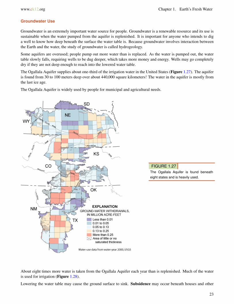
The Ogallala Aquifer supplies about one-third of the irrigation water in the United States (Figure 1.27). The aquiferis found from 30 to 100 meters deep over about 440,000 square kilometers! The water in the aquifer is mostly fromthe last ice age.
The Ogallala Aquifer is widely used by people for municipal and agricultural needs.
FIGURE 1.27The Ogallala Aquifer is found beneatheight states and is heavily used.
About eight times more water is taken from the Ogallala Aquifer each year than is replenished. Much of the wateris used for irrigation (Figure 1.28).
Lowering the water table may cause the ground surface to sink. Subsidence may occur beneath houses and other
23

1.3. Groundwater www.ck12.org
FIGURE 1.28Farms in Kansas use central pivot irrigation, which is more efficient sincewater falls directly on the crops instead of being shot in the air. Thesefields are between 800 and 1600 meters (0.5 and 1 mile) in diameter.
structures (Figure 1.29).
FIGURE 1.29The San Joaquin Valley of California is one of the world’s major agriculturalareas. So much groundwater has been pumped that the land hassubsided many tens of feet.
When coastal aquifers are overused, salt water from the ocean may enter the aquifer, contaminating the aquifer andmaking it less useful for drinking and irrigation. Salt water incursion is a problem in developed coastal regions, suchas on Hawaii.
Springs
Groundwater meets the surface in a stream, as shown above, or a spring (Figure 1.30). A spring may be constant,or may only flow at certain times of year.
Towns in many locations depend on water from springs. Springs can be an extremely important source of water inlocations where surface water is scarce (Figure 1.31).
24

www.ck12.org Chapter 1. Earth’s Fresh Water
FIGURE 1.30(a) Big Spring in Missouri lets out 12,000liters of water per second. (b) Othersprings are just tiny outlets like this one.
FIGURE 1.31In the dry Arizona desert, Oak Creek andmany other streams are spring fed.
Wells
A well is created by digging or drilling to reach groundwater. When the water table is close to the surface, wells area convenient method for extracting water. When the water table is far below the surface, specialized equipment mustbe used to dig a well. Most wells use motorized pumps to bring water to the surface, but some still require people touse a bucket to draw water up (Figure 1.32).
Lesson Summary
• Groundwater is the largest reservoir of fresh water.• The water table is the top of an aquifer below which is water and above is rock or soil mixed with air.• Aquifers are underground areas of sediment or rock that hold groundwater.• An aquifer needs good porosity and permeability.• Where groundwater intersects the ground surface, a spring can form.• People dig or drill wells to access groundwater.
25

1.3. Groundwater www.ck12.org
FIGURE 1.32An old-fashioned well that uses a bucketdrawn up by hand.
Review Questions
1. What is groundwater?
2. What is the water table?
3. What are aquifers and why are they so important?
4. Replenishing an aquifer is important because it makes the aquifer a resource that can last a long time. What doyou think are ways to keep the amount of water used and the amount of water replenished the same?
5. How does a well work?
6. Since groundwater is largely unseen from the surface, how might you monitor how humans are affecting theamount of groundwater in an aquifer?
Further Reading / Supplemental Links
Earth’s water distribution video, University of Waikato, New Zealand http://www.sciencelearn.org.nz/contexts/h2o_on_the_go/sci_media/video/earth_s_water_distribution
Points to Consider
• Is water from a river or from a well more likely to be clean to drink?• Why is overuse of groundwater a big concern?• What policies might people put in place to conserve water levels in lakes and aquifers?
26

www.ck12.org Chapter 1. Earth’s Fresh Water
1.4 References
1. Hana Zavadska, based on data from National Climate Data Center. CK-12 Foundation . CC BY-NC 3.02. (a) Ilya Haykinson; (b)Flickr:xxxxRAJxxxx; (c) Arun Kulshreshtha. (a) http://commons.wikimedia.org/wik
i/File:Glacial_iceberg_in_Argentina.jpg; (b) http://commons.wikimedia.org/wiki/File:Water_droplet_blue_bg05.jpg; (c) http://commons.wikimedia.org/wiki/File:Above_the_Clouds.jpg . (a) CC BY 2.0; (b) CC BY-NC 3.0; (c) CC BY 3.0
3. Courtesy of US Geological Survey. http://commons.wikimedia.org/wiki/File:Water_cycle.png . Public Do-main
4. Courtesy of NASA’s Earth Observatory. http://earthobservatory.nasa.gov/IOTD/view.php?id=3763 . PublicDomain
5. Courtesy of Jeff Schmaltz/NASA’s Earth Observatory. http://earthobservatory.nasa.gov/IOTD/view.php?id=39936 . Public Domain
6. Image copyright Filip Fuxa, 2014. http://www.shutterstock.com . Used under license from Shutterstock.com7. Courtesy of USGS EROS Data Center. http://earthobservatory.nasa.gov/IOTD/view.php?id=3017 . Public
Domain8. Image copyright Ross Ellet, 2014. http://www.shutterstock.com . Used under license from Shutterstock.com9. Courtesy of Johnson Space Center/NASA’s Earth Observatory. http://earthobservatory.nasa.gov/IOTD/view.p
hp?id=4028 . Public Domain10. Courtesy of National Park Service. http://commons.wikimedia.org/wiki/File:Klamath_river_estuary.jpg .
Public Domain11. User:Umbongo91/Wikipedia. http://en.wikipedia.org/wiki/File:Horseshoe_Falls_2006.jpg . Public Domain12. (a) Courtesy of National Atlas of the United States; (b) Thomas Kriese. (a) http://commons.wikimedia.org
/wiki/File:NorthAmericaDivides.gif; (b) http://www.flickr.com/photos/thomaspix/2746090728/ . (a) PublicDomain; (b) CC BY 2.0
13. Flickr:eisenbergalex. http://commons.wikimedia.org/wiki/File:Hampstead_Ponds_(171329664).jpg . CC BY2.0
14. (a) Courtesy of NASA’s Earth Observatory; (b) Courtesy of SeaWiFS Project, NASA/Goddard Space FlightCenter, and ORBIMAGE; (c) Courtesy of NASA’s Earth Observatory. (a) http://earthobservatory.nasa.gov/IOTD/view.php?id=6944; (b) http://commons.wikimedia.org/wiki/File:Great_Lakes_from_space.jpg; (c) http://earthobservatory.nasa.gov/IOTD/view.php?id=38721 . Public Domain
15. Courtesy of US Geological Survey. http://earthobservatory.nasa.gov/IOTD/view.php?id=2976 . Public Do-main
16. Geoff Ruth. CK-12 Foundation . CC BY-NC 3.017. Courtesy of Robert Simmon/NASA’s Earth Observatory. http://earthobservatory.nasa.gov/IOTD/view.php?i
d=37536 . Public Domain18. User:Scorpion0422/Wikipedia. http://commons.wikimedia.org/wiki/File:Long_Point_Marshes_2.jpg . Pub-
lic Domain19. Mike Love. http://www.flickr.com/photos/mikelove/2526016742/ . CC BY 2.020. Robert Simmon, based on Landsat-7 data provided by the University of Maryland Global Land Cover Facility,
NASA. http://commons.wikimedia.org/wiki/File:Susquehanna_ETM_19990923_lrg.jpg . Public Domain21. Courtesy of Advanced Hydrologic Prediction Service/National Oceanic and Atmospheric Administration. http
://commons.wikimedia.org/wiki/File:Pcpnweekending04292011.jpg . Public Domain22. Courtesy of Jesse Allen and Robert Simmon/NASA’s Earth Observatory. http://earthobservatory.nasa.gov/IOT
D/view.php?id=50475 . Public Domain23. Benjamin Evans. http://commons.wikimedia.org/wiki/File:Boscastle_14.jpg . The copyright holder of this
work allows anyone to use it for any purpose including unrestricted redistribution, commercial use, and
27

1.4. References www.ck12.org
modification24. Geoff Ruth and Hana Zavadska. CK-12 Foundation . CC BY-NC 3.025. Laura Guerin. CK-12 Foundation . CC BY-NC 3.026. Courtesy of US Geological Survey. http://en.wikipedia.org/wiki/File:Florida_groundwater_cycle.gif . Public
Domain27. Courtesy of the US Geological Survey. http://ne.water.usgs.gov/ogw/hpwlms/physsett.html . Public Domain28. Courtesy of NASA/GSFC/METI/ERSDAC/JAROS and US/Japan ASTER Science Team. http://earthobservat
ory.nasa.gov/IOTD/view.php?id=5772 . Public Domain29. Courtesy of the US Geological Survey. http://commons.wikimedia.org/wiki/File:Gwsanjoaquin.jpg . Public
Domain30. (a) Courtesy of Charlie Rahm, USDA Natural Resources Conservation Service; (b) Michael Coghlan. (a)
http://commons.wikimedia.org/wiki/File:NRCSMO02038_-_Missouri_(4799)(NRCS_Photo_Gallery).tif; (b)http://www.flickr.com/photos/mikecogh/3067131475/ . (a) Public Domain; (b) CC BY 2.0
31. Miles Orchinik. CK-12 Foundation . CC BY-NC 3.032. Austin Donisan. http://www.flickr.com/photos/pianom4n/3886764321/ . CC BY 2.0
28