dames and moore - 1981-geologic reconnaissance survey prima deshecha
TRANSCRIPT
GEOLOGIC RECONNAISSANCE SURVEY OF PRIMA DESHECHA CANADA -
POTENTIAL HAZARDOUS WASTE DISPOSAL SITE OC-2
January 7, 1983

IIL[IE¢JIIIIIIIIIIII?Iflfi'il.)l4
1·1-l"l~ .• ~ •. ~ •. ,l~l·i•JI.~i'l:l•~li'&;;,t~iw~·l'llllllllllll ........... -•.•..• --.~.-•.• r .... ~-~········"·····-·· .. a. .. ~eeaaa3aGi=t
~-
TABLE OF CONTENTS
Page
1. 0 INTRODUCTION...... • • • • • • • . • • • • • • • • • • • • • • • • • • • • • 1-1
1.1 Objectives................................ 1-1
1.2 Scope of Work............................. 1-2
2. 0 SITE DESCRIPTION •••••••••••.••••••••••• ·• • • • • • • • 2-1
3.0 SITE GEOLOGY................................... 3-1
3.1 Stratigraphy....... . . . . . . . . . . . . . . . . . . . . . . . 3-1
3.2 Structure and Distribution of Units ••••••• 3-1
3.3 Potential Geologic Hazards •••••••••••••.•• 3-2
4 . 0 HYDROLOGY. • . • • • • • • • • • • • • • • • • • • • • • • • • • • • • • • • • • • • 4-1
5.0 CONCLUSIONS AND RECOMMENDATIONS •••••••••••••••• 5-l
5.1 Adequacy of Containment •.••••••••••••••••• 5-l
5.2 Suggested Location of Facilities •••••••••• 5-l
5. 3 Further Investigations. • • • • • • • • • • • • • • • • • • • 5-1
5.4 Other Possible Site Areas •••••••••••••••.• 5-2
TABLE 1 •••••••••••••.•••.•••••••••••••• Following Page 3-3
FIGURE 1 - Site Location Map
FIGURE 2 - Schematic Geologic Cross Section
PLATE 1 - Geologic Map
REFERENCES
i
I

;:._l...,..........-~~~~~'1
I 1.0 INTRODUCTION
This report presents the results of a reconnaissance
geologic and hydrologic study of the Prima Deshecha Canada
area in southern Orange County, California, with respect to
possible siting of a Class I waste disposal facility. The
study was one of several conducted concurrently, each
addressing an area not excluded in a regional geologic
screening study for hazardous waste disposal sites in a
seven-county area of southern California (Dames and Moore,
1981). Authorization for the present investigation was
through the County Sanitation Districts of Los Angeles
County (CSDLAC), as lead agency for the Southern California
Hazardous Waste Management Project. The general location of
the Prima Deshecha study area, which has been designated
OC-2, is shown on Figure 1.
1.1 Objectives
The investigation was conducted in accordance with the
scope of work provided by CSDLAC and was intended to
document geologic and hydrologic conditions in the Prima
Deshecha area and to provide a basis for either eliminating
it as a viable Class I site or for deciding that the site
warrants additional studies if conditions appear favorable.
Information from literature sources and from field recon
naissance studies were used to formulate an opinion as to
the suitability of the site. Our conclusions and recom
mendations in this respect are stated in Section 5.0 of
this report and are based on our understanding of the
criteria for Class I disposal which are summarized as
follows:
0 Geologic materials underlying the site should be of
a sufficiently low permeability as to preclude
l
l

'
0
0
0
0
0
1-2
migration of wastes to usable waters. The State
requires that the site be underlain by a substan
tial amount of nonwater-bearing materials with
permeabilities of less than lxlo-8 centimeters
per second (Franks, 1980).
The topography of the site should be suitable for
installation of lateral migration barriers if
required.
The site should be of sufficient areal extent for
the proposed facilities.
The site should be free of geologic and hydrologic
hazards that might endanger proposed facilities.
Sufficient quantities of workable material should
be present for cut-and-cover operations.
The site should be free from land-use conflicts
such as economic mineral sources.
1.2 Scope of Work
This study was limited by budget and time constraints to a
reconnaissance level of effort. The investigation was
accomplished in three phases: literature research and
planning; field studies; and preparation of maps and the
summary report.
The literature search was limited to information covering
the geology, hydrology, and soils engineering properties of
the site area, and included a search of published liter-
i l
I
' (
'
1-3
ature, graduate theses, and information from government
files. Data from the literature search was compiled and
evaluated for indications of possibly favorable geologic
conditions and serious geological flaws. Specific possible
site locations within the siting area were selected for
field examination on the basis of aerial photograph inter
pretation and analysis of published geologic maps.
Field investigations consisted of a general reconnaissance
of the siting area, supplemental mapping, and sample col
lection at speci fie locations. Site reconnaissance was
intended to verify information on existing geologic maps,
to define the lithology of the prospective containment
unit, and to develop an impression of the site area as a
whole. Supplemental mapping was performed to document
pertinent site details not shown on existing maps.
Preparation of this report consisted of summarizing liter
ature and field information collected during the first two
phases, preparation of a geologic map and cross section,
and formalizing our judgement as to the potential sui ta
bility of the site for further consideration. We have also
indicated what further information may be required to more
fully evaluate the site.

~ ... ._ .... .,. ............. ~ .... ~ .......... .-w~w~rsw'~~~v.-~fift_.rew~---·~-~·•·e•?m&c~·~tea. .. .-&&aa ........ ._ .. ._.__. ... ~H&&mwr•~
t
, ... :~.' . .. '
2.0 SITE DESCRIPTION
Prima Deshecha Canada extends in a southwesterly direction
through the edge of the Santa Margarita Mountain foothills,
··from about 5 miles inland to the ocean. It crosses the
corporate boundaries of the cities of San Juan Capistrano
and San Clemente progressively to the southwest. The
siting locality described in this report includes only the
area drained by the upper portion of the canyon, north of
the San Clemente corporate boundary. This area comprises
most of a 1,500 acre tract dedicated by Orange County
for use as a Class II sanitary landfill and a regional
park. Some areas of the tract are currently receiving
wastes, see Plate 1. No park facilities have yet been
constructed. The limits of the existing tract include a
side canyon of Secunda Deshecha Canada, a parallel major
canyon to the southeast.
Other than disposal operations, the site area is used only
for grazing cattle. Public access to the area is from the
Ortega Highway in the broad valley of San Juan Creek which
parallels upper Prima Deshecha Canada about a mile and a
half to the northwest. The nearest urbanized area is about
1.2 miles down canyon from the limits of the siting area.
An expanded aggregate facility is located in a side canyon
about a mile downstream.
The topography of the siting area consists of subdued to
moderately steep grassy hill slopes except in the northern
portion where a line of steep bluffs have formed in exposed
conglomeratic rock. Elsewhere natural exposures of bedrock
are rare.
The highest point in the site vicinity is a ridge top in
the northeast corner of the area at an elevation of about
I
I I I t
I l I
I l t I i
I
~---~~--~------------~----~ ........ ._ .. M'M~FAWf··~nt~h~'iiWt~&W~·~M?~'l~'»~f~%-CCUi.tiMW8&a& ........................ .a ... l 1
I -t·:
2-2
1130 feet above sea level. The divide of the upper Prima
Deshecha drainage typically ranges from 500 feet to 1000
feet in elevation. At the southwestern corner of the
prospective siting area, the bottom of the canyon is at an
.. elevation of 230 feet above sea level.
l
I I
.. ---~=-----
3.0 SITE GEOLOGY
3.1 Stratigraphy
The stratigraphic sequence of geologic units exposed in the
Prima Deshecha area are listed in Table 1. Detailed
descriptions of these units, including their bulk engineer
ing properties, are also presented in the table. These
descriptions were compiled from engineering geology
reports for each of the four topographic quadrangles which
include parts of the site. The authors of individual
reports are listed at the end of the table.
The prospective containment unit in the area is the Capis
trano Formation, of Pliocene and uppermost Miocene age,
that consists of poorly bedded and poorly indurated mi
caceous mudstones and siltstones. It may be as much as
2000 ft thick in the site vicinity. However, the top of
the unit is not exposed on the site. The only units mapped
overlying the Capistrano Formation in the site area are
alluvial, colluvial and landslide deposits of Recent
age.
Two middle to upper Miocene formations which stratigraph
ically underly the Capistrano are exposed within the site
boundaries. The Monterey Formation contains generally well
bedded diatomaceous, siliceous, and silty shales as we 1 as
siltstones. The underlying San Onofre Breccia is generally
a moderately well cemented massive unit composed almost
entirely of angular metamorphic rock debris ranging in size
from silt to boulders.
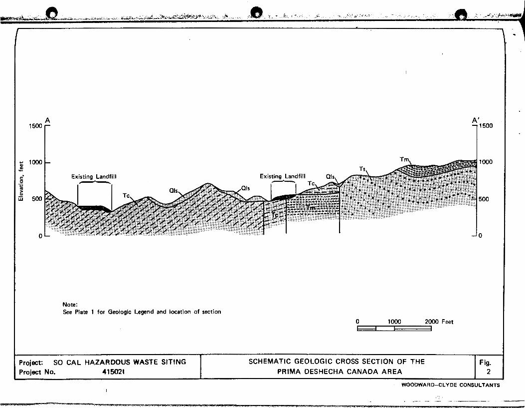
3.2 Structure and Distribution of Units
Several faults have been mapped traversing the site area
(see Plate 1). These are traces and splays of the north-
I
I
!
I
I

a~~ .. ---------------------------------
3-2
west-trending Foster· .. · fault zone which is not known to be
active. The Capistrano Formation, exposed on the south
western side of the zone has been moved downward with
respect to older rock units on the northeast side of the
zone.
Southwest of the fault zone, the Capistrano dips to the
southwest at between approximately 15 and 20 degrees. Dips
within the fault zone appear to be somewhat flatter.
Northeast of the zone, the older units are gently folded.
These dips and their relationship to the faults are shown
on Figure 2 which is a schematic geologic cross section
across the site.
3.3 Potential Geologic Hazards
Faults which cross the site are not considered to be
active. The Cristianitos fault, which is a larger more
pervasive structure passing within 1000 feet to the east of
the site, is also not considered to be active. The nearest
fault known to be active is the Elsinore fault, 12 miles to
the northeast. A large fault mapped offshore, about eight
miles from the site may also be capable generating earth
quakes.
Landslides appear to cover about 40 percent of the surface
area of the site. Most of these are massive slides that
involve entire hillsides or canyon heads. They range in
age from very old, apparent only from hummocky terrain or
diverted drainages, to active with fresh head scarps and
mobile toes. Seeps were noted at the toes of several of
the more recent slides during our site reconnaissance in
December.
(
3-3
Regardless of the age or condition of landslide terrain, it
can be cons~dered potentially hazardous to Class I disposal
facilities. Lan.dslide terrain is subject to renewed
massive movement and to secondary slumping and flows. In
situ material in landslide blocks is not suitable for
either vertical or lateral containment of liquid wastes
because of increased permeability which is almost always
associated with movement.
I I I
I I !
I
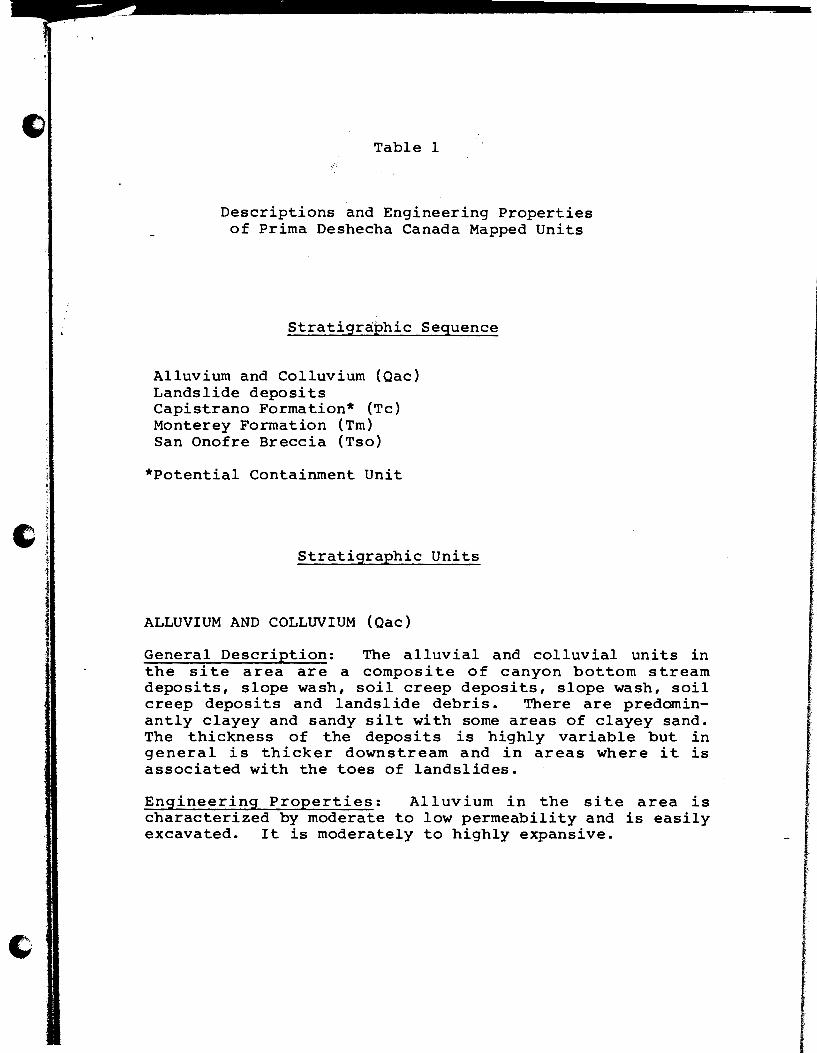
Table 1
Descriptions and Engineering Properties of Prima Deshecha Canada Mapped Units
Stratigraphic Sequence
Alluvium and Colluvium (Qac) Landslide deposits Capistrano Formation* (Tc) Monterey Formation {Tm) San Onofre Breccia {Tso)
*Potential Containment Unit
Stratigraphic Units
ALLUVIUM AND COLLUVIUM (Qac)
General Description: The alluvial and colluvial units in the site area are a composite of canyon bottom stream deposits, slope wash, soil creep deposits, slope wash, soil creep deposits and landslide debris. There are predominantly clayey and sandy silt with some areas of clayey sand. The thickness of the deposits is highly variable but in general is thicker downstream and in areas where it is associated with the toes of landslides.
Engineering Properties: Alluvium in the site area is characterized by moderate to low permeability and is easily excavated. It is moderately to highly expansive.

Table 1 (continued)
LANDSLIDE DEPOSITS
General Description: Mapped landslides are numerous in the Capistrano Formation and exhibit -evidence of continuous or sporadic episodes in that they appear to represent a wide range in age, ranging from recent to very old. Most are
_easily recognized on aerial photos and certain high site vantage points but some of the older slides exhibit only hummocky slopes or uncharacteristic drainage patterns. The landslides appear to consist of both rotational and blockglide failure and occur on moderate to low angle slopes. They are subject to reactivation especially following heavy rains.
Engineering Properties: Landslides are commonly highly fractured and deeply weathered, and are subject to creep, slump, modflow and renewed mass movement. They are generally moderately to easily excavated.
CAPISTRANO FORMATION (Tc)
General Description: The marine Capistrano Formation is uppermost Miocene and Pliocene in age and consists of up to 2000 feet of poorly bedded and interfingering layers of micaceous siltstone, mudstone, silty shale and sandstone. In upper Prima Deshecha Canada where exposed in the current landfill operation the Capistrano Formation consists primarily of poorly consolidated, massive to poorly bedded micaceous siltstone and mudstone. These units are dark gray to blue gray on fresh exposures and weather to light brownish gray. Locally the unit contains interbeds of diatomaceous siltstone and thin sandstone lenses. At the surface the Capistrano Formation is soft, poorly consolidated and is highly subject to creep and massive failures even in areas of relatively low relief. Numerous landslides have occurred in upper Prima Deshecha Canada.
Engineering Properties: The premeability of the Capistrano Formation in the site area is reported as low to very low (Converse, Davis, Dixon Associates, 1977), however, no permeability measurements have been reported for the unit in the area of the site. The unit can generally be moderately to easily excavated with heavy equipment but local cemented sandstone lenses may require light blasting. Slopes are highly unstable and subject to failure both along and across bedding planes as rotational slumps and block-glides.

Table 1 (continued)
MONTEREY FORMATION (Tm)
General Description: The Monterey Formation is a marine unit of middle to upper Miocene age. It consists of light gray to pale brown diatomaceous shale interbedded with silty shale, siltstone and siliceous shale. The unit is
_generally well bedded and weathers to form a platy outcrop. In upper Prima Deshecha Canada the Monterey Formation caps the high ridge to the northeast of the siting area and appears to be held up by the massive bluffs of the underlying San Onofre Breccia.
Engineering Properties: The premeabiii ty of the Monterey Formation is generally low except where deeply weathered and fractured. It is also generally easily excavated with heavy equipment. Steep slopes are highly unstable to slumping especially on dip slopes where unsupported bedding planes can allow block-glide failure.
SAN ONOFRE BRECCIA (Tso)
General Description: The San Onofre Breccia is of Middle Miocene age and consists of massive, very coarse, well cemented, conglomerate and sandstone. It is generally reddish brown to blue gray and made up of a chaotic collection of angular metamorphic boulders of predominantly Catalina Schist origin.
Engineering Properties: The unit is generally massive and moderately well cemented. It is difficult to excavate, even with heavy equipment and locally requires blasting. The permeability is highly variable ranging from moderate to low. It generally forms steep and stable slopes but is subject to rock falls and occasional landslides where oversteepened or deeply fractured and weathered.

1 I
'
4.0 HYDROLOGY
The area within the site boundary shown on Plate 1, except
a small portion in the southeast corner, drains through
upper Prima Deshecha Canada. Streams within the canyon are
essentially dry except during rainy periods.
Seven borings were drilled in the canyon during investi
gations for the County facility (Stankov, 1971). Borings
drilled in the alluvium-filled portion of the canyon
encountered ground water at depths of 9 to 15 feet below
ground surface. Drawdown-and-recovery permeability tests
in two of these holes produced a calculated coefficient of
transmissibility value of lxlo-5 em/sec for the appar
ently clayey alluvium. No tests were run in the Capistrano
Formation.
Stankov (1971) also reported a spring near the head of the
central drainage of the canyon, just above the north
easternmost fault trace. The area underlain by San Onofre
Breccia. He suggests that the occurrence of the spring may
be due to clay gouge in the fault that acts as a ground
water barrier.
All seeps observed during our visit to the site were
associated with landslides. No seep or springs are known
to originate from intact Capistrano Formation material.
r

5.0 CONCLUSIONS AND RECOMMENDATIONS
5.1 Adequacy of Containment
.. Although no formal permeability values are available for
the Capistrano Formation, we feel that portions of the unit
may be suitable for siting hazardous waste disposal facili
ties. The formation contains abundant clayey layers which
should retard water or waste migration. Though fractured
and jointed near the surface, we believe this is due to
weathering and that the formation will become tighter and
less permeable with depth. Clayey portions of landslide
material in the Capistrano Formation may be sui table for
construction of barriers to lateral migration.
5.2 Suggested Location of Facilities
Preliminary research indicated that a large side canyon in
the southwestern corner of the Prima Deshecha site could be
an almost ideal location for Class I facilities. We
found, however, that the canyon was already receiving Class
II fill. Since most of the area not being used for Class
II waste is underlain by landslides or permeable older
bedrock formations, very little room remains for a poten
tial Class I site. The two or three heads of side canyons
underlain by the Capistrano Formation at the southernmost
edge of the area together may provide enough space for
a viable disposal facility. Additional space might be
gained by excavating portions of landslides to the Capis
trano bedrock.
5.3 Further Investigations
If the Prima Deshecha site is selected for further con
sideration, continuing feasibility studies should begin
with a limited boring program during which the permeability
' '
of the Capistrano Formation in the siting area could be
tested. Borings could also be used to determine the
thickness of landslide deposits in areas considered for
their possible removal to provide disposal space.
If considerable variability is found in the formation
during initial testing, it may be advisable to drill
additional holes to obtain continuous core samples and to
conduct permeability tests at more closely spaced intervals
to better define the most favorable zones and layers to be
avoided. More precise geologic mapping, using test pits
and trenches to produce outcrops, would allow better
projection of encountered in borings into adjacent areas.
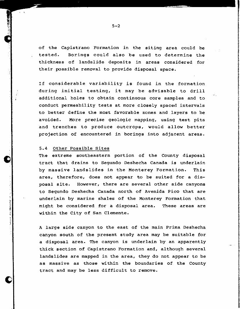
5.4 Other Possible Sites
The extreme southeastern portion of the County disposal
tract that drains to Segundo Deshecha Canada is underlain
by massive landslides in the Monterey Formation. This
area, therefore, does not appear to be suited for a dis
posal site. However, there are several other side canyons
to Segundo Deshecha Canada north of Avenida Pico that are
underlain by marine shales of the Monterey Formation that
might be considered for a disposal area. These areas are
within the City of San Clemente.
A large side canyon to the east of the main Prima Deshecha
canyon south of the present study area may be suitable for
a disposal area. The canyon is underlain by an apparently
thick section of Capistrano Formation and, although several
landslides are mapped in the area, they do not appear to be
as massive as those within the boundaries of the County
tract and may be less difficult to remove.
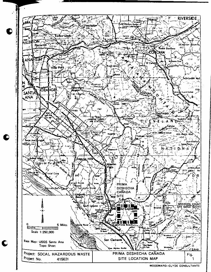
OE=::3:=:::::E===:35 Miles E3 Scale 1 :250,000
Base Map: USGS Santa Ana Topo Sheet
Project: SOCAL HAZARDOUS WASTE Project No. 415621
PRIMA DESHECHA CANADA SITE LOCATION MAP
Fig. 1
WOODWARD-CLYDE CONSULTANTS
~~:..A.f!!J. .. "'""'"-"'··'···~--~-· ... ~-;... ""''··'~; .. ~,~~-~~;;._:"!l; ... :..t~:.·~~~i:t..t~'·'-''-'i;.;';,':'>..
.... Cl)
~
a· ·;:; <'II > Cl)
A 1500
jjj 500
0
Existing Landfill
Note: See Plate 1 for Geologic Legend and location of section
Project: SO CAL HAZARDOUS WASTE SITING Project No. 415021
:-~----~ _._ .. _ ., • k. '._., .. CV ... } "\·. .·"""·. . ..,, "'': ~ ~( .~ .. ~ !';.,'.I
0 1000 2000 Feet b;;Od I I
SCHEMATIC GEOLOGIC CROSS SECTION OF THE
PRIMA DESHECHA CANADA AREA
,., ... :.CJ<:·.;?·i-:r"~-
A' 1500
1000
7':1500
Fig. 2
WOODWARD-CLYDE CONSULTANTS
I
-.MUM.%·"" ' . ... .. " ·'"""" '" "" '"'· ... .., ... ' ....... • I.$,'" ' .. , ' ' ·"'·'"' " ·' . .... ,; ' ....... " .................... ,_,, .. ,_ .• - ••• ::- .. ¢·-- --:~. ' -.=:-:--.:-:·--.- :" .... I

REFERENCES
Blanc, R. P., and Cleveland, G. B., 1968, Natural slope stability as related to geology, San Clemente area, Orange and San Diego Counties, California: California Division of Mines and Geology, Special Report 98.
Converse, Davis, Dixon Associates, 1977, Environmental geotechnical investigation - Prima Deshecha Regional Park: Prepared for Phillips Brandt Reddick and the Orange County Environmental Agency, 26 pp.
Dames and Moore, 1981, Final report, geologic exclusion study, hazardous waste disposal sites, seven-county area of southern California: Prepared for County Sanitation Districts of Los Angeles County, 20 pp.
Edgington, W. J., 1974, Geology of the Dana Point Quadrangle, Orange, County, California: California Division of Mines and Geology, Special Report 109, 31 PP•
Franks, A. L., 1980, Waste Discharge Requirements for Nonsewerable Waste Disposal to Land: California State Water Resources Control Board.
Miller, R. v., 1977, Geologic guidebook to the west-central Santa Ana Mountains, Orange County, California: Los Angeles Basin Geological Society, 42 pp.
Morton, P. K., aspects of Quadrangle, Division of
1974, Geology and engineering geologic the south half of Canada Gobernadora Orange County, California: California Mines and Geology, Special Report 111.
Morton, P. K., 1972, Geologic guidebook to the northern Peninsular Ranges, Orange and Riverside Counties: South Coast Geological Society, South Coast Geological Society Guidebook, 96 pp.
Morton, P. K., Edgington, w. J., and Fife, D. L., 1974, Geology and engineering geologic aspects of the San Juan Capistrano Quadrangle, Orange County, California: California Division of Mines and Geology, Special Report 112, 64 pp.
Morton, P. K., and Miller, R. V., 1981, Geologic Map of Orange County, California, showing mines and mineral deposits: California Division of Mines and Geology, Bulletin 204.

Morton, P. K., Preliminary California: Preliminary
Miller, R. v., and Fife, D. L., 1973, gee-environmental maps of Orange County, ·California Division of Mines and Geology, Report 15.
Stankov, s., 1971, Geologic investigation of the San Juan Capistrano refuse disposal site: County of Orange Road Department, 21 pp.