daintree futures study - wet tropics management authority · · 2017-07-312.2.5 the use of...
TRANSCRIPT

Rainforest CRC
Daintree Futures Study
Final Report to the Wet Tropics Ministerial Council
Rainforest CRC Cairns with Gutteridge Haskins and Davey
Far North Strategies
November 2000


Rainforest CRC i
Table of Contents
LIST OF TABLES III
LIST OF FIGURES III
LIST OF MAPS IV
APPENDICES IV
VOLUMES IV
ABBREVIATIONS AND ACRONYMS V
EXECUTIVE SUMMARY 1
The Vision 3
Major Findings of the Study 5 Community Development 5 Conservation and land management 7 Tourism 8 Electricity 9 Aboriginal Land and Cultural Aspirations 9 Roads and Ferry 10 Proposed Management Arrangements 10 Cost and Revenues 12
1. SECURING THE FUTURE OF THE DAINTREE 13
1.1 The Situation 13
1.2 The need for action 14
1.3 Project Objectives Terms of Reference and Study Approach 16 1.3.1 Community views 18
1.4 Principles for the Study 19 1.4.1 Ecologically sustainable development (ESD) 20 1.4.2 The stewardship of conservation and biodiversity 20 1.4.3 Land restructure and management to achieve biodiversity protection 21 1.4.4 The Role of Douglas Shire Council 21 1.4.5 Interconnectedness of decisions 22 1.4.6 Decisions for reaching the desired future 22
2. DECISION AREAS, DESIRED OUTCOMES, AND OPTIONS 24
2.1 Community development 24 2.1.1 Issues and options 24 2.1.2 Options 24

Rainforest CRC ii
2.1.3 Recommendations for Community Development 34
2.2 Land Management and Biodiversity Conservation 36 2.2.1 Issues 36 2.2.2 Options 38 2.2.3 Recommendations for private land management 43 2.2.4 Recommendations for land management and biodiversity 73 2.2.5 The Use of Precinct Plans and Guidelines as a Planning Tool 77 2.2.6 How Douglas Shire Council might implement the Integrated Planning Act provisions. 79
2.3 Tourism 81 2.3.1 Issues 81 2.3.2 Options 92 2.3.3 Recommendations for tourism 93
2.4 Aboriginal cultural heritage and land aspirations 95 2.4.1 Issues 95 2.4.2 Options 97 2.4.3 Recommendation 98
2.5 Electricity supply 98 2.5.1 Present Situation 98 2.5.2 Overview of proposed options 101 2.5.3 Possible offer conditions for electricity supply connection 106 2.5.4 Recommendation 109
2.6 Roads and ferry 113 2.6.1 Issues 113 2.6.2 Options 118 2.6.3 Recommendations for roads and ferry 121
2.7 Water supply and waste management 122 2.7.1 Issues and options 122 2.7.2 Recommendations for water and waste 123
2.8 Financial issues 124 2.8.1 Issues 124 2.8.2 Options 129 2.8.3 Recommendations 136
2.9 Management arrangements 139 2.9.1 Issues 139 2.9.2 Options 141 2.9.3 Recommendation on management arrangements 148
3. SUMMARY OF RECOMMENDATIONS AND IMPLEMENTATION PROGRAM 151
3.1 The Desired Future for the Daintree 151
3.2 Why Action is Necessary 152
3.3 Finance 154
3.4 Management Arrangements 155
3.5 The Package of Actions to Achieve the Desired Future 156

Rainforest CRC iii
3.6 Summary of Recommendations and Implementation Responsibilities 157
4. REFERENCES 166
ROADWAY CAPACITY 208
Level of Service 208 Level Terrain 209 Rolling Terrain 209 Mountainous Terrain 209
List of Tables
Table 1.4.1: Decision areas and key issues in the project 23 Table 2.1.1: Extent to which properties are occupied by different types of resident 25 Table 2.1.2: Types of buildings on properties 25 Table 2.1.3: Area and number of freehold properties settled, unsettled and in conservation areas
or reserves Daintree by precinct 1999 27 Table 2.1.4: Types of use applying to properties now, in 5 years time and in ten years time 28 Table 2.2.1: Current and Proposed Settlement in the Precincts of the Daintree 47 Table 2.3.1: Expectations of all visitors (in ranked order) percent 81 Table 2.3.2: Visitor numbers in the Daintree 82 Table 2.3.4: Existing and approved accommodation capacity in the project area (beds) 86 Table 2.3.5: Day use visitor sites on public land 87 Table 2.5.1: Total electricity consumption and CO2 emissions 105 Table 2.5.2: Private costs 109 Table 2.5.3: Government costs: based on Ergon Zone A 110 Table 2.5.4: Government costs: based on Ergon Zone B 111 Table 2.5.6: Costs of Electricity Supply 113 Table 2.6.1: Service level criteria 116 Table 2.6.2: Visitor car numbers and total traffic across the Daintree River Ferry 1999 (one-way)116 Table 2.6.3: Total traffic across the Daintree River Ferry 1997-2000 117 Table 2.8.1: Estimated costs of the land settlement reduction program 126 Table 2.8.2: Cost of potential rate losses to Douglas Shire Council 126 Table 2.8.3: Gross rate losses to DSC from reduced settlement in the Daintree 127 Table 2.8.4: Costs of electricity supply - Grid 127 Table 2.8.5: Costs of electricity supply 128 Table 2.8.5: Cost of road maintenance to DSC 128 Table 2.8.6: Total revenue from the Daintree Ferry 1997-1999 ($000) 130 Table 2.8.7: Daintree Ferry one-way fares June 2000 130 Table 2.8.8: Proportion of travellers willing to pay a specified one-way ferry price 131 Table 2.8.9: General rates collected by Douglas Shire Council north of the Daintree River 134 Table 2.8.10: Summary of land holder interest in DRP CMAs and acquisition 135 Table 2.8.11: Distribution of costs of land compensation and resale over five years 137 Table 2.8.12: Alternate Recommended cost sharing and income off-sets over five years ($000) 138 Table 2.8.13: Proposed distribution of major additional costs by source over five years ($000) 139 Table 3.3.1: Funding for land compensation and resale ($ 000) 154
List of Figures
Figure 1: Daintree Futures Overall Strategy 5 Figure 2.2.1: Private Land Strategy 41 Figure 2.2.2: Public Land Strategy 74 Figure 2.4.1: The relationship between the Native Title
process and the Daintree Futures Study 96

Rainforest CRC iv
Figure 2.6.1: Car and utility traffic on the Daintree Ferry, 1999 117 Figure 2.8.1: Gross revenue from the Daintree Ferry 130 Figure 2.8.2: Demand function for FIT travel across the Daintree River at the Ferry 131 Figure 3.5.1: Policy Tools, Community Activities and Outcomes in the Daintree 156
List of Maps
Map 2.2.1: Cape Tribulation 49 Map 2.2.2: Noah Creek 53 Map 2.2.3: Upper Cooper Creek 55 Map 2.2.4: Hutchinson Creek to Cooper Creek 59 Map 2.2.5: Palm Road 60 Map 2.2.6: Hutchinson to Maclean Creek 64 Map 2.2.7: Cow Bay 66 Map 2.2.8: Cape Kimberley 68 Map 2.2.9: Forest Creek Area 72
Appendices
Appendix 1:Maps 170 Appendix 2:Daintree Community Consultation and Publicity 171 Appendix 3:Daintree Indigenous Issues Contacts 175 Appendix 4:People Making Submissions to the Study 177 Appendix 5:Specific Comments on Report by Landholders 181 Appendix 6:Overview of Comments from Government Agencies 197 Appendix 7:Roadway Capacity (Eppel Olsen) 202 Appendix 8:Survey of Self-Drive Visitors to the Daintree Rainforest Area North of the Daintree River Survey of Self-Drive Visitors (Greiner and Walker) 205
Volumes
Gutteridge, Haskins and Davey, 2000. Conservation values.
Gutteridge, Haskins and Davey, 2000. Land use and community attitudes.
Greiner, R and P Walker, 2000. Survey of self-drive visitors.
Renouf, M and R Pagan, 2000. Environmental impacts of tourism in the Daintree.
Herron Todd White, 2000. Population and tourism modelling for the Daintree.

Rainforest CRC v
Abbreviations and Acronyms
4WD Four Wheel Drive
AADT Annual Average Daily Traffic
AQIS Australian Quarantine and Inspection Service
ARF Australian Rainforest Foundation
B&B Bed and breakfast
BFA Biological Farmers of Australia
CAP Commercial Access Permit
CMA Cooperative Management Agreement
CRC Cooperative Research Centre
CSIRO Commonwealth Scientific and Industrial Research Organization
CSO Community Service Obligation
DCP3 Development Control Plan 3 (Douglas Shire Council)
DETIR Department of Employment, Training and Industrial Relations
DNR Department of Natural Resources
DPCG Daintree Planning Coordination Group
DPI Department of Primary Industries
DRP Daintree Rescue Package
DSC Douglas Shire Council
EIA Environmental Impact Assessment
EIAS Environmental Impact Assessment Survey
EPA Environmental Protection Agency/Environmental Protection Act
EPP Environmental Protection Policy
EPBC Environmental Protection and Biodiversity Conservation Act
ESD Ecologically Sustainable Development
FIT Free and Independent Travellers
FNQEB Far North Queensland Electricity Board
GHD Gutteridge Haskins and Davey Pty Ltd
GHGE Greenhouse Gas Emissions
IDAS Integrated Development Assessment System
ILUA Indigenous Land Use Agreement
IPA Integrated Planning Act
IWG Interdepartmental Working Group
NCA Nature Conservation Act
NGO Non-Government Organization
NP National Park
NROLA Natural Resources and Other Legislation Amendment Act
PV Photo-Voltaic/Present Value
QPWS Queensland National Parks and Wildlife Service
RACQ Royal Automobile Club of Queensland
RAMA Recreation Areas Management Act
RAPS Remote Area Power Scheme

Rainforest CRC vi
TAFE Technical And Further Education
VCL Vacant Crown Land (now more properly known as Unallocated State Land)
VPD Vehicles per day
WHA World Heritage Area
WT Wet Tropics
WTMA Wet Tropics Management Authority
WTMC Wet Tropics Ministerial Council
WTWHA Wet Tropics World Heritage Area

Rainforest CRC 1
Executive summary
The Rainforest CRC prepared the Daintree Futures Study between January and July 2000, in partnership with Gutteridge Haskins & Davey (GHD), Cairns and Far North Strategies, Cairns.
The consultant reported to a Steering Committee, endorsed by the Wet Tropics Ministerial Council, comprising representatives of the three levels of Government together with local community and business interests. Community observers attended most meetings.
Substantial stakeholder and community feedback was received during the preparation of the study and during the period for public comment. Appendices 2 - 7 of the Final Report summarise the comments received and the level of public contact.
The Final Report reflects this feedback and outlines the implementation options available under current legislative and administrative provisions.
Major findings of the Study are that:
• A do nothing option would see the continued development of the residential potential; a consequent loss of high biodiversity values and residential amenity and with reduced attractiveness to tourists.
• There is broad consensus on a vision for the Daintree coastal region which would see the resident community engaged in stewardship of the rainforest on freehold land, equitable access arrangements for access to the protected area estate and partnership between the three tiers of government and the community in management of the area.
• Increased financial return to the local community can be realised through creating opportunities for greater participation in a sustainable tourism industry peaking at about 550,000 visitors a year. The development of an organic farming sector focussed on tropical horticulture will also provide opportunities for local enterprise.
• A revised planning scheme prepared should be prepared by Douglas Shire to introduce planning controls for biodiversity conservation and to reduce ultimate settlement densities to ecologically sustainable levels. Market compensation payable for planning decisions that limit development should have funding sources made available through all tiers of government.
• The extension of mains power to south of Cooper Creek should be introduced when potential settlement densities have been reduced to sustainable levels. In the mean time, the State Government should extend funding to all properties, including businesses, for installation and essential maintenance of remote area power systems.
• A Daintree Land Trust, incorporating government and community representatives, should be established to support compensation and land acquisition programs. This Trust will require seed funding from State or Federal Government and would have the capability to develop sponsorship programs and to recoup costs from property consolidations and land dealings.
2 Rainforest CRC
• Douglas Shire should fund a local conservation and environmental management program using funds generated by an increased revenue stream from the ferry.
• A Memorandum of Agreement should be developed between the three spheres of Government to agree an implementation program for Daintree Futures initiatives.
• A short-term Daintree Planning Group (an inter- governmental committee) as a tripartite agreement between Federal, State and Local government, underpinned by a 5 year funding agreement, should be established to handle the transitional arrangements before returning controls to existing agencies.

Rainforest CRC 3
The Vision
This report proposes a future for the Daintree coastal region based on protecting the environmental values and building a sustainable rainforest community on the freehold land north of the Daintree River.
The ultimate settled community of between 1200-1400 people will have a high quality of life based on the natural forest values that brought them to the area and they will be actively involved in protecting the natural values on their land. Residents will have employment opportunities in nature based tourism and may host visitors to the area through a variety of small business opportunities. Tropical horticultural businesses will export high value organic produce and local food enterprises will utilise this produce to develop a unique local cuisine.
The community will have primary services appropriate for a community of its size and location and access to a broader range of services in Mossman and other regional centres.
Rare and threatened species on freehold land will be protected. High biodiversity values on land in private ownership will be managed through resident stewardship of the rainforest, planning controls and local laws. Settlement densities will be at ecologically sustainable levels. Land that remains unsettled will have a number of potential futures. It may be retained by existing owners and covenanted for conservation purposes; or it may be conveyed via the Daintree Land trust to neighbours or private corporate foundations, once appropriate compensation for reduction of development rights has been made. A small number of priority conservation blocks, identified for their outstanding flora and fauna values, may be acquired as public land depending on the aspirations and expectations of existing land owners. Public ownership is not essential for their conservation future. The resident host community, and other stakeholders in the future of the Daintree, including the tourism industry, business interests and public land management agencies, will take an active stewardship role in protecting biodiversity values throughout the area. This will be achieved through retention of natural vegetation, active intervention to control external threats to flora and fauna conservation, improving the levels of understanding and awareness of the ecology and significance of these rainforest communities and by ensuring a sustainable level of visitation. Cassowaries and other vulnerable fauna will survive because they have adequate areas of habitat that support viable breeding populations and connect the lowlands and the mountains. They will have minimal risk from disease, traffic and large dogs.
Stream flows and underground water tables will be sustainable by keeping extraction within limits and making maximum use of rainwater at all dwellings. Water quality will be continuously monitored, and residents and businesses will install improved water treatment systems if required. Disposal of waste will utilise best available domestic technologies.
The Daintree will still be the prime destination for rainforest tourism in Australia. The 550 000 tourists will underpin the Daintree/Port Douglas economies. Each year, an increasing number of tourists will stay for several nights and have improved experiences of the rainforest. Repeat visitation will also increase. Landowners will be involved in creating forest stay and nature-based tourism experiences on their land to cater for this increase. Public agencies will monitor the impacts of visitation to ensure that it is maintained within sustainable levels.

4 Rainforest CRC
Tourists will travel through the area in a green “forest tunnel,” with windows though the rainforest to mountain and coastal scenery. The privacy and seclusion of the rainforest community will be retained and suitably designed signage will indicate those areas where access is welcomed.
Native Title interests will have been resolved and Aboriginal cultural heritage and land aspirations will have been met through an Indigenous Land Use Agreement which will include involvement in joint management of the area.
People south of Cooper Creek will continue with their Remote Area Power System (RAPS) or will have chosen grid electricity and use it as a green grid supplying surplus energy generated by renewable sources, back to the grid. Most of the grid will be underground. North of Cooper Creek, residents and businesses will lead the world in the practical application of renewable energy technology. Their RAPS will have passed strict design criteria and local energy experts will provide education opportunities so that the community can maximise its understanding of available technologies.
The ferry will remain as a gateway. It will be a little larger and serve residents and business needs by a priority lane. Tourists will pay a little more than at present but they will have visitor facilities and improved interpretation services on the southern approaches with improved walking tracks and other recreation opportunities, north of the Daintree river. Community access needs beyond the Daintree area will be considered as part of future planning regimes for roads in the area.

Rainforest CRC 5
Major Findings of the Study
Community Development
Owners of land will generally have up until 2009, [the next review date of the Douglas Shire Planning Scheme] to establish their rights to develop development status of their land. New planning controls will be introduced within the next 3 years.
These revised planning controls, using the code assessment provisions of the Integrated Planning Act, will provide for future residential settlement, within ecological constraints, to a forest residential community of between 1200-1400 people. The cumulative impacts of settlement up to ecologically sustainable development limits will become a factor for consideration by code assessment processes.
It is proposed that land is covenanted where necessary to protect natural and other values and that settlement is limited to given maxima within the nine precincts consistent with ecologically sustainable development principles.
Of the 1136 freehold allotments in the study area, it is recommended that the land use be:
No of Allotments
%
Current Settled 361 32.5 Unsettled 675 46.9 Conservation/Reserve allotments 100 20.6 Total 1136 100.0
Recommended Total Settled 604 53.1 Total Unsettled/conservation allotments 532 46.8
of which: current conservation/reserve allotments 100 20.6 new covenanted allotments (incl 20 priority allotments) 442 38.6
It is recommended that the majority of existing freehold land remains in freehold title and that existing development rights applying to land are recognised. Owners of covenanted land, or of land that can not be settled because settlement limits are reached and permission to build is refused, will be fully compensated for loss of development rights.
The proposed Daintree Land Trust will provide a range of opportunities to covenant land for conservation and to support compensation and land acquisition programs. The active participation of community membership on the Board of Land Trust will be essential to its success. Residents will have the opportunity to participate in collaborative partnerships to develop the concepts of low impact living and rainforest stewardship. Incentives for ecologically sound land management may be introduced into the planning scheme or through Council Local Laws. Such incentives may include rate relief or other financial benefits.
Improved employment opportunities for residents will include nature based tourism and, to a lesser extent, tropical organic horticultural production. The report recognises the continuing role of horticultural activities in the area and proposes that organic farming and horticulture are promoted by extension services and through quality control measures. Individual

6 Rainforest CRC
producers will make their own commercial judgements as to the value adding potential of organic production, but a Daintree organic brand may create competitive advantage.
Expansion of primary services for the community and improved outreach services from Mossman will be negotiated through an intergovernmental implementation committee.

Rainforest CRC 7
Conservation and land management
On private land
The protection of:
• rare and threatened species,
• regional ecosystem types not adequately conserved elsewhere,
• freehold land that is habitat for cassowaries and other vulnerable fauna, is essential.
This project conducted a detailed conservation assessment of the nine precincts in the study area and mapped plant communities at scale that allowed assessment of the conservation values of individual allotments. The analysis specified the biodiversity and ecosystem function values of all freehold land in the area identified the potential for settlement and recommended the framework of ecological management necessary to maintain those values.
For each precinct:
• biodiversity ‘hotspots’ are identified for priority conservation where no development should occur;
• settlement impacts in important but less threatened vegetation communities are minimised;
• the cumulative impacts of settlement up to ecologically sustainable development limits will become a factor for consideration by code assessment processes.
These controls will be implemented through a revised Douglas Shire Council planning scheme, which will set acceptable upper limits on overall settlement density by precincts, based on achieving biodiversity conservation outcomes. This will involve the application of code assessment procedures under the Integrated Planning Act.
For blocks that have established legal residences, settlement will continue within performance criteria for clearing, drainage, fencing etc.
Owners of allotments which are currently undeveloped will have the opportunity to establish development potential of their land through a code assessment process.
Assessment codes will be developed to safeguard conservation of high biodiversity values and to limit potential hazard or risk caused by development of land subject to instability, flooding or other physical constraints.
Other codes which control the environmental impacts of development through emissions and waste disposal will be included.
If development fails to comply with these codes then permission to develop must be refused. A land owner will then have access to appeal rights and compensation.
If an appeal is unsuccessful, it is expected that the land will be covenanted for conservation and passed to a Daintree Land Trust following payment of market compensation.

8 Rainforest CRC
In order to achieve desired biodiversity outcomes of the Daintree Futures Study, it is suggested that a targeted buy- back program should be established to operate in conjunction with planning scheme implementation. This will enable owners of priority conservation allotments to seek market compensation, without having to establish loss of development rights through the development assessment and appeals processes. The code assessment processes of a revised planning scheme have the potential to ensure that the overall settlement densities, together with type and location of development do not prejudice the character or overall ecological significance of the area. However, the scheme processes cannot guarantee the conservation future of the most ecologically significant allotments or those where development is undesirable. The extent to which code assessment determinations will be upheld through appeal processes is uncertain. Development opportunities will almost certainly be sought on some of those allotments. The availability of a buy-back program which targets the most ecologically significant allotments provides an alternative option for landowners who otherwise will experience the potential uncertainty of development assessment and appeal processes. Compulsory acquisition procedures should be applied as last resort for identified priority conservation allotments. Owners of land will have until 2009, [the next review date of the Douglas Shire Planning Scheme] to establish the development status of their land.
In terms of immediate control over building development, pending preparation of a new planning scheme, Douglas Shire should consider seeking Ministerial approval for interim planning scheme controls to ensure there is no pre-emptive rush of building applications in advance of the introduction of code assessment provisions.
On public land
Management Plans are developed to guide the statutory decision making processes of public land management agencies and to establish priorities for resource allocation for operational activities and capital works. Community feedback has identified that:
• Specific threats to biodiversity conservation arise from the incursion of feral animals and weeds. Significant resourcing increases are needed to improve results within the habitat management programs.
• Tourism and visitor management on public land needs a more structured and pro-active response “ to support a high quality tourism industry, which maximises returns to the local community.” Such response should include the lifting of the commercial activity permit moratorium and its replacement with a series of integrated initiatives based on an equitable distribution of site capacity, with some preferential treatment for local businesses outside of peak visitation hours.
Tourism
Recommendations seek to ensure that the Daintree continues to be a prime destination for rainforest tourism, proving quality experiences. The area currently attracts over 400 000 visitors who contribute $80-$100 million to the local and regional economy. This economic benefit can grow and be sustainable if private lands are well managed, and there is improved management of the protected areas, visitor facilities and walking tracks.

Rainforest CRC 9
The report concludes that visitor numbers of up to 550,000 per year (420,000 day trippers and 130,000 overnight visitors stopping an average of 2.5 nights) are consistent with the tourist character and amenity and would not require substantial additional hardening of visitor sites to achieve ecological sustainability.
Tourism can create a long-term employment base for local people in the study area and allow them to present nature based tourism on their own land by:
• expanding opportunities for ‘cottage’ retail/food and beverage/professional services businesses on private land by relaxing planning scheme controls.
• public land management agencies resolving the current permit moratorium in an equitable manner to distribute visitor use across the new and existing visitor sites and provide new tour opportunities. This will provide opportunities for existing operators, local businesses and new business entrants.
• Creating a trade-marked Daintree Rainforest Experience website to allow local small businesses to advertise and sell directly, improving their competitiveness with large companies and package tours.
Electricity
The supply of reliable and cost effective grid mains power to the area north of the Daintree River, in a manner which protects its eco-systems is recommended.
This would include:
• a hybrid of overhead and underground power lines as far north as Thornton Beach but not including Whitby and Cape Kimberley
• continuation of the Daintree RAPS program elsewhere.
This grid system is to be constructed once the program to reduce settlement intensity and protect biodiversity on private lands is finalised.
Whilst recognising the State Government’s recent announcement of its continued intention not to provide mains power in most of the study area, the Study Team reaffirms this recommendation regarding subsidised mains power provision on the grounds of equity, cost effectiveness and minimisation of localised environmental impacts. However, should mains power not be provided, the RAPS subsidies and grants should be extended to all residents and businesses and include support for a battery replacement component.
Aboriginal Land and Cultural Aspirations
Aboriginal involvement in this project was regrettably minimal. Aboriginal groups were not satisfied with the Terms of Reference for the project and were heavily committed to the Native Title and Indigenous Land Use Agreement processes under way in the study area at the time.
The report outlines the need for incorporation of aboriginal cultural heritage considerations and land aspirations for the Daintree within the implementation mechanisms for this study.

10 Rainforest CRC
Roads and Ferry
The report recommends that the Daintree River ferry be retained. Analysis presented here shows that the ferry is used at close to capacity in the tourist high season months.
DSC will need to consider a reservation system and to expand the capacity of the ferry in the not too distant future to cater for increasing tourist trade and to retain level of service to residents.
To serve residents and local business needs, the construction of a priority lane for local residential and business traffic is recommended. This would only be used at times of peak usage.
Douglas Shire should fund a local conservation and environmental management program through a specific allocation from funds generated by a revised ferry pricing structure. Additional revenue will also provide resources to Douglas Shire Council to improve their administrative capacity in land management and community infrastructure provision.
Research in the report showed that traffic flows on the Cape Tribulation Road at peak times are close to the limits for high quality tourism experience. Limiting future potential settlement densities and a containing of future tourist numbers will reduce, if not eliminate, the need for future expensive and environmentally damaging road upgrades. Road maintenance regimes will need to balance community and visitor access needs with environmental constraints, road safety and aesthetic considerations.
The implications of retaining the Bloomfield Track for 4WD will need to be considered in the context of an environmental management plan, to be developed by Douglas Shire Council.. Community access needs will be considered as part of the social impacts assessment component of this study.
Proposed Management Arrangements
• A Memorandum of Agreement will be required between the three spheres of Government to implement the Daintree Futures Study recommendations and demonstrate to all stakeholders that the recommendations agreed from this project are formally accepted and will be implemented with as much certainty as possible
• A Daintree Land Trust should be established under the auspice of Queensland Trust for Nature to manage a revolving land fund, to buy and sell land, enter into statutory covenants with landholders, accept gifts, donations and bequests of real and personal property and act as agents for other persons including the Commonwealth, the State and Local Governments in matters relating to land.
The Trust would have a Board of Trustees consisting of:
• local residents and businesses
• Aboriginal Native Title holders
• Douglas Shire Council
• Commonwealth Government

Rainforest CRC 11
• Queensland Government
A short-term Daintree Planning Group (an inter- governmental committee) as a tripartite agreement between Federal, State and Local government underpinned by a 5 year funding agreement to handle the transitional arrangements as follows:
• advise the Trust on priority land management and acquisition arrangements.
• ensure that planning control frameworks are established
• oversee the implementation of community development requirements
• provide economic development support and links into government programs and funding opportunities

12 Rainforest CRC
Cost and Revenues
The following table presents an overview of anticipated costs and potential revenue available for implementation of study recommendations.
Theme Cost over 5 years
($ 000)
Source of funding Income offsets over 5 years
Net cost
($ 000)
Biodiversity Conservation
Land Trust $14 280 Commonwealth Government Tourists
Foundations and charitable trusts $500 Land resale and amalgamation $2 646 Ferry revenue $1 500
$9 634
Rate Relief $300 DSC Increasing land values Restructured rate profile
$0
Environmentally appropriate electricity
$5 675 State Government $5 675
Administrative Support
$1 000 Local Government Ferry revenue $1 000 $0
Infrastructure and Services
Roads and ferry $2 000 Local Government Rates and ferry revenue
Local Services $1 000 Local Government Rates
Electricity cost CSO
$13 526 State Government Net $13 526
Community Development initiatives including farm field days Community group support etc
$500 Allocations from State and Federal Grant programs by application Possible local Govt input
External funding
*Note: there will be an additional cost in excess of $5M as necessary to fund a RAPS alternative.

Rainforest CRC 13
1. Securing the Future of the Daintree
1.1 The Situation
The area between the Daintree River and Cape Tribulation is very special, one of Australia’s most significant regional landscapes. It has exceptionally high biodiversity values arising from the refugial nature of the rainforests and the resultant high endemism. The rainforest, on mountainous terrain, reaches down to the coastline and the reef, creating outstanding wilderness and scenic values.
The natural values of the Wet Tropics World Heritage Area, of which the Daintree is a prime part, are recognised through the area’s inscription on the World Heritage List. It is an outstanding example of the earth’s evolutionary history and of ongoing ecological and biological processes, and it has exceptional natural beauty and aesthetic importance. It has significant habitats for in situ conservation of biological diversity, including threatened species of plants and animals of outstanding universal value from the point of view of science and conservation.
Visitors come to the Daintree from all over Australia and the world for a rainforest experience. In doing so they contribute substantially to the economies of North Queensland and Australia.
Development and conservation debates have been frequent here in recent times. These include the dispute over the Daintree Coast subdivisions in the late 1970s, the construction of the Bloomfield track, the National Park declarations in the early 1980s, World Heritage listing in the late 1980s (the ‘Daintree’ was almost synonymous with the World Heritage area in the public perception—and still is), and ongoing disagreements about electricity supply, tourism and development. There have been many government inquiries, plans and actions—all seeking to build a sound future for the Daintree.
Most of the rainforest land north of the Daintree River is in the Daintree National Park and other crown reserves and within the Wet Tropics World Heritage Area (WTWHA). The Wet Tropical Forests of North Queensland which include the study area is also on the Interim List of the Register of the National Estate.
However, a significant area of rainforest land held under freehold title and outside the WTWHA exists in three districts: the Forest Creek area on the southern slopes of the Alexandra Range, the Cow Bay and Cooper Creek lowlands north of the Range and, further north, the Cape Tribulation area. This project focuses on the development and management of that freehold land, most of which is held in more than 1100 residential allotments of one to five hectares, totaling 8461 ha. About 35% of these allotments are settled, and at present there is a resident population of about 500.
The area north of the Daintree River within the World Heritage Area is protected under World Heritage legislation and plans, but the outstanding natural values recognised in the WHA do not stop at land tenure boundaries. The management of these freehold lands which are outside the World Heritage needs to be considered within the context of the surrounding World Heritage Area. The freehold land has an essential role in conserving biodiversity, ecological processes especially the water cycle, and maintaining scenic values in the region. Overall, the area represents the last surviving, essentially intact lowland rainforest, substantially free from agriculture within the tropical rainforests of Australia.

14 Rainforest CRC
Equally importantly, there is a growing residential community in the area whose needs and rights are closely connected with the future of the area; with a key role in future development of the area. Choices made about land use and infrastructure have a major impact on the residential quality of life and economic well-being of members of this community. Equity is important, but the choices go much further than equity—to allow residents to prosper in the area, to be stewards of the landscape on their freehold properties and to be involved in decisions about the wider area and the tourism industry.
1.2 The need for action
This project is set against the backdrop of current planning programs and policies including:
• the Douglas Shire Strategic Plan and Development Control Plan 3 for managing private land
• the Douglas Shire tourism strategy
• the Wet Tropics Management Plan and associated National Park Management Plans for the protected areas on public land
• the Wet Tropics Nature-Based Tourism Strategy
• the Daintree Rescue Package
• the Daintree Remote Area Power Scheme and the current intent to remove the area from the electricity supply area under the Electricity Act
• the Proposed Wet Tropical Coast Regional Coastal Management Plan and,
• a native title claim by the Kuku Yalanji people that will resolve their claims for Crown land and for joint management of protected areas.
In the presence of all these activities, one may ask: Why do this project? What needs to be changed? What is the likely outcome in the area in the ‘do-nothing’ case?
For freehold land areas, the ‘do-nothing’ scenario means development within present planning constraints. Over time it could result in full development of freehold land to Douglas Shire’s current planning scheme, with limited conservation controls. The outcome will be a conventional rural residential development and significant reduction of natural habitat on freehold land.
For the do-nothing scenario the potential number of dwellings is approximately 950. The rate of population growth through the settlement of blocks has varied widely in recent years but if it continues at a typical rate, the population will grow from 500 to over 2400 over the next 30 years. Development of every single allotment could be limited as the attractiveness of the area declines, and it is quite possible that not all allotments would be settled in the foreseeable future.
Rainforest CRC 15
Visitor accommodation premises would also develop to the extent permissible under the Douglas Shire’s current planning scheme and day trip visitation would continue to increase, limited mainly by crowding, the capacity of the ferry and the discouraging effect of over-development of land in the area. The ferry is likely to be a contemporary bottleneck as visitor numbers continue to increase.
The need for action arises from the potential consequences of this do-nothing development scenario.
Environmental
• Increased residential densities will result in rainforest clearing and fencing, loss of rare and threatened species, and greater pressure on vulnerable species such as tree kangaroos and cassowaries.
• Scenic values of the area would be significantly diminished in key areas such as the Milky Pine Road area, Heights of Alexandra and lower Cooper Creek.
• Water use and wastewater disposal would strain the carrying capacity of water supplies and natural waste disposal, causing nutrient enrichment of streams, the groundwater and adjacent waters of the reef lagoon.
Economic
• Traffic increases would lead to the need for substantial main road upgrading and either additional ferry capacity or a bridge over the Daintree River.
• Environmental and social change will seriously undermine tourists’ rainforest experience and threaten the $80-100 million visitor industry. It will lead to a change from nature-based tourism to more standard tourism, robbing the Daintree of its special tourism appeal. This will occur at a time when eco-tourism and cultural tourism are increasing rapidly.
• The local community will have less chance to be involved in protecting the rainforest existing on their own land and presenting it to visitors.
• A population of such a size at such a density would necessitate the provision of grid electricity.
• The supply of a greater range of urban services, including health, education and commerce, would have further secondary impacts on population growth and land use change.
Social
• Population growth will substantially change the character of the currently emerging residential environment from the present one of low-density forest residential to a more conventional residential lifestyle as found in nearby areas such as Wonga and Mossman. For many residents this change would diminish the residential appeal and the reason for many of them coming to the Daintree.

16 Rainforest CRC
1.3 Project Objectives Terms of Reference and Study Approach
The Wet Tropics Ministerial Council, in August 1999, approved terms of reference for the Daintree Planning Study. Ministerial Council members subsequently endorsed the Rainforest CRC to undertake the project which commenced in January 2000 with a completion date of 30 June.
Terms of Reference, Daintree Planning Consultancy
1. Identify the range of planning and land use outcomes for the Daintree/Cape Tribulation area (‘the Daintree’) which meet the following objectives:
· conservation of the Daintree’s outstanding biodiversity, natural and cultural values (especially World Heritage values) for current and future generations
· the provision of appropriate services for residents
· The provision of appropriate management regimes and infrastructure to support a high quality tourism industry which maximises returns to the local community.
2. Assess each identified planning and land use outcome by reference to the extent to which it achieves the objectives identified in paragraph 1. Include in this assessment an analysis of the environmental, economic and social costs and benefits of each scenario. Contrast the identified planning and land use outcomes with the outcomes under a ‘do nothing’ option.
3. Identify and evaluate the cost-effective measures available to realise the identified planning and land use outcomes with particular reference to potential planning mechanisms and conservation tools.
4. Recommend an optimal planning and land use outcome (in terms of the objectives in paragraph 1) and a suite of cost-effective measures that can be employed to realise this scenario.
5. In undertaking this consultancy, the consultant must ensure adequate consultation with all affected stakeholders.
6. The consultant will report to a steering committee to be endorsed by the Wet Tropics Ministerial Council comprising:
· one representative from the Commonwealth government
· one representative from WTMA
· one representative of the Douglas Shire Council
· two representatives from the Queensland Government
· two representatives of the Daintree community
· one representatives of the Daintree tourism industry
· two representatives of the local Aboriginal community.

Rainforest CRC 17
The study area includes the land between the Daintree River and Cape Tribulation and to the west as far as the eastern catchment boundary. The majority of rainforest land north of the Daintree River is in the Wet Tropics World Heritage Area and within the Daintree National Park and state forest tenures. The future condition and management of that area is relevant to this project because it affects the use of freehold land, the economic opportunity of the residents and their quality of life. Development of the freehold lands may also impinge on the World Heritage Area. The management of National Parks and visitor management also need to be addressed for this reason.
Many scientific studies, planning reports and impact assessments have been conducted as part of earlier planning processes. Also, as a result of the work of CSIRO, Rainforest CRC scientists and others over many years, a substantial amount of research information is available for the Daintree. This project did not seek to collect substantial new data, but to analyse and interpret that large body of information available. Some new analyses were undertaken, especially on biodiversity values and land management, and they are reported in detail here.
One of the main requirements of the Terms of Reference was the need to maximise the role of the community in the outcome and accordingly the Project Team undertook a substantial program of community consultation and input. That process greatly assisted in eliciting the range of community views and is summarised in Appendix 2.
In responding to Terms of Reference [2], the Study Team chose to use the Term “Desired Outcomes” based on Queensland Integrated Planning Act terminology.
The Integrated Planning Act recognises that “planning and land use outcomes” when defined as “Desired Outcomes” have environmental, social and economic components.
Identification of Desired Outcomes for the decision areas, together with options and recommendations including those components are found in Section 2 of the Report.
Broadly speaking the responses to the major themes of the Terms of Reference are found under the groupings of Study Decision Areas as identified below. Conservation of the Daintree’s outstanding biodiversity, natural and cultural values (especially World Heritage values) for current and future generations Study Decision Areas • Community Development • Land Management and Biodiversity Conservation • Aboriginal Cultural Heritage and Land Aspirations
The provision of appropriate services for residents.
Study Decision Areas • Community Development • Electricity Supply • Roads and Ferry • Water Supply and Waste Management • Management and Institutional Arrangements
The provision of appropriate management regimes and infrastructure to support a high quality tourism industry which maximises returns to the local community.
Study Decision Areas

18 Rainforest CRC
• Tourism • Roads and Ferry • Financial Issues • Management and Institutional Arrangements. None of the Decision Areas stand alone in their own right. The appropriate future for the Daintree is for a series of inter-connected responses across these themes. The justification for action, namely the “how” and “why” statements contained in recommendations made for each decision area respond to the do nothing alternative identified within each theme. The summary section 3.2 clearly spells out “Why Action is Necessary” overall, based on the projected alternative future of declining biodiversity , degraded scenic values and reduced economic and community potential. In responding to Terms of Reference [3], implementation measures for each Decision Area have been identified. Response from the Daintree Community Forum held in April and the broad range of views expressed to the consultants during their investigations have emphasised that such measures must be equitable from a social justice perspective as well as “cost-effective” Above all, the range of options available to stakeholders must recognise freehold property rights and acknowledge the role of community stewardship of biodiversity protection. Section 3 of the Report responds to Terms of Reference [4], by presenting a package of recommendations and implementation responsibilities, taking into account the interdependence between options in each decision area and the implementation requirements. To complete the Final Report to Ministerial Council, a broad range of stakeholder input will now be sought. Pro-active input from existing residents and business interests has highlighted the following themes as being of critical significance
1.3.1 Community views
One hundred and twenty people attended a community workshop held at Diwan in April 2000. These people substantially (although not unanimously) agreed with a range of propositions that would lead towards ecologically sustainable development in the Daintree. These views are taken into account throughout this report.
Conservation
• Conservation of the Daintree’s outstanding biodiversity and natural values (especially World Heritage values) for current and future generations.
• The extinction of any Daintree species of plant or animal as a result of human pressures is totally unacceptable to the local community.

Rainforest CRC 19
• The local community can make a meaningful contribution to the conservation of biodiversity through stewardship, and should be given the maximum assistance possible to achieve this through the recommendations of this study.
The provision of appropriate services for residents.
• Electricity reticulated into the Daintree Coast community should be supplied in an environmentally and scenically appropriate manner.
• The Commonwealth and Queensland Governments should contribute financially towards the supply of services as offset for environmental and scenic considerations that are additional to the cost of basic services.
• Electricity supply should be supplemented to the maximum possible extent by the local community’s use of integrated renewable generation.
• Encourage composting toilet technology and collection of rainwater in tanks, in preference to environmentally compromising sewerage and reticulated water supply.
Management
• Provide appropriate management regimes and infrastructure to support a high quality tourism industry which maximises returns to the local community.
• Develop an institutional arrangement that allows the local community to determine its own management priorities, through funds accumulated from tourism cost-recovery.
• Utilise the ferry as the gateway to the Daintree, a special area requiring awareness of particular protocols, in a manner that minimises costs and maximises returns to the local community.
Tourism
• Encourage the development of visitor facilities and rainforest presentation opportunities on freehold land, to take pressure off national parks and increase community returns from tourism.
• Manage tourism to prevent visitors from accessing areas set aside for community/residential purposes only.
• Encourage a style of visitation that maximises its financial yield and spread to the local community through rainforest presentation, tours, accommodation, food and beverage, crafts and cottage industries.
1.4 Principles for the Study
The following principles have been identified as underpinning the Report recommendations.
• ESD provides the fundamental principle for creating a future for the Daintree.
• The stewardship of conservation and biodiversity protection of rainforests is a key priority for the Daintree Community, with the responsibility shared by residents, business interests and public land management agencies.

20 Rainforest CRC
• Land restructure and management to achieve biodiversity protection must recognise legitimate land and property rights.
• The role of the Douglas Shire Council in implementing planning and administrative controls is critical to the achievement of sustainable development levels.
1.4.1 Ecologically sustainable development (ESD)
Ecologically sustainable development (ESD) provides the fundamental principle for creating a future for the Daintree. Not only is this principle enshrined in all the relevant legislation applying to the area but also it is acutely apt in a region with such outstanding natural values. ESD is intended to enhance the well-being of people now and in the future while protecting the essential ecological values on which life depends.
Translated for the Daintree, ESD means determining the balance between economic use of the area’s environmental resources for residential, tourism, agricultural and other activities, while protecting those resources as well as community and cultural well-being now and in the future. The Daintree’s environmental resources are important for local residents and businesses and also for businesses operating elsewhere and for the protection of biodiversity for the global community.
ESD focuses on the three major dimensions—ecological, social and economic. In the Daintree case these principles are:
Ecological: Maintaining biodiversity, protecting regional ecosystems and ecosystem function
Economic: Providing an economic base for managing the natural resources for the benefit of the local community, as well as the wider community now and into the future.
Social: Meeting basic human needs and services for residents and providing for their involvement in community development. Looking after indigenous rights and aspirations.
1.4.2 The stewardship of conservation and biodiversity
The World Heritage Convention requires signatory governments to ‘give World Heritage a role in the life of the community’. Similarly, ecotourism is based in part on the principle that the host community can be involved in conservation and presentation of natural values. For the Daintree these principles have emerged in a number of forms, including the need to encourage and recognise community stewardship as part of the means of achieving conservation on private lands.
Stewardship of the rainforest for example, implies a personal property ownership and management ethic for protection of existing vegetation, active participation in conservation activities such as weed and pest control and revegetation where needed. Personal lifestyle choices which preclude the keeping of domestic animals and maintenance of unfenced property boundaries which allow faunal movement are integral to the concept of stewardship as is the understanding of the need for community education and training to improve personal knowledge of rainforest ecology.
The resident host community and other stakeholders in the future of the Daintree including the tourism industry, business interests and public land management agencies will take an active stewardship role in protecting biodiversity values throughout the area.

Rainforest CRC 21
This will be achieved through active intervention to control external threats to flora and fauna conservation, improving the levels of understanding and awareness of the ecology and significance of these rainforest communities and by ensuring a sustainable level of visitation. 1.4.3 Land restructure and management to achieve biodiversity protection
Freehold title gives rights for the exclusive use and enjoyment of land within the constraints of the laws of the land. These rights, including the normally accepted right to construct a residence, must be acknowledged. While the principle of eminent domain allows compulsory land acquisition, it should be a last resort. It is important to find ways to achieve public goals for conservation and development that are compatible with freehold ownership.
There is a spectrum of tools available to achieve conservation, ranging from the relatively soft approaches of education and awareness raising, to land use controls and, in the limit, public ownership. For the more than 1000 freehold allotments in the Daintree, the full spectrum of tools needs to be used.
For blocks that have established legal residences, settlement will continue within performance criteria for clearing, drainage, fencing etc.
Owners of allotments which are currently undeveloped will have the opportunity to establish development potential of their land through a code assessment process.
Assessment codes will be developed to safeguard conservation of high biodiversity values and to limit potential hazard or risk caused by development of land subject to instability, flooding or other physical constraints.
Other codes which control the environmental impacts of development through emissions and waste disposal will be included.
If development fails to comply with these codes then permission to develop must be refused. A land owner will then have access to appeal rights and compensation.
If an appeal is unsuccessful, it is expected that the land will be covenanted for conservation and passed to a Daintree Land Trust following payment of market compensation.
In order to achieve desired biodiversity outcomes of the Daintree Futures Study, it is suggested that a targeted buy- back program should be established to operate in conjunction with planning scheme implementation. This will enable owners of priority conservation allotments to seek market compensation, without having to establish loss of development rights through the development assessment and appeals processes.
1.4.4 The Role of Douglas Shire Council
In November 1999, the Douglas Shire Council made a submission to the Daintree Futures Study. It was endorsed by the Council of the time and re-affirmed by the new Council elected in March 2000. (See Appendix ). The proposal of the DSC is known as the three-point plan because it recommended a mix of (1) buy-back, (2) conservation and (3) reticulated electricity delivered concurrently. The objectives of this plan included:
22 Rainforest CRC
• Purchase of land between Daintree River and Cape Tribulation.
• Reduction in population and development potential to below 50% as per EIAS.
• Consolidation of development to nodes serviced with a minimum of bitumen roads and reticulated electricity.
• Introduction of additional conservation controls as per EIAS.
• Limit to number of commercial visitor beds as per DCP3.
• Limit the number of day visitors.
• In the long term to achieve cost recovery for all Douglas Shire controlled infrastructure from rates, ferry revenue and council fees.
• To provide quality, cost effective services to ratepayers at a rate comparable to the rest of the shire.
Enhancing the administrative capacity of Douglas Shire Council is a critical outcome of this Study. Adequate resourcing and clear community accountability mechanisms must be in place to enable the Council to pursue the policy recommendations suggested by this report, particularly in the area of Planning Scheme reform. 1.4.5 Interconnectedness of decisions
The well-being and quality of life of the local community, the survival of the area’s natural values and the quality and prosperity of nature-based tourism in the area, all depend on what development occurs on the private land, and how public land is managed north of the Daintree River. These decisions are closely interrelated.
There is an opportunity to create a sustainable future for the Daintree community and to protect natural values by combining the need for conservation, the rights and needs of the residents and the long term interests of tourism in an innovative land use solution. The key to this solution is to involve the community in the protection of natural values and in the tourism industry for the area.
This report proposes and evaluates options in a package of decisions that could be made to implement a sustainable future for the Daintree.
1.4.6 Decisions for reaching the desired future
These principles are translated into the analysis of development options. Determining the optimal future scenario for the Daintree requires a set of decisions about a number of interconnected decision areas as briefly outlined in Table 1.4.1 below:

Rainforest CRC 23
Table 1.4.1: Decision areas and key issues in the project
Community Development Tourism
• Employment and economic participation in the area’s development
• Land use for housing, agriculture, tourism and conservation
• Services
• Tourist numbers
• Style of tourism, visitor types and industry development
• Private and public sector involvement
Land Management and Biodiversity Conservation
Aboriginal Cultural Heritage and Aspirations
• Biodiversity conservation
• Vegetation Management
• Protection of regional ecosystems
• Maintaining environmental quality and ecosystem functions
• Maintaining scenic values
• Land interests
• Cultural heritage
• Land use aspirations
• Cultural tourism
Electricity Supply Roads
• Form of electricity to be provided
• Cost allocation
• Usage and management of the main road
• The Bloomfield Track
Water Supply and Waste Management Daintree Ferry
• Water supply
• Waste treatment
• Service for residents and businesses
• Pricing
• Use for visitor management and financing
Institutional Arrangements Financial
• Local involvement
• Land restructuring process
• Costs of conservation
• Infrastructure costs
• Equitable distribution of costs and benefits
This report proposes desired environmental outcomes for each of these decision areas and a set of possible options for achieving them. These options are evaluated in economic, social and ecological terms to provide the basis for good ESD management.

24 Rainforest CRC
2. Decision areas, desired outcomes, and options
2.1 Community development
Desired Outcome: A local community, with a high quality of life and employment opportunities, involved in managing, protecting and presenting the outstanding natural values of the area.
2.1.1 Issues and options
Most of the rainforest land north of the Daintree River is in the Daintree National Park and within the Wet Tropics World Heritage Area. However, a significant area of rainforest land is held under private ownership outside the WTWHA in three precincts: the Forest Creek area on the southern slopes of the Alexandra Range, the Cow Bay and Cooper Creek lowlands north of the Range and, further north, the Cape Tribulation area. This project focuses on the development and management of those private lands, most of which is in about 1100 allotments of one to five hectares. (See Table 2.1.3) About 35% of the private allotments are settled and at present there is a resident population of 500 which would rise to approximately 2400 if all the allotments were developed and fully settled.
The well-being and quality of life of the local community, the survival of the area’s natural values and the quality and prosperity of nature-based tourism into the area, all depend on the extent and type of development occurring on these allotments.
In outlining a potential community development model for the area, information is organised under the following themes:
• creating community and living sustainably
• growing a sustainable economy
• protecting natural resources
• partnership with government.
2.1.2 Options
2.1.2.1 Creating community and living sustainably
2.1.2.1.1 Community profile
Population
The resident population of the Daintree has been steadily increasing since subdivision in the late 1970s, increasing from 115 in 1981, to 450 in 1996 and estimated at slightly over 500 in 2000. Recently it has grown at a rate of 4.4% per annum.
The Daintree area is defined as Census Collection Districts 3010803 and 3010808. A difficulty with Census data is that it counted all people in a district on census night (30 June 1996), including visitors. The Daintree area recorded 1375 persons in the 1996 census of whom about 30% were visitors from other parts of Australia, and about 30% were visitors from overseas, with an estimated resident population of 550. The Census reported that only 22% of Daintree residents were living in the same dwelling as five years previously: 78% of residents moved to their 1996 residence (and probably the area) since 1991.
Aboriginal and Torres Strait Islanders were only about 1% of the census population.

Rainforest CRC 25
Labour force
Some 11.5% of the Daintree population in the Labour force, about 50 persons, were unemployed.
2.1.2.1.2 Settlement Intensity and Form
Dwellings and occupancy
The Census counted 350 dwellings in the Daintree area, of which 63 (18%) were being rented. This figure accords reasonably closely to the Powerline EIAs commercialisation survey in 1997 (Table 2.1.1). The Census uses a wide definition of a dwelling to include temporary and mobile dwellings such as tents and caravans.
Table 2.1.1: Extent to which properties are occupied by different types of resident
Type of Resident Number of Properties Average Occupancy
(Months per Year)
Average Occupancy (Number of
Persons)
Self/your family 284 9.2 3.0
Tenants 32 8.4 5.0
Visitors 104 3.4 7.1
Someone else 25 8.1 3.0
Total Not applicable because of vacant properties and double
counting
Not applicable Not applicable
n=580. (Multiple responses permitted) Source: GHD(1998)
Table 2.1.2: Types of buildings on properties
Type of Building Number of Properties Average Number per Property
House – residential 205 1.0
Shed 195 1.2
Resort style accommodation
8 4.8
Commercial buildings 9 1.4
Farm buildings 20 1.1
Other 68 1.6
Total Not relevant because of vacant properties and double
counting
Not applicable
n=580. (Multiple responses permitted) Source: GHD(1998)

26 Rainforest CRC
A ‘settlement’ survey was undertaken during the course of the Daintree Futures Study using 1999 large-scale aerial photographs with some field checking. A large number of Daintree residents do not live in conventional dwellings and for the purpose of this survey (and this project in general), ‘settled’ was defined to include a range of structures including houses, caravans and habitable metal sheds. Whereas the number of dwellings identified in the 1996 Census was 350, in the aerial photograph survey and checking process, a total of 361 allotments are identified as ‘settled’ in 2000. See Table 2.1.3.
This analysis of settlement was undertaken to establish the extent of defacto dwellings as part of the precinct planning process.
The definition of an allotment as “settled” does not confer any rights to the landowner under the Integrated Planning Act or other legislation.
There are a number of ‘dwellings’ that would not meet building standards. This situation has the potential to create adverse public health conditions through poor sanitation, waste disposal and weather protection, and according to the Community Nurse, conceals the true extent of the resident population requiring services such as health and education.

Precinct precinct
No of Properties
Area (ha)
% No of Properties
Area (ha)
% No of Properties
Area (ha)
% No of Properties
Area (ha)
Cape Tribulation 57 452.5 57.6 26 182.7 23.9 16 120.3 15.8 99 763.6
North Cape Tribulation 8 44.3 53.3 2 4.3 7.6 5 8 14.1 15 56.6
Noah Creek 10 198.9 47.6 6 62.7 16.2 5 126.6 32.6 21 388.2
Upper Cooper Creek 18 131.1 30.5 21 25.1 13.7 20 25.5 14.0 59 181.7
Hutchinson Creek to Cooper Creek
54 303.3 44.7 86 250.2 36.9 8 123.9 18.3 148 677.4
Footslopes Thornton
16 38.5 35.2 35 20.7 64.7 0 0 0.0 51 109.3
Palm Road 12 39.2 14.2 31 107.8 39.1 14 129.1 46.7 56 276.1
Hutchinson to MacLean Creek
44 191.9 17.3 170 431.7 41.9 15 572.8 51.6 223 1109.1
Heights of Alexandra 15 18.2 2.7 84 116.6 17.6 9 527.6 79.7 108 662.4
Cow Bay 80 160.4 27.9 195 279.8 54.4 12 74.3 14.4 287 514.5
Footslopes of range 9 10.9 23.1 27 32.1 68.0 3 4.2 8.9 39 47.2
Cape Kimberley 10 385.4 45.5 10 331.9 42.7 2 59.8 7.7 22 777.1
Forest Creek Area 76 684.6 34.4 136 2094.8 66.5 9 368.6 11.7 221 3148.3
Milky Pine Road 7 10.1 16.7 35 145.1 93.6 0 0 0.0 42 155.1
Totals 361 2547.3 32.5 675 3679.4 46.9 100 1599.9 20.14 1136 7836
Source: Aerial photograph, and field inspection by the study team

28 Rainforest CRC
Table 2.1.4: Types of use applying to properties now, in 5 years time and in ten years time
Property Use Now In 5 years In 10 years
Current use
With mains
Without mains
With mains
Without mains
Residential, full time 171 222 158 222 156
Residential, part time 53 89 57 63 52
Agricultural 29 27 25 25 22
Commercial 15 25 16 23 15
Tourism 21 37 29 27 28
Vacant 287 47 95 22 56
Planned resale 55 60 68 51 70
Other 20 16 18 18 19
Not stated 38 158 205 205 242
Source: GHD(1998) (Multiple responses were permitted to future intended land use - each column total will vary from maximum property numbers).
Clearly, there is a link between power availability and settlement intent of property owners. According to the Daintree Powerline EIA Commercialisation Survey, there would be a community intent to settle up to 50 % of residential allotments within 5 years if mains power were provided. See Table 2.1.4.
If owners seek access to Remote Area Power System subsidies, and in the future possibly grid electricity, they will need building approvals. Douglas Shire Council will need to review and update its building approval requirements and to enforce them.
2.1.2.1.3 Population and access to essential services
Mossman has broad infrastructure provision over a range of categories and has the capacity to provide a range of social infrastructure services for the Shire in accordance with a framework developed for the FNQ 2010 Regional Plan. For the Daintree, the future need is to ensure that a range of outreach service can be appropriately provided to more remote parts of the Shire, particularly to service those with personal mobility limited by disability or low income which restricts travel opportunities.
A significant proportion of the present population is seeking a life-style removed from the ‘mainstream’. The Community Nurse estimates that a substantial number of residents have not registered with Queensland Health, are not on the electoral roll and specifically seek solitude rather than community interaction. This ‘hidden population’ presents some difficulties for local government and community and infrastructure service planning.
2.1.2.1.4 Community capacity
Growing communities take time to develop community identity and the capacity to respond to community issues. This has been particularly difficult in the Daintree area due to the low density of settlement, the high number of recent settlers and their variety of lifestyle choices and backgrounds. This makes planning for the area difficult, with a highly variable degree of community development.

Rainforest CRC 29
However, the community has recently demonstrated its capacity to come together to develop common goals. A Community Forum held on 9 April 2000, attended by one hundred and twenty people, resolved to support the following community propositions. The ‘community average rating’ was the average response on a 10 point scale, where +10 represented the highest level of agreement and –10 the highest level of disagreement. Negative values less than –3 indicate general disagreement; values in the range –3 to +3, ambivalence; and greater than +3, general agreement.
Conservation of the Daintree’s outstanding biodiversity and natural values (especially World Heritage values) for current and future generations.
Concept Community average rating
The extinction of any Daintree species of plant or animal as a result of human pressures is totally unacceptable to the local community.
6.0
The local community can make a meaningful contribution to the conservation of biodiversity through stewardship and should be given the maximum assistance possible, by the recommendations of this study, to achieve this.
7.3
Rainforest removal through increased settlement should be minimised through incentives that encourage voluntary conservation of biodiversity.
6.7
Substantial rate rebates for properties with significant undisturbed rainforest will provide financial incentive for the conservation of biodiversity.
3.7
Domestic animals need to be managed, so as to remove potential threats from endangered and vulnerable fauna.
8.3
Visitors’ dogs should not be allowed in the area without a permit. 5.8
The provision of appropriate services for residents.
Concept Community average rating
Electricity reticulated into the Daintree Coast community should be installed in an environmentally and scenically appropriate manner.
8.6
The Commonwealth and Queensland Governments should contribute financially towards the supply of services to offset for environmental and scenic considerations that are additional to the cost of basic services.
7.6
Reticulated electricity supply should be supplemented to the maximum possible extent by the local community’s generation of integrated renewable electricity.
6.0
Encourage composting toilet technology and collection of rainwater in tanks rather than environmentally compromising sewage and reticulated water supply.
7.3

30 Rainforest CRC
The provision of appropriate management regimes and infrastructure to support a high quality tourism industry which maximises returns to the local community.
Concept Community average rating
Develop an institutional arrangement that allows the local community to determine its own management priorities, through funds accumulated from tourism cost-recovery.
5.8
Utilise the ferry as the gateway to the Daintree, a special area requiring awareness of particular protocols, in a manner that minimises costs and maximises returns to the local community.
5.8
Encourage the development of visitor facilities and rainforest presentation opportunities on freehold land to take pressure off national parks and increase community returns from tourism.
6.8
Manage tourism to prevent visitors from accessing areas set aside for community/residential purposes only.
8.0
Encourage a style of visitation that maximises its financial yield and spread to the local community through rainforest presentation, tours, accommodation, food and beverage, crafts and cottage industries.
9.3
Broad community support was not offered for the proposition:
Concept Community average rating
The footprint of settlement needs to be rationalised so as to reduce the cost burden on service provision.
-4.3
Many of the directions identified above could be pursued through integrated application of current government initiatives to:
• combine the need for conservation and the rights and needs of the residents through the involvement of the community in the protection of natural values
• protect the long term interests of tourism for the benefit of the local community
• provide for niche agricultural production and marketing within the area.
A suggested model for community/government interaction is recommended in the section Partnership with Government
2.1.2.2 Growing a sustainable economy
2.1.2.2.1 Employment
The private lands are in the heart of the Daintree rainforest tourism district. This reality constitutes the community’s greatest potential, and forms the foundation for the area’s long term prosperity. Economic opportunities for the resident population of the Daintree area at present comes from self-employed small business operations and employment in enterprises providing for nature based tourism, commercial operations, agriculture and transport. Many residents are supported by superannuation, welfare and pension funds and for a few, employment outside the area including Daintree town, Mossman and Port Douglas.

Rainforest CRC 31
Providing economic opportunities is essential for a sustainable community. A resident population of 1400 people would have an economically active workforce of around 600. The service requirements of an increasing population will provide some of these jobs—approximately half, and the remaining jobs will need to be created in nature based tourism and, to a lesser extent, horticulture. To achieve the desired future of a sustainable rainforest community, it is important to have commercial developments that provide services to tourists while making a meaningful contribution to conservation and stewardship of the area. A major issue is how to increase the opportunities for the present and future residents to be involved in the tourism industry, and to create business and employment opportunities for local landowners in nature based tourism and tourism services.
2.1.2.2.2 Agriculture and horticulture
Approximately 550 hectares are in parcels of 8 to 12 hectares. The majority of these allotments are in the Diwan area immediately to the north of Hutchinson Creek, with a few along Buchanan Creek Road at Cow Bay, and north to Cooper Creek. Currently, agricultural enterprise is a feature of the local community lifestyle and economy. Pockets of grazing occur in the Cape Kimberley, Cow Bay and Forest Creek areas, a tea plantation operates in the Mount Hutchinson area and several small horticultural ventures, notably tropical fruits, are also present. In the last 20 years, some areas of former cane and grazing land have been replanted with bananas and exotic tropical fruits with windbreak and forest planting as support activities.
The total value of agricultural production, estimated by Cummings in (1994) to be relatively small, less than $2 million per annum, has increased significantly in the last 5-6 years and is now probably double that amount. Banana production in the Forest Creek area and the tea plantation at Hutchinson Creek are two significant contributors to the local economy.
The Department of Primary Industries (DPI) suggests that cattle fattening and grazing enterprises are unlikely to be maintained in the long term in this setting.
DPI suggest that there is potential for niche tropical horticultural products, particularly fruits, with durian, mangosteen, rambutan and longan and custard apples all having some potential within the locality. New niche markets are being identified and new crops suited to smaller acreages are being developed in north Queensland, providing potential for the available smaller agricultural parcels to be developed. DPI guidelines show that a number of tropical fruits are suited to small scale ‘domestic production’ and that an 8-12 hectare lot could be managed in early stages of production by 2 people. As the Hutchinson Creek area already has a number of small tourism activities, this would be a suitable location for ‘boutique’ tropical fruit tasting farms, and providing local produce for tourists.
In concert with identification of possible localities for small-scale primary production there is a marketing opportunity for organic produce grown in ‘ wilderness’ locations. There is one major producer of organic bananas with a well-established international market. If the community wishes to pursue a marketing objective of organic production, some form of voluntary performance standards for farm operations would reinforce the current certification standards and support a sustainable agriculture theme. Whilst there is no regulatory framework for organic produce, a certification process exists through the Biological Farmers of Australia, a non-profit organisation of producers based in Toowoomba. Standards for the Daintree might include:
• no vegetation clearing
• no use of chemicals in farm operations
• soil testing to a certain level of residual chemicals.

32 Rainforest CRC
These voluntary compliance standards would be of value in marketing the area as a supplier of “green” organic produce.
Farming operations can contribute to the economy of the area and also contribute to its overall desired future. While the potential may be limited both physically and economically, operations that enhance a rainforest tourism experience would be particularly appropriate—ie specialty activities, including horticulture, of interest to visitors. Given the limitations imposed by the subdivision and ownership pattern, these are most likely to be part-time operations.
There may be a case to allow subdivision of some larger agricultural (grazing) allotments, to become residential allotments and be rehabilitated to forest conditions over time, or to provide alternate settings for small-scale agricultural enterprises.
2.1.2.2.3 Tourism industry
Tourism is the key economic driver and employer in the area. Further, as most visitors either are commercial day tour passengers and/or stay in commercial accommodation, the tourism industry is the prime mechanism for presenting unique natural heritage values of the region.
The Wet Tropics Management Authority’s Draft Nature Based Tourism Strategy identifies the management intent for the Daintree/Cape Tribulation Precinct area as: • providing primarily for small group day tours and overnight stays
• encouraging and supporting the host community to provide visitors with services that present the special attributes of the Daintree.
This is consistent in broad terms with the DSC Planning Scheme, the main instrument for regulating development on private lands in the area.
Providing employment and business opportunities for local involvement in tourism support activities is important for community development and sustainable development. The development of the tourism industry is discussed in Section 2.3.
As visitor numbers and residential populations increase, there will also be increasing needs for commercial services.
Approximately 400 000 tourists visited the Daintree area in 1999. Many perceive that once they cross the Daintree River at the ferry, they enter the Wet Tropics World Heritage Area (commonly advertised as the Daintree rainforest wilderness). In fact only part of the tourist road from the ferry to Cape Tribulation is inside the World Heritage Area; the remainder borders on or passes through private land. There is a need to acknowledge the residents’ rights for privacy and protection from trespass from tourists, including coach tours and private independent visitors (FITs: free and independent travellers).
The tourism industry based in the area has the opportunity to work with the regional tourism promotion and development efforts (through Tourism Tropical North Queensland and the Port Douglas Daintree Tourism Association) to fully realise the areas tourism potential. Further the region has a unique opportunity to be a case study of ecologically sustainable development with the right balance in terms of economic, social and environmental aspects.

Rainforest CRC 33
2.1.2.3 Protecting natural resources
To achieve the desired future of a rainforest community supporting the nature-based tourist industry, consolidation of an ethic of environmental stewardship by the residents and their support for these values, including visual amenity is essential.
The major impacts on the natural heritage values of the area that stem from further settlement of the rural residential allotments are:
• loss of vegetation through clearing for house pads, driveways, gardens and ancillary areas
• habitat fragmentation and the introduction of invasive garden plants
• introduction of domestic pets, particularly dogs, and their impacts on forest fauna
• increase in traffic volumes along subdivision roads, which also poses a threat to fauna
• impact on surface and ground water quality due to ineffective waste treatment systems.
To date the main options for encouraging stewardship of private conservation lands have been the negotiation and registration of Cooperative Management Agreements (CMAs) under the Wet Tropics Management Plan and an education program based on development guidelines administered by the DSC.
Landholder involvement in the Daintree Rescue Package (DRP) CMA and acquisition components have been on a voluntary basis only. Landholders were invited to register an expression of interest with WTMA in, either a CMA, acquisition or both. The invitation was made through letters sent to all landholders at the beginning of the DRP in 1995 and through general promotion undertaken during the course of the DRP.
There was a low response rate from landholders expressing interest in CMAs.
• 69 property owners (or 6% of properties) expressed interest in CMAs only
• a further 63 owners expressed interest in either selling or CMAs
• the 132 properties where owners expressed any interest in CMAs represents about 10% of the total freehold area
• by comparison, the 485 properties (or 44%) where the owners expressed any interest in selling represents about 44% of the total freehold area
• less than 50% of CMA negotiations were successful.
In the absence of strong conservation controls over all properties, specifically directed at protecting areas of greatest ecological significance or creating habitat corridors, a limited number of CMAs scattered throughout the subdivisions would be inadequate. CMAs however can play an important role in the Daintree to buffer and/or consolidate conservation gains achieved through other measures, particularly on larger allotments, but can be regarded as only one of a set of tools needed to achieve good conservation outcomes.
In the context of the Daintree, which has a large number of small allotments, with the majority containing natural heritage values of major significance, if CMAs are to achieve long term conservation gains, they must address all the key issues listed above and be:

34 Rainforest CRC
• binding in perpetuity
• accompanied by financial incentives especially rate relief
• supported by a continuing awareness and education program.
The achievement of community aspirations for biodiversity stewardship will require a definition of stewardship, which encompasses knowledge acquisition, access to financial incentives and community effort underpinned by long term binding agreements.
2.1.2.4 Partnership with government
The Daintree Futures will require a tripartite funding and responsibilities protocol. Once a funding regime and transitional management arrangements are in place, there are opportunities for improving the effectiveness of a range of programs and the involvement of Government agencies for the benefit of the area, including:
• Commonwealth Department of Transport and Regional Development to advise on rural development schemes including rural enterprise initiatives (for example for developing organic farming) and information technology programs for rural areas (for example for developing Daintree Tourism web based marketing).
• Douglas Shire Council: to facilitate planning controls, community development options and local service delivery.
• Department of Families Youth and Community Care: to evaluate and advise on quality of life indicators.
• Tenure Resolution Group [Premiers]: to advise on progress of Native Title claims.
• Department of Primary Industry: to provide farm management and crop development advice.
2.1.3 Recommendations for Community Development
Recommendation 1: Future residential settlement allows for growth within ecological constraints to a forest residential community of approximately 1400
Why: Without the planning controls recommended here, gradual expansion of rural residential settlement will create a standard rural residential subdivision of approximately 2400 people. The residents will have reduced quality of life as a result of a more crowded environment, loss of forest amenity, traffic and other problems. The natural values that brought people to the area in the first place and on which the tourism industry depends will be significantly eroded.
How: Ecological values and existing settlement patterns have been defined for nine precincts, and desirable future settlement limits have been identified that protect the community’s and the area’s natural resources. (See 2.3)
Recommendation 2: Improved employment opportunities for residents based in nature based tourism and to a lesser extent tropical horticulture
Why: Given the area’s relative remoteness from external employment opportunities, it is essential that future residents can find jobs locally. Job opportunities are and will be in

Rainforest CRC 35
tourism and, to a lesser extent, agriculture. The area’s outstanding ecological values can support a tourism industry into the area worth $200 million in gross turnover. There is significant potential for greater local economic participation and for a sustainable employment base.
How:
• By increasing the opportunities for local landowners to engage in tourism accommodation and commercial services provision and by improving the system of Commercial Access Permits to extend to local operators (See also Section 2.3).
• The tropical horticulture industry can be developed and promoted through cooperative efforts between farmers and industry experts.
• Develop the local commercial service sector in keeping with the overall nature-based tourism use of the area by allowing ‘cottage’ retail, food and beverage, commercial and professional service businesses on most properties (with conservation controls).
• Maintain the ranger training programs offered by TAFE to local residents to allow them a greater role in local tourism and environmental management programs.
• The Queensland National Parks and Wildlife Service should be requested to increase their local commercial activity permit capacity (including providing for guided walking tours in remote areas of the National Park). See 2.3.
• Opportunities for tourism based tropical fruit tasting tours and local sales should be promoted as a unique market opportunity for this locality. DPI should conduct field days and similar community briefing to invite community interest in tropical fruit production and disseminate available information.
• The agricultural industry in the Daintree should request Biological Farmers of Australia to sponsor a seminar within the Daintree area in cooperation with a DPI field day to present material to the community about tropical fruit growing options within an organic production framework.
Recommendation 3: Expansion of primary services for the community and improved outreach services from Mossman
Why: To achieve equitable outcomes for residents north of the Daintree River and to ensure that Government decision makers understand community needs.
How:
• By obtaining a more accurate estimate of the actual service planning population of the area, through a health survey, under the auspices of the Tropical Public Health Unit. This would include undertaking a community profile analysis and understanding the extent of the transient population
• Ensuring that Douglas Shire community service planning, access to State community service grant funding, and the service planning activities of Families Youth and Community care recognise actual population needs and characteristics

36 Rainforest CRC
Recommendation 4: Residents participation in land stewardship through involvement in planning and management processes and incentives for ecologically sound land management
Why: For the long-term benefit of both residents and the environment, it is essential to have maximum participation of local people in environmental management and economic development. The local community has strongly expressed its desire for greater participation in decision making. It has not been effectively involved to date, partly because it is an emerging community that has only now matured to the stage that it can be effectively involved.
How:
• By expanding opportunities for nature-based tourism ventures and by including community representatives on proposed management structures. Providing financial incentives for voluntary nature conservation on private land, especially through the DSC rates system.
• Recognise community identity and the community guardianship of natural values by coordinated signage and information that informs visitors about residential land use in the area and the need to respect privacy.
Recommendation 5: Building guidelines should be revised for the area
Why: To fulfil the community preference for dwelling structures suitable for local climatic conditions and to meet the community desire to have interim dwelling approval processes available for those people genuinely not in a position to construct a permanent house.
How: Building assessment codes can be embodied as part of the development of the new planning scheme (under the Integrated Planning Act.) Minimum occupancy standards for any form of temporary dwelling would be needed.
2.2 Land Management and Biodiversity Conservation
Desired Outcome: Settlement and land management regimes on private land that protect the outstanding biodiversity and conservation values of the area. These values include rare and threatened species, habitats for fauna including cassowaries and regional ecosystems.
2.2.1 Issues
2.2.1.1 Conservation goals
2.2.1.1.1 Private Lands
The private lands in the study area contain areas of critical value for biodiversity and habitat conservation. The Daintree National Park provides protection for many of these values but does not contain sufficient representation of all species, habitats and ecological domains in the Wet Tropics Bioregion. The subdivided land in the study area consists mostly of the high rainfall coastal lowland domain which has a significant range of rare (and endemic) species, a diversity of poorly represented rainforest types, habitats and communities.

Rainforest CRC 37
Full residential settlement of all the Daintree subdivisions is undesirable because it would significantly damage biodiversity and conservation values and limit its long term potential as a world class nature-based tourism destination. These impacts would arise from increases in forest clearing, water use and waste disposal, fencing, weeds, pets, traffic and noise.
Achieving the desired nature conservation outcome requires limiting the settlement of remaining vacant lots and defining performance criteria for the use of settled land to protect conservation values. The conservation goals that need to be maximised include:
• protection of rare and threatened species
• protection of habitat for cassowaries and other vulnerable fauna
• protection of regional ecosystem types not adequately conserved elsewhere.
Conservation assessments available to the project team identify the conservation values in these terms for all allotments in the project area. (See Appendix 1)
The maintenance of natural areas will also contribute to the scenic and wilderness experience of both residents and tourists.
It is particularly urgent to stop further clearing of private land in the area. The solution will take political will and will be at a substantial cost. A quick, decisive, one-process solution is required now or the opportunity will be lost forever to protect conservation values in the area and achieve the desired future of sustainable development.
Recommendation 14, details current legislative processes, available to Government relevant to such an initiative.
2.2.1.1.2 Public Lands
The Daintree National Park is the major area of public land in the study area, with a range of other state and local government tenures including road, esplanade and other reserves. Many of the private lands which have been purchased as part of the Daintree Rescue Program are yet to be declared National Park. Given this, the public lands in the study essentially comprise broadacre conservation lands with high biodiversity and relatively high integrity of ecosystem processes.
Importantly, the Kuku Yalangi native title claim includes many of these lands. As such native title holders are likely to be involved in the biodiversity conservation of these lands.
Whilst many of the public lands are essentially intact forest with high levels of ecosystem integrity, there are ongoing biodiversity conservation needs. The main ongoing management issues to maintain biodiversity include weed control and rehabilitation of those areas that have been disturbed, and feral pig control, particularly in areas adjoining disturbed areas where populations appear to be the highest.
Feral pigs have a potentially significant impact on understorey vegetation (reducing seedling recruitment) and soil structure dynamics. The impact of feral pigs on native fauna has not been quantified. At best they disturb habitat with consequent reduction in small mammal numbers; at worst their activities and even potential predation may result in loss of biodiversity and ecosystem integrity.

38 Rainforest CRC
Techniques for feral pig control have been evaluated in the Wet Tropics. Hunting, baiting and trapping have been evaluated, with trapping found to be by far the most effective of the three techniques. However, high levels of effort are required even for trapping to be effective. The main focus needs to be on areas which are particularly sensitive to pig disturbance (eg. lowland forest and margins of swamps) and on boundaries with productive rural or residential land where public lands may harbour pig populations with a consequent impact on adjoining lands (including their biodiversity).
The main issues on the Daintree Rescue Program buy-back blocks are the need for weed control and some revegetation in previously disturbed areas.
There are further issues with regard to visitor management by public land managers, these are important aspects of biodiversity presentation and conservation, however, in order to present tourism and visitor management aspects in an integrated way they are addressed in section 2.3.3.
2.2.1.1.3 Uncontrolled use of off-reserve public land
Uncontrolled damage is occurring in public road reserves and easements not within the protected areas on the Daintree National park. Examples include Emmagen Creek, Fairy Creek Falls, the Strangler Fig at Cow Bay, Little Cooper Creek off Turpentine Road, Cooper and Hutchinson Creek freshwater swimming holes including the Blue Pool and rare and threatened plant communities in and around the Palm Road subdivision.
2.2.2 Options
2.2.2.1 Community Views
The Daintree Community forum of April 2000 reached the following consensus:
In respect to conservation of the Daintree’s outstanding biodiversity and natural values (especially World Heritage values) for current and future generations, the community forum shared substantial agreement with the following statements:
• The extinction of any Daintree species of plant or animal as a result of human pressures is totally unacceptable to the local community.
• The local community can make a meaningful contribution to the conservation of biodiversity through stewardship and should be given the maximum assistance possible by the recommendations of this study, to achieve this.
• Rainforest removal through increased settlement should be minimised through incentives that encourage voluntary conservation of biodiversity.
• Substantial rate rebates for properties with significant undisturbed rainforest will provide financial incentive for the conservation of biodiversity.
• Domestic animals need to be managed, so as to remove potential threats to endangered and vulnerable fauna.
• Visitor’s dogs should not be allowed in the area without a permit.
The community forum shared disagreement with the statements:

Rainforest CRC 39
• The footprint of settlement needs to be rationalised so as to reduce the cost burden on service provision.
• The concept of creating nodes is strongly opposed in the community.
2.2.2.2 Existing settlement pattern
Map A Appendix 1, shows the present distribution of allotments and the extent of settled areas. An obvious and significant feature of this map is that progressive settlement of land has resulted in a random distribution of developments throughout the area. This distribution significantly limits the possibility of retaining large contiguous areas in a natural state within the private subdivision area. Conservation stewardships will be necessary on land that will not be settled in future, since it is proposed here that most will remain in private ownership.
2.2.2.3 Property rights and compensation
Freehold landowners have rights for use of land that normally include construction of a residence. Stringent controls to protect remaining conservation values, thereby limiting settlement, will entail a compensatable restriction of owners’ rights at market value. The purchase price of all the undeveloped land in the study area would be of order of magnitude $24 million (600 * $40 000) plus costs, an amount unlikely to be paid by continued government funded buy-back programs such as the Daintree Rescue package. The cost of compensation to residents for capital investment and dislocation would be higher and social impacts would be greater.
The magnitude of compensation payable may be reduced by voluntary programs of relinquishing development rights only.
For reasons of both financial cost and social impacts, it is not an option simply to restrict all future development rights and in effect to buy back all the undeveloped land. Governments have adopted a range of policy positions on buy back over time. Wholesale buy back is not generally supported by the community. What is required is a socially acceptable and cost-effective means of achieving the conservation goals while allowing the continued private ownership, use and enjoyment of land.
The options set out below show the financial implications of achieving conservation goals to different levels. The FNQEB Daintree Power Supply EIAS recommended that no more than 50% of the allotments should be developed and that means should be found to restrict development above that number. This threshold level of settlement was analysed in the EIAS and is used as a ‘benchmark’ for the options. It implies the non-development of approximately 400 blocks in addition to those already purchased by the Daintree Rescue Package.
One case where compensation is not payable is if a change in the planning scheme affects development that, had it happened under the superseded planning scheme—
(a) would have led to significant risk to persons or property from natural processes (including flooding, land slippage or erosion) and the risk could not have been reduced by conditions attached to a development approval; or
(b) would have caused serious environmental harm, as defined in the Environmental Protection Act 1994, section 17, 107 and the harm could not have been reduced by conditions attached to a development approval.

40 Rainforest CRC
17.(1) ‘Serious environmental harm’ is environmental harm (other than environmental nuisance)—
(a) that causes actual or potential harm to environmental values that is irreversible, of a high impact or widespread; or
(b) that causes actual or potential harm to environmental values of an area of high conservation value or special significance
2.2.2.4 Environmental covenants
On 8 March, 2000, the Natural Resources and Other Legislation Amendment Act (NROLA) came in to force, amending the Land Act 1994 and the Land Title Act 1994 to extend the type of covenants that can be registered against land titles. Under the NROLA amendments, covenants which are related to the use of land or to the conversion of natural or physical features of a property may be registered against land titles. Amongst the broad range of environmental covenants contemplated in the amendments are those that:
• protect and maintain screening vegetation on private property adjoining roads
• entrench building envelopes and buffer areas on lots
• give effect to voluntary conservation agreements under the Native Title Act (making them binding on future owners)
• restrict the allowable use of environmentally sensitive land.
The effect is to give more force to voluntary agreements.
2.2.2.5 Land restructure process
This report seeks to minimise the constraints on private ownership while meeting the essential goals of conservation. The success of this project will be based on the full and cooperative use of a wide range of tools, including:
• awareness and education programs for good practice
• voluntarism including CMAs and covenants
• economic incentives including rate relief and ex gratia payments
• planning scheme limits on development
• land use controls
• and in the last resort, public ownership.
Public land acquisition and addition to the protected areas estate will be used as a last resort in the land restructure process. Given the limited number of allotments identified for priority conservation outcomes, only a restricted area of land will potentially fall within this category.

Rainforest CRC 41
Figure 2.2.1: Private Land Strategy

42 Rainforest CRC
The proposed process of achieving conservation on private lands is shown in Figure 2.2.1. Within the overall purpose of creating a sustainable future for the area, the process involves:
1. Identifying the conservation values of all allotments in the project area for the four primary conservation criteria—(a) protection of rare and threatened species; (b) protection of habitat for Cassowaries and other vulnerable fauna; (c) protection of regional ecosystem types not adequately conserved elsewhere; and (d) contribution to scenic values (see Maps A to E in Appendix 1).
2. Dividing the area into nine precincts for detailed analysis of these values (See Tables 2.2.1 and Maps 2.2.1 to 2.2.9).
3. Analysing settlement for each precinct in relation to:
• key flora and habitat conservation areas, biodiversity hotspots and wildlife corridors
• extent of settlement density that is consistent with maintaining conservation values
• measures for conservation, including site management.
4 On the basis of this analysis, determining the desired future settlement and management of each precinct.
This project conducted a detailed conservation assessment of the nine precincts in the study area and mapped plant communities at scale that allowed assessment of the conservation values of individual allotments. The analysis specified the biodiversity and ecosystem function values of all freehold land in the area identified the potential for settlement and recommended the framework of ecological management necessary to maintain those values.
For blocks that have established legal residences, settlement will continue within performance criteria for clearing, drainage, fencing etc.
Owners of allotments which are currently undeveloped will have the opportunity to establish development potential of their land through a code assessment process.
Assessment codes will be developed to safeguard conservation of high biodiversity values and to limit potential hazard or risk caused by development of land subject to instability, flooding or other physical constraints.
Other codes which control the environmental impacts of development through emissions and waste disposal will be included.
If development fails to comply with these codes then permission to develop must be refused. A land owner will then have access to appeal rights and compensation.
If an appeal is unsuccessful, it is expected that the land will be covenanted for conservation and passed to a Daintree Land Trust following payment of market compensation.
In order to achieve desired biodiversity outcomes of the Daintree Futures Study, it is suggested that a targeted buy- back program should be established to operate in conjunction with planning scheme implementation. This will enable owners of priority conservation allotments to seek market compensation, without having to establish loss of development rights through the development assessment and appeals processes.

Rainforest CRC 43
The code assessment processes of a revised planning scheme have the potential to ensure that the overall settlement densities, together with type and location of development do not prejudice the character or overall ecological significance of the area. However, the scheme processes cannot guarantee the conservation future of the most ecologically significant allotments or those where development is undesirable. The extent to which code assessment determinations will be upheld through appeal processes is uncertain. Development opportunities will almost certainly be sought on some of those allotments. The availability of a buy-back program which targets the most ecologically significant allotments provides an alternative option for landowners who otherwise will experience the potential uncertainty of development assessment and appeal processes. Compulsory acquisition procedures should be applied as last resort for identified priority conservation allotments. Owners of land will have until 2009, [the next review date of the Douglas Shire Planning Scheme] to establish the development status of their land.
2.2.3 Recommendations for private land management
Recommendation 6: Establish a land use and development control regime which sets upper limits on overall settlement density and has specific biodiversity conservation, settlement pattern and economic provisions. Why: The establishment of ecologically sustainable settlement pattern is essential for ongoing biodiversity conservation. How: Implement a planning and management regime which achieves the strategies and recommendations set out in Section 2.2.3. 2.2.3.1 Overall strategies
In order to achieve the conservation objectives of the Daintree Futures Study the following overall strategies are proposed.
2.2.3.1.1 Environmental
Cassowary conservation
In order to maintain the cassowary habitat value of the private lands throughout the study area the following measures are required:
• Owing to the creation of barriers to cassowary movement, there should not be any fences around property boundaries, across creeks or along roads. This measure is essential for Cow Bay/Noah Creek highly desirable for Cape Tribulation and Forest Creek Area and Cape Kimberley.
• Owing to the disturbance to cassowaries and the potential for cassowary mortality, there should be no unrestrained dogs. Ideally, large dogs (greater than 400 mm shoulder height) should be prohibited in the area and it is vital that the practice of hunting wild pigs using dogs in the area should cease. Mechanisms to control the keeping of domestic animals are available to Douglas Shire Council under the provision of the Integrated Planning and Local Government Acts.

44 Rainforest CRC
• Owing to the potential to introduce avian disease to the cassowary population, there should be no domestic fowl. This is essential for Cow Bay/Noah Creek and Cape Tribulation and highly desirable for Forest Creek Area and Cape Kimberley.
• Owing to the potential for increased cassowary mortality as traffic increases, vehicle speeds should be reduced (to that consistent with stopping distances well within sight line distances) and sight lines opened up or maintained at identified crossing areas.
• Owing to the need to maintain habitat connectivity, maintenance of vegetated corridors, foraging and breeding areas is essential. Essential for Cow Bay/Noah Creek desirable for Cape Tribulation and Forest Creek Area and Cape Kimberley.
NOTE: To avoid any doubt about the importance of these measures, the long term viability of the cassowary population depends upon the habitat value of the lowlands (including the private lands) throughout the area in order to maintain habitat connectivity, breeding, genetic transfer throughout the population. The individual cassowaries whose home range is predominantly on the lowland private lands are essential to maintaining the population.
Overall habitat conservation
In order to maintain the natural habitat and integrity of ecosystem processes the following overall habitat conservation measures are needed:
• there should be no extensive clearing for infrastructure, only understorey clearing for pumps, generators etc. This is essential for all native vegetation (including revegetated or regrowth areas). A maximum limit per allotment for development of large buildings and driveways should be set
• no clearing of riparian vegetation (30m buffer along perennial watercourses)
Flora and fauna of conservation significance
• Throughout the study area, clearing should only occur after botanical site inspection linked with the Vegetation Management Local Law or any subsequent Douglas Shire IDAS Code for vegetation clearing. Minor clearing of understorey vegetation which comprises geographically restricted but locally common species is permissible, but clearing of canopy vegetation which comprises rare, vulnerable, endangered and poorly known species to be avoided. Essential across study area. Locally common species but which are geographically restricted and of conservation significance include:
• Cleistanthus myrianthus
• Haplostichanthus sp ‘Cooper Creek’
• Haplostichanthus sp ‘Cape Tribulation’
• Normanbya normanbyi (mature palms not to be removed)
• Hernandia albiflora
• Rhaphidophora pachyphylla
• saplings only (to 5 m) of Endiandra microneura

Rainforest CRC 45
• saplings only (to 5 m) of Ryparosa javanica
• seedlings only (to 1m) of Pseuduvaria froggattii
• seedlings only (to 1m) of Idiospermum australiense.
• The EPA advised that several species of frogs of national significance, with rare and threatened status exist within the area. Frog species are impacted upon by removal of streamside vegetation, reduction in baseflow of streams and polluted run-off.
• In order to minimise predation upon small mammals and birds, the keeping of cats should be restricted across the study area within or adjacent to forested areas.
This proposal could currently only be implemented via a local law.
2.2.3.2 Conservation of physical attributes
Hydrology
The increasing use of ground water could result in the lowering of the water table which may affect natural vegetation particularly, riparian areas and wetlands. In order to minimise the impacts of water use, the following should be used as guidelines for developing IDAS code provisions:
• no more than one domestic bore per 5 ha
• one water extraction point per property on perennial streams
• no consecutive water extraction points from ephemeral streams (ie only 1 extraction per branch of each ephemeral watercourse).
NOTE: The above can only be general guidelines, with more detailed assessment of the sustainability of water supplies requiring further input and deliberation by the Environment Protection Authority and Department of Natural Resources..
Erosion
• No works to be undertaken which will create new or exacerbate erosion.
• Contiguous or large areas of land disturbance will be considered to constitute “significant risk” pursuant to S5.4.4(1) of the Environmental Protection Act.
• No new roads to be constructed, only minor upgrading of existing roads.
2.2.3.2.1 Tourism and Economic Considerations
There is a need to protect and enhance the rainforest village atmosphere throughout the area. This can be achieved by the further formalisation of a signage policy, appropriate design, colours and siting of public structures and commercial buildings. As both the residential population and visitor numbers grow, the need to ensure the “image and experience” for visitors will be crucial.

46 Rainforest CRC
2.2.3.3 Precincts
Nine precincts have been identified, these are set out below. These have been derived on the basis of ecological value and settlement regime to identify areas with unique management requirements to ensure a sustainable future.
2.2.3.4 Special Management Areas
Special Management Areas have been identified within selected precincts. These areas have been identified as having specific conservation requirements which are summarised in each precinct statement. Code assessment procedures will seek minimise the impacts of threatening processes in these significant potential conservation areas.
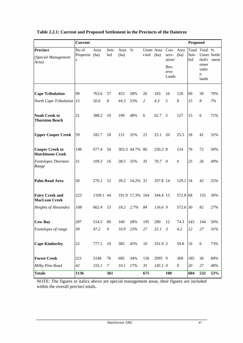
Rainforest CRC 47
Table 2.2.1: Current and Proposed Settlement in the Precincts of the Daintree
Current Proposed
Precinct
(Special Management Area)
No of Properties
Area (ha)
Sett-led
Area (ha)
% Unsett-led
Area (ha)
Con-serv-ation/
Res-erve Lands
Area (ha)
Total Sett-led
Total Unsettled/conservation lands
% Settle-ment
Cape Tribulation 99 763.6 57 453 58% 26 183 16 120 69 30 70%
North Cape Tribulation 15 56.6 8 44.3 53% 2 4.3 5 8 15 8 7%
Noah Creek to Thornton Beach
21 388.2 10 199 48% 6 62.7 5 127 15 6 71%
Upper Cooper Creek 59 181.7 18 131 31% 21 25.1 20 25.5 18 41 31%
Cooper Creek to Hutchinson Creek
148 677.4 54 303.3 44.7% 86 250.2 8 124 76 72 50%
Footslopes Thornton Range
51 109.3 16 38.5 35% 35 70.7 0 0 25 26 49%
Palm Road Area 56 276.1 12 39.2 14.2% 31 107.8 14 129.1 14 42 25%
Fairy Creek and MacLean Creek
223 1109.1 44 191.9 17.3% 164 344.4 15 572.8 68 155 30%
Heights of Alexandra 108 662.4 15 18.2 2.7% 84 116.6 9 572.6 30 82 27%
Cow Bay 287 514.5 80 160 28% 195 280 12 74.3 143 144 50%
Footslopes of range 39 47.2 9 10.9 23% 27 32.1 3 4.2 12 27 31%
Cape Kimberley 22 777.1 10 385 45% 10 331.9 2 59.8 16 6 73%
Forest Creek 221 3148 76 685 34% 136 2095 9 369 185 36 84%
Milky Pine Road 42 155.1 7 10.1 17% 35 145.1 0 0 20 27 48%
Totals 1136 361 675 100 604 532 53%
NOTE: The figures in italics above are special management areas, their figures are included within the overall precinct totals.

48 Rainforest CRC
2.2.3.4.1 Cape Tribulation
Biodiversity values
The ecology of the Cape Tribulation Precinct is characterised by complex rainforest associations on coastal footslopes and ridges with littoral rainforest on strand areas. Most of the area of rainforest on alluvium between the mountain range and the coast has been cleared, except for riparian margins about Thompson and Myall Creeks. The remaining rainforest is of varying integrity, with recent cyclonic activity severely damaging most areas. However, these areas remain of moderate value as habitat to a range of species of conservation significance, with the riparian zones throughout the precinct having high habitat values. The littoral rainforest present is representative of an endangered regional ecosystem and is of outstanding value as a community in its own right.
The area north of Cape Tribulation is an area of special management consideration. The forest of this management area is predominantly of a very high integrity, and maintains an unbroken vegetated corridor between the Thornton Range and the foreshore, one of the very few areas in the Wet Tropics where this occurs.
The Cape Tribulation precinct is not an area of high significance to fauna, since most of it has been cleared, with limited habitat and resource opportunities being available to most animals. The precinct is not a high priority cassowary conservation area owing to the very low populations of cassowaries in the area and lack of suitable coastal habitat.
Current settlement character
Of the 99 properties in the Cape Tribulation precinct (an area of 763.6 ha), 57 properties are settled (452.5 ha), 26 are unsettled (182.7 ha) with the remainder being dedicated conservation lands or reserves (120.3 ha). A small number of large holdings comprise the majority of the total area of the precinct. These were previously pastoral areas, but now some have been acquired and developed for resort or future resort business. The majority of the properties, excluding the large holdings, are small rural residential blocks, in most cases forested with small clearings.
North of Cape Tribulation these small properties (total of 15 with an area of 56.6 ha with 8 properties settled, 2 unsettled and 5 dedicated to conservation lands or reserves) are generally on coastal footslopes that drop almost directly onto the foreshore area, or are on narrow littoral frontages. This area constitutes a special management area by virtue of its scenic contribution to the Cape Tribulation experience, the high to very high habitat values and high vegetation integrity.
Appropriate settlement pattern
In order to maintain the habitat conservation value of the precinct, approximately 75% of the total properties in the Cape Tribulation precinct can be settled. Cape Tribulation is currently close to this figure. Owing to the mostly cleared areas of the coastal flat, there are relatively few restrictions on dwelling construction. Within all the forested areas the general principles of containing dwellings to the smallest possible footprint would apply. Any additional settlement should be encouraged on the larger pastoral and cleared holdings that exist in this precinct, with the balance of the remaining forested properties to remain unsettled.

Rainforest CRC 49
Map 2.2.1: Cape Tribulation

50 Rainforest CRC
Overall strategies
The following strategies are proposed:
• hillslopes over 1 in 6 constrained— (no major earthworks, no exceptional engineering required for house site ie no house pad or large (>25 m2) vehicle areas established).
• slopes in excess of 1 in 3 restricted
• no development on soils with impeded drainage condition
• housing footprint in forested areas to be as small as possible
• no large (greater than 200mm diameter at breast height) canopy trees to be removed
• all riparian vegetation to be retained to a minimum of 30 m from the high point of a perennial water course and 10 m from the high point of an ephemeral water course.
Area specific strategies (north Cape Tribulation)
In addition to the general strategies above, the following measures should be applied to the area north of Cape Tribulation:
• no development or clearing of littoral vegetation
• no fences
• no canopy clearing
• botanist to check house site pad prior to clearing and construction.
Tourism and economic considerations
In order to maintain the ‘green tunnel’ character of the main tourism route from the ferry to Cape Tribulation, a forested setback of at least 50m should be provided for any buildings on properties fronting the Cape Tribulation Road. Signage should be strictly in accordance with the DSC signage policy. Dwellings north of Cape Tribulation should be located such that minimum length driveways are required to be cleared, and a vegetated belt is maintained as a screen to traffic on the Cape Tribulation to Bloomfield Road.

Rainforest CRC 51
2.2.3.4.2 Noah Creek
Biodiversity values
This precinct encompasses a variety of coastal community types, including the best example of an endangered vegetation community type—coastal rainforest on sands (Tracey type 2b), in north Queensland. Most of the vegetation communities represented are of high to very high habitat value to a range of endemic, rare and/or threatened and other species of conservation significance. These communities are of varying degrees of integrity, with recent cyclonic disturbance severely compromising integrity about the Thornton Beach area and some of the range areas. The broad community types include:
• rainforest on sands
• complex lowland rainforests
• Melaleuca swamps
• littoral/foreshore communities
• mangrove communities.
Owing to the mosaic of community types the area is a critical habitat to cassowaries, and is of outstanding value as a corridor linkage between the Thornton Range and the foreshore area. It is the most critical area for cassowary habitat preservation in the study area.
Current settlement character
Settlement pattern in this precinct is dominated by small Thornton Beach properties (approximately 1000m2 ) utilised primarily as fishing/holiday areas. Although the total area of settlement is approximately 198 ha, the majority of this area is taken up with the large holding of Noah Creek. Of the total 21 properties in this precinct, 10 are settled, 6 are unsettled and the remainder are conservation or reserve lands.
Appropriate settlement pattern
There is no need for restrictions on the settlement of the remaining properties within the Thornton Beach area, excepting those relating to maintenance of ecological characteristics. However, some blocks are poorly drained and site drainage will be an important consideration in siting any building. Current settlement at Noah Creek is at the maximum allowed under the Douglas Shire Planning Scheme, and no further settlement is envisaged or should be encouraged within this area.
Overall strategies
The following strategies are proposed:
• hillslopes over 1 in 6 constrained—no major earthworks, no exceptional engineering required
• slopes in excess of 1 in 3 restricted
• no development on soils with impeded drainage conditions
• housing footprint in forested areas to be as small as possible

52 Rainforest CRC
• no large canopy trees to be removed
• all riparian vegetation to be retained to a minimum of 30 m from the high point of a perennial water course and 10 m from the high point of an ephemeral water course.
Area specific strategies
Ongoing rehabilitation of the road verges between Thornton Beach and Noah Creek should be continued as a priority action.
All existing canopy trees along the Thornton Beach section should be retained. Illegal camping within the Noah Creek/South Noah beach should be discouraged as these activities are compromising littoral forest integrity in constantly used areas.
The non-settled section of the Noah Creek area should be acquired as a conservation priority and to restrict further development within the Noah Creek catchment (excluding current commercial tourism and agricultural ventures).
Tourism and economic considerations
In order to maintain the ‘green tunnel’ character of the main tourism route from the ferry to Cape Tribulation, current large canopy species should not be cleared on property and road reserve frontages in the Thornton Beach area. As much setback should be maintained as possible in any new settlement. Signage should be strictly in accordance with the DSC signage policy.
2.2.3.4.3 Upper Cooper Creek
Biodiversity values
The upper and mid Cooper Creek catchment area is one of the most diverse terrestrial ecosystems in Australia. The forests are characterised by an outstanding representation of species of conservation significance including rare and/or threatened species, narrow endemics, species with widely disjunct ranges, poorly known and/or undescribed species and many species considered to have primitive floral characteristics. This combination is unmatched anywhere in Australia. The integrity of the majority of this area remains high to very high.
It is the most critical precinct within the study area for the retention of all existing vegetation.
The area has important riparian linkages via Little Cooper and Cooper Creek across the coastal plain between the range and the coast but is only considered to be an area of moderate importance as cassowary habitat.

Rainforest CRC 53
Map 2.2.2: Noah Creek

54 Rainforest CRC
Current settlement character
Of the 59 properties in the precinct currently there are 18 settled, 20 have been acquired and 2 are subject to Cooperative Management Agreements with the Wet Tropics Management Authority. 21 blocks remain unsettled.
In the vicinity of Little Cooper Creek, the main character is forest residential with dwellings constructed on small clearings. To the north of Cooper Creek, two properties have dwellings in established cleared areas of around 1 hectare.
Appropriate settlement pattern
Owing to the high biodiversity conservation value (the restricted populations of endemic plants) and the ongoing conservation requirements to protect ecological integrity, it is not appropriate for any further settlement in this precinct.
Overall strategies
The overall strategy for this precinct is the maintenance of rainforest canopy integrity with no further disturbance. This aspect has the highest priority in the study area for flora species conservation of conservation significance. The following strategies are proposed:
• hillslopes over 1 in 6 constrained—no major earthworks, no exceptional engineering required
• slopes in excess of 1 in 3 restricted
• no development on soils with impeded drainage conditions
• housing footprint in forested areas to be as small as possible
• no canopy trees to be removed
• all riparian vegetation to be retained to a minimum of 30 m from the high point of a perennial water course and 10 m from the high point of an ephemeral water course.
Acquisition for Conservation
All undeveloped properties in this precinct are the highest priority for securing conservation.
Area specific strategies
The following strategies are proposed:
• riparian verges (to within 30 m of high bank) not to be developed
• strictly no clearing without a prior botanical survey
• all clearing to done in accordance with survey and under botanical supervision
• housing design to reflect smallest possible clearing required
• no granite boulder scree to be moved
• no ephemeral drainage lines to be altered or interfered with in any way.

Rainforest CRC 55
Map 2.2.3: Upper Cooper Creek

56 Rainforest CRC
Tourism and economic considerations
This precinct is not an appropriate area for additional tourism development or additional day visitation except on cleared land. There are insufficient resources and facilities for tourism to have no net impact on the environment. Uncontrolled tourism has resulted in loss of ecological integrity in some areas of outstanding habitat values, primarily the Blue Pool on Cooper Creek. Day trip visitation needs to be better managed in this area in cooperation with local landowners.
There should be no commercial or fee for service access to Blue Pool or Cooper Creek available for day tours or tour buses.
Access to the creek for swimming from private properties should be subject to the terms of Co-operative Management Agreements with the Wet Tropics Management Authority concerning defined locations for access points on the creek and agreed arrangement for preventing erosion and siltation.
Local pedestrian access to Cooper Creek should be managed by Douglas Shire Council via an appropriate system of reserves.
2.2.3.4.4 Hutchinson Creek to Cooper Creek
Biodiversity values
This precinct is one of the most diverse within the study area. It includes examples of ‘at risk’ (vulnerable) and ‘of concern’ vegetation communities including monotypic fan palm forests and lowland complex mesophyll vine forests. The fan palm forests represented in this precinct are one of the best examples of this ‘at risk’ vegetation community in north Queensland.
The footslopes of the range in this area are of outstanding value as habitat to a number of rare, restricted and other species of conservation significance. Of particular significance is that fauna and flora species otherwise restricted to high altitude (above 750 m altitude) elsewhere in the state are represented in lowland freehold properties.
Some portions of this precinct have been cleared for agricultural purposes, primarily cattle and tea, and have contributed to loss of opportunity for habitat connectivity between the Thornton Range and the coastal communities. However, this has not affected the overall habitat integrity and a mosaic of vegetation community remains.
This precinct is an important habitat area for cassowaries owing to the mosaic of communities and the position in the landscape of this precinct on the coastal plain.
The lower area of the precinct adjacent to Hutchinson Creek is an area of special management consideration, owing to very high representation of species of conservation significance, as a cassowary and general fauna linkage between the Cooper Creek catchment and Hutchinson Creek catchment, and the generally high integrity of most of the vegetation. Some of the properties in this management area have the frontages partially cleared.
Current settlement character
There are 148 properties in total in this precinct, with 54 settled. Those settled include a variety of small forest residential properties in the Candlenut and Carbeen areas, larger holdings of primarily agricultural activity, and medium size (to 10 ha) rural residential properties. The last two property types are generally on cleared or partially cleared land.

Rainforest CRC 57
Appropriate settlement pattern
Given the partially cleared nature of this precinct, 50% of the total properties in this precinct can be settled. Further settlement in the Candlenut and Carbeen Road (that area on the lower slopes of Hutchinson Hill) areas within forested properties is not to be encouraged. Further settlement on properties with forested lots in the Mahogany and Ironbark Road areas to be encouraged on existing cleared areas at the front of the properties.
There is some potential for small niche market horticultural enterprises within this precinct.
Overall strategies
The overall strategies for this precinct should be:
• hillslopes over 1 in 6 constrained—no major earthworks, no exceptional engineering required
• slopes in excess of 1 in 3 restricted
• no development on soils with impeded drainage conditions
• housing footprint in forested areas to be as small as possible
• no large canopy trees to be removed
• all riparian vegetation to be retained to a minimum of 30 m from the high point of a perennial water course and 10 m from the high point of an ephemeral water course
• assistance to be supplied to landowners looking for revegetation support on their properties.
This precinct, owing to its strategic position on the coastal plain between the Thornton Range and the Bailey/Cooper Creek wetland mosaic, is considered to be a priority rehabilitation area to restore riparian areas and to re-establish forest continuity as fauna movement corridors.
Area specific strategies
Residences in the Ironbark and Mahogany Road areas should be restricted to existing clearings.
Residential footprints in the Candlenut and sections of Carbeen Road areas should be within the smallest possible footprint, with residences near the road frontage to avoid the requirement for long driveways and potential electricity supply provision. It is preferable to avoid any further development within the Candlenut and Carbeen Road (on the foothills of Hutchinson Hill). Given the high percentage of wattles in the canopy in some section of Carbeen Road, it is appropriate that extra clearing for a wider housing footprint is undertaken for safety reasons (limb shear from the wattles).
No clearing for housing development should be undertaken without a specific site plan that has been surveyed by a recognised botanist prior to construction. No mature canopy trees are to be removed within the Carbeen and Candlenut Road areas, nor should any rare and/or threatened species, excluding those species considered to be abundant in both area immediate, (ie within that particular property and neighbouring properties), and locally within the Daintree River to Cape Tribulation area.
Horticultural or other farm enterprises to be established only in accordance with guidelines developed for organic production.
Tourism and economic considerations
In order to maintain the ‘green tunnel’ character of the main tourism route from the ferry to Cape Tribulation, a forested setback of at least 50m should be provided for any buildings on

58 Rainforest CRC
properties fronting the Cape Tribulation Road. Signage should be strictly in accordance with the DSC signage policy.
• The general forested set back of 50m for the main Cape Tribulation Road is not appropriate for properties in the forested sections of Ironbark or Mahogany Road nor for the Carbeen and Candlenut Road area. In these areas clearing for driveway and services provision should be a minimum.
2.2.3.4.5 Palm Road
Biodiversity values
The Palm Road area has one of the largest areas of high integrity monotypic fan palm galleries remaining in north Queensland, and the largest remaining single gallery within freehold tenure. These galleries are unique in that a number of characteristic species associated with the fan palms are localised endemics (eg Normanbya normanbyi, Cleistanthus myrianthus). These fan palms forest areas are considered regionally to be an ‘at risk’ ecosystem type and are one of the highest priorities for conservation.
Additionally, the fan palm gallery is noted as being an area of importance to cassowaries both as foraging areas, and as corridor areas between the lower Hutchinson Creek area and the estuarine coastal wetlands between Bailey Creek and Cooper Creek.
Current settlement character
The total area of this precinct is 276 ha, with 12 (39 ha) out of the total 56 properties settled. Of the remaining 44 properties, 14 have been acquired for conservation purposes. The settled properties are primarily forest residential, with small clearings established within the forest.
Appropriate settlement pattern
• There should be no further settlement within monotypic fan palm galleries in this precinct. Other settlement should be restricted to the smallest possible footprint, close to road frontage to avoid the necessity for clearing of long driveways.
Overall strategies
• The overall strategy in this area is to maintain integrity of the canopy of the fan palm galleries, and to exclude drainage works within and immediately adjacent to these communities.

Rainforest CRC 59
Map 2.2.4: Hutchinson Creek to Cooper Creek

60 Rainforest CRC
Map 2.2.5: Palm Road

Rainforest CRC 61
Area specific strategies
Canopy clearance is not appropriate in fan palm forests owing to changes in light and humidity regimes adversely affecting recruitment patterns, and allowing potential storm winds to gain understorey access.
Development involving changes in drainage regime within or immediately adjacent to these communities is similarly to be discouraged as changes in drainage regime will affect the structural integrity and recruitment patterns.
Changes in light and drainage within these communities favour the development of introduced environmental weeds, notably pond apple (Annona glabra) which already has an established population in the south east of this precinct.
Large dogs should be prohibited within the area and the practice of hunting wild pig using dogs should cease. Dog control should be specifically enforced owing to the value of these areas as breeding and foraging habitats for cassowaries.
No fences should be erected which interfere with cassowary movement, and/or restrict their access to resources including water, different community types and specific fruiting tree species.
Tourism and economic considerations
It is not appropriate in this precinct to have set backs from the edge of the road to 50 m for visual amenity reasons. The length of driveway required would be counterproductive to the desired outcome of the smallest possible settlement footprint within this precinct. Palm Road is not a major tourism route, but is used sporadically by smaller operators for informal walks through vacant properties.
2.2.3.4.6 Hutchinson to Maclean Creek
Biodiversity values
This precinct is primarily the northern footslopes and runoff areas of the Heights of Alexandra in the western-most section of the general Cow Bay area. The habitats are represented by a mixture of very high value complex mesophyll rainforests on the ridges and footslopes, and depauperate sclerophyll woodlands of various floristic character. The footslopes areas have the highest percentage of complex mesophyll rainforests on red earths in the study area. This is a very unusual combination in north Queensland, and has resulted in a very high biodiversity with the rainforest typified by endemic species (Endiandra microneura, Haplostichanthus sp ‘Cooper Creek, Cleistanthus myrianthus). In addition, a number of species which only otherwise exist on red soils on the Atherton Tablelands, eg Beilschmiedia volckii, are represented as disjunct examples of these species. Recent cyclonic activity, while reducing structural integrity, have not reduced value as habitat. Similarly past logging, while having local effects on structural integrity have likewise not reduced the values of these areas as habitat.
The runoff areas at the base of the footslopes in this precinct are on poorly drained alluvial soils supporting various sclerophyll communities. Most of these areas (adjacent to Hutchinson Creek), have been cleared for past pastoral/agricultural activity and are of low habitat and of low integrity. The primary value of the depauperate sclerophyll communities is for corridor connectivity between this precinct, the Cow Bay precinct and the Hutchinson Creek precinct.

62 Rainforest CRC
This precinct is generally of very high value as cassowary habitat, and supports the largest population of this species in the lowland areas.
Owing to the particular values of the complex rainforest on red earths, the foothills of the Heights of Alexandra have been nominated as a special management area. Much of this area as mapped is unlikely to be settled, and/or is in conservation reserve. There is a small area of fan palm forest on the levee banks of Hutchinson Creek in this area.
Current settlement character
There are in total 223 properties (1109 ha) in this precinct with 44 settled (191 ha), 164 unsettled (344 ha) and the remainder being reserves or conservation lands. Nearly all settlement is of a forest residential nature, with small clearings within a forested landscape. The large pastoral holding in this area has a caretaker residence and contributes nearly all of the clearing in this precinct.
Appropriate settlement pattern
Of the 223 properties in this precinct, approximately half can be developed without incurring further environmental and economic costs in this precinct. Further development should be discouraged in the Black Bean, Tulip Oak Road, Maple Road, and Bailey Hill Road (on lower northern footslopes of Heights of Alexandra only). Dwellings should be encouraged elsewhere in the precinct (eg Hickory, Pandanus, Cypress and Fig Tree Road areas) as an alternative to these areas of high biodiversity values.
Overall strategies
The following strategies are proposed:
• hillslopes over 1 in 6 constrained—no major earthworks, no exceptional engineering required
• slopes in excess of 1 in 3 restricted
• no development on soils with impeded drainage conditions
• housing footprint in forested areas to be as small as possible
• no large canopy trees to be removed
• all riparian vegetation to be retained to a minimum of 30 m from the high point of a perennial water course and 10 m from the high point of an ephemeral water course.
Area specific strategies
Clearings on the footslopes of the Heights of Alexandra in complex mesophyll vine forests on red earths should be restricted to the smallest possible footprint.
No large canopy species should be removed, and a specific audit should be conducted of individual housepad sites by botanists to ensure that no significant species are to be removed.
Dog control should be specifically enforced owing to value of these areas as breeding and foraging habitats for cassowaries.
No fences should be erected which interfere with cassowary movement, and/or restrict their access to resources including water, different community types and specific fruiting tree species.

Rainforest CRC 63
Tourism and economic considerations
The majority of the properties on either side of the Bailey Creek Road from the base of the Heights of Alexandra through to and just beyond the intersection with Buchanan Creek Road are separated from the main road by a vegetated screening corridor on the road reserve.
In order to maintain the ‘green tunnel’ character of the main tourism route from the ferry to Cape Tribulation, this forested section of the road reserve should be maintained. For any dwellings on the main road outside the management area of the foothills of the Heights of Alexandra, and without fronting forested road reserve area clearings, a 50 m setback should be provided for any buildings on properties fronting the road. Signage should be strictly in accordance with the DSC signage policy.
In the special management area clearings should be as close to the road reserve as practical to avoid unnecessary clearing of high value forested habitat. These properties will remain screened through the retention of the forested road reserve.
2.2.3.4.7 Cow Bay
Biodiversity values
The Cow Bay area vegetation is characterised by sclerophyll dominated communities on the coastal plain and adjoining Bailey Hill and complex rainforest communities in sheltered positions on the northern footslopes of the Heights of Alexandra. Along drainage lines and areas of impeded drainage Melaleuca dominated swamps are typical. These are successional communities established only since the turn of the nineteenth century and in some instances are well advanced. Owing to the recent lack of a fire history, many of the sclerophyll forests are reverting to rainforest as conditions favourable to rainforest species recruitment continues. Given the density of residents in these areas, burning of these communities to maintain their character is not feasible. There is evidence of many canopy sclerophyll trees dying, the understorey and sub-canopy dominated by primary rainforest successional species.
The habitat values of these successional sclerophyll/rainforest communities varies from very low to low. The primary values of these areas are as contributions to habitat diversity and connectivity for fauna between the Heights of Alexandra and the Bailey Creek wetland complex (and Bailey Hill itself).
There are areas of very high biodiversity and of very high value as habitat to both flora and fauna in this precinct. These are primarily the lowland/wetland complexes (mixed complex mesophyll rainforests, fan palm forest and melaleuca woodlands) represented on the northern footslopes of the Heights of Alexandra and in MacLean/Bailey Creek area. These are of outstanding habitat values (foraging and breeding) for Cassowaries, and for flora of the complex rainforest on the footslopes.
The complex rainforest on the footslopes is similar in character to the special management area nominated for the MacLean/Fairy Creek area. As a result, that portion of the precinct with these values is a similarly nominated special management area for both fauna (particularly cassowaries) and flora.

64 Rainforest CRC
Map 2.2.6: Hutchinson to Maclean Creek

Rainforest CRC 65
Current settlement character
There are 287 properties in this precinct (514 ha) with 80 settled, 195 unsettled and 12 given over to conservation/reserve purposes. Residential pattern has varied between almost total clearing of some properties in sclerophyll areas, to rainforest residential dwellings with only the footprints cleared. The large majority of the properties are approximately 1 ha in size, with a few larger. The largest single property is a commercial agricultural property in the south west of the precinct.
Appropriate settlement pattern
Given the past history of land use and current biodiversity values and level of settlement, 60% of the existing properties could be developed without incurring major environmental or economic costs. There remains the potential for a further 80 blocks which can be settled in this precinct.
Further dwellings in the Spurwood Road area should be discouraged owing to the steep slopes, and high biodiversity value of the complex rainforests on red earths represented in that area. Settlement should be encouraged in the sclerophyll dominated areas.
The steep slopes of Red Gum and White Beech Road areas would require visually dominant clearings and major earthworks to access and construct house sites and works in these should be restricted.
Overall strategies
The following strategies are proposed:
• riparian corridors should be maintained in a vegetated condition for corridor connectivity for fauna throughout the precinct
• hillslopes over 1 in 6 constrained—no major earthworks, no exceptional engineering required
• slopes in excess of 1 in 3 restricted
• no development impeded drainage conditions
• housing footprint in forested areas to be as small as possible (note area specific strategies below)
• no large canopy trees to be removed (note area specific strategies below)
all riparian vegetation to be retained to a minimum of 30 m from the high point of a perennial water course and 10 m from the high point of an ephemeral water course.
Area specific strategies
Clearings on the footslopes of the Heights of Alexandra in complex mesophyll vine forests on red earths should be restricted to the smallest possible footprint.
Clearing in sclerophyll dominated forest permissible beyond that of immediate house pad area. Similarly, sclerophyll canopy trees (Acacia, Eucalypt and Corymbia) may be removed for safety reasons owing to propensity to limb shear.
Within the Spurwood Road area, no large canopy species should be removed, and a specific audit should be conducted of individual housepad sites by botanists to ensure that no significant species are to be removed.
Dog control should be specifically enforced owing to value of these areas as breeding and foraging habitats for cassowaries.

66 Rainforest CRC
Map 2.2.7: Cow Bay

Rainforest CRC 67
No fences should be erected which interfere with cassowary movement, and/or restrict their access to resources including water, different community types and specific fruiting tree species in the special management area.
Tourism and economic considerations
The Buchanan Creek Road is of secondary importance to tourism, with predominantly only local traffic and accommodation people visiting Cow Bay beach. It is desirable (in accordance with the general management requirements for this precinct) that a 50 m setback exist for possible buildings and clearing locations. This setback should not be at the expense of environmental considerations, and should only be in place for properties fronting Buchanan Creek Road.
2.2.3.4.8 Cape Kimberley
Biodiversity values
The Cape Kimberley precinct is at the interface of the southern footslopes and ridges of the Heights of Alexandra and the marine estuarine environment about the Daintree river. Consequently there is substantial variation in the communities represented. The rainforests of the footslopes of the Heights of Alexandra share many of the habitat characteristics with the forest of the northern side of the range, but are not as diverse in character and their structural integrity is lower. The value of these as habitat for flora of conservation significance varies from moderate to high depending on degree of disturbance and position in the landscape (riparian, ridge crest etc).
The alluvial interface between the Heights of Alexandra and the Daintree river is dominated by vegetation mosaics of various combinations, including limited fan palm areas, various sclerophyll types and Melaleuca swamps. There are also large areas of mangroves on the southern side of this precinct. These mosaics provide habitat to a range of species of conservation significance, both fauna and flora, and are vulnerable to drainage works being undertaken within adjoining agricultural/pastoral lands.
Current settlement character
The Cape Kimberley precinct is sparsely settled owing to the properties being nearly all larger agricultural/pastoral holdings or tourism development. There are 22 properties (777 ha) of which 10 are settled, 10 unsettled and two acquired for conservation/reserve purposes. Much of the vegetation has been cleared from the larger properties for agriculture/pasture and the settlement character reflects this land use.
Appropriate settlement pattern
Owing to the predominantly rural land use in the area, and the large percentage of cleared area, approximately 73% of the properties in this precinct can be developed. Settlement in this precinct should primarily be encouraged south of the Cape Kimberley Road utilising the existing cleared area in preference to the footslopes of the Heights of Alexandra.

68 Rainforest CRC
Map 2.2.8: Cape Kimberley

Rainforest CRC 69
Overall strategies
Riparian corridors should be maintained in a vegetated condition for corridor connectivity for fauna throughout the precinct. The following strategies are proposed:
• hillslopes over 1 in 6 constrained—no major earthworks, no exceptional engineering required
• slopes in excess of 1 in 3 restricted
• no development on soils with impeded drainage conditions
• housing footprint in forested areas to be as small as possible (note area specific strategies below)
• no large canopy trees to be removed (note area specific strategies below)
• all riparian vegetation to be retained to a minimum of 30 m from the high point of a perennial water course and 10 m from the high point of an ephemeral water course.
Area specific strategies
Further drainage works on agricultural/pastoral lands to be limited.
Riparian margins to be maintained for connectivity between the Daintree River area and the Heights of Alexandra.
Littoral and foreshore vegetation not to be removed or interfered with.
Dwellings and associated clearings in rainforest areas to be restricted to smallest possible footprint.
Clearing in sclerophyll dominated forest permissible beyond that of immediate house pad area. Similarly, sclerophyll canopy trees (Acacia, Eucalypt and Corymbia) may be removed for safety reasons owing to propensity to limb shear.
Tourism and economic considerations
Cape Kimberley Resort is an existing backpacker/family camping area. Existing facilities to be maintained at current level. A forested setback of at least 50m should be provided for any buildings on properties fronting the road. This setback is not to be at the expense of other area specific or general strategies for the area. Signage should be strictly in accordance with the DSC signage policy.

70 Rainforest CRC
2.2.3.4.9 Forest Creek Area
Biodiversity values
The Forest Creek Area precinct is an area dominated by various vegetation communities, most of which are in various stages of succession. Much of this precinct has been previously cleared for agricultural/pastoral activity, and it has only been within predominantly the last 3 decades that the lack of continued use of these areas for primary production has resulted in extensive stands of successional communities dominated by Acacia. Much of the remaining lowland areas in this precinct which were not cleared were heavily logged, and this is reflected in the low to moderate structural integrity of the remnant rainforest in most of this area.
Varying drainage conditions in the lower section of Forest Creek have resulted in a complex mosaic of impeded drainage type communities, with intimate mixtures of Melaleuca, Acacia, and fan palm forests. These areas are of moderate habitat value to flora and fauna, but riparian linkages (notably Forest Creek) are important corridor movement areas between this precinct and the Heights of Alexandra.
The rainforest area about the Milky Pine Road area is typical of the complex mesophyll rainforests of the footslopes of the Heights of Alexandra. This is of high habitat value to a range of flora species of conservation significance, and is important for corridor connectivity between the estuarine environment of the Daintree River and the Heights of Alexandra. This area has been nominated as a special management area.
Current settlement character
Of the 221 properties (3148 ha) in the precinct currently there are 76 (684.6) settled, 9 are within conservation or other reserves and 136 privately owned blocks remain unsettled (2094 ha). The large area is due to a few large rural holdings in the east of the precinct which have few dwellings.
The main settlement character is residential with dwellings constructed on moderate clearings on forested blocks and a range of essentially cleared rural properties.
Appropriate settlement pattern
Provided clearing is minimised and setbacks from riparian corridors are achieved, it is appropriate to settle almost all blocks in the precinct (other than the Milky Pine Road area).
Overall strategies
The following strategies are proposed:
• hillslopes over 1 in 6 constrained—no major earthworks, no exceptional engineering required
• slopes in excess of 1 in 3 restricted
• no development on soils with impeded drainage conditions
• housing footprint in forested areas to be as small as possible
• no large canopy trees to be removed

Rainforest CRC 71
• all riparian vegetation to be retained to a minimum of 30 m from the high point of a perennial water course and 10 m from the high point of an ephemeral water course.
Area specific strategies
Clearings on the footslopes of the Heights of Alexandra in complex mesophyll vine forests on red earths should be restricted to the smallest possible footprint.
Maintenance of riparian verges as important corridors linking the Heights of Alexandra with the Daintree River wetland system is a priority strategy.
Within the Milky Pine Road management area, no large canopy species should be removed, and a specific audit should be conducted of individual housepad sites by botanists to ensure that no significant species are to be removed.
Clearing for buildings on the rainforest sections of Thornton Peak Drive should be as close to the road reserve as practical, requiring minimal clearing.
Tourism and economic considerations In order to maintain the current ‘green tunnel’ character of the Forest Creek Road a forested setback of at least 50m should be provided for any buildings on properties fronting the road. This setback is not to be at the expense of other area specific or general strategies for the area. Signage should be strictly in accordance with the DSC signage policy. Accessibility to the ferry suggests that this location is well placed and provides opportunities for small scale tourism accommodation and day visitor facilities and agricultural production enterprises. Higher levels of traffic related of such enterprises will not adversely contribute to congestion of road safety conditions elsewhere on Cape Tribulation Road.

72 Rainforest CRC
Map 2.2.9: Forest Creek Area
Rainforest CRC 73
2.2.4 Recommendations for land management and biodiversity
Recommendation 7: Ensure the protection of rare and threatened species on freehold land.
Why: The Wet Tropics World Heritage Area surrounds the Daintree study area. The outstanding biodiversity values recognised within the WHA also extend outside the boundary, especially onto the lowland areas where a significant number of rare and threatened plants and animals are present largely on freehold lands. Some relatively intact forests have outstanding representation of species of conservation significance including rare and/or threatened species, narrow endemics, species with widely disjunct ranges, poorly known and/or undescribed species and many species considered to have primitive floral characteristics. The entire known populations of some species such as eg Acmena sp ‘Cooper Creek’, Endiandra cooperana are located on freehold land. Some priority land acquisitions, special management arrangements and general environmental management guidelines proposed here will give adequate protection to these biodiversity values, if the latter two options are implemented through code assessment requirements in an IPA scheme.
How: Detailed conservation assessment of the nine precincts here is based on 150,000 plant records and mapping of plants communities at a scale that allows assessment of the biodiversity values of individual allotments. In some precincts biodiversity ‘hotspots’ have been identified for priority acquisition. Reducing the impacts of settlement on the biodiversity of important but less threatened communities, have been achieved through a combination of special management guidelines, and where relevant, settlement densities that are less than would occur if full settlement proceeded.
Environment Australia have indicated that the precinct descriptions would be enhanced by the addition of lists of threatened species of flora and fauna and migratory species.
Recommendation 8: Protection of regional ecosystem types not adequately conserved elsewhere.
Why: The Daintree lowlands have several regional ecosystem types not adequately conserved in protected areas in this district or elsewhere in the Wet Tropics bioregion. Most important are (i) a variety of coastal community types, including the best example of an endangered vegetation community type—coastal rainforest on sands (Webb and Tracey Type 2b), in north Queensland, and, (ii) monotypic fan palm forests and lowland complex mesophyll vine forests. The fan palm forests represented in the Palm Road precinct for example, is the best example of this ‘at risk’ vegetation community in north Queensland (and therefore the world).
How: These communities are given protection by land management controls on residential and business development and limiting settlement density to reduce clearing and other impacts.

74 Rainforest CRC
Figure 2.2.2: Public Land Strategy

Rainforest CRC 75
Recommendation 9: The protection of habitat for cassowaries and other vulnerable fauna.
Why: The long term viability of the cassowary population and other fauna depends upon the habitat value of the lowlands (including the freehold lands) throughout the area in order to maintain habitat connectivity, breeding and genetic transfer throughout the population. The survival of sufficient numbers of individual cassowaries whose home range is predominantly on the lowland private lands is essential to maintaining the population.
How: By the protection of sufficient areas of habitat to support a viable breeding population and by restricting settlement densities and habitat change in key areas. Providing for vegetated corridors, foraging and breeding areas is essential especially in the Cow Bay/Noah Creek desirable for Cape Tribulation and Forest Creek Area and Cape Kimberley. Connectivity of habitat is maximised by having no fencing. Predation and disease risks are minimised by limiting domestic dogs and poultry.
Recommendation 10: Maintenance of ecosystem processes through environmental quality protection.
Why: The survival of natural ecosystems and human well-being depends on protecting ecosystem processes especially water quality and quantity. Water quality must be maintained at high standards since the streams and associated groundwater meet domestic water requirements and support freshwater biodiversity and then discharge into the nearby Great Barrier Reef World Heritage Area.
How: Water can be used within the natural recharge rate of aquifers and streamflow by ensuring demands are kept within limits. The proposed population limit here, together with encouragement of rainwater capture, will achieve this. Water quality needs continuous monitoring.
Minimising soil erosion by preventing development of slopes in excess of 33% and within 30m from perennial watercourses will help to maintain natural stream condition and water quality.
Research by EPA into appropriate environmental values for Daintree creeks and waterways under the provisions of EPP [Water] and integrated rural water cycle management to achieve specified values/required controls on mission to water can be called up under planning schemes.
Provisions of the Wet Tropical Coastal Plan also offer potential for controlling runoff quality to Great Barrier Reef Lagoon
See also under Water Supply and Waste Management
Recommendation 11: Improve the control of pigs on public land in the area.
Why: The maintenance of the integrity of ecosystem processes requires the control of feral animals, control of weeds and rehabilitation of disturbed areas.
How: Establish a feral pig control officer and provide necessary operational resources (including sufficient traps) to reduce pig populations. Establish weed control programs for high priority sites, and in disturbed areas undertake rehabilitation.

76 Rainforest CRC
The opportunity to establish a pest management officer within Douglas Shire Council should also be considered.
Recommendation 12: Ensure accountable management of protected areas.
Accountable management arrangements for the Protected Area estate should be developed to comprise equitable land management responses to: • Biodiversity conservation and rehabilitation. • Habitat management including adequate resources for pest and feral animal control. • Protocols for interaction with neighbours and resolution of boundary management issues. • Development and maintenance of visitor facilities. • Monitoring of use and activity within protected areas. • Maintenance of equitable commercial activity permit systems. Why: The community has little confidence in decision making in public land management agencies and requires a more open process and community dialogue to be established How: Public land management agencies to collaborate to bring their decision making processes into the public arena. Figure 2.2.2 details possible linkages essential for accountable public land management.
Recommendation 13: Maintenance of scenic and wilderness values for residents and tourists.
Why: Most tourists experience the Daintree by car/coach along the Cape Tribulation Road and the small number of key sites adjacent to it, including the Alexandra Range Lookout, the Environment Centre and boardwalk, the creek crossings and views through to Cape Tribulation, its beaches and boardwalks. It is important to maintain the quality of that path as a critical element of tourists rainforest experience. The concept of a ‘green tunnel’ from the ferry to Cape Tribulation has been accepted by the DSC, WTMA and the tourist industry for this purpose and the road designed accordingly. Some non-forest uses such as tropical horticulture and the tea plantation would be consistent with that experience.
How: In order to maintain the ‘green tunnel’ character of the main tourism route from the ferry to Cape Tribulation, a forested setback of at least 50m should be provided for any buildings on properties fronting the Cape Tribulation Road. Signage should be strictly in accordance with the DSC signage policy. Dwellings north of Cape Tribulation should be located such that minimum length driveways are required to be cleared and a vegetated belt is maintained as a screen to traffic on the Cape Tribulation to Bloomfield Road.
Recommendation 14: An immediate limit to further land clearing in the study area until the precinct plans are in place.
Why: Under current planning regimes the area will change substantially over the next 20 years. The right to develop a house, drainage and ancillary services means that the integrity of the area will continue to be fragmented despite DSC planning controls. Information that new controls might be put in place may encourage pre-emptive clearing and development.

Rainforest CRC 77
How: An interim local policy that allows only clearing that is consistent with the precinct plans in this report. One available mechanism is found under the Queensland Vegetation Management Act 1999. Division 4 –Declaration of areas of high nature conservation value and areas vulnerable to land degradation. This states that the Minister may declare a stated area, an area of high nature conservation value and that in preparing the declaration the Minister must consult with an advisory committee and the relevant local government. An interim declaration may also be made if the Minister considers that urgent action is needed to protect the area, however, an interim provision may stay in place for 3 months. The current State policy on Vegetation Management on freehold and leasehold land and associated vegetation clearing codes does not offer adequate protection for small rural residential allotments. Additional regional codes are likely to be required to safeguard biodiversity and vegetation clearing codes developed under these provisions will function as part of the IDAS system of development approvals. An update of the Douglas Shire Council Vegetation Local Law to achieve compliance with Integrated Planning Act provisions could create a new planning framework for precinct based control of tree clearance. Additional technical and enforcement resourcing will be needed to implement such an initiative. Discussions should be held between the Douglas Shire Council and Department of Natural Resources as the potential for declaring part of the Daintree as areas of high conservation value. 2.2.5 The Use of Precinct Plans and Guidelines as a Planning Tool
The implementation of precinct plan recommendations would be undertaken through the development of a new Planning Scheme for the Douglas Shire Council under the Integrated Planning Act.
Douglas Shire Council will be required to update its planning scheme within the next three years.
The purpose of the Integrated Planning Act is to seek to achieve ecological sustainability by : • Co-ordinating and integrating planning at local regional and state levels. • Managing the process by which development occurs. • Managing the effects of development on the environment. Components of an Integrated Planning Act scheme include :
• Desired Environmental Outcomes including defined futures for social, cultural economic, ecological and natural resources.
• Measures to facilitate achievement of those outcomes through the mechanisms of self assessable development and assessable development requiring code or impact assessment.
• Performance indicators to assess the achievement of desired environmental outcomes and whether the measures lead to those outcomes.
The core matters to be addressed within an Integrated Planning Act scheme are • Land use and development;

78 Rainforest CRC
• Infrastructure. • Valuable Features including:
° Resources of ecological significance. ° Areas or places of cultural or historical heritage significance. ° Areas which contribute significantly to amenity such as ares of high scenic or
aesthetic value. ° Resources or areas of economic value.
The General Sections of the Douglas Shire Planning Scheme could include: • A Vision Statement which links to the FNQ Regional Plan and Council Corporate Plans
and Strategies • A Structure Plan which outlines future strategies for the Shire as a whole and identifies
localities where detailed District or Precinct Based planning controls will apply. • General Planning Scheme Policies will also be identified and these will replace the
existing framework of Local ByLaws. • Management arrangements that might be developed under this category including
Vegetation Protection management, Access to Reserves, Control of Domestic Animals etc and will include defined penalties for non compliance.
Precinct based Planning Controls will identify: • Desired Environment Outcomes for each precinct. • Policy measures. • Development assessment categories. • Precinct specific codes for special management areas or place specific requirements such
as local access arrangements. For the Daintree Area Precinct Plans will incorporate maps showing : • The extent of settled, unsettled and conservation or reserve lands appropriate for each
precinct to protect stated biodiversity values. • Special management ares where priority conservation outcomes must be achieved. Daintree Area and precinct specific Code and Impact Assessment requirements will include: • Control of development on steep slopes through defined site analysis and assessment
procedures. • Control of development on areas of impeded drainage through defined site identification
and assessment procedures. • Area Specific Vegetation management controls including site analysis, survey and

Rainforest CRC 79
assessment procedures, locations for control of clearing and maintenance and enhancement of riparian vegetation.
• Specification of maximum building envelopes. • Building design requirements which will reduce visual or physical impacts of buildings. • Building density and distribution requirements. • Temporary building or structure design requirements. • Sewerage system installation requirements. • Groundwater bore distribution requirements. • Rainwater tank installation requirements. • Environment management guidelines for installation and management of remote area
power systems. • Restrictions on the erection of fences. • Restrictions on the removal of timber products, rock or sand from any property. • Maintenance of road reserve vegetation. • Maintenance and provision of local pedestrian and vehicle access networks. • Requirements for maintenance and rehabilitation of vegetation on reserves and riparian
areas. 2.2.6 How Douglas Shire Council might implement the Integrated Planning Act provisions.
Douglas Shire Council will need to consider the timing of implementing the recommended planning and precinct regimes. It is recommended that Council commence immediate consideration of processes suitable to develop the Vision Statement which links to the FNQ Regional Plan and Council Corporate Plans and Strategies. An initial scoping of development of the Structure Plan is also required. Particular components to be considered include: • The extent of community consultation required under the Integrated Planning Act and suitable ways of managing such consultation in Douglas Shire. • The extent of technical investigation required. General Planning Scheme Policies will also be identified and these will replace the existing framework of Local ByLaws. Consideration of the type of policy framework required will depend on: • Current community satisfaction levels with existing by laws and compliance frameworks. • Compliance of existing local law framework with current legislative requirements.

80 Rainforest CRC
The development of Daintree Area and precinct specific Code and Impact Assessment provisions will require some specific technical work to establish development assessment codes. The need for original technical investigations to develop such guidelines may be reduced by research into documents such as the Cairns City Council Development Manual and relevant compliance codes available from other agencies. Compilation and consultations concerning the new Integrated Planning Act scheme could take 2-3 years for all statutory compliance stages to be completed. In terms of immediate control over building development, pending preparation of a new planning scheme, Douglas Shire should consider seeking Ministerial approval for interim planning scheme controls to ensure there is no pre-emptive rush of building applications in advance of the introduction of code assessment provisions. Revised assessment procedures are likely need improved technical knowledge and administrative capabilities within the Douglas Shire Council. Staffing and specialist technical assistance to undertake these stages could use resources of up to $500,000 over a three-year period. Table 3.3.1 suggests that one possible funding source for this improved administrative and technical capability potentially comes from ferry revenue. Council will need to consider the benefits of the total implementation package to assess its response to this suggestion.

Rainforest CRC 81
2.3 Tourism
Desired Outcome: A high quality, sustainable nature-based tourism industry based on the outstanding ecological and scenic resources of the area. The industry is committed to ensure that these outstanding values are not compromised and will provide opportunities for local business involvement and employment.
2.3.1 Issues
2.3.1.1 Visitor patterns
The dominant issue for the tourism industry is to maintain the high level of nature-based tourism experiences offered to visitors in keeping with the district’s world-class tourism values. Key components of tourism policy development include protecting the environment, managing visitor impacts, balancing overnight stays and day-tripper opportunities to maximise the returns to the local community, ensuring appropriate returns to the host community and the roles of publicly provided and private sector facilities and services.
The Daintree is one of, if not, the most important tropical rainforest tourism destination in Australia. Visitors are attracted to the largely unspoiled natural character of the area and the opportunities to experience rainforest and for the area’s scenery (Table 2.3.1). The majority of visitors are from overseas (with most of these from Europe), with domestic visitors comprising only 39% of visitors; 38% of the visitors surveyed undertook a guided rainforest walk, while 42 % went on an unguided walk.
Table 2.3.1: Expectations of all visitors (in ranked order) percent
Irrelevant Little relevance
Relevant Very relevant
Extremely relevant
Total Mean response
Undisturbed Rainforest
2 4 26 38 29 99 2.86
Good walking tracks
3 7 33 35 22 100 2.66
Birds & wildlife 3 10 34 34 19 100 2.56
Remote wilderness
3 12 35 30 20 100 2.52
Ecological Information
4 14 38 28 16 100 2.38
Scenic drive 14 11 31 27 17 100 2.22
High quality facilities
13 27 33 19 8 100 1.82
Sunny weather 18 27 27 18 10 100 1.75
Few other people 17 27 32 14 10 100 1.73
Interpretation by guide
48 26 18 5 3 100 0.89
4WD experience 68 19 7 3 2 99 0.50
Source: Walker, P., 2000, Daintree tourism futures
Tourists visit the Daintree on commercial tours and as independent self-drive or coach passengers. Many make day trips only while make overnight stays, averaging 2.5 nights.

82 Rainforest CRC
Cummings (1997) estimated that in 1996/97, 358 000 visitors crossed the Daintree River into the Study Area, consisting of 258 200 day visitors and 99 800 overnight visitors. Visitor numbers were spread more or less evenly between self-drive visitors, and passengers on commercial tours. Day visitor numbers and overnight visitor nights in the area have grown at high rates since 1983, but the rate of growth has slowed in recent years.
Table 2.3.2: Visitor numbers in the Daintree
Estimate 1991
Estimate 1996/97
Estimate 1999
Average Annual Growth 1991 to 1996/97
Day Trippers 172 400 258 200 299 138 7.6%
Overnight Visitors 50 700 99 800 127 231 13.1%
Total 223 100 358 000 426 369 9.0%
Source: Cummings (1997), project team
The Daintree Planning Package (Brannock Humphreys, 1994) recommended capping the number of visitors to the Daintree – Cape Tribulation area at 738 000 comprising 575,000 day trippers (144,000 self drive and 431,000 on commercial tours) and 163,000 overnight visitors (65,000 self drive and 98,000 on commercial tours. They recommended a visitor cap to shift the balance of visitation to 72% on commercial tours and 28% self drive (compared to a 50:50 ratio at that time), and place greater emphasis on day-trippers at the expense of overnight visitors.
Recent events have overtaken the tourism scenario proposed by Brannock-Humphreys and which underpins the current DSC Planning Scheme. Most importantly, there has been a rapid increase in the number of self-drive day trippers since the sealing of the Cape Tribulation Road and the consequent increase in the number of ordinary vehicles, especially hire cars, north of the River.
Local tour operators suggest that visitor numbers on commercial tours are now static or shrinking. The latter circumstances are thought to be a result of competition in the rainforest experiences segment (eg from Skyrail), a shift by those visiting the Daintree away from commercial tours to self drive, and low visitor satisfaction with the Daintree as a rainforest wilderness experience, due to overcrowding and the extent of development now present in the area. The relative remoteness of the area means for many visitors a long drive followed by several short stops at key locations such as the Range lookout, the boardwalks and Cape Tribulation.
The Daintree Powerline EIAS undertook some modelling of the implications for tourism of the types and level of settlement and the type of power infrastructure.
The modelling was essentially intuitive, based on discussions with tour operators and the work undertaken by GHD in the development of the Douglas Shire Tourism Strategy.
The key implications for tourism numbers are:
• if settlement of all or most blocks occurred (with or without conservation controls) the “urban” character of the area would be such that tourism character would be affected.
• if approximately half the blocks remain unsettled, conservation controls are implemented and power is provided essentially underground (or RAPS), the tourism character would be largely sustained. Tourism numbers would grow until the visitor numbers affected the

Rainforest CRC 83
visitors amenity (through crowding, intergroup interactions etc.) and numbers would plateau.
A critical population threshold of 1400 was identified as approximately the level of residential activity (from evident buildings, people, traffic etc.) at which the “rainforest wilderness” character would start to be significantly diminished.
The EIAS concluded that with half the blocks settled, conservation controls implemented (e.g. Scenario 4) and power is provided essentially underground or RAPS:
• day tripper numbers are expected to grow at a constant rate to 420,000 visitors in 2008; and
• visitor nights would grow from 240,100 in 1998 to almost 330,000 in 2008 and plateau at that level.
The above estimates of 330,000 in 2008 equates to about 130,000 overnight visitors (at an average length of stay of 2.5 nights).
Given the above, based on the modelling in the EIAS, the estimated level of visitors, beyond which the tourism character would be affected through crowding etc. is around 550,000 visitors.
This is about 125,000 more than the 1999 estimate (see Table 2.3.2). Importantly the 130,000 overnight visitor number was essentially reached in 1999. As such more accommodation or reduced average length of stay of overnight visitors would be required to enable increased growth of overnight visitors.
Importantly, significantly increases in overnight visitors (for example if all “approved” tourist accommodation is developed) would need to be an alternative to day trippers or the tourism amenity could be affected. The extent to which this occurs is dependent upon the visitor infrastructure (boundaries, beach access, picnic areas, carparks at same etc.) behaviour of visitors (generally better controlled by guided tours than self drive and the overall proportion of self drive and tour visitors.
The ecological sustainability of increased visitor numbers depends on the hardening (development of visitor infrastructure e.g. boardwalks to minimise impacts of increasing visitation) of sites. It is reasonable to assume that if visitor numbers grow above 550,000 per year further visitor infrastructure would need to be provided (beyond that recently developed under the Daintree Rescue Program) in order that visitation to be ecologically sustainable.
On the basis of the above, it is concluded that visitor numbers of up to 550,000 per year (420,000 day trippers and 130,000 overnight visitors staying on average 2.5 nights) are consistent with the tourism character and amenity and would not require substantially increased hardening of visitor sites to achieve ecological sustainability.

84 Rainforest CRC
2.3.1.2 Tourism planning
The Douglas Shire Tourism Strategy was developed in 1997 and finalised in 1998. It considers the social and economic impact of tourism and was developed in the context of a vision for tourism in the Douglas Shire to be recognised as a model of best practice sustainable tourism which presents the unique reef, rainforest and cultural heritage whilst benefiting the local community. The Strategy sets out a description of the Daintree Coast precincts and recognised a number of nodes within the precinct:
Daintree Coast Precinct
The Daintree Coast precinct includes the coastal lands north of the Daintree River.
Daintree Coast is used as a national icon to depict “where the rainforest meets the reef” - the meeting point of two World Heritage areas. It contains Australia’s and possibly the world’s most ancient refugial rainforest and has extremely high biological significance.
The desired character of the Daintree Coast precinct is a rainforest experience where visitors can experience untouched beaches, pristine rainforest and access to the Great Barrier Reef precinct. The intended experience is one which highlights living sustainably in the rainforest and is focussed on interpretation, education and research of the precinct’s biodiversity.
It is recognised that whilst the majority of visitors will be day visitors, those staying in the precinct will have an- intimate experience of life within the rainforest.
Nodes
Within each of the precincts a number of nodes are identified. These nodes are not exhaustive and there are many thriving tourism sites and businesses outside these nodes. The nodes, however, are points of focus for a range of tourism activities throughout the Shire.
Cape Tribulation
Cape Tribulation is a major ‘icon’ for the Shire. Within the node, careful planning is required to ensure that the character remains and that individual sites offer visitors the opportunity to experience the rainforest first hand.
Thornton Beach
Thornton Beach provides visitors an opportunity to explore the pristine beaches of the Daintree Coast.
Cooper Creek
Cooper Creek (along with Noah Creek) is the richest and most diverse section of the ancient Daintree Rainforest. It has become a node in its own right as it has high quality rainforest walks and cruises.

Rainforest CRC 85
Cow Bay
The Cow Bay node is a service node for visitors providing services, restaurants, the hotel, accommodation and the opportunity for further accommodation development.
Cape Kimberley
The Cape Kimberley node has the potential to provide visitors with a unique experience of isolation and solitude in a relatively easily accessible area.
Daintree Ferry
The Daintree Ferry node provides the entrance to the Daintree Coast precinct and a taste of the Daintree Valley precinct. The node should be established primarily as a gateway rather than a destination in itself.
Note: To avoid any doubt the ferry crossing is considered an essential experience to retain the tourism character of the Daintree Coast and Daintree Valley precincts.
Daintree River
The Daintree River offers a tranquil setting for visitors to experience the rainforest and river environment.
The Wet Tropics Management Authority’s Draft Nature Based Tourism Strategy identifies the management intent for the Daintree/Cape Tribulation Precinct area as: • providing primarily for small group day tours and overnight stays
• encouraging and supporting the host community to provide visitors with services that present the special attributes of the Daintree.
2.3.1.3 Community views
The Daintree Community forum outcomes were:
In respect to the provision of appropriate management regimes and infrastructure to support a high quality tourism industry which maximises returns to the local community, the community forum shared agreement with the following statements:
• Develop an institutional arrangement that allows the local community to determine its own management priorities, through funds accumulated from tourism cost-recovery.
• Utilise the ferry as the gateway to the Daintree, a special area requiring awareness of particular protocols, in a manner that minimises costs and maximises returns to the local community.
• Encourage the development of visitor facilities and rainforest presentation opportunities on freehold land, to take pressure off national parks and increase community returns from tourism.
• Manage tourism to prevent visitors from accessing areas set aside for community/residential purposes only.

86 Rainforest CRC
• Encourage a style of visitation that maximises its financial yield and spread to the local community through rainforest presentation, tours, accommodation, food and beverage, crafts and cottage industries.
2.3.1.4 Tourism accommodation beds in the area
Overnight visitor accommodation facilities in the study area are provided at nine locations, mostly located along the axis from Cow Bay to Cooper Creek. Together, they offer a combination of motel, hostel, dormitory, cabin and camping accommodation, occupying 178 hectares and providing total capacity of 501 persons. In addition there are 728 beds in the Cape Tribulation area. Visitor accommodation provision in the study area is regulated through an Accommodation Register established under the Douglas Shire Council Development Control Plan. The Register, as at December 1997, provides for a total of 2 370 beds throughout the project area. However, under the DCP, a lower total accommodation capacity of 1,720 is targeted, with a preferred mode split of 50% in motel/private rooms, 25% in dormitory and 25% in camping accommodation.
Accommodation actually available at existing establishments falls short of their approved accommodation capacity of 2370 beds, giving scope for accommodation expansions at existing outlets to cater for 970 additional beds. In addition there are a further five properties in the Forest Creek – Thornton Beach area which have accommodation approved but have no existing development. Together, unutilised capacity approvals indicate scope for the accommodation supply within the study area to almost double, from 1278 to 2370 beds, without breaching existing approval levels.
Over two-thirds of the approved capacity (1093 beds) is for hostel, dormitory, or camping accommodation, and at present over three-quarters of existing capacity is for this type of accommodation. Most existing establishments are small owner-operated businesses. The accommodation outlets are complemented by a small number of bed and breakfast establishments operating within private homes.
Table 2.3.4 summarises the current level of actual and approved accommodation provision in the Daintree – Cape Tribulation (DCP3) area as a whole. It is noteworthy that the Cow Bay area contains 67% of the approved accommodation capacity of the DCP3 area as a whole, but only 39% of the present supply, suggesting a market preference for accommodation at Cape Tribulation rather than other locations of the study area.
Table 2.3.4: Existing and approved accommodation capacity in the project area (beds)
Existing Capacity Approved Capacity Forest Creek – Thornton Existing Establishments 501 931 Other 306 Total 501 1 237 Cape Tribulation Existing Establishments 615 728 Other 316 Total 615 1 044 Total project Area 1 278 2 281 Source: Douglas Shire Council DCP3 Accommodation Register. This includes camping but not National Park accommodation

Rainforest CRC 87
Future accommodation provision levels will adapt to suit the market. Under high residential population growth scenarios that involve significant levels of environmentally destructive development, the Daintree could lose its reputation as an area of tropical wilderness, and some of its rainforest tourism market. The tourism character of the area will change focus from an appreciation of natural rainforest to a tourism destination experience in a rainforest location. Excessive tourism development could have a similar effect.
2.3.1.5 Visitor facilities on public land
A major focus of the Daintree Rescue Package was the construction and upgrading of a number of visitor sites on public land throughout the area.. The sites now available for use by FITs and Tour Operators are set out in Table 2.3.5.
The development of these sites has significantly expanded the facilities available. At this stage the Daintree Planning Coordination Group hopes to construct one additional site, a fan palm board walk and associated car park in the vicinity of Cooper Creek. It is understood that construction depends upon resolution of native title processes.
The visitor facilities are now fairly extensive and in the area between Alexandra Range and Cape Tribulation, there are very few additional opportunities to develop additional major visitor sites on public land. The current sites are considered by managers to be adequate for exiting use but their ability to cope with significant increases in visitor use has been questioned. Once the redistribution of tour operator use at the various sites as a result of the lifting of the permit moratorium has ‘bedded down’ (expected in 12-24 months) the actual levels of use and capacity of sites to accommodate additional use will be able to be finalised.
Table 2.3.5: Day use visitor sites on public land
Facilities Carparks
Site Length of Stay
(hours)
Walk-ing
Interpretation
Picnic Toilets Stan-dard
O/S Bus Total
Walu - Wugirriga - Alexandra Range Lookout
<.25 8 8 8 8 9 7 16
Jindalba - Alexandra Range
.75-2 3 3 3 3 31 9 2 42
Cow Bay .25+ 8 8 3 3 5 1 6
Marrdja Botanical Walk
.5 3 3 8 3 10 4 14
Thornton Beach .5-2+ 3 3 3 3
Dubuji - Cape Tribulation
1-3+ 3 3 3 3 53 10 10 73
Kulki - Cape Tribulation
.5-2+ 3 3 3 3 31 8 39

88 Rainforest CRC
There are now four well constructed and interpreted walking tracks in the area, Marrdja, Jindalaba, Kulki and Dubuji. These offer a range of experiences and are essentially the primary means of presenting the rainforest to visitors. The are numerous other short walking trails including a link to the beach from Dubuji.
The sealing of much of the road north of the Daintree River has seen an increase in private cars (including hire cars) compared to tour operator’s buses. This has resulted in increased crowding of carparks, although the actual number of visitors at sites may not have increased (fewer people in more vehicles). This has resulted in the situation that carparking can be a limit to capacity. The two new sites, Dubuji and Jindalba have significantly increased the numbers of available parking spaces for private cars. Jindalba probably could have many more parking spaces and visitor facilities added to increase its capacity, although this option is limited at other sites.
The assessment of capacity for actual numbers of day visitors to the area is compounded by the many and varied itineraries private vehicles and tour operators may use, and by the fact that there are various opportunities on private land.
Given all of the above, it is concluded that the available visitor sites on public land are probably able to provide high quality visitor experiences for current visitor numbers and some modest growth. It is considered that should visitor numbers grow there may need to be some additional visitor facilities at existing public land sites and that the demand for visitor use of private lands will increase.
Ongoing management and maintenance of visitor sites is going to be important. Whilst sturdy low maintenance materials have been used to some extent, ongoing maintenance will be required. It will be important to ensure that operational budgets of the managers of these sites (QPWS and DSC) provide for such preventative maintenance.
Visitor sites on public land, whilst vital to the current tourism use of the area, also provide competition and a disincentive to the development of day use visitor facilities on private land (as envisaged by the Douglas Shire Planning Scheme as “forest access”). Given tour operators usually pay only $1.15 per passenger for the permit to access the national park sites (some of which such as the Alexandra Range Lookout are on the must do list in itineraries!) any use by tour operators of privately owned facilities adds to their cost of conducting a tour. For self-drive visitors, the national park sites are free, so private sites have difficulty competing. Whilst the equity of user pays for access to national parks between commercial operators and private individuals (self drive) needs to be resolved on a state wide basis (and is not further addressed in this study) any initiatives which provide additional incentives for the development of visitor facilities on private land would be beneficial.
2.3.1.6 Commercial businesses
Visitor accommodation outlets within the study area are complemented by seven small businesses catering essentially to visitors. The extent of commercial activity taking place in the study area, outside the tourism and agricultural sectors, is thin. There is only one dedicated retail premises inside the study area—a general store/service station at Cow Bay. However, Rainforest Camp also provides fuel and basic supplies to the general public and provides the local RACQ service. There are some instances of home based businesses in the area, with the small number of such trade services businesses identified consisting of a general carrier, three earthmoving contractors and a plumber.

Rainforest CRC 89
A number of businesses offer guided walks, mostly on private lands. There is a boat cruise business based on Cooper Creek and at least three vessels undertake day tours to various reef sites from Cape Tribulation.
The DCP3 allows ancillary retail outlets inside tourism resorts, but confines their activities to catering essentially to guests, and limits the provision of wider commercial premises to 0.46 m2 of space per head of population.
A recent CSIRO survey of visitors showed that there was inadequate provision of food outlets, entertainment and walking tracks in the area.
Key issues here include:
• the need to expand commercial opportunities as visitation increases; and
• whether regulations should be revised to allow the supply of tourism services in a wider range of outlets.
2.3.1.7 Self-drive day-trippers north of the River
At present there is no limit on the number of day-trippers who can visit the Daintree. Numbers of these visitors have increased markedly since the road was sealed (see Table 2.6.3). Their impact on infrastructure requirements, parking, road capacity and site crowding at peak times is high. The ferry cost and capacity does offer some deterrent to some potential visitors. The ferry operates at 60% capacity but at peak times in peak months, queuing occurs and there are reports of intending visitors turning back without visiting the Daintree.
Key issues here include:
• the impact of day-trippers on roads and ferry capacity;
• car parking needs at critical destinations including the Alexandra Range Lookout and Cape Tribulation;
• crowding and conflict with coach tours who have scheduled and permitted access to selected sites; and
• recognising that self-drive tourists are more likely to use local services and facilities supporting local businesses.
2.3.1.8 Tour operations
There are currently 45 tour operators permitted to undertake commercial tours in Daintree National Park. In the early 1990’s, in an era when there had been very rapid growth in tourism to Cairns and the ‘Daintree’, with an unsealed road (with consequent dust problems) from the Ferry to Cape Tribulation and the only developed visitor sites on public land were Cape Tribulation and Marrdja Boardwalk a moratorium on additional commercial activity permits was imposed by the then Queensland National Parks and Wildlife Service. At the time the moratorium was supported by tour operators, councillors, the Wet Tropics Management Authority and many residents.

90 Rainforest CRC
In recent years, with most of the road now sealed and a greater capacity and diversity of visitor facilities now developed managers and the tourism industry have considered how to lift the permit moratorium. This came to a head in late 1999, with QPWS publishing an approach of tendering access to new visitor sites. Unfortunately the agenda of providing an equitable ‘opening’ of a limited access market was confused with the potential impact on tour operators of moving from a simple per passenger fee to other commercial arrangements, with no certainty of access over the longer term. There was an outcry by existing tour operators which resulted in an extension of the moratorium while ongoing negotiation is concluded.
The permit moratorium must be resolved for tourism to thrive, for new visitor sites be used effectively and to and the development of local tour businesses. There are many detailed aspects to this issue which, for the sake of brevity are not addressed in detail here, in summary they include:
• the need to provide opportunities for local businesses;
• the need to agree on capacity of sites (vehicles, people, commercial/independent mix), including proactively managing length of stay and time of visit;
• the need to recognise the temporal capacity of sites (eg morning and late afternoon versus the busy middle of the day, owing to tour itineraries);
• the need to resolve tour permitting arrangements in national parks and other public lands across the state;
• the need to resolve mechanisms which take into account industry marketing lead times;
• the need to provide operators with ‘free’ itinerary access to new sites for a trial period to establish tourist acceptance of itineraries;
• recognition of tour operators who have been operating consistently throughout the moratorium; and
• providing equitable access to tour operators who have not been able to access the Daintree area throughout the moratorium.
2.3.1.9 Research and Education in The Daintree
One of the reasons many visitors are keen to see the ‘Daintree’ is because of the extraordinary biodiversity it holds. Our knowledge of these rainforests surpasses any other rainforest region in the world. This helps to give the tourism industry a competitive edge. Much research needs to be done, however, if we are to understand more about the rare and threatened species and communities in this part of the world. The Rainforest CRC is undertaking some of this work. It is also for this reason (and for many others) that the first canopy crane in the Southern Hemisphere was located not far from Cape Tribulation.
There is an opportunity to help provide a more robust economy in the region by taking advantage of the opportunities that this research provides by developing further a greater research and education focus for the region. Coconut Beach Resort has an environmental centre with accommodation for more than 100 students. The Rainforest CRC has used that increasingly to host workshops and training. The advantage for the CRC is that it does not have to bear the cost of developing its own teaching facilities in the region. The advantage to businesses in the region is most of this teaching can take place in the rainy season when there are fewer tourists. There are several models for this kind of international training centre around the world such as La Selva in Costa Rica—run by the Organisation for Tropical Studies.

Rainforest CRC 91
The Queensland Government recently signed an agreement with the Smithsonian Institution including projects on north Queensland’s rainforests. There is a real opportunity to further extend that collaboration to teaching and research in a multipurpose agreement for the Daintree and other parts of the Wet Tropics.
The further development of such an international research and education facility would help a knowledge based economy and add breadth and greater robustness to the local economy. It could also enhance existing research and interpretation facilities. It would provide new rainforest knowledge which would boost rainforest tourism in the future.
2.3.1.10 Composition, expectations and growth
Future visitor numbers may deteriorate once the residential population reaches certain critical thresholds. This arises from the adverse scenic alteration caused by the extent of clearing and the general visibility of development involved, whether or not power is provided. These changes would be detrimental to the long-term vision for the tourism industry.
Consultation with local tourism representatives suggest that realistic population thresholds for the study area, at which point tourism activity starts to decline, would be:
• 1 000 in the absence of conservation controls
• 1 400 under a strengthening of conservation controls.
The net effect of excessive residential and/or tourism growth would be to modify the tourism character of the area—a change widely observed in other tourism destinations and referred to as the destination life-cycle of the tourism cycle. It is important for conservation and for sustainable development of the Daintree, that this cycle does not go unchecked.
2.3.1.11 Marketing in the Internet Age
The Internet is revolutionising tourism marketing and selling worldwide, a trend that has just started but is already having far-reaching consequences. The low cost and global reach of the Internet allows small and isolated tourism businesses to market and sell directly to the world. The ‘net effect’ will be to improve the business prospects for small nature-based tourism enterprises in the Daintree allowing them to adopt this technology, to allow tourists to by-pass organised package tour agents and deal directly with their hosts.
Nature-based accommodation tour ventures in future will attract more free and independent travellers in competition with larger enterprises in Cairns and Port Douglas.
The Daintree has an excellent image and focus for marketing and website development. The in-bound tourism industry and local governments are already doing this—but this simple site (http://www.fnq.com.au/clients/dctta) can be substantially upgraded to provide:
• a focussed marketing site with information on the attractions of the area, its ecology and values, accommodation, travel and visitor sites
• connections for individual enterprises for direct advertising and direct selling.

92 Rainforest CRC
Implementation of this would involve:
• selection of a host site—most probably the Douglas Shire Council
• initial website development ($20,000) available from Australia’s leader in this field, the Tourism CRC at the University of Queensland. Industry development funds are available for this purpose.
• annual maintenance and regular upgrades approximately $25,000 per year
• subscriber costs to businesses ($500).
Commonwealth and State industry and information technology programs could provide funding for this initiative.
2.3.2 Options
• Accept existing bed limits.
• Amend the DSC planning scheme to:
• allow an increase in ‘cottage’ retail/food and beverage/professional services businesses on properties outside the ‘nodes’
• allow for ‘forest stay’ (farm stay, see DS Tourism Strategy), and B&B (with local laws amended following the Tourism Strategy).
• Continue financial incentives that favour bus passengers. The number of self-drive day-trippers will continue increasing despite the disincentive.
• In the longer term promoting the concept of visitors using buses from the ferry into the area.
• Keep the tour operator permit moratorium.
• Resolve the tour operator permit moratorium in an equitable manner.
• Creation of a copyrighted Daintree Rainforest Experience website to allow local small businesses to advertise and sell direct (in competition with major companies and package tours).
• The moratorium on CAPs in National Parks be relaxed for off-peak periods which would advantage local businesses immediately.
Note: the above options are not all mutually exclusive (the recommendations suggest adoption of a number of these).

Rainforest CRC 93
2.3.3 Recommendations for tourism
Recommendation 15: Maintain the Daintree as a prime destination for rainforest tourism.
Why: The Daintree currently attracts over 400 000 visitors who spend between $80 and $100 million in the local and regional economy. This economic benefit can grow and be sustainable if the area continues to offer high quality rainforest experiences.
How: By accepting existing bed limits at 2 370 and targeted total visitation to 735 000 and by managing the development of private lands in the area to protect natural values (See also 2.3).
Recommendation 16: Maximise the opportunity for local land owners and business to participate in tourism in the Daintree.
Why: To create a long term employment base for residents in the study area and to allow them to assist the presentation and protection of nature based tourism on their own land.
How: By expanding opportunities for ‘cottage’ retail/food and beverage/professional services businesses on properties outside the ‘nodes’ and allowing for ‘forest stay’, and B&B (with local laws amended following the recommendations of the Douglas Shire Tourism Strategy). Creation of a copyrighted Daintree Rainforest Experience website to allow local small businesses to advertise and sell direct (in competition with major companies and package tours).
Recommendation 17: In order to distribute visitor use across the new and existing visitor sites and provide new tour opportunities, resolve the permit moratorium in an equitable manner, providing opportunities for existing operators, local businesses and tour operators previously denied opportunities.
Why: To distribute visitor use across the new and existing visitor sites and provide new tour opportunities.
How: Resolve the permit moratorium by implementing the following actions and principles:
• immediately permit local established businesses the ability to access new or existing sites in morning, afternoon and evening timeslots when existing visitor use from self drive and commercial tours is low (note any demand which exceeds capacity agreed below to be resolved by ballot as per below, but to avoid any doubt, initial offer to local businesses for non peak times should be immediate even if permit only temporary while capacity and ballot process finalised).
• provide a three month trial period for existing permitted tour operators to use Jindalba and Dubuji to ascertain client acceptance and practicality in including in itineraries
• during the trial period, QPWS and existing permitted tour operators and interested local businesses agree on the capacity at existing and new sites (vehicles parked, people/activity, commercial/independent mix, including proactively managing length of stay and time of visit).
94 Rainforest CRC
• at the end of the trial period, offer existing permitted tour operators the ability to alter itineraries for their existing permitted capacity (to avoid doubt, no increase in capacity for any day for any operator, just a redistribution of existing use right across all available sites)
• resolve any demand which is beyond the agreed capacity, by ballot conducted by an independent process eg by accounting firm (operators give first and second preference in above stage)
• to avoid any doubt permits should be issued for say 120% agreed capacity at any time on the basis that it is very rare that all tour operators will use all permitted sites on the same day
• once this redistribution is offered finalise use of sites (as normal commercial activity permits) by local business and existing permitted operators, and determine any excess capacity at sites
• offer this to as normal commercial activity permits all tourism businesses, local, existing tour operators and tour operators previously denied access during the moratorium, resolve any demand which is beyond the agreed capacity, by ballot conducted by an independent process eg by accounting firm (operators give first and second preference in above stage)
• to avoid any doubt the above may provide local businesses with access during peak times, existing tour operators with increased capacity on existing tours, existing permitted operators to establish new tours and existing (but not permitted in Daintree National Park) operators to establish new tours
• establish a ‘use or lose’ policy and request reasons if an operator uses less than 50% permitted capacity in any twelve month period, relinquish unused capacity if not used in subsequent twelve months (panel with two QPWS representatives and one representative each from Port Douglas Daintree Tourism Association and Far North Queensland Tour Operators Association who are not permitted Daintree operators to establish criteria for then assess ‘reasonable’ ‘excuses’ such as product development, financial hardship etc.)
• offer excess capacity established by the use or lose process, through upgrading capacity at sites (eg larger carpark) and/or reduced self drive visitation levels through a general offer and ballot process as per above.
Recommendation 18: Construct a high quality website for Daintree tourism promotion and direct marketing.
Why: To take advantage of Internet tourism promotion which will especially benefit small operators.
How: Seek $45 000 in industry development funds and construct website at Daintree Shire Council.

Rainforest CRC 95
2.4 Aboriginal cultural heritage and land aspirations
Desired outcome: Incorporation of the rights and aspirations of traditional owners in development decisions and in tourism.
2.4.1 Issues
Regrettably, this project has not had effective Aboriginal involvement, mainly due to the over-riding importance of current Native Title negotiations to traditional owners in the region. The native title process is both time consuming and has fundamental significance to securing their future interests. Aborigines were also dissatisfied with the Terms of Reference for this project. The timing of this project, occurring simultaneously with the native title process, was not optimal; it proceeded on the basis of sensitivity to Aboriginal interests and with the intention of providing options which would be necessarily provisional and partial without full Aboriginal involvement, but with appropriate dialogue could be integrated at a later stage. (See Figure 2.4.1 below)
2.4.1.1 Aboriginal interests in land
The area between Daintree and Cape Tribulation is one of the most significant parts of the Wet Tropics, both for its natural heritage conservation values and for its Aboriginal cultural heritage and native title values. Governments at all three levels have developed legal, administrative and policy development processes to resolve competing interests and address the challenges in relation to both nature conservation and Aboriginal interests. However, these processes to date are essentially separate. Resolution of the Aboriginal interests is occurring primarily through processes established under the Native Title Act, and negotiations between the Governments and the Eastern Yalanji people about an Indigenous Land Use Agreement (ILUA).
Eastern Yalanji people have a registered claim QC 94/132 in mediation with the National Native Title Tribunal. The Native Title Tribunal has conducted a number of meetings between Eastern Yalanji people and parties to the claim. A substantial amount of planning work has been undertaken by Eastern Yalanji people in order to provide a good basis for a mediated agreement with parties to the claim. In 1999, a proposal was presented by Eastern Yalanji people for negotiation of an ILUA as a means of achieving agreement, and a Protocol for Negotiation was recently agreed between the State of Queensland and the Cape York Land Council Aboriginal Corporation. As a result, the Tenure Resolution Group, within the Department of Premier and Cabinet, will be providing administrative support for the ongoing negotiation, which is due for completion in 2001.
Many of the recommendations of the Review of Aboriginal Involvement in the Management of the Wet Tropics World Heritage Area (Review Steering Committee 1998) were adopted by the Wet Tropics Ministerial Council in 1999 and agreement-in-principle has been reached to establish an Interim Negotiating Forum and the appointment of a High Profile Negotiator by WTMA is currently in progress. The State of Queensland established in 1998 an Interdepartmental Working Group to develop policy options regarding the involvement of Indigenous people in the management of protected areas in recognition of native title rights and interests, or other Indigenous connections to national parks. A Queensland Indigenous Working Group was established to coordinate Indigenous input to this process, through which Eastern Yalanji people have contributed. The Working Group process is currently still active
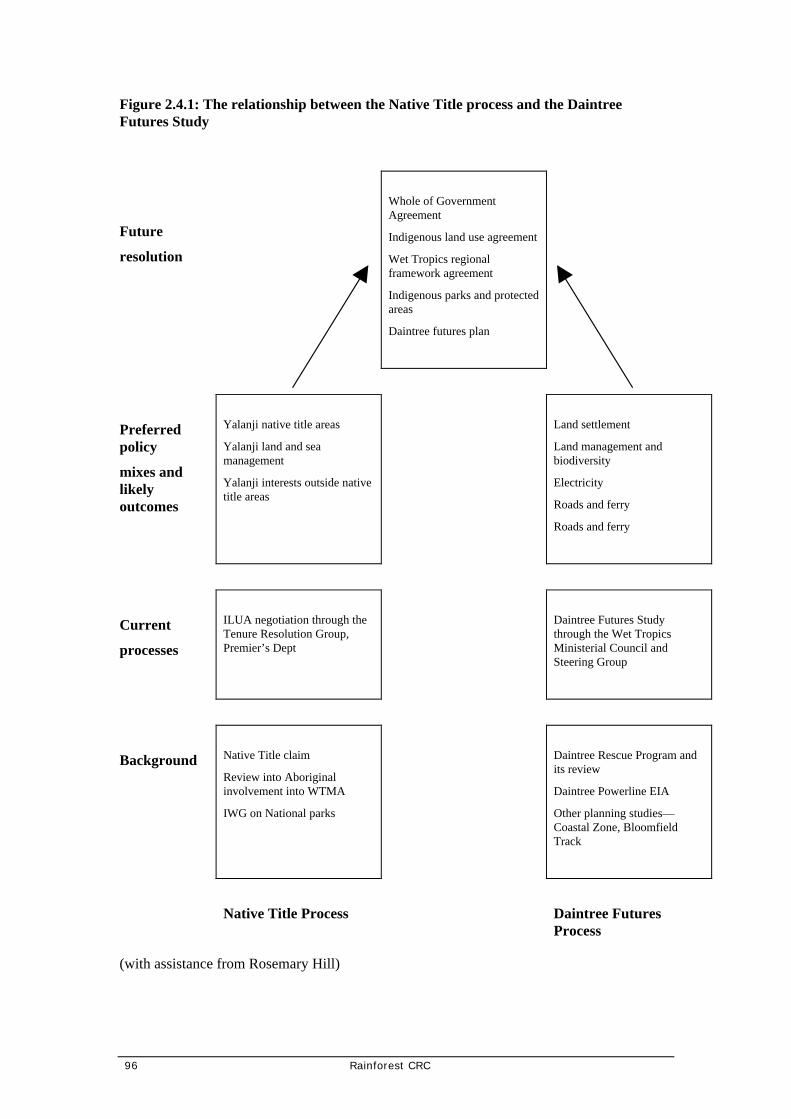
96 Rainforest CRC
Figure 2.4.1: The relationship between the Native Title process and the Daintree Futures Study
Future
resolution
Whole of Government Agreement
Indigenous land use agreement
Wet Tropics regional framework agreement
Indigenous parks and protected areas
Daintree futures plan
Preferred policy
mixes and likely outcomes
Yalanji native title areas
Yalanji land and sea management
Yalanji interests outside native title areas
Land settlement
Land management and biodiversity
Electricity
Roads and ferry
Roads and ferry
Current
processes
ILUA negotiation through the Tenure Resolution Group, Premier’s Dept
Daintree Futures Study through the Wet Tropics Ministerial Council and Steering Group
Background
Native Title claim
Review into Aboriginal involvement into WTMA
IWG on National parks
Daintree Rescue Program and its review
Daintree Powerline EIA
Other planning studies—Coastal Zone, Bloomfield Track
Native Title Process
Daintree Futures Process
(with assistance from Rosemary Hill)

Rainforest CRC 97
While the extent of native title rights existing in the area has yet to be resolved, it is likely that native title will be granted to traditional owners and affirm their prior connection with traditional lands in the region. Land use decisions must recognise the potential existence of this native title. While native title would not apply to freehold land, for development decisions on land where native title may exist, especially Unallocated State Land, development rights and compensation would be similar to those applying to freehold land.
It is important that any Daintree Management arrangements can implement any Indigenous Land Use Agreements that arise from the native title process.
2.4.1.2 Indigenous cultural heritage and aspirations
Indigenous people have obligations for the protection of cultural landscapes and aspirations for their active involvement in the management of the area and its enjoyment. Cultural heritage encompasses issues such as landscape values and impacts, intellectual property rights, conservation and management of cultural heritage places (regardless of tenure) and opportunities for indigenous and cultural tourism to the area. It is important to recognise that parallel processes of land tenure resolution may create land management options for indigenous people in the Daintree. There will need to be affirmative action by all levels of government to find land use outcomes that balance native title interests and aspirations with conservation and the rights of other residents in this regard.
2.4.1.3 Protection of Aboriginal archaeological sites and artefacts
Aboriginal places of cultural significance are protected by legislation administered by the Environmental Protection Agency.
2.4.1.4 Wider community awareness and involvement
It is important to ensure that the wider community receives information on indigenous land tenure options.
2.4.2 Options
An ILUA may be deemed a suitable way to resolve land and cultural interest in the area. The outcome of any preferred options for land settlement and the tourism industry arising from this project can hopefully be harmonised into any ILUA.
An Indigenous Land Use Agreement providing determination of native land interests in the area may also include reference to:
• continued Aboriginal access to traditional lands for reasons of educational, spiritual and resource use, under appropriate agreements and guidelines
• development of appropriate public and private land management practices which safeguard identified natural and cultural values
• restrictions on access to special areas and the implications of construction and development on such sites and the maintenance of ongoing cultural heritage surveys through coordinated input from Community Rangers, Elders and archaeological and anthropological sources

98 Rainforest CRC
• creation of opportunities to create cultural tourism business initiatives including identification of business opportunities and identification of grants and subsidies for business development by Aborigines.
2.4.3 Recommendation
Recommendation 19: To allow Aboriginal cultural heritage and land aspirations to be reconciled in the future
Why: Unfortunately, there was minimal Aboriginal involvement in this project and their own opinions, attitudes and preferences are not adequately reflected in these recommendations.
How: Appreciate that the parallel processes of land tenure resolution that recognise native title rights and interests will create land management options for indigenous people in the Daintree. The recommendations of this project, if implemented, may infringe those rights and be compensatable as they would be for all landowners. Ensure that the wider community receives information on indigenous land tenure and management options. Provide that any Daintree Management Structure can implement Indigenous Land Use Agreements.
2.5 Electricity supply
Desired Outcome: Reliable electricity to all residents and businesses at equitable cost with least social, economic and ecological impacts.
2.5.1 Present Situation
2.5.1.1 Grid status
The electricity grid is connected to approximately 12 properties in the northern area of Forest Creek and has not been extended since the S
tate government announced a moratorium on grid extensions in 1995.
2.5.1.2 RAPS systems
Residents and businesses in the study area rely on their own electrical generation equipment. These systems are known as remote area power supply (RAPS) systems. A generator operating 24 hours per day on a domestic or commercial load operates at low conversion efficiencies. These efficiencies can be improved through the addition of battery banks and inverters (full descriptions of these systems are in the EIAS). When battery banks and inverters are incorporated in systems they can utilise solar, hydro or wind power. These items have high upfront costs, and in consideration of the benefits they provide the state government initiated the Daintree RAPS subsidy scheme.
The scheme is for bonafide residents to purchase and install a remote area power scheme, which normally consists of an integrated photo-voltaic array, diesel or gasoline generator, batteries and inverter, provided on an individual property basis.

Rainforest CRC 99
The subsidy scheme provides:
• 75% of the cost of renewable energy components up to a maximum of $7 500, and
• 75% of the cost of the non-renewable equipment cost to a maximum of $7 500, and
• $5.50 per peak watt of installed photo-voltaic capacity capped at $8 250 for 1.5kW of installed PV (funded under a federal government initiative).
The maximum subsidy is $23 250 for a maximally designed RAPS system, which would have cost the resident a total of approximately $30 000. In practice the level of subsidy is closer to $15 000. In addition to the RAPS system, residents normally purchase gas-powered appliances such as stoves and hot water systems and energy efficient appliances such as refrigerators (Department of Mines and Energy, Office of Sustainable Energy, 2000).
Underlying this policy is the concern of the Queensland government and sections of the community that extending mains grid power throughout the Daintree would accelerate land development. There is also the belief that renewable energy generation is desirable in the Daintree as a demonstration of commitment to sustainable energy development and sensitivity to the special values of the area.
The Department of Mines and Energy have advised 150 RAPS systems subsidies were paid under the first DRAPS scheme which finished in 1996. Under the 2000 DRAPS program a further 45 applications have been received, most of these relate to adding solar panels to existing systems under a federally funded solar rebate program. (Per communications with Brian Elmer, RAPS Program Officer Department of Mines and Energy 29th June, 2000.)
Businesses in the study area are currently not eligible for any subsidy programs for RAPS systems. This is despite a statement by the Minister for Mines and Energy in October, 1999 that “A commercial rebate scheme is also to be introduced”. The lack of a subsidy has likely hampered economic development as businesses have had to fund substantial capital to establish their generation plant, and higher operating and maintenance costs.
The variable cost to generate power privately via diesel generators will be in the order of 25-35 cents/kWh compared to grid subsidised grid power costs of 10 cents/kWh. Businesses such as hotels and accommodation facilities will have annual power demand of between 50 000kWh and 1GWh per annum (any reasonable size business would have a power demand of 50 000kWh per annum or greater). The additional annual cost, adjusted for company tax, of self generation versus grid will be in the range of $5 000 to $167 000. The larger savings would accrue to developments such as Coconut Beach, whereas as hotel would be in the order of $40 000 additional cost per annum and small Ecolodges would save in the range of $5 000 per annum.
It is in the local business’ financial interest, more than in the domestic customers, to pursue grid subsidised electricity. Businesses should be prepared to pay more for connection than domestic customers on the basis of the larger annual savings. If businesses paid a higher initial connection fee compared to the proposed fee for domestic customers, additional revenue could be earned. On the basis that 35 businesses paid say a $30 000 connection fee, the present value of the CSO would reduce by approximately $1.0M.

100 Rainforest CRC
Whilst RAPS systems are used to supply electricity to operate businesses in the study area currently, and will continue to do the same at Cape Tribulation for a long time in the future, there is an argument that the higher private costs incurred by businesses has depressed economic development in the study area. Whilst the EIAS didn't really address the businesses issue, the reliance on RAPS systems creates an economic ‘choke’. Business operator’s in the study area concur with this conclusion one small resort operator said, "mainland experience - island prices". This could result in business in the study area being in direct competition with south of river grid power connected businesses.
The result of not providing a subsidised electricity grid in the study area, is likely to lead to reducing environmental tourism opportunities and therefore economic development in Queensland. To encourage tourism development in the study area the government should consider addressing the provision of assistance to cover the higher electricity supply costs should grid connection not eventuate.
2.5.1.3 Government policy
In 1996 the Queensland Government Cabinet gave in-principle approval to the extension of grid connected mains power to privately owned properties north of the Daintree River subject to the satisfactory outcome of a full environmental impact assessment study. Gutteridge Haskins and Davey Pty Ltd was commissioned in 1997 to prepare an Environmental Impact Assessment Study (EIAS) to assess the proposed extension of grid power and any prudent and feasible alternatives.
The proposed power line extends north from the Daintree River to Thornton Beach serving the areas of Forest Creek Road, Cow Bay, north of Hutchinson Creek to Coopers Creek and Thornton Beach. The proposed power line is to consist of a combination of overhead and underground, high voltage and low voltage distribution lines with associated substations and transformers.
Over the past two decades, some land owners in the Daintree have requested mains power. In 1992, an Impact Assessment Report for the Daintree to Cape Tribulation 22 kV and 12.7 kV Distribution Powerlines and LV Reticulation was produced by Hollingsworth Dames & Moore. In 1995, the then State Government decided that mains power would not be supplied to the area. In 1996, schemes offering financial assistance for the installation of remote area power supplies (RAPS) to owner occupied residences in the Daintree were introduced by the State Government. Diesel or petrol generators, solar systems, wind generators and micro-hydro systems were installed by property owners under the scheme which ceased in December 1997.
In Parliament on 26 October 1999, the Minister for Mines and Energy, the Honourable Tony McGrady said that:
“The Government has a clear policy position on opposing the extension of mains power north of the Daintree River. This was clearly stated at the time of the last election and recently affirmed by cabinet. The Government is not denying people access to power. As announced in the budget, $4.5 million has been set aside over the next two years for a new rebate scheme. This scheme will provide rebates of up to $15 000 per household for people who install Remote Area Power systems. A commercial rebate scheme is also to be introduced.” (McGrady, 1999)
Rainforest CRC 101
In January 2000 the Queensland Government affirmed its policy on electricity supply to the Daintree.
“The Government’s proposal to re-introduce the Daintree Remote Area Power Supply provides the best option to provide a quality power supply for residents whilst preserving the unique environmental character of the area” (McGrady, 12/1/2000)
On 15 May, the Department of Mines and Energy published a discussion paper ‘Amendment of Distribution Authority held by Ergon Energy Corporation Limited to exclude an area north of the Daintree River.’ This proposal, under the provisions of the Electricity Act 1994, would exclude the study area of this project from the area to be supplied by mains power and remove community service obligation on the Government and the electricity supplier for the area, Ergon, to do so.
2.5.2 Overview of proposed options
The EIAS (GHD, 1998. Environmental Impact Assessment Study) analysed the financial, environmental and technical aspects of several means of delivering electricity to the Daintree, from open wire configuration, to full underground to remote area power supply systems. The report concluded that a hybrid overhead and underground system, Alternative ‘C’, provided maximum benefit to society.
The Daintree Community Forum resolved the following with respect to electricity supply:
In respect to the provision of appropriate services for residents, the community forum shared agreement with the following statements:
• Electricity reticulated into the Daintree Coast community should be installed in an environmentally and scenically appropriate manner.
• The Commonwealth and Queensland Governments should contribute financially towards the supply of services to offset for environmental and scenic considerations that are additional to the cost of basic services.
• Reticulated electricity supply should be supplemented to the maximum possible extent by the local community’s generation of integrated renewable electricity.
In accordance with the agreement arrived at the Daintree Forum, the grid connection costs have been broken into ‘basic service’ (standard open wire overhead reticulation, Option A in the EIAS) and ‘environmentally and scenically appropriate manner’ (underground and overhead reticulation, Option C in the EIAS.) designs. For the purposes of this study the three isolated communities; Whitby, Cape Kimberley and Thornton Beach, have been excluded from the analysis. The cost per block connection exceeded $50 000 and skewed the connection cost data for the general Daintree area.

102 Rainforest CRC
2.5.2.1 EIS conclusions and impacts
The FNQEB commissioned Daintree Power Supply EIAS (1998) provides thorough and detailed analysis of options for electricity supply into the area. The EIAS considered seven different electricity supply options including a range of mains grids alternative and remote area power schemes (RAPS). These alternatives electricity supply options were set in the context of a number of land development scenarios related to the extent of population and settlement.
Alternative A
The EIAS has been developed based on FNQEB’s proposed power supply known as ‘Option A’. This proposed Daintree mains power option involves 57.6 km of overhead powerlines and 20.3 km of underground powerlines using both high (3-phase, 22 kV) and low (3-phase, 240 V per phase) voltage distribution powerlines. Infrastructure elements required for the overhead sections include conductors, power poles, cross arm supports, stays, pole mounted transformers and pole mounted switches, regulators and reclosers. The underground powerline section requires conductors, conduits, pad mounted transformers and pillar boxes.
Alternative C
The EIAS’s recommended approach to power connection was the adoption of Alternative C which uses a combination of underground (58.7 km) and overhead powerlines (14.5 km) but uses more underground sections than Alternative A. The cable plough is used for underground sections and would utilise road shoulders and table drains to install underground cables. Directional boring would be used where ploughing is impractical.
Indicative figures developed in the Cost Benefit Analysis imply that under each combination of scenarios, connection cost regimes and discount rates, almost all alternatives represent a net economic cost to society. However, the provision of power under Scenario 4 begins to show some positive net returns to society, with Alternative C consistently offering the superior outcome.
Given the nexus between land use development scenarios and power supply alternatives and the potential for cumulative impacts between the two, for the purpose of determining a preferred alternative the EIAS assumed land use Scenario 4 is essentially implemented. This assumes that a mechanism is in place to ensure in the order of half the blocks are not settled and that most of the conservation controls are enacted. Further, it is assumed that the Environmental Management Plan is implemented during design and construction.
Environmental impacts
Summary of Impacts of Option C: Underground Mains Power
Overall, this alternative is the most ecologically sustainable construction alternative of those examined: No clearing of any vegetation community, excepting the ABC option for Whitby, which is not a recommended option to pursue and no edge effects associated with linear clearing. No population impacts on any species of conservation importance. All overhead clearing is in areas of existing clearing, with limited successional forest cover.
• Potential for the cassowary/ fauna corridor in the George Road area to be disrupted by clearing for overhead powerlines.

Rainforest CRC 103
• Potential for research sites in Palm and Mangrove Roads to be impacted by clearing for overhead powerlines.
• Noticeable increase in background noise level during construction.
• No direct impact on any identified Aboriginal cultural heritage or historic sites.
• No major long-term impact to the amenity and character of the area caused by the physical infrastructure.
• Potential for sub-surface archaeological material to be uncovered during earthworks.
• Reduction in noise levels and diesel fumes, etc, from generators.
• Improvement in quality of lifestyle for some residents: reduced quality of lifestyle for other residents.
• Potential to improve home/personal safety.
Summary of Impacts of Option F (RAPS): Existing Systems
Impact of increased noise levels and fumes from generators if noise and emission controls are not in place.
• Apart from potential for noise/emission pollution the physical infrastructure will not alter the existing amenity or character of the area.
• Potential for pollution from diesel oil spills.
• Potential for personal injury from activities associated with system maintenance.
• It is anticipated that this Alternative would have little impact on Kuku Yalanji cultural heritage values if system numbers were kept at a reasonable level.
• Apart from the effect of a possible increase in generator noise level and diesel emissions, the physical infrastructure associated with this Alternative is not expected to alter the amenity and character of the local area.
The noise and air quality impacts, the risk of hydrocarbon pollution from spills and waste disposal aspects would increase as the population grows. System numbers are expected to triple is Scenario 3 is reached from current population densities.
Greenhouse Gas Emissions
Minimising Greenhouse Gas Emissions (GHGE) is a major global and national policy issue and one underpinning the promotion of alternative energy systems. It is therefore relevant to compare the GHGE performance of different electricity supply options to the Daintree.
The GHGE for different sources of electricity has been calculated on the basis of data supplied in the Australian Greenhouse Challenge Office, 1997: Workbook. ‘The Greenhouse Challenge A Six-Step Guide to Developing your Cooperative Agreement’. Two alternatives will be compared: the supply of electricity from the state grid and supply of electricity from a combination or renewable sources (primarily solar panels) and diesel generator powered RAPS.

104 Rainforest CRC
The GHGE for the two primary electricity sources is:
Diesel generator:
1. Litres per kWh 0.57 (from Ergon RAPS trial data for large generators)
2. GJ/litre 0.0386 (from Greenhouse Challenge Workbook p 28)
3. CO2/GJ (kg) 74.9 (from Greenhouse Challenge Workbook, p28)
4. CO2/litre (kg) 2.89 (2 * 3)
5. CO2/kWh 1.643 (1 * 4)
Grid power:
6. CO2/kWh (kg) 1.02 (from Greenhouse Challenge Workbook, p28)
This is based on 8% transmission loss; Ergon advice is 35%, thereby increasing emissions to 1.275. (Per communications with Mr Brinks, Ergon Energy, 25th June, 2000. Figure is approximate only.)
Determining the total GHGE for different scenarios depends on the sources of supply and the total energy consumption over time, which consists of electricity and LPGas consumed at each household. For domestic RAPS systems, it is assumed that 50% of the electricity will be supplied from renewable sources and that gas will be used for cooking and 80% water heating and solar 20%. The 50% renewable assumption is from the Powerline EIA. It accords with the excellent records that Peter Schultz, a Daintree resident in the Cow Bay area, achieved at this level with the use of solar tracking equipment that improve efficiency of solar panels by approximately 30%.
Business consumers are assumed to use generators for all their electricity. Calculations can easily be made on different assumptions about fuel sources and the proportion of renewable energy in domestic and business systems. Total electricity consumption is as projected in the Powerline EIA Table 63. These are shown in Table 2.5.1 below.
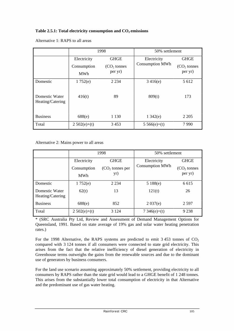
Rainforest CRC 105
Table 2.5.1: Total electricity consumption and CO2 emissions
Alternative 1: RAPS to all areas
1998 50% settlement
Electricity
Consumption
MWh
GHGE
(CO2 tonnes per yr)
Electricity Consumption MWh
GHGE
(CO2 tonnes per yr)
Domestic
1 752(e) 2 234 3 416(e) 5 612
Domestic Water Heating/Catering
416(t) 89 809(t) 173
Business 688(e) 1 130 1 342(e) 2 205
Total 2 502(e)+(t) 3 453 5 566(e)+(t) 7 990
Alternative 2: Mains power to all areas
1998 50% settlement
Electricity
Consumption
MWh
GHGE
(CO2 tonnes per yr)
Electricity Consumption MWh
GHGE
(CO2 tonnes per yr)
Domestic 1 752(e) 2 234 5 188(e) 6 615
Domestic Water Heating/Catering
62(t) 13 121(t) 26
Business 688(e) 852 2 037(e) 2 597
Total 2 502(e)+(t) 3 124 7 346(e)+(t) 9 238
* (SRC Australia Pty Ltd, Review and Assessment of Demand Management Options for Queensland, 1991. Based on state average of 19% gas and solar water heating penetration rates.)
For the 1998 Alternative, the RAPS systems are predicted to emit 3 453 tonnes of CO2
compared with 3 124 tonnes if all consumers were connected to state grid electricity. This arises from the fact that the relative inefficiency of diesel generation of electricity in Greenhouse terms outweighs the gains from the renewable sources and due to the dominant use of generators by business consumers.
For the land use scenario assuming approximately 50% settlement, providing electricity to all consumers by RAPS rather than the state grid would lead to a GHGE benefit of 1 248 tonnes. This arises from the substantially lower total consumption of electricity in that Alternative and the predominant use of gas water heating.

106 Rainforest CRC
In terms of diesel fuel consumption, this model estimates that approximately 1.1 million litres of diesel fuel is consumed in the Daintree in 1998 which would rise to 2.7 million litres if the residential and business developments assumed in Alternative 2 occur.
2.5.3 Possible offer conditions for electricity supply connection
2.5.3.1 Conditions of supply upfront, annual access fees, electricity usage
The basic service, open wire bare conductor, would need to recover the $10.1M needed for its construction. The precise offer conditions would need to be calculated using standard determinations by Ergon Energy in accordance with its policies. However, by utilising an upfront charge of $2 000 and an annual access fee of $1 635 per annum, for blocks connected in the first year of the project. These charges would not escalate if the CSO relating to take-up rates was applied. All electricity would be charged at the standard gazetted tariffs.
2.5.3.2 Take-up rates
The number of households in the study that will connect to the grid will not be the full 500 estimated blocks which are needed to meet the $10.1M capital cost of the basic service power project in the first year. Ergon will require a payment to carry this capital investment over and above the cost between Option A and Option C. Modelling undertaken in the EIAS indicated that 422 blocks would connect in the first 10 years. The capital cost would likely be in the range of $400 000 to $500 000 per annum for the period 5 – 10 years the cost would be in the order of $200 000 to $300 000 in the period after 10 years declining to $70 000 to $100 000. The present value of these subsidies is estimated at $3.0M.
2.5.3.3 Existing RAPS owners
It is estimated that over 150 households have accessed the DRAPS subsidy scheme. It is proposed that for equity purposes that where a household had paid towards a RAPS systems which was also subsidised by the government, this investment would be credited towards grid connection with Ergon taking ownership of the system, which would remove the system and sell it in the market to recover this cost. Alternatively, the householder would be relieved of the conditions of contract on which the DRAPS grant was made and allow them to dispose of the system to raise funds to connect to the grid. The cost of this option has not been costed, however, it is considered that it could be cost neutral. Considering that solar panels maintain their value and Ergon could have alternative uses for this equipment, and this value should exceed the investment of the householder.
Alternatively, it may be possible (if commercially viable, which would need to be assessed by Ergon) to implement the green grid concept, where solar panels are retained by households and electricity generated returned to the grid. Arrangements for this scheme are in place, however its applicability to any particular household would have to be assessed. Many houses/buildings contributing in such a way elsewhere in Australia use many more solar panels than most RAPS systems in the study area.

Rainforest CRC 107
2.5.3.4 Community service obligation
The estimate of the level of CSO is based on the amount of money required to be paid by the government to Ergon to undertake an investment that is not commercial to become commercial. Under the proposal discussed a CSO will be required to upgrade the reticulation system from basic to one that is environmentally and scenically appropriate. To achieve a basic service an investment of $10 112 508 (EIAS Estimated construction cost of Alternative A-E) is required in overhead power cables. Based on 492 connections (his relates to Scenarios 3-4 in the EIAS with an estimated 492 users) this equates to $20 091 per household.
The funding of the connection cost can be achieved under many scenarios, however, consideration of the findings of the EIAS with respect to take-up-rates This equates to a connection fee of $2 000 per block and an annual access fee of $1 635 (based on 18 225 with a 7.5% interest over a 25 year term). In addition the householder would pay for all electricity consumed at the standard tariff rates published by Ergon Energy.
The government would be required to pay a CSO worth approximately $450 000 per annum to meet the capital shortfall between the basic service and the environmentally and scenically appropriate service (Being the annuity of $5.9M which is the difference between $16M (Option C) and $10.1M (Option A). In addition, the government would also pay Ergon Energy an annual community service obligation (CSO) for all electricity supplied to the Daintree area at the actual cost of delivery less the published tariff costs.
Advice from Ergon (per communications with Gordon Binks, Ergon Energy 26th June, 2000), is that consistent with their Corporate Distribution Pricing Manual the CSO would be based on the published manual data for Zone B small volume customers (that is usage less than 274 000kWh). The average revenue per kWh in the EIAS is 9.975 cents/kWh for small users. Based on this revenue and the costs published in the manual and allowing for energy purchases the estimated cost to be met by the government is 23 cents/kWh (Corporate Distribution Pricing Manual, Ergon Energy, July, 1999 Zone B2 volume charge category $46.21 per month per customer service availability charge and 27.49 cents/kWh plus approximately 6 cents/kWh for delivery energy being 4.5 cents/kWh plus 30% loss adjustment) plus the service fee. The annual equivalent CSO applicable to meet Ergon Energy’s network costs are $2 055 000 per annum (based on average annual energy demand over the project period of 6.5GWh.). This equates to $5 093 per block per annum. The total present value of these two annual payments is $31.6M.
Ergon Energy’s distribution pricing for Zone ‘B’ applies to all areas north of the Daintree River (excluding the blocks currently connected in Forest Creek), for areas south of the Daintree River Zone ‘A’ distribution charges apply. As underground power would require reduced maintenance compared to open wire, there is an argument that the Zone A costs would apply, meaning that the CSO would be reduced to an estimated 5.9 cents/kWh (Corporate Distribution Pricing Manual, Ergon Energy, July, 1999 Zone A2 volume charge category $65.78 per month per customer service availability charge and 5.64 cents/kWh plus approximately) plus the service fee. The annual equivalent CSO applicable to meet Ergon Energy’s network costs would reduce to $835 000 per annum (based on average annual energy demand over the project period of 6.5GWh.). Adding the annuity for the capital cost makes a total annual CSO payment of $1 286 423. This equates to a CSO of $2 615 per block per annum. The total present value of these two annual payments is $16.2M.
In addition to the above costs is the take-up rate CSO which is estimated at $238 201 per annum which has a present value of $3 000 000.

108 Rainforest CRC
2.5.3.5 Alternative Power Options
In addition to the work undertaken in the further analysis has been undertaken of a full remote area power supply and a green grid option.
Daintree Remote Area Power Supply (DRAPS)
A Daintree Remote Area Power Supply (DRAPS) option could have the following characteristics:
• Grid connection for Forest Creek south and west of the Telstra Site
• Residential RAPS for Southern Subdivision of Forest Creek
• Residential RAPS for all areas in Cow Bay; and
• 10 large RAPS for Commercial operation in Cow Bay, Thornton Beach, Cape Tribulation.
The Residential RAPS systems are costed on the basis of the 15kWh per day systems noted in the EIAS Proposed Daintree Powerline with the following assumptions (refer to Table 2, 'Section 1.2.2 - Individual Remote Area Power Supply (RAPS)':
• Capital cost of $41,000;
• $23,500 of funding provided by the Government, remainder by resident;
• Maintenance and system support for each system being provided by Ergon at a cost of $2,400 per annum;
• Fuel costs fully met by RAPS users and
• Take up rates as for grid connection.
The large RAPS systems are costed on the basis of the 150,000kWh per year systems with the following assumptions:
• Capital cost of $150,000 per system; and
• Operation and maintenance costs 45 cents/kWh.
Table 2.5.2 : RAPS Costs
Private
Capital Costs
($)
Private
Operating Costs
($/year)
CSO
Capital Cost
($)
Annual CSO
Operating Costs
($/year)
Total
Capital Cost
($)
Total
Operating Cost
($/year)
DRAPS 8,688,536 1,497,790 8,263,888 860,893 16,952,424 2,358,683

Rainforest CRC 109
From Table 2.5.2 it can be seen that the necessary CSO capital cost of a RAP’s share would be about $8.3M, with an annual CSO operating cost of $860,000.
2.5.4 Recommendation
Recommendation 20: Assuming the introduction of mechanisms to limit development in the Daintree and thereby protect its eco-systems, construct a hybrid grid of overhead and underground power lines as far as Cooper Creek (the FNQEB EIAS preferred Option C).
Why: In economic and social terms this is the most effective and efficient solution. Providing conservation controls are in place, it does not have any significant environmental problems.
The Queensland Government has committed itself to expending $4.5M over the next two years on subsidies under the DRAPS program. From a policy perspective this allocation can be taken off the total CSO obligation as these funds will not be expended should the government introduce grid power.
The costs of this system in private and government terms has been estimated based on the work undertaken in the EIAS. It is proposed that consumers in the Daintree area would meet the costs of a ‘basic service’ which is constituted by open wire power reticulation and the government would meet the costs of making the system environmentally and scenically appropriate.
Two government cost tables are provided. The first assumes that the area will be considered a development in Zone A of Ergon Energy’s ‘Corporate Distribution Pricing Manual’. The manual defines Zone A as the coastal zone below the Daintree River, however includes several blocks in the Forest Creek area which are north of the Daintree River. There is arguable grounds for consideration of Zone A, as the proposed reticulation is underground and will require less maintenance on the part of Ergon Energy. The present value of the government subsidy is estimated $16.2M. This range is consistent with Ergon’s advise in the EIAS which identified a total CSO of $17.8M.
The second government cost table assumes that the area will be considered a development in Zone B of the manual, which substantially increases the volume based charges for connection and support to the network. This increases the present value of the government subsidy to an estimated $31.6M.
Table 2.5.2: Private costs
Grid Connection Total Cost Basic Service Only
$20 000
Upfront Connection Fee $2 000
Annual Access Fee $1 635
Electricity Cost At standard Ergon tariff rates.

110 Rainforest CRC
Table 2.5.3: Government costs: based on Ergon Zone A
Description Present Value CSO Annual CSO
Grid Connection Cost Environmentally And Scenically Appropriate Minus Capital Cost Of Basic Service
$5 675 208 $450 613
Electricity Cost CSO $10 526 525 $835 809
Take-Up Rate Of Basic Service CSO (Estimate Only)
$3 000 000 $238 201
Total
$19 201 733
$1 524 624
If the project was considered a Zone A development the total CSO equates a per block of $39 027 compared to the existing government DRAPS subsidy of $23 500.

Rainforest CRC 111
Table 2.5.4: Government costs: based on Ergon Zone B
Description Present Value
CSO
Annual
CSO
Grid Connection Cost Environmentally And Scenically Appropriate Minus Capital Cost Of Basic Service
$5 675 208 $450 613
Electricity Cost CSO $25 884 470 $2 055 235
Take-Up Rate Of Basic Service CSO (Estimate Only)
$3 000 000 $238 201
Total
$34 559 678
$2 744 049
If the project was considered a Zone B development the total CSO equates a per block of $70 243 compared to the existing government DRAPS subsidy of $23 500.
Alternative Recommendation 20: Assuming the introduction of mechanisms to limit development in the Daintree and thereby protect its eco-systems, provide subsidies and grants to establish remote area power for residences and businesses in the Study Area.
NOTE: The study recognises the State Government’s recent announcement of its continued intention not to provide mains in most of the study area. Whilst the Study Team reaffirms the recommendation regarding subsidised mains power provision to most of the study area, should mains power not be provided, the RAPS subsidies and grants should be extended to all residents and businesses.
Why:
This recommendation is provided in the event that the Queensland Government reaffirms its recent decision against grid power in favour of DRAPS program expanded to include businesses.
How:
The Queensland Government would need to further commit to an ongoing DRAPS program and expand it to include businesses. Subsidies for businesses would need to be established on a sliding scale depending on the reasonable energy needs for the business.
Give the high capital reinvestment required to replace batteries with RAPS, there will be a need for a battery replacement subsidy (of around $4000 - $8000 per household)
With may older RAPS having been established for 5 - 10 years, and the maximum life expected of the best batteries in well designed systems managed well, the scheme could be expected to be required soon.
As alternative to grid power (and in accordance with the Queensland Electricity Regulations recent decision to remove the study area from Ergon’s supply area) the ongoing subsidy of RAPs could be undertaken. Based on the utility (Ergon) installing and owning individual household RAPs providing 5000 kWh per annum (about 1/3 normal householder use) and

112 Rainforest CRC
larger systems for commercial premises on the same take up rates as per the grid and the same connection and arrival fees as above to community service obligation would be:

Rainforest CRC 113
Table 2.5.6: Costs of Electricity Supply
Present Value
Annual
Private Costs
RAPs supply cost $2 000
RAPs annual access fee electricity costs $1 635* at agreed Ergon tariffs
Government Costs
Capital subsidy $9 688 791 $746 738
Operating cost subsidy $11 977 748 $923 154
Take up rate of basic service CSO $0 $0
Gross total to Government $21 666334 $1 669 892
*Annual fee would be applicable for at least 10 years.
2.6 Roads and ferry
Desired Outcomes: Ferry and road management that meets the needs of residents, businesses and tourists. Roads and road corridors that are sympathetic to the environmental sensitivities of the areas through which they pass based on the green corridor concept for the main tourist pathway from the ferry to Cape Tribulation. The minor road network will provide access to residential and other allotments. The ferry will provide an attractive gateway experience for visitors to the area and serve community needs.
2.6.1 Issues
2.6.1.1 The main road - green corridor
Almost all people visiting the Daintree travel by road and the trip along the area’s roads is a major component of their rainforest experience. Maintaining the visual quality and appropriate traffic conditions along the main road is critical to the rainforest tourism experience (See Section 3.3).
Visually unobtrusive development of land along the road and management of the road corridor as a ‘green tunnel’ are essential ingredients of maintaining sustainable tourism. In places the quality of the visual experience could be improved through forest rehabilitation, application of signage standards and development setbacks that allow residential and commercial development while maintaining the green corridor.
Traffic flows along the main road may increase in future to the point that congestion damages visitor experiences, however the limited capacity of the ferry at present acts as a control on flows within reasonable service limits. Traffic flow at the ferry is therefore also a very good indicator of road traffic. Local resident and business traffic is relatively constant throughout

114 Rainforest CRC
the year, whereas the tourist traffic peaks in the winter and spring months (See Table 2.6.1). Congestion at the ferry and in parking areas for key sites occurs mostly in this peak season and then only at critical times of the day – morning for inbound traffic and afternoon for outbound traffic.
The main road has now been sealed along most of the section to Cape Tribulation resulting in a substantial increase in traffic, especially self-drive tourists. There are some unsealed sections currently being sealed in the 2000/2001 financial year.
2.6.1.2 Bloomfield Track
The Bloomfield Track provides important access beyond Cape Tribulation to communities at Wujal Wujal, Ayton and other northern communities. Some tourist traffic uses the Track as part of a circuit through to Cooktown. Many tour passengers and FITs currently go on the Track as far north as Emmagen Creek.
At present the Track is causing undesirable environmental impacts arising from run-off, sediment, dust and the effect of increasing visitor numbers at stopping points. Main impacts affect stream, wetlands, riparian corridors and foreshores. These roads related problems need environmental assessment.
There is some pressure, mainly from Bloomfield residents to continue upgrading the road past Cape Tribulation to Bloomfield, to normal vehicle use standard. If this should occur, there would be some increase in the through traffic in the Daintree destined for Bloomfield. There is a significant potential for increases in traffic using this route to Cooktown for tourism and other reasons although there may be some compensating increase in ‘tourist circuit traffic’ making one-way trips through the Daintree. Given the limited ferry and road capacity south of Cape Tribulation, any significant increase in through traffic would have undesirable consequences for tourism activities, environmental values and ferry and road capacity.
The Bloomfield Track at present provides an additional choice for tourists to have 4WD experience that would be lost by further upgrading.
2.6.1.3 Main road traffic and capacity
The Cape Tribulation Road is the only transport route into the area, and central to the tourism experience. Its width, alignment and adjoining land uses are major determinants of visitor experience. Maintaining the road in largely its present form, with only minor upgrading, as a green corridor, has wide acceptance amongst locals and the tourist industry.
Traffic capacity is also a potential constraint, if the road is to continue to provide a satisfactory level of service for residents and businesses while supporting the visitor experience. The ultimate capacity of the road and the ferry, which at present acts as a partial choke, can only be defined in terms of acceptable service levels, acceptable congestion and waiting times and in terms of very variable peak flows diurnally and seasonally.
Current traffic flows are shown in the two tables 2.6.2 and 2.6.3. In 1999, there were 277 000 recorded trips on the ferry by a mixture of pedestrians, cars, buses, trucks and other vehicles and equipment. Of those trips 227 996 were by cars and utilities and 21 554 by buses of varying size. Cars of local residents and visitors to local residents account for an average of 32% of all cars across the ferry, being a relatively constant average of 6000 (one-way trips) per month. The percentage declines as the number of tourist visitors increases in the winter months.

Rainforest CRC 115
Before the ferry was upgraded in 1997, it had an estimated daily capacity of 1200 Vehicles per Day (VPD), taking into account the daily variation in flows (Eppell Olsen Report 1996). It now has an estimated capacity of 1400 VPD. From these data, the ferry would be operating at near 80% of capacity in September 1999, the busiest month. Queuing occurred during peak hours. Ferry capacity is an issue—clearly any significant growth in either local or vehicular traffic (or both) will bring the ferry to capacity or beyond in the near future.
While the ferry acts as a choke for road traffic into the Daintree, according to the Eppell Olsen report, additional traffic is generated in the Forest Creek area to shops, the school and other services, on the road north of the Alexandra Range. Daily average vehicle flows across Alexandra Range, the most restricted section of the Road, are then similar to or higher than the ferry.
Maximum VPD occurs in the winter months, averaging 1000 per day (Table 2.6.2). Using the Transport Research Board Level of Service criteria for rural roads, the Cape Tribulation Road in the Alexandra Range section is still at levels A, or at worst B (See Table 2.6.1) Service levels will decline into lower service classes in future years that will disadvantage locals and limit the tourist attractiveness (See Table 2.6.1).

116 Rainforest CRC
Table 2.6.1: Service level criteria
Category Level of Service A a condition of free flow in which individual drivers are virtually unaffected by
the presence of others in the traffic stream. Freedom to select desired speeds and to manoeuvre within the traffic stream is extremely high, and the general level of comfort and convenience provided is excellent.
B in the zone of stable flow and drivers still have reasonable freedom to select their desired speed and to manoeuvre within the traffic stream, although the general level of comfort and convenience is a little less than with level of service A.
C also in the zone of stable flow, but most drivers are restricted to some extent in their freedom to select their desired speed and to manoeuvre within the traffic stream. The general level of comfort and convenience declines noticeably at this level.
Source: Eppell Olsen (1996)
Table 2.6.2: Visitor car numbers and total traffic across the Daintree River Ferry 1999 (one-way)
Cars Other vehicles Residents
& their Visitors
Tourists and other Visitors
Total Cars
Total Buses
Other (trucks
etc)
Total Vehicles
Pedestrians (inc bikes)
Total Traffic
Jan 7825 12292 20117 1804 1134 23055 773 23828 Feb 5415 5099 10514 838 678 12030 495 12525 Mar 5213 5354 10567 1121 694 12382 408 12790 Apr 6575 10537 17112 1971 1058 20141 746 20887 May 4874 10097 14971 1359 1037 17367 677 18044 June 5031 16334 21365 1803 1553 24721 1302 26023 July 5547 20258 25805 2352 1930 30087 1783 31870 Aug 6377 17465 23842 2217 1612 27671 1361 29032 Sept 8520 18760 27280 2410 2268 31958 1333 33291 Oct 5969 13167 19136 2057 1554 22747 901 23648 Nov 6237 11156 17393 1799 1244 20436 1051 21487 Dec 7396 12498 19894 1823 1287 23004 1209 24213 TOTAL 74979 153017 227996 21554 16049 265599 12039 277638 Source: DSC, April, 2000

Rainforest CRC 117
Table 2.6.3: Total traffic across the Daintree River Ferry 1997-2000
1997 1998 1999 2000 Jan 11002 23828 13952 Feb 12879 12525 12281 Mar 13186 12790 16308 Apr 21211 20887 18075 May 18278 18044 Jun 25000 26023 Jul 23598 31072 31870 Aug 27590 28864 29032 Sep 22905 24676 33291 Oct 29020 31480 23648 Nov 20024 20439 21487 Dec 22914 16377 24213 Total 254464 277638 Source: DSC, April, 2000
Figure 2.6.1: Car and utility traffic on the Daintree Ferry, 1999
2.6.1.4 Local roads to subdivisions
At present there are 48 km of subdivision roads in the study area, maintained by DSC at an annual cost of $85 000 ($1770/km).
If some areas of land are removed from development to establish conservation precincts, some roads may be unnecessary and capable of removal and rehabilitation.
Future residents of a modified settlement pattern may elect to close some subdivision roads and make them private roads, thereby restricting access to the public and to tourist buses. This will need to determine on a case-by-case basis and has not been considered in detail in this report. Residents (or tourist operators) would need to maintain these roads at their own cost.
Car and Utility Traffic on the Daintree Ferry 1999
0
5000
10000
15000
20000
25000
30000
Jan Feb Mar Apr May June July Aug Sept Oct Nov Dec
Mo
nth
ly T
ota
l Tra
ffic
Visitors
Residents & Visitors

118 Rainforest CRC
2.6.1.5 Ferry operations
At present the ferry provides an important entry point to the Daintree and contributes to the overall tourist experience. At times there is congestion and reports of tourists turning back. The key issues at the ferry are that its pricing structure and management have a substantial effect on the convenience and cost of access for local residents and for the different categories of tourists. Conversely, varying prices and management can influence the equity to local residents and businesses and also provide a means of influencing visitation types.
It is important to provide priority to local residents through pricing and ticketing. Further, this can influence activities that contribute to sustainable nature-based tourist activities by influencing private vehicle movements, commercial tours and bus operations. For example, it is possible to give priority to overnight stays and group tours through pricing and ticketing.
The ferry also provides a convenient opportunity to charge visitors a fee to contribute to the cost of providing and maintaining visitor facilities, infrastructure services and contributing to DSC revenues to ameliorate high rates north of the River.
2.6.1.5.1 Main Visitor Types
Self-drive: Increasing number of visitors are travelling in private cars including hire cars. They do not pay any service fee other than the ferry but they may elect to visit commercial establishments in the area. They provide significant benefits for local businesses but cause increased traffic and parking problems
Tourists in transfer buses: These passengers travel in regular passenger buses (mainly Coral Coaches) and courtesy coaches (such as Jungle Tours and resort mini-buses) to accommodation and for day trips in the area. They do not pay any service fee other than the ferry but they may visit commercial establishments in the area.
Tour passengers: Tour coaches visit either National Parks where they pay CAP fee or have arrangements with private landholders (commercial arrangements are not known).
Table 2.6.3: Current fees and ferry revenues for main visitor types
Ferry Fee No of Av No of Total Per capita
per vehicle People Occupancy Vehicles Revenue Cost
($ return) (000) (persons) (000) ($000) ($)
Self-drive 14 270 2.8 96 1350 5.00
Transfer buses 25 30 10 3 75 2.50
Tour buses 22 90 12 8 165 1.83
Total 390 107 1590 4.08
Note: In addition, tour coach revenue includes CAP fees of an average $1.15 per person,
2.6.2 Options
2.6.2.1 Ferry pricing and management
The ferry is used almost to capacity in peak tourist season months now. Increases in residential, tourist and business traffic of the levels predicted here will mean that service levels at the ferry will continue to decline to unacceptable levels for all. Options are:

Rainforest CRC 119
• increase the capacity or duplicate it (the second ferry being used in peak times and for priority traffic including local residents, businesses and scheduled buses).
• use pricing as a demand management tool to encourage more transport efficient modes of travel especially buses.
• apply a management regime that gives priority to local residents and scheduled tour and public buses, for example by a priority lane. The ferry pricing structure for tour buses should be adjusted to reflect this priority.
• build a bridge either at the ferry site or in the Daintree village area and upgrade the connecting road to all-weather standard, especially for Forest Creek Area residents.
Ferry pricing, ticketing arrangements and queue management significantly influence private vehicle movements, commercial tours and bus operations. The ferry must provide essential access for residents and businesses north of the River and can be used to encourage preferred visitor categories. The ferry is also a convenient opportunity to collect user fees for environmental management, providing and maintaining visitor facilities and for infrastructure services where user pays at individual sites is inefficient
Criteria for ferry pricing are:
• For local residents and businesses
• minimal cost of access in recognition of it as an essential service
• minimal economic barriers to business traffic supporting local enterprises.
• Influence on visitor types
• priority to overnight stays to improve visitor experiences and economic benefits
• competitive neutrality to private/public land use.
• Traffic effects
• preference for fewer vehicles.
• Revenue
• visitors contribute to environmental management
• visitors contribute to the cost of visitor facilities and infrastructure.
• Equity
• visitors pay similar amounts for similar access and services (incl CAP fees).

120 Rainforest CRC
Table 2.6.4: Proposed fees and ferry revenues for main visitor types
Ferry Fee No of Average No of Total Per capita Per capita Total
Return trip People Occupancy Vehicles Revenue Cost Increase Increase
(000) (persons) (000) ($000) ($) ($) ($)
Self-drive $20 per vehicle
30 day pass
non-transferable
229.5 2.8 82 1639 7.14 2.14 289
Transfer buses
$4 per person 30 10 3 120 4.00 1.50 45
Tour buses $4 per person 90 12 8 360 4.00 2.17 195
Total 350 25 92 2119 6.06 1.99 529
Note: Tour coach revenue includes CAP fees of an average $1.15 per person
The proposal is to increase ferry fees for visitors as shown in Table . It is not recommended to change fees for local residents and their visitors or to change the CAP fee collected by QPWS.
The impact of the proposed fees using current visitation levels as base figures would be to:
Economic
• depress the numbers of FITs in cars by about 15% in the first year;
• raise approximately an additional $500,000 per year with existing visitor levels for environmental management and infrastructure services north of the River. This amount would increase to approximately double that amount as visitor numbers increase.;
• allow visitors accommodated north of the River to travel across the River a number of times without additional costs, thereby encouraging longer stays;
• take away some of the cost on local businesses suppliers and shippers;
• encourage regional residents to make repeat visits.
Social
• maintain service levels for local residents and businesses;
• encourage employment in accommodation north of the River.
Environmental
• provide a small incentive for visitors to travel in coaches reducing traffic;
• retain the CAP for coach tours that wish to have scheduled permitted visits to the National Park sites while retaining their incentive to work with private sector sites;
• prioritisation will encourage park and ride especially in peak times.

Rainforest CRC 121
The traffic management recommendations are that:
• a priority lane is provided for local residents, regular public transport and commercial tours;
• freight vehicles should not be allowed at peak times (not between 9-11am northbound),
• DSC plan to duplicate or increase the size of the ferry to cater for peak periods.
These fees and management provisions should be implemented only after a 12 month adjustment period.
2.6.2.2 The Cape Tribulation Road
The Road is not as near to capacity as the ferry, and its capacity is defined in less concrete terms as a desirable level of service. Service levels on the Road, and especially its Alexandra Range section, are deteriorating now and will reach undesirable levels, especially for tourists and tour buses in peak season, ultimately to unacceptable levels in the foreseeable future (Levels C-E). These increases in traffic will be substantially, but not entirely, dependent on decisions made about ferry operations. Options here include:
• allow service and commercial developments south of Alexandra Range as the population of Forest Creek Area increases to provide more convenient services and reduce the need for trip making over the Range;
• provide park-and-ride facilities for day-trippers south of the ferry;
• construct turn-outs in several locations on the Alexandra Range section to improve traffic flow and visitor experience.
2.6.3 Recommendations for roads and ferry
Recommendation 21: The ferry will provide an attractive gateway experience for visitors to the area
Why: The Daintree River ferry is an important component of the Daintree tourism experience.
How: The ferry should be retained. The visitor centre on the southern approaches will provide improved interpretation services. Traffic congestion at peak times will become an increasing issue as tourism expands in line with forecasts and until recommended visitation maxima are achieved. While this need is not urgent at present, the DSC will need to consider a reservation system and/or to duplicate the ferry in the not too distant future.
Recommendation 22: The ferry will continue to serve residents and local business needs
Why: The ferry is an essential for the road access for residents and businesses.
How: Constructing a priority lane for local residential and business traffic. This would only be necessary in peak times and directions.
122 Rainforest CRC
Recommendation 23: All roads and road corridors will be sympathetic to the environmental sensitivities of the areas through which they pass.
See Biodiversity and Land Management Recommendation 2.
Recommendation 24: The ferry pricing structure should be changed to:
Self-drive: $20 per vehicle (30 day pass non-transferable) Transfer buses: $4 per person Tour buses: $4 per person Residents: Current pricing retained.
Why: The present pricing structure is fair for residents and should be retained. Slightly higher fees are justifiable and will provide revenue for environmental management and infrastructure.
How: Changing the ferry fee structure.
Recommendation 25: Consider the implications of retaining the Bloomfield Track for 4WD only
Why: The Bloomfield Track at present provides an additional choice for tourists to have 4WD experience that would be lost by further upgrading. The additional through traffic in the Daintree of traffic to Bloomfield and Cooktown has undesirable consequences for tourism activities, environmental values and ferry and road capacity south of Cape Tribulation.
How: Ensure that the Bloomfield Track EIA, considers the social, economic and environmental impacts of:- the upgrading of the Cooktown Development Road and its capability for improving access and services for Bloomfield, Wujal Wujal and Ayton residents.
Recommendation 26: Use the ferry as an opportunity to collect revenue from tourists for use in conservation management and service provision north of the River
Why: Section 2.8 on financial arrangements outlines the opportunities for ferry revenue collection. Surveys of tourist visitors indicate a willingness to pay an increased fee for conservation management. Increased ferry fees also have a short term demand management effect on ferry usage, deferring the need for additional capital investment in the immediate future. Given these factors, Douglas Shire has the opportunity to undertake an open and accountable review of the ferry pricing structure.
2.7 Water supply and waste management
Desired outcome: Supply of water for commercial and domestic purposes within renewable supply constraints and without damaging the environment and waste disposal within the assimilative capacity of local ecosystems.
2.7.1 Issues and options
2.7.1.1 Water supply
Residential and business water supply is from a mixture of bores, surface water and rainwater tanks.

Rainforest CRC 123
For domestic purposes in this wet environment, rainwater tanks can provide adequate supplies, although not all houses have tanks. For commercial business not requiring high water usage the same applies.
There is no case for reticulated water into the area.
Bores may become increasingly unreliable if multiple approvals are given. EPA have advised of their concerns regarding the maintenance of baseflows in streams and acquifers indicating that multiple bores or extraction points may not be approved.
The cost of providing water supply/storage from a common extraction point needs investigation. Such an option has potentially high capital cost and environmental disturbance.
Additional cost would need to be met through rates or special charges.
2.7.1.2 Waste water and solid waste
The main wastewater disposal at present is septic systems with effluent irrigated or drained.
Some blocks can not support septic systems because of poor drainage.
Development to maximum levels would create risks to surface water quality and to the environmental health safety of shallow bores used for potable water supply.
There is a need to review the efficiency and environmental compliance level of septic tank systems because of potential contamination of water supplies and watercourses of increased populations and visitor numbers.
Assess scope and costs of providing an upgraded waste disposal system. The additional cost would need to be met through rates or special charges.
2.7.1.3 Community views
The Daintree community forum made the following resolutions:
• The Commonwealth and Queensland Governments should contribute financially towards the supply of services to offset for environmental and scenic considerations that are additional to the cost of basic services.
• Encourage composting toilet technology and collection of rainwater in tanks rather than environmentally compromising sewage and reticulated water supply.
2.7.1.4 Water quality monitoring
Water supply and waste management impacts are substantially reduced by the overall reduction in future settlement density in the study area. However there remains a longer term concern that effluent disposal and water quality may be impacted by residential and tourism activities. Continued monitoring of this situation is necessary and available technical solutions applied if necessary.
2.7.2 Recommendations for water and waste
Recommendation 27: A water quality monitoring program be established in several key streams in the study area.

124 Rainforest CRC
Why: To ensure early warning of emerging water quality problems.
How: By DSC in cooperation with local residents (perhaps through a Waterwatch program in conjunction with the school)
Recommendation 28: Rainwater tanks should be required for all new dwellings and businesses and encouraged for existing dwellings without them.
Why: Adequate sized rainwater tanks can meet domestic needs in the Daintree and minimise the need to impact on groundwater systems.
How: As a condition for development approval.
Recommendation 29: Septic waste water treatment systems to be monitored to ensure they meet environmental standards.
Why: To ensure that the cumulative impact of nutrient-rich run-off does not damage waterways and groundwater.
How: By DSC environmental health inspector on a programmed basis.
Recommendation 30: There should be no new septic systems permitted in the Special Management Areas identified in Section 2.2
Why: The risks of water pollution are too high in these areas and composting toilets can be applied to remove this risk.
How: Requiring composting toilets or other approved water treatment systems for all building approvals in Special Management areas.
Recommendation 31: Encourage composting toilets.
Why: To minimise the impact of nutrient and other pollution being introduced into the waterways.
How: Promotion by DSC (with funds from the ferry charge).
2.8 Financial issues
Desired Outcome: Long term funding arrangements to enable timely implementation of land use and infrastructure decisions, protect biodiversity values, and maintain public infrastructure and tourism facilities north of the Daintree River. All levels of government, local residents, tourists and tourist operators contribute to finances in an equitable manner.
2.8.1 Issues
The total costs of proposals and recommendations made in this report require significant new funding. The main issues here are:
• the cost of permanent reduction in potential future settlement densities by the operation of the proposed Daintree Land Trust
• funding for the construction and maintenance of infrastructure and services to the area, especially electricity and roads

Rainforest CRC 125
• funding for on-going supply and maintenance of visitor facilities
• funding for community development initiatives
• there must be an equitable distribution of these costs on governments (on behalf of the Australian public), visitors, businesses and residents
• there are potential new sources of revenues from the private sector.
2.8.1.1 Land settlement reduction program
The costs in gross terms are the total of compensation and administration costs as shown in Table 2.8.1. Including the possible resale to other owners for amalgamation or as a land holding without settlement rights reduces this total. The extent of landholder desire to own covenanted land with limited development rights is not known but it is estimated here to be 15% of landholders from DRP experiences. Experience elsewhere suggested that this is not unrealistic.

126 Rainforest CRC
Table 2.8.1: Estimated costs of the land settlement reduction program
Total Number of allotments affected 420
Percent of owners that may agree to CMAs or similar 15
Net number of allotments for compensation payments (assumed)
357
Average value of compensation $40 000
Total gross cost (@ average value of $40 000 ) $14 280 000
Legal and administrative costs( $200 000/yr 5 years) $1 000 000
Resale price of covenanted allotments $10 000
Percent of resale of covenanted allotments 70
Revenue from resale of covenanted allotments (@$10 000) $2 499 000
Rainforest Foundation and Private Donations $500 000
Total Net Cost $12 281 000
Table 2.8.2: Cost of potential rate losses to Douglas Shire Council
Total Number of lots affected 420
Land value (@ average value of $40 000 ) $16 800 000
Rate per dollar 0.018
Rate loss (annual) $302 400
The DSC has already experienced a reduction in rates from properties acquired in the Daintree Rescue Program buy-back of 83 properties. Coopers and Lybrand in a report to the DSC and EA estimated this to be $135 733 per annum by the end of 1998. These properties were a mixture of rural residential and rural properties.
It could be expected that the Valuer-General’s valuation of properties that become the subject of covenants will reduce and therefore the rates yield on those properties will reduce accordingly. The net effect will range from $302 400 if the assessed value is zero, to $226 800 if rates are paid on a lower assessed value of $10 000. It is assumed that all properties affected are rural-residential in the higher rate category. This estimate is the gross worst case scenario for loss of rates to DSC. It assumes there is no concomitant increase in land values in the area over time. A decision to supply metered power would have a major effect on land values in those areas — of the order of $5 000-$10 000 per allotment, an increase that would largely eliminate the rate loss to DSC from the acceptance of covenants. To remove the inequitable burden on residents and businesses arising from land value increases, the DSC will need to lower the rate for properties north of the River to something approaching the Shire wide level for rural residential allotments.
On balance, it is likely DSC will lose revenue from the proposed reduction in settlement densities and the costs here are calculated on the basis that no rates are paid on covenanted allotments. This would have a gradual impact through time as shown in Table 2.8.3:
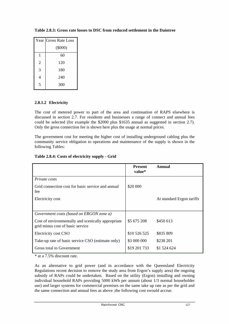
Rainforest CRC 127
Table 2.8.3: Gross rate losses to DSC from reduced settlement in the Daintree
Year Gross Rate Loss
($000)
1 60
2 120
3 180
4 240
5 300
2.8.1.2 Electricity
The cost of metered power to part of the area and continuation of RAPS elsewhere is discussed in section 2.7. For residents and businesses a range of connect and annual fees could be selected (for example the $2000 plus $1635 annual as suggested in section 2.7). Only the gross connection fee is shown here plus the usage at normal prices.
The government cost for meeting the higher cost of installing underground cabling plus the community service obligation to operations and maintenance of the supply is shown in the following Tables:
Table 2.8.4: Costs of electricity supply - Grid
Present value*
Annual
Private costs
Grid connection cost for basic service and annual fee
$20 000
Electricity cost At standard Ergon tariffs
Government costs (based on ERGON zone a)
Cost of environmentally and scenically appropriate grid minus cost of basic service
$5 675 208 $450 613
Electricity cost CSO $10 526 525 $835 809
Take-up rate of basic service CSO (estimate only) $3 000 000 $238 201
Gross total to Government $19 201 733 $1 524 624
* at a 7.5% discount rate.
As an alternative to grid power (and in accordance with the Queensland Electricity Regulations recent decision to remove the study area from Ergon’s supply area) the ongoing subsidy of RAPs could be undertaken. Based on the utility (Ergon) installing and owning individual household RAPs providing 5000 kWh per annum (about 1/3 normal householder use) and larger systems for commercial premises on the same take up rate as per the grid and the same connection and annual fees as above ;the following cost swould accrue.

128 Rainforest CRC
Table 2.8.5: Costs of electricity supply
Present value*
Annual
Private costs
RAPs supply cost $2000
Electricity costs $1635*
At agreed Ergon tariffs
Government costs
Capital subsidy $9 688 791 $746 738
Operating cost subsidy $11 977 748 $923 154
Take up rate of basic service CSO $0 $0
Gross total to Government $21 666 534 $1 669 892
*Note: there will be an additional cost in excess of $5M as necessary to fund a RAPS alternative.
Annual fee would be applicable for at least 10 years.
2.8.1.3 Roads
The costs of road maintenance for the Cape Tribulation Road and minor roads in the area were estimated in Section 2.6. These are the responsibility of the DSC. The longer term annual cost to DSC for road maintenance is estimated to be:
Table 2.8.5: Cost of road maintenance to DSC
Annual cost
Cape Tribulation Road $300 000
Subdivision roads 48km @ $1770/km $100 000
Total $400 000
There may be savings in local road maintenance if local residents elect to have sections of road closed to the public and privatised.
2.8.1.4 Other services
In the 19998/99 financial year DSC spent $100 000 on the Waste Transfer Station operation and $15 000 for the Cow Bay Health Centre operation in the study area (DSC, June 2000).
In addition, general Council operations including park maintenance, library services, dog, control, environmental management, emergency and community services and general overheads should be included in the cost to DSC of servicing the study area. Long term costs of these services will increase with population growth, estimated to be of order of magnitude of $200 000.

Rainforest CRC 129
2.8.2 Options
2.8.2.1 Sources of revenue
There are a number of possible revenue sources. In the final analysis the solution to finance can only be found through the combination of sources in an equitable manner.
The main sources are:
• visitor fees and charges including commercial access fees
• ferry revenue
• council rates
• infrastructure charges
• voluntary agreements
• government subsidies
• corporate funding through the Rainforest Foundation.
2.8.2.2 Visitor fees and charges
At present visitors pay for visiting the Daintree through:
• tour passengers payments to tour operators who pay commercial access permits to QPWS or for arrangements with private landowners, and for the ferry fee
• FITs by payment for the ferry and for access to private operations if they choose. They pay no general NP access fee.
There is a significant issue of competitive equity between the local community’s provision and maintenance of nature-based tourism facilities and those on public lands. As discussed in section 2.6, there is a need to adjust ferry charges to achieve a better balance between the costs paid by public site users and those who visit private destinations.
2.8.2.3 Ferry revenue
The DSC has the task of managing its affairs with a rate base that comes from only 18% of its area, the balance being in the Wet Tropics World Heritage Area. The Daintree River ferry is a major source of revenue to the Council, the net revenue raised through fees and charges far exceeding the operating costs paid to the contractor. Table 2.8.6 shows the gross revenue, expenses and net revenue for the ferry 1997-2000. This revenue is used for Council works projects, mostly road construction and maintenance north of the river, and the balance is incorporated into the Shire’s general revenue for use throughout the Shire. In the year 2000, the cost estimate includes the expenditure of $150 000 for land purchases required for the rationalisation of traffic management on the southern ferry crossing. Works of this nature are expected to occur in future years as well.
On the basis of these figures, net revenue from the ferry with current fee structures is of the order of magnitude $500 000 per annum. This revenue is incorporated into the Shire’s general revenue for use in major roadwork north of the River especially the continuing

130 Rainforest CRC
improvements to the Cape Tribulation Road. There remains significant work on this Road especially in the Noah headland area.
Table 2.8.6: Total revenue from the Daintree Ferry 1997-1999 ($000)
Year Total revenue Expenses Net Revenue
1997 $1 087 $631 $456
1998 $1 240 $674 $566
1999 $1 380 $655 $725
2000 est
$1 472 $929 $543
Source Douglas Shire Council, June 2000
Figure 2.8.1: Gross revenue from the Daintree Ferry
Residents pay an annual fee of $20 that also covers their visitors. The main user charges for the most frequent classes of visitors and business traffic for one way trips are shown in Table 2.8.7. The ferry fee structure recognises its role as an essential infrastructure for local residents and sets fees that mostly are paid by visitors (or their transporters). DSC has announced a further increase in the fees for cars to apply from 1 July 2000.
Table 2.8.7: Daintree Ferry one-way fares June 2000
Category One-way fee
Revenue from the Daintree Ferry
$0.00
$50,000.00
$100,000.00
$150,000.00
$200,000.00
$250,000.00
Jun-
96
Aug
-96
Oct
-96
Dec
-96
Feb
-97
Apr
-97
Jun-
97
Aug
-97
Oct
-97
Dec
-97
Feb
-98
Apr
-98
Jun-
98
Aug
-98
Oct
-98
Dec
-98
Feb
-99
Apr
-99
Jun-
99
Aug
-99
Oct
-99
Dec
-99
Feb
-00
Apr
-00

Rainforest CRC 131
Pedestrians $1
Cars and utilities $7
Truck >5m - $6
Busses 6-8 seat $9
Busses 11-15 - $17
Busses 21-25 - $27
The CSIRO Douglas Shire tourism survey investigated the revenues collected from FITs and their willingness to pay for a one-way ferry crossing. Willingness-to-pay is the value that people put on the experience that they expect to have by visiting this area.
Figure 2.8.2: Demand function for FIT travel across the Daintree River at the Ferry
The demand function is calculated from the willingness-to-pay values of the 927 survey respondents on the y-axis, and the proportion of self-drive visitors who are prepared to pay this price on the x-axis. For example, if the price for a one-way ferry crossing was to increase to $10, then 85 per cent of people would still go, but 15% of respondents indicated that they would not be prepared to pay this amount.
Table 2.8.8: Proportion of travellers willing to pay a specified one-way ferry price
One-way Ferry Price
($)
Percent willing to pay this price
100 4
70 8
FITs Willingness to Pay for Daintree Ferry
0
5
10
15
20
25
30
35
0 20 40 60 80 100
Percent
$ o
ne-
way
fee
$

132 Rainforest CRC
50 19
40 25
30 36
25 43
20 54
15 67
10 85
7 100
r = 0.986
Figure 2.8.2 shows a price elastic demand for self-drive visits to the area north of the Daintree River. This price elasticity can be translated into policy for managing the self-drive traffic volume to the destination by varying the price for a ferry crossings. This is highlighted in Table 2.8.8, which shows, for a range of one-way ferry prices, what proportion of FIT travellers responded that they would still make the trip north for a specified price.
The one-way ferry price is currently $7 per vehicle. The consumer surplus for a visit to the area north of the Daintree River has been estimated from the survey data to be $39.86 per tourist self-drive vehicle (return trip). (ie the additional value that visitors expect to have from their visit above the costs they actually pay). If we assume that the approximately 110 000 full-paying car ferry crossings in 1998/9 (Douglas Shire Council data) relate to self-drive tourists, the associated annual consumer surplus is in excess of $2 million. If some of this consumer surplus could be captured and added to the region’s rent from its natural resources, significant efforts into managing and preserving the heritage and environmental attributes of the destination could be funded.
The survey was unable to quantify the social impact that a change in ferry charge would have. The stratification of valuation responses against occupation of main income shows no difference in median willingness to pay for a one-way crossing. Across all categories, it is $20. However, the mean willingness-to-pay reveals a differentiation between occupations with a clear gradient based on presumed available income (Table 2.8.9). The higher the income, the higher is the consumer surplus which people gain from the trip as reflected in their willingness-to-pay. It can therefore be concluded that a traffic reduction due to an increase of the ferry charge would disadvantage low-income travelling parties in affordability of access to the area north of the Daintree River.
The price elasticity of the FIT demand function indicates that the price for the Daintree Ferry crossing would be suitable instrument for:
• increasing the resource rent which the DSC can draw from tourism and thereby generating additional revenue for the management of this area and,
• managing the volume of self-drive traffic into the area.
2.8.2.4 Council rates
Douglas Shire Council levies rates on the unimproved value of all privately owned land in the Shire under the Local Government Act 1993. These are the general rates. The general rate revenue collected is a product of the land valuation and the rate per dollar of the land value as defined by the Director General Valuations of Queensland Department of Natural Resources.

Rainforest CRC 133
Reflecting the different costs of servicing different types of land use the DSC has seven different rates as shown in Table 2.8.9 below. In addition, DSC collects specific service charges for water supply and sewerage.

134 Rainforest CRC
Table 2.8.9: General rates collected by Douglas Shire Council north of the Daintree River
Rating Category Rate
(per $)
No. of properties North side of Daintree
River
Valuation
($000)
Income ($)
1999
Percent of area total
1 All lands not included in other categories
0.9494 65 8 591 79 246 10.99
2 Sugar cane lands 1.3331 0
3 Large residential properties North of the Daintree River
1.8000 950 36 861 609 822 84.57
4 Marinas 4.1500 0
5 Grazing land 1.2782 28 2 668 31 975 4.43
6 Major Shopping Centres
5.9682 0
7 Large residential properties south of the Daintree River
1.0000 0
TOTAL 1043 48 120 721 043 100.00
Source: Douglas Shire Council, May 2000
These data show that DSC may collect $721 043 in general rates north of the Daintree River, the majority of which is collected from the 950 large residential allotments. The average allotment is valued at $38 801 and pays $641 per annum in rates. In the 1998/99 financial year the amount collected was $704 000.
The justification for the higher general rate for large residential properties north of the River compared with elsewhere in the Shire is the lower land values there. DSC argues that the actual rates paid per allotment are similar throughout the Shire.
There are 41 properties in the area with outstanding rates for 1999/2000 and a further 18 properties with outstanding rates for 1999/2000 and previous years. The DSC has not acquired any properties for outstanding rates in the past two years but has a total of 20 acquired in previous years, some of which have been sold.
2.8.2.5 Infrastructure charges
Local governments are increasingly requiring developers of commercial, industrial and residential land to meet the costs of infrastructure such as roads, parks, water. For future tourism and commercial developments in the North Daintree area it is important that DSC collect adequate fees from these new developments to minimise the burden on ratepayers.

Rainforest CRC 135
2.8.2.6 Voluntary agreements
The voluntary agreement by landholders to forego development rights on land has obvious cost implications for the program envisaged here. The more land that can have permanent protection by owners’ voluntary decisions, the lower the legal and compensation bill will be. This opportunity needs to be maximised for social and financial reasons.
There is now a body of knowledge on the interest of North Daintree landowners in CMAs, and in the agencies, the process and costs involved. The best data of this kind were prepared for the WTMA through the Daintree Rescue Package. Interested landholders were invited to register an expression of interest with WTMA in a CMA, acquisition or both. The invitation was widely canvassed. Table 2.8.10 summarises the response from landholders to the call for expressions of interest.
Table 2.8.10: Summary of land holder interest in DRP CMAs and acquisition
Allotment Details Number of Allotments
% of total Allotments
Freehold Area (ha)
% of Freehold Area (approx)
Daintree freehold lots 1 100 100 7 000 100
Lots offered for sale only 422 38 3 000 40
Lots offered for sale or CMA
63 6 299 4
Lots offered for CMA only
69 6 386 6
Lots acquired 83 8 1 640 20
Approved CMAs 18 2 56 <1
Source: Daintree Rescue Package.
CMAs will provide a small but significant source of funding relief in this program. We assume that 15% of landowners will respond in the longer term to the opportunity for a CMA or similar such as voluntarily having their land placed in a Nature Refuge.
2.8.2.7 Government contributions
Both Commonwealth and State Governments have strong interests in conservation of the natural values of the Daintree region. In the past the Commonwealth in particular has contributed a substantial sum under the World Heritage program for protected area management and through the Daintree Rescue Package that included spending $15m on buying back land from owners on a voluntary basis.
There remain obligations to protect the World Heritage values by further financial support to land management activities on freehold land in this area.
136 Rainforest CRC
2.8.2.8 Private donations and the Australian Rainforest Foundation
There is an emerging possibility of corporate funding through the Australian Rainforest Foundation. The Australian Rainforest Foundation is a not-for-profit organisation established to assist with the protection and management of Australia’s tropical rainforests. It is a fund raising organisation with a principal focus of establishing partnerships with land managers and the corporate sector. It aims to secure corporate investment in a range of conservation measures including land acquisition, land rehabilitation, research and education. It also intends to develop a significant individual membership as the Foundation grows over time. The Foundation is looking beyond the normal fund-raising activities and is looking to achieve substantial contributions from the private sector by direct engagement at boardroom level. However, member contributions, donations, bequests, etc. will become part of its long-term revenue base.
Whilst still in its development phase, the Foundation has already achieved the acquisition of two strategic parcels of land at Mission Beach required to secure a habitat corridor for cassowaries between Innisfail and Cardwell.
Over the next year or so, the Foundation could become a significant partner in assisting to secure rainforest parcels in the Daintree. The principles and general approach that have been taken in its role in the Mission Beach cassowary corridor project can equally be applied to the Daintree, and the Foundation could become the principal agency for acquiring land for future management by sympathetic private owners (once covenanted) or where appropriate transfer to the National Park Estate.
2.8.3 Recommendations
Meeting the costs of conservation, development and management of the Daintree requires a partnership between three governments and the private landholders. Tourists should also make a contribution for environmental management and infrastructure provision. The cost revenue situation here shows a program of funding arrangements incorporating
• Commonwealth and State and local Government contributions to long term biodiversity conservation,
• DSC maintaining local government services and roads,
• residents paying for the net cost of their infrastructure and services, and
• tourists contributing to conservation and infrastructure management in the area by visitor fees (ferry and CAP fees).
It is proposed that a Land Trust be established to manage funds for compensation and covenanting land and managing resale and external contributions of funds.
The total costs of achieving a desired rainforest community outcomes here are substantial, being an estimated $14.28 million for compensation to land owners, legal and administrative costs of $1 million and a range of program development costs of a further $1 million. Rate losses to Douglas Shire Council of approximately $300 000 will also result.

Rainforest CRC 137
These total costs will be significantly reduced by the resale of covenanted blocks (at a fraction of their existing price) and the maximisation of voluntary private conservation agreements. Attracting funds from private donations through the Rainforest Foundation and charitable trusts and program funds from other rural development programs will further reduce the net cost of the conservation and land settlement measures proposed. It is proposed here that the core funding of land compensation and resale be from a balance of Commonwealth and local sources (approximately $12 million or $8.7 million NPV), a portion of the Daintree River ferry fee ($500 000 per year), resale revenue approximately $2.6 million over the longer period and private donations of $0.5 million.
It is recommended that the State Government contribution to biodiversity conservation is the net additional cost ($5 675 million) of supplying environmentally and scenically appropriate electricity. The State will also need to continue its CSO obligations to supply electricity to the area.
Table 2.8.11: Distribution of costs of land compensation and resale over five years
Year 1 2 3 4 5 Total
Rate of resolution 0.2 0.2 0.3 0.2 0.1 1
Costs
Compensation payments $2 856 $2 856 $4 284 $2 856 $1 428 $14 280
Legal and administrative $200 $200 $200 $200 $200 $1 000
Total cost $3 056 $3 056 $4 484 $3 056 $1 628 $15 280
Revenues
Resale revenue (resolution rate lagged 1 yr) $0 $588 $588 $882 $588 $2 646
Rainforest Foundation $100 $100 $100 $100 $100 $500
Total revenue $100 $688 $688 $982 $688 $3 146
Net annual cost $2 956 $2 368 $3 796 $2 074 $940 $12 134
Present value $2 956 $2 068 $3 099 $1 582 $670 $10 375

138 Rainforest CRC
Table 2.8.12: Alternate Recommended cost sharing and income off-sets over five years ($000)
Theme Cost over 5 years
Source of Funding Income Offsets over 5 years
Net cost
Biodiversity Conservation
Land Trust $14 280 Commonwealth Government
Tourists
Foundations and charitable trusts $500
Land resale and amalgamation $2 646
Ferry revenue $1 500
$9 634
Rate Relief $300 DSC Increasing land values
Restructured rate profile
$0
Infrastructure and Services
Roads and ferry $2 000 Local Government Rates and ferry revenue
Local Services $1 000 Local Government Rates
Electricity cost CSO (DRAPS)
$13 526 State Government Net $13 526
Community Development initiatives including farm field days
Community group support etc
$500
Allocations from State and Federal Grant programs by application
Possible local Govt input
External funding
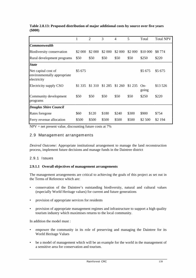
Rainforest CRC 139
Table 2.8.13: Proposed distribution of major additional costs by source over five years ($000)
1 2 3 4 5 Total Total NPV
Commonwealth
Biodiversity conservation $2 000 $2 000 $2 000 $2 000 $2 000 $10 000 $8 774
Rural development programs $50 $50 $50 $50 $50 $250 $220
State
Net capital cost of environmentally appropriate electricity
$5 675 $5 675 $5 675
Electricity supply CSO $1 335 $1 310 $1 285 $1 260 $1 235 On-going
$13 526
Community development programs
$50 $50 $50 $50 $50 $250 $220
Douglas Shire Council
Rates foregone $60 $120 $180 $240 $300 $900 $754
Ferry revenue allocation $500 $500 $500 $500 $500 $2 500 $2 194
NPV = net present value, discounting future costs at 7%
2.9 Management arrangements
Desired Outcome: Appropriate institutional arrangement to manage the land reconstruction process, implement future decisions and manage funds in the Daintree district
2.9.1 Issues
2.9.1.1 Overall objectives of management arrangements
The management arrangements are critical to achieving the goals of this project as set out in the Terms of Reference which are:
• conservation of the Daintree’s outstanding biodiversity, natural and cultural values (especially World Heritage values) for current and future generations
• provision of appropriate services for residents
• provision of appropriate management regimes and infrastructure to support a high quality tourism industry which maximises returns to the local community.
In addition the model must :
• empower the community in its role of preserving and managing the Daintree for its World Heritage Values
• be a model of management which will be an example for the world in the management of a sensitive area for conservation and tourism.

140 Rainforest CRC
2.9.1.2 The World Heritage Area and the requirements of the Environment Protection and Biodiversity Conservation Act.
The Commonwealth has the obligation to manage World Heritage values of the study area (under the World Heritage Convention) and has considerable power to do so. The statutory and management component of any management agreement must be designed to achieve land management provisions which will ensure that development of land outside the World Heritage area meets the requirements of the Environment Protection and Biodiversity Conservation Act (EPBC). The Act applies to an action that has, will have, or is likely to have a significant impact on a matter of national environmental significance.
Matters of national environmental significance include:
• World Heritage properties
• nationally threatened species and communities.
The Act provides for the establishment of lists of:
• nationally threatened native species (classified as extinct, extinct in the wild, critically endangered, endangered, vulnerable, and conservation dependent)
• nationally threatened ecological communities (which may be classified as critically endangered, endangered or vulnerable)
• key threatening processes
• it also provides for the development of a register of critical habitat for threatened species and ecological communities.
There is a strong possibility that parts of the area north of the Daintree River would be listed under these categories with consequent requirement for the development of recovery plans and necessitate intervention strategies to manage habitat loss.
The Act also promotes the use of Conservation agreements with private landholders. Under conservation agreements, land is managed in an agreed manner to enhance conservation, and the Commonwealth may provide financial or other assistance. Conservation agreements must result in a net benefit to the conservation of biodiversity in the place covered by the agreement.
The Commonwealth has an essential role and responsibility in any management arrangements established, most likely through the Environment Australia portfolio and the EPBC Act. It also has strong local engagement through the WTMA.
2.9.1.3 Financial management
The proposals here require new or re-directed sources of funding for:
• financial support to the community through conservation agreements for the protection of biodiversity on private land
• a market compensation and incentive program for land owners who relinquish development rights

Rainforest CRC 141
• provision for assistance to the community for economic development in local tourism ventures and organic primary production
• financial provision for essential infrastructure and services.
A choice needs to be made between using existing agencies and creating a new entity for this purpose.
2.9.1.4 Land use plans
Reduction in settlement density to protect the natural values of the area and to meet community aspirations requires changes to local planning controls under the Integrated Planning Act:
• to give effect to reduced settlement density to achieve biodiversity conservation.
• to provide for an increased range of options for small scale tourism development subject to controls limiting vegetation removal, provisions for suitable waste and effluent disposal and restrictions on vehicle types and numbers to protect residential amenity and road condition.
This would be administered by the DSC but will need support and oversight.
2.9.1.5 Integrated tourism planning
Many recommendations here require the coordination between a number of agencies in tourism and infrastructure management and planning. This includes ferry and road issues, fee structures, private accommodation and services, private and public land management, visitor infrastructure, privacy and other issues
2.9.1.6 Community involvement
As required in the terms of reference of this report and frequently stated by the community inputs, there is a need to improve community involvement in management of the area. This will need to also involve the Native Title process and the likely Indigenous Land Use Agreement.
The predominant community ethos favours management arrangements which minimise government ‘intervention’ into the every day lives of Daintree residents and business owners. Most acknowledge however that community members need a degree of government ‘support’ to achieve personal goals. There is also a strong belief that governments should meet the extra costs associated with the special conservation needs of this area.
The Daintree community forum in April reached a moderate level of agreement with the following statement:
• Develop an institutional arrangement that allows the local community to determine its own management priorities, through funds accumulated from tourism cost-recovery.
2.9.2 Options
There are many management arrangement options available to meet the above needs. The current distribution of powers and responsibilities will not be adequate because:

142 Rainforest CRC
• there is a need to identify which agency will administer the proposed funding of compensation and land reconstruction.
• there is a need for continuing and improved coordination between key management agencies
• there may not be adequate powers in some agencies to undertake the required or assumed functions
• there is need for some certainty in the implementation of this package of recommendations. Part implementation could lead to a situation worse than at present (eg supplying metered power without land use controls). There is legitimate concern on all sides about the possible instability or unreliability of decisions that have been made in the past and that possibly may be made in the future.
Existing key management agencies including the Wet Tropics Ministerial Council, DSC, QPWS, WTMA will remain dominant players, but there are additional needs—to manage funds and to ensure the coordinated implementation of all agreed recommendations.
2.9.2.1 Give permanence to the Daintree Planning Coordination Group (DPCG).
The DPCG represents all the main agencies involved in land use planning in the area. The main weakness of the DPCG is that it does not include sufficient local input and its brief does not extend far enough into tourism and infrastructure management. It does not have the statutory strength and processes to deal with managing funds, relying only on informal cooperation. It does not have adequate stakeholder involvement. It could however form the core of an expanded body to manage the Daintree.
2.9.2.2 Create the Daintree Management Authority by a new Queensland Act as proposed by the Daintree Alliance
This proposal has the merit of anchoring the management arrangements in legislation and giving a strong statutory basis for representation, planning, financial management and decision making. The major obstacle for a new authority is that it would create another parallel management entity at a time when all governments are striving for efficiency and coordination. The goals of the proposed authority could be met more efficiently by other means.
2.9.2.3 Declare the Daintree a special area under existing Queensland legislation, either the: Nature Conservation Act (Coordinated Conservation Area) or Recreation Areas Management Act
There are generally strong community reactions against the concept of declaring their area under either the Recreation Areas Management Act or the Nature Conservation Act. Responsible Government agencies do not favour either of these options. Reasons include:
• relevant legislation is designed to manage the area for conservation or recreation and tourism outcomes rather than achieving a synthesis between themes of tourism, conservation and community social and economic development
• the future of the area is removed from community control.
The potential role of local government in the area is weakened

Rainforest CRC 143
2.9.2.4 Incorporate the study area in the World Heritage Area.
The advantages of this option are:
• maximum likelihood of protection of conservation values under the unequivocal statutory protection of the EPBC Act
• efficiencies in administration through the existing WTMA and its coordinated arrangement with land management agencies including QPWS, DNR and DSC
• greater assurance of long term Commonwealth funding of conservation activities.
Disadvantages of this option are:
• certainty of vehement landowner and resident opposition
• concern in some quarters that the WTMA coordination with agencies is not effective at present.
A decision to extend the boundary of the World Heritage Area would have major political and social consequences. If this option were to be selected, it would need to follow a rigorous review of the whole World Heritage Area boundary.

144 Rainforest CRC
2.9.2.5 Establish a Daintree Trust as recommended in the review of the DRP.
The report on the review of the Daintree Rescue Package recommended the creation of the Daintree River Trust. Some of the essential features of that recommendation are:
(a) Structural
• it be established under Queensland statute
• it be administered by a board of trustees consisting of The Chair of WTMA, The Chair of the Douglas Shire Council and a prominent local person with significant knowledge of the tourism industry
• it be advised by a board of local citizens selected to reflect the views of the community
• it seek the advice of the Scientific Committee of WTMA as necessary
• it report to Ministerial council six monthly and both Parliaments annually.
The day to day management of the trusts affairs would be the responsibility of the WTMA executive officer.
(b) Funding
• initially the trust would be funded by guaranteed equal contributions of the Douglas Shire Council, The State of Queensland and The Commonwealth of Australia. It is proposed that the Douglas Shire Contribution would reflect the income from the Daintree Ferry. The contribution from the Queensland Government should reflect the commercial use fees gathered from the area but should be set to match the Commonwealth contribution of $1 million
• after three years the trust would be expected to negotiated an arrangement with the three supporting parties to be self funding.
(c) Activities
The primary purposes of the trust are to ensure that:
• the values and infrastructure of the area are protected and maintained
• the local community develops an enlightened self interest in preserving the area.
The trust will do this by:
• letting contracts for infrastructure maintenance with a preference for local contractors
• building new or replacement infrastructure as needed
• encouraging NGO’s to protect land through purchase by entering into an agreement to pay the shire rates for such land up to the point where the lands value has been paid at this point the land would revert to the trust as rateable freehold land.
• cooperate with the Douglas Shire and local residents to assist in land swaps which will rationalize the provision of services and consolidate development into nodes. The purpose of this provision is to reduce the cost of service provision to the Douglas Shire and provide better services to residents. It is possible that this process may involve the purchase of property or the subsidisation of purchase
• oversee the development and promotion of a branded product styled ‘Daintree Guides’. This will require a trademark and a system of mark authorisation built around the training and quality assurance of the product providers. The ISO 9000 and 14000 series could be considered for this exercise. It is proposed that the Daintree Guides product be limited in its availability so as to ensure maximum benefit to the community while not prejudicing the viability of the local tourism industry
• negotiate with DoE to ensure that only Daintree Guides accredited operators provide services north of the Daintree

Rainforest CRC 145
• enter into a contract with the Daintree Foundation for the further development of existing rate relief agreements in the area. Such agreement are binding agreement by land owners to protect the vegetation on their land in return for a rate subsidy. It is proposed to provide a success fee of about $2000 to the foundation for every contract signed
• link the provision of funds for land restoration to the signing of a CMA or a contract with the Daintree foundation
• consider the purchase of timber rights on private land as an additional vegetation protection measure
• purchase land where such a purchase is consistent with the purposes of the trust
• provide support for local residents by way of capital guarantees for the establishment of appropriate tourism enterprises. It may be necessary to provide this service by way of competitive bids for a fixed annual sum. This proposal is important but will need further development
• provide funding for professional business advise to local businesses as far as this is consistent with the purposes of the trust.
This option has considerable merit and is reviewed in terms of the Queensland Land Trust provisions below.
2.9.2.6 Establish a Daintree Land Trust under Queensland Legislation
2.9.2.6.1 Background
The concept of Land Trusts is well established throughout the western world. A Land Trust is a body legally constituted to manage land and revenue in the community interest, usually for the purpose of protecting the natural environment. Land Trusts engage the community in acquisition and ongoing protection of land under its control. Good examples of successful Land Trusts include the Trust for Nature (Victoria), the Queen Elizabeth II Trust in New Zealand and Land Trusts in America. The Trust for Nature Victoria as at 1998 had 250 covenants and 115 properties protecting over 17 000 hectares of land. There are over 1500 Land Trusts in the USA, the largest being the Nature Conservancy with 1.5m hectares protected and an annual turnover of $722 million. The Queen Elizabeth II Trust of New Zealand has over 1000 covenants protecting open space These Trusts provide incentives to landholders such as a contribution towards fencing covenanted land and advice on land management practices and subject to negotiation with the relevant authority, rates and Land Tax relief.
(Denis Moretto, DNR pers com).
At the present time the Queensland Government is considering a proposal for the establishment of a Land Trust in this State. The Government is considering a report on the consultation process undertaken to determine community views on a Land Trust and the type of organisation that would receive most support. The consultation process revealed that the preferred model is for a single Trust with the power to accredit local groups. If it was decided to proceed, a Land Trust could be established along the following lines:
2.9.2.6.2 Objects of the proposed Land Trust are to:
• undertake and encourage the permanent protection and enhancement of areas that are significant in the natural environment (natural environment includes wildlife and their habitats, native plants, landscapes and natural areas)
• empower the community to actively participate in achieving the objects of the Trust

146 Rainforest CRC
• engage the community and landholders in the ongoing stewardship of Trust land and
• permanent protection and enhancement of areas that are significant for natural and cultural heritage.
Structure
• a single Trust established under legislation
• managed by a board of Trustees
• trustees would be selected on a skills based criteria
• there would be a membership component for the Trust
• members would be able to elect some Trustees
Powers of the Trust
• accredit groups to run its operations in a particular locality (Membership of these local groups would be determined at the local level)
• delegate some of its powers to these accredited groups
• enter into statutory covenants with landholders that would bind successors in title
• buy and sell land
• accept gifts, donations and bequests of real and personal property
• act as agents for other persons including the Commonwealth, the State and Local Governments.
The Land Trust would be entered on the Register of Environmental Organisations so that donations of money and land are tax-deductible.
2.9.2.6.3 Operations of the Land Trust:
With the powers and structure proposed, the Trust could undertake its operations in the manner that best suited it. For a particular project, the Trust might operate in one or all of the following ways:
• buy land, place a covenant over all or part and then resell (A Revolving Land Fund)
• buy strategic land and retain for ongoing management
• facilitate a program of incentives to encourage landholders to enter into a covenant with the Trust to protect particular values
• facilitate public appeals to purchase land.
(Denis Moretto, DNR pers com)

Rainforest CRC 147
2.9.2.7 A Land Trust for the Daintree
The Daintree area would be a most suitable case for a Land Trust under this new program. If the statewide Trust were not established, it would need to be a special case Trust with similar functions.
2.9.2.7.1 Possible objects of the Daintree Land Trust:
• undertake the permanent protection and enhancement of areas identified in this report
• promoting community participation in nature conservation in the area and involving the community and landholders in the ongoing stewardship of Trust land and
• permanent protection and enhancement of areas that are significant for natural and cultural heritage
2.9.2.7.2 Possible structure:
• a single Trust established under new Queensland legislation
• the Trust would be managed by a board of Trustees representing:
• local residents and businesses
• Aboriginal Native Title holders
• Douglas Shire Council
• Commonwealth Government
• Queensland Government
2.9.2.7.3 Powers of the Trust:
• enter into statutory covenants with landholders that would bind successors in title
• buy and sell land and manage the financial program as set out in 3.9 above
• accept gifts, donations and bequests of real and personal property
• act as agents for other persons including the Commonwealth, the State and Local Governments in matters relating to land
It would be possible to utilise the developing expertise of the Australian Rainforest Foundation, recently established in association with the Wet Tropics Management Authority, and constituted with a separate Board of Directors and management structure; to manage land transactions to achieve conservation outcomes and to obtain sponsorship and private funding to support initiatives for he protection of biodiversity.
It is expected that the Trust would be self funded after 5 years.

148 Rainforest CRC
2.9.2.8 Transitional arrangements
In determining the most appropriate management structure for the Daintree the following matters should be considered:
There is a growing trend in government to set up transitional management arrangements with the intent of handing back defined responsibilities and tasks to relevant tiers of government when defined outcomes are reached. This allows government resources to be diverted to areas in need but not ‘tied up’ for extended periods of time.
Management structures under the Recreation Areas Management Act or the Nature Conservation Act etc are intended to continue in perpetuity whereas tasks undertaken by a defined Daintree management structure will be ‘complete’ when a defined future of human settlement and conservation in balance is reached .
What is required is a transitional arrangement to implement the far-reaching findings of this project and then for the management to revert to established agencies including DSC, QPWS, WTMA etc.
2.9.3 Recommendation on management arrangements
Recommendation 32: A package of financial contributions from Commonwealth and State Governments and the DSC.
(i) For biodiversity conservation
• $2 million per year over five years for compensation to private landowners from the Commonwealth Government
• $5.5 million from the Queensland Government for the additional costs of environmentally appropriate grid electricity via a DRAPS.
• $200 000 per year over five years for administrative support provided by DSC.
Revenue offsets for biodiversity conservation are to include revenue from charitable trusts and private donations, revenue from land resale and from ferry revenue.
(ii) For infrastructure and services:
• $400 000 per year for roads and ferry services funded by DSC ferry revenue
• $200 000 per year for local services funded by DSC rates
• $13.5 million to meet the community service obligation for electricity supply funded by the Queensland Government
• $500 000 for industry and community development funded by external grant sources
Revenue offsets for service provision are to include equitable user payments for electricity, rates and for ferry use.

Rainforest CRC 149
Recommendation 33: Signing of a Memorandum of Agreement between the three spheres of Government to endorse the (accepted) Daintree Futures recommendations.
Why: There is the need for understanding amongst all stakeholders that the recommendations agreed from this project are formally accepted and will be implemented with as much certainty as possible The recommendations will require implementation by one or more Governments through their agencies. A framework agreement for that commitment is necessary to guide future actions.
How: Signing of a Memorandum of Agreement listing the agreed actions.
Recommendation 34: The establishment of the Daintree Land Trust under the auspice of the Queensland Trust for Nature, if established or other appropriate management recommendation.
What: The Trust would manage a revolving land fund and to buy and sell land, enter into statutory covenants with landholders, accept gifts, donations and bequests of real and personal property and act as agents for other persons including the Commonwealth, the State and Local Governments in matters relating to land.
The Trust would have a Board of Trustees consisting of:
• local residents and businesses
• Aboriginal Native Title holders
• Douglas Shire Council
• Commonwealth Government
• Queensland Government.
Why: A Land Trust is the most appropriate body to deal with the land reconstruction process proposed here. There are precedents throughout the world for this vehicle for managing complex private land interest in areas with high conservation values.
How: The creation of the Trust under Queensland legislation.
Recommendation 35: Establish a short-term Daintree Planning Group as a tripartite agreement between Federal, State and Local government underpinned by a 5 year funding agreement.
The administrative component of the management agreement could be met through the appointment of an inter- governmental committee that meets quarterly to:
• advise the Trust on priority land management and acquisition arrangements
• ensure that planning control frameworks are established
• oversee the implementation of community development requirements
• provide economic development support and links into other programs and funding opportunities.

150 Rainforest CRC
Agency membership would include:
• Department of State Development
• Department of Primary Industry
• Department of Communication, Information, Local Government, Planning and Sport.
• Department of Families Youth and Community Care
• Douglas Shire Council
• Environment Protection Agency.
• Wet Tropics Management Authority
• Department of Mines and Energy
• Department of Natural Resources
The DPG would have a community advisory committee to advise on priorities for delivery of government services and programs and application of funding within the area.
A Program Coordinator and technical administrative officer will be appointed and located within the Douglas Shire Council offices to :
• provide secretariat services to the committee and governance structures
• develop community capacity in economic development and environmental protection including access to grants and funding external to the Daintree Futures program.
Why: There is a need to provide significant and coordinated action across a number of Government agencies to implement the recommendation of this study. It is proposed that this Group be considered a transitional arrangement to be disbanded after the agreed five-year core funding of the Daintree Land Trust.
How: By administrative action under the coordination of the Director of the Wet Tropics Management Authority.

Rainforest CRC 151
3. Summary of Recommendations and Implementation Program
3.1 The Desired Future for the Daintree
The Community
This report proposes a future for Daintree future based on protecting the environment and building a sustainable rainforest community on the freehold land north of the Daintree River.
The community between 1200 - 1400 people will have a high quality of life based on the natural forest values that attracted them to the area and they will be actively involved as stewards of the natural values on their land.
Residents will have employment opportunities, in nature based tourism and to a lesser extent in tropical horticulture, and a congenial retirement atmosphere depending on their situation. The community will have the normal primary services for a community of its size and access to a broader range of services in Mossman and other regional centres.
Land ownership
Rare and threatened species on freehold land will be protected. High biodiversity values on land in private ownership will be managed through resident stewardship of the rainforest, planning controls and local laws. Settlement densities will be at ecologically sustainable levels. Land that remains unsettled will have a number of potential futures. It may be retained by existing owners and covenanted for conservation purposes; or it may be conveyed via the Daintree Land trust to neighbours or private corporate foundations, once appropriate compensation for reduction of development rights has been made. A small number of priority conservation blocks, identified for their outstanding flora and fauna values, may be acquired as public land depending on the aspirations and expectations of existing land owners. Public ownership is not essential for their conservation future.
Natural Heritage
Rare and threatened species and regional ecosystems on freehold land will be protected.
Cassowaries and other endangered vulnerable fauna will survive because they have adequate areas of habitat to support viable breeding populations and connections between the lowlands and the mountains not obstructed by fencing, as well as minimal risk from disease, traffic and large dogs.
Stream flows and underground water tables will be sustainable by keeping extraction within limits and making maximum use of rainwater at all dwellings. Water quality will be continuously monitored and if quality problems occur, residents and businesses will change to improved water treatment systems.

152 Rainforest CRC
Tourism
The area’s outstanding ecological values will continue to support a world-class rainforest tourism industry. The Daintree is the prime destination for rainforest tourism in Australia and tourism spending will provide substantial support to local communities.
Many of the tourists will stay for a few nights and be involved in a personalised rainforest experience on private lands Land owners will offer forest stay and nature-based tourism opportunities on their land in addition to improved management of the National Parks in the area..
Tourists will travel through the area in a green tunnel, with windows into the rainforest, the mountain scenery and adjacent tropical horticulture land. They will be aware of the rights of private land owners in the area for privacy.
Infrastructure
People south of Cooper Creek will continue with their RAPS or have chosen to link to grid electricity and use it as a green grid. Most of the grid will be underground. Throughout the area and especially north of Cooper Creek, residents and businesses will lead the world in the practical application of renewable energy technology. Their RAPS will have passed strict design criteria and local energy experts will provide education opportunities.
The ferry will remain as a gateway. It will be a bit larger and serve community and business needs by a priority lane. Tourists will pay a little more than at present but they will have visitor centre on the southern approaches to provide improved interpretation services and more walking tracks and other recreation opportunities in the Daintree north of the river. As visitor numbers increase and capacity limits on the road and ferry are reached, more tourists will select a park and ride option (like they do in Yosemite and Grand Canyon NPs).
The future of the Bloomfield track will depend on the outcomes of environmental impact investigations.
Indigenous People
Traditional owners of land in the Daintree will have Native Title to some land and be involved in joint management of the area’s Crown Lands. The Indigenous Land Use Agreement will have been negotiated to give them opportunities to meet their aspirations for land use and protection of cultural sites and landscapes.
3.2 Why Action is Necessary
Projecting current development trends gives a do-nothing scenario where population will increase steadily to an eventual maximum of over 2000. Residential expansion and tourism growth will cause gradual and irreversible impacts on the opportunities for future generations of residents and visitors:
• Threatening the survival of the area’s outstanding ecological and biodiversity values - vulnerable species such as tree kangaroos, cassowaries and a large number of less spectacular plants and animals found nowhere else on earth
• Increasing the clearing of sites, affecting remnant ecosystems that are found only in a few lowland areas of North Queensland including the fan palm forests (Type 3b) and lowland rainforests on sands (Type 2b).

Rainforest CRC 153
• Degrading scenic values that are important for residents and for tourists from around the world—undermining the $80-100 million visitor industry and the reason many residents moved to the Daintree.
• Increasing traffic flows that could only be accommodated by a substantial upgrading of the main road and a bridge over the Daintree River.
In fact the area would become just like most other semi-urban landscapes and communities that make up so much of the coastal sprawl of Australia.
The do nothing scenario precludes positive community control of outcomes because Governments will need to intervene more stringently in later years if World Heritage values are threatened by suburban encroachment onto or impacts on protected areas. It also reduces the role for the community in the tourism industry. Externally based marketing interests and globalised businesses will have greater say in future in the do-nothing case.
The best future for the Daintree is not for it to become just another part of Australia’s semi-urban sprawl but for it to be a unique Rainforest Community: to protect its unique natural values as a base for an economy and a community. This is an ecologically, socially and economically sustainable solution.

154 Rainforest CRC
3.3 Finance
It is proposed here that the core funding of land compensation and resale be from a balance of Commonwealth, State and local sources as shown in table 3.3.1 below:
Table 3.3.1: Funding for land compensation and resale ($ 000)
Theme Cost over 5 years
Source of funding Income offsets over 5 years
Net cost
Biodiversity Conservation
Land Trust $14 280 Commonwealth Government Tourists
Foundations and charitable trusts $500 Land resale and amalgamation $2 646 Ferry revenue $1 500
$9 634
Rate Relief $300 DSC Increasing land values Restructured rate profile
$0
Environmentally appropriate electricity
$5 675* State Government $5 675
Administrative Support
$1 000 Local Government Ferry revenue $1 000 $0
Infrastructure and Services
Roads and ferry $2 000 Local Government Rates and ferry revenue
Local Services $1 000 Local Government Rates
Electricity cost CSO
$13 526 State Government Net $13 526
Community Development initiatives including farm field days Community group support etc
$500 Allocations from State and Federal Grant programs by application Possible local Govt input
External funding
*Note: there will be an additional cost in excess of $5M as necessary to fund a RAPS alternative.

Rainforest CRC 155
3.4 Management Arrangements
• A Memorandum of Agreement between the three spheres of Government to endorse the Daintree Futures recommendations and demonstrate to all stakeholders that the recommendations agreed from this project are formally accepted and will be implemented with as much certainty as possible
• The Daintree Land Trust under the Queensland Land Act to manage a revolving land fund, to buy and sell land, enter into statutory covenants with landholders, accept gifts, donations and bequests of real and personal property and act as agents for other persons including the Commonwealth, the State and Local Governments in matters relating to land. The Trust would have a Board of Trustees consisting of:
• Local residents and businesses
• Aboriginal Native Title holders
• Douglas Shire Council
• Commonwealth Government
• Queensland Government
• A short-term Daintree Planning Group (an inter- governmental committee) as a tripartite agreement between Federal, State and Local government underpinned by a 5 year funding agreement to handle the transitional arrangements before returning controls to existing agencies. Main functions would be to:
• Advise the Trust on priority land management and acquisition arrangements.
• Ensure that planning control frameworks are established.
• Oversee the implementation of community development requirements.
• Provide economic development support and links into other programs and funding opportunities.

156 Rainforest CRC
3.5 The Package of Actions to Achieve the Desired Future
It is possible that some of the recommendations can be picked up and implemented in isolation. For example it is completely possible that some more buy-back could be funded or for a priority lane at the ferry to be installed or a website for direct selling of tourism by local entrepreneurs could be created. However, to achieve the sustainable rainforest future, and to provide adequate protection to the natural values on freehold lands in the Daintree, involves an integrated solution. Choices made in any decision area have effects on the feasibility of choices and outcomes in other areas. The Figure 3.5.1 shows the complex character of decisions to be made about the preferred future for the Daintree, through:
• key policy tools—land settlement, ferry, electricity supply, industry and community and visitor types
• economic and community processes—finance, land settlement, the tourism industry, roads and traffic, community infrastructure
• outcomes for sustainable development—conservation, quality of life and economic activity and employment.
Figure 3.5.1: Policy Tools, Community Activities and Outcomes in the Daintree
Ferrycapacity
Residents
quality of life Conservation
Tourismexperience
Electricity
Finance
Water and waste
Communityinfrastructure
ResidentialdevelopmentTraffic & Roads
Ferry Fee
Visitor types
Employmentand economic
benefits
Rate of landsettlement

Rainforest CRC 157
3.6 Summary of Recommendations and Implementation Responsibilities
Recommendation Summary of Implementation Implementation Responsibility
Community Development
1. Future residential settlement allows for growth within ecological constraints to a forest residential community of approximately 1400
Ecological values and existing settlement patterns have been defined for nine precincts and desirable future settlement limits and management requirements have been identified that protect the community and its natural resources.
The Daintree Land Trust
DSC revised DCP 3
2. Improved employment opportunities for residents based in nature based tourism and to a lesser extent tropical horticulture.
Increasing the opportunities for local land owners to engage in tourism accommodation and commercial services provision and by changes to town planning and improving the system of Commercial Access Permits to extend to local operators
DSC revised DCP 3 QPWS CAP allocations DSC ferry fees DPI horticulture branch
3. Expansion of primary services for the community and improved outreach services from Mossman
Coordination with outreach services Queensland Health DSC services program
4. Residents participation in land stewardship through involvement in planning and management processes and incentives for ecologically sound land management
Expanded opportunities for nature-based tourism ventures and by formal recognition of community representatives on the management structures proposed here. Community education and incentives package Recognise community identity and the community guardianship of natural values by signage and information that informs visitors of the legitimacy of residential living and the need to respect privacy.
DSC rate charges Daintree Land Trust negotiations and covenants DSC signage and information QPWS plans CAPs WTMA plans and information
5. Building guidelines should be revised for the area.
Town planning changes DSC revised DCP 3

158 Rainforest CRC
Recommendation Summary of Implementation Implementation Responsibility
6. Establish a land use and development control regime which sets upper limits on overall settlement density and has specific biodiversity conservation, settlement pattern and economic provisions.
Conservation and Land Management
7. Ensure the protection of rare and threatened species on freehold land.
Detailed conservation assessment of the nine precincts and mapping of plants communities at a scale that allows assessment of the biodiversity values of individual allotments. For each precinct biodiversity ‘hotspots’ have been identified for priority conservation. Impacts of settlement on the biodiversity of important but less threatened communities, are achieved through a combination of special management guidelines, and where relevant, settlement densities that are less than would occur if full settlement proceeded.
The Daintree Land Trust DSC revised DCP 3 WTMA Plans QPWS Plans and management
8. Protection of regional ecosystem types not adequately conserved elsewhere
As above As above
9. The protection of habitat for cassowaries and other vulnerable fauna
As above As above
10. Maintenance of ecosystem processes through environmental quality protection.
By accepting limits on settlement and visitation. Management of wastewater.
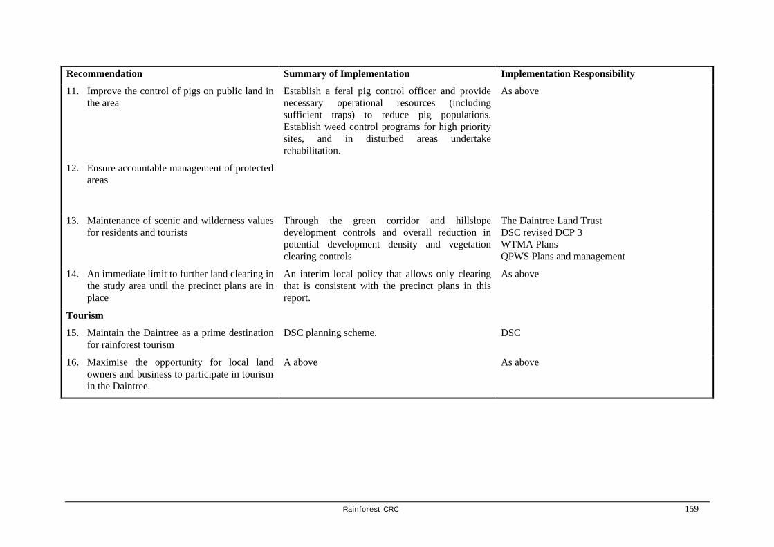
Rainforest CRC 159
Recommendation Summary of Implementation Implementation Responsibility
11. Improve the control of pigs on public land in the area
Establish a feral pig control officer and provide necessary operational resources (including sufficient traps) to reduce pig populations. Establish weed control programs for high priority sites, and in disturbed areas undertake rehabilitation.
As above
12. Ensure accountable management of protected areas
13. Maintenance of scenic and wilderness values for residents and tourists
Through the green corridor and hillslope development controls and overall reduction in potential development density and vegetation clearing controls
The Daintree Land Trust DSC revised DCP 3 WTMA Plans QPWS Plans and management
14. An immediate limit to further land clearing in the study area until the precinct plans are in place
An interim local policy that allows only clearing that is consistent with the precinct plans in this report.
As above
Tourism
15. Maintain the Daintree as a prime destination for rainforest tourism
DSC planning scheme. DSC
16. Maximise the opportunity for local land owners and business to participate in tourism in the Daintree.
A above As above

160 Rainforest CRC
Recommendation Summary of Implementation Implementation Responsibility
17. In order to distribute visitor use across the new and existing visitor sites and provide new tour opportunities, resolve the permit moratorium in an equitable manner, providing opportunities for existing operators, local businesses and tour operators previously denied opportunities
By resolving the permit moratorium for commercial access to National Parks
QPWS
18. Construct a high quality website for Daintree tourism promotion and direct marketing.
Seek $45 000 in industry development funds and construct website at Daintree Shire Council.
DSC in conjunction with DCCTA and the regional tourism industry. Assistance from the Tourism CRC.
Aboriginal Land and Cultural Heritage
19. To allow aboriginal cultural heritage and land aspirations for the Daintree to be reconciled in the future.
Ensuring that the wider community receives information on indigenous land tenure and management options.
Ensure no plans infringe Native Title rights
Provide that any Daintree Management Structure can implement Indigenous Land Use Agreements
DSC planning
WTMA and National Park planning and joint management arrangements
Daintree Planning Group

Rainforest CRC 161
Recommendation Summary of Implementation Implementation Responsibility
Electricity Supply
20. Assuming the introduction of mechanisms to limit development in the Daintree and thereby protect its eco-systems, construct a hybrid grid of overhead and underground power lines as far as Cooper Creek (the FNQEB EIAS preferred Option C).
Assuming the introduction of mechanisms to limit development in the Daintree and thereby protect its eco-systems, provide subsidies and grants to establish remote area power for residences and businesses in the Study Area.
The implementation of the FNQEB Powerline EIAS’s preferred option ‘C’ electricity system.
• a hybrid of overhead and underground power lines as far north as Cooper Creek but not including Whitby and Cape Kimberley
• RAPS elsewhere.
Not to be constructed until the program to reduce settlement intensity and protect biodiversity on private lands is implemented
Queensland Government funding to Ergon Energy to construct the network
DME to continue DRAPS program in areas outside the grid service area
Roads and Ferry
21. The ferry will provide an attractive gateway experience for visitors to the area
The ferry should be retained.
The visitor centre on the southern approaches will provide improved interpretation services.
DSC will need to consider a reservation system and/or to duplicate the ferry in the not too distant future.
DSC
22. The ferry will continue to serve residents and local business needs
Constructing a priority lane for local residential and business traffic. This would only be necessary in peak times and directions.
DSC
23. All roads and road corridors will be sympathetic to the environmental sensitivities of the areas through which they pass
See Biodiversity and Land Management Recommendation 5
DSC

162 Rainforest CRC
Recommendation Summary of Implementation Implementation Responsibility
24. The ferry pricing structure should be changed to: Self-drive: $20 per vehicle (30 day pass non-transferable) Transfer buses: $4 per person Tour buses: $4 per person Residents: Current pricing retained.
Revised fare structure. DSC
25. Consider the implications of retaining the Bloomfield Track for 4WD only
Environmental Impact Assessment to consider the full range of social, economic and environmental issues.
WTMA DSC
26. Use the ferry as an opportunity to collect revenue from tourists for use in conservation management and service provision north of the River
See section on Financial arrangements
Water Supply and Waste Management
27. A water quality monitoring program be established in several key streams in the study area.
A regular monitoring program under Waterwatch or DNR programs
DCS/DNR/EPA
28. Rainwater tanks should be required for all new dwellings and businesses and encouraged for existing dwellings without them.
Condition of building approval DSC
29. Septic waste water treatment systems to be monitored to ensure they meet environmental standards.
Inspections by DSC environmental health officer DSC
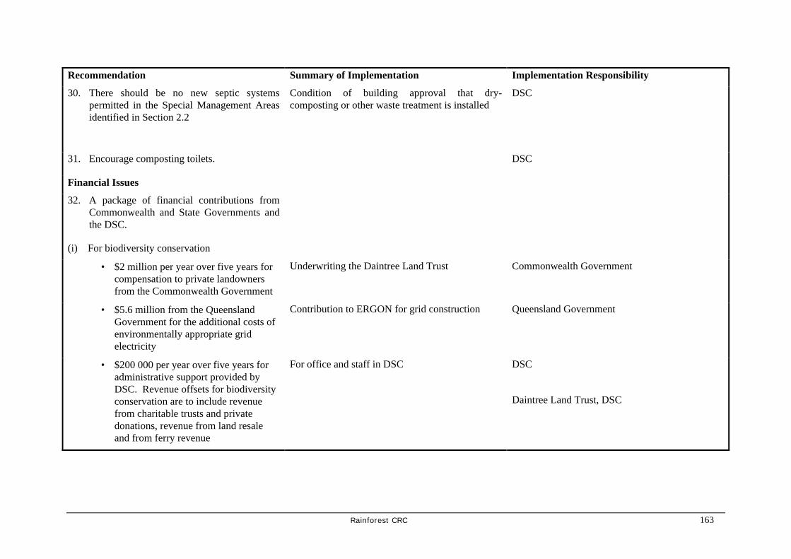
Rainforest CRC 163
Recommendation Summary of Implementation Implementation Responsibility
30. There should be no new septic systems permitted in the Special Management Areas identified in Section 2.2
Condition of building approval that dry-composting or other waste treatment is installed
DSC
31. Encourage composting toilets. DSC
Financial Issues
32. A package of financial contributions from Commonwealth and State Governments and the DSC.
(i) For biodiversity conservation
• $2 million per year over five years for compensation to private landowners from the Commonwealth Government
Underwriting the Daintree Land Trust Commonwealth Government
• $5.6 million from the Queensland Government for the additional costs of environmentally appropriate grid electricity
Contribution to ERGON for grid construction Queensland Government
• $200 000 per year over five years for administrative support provided by DSC. Revenue offsets for biodiversity conservation are to include revenue from charitable trusts and private donations, revenue from land resale and from ferry revenue
For office and staff in DSC DSC
Daintree Land Trust, DSC

164 Rainforest CRC
Recommendation Summary of Implementation Implementation Responsibility
(ii) For infrastructure and services:
• $400 000 per year for roads and ferry services funded by DSC ferry revenue
Normal DSC operations DSC
• $200 000 per year for local services funded by DSC rates
As above DSC
• $10 5 million to meet the community service obligation for electrical supply funded by the Queensland Government
Payment to ERGON Queensland Government
• $500 000 for industry and community development funded by external grant sources. Revenue offsets for service provision are to include equitable user payments for electricity, rates and for ferry use.
Applications to funding agencies Daintree Planning Group
DSC, Queensland Government
Management Arrangements
33. Signing of a Memorandum of Agreement between the three spheres of Government to endorse the (accepted) Daintree Futures recommendations.

Rainforest CRC 165
Recommendation Summary of Implementation Implementation Responsibility
34. The establishment of the Daintree Land Trust under the Queensland Land Act.
The Daintree Land Trust to manage a revolving land fund, to buy and sell land, enter into statutory covenants with landholders, accept gifts, donations and bequests of real and personal property and act as agents for other persons including the Commonwealth, the State and Local Governments in matters relating to land. Board of Trustees would consist of:
Local residents and businesses
Aboriginal Native Title holders
Douglas Shire Council
Commonwealth Government
Queensland Government
The Queensland Department (Minister) of Natural Resources
35. Establish a short-term Daintree Planning Group as a tripartite agreement between Federal, State and Local government underpinned by a 5 year funding agreement.
The Daintree Planning Group (an inter- governmental committee) as a tripartite agreement between Federal, State and Local government underpinned by a 5 year funding agreement Main functions would be to:
Advise the Trust on priority land management and acquisition arrangements.
Ensure that planning control frameworks are established
Oversee the implementation of community development requirements.
Provide economic development support and links into other programs and funding opportunities
Wet Tropics Ministerial Council

166 Rainforest CRC
4. References
Anderson, C., 1986. Aborigines & Conservationism—The Daintree - Bloomfield Road, Australian Journal of Social Issues 24 (3) August.
Australian Greenhouse Challenge Office, 1997: Workbook. The Greenhouse Challenge A Six-Step Guide to Developing your Cooperative Agreement. Canberra. AGCO
Beeton, R. & R. Bell, 1998. Evaluation of Daintree Rescue Package, Canberra, Environment Australia.
BPA Air Photography, 1997. Copy of Reference sheet for Mossman. (1:12 000).
Brannock Humphreys, 1998. Daintree Planning Package, Final Report to the Douglas Shire Council, Brannock Humphreys Planning and Environment Consultants, Brisbane, Queensland.
Brannock Humphreys, 1994. Douglas Shire Planning Scheme: Development Control Plan Planning Study Daintree - Bloomfield, Report to the Douglas Shire Council, Brannock Humphreys Planning and Environment Consultants, Brisbane, Queensland.
Brannock Humphreys, 1994. Douglas Shire Planning Scheme: Strategic Plan Planning Study, Report to the Douglas Shire Council, Brannock Humphreys Planning and Environment Consultants, Brisbane, Queensland.
Brannock Humphreys, 1997. Douglas Shire Planning Scheme: Strategic Plan Planning Study Tourism Report, Report to the Douglas Shire Council, Brannock Humphreys Planning and Environment Consultants, Brisbane, Queensland.
Brannock Humphreys, 1994. Daintree Planning Package. Report for Douglas Shire Council, Brannock Humphreys Planning and Environment Consultants, Brisbane, Queensland.
Brannock Humphreys. 1994. Daintree Planning Package: Summary & Recommendations, Report to the Douglas Shire Council, Brannock Humphreys Planning and Environment Consultants, Brisbane, Queensland.
Carroll and Donohue, 1994. An economic analysis of the costs and benefits associated with the supply of grid based electricity system in the Forest Creek area of the Daintree, Brisbane, Carroll and Donohue Economic and Policy Consultants.
CILC 1995. Landholders Information Kit, Forest Creek.
Crome, F. & L. Moore, 1993. Cassowary Populations and their Conservation between the Daintree River and Cape Tribulation, Vols I and II. CSIRO Division of Wildlife Ecology, Atherton
Cummings, W.S. 1997. Tourism Development in the Daintree Cape Tribulation Area. Report by W.S. Cummings Economic Research Services.
Cummings, W.S. 1992. Economic contribution of tourism to the Daintree/Cape Tribulation Area. Wet Tropics plan strategic directions supporting paper 15, Wet Tropics Management Authority.]
Department of Mines and Energy, Office of Sustainable Energy, 2000. Daintree Remote Area Power Supply Rebate Scheme Photovoltaic Rebate Program. Department of Mines and Energy, Office of Sustainable Energy, 2000

Rainforest CRC 167
Douglas Shire Council 1997. DCP-3 Accommodation Register.
Douglas Shire Council 1997. Inventory of Visitor Accommodation Capacity, Daintree - Cape Tribulation.
Douglas Shire Council 1998. Douglas Shire Tourism Strategy Research Report, Gutteridge, Haskin and Davey, Cairns.
Douglas Shire Council 1998. Douglas Shire Tourism Strategy, Gutteridge, Haskin and Davey, Cairns.
Douglas Shire Planning Scheme 1996. Part 1 - Strategic Plan, Part 4 - Development Control,
Duke, 1995. Daintree Rescue Package Community Information Strategy Draft. Prepared for Wet Tropics Management Authority
Eppell Olsen and Partners, 1996. Licuala Resort Cape Tribulation Traffic Assessment. Prepared for Naincio Pty Ltd, Eppell Olsen and Partners, Brisbane.
FNQ Management Services, 1998. SWOT Analysis: Daintree Region Tourism Development. Results of SWOT workshop, QTTC.
Future Supply Consultative Electricity Task Force, 1994. Queensland’s Future Power, A Report. Prepared for the Queensland Electricity Commission.
Gutteridge, Haskin and Davey, 1998. Proposed Daintree Powerline EIA Study (Report) Gutteridge, Haskin and Davey, Cairns.
Hollingsworth, Dames & Moore, 1991. Preliminary Impact Assessment Study Report: Daintree to Cape Tribulation 22kV and 12.7kV Distribution Powerlines and L.V. Reticulation, in: FNQEB, 1994. Queensland’s Future Power. Future Supply Consultative Electricity Task Force.
McColl, D. 1996, The Daintree Coast - A Quick Reference for Visitors and Residents, Wet Tropics Management Authority, Cairns, Queensland.
McColl, D. 1996. The Daintree Coast, Daintree Rescue Program, Cassowary Publications, Cairns.
McGrady, 12/1/2000: Letter to Ms P. Hewitt, Daintree Alliance.
McGrady, 1999. Reply to question on Notice No. 1253 from Mr.Malone to the Minister for.Mines and Energy. Queensland Hansard.
Moore, L., 2000. Preliminary Draft Regional Cassowary Management Plan Daintree. L.A. Moore and N.J. Moore Pty Ltd.
Moore/NRA, 1996. Cassowary Monitoring Program in the Daintree to Cape Tribulation Area: Stage 1 Daintree 15-27 July 1996. Stage 2 Cassowary Monitoring Nov-Dec 1996. Prepared for Wet Tropics Management Authority..
Moore/NRA, 1996. Cassowary Assessment at Two Sites (Central Cow Bay area, Daintree). Prepared for Siteplan, Cairns.
Nielsen, L 1997. Daintree - Jewel of Tropical North Queensland, PO Box 55, Mt Malloy QLD.
Queensland Parks and Wildlife Service, 1999. Draft Strategic Plan for the Conservation of the Southern Cassowary 1999-2001. Brisbane, Queensland Parks and Wildlife Service.

168 Rainforest CRC
Review Steering Committee, 1998: Aboriginal Involvement in the Wet Tropics World Heritage Area, Cairns, Wet Tropics Management Authority.
Spencer, 1994. Daintree Power Survey. Australian Tropical Research Foundation.
Spencer, H. J and Cowie, J., 2000. Daintree Power Survey 1999-2000. Cape Tribulation Tropical Research Station.
Walden, G., and Behrendorff, G., 1999. Queensland remote area power supply trials. Electricity Supply Association of Australia, 5th Renewable Energy Technologies and RAPS Conference, Cairns, August.
Wet Tropics Management Authority, 1998. Wet Tropics Management Plan. WTMA Cairns.
Wet Tropics Management Authority, 1996. Cape Tribulation-Daintree Draft Management Plan
Wet Tropics Ministerial Council Meeting No 8, 1994, Daintree Rescue Package Implementation Strategy
Wet Tropics Management Authority, 1998. Wet Tropics Management Plan. WTMA Cairns.
Wet Tropics Management Authority, 1996. Cape Tribulation-Daintree Draft Management Plan
Wet Tropics Ministerial Council, 1994, Daintree Rescue Package Implementation Strategy

Rainforest CRC 169
Daintree Futures Study
APPENDICES
Appendix 1:Maps 170
Appendix 2:Daintree Community Consultation and Publicity 171
Appendix 3:Daintree Indigenous Issues Contacts 175
Appendix 4:People Making Submissions to the Study 177
Appendix 5:Specific Comments on Report by Landholders 181
Appendix 6:Overview of Comments form Government Agencies 197
Appendix 7:Roadway Capacity (Eppel Olsen) 202
Appendix 8:Suvey of Self-Drive Visitors to the Daintree Rainforest Area North of the Daintree River Survey of Self Drive Visitors (Greiner and Walker) 205

170 Rainforest CRC
Appendix 1: Maps

Rainforest CRC 171
Appendix 2:Daintree Community Consultation and Publicity

172 Rainforest CRC
Appendix 2:Daintree Community Consultation and Publicity Date Activity Comments 14 January 2000 Inaugural Steering
Committee Meeting Community Reference Panel concept agreed
1 February Individual meetings Key Community Stakeholders and Reference Panel Members
17 February 2000 Public Notice Port Douglas and Mossman Gazette Study Announcement
Week ending February19 Press coverage Port Douglas and Mossman Gazette
Cairns Post and Port Douglas and Mossman Gazette
28 February 2000 Steering Committee Scheduled
Postponed due to Cyclone
3 March 2000 Additions to Community Reference Panel
Requested by Community member of Steering Committee
8 March 2000 Additions to Community Reference Panel
Requested by Community member of Steering Committee
13 March 2000 Bloomfield Catchment Co-ordinating Committee/Wujal Wujal representatives meeting at Wujal Wujal
15 March 2000 Steering Committee [Rescheduled]
Community Observers present
24 March 2000 Community Newsletter Circulated by email Daintree News Group School newsletter Community Reference Panel and other community contacts
30 March 2000 Community Information and Liaison Group [CILG]Meeting Diwan
Additions to Community Reference Panel
Requested by CILG
30 March 2000 Public Notice Port Douglas and Mossman Gazette
Advertising Community Information sessions on April 5 and 6
30 March Press coverage Port Douglas and Mossman

Rainforest CRC 173
Date Activity Comments Gazette
31 March Web site available Via University of Queensland server
5 April 2000 Mossman Bowls Club Community Information session
10 participants
6 April 2000 Daintree [Diwan} Community Information Session
Cancelled at direction of Douglas Shire due to cyclone warning
9 April 2000 Community Forum at Alexandra Bay State School
120 participants Organised by Allen Sheather and Neil Hewitt Facilitated by Ross Craig
28 April 2000 Steering Committee 5 – 13 May 2000 Newsletter Circulated by
email Daintree News Group School newsletter Community Reference Panel and other community contacts and Special Interest Groups
Advising of Community Information sessions on 28/29 May and providing study update
13 May 2000 Daintree [Diwan] Community Information Session
15 participants
25 May 2000 Public Notice Mossman and Port Douglas Gazette
Advertising Community Information Sessions at Diwan and Mossman 28 and 29 May
25 May 2000 Press coverage Port Douglas and Mossman Gazette
26-29 May 2000 Community Service Announcements re Community Information Sessions at Diwan and Mossman
ABC local radio and Port Douglas radio
28 May 2000 Daintree [Diwan] Community Information Session
30 participants
29 May 2000 Steering Committee 29 May 2000 Briefing to Douglas Shire
Council
29 May 2000 Mossman[ Douglas Shire Council] Community Information session
4 participants
29 May – 15 June 2000 Availability of Progress Report
Multiple contacts to Steering Committee

174 Rainforest CRC
Date Activity Comments 166 copies sent to Daintree area
community members, Study Team, WTMA and local politicians
16 June 2000 Steering Committee Community Observers present
24 July 2000 Steering Committee Community Observers present
18 August 2000-18 October 2000
Period for Public Comment
198 Submissions received in response to mail out of documents to all land owners.
26 August 2000 Cairns Consultation Meeting
2 participants
27 August 2000 Daintree Consultation Meeting
13 participants
28 August 2000 Cairns Consultation Meeting
1 participant

Rainforest CRC 175
Appendix 3:Daintree Indigenous Issues Contacts

176 Rainforest CRC
Appendix 3:Daintree Indigenous Issues Contacts Date Activity Comments 31 January Cape York Land Council
briefing Advice that indigenous interests were unlikely to be represented on Steering Committee pending resolution of native title claims
10 March – 4 April Attempts to seek contact with Mossman Gorge Community
Unsuccessful Advice that traditional owners not yet ready to talk about Study pending Tenure Resolution issues
13 March 2000 Bloomfield Catchment Co-ordinating Committee/Wujal Wujal representatives meeting at Wujal Wujal
15 March 2000 Apologies from Wujal Wujal representatives for non attendance at Steering Committee
16 March 2000 Meeting with EPA Manager Cultural Heritage
Confirmation of cultural issues and available documented cultural record
24 March 2000 Community Newsletter Circulated
17 April – 18 May 2000 Discussions with Tenure Resolution Group Dept of Premier and Cabinet
Confirmation of timetable for tenure resolution as being well beyond Study horizons
15 May 2000 Offer of briefing to Mossman Gorge Community
No response
15 May 2000 Newsletter Circulated August/September 2000 Phone calls offering
community briefing
19 September 2000 Formal correspondence to Mossman Gorge and Wujal Wujal communities offering community briefing
Phone advice that communities were considering report but had not determined need for briefing.

Rainforest CRC 177
Appendix 4: People Making Submissions to the Study

178 Rainforest CRC
Appendix 4: People Making Submissions to the Study 1 Brian Searle 2 Brian Hewett 3 Louise Sinclair_Smith 4 K.F. & S.P. Hellwege 5 KJ & P Hands 6 Amanda Varcoe and Gary Dodson 7 John Groffen 8 Bill Yates 9 H. Clemo 10 Dr Peter M. Heise-Pavlov & Dr Sigrid
R. Heise-Pavlov 11 Philip Smith 12 Neecie Burgess 13 P.J. & P. Holt 14 P. Cook 15 John Carlsen 16 Lyndon & Doreen Ferry 17 Baileys Creek Community League Inc. 18 Dave Gregory 19 Chair, Landholders and Neighbours
Liaison Group 20 Kev & Lisa Crosby 21 Helen Coffey 22 K.J. Paterson 23 Dr P and Mrs P Holt 24 Janet Bell 25 Stephen Millar 26 Chris Bennett 27 Ric Otton 28 Peter Baxendell 29 Vicki Thomas 30 Prof. Brian Roberts 31 EJW & ME Crosby 32 Russell Brooke 33 Wendy Maddocks 34 Peter and Nanette Pendergast 35 AH & MH Shields 36 Mark Vockler 37 Daintree Alliance Inc. 38 Marion Esser 39 Dr Hugh Spencer 40 Stephen Donato 41 Margaret Whitfield 42 Allen Sheather 43 Mrs V Davis 44 Sonny & Winsome Montgomery 45 Sonny & Winsome Montgomery 46 Lincoln Emms
101 David Perkins 102 Cherylann Childs 103 Noel Ryan 104 Noel Ryan 105 Alexander Riddell 106 Marjorie Riddell 107 M.R. Schwab 108 M.R. Schwab 109 Jenny-Anne Dillon 110 Jenny-Anne Dillon 111 Jenny-Anne Dillon 112 Jenny-Anne Dillon 113 Ernest Peter Dillon 114 Ernest Peter Dillon 115 Ernest Peter Dillon 116 Ernest Peter Dillon 117 Phillip Orth 118 Leonard Clarke 119 Jacqueline Jones 120 David Jones 121 Josh Jones 122 Rebecca Jones 123 Laura Clark 124 Michele, Stephen and Daniel Lamond 125 KP & PA Schulze 126 Peter Jones DCILGPS 127 Des & Jean Howard 128 Geoff Watson 129 Mrs Ildi Baran 130 Jennellda Harlow 131 Daintree Area Mains Power
Association 132 Bloomfield Yalanji Catchment
Coordinating Association Inc. 133 Val Schier 134 Patricia Sherrell 135 Andrew Spooner 136 Tim Henderson 137 Ms C Wright 138 Russell Lynch 139 Cynthia Lynch 140 Sue and Stephen Craig 141 David and Helen Cooper 142 Bill Selge 143 Elaine Johnson 144 Don & Judith Matthews 145 Ernie and Jenny-Anne Dillon 146 Peter Brooke

Rainforest CRC 179
47 Sue Pickup 48 Nigel Carney 49 Neil Hewett Community
Representative 50 SJ Nissila 51 Jan & Soni Freeman 52 Brian & Kathy Berzinski
Jack & June Connolly 53 T & E Goodwin 54 Carmen Fabro & Gilles Germain 55 Dixie Phillpot 56 Daintree Rainforest Taskforce 57 Alan and Lyn Barwick 58 David and Marney Gordon 59 John Nicholas 60 Fred Brendecke 61 Neil Hewett Cooper Creek Wilderness 62 John Carr 63 Gaylene Sheather 64 Bob Owen 65 James Wegner 66 Peter Rabig 67 GW Palmway 68 Robert Henham 69 Bodo Wintergerst 70 Jeda White 71 Tamlin Harris 72 Frank Moore 73 Antony Tunks 74 Dianne Munro 75 Shaun Stannett 76 Coral Sullivan 77 Steven Higgins 78 Ressurrecion Freeman 79 Mr T Dean 80 Mr T Schibrowski 81 Bruce Ree 82 Neil Leavis 83 Edward Green 84 B Crabb 85 Michael Lilley 86 Nathan Dalton 87 J McIntosh 88 Barry Gamble 89 John Grigoriadis 90 Donald Bromley 91 Philip Rice 92 Carl Johanson 93 Neil Pese
147 Jim Rea 148 Steve Lamond 149 Douglas Shire Council 150 R. Windley 151 D. Seare 152 Joseph Constable 153 Diana Price 154 Dean Schacher 155 Edward Sullivan 156 Victor Hobman 157 William Rankin 158 Anne Colquhoun 159 Rod Colquhoun 160 Alan Barwick 161 Mr Nicholas 162 Robyn Begg 163 Jamie Wilson 164 John Hall 165 James Thompson 166 H & D Richards 167 Sharon Gerrard 168 Frances Mills 169 Toni Martin 170 John Martin 171 Margaret Schafer 172 Bill Schafer 173 R Mulders 174 Grant Redshaw 175 Rosemary D’Arth 176 Kevin Jones 177 Ben Ingram and Karen Barrett 178 Dennis Verri 179 Department of Natural Resources 180 Robyn Jones 181 Percy Neilsen 182 Peter and Cathy Billam 183 Craig Polkinghorne 184 CAFNEC 185 Wildlife Australia Branch,
Environment Australia 186 Murray Lumsden 187 Noel Wright 188 World Heritage Branch, Environment
Australia 189 Robert & Lynn Fisher 190 Ken Hardwick 191 Russell and Teresa O’Doherty 192 Marj King 193 Lynda Nicholas

180 Rainforest CRC
94 Ian Fenwick 95 Germain Ensnck 96 Renee Sheldrick 97 Eric Peters 98 Matthew Searle 99 Trevor Powell 100 P Kelly & K Larkin
194 Glenn Hutchings 195 Wendy Van der Walf 196 Ronald Rowlands 197 EPA/QPWS 198 Glenn Miller

Rainforest CRC 181
Appendix 5: Specific Comments on Report by Landholders

182 Rainforest CRC
Specific Comments on Daintree Futures Report by landholders, businesses, community groups
& the conservation sector
(numbers in brackets denote submission #, a slash between numbers eg 24/45 represents form letters or submissions, a dash between numbers eg 150-176 represents a large block of form submissions) • broadly support most recommendations (1,8,20,29,30,32)
• were some acceptable and achievable recommendations (19,60,63,17)
• happy to see area properly managed (36)
• support “do-nothing (181,182,189)
• report should be rejected (181, 150-176, 124, 46, 66-123, 145, 137, 138), is not endorsed (39, 38, 51, 178) should be set aside (16, 54, 64, 127, 33) does not meet Terms of Reference (125, 127, 136, 180, 17/37)
• there is too much government intervention on freehold land/or want to reduce government intervention (2, 7, 18, 24/45/57/58/191, 27, 38, 44, 51, 53, 54, 124, 127, 33, 17, 186, 187), which leads to community tension, disruption and family disintegration (33) and uncertainty over land (27), land in Daintree currently unsaleable (8, 31, 40, 186), constant surveys and fear of outcomes has caused community division, anger and stress (189) there has been too many plans/ or too much money spent on projects (2, 60, 124, 125, 127, 142, 145, 26, 186, 189, 193)
Community Development
Recommendation 1: Future residential settlement allows for growth within ecological constraints to a forest residential community of approximately 1400
FOR • many studies have now recommended at least a 50% reduction in settlement density (63)
AGAINST • no evidence to substantiate this (142), recommended density criteria is arbitrary (54), no
rationale for 1200-1400 total community (136,39), submission 39 states that FNQEB EIAS recommended 1160 and believes it should be fewer
Recommendation 2: Improved Employment Opportunities for residents based in nature based tourism and to a lesser extent tropical horticulture.
FOR • existing larger businesses should be encouraged to employ locals (39)

Rainforest CRC 183
• Daintree is an ideal place of organic and biodynamic farming, there are existing regulations for organic farming and farmers should not be subject to additional regulation (54)
• farming needs to be encouraged (193)
AGAINST • tropical horticulture is not sustainable, escape of seeds alters environment (39)
• primary industry does not seek to clear rainforest for expansion, it does seek protection from those who would like to expand tourism and conservation (59)
• report fails to recognise employment needs of the community (33)
COMMENTS • NB there are significant comments regarding tourism in under Recommendations 15 & 16.
• concern that primary industry submission to initial part of study has been ignored (59), has been overlooked (17/37), primary industry should be recognised as secure and profitable and as complementary to tourism (17/37), primary industry is a major provider of employment in the area. Farmers need security of tenure to have successful businesses, ecotourism is a much more unstable industry than primary industry, eg the effect of the pilots strike. Tourism and conservation alone cannot employ 600 people (59)
• tourism focus is very narrow, there is a lack of analysis of employment opportunities for internet/IT professionals who would be attracted by the lifestyle (177,192)
• Concern that based on prior experience with DSC (10) home based development of nature based tourism facilities will not occur. Conditions placed by DSC on a permit to develop a forest living experience negated the experience these people were trying to create.
• 1998 EIA study quotes that DCP3 “will actively discourage development of housing in control plan area by d) not allowing or facilitating development of new employment activities (125, 133)
• believe land has been rezoned for organic farming (178)
• Chairman of Organic Farmers Association Andre Leu, resident of area, not contacted (39)
Recommendation 3: Expansion of primary service for the community and improved outreach services from Mossman
FOR • boat ramp needed north of the River, suggest Cooper Creek (43,193)
COMMENTS • small size of recommended community is not big enough to attract most services (142)

184 Rainforest CRC
• there are no facilities for youth (?)
• inventory of social infrastructure has omitted Alchera aged nursing homes, housing commission housing in Mossman, “Stella Maris” in Port Douglas, private dental facility at Mossman Hospital, Centrelink, Mossman Courthouse, Coral Coaches (?)
• DSC has had high rates for no services, particularly as the majority of landholders are absentee and do not use services (196)
Recommendation 5: Building guidelines should be revised for area
FOR • supported (39),
• suggest development of a building guide citing problems and solutions experienced by existing residents (50)
AGAINST • building guidelines limit options for developing quality lifestyle, recommendations regarding
solar, water, sewage etc effectively double the size of the footprint needed for settlement (182)
• building setbacks should be based on visibility from the road, topography and botanical audits, not be set at 50m (26,56)
COMMENTS • non-landowning residents/squatters damage environment, live in substandard housing and are
not regulated/held accountable (142), existing substandard housing without water or proper toilet facilities should be dealt with (44)
• report should promote architecture designed to “breath” with the rainforest and recommend assistance with retro-designing buildings to function effectively in the environment (148)
Recommendation 6: Establish a land use and development control regime which sets upper limits on overall settlement density and has specific biodiversity conservation, settlement pattern and economic provisions.
FOR • supports altering World Heritage Boundary in the Upper Cooper Creek precinct (10).
• support reduction in development rights (12), support reduction in population (146)
• future development should take place where is will have minimal loss of biodiversity (30, 24/45/57/58/191, 17/37)

Rainforest CRC 185
• welcomes opportunity to purchase neighbouring blocks which in this person’s case will to create a continuous corridor to National Park on eastern slopes of Thornton Peak (30) also supported by (20)
AGAINST • strong objection (140), not supported (142)
• do not support loss of 442 legitimate landowners (17/37)
• there should be no covenants or CMAs (43,54,183)
• object to potential loss of development rights/ reduction in land owners rights (2, 4, 5, 6, 7, 14, 16, 17, 19, 50, 54,25,27,28,35,41,43,44,45,51,66-123, 124, 125, 127, 129, 132, 134, 144, 145, 147, 150-176, 182, 17/37, 190, 194) options are intimidating (182) and threatening (187)
• concern that $10 000 ex gratia payment not adequately covering investment in land, improvement and rates, or is completely unacceptable ie market value should be paid (2, 4, 5, 6, 7, 8, 9, 13, 17, 18, 21, 22, 23, 41, 50, 54, 27, 31, 34, 36, 40, 43, 44, 45, 47, 125, 129, 134, 143, 144, 145, 146, 147, 150-176, 180, 182, 183, 186)
• does not think $10 000 “walk away” will attract landholders (30)
• landowners bought for retirement and did not intend to develop within 5 years (4, 5, 7, 9, 13, 16, 18, 25, 28, 29, 34, 36, 44, 46, 47, 128, 144, 182) or intend property to be part of kid’s inheritance (51, 53, 124, 145)
• uncertainty created by report devalues land (182)
• as neighbouring blocks of submission #34 are government owned, sees the Report as recommending government obtaining freehold land (34)
• does not support 5 year limit on building applications (41,54,29,31,129,144,192), reject “use it or lose it” (124)
• landowners who apply for building permits who first have to get vegetation clearance permission, soil tests etc and then may still have their plans rejected due to the area already reaching maximum settlement (41), study prejudiced against those who have not yet settled land (41)
• concept of “use it or lose it” has caused panic among landowners and penalises landowners who have not yet developed their land (24/45/57/58/191) and landowners who are unable to develop in next 5 years discriminated against (51), there is no legislative basis for 5 year limit (184)
• object to 5 yr limit on development - forces them to develop faster than they proposed to do in order to not lose money (184,187). Are concerned that a time limit will decrease their ability to develop in an environmentally sensitive manner (52,127,136,145,182), will create boom of development (130) proposed loss of development rights may cause cheap houses to

186 Rainforest CRC
be built with no regard for local conditions, area of low employment opportunity means many will not be able to afford to beat 5 year limit (50), advantages wealthy over poor as banks will not lend to develop on land without services (177)
• totally rule out compulsory acquisition of freehold land (60, 24/45/57/58/191, 17/37,189,195)
• “no nodes” (24/45/57/58/191) reject development of nodes (54,55,43,60,125, 146) and DSC’s three point plan (62, 178, 180, 181, 17/137)
• freehold land should not be incorporated into World Heritage Area (?)
COMMENTS • concern that the untried raft of strategies will be slow, high cost (135), complex mechanism
to sidestep buyback confusing and resisted as an imposition of free hold rights (39) and will not achieve biodiversity conservation outcomes (184)
• support buy back (9,13,15,18,39,42,130,135, 184, 186), a buy-back scheme would be the best and fairest mechanism for reducing settlement density. Reduction in development rights will be fought in court which will be costly and create bitterness and resentment (63), a swift buyback at federal level is the most sensible means to settle many issues (48), support voluntary acquisition of land (56,184) which ensures owners receive equitable returns on their investment (184), failure to support land acquisition on financial grounds is inconsistent given the Report’s support for mains power (184)
• no government support for buyback (124),no more land should go into World Heritage, ie no buyback (43)
• complementary tools to buy back include: covenants, CMAs, encouraging philanthropy through tax concessions, encouraging conservation foundations to buy land (42), support voluntary conservation measures (17/37), CMAs should be funded (56)
• appropriate tool is a “Coordinated Conservation Area” under the Nature Conservation Act (63,39,42), area should be declared as a “Coordinated Conservation Area (56)
• ability to donate land to appropriate trust or foundation should be included here as an option (26,56)
• there is no differentiation between guidelines for small blocks with residential development rights and large blocks that can develop large tourism facilities (182)
• not enough detail has been provided on priority conservation blocks (137)
• believes the report is recommending compulsory buy back for $10 000 after 5 years (46,125)
• proposed limited settlement means that 98% of landowners that have not yet erected dwellings on their land will not be able to do so (41)
• offering to pay market value for a property with no development rights is ludicrous (177)

Rainforest CRC 187
• believe the report recommends rezoning their “resort business” zone and do not support this (52)
• injurious affection through downgrading of rights should have been mentioned in the report as information for landowners (177), injurious affection can be triggered by DSC planning scheme changes (184), report makes no effort to estimate compensation payable due to injurious affection (184)
• submission 184 advises that if a Nature Refuge was declared under the Nature Conservation Act and it conflicted with a development approval under IPA then the IPA approved development would override the NCA.
• DCP3 should be revised to remove unfair restrictions and allow conservation management, residency, tourism and primary industry to coexist (17/37)
• two submissions propose a new chart illustrating an alternative Daintree Freehold Land Strategy (17/37)
• the above 2 submissions also propose an alternative structure for the Land Trust and believe one it’s key roles should be to identify vulnerable areas to be added to the protected area estate under a conservation agreement with the relevant land manager (17/37)
Conservation and Land Management
FOR • recommendations are supported on public land (129,33)
AGAINST • recommendations 7-10 regarding conservation of plants, animals and ecosystems on private
land are questionable as there is plenty of public land available for them (142)
COMMENTS • report fails to acknowledge changes in Commonwealth Environment and Biodiversity
Conservation Act 1999. Daintree lowlands should be considered for inclusion in “National Heritage List” (42)
• international conservation significance is inadequately described (26,184) concern that this may not be recognised by absentee landholders (?)
• recommendations regarding clearing are laughable considering Jindalba was built in vulnerable cassowary habitat (124)
• disappointed that “special management areas” do not have sufficiently prescriptive measures to retain their “specialness” (42)
• no specific actions for flora and fauna corridors (42,130), at least a priority acquisition area in Cow Bay be recommended (42)

188 Rainforest CRC
• the DSC should formalise arrangement with all land managers to ensure effective management control regardless of tenure (17/37)
• Ministerial Council should commission a report to determine how much the rainforest can tolerate (traffic, tourism) by an independent, eminent ecologist (128)
• astonished that the Study team would endorse minor clearing of understorey vegetation without employing the precautionary principle (26), should have an exhaustive list of species (184)
• Domestic animals
EXCLUDED • dogs must be excluded (12), detrimental domestic animals must be excluded (42), all
domestic animals that pose a threat should be excluded (26)
• visitors animals should be excluded (48)
NOT EXCLUDED • restrictions on keeping domestic animals is unreasonable, DSC should increase patrols
(17/37) and cat owners should keep cats inside (24/45/57/58/191), domestic pets should be allowed (43,127)
• suggest one dog per household and that the animal not be trained to kill rats which encourages them to kill other wildlife, heavy fines for roaming dogs, spaying female dogs (50)
• domestic animals of “feral element” a problem, not those belonging to locals (3)
• domestic pets should be under control of owners (17/37)
COMMENTS • there is insufficient information regarding risks from domestic fowl (50,135)
• visitors who wish to bring in dogs should get a DSC permit (17/37)
Recommendation 11: Improve the control of pigs on public land in the area • supported (16, 54,43,127,146, 17/37, 189), estimate existing pig population is 10,000 and
these are a major source of damage to the environment (54,146)
• develop pig DNA sterilising agent (146), suggest pig eradication program aimed at reducing population by 70% (17/37)
Recommendation 14: An immediate limit to further land clearing in the study area until the precinct plans are in place.

Rainforest CRC 189
FOR • the interim arrangements are a minimum (42), should be no clearing without complete
building plans submitted and passed together with complete site inspection (42), should be more timely and effective (26)
AGAINST • strong objection (140), leave freehold blocks alone (142)
• already exists in vegetation controls and DCP3, DSC should enforce own regulations (189)
COMMENTS • warning of panic clearing underway (12,39,42,127)
Tourism
Recommendation 15: Maintain the Daintree as a prime destination for Rainforest Tourism
FOR • majority of landholders happy to see tourism developed but some do not want to be involved
(127, 182)
• recognise the importance of tourism but warns that it’s long term viability is dependent on preservation of natural and cultural values (184)
AGAINST • concerns over the large increase in tourist numbers recommended (12,42,132,30,26,17/37,
184, 189) and whether the transportation required will reduce amenity of area (30)
• tourist number cap should be less than 740 000 (128,39) suggests 500 000 maximum (39), should be capped at current levels until assessment of current environmental impact of tourism use for the entire region is undertaken (184), should be re-evaluated (56)
• misleading for report to imply a reduction in the resident population would provide a better tourism experience (54), disagree with “controlling residential numbers in favour of visitor satisfaction (127,128,182), tourism industry disproportionately advantaged by report at expense of residents (7,142,182,189), report appears to have been captured by commercial tourist operators in Port Douglas and Cairns (16, 17,65 124)
• increased number of tourists speeding on roads are biggest threat to wildlife (24/45/57/58/191,127,128,189), and degrade areas (184)
• the increase in tourist numbers doubles the magnitude of environmental impacts, loss of residential amenity, risks to endangered fauna through increased traffic and low visitor satisfaction (65), importation of exotic seeds, spores etc and impact of rainforest due to
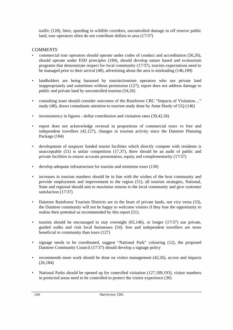
190 Rainforest CRC
traffic (128), litter, speeding in wildlife corridors, uncontrolled damage in off reserve public land, tour operators often do not contribute dollars to area (17/37)
COMMENTS • commercial tour operators should operate under codes of conduct and accreditation (56,26),
should operate under ESD principles (184), should develop nature based and ecotourism programs that demonstrate respect for local community (17/37), tourists expectations need to be managed prior to their arrival (48), advertising about the area is misleading (146,189)
• landholders are being harassed by tourists/tourism operators who use private land inappropriately and sometimes without permission (127), report does not address damage to public and private land by uncontrolled tourism (54,26)
• consulting team should consider outcomes of the Rainforest CRC “Impacts of Visitation…” study (48), draws consultants attention to tourism study done by Anne Hardy of UQ (146)
• inconsistency in figures - dollar contribution and visitation rates (39,42,56)
• report does not acknowledge reversal in proportions of commercial tours vs free and independent travellers (42,127), changes in tourism activity since the Daintree Planning Package (184)
• development of taxpayer funded tourist facilities which directly compete with residents is unacceptable (51) is unfair competition (17,37), there should be an audit of public and private facilities to ensure accurate presentation, equity and complementarity (17/37)
• develop adequate infrastructure for tourists and minimise tours (130)
• increases in tourism numbers should be in line with the wishes of the host community and provide employment and improvement to the region (51), all tourism strategies, National, State and regional should aim to maximise returns to the local community and give customer satisfaction (17/37)
• Daintree Rainforest Tourism Districts are in the heart of private lands, not vice versa (33), the Daintree community will not be happy to welcome visitors if they lose the opportunity to realise their potential as recommended by this report (51).
• tourists should be encouraged to stay overnight (65,146), or longer (17/37) use private, guided walks and visit local businesses (54). free and independent travellers are more beneficial to community than tours (127)
• signage needs to be coordinated, suggest “National Park” colouring (12), the proposed Daintree Community Council (17/37) should develop a signage policy
• recommends more work should be done on visitor management (42,26), access and impacts (26,184)
• National Parks should be opened up for controlled visitation (127,189,193), visitor numbers in protected areas need to be controlled to protect the visitor experience (30)

Rainforest CRC 191
• proposed Daintree Coast Land Trust (17/37) employ shire rangers to manage tourism, provide assistance, guidance and enforcement in area.
• propose that the DSC introduces cost-recovery strategies through tourism on a shire-wide basis by introducing commercial operations permits and placing a levy or bed tax on commercial business (17/37)
Recommendation 16: Maximise the opportunity for local land owners and business to participate in tourism in the Daintree
FOR • most of the following submissions support this recommendation but do not think the
report achieves it.
• supports forest stays for discerning tourists (20)
COMMENTS • support for changes to restrictions on Bed and Breakfast businesses in DSC planning scheme
(30), should be revaluation of scale and siting of tourism accommodation in keeping with the Brannock Humpheries proposed bed limits (56).
• report does not resolve problem of bed permits, many bed permits issued years ago are not being utilised because they have no development time limit leading to a deadlock for future, new projects (54), should be a limit of one guest per acre and bed limits should reflect this (146), more tourist beds needed (43), agree with redistributing bed permits and “use or lost” recommendation (12)
• current DSC controls on development are ineffective because they use existing bed permits to control development (127)
• fees should be paid at each site - if National Parks are unable to implement such a scheme then public facilities should be leased to private providers who can operate and maintain facilities without cost to the taxpayer (17/37)
• the report does not present estimates of “current” or “maximised” returns to the local community (26)
Recommendation 17: In order to distribute visitor use across the new and existing visitor sites … resolve permit moratorium …provide opportunities …
Recommendation 18: Construct a high quality website for Daintree tourism promotion and direct marketing. • why? this technology is already utilised in Daintree (54)
• reasonable suggestion (142)

192 Rainforest CRC
Aboriginal Land and Cultural Heritage
CONCERN REGARDING LACK OF INDIGENOUS INVOLVEMENT • negligible Aboriginal involvement and their aspirations are not reflected in the Report (65,
132, 26), believes cultural heritage was deliberately omitted (26)
• future indigenous settlement numbers not addressed - what happens if the 1400 cap is reached before indigenous people have the opportunity to settle? (177)
CONCERN REGARDING ABORIGINAL INTENTIONS IN DAINTREE • believe there was no Aboriginal interest in land until tourism industry showed financial
potential (127)
• Native title issues have no jurisdiction over freehold land (127)
• warns that Aboriginal land title aspirations are not necessarily compatible with “our” long term conservation objectives (39)
• suggestion of subsidies for setting up Aboriginal businesses discriminating against others who have no access to assistance (127)
Electricity Supply
Recommendation 20: Assuming the introduction of mechanisms to limit development in the Daintree and thereby protect its ecosystems, construct a hybrid grid of overhead and underground power lines as far as Cooper Ck.
FOR • services and regulations must be equitable throughout the shire (17/137)
• support recommendations (129, 186, 189, 193), support mains power if provided in an appropriate manner complimentary to the environment and at a comparable price to the rest of QLD (24/45/57/58/191, 142, 127, 125, 53, 44, 43) because of high levels of monitoring, maintenance and investment required for solar power (44), support mains if population cap is enforced (130), overhead powerlines of any length would reduce the amenity of the area (10), no environmentally or scenically appropriate, must be completely underground (141,142)
• if mains power does go through please ensure Turpentine Rd and Stonewood Rd have underground power and there is no clearing for powerlines in these sensitive areas (50). These two areas have high biodiversity values and residents are encouraged not to clear land so Ergon shouldn’t be able to clear land for overhead powerlines.
• suggest Carbeen Rd become private from beginning of special management area and have access to mains power (20)

Rainforest CRC 193
AGAINST • report does not demonstrate grid mains power is “appropriate” or a desired outcome (26, 84),
26 goes on to argue that grid power is recommended for economic reasons only (26)
• does not support/ or rejects recommendations regarding grid power (42, 184), supports solar only (11), mains power will put catastrophic pressure on unprotected rainforest (184)
• grid power flies in face of political, financial and environmental reality (39), this recommendation outside state funding policy and residential capacity to afford it (26,184), 26
• presents comprehensive table to illustrate point on page 14 of submission, is not supported by current government (124), report will not be accepted by government due to power recommendations (10),
• supports renewable energy options (184)
• strongly disagree with the statement on page 101, 2nd para “Not providing grid electricity will lead to reduced environmental tourism opportunities and therefore economic development in QLD” (10).
GENERAL COMMENTS • recommendations regarding north of Coopers Creek severely impact business (136), reject
the stopping of grid north of Coopers Creek as 12 of 13 freeholders won right for Thorntons Beach to be included in power plan (145), unfair that residents north of Cooper Ck will not have access to mains electricity (54)
• QLD ALP discriminating against residents north of the river by denying power (127), power issue airs much political dirty laundry (142)
• drainage pipes and telephone cables have been buried, why are power cables so different? (142)
• why would Ergon supply power to community whose development potential has been reduced? There would be a much lower return on their investment (35, 127, 131, 142, 180, 26,189, 195), Study compromised because Ergon wants to excise the area from their distribution zone (184, 24/45/57/58/191)
• concern regarding trees growing into overhead powerlines, has heard that trees are sprayed with growth retardant hormone sprays (50)
• figures used to calculate costs need to be revisited as the “Australian green house gas office” has cut back on rebates for RAPS (55)
• proposed mains connection and annual fees disadvantage residents (54)
• reject linking provision of grid mains to reduced settlement and implementation of biodiversity conservation measures (60)

194 Rainforest CRC
• Hugh Spencers power survey is suspect and taints report as main participants are well known anti-power people (127), survey poorly conducted and open to misinterpretation and misuse (33)
• gas fridges very costly to run with gas prices rising from $49.50 to $71.50 per bottle in last 12 months (127)
• bought blocks with the assurance that power would be available in x years (3,9,28)
• report should recommend greater use of renewable energy technology (184, 192), and promote energy efficient appliances 12/24V (48)
COMMENTS ON RAPS
POSITIVE • very specific comments regarding private RAPS in submission 39, pages 7-10
• private generators do not run 24 hours per day (page 99), this residential generator runs 8-10 hours per week even during the wet season (10)
• report should recommend RAPS be extended and promoted to resident and business users (48), and support education services to use them (184,192)
NEGATIVE • RAPS are 75% reliant on generator power (supporting graph attached to submission 125),
RAPS not appropriate because of high cost, high maintenance, loss of tax concessions and lack of sunshine hours (125,127), lead acid batteries required for RAPS to work are hugely environmentally unfriendly (142), RAPS very costly to run with high replacement value and loss of government subsidy (33)
• Regarding the green grid proposal: Existing batteries have a maximum of 5 years life left. Replacement of 12 batteries @$680 each is $8160. These will not be replaced in 2005 if have access to mains power, consequently there will be no green grid (24/45/57/58/191),
• RAPS in an area which is cloudy most of the year is “laughable” (53,127) not practical (142) unsatisfactory (189, 33)and generators pollute surrounding rainforest (33)
Roads and Ferry • support recommendations (129,141)
• inaccuracy of visitation figures compromises these recommendations (26)
Recommendation 22: The ferry will continue to serve residents and local business needs.

Rainforest CRC 195
FOR • supports having ferry (3) and spreading demand throughout the day (39)
• there should be no increase in size or capacity of the ferry (15)
• priority lane for use by residents is essential (142,146)
• ferry should be 1st come, 1st served (43, 193)
AGAINST • a bridge should replace the ferry (35, 193) or a bridge should be built with the ferry left for
tourists (24/45/57/58/191), or one way ferry and other way bridge (43) or only should be bridge if cannot have 2nd ferry (146), feasibility of a bridge should be investigated (17/37)
COMMENTS • suggest a second ferry (146, 17/37)be for use by local and residents leaving one ferry
specifically for tourism (30, 24/45/57/58/191)
• there should be no bridge (39)
• report does not address ferry capacity while recommending increasing tourism numbers (54)
• there should be a comprehensive data capture and analysis system developed for ferry (26, 56)
Recommendation 23: All roads and road corridors will by sympathetic to the environmental sensitivities of the areas through which they pass.
FOR • support concept of green tunnel (15), for reducing barrier effect of road on small terrestrial
animals and some birds and suggest provision of animal underpasses (39)
• support for effective speed humps for reducing cassowary mortality (15)
AGAINST • sightlines will reduce concept of “green tunnel” (39)
• there should be no green tunnel (142, green tunnel is not safe, danger to vehicles from falling trees (35), not safe for pedestrians and cyclists (128)
COMMENTS • there should be composting toilets available on the north side of the ferry (35)
• roads should be constructed in such a way to encourage bikes and pedestrians (128,193)

196 Rainforest CRC
• road over Alexandra Range should be gazetted and made more safe (35, 193), all roads should be upgraded to Department of Transport standard (43, 193)
• Encourage reopening of the blocked off overflow channel of Little Cooper Ck caused by the current turning circle at the end of Turpentine Rd. The remainder of the road can turned into a private road (10) submission 128 presents a personal traffic report which is said to demonstrate that the Daintree Futures Report is incorrect, misleading and fallacious. Tourists do not take any notice of speed reduction signs for cassowaries but the worst offenders are council contracted trucks, tour bus drivers, food supply trucks and locals (128)
• residents should not be responsible for upkeep of “closed” roads
Recommendation 24: The ferry pricing structure should be… • stop escalation of ferry fees (145)
• cost of ferry tickets and residents concession have changed so figures in Report need to be amended (55)
• ferry pricing should be based on people and vehicle numbers (48)
• ferry creates a financial disadvantage to primary producers north of the river (59, 17/37)
• introduce subsidised public transport to entice people to use buses (48)
Recommendation 25: Retain Bloomfield Track for 4WD only.
AGAINST • disappointed that CREB track (I think this should be Bloomfield Track - EH) should be
retained as 4WD only (30)
• Bloomfield track should be upgraded for residents access to businesses and medical facilities (43,132, 193), support upgrade with strong controls and DSC maintenance (39)
COMMENTS • recommendations concerning the Cape Tribulation to Bloomfield Road are outside the TOR
(64, 65). It was never intended as a tourist road (64,65, 132) The most environmentally sensitive solution is to seal the road (64). This submission also includes an number of points clarifying history of road and questioning why the report preempts a Douglas Shire Council EIA on the road (132).
Recommendation 26: Use the ferry as an opportunity to collect revenue from tourists…
FOR • proportion of money from ferry should be allocated to Wet Tropics Management Authority
to contribute to conservation (48)

Rainforest CRC 197
• FITs should be charged more and tours should be encouraged to start from the northern side of the ferry (130)
AGAINST • a free ferry should be provided for all users (17/37, 189)
• free and independent travellers (FITs) should not be disadvantaged by increased fees and 2nd priority on ferry (127)
• no entry fee should be charged at ferry because it falsely advertises area north of the river as National Park (51,127), existing ferry fees are already seen as an entry fee to National Park (54)
• “unAustralian” to increase ferry fees to put money into a Land Trust (55), is unAustralian and negative competition put subsidise public sector management and infrastructure using ferry fees (54)
• higher ferry fees reduce likelihood of tourists spending dollars in local businesses (54), or stop tourists coming over the river (125, 145, 146)
• visitor fees and charges should be collected on-site not at ferry, revenue from ferry should benefit residents not tour operators (127)
COMMENTS • support park and ride (39), reject buses for FITs (145)
• free and independent travellers are most likely to stimulate local economy and report recommends using ferry fees to curb their numbers (54)
Water Supply and Waste Management • support recommendations (129)
• support reuse of grey water (39)
• rules should be the same as the rest of the Douglas Shire (142)
Recommendation 28 Rainwater Tanks • rainwater tanks should be optional (1)
• rainwater tanks should be compulsory (10) and use of any creeks or watercourses for domestic or commercial uses should be stopped.
• rainwater tanks significantly increases footprint of building site (39)
Recommendation 29 Septic water, water treatment systems to be monitored to

198 Rainforest CRC
ensure they meet environmental standards • sewage disposal on many properties contravenes health regulations and more inspection and
issuing of orders is required if the principle of ESD is to be met (30)
Recommendation 31 Encourage Composting Toilets • Encourage composting toilets when they are not attached to habitable residence. Encourage
1st deep drainage sewage systems and 2nd septic systems when attached to residences (1).
• supported (39)
• toilets should be included in building/residence (43)
Recommendations regarding Financial Issues
CONCERNS • arguments about reducing rateable income do not take into account the 5-1 increase in
rateable income in Port Douglas compared to the Daintree (42)
• report has relied on outdated economic date which has undermined outcomes (42, 26). Recommend an economic analysis be undertaken (42), believe figures in Daintree Power Supply EIAS are suspect (127)
• due to inappropriate electricity recommendation funding is disproportionately directed to power infrastructure over biodiversity conservation (26)
SUGGESTIONS • no rate rebates should be recommended (43)
• removing recommendations regarding power reduces cost of package, DSC does not need extra funding (42)
• there should be rate rebates for retention of viable forest (56)
• there should be active promotion of tax deductable land donations to Trusts and foundations listed on the Register of Environmental Organisations (56)
• there should be an equitable contribution from State and Commonwealth towards biodiversity conservation (56)
• the community proposal (17/37) attracts funding requirement of $16m over 4 years
Recommendations regarding Management Arrangements and Implementation
CONCERNS • “lost your marbles” (142)

Rainforest CRC 199
• not convinced that recommendations can be carried out with DSC as lead management body - have not enforced regulations regarding dogs, pig hunting, camping, clearing and building (63)
• recommendations are contrary to Integrated Local Area Planning, Integrated Planning Act, Environmental and Biodiversity Conservation Act and National Competition Policy (64)
• Daintree Land Trust should not be funded by Government (43), money should be found from corporations (146)
• fails to acknowledge and utilise the community as a valuable tool in solutions (17/37)
• reject intergovernmental committee (17/37, 187) in favour of Community Land Trust. No bureaucratic intervention other than maximum assistance (17/37)
SUGGESTIONS • local, state and commonwealth governments should heed this opportunity to work together as
they are encouraging the community to do so (63)
• support the Land Trust if the community plan (Baileys Creek Community League) for representation on the Trust Board is followed (?)
• a Community Council should be established with democratically elected members - it should operate as a sub-committee of the DSC (17/37)
• a Daintree Coast Community Land Trust be established to conduct all surveys, negotiations, conservation agreements and implement boundary changes (17/37) - specific details on operation provided in submission
Comments on Particular Precincts • support precinct approach (39,149), special management areas should be modified to include
comprehensive protection of rare and threatened species and maintenance of habitat (26)
• resident at Lot 174 Buchanan Rd says lats and longs are incorrect (3)
• general constraints in all precincts are unnecessary (124)
Hutchinson to MacLean Creek Precinct • a major cause of cassowary mortality is the high traffic flows on Baileys Creek Rd so that
plans to increase tourism (eg using the new boardwalk at Jindalba) are inconsistent with plans to conserve the cassowary population (16)
• the Sheather’s property is a good example of how development in the area including Black Bean Rd can take place with minimal impact, can improve rainforest quality and can take place on steep slopes with minimal impact (16)

200 Rainforest CRC
• submission #16 uses the 2 comments above to argue that any arbitrary constraint on settlement in this precinct is unnecessary
Hutchinson to Coopers Creek Precint • support for proposed % development of Hutchinson to Coopers Ck (30)
• recommendations to minimise driveway length for power provision contradicts biodiversity conservation outcomes (26)
Cape Tribulation Precinct • report does not afford protection to a significant area of complex mesophyll vine forest on
coastal alluvia/colluvia (26)
• 50m setback would require too much clearing (26), a better description would require buildings to be unobservable from main tourist route.
Cow Bay Precinct • special management area should include all properties north of Spurwood Rd between
Silkwood Rd and Quandong Rd (?)
Comments on Principles • concern that some recommendations match vision (26)
• report is essentially an economic planning document which has minimalist focus on rare and threatened species, regional ecosystems, biodiversity hotspots and allowable levels of land clearing (184)
PARTNERSHIP AND STEWARDSHIP • Report fails to develop concept of partnership between all stakeholders in the region (16,129)
• report does not give due respect for existing stewardship amongst residents/landowners (16,17, 24/45/57/58/191, 41, 59, 54, 38, 124, 125, 127, 144, 17/37, 189, 196), fails to acknowledge existence of established, developing community (33), increased forest on residential land compared with time of settling (17/37, 189, 196) stewardship will not occur without encouraging and education landowners (187)
• only a ground swell of support among the majority of landholders will achieve a pleasant and economically acceptable lifestyle in the Daintree (30)
• stewardship is a loose term used by some members of the community to argue against regulation when they are not actively managing land (42)
RESPECT FOR FREEHOLD TITLE • private land ownership and integrity of free hold title should be recognised as having
significant conservation capabilities (17/37)

Rainforest CRC 201
• covenants (182), recommendations regarding loss of development rights and “walkaway” contravene key principle of “Land restructure and management to achieve biodiversity protection must recognise legitimate land and property rights” (46, 178)
• legitimate land and property rights are not recognised by this study (65)
SUSTAINABLE RAINFOREST COMMUNITY • a sustainable rainforest community cannot be developed in an area where back stabbing,
spying, trespassing, money grubbing and exploitation exist (35), a lot of personal hatred, community fragmentation (3)
• report will destroy sustainable rainforest community (17)
MAXIMISING RETURNS TO THE LOCAL COMMUNITY • report limits development of new business ventures and therefore does not create
employment opportunities (51)
• recommendations do not “maximise returns to the local community” or are “for the benefit to the community” (54, 65 180), discriminates against residents (129)
• local community disadvantaged, outside interests benefit from report (54) report looks after the aspirations of the Cairns and Port Douglas tourist industry (65)
• Cape Tribulation residents must provide own power, water and sewage services, contrary to TOR which seeks “provision of appropriate services for residents” (182)
USE OF WORDS/TERMS • report incorrectly infers that total area of “Daintree” in National Park or World Heritage
listed (51) or the terms National Park and World Heritage have been misused (3, 24/45/57/58/191, 51, 53, 62, 124, 127, 33, 189), area is not clearly defined (33), parts of the report imply the Area is “World Heritage Listed” when much of it is not. eg “Another major consideration for half the visitors is the fact that the area is World Heritage listed” (24/45/57/58/191, 53), misleading or incorrect use of the term World Heritage (3)
• object to use of word “sustainable” as undeveloped buzz word (39), precautionary principle should have been included (39)
Other Issues • the Report does not address the use of native plants for medicinal/herbal purposes. This was
addressed in Suriname and French Guinea by directing profits back to indigenous people. This submissions suggests such money could go to the Land Trust for buying property and supporting ethno-botanical research (29)
• use of botanical names makes report difficult to read (127)
• would like to see Daintree resident elected to the DSC (10)

202 Rainforest CRC
• World Heritage listing is distrusted because of interference in daily lives and suppression of freehold rights (33)
• State and Federal governments should conduct an inquiry into the extent of government intervention in the Daintree area (17/37, 196)
Comments on the Process of Developing Report and Public Consultation
MEMBERSHIP OF THE STEERING COMMITTEE • community representatives on steering committee were not chosen by the community (55, 62,
125), were non-elected representatives (38) and did not report back to the community in an open manner (55), were not qualified (3), were not representative (127,180), should have been more community representatives (127,180)
• no primary industry representative (65, 180) or Bloomfield representative on Steering Committee (65)
CONSULTATION • there are people listed as being on the community reference panel were not contacted (55)
• absentee landholders were only asked to submit their concerns after the report was written (54)
• there has been a total lack of community consultation (146), lack of serious consultation in this and previous studies by Wet Tropics Management Authority and others (27), community consultation was erratic with short notice (54, 48), was not thorough (64, 125, 127), no consultation with some sectors while the rest was a token effort (17)
• no previous opportunity for input (13)
• DSC not committed to hearing the view of absentee landholders (142)
• were told that absentee landholders excluded by design (16), believe absentee landholders were deliberately omitted (54,125) absentee landholders not consulted, believes large numbers of absentee landholders did not receive any information during or after the study (196)
• disappointed that views of resident landholders seem to have taken precedence over absentee landholders (16), local residents only account for 32.5% of landowners so their views are disproportionately taken into account - they are not neutral as they have an established interest in the land (177)
PROCESS • lack of time to comment on TOR (65)
• unacceptable that an independent/external body is not evaluating submissions (64), lack of independent legal advisor (54, 180)

Rainforest CRC 203
• during public consultation period for report, answers to questions asked have been slow in coming and limited in scope (144)
• believes there was conflicts of interest - concerns include within and outside consulting team, GHD, Rainforest CRC, Douglas Shire Council and Wet Tropics Management Authority (64, 54, 16, 124, 125, 132, 146, 178, 37/17, 48)
• seriously questions GHD’s capabilities to deliver outcomes due to GHD being involved in delivery of electricity infrastructure around the world (48)
• Appendix 2 of the report lists people as making submissions to the Report who are certain that they did not contribute including a child (55) further comments on children on the list found in the following submissions (62)
• methodology was non-inclusive, alienating the community (?)
• does not support outcomes of community forum (39), does not support methodology used in workshop (48)
• support outcomes of community forum, their recommendations should be incorporated into the report (17/37)
• poor quality of report, lack of adequate data affects the quality of recommendations (48)

204 Rainforest CRC
Appendix 6: Overview of Comments from Government Agencies

Rainforest CRC 205
Overview of Comments from Government regarding the Daintree Futures Study
This is a short overview of general comments made in government submissions. Department of Communication, Information, Local Government and Planning (126) • have fundamental planning and development issues in relation to the study’s
recommendations
• doesn’t dispute need to conserve biodiversity
• the report has a substantial misconception of what the Douglas Shire Planning Scheme may lawfully regulate
• the entire planning process would have been better served by having professional planning input from the outset, particularly from the perspective of the Integrated Planning Act 1997.
• has asked that the consultants reassess study in light of the specific comments they provide
Douglas Shire Council (149) • supports buyback, rather than the consultants’ model for biodiversity conservation
• believes increase in tourist numbers to 750,000 to high
• recognises own responsibility in implementing report and seeks meeting with the State and Commonwealth to discuss implementation of supported recommendations
• believes further consultation with stakeholders will be necessary
• Council supports most community views presented at the forum
Department of Natural Resources (179) •
• voluntary covenants are granted under the Land Titles Act 1994, not the “Land Act”
• report should recognise DNR’s role as a land management agency
• Recommendation 11 should be expanded to include a pest management officer
• reserves are not all available for conservation
• provides advice about the operation of a land trust
• state land could be transferred under Aboriginal Land Act 1991 therefore increasing resident population. This is not taken into account.
• rainwater tanks have the potential to provide poor quality water leading to disease problems, particularly with tourists

206 Rainforest CRC
• specific comments on Recommendations 27, 34, 35
Environmental Australia - Wildlife • no concerns regarding potential adverse affects of the planning scheme on rare and
threatened species and ecological communities
• supports measures planned for protection
• recommends developing lists of threatened species in each precinct and entire area
• would like to see expansion of Section 2.9.1.2 to include compliance provisions of EPBC Act
• there was no reference in the report to migratory species
Environment Australia - World Heritage • not yet received
EPA/QPWS joint submission (197) • believes report addresses TOR
• feels there is a lack of recognition of the link between provision of power and increased development
• specific comments on achieving conservation on private lands
• specific comments about management of public lands
• need for pigs to be controlled on public and private land
• would like to see a list and map of rare and threatened species and regional ecosystems. Impacts on rare and threatened frogs of particular concern.
• riparian buffer needs to be at least 50m
• there are also comments on permits, lack of Aboriginal involvement, mechanisms for implementation and management, road and ferry

Rainforest CRC 207
Appendix 7:Roadway Capacity (Eppel Olsen)

208 Rainforest CRC
ROADWAY CAPACITY
From: Eppell Olsen and Partners, 1996. Licuala Resort Cape Tribulation Traffic Assessment. Prepared for Naincio Pty Ltd, Eppell Olsen and Partners, Brisbane.
Level of Service
Level of service is defined as a qualitative measure describing operational conditions within a traffic stream, and their perception by motorists and/or passengers.
A level of service definition generally describes these conditions in terms of factors such as speed and travel time, freedom to manoeuvre, traffic interruptions, comfort and convenience and safety. In general, there are six levels of service, designated from A to F, with level of service A representing the best operating conditions (ie free flow) and level of service F the worst (ie forced or break-down flow).
Each of the levels of service can generally be described as follows:
• Level of Service A is a condition of free flow in which individual drivers are virtually unaffected by the presence of others in the traffic stream. Freedom to select desired speeds and to manoeuvre within the traffic stream is extremely high, and the general level of comfort and convenience provided is excellent.
• Level of Service B is in the zone of stable flow and drivers still have reasonable freedom to select their desired speed and to manoeuvre within the traffic stream, although the general level of comfort and convenience is a little less than with level of service A.
• Level of Service C is also in the zone of stable flow, but most drivers are restricted to some extent in their freedom to select their desired speed and to manoeuvre within the traffic stream. The general level of comfort and convenience declines noticeably at this level.
• Level of Service D is close to the limit of stable flow and is approaching unstable flow. All drivers are severely restricted in their freedom to select their desired speed and to manoeuvre within the traffic stream. The general level of comfort and convenience is poor, and small increases in traffic flow will generally cause operational problems.
• Level of Service E occurs when traffic volumes are at or close to capacity, and there is virtually no freedom to select desired speeds or to manoeuvre within the traffic stream. Flow is unstable and minor disturbances within the traffic stream will cause break-down.
• Level of Service F is in the zone of forced flow. With it, the amount of traffic approaching the point under consideration exceeds that which can pass it. Flow break-down occurs, and queuing and delays result.
Table 3.9 Maximum AADTs for Various Levels of Service and Types of Terrain on Two-Lane Two-Way Rural Roads

Rainforest CRC 209
K factor a Level of Service
A B C D E
Level Terrain
0.10 0.11 0.12 0.13 0.14 0.15
2 400 2 200 2 000 1 900 1 700 1 600
4 800 4 400 4 000 3 700 3 400 3 200
7 900 7 200 6 600 6 100 5 700 5 300
13 500 12 200 11 200 10 400 9 600 9 000
22 900 20 800 19 000 17 600 16 300 15 200
Rolling Terrain
0.10 0.11 0.12 0.13 0.14 0.15
1 100 1 000 900 900 800 700
2 800 2 500 2 300 2 100 2 000 1 800
5 200 4 700 4 400 4 000 3 700 3 500
8 000 7 200 6 600 6 100 5 700 5 300
14 800 13 500 12 300 11 400 10 600 9 900
Mountainous Terrain
0.10 0.11 0.12 0.13 0.14 0.15
500 400 400 400 300 300
1 300 1 200 1 100 1 000 900 900
2 400 2 200 2 000 1 800 1 700 1 600
3 700 3 400 3 100 2 900 2 700 2 500
8 100 7 300 6 700 6 200 5 800 5 400
a. K is the ratio of the design hour volume to the annual average daily traffic.
b. All values rounded to the nearest 100 vehicles per day. Assumed conditions include 60/40 directional split 14 percent trucks 4 percent buses. Percentages of length with no overtaking for level rolling and mountainous terrain of 20 40 and 60 have been assumed.
Source: TRB (1985) Table 8.10

210 Rainforest CRC
Appendix 8: Survey of Self-Drive Visitors to the Daintree Rainforest Area North of the Daintree River Survey of Self-Drive Visitors (Greiner and Walker) and Walker)

Rainforest CRC 211
1. Background to the survey
The coastal rainforest area north of the Daintree River is an important destination for visitors to Tropical North Queensland. A large proportion of the rainforest is part of the Wet Tropics World Heritage Area. Cape Tribulation, about 50 kilometres north of the river by road, is a historically colourful location and a backpacker heaven. Most people visit the area for a day trip, either by organised tour or, increasingly, by self-drive in either their own or hire vehicles. Sealing of the road between the Daintree River and Cape Tribulation in recent years has made the area accessible to hire vehicles.
Tourists obviously derive benefits from visiting the Daintree Rainforests. Two critical questions arise with important management implications for the region: Firstly, who are the FIT visitors to the region? Secondly, what is the value of the benefits that visitors derive from visiting the Daintree Rainforest?
Economists differentiate two types of benefits that can be derived from a ‘good’ such as a rainforest. They are use values and non-use values. The total value of an environmental good is the sum of use and non-use values.
Use values, such as the production of timber, are associated with direct and indirect consumption of an environmental good. Use values are derived from the current, expected or possible use of the good. The recreational value of a forest is a use value.
Non-use values do not involve the consumption of the good but refer to other benefits derived from its existence. Three kinds of non-use values are commonly distinguished: (1) Existence value is the value someone attaches to knowing something exists. (2) Bequest value captures the future benefit of a person’s descendants due to the good’s existence. (3) Altruistic value is the value associated with the well-being of someone else in general.
This research described in this paper set out to measure one specific aspect of the use values of the Daintree Rainforest north of the Daintree River, its recreational value for self-drive tourists.
The value of some uses which involve markets, for example in the case of timber production, can be estimated using price information. Value estimation for non-market values, including recreation, requires non-market valuation techniques.

212 Rainforest CRC
2. Methodology
In response to the challenge of measuring the non-market and non-use values of environmental resources, economists have developed several valuation techniques. The most commonly used techniques are the Travel Cost Method (TCM) and the Contingent Valuation Method (CVM).
This study uses Contingent Valuation to establish a demand function for self-drive visitation of the Daintree Rainforest area north of the Daintree River. The survey designed for this purpose also collected relevant variables to perform a travel cost analysis. This aspect of the project is not explored in this paper.
Contingent Valuation relies on surveys to elicit users’ valuation of their particular resource use activities (eg. visit to the rainforest), and to collect demographic or activity information which might be used as predictors for these valuations. The term contingent valuation is used because the questions directed toward users are ‘contingent’ on there being a market for the good in question.
The CVM can be used to estimate value by asking resource users to state their willingness to pay for use of a particular resource or their willingness to accept compensation for not using the resource. Data collected by the CVM are analysed by computing the mean of responses for a direct appraisal of the resource’s value, or regression models can be fitted to the responses for predictive possibilities. CVM accuracy is increased if participants are more familiar with the commodity being valued, they have experience making choices about the commodity, and if there is little uncertainty.
The CVM has several advantages over other methods. First, resource quality changes can be evaluated, multi-destination trips can be dealt with for recreation experiences, and congestion effects can be evaluated. As well, CVM questions can be designed to delineate consumptive, nonconsumptive, option, quasi-option, and existence values.
However, the CVM possesses several theoretical and practical shortcomings and two biases in particular need to be carefully addressed.
1. The estimates are susceptible to ‘anchoring bias’, also known as ‘starting point bias’ if people are asked whether they would be willing to pay a specified amount of money. A higher initial amount mentioned in the questionnaire leads to a higher estimated willingness to pay. This problem can be addressed by choosing a ‘referendum’ of closed ended format of CVM, whereby people are asked a willingness-to-pay question for a single sum which is varied among respondents. An average willingness to pay value can be calculated by observing the proportions of respondents who are willing to pay the varied amounts. However, problems remain with this method. In comparison to open-ended CVM procedure, the referendum tends to produce much larger estimates.
2. The estimates are susceptible to ‘embedding’. This refers to the fact that same good is assigned a lower value if the willingness to pay for it is inferred from the willingness to pay for a more inclusive good rather than if the particular good is evaluated on its own. There is a common tendency of people to give similar willingness-to-pay responses to more or less inclusive goods.

Rainforest CRC 213
3. Survey design
The Daintree Rainforest north of the Daintree River is accessible by road from the south and north. 99 per cent of self-drive vehicles to the area come from the south as access from the north is by 4WD only from remote Cooktown. The road from the south is interrupted by the Daintree River Ferry. All traffic into the area coming from Cairns and Port Douglas must cross the Daintree River via the Daintree River ferry.
The ferry constitutes a ‘bottleneck’ which is utilised for the survey in two ways. Firstly, it provides convenient access to car travellers as cars have to stop while waiting for the ferry. Second, a fee applies for crossing the river by ferry and therefore a ‘payment vehicle’ is in place that can serve as a basis for valuation questions.
The survey was administered as a face-to-face survey of the drivers of the cars lining up on the southern side of the Daintree River to get onto the ferry. Three survey periods of one week each have been concluded in July, September and November 1999, yielding a total of 927 valid responses.
The survey collected a range of variables characterising the visitor that are of relevance for tourism management. These variables included whether visitors were domestic or came from overseas, where exactly they came from, how long they stayed in the country and/or in the Port Douglas – Daintree Region; whether their trip across the Daintree River was a day trip; whether they had a hire car and what type of car; size and type of travelling party; what attributes brought them to visit the area north of the Daintree River.
Most importantly, though, the survey provided a non-market valuation of FIT access to the area north of the Daintree River. To this effect the respondents were asked some contingent valuation questions.
Before a valuation question was put to the respondents, proper ‘embedding’ was ensured to minimise any potential bias of the answers. First respondents were asked whether they knew that the current price for a one-way crossing was $7. Then a background briefing provided context and relevance of the question. Only then, the valuation question was asked. A ‘referendum’ or closed ended format was chosen for this question whereby people are asked a willingness-to-pay question for a single sum which was varied among respondents. Five ‘bids’ were offered at random which were $20, $30, $50, $70 and $100 for a one-way crossing. If respondents declined the first bid, a second bid at half the amount was offered. The final, open-ended question provided a chance to capture respondents that were willing to pay more than the accepted bid. The wording of the CVM section comprises questions 10 to 13 in the survey questionnaire as shown in Box 1.

214 Rainforest CRC
Box 1: Wording of the FI survey
Good Morning! Are you a visitor to the Port Douglas – Daintree Region? If YES, continue: While you are waiting for the ferry, would you be willing to participate in a short survey that will assist the management of this tourist destination. If YES, continue - and please fill in boxes rr àà nn What is your place of residence – Australia or overseas ? Australia r1 è What is your post code? . . . . Overseas r2 è What country?…… ……Assign to one of the following boxes: USA/Canada r1 Europe r2 Asia r3 New Zealand r4 Africa r5 other r6 è How long are you staying in Australia? <= 2 weeks r1 2-3 weeks r2 4-6 weeks r3 >6 weeks r4 How many days are you staying in the Port Douglas – Daintree Region ? Only today r1 2-3 days r2 4-7 days r3 8+ days r4 How many nights will you spend across the Daintree River? None r1 one r2 two r3 three+ r4 Where did you stay last night, in what town or location? Port Douglas / Mossman / Craiglie etc r1 Daintree Village / Wonga Beach etc r2 Cairns / Northern Beaches / Palm Cove r3 Other (please specify) r
4……………………….. What type of accommodation were you staying in? Read: Budget-type (backpacker, camping, etc) r1 3-4 star (motel, unit, B&B) r2 4_-5 star (luxury) r3 other (eg. friends, family) r4 How many people, including yourself, are travelling in the car? people What term best describes your travelling party? Read: Adult couple r1 Family group w children r2 FG w/o children r3 Friends/Relatives r4 Other r5. Is this a rental car? Yes r1 No r2 Record size of car: large r1 medium r2 small r3
eg 4WD Falcon Fiesta What are your main reasons for visiting the Daintree area north of the river? (Max 3) Read: Scenery/views r1 Rainforest r2 Cape Tribulation r3 Fact that this is a WHA r4 Wildlife r5 Remoteness/Isolation r6 4WD experience r7 Getting away from people r8 on way to Cooktown/Cape York r9 other (please specify) …………………. r10 Did you know that the price for a one-way Ferry crossing is $7 per car? Yes r1 No r2

Rainforest CRC 215
An increasing number of people choose to take a car across the Daintree River. During peak times visitors may encounter high traffic volumes and parking problems. The following questions deal with the hypothetical situation that the ferry price was increased. There is no intention whatsoever to increase the price. This is purely a way of gauging the value that people place on their visit to the area north of the Daintree River. If the price for a one-way Ferry crossing was $ 30/40/50/70/100 per car, would you still cross the River? Yes r1 è skip next question and go to Q 13 No r2 è go to next question If the price for a one-way Ferry crossing was $ 15/20/25/35/50 per car, would you cross the River? . Yes r1 No r2 What is the maximum you would be prepared to pay for a one-way ferry crossing? $ per car For the purpose of data analysis, I would like to ask you two more questions. Are you a member or financial supporter of an environmental society? Yes r1 No r2 Which of these categories best describes your / the main income earner’s occupation? Read: Professional or business owner r1 White collar r2 Skilled blue collar r3 Unskilled blue collar r4 Unemployed r5 School student r6 University or college student r7 Home duties r8 Retired r9 Refused r10

216 Rainforest CRC
3. Characterisation of the FIT travellers to the Daintree Rainforest north of the Daintree River
A good understanding of the visitors and their expectations is essential for the assessment and evaluation of possible management instruments. A statistical analysis of the survey variable was undertaken to help profile the FIT visitors to the Daintree Rainforest. A total of 927 surveys were analysed including 395, 411 and 120 for the survey periods in July, September and November 1999, respectively.
Overall, the ratio between domestic and overseas FIT travellers was 38% overseas to 62% domestic. In July and September, the dominance of domestic visitors was particularly pronounced (65%) while for November the ratio between domestic and overseas visitors was reversed to 40:60.
Of the domestic visitors, 37% were from Queensland, 26% from Victoria, 25% from NSW/ACT and, 5,4 and 2% from South Australia, Western Australia and Tasmania respectively.
Of the international visitors, 70% came from Europe, 12% from USA/Canada, 11% from New Zealand and less than 1% from Asia including Japan.
Table 1 outlines the reasons why respondents visit the Daintree Rainforest north of the Daintree River. ‘Rainforest’, ‘Scenery and views’ and ‘Cape Tribulation’ are the most important drawcards with 88, 87 and 80% of respondents nominating these attributes, respectively. The fact that the area is World Heritage constitutes a reason to visit for almost half the FITs. 30% of visitors is looking for wildlife encounters while only 25 and 20% are expecting solitude and remoteness. 8% of vehicles travel north to Cooktown and/or Cape York. Rainforest and wildlife experiences are specifically important to overseas visitors.
Table 1: Reasons for visiting the Daintree Rainforest north of the Daintree River and % of nominations
4.1.1.1 Attribute %
Scenery/views 88.5 Rainforest 87.2 Cape Tribulation 79.7 Fact that this is a WHA 48.5 Wildlife 30.2 Getting away from people 26.8 Remoteness/Isolation 20.2 4WD experience 8.4 on way to Cooktown/Cape York 8.2
other (please specify) 14.2

Rainforest CRC 217
The majority of FIT travellers spent the previous night in the Douglas Shire. 44% stayed in Port Douglas/Mossman/Craiglie and further 8% in Daintree Village/Wonga. 46% of FIT travellers came from outside the Shire. 40% stayed in Cairns/Northern Beaches the previous night and 6% came from further away. This statistic showed no significant difference between international and domestic FIT visitors except that most respondents who had come from further away were Australians.
25% of respondents stated they were day visitors to the Shire. 24% stayed in the Shire for 2-3 days, 31% for 4-7 days and 20% for 8 or more days.
51% of travelling parties were adult couples, 21% were families, 23% friends and 3% were individuals. 57% of vehicles had 2 passengers, 30% 3-4 passengers and 10% more than 4 passengers.
54% of FITs travelled in hire cars. As would be expected, the proportion of international visitors travelling in hire cars was higher at 79% while 60% of domestic visitors travelled in their own vehicle. Of the international visitors, Europeans tended to have the longest stays in Australia with 34% spending more than 6 weeks in Australia. 22% of Europeans has purchased a car in Australia. Of the domestic FITs, 15 % of QLD visitors drove hire cars. The corresponding proportion was 64% for WA, 57% for VIC, 53% for NSW/ACT, 36% for TAS and 28% for SA.
Asked whether they were members or supporters of an environmental society, 18% of domestic and 31% of international visitors responded positively.
Respondents were asked to nominate the occupation of the main income earner in the vehicle. The responses are summarised in Table 2. 51% nominated ‘professional’, 27% nominated ‘blue collar’ and 14% were retired people. The proportion of retirees was 19% for domestic visitors.
Table 2: Occupational profile of FITs
4.1.1.2 Occupation category %
Professional 50.9 White collar worker 16.6 Skilled blue collar worker 10.8 Unskilled blue collar worker 0.6 Unemployed 1.0 School student 0.1 University student 4.6 Home duties 0.5 Retired 13.7 Unspecified 0.3
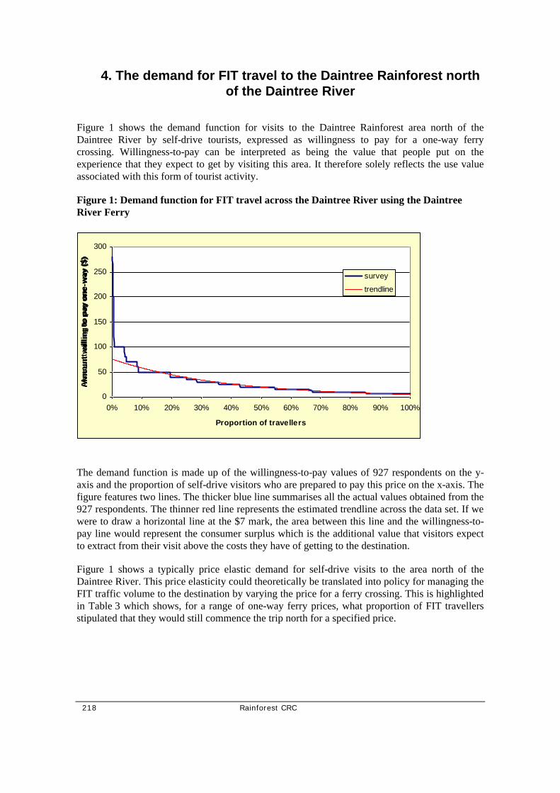
218 Rainforest CRC
4. The demand for FIT travel to the Daintree Rainforest north of the Daintree River
Figure 1 shows the demand function for visits to the Daintree Rainforest area north of the Daintree River by self-drive tourists, expressed as willingness to pay for a one-way ferry crossing. Willingness-to-pay can be interpreted as being the value that people put on the experience that they expect to get by visiting this area. It therefore solely reflects the use value associated with this form of tourist activity.
Figure 1: Demand function for FIT travel across the Daintree River using the Daintree River Ferry
The demand function is made up of the willingness-to-pay values of 927 respondents on the y-axis and the proportion of self-drive visitors who are prepared to pay this price on the x-axis. The figure features two lines. The thicker blue line summarises all the actual values obtained from the 927 respondents. The thinner red line represents the estimated trendline across the data set. If we were to draw a horizontal line at the $7 mark, the area between this line and the willingness-to-pay line would represent the consumer surplus which is the additional value that visitors expect to extract from their visit above the costs they have of getting to the destination.
Figure 1 shows a typically price elastic demand for self-drive visits to the area north of the Daintree River. This price elasticity could theoretically be translated into policy for managing the FIT traffic volume to the destination by varying the price for a ferry crossing. This is highlighted in Table 3 which shows, for a range of one-way ferry prices, what proportion of FIT travellers stipulated that they would still commence the trip north for a specified price.
0
50
100
150
200
250
300
0% 10% 20% 30% 40% 50% 60% 70% 80% 90% 100%
Proportion of travellers
Am
ou
nt
will
ing
to
pay
on
e-w
ay (
$)
survey
trendline

Rainforest CRC 219
Table 3: Proportion of travellers willing to pay a specified one-way ferry price
Price for a one-way ferry ticket
($)
Proportion of travellers willing to pay this price or
more (%)
100 4 70 8 50 19 40 25 30 36 25 43 20 54 15 67 10 85
For example, if the price for a one-way ferry crossing was to increase to $10, then 85 per cent of people would still go but 15% of respondents indicated that they would not be prepared to pay this amount. If, for example, the goal was to half self-drive tourist traffic across the Daintree River using this price mechanism, then the price for a one-way ferry crossing would have to be increased to $25. Despite the traffic reduction Shire revenue from the ferry would increase by about 50 per cent.
The one-way ferry price is currently $7 per vehicle. The difference between this price and what people are willing to pay per vehicle is ‘consumer surplus’. The consumer surplus for a visit to the area north of the Daintree River has been estimated from the survey data to be $39.86 per tourist self-drive vehicle (return trip). If we assume that the approximately 110,000 full-paying car ferry crossings in 1998/9 (Douglas Shire Council data) relate to FITs, the associated annual consumer surplus is in excess of $2 million. If some of this consumer surplus could be captured and added to the region’s rent from its natural resources, significant efforts into managing and preserving the heritage and environmental attributes of the destination could be funded.
The survey is unable to quantify the social impact that a change in ferry charge would have. The stratification of valuation responses against occupation of main income shows no difference in median willingness to pay for a one-way crossing. Across all categories, it is $20. However, the mean willingness-to-pay reveals a differentiation between occupations with a clear gradient based on presumed available income (Table 4). The higher the income, the higher is the consumer surplus which people gain from the trip as reflected in their willingness-to-pay. It can therefore be concluded that a traffic reduction due to an increase of the ferry charge would disadvantage low-income travelling parties in affordability of access to the area north of the Daintree River.

220 Rainforest CRC
Table 4: Willingness to pay and occupation of main income earner
Occupation
Mean amount willing to pay for one-way ferry crossing ($)
Professional 30.11 White collar 28.69 Skilled blue collar 24.91 Unskilled blue collar 19.50 Unemployed 22.11 School student 10.00 University student 24.09 Home duty 14.40 Retired 23.33 Unspecified 8.00 All Groups 27.79

Rainforest CRC 221
5. Concluding remarks
In summary, the survey results show that FIT travellers are mainly attracted to the area north of the Daintree River by its unique rainforest, the scenery and views of the area, and Cape Tribulation. Another major consideration for half the visitors is the fact that the area is World Heritage listed.
The socio-economic profile of FIT visitors shows that half the travelling parties are adult couples with the main income earner having a ‘professional’ occupation. Families travelled in one fifth of the FIT vehicles. One in five of domestic travelling parties were retirees.
The expectations that FITs have for their trip to the Daintree Rainforest area north of the Daintree River bears a substantial consumer rent of, on average, $40 per vehicle. The price elasticity of the FIT demand function indicates that the price for the Daintree Ferry crossing would be suitable instrument for (a) increasing the resource rent which the municipality can draw from tourism and thereby generating additional revenue for the management of this area and (b) managing the volume of FIT traffic into the area.

222 Rainforest CRC