d020-ad-pln-10000 0 exploration drilling ep summary · exploration drilling campaign wa-341-p, ac/p...
TRANSCRIPT


EXPLORATION DRILLING CAMPAIGN WA-341-P, AC/P 36, WA-343-P ENVIRONMENT PLAN SUMMARY
ii Document no.: D020-AD-PLN-10000 Security Classification: Business - Unrestricted Revision: 0 Date: 04 SEP 2013
DOCUMENT DISTRIBUTION
Copy No.
Name Hard
Copy
Electronic
Copy
00 NOPSEMA
01
02
03
04
05
06
07
08
09
10
NOTICE
All information contained with this document has been classified by INPEX as Business - Unrestricted and must only be used in accordance with that classification. Any use contrary to this document's classification may expose the recipient and subsequent user(s) to legal action. If you are unsure of restrictions on use imposed by the classification of this document you must refer to the INPEX Sensitive Information Protection Standard or seek clarification from INPEX.
Uncontrolled when printed.

EXPLORATION DRILLING CAMPAIGN WA-341-P, AC/P 36, WA-343-P ENVIRONMENT PLAN SUMMARY
iii Document no.: D020-AD-PLN-10000 Security Classification: Business - Unrestricted Revision: 0 Date: 04 SEP 2013
TABLE OF CONTENTS
1 INTRODUCTION .......................................................................................... 1
2 DESCRIPTION OF ACTIVITY ...................................................................... 2 2.1 Location of the activity .............................................................................. 2 2.2 Timing of the activity ................................................................................. 4 2.3 Drilling campaign description .................................................................... 4
3 DESCRIPTION OF THE ENVIRONMENT ................................................... 5 3.1 Physical environment ................................................................................ 5 3.2 Biological environment .............................................................................. 5 3.3 Cultural environment ................................................................................. 7 3.4 Socio-economic environment .................................................................... 7
4 MAJOR ENVIRONMENTAL HAZARDS AND CONTROLS ........................ 8
5 MANAGEMENT APPROACH .................................................................... 14
6 CONSULTATION ....................................................................................... 15
7 CONTACT DETAILS .................................................................................. 16
LIST OF TABLES
Table 2-1: Boundary coordinates of drilling zone within each permit ........................ 2 Table 3-1: EPBC Act listed species that may occur within or adjacent to the Project
area .......................................................................................................... 5 Table 4-1: Key environmental hazards and control measures .................................. 9
LIST OF FIGURES
Figure 2-1: Location map of planned activity .............................................................. 3

EXPLORATION DRILLING CAMPAIGN WA-341-P, AC/P 36, WA-343-P ENVIRONMENT PLAN SUMMARY
Document no.: D020-AD-PLN-10000 Page 1 of 16 Security Classification: Business - Unrestricted Revision: 0 Date: 04 SEP 2013
1 INTRODUCTION
INPEX Browse Ltd (INPEX) as operator on behalf of its joint venture partners is proposing to conduct an exploration drilling campaign within permit areas WA-341-P, AC/P 36 and WA-343-P to assess the economic potential of gas and condensate reserves contained within a Jurassic reservoir (the Project) in the Browse Basin, offshore Western Australia (WA). The Project will consist of drilling up to three wells, including vertical seismic profiling (VSP).
This document provides a summary of the Environment Plan (EP) that was accepted by the National Offshore Petroleum Safety and Environmental Management Authority (NOPSEMA) in accordance with Regulation 11(1) of the Offshore Petroleum and Greenhouse Gas Storage (Environment) Regulations 2009 and Amendment Regulations 2011 (Environment Regulations). This document has been prepared as per the requirements of Regulation 11 (7) and (8) of the Environment Regulations.

EXPLORATION DRILLING CAMPAIGN WA-341-P, AC/P 36, WA-343-P ENVIRONMENT PLAN SUMMARY
Document no.: D020-AD-PLN-10000 Page 2 of 16 Security Classification: Business - Unrestricted Revision: 0 Date: 04 SEP 2013
2 DESCRIPTION OF ACTIVITY
2.1 Location of the activity
Drilling will be undertaken within petroleum exploration permits WA-341-P, AC/P 36, and WA-343-P (the Project area), located wholly in Commonwealth waters (Figure 2-1). The Project area is located approximately 400 km north of Derby, Western Australia, and approximately 185 km north-west of the Kimberley coastline, at its closest point. Water depths of the proposed well locations range between 180 m and 340 m.
The coordinates of the drilling zones for the provisional wells planned are provided in Table 2-1 and illustrated in Figure 2-1. The well locations will be confirmed prior to commencement of drilling activities and will be based on the outcomes of ongoing geophysical and geological data interpretation.
Table 2-1: Boundary coordinates of drilling zone within each permit
Location point
Permit (and well location)
Drilling zone within permit
Latitude GDA94 Longitude GDA94
WA-341-P 341-1 -13.58193 123.83458
-13.41526 123.83458
-13.41526 124.00124
-13.58193 124.00124
WA-343-P 36-1 -13.32404 123.25129
-13.24860 123.25125
-13.24860 123.50125
-13.32364 123.50125
AC/P 36 343-1 -13.49860 123.50125
-13.49860 123.33459
-13.32364 123.33459
-13.32364 123.50125

EXPLORATION DRILLING CAMPAIGN WA-341-P, AC/P 36, WA-343-P ENVIRONMENT PLAN SUMMARY
Document no.: D020-AD-PLN-10000 Page 3 of 16 Security Classification: Business - Unrestricted Revision: 0 Date: 04 SEP 2013
Figure 2-1: Location map of planned activity

EXPLORATION DRILLING CAMPAIGN WA-341-P, AC/P 36, WA-343-P ENVIRONMENT PLAN SUMMARY
Document no.: D020-AD-PLN-10000 Page 4 of 16 Security Classification: Business - Unrestricted Revision: 0 Date: 04 SEP 2013
2.2 Timing of the activity
Drilling operations are anticipated to commence in late 2013 at the earliest. However, the exact timing of the works is dependent upon analysis of pre-drilling survey geophysical and geotechnical data and mobile offshore drilling unit (MODU) availability.
2.3 Drilling campaign description
The Project will consist of drilling up to three exploration wells within the permit areas. The exploration wells will be drilled using a semi-submersible MODU. The wells will be vertical exploration wells, drilled in phases using water based mud (WBM) in upper sections and synthetic-based mud (SBM) systems in the lower sections of the well. Each well is estimated to take approximately 90 days to complete.
While on location, a 500 m radius safety exclusion zone will be maintained around the MODU to control activities and reduce the risk of marine collisions.
Drilling each of the exploration wells will include the following steps:
1. Drilling of the top-hole sections using WBM and seawater
2. Installation and cementing of the drill casing string
3. Testing and installation of the blow out preventer on the wellhead
4. Installation of the marine riser
5. Displacement of the top-hole section with water based mud
6. Drilling of the intermediate-hole sections using WBM, gel and polymer
7. Installation and cementing of the drill casing string
8. Drilling of the bottom-hole section using low toxicity SBM
9. Plugging and abandoning the well

EXPLORATION DRILLING CAMPAIGN WA-341-P, AC/P 36, WA-343-P ENVIRONMENT PLAN SUMMARY
Document no.: D020-AD-PLN-10000 Page 5 of 16 Security Classification: Business - Unrestricted Revision: 0 Date: 04 SEP 2013
3 DESCRIPTION OF THE ENVIRONMENT
3.1 Physical environment
The Project area is located within the Browse Basin, approximately 400 km north of Derby, WA, and approximately 185 km north-west of the Kimberley coastline, at its closest point.
The broad scale oceanography of Northern Australia is complex, with multiple large-scale currents present in the region, of which the Indonesian Throughflow current system is dominant. This current is generally strongest during the south-east monsoon from May to September.
A number of shoals and reefs exist within the Browse Basin. At their closest points, Heywood and Echuca shoals are located approximately 15 km to the north-east and 40 km to the south-east of the Project area, respectively. Browse Island is the nearest intertidal habitat, located approximately 25 km south of the Project area at its closest point.
3.2 Biological environment
Surveys conducted by INPEX during previous regional studies found very few epibenthic organisms within the Project area. This is likely a consequence of the great depths, extreme currents and mobile sediments (as suggested by the appearance of the seabed) experienced in the Project area, which do not favour the development of diverse epibenthic communities.
As the seabed depth is well below the photic zone, benthic macrophyte communities are not expected within the Project area due to the limited light penetration and photosynthetic ability of organisms at these depths. As expected, species richness and abundance for the area was seen to decrease with increasing distance from land, and with increasing water depth.
The Timor Province is described as the most strongly defined province for demersal slope fish species in the area and characterised as having a high level of endemism and species diversity. This continental slope supports more than 418 demersal fish species, of which large proportions are considered to be endemic (Last et al. 2005).
The Department of Sustainability, Environment, Water, Population and Communities (DSEWPaC) Protected Matters database (using a 10 km buffer) identified 10 Threatened species and 20 Migratory species (of which nine are Threatened species) listed as potentially utilising the Project area (Table 3-1). The search did not identify any threatened ecological communities.
Further, no known breeding grounds or sensitive habitat environments critical to the species outlined are known to exist within or adjacent to the Project area.
Table 3-1: EPBC Act listed species that may occur within or adjacent to the Project area
Scientific name Common name
Birds
Calonectris leucomelas or Puffinus leucomelas
Streaked shearwater
Fregata ariel Lesser frigatebird

EXPLORATION DRILLING CAMPAIGN WA-341-P, AC/P 36, WA-343-P ENVIRONMENT PLAN SUMMARY
Document no.: D020-AD-PLN-10000 Page 6 of 16 Security Classification: Business - Unrestricted Revision: 0 Date: 04 SEP 2013
Scientific name Common name
Fregata minor Great frigatebird
Sula sula Red-footed booby
Reptiles
Aipysurus apraefrontalis Short-nosed seasnake
Caretta caretta Loggerhead turtle
Chelonia mydas Green turtle
Dermochelys coriacea Leatherback turtle
Eretmochelys imbricate Hawksbill turtle
Lepidochelys olivacea Olive ridley turtle
Natator depressus Flatback turtle
Various sea snake sp various sea snakes
Mammals
Balaenoptera musculus Blue whale
Megaptera novaeangliae Humpback whale
Balaenoptera bonaerensis Antarctic minke whale
Balaenoptera edeni Bryde’s whale
Orcinus orca Killer whale
Physeter macrocephalus Sperm whale
Tursiops aduncus Spotted bottlenose dolphin (Arafura or Timor sea populations)
Fishes
Rhincodon typus Whale shark
Isurus oxyrinchus Shortfin mako
Isurus paucus Longfin mako
Other
Various pipefish, pipehorse, seahorse Various pipefish, pipehorse, seahorse

EXPLORATION DRILLING CAMPAIGN WA-341-P, AC/P 36, WA-343-P ENVIRONMENT PLAN SUMMARY
Document no.: D020-AD-PLN-10000 Page 7 of 16 Security Classification: Business - Unrestricted Revision: 0 Date: 04 SEP 2013
3.3 Cultural environment
The Project area is located within the ‘Economic Exclusion Zone and Territorial Sea’ Commonwealth Marine Area. The Commonwealth Marine Area encompasses seas 3 to 200 nautical miles from the coast.
The Project area is not located in, or immediately adjacent to, any national heritage, world heritage, wetland of international importance, commonwealth marine areas, commonwealth marine reserve, maritime heritage or indigenous heritage places. However some do exist within the vicinity of the Project area.
3.4 Socio-economic environment
The Project area is traditionally used by a range of stakeholders, including traditional Indonesian fisherman, recreational fisherman, commercial fisheries (Commonwealth and state managed), oil and gas industry, shipping and the Department of Defence.
The Project area and surrounds are used by one Commonwealth and three State-managed commercial fisheries. These are the North West Slope Trawl Fishery (NWSTF), Northern Demersal Scalefish Fishery, Mackerel Managed Fishery and Northern shark fisheries, respectively.
Currently there are no oil and gas production facilities in operation within the Browse Basin. However, the region is subject to considerable exploration activity, with numerous exploration wells which have resulted in hydrocarbon discoveries.
Shell is in the process of constructing a floating LNG facility (Prelude) which will be located to the south west of the Project area, and Browse LNG Development has proposed the commercialisation of three fields; Brecknock, Calliance and Torosa, owned by the Browse Joint Venture.
The ports along the north-west coast of Australia such as Dampier, Cape Lambert, and Port Hedland handle large tonnages of iron ore and petroleum exports, with shipping routes throughout the north-west Australian region.
The Royal Australian Air Force Base Curtin air-to-air weapons range training zone are located approximately 100 km south-west of the Project area. As such the Department of Defence can request the Civil Aviation Safety Authority to declare the airspace prohibited or restricted.

EXPLORATION DRILLING CAMPAIGN WA-341-P, AC/P 36, WA-343-P ENVIRONMENT PLAN SUMMARY
Document no.: D020-AD-PLN-10000 Page 8 of 16 Security Classification: Business - Unrestricted Revision: 0 Date: 04 SEP 2013
4 MAJOR ENVIRONMENTAL HAZARDS AND CONTROLS
INPEX has a risk management process to ensure that activities are undertaken so that risk is managed to ‘As Low As Reasonably Practicable’ (ALARP) levels. The risk assessment has been undertaken for all activities within the Project area, in accordance with the procedures outlined in the Australian and New Zealand Standards AS/NZS ISO 31000:2009 (Risk Management – Principles and Guidelines) and HB 203:2012 (Managing Environment – Related Risk). The process is documented at various levels throughout the organisation and is supported by risk management standards, procedures and tools.
The key environmental hazards and control measures to be applied to the Project are provided in Table 4-1. These are consistent with INPEX’s corporate and project-specific objectives, standards and criteria. All control measures associated with the hazards will be used to reduce environmental risk to ALARP and will be of an acceptable level.

EXPLORATION DRILLING CAMPAIGN WA-341-P, AC/P 36, WA-343-P ENVIRONMENT PLAN SUMMARY
Document no.: D020-AD-PLN-10000 Page 9 of 16 Security Classification: Business - Unrestricted Revision: 0 Date: 04 SEP 2013
Table 4-1: Key environmental hazards and control measures
Source of risk (Hazard) Potential environmental impact Management and mitigation measures
Physical presence
Physical presence of MODU and support vessels
Damage or loss of equipment
Loss of access within safety exclusion zone
‘Notice to Mariners’ advising of the presence of the drilling rig issued through the Australian Maritime Safety Authority
Use of lights and signals in accordance with Marine Orders – Part 30: Prevention of collisions, Issue 8
Maintenance 500 m radius safety exclusion zone (as required under the OPGGS Act)
Adhere to relevant standard maritime safety or navigation procedures, as per relevant Navigation Act 2012 and IFC Environment, Health and Safety Guidelines
Anchoring of MODU Temporary physical scarring of benthic habitats
Prepare a ‘Rig Move and Positioning Plan’ prior to activity commencement
Site survey so that positioning of anchors is such that it avoids environmental sensitivities if present.
Accidental loss of equipment overboard
Temporary localised damage/ disturbance of benthic habitats
Promote organised working areas and following work procedures
Retrieval of any dropped objects
Carrying out a post-well remote operated underwater vehicle (ROV) survey.
Well abandonment Temporary localised damage/ disturbance of benthic habitats
Implement INPEX Well Construction and Integrity Standard and drilling campaign Well Operations Management Plan (WOMP)
Carrying out a post well ROV survey.
Introduction of invasive marine species
Reduction in species biodiversity of surrounding environment
Displacement of native marine species
Socio-economic impacts
Adherence to all legal requirements and guidance - e.g. the Department of Agriculture, Fisheries and Food (DAFF) Australian Ballast Water Management Requirements - Version 5
National Biofouling Management Guidance for the Petroleum and Production Exploration Industry
Vessels will have a certified and inspected hull as per DAFF and WA Department of Fisheries (DOF) requirements
Implementation and strict adherence to INPEX Quarantine Management Standard
EXPLORATION DRILLING CAMPAIGN WA-341-P, AC/P 36, WA-343-P ENVIRONMENT PLAN SUMMARY
Document no.: D020-AD-PLN-10000 Page 10 of 16 Security Classification: Business - Unrestricted Revision: 0 Date: 04 SEP 2013
Source of risk (Hazard) Potential environmental impact Management and mitigation measures
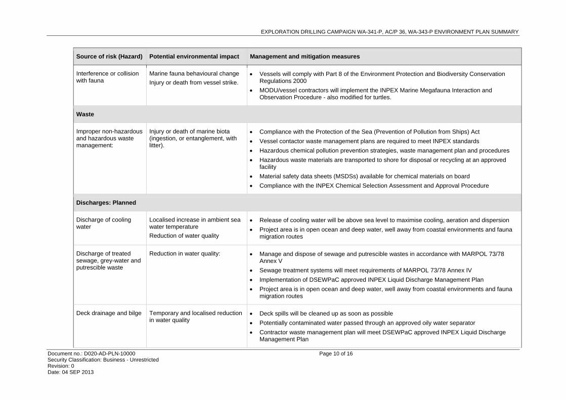
Interference or collision with fauna
Marine fauna behavioural change
Injury or death from vessel strike.
Vessels will comply with Part 8 of the Environment Protection and Biodiversity Conservation Regulations 2000
MODU/vessel contractors will implement the INPEX Marine Megafauna Interaction and Observation Procedure - also modified for turtles.
Waste
Improper non-hazardous and hazardous waste management:
Injury or death of marine biota (ingestion, or entanglement, with litter).
Compliance with the Protection of the Sea (Prevention of Pollution from Ships) Act
Vessel contactor waste management plans are required to meet INPEX standards
Hazardous chemical pollution prevention strategies, waste management plan and procedures
Hazardous waste materials are transported to shore for disposal or recycling at an approved facility
Material safety data sheets (MSDSs) available for chemical materials on board
Compliance with the INPEX Chemical Selection Assessment and Approval Procedure
Discharges: Planned
Discharge of cooling water
Localised increase in ambient sea water temperature
Reduction of water quality
Release of cooling water will be above sea level to maximise cooling, aeration and dispersion
Project area is in open ocean and deep water, well away from coastal environments and fauna migration routes
Discharge of treated sewage, grey-water and putrescible waste
Reduction in water quality: Manage and dispose of sewage and putrescible wastes in accordance with MARPOL 73/78 Annex V
Sewage treatment systems will meet requirements of MARPOL 73/78 Annex IV
Implementation of DSEWPaC approved INPEX Liquid Discharge Management Plan
Project area is in open ocean and deep water, well away from coastal environments and fauna migration routes
Deck drainage and bilge Temporary and localised reduction in water quality
Deck spills will be cleaned up as soon as possible
Potentially contaminated water passed through an approved oily water separator
Contractor waste management plan will meet DSEWPaC approved INPEX Liquid Discharge Management Plan

EXPLORATION DRILLING CAMPAIGN WA-341-P, AC/P 36, WA-343-P ENVIRONMENT PLAN SUMMARY
Document no.: D020-AD-PLN-10000 Page 11 of 16 Security Classification: Business - Unrestricted Revision: 0 Date: 04 SEP 2013
Source of risk (Hazard) Potential environmental impact Management and mitigation measures
Deck drainage discharge procedure
All oily water separators will be constantly monitored for efficient operation
MODU and vessels will have current MARPOL compliant ship oil pollution emergency plan (SOPEP).
Disposal of drilling fluids and cuttings
Increase water turbidity
Significant benthic fauna smothering
Temporary and localised reduction in water quality
Lowest practical toxicity drilling fluids will be used based on;
- CHARM and OCNS rating
- INPEX Chemical Selection, Assessment and Approval Procedure
- Drilling and completion fluids selection procedures
Use solids control equipment (SCE) to reduce concentration of SBM on cuttings
Monitor performance of equipment on board
Cementing fluids and additives discharged
Increase water turbidity
Benthic fauna smothering
Temporary and localised reduction in water quality
Monitor using an ROV
Minimise excess production of slurry
Where practical select cement and additives with the lowest environmental footprint through:
- INPEX Chemical Selection Assessment and Approval Procedure
- NOHSC: 1008 (2004) – Approved Criteria for Classifying Hazardous Substances
- Use cement products which have an OCNS ranking of D or E.
BOP control fluid discharge
Temporary and localised reduction in water quality
Use Blowout Preventer (BOP) Control Fluid with the lowest environmental footprint that meets technical requirements based on OCNS ranking of D or better
Compliance with NOHSC: 1008 (2004) – Approved Criteria for Classifying Hazardous Substances).
Brine discharge from reverse osmosis (RO) plan onboard the MODU
Temporary and localised reduction in water quality
Comply with IFC Environmental, Health and Safety Guidelines
Desalination Brine should be mixed with other waste streams, where feasible.
Emissions: Planned
Atmospheric emissions from combustion of fuel
Reduction in localised air quality
Contribution to global greenhouse
Carry out operational preventative maintenance
Low sulphur diesel (sulfur content with sulfur < 3.5% m/m) will be used

EXPLORATION DRILLING CAMPAIGN WA-341-P, AC/P 36, WA-343-P ENVIRONMENT PLAN SUMMARY
Document no.: D020-AD-PLN-10000 Page 12 of 16 Security Classification: Business - Unrestricted Revision: 0 Date: 04 SEP 2013
Source of risk (Hazard) Potential environmental impact Management and mitigation measures
gas emissions Emissions will be in compliance with MARPOL 73/78 Annex VI
Light emissions from MODU, support vessels and well test flaring
Light emissions may disturb by attraction, disorientation or repulsion of migratory seabirds, fish and marine turtles
Flaring will be intermittent
Lighting will be kept at the lowest acceptable level for safe operating procedure
HSE Inspection of the MODU includes consideration of lighting in terms of safe working conditions and minimising impact on marine fauna.
Sound generated as a result of general drilling operations
Increased underwater noise levels causing behavioural change to marine fauna
Operations to be undertaken in accordance with EPBC Regulations 2000 - Part 8 Division 1
Implement the INPEX Marine Megafauna Interaction and Observation Procedure.
Sound generated as a result of VSP activities
Increased underwater noise levels causing behavioural change to marine fauna
VSP operations will be undertaken in accordance with EPBC Act Policy Statement 2.1
A marine mammal observer (MMO) will be on board the MODU during VSP operations
Implement the INPEX Marine Megafauna Interaction and Observation Procedure
Implement an environmental awareness program.
Ozone depleting substances (ODS)
Contribution to global ozone depletion
Compliance with Ozone Protection and Synthetic Greenhouse Gas Management Act 1989 and Regulations 1995
Reporting requirements relating to the import of ODS and synthetic greenhouse gases (SGG)
Maintenance of an ODS Record Book.
Discharges: Unplanned
Spill of diesel or SBM Temporary and localised reduction in water quality
Potential oiling of marine wildlife.
Strict adherence to refuelling and transfer procedures
Refuelling operation will be undertaken in daylight hours
MODU and vessels SOPEP
Monitor prevailing and forecast weather conditions
NOPSEMA approved Oil Spill Contingency Plan (OSCP)
Incorporate INPEX Chemical Selection Assessment and Approval Procedure
Vessel collision resulting in diesel spill
Temporary and localised reduction in water quality
A ‘Notice to Mariners’ issued through the Australian Maritime Safety Authority

EXPLORATION DRILLING CAMPAIGN WA-341-P, AC/P 36, WA-343-P ENVIRONMENT PLAN SUMMARY
Document no.: D020-AD-PLN-10000 Page 13 of 16 Security Classification: Business - Unrestricted Revision: 0 Date: 04 SEP 2013
Source of risk (Hazard) Potential environmental impact Management and mitigation measures
Potential oiling of marine wildlife. Consult with AMSA, AMOSC and Oil Spill Response Limited (OSRL)
Standby vessel will be on location
MODU and anchor handling supply vessels (AHSVs) Shipboard Oil Pollution Emergency Plans (SOPEP)
Loss of well containment/ blow out
Extensive toxicological threat to population viability of protected species within sensitive and protected marine environments
Strict adherence to NOPSEMA accepted WOMP and drilling program and INPEX Well Control Manual
MODU and vessels will hold SOPEP
OSCP identifies;
- activate initial on-site response to spills to ocean
- identify available response equipment
- provide ongoing support and response to spills to the marine environment
Implementation of preventative barriers
Personnel appropriately trained in spill response
Preventative Maintenance Systems.
Well design integrity is aligned with industry and global standards.
Installation of robust BOP.

EXPLORATION DRILLING CAMPAIGN WA-341-P, AC/P 36, WA-343-P ENVIRONMENT PLAN SUMMARY
Document no.: D020-AD-PLN-10000 Page 14 of 16 Security Classification: Business - Unrestricted Revision: 0 Date: 04 SEP 2013
5 MANAGEMENT APPROACH
The Project will be managed in compliance with the Exploration Drilling Campaign WA-341-P, AC/P 36, WA-343-P Environment Plan accepted by NOPSEMA under the Environment Regulations, other relevant environmental legislation and the INPEX Environment Policy.
The implementation strategy will be undertaken in accordance with the INPEX HSE-MS, which provides a foundation of standards, procedures and tools that support the implementation of the EP in accordance with Regulation 14 of the OPGGS (E) Regulations.
The key components of implementation are:
Policy: provides a statement of INPEX’s Environment Policy which sets the framework for the INPEX HSE-MS under which the Project will be managed to ensure that the environmental impacts and risks of the Project are continuously reduced to ALARP.
Plan: specific INPEX standards and guidelines to be used to ensure the Project will be managed such that risks are ALARP.
Do: details roles and responsibilities, training and competency measures, INPEX emergency response framework including incident management, references to the INPEX OSCP and contractor SOPEP, cyclone response and emergency response training which in turn provides for the maintenance for the INPEX OSCP and contractor SOPEP, and provides details on INPEX document control procedures.
Check: monitoring, audit and management of non-conformance of INPEX environmental performance and the implementation strategy.
Act: management review of the Project’s environmental performance and the implementation strategy.

EXPLORATION DRILLING CAMPAIGN WA-341-P, AC/P 36, WA-343-P ENVIRONMENT PLAN SUMMARY
Document no.: D020-AD-PLN-10000 Page 15 of 16 Security Classification: Business - Unrestricted Revision: 0 Date: 04 SEP 2013
6 CONSULTATION
INPEX has used well-developed stakeholder engagement procedures in order to consult in an appropriate manner with a variety of stakeholders relevant to the Project, as summarised below:
convene stakeholder identification and classification workshop
compile list of stakeholders
rate stakeholder levels of interest and expectations
rate stakeholder levels of influence
determine appropriate method of stakeholder engagement
finalise and approve stakeholder register.
INPEX has used this process to engage with relevant stakeholders that have an interest in or the potential to be impacted by the Project. Stakeholder groups include commercial fisheries and their associations, recreational fishing associations, Commonwealth and State Government departments, industry and business and environmental groups. All stakeholders have been informed of the exclusion zone applied around the MODU and have been provided a map with details of the coordinates of the Project area.
To date, consulted stakeholders have not raised concerns with regards to the Project.
EXPLORATION DRILLING CAMPAIGN WA-341-P, AC/P 36, WA-343-P ENVIRONMENT PLAN SUMMARY
Document no.: D020-AD-PLN-10000 Page 16 of 16 Security Classification: Business - Unrestricted Revision: 0 Date: 04 SEP 2013
7 CONTACT DETAILS
The main point of contact for further information regarding this EP or the Project is:
Dawn MacInnes
Senior Environmental Adviser Well Construction and Integrity
INPEX
T + 61 8 6213 6477