d. valleys and hills region - secure.in.gov · d. valleys and hills region ... develop and promote...
TRANSCRIPT

150
D. VALLEYS AND HILLS REGION
Figure 6-16. Outline of the Valleys and Hills Region in Indiana.
G r e a t L a k e s
K a n k a k e e
C o r n B e l t
V a l l e y s a n d H i l l s
I n t e r i o r P l a t e a u
D r i f t P l a i n s
151
IntroductionThis section summarizes habitat conditions, threats to SGCN and their habitats, and conservation actions for species and habitats in the Valleys and Hills Region. This section also reviews land cover changes over the past decade and identifies unique habitat types in this region. Summaries of threats to and conservation actions for SGCN and their habitats that were generated from two surveys can be found at the end of this section.
In addition to the threats and actions identified in the Habitat Survey and the Species Survey, the DFW recognized the need to identify threats aligned with specific actions. Several threats and actions were identified as ubiquitous across all six regions. These include:
• Habitat Loss: Develop and promote farming technologies and practices that have conservation benefits (e.g., cover crops, no-till).
• Invasive Species: Build external capacity (form and facilitate partnerships, alliances, and networks of organizations to address invasive species).
• Law and Policy: Develop, change, influence and help implement formal legislation, regulations and voluntary standards.
• Dams and Water Management and Use: Remove unnecessary dams and utilize necessary dams with effective fish passage structures.
The DFW also identified specific threats and actions for each SWAP region based on DFW priorities. These threats were identified due to their high level of relevancy to the specific region and the workability of the associated actions. These threats and actions for the Valleys and Hills Region include:
• Natural System Modifications: Re-establish river floodplain connectivity.
• Habitat Degradation of Reclaimed Mine Lands Grasslands: Build external capacity by forming partnerships and networks, raising and providing funds and resources for conservation organizations to maintain and protect grasslands.
• Habitat Degradation to Forests: Control invasive species.
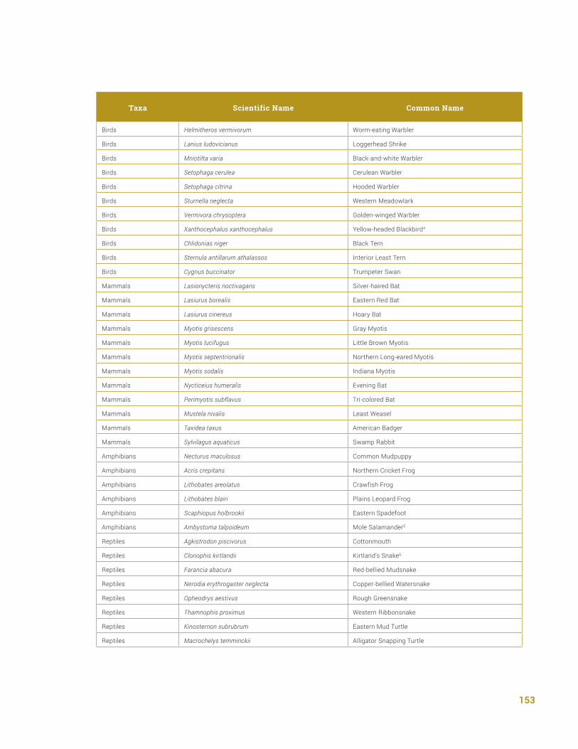
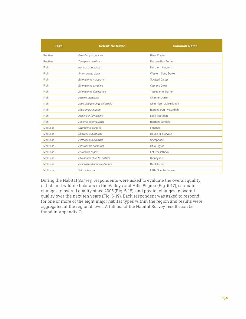
Current Habitat Conditions During the Species Survey, respondents were asked to identify SGCN within the Valleys and Hills Region. A full summary of the Species Survey results can be found in Appendix P.

152
Table 6-10. Distribution of SGCN across the Valleys and Hills Region.
Taxa Scientific Name Common Name
Birds Grus americana Whooping Crane1
Birds Grus canadensis Sandhill Crane2
Birds Ardea alba Great Egret3
Birds Botaurus lentiginosus American Bittern
Birds Ixobrychus exilis Least Bittern
Birds Nyctanassa violacea Yellow-crowned Night-heron
Birds Nycticorax nycticorax Black-crowned Night-heron
Birds Antrostomus vociferus Eastern Whip-poor-will
Birds Chordeiles minor Common Nighthawk
Birds Gallinula galeata Common Gallinule
Birds Laterallus jamaicensis Black Rail
Birds Rallus elegans King Rail
Birds Rallus limicola Virginia Rail
Birds Accipiter striatus Sharp-shinned Hawk
Birds Asio flammeus Short-eared Owl
Birds Buteo lineatus Red-shouldered Hawk
Birds Buteo platypterus Broad-winged Hawk
Birds Circus cyaneus Northern Harrier
Birds Falco peregrinus Peregrine Falcon
Birds Haliaeetus leucocephalus Bald Eagle
Birds Ictinia mississippiensis Mississippi Kite
Birds Pandion haliaetus Osprey
Birds Tyto alba Barn Owl
Birds Arenaria interpres Ruddy Turnstone
Birds Bartramia longicauda Upland Sandpiper
Birds Calidris subruficollis Buff-breasted Sandpiper
Birds Charadrius melodus Piping Plover
Birds Limnodromus griseus Short-billed Dowitcher
Birds Phalaropus tricolor Wilson’s Phalarope
Birds Pluvialis dominica American Golden-plover
Birds Tringa melanoleuca Greater Yellowlegs
Birds Tringa solitaria Solitary Sandpiper
Birds Ammodramus henslowii Henslow’s Sparrow
Birds Cistothorus palustris Marsh Wren
Birds Cistothorus platensis Sedge Wren
153
Taxa Scientific Name Common Name
Birds Helmitheros vermivorum Worm-eating Warbler
Birds Lanius ludovicianus Loggerhead Shrike
Birds Mniotilta varia Black-and-white Warbler
Birds Setophaga cerulea Cerulean Warbler
Birds Setophaga citrina Hooded Warbler
Birds Sturnella neglecta Western Meadowlark
Birds Vermivora chrysoptera Golden-winged Warbler
Birds Xanthocephalus xanthocephalus Yellow-headed Blackbird4
Birds Chlidonias niger Black Tern
Birds Sternula antillarum athalassos Interior Least Tern
Birds Cygnus buccinator Trumpeter Swan
Mammals Lasionycteris noctivagans Silver-haired Bat
Mammals Lasiurus borealis Eastern Red Bat
Mammals Lasiurus cinereus Hoary Bat
Mammals Myotis grisescens Gray Myotis
Mammals Myotis lucifugus Little Brown Myotis
Mammals Myotis septentrionalis Northern Long-eared Myotis
Mammals Myotis sodalis Indiana Myotis
Mammals Nycticeius humeralis Evening Bat
Mammals Perimyotis subflavus Tri-colored Bat
Mammals Mustela nivalis Least Weasel
Mammals Taxidea taxus American Badger
Mammals Sylvilagus aquaticus Swamp Rabbit
Amphibians Necturus maculosus Common Mudpuppy
Amphibians Acris crepitans Northern Cricket Frog
Amphibians Lithobates areolatus Crawfish Frog
Amphibians Lithobates blairi Plains Leopard Frog
Amphibians Scaphiopus holbrookii Eastern Spadefoot
Amphibians Ambystoma talpoideum Mole Salamander5
Reptiles Agkistrodon piscivorus Cottonmouth
Reptiles Clonophis kirtlandii Kirtland’s Snake6
Reptiles Farancia abacura Red-bellied Mudsnake
Reptiles Nerodia erythrogaster neglecta Copper-bellied Watersnake
Reptiles Opheodrys aestivus Rough Greensnake
Reptiles Thamnophis proximus Western Ribbonsnake
Reptiles Kinosternon subrubrum Eastern Mud Turtle
Reptiles Macrochelys temminckii Alligator Snapping Turtle
154
Taxa Scientific Name Common Name
Reptiles Pseudemys concinna River Cooter
Reptiles Terrapene carolina Eastern Box Turtle
Fish Noturus stigmosus Northern Madtom
Fish Ammocrypta clara Western Sand Darter
Fish Etheostoma maculatum Spotted Darter
Fish Etheostoma proeliare Cypress Darter
Fish Etheostoma tippecanoe Tippecanoe Darter
Fish Percina copelandi Channel Darter
Fish Esox masquinongy ohioensis Ohio River Muskellunge
Fish Elassoma zonatum Banded Pygmy Sunfish
Fish Acipenser fulvescens Lake Sturgeon
Fish Lepomis symmetricus Bantam Sunfish
Mollusks Cyprogenia stegaria Fanshell
Mollusks Obovaria subrotunda Round Hickorynut
Mollusks Plethobasus cyphyus Sheepnose
Mollusks Pleurobema cordatum Ohio Pigtoe
Mollusks Potamilus capax Fat Pocketbook
Mollusks Ptychobranchus fasciolaris Kidneyshell
Mollusks Quadrula cylindrica cylindrica Rabbitsfoot
Mollusks Villosa lienosa Little Spectaclecase
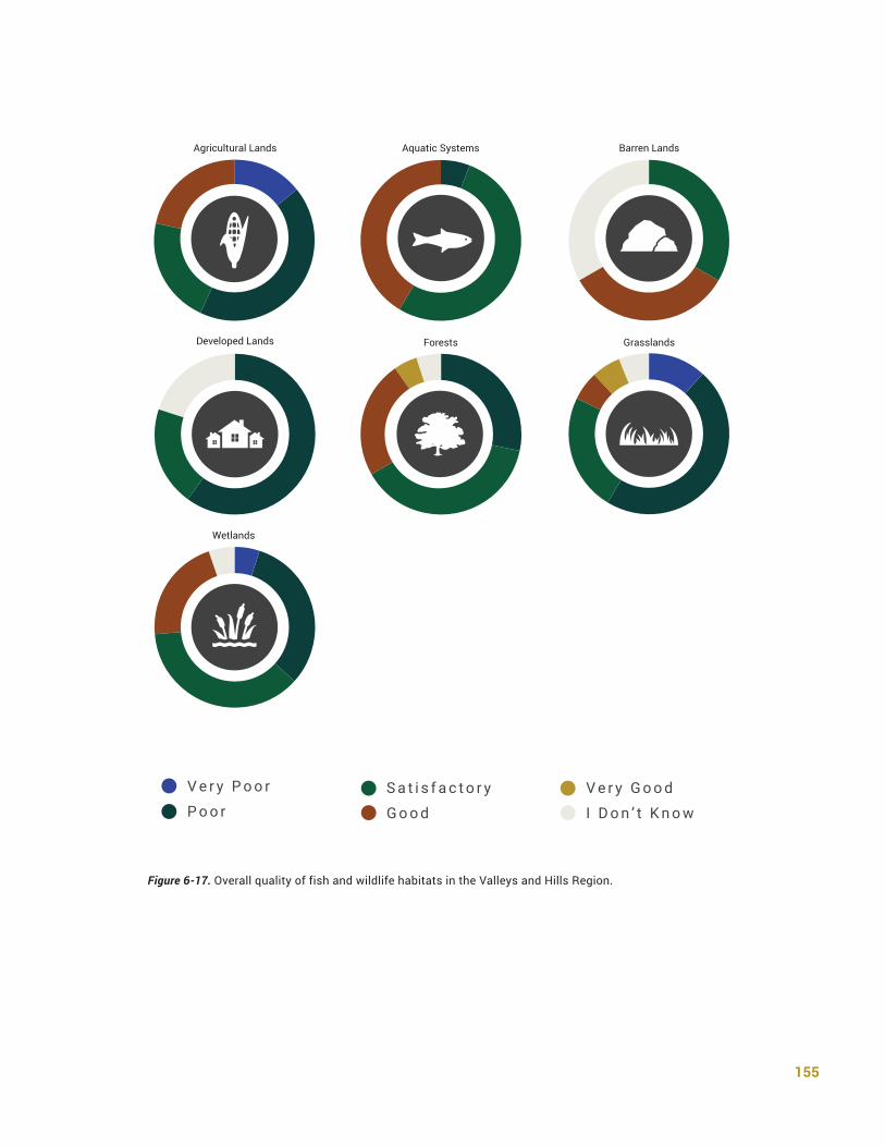
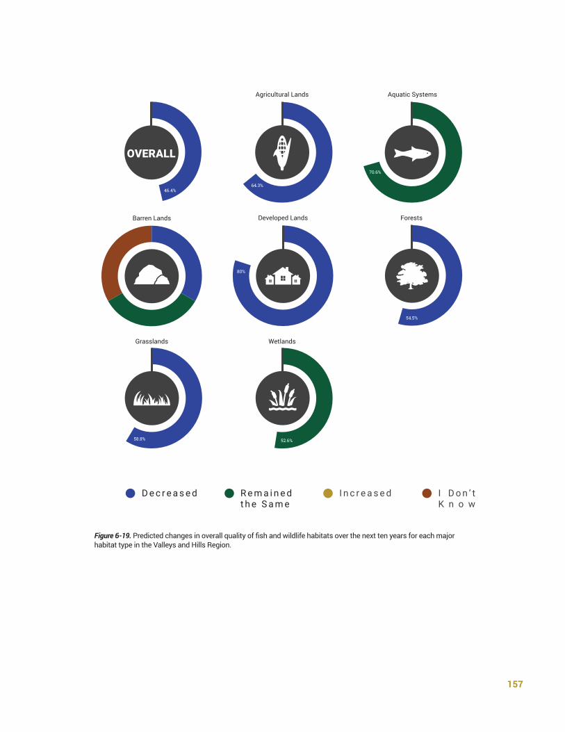
During the Habitat Survey, respondents were asked to evaluate the overall quality of fish and wildlife habitats in the Valleys and Hills Region (Fig. 6-17), estimate changes in overall quality since 2005 (Fig. 6-18), and predict changes in overall quality over the next ten years (Fig. 6-19). Each respondent was asked to respond for one or more of the eight major habitat types within the region and results were aggregated at the regional level. A full list of the Habitat Survey results can be found in Appendix Q.
155
Figure 6-17. Overall quality of fish and wildlife habitats in the Valleys and Hills Region.
S a t i s f a c t o r y
G o o d
V e r y G o o d
I D o n ’ t K n o w
V e r y P o o r
P o o r
Agricultural Lands
Developed Lands
Wetlands
Aquatic Systems
Forests Grasslands
Barren Lands

156
Figure 6-18. Estimated change in the overall quality of fish and wildlife habitats since 2005 for each of the major habitat types in the Valleys and Hills Region.
R e m a i n e d t h e S a m e
I n c r e a s e dD e c r e a s e d
OVERALL
41.2%
48.1%
43.3%
38.1%
70.6%
40%
78.6%
45.5%
80%
66.7%
52.9%
31.6%
31.6%
Agricultural Lands
Developed Lands
Wetlands
Aquatic Systems
Forests
Grasslands
Barren Lands
157
Figure 6-19. Predicted changes in overall quality of fish and wildlife habitats over the next ten years for each major habitat type in the Valleys and Hills Region.
R e m a i n e d t h e S a m e
I D o n ’ t K n o w
I n c r e a s e dD e c r e a s e d
OVERALL
46.4%
70.6%
64.3%
54.5%
80%
58.8% 52.6%
Agricultural Lands
Developed Lands
Wetlands
Aquatic Systems
Forests
Grasslands
Barren Lands
158
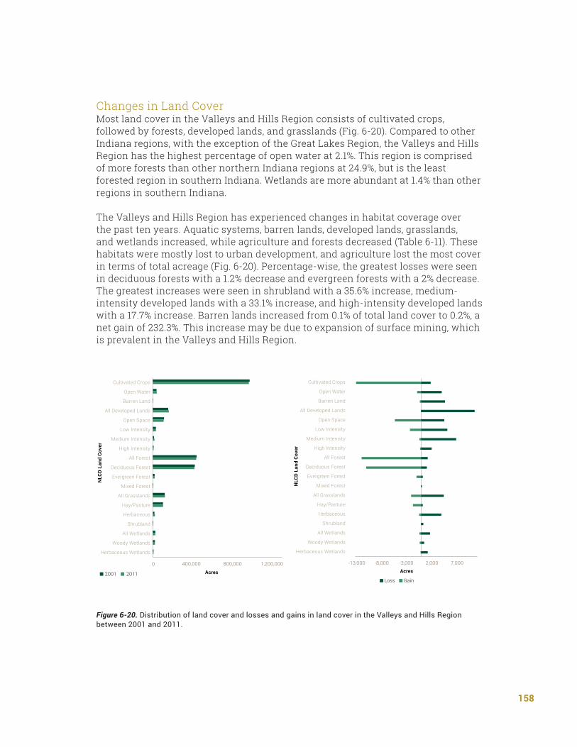
Changes in Land Cover Most land cover in the Valleys and Hills Region consists of cultivated crops, followed by forests, developed lands, and grasslands (Fig. 6-20). Compared to other Indiana regions, with the exception of the Great Lakes Region, the Valleys and Hills Region has the highest percentage of open water at 2.1%. This region is comprised of more forests than other northern Indiana regions at 24.9%, but is the least forested region in southern Indiana. Wetlands are more abundant at 1.4% than other regions in southern Indiana.
The Valleys and Hills Region has experienced changes in habitat coverage over the past ten years. Aquatic systems, barren lands, developed lands, grasslands, and wetlands increased, while agriculture and forests decreased (Table 6-11). These habitats were mostly lost to urban development, and agriculture lost the most cover in terms of total acreage (Fig. 6-20). Percentage-wise, the greatest losses were seen in deciduous forests with a 1.2% decrease and evergreen forests with a 2% decrease. The greatest increases were seen in shrubland with a 35.6% increase, medium-intensity developed lands with a 33.1% increase, and high-intensity developed lands with a 17.7% increase. Barren lands increased from 0.1% of total land cover to 0.2%, a net gain of 232.3%. This increase may be due to expansion of surface mining, which is prevalent in the Valleys and Hills Region.
Figure 6-20. Distribution of land cover and losses and gains in land cover in the Valleys and Hills Region between 2001 and 2011.
Region 4- Valleys & Hills
NLC
D L
and
Cove
r
Cultivated Crops
Open Water
Barren Land
All Developed Lands
Open Space
Low Intensity
Medium Intensity
High Intensity
All Forest
Deciduous Forest
Evergreen Forest
Mixed Forest
All Grasslands
Hay/Pasture
Herbaceous
Shrubland
All Wetlands
Woody Wetlands
Herbaceous Wetlands
0 400,000 800,000
2001 2011 Acres
1,200,000
Region 4 - Valleys & Hills
NLC
D L
and
Cove
r
Cultivated Crops
Open Water
Barren Land
All Developed Lands
Open Space
Low Intensity
Medium Intensity
High Intensity
All Forest
Deciduous Forest
Evergreen Forest
Mixed Forest
All Grasslands
Hay/Pasture
Herbaceous
Shrubland
All Wetlands
Woody Wetlands
Herbaceous Wetlands
Loss Gain
Acres-13,000 -8,000 -3,000 2,000 7,000

159
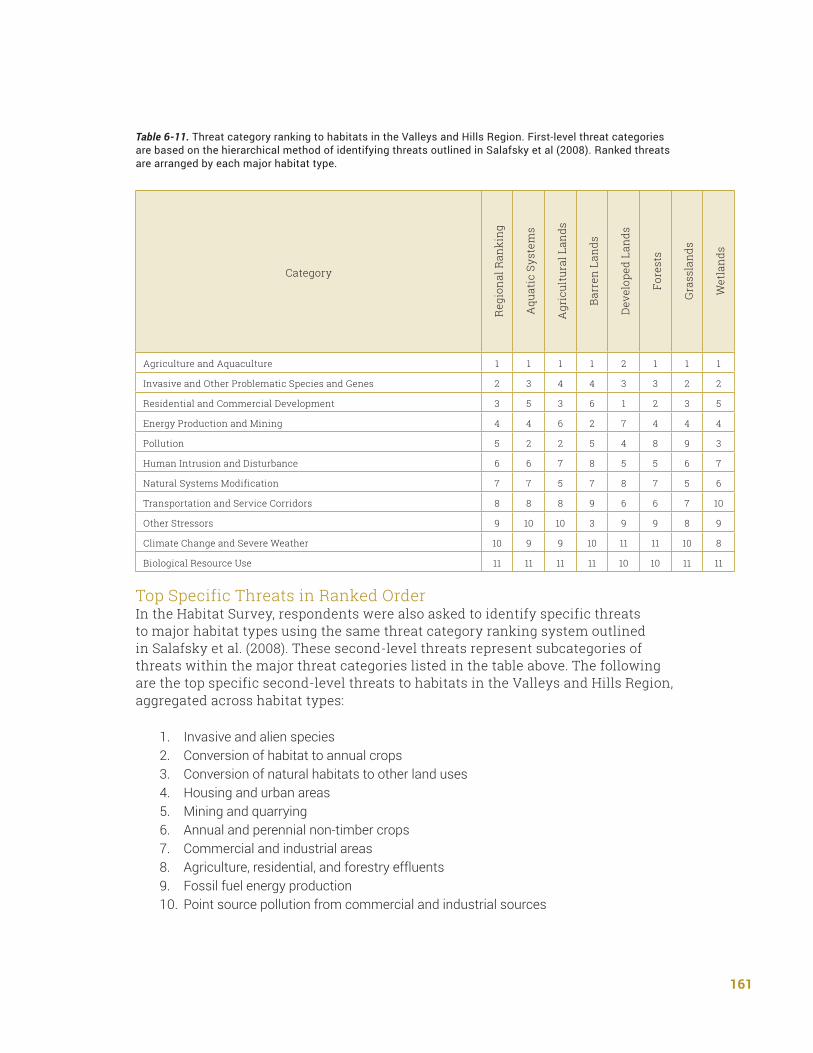
Threats Affecting Habitats Top Threat CategoriesThe third element requires the description of threats to SGCN and their habitats. The SWAP identifies a habitat perspective in order to manage for the conservation of species in Indiana. This section utilizes the same hierarchical method of identifying and rating threats based on Salafsky et al. (2008) that was outlined in Chapter V. Category rankings and specific threat rankings for habitats in this region are outlined below (Table 6-11). A full summary of the Habitat Survey results for the Great Lakes Region can be found in Appendix Q.
For first-level threat categories, agriculture and aquaculture, invasive and other problematic species and genes, and residential and commercial development received mean ratings as categories between significant and moderate threats. All other threat categories, with the exception of biological resource use were, on average, rated between a moderate and minor threat. Biological resource use was rated as minor to not a threat as a category.
Agriculture and aquaculture was the top ranked first-level threat regionally and within each habitat type with the exception of developed lands. Conversion of habitat to agriculture as well as annual and perennial non-timber crops in general were identified as the most significant specific second-level threats in this area. Respondents noted particular threats may stem from the draining and destruction of wetlands for agricultural purposes. Livestock was rated as a moderate to minor threat, while both aquaculture and wood and pulp plantations were not identified above a minor threat across habitat types.
The invasive and other problematic species and genes category was rated relatively high across habitat types, but especially highly in grasslands and wetlands. Alien species was identified as the most significant threat across habitat types within this region. Problematic native species, introduced genetic material, and plant diseases were only ranked as moderate to minor threats.
Residential and commercial development was rated third overall but first for habitats in developed lands. In this region, one respondent identified that development associated with interstate development may be a threat to fish and wildlife habitats. Both housing and urban areas and commercial development were specifically rated within this category as significant to moderate threats, while development associated with tourism and recreation areas was identified as a moderate to minor threat.
Energy production and mining was rated slightly higher as a threat in barren lands compared to other habitat types. Both mining and fossil fuel production were identified as significant threats within this category for barren lands and aggregated across all habitat types. Oil and gas drilling and shale gas development were identified as moderate to minor in this region. Renewable energy production was identified as minor to not a threat to fish and wildlife habitats.
160
Pollution was rated as a more significant threat in aquatic systems and to habitats in agricultural lands compared to other habitat types. Agriculture, residential, and forestry effluents were identified as a significant to moderate threat in both of these habitat types. Point source pollution was additionally identified as a significant to moderate threat for habitats in agricultural lands. Human intrusion and disturbance and recreational activities as a specific threat within this category were both rated as moderate to minor threats for this region across all habitat types. Natural systems modification as a category was also identified as moderate to minor. However, conversion of habitat to other uses was identified as a significant to moderate threat, reinforcing the significance of this issue as it was identified prior as conversion to agriculture.
Within transportation and service corridors, only roads and railroads were identified as significant to moderate specific threats across habitat types. Utility and service lines were rated as a moderate to minor threat. Both flight paths and shipping lanes were identified as minor to non-threats for this region.
While other stressors as a category was rated as a moderate to minor threat, both diseases and low genetic diversity were individually ranked as significant to moderate threats across habitat types. Climate change and severe weather similarly was ranked lower across habitats as a category, all of the specific threats within this category were identified as significant to moderate threat across all habitat types in this region.
Biological resource use was identified as a minor to non-threat for habitats within this region. However, forestry practices were rated as a moderate to minor threat, with one respondent pointing specifically to lack of sustainable timber management in natural systems modification as a point of stress for fish and wildlife habitats in this region.
161
Table 6-11. Threat category ranking to habitats in the Valleys and Hills Region. First-level threat categories are based on the hierarchical method of identifying threats outlined in Salafsky et al (2008). Ranked threats are arranged by each major habitat type.
Category
Reg
ion
al R
anki
ng
Aqu
atic
Sys
tem
s
Agr
icul
tura
l Lan
ds
Bar
ren
Lan
ds
Dev
elop
ed L
ands
Fore
sts
Gra
ssla
nds
Wet
land
s
Agriculture and Aquaculture 1 1 1 1 2 1 1 1
Invasive and Other Problematic Species and Genes 2 3 4 4 3 3 2 2
Residential and Commercial Development 3 5 3 6 1 2 3 5
Energy Production and Mining 4 4 6 2 7 4 4 4
Pollution 5 2 2 5 4 8 9 3
Human Intrusion and Disturbance 6 6 7 8 5 5 6 7
Natural Systems Modification 7 7 5 7 8 7 5 6
Transportation and Service Corridors 8 8 8 9 6 6 7 10
Other Stressors 9 10 10 3 9 9 8 9
Climate Change and Severe Weather 10 9 9 10 11 11 10 8
Biological Resource Use 11 11 11 11 10 10 11 11
Top Specific Threats in Ranked OrderIn the Habitat Survey, respondents were also asked to identify specific threats to major habitat types using the same threat category ranking system outlined in Salafsky et al. (2008). These second-level threats represent subcategories of threats within the major threat categories listed in the table above. The following are the top specific second-level threats to habitats in the Valleys and Hills Region, aggregated across habitat types:
1. Invasive and alien species2. Conversion of habitat to annual crops3. Conversion of natural habitats to other land uses4. Housing and urban areas5. Mining and quarrying6. Annual and perennial non-timber crops7. Commercial and industrial areas8. Agriculture, residential, and forestry effluents9. Fossil fuel energy production10. Point source pollution from commercial and industrial sources

162
In the Species Survey, respondents were also asked to identify threats to individual SGCN using the same threat category ranking system. The following are the top specific second-level threats to SGCN occurring in the Valleys and Hills Region, aggregated across all species:
1. Invasive and alien species2. Natural habitat conversion3. Conversion of habitat to annual crops4. Housing and urban areas5. Annual and perennial non-timber crops6. Commercial and industrial areas7. Dams and water management and use8. Tourism and recreation areas9. Recreational activities10. Livestock farming and ranching
Emerging/Anticipated ThreatsRespondents were asked specifically to identify any emerging or anticipated threats over the next ten years for fish and wildlife habitats within the major habitat types for a region in a free-response question. A full summary of these results can be found in Appendix Q.
Respondents anticipate a development “boom” associated with construction of an interstate in coming years, which may increase potential for introduction of exotic and invasive species on top of modifying natural systems. The construction may also lead to fragmentation. Loss of wetland habitat, exotic species establishing in wetland habitats, and mine reclamation areas not being converted to wetland habitat types were a concern for this region as well.
Conservation Actions Needed Top Action CategoriesThe fourth element of the Congressional guidelines requires that the SWAP describe conservation actions proposed to conserve identified species and habitats as well as outlining priorities for their implementation. This section outlines conservation actions identified on a regional basis for each of the major habitat types. This section follows the same protocol to rate and rank actions in this region based on Salafsky et al. (2008) that was outlined in Chapter V. A full list of survey results can be found in Appendix Q. Category rankings for actions and specific second-level actions are outlined in the list below (Table 6-12).
Within this region, land, water, and species management, land and water protection, and education and awareness received average category rankings between very and moderately important. Law and policy, external capacity building,
163
and livelihood, economic, and other incentives received average category ratings between moderately and somewhat important. No action category was rated between somewhat important and not important, indicating a general importance for a variety of actions within this region.
Land, water, and species management was ranked first regionally and within barren lands, forests, grasslands, and wetlands. Top actions within this region indicate an importance to restore natural systems, disturbance regimes, and diversity of successional stages in a variety of habitat types including grasslands and wetlands. Reducing loss of fish and wildlife habitat to agriculture and development was also identified as an important action, ranking first in developed lands and forests. Developing and promoting farming technologies and practices with conservation benefit ranked first for habitats within aquatic systems, agricultural lands, and wetlands. Mine reclamation was ranked first for barren lands.
Land and water protection was ranked second regionally, first within aquatic systems, and tied for first within barren lands. Acquiring unprotected systems and reducing conversion to cropland was identified important regionally as well as within most individual habitat types, ranking first in barren lands, developed lands, and wetlands. Acquiring easements was ranked first for fish and wildlife habitats within agricultural lands. Building and strengthening CRP partnerships was identified as most important for aquatic systems within this category.
Education and awareness was ranked third regionally as a category; however, it was ranked first for agricultural lands and developed lands. Within this category, educational programs specifically for K-12, educational programs in general, and training programs for stakeholders all received average ratings between very and moderately important.
Law and policy was ranked fourth regionally and varied between ranking fourth and sixth for various habitat types. Across the region, improvement of compliance and enforcement of current policies was ranked first. Some respondents suggested a need for changes to current policies to benefit fish and wildlife habitat within this region and suggested changes to regulations for energy production, including mining, oil, and gas laws.
Livelihood, economic, and other incentives was ranked fifth regionally but third for fish and wildlife habitats in agricultural lands. Promotion of conservation payment programs was ranked first regionally and within aquatic systems, agricultural lands, barren lands, developed lands, grasslands, and forests. Promotion of nonmonetary values of natural systems was ranked first within wetlands.
While external capacity building was ranked sixth regionally, five of the six specific actions were rated between very and moderately important. Developing alliances and partnerships was ranked first regionally and first for agricultural lands,

164
barren lands, developed lands, forests, and grasslands. Strengthening conservation financing was ranked first in aquatic systems and wetlands.
Table 6-12. Action category ranking to habitats in the Valleys and Hills Region. First-level categories are based on the hierarchical method of identifying actions outlined in Salafsky et al. (2008). Ranked action categories for this region are arranged by major habitat type.
Category
Reg
ion
al R
anki
ng
Aqu
atic
Sys
tem
s
Agr
icul
tura
l Lan
ds
Bar
ren
Lan
ds
Dev
elop
ed L
ands
Fore
sts
Gra
ssla
nds
Wet
land
s
Land/Water/Species Management 1 3 2 1 3 1 1 1
Land/Water Protection 2 1 5 1 2 2 2 2
Education and Awareness 3 2 1 3 1 3 3 3
Law and Policy 4 4 6 4 5 5 5 4
Livelihood, Economic, and Other Incentives 5 5 3 4 4 4 4 6
External Capacity Building 6 6 4 6 6 6 6 5
Indicates a tie within this habitat type
Top Specific Actions in Ranked OrderIn the Habitat Survey, respondents were also asked to identify specific actions for major habitat types using the same action category ranking system outlined in Salafsky et al. (2008). These second-level actions represent subcategories of actions within the major action categories listed in the table above. The following are the top specific (second-level) conservation actions for habitats in the Valleys and Hills Region, aggregated across habitat types:
1. Reduce conversion to cropland2. Reducelossoffishandwildlifehabitats(duetoagriculture,urbansprawl,
commercial development, etc.)3. Preserve currently existing corridors4. Develop alliances and partnerships (e.g., between producers, landowners, and
conservation professionals)5. Acquire conservation easements to protect important wildlife habitats6. Promote use of research and science in conservation decision-making processes7. DevelopeducationprogramsspecificallyforK-128. Develop education programs in general9. Develop and promote farming technologies and practices that have conservation
benefits(e.g.,covercrops,no-till)10. Strengthenconservationfinancing

165
The following are top actions for SGCN occurring for the Valleys and Hills Region, as summarized from the free-response questions about conservation actions for individual species:
1. Educate and engage with landowners and citizens.2. Enhance connectivity of habitats3. Reclaim coal mine grasslands4. Restore and protect bottomland hardwood forests and floodplain swamps5. Protect and restore river corridors6. Protect large contiguous forested areas7. Protect and manage large wetland complexes8. Control invasive plants9. Use burning and mowing as grassland management techniques10. Implement agricultural practices that improve water quality
Prioritization of ActionsIn order to prioritize these actions within an environment of limited resources, respondents were then asked to distribute hypothetical “effort points” to any action they had previously rated as “very important” for any of the major habitat types within a region. The effort ratings were averaged and then ranked to identify the top five actions for a region. A full list of these results can be found in Appendix Q. Priority actions for the Valleys and Hills region include:
1. Preserve currently existing corridors2. Acquire currently unprotected wetlands3. Develop and promote farming technologies and practices that have conservation
benefits(e.g.,covercrops,no-till)4. Reduce conversion to cropland5. Acquire currently unprotected grasslands
While land, water, and species management actions were, on average, rated as most important, land and water protection-based actions, with an emphasis on acquiring wetland and grassland habitats within this region, were also ranked highly. Promotion of farming technologies and practices that have conservation benefits and reduce conversion to cropland reflect the identification of agriculture as a large threat to fish and wildlife habitats within this region.
Threats and Actions by Major Habitat TypeThe following summaries break down threats and conservation actions in this region by major habitat type, based on responses to the Habitat Survey and the Species Survey. The SGCN that occur there, top threats to SGCN, top actions for SGCN, key threats to habitats, and priority actions for each major habitat type in this region are summarized below.Threats and actions were only included in detail below if a majority of eligible
166
survey respondents, greater than 50%, rated them, to avoid artificially elevating items, which were highly ranked but only by a few respondents. This approach left some threats and action lists with no items for certain habitats, which is illogical from a practical perspective. Therefore, in these situations, the top threats and actions are still listed but are denoted with an asterisk (*) to signify that there may be some items, which seem out-of-place, reflecting a lack of sufficient response for a particular habitat in the survey. This approach and the survey design also caused for some disparities between threats and actions.
Approximately ten items are given for each list below. Lists may be shorter if fewer than ten items were rated by a majority of survey respondents, or longer if there were tires between items.
Top actions for SGCN were summarized from free-response questions about individual species and do not follow the same categorizations as actions for habitats. A full summary of the Habitat Survey responses can be found in Appendix Q.
Agricultural Lands Agricultural lands are defined as lands devoted to commodity production. Examples of agricultural lands include: intensively managed non-native grasses, row crops, fruit and nut-bearing trees, confined feeding operations, and feedlots.
Top threats to SGCN occurring in agricultural lands in the Valleys and Hills Region:
1. Conversion of habitat to annual crops2. Annual and perennial non-timber crops
Top Conservation actions for SGCN occurring in agricultural lands in the Valleys and Hills Region:
1. Educate and engage with landowners and citizens2. Reduce conversion of farmland to development3. Increase use of CRP partnerships4. Increase use of conservation easements5. Implement agricultural practices that improve water quality6. Maintain shallow-water areas for migrating shorebirds7. Establish no-plow zones
Top threats to fish and wildlife habitats in agricultural lands in the Valleys and Hills Region:
1. Conversion of habitat to annual crops2. Conversion of natural habitats to other land uses3. Commercial and industrial areas

167
4. Housing and urban areas5. Mining and quarrying6. Invasive and alien species7. Annual and perennial non-timber crops8. Point source pollution from commercial and industrial sources9. Agriculture, residential, and forestry effluents10. Oil and gas drilling
Top conservation actions for fish and wildlife habitats in agricultural lands in the Valleys and Hills Region:
1. Acquire conservation easements to protect important wildlife habitats2. Reduce conversion of habitat to cropland3. Develop and promote farming technologies and practices that have conservation
benefits(e.g.,covercrops,no-till)4. Reducelossoffishandwildlifehabitats(duetoagriculture,urbansprawl,
commercial development, etc.)5. Preserve currently existing corridors6. Increase acres of riparian buffers7. Link existing habitat blocks through corridor enhancement in agricultural lands8. Develop education programs in general9. Establish training programs for stakeholders10. Develop alliances and partnerships (e.g., between producers, landowners, and
conservation professionals)11. Promote use of research and science in conservation decision-making processes
Aquatic Systems Aquatic systems are defined as all water habitats, both flowing and stationary. Examples of aquatic systems include: manmade impoundments, natural lakes rivers, streams, oxbows, sloughs, embayments, and backwaters (not including wetlands).
Top threats to SGCN occurring in aquatic systems in the Valleys and Hills Region:
1. Natural habitat conversion2. Conversion of habitat to annual crops3. Annual and perennial non-timber crops4. Dams and water management and use5. Livestock farming and ranching

168
Top conservation actions for SGCN occurring in aquatic systems in the Valleys and Hills Region:
1. Implement agricultural best management practices to improve water quality2. Protect and restore river corridors3. Enhance public, stakeholder, and landowner education and awareness4. Reduce point and non-point source pollution5. Protect/Restore riparian buffer zones6. Restore floodplains and connect to rivers7. Remove dams8. Reduce sediment and nutrient loads9. Reduce bank erosion10. Protect oxbow lakes and sloughs11. Restrict draining of floodplain lakes12. Improve ditch maintenance13. Prohibit take of mussels
Top threats to fish and wildlife habitats in aquatic systems in the Valleys and Hills Region:
1. Invasive and alien species2. Agriculture, residential, and forestry effluents3. Annual and perennial non-timber crops4. Housing and urban areas5. Conversion of natural habitats to other land uses6. Conversion of habitat to annual crops7. Mining and quarrying8. Commercial and industrial areas9. Point source pollution from commercial and industrial sources10. Fossil fuel energy production11. Problematic native species
Top conservation actions for fish and wildlife habitats in aquatic systems in the Valleys and Hills Region:
1. Develop and promote farming technologies and practices that have conservation benefits(e.g.,covercrops,no-till)
2. Develop education programs in general3. Reduce nutrient and toxin loads (e.g., heavy metals, pharmaceuticals, fertilizers,
insecticides)4. Acquire currently unprotected aquatic systems5. Acquire conservation easements to protect important wildlife habitats6. DevelopeducationprogramsspecificallyforK-127. Preserve currently existing corridors

169
8. Reduce conversion of habitat to annual crops9. Increase acres of riparian buffers10. Reducelossoffishandwildlifehabitats(duetoagriculture,urbansprawl,
commercial development, etc.)11. Develop alliances and partnerships (e.g., between producers, landowners, and
conservation professionals)
Barren Lands Barren lands are defined as lands dominated by exposed rock or minerals with sparse vegetation. Examples of barren lands include: sand/dunes, rock outcrops, cliffs, and bare rock.
Top threats to SGCN occurring in barren lands in the Valleys and Hills Region:*
1. Annual and perennial non-timber crops2. Natural habitat conversion3. Conversion of habitat to annual crops4. Recreation activities5. Dams and water management and use
Top conservation actions for SGCN occurring in barren lands in the Valleys and Hills Region:
1. Educate public about Peregrine Falcon2. Protect Bald Eagle nest sites
Top threats to fish and wildlife habitats in barren lands in the Valleys and Hills Region:
1. Conversion of habitat to annual crops2. Mining and quarrying3. Fossil fuel energy production4. Conversion of habitat to other land uses5. Annual and perennial non-timber crops6. Livestock farming and ranching7. Shale gas development8. Household sewage and urban water waste9. Agriculture, residential, and forestry effluents
Top conservation actions for fish and wildlife habitats in barren lands in the Valleys and Hills Region:
1. Preserve currently existing corridors2. Reduce conversion to cropland
170
3. Build/Strengthen CRP partnerships4. Mine reclamation5. Promote conservation payment programs (e.g., payment for ecosystem services,
conservation easements)6. Promote nonmonetary values of natural systems within the state7. Managerecreationalopportunitiestobecompatiblewithfishandwildlifehabitats
Developed Lands Developed lands are defined as highly impacted lands intensively modified to support human habitation, transportation, commerce, and recreation. Examples of developed lands include: urban lands, suburban lands, industrial areas, commercial areas, towers for communication and wind power generation, and recreational areas such as golf courses and soccer fields.
Top threats to SGCN occurring in developed lands in the Valleys and Hills Region:*
1. Housing and urban areas2. Commercial and industrial areas3. Renewable energy production4. Conversion of habitat to annual crops5. Invasive and alien species6. Diseases from domestic populations and unknown sources7. Mining and quarrying8. Fossil fuel energy production9. Tourism and recreation areas10. Wood and pulp plantations
Top conservation actions for SGCN occurring in developed lands in the Valleys and Hills Region:
1. Public education and awareness about bat ecology and issues2. Reduce urban sprawl and commercial property expansion3. Manage urban areas for peregrine falcons; minimize disturbance during nesting4. Increase gravel-surfaced rooftop habitat for breeding common nighthawks5. Limit mowing along roads
Top threats to fish and wildlife habitats in developed lands in the Valleys and Hills Region:
1. Invasive and alien species2. Roads and railroads3. Housing and urban areas4. Runoff from roads and service corridors5. Air pollution

171
6. Annual and perennial non-timber crops7. Conversion of habitat to annual crops8. Commercial and industrial areas
Top conservation actions for fish and wildlife habitats in developed lands in the Valleys and Hills Region:
1. Reducelossoffishandwildlifehabitats(duetoagriculture,urbansprawl,commercial development, etc.)
2. DevelopeducationprogramsspecificallyforK-123. Increase acres of riparian buffers4. Link existing habitat blocks through corridor enhancement in developed lands5. Develop alliances and partnerships (e.g., between producers, landowners, and
conservation professionals)6. Promote use of research and science in conservation decision-making processes7. Preserve currently existing corridors8. Acquire conservation easements to protect important wildlife habitats
ForestsForests are defined as a plant community dominated by trees. Examples of forests include, but are not limited to, all stages of natural forest and plantations. Top threats to SGCN occurring in forests in the Valleys and Hills Region:*
1. Conversion of habitat to annual crops2. Natural habitat conversion3. Housing and urban areas4. Invasive and alien species5. Commercial and industrial areas6. Annual and perennial non-timber crops7. Renewable energy production8. Diseases from domestic populations and unknown sources9. Fossil fuel energy production10. Mining and quarrying11. Tourism and recreation areas12. Wood and pulp plantations13. Fireandfiresuppression
Top conservation actions for SGCN occurring in forests in the Valleys and Hills Region:
1. Protect large contiguous forested areas and reduce forest fragmentation2. Limit conversion of forests to non-forest land uses3. Restore and protect bottomland hardwood forests
172
4. Control invasive woody plants5. Reduce development in forested areas6. Manage for healthy forest edge habitats7. Protect roost trees for bat species8. Restore forests and woodlands9. Create small forest openings to increase diversity10. Implement best management practices in forestry
Top threats to fish and wildlife habitats in forests in the Valleys and Hills Region:
1. Invasive and alien species2. Conversion of habitat to annual crops3. Housing and urban areas4. Mining and quarrying5. Conversion of natural habitats to other land uses6. Fossil fuel energy production7. Annual and perennial non-timber crops8. Problematic native species9. Commercial and industrial areas10. Oil and gas drilling
Top conservation actions for fish and wildlife habitats in forests in the Valleys and Hills Region:
1. Reducelossoffishandwildlifehabitats(duetoagriculture,urbansprawl,commercial development, etc.)
2. Preserve currently existing corridors3. Restore habitats and natural systems in forests4. Promote diversity of forest types and successional stages5. Reduce conversion to cropland6. Control invasive species in forests7. Link existing habitat blocks through corridor enhancement in forests8. Re-establish natural disturbance regimes in forests9. DevelopeducationprogramsspecificallyforK-1210. Promote conservation payment programs (e.g., payment for ecosystem services,
conservation easements
GrasslandsGrasslands are defined as an open area dominated by grass species. Examples of grasslands include: haylands, pasture, prairies, savannahs, or reclaimed mine lands. Top threats to SGCN occurring in grasslands in the Valleys and Hills Region:
1. Conversion of habitat to annual crops2. Annual and perennial non-timber crops
173
Top conservation actions for SGCN occurring in grasslands in the Valleys and Hills Region:
1. Restore and improve connectivity of grasslands2. Reduce conversion of grasslands to coal mines3. Reclaim coal mine grasslands4. Increase use of conservation easements5. Maintain large tracts of grasslands6. Reduce woody encroachment on grassland7. Increase CRP grasslands8. Implement proper burning regimes9. Minimize disturbance to nesting grassland birds (e.g., Henslow’s Sparrow.10. Mow properly (reduce mowing for shorebirds and owls)11. Improve grazing practices12. Preservelow,wetfields
Top threats to fish and wildlife habitats in grasslands in the Valleys and Hills Region:
1. Conversion of habitat to annual crops2. Invasive and alien species3. Housing and urban areas4. Annual and perennial non-timber crops5. Commercial and industrial areas6. Livestock farming and ranching7. Introduced genetic material (such as crop, seed stock, bio-control, stocked/released
species, etc.)8. Problematic native species9. Tourism and recreation areas10. Aquaculture
Top conservation actions for fish and wildlife habitats in grasslands in the Valleys and Hills Region:
1. Perform mine reclamation2. Restore habitats and natural systems in grasslands3. Acquire currently unprotected grasslands4. Reduce conversion to cropland5. Promote diversity of grassland types and successional stages6. Preserve currently existing corridors7. Acquire conservation easements to protect important wildlife habitats8. Reducelossoffishandwildlifehabitats(duetoagriculture,urbansprawl,
commercial development, etc.)9. Re-establish natural disturbance regimes in grasslands

174
Wetlands Wetlands are defined as either ephemeral or permanently flooded habitat. Examples of wetlands include: swamps, marshes, bogs, fens, potholes, wetlands of farmed areas, and mudflats.
Top threats to SGCN occurring in wetlands in the Valleys and Hills Region:*
1. Invasive and alien species2. Natural habitat conversion3. Conversion of habitat to annual crops4. Annual and perennial non-timber crops5. Dams and water management and use
Top conservation actions for SGCN occurring in wetlands in the Valleys and Hills Region:
1. Protect and maintain large wetlands complexes2. Restore wetlands3. Control invasive plants in wetlands4. Preserve and restore bottomland hardwood forests and floodplain swamps5. Expand floodplain and upland habitat with multiple wetlands6. In some cases, actively manage water levels (e.g., for black tern, common gallinule)7. Enroll lands in Wetlands Reserve Program (WRP)8. Mitigate road hazards to amphibians and reptiles when roads cross over wetlands9. Manage for high-diversity marshes10. Provide stopover and roosting habitat for cranes
Top threats to fish and wildlife habitats in wetlands in the Valleys and Hills Region:
1. Conversion of habitat to annual crops2. Invasive and alien species3. Conversion of natural habitats to other land uses4. Fossil fuel energy production5. Housing and urban areas6. Agriculture, residential, and forestry effluents7. Mining and quarrying8. Commercial and industrial areas9. Point source pollution from commercial/industrial sources10. Annual and perennial non-timber crops
Top conservation actions for fish and wildlife habitats in wetlands in the Valleys and Hills Region:
1. Reduce conversion to cropland2. Acquire currently unprotected wetlands