d r a f t - sandiegocounty.gov€¦ · draft land use and community character report for the...
TRANSCRIPT

DRAFT
Land Use and Community Character Report
for the
Jacumba Solar Energy Project
Major Use Permit PDS2014-MUP-14-041
Jacumba, San Diego County, California
Prepared for:
County of San Diego
Department of Planning and Development Services 5510 Overland Avenue
San Diego, California 92123 Contact: Ashley Gungle
Prepared by:
605 Third Street
Encinitas, California 92024 Contact: Asha Bleier
APRIL 2015

Printed on 30% post-consumer recycled material.

Land Use and Community Character Report for the Jacumba Solar Energy Project
8477 i April 2015
TABLE OF CONTENTS
Section Page No.
1 INTRODUCTION..............................................................................................................1
2 PROJECT DESCRIPTION ..............................................................................................3
3 ENVIRONMENTAL SETTING ....................................................................................13
3.1 Land Use Designations and Zoning ...................................................................... 13
3.2 Surrounding Land Uses......................................................................................... 14
4 REGULATORY SETTING ............................................................................................21
4.1 Federal................................................................................................................... 21
4.2 State....................................................................................................................... 21
4.3 Local ..................................................................................................................... 22
5 CONSISTENCY WITH PLANS, POLICIES, AND REGULATIONS ......................43
5.1 Land Use Regulations ........................................................................................... 43
5.2 Land Use Plans and Policies ................................................................................. 44
5.3 Project Requirements that Achieve Consistency .................................................. 65
6 REFERENCES .................................................................................................................67
FIGURES
1 Regional Map .......................................................................................................................5
2 Vicinity Map ........................................................................................................................7
3 Site Plan ...............................................................................................................................9
4 Land Use Designation ........................................................................................................15
5 Project Zoning ....................................................................................................................17
6 ALUCP Noise Impact Zones .............................................................................................39
7 ALUCP Safety Zones ........................................................................................................41
TABLES
1 County Board of Supervisors Consistency Analysis .........................................................45
2 Land Development Ordinances Consistency Analysis ......................................................48
3 County General Plan Consistency Analysis ......................................................................49
4 Mountain Empire Subregional Plan Consistency Analysis ...............................................63

Land Use and Community Character Report for the Jacumba Solar Energy Project
8477 ii April 2015
INTENTIONALLY LEFT BLANK

Land Use and Community Character Report for the Jacumba Solar Energy Project
8477 1 April 2015
1 INTRODUCTION
The purpose of this study is to assess the land use impacts of the proposed Jacumba Solar Energy
Project (Proposed Project) relative to potential conflicts with land use plans, policies, or
regulations, such as the County of San Diego (County) General Plan (County of San Diego
2011). The County General Plan serves as the blueprint for growth and development in the
unincorporated County. It is based on a set of guiding principles and consists of the following
elements: Land Use, Mobility, Conservation and Open Space, Housing, Safety, and Noise. Each
of these elements contains a set of goals and policies to which all discretionary development
projects must adhere. In addition to the policy document, the County General Plan also consists
of a land use map and mobility element network map. The land use map identifies the type and
intensity of future uses on parcels of land throughout the County, whereas the mobility network
delineates the road network that is required to accommodate these proposed uses. Finally, the
County General Plan also consists of several community or subregional plans that are intended to
provide more precise guidance regarding the character, land uses, and densities within each
community planning area. All of these components make up the County General Plan.

Land Use and Community Character Report for the Jacumba Solar Energy Project
8477 2 April 2015
INTENTIONALLY LEFT BLANK

Land Use and Community Character Report for the Jacumba Solar Energy Project
8477 3 April 2015
2 PROJECT DESCRIPTION
The Proposed Project includes a major use permit (MUP) to authorize a major impact utility
pursuant to Sections 2926 of the County Zoning Ordinance. The Project Project would produce
up to 20 megawatts (MW) of solar energy and would be located on approximately 108 acres of
private lands in southeastern San Diego County near the unincorporated community of Jacumba,
California. See Figure 1, Regional Map, and Figure 2, Vicinity Map, for Project location. In
addition to the photovoltaic (PV) panels and direct current (DC) to alternating current (AC)
conversion equipment (i.e., inverter and transformer units), the Project would include a 1,000-
volt DC underground collection system and a 34.5-kilovolt (kV) underground collection system
linking the panels to the 110-foot by 215-foot on-site Project substation. In addition, the Project
would also feature a 10-MW battery energy storage system within the Project substation’s fenced
boundaries. The Project would also include 138 kV overhead transmission line (gen-tie) that
would connect the Project substation to the adjacent East County (ECO) Substation. A site plan
of the Proposed Project is presented on Figure 3, Site Plan.
PV Modules
The project would include installation of approximately 81,108 individual PV modules fitted
on approximately 2,253 fixed-tilt rack panels. PV modules and associated racking systems
would compose the majority of the proposed facilities. PV modules generate electricity by
safely converting the energy of the sun’s photons into DC electrons. PV modules can be wired
in series and/or parallel to obtain a required nominal voltage. The PV modules are
interconnected and arranged to increase overall reliability. This technology requires no moving
parts or fuel, needs limited maintenance, and is a proven technology that can withstand long-
term exposure to the environment.
The PV modules have been stringently tested and are robustly constructed with a lifespan of
approximately 30 years. The PV modules are uniformly dark in color, non-reflective, and
designed to be highly absorptive of all light that strikes their glass surfaces. The PV modules
deployed for use in the Project would comply with all industry-standard quality testing. The PV
modules would be electrically connected to the grounding system of the facility in accordance
with local codes and regulations. The final PV module selection would be determined at the
detailed engineering phase.
Support Structures
Racking refers to the support structure to which the solar PV modules are affixed, which allows
them to be properly positioned for maximum capture of the sun’s solar energy. The PV module
arrays (a row of PV modules) would be a fixed-tilt system that would be oriented along an east–

Land Use and Community Character Report for the Jacumba Solar Energy Project
8477 4 April 2015
west axis. The mounting structures are typically mounted on metal pipe pile or beam foundations
4 to 6 inches in diameter. The beams would be driven into the soil using a pile/vibratory/rotary
driving technique similar to that used to install freeway guardrails. Driven pier foundations offer
multiple benefits, including quick installation and minimal site disturbance, and are a “concrete-
free” foundation solution that would allow for easy site reclamation at the end of the Project life
cycle. Most foundations are driven to approximate depths of 10 to 15 feet. The PV modules, at
their highest point, would be approximately 8 feet above the ground surface.
Depending on final engineering, the arrays may be equal in length, creating a uniform
rectangular Project footprint, or may vary in length in order to avoid sensitive resources and
work with the site terrain. The east–west arranged fixed-tilt arrays, if used, would be constructed
approximately 25 feet apart (centerline to centerline) in a north–south direction, with an east–
west array spacing of approximately 12.5 feet. Each PV module array row would measure
approximately 144 feet in total combined length and approximately 6.5 feet in width. The PV
module arrays’ final elevations from the ground surface would be determined during detailed
Project design; however, it is common to maintain as low an elevation profile as possible to
reduce potential wind loads on the PV module arrays.
Inverters, Transformers, and Associated Equipment
PV modules would be electrically connected to adjacent modules to form module strings using
wiring attached to the support structures. The PV module strings would be electrically connected
to each other via underground wiring. Wire depths would be in accordance with local, state, and
federal codes. String wiring terminates at PV module array combiner boxes, which are lockable
electrical boxes mounted on or near an array’s support structure. Output wires from combiner
boxes would be routed along an underground trench system approximately 3.5 feet deep and 1
foot wide, including trench and disturbed area, to the inverters and transformers.
Inverters are a key component of solar PV power-generating facilities because they convert
the DC generated by the PV module array into AC that is compatible for use with the
transmission network. The inverters within the electrical enclosures would convert the DC
power to AC power and the medium-voltage transformers would step up the voltage to
collection-level voltage (34.5 kV).
The inverters, medium-voltage transformers, and other electrical equipment are proposed to be
housed in up to 13 enclosures throughout the Project site. Electrical enclosures would be up to
14 feet wide by 44 feet long and would sit on site. The inverter and medium-voltage transformer
units would be mounted on concrete foundation pads. All electrical equipment would be either
outdoor rated or mounted within electrical enclosures designed specifically for outdoor
installation. The proposed equipment poses no electrical shock risk and is safe to touch.

Imperial County
ngunty
n Diego
CountySan Diego County
San Diego County
Riverside County
Campo
ImperialBeach
ChulaVista
NationalCity
Bonita
Coronado
LemonGrove
LaMesa
Poway
Encinitas
San Diego
Carlsbad
SanMarcos Escondido
VistaValleyCenter
Camp PendletonSouth Hidden
MeadowsOceanside
Bonsall
CampPendleton
North
Fallbrook
Rainbow
Jamul
Rancho SanDiegoSpring
Valley
Casa deOro-Mount Helix
AlpineHarbisonCanyon
Lakeside PineValley
El Cajon
Santee
Ramona San DiegoCountryEstates
Julian
BorregoSprings
Jacumba
Boulevard
Santa Ysabel
S a l t o nS e a
P a c i f i c
O c e a nM E X I C OM E X I C O
282
188905
371
209
163
56
75
52
111
67
98
86
79
76
94
78
15
8
805
5
Copyright:' 2014 Esri
FIGURE 1
Regional MapJacumba Solar Project
8477
0 105Miles
Project Site

Land Use and Community Character Report for the Jacumba Solar Energy Project
8477 6 April 2015
INTENTIONALLY LEFT BLANK

OLD HIGHWAY 80
M E X I C OM E X I C O
8
FIGURE 2Vicinity Map
8477Jacumba Solar ProjectJUNE 2011
Path
: Z:\P
rojec
ts\j8
4770
1\M
APDO
C\DO
CUM
ENT\
Land
_Use
\Figu
re2_
Vicin
ty.m
xd
0 6,0003,000Feet
Project Boundary
Solar Site

Land Use and Community Character Report for the Jacumba Solar Energy Project
8477 8 April 2015
INTENTIONALLY LEFT BLANK

FIGURE 3
Site PlanJacumba Solar Project
8477
Path
: Z:\P
rojec
ts\j8
4770
1\M
APDO
C\DO
CUM
ENT\
Land
_Use
\Figu
re3_
Site
_Plan
.mxd
Project Boundary
138kV Transmission Poles
Perimeter Security Fence
PV Solar Panels
Collector Substation and Battery Storage Area
On-Site Access Roads
Gen-Tie Parcel
Gen-Tie Line Alignment
ECO SubstationExisting ECO Substation Access Road
Land Use and Community Character Report for the Jacumba Solar Energy Project
8477 10 April 2015
INTENTIONALLY LEFT BLANK

Land Use and Community Character Report for the Jacumba Solar Energy Project
8477 11 April 2015
Connector Line, Fiber Optic Line, and Point of Interconnection
The Project would interconnect to the ECO Substation project, which is owned and operated
by San Diego Gas & Electric (SDG&E). A 138 kV line interconnecting from the ECO
Substation project to the Jacumba Solar Energy Project would be constructed above grade.
Fencing and Security
The Project site would be fenced along the entire property boundary for security with fencing
that meets National Electrical Safety Code requirements for protective arrangements in electric
supply stations. Fencing would be approximately 9 feet high, with an 8-foot-tall chain-link
perimeter fence with 1 foot of three-strand barbed wire along the top and a 4-inch maximum
clearance from the ground surface. Signage in Spanish and English for electrical safety would be
placed along the perimeter of the Project site, warning the public of the high voltage and the need
to keep out. Signage would also be placed within the Project site where appropriate. Some
localized security-related lighting, on-site security personnel, and/or remotely monitored alarm
system may be required during construction and/or operation. Remotely monitored cameras and
alarm system(s) and perimeter and safety lighting (which would be used only on an as-needed
basis for emergencies, protection against security breach, or unscheduled maintenance and
trouble-shooting (such as may occasionally be required)) would be installed.
Maintenance and Security Lighting
Lighting would be designed to provide security lighting and general nighttime lighting for
operations and maintenance personnel. Lighting would be shielded and directed downward to
minimize any effects to the surrounding area, and would be used only on an as-needed basis.
Lighting would be provided at the entrance gates and the Project substation.
The on-site substation would include lighting inside the substation to allow for safety inspections
or maintenance that may be required during the evening hours. Lighting would also be provided
next to the entrance door to the control house and mounted at the entrance gates to allow for safe
entry. Since maintenance activities are not anticipated to occur during the evening hours, lights
would only be turned on if needed.
All lighting for the solar facility would have bulbs that do not exceed 100 watts, and all lights
would be shielded and directed downward and would comply with the County Light Pollution
Code, Section 59.101 et seq. (County of San Diego 1986).

Land Use and Community Character Report for the Jacumba Solar Energy Project
8477 12 April 2015
Access
Primary access to the Project site would be provided via an improved access road from Old
Highway 80, as shown on Figure 3. Two additional points of emergency egress/ingress would be
provided at the Project’s southwestern and northeastern points to facilitate U.S. Customs and
Border Protection access and to provide an alternate fire access point, respectively.

Land Use and Community Character Report for the Jacumba Solar Energy Project
8477 13 April 2015
3 ENVIRONMENTAL SETTING
The Proposed Project is located in southeastern San Diego County at the convergence of the
California Peninsular Ranges and desert regions. More specifically, the Project site is
situated in the eastern extent of the Jacumba Valley. The Jacumba Mountains are located to
the east of the Project site, the In-Ko-Pah Mountains are located to the north, and Grey and
Table Mountains are located to the northwest and north, respectively. Jade Peak is located
south of Interstate 8 (I-8) and northeast of the Project site. The Airport Mesa landform is
located immediately west of the Project site.
The Project site consists of undeveloped desert lands crossed by a network of dirt roads and dry
washes/drainages. The northern portion of the site is bisected by Old Highway 80; I-8 is located
approximately 0.5 mile to the north. The topography of the site generally slopes to the east and
the south. The lower, easternmost extent of the Airport Mesa landform extends across the
southwestern portion of the Project. The majority of the site has a scattered, patchy composition;
however, moderately dense strands of vegetation occur adjacent to washes/drainages. Views
from the site are relatively wide in nature but tend to be enclosed by the Jacumba Mountains to
the east and the In-Ko-Pah Mountains to the north. The tall, mounded form of Airport Mesa
limits the availability of long views to the west and tends to direct the eye to the northwest.
East of the site, the terrain rises gently towards the Jacumba Mountains, and the vegetation
exhibits a similar coarse, patchy composition. To the south, the dark-brown panels of the
international border fence create a bold, dark line that interrupts the intactness of the landscape
and the continuity of desert vegetation. The Southwest Powerlink Transmission Line is visible to
the north, as is traffic on I-8 and the large, rectangular form of Table Mountain. The ECO
Substation is located to the northeast.
The undeveloped natural lands in the immediate Project area and the presence of
mountainous terrain create a generally rural ambience; however, modifications that have
occurred because of electrical infrastructure development are highly visible and interrupt the
intactness of the natural-appearing landscape.
3.1 Land Use Designations and Zoning
The Proposed Project site is on privately owned land located directly north of the U.S./Mexico
international border and west and south of public lands managed by the Bureau of Land
Management (BLM). Privately owned lands are located east of the Project site and extend to the
San Diego / Imperial County line. The site is located within the Jacumba Subregional Group
Area, which is part of the larger Mountain Empire Subregional Plan Area. The Jacumba

Land Use and Community Character Report for the Jacumba Solar Energy Project
8477 14 April 2015
Subregional Group Area land use map identifies the site as Rural Lands 80 (RL-80), which
translates to one dwelling unit per 80 gross acres; see Figure 4, Land Use Designation. The
Project site is zoned General Rural (S92); see Figure 5, Project Zoning. Privately owned lands to
the northeast and east are also designated RL-80 and zoned S92. Lands managed by BLM are
located immediately adjacent to the west and north of the site and are identified as Public
Agency Lands. These lands are zoned Open Space (S80) by the County of San Diego but are
managed by BLM according to the Eastern San Diego County Resource Management Plan.
Lands located approximately 0.5 and 1.0 mile to the west of the Project site are zoned S92 and
are designated RL-80 and RL-40, respectively. The Jacumba Airport is located approximately
1.2 miles west of the solar facility site. The airport is designated Public/Semi-Public Facilities
and is zoned S80. The Jacumba Valley Ranch Specific Plan Area is located approximately 1.5
miles west of the Project site and the I-8 corridor is 0.5 mile to the north.
3.2 Surrounding Land Uses
The surrounding Jacumba area, which includes the community of Jacumba Hot Springs, can
be characterized as a predominantly rural landscape featuring large-lot ranches and single-
family homes with a mixture of small-scale agriculture, recreational opportunities, and vast
areas of undeveloped lands. Old Highway 80 runs through the community and functions as
its main street. Single-family residences, limited commercial businesses, and the Jacumba
branch of the San Diego County Library and an adjacent community park line Old Highway
80 through Jacumba. Agricultural fields are located at the eastern extent of the community.
The Jacumba Airport is approximately 1 mile east of Jacumba and 1.2 miles west of the solar
facility site. The airport is unattended and unlighted and is used mainly on the weekends as
an operations area for gliders (County ALUC 2011).
Very few single-family homes are scattered amid the mountainous landscape located to the
north and east of the Project site; however, recent developments have resulted in a variable
physical setting that includes both rural and major infrastructure elements, including the
500 kV Sunrise Powerlink and the SDG&E ECO Substation. The Sunrise Powerlink is
supported by large steel lattice towers that dot the landscape located northeast and north of
the Project site and south of I-8. Currently under construction, the ECO Substation includes
both a 500 kV and a 230/138 kV yard as well as a short loop-in of the Southwest Powerlink.
The ECO Substation project also includes a 13.3-mile-long 138 kV transmission line
supported by steel monopoles. Also proposed in the immediate Project area is the Energia
Sierra Juarez Generation Tie-Line (ESJ Gen-Tie) Project. As proposed, the ESJ Gen-Tie
Project consists of a less than 1-mile-long electric gen-tie line supported by steel lattice or
monopole towers from the U.S./Mexico border north to the ECO Substation.

FIGURE 4Land Use Designation
8477Jacumba Solar ProjectJUNE 2011
SOURCE: Bing 2014, SANDAG 2014
Path
: Z:\P
rojec
ts\j8
4770
1\M
APDO
C\DO
CUM
ENT\
Land
_Use
\Figu
re4_
Land
Use.
mxd
0 10.5Miles
Project BoundarySolar Site
San Diego County General Plan Land Use DesignationsGENERAL COMMERCIALOPEN SPACE (CONSERVATION)OPEN SPACE (RECREATION)PUBLIC AGENCY LANDSPUBLIC/SEMI-PUBLIC FACILITIESRURAL COMMERCIALRURAL LANDS (RL-40)RURAL LANDS (RL-80)SEMI-RURAL RESIDENTIAL (SR-1)VILLAGE RESIDENTIAL (VR-2)VILLAGE RESIDENTIAL (VR-15)SPECIFIC PLAN AREA

Land Use and Community Character Report for the Jacumba Solar Energy Project
8477 16 April 2015
INTENTIONALLY LEFT BLANK

FIGURE 5Project Zoning
8477Jacumba Solar ProjectJUNE 2011
SOURCE: Bing 2014
Path
: Z:\P
rojec
ts\j8
4770
1\M
APDO
C\DO
CUM
ENT\
Land
_Use
\Figu
re5_
Zonin
g.m
xd
0 10.5Miles
Project Boundary
Solar Site
Unknown
Agriculture
Commercial and Office
General Rural
Open Space
Residential Mobilehome
Rural Residential
Specific Plan

Land Use and Community Character Report for the Jacumba Solar Energy Project
8477 18 April 2015
INTENTIONALLY LEFT BLANK

Land Use and Community Character Report for the Jacumba Solar Energy Project
8477 19 April 2015
Public lands managed by BLM are located immediately north and west of the Project site. These
lands are identified in the Eastern San Diego County Resource Management Plan as the Airport
Mesa Resource Management Zone. The Airport Mesa Resource Management Zone is managed
for its rural recreational qualities and primarily affords recreationists opportunities for hiking
(BLM 2008). The Airport Mesa Resource Management Zone is also identified as a limited off-
highway vehicle (OHV) management area at which OHV use is restricted at certain times, in
certain areas, and/or to certain vehicular use (BLM 2008). North of I-8, BLM lands comprise the
Table Mountain Area of Environmental Concern. Areas of Environmental Concern are
established to provide protection for relevant and important values including special status
species, wildlife, scenic, and significant cultural values. The Table Mountain Area of
Environmental Concern is managed for biological and cultural values (BLM 2008). Lastly, the
Jacumba Wilderness comprises rugged ridgelines and intervening valleys located east of the
Project site. Use of wilderness areas is defined in the Wilderness Act of 1964 and certain uses,
including temporary roads, motorized vehicles and other forms of mechanical transport, and
structures or installation, are prohibited. Hiking and camping are permitted in the Jacumba
Wilderness (BLM 2014).

Land Use and Community Character Report for the Jacumba Solar Energy Project
8477 20 April 2015
INTENTIONALLY LEFT BLANK

Land Use and Community Character Report for the Jacumba Solar Energy Project
8477 21 April 2015
4 REGULATORY SETTING
The County has numerous policies, programs, codes, and ordinances that regulate land use
development. In order to simplify the volume and complexity of these regulations, this inventory
focuses on policies that affect land use designations and zoning.
4.1 Federal
There are no relevant federal policies concerning land use that would be applicable to the
Proposed Project.
4.2 State
California Aeronautics Act
The California Aeronautics Act, established by the California Department of Transportation
(Caltrans) – Division of Aeronautics, requires the preparation of airport land use compatibility
plans (ALUCPs). ALUCPs promote compatibility between airports and the land uses that
surround them to the extent that these uses are not already developed with incompatible land
uses. They are intended to protect the safety of people, property, and aircraft on the ground and
in the air in the vicinity of the airport. They also protect airports from encroachment by new
incompatible land uses that could restrict their operations. In late 2006, the San Diego County
Regional Airport Authority adopted new ALUCPs for six rural airports operated by the County
(Agua Caliente, Borrego Valley, Fallbrook, Jacumba, Ocotillo, and Ramona).
California Planning and Zoning Law
The legal framework in which California cities and counties exercise local planning and land use
functions is provided in the California Planning and Zoning Law, Sections 65000 through
66499.58. Under state planning law, each city and county must adopt a comprehensive, long-
term general plan. State law gives cities and counties wide latitude in how a jurisdiction may
create a general plan, but there are fundamental requirements that must be met. These
requirements include the inclusion of seven mandatory elements described in the California
Government Code. Each of the elements must contain text and descriptions setting forth
objectives, principles, standards, policies, and plan proposals; diagrams and maps that
incorporate data and analysis; and mitigation measures.
Land Use and Community Character Report for the Jacumba Solar Energy Project
8477 22 April 2015
OPR General Plan Guidelines
To assist local governments in meeting general plan requirements, the California Governor’s
Office of Planning and Research (OPR) is required to adopt and periodically revise guidelines
for the preparation and content of general plans (California Government Code, Section 65040.2).
These are advisory guidelines, not mandated requirements, and serve as a reference tool for cities
and counties in the preparation of local general plans. The guidelines include information on the
required contents of a general plan, sustainable development and environmental justice,
formatting, public participation, and implementation. The most recent version of the OPR
General Plan Guidelines was prepared in 2003. OPR is currently in the process of preparing an
updated version of the guidelines.
4.3 Local
County of San Diego General Plan
The 2011 County General Plan guides future growth in the unincorporated areas of the County
and considers projected growth anticipated to occur within various communities. The following
goals and policies from several General Plan elements were determined to be applicable to the
Proposed Project.
Land Use Element
The Land Use Element provides a framework to accommodate future development in an
efficient and sustainable manner that is compatible with the character of unincorporated
communities and the protection of valuable and sensitive natural resources (County of San
Diego 2011). Currently, the County is faced with both significant growth pressures and severe
environmental constraints. While population continues to grow, the supply of land capable of
supporting development continues to decrease. In accommodating this growth, the land use
plan encourages the provision of diverse housing choices while protecting the established
character of existing urban and rural neighborhoods. The Land Use Element provides a
description of all land use designations applicable to land within the County and specifies the
permitted uses on those land use designations.
The following policies of the Land Use Element are applicable to the Proposed Project:
Policy LU-2.8: Mitigation of Development Impacts. Require measures that minimize
significant impacts to surrounding areas from uses or operations that cause excessive
noise, vibrations, dust, odor, aesthetic impairment and/or are detrimental to human health
and safety.

Land Use and Community Character Report for the Jacumba Solar Energy Project
8477 23 April 2015
Policy LU-5.3: Rural Land Preservation. Ensure the preservation of existing open
space and rural areas (e.g., forested areas, agricultural lands, wildlife habitat and
corridors, wetlands, watersheds, and groundwater recharge areas) when permitting
development under the Rural and Semi-Rural Land Use Designations.
Policy LU-5.5: Projects that Impede Non-Motorized Travel. Ensure that development
projects and road improvements do not impede bicycle and pedestrian access. Where
impacts to existing planned routes would occur, ensure that impacts are mitigated and
acceptable alternative routes are implemented.
Policy LU-6.1: Environmental Sustainability. Require the protection of intact or sensitive
natural resources in support of the long-term sustainability of the natural environment.
Policy LU-6.5: Sustainable Stormwater Management. Ensure that development
minimizes the use of impervious surfaces and incorporates other Low Impact
Development techniques as well as a combination of site design, source control, and
stormwater best management practices, where applicable and consistent with the
County’s LID Handbook.
Policy LU-6.6: Integration of Natural Features into Project Design. Require
incorporation of natural features (including mature oaks, indigenous trees, and rock
formations) into proposed development and require avoidance of sensitive
environmental resources.
Policy LU-6.9: Development Conformance with Topography. Require development to
conform to the natural topography to limit grading, incorporate and not significantly alter
the dominant physical characteristics of a site, and to utilize natural drainage and
topography in conveying stormwater to the maximum extent practicable.
Policy LU-6.10: Protection from Hazards. Require that development be located and
designed to protect property and residents from the risks of natural and man-induced hazards.
Policy LU-8.2: Groundwater Resources. Require development to identify adequate
groundwater resources in groundwater dependent areas, as follows.
o In areas dependent on currently identified groundwater overdrafted basins, prohibit
new development from exacerbating overdraft conditions. Encourage programs to
alleviate overdraft conditions in Borrego Valley.
o In areas without current overdraft groundwater conditions, evaluate new groundwater
dependent development to assure a sustainable long-term supply of groundwater is
available that will not adversely impact existing groundwater users.

Land Use and Community Character Report for the Jacumba Solar Energy Project
8477 24 April 2015
Policy LU-10.2: Development—Environmental Resource Relationship. Require
development in Semi-Rural and Rural areas to respect and conserve the unique natural
features, and rural character, and avoid sensitive or intact environmental resources and
hazard areas.
Policy LU-12.1: Concurrency of Infrastructure and Services with Development.
Require the provision of infrastructure, facilities, and services needed by new
development prior to that development, either directly or through fees. Where
appropriate, the construction of infrastructure and facilities may be phased to coincide
with project phasing.
Policy LU-12.2: Maintenance of Adequate Services. Require development to mitigate
significant impacts to existing service levels of public facilities or services for existing
residents and businesses. Provide improvements for Mobility Element roads in
accordance with the Mobility Element Network Appendix matrices, which may result in
ultimate build-out conditions that achieve an improved Level of Service (LOS) but do not
achieve a LOS of D or better.
Policy LU-13.2: Commitment of Water Supply. Require new development to identify
adequate water resources, in accordance with State law, to support the development prior
to approval.
Policy LU 18.1 Compatibility of Civic Uses with Community Character. Locate and
design Civic uses and services to assure compatibility with the character of the
community and adjoining uses, which pose limited adverse effects. Such uses may
include libraries, meeting centers, and small swap meets, farmers markets, or other
community gatherings.
Mobility Element
The Mobility Element provides a framework for a balanced, multimodal transportation system
for the movement of people and goods within the unincorporated areas of the County. The
Mobility Element identifies the County road network so that rights-of-way can be preserved for
future motorized and non-motorized roadway purposes (County of San Diego 2011).
The following policies from the Mobility Element are applicable to the Proposed Project:
Policy M-3.3: Multiple Ingress and Egress. Require development to provide multiple
ingress/egress routes in conformance with state law and local regulations.
Policy M-4.4: Accommodate Emergency Vehicles. Design and construct public and
private roads to allow for necessary access for appropriately-sized fire apparatus and
emergency vehicles while accommodating outgoing vehicles from evacuating residents.

Land Use and Community Character Report for the Jacumba Solar Energy Project
8477 25 April 2015
Conservation and Open Space Element
The primary focus of the Conservation and Open Space Element is to provide direction to future
growth and development in the County with respect to conservation, management, and utilization
of natural and cultural resources, protection and preservation of open space, and provision of
park and recreation resources (County of San Diego 2011).
The following policies of the Conservation and Open Space Element are applicable to the
Proposed Project:
Policy COS-1.1: Coordinated Preserve System. Identify and develop a coordinated
biological preserve system that includes Pre-Approved Mitigation Areas, Biological
Resource Core Areas, wildlife corridors, and linkages to allow wildlife to travel
throughout their habitat ranges.
Policy COS-2.2: Habitat Protection through Site Design. Require development to be
sited in the least biologically sensitive areas and minimize the loss of natural habitat
through site design.
Policy COS-3.1: Wetland Protection. Require development to preserve existing natural
wetland areas and associated transitional riparian and upland buffers and retain
opportunities for enhancement.
Policy COS-3.2: Minimize Impacts of Development. Require development projects to:
o Mitigate any unavoidable losses of wetlands, including its habitat functions and
values; and
o Protect wetlands, including vernal pools, from a variety of discharges and activities, such
as dredging or adding fill material, exposure to pollutants such as nutrients,
hydromodification, land and vegetation clearing, and the introduction of invasive species.
Policy COS-4.1: Water Conservation. Require development to reduce the waste of
potable water through use of efficient technologies and conservation efforts that minimize
the County’s dependence on imported water and conserve groundwater resources.
Policy COS-4.2: Drought-Efficient Landscaping. Require efficient irrigation systems
and in new development encourage the use of native plant species and non-invasive
drought tolerant/low water use plants in landscaping.
Policy COS-5.2: Impervious Surfaces. Require development to minimize the use of
directly connected impervious surfaces and to retain stormwater run-off caused from the
development footprint at or near the site of generation.

Land Use and Community Character Report for the Jacumba Solar Energy Project
8477 26 April 2015
Policy COS-5.3: Downslope Protection. Require development to be appropriately sited
and to incorporate measures to retain natural flow regimes, thereby protecting downslope
areas from erosion, capturing runoff to adequately allow for filtration and/or infiltration,
and protecting downstream biological resources.
Policy COS-5.5: Impacts of Development to Water Quality. Require development
projects to avoid impacts to the water quality in local reservoirs, groundwater resources,
and recharge areas, watersheds, and other local water sources.
Policy COS-7.1: Archaeological Protection. Preserve important archaeological
resources from loss or destruction and require development to include appropriate
mitigation to protect the quality and integrity of these resources.
Policy COS-7.3: Archeological Collections. Require the appropriate treatment and
preservation of archaeological collections in a culturally appropriate manner.
Policy COS-9.1: Preservation. Require the salvage and preservation of unique
paleontological resources when exposed to the elements during excavation or grading
activities or other development processes.
Policy COS-9.2: Impacts of Development. Require development to minimize impacts to
unique geological features from human related destruction, damage, or loss.
Policy COS‐11.1: Protection of Scenic Resources. Require the protection of scenic
highways, corridors, regionally significant scenic vistas, and natural features, including
prominent ridgelines, dominant landforms, reservoirs, and scenic landscapes.
Policy COS‐11.3: Development Siting and Design. Require development within
visually sensitive areas to minimize visual impacts and to preserve unique or special
visual features, particularly in rural areas, through the following:
o Creative site planning
o Integration of natural features into the project
o Appropriate scale, materials, and design to complement the surrounding
natural landscape
o Minimal disturbance of topography
o Clustering of development so as to preserve a balance of open space vistas, natural
features and community character
o Creation of contiguous open space networks.
Policy COS-11.7: Underground Utilities. Require new development to place utilities
underground and encourage “undergrounding” in existing development to maintain
viewsheds, reduce hazards associated with hanging lines and utility poles, and to keep
pace with current and future technologies.

Land Use and Community Character Report for the Jacumba Solar Energy Project
8477 27 April 2015
Policy COS‐13.1: Restrict Light and Glare. Restrict outdoor light and glare from
development projects in Semi‐Rural and Rural Lands and designated rural communities
to retain the quality of night skies by minimizing light pollution.
Policy COS‐14.7: Alternative Energy Sources for Development Projects. Encourage
development projects that use energy recovery, photovoltaic, and wind energy.
Policy COS-14.8: Minimize Air Pollution. Minimize land use conflicts that expose
people to significant amounts of air pollutants.
Policy COS‐14.9: Significant Producers of Air Pollutants. Require projects that
generate potentially significant levels of air pollutants and/or GHGs such as quarries,
landfill operations, or large land development projects to incorporate renewable energy,
and the best available control technologies and practices into the project design.
Policy COS‐14.10: Low-Emission Construction Vehicles and Equipment. Require
County contractors and encourage other developers to use low‐emission construction
vehicles and equipment to improve air quality and reduce GHG emissions.
Policy COS‐14.11: Native Vegetation. Require development to minimize the
vegetation management of native vegetation while ensuring sufficient clearing is
provided for fire control.
Policy COS‐15.6: Design and Construction Methods. Require development design and
construction methods to minimize impacts to air quality.
Policy COS‐17.2: Construction and Demolition Waste. Require recycling, reduction
and reuse of construction and demolition debris.
Policy COS‐18.1: Alternate Energy Systems Design. Work with San Diego Gas and
Electric and non‐utility developers to facilitate the development of alternative energy
systems that are located and designed to maintain the character of their setting.
Policy COS-18.3: Alternate Energy Systems Impacts. Require alternative energy
system operators to properly design and maintain these systems to minimize adverse
impacts to the environment.
Policy COS-19.1: Sustainable Development Practices. Require land development,
building design, landscaping, and operational practices that minimize water consumption.
Land Use and Community Character Report for the Jacumba Solar Energy Project
8477 28 April 2015
Safety Element
The purpose of the Safety Element is to provide safety considerations that will help minimize the
risk of personal injury, loss of life, property damage, and environmental damage associated with
natural and man-made hazards within the County (County of San Diego 2011).
The following policies of the Safety Element are applicable to the Proposed Project:
Policy S-3.1: Defensible Development. Require development to be located, designed,
and constructed to provide adequate defensibility and minimize the risk of structural loss
and life safety resulting from wildland fires.
Policy S-3.3: Minimize Flammable Vegetation. Site and design development to
minimize the likelihood of a wildfire spreading to structures by minimizing pockets or
peninsulas, or islands of flammable vegetation within a development.
Policy S-3.4: Service Availability. Plan for development where fire and emergency
services are available or planned.
Policy S-3.5: Access Roads. Require development to provide additional access roads
when necessary to provide for safe access of emergency equipment and civilian
evacuation concurrently.
Policy S-3.6: Fire Protection Measures. Ensure that development located within fire
threat areas implement measures that reduce the risk of structural and human loss due
to wildfire.
Policy S-3.7: Fire Resistant Construction. Require all new, remodeled, or rebuilt
structures to meet current ignition resistance construction codes and establish and enforce
reasonable and prudent standards that support retrofitting of existing structures in high
fire threat areas.
Policy S-6.1: Water Supply. Ensure that water supply systems for development are
adequate to combat structural and wildland fires.
Policy S-6.3: Funding Fire Protection Services. Require development to contribute its
fair share towards funding the provision of appropriate fire and emergency medical
services as determined necessary to adequately serve the project.
Policy S-6.4: Fire Protection Services for Development. Require that new development
demonstrate that fire services can be provided that meets the minimum travel times
identified in Table S-1 (Travel Time Standards from Closest Fire Station).

Land Use and Community Character Report for the Jacumba Solar Energy Project
8477 29 April 2015
Policy S-7.1: Development Location. Locate development in areas where the risk to
people or resources is minimized. In accordance with the California Department of
Conservation Special Publication 42, require development be located a minimum of 50
feet from active or potentially active faults, unless an alternative setback distance is
approved based on geologic analysis and feasible engineering design measures adequate
to demonstrate that the fault rupture hazard would be avoided.
Policy S-7.2: Engineering Measures to Reduce Risk. Require all development to
include engineering measures to reduce risk in accordance with the California Building
Code, Uniform Building Code, and other seismic and geologic hazard safety standards,
including design and construction standards that regulate land use in areas known to have
or potentially have significant seismic and/or other geologic hazards.
Policy S-9.2: Development in Floodplains. Limit development in designated floodplains
to decrease the potential for property damage and loss of life from flooding and to avoid
the need for engineered channels, channel improvements, and other flood control
facilities. Require development to conform to federal flood proofing standards and siting
criteria to prevent flow obstruction.
Policy S-10.4: Stormwater Management. Require development to incorporate low
impact design, hydromodification management, and other measures to minimize
stormwater impacts on drainage and flood control facilities.
Policy S-10.5: Development Site Improvements. Require development to provide
necessary on- and off-site improvements to stormwater runoff and drainage facilities.
Policy S-15.3: Hazardous Obstructions within Airport Approach and Departure.
Restrict development of potentially hazardous obstructions or other hazards to flight
located within airport approach and departure areas or known flight patterns and
discourage uses that may impact airport operations or do not meet Federal or State
aviation standards.
Noise Element
The Noise Element provides for the control and abatement of environmental noise to protect
citizens from excessive exposure through establishing noise / land use compatibility standards
(County of San Diego 2011).

Land Use and Community Character Report for the Jacumba Solar Energy Project
8477 30 April 2015
The following policies of the Noise Element are applicable to the Proposed Project:
Policy N-1.1: Noise Compatibility Guidelines. Use the Noise Compatibility Guidelines
(Table N‐1) and the Noise Standards (Table N‐2) as a guide in determining the
acceptability of exterior and interior noise for proposed land uses.
Policy N-1.2: Noise Management Strategies. Require the following strategies as
higher priorities than construction of conventional noise barriers where noise abatement
is necessary:
o Avoid placement of noise sensitive uses within noisy areas
o Increase setbacks between noise generators and noise sensitive uses
o Orient buildings such that the noise sensitive portions of a project are shielded from
noise sources
o Use sound‐attenuating architectural design and building features
o Employ technologies when appropriate that reduce noise generation (i.e., alternative
pavement materials on roadways).
Policy N-2.1: Development Impacts to Noise Sensitive Land Uses. Require an
acoustical study to identify inappropriate noise level where development may directly
result in any existing or future noise sensitive land uses being subject to noise levels
equal to or greater than 60 CNEL and require mitigation for sensitive uses in compliance
with the noise standards listed in Table N‐2.
Policy N-3.1: Groundborne Vibration. Use the Federal Transit Administration and
Federal Railroad Administration guidelines, where appropriate, to limit the extent of
exposure that sensitive uses may have to groundborne vibration from trains, construction
equipment, and other sources.
Policy N-6.2: Recurring Intermittent Noise. Minimize impacts from noise in areas
where recurring intermittent noise may not exceed the noise standards listed in Table N-
2, but can have other adverse effects.
Policy N-6.4: Hours of Construction. Require development to limit the hours of
operation as appropriate for non-emergency construction and maintenance, trash
collection, and parking lot sweeper activity near noise sensitive land uses.
County of San Diego Zoning Ordinance
The Zoning Ordinance regulates land uses in the unincorporated portions of the County of San
Diego and specifies permitted uses on established land use zones. The Proposed Project site is

Land Use and Community Character Report for the Jacumba Solar Energy Project
8477 31 April 2015
zoned General Rural (S92). The S92 zone is intended for residential and agricultural
development and is typically applied to environmentally constrained lands (e.g., rugged terrain,
watershed, groundwater dependent, susceptible to fire or erosion). Permitted development in the
S92 zone includes low-intensity recreational uses, residences on large parcels, and animal
grazing. Minor and major impact utilities may be allowed with approval of a use permit.
Major impact services and utilities (e.g., solar generation facilities) and minor impact utilities
(e.g., electrical distribution substations) are defined under Sections 1350 and 1355 of the County
Zoning Ordinance (County of San Diego 2014). Upon issuance of either a minor use permit or
major use permit (MUP), minor impact utilities (utilities that are necessary to provide essential
services, such as electrical distribution substations) and major impact services and utilities
(utilities and public services that have a substantial impact, such as solar facilities) are permitted
uses within each of the County-designated zones. Minor impact utilities require a minor use
permit, while major impact services and utilities require a MUP. Major impact services and
utilities, however, may be conditionally permitted in any zone if it is determined that public
interest supersedes the usual limitations placed on land use and transcends the usual restraints of
zoning for reasons of necessary location and community-wide interest (County of San Diego
2014, Section 1350).
Section 6952(b) of the County Zoning Ordinance provides direction for the development of PV
solar energy systems. According to the Zoning Ordinance, “A photovoltaic solar energy system
for off-site use with a project area of 10 acres of more, or a combination of parcels with a
combined area of 10 acres or more is a Major Impact Service and Utility in all zones and shall
require a Major Use Permit permitted in accordance with the use permit procedure commencing
at section 7350. All other types of solar energy systems of solar power plants including
concentrating solar power plants, parabolic troughs, concentrating linear Fresnel reflectors,
Stirling solar dish, or a solar power tower are a Major Service and Utility in all zones and shall
require approval of a Major Use Permit in accordance with section 7350 and the following
requirements on any parcel of land:
A. Setback. A system or plant shall meet all of the setback requirements of the zone.
B. Height. A system or plant of more than 200 feet in height is required to comply with
Federal Aviation Administration safety height requirements.
C. Visual. The following measures shall be followed in order to minimize the visual impact
of the project:
i. Removal of existing vegetation shall be minimized.
ii. Internal roads shall be graded for minimal size and disruption.

Land Use and Community Character Report for the Jacumba Solar Energy Project
8477 32 April 2015
iii. Any accessory buildings shall be painted or otherwise visually treated to blend with
the surroundings.
iv. A structure shall be non-reflective in all areas possible to blend with the surroundings.
D. Security. The operator shall provide a security in the form and amount determined by the
Director to ensure removal of the Solar Energy System. The security shall be provided to
the Department of Planning and Development Services (PDS) prior to building permit
issuance. Once the Solar Energy System has been removed from the property pursuant to
a demolition permit to the satisfaction of the Director, the security may be released to the
operator of the Solar Energy System” (County of San Diego 2012 Section 6952 (b)).
Solar Energy System, Off-site Use, is defined by Ordinance No. 10072 (New Series) as “a solar
energy conversion system consistent with the requirements of section 6952 for off-site energy
use. The energy generated is predominately used off site” (County of San Diego 2010).
The applicable setbacks associated with the S92 zone are 60 feet (front yard), 15 feet (interior
side yard), 35 feet (exterior side yard) and 25 feet (rear yard).
The Airport Land Use Compatibility Plan Area Regulations are defined by Sections 5250
through 5260 of the County Zoning Ordinance (County of San Diego 2014). The Proposed
Project is located within the Airport Influence Area (AIA) of the Jacumba Airport, for which the
San Diego County Regional Airport Authority (Authority) has adopted the Jacumba ALUCP,
and is therefore subject to Sections 5250 through 5260 of the County Zoning Ordinance.
According to the Zoning Ordinance, “New development, redevelopment, expansions,
conversions and other uses of land located within the AIA of an adopted ALUCP for which
County approval or permit are required shall be reviewed against the established criteria and
policies of the ALUCP. Unless the property is already devoted to the proposed incompatible use
or the ALUCP is overridden by the County in a manner which renders the use compatible with
the ALUCP, the proposal, must comply with the established policies and criteria of the
applicable ALUCP. ALUCPs are available at the Department of Planning and Development
Services and from the Authority.”
Land Use and Community Character Report for the Jacumba Solar Energy Project
8477 33 April 2015
County Board of Supervisors Policies
The following County Board of Supervisors policies would be applicable to the Proposed Project:
Policy I-18: Right-of-Way Dedication and Public Improvement Requirements in
Connection with Major and Minor Use Permits
o Where application is made pursuant to the Zoning Ordinance for a Major or Minor
Use Permit and it is found that road improvements, drainage, sewage, fire protection,
or other public facilities and improvements (including the land, easements and rights-
of-way therefore) are necessary to insure that the establishment or maintenance of the
requested use will not be materially detrimental to the public health, safety or welfare
or to the property or improvements in the vicinity and zone in which the subject
property is located, such use permit shall be issued only upon conditions that
provision be made for such improvements and facilities (including the land,
easements and rights-of-way therefore).
Policy I-60: Prohibition of Grading Until Annexation or Other Discretionary
Actions are Completed
1. A grading permit for any project requiring discretionary approvals shall not be issued
until all discretionary permits or approvals that can be determined as necessary in
light of the project detail shown on the plan or permit application or known or
reasonably inferred by the County Official, including those by other governmental
agencies, such as Special Districts, or the Coastal Commission have been obtained.
Where the Board of Supervisors, the Planning Commission, Director of Planning and
Development Services (PDS) or Zoning Administrator approval is conditional on
discretionary actions by other governmental agencies, the resolution should note
which actions, if any, are prerequisite to the issuance of a grading permit.
2. PDS will inform the applicant after an initial review of a project application, of all
County discretionary permits or approvals which will be necessary for the project and
will ensure that the requirement for obtaining such permits or approvals is
incorporated in any associated conditional approval. The applicant should be
encouraged to seek relating County discretionary approvals by concurrent processing
of appropriate applications.
Policy I-84: Project Facility Availability and Commitment for Public Sewer, Water,
School and Fire Services
C. No building permit, nor permit for the grading of a site in preparation for construction,
will be issued until evidence of permanent water and sewer facility commitment (where
such facilities are required by the project) is submitted to the County.

Land Use and Community Character Report for the Jacumba Solar Energy Project
8477 34 April 2015
The Project Facility Availability forms request standard information on the ability of
special districts and other facility providers to potentially provide facilities to serve a
project. They also allow facility providers to recommend specific requirements that
may be made conditions of project approval.
D. For Sewer and Water Facility Only
1. Project Facility Availability (PFA Form)
a. A PFA form will be required at project intake. In order to be considered
affirmative, a completed Project Facility Availability form shall contain a
statement from the facility provider that it is reasonably expected that the
facility provider will be able to give a commitment for facilities to serve the
project at the time of need.
E. For Fire Protection and Emergency Services Facilities Only
For approval for all discretionary applications, sufficient fire protection and
emergency service facilities must be available concurrent with need, and response
times must be adequate, as detailed in the Public Facility Element of the General
Plan. This information will be requested from the fire protection agency.
Policy I-92: Undergrounding of Utilities –Waiver Requests
The purpose of undergrounding is to improve the appearance of communities by
removing unsightly overhead wires and poles and to increase reliability of service by
placing these lines underground where they are less subject to incurring damage.
Sections 81.404(a)(7), 81.707(b)(3), and 51.312 of the County Code of Regulatory
Ordinances require undergrounding of new and existing utility distribution facilities, of
up to 34.5kV, including cable television lines, within the boundary or abutting half
street of any new subdivision or centerline project. The developer is responsible for
complying with these requirements.
This requirement to underground utilities may be completely or partially waived only
when it is deemed that undergrounding would be impossible or impractical. This policy is
intended to provide guidelines for reviewing such waiver requests.
1. Undergrounding may be waived if any of the following criteria are met:
a. All other properties in the immediate area are completely “built out” to planned
densities and uses and the established utility system for that area is overhead, OR
b. Undergrounding would result in no reduction in the number of poles on or
adjacent to the project, OR

Land Use and Community Character Report for the Jacumba Solar Energy Project
8477 35 April 2015
c. The cost of undergrounding is prohibitively high based on utility company estimates.
Policy I-111: Land Use Policy for Discretionary Permits Adjacent to the
International Border
It is the policy of the Board of Supervisors that for discretionary permits requested for
properties located within 150 feet from the International Border, the following shall apply:
1. Upon the receipt of such above described application, the Department of Planning
and Development Services (PDS) shall notify the Department of Homeland Security
(DHS) of such pending application and of the provisions of this policy.
2. Such application shall not be deemed complete until one of the following occurs:
a. A letter submitted from the DHS indicating they do not plan on entering into
negotiations toward purchasing rights to the open space corridor located on the
property subject to the application.
b. Ninety days has elapsed from the date of original submittal, and the DHS has not
indicated to the Department that they are interested in opening negotiations
regarding an open space corridor.
c. A letter is submitted from DHS indicating that negotiations have been completed
or attempts to purchase have been abandoned.
d. One hundred eighty days have elapsed from the date upon which the letter from
the DHS indicating intent to negotiate was received by the PDS.
Community Plans and Subregional Plans
Community and subregional plans, adopted as integral parts of the County General Plan, are
policy plans specifically created to address the issues, characteristics, and visions of
communities within the County. These communities each have a distinct physical setting with
a unique history, culture, character, lifestyle, and identity. Community and subregional plans
thus provide a framework for addressing the critical issues and concerns that are unique to a
community and are not reflected in the broader policies of the General Plan. As part of the
General Plan, the Mountain Empire Subregional Plan is consistent with all other parts of the
County’s General Plan.
Mountain Empire Subregional Plan
The Mountain Empire Subregional Plan (a supplement to the County General Plan) establishes
goals and policies to guide development within the areas of Tecate, Potrero, Boulevard,
Campo/Lake Morena, Jacumba, and the Mountain Empire Balance (including the community of

Land Use and Community Character Report for the Jacumba Solar Energy Project
8477 36 April 2015
Tierra del Sol), which together comprise the Mountain Empire Subregion of southeastern San
Diego County. The goals and policies of the Subregional Plan are intended to be more specific
than those of the County General Plan as they consider the distinct history, character, and
identity of Mountain Empire communities. The Mountain Empire Subregional Plan contains nine
elements: community character, land use, housing, mobility, public facilities and services,
conservation, recreation, energy conservation, and scenic highways. Each element contains goals
and policies intended to responsibly direct the development of the subregion.
The following policies and recommendations of the Mountain Empire Subregional Plan are
applicable to the Proposed Project.
Land Use Goal. Provide a land use pattern consistent with the subregional
population forecast.
o Policy and Recommendation 1. The landforms of the Subregion are an important
environmental resource that should be respected in new development. Hillside grading
shall be minimized and designed to blend in with the existing natural contours.
o Policy and Recommendation 2. Create a buffer area of one hundred and fifty (150)
feet in width along the international boundary line inclusive of the existing sixty-foot
(60ʹ) Public Reserve owned by the Federal Government.
o Policy and Recommendation 3. Apply a ninety (90) foot setback within which no
new permanent building may be built northerly of the existing sixty (60) foot Public
Reserve line. Where such ninety (90) foot setback can be shown to adversely impact a
property, owner may apply for a waiver from complying with the setback as provided
for Section 7060 of the Zoning Ordinance.
o Policy and Recommendation 4. Ensure that all development be planned in a manner
that provides adequate public facilities prior to or concurrent with need.
Energy Conservation Goal. Ensure the conservation of non-renewable energy resources
is pursued in a way that is not detrimental to the rural lifestyle.
o Policy and Recommendation 8.1. New development should utilize alternative
energy technologies, especially active and passive solar energy systems.
Public Facilities and Services Goal. Provide the facilities and level of service necessary
to satisfy the needs of the subregion.
o Policy and Recommendation 5.4. Uses proposed for the property adjacent to
substations or transmission line rights-of-ways should be reviewed for possible
impacts to the power facilities and vice versa.

Land Use and Community Character Report for the Jacumba Solar Energy Project
8477 37 April 2015
Environmental Resources Goal. Ensure that there is careful management of
environmental resources in the area in order to prevent wasteful exploitation or
degradation of those resources and to maintain them for future needs.
o Policy and Recommendation 1. All development shall demonstrate a diligent effort
to retain as many native oak trees as possible.
o Policy and Recommendation 3. Floodways should be maintained in their natural
state unless findings can be made that a threat to public safety exists.
o Policy and Recommendation 4. The dark night sky is a significant resource for the
Subregion and appropriate steps shall be taken to preserve it.
o Policy and Recommendation 5. Development shall not adversely affect the habitat
of sensitive plant and wildlife species or those areas of significant scenic value.
Jacumba Subregional Group Area Plan
The Jacumba Subregional Group Area Plan is a portion of the Mountain Empire Subregional
Plan that focuses specifically on Jacumba, a small town located on the U.S./Mexico border. A
small settlement exists on the Mexican side, known as Jacume, with an unstaffed crossing that
was closed in 1995. The new enlarged border fence now runs through the area. The U.S.
Customs and Border Protection maintains an increased presence in the area to curtail smuggling
and illegal immigration.
While the Jacumba Subregional Group Area Plan does not have specific goals and policies, it
presents an overall vision statement and background information. The vision statement for
Jacumba includes the need for services, such as schools, fire protection, police, and medical care,
while maintaining clean air, beautiful scenery, superb climate, and minimal traffic or congestion.
Overall, the vision statement supports new development that is compatible with and preserves
the natural and historic environment of the area. It should also be noted that Jacumba has the
only County of San Diego airport in the Mountain Empire Subregion.
Jacumba Airport Land Use Compatibility Plan
The Jacumba ALUCP provides for the orderly growth of the Jacumba airport and surrounding
area, and safeguards the welfare of the inhabitants within the vicinity of the airport and the
public in general (County ALUC 2011). The Jacumba Airport airstrip is located on Old Highway
80, about 100 yards north of the Mexican border and 1 mile east of the small town of Jacumba.
The airport consists of a single gravel runway 2,508 feet in length and 100 feet wide. The airport
is a low-activity facility with an estimated 2,500 total annual aircraft operations as of 2003/2004

Land Use and Community Character Report for the Jacumba Solar Energy Project
8477 38 April 2015
(County ALUC 2011). The airport is mainly used as a glider facility by single-engine aircraft and
sailplanes. No airport improvements are planned (County ALUC 2011).
The ALUCP includes a compatibility plan that addresses four types of airport land use
compatibility concerns: noise, safety, airspace protection, and overflight. Each of these four
concerns has its own layer with applicable policies and maps. In accordance with state law, the
combination of the four layers determines the boundary of the airport influence area.
To facilitate implementation and reduce unnecessary referrals of projects to the San Diego
County Airport Land Use Commission (ALUC), the airport influence area is divided into Review
Area 1 and Review Area 2. The composition of each area is determined as follows:
Review Area 1 consists of locations where noise and/or safety concerns may necessitate
limitations on the types of land uses. Specifically, Review Area 1 contains the 50 decibel
community equivalent noise level (dB CNEL) noise contours and all of the safety zones
depicted on the associated maps in this chapter. Within Review Area 1, all types of land use
actions are to be submitted to the ALUC for review to the extent review is required by law.
Review Area 2 consists of locations beyond Review Area 1 but within the airspace
protection and/or overflight areas depicted on the associated maps in this chapter. Limits
on the heights of structures, particularly in areas of high terrain, are the only restrictions
on land uses within Review Area 2. The additional function of this area is to define where
various mechanisms to alert prospective property owners about the nearby airport are
appropriate. Within Review Area 2, only land use actions for which the height of objects
is an issue are subject to ALUC review (County ALUC 2011, Chapter 2, Policy
1.6.2(a)(2)).
A small portion of the Project site is located within Review Area 2 and therefore is not located
within the noise or safety concern zones; see Figure 6, ALUCP Noise Impact Zones, and Figure 7,
ALUCP Safety Zones. The remainder of the Proposed Project is outside the review areas.

FIGURE 6
ALUCP Noise Impact ZonesJacumba Solar Project
8477
Path
: Z:\P
rojec
ts\j8
4770
1\M
APDO
C\DO
CUM
ENT\
Land
_Use
\Figu
re6_
ALCU
P_No
ise_I
mpa
ct_Zo
nes.m
xd
Project Boundary
Solar Site

Land Use and Community Character Report for the Jacumba Solar Energy Project
8477 40 April 2015
INTENTIONALLY LEFT BLANK

FIGURE 7
ALUCP Saftey ZonesJacumba Solar Project
8477
Path
: Z:\P
rojec
ts\j8
4770
1\M
APDO
C\DO
CUM
ENT\
Land
_Use
\Figu
re7_
ALCU
P_Sa
fety_
Zone
s.mxd
Project Boundary
Solar Site

Land Use and Community Character Report for the Jacumba Solar Energy Project
8477 42 April 2015
INTENTIONALLY LEFT BLANK

Land Use and Community Character Report for the Jacumba Solar Energy Project
8477 43 April 2015
5 CONSISTENCY WITH PLANS, POLICIES, AND REGULATIONS
This section identifies several land use plans, policies, and regulations that are applicable to the
Proposed Project and explains the rationale for reaching a conclusion of compliance.
5.1 Land Use Regulations
As previously described in Section 3.1, the Project site is designated RL-80 and is zoned S92.
Per the County Zoning Ordinance, the Proposed Project can only be developed with approval of
a MUP. The densities provided by the RL designations are the lowest in the unincorporated
County and are intended to reflect and preserve the rural agricultural, environmentally
constrained, and natural “backcountry” areas of the County (County of San Diego 2011).
Permitted land uses in the S92 zones are family residential; civic uses limited to essential
services, fire protection services, and law enforcement services; and agricultural uses. The
County Zoning Ordinance categorizes the Proposed Project as a civic use type and more
specifically as a major impact services and utilities land use. These designations are defined in
Sections 1300 and 1350 as follows:
1300 General Description of Civic Use Types. Civic use types include the
performance of utility, educational, recreational, cultural, medical, protective,
government, and other uses which are strongly vested with public or social importance.
They also include certain uses accessory to the above, as specified in Section 6150,
Accessory Use Regulations.
1350 Major Impact Services and Utilities. The Major Impact Services and Utilities
use type refers to public or private services and utilities which have substantial impact.
Such uses may be conditionally permitted in any zone when the public interest
supersedes the usual limitations placed on land use and transcends the usual restraints of
zoning for reasons of necessary location and community wide interest. Typical places or
uses are schools, sanitary landfills, public and private airports, public park/playground/
recreational areas (other than public passive park/recreational areas), hospitals,
psychiatric facilities, cemeteries, nursing homes, detention and correction institutions,
trade schools (with outdoor training facilities), security or paramilitary type training
facilities, or field medical training uses.
The applicable setbacks associated with the underlying S92 zone are 60 feet (front yard), 15 feet
(interior side yard), 35 feet (exterior side yard), and 25 feet (rear yard). On the west side of the
Project site, solar panels would be set back approximately 48 feet from the property boundary.
Along the northern boundary, solar panels would be set back approximately 1,361 feet. Along

Land Use and Community Character Report for the Jacumba Solar Energy Project
8477 44 April 2015
the eastern boundary, solar panels would be set back approximately 155 feet and along the
southern property boundary, solar panels would be setback approximately 174 feet. As such,
setbacks provided by the Project would be greater than those required by the County Zoning
Ordinance for the underlying S92 zones.
Sections 2705 and 2926 of the Zoning Ordinance require that uses classified as major impact
services and utilities within the S92 zone obtain a MUP.
5.2 Land Use Plans and Policies
As demonstrated in Table 1, County Board of Supervisors Consistency Analysis, and Table 2,
Land Development Ordinances Consistency Analysis, the Project would be consistent with
applicable County Board of Supervisors policies and County ordinances. Table 3, County
General Plan Consistency Analysis, demonstrates the Project’s compliance with applicable
policies of the County General Plan and Table 4, Mountain Empire Subregional Plan
Consistency Analysis, shows the Proposed Project’s consistency with the Subregional Plan. It
should also be noted that the following County ordinances are not applicable to the Project for
reasons as stated below:
Subdivision Ordinance Section 81.404 states the following: “Install underground all
new and existing utility distribution facilities, including cable television lines and other
video service facilities, within the boundaries of any new subdivision or within any half
road abutting a new subdivision.” Furthermore, this section of the Subdivision Ordinance
states, “This subsection shall not apply to the installation and maintenance of overhead
electric transmission lines in excess of 34,500 volts (34.5 kV) and long distance and trunk
communication facilities.”
The Project would include the development of a dual-circuit 138 kV gen-tie line. The Project
gen-tie line would be overhead. However, this section of the Subdivision Ordinance would not
apply to the Project because the gen-tie transmission line would be in excess of 34.5 kV.
Centerline Ordinance Section 51.312 states the following: “(a) A property owner
subject to section 51.303 shall make arrangements with the serving utility companies for
all existing utility distribution facilities, including cable television lines, to place the
facilities underground along the frontage of the property. This section shall not apply to
the installation and maintenance of overhead electric transmission lines in excess of
34,500 volts and long distance and trunk communications facilities.”
This section of the Centerline Ordinance Section would not apply to the Project because the gen-
tie line would be in excess of 34.5 kV.

Land Use and Community Character Report for the Jacumba Solar Energy Project
8477 45 April 2015
Underground Utility District Regulations Section 89.106.d states the following: “This
division and any ordinance adopted pursuant to Section 89.103 hereof shall, unless otherwise
provided in such ordinance, not apply to the following types of facilities: … (d) Poles, overhead
wires and associated overhead structures used for the transmission of electric energy at nominal
voltages in excess of 34,500 volts (34.5kV).”
This section of the Centerline Ordinance Section would not apply to the Project because the gen-
tie line would be in excess of 34.5 kV.
Table 1
County Board of Supervisors Consistency Analysis
County Board of Supervisors Land Development Section I
Policy Project Consistency with Policy
Policy I-18: Right-of-Way Dedication and Public Improvement Requirements in Connection with Major and Minor Use Permits
Where application is made pursuant to The Zoning Ordinance for a Major or Minor Use Permit and it is found that road improvements, drainage, sewage, fire protection or other public facilities and improvements (including the land, easements and rights-of-way therefore) are necessary to insure that the establishment or maintenance of the requested use will not be materially detrimental to the public health, safety or welfare or to the property or improvements in the vicinity and zone in which the subject property is located such use permit shall be issued only upon conditions that provision be made for such improvements and facilities including the land, easements and rights-of-way therefore).
Public drainage and sewage improvements would not be required for the Proposed Project as these utilities are not generally available in the Project area. Improvements to roadways required to facilitate construction and operation of the Project would be constructed pursuant to County standards for the intended use of the roadways. Additionally, a fire protection plan (FPP) has been prepared for the Project to address fire suppression design measures and emergency access requirements for the Project.
Policy I-60: Prohibition of Grading Until Annexation or Other Discretionary Actions are Completed
1. A grading permit for any project requiring discretionary approvals shall not be issued until all discretionary permits or approvals that can be determined as necessary in light of the project detail shown on the plan or permit application or known or reasonably inferred by the County Official, including those by other governmental agencies, such as Special Districts, or the Coastal Commission have been obtained. Where the Board of Supervisors, the Planning Commission, Director of Planning and Development Services or Zoning Administrator approval is conditional on discretionary actions by other governmental agencies, the resolution should note which actions, if any, are prerequisite to the issuance of a grading permit.
Grading would be performed; therefore, grading permits from the County would be required. The applicants would also obtain all necessary and required discretionary permits and approvals before a grading permit is issued.

Land Use and Community Character Report for the Jacumba Solar Energy Project
8477 46 April 2015
Table 1
County Board of Supervisors Consistency Analysis
County Board of Supervisors Land Development Section I
Policy Project Consistency with Policy
2. PDS will inform the applicant after an initial review of a project application, of all County discretionary permits or approvals which will be necessary for the project and will ensure that the requirement for obtaining such permits or approvals is incorporated in any associated conditional approval. The applicant should be encouraged to seek relating County discretionary approvals by concurrent processing of appropriate applications.
Policy I-84: Project Facility Availability and Commitment for Public Sewer, Water, School and Fire Services
C. No building permit, nor permit for the grading of a site in preparation for construction, will be issued until evidence of permanent water and sewer facility commitment (where such facilities are required by the project) is submitted to the County.
The Project Facility Availability forms request standard information on the ability of special districts and other facility providers to potentially provide facilities to serve a project. They also allow facility providers to recommend specific requirements that may be made conditions of project approval.
D. For Sewer and Water Facility Only
1. Facility Availability (PFA Form)
a. A Project Facility Availability form will be required at project intake. In order to be considered affirmative, a completed Project Facility Availability form shall contain a statement from the facility provider that it is reasonably expected that the facility provider will be able to give a commitment for facilities to serve the project at the time of need.
E. For Fire Protection and Emergency Services Facilities Only
For approval for all discretionary applications, sufficient fire protection and emergency service facilities must be available concurrent with need, and response times must be adequate, as detailed in the Public Facility Element of the General Plan. This information will be requested from the fire protection agency.
During construction of the solar facilities, water would be required for clearing and grading, application of water/soil binding agent, and concrete hydration. During operation, water would be required for washing solar panels and re-applying the water/soil binding agent to prevent erosion and reduce fugitive dust. Water would be trucked in and supplied from the Jacumba Community Services District or Padre Dam Municipal Water District. PFA forms have been issued by JCSD and PDMWD to serve the Proposed Project. PFA forms are not required for sewer, as no sewer service is necessary for the unstaffed Project.
PFA forms have been issued by the County Fire Authority. Fire service is reasonably expected in the Project area and it is anticipated that agencies/stations would have adequate facilities to serve the Proposed Project at the time of need.
Additionally, an FPP has been prepared and a Construction FPP would be prepared for the Project and would require approval by the County Fire Authority. The San Diego Rural Fire Protection District would provide fire protection services to the Proposed Project site as well as to the fire protection district. No additional demand on police or medical services would result from the Proposed Project, as the facility would not be staffed on site.

Land Use and Community Character Report for the Jacumba Solar Energy Project
8477 47 April 2015
Table 1
County Board of Supervisors Consistency Analysis
County Board of Supervisors Land Development Section I
Policy Project Consistency with Policy
Policy I-92: Undergrounding of Utilities – Waiver Requests
This requirement to underground utilities may be completely or partially waived only when it is deemed that undergrounding would be impossible or impractical. This policy is intended to provide guidelines for reviewing such waiver requests.
2. Undergrounding may be waived if any of the following criteria are met: a. All other properties in the immediate area are
completely “built out” to planned densities and uses and the established utility system for that area is overhead, OR
b. Undergrounding would result in no reduction in the number of poles on or adjacent to the project, OR
c. The cost of undergrounding is prohibitively high based on utility company estimates.
As previously stated, Sections 81.404(a)(7), 81.707(b)(3), and 51.312 of the County Code of Regulatory Ordinances require undergrounding of new and existing utility distribution facilities. These ordinances are directly related to this policy, The Project would include the development of a 138 kV gen-tie line. The Project gen-tie line would be overhead. However, this policy and the associated ordinances would not apply to this Project component because the gen-tie transmission line would be in excess of 34.5 kV. All other utility lines, such as internal collector lines, would be underground. Therefore, the Project is consistent with this policy.
Policy I-111: Land Use Policy for Discretionary Permits Adjacent to the International Border
It is the policy of the Board of Supervisors that for discretionary permits requested for properties located within 150 feet from the International Border, the following shall apply:
1. Upon the receipt of such above described application, the Department of Planning and Development Services (PDS) shall notify the Department of Homeland Security (DHS) of such pending application and of the provisions of this policy.
2. Such application shall not be deemed complete until one of the following occurs: a. A letter submitted from the DHS indicating they do
not plan on entering into negotiations toward purchasing rights to the open space corridor located on the property subject to the application.
b. Ninety days has elapsed from the date of original submittal and the DHS has not indicated to the Department that they are interested in opening negotiations regarding an open space corridor.
c. A letter is submitted from DHS indicating that negotiations have been completed, or attempts to purchase have been abandoned.
d. One hundred eighty days have elapsed from the date upon which the letter from the DHS
The Project would be located on property within 150 feet of the international border. The applicant has coordinated with DHS. DHS access to the border fence would not be inhibited. The fence line for the proposed solar facility would be 150 feet from the border.

Land Use and Community Character Report for the Jacumba Solar Energy Project
8477 48 April 2015
Table 1
County Board of Supervisors Consistency Analysis
County Board of Supervisors Land Development Section I
Policy Project Consistency with Policy
indicating intent to negotiate was received by the Department of Planning and Development Services.
Table 2
Land Development Ordinances Consistency Analysis
Ordinance Project Consistency with Ordinance
Resource Protection Ordinance
The purpose of this ordinance is to protect sensitive lands (wetlands, floodplains, steep slopes, sensitive biological habitats, and prehistoric and historic sites) and prevent their degradation and loss by requiring a Resource Protection Study for certain discretionary projects. It is the intent of this ordinance to increase the preservation and protection of the County’s unique topography, natural beauty, diversity, and natural resources and a high quality of life for current and future residents of the County of San Diego.
The Project would be consistent with this policy. No wetlands or sensitive habitat lands under the jurisdiction of the County, as outlined in the Resource Protection Ordinance were identified within the solar or gen-tie sites. In addition, the Proposed Project would follow county requirements for monitoring to mitigate for potential impacts to historic and prehistoric resources consistent with the RPO.
Noise Ordinance
The purpose of this ordinance is to regulate noise in the unincorporated area of the County to promote the public health, comfort and convenience of the County’s inhabitants and its visitors.
An acoustical assessment report has been prepared for the Project, which concludes that through implementation of mitigation measures the Project would comply with the Noise Ordinance.
Zoning Ordinance
The purpose of the Zoning Ordinance is to specify the range and combinations of uses necessary to meet requirements for residential and non-residential development within San Diego County as set forth in the policies and principles of the San Diego County General Plan.
Per the County Zoning Ordinance, solar projects are allowed on lands zoned General Rural (S92); however, solar projects and other major impact services and utilities are subject to the issuance of a MUP. Upon approval of the MUP, the Project would be consistent with the Zoning Ordinance.
Additionally, the Project is located within the AIA of the Jacumba Airport, for which the County Regional Airport Authority has adopted the Jacumba ALUCP, and is therefore subject to Sections 5250 through 5260 of the County Zoning Ordinance. The Project would be required to file a Notice of Proposed Construction or Alteration (Form 7460-1) with the Federal Aviation Administration (FAA).Based on the information provided in Form 7460-1, the FAA has determined that the Project would not present a hazard to airspace or navigation.

Land Use and Community Character Report for the Jacumba Solar Energy Project
8477 49 April 2015
Table 3
County General Plan Consistency Analysis
Policy Project Consistency with Policy
Policy LU-2.8: Mitigation of Development Impacts
Require measures that minimize significant impacts to surrounding areas from uses or operations that cause excessive noise, vibrations, dust, odor, aesthetic impairment, and/or are detrimental to human health and safety.
The Project would be consistent with this policy. Implementation of mitigation measures discussed would reduce Project-generated impacts to the extent feasible. As described in Section 3.1.1, Air Quality of the EIR, the Proposed Project would not generate significant impacts associated with dust, odor, or emission detrimental to human health. Section 2.5, Noise, of the EIR presents mitigation to minimize the potential effects of Project operational noise, and Section 2.1, Aesthetics of the EIR, identifies mitigation to reduce the impacts of the Proposed Project related to visual character of the site and from light and glare. Visual character impacts are not fully mitigated.
Policy LU-5.3: Rural Land Preservation
Ensure the preservation of existing open space and rural areas (e.g., forested areas, agricultural lands, wildlife habitat and corridors, wetlands, watersheds, and groundwater recharge areas) when permitting development under the Rural and Semi-Rural Land Use Designations.
The Project would be consistent with this policy. The Project site does not include any existing open space easements. While the Project site does consist of rural lands, the Project site does not contain wetland habitats. The Project includes an Open Space Preserve to provide protection in perpetuity for natural resources and maintain wildlife movement at a landscape level that enables connection between gaps in the border fence and Federally managed lands.
Groundwater recharge on the Project site would not be significantly altered, as the Project site would consist of primarily permeable surfaces to allow for groundwater recharge similar to that under current conditions.
Policy LU-5.5: Projects that Impede Non-Motorized Travel
Ensure that development projects and road improvements do not impede bicycle and pedestrian access. Where impacts to existing planned routes would occur, ensure that impacts are mitigated and acceptable alternative routes are implemented.
The Project would be consistent with this policy. The Project does not propose any features or improvements that would impede bicycle and pedestrian access. There are currently no existing bicycle or pedestrian access points to the Project site or on surrounding access roads and Old Highway 80. Primary access to the Jacumba Solar site would be provided via an improved access road from Old Highway 80.
Policy LU-6.1: Environmental Sustainability
Require the protection of intact or sensitive natural resources in support of the long-term sustainability of the natural environment.
The Project would be consistent with this policy. The Project site contains sensitive biological habitats with the potential for use by sensitive and/or protected species. No threatened or endangered species have been identified on the Project site. All Project impacts to sensitive natural resources (biological and cultural resources) would be mitigated to below a level of significance. Refer also to the Biological Resources Report and Cultural Resources Report prepared for this Project. Mitigation for habitat impacts would be located in areas that contribute significant resources to an integrated preserve system. The integrated Open Space Preserve is proposed as part of the project and would promote resource protection in perpetuity.
Policy LU-6.5: Sustainable Stormwater Management
Ensure that development minimizes the use of impervious surfaces and incorporates other Low Impact Development
The Project would be consistent with this policy. Solar development has been determined to be a non-priority development project by the County and the local Regional Water

Land Use and Community Character Report for the Jacumba Solar Energy Project
8477 50 April 2015
Table 3
County General Plan Consistency Analysis
Policy Project Consistency with Policy
techniques as well as a combination of site design, source control, and stormwater best management practices, where applicable and consistent with the County’s LID Handbook.
Quality Control Board; therefore, the Project is not subject to hydromodification requirements and major stormwater management program requirements. The use of impermeable surfaces would be minimized to the extent practicable; however, concrete foundations for the substation components and the energy storage facility would include impervious surfaces and would effectively alter existing drainage patterns and would potentially result in an increase in erosion and siltation. Preparation and implementation of a stormwater pollution prevention plan (SWPPP) would require the applicant to incorporate low-impact development features into the Project design to ensure that existing drainage patterns are not significantly altered.
LU-6.6: Integration of Natural Features into Project Design
Require incorporation of natural features (including mature oaks, indigenous trees, and rock formations) into proposed development and require avoidance of sensitive environmental resources.
Native vegetation communities within the Project area include Peninsular juniper woodland and scrub, which consists of Parry pinyon (Pinus quadrifolia), California juniper (Juniperus californica), and Sonoran scrub oak (Quercus turbinella). The Project would not require removal of existing oak trees or rock outcroppings. Rock outcroppings present on the property occur within the area to be included in the Open Space Preserve. Approximately 108 acres within the Project area that comprises the proposed solar facility and related improvements would not retain any existing natural features. Approximately 184 acres would be dedicated as an Open Space Preserve.
Policy LU-6.9: Development Conformance with Topography
Require development to conform to the natural topography to limit grading; incorporate and not significantly alter the dominant physical characteristics of a site; and to utilize natural drainage and topography in conveying stormwater to the maximum extent practicable.
The Project would be consistent with this policy. Grading required for the installation PV modules would be consistent with the requirements of the County Grading Ordinance. The Project does not propose major grading that would create major landform modifications. During construction, the implementation of required erosion control plans, stormwater management plans, and best management practices (BMPs) would minimize potential erosion and sedimentation impacts to a less than significant level. Approximately 108 acres within the Project area that comprises the proposed solar facility and related improvements would be graded. However, as discussed in Section 3.1.4, Hydrology and Water Quality of the EIR, the proposed drainage improvements would adequately convey stormwater flows and would maintain general topography to the extent feasible.
Policy LU-6.10: Protection from Hazards
Require that development be located and designed to protect property and residents from the risks of natural and man-induced hazards.
The Project would be consistent with this policy. Based on a site visit and regulatory database search, the Project site has not been subject to a release of hazardous substances that would create a significant hazard to the public or environment. The Project site is not included in any of the following lists or databases: the State of California Hazardous Waste and Substances sites list compiled pursuant to Government Code

Land Use and Community Character Report for the Jacumba Solar Energy Project
8477 51 April 2015
Table 3
County General Plan Consistency Analysis
Policy Project Consistency with Policy
Section 65962.5, the San Diego County Hazardous Materials Establishment database, the San Diego County Department of Environmental Health Site Assessment and Mitigation Case Listing, the Department of Toxic Substances Control Site Mitigation and Brownfields Reuse Program Database (CalSites Envirostor Database), the Resource Conservation and Recovery Information System listing, the U.S. Environmental Protection Agency’s (EPA’s) Superfund Comprehensive Environmental Response, Compensation, and Liability Information System (CERCLIS) database, or the EPA’s National Priorities List.
Proposed development of the site would not interfere with implementation of emergency responses in the area. The Project site and gen-tie are located within Review Area 2 of Jacumba airport and would be compliant with height restrictions; the Project would not result in an air traffic hazard. With the implementation of a site-specific FPP, the Project would be compliant with applicable fire codes and would reduce potential impacts associated with wildfire hazards. In addition, compliance with the CBC would ensure that the development is protected from risks associated with geologic hazards. Equipment on the site that may be ignition sources during operation and maintenance includes transformers, capacitors, electric transmission lines, substations, vehicles, and gas- or electric-powered hand tools. Inverters, batteries, and solar panels represent potential ignition sources that are considered to have low likelihood of causing fires. The recommendations and measures included in the FPP incorporate considerations for electrical components.
Policy LU-8.2: Groundwater Resources
Require development to identify adequate groundwater resources in groundwater dependent areas, as follows:
In areas dependent on currently identified groundwater overdrafted basins, prohibit new development from exacerbating overdraft conditions. Encourage programs to alleviate overdraft conditions in Borrego Valley.
In areas without current overdraft groundwater conditions, evaluate new groundwater dependent development to assure a sustainable long-term supply of groundwater is available that will not adversely impact existing groundwater users.
The Project would be consistent with this policy. The Jacumba Valley Groundwater Basin is not reported to be in overdraft and has not been adjudicated. Groundwater is the primary source of water supply for land uses in the Proposed Project area, and most rural residences rely entirely on groundwater wells for their source of water; however, the Proposed Project would use trucked-in reclaimed and/or brackish water provided by local purveyors including Jacumba Community Services District and/or Padre Dam Municipal Water District.
Policy LU-10.2: Development–Environmental Resource Relationship
Require development in semi-rural and rural areas to respect and conserve the unique natural features and rural character and avoid sensitive or intact environmental resources and hazard areas.
The Project would be consistent with this policy. While the Project site contains native habitat, no endangered species were identified on the Project site. No highly sensitive or sensitive habitat lands as identified by the Resource Protection Ordinance were identified on site that warrant avoidance measures. The Project includes a large on-site proposed open space area that

Land Use and Community Character Report for the Jacumba Solar Energy Project
8477 52 April 2015
Table 3
County General Plan Consistency Analysis
Policy Project Consistency with Policy
would mitigate all impacts to natural habitat to a less than significant level. The Project site does not contain any unique natural features or hazard areas that require avoidance. The Open Space Preserve would maintain a rural character for the most visible proportion of the property.
Policy LU-12.1: Concurrency of Infrastructure and Services with Development
Require the provision of infrastructure, facilities, and services needed by new development prior to that development, either directly or through fees. Where appropriate, the construction of infrastructure and facilities may be phased to coincide with project phasing.
The Proposed Project is not expected to significantly alter the demand for schools, parks, or police facilities. With regard to fire protection, an FPP prepared for the Proposed Project determined that there would not be the need for new or altered fire protection facilities. Following the recommendations found in the FPP would ensure that adequate fire protection facilities are provided concurrent with development of the Proposed Project.
Policy LU-12.2: Maintenance of Adequate Services
Require development to mitigate significant impacts to existing service levels of public facilities or services for existing residents and businesses. Provide improvements for Mobility Element roads in accordance with the Mobility Element Network Appendix matrices, which may result in ultimate build-out conditions that achieve an improved Level of Service (LOS) but do not achieve a LOS of D or better.
The Project would be consistent with this policy. Primary access to the Project site would be provided via an improved access road from Old Highway 80. The access road was recently constructed as part of the ECO Substation project. Two additional points of emergency egress/ingress would be provided at the Project’s southwestern and northeastern points to facilitate U.S. Customs and Border Protection access and to provide an alternate fire access point, respectively. According to the Mountain Empire Mobility Element Network Map, Old Highway 80 is classified as a Mobility Element Road and the Project does not propose any alterations to Old Highway 80. Therefore, improvements of these Mobility Element Roads are not required. Additionally, the Proposed Project would contribute funds to fire and emergency medical services to improve response capabilities in the area.
Policy LU-13.2: Commitment of Water Supply
Require new development to identify adequate water resources, in accordance with state law, to support the development prior to approval.
The Project would be consistent with this policy. The Project would use trucked-in reclaimed and/or brackish water provided by the purveyors including Jacumba Services District and/or Padre Dam Municipal Water Company, each of these entities have provided a PFA form to service water to the Project.
Policy LU 18.1: Compatibility of Civic Uses with Community Character
Locate and design Civic uses and services
to assure compatibility with the character of the community and adjoining uses, which pose
limited adverse effects. Such uses may include libraries, meeting centers, and small swap meets,
farmers markets, or other community gatherings.
The Project would be consistent with this policy. The Project footprint has been sited adjacent to the existing ECO Substation infrastructure to minimize gen-tie facilities and length. Additionally, the southwestern most portions of the subject properties are largely shielded from public view by topography. It should also be noted that while the character of the Jacumba community has been singularly rural in the past, recent developments have resulted in a variable physical setting that includes both rural and civic elements. The character of the community is evolving into a mix of rural, civic, and infrastructure uses and facilities as evidenced by the ECO Substation adjacent to the Proposed Project site, the SWPL, Boulevard Substation, Sunrise Power Link and renewable energy projects.

Land Use and Community Character Report for the Jacumba Solar Energy Project
8477 53 April 2015
Table 3
County General Plan Consistency Analysis
Policy Project Consistency with Policy
Policy M-3.3: Multiple Ingress and Egress
Require development to provide multiple ingress/egress routes in conformance with State law, and local regulations.
The Project would be consistent with this policy. Primary access to the Project site would be provided via an improved access road from Old Highway 80. The access road was recently constructed as part of the ECO Substation project. An additional point of emergency egress/ingress would be provided at the Project’s south end of the site to facilitate U.S. Customs and Border Protection access and to provide an alternate fire access point, respectively. Fire roads will be designed to support the imposed loads of fire apparatus.
Policy M-4.4: Accommodate Emergency Vehicles
Design and construct public and private roads to allow for necessary access for appropriately sized fire apparatus and emergency vehicles while accommodating outgoing vehicles from evacuating residents.
The Project would be consistent with this policy. Please refer to Policy M-3.3 consistency analysis.
Policy COS‐1.1 Coordinated Preserve System.
Identify and develop a coordinated biological preserve system that includes Pre‐Approved Mitigation Areas, Biological Resource Core Areas, wildlife corridors, and linkages to allow wildlife to travel throughout their habitat ranges.
The Project would be consistent with this policy. The Project will preserve in permanent open space 180 acres of native habitats generally consistent with the assemblage of vegetation communities impacted by the Project in an on-site biological open space area. This will include preservation of 180 acres of native habitats to mitigate for Project impacts to approximately 99.9 acres of special-status upland vegetation communities; thereby preserving compensatory habitat that provides equal or greater benefit to plant and wildlife species. Proposed on-site biological open space has already been evaluated and may be used to satisfy this requirement.
Policy COS-2.2: Habitat Protection through Site Design
Require development to be sited in the least biologically sensitive areas and minimize the loss of natural habitat through site design.
The Project would be consistent with this policy. The Project includes a large on-site mitigation element, consisting of a 180-acre Open Space Preserve, which would mitigate all impacts to natural habitat to a less than significant level and provide protection in perpetuity. Multiple iterations of site design were considered during the initial development process based on sun exposure, proximity to infrastructure, and availability of property. The proposed site plan is the design that minimizes impacts to biological resources to the extent possible.
Policy COS-3.1: Wetland Protection
Require development to preserve existing natural wetland areas and associated transitional riparian and upland buffers and retain opportunities for enhancement.
The Project would be consistent with this policy. The Project site does not contain any wetland habitats. The Project site contains upland vegetation communities; however, short-term, indirect impacts to special-status upland vegetation communities will be mitigated to a level below significance through biological monitoring and implementation of a Fugitive Dust Control Plan and a SWPPP. Permanent, long-term impacts would be mitigated through restrictions on operation and maintenance personnel activity, biological review of landscape plans, regulated herbicide application, on-site mitigation, and the implementation of a FPP and Fugitive Dust Control Plan. As such, the Proposed Project includes measures and design considerations that would minimize impacts to water quality and runoff, protecting potential off-site wetlands downstream of the Project.

Land Use and Community Character Report for the Jacumba Solar Energy Project
8477 54 April 2015
Table 3
County General Plan Consistency Analysis
Policy Project Consistency with Policy
Policy COS-3.2: Minimize Impacts of Development
Require development projects to:
Mitigate any unavoidable losses of wetlands, including its habitat functions and values; and
Protect wetlands, including vernal pools, from a variety of discharges and activities, such as dredging or adding fill material, exposure to pollutants such as nutrients, hydromodification, land and vegetation clearing, and the introduction of invasive species.
The Project would be consistent with this policy. The Project site does not contain any wetland habitats or vernal pools. All Project impacts to existing biological resources would be mitigated to a less than significant level.
Policy COS-4.1: Water Conservation
Require development to reduce the waste of potable water through use of efficient technologies and conservation efforts that minimize the County’s dependence on imported water and conserve groundwater resources.
The Project would be consistent with this policy. Construction and operation of the Project would require the use of water; however, water usage will be limited to the extent practicable and involve only brackish or recycled water, not potable water. The Proposed Project would use approximately 58.6 acre-feet of water during construction, and approximately 3.5 acre-feet of water per year for ongoing operations. The water necessary for construction of the Proposed Project would be reclaimed and/or brackish water provided from numerous sources, including the Jacumba Community Services District and the Padre Dam Municipal Water District, to ensure that no significant impacts result. Ongoing water use for the Project would be minimized to use the least amount necessary to wash the solar panels and reapply soil stabilizers.
COS-4.2: Drought-Efficient Landscaping
Require efficient irrigation systems and in new development encourage the use of native plant species and non-invasive drought tolerant/low water use plants in landscaping.
The Project would be consistent with this policy. As prescribed in M-BI-9, prior to installation of any landscaping (which would be limited to reseeding disturbed areas), plant palettes shall be reviewed by the Project Biologist. Irrigation would not be required or installed.
Policy COS-5.2: Impervious Surfaces
Require development to minimize the use of directly connected impervious surfaces and to retain stormwater run-off caused from the development footprint at or near the site of generation.
The Project would be consistent with this policy. The only impervious surfaces on the Proposed Project site consist of concrete pad sites for substation equipment and the battery energy storage facility; however, the majority of the Project site would remain pervious as under the existing conditions.
Policy COS-5.3: Downslope Protection
Require development to be appropriately sited and to incorporate measures to retain natural flow regimes, thereby protecting downslope areas from erosion, capturing runoff to adequately allow for filtration and/or infiltration, and protecting downstream biological resources.
The Project would be consistent with this policy. Installation of the PV modules and associated facilities would cause a minimal increase in the amount of impervious surface area on the Project site. As such, the Project is not anticipated to result in an increase in the rate or amount of surface water runoff rate or cause flooding in on-site or off-site areas. In addition, site drainage would be designed in accordance with County standards to ensure that a substantial alteration of existing drainage patterns would not occur, and that the rate and/or runoff would be consistent with existing conditions.
Grading required for development of the Project would be consistent with the County Grading Ordinance, which would be enforced via the required grading permit. Also, prior to

Land Use and Community Character Report for the Jacumba Solar Energy Project
8477 55 April 2015
Table 3
County General Plan Consistency Analysis
Policy Project Consistency with Policy
construction, the applicant would be required to implement a SWPPP that will include BMPs to minimize potential impacts regarding stormwater runoff.
Policy COS-5.5: Impacts of Development to Water Quality
Require development projects to avoid impacts to the water quality in local reservoirs, groundwater resources, and recharge areas, watersheds, and other local water sources.
The Project would be consistent with this policy. Potential impacts to groundwater resources and local water resources would be minimized through implementation of BMPs in compliance with the Project’s Stormwater Management Plan and SWPPP.
Policy COS-7.1: Archaeological Protection
Preserve important archaeological resources from loss or destruction and require development to include appropriate mitigation to protect the quality and integrity of these resources.
The Project would be consistent with this policy. While the archaeological evaluation of the Project site has identified archaeological resources, no sites were determined to be potentially eligible for listing on the California Register of Historical Resources or considered significant cultural resources under the standards of the County’s Resource Protection Ordinance. In order to mitigate for potential impacts to undiscovered buried archaeological resources on the Project site, a grading monitoring program and potential data recovery program would be implemented.
Policy COS-7.3: Archaeological Collections
Require the appropriate treatment and preservation of archaeological collections in a culturally appropriate manner.
The Project would be consistent with this policy.
Policy COS-9.1: Preservation
Require the salvage and preservation of unique paleontological resources when exposed to the elements during excavation or grading activities or other development processes.
The Project would be consistent with this policy. A review of the County’s Paleontological Resources Maps indicates that the Project could potentially result in the discovery of fossil remains. Therefore, impacts to paleontological resources as a result of the Project would be monitored to ensure impacts are less than significant.
Policy COS-9.2: Impacts of Development
Require development to minimize impacts to unique geological features from human related destruction, damage, or loss.
The Project would be consistent with this policy. There are no identified unique geologic features located on the Project site.
Policy COS-11.1: Protection of Scenic Resources
Require the protection of scenic highways, corridors, regionally significant scenic vistas, and natural features, including prominent ridgelines, dominant landforms, reservoirs, and scenic landscapes.
The Project would be consistent with this policy. The Project would be visible from I-8 and Old Highway 80, both of which are County designated scenic roads. As indicated in the visual resources report prepared for the Project, existing views from I-8 and Old Highway 80 would be protected to the extent feasible by siting the proposed facility near existing substation development, and minimization of gen-tie line length and installation of monopoles displaying similar form, line and color as monopoles for the ECO Substation 138 kV transmission line. Furthermore, the Proposed Project would install low-profile racks and PV modules that would be partially screened by intervening vegetation and terrain when viewed from Old Highway 80. Construction of the Project would avoid alteration of dominant

Land Use and Community Character Report for the Jacumba Solar Energy Project
8477 56 April 2015
Table 3
County General Plan Consistency Analysis
Policy Project Consistency with Policy
landforms and prominent ridgelines. From both Interstate 8 and Old Highway 80, the visual details of racks and solar panels would be difficult to detect.
Policy COS-11.3: Development Siting and Design
Require development within visually sensitive areas to minimize visual impacts and to preserve unique or special visual features, particularly in rural areas, through the following:
Creative site planning
Integration of natural features into the project
Appropriate scale, materials, and design to complement the surrounding natural landscape
Minimal disturbance of topography
Clustering of development so as to preserve a balance of open space vistas, natural features, and community character.
Creation of contiguous open space networks
The Project would be consistent with this policy. While the Proposed Project will introduce new visual features into the existing visual environment, several mitigation measures have been identified in the Jacumba Solar Visual Technical Report and are recommended to ensure that visual contrast with the surrounding landscape is minimized to the extent practicable. These measures include the following: inverter enclosures and energy storage containers shall be painted with a flat, non-reflective grayish or dark-green color to match the color of surrounding Project components and the existing landscape, and the installation of water tanks atop elevated landforms shall be avoided. If the installation of water tanks atop elevated landforms is required by San Diego Rural Fire Protection, then water tanks shall be painted with a flat, non-reflective grayish or dark green color to match the color of surrounding Project components and the existing landscape. The proposed site plan minimizes potential impacts to biological resources to the extent feasible, and provides a balance of open space and developed area (108 acres for the proposed solar facility and 184 acres for the Open Space Preserve). The developed area would be clustered within the southern portion of the Proposed Project area, and the proposed Open Space Preserve would provide a large area of contiguous open space. The 108 acres required for the proposed solar facility would be graded and fully developed, but existing topography and drainage would be retained.
Policy COS-11.7: Underground Utilities
Require new development to place utilities underground and encourage “undergrounding” in existing development to maintain viewsheds, reduce hazards associated with hanging lines and utility poles, and to keep pace with current and future technologies.
The Proposed Project proposes a short overhead 138 kV gen-tie line, as undergrounding the entire gen-tie as part of the Proposed Project would be cost prohibitive and would increase impacts relative to biology, cultural resources, and air quality due to required trenching activities. Facilities exceeding 34.5kV are exempt from the intended undergrounding requirements. It should be noted that multiple existing overhead high-voltage transmission lines are located in the viewshed of the aboveground gen-tie associated with the Project.

Land Use and Community Character Report for the Jacumba Solar Energy Project
8477 57 April 2015
Table 3
County General Plan Consistency Analysis
Policy Project Consistency with Policy
Policy COS-13.1: Restrict Light and Glare
Restrict outdoor light and glare from development projects in Semi-Rural and Rural Lands and designated rural communities to retain the quality of night skies by minimizing light pollution.
The Project would be consistent with this policy. Nighttime lighting during operations would be restricted to minimal maintenance and security lighting and all Project lighting would comply with the County Light Pollution Code. In addition, proposed security lighting at the Project site would be directed downward and shielded to minimize instances of light spillover and potential lighting impacts to adjacent properties and/or the night sky. As the Project would not introduce substantial sources of nighttime lighting, it would not be expected for substantial glare or light reflection to affect the night sky.
Policy COS‐14.7: Alternative Energy Sources for Development Projects
Encourage development projects that use energy recovery, photovoltaic, and wind energy.
The Project would be consistent with this policy in that it would produce solar power eligible for the state’s Renewable Portfolio Standard that would be used by existing or future development.
Policy COS-14.8: Minimize Air Pollution
Minimize land use conflicts that expose people to significant amounts of air pollutants.
The Project would be consistent with this policy. Potential air quality impacts associated with ground-disturbing activities during construction would be short term. The Project would result in negligible operational emissions and the Project includes constructing a renewable energy resource that would result in an overall net reduction in air emissions when compared to energy generated from a non-renewable energy source.
Policy COS‐14.9: Significant Producers of Air Pollutants
Require projects that generate potentially significant levels of air pollutants and/or GHGs such as quarries, landfill operations, or large land development projects to incorporate renewable energy, and the best available control technologies and practices into the project design.
The Project would be consistent with this policy. Potential air quality impacts associated with ground-disturbing activities during construction would be short term. The Proposed Project is a renewable energy project and therefore by its nature would comply with this policy.
Policy COS‐14.10: Low-Emission Construction Vehicles and Equipment
Require County contractors and encourage other developers to use low‐emission construction vehicles and equipment to improve air quality and reduce GHG emissions.
The Project would be consistent with this policy. The Project would be constructed by private developers who would be encouraged by the County to use low‐emission construction vehicles and equipment to improve air quality and reduce GHG emissions.
Policy COS-14.11: Native Vegetation
Require development to minimize the vegetation management of native vegetation while ensuring sufficient clearing is provided for fire control.
The Project would be consistent with this policy. To comply with the fire code, fuel modification zones would be incorporated into the layout of the Proposed Project ongoing maintenance activities would include general maintenance of areas under solar facilities. Fuel modification area vegetation management shall be completed annually by May 15 of each year and more often as needed for fire safety, as determined by the SDCFA. Fuel modification maintenance work may be provided by mowing, trimming, masticating, managed goat grazing, or other methods that result in the desired low-fuel conditions detailed in the FPP.

Land Use and Community Character Report for the Jacumba Solar Energy Project
8477 58 April 2015
Table 3
County General Plan Consistency Analysis
Policy Project Consistency with Policy
Policy COS‐15.6: Design and Construction Methods
Require development design and construction methods to minimize impacts to air quality.
The Project would be consistent with this policy. Construction of the Proposed Project would result in a temporary addition of pollutants to the local air basin caused by soil disturbance, dust emissions, and combustion pollutants from on-site construction equipment and off-site trucks hauling construction materials, including water, to the site. However, the Project would not result in any significant impacts related to air quality. In addition, the Project will include design features to minimize air quality impacts during construction and ensure that impacts remain at a level less than significant.
The Project would adhere to County Code Section 87.428, Dust Control Measures and SDAPCD Rule 55 for fugitive dust emissions during construction and operation of the Proposed Project.
Policy COS-17.2: Construction and Demolition Waste
Require recycling, reduction and reuse of construction and demolition debris.
The Project would be consistent with this policy. Recycling, reduction, and reuse of construction and demolition debris will be required during construction. In compliance with County Construction Demolition and Debris Management Plan requirements and in accordance with County Ordinance 68.508-68.518, recycling would be conducted during construction activities.
Policy COS‐18.1: Alternate Energy Systems Design
Work with San Diego Gas and Electric and non‐utility developers to facilitate the development of alternative energy systems that are located and designed to maintain the character of their setting.
The Project would be inconsistent with this policy. The County has worked with the applicant to design the Project to maintain the character of the setting to the maximum extent possible, including locating the solar facility adjacent to an existing substation. However, the project would result in a significant and unmitigable impact to the visual character.
Policy COS-18.3: Alternate Energy Systems Impacts
Require alternative energy system operators to properly design and maintain these systems to minimize adverse impacts to the environment.
The Project would be consistent with this policy. The Proposed Project has been designed to avoid wetlands and vegetation communities to the maximum extent practicable. There will be direct impacts to 0.15 acres (3,536 linear feet) of non-wetland ephemeral waters under the jurisdiction of ACOE/RWQCB/CDFW and conservation of approximately 62% of vegetative communities within the on-site open space (184 acres) would occur. The Project includes a large on-site mitigation element, which would mitigate all impacts to natural habitat to a less than significant level.
Permanent, long-term impacts related to the maintenance and operation of the Project would be mitigated through restrictions on operation and maintenance personnel activity, biological review of landscape plans, regulated herbicide application, on-site mitigation, and the implementation of an FPP and Fugitive Dust Control Plan.

Land Use and Community Character Report for the Jacumba Solar Energy Project
8477 59 April 2015
Table 3
County General Plan Consistency Analysis
Policy Project Consistency with Policy
Policy COS-19.1: Sustainable Development Practices.
Require land development, building design, landscaping, and operational practices that minimize water consumption.
Construction and operation of the Project would require the use of water; however, water usage will be limited to the extent practicable. During construction, the Proposed Project would use approximately 58.6 acre-feet of water and during construction, the Project will use approximately 3.5 acre-feet of water per year. The water necessary for construction of the Proposed Project may be provided from numerous sources, including the Jacumba Community Services District and the Padre Dam Municipal Water District, to ensure that no significant impacts result. Ongoing water use for the Project would be minimized to use the least amount necessary to wash the solar panels and reapply soil stabilizers.
As prescribed in M-BI-9, prior to installation of any landscaping, plant palettes shall be reviewed by the Project Biologist. Landscape plans will include a plant palette composed of native species that do not require high irrigation rates.
Policy S-3.1: Defensible Development
Require development to be located, designed, and constructed to provide adequate defensibility and minimize the risk of structural loss and life safety resulting from wildland fires.
The Project would be consistent with this policy. Fuel modification areas would be incorporated into the layout of the Proposed Project. Ongoing maintenance activities would include weed whipping and general maintenance of areas under PV modules so as to minimize fire probability and risk. An FPP has been prepared for approval by the County Fire Marshal and the Project is also subject to state, county, and federal laws, ordinances, rules, and regulations pertaining to the prevention and suppression of fires and would be required to comply with all applicable regulations.
Policy S-3.3: Minimize Flammable Vegetation
Site and design development to minimize the likelihood of a wildfire spreading to structures by minimizing pockets or peninsulas, or islands of flammable vegetation within a development.
The Project would be consistent with this policy. The likelihood of wildfire would be minimized by incorporating fuel modification areas into the layout of the Proposed Project. In addition, a Project FPP has been prepared for approval by the County Fire Marshal.
Policy S-3.4: Service Availability
Plan for development where fire and emergency services are available or planned.
The Project would be consistent with this policy. Emergency response for the Project would be provided, initially, by the San Diego Rural Fire Protection District from its Station 43 in Jacumba. The Jacumba Fire Station is located at 255 Jacumba Street and is staffed with reserve firefighters. The Jacumba Station is approximately 5.0 miles from the most remote areas of the Project and travel time to these areas is approximately 9 minutes. This is compliant with the required Consolidated Fire Code and General Plan response time and distance requirements for rural land use zoning.
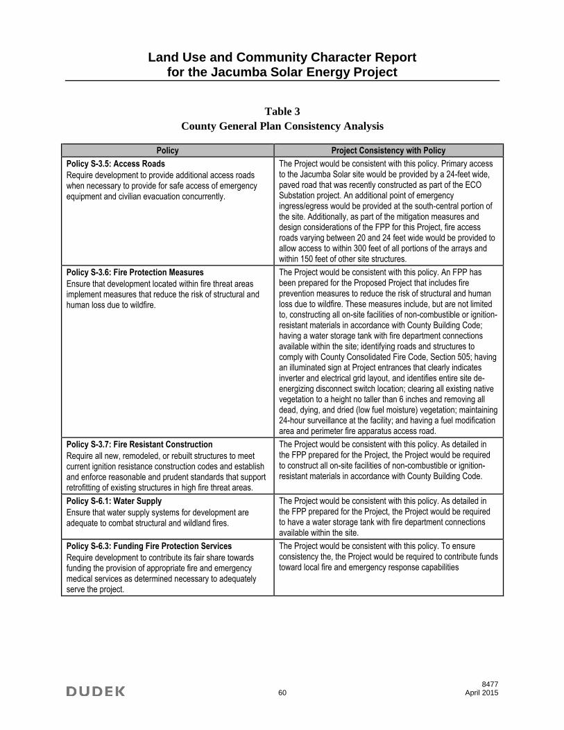
Land Use and Community Character Report for the Jacumba Solar Energy Project
8477 60 April 2015
Table 3
County General Plan Consistency Analysis
Policy Project Consistency with Policy
Policy S-3.5: Access Roads
Require development to provide additional access roads when necessary to provide for safe access of emergency equipment and civilian evacuation concurrently.
The Project would be consistent with this policy. Primary access to the Jacumba Solar site would be provided by a 24-feet wide, paved road that was recently constructed as part of the ECO Substation project. An additional point of emergency ingress/egress would be provided at the south-central portion of the site. Additionally, as part of the mitigation measures and design considerations of the FPP for this Project, fire access roads varying between 20 and 24 feet wide would be provided to allow access to within 300 feet of all portions of the arrays and within 150 feet of other site structures.
Policy S-3.6: Fire Protection Measures
Ensure that development located within fire threat areas implement measures that reduce the risk of structural and human loss due to wildfire.
The Project would be consistent with this policy. An FPP has been prepared for the Proposed Project that includes fire prevention measures to reduce the risk of structural and human loss due to wildfire. These measures include, but are not limited to, constructing all on-site facilities of non-combustible or ignition-resistant materials in accordance with County Building Code; having a water storage tank with fire department connections available within the site; identifying roads and structures to comply with County Consolidated Fire Code, Section 505; having an illuminated sign at Project entrances that clearly indicates inverter and electrical grid layout, and identifies entire site de-energizing disconnect switch location; clearing all existing native vegetation to a height no taller than 6 inches and removing all dead, dying, and dried (low fuel moisture) vegetation; maintaining 24-hour surveillance at the facility; and having a fuel modification area and perimeter fire apparatus access road.
Policy S-3.7: Fire Resistant Construction
Require all new, remodeled, or rebuilt structures to meet current ignition resistance construction codes and establish and enforce reasonable and prudent standards that support retrofitting of existing structures in high fire threat areas.
The Project would be consistent with this policy. As detailed in the FPP prepared for the Project, the Project would be required to construct all on-site facilities of non-combustible or ignition-resistant materials in accordance with County Building Code.
Policy S-6.1: Water Supply
Ensure that water supply systems for development are adequate to combat structural and wildland fires.
The Project would be consistent with this policy. As detailed in the FPP prepared for the Project, the Project would be required to have a water storage tank with fire department connections available within the site.
Policy S-6.3: Funding Fire Protection Services
Require development to contribute its fair share towards funding the provision of appropriate fire and emergency medical services as determined necessary to adequately serve the project.
The Project would be consistent with this policy. To ensure consistency the, the Project would be required to contribute funds toward local fire and emergency response capabilities

Land Use and Community Character Report for the Jacumba Solar Energy Project
8477 61 April 2015
Table 3
County General Plan Consistency Analysis
Policy Project Consistency with Policy
Policy S-6.4: Fire Protection Services for Development.
Require that new development demonstrate that fire services can be provided that meets the minimum travel times identified in Table S-1 (Travel Time Standards from Closest Fire Station).
The Project would be consistent with this policy. Emergency response for the Project would be provided, initially, by the San Diego Rural Fire Protection District from its Station 43 in Jacumba. The Jacumba Fire Station is located at 255 Jacumba Street and is staffed 24/7 with volunteer (stipend) firefighters. The Jacumba Station is approximately 5.0 miles from the most remote areas of the Project and travel time to these areas is approximately 9 minutes. This is compliant with the required Consolidated Fire Code and General Plan response time and distance requirements for rural land use zoning.
Policy S-7.1: Development Location
Locate development in areas where the risk to people or resources is minimized. In accordance with the California Department of Conservation Special Publication 42, require development be located a minimum of 50 feet from active or potentially active faults, unless an alternative setback distance is approved based on geologic analysis and feasible engineering design measures adequate to demonstrate that the fault rupture hazard would be avoided.
The Project would be consistent with the policy. The Project site is not located in a fault rupture hazard zone as identified by the Alquist-Priolo Earthquake Fault Zoning Act.
Policy S-7.2: Engineering Measures to Reduce Risk.
Require all development to include engineering measures to reduce risk in accordance with the California Building Code, Uniform Building Code, and other seismic and geologic hazard safety standards, including design and construction standards that regulate land use in areas known to have or potentially have significant seismic and/or other geologic hazards.
To ensure the structural integrity of all buildings and structures, the Project would conform to the seismic design requirements as outlined within the California Building Code (CBC), which contains universal standards for proper site preparation and grading practices, adequate design of foundation, and guidelines for the appropriate selection and use of construction materials. The local agency that enforces the CBC is the County Department of Planning and Development Services, which reviews applications for building permits for compliance with the CBC, local amendments to the CBC, and County zoning ordinances.
Policy S-9.2: Development in Floodplains
Limit development in designated floodplains to decrease the potential for property damage and loss of life from flooding and to avoid the need for engineered channels, channel improvements, and other flood control facilities. Require development to conform to federal flood proofing standards and siting criteria to prevent flow obstruction.
The Project would be consistent with this policy. The Project site contains drainage swales that would be subject to 100-year flood flows. The drainage system would be designed to adequately handle the 100-year flow estimated for the site. The facility would be unstaffed and would not put lives in danger due to flooding.
Policy S-10.4: Stormwater Management
Require development to incorporate low impact design, hydromodification management, and other measures to minimize stormwater impacts on drainage and flood control facilities.
The Project would be consistent with this policy. Grading required at the Project site would proceed in accordance with the County Grading Ordinance, which would be enforced through the grading permit. The Proposed Project would comply with the County Watershed Protection Ordinance. It does not qualify as a Priority Development Project, as it is located east of the Salton Divide. Prior to construction, the Project applicant would be required to develop and implement a SWPPP that would include BMPs to protect stormwater runoff during ground-disturbing activities. BMPs would include construction erosion control (soil applications, bonded fiber matrix), proper management of

Land Use and Community Character Report for the Jacumba Solar Energy Project
8477 62 April 2015
Table 3
County General Plan Consistency Analysis
Policy Project Consistency with Policy
construction materials to prevent spills, conservation of natural drainages, minimization of impervious surfaces, and low-impact-development roadway design. Also, see the response for Policy LU-6.5.
Policy S-10.5: Development Site Improvements
Require development to provide necessary on- and off-site improvements to stormwater runoff and drainage facilities.
The Project would be consistent with this policy. Improvements to conform with site improvement standards including storm water flows are provided.
Policy S-15.3: Hazardous Obstructions within Airport Approach and Departure.
Restrict development of potentially hazardous obstructions or other hazards to flight located within airport approach and departure areas or known flight patterns and discourage uses that may impact airport operations or do not meet Federal or State aviation standards.
The Project would be consistent with this policy. The Project is located within the AIA of the Jacumba Airport, for which the County Regional Airport Authority has adopted the Jacumba ALUCP, and is therefore subject to Sections 5250 through 5260 of the County Zoning Ordinance. The Project filed a Notice of Proposed Construction or Alteration (Form 7460-1) with the FAA. Based on the information provided in Form 7460-1, the FAA determined that the Project would not create an airspace obstruction or hazard.
Policy N-1.1: Noise Compatibility Guidelines
Use the Noise Compatibility Guidelines (Table N‐1) and the
Noise Standards (Table N‐2) as a guide in determining the acceptability of exterior and interior noise for proposed land uses.
The Project would be consistent with this policy. The Project would not generate additional traffic noise or other noise that would exceed the Noise Compatibility Guidelines or Noise Standards at Noise Sensitive Land Uses.
Policy N-1.2: Noise Management Strategies
Require the following strategies as higher priorities than construction of conventional noise barriers where noise abatement is necessary:
Avoid placement of noise sensitive uses within noisy areas
Increase setbacks between noise generators and noise sensitive uses
Orient buildings such that the noise sensitive portions of a project are shielded from noise sources
Use sound‐attenuating architectural design and building features
Employ technologies when appropriate that reduce noise generation (i.e., alternative pavement materials on roadways)
The Project would be consistent with this policy. Noise-generating equipment on the Project site has been located and buffered so as to not result in significant noise impacts. To ensure that noise from inverters would comply with the County Noise Ordinance, the following would be implemented: storage battery system equipment would be enclosed to provide noise barrier shielding to the east from the heating, ventilation, and air conditioning (HVAC) system, step-up transformers, and power inverters; quieter HVAC systems would be specifically chosen for the Project or orientation of components would be designed to ensure shielding; and the PV inverter/transformer systems would also use a quieter model to ensure noise levels are not exceeded at the property boundary.
Policy N-2.1: Development Impacts to Noise Sensitive Land Uses
Require an acoustical study to identify inappropriate noise level where development may directly result in any existing or future noise sensitive land uses being subject to noise levels equal to or greater than 60 CNEL and require mitigation for sensitive uses in compliance with the noise standards listed in Table N-2.
The Project would be consistent with this policy. An Acoustical Assessment Report was prepared for the Proposed Project. The Project would not generate additional traffic noise or other noise that would exceed the Noise Compatibility Guidelines or Noise Standards at Noise Sensitive Land Uses.

Land Use and Community Character Report for the Jacumba Solar Energy Project
8477 63 April 2015
Table 3
County General Plan Consistency Analysis
Policy Project Consistency with Policy
Policy N-3.1: Groundborne Vibration
Use the Federal Transit Administration and Federal Railroad Administration guidelines, where appropriate, to limit the extent of exposure that sensitive uses may have to groundborne vibration from trains, construction equipment, and other sources.
The Project would be consistent with this policy. No operational components of the Proposed Project include significant groundborne noise or vibration sources, and no significant vibrations sources currently exist, or are planned, in the area. Construction activities, including use of graders, scrapers, backhoes, loaders, cranes, dozers, water trucks, portable generators and air-compressors, and miscellaneous trucks, for the Proposed Project would not exceed the Federal Transit Administration guidelines.
Policy N-6.2: Recurring Intermittent Noise
Minimize impacts from noise in areas where recurring intermittent noise may not exceed the noise standards listed in Table N-2.
The Project would be consistent with this policy. Recurring intermittent noise (such as noise generated during maintenance activities, including panel washing) would be relatively low and would not exceed the noise standards for adjacent land uses with incorporation of design recommendations as identified in the Acoustical Assessment Report.
Policy N-6.4: Hours of Construction
Require development to limit the hours of operation as appropriate for non-emergency construction and maintenance.
The Project would be consistent with this policy. Construction and maintenance of the Proposed Project would conform to the hours of operation for such activities as specified by the County Noise Ordinance. If work is required outside of regularly permitted hours, then the Project applicant would go through the appropriate County process to ensure County approval of activities.
Table 4
Mountain Empire Subregional Plan Consistency Analysis
Policy and Recommendation Project Consistency with Policy
Land Use (Policy and Recommendation 1)
The landforms of the Subregion are an important environmental resource that should be respected in new development. Hillside grading shall be minimized and designed to blend in with the existing natural contours.
The Project would be consistent with this policy. Topography within the Project area varies from a gentle slope to steeper terrain on the southwest portion of the Project site. Site grading would be required for the installation of PV modules and would be limited to the southern portion of the Project site. Grading would be designed to conform to the existing contours to the extent feasible. See the Project Preliminary Grading Plan for additional detail.
Land Use (Policy and Recommendation 2)
Create a buffer area of one hundred and fifty (150) feet in width along the international boundary line inclusive of the existing sixty-foot (60’) Public Reserve owned by the Federal Government.
The Project would be consistent with this policy. See response to Land Use (Policy and Recommendation 3).
Land Use (Policy and Recommendation 3)
Apply a ninety (90’) foot setback within which no new permanent building may be built northerly of the existing sixty (60’) foot Public Reserve line. Where such ninety (90’)
The Project would be consistent with this policy. A 90-foot setback has been applied. See the Project Plot Plan for additional detail.

Land Use and Community Character Report for the Jacumba Solar Energy Project
8477 64 April 2015
Table 4
Mountain Empire Subregional Plan Consistency Analysis
Policy and Recommendation Project Consistency with Policy
foot setback can be shown to adversely impact a property, owner may apply for a waiver from complying with the setback as provided for Section 7060 of The Zoning Ordinance.
Land Use (Policy and Recommendation 4)
Ensure that all development be planned in a manner that provides adequate public facilities prior to or concurrent with need.
The Project would be consistent with this policy. There are several fire stations that are owned and staffed by San Diego County Fire Authority, CAL FIRE, San Diego County Rural Fire Protection District, and U.S. Forest Service within the Project area. Police protection in the Project area is served by the San Diego County Sheriff’s Department, California Highway Patrol, and U.S. Customs and Border Protection. The Mountain Empire Unified School District serves the Project area, and includes six elementary schools, one senior high school, and three alternative education schools. The Proposed Project is not expected to significantly alter the demand for schools, parks, or police facilities. With regard to fire protection, a FPP prepared for the Proposed Project determined that there would not be a need for new or altered fire protection facilities. Following the recommendations found in the FPP would ensure that adequate fire protection facilities are provided concurrent with development of the Proposed Project.
Energy Conservation (Policy and Recommendation 8.1)
New development should utilize alternative energy technologies, especially active and passive solar energy systems.
The Project would be consistent with this policy in that it would produce solar power eligible for the state’s Renewable Portfolio Standard that would be used by existing or future development.
Public Facilities and Services (Policy and Recommendation 5.4)
Uses proposed for the property adjacent to substations or transmission line rights-of-ways should be reviewed for possible impacts to the power facilities and vice versa.
The Project would be consistent with this policy. The Proposed Project site is adjacent to the SDG&E ECO substation. The Proposed Project would be compatible with the existing transmission facilities and vice versa.
Environmental Resources (Policy and Recommendation 1)
All development shall demonstrate a diligent effort to retain as many native oak trees as possible.
The Project would be consistent with this policy. Native vegetation communities within the Project area include Peninsular juniper woodland and scrub, which consists of Sonoran scrub oak (Quercus turbinella). However, development of the Project would not require the removal of existing oak trees.
Environmental Resources (Policy and Recommendation 3)
Floodways should be maintained in their natural state unless findings can be made that a threat to public safety exists.
The Project would be consistent with this policy. The Project site contains drainage swales that are subject to 100-year flood flows. As such, proposed improvements, such as access roads, may impede or redirect flood flows. The drainage plan and resulting drainage study would design development in such a manner as to limit the need for engineered flood control facilities to the extent feasible.
Environmental Resources (Policy and Recommendation 4)
The dark night sky is a significant resource for the Subregion and appropriate steps shall be taken to preserve it.
The Project would be consistent with this policy. Nighttime lighting during operations would be restricted to ongoing maintenance and security lighting and all Project lighting would comply with the County Lighting Ordinance. In addition, proposed security lighting at the solar facility would be directed downward and shielded to

Land Use and Community Character Report for the Jacumba Solar Energy Project
8477 65 April 2015
Table 4
Mountain Empire Subregional Plan Consistency Analysis
Policy and Recommendation Project Consistency with Policy
minimize light spillover and potential lighting impacts to adjacent properties and/or the night sky.
Environmental Resources (Policy and Recommendation 5)
Development shall not adversely affect the habitat of sensitive plant and wildlife species or those areas of significant scenic value.
The Project would be consistent with this policy. While the Project site contains native habitat, no endangered species were identified on the Project site. No highly sensitive or sensitive habitat lands as identified by the Resource Protection Ordinance were identified on site that warrant avoidance measures. The Project includes a large on-site mitigation element, which would mitigate all impacts to natural habitat to a less than significant level.
5.3 Project Requirements that Achieve Consistency
The following requirements are stipulated in County Code or standard administrative
requirments and would be implemented during construction and/or operation of the Proposed
Project ensuring consistency with existing plans, policies, and regulations.
The following will be implemented during Proposed Project construction to minimize fugitive
dust (PM10) and to comply with County Code Section 87.428 (Grading Ordinance):
The applicant will apply water three times per day or as necessary depending on weather
conditions to suppress fugitive dust during grubbing, clearing, grading, trenching, and
soil compaction and/or apply a nontoxic soil binding agent to help with soil stabilization
during construction. These measures will be applied to all active construction areas,
unpaved access roads, parking areas, and staging areas as necessary.
Sweepers and water trucks will be used to control dust and debris at public street
access points.
Internal construction roadways will be stabilized by paving, chip sealing, or nontoxic soil
binders after rough grading.
Exposed stockpiles (e.g., dirt, sand) will be covered and/or watered or stabilized with
nontoxic soil binders, tarps, fencing, or other suppression methods as needed to
control emissions.
Traffic speeds on unpaved roads will be limited to 15 miles per hour (mph).
All haul and dump trucks entering or leaving the site with soil or fill material will
maintain at least 2 feet of freeboard, or cover loads of all haul and dump trucks securely.

Land Use and Community Character Report for the Jacumba Solar Energy Project
8477 66 April 2015
Disturbed areas will be reseeded with either a native plant hydroseed mix as soon as
possible after disturbance, or covered with a nontoxic soil binding agent (such as EP&A’s
Envirotac II and RhinoSnot Dust Control, Erosion Control, and Soil Stabilization).
The following will be implemented to reduce fugitive dust emissions during Proposed
Project operation:
Enforce a 15 mph speed limit on unpaved surfaces.
Provide any of the following or equally effective trackout/carryout and erosion control
measures to minimize transfer of soil or other materials to public roads:
o Trackout grates or gravel beds at each egress point
o Wheel washing at each egress point during muddy conditions
o Application of nontoxic, permeable soil-binding agent; chemical soil stabilizers;
geotextiles; mulching; and/or seeding annually.

Land Use and Community Character Report for the Jacumba Solar Energy Project
8477 67 April 2015
6 REFERENCES
BLM (Bureau of Land Management). 2008. Eastern San Diego County Resource Management
Plan. El Centro, California: BLM. October 2008. http://www.blm.gov/ca/st/en/fo/
elcentro/esdrmp.html.
BLM. 2014. “Jacumba Mountains Wilderness.” http://www.blm.gov/ca/st/en/fo/elcentro/
recreation/ecwilderness/jacumba.html. Accessed June 24, 2014.
County ALUC (San Diego County Airport Land Use Commission). 2011. Jacumba Airport Land
Use Compatibility Plan. Adopted December 2006; amended December 2011. San Diego
County Regional Airport Authority, County ALUC.
County of San Diego. 1986. San Diego County Code, Division 9.0, Light Pollution Code,
Section 59.101 et seq. Effective July 1986.
County of San Diego. 2004. “Suggested Plant List for a Defensible Space.”
County of San Diego. 2011. San Diego County General Plan. August 3, 2011.
County of San Diego. 2014. Zoning Ordinance: San Diego County. Adopted October 18, 1978;
amended February 2014.

Land Use and Community Character Report for the Jacumba Solar Energy Project
8477 68 April 2015
INTENTIONALLY LEFT BLANK