d-mt-15 marnis final report 050609 v2 final · marnis final report d-mt-15 marnis/mt/final...
TRANSCRIPT

MarNIS Final Report D-MT-15
MarNIS/MT/Final Report/D-MT-15/DVS/05062009/version 2.0 (final) 1 of 139
SIXTH FRAMEWORK PROGRAMME
PRIORITY [1.6.2]
Sustainable Surface Transport
Final Report
Version 2.0 (Final): 05/06/09
Deliverable code: D-MT-15
Project acronym: MarNIS
Project full title: Maritime Navigation and Information Services
Contract no.: TREN/04/FP6TR//S07.36353/506408

MarNIS Final Report D-MT-15
MarNIS/MT/Final Report/D-MT-15/DVS/05062009/version 2.0 (final) 2 of 139
Document Title: Final Report
(Sub)WP/HA number: MT
Document number:
MarNIS/D-MT-15/Final Report/DVS/05062009/version 2.0 (final)
Document
History
Version Comments Date Authorised by
0.1 Initial Draft 29/01/2009 DJ
0.2 Comments and
Update
30/01/2009 DJ
0.3 Comments and
update
1/02/2009 CW
CCG
1.0 Final Draft 24/04/2009 DJ
2.0 Final Report 05/06/2009 DJ
Classification Public
Number of pages:
139
Number of annexes:
2
Responsible Organisation(s):
DVS / Sarnia Maritime b.v.
Contributing Organisation(s):
DVS
CETLE
Principal Author(s):
D. J. Jarvis
Contributing Author(s):
C. P. M. Willems
C. C. Glansdorp

MarNIS Final Report D-MT-15
MarNIS/MT/Final Report/D-MT-15/DVS/05062009/version 2.0 (final) 3 of 139
Table of Contents
1 EXECUTIVE SUMMARY........................................................................................................................................................11 2 INTRODUCTION .....................................................................................................................................................................14
2.1 Objectives of the Report .................................................................................................................. 14
2.2 Place of the Report .......................................................................................................................... 14 2.3 Structure of the Report .................................................................................................................... 15
3 THE MARNIS CONCEPT .......................................................................................................................................................16 3.1 Introduction to the concept .............................................................................................................. 16
3.2 The MarNIS elements...................................................................................................................... 16
3.2.1 SafeSeaNet++ (SSN++)........................................................................................................... 16
3.2.2 National Single Window (NSW)............................................................................................. 16
3.2.2.1 Pre Notifications.................................................................................................................. 16
3.2.2.2 PEPs/PDPs........................................................................................................................... 17
3.2.2.3 Pre Clearance Procedure (PCP)........................................................................................... 17
3.2.2.4 ETA messages ..................................................................................................................... 17 3.2.3 Port Single Window (PSW)..................................................................................................... 18
3.2.4 Port Commercial Community Systems (PCCS) ...................................................................... 18
3.2.5 Maritime Operational Services (MOS).................................................................................... 18
3.2.6 VTM in ports, VTS and POADDS.......................................................................................... 18
3.2.6.1 Self-assessment Toolkit:...................................................................................................... 18
3.2.6.2 Integral Traffic Plan (ITP):.................................................................................................. 19
3.2.6.3 Port Operations and Approach Decision Support System (POADSS): ............................... 19
3.3 Other aspects ................................................................................................................................... 19
3.3.1 Functional architecture ............................................................................................................ 19 3.3.2 Job creation and training.......................................................................................................... 19
3.3.3 Legal measures to make MarNIS possible .............................................................................. 19
3.4 Policy Considerations ...................................................................................................................... 19 3.4.1 An Integrated Maritime Policy for the European Union ......................................................... 19
3.4.2 e-Maritime ............................................................................................................................... 20
3.4.3 European maritime transport space without barriers ............................................................... 21 3.4.4 Strategic goals and recommendations for the EU’s maritime transport policy until 2018...... 23
3.4.5 e-Navigation ............................................................................................................................ 23 4 ARCHITECTURE.....................................................................................................................................................................26
4.1 Introduction ..................................................................................................................................... 26
4.1.1 The architecture content .......................................................................................................... 26
4.2 Architecture Theory......................................................................................................................... 27
4.2.1 The overall conceptual aspects ................................................................................................ 28 4.2.1.1 The Reference Model .......................................................................................................... 28
4.2.1.2 Roles .................................................................................................................................... 29
4.2.2 The logical aspects................................................................................................................... 30 4.2.2.1 Tasks.................................................................................................................................... 31
4.2.2.2 Process descriptions............................................................................................................. 32
4.2.2.3 Information flows ................................................................................................................ 33
4.2.3 Architecture deployment ......................................................................................................... 34
4.2.3.1 Defining maritime concepts................................................................................................. 34
4.2.3.2 Defining scenarios ............................................................................................................... 34
4.2.3.3 Local deployment ................................................................................................................ 34
4.3 The Reference Model ...................................................................................................................... 35
4.3.1 The Transportation Network Management responsibility domain .......................................... 36 4.3.1.1 Transportation Network Infrastructure Management .......................................................... 36

MarNIS Final Report D-MT-15
MarNIS/MT/Final Report/D-MT-15/DVS/05062009/version 2.0 (final) 4 of 139
4.3.1.2 Transportation Network Utilisation..................................................................................... 36 4.3.1.3 Transport Policy .................................................................................................................. 37
4.3.1.4 Regulation Enforcement ...................................................................................................... 37
4.3.1.5 Emergency Management ..................................................................................................... 37 4.3.2 The Transport Demand responsibility domain ........................................................................ 38
4.3.3 The Transport Service Management responsibility domain .................................................... 38
4.3.4 The On-board Support and Control responsibility domain ..................................................... 39 4.3.5 The Transport Sector Support responsibility domain.............................................................. 39
4.4 The MarNIS Roles........................................................................................................................... 40
4.5 Functional view - Task Descriptions ............................................................................................... 42
4.6 Process Descriptions........................................................................................................................ 42
4.7 The application of the architecture within the MarNIS concept...................................................... 42
4.7.1 Terminology mapped to roles.................................................................................................. 43 5 MARITIME INFORMATION MANAGEMENT ..................................................................................................................46
5.1 Background...................................................................................................................................... 46
5.2 Scope of MIM.................................................................................................................................. 46
5.2.1 MIM Architecture.................................................................................................................... 47 5.2.1.1 The roles of the MIM concept ............................................................................................. 47
5.2.1.2 Processes in the MIM concept............................................................................................. 48
5.3 Infrastructure ................................................................................................................................... 49
5.3.1 General Architecture of the System......................................................................................... 49
5.3.2 National Single Windows........................................................................................................ 49
5.3.2.1 Unique Voyage Number ...................................................................................................... 51
5.3.3 SafeSeaNet++ .......................................................................................................................... 51
5.3.3.1 Voyage Plan Server ............................................................................................................. 51
5.4 Reporting ......................................................................................................................................... 52 5.4.1 Reporting Process .................................................................................................................... 52
5.4.2 Reporting Stages...................................................................................................................... 53
5.4.3 Origin Dependent .................................................................................................................... 56 5.4.4 Arrival (PAN) and Departure (PDN) Notifications................................................................. 57
5.4.4.1 Reporting Requirements ...................................................................................................... 57
5.4.4.2 Arrival Notifications............................................................................................................ 59 5.4.4.3 Departure Notifications ....................................................................................................... 61
5.4.5 Entrance (PEPs) and Departure (PDPs) Profiles ..................................................................... 62
5.4.5.1 Systematic Approach........................................................................................................... 62
5.4.5.2 FAL, PAN and PEP information ......................................................................................... 64
5.4.5.3 Cross Reference Checking (CRC) ....................................................................................... 65
5.4.5.4 User Guides ......................................................................................................................... 65
5.4.5.5 Alert and MOS Messaging .................................................................................................. 65
5.4.5.6 Port Clearance Procedure (PCP).......................................................................................... 65
5.4.5.7 Integral Traffic Plan (ITP)................................................................................................... 65
5.5 Legal Considerations ....................................................................................................................... 66 5.5.1 The principle............................................................................................................................ 66
5.5.2 The distribution of information ............................................................................................... 67
5.5.3 The retention of information.................................................................................................... 68
5.5.4 Recommendations for the legal elements of Single Window.................................................. 68 6 MARITIME OPERATIONAL SERVICES ............................................................................................................................69
6.1 Background...................................................................................................................................... 69
6.2 Scope of MOS ................................................................................................................................. 69
6.2.1 MOS centres ............................................................................................................................ 70
6.2.1.1 Area of Operation ................................................................................................................ 70 6.2.1.2 Under-One-Roof Principle .................................................................................................. 70

MarNIS Final Report D-MT-15
MarNIS/MT/Final Report/D-MT-15/DVS/05062009/version 2.0 (final) 5 of 139
6.2.1.3 MOS Operations.................................................................................................................. 71 6.2.2 MOS responsibilities ............................................................................................................... 73
6.2.2.1 Search and Rescue (SAR).................................................................................................... 73
6.2.2.2 Oil Pollution Preparedness, Response and Cooperation (OPRC)........................................ 73 6.2.2.3 Maritime Assistance Services (MAS) ................................................................................. 73
6.2.2.4 Pro-active Vessel Traffic Management (VTM)................................................................... 73
6.2.2.5 Flag State responsibilities .................................................................................................... 74 6.2.2.6 Assistance to other Competent Authorities ......................................................................... 74
6.2.3 MOS Organization................................................................................................................... 74
6.2.3.1 MarNIS representative of State (MarNISrep)...................................................................... 75
6.2.3.2 MOS Emergency Manager (MEM)..................................................................................... 75
6.2.3.3 SAR Coordinator ................................................................................................................. 76
6.2.3.4 MOS Operator ..................................................................................................................... 76
6.2.3.5 Other .................................................................................................................................... 77
6.2.4 MOS Architecture.................................................................................................................... 77
6.2.4.1 Roles in the MOS concept ................................................................................................... 77 6.2.4.2 Processes in the MOS concept............................................................................................. 79
6.3 Services............................................................................................................................................ 80
6.3.1 MOS and Search and Rescue (SAR) ....................................................................................... 80
6.3.1.1 IMO International Convention on Maritime Search and Rescue, 1979............................... 80
6.3.1.2 Mass rescue operations........................................................................................................ 80
6.3.1.3 MOS and leisure craft.......................................................................................................... 81
6.3.1.4 Evacuation Software............................................................................................................ 81 6.3.2 MOS and Oil Pollution Preparedness, Response and Cooperation (OPRC) ........................... 82
6.3.3 MOS and Maritime Assistance Services (MAS) ..................................................................... 83
6.3.3.1 MOS centre and Places of Refuge ....................................................................................... 83 6.3.4 MOS and Pro-active Vessel Traffic Management (VTM) ...................................................... 84
6.3.4.1 Risk and Alert Values.......................................................................................................... 86
6.3.4.2 Dissemination of ENC information through MOS.............................................................. 86 6.3.4.3 Promulgation of NAVTEX messages.................................................................................. 86
6.3.5 MOS and Flag State responsibilities........................................................................................ 87
6.3.6 MOS and Assistance to Other Authorities............................................................................... 87
6.3.6.1 Monitoring for customs ....................................................................................................... 88
6.3.6.2 Monitoring for health authorities......................................................................................... 89
6.3.6.3 Monitoring for fishing authorities ....................................................................................... 90
6.3.6.4 Security monitoring ............................................................................................................. 90
6.4 MOS and Surveillance Techniques ................................................................................................. 90
6.4.1 Satellite Tool Kit ..................................................................................................................... 90 6.4.2 SAR and SLAR ....................................................................................................................... 91
6.5 Web Map Services (WMS).............................................................................................................. 92
6.6 Risk.................................................................................................................................................. 92 6.6.1 Risk-based approach................................................................................................................ 92
6.6.2 The instructions of the MOS-operators ................................................................................... 93
6.6.3 Risk values for individual ships............................................................................................... 93 6.6.4 Consequences .......................................................................................................................... 95
6.6.5 Factors that need to be considered in the future ...................................................................... 96
6.6.6 Implementation of risk calculations in a MOS centre ............................................................. 96
6.6.6.1 Calculated risk ..................................................................................................................... 97
6.6.7 Alert / High Risk Ships............................................................................................................ 98
6.6.7.1 Operational process ............................................................................................................. 98 6.6.7.2 Risk mitigating measures..................................................................................................... 98

MarNIS Final Report D-MT-15
MarNIS/MT/Final Report/D-MT-15/DVS/05062009/version 2.0 (final) 6 of 139
6.6.7.3 Operational process to indicate an Alert Vessel and the declaration of a vessel as HRS.... 99 6.6.7.4 Selection of route............................................................................................................... 100
6.6.7.5 Route advice ...................................................................................................................... 101
6.7 Human Factors............................................................................................................................... 102 6.7.1 Manning and Training ........................................................................................................... 102
6.8 Legal Considerations ..................................................................................................................... 104
6.8.1 High risk ships....................................................................................................................... 104 6.8.1.1 What is a High Risk Ship?................................................................................................. 104
6.8.1.2 A different legal regime..................................................................................................... 105
6.8.1.3 Informing the master of a ship and enforcement ............................................................... 106
6.8.1.4 The dynamic element......................................................................................................... 106
6.8.1.5 Possible legal consequences in case of non-compliance ................................................... 107
6.8.1.6 Recommendations for the legal elements of High Risk Ships........................................... 107
6.8.2 National co-ordination centres and sub-centres..................................................................... 108
6.8.2.1 Recommendations for the legal elements of National Co-ordination centres and sub-centres
108 6.8.3 Powers and obligations of competent authorities and co-operation within the EU............... 108
6.8.3.1 Recommendations for the legal elements of the powers of competent authorities............ 108
6.8.4 Regional co-operation between neighbouring member States .............................................. 109
6.8.4.1 Independent Regional consultative body or authority ....................................................... 109
6.8.4.2 Regional agreements.......................................................................................................... 111 7 VESSEL TRAFFIC MANAGEMENT IN PORTS ...............................................................................................................112
7.1 Port Assessment Tool .................................................................................................................... 112
7.1.1 Introduction ........................................................................................................................... 112
7.1.2 Objectives and use of Port Assessment Tool......................................................................... 112
7.1.3 Port Data Module................................................................................................................... 113 7.1.4 Operational Risk Management Module................................................................................. 113
7.1.5 Functional description ........................................................................................................... 114
7.1.5.1 Identification of Hazards ................................................................................................... 115 7.1.5.2 Determination of Risk ....................................................................................................... 115
7.1.5.3 Determination of Causes ................................................................................................... 116
7.1.5.4 Risk Control Options......................................................................................................... 117 7.1.5.5 Output ................................................................................................................................ 117
7.1.5.6 Accident and Incident Module .......................................................................................... 117
7.2 Portable Operational Approach and Docking Support Systems (POADSS) ................................. 118
7.2.1 POADSS – Concept............................................................................................................... 118
7.2.1.1 Web Map Services (WMS)................................................................................................ 118
7.2.1.2 Dynamic Under Keel Clearance (DUKC) ......................................................................... 119
7.2.1.3 Reference model ................................................................................................................ 119
7.2.1.4 Functional requirements .................................................................................................... 120 8 ASSESSMENT.........................................................................................................................................................................121
8.1 Costs/benefits analysis................................................................................................................... 121 8.2 Acceptance Assessment................................................................................................................. 123
8.3 Conclusions ................................................................................................................................... 126 9 ANALYSIS OF PORT STATE CONTROL DATA..............................................................................................................127
9.1 Introduction ................................................................................................................................... 127
9.2 Conclusions ................................................................................................................................... 128
9.3 Perspectives ................................................................................................................................... 128 10 SHIPBORNE EQUIPMENT ..................................................................................................................................................129
10.1 Dissemination of ENC information............................................................................................... 129
10.1.1 Background............................................................................................................................ 129
10.1.2 The ENC Inventory ............................................................................................................... 129

MarNIS Final Report D-MT-15
MarNIS/MT/Final Report/D-MT-15/DVS/05062009/version 2.0 (final) 7 of 139
10.1.3 Central database integrated with SafeSeaNet ........................................................................ 130 10.1.4 Potential ways to establish contact between ships and the MOS .......................................... 130
10.1.5 Potential of NAVTEX ........................................................................................................... 131
10.2 Calculated Time of Arrival (CTA) Server..................................................................................... 131 10.3 Bridge Alert Management ............................................................................................................. 131
11 POLICY RECOMMENDATIONS ........................................................................................................................................133 11.1 Policy Recommendations .............................................................................................................. 133
11.2 Technical Aspects.......................................................................................................................... 134
11.3 Legal Measures.............................................................................................................................. 136 12 IMPLEMENTATION PLAN..................................................................................................................................................139
ANNEX 1: The MarNIS Architecture, Roles and Tasks
ANNEX 2: List of relevant MarNIS research reports

MarNIS Final Report D-MT-15
MarNIS/MT/Final Report/D-MT-15/DVS/05062009/version 2.0 (final) 8 of 139
List of Abbreviations AIS Automatic Identification System
A2A Administration to Administration
ATD Actual Time of Departure
AtoN Aids to Navigation
B2A Business to Administration
BGW Black-Grey-White List (of PSC)
CASRAT Casualty Rate
CBA Cost Benefit Analysis
COSS Committee on Safe Seas and the Prevention of Pollution from Ships
CRC Cross Reference Check
CTA Calculated Time of Arrival
DG TREN Directorate General for Energy and Transport
DSS Decision Support System
DUKC Dynamic Under Keel Clearance
EC European Commission
ECDC European Centre for Disease Prevention and Control
ECDIS Electronic Chart Display and Information System
EDI Electronic Data Interchange
EEZ Exclusive Economic Zone
EIS European Index Server
EMSA European Maritime Safety Agency
ENC Electronic Navigation Chart
EOS Earth Observation System
ETA Estimated Time of Arrival
ETD Estimated Time of Departure
ETP Estimated Time of Passage
ETV Emergency Towing Vessel
EU European Union
FAL IMO Facilitation Convention
FSA Formal Safety Assessment
FTP File Transfer Protocol
GMDSS Global Maritime Distress and Safety System
GNSS Global Navigation Satellite System.
GPRS General Packet Radio Service
GPS Global Positioning System
HA Horizontal Activity
HAS High Alert Ship
HNS Hazardous or Noxious Substances
HRV High Risk Ship
IALA International Association of marine Aids to Navigation and Lighthouse
Authorities

MarNIS Final Report D-MT-15
MarNIS/MT/Final Report/D-MT-15/DVS/05062009/version 2.0 (final) 9 of 139
ICT Information and Communication Technology
IHO International Hydrographic Organization
ILO International Labour Organization
IMO International Maritime Organization
IRR Internal Rate of Return
ISM Code International Management Code for the Safe Operation of Ships and for
Pollution Prevention
ISPS Code International Ship and Port Facility Security Code
ITP Integral Traffic Plan
LRIT Long Range Identification and Tracking
LRR Long Range Reporting
MAOC-N Maritime Analysis and Operations Centre – Narcotics
MARE Temporary Committee of the European Parliament on improving safety at sea
MarNIS Maritime Navigation and Information Services
MAS Maritime Assistance Services
MEM Maritime Emergency Manager
METOC Meteorological and Oceanographic
MIM Maritime Information Management
MOS Maritime Operational Services
MoU Memorandum of Understanding
MRCC Maritime Rescue Coordination Centre
MRO Mass Rescue Operations
MSC Maritime Safety Committee (of IMO)
MSI Maritime Safety Information
NAVTEX Navigational Telex
NSW National Single Window
OEDA Observation-Evaluation-Decision-Action
OPRC Oil Pollution Response Coordination
OSC On scene Commander
PAN Pre/Port Arrival Notification
PCCS Port Commercial Community System
PCP Port Clearance Procedure
PCS Port Community System
PDN (Pre/Port) Departure Notification
PDP (Pre/Port) Departure Profile
PEP (Pre-) Entrance Profile
POADSS Port Operational Approach &Docking Support System
PPU Portable Pilot Unit
PSC Port State Control
PSSA Particularly Sensitive Sea Area
PSW Port Single Window
QRA Quantitative Risk Analysis
RCO Risk Control Option

MarNIS Final Report D-MT-15
MarNIS/MT/Final Report/D-MT-15/DVS/05062009/version 2.0 (final) 10 of 139
RENC Regional ENC Centre
SAR Synthetic Aperture Radar
SAR Search and Rescue
SITREP Situation Report
SLAR Side Looking Airborne Radar
SMC SAR Mission Co-ordinator
SMTP Simple Mail Transfer Protocol
SOLAS IMO Convention Safety of Life at Sea
SOSREP Secretary of State's representative
SRR Search and Rescue Region
SRU Search and Rescue Unit
SSN SafeSeaNet
SSN NOT DEP SafeSeaNet Notification Departure
SSN NOT ENT SafeSeaNet Notification Entrance
SSN++ MarNIS enhanced version of SafeSeaNet
SSS Short Sea Shipping
STK Satellite Toolkit
SW Single Window
UAV Unmanned Aerial Vehicle
UKC Under Keel Clearance
UML Universal Markup Language
UNCLOS United Nations Convention on the Law of the Sea
UNECE United Nations Economic Commission for Europe
VAR Value Added Resellers
VDR Voyage Data Recorder
VMS Vessel Monitoring System
VPS Voyage Plan Server
VTM Vessel Traffic Management
VTS Vessel Traffic Services
WLAN Wireless Local Area Network
WMS Web Map Services
WP Work Package
WWNWS World Wide Navigation Warning Service
XML eXtensible Markup Language

MarNIS Final Report D-MT-15
MarNIS/MT/Final Report/D-MT-15/DVS/05062009/version 2.0 (final) 11 of 139
1 EXECUTIVE SUMMARY
Maritime safety, efficiency, security and protection of the environment are inextricably linked. Supported by
the European Commission (EC) Green Paper “Towards a future Maritime Policy for the Union”, a
requirement has been clearly identified for coherent, transparent, efficient and simplified solutions in support
of cooperation, interoperability and consistency between member States, systems and sectors, placing
emphasis on and promoting the role of the maritime industry.
Figures in the Green Paper state that 90% of the EU’s external trade and over 40% of its internal trade is
transported by sea, with Europe having 40% of the world fleet. This emphasizes the importance of the
continued efficiency of ports, the effective management of vessel traffic in coastal waters and the facilitation
of trade through cooperation and coherence.
Further, the EC is promoting the development of e-Maritime; a meeting of services and systems, in response
to the need for a more transparent and harmonized approach within the maritime sector in general in order to
secure its position as a leading transport mode.
The EC co-funded 6th Framework project MarNIS (Maritime Navigation and Information Services) is
contributing to the development of e-Maritime. The focus is placed on the improved exchange of information
and provision of services and the required infrastructure to meet the requirements placed on both the
authority and business level. The stakeholders may include on the one hand the ship itself, together with the
ship owner, operator and agent, and on the other hand shore-based entities, including maritime authorities
(e.g. Search and Rescue (SAR), coastal and port), related authorities (e.g. customs and immigration) and
commercial parties within the port sector.
MarNIS proposes means to put an end to present fragmentation of measures in place through the
development of a concept where resources, systems and services are organised and strengthened into one
coherent set of measures.
In the lifecycle of the project, the “MarNIS concept” has been developed to enhance safety at sea whilst at
the same time improving the efficiency of sea traffic and of course the prevention of the pollution of our
marine environment. Whilst providing concrete proposals for the enhancement of the current EU Directive
2002/59/EC and (proposed) amendments, as well as many other Directives dealing with maritime issues, the
MarNIS concept is not restricted to a technological solution; it is an integrated organisational, operational
and legal concept, using electronic information and communication technology. The concept focuses on an
implementation timeframe of 2012 – 2020.
The core concept of MarNIS is three fold:
• Assist the vessel master in communicating with the ports and its myriad authorities in a seamless and
effortless way by the introduction of a “one-stop-shop” methodology.
• Coastal vessel traffic management to avoid congestion, fuel savings and port efficiency.
• Enhancing SAR authorities’ capabilities, anti-pollution measures and tracking and monitoring of
vessels throughout the EU coastal regions.
Following two successful demonstrators in Genoa and Lisbon, including the enthusiastic response to the
MarNIS concept of many different administrations, authorities, service providers and shipmasters, it is to be
noted that a number of individual aspects are being carried forward by various member States today.
However, whilst some issues are for the consideration of international bodies such as the International
Maritime Organisation, the MarNIS concept as a whole is designed to best meet the needs of the EU member
MarNIS Final Report D-MT-15
MarNIS/MT/Final Report/D-MT-15/DVS/05062009/version 2.0 (final) 12 of 139
States, taking into full consideration the “Integrated Maritime Policy for the European Union”, or Blue Book,
and providing key inputs for developments towards Common Maritime Space and eMaritime. As such the
MarNIS concept promotes and relies on coherent, transparent, efficient and simplified solutions in support of
cooperation, interoperability and consistency between member States, systems and sectors, placing emphasis
on and promoting the role of the maritime industry.
MarNIS has developed the Maritime Information Management (MIM) concept providing the means
whereby the Master is only required to report once, all other updates being fed automatically into the
information messaging structure and passed on to the relevant authorities. Early reporting leads to improved
planning for ports and related nautical services through enhanced traffic organisation services and the
integral traffic plan. A messaging structure designed to involve all authorities, not only maritime, has been
developed so that the passage of a ship may be as safe, efficient and secure as possible whilst rendering less
threat to the environment as a consequence of incidents. The MIM concept also envisages the centralisation
of all relevant data on a ship, including its cargo, number of passengers, last and next port of call, flag, type,
age, Port State Control inspection information, ETA and voyage plan. This centralisation is achieved through
the creation of National Single Windows (NSW), through which all the data are funnelled. The NSW is like
a hub, to which all authorised maritime stakeholders are connected, sharing the same information. The data
are held in an enhanced, pan-European SafeSeaNet (SSN++) electronic database, distributed to stakeholders
via the NSW.
Through innovative use of resources and technologies, shore-based operators are able to monitor and provide
the appropriate level of assistance wherever the ship may be located in the coastal waters, shifting the
emphasis from remedial services towards proactive services. For this the Maritime Operational Services
(MOS) concept has been developed.
The MOS concept envisages the integration of several maritime operational services, notably Vessel Traffic
Management (VTM), Search and Rescue (SAR) and Oil Pollution Preparedness Response and Co-operation
(OPRC) ‘under one roof’, as Maritime Operational Services. In several Member States, these services are
separate, with their own staff and resources, and fall under different government departments or Ministries.
The MOS concept does not have to mean physically bringing these services together. They could be co-
ordinated virtually, sharing centralised databases and traffic images, for example.
Through the identification of High Risk Ships appropriate measures may be taken in order to relieve the
threat to the coastline and oceans. Research in MarNIS into the legal consequences for this more proactive
approach has indicated that coastal States have the opportunity to monitor and prevent undesired incidents
from developing through the use of appropriate risk-based assessment methods, also developed within
MarNIS.
The following notions are used throughout MarNIS: early reporting; buying time; no blame culture;
reporting once to authorities; reducing risks; reducing administrative burden; improving safety; improving
efficiency of remedial services; they are all common place within the MarNIS project.
The MarNIS concept is based on a number of fundamental considerations. The overriding design factor is the
respect for the principle of subsidiary of the member States. The member States have elected to co-operate
but their sovereignty of their area leads to a sense of immunity of their territory. In short, the analysis of
these principles lead to a European authority that makes directives that need to be implemented by the
member States according to the agreements but in harmony with the existing legal structures that exist in
each member State.
The MarNIS concept revolved around three key areas, these being Maritime Information Management
(MIM), Maritime Operational Services (MOS) and Traffic Management in Ports. Appropriate consultation

MarNIS Final Report D-MT-15
MarNIS/MT/Final Report/D-MT-15/DVS/05062009/version 2.0 (final) 13 of 139
has taken place accounting for the e-Navigation and e-Maritime strategies as being developed by IMO and
the EU respectively.
As well as outlining in detail the key areas of the MarNIS concept this report also highlights a number of the
tools and applications that have been developed within the MarNIS project.
The reader is invited to consult the numerous individual work package reports, providing for more detail; a full
list of relevant research reports in included in the Annexes to this report.

MarNIS Final Report D-MT-15
MarNIS/MT/Final Report/D-MT-15/DVS/05062009/version 2.0 (final) 14 of 139
2 INTRODUCTION
2.1 Objectives of the Report
The EC co-funded 6th Framework project MarNIS (Maritime Navigation and Information Services) is
contributing to the development of e-Maritime. The focus is placed on the improved exchange of information
and provision of services and the required infrastructure to meet the requirements placed on both the
authority and business level. The stakeholders may include on the one hand the ship itself, together with the
ship owner, operator and agent, and on the other hand shore-based entities, including maritime authorities
(e.g. Search and Rescue (SAR), coastal and port), related authorities (e.g. customs and immigration) and
commercial parties within the port sector.
According the original remit of MarNIS the strategic objectives included:
• Better observation of all rules and a better follow-up of the maritime traffic, through:
o Screening all elements and data required from a ship while it is still navigating towards the port.
Communication by the ship to the relevant office on shore of all the required data for conducting
controls with respect the application of ISM, ISPS, codes of the ILO or indeed other Conventions, of
all customs, sanitary, veterinary and phyto-sanitary rules, immigration and identity, or certificates of
competence checks amongst others;
o Enhanced use of tracking technology, e.g. AIS, to improve the efficiency of traffic monitoring and
control of operations, also allowing to better provide services such as emergency tugs, oil pollution
combating vessels, salvage capabilities and assisting in the decision making process in allocating
ships to safe havens. Enable neighbouring countries to better share maritime-control public-services
resources and even pool control efforts;
o Developing proposals for the standardisation and harmonisation in a European network for the safety
and routing of ships at sea, also being dependent on maritime weather information. Additionally,
updating of ships’ Electronic Navigation Charts and other shore-to-ship services using modern
telecommunications means allowing for timely corrections when required.
• Better management of the ship, it’s cargo and it’s crew, through:
o Allowing for the use of the two way system (communication ship to shore and vice versa) to enable
a better preparation of unloading-loading operations planning, advance of connection of the cargo to
hinterland transport, supplies to the ship, change of the crew, etc.
This report has the objective to present the results of the MarNIS project, in particular the Maritime
Information Management (MIM) and Maritime Operational Services (MOS) concepts, and highlight the
approach adopted through use of the Architecture as well as highlighting a number of the tools and applications
that have been developed within the MarNIS project.
2.2 Place of the Report
This report constitutes the Final Report of the MarNIS project, a consolidated overview of the key issues
addressed in MarNIS and the solutions proposed. This report is based on the findings of the original Work
Package (WP) and Horizontal Activity (HA) deliverables.

MarNIS Final Report D-MT-15
MarNIS/MT/Final Report/D-MT-15/DVS/05062009/version 2.0 (final) 15 of 139
2.3 Structure of the Report
This report is divided into four sections dealing with:
Chapter 1: Providing an Executive Summary as an overview of the main content of the report.
Chapter 2: Providing insight into the purpose of this report and it’s relation to other deliverables of
MarNIS.
Chapter 3: Providing an overview of the MarNIS concept as developed and the key elements thereof.
Also included is an overview of key EU and international policies relating to the subject
matter of MarNIS and the areas addressed thereto;
Chapter 4: Providing an overview of the Architecture as developed, including the Reference Model,
roles, tasks and responsibilities;
Chapter 5: Providing an overview of the Maritime Information Management (MIM) concept; the scope,
architecture, infrastructure (including Single Windows and SafeSeaNet), reporting and legal
considerations;
Chapter 6: Providing an overview of the Maritime Operational Services (MOS) concept; the scope,
organisation, services, surveillance techniques, risk, human factors and legal considerations;
Chapter 7: Providing an overview of the work conducted related to Vessel Traffic Management in Ports,
namely the development of the Port Assessment Toolkit and the Portable Operational
Approach and Docking Support System (POADSS);
Chapter 8: Providing an overview of the Assessment activities in MarNIS, including the Cost/Benefit
and Acceptance Assessments;
Chapter 9: Providing a brief consideration of Port State Control (PSC) data and the relationship with the
work of MarNIS on risk;
Chapter 10: Providing an overview of a number of studies conducted relating to the vessel itself,
including the dissemination of ENC data, the Calculated Time of Arrival (CTA) Server and
Bridge Alarm Management;
Chapter 11: Providing an overview of the derived Policy, Technical and Legal Recommendations from
the various deliverables;
Chapter 12: Providing an overview of the potential next steps in developing an implementation plan for
the MIM and MOS concepts of MarNIS.
Annex 1: Provides further insight into the Roles and Tasks as developed within the MarNIS
Architecture.
Annex 2: Provides for an overview of all relevant MarNIS research reports where further details may
be sought.

MarNIS Final Report D-MT-15
MarNIS/MT/Final Report/D-MT-15/DVS/05062009/version 2.0 (final) 16 of 139
3 THE MARNIS CONCEPT
3.1 Introduction to the concept
The heart of the MarNIS concept is the newly developed information and information exchange structure using
some crucial recommendations as regards the single window concept. Simplification of reporting requirements
and the creation of interoperability between different member State systems and sectors provide for coherence,
transparency and efficiency. Based on the single reporting from the Master and/or agent all processes should
begin.
Under current EC Directives and various complementary regulations and rules the Master is faced with a large
reporting burden, often having to send the same information numerous times to numerous different authorities.
In the MarNIS concept the Master is required to report once through the port arrival notification to the
destination port or anchorage. All relevant authorities and services are then obtaining the information required by
them through the National Single Window.
Authorities requiring information from maritime traffic and transport are numerous and fall under the
traditional maritime authorities, such as port-, coastal-, search and rescue and pollution response authorities,
or others such as security, customs, immigration, health and border control authorities. These authorities
make up rill now use of their own means for maritime information management and would benefit from
increased access to data and interoperability. The MarNIS concept provides for a harmonised and coherent
system for the exchange of all relevant information.
3.2 The MarNIS elements
3.2.1 SafeSeaNet++ (SSN++)
SafeSeaNet currently acts as an index server, allowing the authorized user to find information on notifications,
cargo manifests, voyage history and incident history. Basic data is held within the SSN system whilst contact
points are provided for further information on for example dangerous or hazardous goods. The MarNIS concept
envisages an expansion and strengthening of the role of SSN into the so-called SSN++, providing a more
efficient service through the SSN++ Core and the SSN++ Portal leading to more added-value through the
generation of notifications to coastal authorities on ships likely to pass through their areas of jurisdiction as well
as consolidate reports to all authorities. Connections to the National Single Windows (NSW) and the SSN++
Core, being the central server system, will consist of an European Index Server (EIS), Request and Response (R
and R) server, voyage plan server, AIS repository, Long Range Reporting (LRR) database, on-going SAR
operations and update of Estimated Time of Arrival (ETA) messages. In addition to dedicated databases, SSN++
also has access to reference databases such as Equasis. The SSN++ Portal consists of the National Single
Window (NSW), this being the gateway for users to provide and receive the information.
3.2.2 National Single Window (NSW)
Under MarNIS, each member State maintains a National Single Window, receiving notifications from ships
intending to enter a port in its waters and ensuring the direct distribution of derived messages to the port, other
authorities (such as customs, immigration etc.) as well as handling requests for information or clarification. The
NSW is the single point of contact point within the total SSN++ structure and ensures that the appropriate
information is in the first place made available within the SSN server and secondly available to requesting
authorities from other member States.
3.2.2.1 Pre Notifications
The Master and/or agent of a ship bound for a port or anchorage within the European Community sends a
notification containing all information required by “Authorities” to the NSW of the member State having the

MarNIS Final Report D-MT-15
MarNIS/MT/Final Report/D-MT-15/DVS/05062009/version 2.0 (final) 17 of 139
port of destination. This notification can be seen as one single report and replaces the separate reporting required
today. In practice the information may be sent by the Master (ship related) and agent (cargo and facilities
related). The NSW will redistribute the information to the relevant authorities and SSN++ in messages according
to the spirit of the FAL convention and Pre Entrance Profiles (PEPs) in so far as they are supplementing each
other.
3.2.2.2 PEPs/PDPs
A Pre-Entrance Profile (PEP) is a structured and concise report containing the information on a given aspect of
the arrival of a ship in a port or anchorage which will be used by the authorities to make a decision regarding the
entrance of that ship. The background of a PEP is based on the increasing international rules which need to be
satisfied by ships when arriving in a port of the Community. The PEP provides an opportunity to use information
from other ports in the Community and as such contribute to the efficiency of the port as well as contribute to the
reliability and quality of the information to be received. PEPs are derived for: Arrival Information; Port
Planning; Safety; Dangerous Goods; Environment; Security; Customs; Health; Immigration; and Emergency.
Similarly a Port Departure Profile (PDP) contains the information required for departure procedures.
In order to reduce inspection work of all maritime authorities , the last port of call sends a consolidated PDP to
port of arrival which may be used to reduce inspection work, if the authority considers that inspections in the
preceding port are carried out by a “trusted source”.
On top of that reliable information that is contained in the system needs not to be reported over again.
PEP information may be cross-referenced to information which is available in SSN++ and in databases that are
connected to SSN++. The Cross Reference Checks (CRCs) are made with the objective to check the reliability of
the information and may be invoked by the Harbour Master or by a competent authority that checks the PEP.
The CRCs go to the NSW and, when all CRCs are collected, are sent to SSN++ in order to check the information
in its available databases. When the information is checked the results are sent back to the requestors and the
authorities are now in a position to assess the information.
3.2.2.3 Pre Clearance Procedure (PCP)
The Port Clearance Procedure (PCP) is a procedure designed to assess the results of the different PEPs in order
to allow the ship to enter a Community port.
The master and the agent provide information to the NSW by means of the port arrival notification. This NSW
composes the PEPs and sends them to the different authorities. The NSW sends also the information of the
consolidated preceding port PDP to the different authorities. They assess the information contained in the PEP
and may send it back to the NSW to obtain a crosscheck. This cross check is to be executed with the support of
the databases within SSN++. When the information is found this information is sent back to the different
authorities and they give their final assessment. The results of this assessment go to the NSW which in turn
sends the information to the Decision Support System (DSS) of the responsible authority. The DSS assesses the
information based on a prescribed screen and communicates the decision to the authority who will, if agreeable,
communicate this to the ship and the agent through the NSW.
Special rules will apply to determine the way in which entrance might be provided. The result of this assessment
is one of the following: Unrestricted entrance, entrance with special requirements and no entrance. These rules
will be established in consultation with the competent authorities.
3.2.2.4 ETA messages
Much of the information reported in the port notification is static, however the Estimated Time of Arrival may be
updated or amended by the Master, on request of the owner (ship or cargo) or on request of the port of
destination. It is not the intention that the Master report each time the ETA is updated; instead this will be
retrieved from Short Range Reporting Systems (presently Automatic Identification (AIS)) or Long Range
Reporting Systems (presently LRIT messages). The NSW will inform the relevant authorities as and when an
update is received.
Voyage plan messages: Ships calling at an EC port will normally transit SRRs of member States other than those
of the final destination. In order to assist MOS centres a Voyage Plan Server located within SSN++ will
MarNIS Final Report D-MT-15
MarNIS/MT/Final Report/D-MT-15/DVS/05062009/version 2.0 (final) 18 of 139
calculate the most probable intended route of a ship, based on port of departure and destination as well as known
shipping routes, and inform MOS centres along this route of the predicted times and place of entry in each of the
centre’s areas of operation. The basic reason is to inform the MOS centres of the arrival of vessels that may be
used in potential distress situations
3.2.3 Port Single Window (PSW)
Under MarNIS, the Port Single Window is the information management system for the port authority and
provides for a central collection and distribution of information coming from the port environment and required
by either external authorities as additional information to the ship notifications or for internal (local) authorities
and maritime services requiring specific information within the port itself. Information provision to external
partners is on an authorised basis only.
3.2.4 Port Commercial Community Systems (PCCS)
The considerable investment that ports and their communities have made in systems aimed at the facilitation of
information exchange should not be ignored but embraced in the overall MarNIS concept. Whilst MarNIS
concentrated on Administration to Administration (A2A) reporting requirements, details for the Business to
Administration (B2A) reporting requirements were developed to the extent as to allow for flexibility and choice
form the master/agent as to how the information was supplied to the NSW. The so-called MarNIS Node was
promoted in its infancy as a mechanism whereby a PCCS could communicate with different PCCS in different
ports as well as “feed” the PSW with the required information. Further development of such mechanisms was
deemed outside the core focus of the Administration reporting requirements and should be subject to a dedicated
initiative.
3.2.5 Maritime Operational Services (MOS)
This is a new concept integral to MarNIS designed to provide for routine, enforcement, preventive, and remedial
services in the search and rescue area in the form of monitoring and the co-ordination and provision of response
services. Going one step further than the Green Paper, MOS promotes proactive services to avoid incidents not
only developing but also occurring in the first place. Functions such as SAR, VTS, enforcement, oil pollution
response, risk determination, use of places of refuge and sending Emergency Towing Vessels (ETV) are
combined in a MOS centre; MAS services as meant by IMO are fully integrated in MOS. Operators responsible
for one or more of these tasks can share the same information and equipment and co-operate in performing their
tasks.
3.2.6 VTM in ports, VTS and POADDS
3.2.6.1 Self-assessment Toolkit:
The use of risk assessment procedures obliges Port Authorities to analyse their functional responsibility more
closely and to this end a toolkit has been developed whereby ports are able to self-assess the measures in place
and qualify the ranking of potential risks in their port. The toolkit consists of four modules: port data; operational
risk management; Quantative Risk Analysis (QRA); and, strategic advice. Working from a generated baseline
document, highlighting the situation today and planned developments, the operational risk management module
uses self-assessment and provides a ranking of potential risks based on ‘what if’ scenarios’. The QRA module
provides the costs and benefits of proposed measures in terms of risk reduction. The toolkit encourages a process
of review, which helps to reinforce established measures and promote a safety culture within the contributing
maritime authorities.
Small and medium ports: Whilst the toolkit will highlight potential measures to be taken it is often the case that
large investments in shore-based monitoring equipment are disproportionate for the smaller and medium ports.
To this end a review is conducted on the potential for ports to make use of coastal AIS networks and other means
in order to generate an appropriate traffic image.

MarNIS Final Report D-MT-15
MarNIS/MT/Final Report/D-MT-15/DVS/05062009/version 2.0 (final) 19 of 139
3.2.6.2 Integral Traffic Plan (ITP):
Through the early reporting and availability of information ports can better anticipate the demand for use of
facilities in the port and provide enhanced Traffic Organisation Services. Based on an ETA Berth, the port can
request a ship to adapt its ETA and so optimize not only the resources but also the arrival of the ship. This allows
for better use of infrastructure and reduced waiting times leading to improved efficiency.
3.2.6.3 Port Operations and Approach Decision Support System (POADSS):
Consisting of a normal Portable Pilot Unit (PPU) the POADSS is augmented with a high precision system of
measuring the relative motions of the ship with respect under keel clearance. Information to and from the
POADDS will go to a special module that is coupled to the Tactical Traffic Image of the VTS. Utilising high
density charts, precision motion detection and the latest information of surrounding traffic, the POADSS will
facilitate optimal use of the fairway.
3.3 Other aspects
3.3.1 Functional architecture
Recognising that diverse roles and tasks are not always conducted by the same stakeholders in the different
member States, the functional architecture of MarNIS describes the more generic functions and the roles that are
played by authorities and operators, masters and other functionaries. This consistent approach of the functional
architecture supports the endeavour to have a generic approach which may be used by the administrations of the
member States to organise their activities according to their national law.
3.3.2 Job creation and training
The MarNIS concept introduces new tasks where additional training will be required. With respect the creation
of jobs it is very much dependant on the type of person required to fulfil particular tasks and MarNIS may on the
one hand reduce personnel requirements for authorities however, through improved efficiency and with it
increased market share, the maritime industry as a whole will provide increasing opportunities.
3.3.3 Legal measures to make MarNIS possible
Vital elements of the MarNIS concept, including the preventive services of MOS and the determination of High
Risk Ships, have required thorough consideration of the present international legal framework. Whilst the Green
Paper questions the ability for coastal States to intervene with ships in transit or in the EEZ of that State, it has
been shown in MarNIS that through the use of appropriate risk assessment methodologies coastal States do have
the right to monitor and, where appropriate, impose additional routing measures to ships posing a more than
average threat.
MarNIS have also been identified that duplication and even contradiction in present rules and regulations lead to
less clarity, coherence and simplicity of these rules. MarNIS supports recommendations for legal measures
supporting the introduction of the MarNIS concept.
3.4 Policy Considerations
MarNIS has direct bearing on the following policy considerations:
3.4.1 An Integrated Maritime Policy for the European Union
The Communication of the European Commission on “An Integrated Maritime Policy for the European
Union” (COM(2007) 575 final), the so-called “Blue Book”, recognized that “an Integrated Maritime Policy
will enhance Europe's capacity to face the challenges of globalisation and competitiveness, climate change,
degradation of the marine environment, maritime safety and security, and energy security and sustainability”.
Further this must be based on “excellence in marine research, technology and innovation…”.
The EU Integrated Maritime Policy focuses its action primarily in the following five areas:
• Maximising the Sustainable Use of the Oceans and Seas;

MarNIS Final Report D-MT-15
MarNIS/MT/Final Report/D-MT-15/DVS/05062009/version 2.0 (final) 20 of 139
• Building a knowledge and innovation base for the maritime policy;
• Delivering the Highest Quality of Life in Coastal Regions;
• Promoting Europe's Leadership in International Maritime Affairs;
• Raising the Visibility of Maritime Europe.
In maximizing the sustainable use of the oceans and seas the Blue Book recognizes that an updated strategic
vision for the development of competitive, safe and secure shipping, ports and related sectors is essential if
we are to achieve sustainable growth of sea-related activities while ensuring that maritime activities develop
in a way that does not threaten marine ecosystem health.
It is further recognised that shipping remains at a disadvantage compared to other means of transport. Other
transport modes benefit from more public investment. Furthermore, a vessel travelling between two EU ports
is subject to more complex and time-consuming procedures than a truck would be, because a real internal
market for maritime transport in Europe does not yet exist. In order to unlock the full potential of Europe's
shipping industry this disadvantage of maritime transport compared with the other modes must be eliminated
through the simplification of administrative and customs formalities for intra-EU maritime services.
In response to these, and other considerations, with a view to improving the efficiency of maritime transport
in Europe and ensuring its long term competitiveness, it was stated that the Commission will:
• Propose a European Maritime Transport Space without barriers;
• Prepare a comprehensive maritime transport strategy for 2008-2018.
The Commission has recently published two Communications to this effect:
• COM(2009) 10 – Communication and action plan with a view to establishing a European maritime
transport space without barriers; and.
• COM92009) 11 – Strategic goals and recommendations for the EU’s maritime transport policy until
2018.
3.4.2 e-Maritime
e-Maritime represents a set of EU policies, strategies and capabilities facilitating online or electronic
interactions between all different stakeholders involved in the development of an efficient and sustainable
waterborne transport system throughout Europe, fully integrated within the transport logistic chains.
The implementation of the e-Maritime concept will facilitate the maritime transport to become more
attractive to operators, as well as to meet obligations as placed on authorities and to facilitate business-to-
business relations.
The European Commission announced in its Mid-term Review White Paper on Transport Policy (COM
(2006)314 final of 22 June 2006) that will propose measures for the implementation of e-Maritime systems
in 2009. This announcement was repeated in the European Agenda for Freight Logistics of 18 October 2007:
Boosting the efficiency, integration and sustainability of freight transport in Europe COM(2007) 606 final.
The objective of the European e-Maritime initiative is to promote “coherent, transparent, efficient and
simplified solutions in support of cooperation, interoperability and consistency between member States,
sectors, business and systems involved in the European Transport System” (European Commission Green
Paper “Towards a future Maritime Policy for the Union”). This objective is fully compatible with the Lisbon
Agenda, the mid-term review of the Transport White Paper, the Blue Book on an integrated maritime policy,
the information society and a range of other policies inspired from electronic means of communication
including e-Government, e-Customs and e-Freight.

MarNIS Final Report D-MT-15
MarNIS/MT/Final Report/D-MT-15/DVS/05062009/version 2.0 (final) 21 of 139
3.4.3 European maritime transport space without barriers
The Communication on a European maritime transport space without barriers has identified a number of
actions required in both the short- and medium term, in the main dealing with the simplification and easing
of administrative formalities and burdens. This is not only true for the European maritime transport space
without barriers but in the wider sense forms the core of the approach to e-Maritime in general, at least for
the administrative actions.
It is recognized that the administrative procedures for maritime transport are too often unnecessarily
complex. Whilst solutions have been proposed towards the public side of reporting it needs to be recognized
that much “reporting” required for the smooth and efficient operation of a port is not always the
“administrative” reporting in response to regulation and requirements of the various authorities.
Maritime safety, efficiency, security and protection of the environment are inextricably linked. A
requirement has been clearly identified for coherent, transparent, efficient and simplified solutions in support
of cooperation, interoperability and consistency between member States, systems and sectors, placing
emphasis on and promoting the role of the maritime industry. Figures in the Green Paper state that 90% of
the EU’s external trade and over 40% of its internal trade is transported by sea, with Europe having 40% of
the world fleet. This emphasizes the importance of the continued efficiency of ports, the effective
management of vessel traffic in coastal waters and the facilitation of trade through cooperation and
coherence.
In the eyes of the Customs authorities, voyages from one EU port to another EU port are always considered
to be international, even when the transported cargo is internal market-cleared goods. A vessel is considered
to leave the customs territory when it leaves a Community port as part of the external border.
The current situation not only has an impact on the efficiency of shipping operations in the EU but bears a
financial cost for the operators. As long as this remains the case then initiatives including Short Sea Shipping
(SSS) and Motorways of the Sea (MoS) are to some extent hampered in providing a viable alternative to road
transport.
Following the publication of the Blue Book, and in the development of consultation papers on European
Maritime Transport Space without barriers, DGTREN have noted that 9 measures are under consideration,
namely:
1. Simplification of regulations on carriage of dangerous goods;
2. Abolishment of Customs formalities;
3. Single document for all vessel related procedures;
4. Enhanced electronic data transmission (elimination of paperwork);
5. Administrative Single Window;
6. One-stop administrative shops in ports;
7. Use of English as second official administrative language;
8. Pilot exemption certificate;
9. Separation of areas in ports (Community and non-Community goods).
Within MarNIS the Maritime Information Management (MIM) concept has gone some way to responding
directly to a number of the considerations as stated above, in particular:
3. Single document for all vessel related procedures;
4. Enhanced electronic data transmission (elimination of paperwork);
5. Administrative Single Window;
6. One-stop administrative shops in ports.

MarNIS Final Report D-MT-15
MarNIS/MT/Final Report/D-MT-15/DVS/05062009/version 2.0 (final) 22 of 139
The development of the National Single Window approach within the MIM concept also coincided with
efforts from Customs to develop a Customs Single Window. Whilst these are considered complimentary
there are questions as to the true “single” nature being achieved. On the one hand it is necessary to separate
information requirements specific to the cargo as required by Customs and information related to the vessel
and the voyage as required by the maritime authorities, however there are synergies and solutions are
required in order to ensure that every authority creates its own Single Window, thereby rendering the
solution pointless. Solutions were sought within the MIM concept where boundaries could be drawn and the
two systems could cooperate or even merge in the foreseeable future.
Whatever the case, goods and persons are transported by vessel and the route of that vessel and possible
encounters with other vessels at sea will influence the assurances that cargo has not been interfered with by
outside agents.
One may argue that for road transport the truck starts on a road within the EU and cannot be influenced by other
road users not having already been subjected to border controls before entering the EU. This is of course not the
same for vessels and with the relative remoteness of the open seas the opportunity for other vessels originating
outside the EU to intercept and i.e. transfer goods or persons whilst at sea to vessels sailing between two EU
ports, remaining undetected, would appear to be far greater.
The requirements, as determined for demonstrating the potential that the MarNIS concept could provide to the
European maritime transport space without barriers, introduce the concept that a ship which is checked in a
European port with respect to the fulfilment of the requirements of the authorities need not be checked in the
next port. A “certificate” may be issued and used to get exemption from a number of inspections and
notification procedures.
The certificates are issued on behalf of the authorities in accordance with the concept of the “European
maritime transport space without barriers” when it can be proved that these ships making a voyage in the
maritime space didn’t anchor, stop, go alongside another ship when at sea and that no other fast vessels have
been alongside, even when the speed of the ship has not been changed. The required intervals between
identification and position fixing of the particular vessels, as well as of surrounding vessels, cannot be
determined without the authorities participation.
The concept of European maritime transport space without barriers has not been developed to the extent that
Customs, or any other authorities such as Immigration, have declared what their requirements for tracking (or
tracing) a particular vessel would be, let alone minimum requirements. The work in MarNIS was aimed to
provide an insight into the potential that the MarNIS concept can provide to these authorities.
The following basic requirements were assumed in providing a monitoring and surveillance regime that
would satisfy the potential requirements of the authorities:
• The method adopted should be “non-cooperative”, i.e. the vessel under scrutiny should not be able to
influence the identification and position information obtained;
• The method should be covert, in cases where the authority does not wish the vessel to know that they
are being monitored;
• The method should be unlimited by range, in that vessels should be capable of being detected
wherever they are sailing in EU waters;
• The method should provide an overview of other vessels in the vicinity, even small fast craft
potentially used in the transfer of goods or persons;
• The method should provide an update rate, e.g. individual position or area scan, at a rate that meets
the requirements of the authority.

MarNIS Final Report D-MT-15
MarNIS/MT/Final Report/D-MT-15/DVS/05062009/version 2.0 (final) 23 of 139
3.4.4 Strategic goals and recommendations for the EU’s maritime transport policy until 2018
The Communication seeks the “..continuous performance of the EU maritime transport system..” and in this
respect addresses the place of:
• European shipping in globalised markets;
• Human resources, seamanship and maritime know-how;
• Quality Shipping as a key competitive advantage:
o Improving the environmental performance;
o Maritime transport safety;
o Maritime transport security;
o Maritime surveillance;
o Maritime transport as a key element of EU energy security.
• Working together on the international scene;
• Exploiting the potential of SSS a.o.;
• Europe as world leader in maritime research and innovation.
To this end MarNIS contributes to the stated goals in that:
• With respect human resources, through an intelligent approach to the use and distribution of data
available on shore assist to:
o “Implement simplification measures to reduce the administrative burden on Masters and
senior officers on board ships”.
• With respect to improving the environmental performance facilitate the consequences of expected
traffic growth regarding support through information towards the administrative procedures.
• With respect maritime surveillance provide support to the development of the e-Maritime initiative
and the development of an integrated EU system providing e-services at the different levels of the
transport chain.
• With respect to exploiting the full potential of Short-Sea Shipping, a.o., through assisting in:
o Establishing a “European maritime transport space without barriers”..;
o Reinforcing the full deployment of Motorways of the Sea, further facilitating the start-up of
innovative integrated inter-modal transport solutions and simplifying administrative
procedures.
3.4.5 e-Navigation
The Maritime Safety Committee of IMO initiated in May 2006 initiated the development of a vision with respect
to e-Navigation using existing and future supporting systems for navigation of vessels. As stated on the IMO
web side, the aim is to develop a strategic vision for e-navigation, to integrate existing and new navigational
tools, in particular electronic tools, in an all-embracing system that will contribute to enhanced navigational
safety (with all the positive repercussions this will have on maritime safety overall and environmental protection)
while simultaneously reducing the burden on the navigator. As the basic technology for such an innovative step
is already available, the challenge lies in ensuring the availability of all the other components of the system,
including electronic navigational charts, and in using it effectively in order to simplify, to the benefit of the
mariner, the display of the occasional local navigational environment. E-navigation would thus incorporate new
technologies in a structured way and ensure that their use is compliant with the various navigational
communication technologies and services that are already available, providing an overarching, accurate, secure
and cost-effective system with the potential to provide global coverage for ships of all sizes.
During the 85th session of the IMO Maritime Safety Committee (MSC) held from 26 November to 5 December
2008 the strategy for the development and implementation of e-Navigation was approved. The Committee also
approved the Framework for the implementation process for the e-navigation strategy, along with a time frame
for implementation of the proposed e-navigation strategy.

MarNIS Final Report D-MT-15
MarNIS/MT/Final Report/D-MT-15/DVS/05062009/version 2.0 (final) 24 of 139
e-Navigation is defined as:
“e-Navigation is the harmonised collection, integration, exchange, presentation and
analysis of marine information onboard and ashore by electronic means to enhance berth to
berth navigation and related services for safety and security at sea and protection of the
marine environment”
e-Navigation is intended to meet present and future user needs through harmonization of marine navigation
systems and supporting shore services.
IMO has taken the lead in the development of the e-Navigation development strategy but other organisations, in
particular the International Association of Marine Aids to Navigation and Lighthouse Authorities (IALA) and
the International Hydrographic Organization (IHO), are participating in its work and provide relevant input.
The core objectives of e-Navigation are to:
• Facilitate safe and secure navigation of vessels having regard to hydrographic, meteorological and
navigational information and risks;
• Facilitate vessel traffic observation and management from shore/coastal facilities, where appropriate;
• Facilitate communications, including data exchange, among ship to ship, ship to shore, shore to ship,
shore to shore and other users;
• Provide opportunities for improving the efficiency of transport and logistics;
• Support the effective operation of contingency response, and search and rescue services;
• Demonstrate defined levels of accuracy, integrity and continuity appropriate to a safety-critical system;
• Integrate and present information onboard and ashore through a human interface which maximizes
navigational safety benefits and minimizes any risks of confusion or misinterpretation on the part of the
user;
• Integrate and present information onboard and ashore to manage the workload of the users, while also
motivating and engaging the user and supporting decision-making;
• Incorporate training and familiarization requirements for the users throughout the development and
implementation process;
• Facilitate global coverage, consistent standards and arrangements, and mutual compatibility and
interoperability of equipment, systems, symbology and operational procedures, so as to avoid potential
conflicts between users; and
• Support scalability, to facilitate use by all potential maritime users.
IMO agreed to the following expectations for the onboard, onshore and communications elements of e-
Navigation:
Onboard: Navigation systems that benefit from the integration of own ship sensors, supporting information, a standard user
interface, and a comprehensive system for managing guard zones and alerts. Core elements of such a system will
include, actively engaging the mariner in the process of navigation while preventing distraction and
overburdening,
Ashore: The management of vessel traffic and related services from ashore enhanced through better provision, co-
ordination, and exchange of comprehensive data in formats that will be more easily understood and utilised by
shore-based operators in support of vessel safety and efficiency, and
Communications:

MarNIS Final Report D-MT-15
MarNIS/MT/Final Report/D-MT-15/DVS/05062009/version 2.0 (final) 25 of 139
An infrastructure providing authorised seamless information transfer onboard ship, between ships, between ship
and shore and between shore authorities and other parties with many related benefits, including a reduction of
single person error.
Key elements in the e-navigation development are:
• Conceptual, Functional and technical Architecture;
• Communication and Information Systems;
• Standardisation of equipment and interfaces;
• Equipment, ENC’s and Position Fixing;
• International conventions, regulations and guidelines, legislation;
• Human Factors;
• Scalability.

MarNIS Final Report D-MT-15
MarNIS/MT/Final Report/D-MT-15/DVS/05062009/version 2.0 (final) 26 of 139
4 ARCHITECTURE
4.1 Introduction
MarNIS addresses comprehensive issues such as: maritime safety; protection of the environment; maritime
security; efficiency; reliability, economic, legal and organisational aspects.
In developing an integrated approach MarNIS was faced with a common challenge in the maritime field, that
of the need to consider and represent a complex diversity of issues, as indicated above, whilst at the same
time recognising the different approaches adopted by the various EU member States in organising and
conducting any services related hereto.
MarNIS sought pan-European solutions for the maritime traffic and transport sector and whilst member
States organise and conduct their operations and services from different standpoints, the stakeholders
involved are more or less the same. These stakeholders are more or less dependent upon the same
information and ultimately have common aims.
In recognising the diversity of issues, and therewith focus areas in MarNIS, in seeking pan-European
solutions, the MarNIS framework architecture provides formal specifications of holistic solutions that are
harmonized and coordinated to arrange for common recommendations and solutions at political,
organisational, legal and technical levels.
4.1.1 The architecture content
The MarNIS architecture describes the maritime traffic and transport domain in a generic way. The
conceptual and logical aspects specified in the architecture will form the basis for technical implementations.
Reference model
Functional viewpoint
Information viewpoint
Technical implementation
Overall conceptual aspects
Logical aspects
Technical aspects
Roles
Process viewpoint
The MarNIS Architecture: The maritime business as seen from the different roles of the stakeholders
Figure 1 The content of the architecture description
The MarNIS framework architecture consists of two levels that specify the maritime traffic and transport
sector in a technology independent way. The top level addresses the overall conceptual aspects and provides
specifications of:
• A Reference Model that provides an overall conceptual view upon the transport and traffic domain. The
model is organised around responsibilities. Stakeholders, activities, products, problems and information
exchange can easily be mapped into the model. The same reference model is also used by other
European projects, e.g. the Freightwise project. Thus, the scopes of the different projects and their
relations can be illustrated;

MarNIS Final Report D-MT-15
MarNIS/MT/Final Report/D-MT-15/DVS/05062009/version 2.0 (final) 27 of 139
• The generic roles of stakeholders in the maritime traffic and transport domain. The roles provide
common terminology for responsibilities in the maritime sector.
The logical aspects provide conceptual views upon the maritime traffic and transport domain, as seen from
the relevant roles:
• A functional viewpoint describing the tasks accomplished by the different roles;
• A process viewpoint describing work processes that span across roles and responsibilities. The process
descriptions illustrate and identify the need for interactions between the roles;
• An information viewpoint providing conceptual definitions of the information that is being shared
between the roles.
The technical aspects are not included in the MarNIS architecture. Several technologies and technical
solutions may fulfil the requirements represented by the upper layers, and the MarNIS demonstrators have
provided examples of technical implementations of such solutions.
4.2 Architecture Theory
The intention of the MarNIS architecture activity is to describe generic solutions that can be used in all
regions in Europe. The maritime world of MarNIS incorporates many parties such as fleet owners, port
authorities, national authorities, etc. These parties, or stakeholders, execute tasks to accomplish their
responsibilities. The stakeholders can have different names and different responsibilities in different
regions. From an architectural perspective, this is one of the main challenges when it comes to describing
generic solutions.
Despite the many differences between local, national, regional and global situations, it is evident that the
responsibilities are by and large similar. Some core responsibilities will, due to for example directives and
agreements, always be present. The example in Figure 2 illustrates that regions A, B and C have
responsibilities that to a large extent are overlapping responsibilities.
Common
to all
Common
to all
C
A
B
B
A Common
to all
C
Figure 2 Overlapping responsibilities in different regions
The responsibilities are more stable than the organizational structures. Owing to the relative stability of each
and every responsibility, they are taken as the major starting point in setting up the MarNIS architecture.
Therefore, the architecture abstracts away from specific stakeholders and builds on generic responsibilities

MarNIS Final Report D-MT-15
MarNIS/MT/Final Report/D-MT-15/DVS/05062009/version 2.0 (final) 28 of 139
by re-combining them into generic roles. For a role to accomplish its responsibility or responsibilities it must
execute one or more tasks. In reality roles need to cooperate in order to perform required and coordinated
actions. This cooperation implies exchange of information between roles. By means of the MarNIS
architecture the information needs and communication requirements are analysed for each role. Specific
solutions can be realised through allowing specific stakeholders to adopt the relevant roles, and the
stakeholder’s requirements can now be derived from the requirements of the adopted roles.
The MarNIS architecture is described in terms of generic responsibilities, roles, tasks and information to be
shared.
4.2.1 The overall conceptual aspects
At the level addressing the overall conceptual aspects of the MarNIS architecture the roles are organised in
the Reference Model according to consistent responsibility domains.
4.2.1.1 The Reference Model
The Reference Model provides an overview of the traffic and transport sector. As the sector is extensive and
complex, it is divided into manageable parts.
The definition of the Reference Model is based on the following objectives:
• Commonality: The Reference Model must contribute to the establishment of a common conceptual
model of the transport domain;
• Simplicity: Such a model must be simple and easy to be interpreted. In that way the Reference Model can
provide a common context providing simple solutions for all involved processes;
• Stability: The Reference Model must last through changes in user needs, user requirements,
organisational structures and technology;
• Independence: The Reference Model must be independent of organisational issues as well as the physical
realisation of the technical solutions;
• Usability: It must be easy to map activities, projects, systems, stakeholders and challenges into the
model, and thus to find those parts of the architecture that is of relevance.
Responsibility domain
Responsibility
sub-domain .
Responsibility sub-domain
Responsibility sub-domain
Responsibility sub-domain
Responsibility domain
Responsibility domain
Stakeholders in real world
Stakeholder Region 1
Stakeholder Region 2
Responsibility sub-domain
Responsibility

MarNIS Final Report D-MT-15
MarNIS/MT/Final Report/D-MT-15/DVS/05062009/version 2.0 (final) 29 of 139
Figure 3 Schematic view of a responsibility centric Reference Model
In line with these objectives and after due consideration a model that can be described as a responsibility
centric model is considered to be the best alternative. Thus, the MarNIS Reference Model divides the
maritime traffic and transport sector into responsibility domains and presents the relations between them.
Related responsibilities belong to the same domain. Within each domain coherent sets of responsibilities are
grouped within roles.
The Reference Model provides the overall structure for the architecture description. By means of the
Reference Model it shall be easier for the stakeholders to find the relevant parts of the architecture
descriptions.
4.2.1.2 Roles
In the Reference Model each responsibility domain and its sub-domains provide a top level view upon the
architecture description. In the MarNIS architecture description, the roles capture consistent sets of
responsibility. Consequently, roles have the following characteristics:
• A role belongs to just one responsibility domain or sub-domain in the MarNIS Reference Model;
• A responsibility belongs to just one role;
• Roles support changing levels of automation. For example a role may be implemented by human
beings or by systems or by both at the same time.
The roles are related to the stakeholders via the responsibilities. Figure 4 schematically draws the relation
between stakeholders, responsibilities and roles. Some implications of this relation are listed below.
• Using roles, the responsibilities of stakeholders can be handled in a generic way;
• Stakeholders can fulfil one or more roles;
• Stakeholders with identical responsibilities will implement the same set of roles;
• A role represents all stakeholders with the same set of responsibilities1.
Stakeholder 1
Role A
Responsibility
Stakeholder 2
Stakeholder 3
Role B
Role D
Responsibility
Responsibility
Role C
Responsibility
Figure 4 Stakeholders – Roles – Responsibilities
The figure depicts the relation between stakeholders, roles and responsibilities. A stakeholder can have one
(as with stakeholder 3) or more roles (as with stakeholders 1 and 2). One role can also be shared by more
stakeholders (as with stakeholders 1 and 2 who share role B).
1 The Carrier role for example represents all carriers and describes the carrier’s responsibilities.

MarNIS Final Report D-MT-15
MarNIS/MT/Final Report/D-MT-15/DVS/05062009/version 2.0 (final) 30 of 139
Some important aspects concerning the use of the concept of roles are:
• Stakeholders that implement multiple roles can be handled by focusing on each role separately;
• Roles are independent of organisational issues and will persist through organisational changes
(stakeholders may change, differences in different countries, etc.). One or more stakeholders can
be appointed for the same role, or one stakeholder can be appointed for more than one role;
• A stakeholder can dynamically change the set of roles that he implements at any moment of time.
At times of crisis a stakeholder may for example have to adopt roles on a rather semi-permanent
basis;
• From the role interactions and their information sharing one can derive communication
requirements.
Responsibility domain
Responsibility
sub-domain .
Responsibility sub-domain
Responsibility sub-domain
Responsibility sub-domain
Responsibility domain
Responsibility domain
Responsibility sub-domain
Roles Responsibility
Figure 5 The roles relate to responsibilities within one responsibility domain
Roles can be associated to certain planning and control levels:
1. Strategic planning is the process where the manager decides on the objectives of the organisation, on the
resources to be used to reach the objectives, and on the policies governing the acquisition, use and
disposition of resources;
2. Tactical planning is the process where the planner ensures that resources are obtained and used
efficiently in the accomplishment of the organisation’s objectives;
3. Operational management is planning done in parallel with the coordination of the execution of tasks.
The planning goes on continuously and the activities are coordinated to assure that specific tasks are
carried out effectively and efficiently;
4. Operational execution is the process of performing the actual tasks.
4.2.2 The logical aspects
The logical aspects of the MarNIS architecture address the maritime sector by means of viewpoints
specifying the required functionality, the information to be exchanged and the work process to be carried out.
• The functional view describes the tasks to be performed within the MarNIS context. Those tasks are
linked with the roles described above. To perform a task, data is required as input and each task may also
provide information as output;
• Figure 6 illustrates the relation between responsibilities at policy level, the roles and the tasks and
information flow on the business level. This figure provides a static picture of the information exchange

MarNIS Final Report D-MT-15
MarNIS/MT/Final Report/D-MT-15/DVS/05062009/version 2.0 (final) 31 of 139
between tasks and roles. A more dynamic picture can be provided by linking the tasks and information
flows to a process description. This is the process viewpoint of the architecture;
• The information flow is the basis for the information viewpoint of the architecture, which describes the
information content and exchange in more details.
Policy level
Role A
Responsibility domain
Responsibility sub-domain
Role A Role B Role C
Business level
Task
Information flow
Figure 6 A role execute tasks, and information flows between tasks
The roles are crucial in describing the relation between stakeholders and responsibilities at policy level and
the related tasks and information flow at business level.
4.2.2.1 Tasks
For a role to accomplish its responsibilities it must execute one or more tasks. In order to execute a task
intelligently a cognitive process consisting of four steps has to be followed.
• Data and information is to be acquired. This is the observation step;
• Then, the information must be put and interoperated into a wider context. This is the evaluation step;
• Then, based on the situational awareness established after the evaluation step, decisions about
prospective actions must be made. This is the decision making step;
• Finally, actions can be undertaken based on the decisions and planning that has been made. This is the
action step.
Thus, tasks can be considered as a so-called OEDA control loop (OEDA = Observation – Evaluation –
Decision – Action). This task model is generic and can be applied for tasks at all organisational levels
whether it is strategic, tactical or operational. The difference between these levels is that the characteristic
time scales of the task will vary. For instance, tasks at the strategic level will typically be accomplished once
a year or in months, at the tactical level in weeks or days, and at operational level in days, hours or minutes.
The OEDA model also helps in identifying information input required to execute a task expediently, and the
information output that can be provided by the task. Figure 7 illustrates the OEDA loop.

MarNIS Final Report D-MT-15
MarNIS/MT/Final Report/D-MT-15/DVS/05062009/version 2.0 (final) 32 of 139
Maritime World
Situational awareness
Observation
Evaluation
Action
Decision
Input Output
Figure 7 The steps of a task: Observation – Evaluation – Decision – Action
The four steps can define a task. In the MarNIS architecture the input and the output are defined by the
process models (see below).
4.2.2.2 Process descriptions
Within the MarNIS context a process is defined as a collaboration of roles to achieve one or more goals. A
process emerges when different roles at the task level start using and providing information from and to each
other. The tasks can be combined as shown in Figure 8.
Role 1
Role 2
Role 3 Information flow
Figure 8 The information flows between tasks executed by roles
A MarNIS process description defines the time independent relation between tasks and the exchange of
information between the tasks. The processes are described by means of UML activity diagrams in swim
lanes as shown by the example in Figure 9. Each swim lane (or column) represents a role, or a set of related
roles. The latter is a space saving in processes involving many roles. UML notations are used to define the
processes:
• The tasks are the activities. They are represented by the rounded rectangles, and as described above, they
are specified in the table describing the task control cycle;
• The arrows between the activities within one swim lane represent the control flows between the tasks and
show the sequence in which the activities are executed;
• The arrows between the activities in different swim lanes represent the flow of information objects
(information flows);
• It is important to notice that there is no depiction of the information flows within one single swim lane
(between the activities of one single role). Just the information flows to and from other roles (i.e. other
swim lanes) are depicted;

MarNIS Final Report D-MT-15
MarNIS/MT/Final Report/D-MT-15/DVS/05062009/version 2.0 (final) 33 of 139
• It is assume that all information possessed by the associated role is available to all activities of the
role, i.e. all activities (belonging to this role) within the same swim lane. This includes information
established at process initiation as well as updates to this information and new information
established throughout the process;
• The information used by the activities can be identified in the table describing the task control cycle
– as described above. This is not done for all tasks.
• Additional notations can be used to express the details regarding the process execution and control flow,
e.g. conditional executions and time dependencies.
• Processes are split into parallel branches by means of the fork symbol (line with one control flow in
and more than one out);
• Parallel executions are synchronized by means of the join symbol (line with more than one control
flow in and equal or less control flows out);
• Decisions can be depicted by means of the diamond symbol. However, the decision step in the task
control cycle may also be used for this purpose. In general decisions that influence on the process
flow should be illustrated by means of the diamond symbol. In addition, such decision may also be
described as a part of the control cycle of the task prior to the diamond symbol.
act Process
Role A Role B
ActivityInitial
a
ObjectNode1
b c
d
e
ObjectNode4
ActivityFinal
f
ObjectNode2
g h
i
ObjectNode3
Condition
Join -
synchronization
Control flow
Fork – parallel
execution
Information
flow
Activity
Swim lane
Figure 9 Activity diagram showing information flows between different roles
Describing a process requires detailed knowledge about tasks, information requirements and (time related)
dependencies between tasks. These processes were described in close consultation with experts in the
MarNIS work packages.
The processes are described on a high level to enable generalisation and independency from local
procedures. However, these process descriptions may be used as a template for harmonisation and local
customisation.
4.2.2.3 Information flows
The sharing of information is essential for coordinated actions between roles to perform tasks. Therefore, the
representation of information flows in relation to the roles and tasks has to be defined as well as other aspects
such as ownership (responsibility for validity and quality) of the information elements.
An information flow being input to or output from a task is defined by means of:
MarNIS Final Report D-MT-15
MarNIS/MT/Final Report/D-MT-15/DVS/05062009/version 2.0 (final) 34 of 139
• An unique information flow name;
• Definition of the information content:
- One or more information elements:
These may be common to more information flows (a variety of structures may used):
o The content of the information elements
� Other information elements (in case of composed information elements);
� Codes and data.
o Other aspects of the information elements:
� Level of detail;
� Quality (timeliness, accuracy, etc.);
� Ownership;
� Legality and authorisation to send such information;
� Etc.
It is important to recognize the different types of information needed by different roles and management
levels. Typically, lower levels need considerable detail, volume, and frequency; higher levels need
summaries, exception reporting, and inquiries, ‘what-if’ analysis, etc. The same information elements may
be used to provide different levels of detail, thus a specific data field is required to specify the level of detail.
4.2.3 Architecture deployment
4.2.3.1 Defining maritime concepts
Maritime concepts emerge and disappear as the technical and organisational premises change and the
concepts are partly overlapping with respect to responsibility.
The maritime concepts are not a part of the architecture, but can be defined by means of the architecture
elements:
• The localisation within the Reference Model, i.e. the overall placement of the concept within the
maritime domain;
• The responsibilities, i.e. the roles, included in the concept;
• The tasks included in the concept;
• The processes conducted by the roles and the tasks included in the concept;
• The information shared as a part of the concept. This also includes information exchange with tasks and
roles that are not a part of the actual concept.
By means of the architecture elements, the concepts can be defined in a precise and generic way that is
independent of local and organisational issues.
4.2.3.2 Defining scenarios
The process descriptions can be used as a basis for local scenarios where local stakeholders and systems
interact. The overall and generic processes defined by the architecture can be refined further to include local
tasks and real stakeholders.
4.2.3.3 Local deployment
The generic descriptions in the MarNIS architecture can be used as a starting point for the specifications of
local solutions and procedures:
• The roles can be assigned to real stakeholders;
• The tasks can be implemented by means of manual procedures of by the use of ICT solutions;
• The information flows representing reporting and exchange of safety related information should be
standardised and implemented.

MarNIS Final Report D-MT-15
MarNIS/MT/Final Report/D-MT-15/DVS/05062009/version 2.0 (final) 35 of 139
4.3 The Reference Model
Adopted from the ARKTRANS2 framework, the MarNIS Reference Model provides an overall view upon
the transport sector, and it has proved its usability for all transport modes (sea, road, rail and air) and types of
transport (freight and passenger) through use in several projects. European projects other than MarNIS, such
as D2D (intermodal freight transport), Freightwise (co-modal freight transport) and SMARTFREIGHT
(urban freight distribution), have also contributed to the overall model.
The Reference Model provides a common view upon the transport sector, and supports communication and
understanding across the modes. This also supports the establishment of solutions that improve the efficiency
in co-modal transport chains, and maritime transport is always is a part of such chains.
The Reference Model divides the traffic and transport sector into responsibility domains and sub-domains
that, as described below, address responsibilities that to a large extent are related to the objectives of
MarNIS, i.e. safety, environmental protection, security and efficiency. The scope of MarNIS and activities
within MarNIS can be depicted within a broader context.
Figure 10 The Reference Model with responsibility domains and sub-domains
The responsibility domains of the Reference Model are implemented by a set of roles that may be played by
different stakeholders. One role or one responsibility is related to just one responsibility domain or sub-
domain. Thus, the Reference Model is role-centric. The focus on responsibilities and roles makes it easy to
map stakeholders, activities, interactions between stakeholders and challenges into the model.
The responsibility domains and sub-domains are described below, and they also define the overall structure
for the MarNIS architecture. Due to the use in several transport modes, the terminology used in the names of
the domains and sub-domains is not maritime specific, but in the following description the terms and the
specification to the issues addressed by MarNIS will be related.
2 ARKTRANS was first established in a research project founded by the Research Council of Norway and a large
nubmer of stakeholders in the transport industry representing all transport modes. Since then, the content has been
refined through use in national and European projects.

MarNIS Final Report D-MT-15
MarNIS/MT/Final Report/D-MT-15/DVS/05062009/version 2.0 (final) 36 of 139
MarNIS does not address all parts of the Reference Model (see Figure 10), but the MarNIS solutions depend
on interactions with the other parts of the Reference Model. The Transport Demand domain (dealing with the
booking and follow up of transport tasks) is for example the origin of the information about the cargo that is
transported.
4.3.1 The Transportation Network Management responsibility domain
The Transportation Network Management responsibility domain is, in the context of MarNIS, about how to
arrange for safe, secure, environmental friendly and efficient transport in maritime areas and port areas. The
management of the fairway infrastructure and the traffic in fairways, marine areas and ports are addressed,
including traffic management during normal and abnormal sailing conditions as well as incident and
emergency handling and regulation enforcement.
The overall responsibilities towards the other parts of the Reference Model are:
• To establish and maintain fairways and navigation aids which optimise safety, protection of
environment, security and efficiency;
• To publish updated information about the marine infrastructure and marine areas;
• To manage the traffic in a way that optimises safety, protection of environment, security and efficiency;
• To handle foreseen and occurred incidents in a way that minimise the threats to safety, environment,
security, efficiency and property;
• To establish a sustainable transport policy;
• To do regulations enforcement with respect to traffic and transport issues;
• To support the preparedness with respect to emergencies and threats to the environmental;
• To manage emergency response and pollution response operations.
4.3.1.1 Transportation Network Infrastructure Management
The Transportation Network Infrastructure Management sub-domain addresses the management of the
physical transport infrastructure. In the context of MarNIS this is port areas, maritime areas and fairways,
navigation aids included. Environmental issues, safety and security have to be considered as well as capacity
issues. Information about the infrastructure must be published, and it has to be managed, maintained and
improved. The Transportation Network Infrastructure Management is however not strongly addressed in
MarNIS, but all maritime activities, also those addressed by MarNIS, depend upon good management of the
infrastructure and information about it.
The responsibilities towards the other parts of the Reference Model are:
• To define and mange the maritime areas in general as well as fairways and port areas (the regulation of
the fairway or area, the particulars, navigation aids, etc.) in such a way the safety, protection of the
environment, security and efficiency is optimised;
• To ensure proper operation of navigation aids;
• To manage and publish information about fairways, maritime areas, port areas and navigation aids;
• To manage the area, fairway or port area according to laws, regulations and agreements with respect to
safety, security and protection of environment.
4.3.1.2 Transportation Network Utilisation
The Transportation Network Utilisation sub-domain is strongly addressed by MarNIS and addresses traffic
management, nautical support and other support to mariners in all types of waters, e.g. ports, transfer areas,
coastal areas and open sea areas. The traffic density, the type of traffic and the challenges may vary, and thus
also the complexity.
The sub-domain also addresses the services and duties of a port towards the visiting vessels such as the
management of the traffic in the port area, arrivals to and departures from the port included; provision of

MarNIS Final Report D-MT-15
MarNIS/MT/Final Report/D-MT-15/DVS/05062009/version 2.0 (final) 37 of 139
nautical services such as pilotage and tug boats; the availability of equipment and facilities for port
operations.
Responsibilities of this part of the transport domain are as follows:
• To define the sailing conventions and rules in the fairway, area or port with respect to traffic
management;
• To provide sailing guideline, guidelines for navigation support and other information that arrange for
safe, secure, environmental friendly, and efficient transport;
• To arrange for and to provide nautical support;
• To manage access, arrivals, departures and the traffic or vessel movements in conformance with laws
and regulations in a way that optimises safety, security, environmental protection and efficiency;
• To handle foreseen and occurred incidents in a way that minimise the threats to safety, environment,
security, efficiency and property;
• To provide assistance and information to search and rescue and pollution response operations and to
maritime assistance operations;
• To share information with other responsibility areas;
• To provide the required information to the authorities and others.
4.3.1.3 Transport Policy
The Transport Policy sub-domain supports the establishment of long term strategies with respect to transport
infrastructures, provision of transport and cargo handling services, and control mechanisms with respect to
traffic and transport. Preferably, total utilisation of all transport modes and the total need for transport in a
wide area (European, national or regional) must be considered. The sub-domain is not within the scope of
MarNIS, but the decisions taken may influence on the parts addressed by MarNIS.
The responsibilities towards the other parts of the Reference Model are:
• To support the effectuation of a sustainable transport policy by means of control mechanisms, laws and
regulations;
• To provide political guidelines and requirements for the accomplishment of transport and for the
management of infrastructure and traffic.
4.3.1.4 Regulation Enforcement
The Regulation Enforcement sub-domain addresses the work done by authorities or those operating on
behalf of the authorities. Laws and regulations that ensure safety, protection of the environment, security and
efficiency related to transport and traffic issues are enforced, both with respect to national or supranational
issues. This includes operative control as well as the establishment and maintenance of the required
information and documents. Parts of the regulation enforcement responsibilities are addressed by MarNIS.
The responsibilities towards the other parts of the Reference Model are:
• To prevent undesirable situations and unlawfulness by providing information to the public about rules
and regulation and desired behaviour;
• To provide qualified advices to individual actors on desired behaviour in particular cases;
• To inspect and certify according to rules and regulations;
• To supervise the actual behaviour of individual actors in order to detect rule and regulation violations;
• To handle rule or regulation violations.
4.3.1.5 Emergency Management
The Emergency Management sub-domain focuses on search and rescue and pollution response and is
strongly addressed by MarNIS. Good preparedness is crucial as well as access to information and knowledge
in case of emergencies.
MarNIS Final Report D-MT-15
MarNIS/MT/Final Report/D-MT-15/DVS/05062009/version 2.0 (final) 38 of 139
The responsibilities towards the other parts of the Reference Model are:
• To manage information about incidents, emergencies, calamities and pollution, and to derive knowledge
about safety and environmental threats from this information;
• To establish calamity and emergency response plans and pollution response plans;
• To provide guidelines and requirements for emergency preparedness, pollution control, and pollution
preparedness;
• To support search and rescue operations;
• To support pollution response operations;
• To support salvage operations;
• To investigate calamities, accidents, pollution and incidents;
• To share information and coordinate activities with other responsibility areas.
4.3.2 The Transport Demand responsibility domain
The Transport Demand responsibility domain supports transport preparation and planning, transport booking,
freight collection and follow-up for cargo as well as passenger transport. The needs of the stakeholders
wanting to travel or to ship cargo, as well as the needs of those who are organising the transport on behalf of
others (travel agencies, forwarders, etc.), are focused. Transport chains of variable complexity that may
include several transport modes are defined and managed. This sub-domain is not within the scope of
MarNIS, but provides required information about the cargo (e.g. dangerous cargo).
The responsibilities towards the other parts of the Reference Model are:
• To define the transport demand by establishing the required information about the items to be
transported (cargo or passengers), instructions to be followed and the required start, stop and via
locations;
• To plan and establish the transport chain (may encompass several transport legs and transport modes);
• To manage the execution of the transport chain, including coordination, information exchange towards
the parties involved, and organisation of corrective actions in case of deviations or changes;
• To support the termination of a transport chain in such a way that experience gained can be reused.
4.3.3 The Transport Service Management responsibility domain
The Transport Service Management responsibility domain addresses the management and provision of
transport services to the Transport Demand responsibility domain and also the overall management of the
actual transport operations carried out in the On-board Support and control domain. Such transport services
are provided by carriers and as well by those handling the cargo (terminal operators, cargo handlers,
warehouse providers, etc.).
The provision of transport services is planned based on actual and foreseen demands. Voyages and
timetables are decided upon according to predefined routes or by means of dynamic route planning based on
the current transport demands. Optimisation of voyages, time schedules and resource usage as well as safe,
secure, efficient and environmentally friendly transport are aimed. The ongoing transport operations are
monitored and controlled by interactions with the vessel and those handling the cargo (the On-board Support
and Control domain). Status information must be provided to the Transport Demand responsibility domain,
which is managing for the total transport chain.
Neither the provision of transport services nor the overall management of transport operations, as addressed
by this responsibility domain, are addressed by MarNIS, but the domain provides required information to the
On-board Support and Control domain.

MarNIS Final Report D-MT-15
MarNIS/MT/Final Report/D-MT-15/DVS/05062009/version 2.0 (final) 39 of 139
The responsibilities towards the other parts of the Reference Model are:
• To provide transport services in a way that is in accordance with laws and regulations; as well as
commercial objectives;
• To optimise with respect to safety, security, environmental protection, efficiency, and quality (avoid
damages);
• To arrange for navigation and vessel operation that is in conformance with laws and regulations and
where applicable traffic control, to ensure safe, secure, efficient and environmental friendly transport;
• To support the execution of the transport operation;
• To arrange for timely, correct and efficient information exchange between stakeholders with interests in
the transport operation (cargo owner, authorities, agencies, commercial actors, etc.).
4.3.4 The On-board Support and Control responsibility domain
The On-board Support and Control responsibility domain addresses issues related to the operation and
navigation of the vessel and the handling of goods. The first is of high relevance to MarNIS. External
information sources and on-board equipment provide information that supports the transport operations as
well as the operation of the vessel. Access to relevant information combined with decision support,
information management, and functionality supporting vessel operation improve the safety and efficiency.
The overall responsibilities towards the other parts of the Reference Model are:
• To support the operation of the vessel in such a way that dangerous situations are avoided or detected so
that they can be avoided;
• To sail according to laws and regulations and to obey guidelines provided by the Fairway Utilisation
Management responsibility sub-domain;
• To inform about dangerous or irregular situations;
• To optimise the transport operation and the operation of the vessel with respect to safety, environmental
protection, security and efficiency;
• To support the handling operations in such a way that dangerous situations are avoided or detected so
that they can be avoided;
• To monitor the passengers and the cargo in such a way that damage and irregular or dangerous situations
can be detected and if possible avoided;
• To support and to ensure the quality of the reporting of required information to authorities, agencies,
ports, carrier and others.
4.3.5 The Transport Sector Support responsibility domain
The Transport Sector Support responsibility domain represents the provision of services that are supportive
to traffic and transport activities (but the services do not represent core activities – they are covered
elsewhere in the Reference Model). Several types of services may be offered to the other sub-domains, e.g.
information services, single window services, mooring services, etc. Some of these services are highly
relevant to MarNIS as they arrange for improved efficiency and safety. The services will be carried out and
managed in different ways.
The responsibilities towards the other parts of the Reference Model are:
• To provide services that support safe, environmental friendly, secure, efficient and comfortable transport
and traffic;
• To provide information about available services;
• To handle requests for services;
• To provide information and reporting services.

MarNIS Final Report D-MT-15
MarNIS/MT/Final Report/D-MT-15/DVS/05062009/version 2.0 (final) 40 of 139
4.4 The MarNIS Roles
This section addresses roles and responsibilities addressed by MarNIS, but some roles outside this scope are
also described. The latter may represent stakeholders that provide input to or receive output from roles
addressed in MarNIS, or they may support future development enabled by MarNIS. The roles related to the
MarNIS are however the basis for the tasks and processes.
Business/Operation
� Decisions
� Regulations
� Agreements
� Legislation
� Information on
agreements, laws
and regulations
� Guidelines on
desired behaviour
� Supervision of
adherence to laws
and regulations
� Collect/demand
information
� Inspections and
certifications
� Enforcement/interve
ntion (instructions,
handling of law and
regulation violation)
The regulation
enforcement of
competent
authorities
Authority
roles
Tactics
Planning of how to achieve
Planner roles
Operational
decisions and actions
Coordinator roles
Operator roles
Strategy
Decisions on what to achieve
Manager roles
� Decisions
� Resources
� Resources
� General
procedures
Policy,
regulations,
agreements and
legislation of
IMO, EU and
nations
Body roles
Service provision
Provider roles
� Services
� Services � Information
� Coordination
Figure 11 Overall types of roles and the relations between them
Some responsibility domains, for example the Transport Demand, the Transport Service Management and
the On-board Support and Control, have their own role terms. Elsewhere the naming of the roles is partly
done by means of a naming convention. Specific terms (Body, Authority, Provider, Manager, Planner,
Coordinator and Operator) indicate the overall type of the role, as shown in the yellow boxes in Figure 11.
Some of theses terms are strictly related to the roles belonging to one of the responsibility domains or sub-
domains:
• The term Body is used in the name of roles belonging to the Transport Policy sub-domain. These roles
are, at an international, national or regional level, dealing with policymaking, establishment of
regulations and legislation, and agreements between nations or regions;
• The term Authority is used in the name of roles belonging to the Regulation Enforcement sub-domain.
These roles are made responsible by or under national law for the enforcement of laws, regulations,
administrative provisions and international agreements with respect to maritime traffic and transport.
The competent authorities possess the roles. The competent authorities may mandate stakeholders, e.g.
those possessing the Manager roles mentioned below, to take care of the strategic planning and the
management of the operational issues of the regulation enforcement. In such cases the stakeholder is
acting on the behalf of the competent authority, and the competent authority is responsible towards the
outside world (however, the stakeholder that is mandated is responsible for fulfilling his/her obligations
towards the competent authorities). The powers/obligations of a competent authority shall be at least:
• To give orders to demand/collect defined information from vessels and third parties;
• To take care of a national information collection;
• To consider that information that is received;

MarNIS Final Report D-MT-15
MarNIS/MT/Final Report/D-MT-15/DVS/05062009/version 2.0 (final) 41 of 139
• To provide information to other competent authorities (national and international);
• To give instructions to vessels;
• To take measures to (high risk) vessels in the territorial sea and in the EEZ;
• To cooperate with other competent authorities national and international, and to coordinate their
activities.
• The Provider term is used in the name of the roles belonging to the Transport Sector Support
responsibility domain. These roles may provide a wide spectre of supportive services.
Some terms are related to the hierarchy of roles present in a business or in the execution of an operation:
• The term Manager is used in the name of roles that are responsible for strategic decisions on overall
goals and policy such as for example what to achieve; how to fulfil regulations or directions from
competent authorities; which operations are to be carried out or are not to be carried out; which services
are to be provided; generic rules or guidelines for how to handle situations; rules for prioritizing in case
of conflicts; the required roles, their presence and their responsibilities; assignment of resources; etc. The
focus is on what is to be achieved and how to make it possible. The focus is not on how things actually
are to be done. The strategy is usually not updated very often. Some Manager roles may have
responsibilities defined by competent authorities, i.e. they have to fulfil public obligations by means of
their operational organisation (i.e. the associated set of Manager, Planner, Coordinator and Operator
types of roles);
• The term Planner is used in the name of roles dealing with tactical planning. This is about how to meet
the strategy. The tactical plans are established before the actual operations, and there may be several
types of tactical plans:
• Generic plans for how to accomplish operations or a set of operations, for example emergency
plans that shall be used in case of emergencies. The actual operation details, e.g. information about
the actual emergencies that may come, are not known. Thus, the handling of possible operation
variants must be described in a generic way including the assignment of roles; what shall be done
by whom in specific situations (the working procedures); the criteria for different choices; and the
information flows (who shall have the different types of information), etc. There may be several
alternative plans available at the same time (e.g. alternative way to handle emergencies), and
during actual operation decisions, that take the actual situation into account, may be taken basted
upon the most suitable generic plan;
• Specific plans for the handling of situations that are heralded, e.g. the arrival of a vessel at a
certain estimated time of arrival. These plans are made in advance as soon as some information
about a foreseen operation is available. They may include the allocation of resources and the
planning of how to manage the foreseen situation. The plans may be continuously updated or
adjusted as more information becomes available up till the start of the operation.
• The term Coordinator is used in the name of roles managing and coordination of ongoing operations.
The generic plans established by the Planner, e.g. emergency abatement plans, may be used as guidelines
for how an operation is to be carried out. Choices are made, time schedules are decided, resources
allocated, etc. The decisions may continuously be adjusted during the operation according to the status.
The Coordinator role does not exist for all operations, as all decisions may be taken on the fly by those
persons handling the actual operation (the Operator roles). This may be the case for predictable
operations for which the plans established by the Planner can be directly used. In complex and dynamic
operations however, a Coordinator role may be required. Especially when decision taking; establishment
and maintenance of working instructions; and the coordination of ongoing operations are dedicated
tasks;
• The Operator term is used in the name of roles dealing with the actual accomplishment of operations. A
tactical plan (provided by a Planner role) or decisions and instructions (provided by the Coordinator role)
may be followed, or decisions may be taken on the fly during the accomplishment of the operation. It is
important to notice that there is not necessarily a one to one relationship between an Operator role and a

MarNIS Final Report D-MT-15
MarNIS/MT/Final Report/D-MT-15/DVS/05062009/version 2.0 (final) 42 of 139
person. As for other roles, a person having one Operator role may in addition also have other Operator
roles (and other roles as well), and there may be several persons having the same Operator role at the
same time (for example in case of heavy work loads).
The roles described below are either superficial or detailed:
• Superior roles are overall generic terms. They are used to describe generic properties of the associated
detailed roles;
• Detailed roles are refinements of the superior roles and are used when such details are needed. Some
detailed roles are further decomposed (they then also are defined as superior roles).
A full listing of the following roles as determined are provided for in Annex 1 of this Report:
• Transportation Network Management;
• Transport Demand;
• Transport Service Management;
• On-board Support and Control;
• Transport Sector Support.
In addition some examples are provided in the deployment of these roles for:
• Harbour Master;
• Port Authority;
• Port and Terminal.
4.5 Functional view - Task Descriptions
The tasks are the building blocks for these processes. A full listing of the tasks as executed by the roles as
determined are provided for in Annex 1 of this Report:
• Transportation Network Utilisation;
• Emergency Management;
• Regulation Enforcement;
• Transport Sector Support;
• Transport Service Management;
• On-board Support and Control;
• Miscellaneous.
4.6 Process Descriptions
The processes carried out in the responsibility domains and sub-domains of the Reference Model have been
described, taking the tasks as detailed above as building blocks. One task is mainly related to just one
process; however, tasks belonging to the same roles may be present in different processes.
A number of process descriptions, determined according the MarNIS framework architecture, are included in
the subsequent sections here below as illustrations when referring to the elements of the MarNIS concept as
included in Maritime Information Management (MIM), Maritime Operational Services (MOS) and Vessel
Traffic Management (VTM) in ports.
4.7 The application of the architecture within the MarNIS concept
By means of the architecture elements, the MarNIS concept can be defined in a way that is independent of
local and organisational issues. By mapping the concept into the Reference Model one can show how they
relate to the overall objectives and responsibilities.

MarNIS Final Report D-MT-15
MarNIS/MT/Final Report/D-MT-15/DVS/05062009/version 2.0 (final) 43 of 139
The MarNIS concept can be divided into sub- concepts as illustrated in Figure 12, and these sub-concepts
can be mapped to architecture processes as described in the following sections.
act MarNis Concepts
MIM Concept
VTM in Port
MOS Concept
RemedialServices
RoutineServices
InfrastructureResource
ManagementServices
Pilot Services
VTM in PortSupportingServices
VTS Services inPort
Vessel andVoyage
InformationServices
ProactiveServices
MOSEnforcement
Services
ClearanceServices
GovernmentalInformation
ManagementServices
Figure 12 The MarNIS concept is composed of sub-concepts
4.7.1 Terminology mapped to roles
MarNIS refers to a systems and solutions by means of a set of terms that can be defined by means of the
architecture. In Figure 13 these are mapped into the reference model.
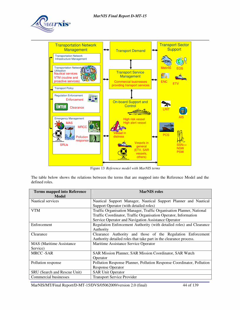
MarNIS Final Report D-MT-15
MarNIS/MT/Final Report/D-MT-15/DVS/05062009/version 2.0 (final) 44 of 139
Transport Sector Support
Transportation Network Management
Transport Demand
Transport Service Management
On-board Support and Control
Emergency Management
Transportation Network Utilisation
Transportation Network Infrastructure Management
Transport Policy
Regulation Enforcement
Vessel in distress
MRCC
SRUs
VTM (routine and proactive services)
Metinfo
ETV
High risk vessel High alert vessel MAS
EOS
Pollution response
Vessels in general
(ETV, SAR vessels, others)
Enforcement
SSN++ NSW PSW
ENC
LRIT
AIS
PCS
Commercial businesses providing transport services
Nautical services
Clearance
Figure 13 Reference model with MarNIS terms
The table below shows the relations between the terms that are mapped into the Reference Model and the
defined roles.
Terms mapped into Reference
Model
MarNIS roles
Nautical services Nautical Support Manager, Nautical Support Planner and Nautical
Support Operator (with detailed roles)
VTM Traffic Organisation Manager, Traffic Organisation Planner, National
Traffic Coordinator, Traffic Organisation Operator, Information
Service Operator and Navigation Assistance Operator
Enforcement Regulation Enforcement Authority (with detailed roles) and Clearance
Authority
Clearance Clearance Authority and those of the Regulation Enforcement
Authority detailed roles that take part in the clearance process.
MAS (Maritime Assistance
Service)
Maritime Assistance Service Operator
MRCC -SAR SAR Mission Planner, SAR Mission Coordinator, SAR Watch
Operator
Pollution response Pollution Response Planner, Pollution Response Coordinator, Pollution
Response Operator
SRU (Search and Rescue Unit) SAR Unit Operator
Commercial businesses Transport Service Provider

MarNIS Final Report D-MT-15
MarNIS/MT/Final Report/D-MT-15/DVS/05062009/version 2.0 (final) 45 of 139
High Risk Ship Master (represents the vessel)
High Alert Ship Master (represents the vessel)
Vessel in need of assistance Master (represents the vessel)
Vessel in distress Master (represents the vessel)
Vessel in general Master (represents the vessel)
Metinfo Meteo and hydro. Information Provider
EOS (Earth Observation System) Environmental Information Provide
ETV (Emergency Towing Vessel) Tug Provider
ENC (Electronic Navigation Chart) Geodata Provider
LRR (Long Range Reporting) “Real” Time Position Information Provider Aggregated Position
Information Provider
LRIT (Long Range Identification
and Tracking)
Real Time Position Information Provider Aggregated Position
Information Provider
AIS (Automatic Identification
System)
Real Time Position Information Provider, Aggregated Position
Information Provider
PCS (Port Community System) Local Information Provider (PSW) + Commercial Information Provider
SSN++(enhances SafeSeaNet) European Information Provider
NSW (National Single Window) National Information Provider
PSW (Port Single Window) Local Information Provider (the authority part of a Port Community
System)

MarNIS Final Report D-MT-15
MarNIS/MT/Final Report/D-MT-15/DVS/05062009/version 2.0 (final) 46 of 139
5 MARITIME INFORMATION MANAGEMENT
5.1 Background
5.2 Scope of MIM
The following notions are used throughout MarNIS: early reporting; buying time; no blame culture;
reporting once to authorities; reducing risks; reducing administrative burden; improving safety; improving
efficiency of remedial services; they are all common place within the MarNIS project.
At the heart of the MarNIS concept is the information and information exchange structure, or Maritime
Information Management. Having the key aim towards simplification of reporting requirements and the
creation of interoperability between different member State systems and sectors, the proposals towards
Maritime Information Management provide for coherence, transparency and efficiency. Based on the single
reporting from the Master and/or agent all processes can begin.
The MarNIS concept has been developed whereby the Master/Agent is only required to report each piece of
data once, with the receiving party, the National Single Window, collating and distributing this data to the
relevant authorities. This is performed in conjunction with SafeSeaNet++, an enhanced vision of SSN for the
years 2012-2020, supplementing the initial reports from the Master/Agent with data held in the system from
previous calls. Updates from the Master/Agent are fed automatically into the information messaging
structure and passed on to the relevant authorities.
Early reporting leads to improved planning for ports and related nautical services through enhanced traffic
organisation services and the integral traffic plan. A messaging structure designed to involve all authorities,
not only maritime, has been developed so that the passage of a ship may be as safe, efficient and secure as
possible whilst rendering less threat to the environment as a consequence of incidents.
Proof of concept trials were conducted whereby mock-ups of National Single Windows for Germany, Lisbon
and Italy were demonstrated during fictitious voyages during the MarNIS Genoa Demonstrator held in
September 2008.
The key stakeholders derive immediate benefits from the developed concept, namely:
Vessel and agent: Under current Directives and various regulations and rules the Master is faced with a
tremendous reporting burden, often having to send the same information numerous times to numerous
different authorities. In the MarNIS concept the Master is required to report all the information only once
through the port notification to the destination port or anchorage. All relevant authorities and services are
then provided the information required by them through the National Single Window.
Authorities: Authorities requiring information from maritime traffic and transport are numerous and fall
under the traditional maritime authorities, such as port, coastal, search and rescue and pollution, or other
authorities such as security, customs, immigration, health and border control. Each currently makes use of
their own means for maritime information management and would benefit from increased access to data and
interoperability. The MarNIS concept provides for a harmonised and coherent system for the exchange of all
relevant information.
The Maritime Information Management approach applies to all merchant vessels sailing in European Waters.

MarNIS Final Report D-MT-15
MarNIS/MT/Final Report/D-MT-15/DVS/05062009/version 2.0 (final) 47 of 139
5.2.1 MIM Architecture
The MIM concept is about the information management and exchanges between European stakeholders and
systems. The concept includes an enhanced SafeSeaNet solution (SSN++) with a voyage plan server;
National Single Windows (NSW); Port Single Windows (PSW); vessel tracking; and the clearance process.
The exchange of information about vessels and voyages is supported. The MIM concept can be mapped into
the Reference model as illustrated in Figure 14.
Figure 14 The MIM concept is implemented by the green areas of the reference model
5.2.1.1 The roles of the MIM concept
The table below shows MarNIS roles involved in such a process and the stakeholders that may fulfil the roles
(just examples – the mapping towards stakeholders may vary depending on region/location).
MarNIS Roles Stakeholder examples Comments
European
Information Provider
Enhanced SafeSeaNet
(SSN++)
Interface between National Information Providers
National Information
Provider
National Single Window
(NSW)
The interface between national authorities, The
Local Information Provider and European
Information Provider
Local Information
Provider
Port Single Window (PSW)
The authority part of a Port
Community System
The interface towards local authorities
Commercial
Information Provider
The commercial part of a
Port Community System
The interface towards commercial stakeholders.
Table 1 Examples of Transport Sector Support roles included in the MIM concept

MarNIS Final Report D-MT-15
MarNIS/MT/Final Report/D-MT-15/DVS/05062009/version 2.0 (final) 48 of 139
MarNIS Roles Stakeholder examples Comments
Agricultural Authority
Customs Authority
Health Authority
Immigration Authority
Safety Authority
Security Authority
Veterinary Authority
Environmental Authority
Misc. national competent authorities
involved in the checking of the
entry/departure profiles of a vessel that is
entering/leaving a port. Each authority
will control that certain requirements are
fulfilled.
Depending on the organisation in
that particular country, one role
may be played by an dedicated
authority, or one authority may
have several of the roles. The
customs may for example also be
responsible for immigration.
Local Safety Authority Local competent authority involved in the
checking of the entry/departure profile of
a vessel that is entering/leaving a port.
Will consider the nautical safety.
Clearance Authority System acting on behalf of all the relevant
competent authorities. Provides clearance
depending on the results of the checking
done by the competent authorities.
One of the competent authorities
may be responsible for the
system.
Table 2 Examples of Emergency Management roles included in the MIM concept
Several roles benefit from the MIM concept, as listed in Table 1. The Master or Carrier’s Agent will provide
input, and actors involved in having the objective to optimise resource management, may use a significant
part of the information. A typical example is the ETA/ETD information, which has an impact on, for
instance, the VTS Traffic Organisation Services, the Pilot Services, and resource management of pilots,
linesmen, gangs of stevedores and terminals.
MarNIS Roles Stakeholder examples Comments
Master/Carriers
agent
Captain and the vessel or the
agent representing it.
Will provide tracking information (by means of for
example AIS or LRR(LRIT)).
Will report the required information to the NSW.
Traffic
Organisation
Planner
Port VTS planner
MOS operator
Involved in the information chain related to planning
of arrivals/departures.
Traffic
Organisation
Operator
Port VTS operator
MOS operator
Involved in the information chain related to planning
of arrivals/departures.
Pilot Planner Operator at pilot back offices Involved in the information chain related to
planning of arrivals/departures.
Pilot Master, Crew, VTM operator
(sea pilot) or VTS operator (port
pilot)
Advises the master. The port pilot keeps
communication with VTS.
Table 3 Table 1 Examples of roles which benefits from the MIM concept (not a part of the MIM
concept)
5.2.1.2 Processes in the MIM concept
As illustrated in Figure 12 the MIM concept consists of three sub-concepts, and these can be mapped to
processes described in the architecture:
• Clearance services – a part of the Regulation Enforcement sub-domain;
• Vessel and Voyage Information services -– a part of the Transport Sector Support sub-domain;
• Governmental Information Management Services - a part of the Regulation Enforcement sub-domain.

MarNIS Final Report D-MT-15
MarNIS/MT/Final Report/D-MT-15/DVS/05062009/version 2.0 (final) 49 of 139
5.3 Infrastructure
5.3.1 General Architecture of the System
The diagram below represents the general architecture of the system as developed for the National Single
Window concept. The diagram includes the involved actors and the messages used in each case.
Figure 15 MIM System Architecture
The architecture for the NSW is the same as that for SSN++.
5.3.2 National Single Windows
Under MarNIS, each member State maintains a National Single Window, receiving notifications from ships
intending to enter or depart a port in it’s waters and ensuring the directed distribution of derived messages to
the port, other authorities (such as customs, immigration etc.) as well as handling requests for information or
clarification. The NSW is the contact point within the total SSN++ structure and ensures that the appropriate
information is made available within the index server and available to requesting authorities from other
member States.
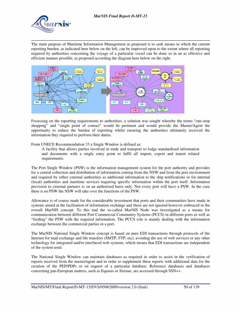
MarNIS Final Report D-MT-15
MarNIS/MT/Final Report/D-MT-15/DVS/05062009/version 2.0 (final) 50 of 139
The main purpose of Maritime Information Management as proposed is to seek means in which the current
reporting burden, as indicated here below on the left, can be improved upon to the extent where all reporting
required by authorities concerning the voyage of a particular vessel can be done so in an as effective and
efficient manner possible, as proposed according the diagram here below on the right.
Focussing on the reporting requirements to authorities, a solution was sought whereby the terms “one-stop
shopping” and “single point of contact” would be pertinent and would provide the Master/Agent the
opportunity to reduce the burden of reporting whilst ensuring the authorities ultimately received the
information they required to perform their duties.
From UNECE Recommendation 33 a Single Window is defined as:
A facility that allows parties involved in trade and transport to lodge standardized information
and documents with a single entry point to fulfil all import, export and transit related
requirements.
The Port Single Window (PSW) is the information management system for the port authority and provides
for a central collection and distribution of information coming from the NSW and from the port environment
and required by either external authorities as additional information to the ship notifications or for internal
(local) authorities and maritime services requiring specific information within the port itself. Information
provision to external partners is on an authorised basis only. Not every port will have a PSW. In the case
there is no PSW the NSW will take over the functions of the PSW.
Allowance is of course made for the considerable investment that ports and their communities have made in
systems aimed at the facilitation of information exchange and these are not ignored however embraced in the
overall MarNIS concept. To this end the so-called MarNIS Node was investigated as a means for
communication between different Port Commercial Community Systems (PCCS) in different ports as well as
“feeding” the PSW with the required information. The PCCS role is mainly dealing with the information
exchange between the commercial parties in a port.
The MarNIS National Single Window concept is based on pure EDI transactions through protocols of the
Internet for mail exchange and file transfers (SMTP, FTP, etc), avoiding the use of web services or any other
technology for integrated and/or interfaced web systems, which means that EDI transactions are independent
of the system used.
The National Single Window can maintain databases as required in order to assist in the verification of
reports received from the master/agent and in order to supplement these reports with additional data for the
creation of the PEP/PDPs or on request of a particular database. Reference databases and databases
concerning pan-European matters, such as Equasis or Sirenac, are accessed through SSN++.

MarNIS Final Report D-MT-15
MarNIS/MT/Final Report/D-MT-15/DVS/05062009/version 2.0 (final) 51 of 139
5.3.2.1 Unique Voyage Number
An important aspect of the MIM concept is the allocation of unique voyage numbers. On receipt of an Arrival
Notification (PAN), the NSW of the port of destination will assign a unique voyage number that will then stay
with that vessel for that particular voyage. All updates and additional data provided will contain this voyage
number in the message header thereby ensuring that the data provided is stored and (re-)allocated in the correct
database for subsequent use in the generation of PEP/PDPs and SSN notifications.
5.3.3 SafeSeaNet++
SafeSeaNet currently acts as an index server, allowing the authorized user to find information on
notifications, cargo manifests, voyage history and incident history. Basic data is held within the SSN system
whilst contact points are provided for further information on for example dangerous or hazardous goods. The
MarNIS concept envisages an expansion and strengthening of the role of SSN into the so-called SSN++
,
providing a more efficient service through the SSN++ Core and the SSN++ Portal leading to more added-
value through the generation of notifications to coastal authorities on ships likely to pass through their areas
of jurisdiction as well as consolidate reports to all authorities. Connections to the National Single Windows
(NSW) and the SSN++ Core, being the central server system, consist of an European Index Server (EIS),
Request and Response (R and R) server, voyage plan server, Long Range Identification and Tracking (LRIT)
database, retrieval of information and SITREPS on lost containers, on-going SAR operations and update of
Estimated Time of Arrival (ETA) messages. In addition to dedicated databases SSN++ also has access to
reference databases such as Equasis. The SSN++ Portal consists of the National Single Window (NSW), this
being the gateway for users to provide and receive the information.
SafeSeaNet exchanges data with the National Single Windows through notifications, these relaying
either a message from on NSW to another or providing supplementary data on a particular vessel as available through its own as well as external databases.
All communication to and from SafeSeaNet++ is conducted through only the National Single Windows. The
SSN++ Portals are the NSW whilst the SSN+ Core consists of:
• European Index Server;
• Voyage plan server;
• AIS repository;
• LRIT repository;
• Request & Response Server;
• Databases (Equasis, Sirenac, etc.).
5.3.3.1 Voyage Plan Server
The Voyage Plan Server (VPS) has been created in MarNIS and is a crucial element in both the MIM and
MOS concepts.
Ships calling at an EU port will normally transit coastal areas of member States other than those of the final
destination. In order to assist MOS centres a voyage plan server located within SSN++ will calculate the
most probable intended route of a ship, based on port of departure and destination as well as known shipping
routes, and inform MOS centres along this route of the predicted times and place of entry in each of the
centre’s areas of operation.
This enables the MOS to both know what vessels are expected in their region, having potential benefit in e.g.
SAR operations, as well as prepare them for other aspects such as determining the potential risk of a vessel
or impending situation in the allocation of High Risk Ships (HRS) in providing forewarning of their expected
arrival as well as key data, and provide the MOS with the necessary details so that they can seamlessly pass

MarNIS Final Report D-MT-15
MarNIS/MT/Final Report/D-MT-15/DVS/05062009/version 2.0 (final) 52 of 139
on any updates received from the vessel related to the progress of its voyage, i.e. ETA updates. All
communication of course goes via the National Single Window.
5.4 Reporting
In the MarNIS Single Window concept the master and/or agent is required to report each data element only
once to the destination, based on the single reporting all related processes can be initiated. Through the
National Single Window all relevant authorities and services are provided with the required information
according a special mechanism; the MarNIS Entrance Profiles (PEPs). A PEP is a structured and concise
report containing the relevant information on a given aspect of the arrival of a ship to be used by the
authorities to make a decision regarding the entrance of that ship and for fulfilling their tasks. The National
Single Window will process and redistribute the obtained information to the relevant authorities and
SafeSeaNet. The MarNIS concept envisages an expansion and strengthening of the role of SafeSeaNet (SSN)
into the so called SafeSeaNet++, evolving to provide more and more efficient services. SSN currently acts as
an index server, allowing the authorized user to find information on notifications, cargo manifests, voyage
history and incident history. Connections to and between the National Single Windows (NSW) and the
SSN++ will give SSN an extended role as request and response server as provider of more operational and
reference information toward the users.
5.4.1 Reporting Process
Considering one of the key objectives, that being to reduce the administrative burden, a mechanism was sought
whereby the Master or Agent were only required to report each item of data once and this would then be
redistributed to the relevant authorities. This would eliminate the current practice of reporting the often same
data to numerous authorities.
It was necessary to simplify two key aspects:
1) The point of contact to which data should be reported;
2) The data elements that were required for a port call and to satisfy the requirements of all authorities.
It was required that there be one point of contact for all reporting requirements concerning an intended call at a
port within a member State. To this end the National Single Window was developed whereby all data required
by authorities related to that call could be reported.
The Arrival and Departure Notifications were formed consisting of all data (approximately 180 data elements)
required by the various authorities. The principle is such that one report contains all data elements.
However, there are a number of considerations to be taken into account:
a) Reported data had to be delivered to the intended authority;
b) Data contained in departure notifications of the last port of call are often identical to data required at the
next port of call;
c) Static and semi-static data often remains unchanged during the lifetime of a vessel, with only minor
updates being required;
d) Some (updated) data was required whilst the vessel was at sea between two ports;
e) Vessels sailing from a port of one member State to a port of another should not have to repeat
unnecessary data and this data should be passed between the ports in a uniform manner.
To this end a number of elements of the MIM concept were developed whereby only the required data was
automatically forwarded to the relevant authority and the Master/Agent was not required to submit data that was
already available onshore. In addition, the functionality of SafeSeaNet was considered and fundamental changes
proposed whereby all communications between NSWs of different member States would go via the so-called
SafeSeaNet++, an enhanced version of SSN for 2012-2020.

MarNIS Final Report D-MT-15
MarNIS/MT/Final Report/D-MT-15/DVS/05062009/version 2.0 (final) 53 of 139
With SSN++ being central to the system new messages were formed, SSN Notifications for Entry and
Departure. These contained the data that would be of added value to the next port of call as well as provide key
data for coastal services such as Maritime Operational Services (MOS). The SSN++ would not only pass on the
relevant data to the relevant authority but would also file certain information in dedicated databases so that
historical reference could be built up, further reducing the need to re-report data (i.e. the last 10 ports of call).
The data required by the (local) authorities in fulfilling their clearance procedures would be provided to them via
the NSW in the form of (Pre-) Entrance Profiles (PEPs) and (Pre-) Departure Profiles (PDPs). These contain all
data required to conduct their (pre-) clearance checks and make arrangements for i.e. inspections.
The diagram below represents the flow between the different actors that participate in the National Single
Window concept (Master/Agents, NSWs, SafeSeaNet++, Authorities). These actors interchange the messages
PAN/PDN and SSN NOT ENT/DEP:
PAN: (Pre-) Arrival Notification (180 data elements)
PDN: (Pre-) Departure Notification
PEP: (Pre-) Entrance Profile (one per Authority: Harbour Master, Port Authority, Immigration, etc.)
PDP: (Pre-) Departure Profile (one per Authority)
SSN NOT ENT: SafeSeaNet Notification Entry
SSN NOT DEP: SafeSeaNet Notification Departure
5.4.2 Reporting Stages
Following is an overview of how the Maritime Information Management (MIM) concept works in general.
Vessel alongside in Port of Departure: At present the Master/Agent/Operator are subject to a reporting
burden in that they are required to provide what often amounts to being the same data to numerous different
authorities, all having their own reporting formats and times for receiving the data.
The concept behind the National Single Window (NSW) and SafeSeaNet++
(SSN++
) is geared towards
reducing the Master/Agent/Operator reporting burden whilst simultaneously facilitating tailor-made reports
to authorities. This is achieved with minimum disruption to the private sector and the procedures and
reporting systems in place.

MarNIS Final Report D-MT-15
MarNIS/MT/Final Report/D-MT-15/DVS/05062009/version 2.0 (final) 54 of 139
Prior to departure from the previous port the Arrival Notification is sent to the NSW of the country of
destination. This initial notification may be sent by the Master, Agent or Operator, dependant on company
procedures, and is received in the Mailbox Manager of the NSW. The contents are subsequently forwarded
to the Transactional Platform where a check for syntax is made and a Voyage Number assigned. This
Voyage Number is unique for this voyage and is provided to the Master/Agent/Operator, via the Mailbox
Manager, together with the confirmation of receipt of the initial notification. Parallel to this the data as
provided by the Master/Agent/Operator will be forwarded to the NSW Database, commencing the process of
collecting all relevant data for the generation of new messages to the various authorities. Certain information
such as Ship Identity, Port of Destination, Estimated Time of Arrival (ETA) and presence of any Hazardous
or Noxious Substances (HNS) is required as a minimum at this stage.
All subsequent additions, amendments and updates made to the Arrival Notification by the
Master/Agent/Operator will include the Voyage Number as reference and allow for simplified updating of
the NSW Database.
Prior to departure a Departure Notification has also been sent by the Master/Agent/Operator to the NSW of
the country of departure. This notification provides the NSW with the necessary data on cargo, vessel
condition and Estimated Time of Departure (ETD). Using data from this Departure Notification and as
collected during the original arrival of the vessel, supplemented by additional data from SSN++
, the NSW
country of departure will then generate messages for the relevant authorities containing all data elements
required for their respective clearance procedures. These messages are known as (Pre-) Departure Profiles
(PDPs). The PDPs undergo checks from the respective authorities and a decision is made as to whether the
vessel is free to depart and any eventual conditions, e.g. upon inspection or upon receipt of additional
information. The authorities return the PDPs and status via the NSW country of departure to the Clearance
Authority of the Port of Departure whereby any inspection activities may be coordinated or requests for
additional information evaluated and eventual permission for departure may be granted dependant on
conditions.

MarNIS Final Report D-MT-15
MarNIS/MT/Final Report/D-MT-15/DVS/05062009/version 2.0 (final) 55 of 139
Vessel leaves Port of Departure: Having received permission to depart, and following necessary local
interaction with traffic services of the port with respect to entering of the fairway, the vessel is underway.
Now having an Actual Time of Departure (ATD), the port informs the NSW country of departure of this
along with the consolidated information of the PDPs, providing data on such matters as cargo (including
presence and nature of HNS), waste and status of vessel. This SSN Notification Departure (SSN NOT
DEP) is passed on to SSN++ where it is subsequently passed on to the NSW country of destination as well
as stored in a SSN++
database.
This will also trigger the Voyage Plan Server located within SSN++ and will calculate the most probable
intended route of a ship, based on port of departure and destination as well as known shipping routes, and
inform Maritime Operational Services (MOS) centres along this route of the predicted times and place of
entry in each of the centre’s areas of operation. MOS centres detecting updates on e.g. ETAs as being
transmitted via AIS, will forward these through their NSW and SSN++ to the NSW of the port of destination
so that the prot may be informed automatically and remove the need for the Master/Agent to provide a
separate update. Where deviations from calculated passing times or positions are noted the Voyage Plan
Server will recalculate the most probable intended route and pass this on to the MOS centres hereby affected.
Vessel 24hrs from Port of Destination: Upon receipt of all required data from the Master/Agent/Operator,
this being minimum “n” (or 24) hours prior to arrival, the NSW country of destination will make use of the
complete Arrival Notification, Consolidated PDP and additional data from the SSN++
databases in order to
generate a tailor-made so-called (Pre-) Entrance Profile (PEP) for each authority. Each PEP contains only the
data relevant for the target authority and ensures that all regulatory requirements are met with respect to the
obligation of the Master/Agent/Operator to report certain data to authorities. In effect the
Master/Agent/Operator have reported each data element only one time to the NSW country of destination
and the NSW has promulgated all data to the required recipient.
On receipt of the PEP each authority is able to conduct their own evaluation of the intended port visit as well
as the validity of the data contained. Based on the data received the authority may require further
clarification, through sending a request for additional data to the Master/Agent/Operator through the NSW or
request additional data from either the NSW or SSN++ databases. If the authority concerned is satisfied that
the vessel is clear to enter, according their jurisdiction, and that any intention to conduct an inspection is
known, the authority sends a message to the Clearance Authority stating any conditions or intended
inspections that may apply.
Clearance Authority: The Port Clearance Procedure (PCP) is a procedure designed to assess the results of
the different PEPs in order to allow the ship to enter a Community port. The Clearance Authority is a generic
term that is used for the authority making the final decision on whether a vessel is to be admitted to the port.
As well as checking on any conditions that may have been placed by the various authorities, the Clearance
Authority will also best coordinate any planned inspection activities so that the inspection regime is
conducted as efficiently as possible. This may include inspections be conducted simultaneously by one or
more inspectors.
Special rules will apply to determine the way in which entrance might be provided. The result of this
assessment is one of the following: Unrestricted entrance, entrance with special requirements and no
entrance. These rules will be established in consultation with the competent authorities.
Upon clearance a SSN Notification Entry (SSN NOT ENT) is generated and stored in the NSW port of
destination as well as passed on to a SSN++ database.

MarNIS Final Report D-MT-15
MarNIS/MT/Final Report/D-MT-15/DVS/05062009/version 2.0 (final) 56 of 139
5.4.3 Origin Dependent
Allowance is required for vessels entering from outside EU waters and those sailing between two EU ports. To
this extent flow diagrams were created illustrating which reports are required or generated depending on the
progress of a particular vessel. Message flows were created for the following scenarios:
Phase 0: Departure from a non-EU port
Phase 1: Arrival to EU waters
Phase 2: Arrival to the 1st EU port
Phase 3: Stay in the 1st EU port
Phase 4: Departure from the 1st EU port
Phase 5: On the way to the 2nd EU port
Phase 6: Arrival to the 2nd
EU port
An example of the message flow for Phase 0: Vessel entering from outside EU waters with destination EU port:
Figure 16 Phase 0: Departure from a non-EU port

MarNIS Final Report D-MT-15
MarNIS/MT/Final Report/D-MT-15/DVS/05062009/version 2.0 (final) 57 of 139
Such schemes were produced for all scenarios.
5.4.4 Arrival (PAN) and Departure (PDN) Notifications
The Arrival (PAN) and Departure (PDN) Notifications work on the principle of reporting each data element only
once.
The Master and/or agent of a ship bound for a port or anchorage within the European Community sends a
notification containing all information required by “Authorities” to the NSW of the member State having the
port of destination. This notification can be seen as one single report and replaces the separate reporting
required today. In practice the information may be sent by the Master (ship related) and agent (cargo and
facilities related). The NSW will redistribute the information to the relevant authorities and SSN++ in
messages according to the FAL convention and Entrance (PEP) and Departure (PDP) Profiles in so far as
they are supplementing each other.
When considering the numerous reports currently required of the Master/Agent to the various authorities
there are over 180 individual data elements required. These data elements have different characteristics,
some being dynamic in nature, usually voyage related, others semi-dynamic/static, these often depending on
the precise characteristics of the cargo or port to be called at, and static data, mainly related to the vessel
characteristics itself such as dimensions and measurements.
Static data, by its very nature, will not change on a regular basis, if at all, and once a vessel has entered
European waters at least once this data will be available through SSN++. Therefore, instead of the
Master/Agent being obliged to resubmit this data for every subsequent European call, updates only have to
be provided in the event that the data has changed, i.e. hatch measurements.
Through this and other techniques, such as using Maritime Operational Services (MOS) to relay automatic
updates, on for example Estimated Time of Arrival (ETA) as detected through the coastal AIS networks, the
reporting burden on the Master is greatly reduced, both in number of data elements required to be reported
(more than half) and frequency or duplication (often with the same data element currently being required to
be reported 5 or 6 times to different authorities).
5.4.4.1 Reporting Requirements
The system is fed by (mostly dynamic) information that is notified to the NSW either by the master or by his
agent.
Taking into consideration a number of EU Directives as well as existing FAL forms, other international
conventions and regulations and the request for more information on the local (port) level (i.e. BERMAN,
WASDIS and IFTDGN messages), there are in excess of 180 different data elements that are to be reported
by the master/agent before entry/exit from a port.
In conjunction with the HA3 architecture development team a full analysis was made of the individual data
elements and the attributes assigned. These can also be found in the User Guides (see MarNIS deliverable D-
HA9B1 Annexes).
In order to create one set of data the data elements were arranged within the following categories:
• Message Header;
• Ship Identity;
• Ship Contacts;
• Ship Particulars;

MarNIS Final Report D-MT-15
MarNIS/MT/Final Report/D-MT-15/DVS/05062009/version 2.0 (final) 58 of 139
• Security Data;
• Cargo and Passenger Overview;
• Voyage Data;
• Crew Data;
• Passenger Data;
• General Cargo Data;
• Dangerous Cargo Data;
• Waste;
• Services;
• Vessel Operation Data.
The following reference documentation was used in order to determine current reporting requirements
according International and European regulations:
• FAL and other IMO / International documents
o FAL Forms 1 to 7
o CSR - Continuous Synopsis Record
o ISPS - BERMAN, MSC/1130
o IMO A.960 Pilot request
o Bulk loading/unloading (BLU) code
o COMSAR 10 Ship reporting in XML
o UNR11 - Multimode dangerous goods
o ILO Seafarers Identity Documents Convention (Revised 2003)
• SafeSeaNet o Port Notification
o Ship Notification
o HazMat Notification
o Security Notification
• eNOA/D o Arrive
o Depart
• PortNet
o Port_Call
o DG_cargo
o cargo_statistics
• EU Directives (and proposed amendments) o Com2005/588 - Port State Control
� Art. 6 (Annex III) - Arrival notification 2005/588
o 1998/41/EC - Passenger Lists
� Art. 4 - Number of Persons (to company)
� Art. 5 - List of Persons Onboard (to company)
o 2000/59/EC - Port Reception
� Art. 6 (Annex III) - delivery waste
o 2001/96/EC - Safe Loading/Unloading
� Art. 7 (1b) - ship arrival info (to terminal)
� Art. 10 (2) - damage impairing structure, watertight or essential engineering (to flag
state)
o 1998/18/EC with 2003/24/EC+2003/25/EC amendments - Safety Passenger Ships
o 1999/35/EC - Stability RoRo
o 2002/59/EC + COM(2005)589 final - Monitoring
� Art. 4 - 24h Notification

MarNIS Final Report D-MT-15
MarNIS/MT/Final Report/D-MT-15/DVS/05062009/version 2.0 (final) 59 of 139
� Art. 5 - Mandatory Reporting Scheme
� Art. 10 - VDR Info
� Art. 13 - DG Notification
� Art. 17(1) - Incident/Accident report
� Art. 18 - adverse meteo/hydro (to company)
� Art. 19 - ISM incident/accident report
o COM589 - Art. 19(2) - DG info
o Regulation 725/2004
� Art. 6 (1) - Security info entrance
5.4.4.1.1 Notification Order
The Master/Agent may provide all data in the PAN initial however where this is not possible updates and final
messages can be sent accordingly, depending on whether they are entering from outside EU-waters or are
already in EU-waters:
5.4.4.2 Arrival Notifications
The PAN ((Pre-) Arrival Notification) is the document required to declare the arrival of a vessel to a port. In
this document must appear all the information related to the cargo, crew and passenger and also the
information related to the ship identity and voyage plan.
The first version of the document should be sent before the departure of previous port and the remaining data
are completed during the trip. The completion and sending of the PAN is conducted by the master, the carrier
and/or the agent.
The requirements needed by the vessel to operate or to handle the cargo when in berth should be specified in
the PAN. Another important part of the document is the information about the port of destination and the
services needed to operate.
When the vessel is still in the previous port, the first version of the Arrival Notification must be send to the
National Single Window of the country where the port of arrival is located. The information is codified in
XML language (Extensible Markup Language) and is validated with a schema file that contains the structure
of the PAN document.
MarNIS Final Report D-MT-15
MarNIS/MT/Final Report/D-MT-15/DVS/05062009/version 2.0 (final) 60 of 139
There are four types of Port Arrival Notification:
• Initial
• EU-Waters
• Update
• Final
These documents contain different minimum information and some optional fields.
� The PAN Initial must be sent “n” hours before the vessel leaves the departure port.
� When the port of departure is a non-EU Port then the PAN EU-Waters must be sent “m” hours
before the arrival in EU-Waters.
� The PAN Update is used to send the remaining information or to notify some changes in the
information sent before.
� The PAN Final should be sent “p” hours before the arrival to the destination port.
The Port Arrival Notification will be validated when this is received by the National Single Window and
some information will be checked to find any errors.
The main aim of this message is to inform the relevant authorities of the destination port about all the
information related to the vessel characteristics, the cargo and dangerous cargo information, the crew and
passenger data, the voyage plan, the security information, the service requirements, the waste information
and the vessel operation data.
This message contains the following information: identification data of the vessel, technical data of the
vessel, aspects about cargo, insurances, dates of departure/arrival, data about the route, and different
information to be specified by the authorities.
The message will be created by the Master or the carrier of the ship and later this message will be sent to the
National Single Window of the port of destination’s country. In addition to generating the PEPs, the
information contained in the PAN will be used in order to create other types of messages which will be sent
to the SSN++ (SSN ENT).
The message has been developed in XML language adapting the communication of information to the new
technologies.
In general, all PAN messages have the same relation with the SSN++. These messages are combined inside
of NSW in order to create two new messages so-called SSN ENT.
The information contained in these new messages will be used in the later voyages of the vessel by the ports
of the member States.
The different actors which participate here are the following:
• Shipping line
• Master of vessel
• Port Commercial Community System
• National Single Window
• Authorities (i.e. Harbour Master)
• SSN++

MarNIS Final Report D-MT-15
MarNIS/MT/Final Report/D-MT-15/DVS/05062009/version 2.0 (final) 61 of 139
• Etc.
5.4.4.3 Departure Notifications
The PDN ((Pre) Departure Notification) is the document required to declare the departure of a vessel to a
port. In this document must appear all the information related to the cargo, crew and passenger and also the
information related to the ship identity and voyage plan. The resource requirements needed by the vessel to
should be specified in the PDN.
There are three types of Pre Departure Notification:
• Initial
• Update
• Final
These documents contain different minimum information and some optional fields.
� The PDN Initial must be sent “n” hours before the vessel leaves the departure port.
� The PDN Update is used to send the remaining information or to notify some changes in the
information sent before.
� The PDN Final should be sent “p” hours before the departure to the destination port.
The Port Departure Notification will be validated when it is received by the National Single Window and
information will be checked for errors.
The information has been codified in XML language (Extensible Markup Language) and is validated with a
schema file that contains the structure of the PDN document.
The main aim of this message is to inform to the port authority of the departure port about all the information
related to the vessel characteristics, the cargo and dangerous cargo information, the crew and passenger data,
the voyage plan, the security information, the service requirements, the waste information and the vessel
operation data.
This message contains the following information: identification data of the vessel, technical data of the
vessel, aspects about cargo, insurances, dates of departure/arrival, data about the route, and different
information to be specified by the authorities.
The message will be created by the Master or the carrier of the ship and later this message will be sent to the
national single window of the port´s country. In addition, the information contained in the PDN will be used
in order to create other types of messages which will be sent to the SSN++ (SSN NOT DEP).
The SSN NOT DEP is used by SafeSeaNet++ to (pre-)warn the port of destination of an intended call should
the PAN not have been received. The SSN NOT DEP will contain the relevant information on (semi-) static
data which will not change during the voyage, thereby relieving the burden of repeating this information in
the PAN.
In addition, the SSN NOT DEP will trigger the Voyage Plan Server (VPS), see section 5.3.3.1.

MarNIS Final Report D-MT-15
MarNIS/MT/Final Report/D-MT-15/DVS/05062009/version 2.0 (final) 62 of 139
5.4.5 Entrance (PEPs) and Departure (PDPs) Profiles
An (Pre-) Entrance Profile (PEP) is a structured and concise report containing the information on a given
aspect of the arrival of a ship in a port or anchorage which will be used by the authorities to make a decision
regarding the entrance of that ship and for fulfilling their tasks.. The background of a PEP is based on the
increasing international rules which need to be satisfied by ships when arriving in a port of the Community.
The PEP provides an opportunity to use information from other ports in the Community and as such
contribute to the efficiency of the port as well as contribute to the reliability and quality of the information to
be received. PEPs are derived for: Arrival Information; Port Planning; Safety; Dangerous Goods;
Environment; Security; Customs; Health; Immigration; and, Emergency. Similarly a (Pre-) Departure Profile
(PDP) contains the information required for departure procedures.
With the National Single Window having access to all possible data requirements for a normal visit to a port
in the member State thereof, new messages are generated containing only the specific information a specific
authority requires for their entrance and departure clearance procedures. This is the mechanism whereby
Masters and Agents are no longer required to provide numerous, often duplicated, reports to the individual
authorities directly; the National Single Window ensuring the timely and efficient delivery of the required
data.
5.4.5.1 Systematic Approach
The PEP concept is a systematic approach of the information needed to carry out the decision-making and to
facilitate the intervening powers of the designated authority for that role. As a result, the Harbour master for
example is provided with a tool to quickly select those ships that need additional attention.
Each PEP describes the data elements that are needed for a specific role and the therewith related decision
process. It proved to be possible to define this minimum level of required information for each role and for
each Harbourmaster, regardless of the country.
The PEP concept therefore not only pays attention to the ‘entrance’ of the system (data delivery to the
system), but specifically to its ‘exit’ (how to retrieve the information from the system). In this way, the
accessibility of information can be greatly improved. The result of the ‘exit’ of all profiles (the result of all
PEP queries) is vessels that they are “flagged” because they probably need additional attention and/or may
require non-routine decisions.
The PEPs act as ‘traffic lights’; a green light indicates “pass”; orange indicates that some conditions need to
be fulfilled before entering; red means ‘stop’, indicating that international legal obligations are not respected
or serious problems are anticipated. PEPs function as a decision support tool and an ‘early warning system‘,
not as an obligatory end-decision structure.
The PEP concept seeks to combine information received by notifications sent from vessels and
representative to authorities with information that is stored in public databases.
The PEP has to be seen in combination with the other elements developed in MarNIS, as for the PEP concept
to fit properly into the overall MarNIS concept, the following has to be recalled:
• Each member State will have a National Single Window. Such a window will act as one point of
contact through which all information from vessels agents operators and information from and to
SSN++ flows;
• The reporting effort of masters and agents needs to be minimized in order to improve the reporting
duties of masters and agents (in the first place within the framework of the reduction of
administrative burden);

MarNIS Final Report D-MT-15
MarNIS/MT/Final Report/D-MT-15/DVS/05062009/version 2.0 (final) 63 of 139
• All authorities who are involved in the maritime field will get standardized messages which are
composed by the NSW and on which they would take decisions for entrance of the vessel, or special
inspections or even other enforcement measures;
• All authorities may be able to cross check information using the so-called Cross Reference Checks
(CRCs) using the facilities of the NSW and SSN++
;
• The authorities mandate the Harbour Master or duly appointed “Clearance Authority3” to make the
final decision to give the vessel permission to enter the port and indicate that decision to the vessel
through the NSW.
In the mixed model, a composition of a number of PEPs and PDPs, lead automatically to the entrance or
departure of a vessel in a port. At least, 11 PEP/PDPs have been defined:
• Arrival Information PEP / Departure Information PDP
• Port Planning PEP/PDP
• Safety PEP/PDP
• Dangerous Goods/Cargo PEP/PDP
• Environmental Issues PEP/PDP
• Security PEP/PDP
• Emergency PEP
• Health PEP/PDP
• Immigration PEP/PDP
• Veterinary and Plant Health PEP/PDP
In general, all PEP and PDP messages have the same relation with the SSN++. These messages are
combined inside of NSW in order to create two new messages so-called SafeSeaNet++ entry and departure
notifications (SSN NOT ENT and DEP).
The information contained in these new messages will be used in the later voyages of the vessel by the ports
of the member states.
The different actors which participate are the following:
o Shipping line;
o Master of vessel;
o PCCS;
o National Single Window;
o Authorities;
o SSN++;
o Etc.
The PEP and PDP messages are created in the NSW of the country of destination (PSW where appropriate).
The message is developed in XML language adapting the communication of information to the new
technologies. In order to be able to construct these messages is necessary to extract the information of
different messages already used in EDI format (i.e.: BERMAN, IFTDGN, IFCSUM, WASDIS, etc.).
The definition of a PDP, Port Departure Profile, is that it is similar to a PEP but only for the permission to
depart.
3 The Clearance Authority is a generic role assigned under HA3 of MarNIS and does not imply any particular standing
competent Authority or the requirement to instigate a new authority.

MarNIS Final Report D-MT-15
MarNIS/MT/Final Report/D-MT-15/DVS/05062009/version 2.0 (final) 64 of 139
5.4.5.2 FAL, PAN and PEP information
Discussions have taken place with respect the use of FAL forms in the Maritime Information Management
concept of MarNIS. FAL forms provide a uniform method for Master/Agents to provide data to the relevant
authorities, however data elements are often duplicated between forms.
With the single reporting approach as adopted the Master/Agent would report each data element just once to
the NSW. The NSW would then, in principle, generate PEPs for the relevant authorities. In essence these
would resemble current FAL forms however would be supplemented with additional required information
for that particular instance as well as exclude data that is considered superfluous to their needs. If authorities
so require the data could still be provided to them in the form of a FAL form, however considering the
premise of directed information that is fit for purpose it is envisaged that the PEP structure will provide more
added-value.
Directive 2002/6/EC provides information on the use of the FAL messages as developed by the Facilitation
Committee of IMO. The Directive is concerned with reporting formalities for ships arriving and/or departing
from ports of the member States of the Community. The purpose of the directive is to facilitate maritime
transport by providing for standardisation of reporting formalities.
The scope of the Directive is to apply the directive to the reporting formalities on arrival and/or departure
from ports of the Member States of the Community. The essence of the Directive is given as follows:
MS shall accept that the reporting formalities referred to above are satisfied when the information submitted
is in accordance with:
(a) The respective specifications which are annexes to the directive
(b) The corresponding model forms set out in ANNEX II of the directive.
The question arises that when a port requires (or any other competent authority in a member State) more
information as is prescribed by Directive 2002/6/EC this is possible and is not in contravention of the
Directive. Some PEPs are requiring information which is not to be found in the FAL forms. According to
MarNIS juridical experts such information should be provided by the master or the agent of a calling vessel.
The FAL forms describe the information for the purposes for which they are intended and not for other
purposes such as the important question of clearance of a vessel in a port.
In summary, the PEPs might require more information than is provided by the FAL forms but it is perfectly
legal that this information is required from the master and/or the agent. However, some of the FAL messages
also play a role in the PEPs and where the FAL messages are useful they should be retained.
FALs are developed to promote and facilitate international sea trade. PEPs are a much more structured piece
of uniform information that allows an authority to make a decision whether or not this vessel satisfies the
legal requirements. The PEPs may be used to allow the vessel coming into a port of the Community. It
should be considered whether or not the PEPs, and the method of reporting through the PAN, may replace
the FALs. FALs are structured in a much more general way and PEPs serve a direct objective.
In summary the PEP is a further development of some FAL messages. The difference is that the PEPs are an
amount of structured information which can immediately assist in taking a decision, whilst the FAL
messages is information of which it is suspected that they might play a role in the information process
required by a decision that needs to be taken by an authority. PEPs are more goal-oriented than FAL
messages.
MarNIS Final Report D-MT-15
MarNIS/MT/Final Report/D-MT-15/DVS/05062009/version 2.0 (final) 65 of 139
5.4.5.3 Cross Reference Checking (CRC)
PEP information may be cross-referenced to information which is available in SafeSeaNet++ and in
databases that are connected to SSN++. The CRCs are made with the objective to check the reliability of the
information. The checks may be invoked, via the NSW, by the Harbour Master or by a competent authority
that checks the PEP. Generally speaking the PEPs will indicate a number of variables that may be checked if
there are reasonable grounds to believe that the data that are provided are incorrect, by accident or
deliberately and that a cross-check is required. The CRCs then go to the NSW and when all CRCs are
collected the CRCs are sent to SSN++ in which databases reside to check the information. When the
information is checked the results are sent back to the requestors and the authorities are now in a position to
assess the information.
5.4.5.4 User Guides
The User Guides are provided in the Annexes to this report. These User Guides are aimed at providing the
developer with the XML codification for the creation of the various PEPs and PDPs, i.e. the message header
wherein administrative information which is used in the messages in order to identify the sender and/or
receiver, the version codes or any other information related with the interpretation or validation of the
content of the messages.
5.4.5.5 Alert and MOS Messaging
Alert messages: In the event that a ship has been identified as posing a potential risk or is of special interest
for security, customs, immigration, border police and/or health, alert messages may be sent to all MOS
centres along the route indicating the nature of risk so that the MOS can determine appropriate monitoring
and preventive actions.
MOS messaging: Automatic reports containing identity and position of vessels under the coverage of AIS
base stations are received by a MOS centre. Long Range Reporting (LRR) information will be received
through a European Data Centre, where the identity and position information is provided to a MOS centre
through the NSW. All SAR messaging, as it exists today, will be handled by a MOS centre. ETA changes
will be automatically detected and sent to the appropriate NSWs. These ETAs will update the already sent
port notifications.
5.4.5.6 Port Clearance Procedure (PCP)
The Port Clearance Procedure (PCP) is a procedure designed to assess the results of the different PEPs in
order to allow the ship to enter a Community port.
The master and the agent provide information to the NSW by means of the port notification (PAN/PDN).
This NSW composes the PEPs and sends them to the different authorities. The NSW sends also the
information of the consolidated preceding port PDP to the different authorities. They assess the information
contained in the PEP and may send it back to the NSW to obtain a crosscheck. This cross check is to be
executed with the support of the databases within SSN++. When the information is found this information is
sent back to the different authorities and they give their final assessment. The results of this assessment go to
the NSW which in turn sends the information to the Decision Support System (DSS) of the responsible
authority. The DSS assesses the information based on a prescribed screen and communicates the decision to
the authority who will, if agreeable, communicate this to the ship and the agent through the NSW.
Special rules will apply to determine the way in which entrance might be provided. The result of this
assessment is one of the following: Unrestricted entrance, entrance with special requirements and no
entrance. These rules are to be established in consultation with the competent authorities.
5.4.5.7 Integral Traffic Plan (ITP)
The Integral Traffic Plan is a development in MarNIS which is made possible as a direct consequence of
Maritime Information Management. Not only the individual authorities may benefit from timely information

MarNIS Final Report D-MT-15
MarNIS/MT/Final Report/D-MT-15/DVS/05062009/version 2.0 (final) 66 of 139
of an intended visit, in organising their e.g. inspection regimes, but ultimately the port requires to optimise
the use of its resources in servicing a vessel wishing to enter or depart that port. To this end the Integral
Traffic Plan illustrates, though use of the architecture techniques as used in the HA3 MarNIS architecture
team, the way in which information may be used to better plan resources and relay this to the vessel, whilst
at the same time making allowance for e.g. any potential inspections that may hinder the intended arrival or
departure time. Ultimately creating benefit for both resource and infrastructure management.
5.5 Legal Considerations
5.5.1 The principle
Within the IMO important steps have been taken to diminish the administrative burden of all sorts of
documents that have to be filled in and transferred to the different authorities in each different country. The
FAL Convention is one of those results. Much time and therefore money is saved by ship owners and
terminals simplifying these kinds of procedures.
Evolving information technology opens up the possibility to set a next step in this direction.
The standardized transfer to one National Single Window (NSW) of the necessary information to one single
point of contact in each member State by automated means and by telecommunication, as a one shop stop
procedure, might further reduce the workload of those involved in these procedures. The information should
be sent to a National Single Window of the member State under whose jurisdiction the port of destination is
located. Modern technology makes the question irrelevant whether the information is routed through the port
a ship is approaching or directly to a national centre and is distributed subsequently to the port. A National
Single Window receives only information within its area of competence (i.e. ports and anchorages of the
member State). This approach would relieve in principle all parties from any paper documents in their
administrative proceedings. Where paper is nevertheless regarded to be necessary, this would need a strong
justification.
The standardization of the way in which information is communicated allows for a simplified exchange
where necessary of information between EU member States. If any information available in one country
might be needed in another country, it can be transferred (see the function of SafeSeaNet in this respect
hereafter). This procedure avoids or at least reduces that a master of a ship has to deliver information to
authorities in one EU country that is already available in another. In principle no information should be
required from a ship by any authority within the EU if that information is already available to any other
authority in the EU.
Procedures may be streamlined to such an extent that all standard information that a ship has to deliver to the
authorities can go in one single message. Authorities are to be understood in a broad sense: not only those
that have specifically to deal with maritime traffic and transport, but also those with a more general task that
includes maritime aspects. One could think of immigration and border control, customs, police, veterinary
and sanitary inspection, labour inspection, food quality control etc. The request of additional information
should be limited to specific cases and need therefore special justification.
It seems likely that in the near future a same set of standardized information will suffice for all EU member
States. However, each country will have its own authorities, differing from the other, that require the
information they deem necessary for the execution of their tasks. That requires that each member State
determines the specific authorities involved according to national law to receive parts of the standardised
information. It seems possible to develop a technological standard for the EU in which ships are allowed to
communicate the information through the intermediary of the National Single Window to any authority in an

MarNIS Final Report D-MT-15
MarNIS/MT/Final Report/D-MT-15/DVS/05062009/version 2.0 (final) 67 of 139
EU member State. A simplified procedure might be foreseen to update the standard in the light of new
technological or other developments.
For some countries a National Single Window might be a new step. Modern information and
telecommunication technology makes the real distance between a ship and the authorities less relevant. The
direct contact between a ship and the authorities of a member State and its ports it is entering will go through
the intermediary of the National Single Window. This facilitates the co-operation within in the EU.
Authorities of any other EU member State know where, if necessary, any information is available and
accessible to the extent as is needed by those authorities. No time will be wasted finding the appropriate
authority in order to get information. A tighter network of cooperating single windows, organised at a
national level, might thus arise within the EU.
5.5.2 The distribution of information
A National Single Window is the node of communication into two directions: internally within the state in
which it operates; and, externally in its international contacts with other EU member States.
It distributes internally the information it receives from an incoming ship to all the authorities in that member
State for which the information is meant. In the first place it sends the relevant information to the port that
the ship is entering. In many ports there is already a Port Single Window (PSW), sometimes combined with a
Port Community System (PCS). In a PSW all authorities cooperate in the information gathering task. In a
PCS private parties join in to exchange additional commercial information. It should be possible that a PCS
be recognized as a PSW, in the case that the authority bound information is not used for commercial gain.
Whatever systems there are, they will receive the information they request through the intermediary of the
National Single Window.
The National Single Window will send the information, as far as this is relevant for them, to other authorities
than those having a task directly linked to maritime traffic and transport, whether in the port of entry or to
authorities organised on the national level. Any additional direct communication between a ship and any
authority should be reduced to non-standard situations, i.e. where the standard procedure does not suffice. It
implies that these contacts need a justification in the specific case. In those cases one could think of the
possibility that information can be requested also from the pilot or any other person or organisation directly
or indirectly associated with the navigation or the cargo of that ship.
On the international level a National Single Window sends all relevant information to the pan-European
system of SafeSeaNet++ where each port can gain information from this last system. The information that a
master of the ship has to send in addition to the information already available through SafeSeaNet++ may
thus be further reduced. This serves the purpose of reducing administrative burden.
The connection between a National Single Window and SafeSeaNet++ requires that EU legislation not only
demands that every member State shall install a National Single Window, but also prescribes the required
applications and the minimum content of the information that will be exchanged between a National Single
Window and SafeSeaNet++. A simplified procedure to amend this more technological kind of rules might be
useful. (For a more detailed description the reader is referred to deliverable D-HA9B1 of MarNIS.)
Principles of commercial confidentiality, national security and privacy may lead to the formulation of rules
on who is allowed to get which information. Article 24 of the Directive 2002/59/EC establishes that member
States should determine which information might be communicated to other EU member States. Within the
EU, member States could perhaps agree which minimum information should be transmitted, either
automatically or on request in a specific case.

MarNIS Final Report D-MT-15
MarNIS/MT/Final Report/D-MT-15/DVS/05062009/version 2.0 (final) 68 of 139
5.5.3 The retention of information
A single window may receive enormous amounts of information, some of only ephemeral importance, other
of possibly more permanent relevance. The same is true for SafeSeaNet++ with regard to the data it receives.
The duration of storage of information is legally relevant, as storage implies possible usage. Confidential
information might leak, for instance as a result of hacking.
This might have adverse effects to commercial confidentiality or to the persons related to that information.
Where the use is regarded to be justified, the storage must be prescribed. Where this is not the case, there is
no justification for storage and - in order to avoid illegitimate use - the information should then be deleted,
given anonymity or archived. Archived data may be useful afterwards to evaluate an accident or do statistical
research.
To give a general idea, one could think of the retention of the received information by a National Single
Window for a period of at least thirty days and of at most ninety days, unless in case of specific information
continued retention is required or allowed by national law. The concrete period of retention must be
established in consultation with those parties that have a legitimate interest in it.
5.5.4 Recommendations for the legal elements of Single Window
In summary the following recommendations with respect the legal elements in support of the Single Window
are considered:
• Member States shall install only one National Single Window. Member States can allow ports to
have a Port Single Window;
• If there are Port Single Windows, then the National Single window provides the information that is
relevant for a specific Port Single Window;
• Member States can recognize a Port Community System as a Port Single Window;
• Member States shall ensure that the master, operator or agent of a ship may send the information (as
currently listed in Annex I of EU Directive 2002/59/EC or as amended according recommendations
in MarNIS deliverable D-HA9B1), in only one set of electronic data to the National Single Window,
which may be updated if additional information becomes available or if the original information
needs correction. The Annex may differentiate according to specific regions within the European
Union;
• Competent authorities may only request additional information if they believe that there are
reasonable grounds to assume that with regard to a specific ship the information meant in bullet 3,
does not suffice to apply any national law;
• The information as mentioned in the previous bullet, can be requested also from the pilot or other
person or organisation directly or indirectly associated with the navigation or the cargo of that ship;
• A single window shall retain the received information for a fixed period for instance for a period
between thirty days and ninety days, unless in case of specific information continued retention is
required or allowed by national law;
• The equipment of a National Single Window and the information that has to be exchanged with
SafeSeaNet++ shall be in accordance with detailed specifications.

MarNIS Final Report D-MT-15
MarNIS/MT/Final Report/D-MT-15/DVS/05062009/version 2.0 (final) 69 of 139
6 MARITIME OPERATIONAL SERVICES
6.1 Background
Many authorities are involved with maritime traffic and transport, encompassing authorities that have a task
directly linked with this phenomenon and authorities with a more general task that under circumstances may
bring them in contact with them.
Within the confines of the ports (and approaches) the master of a ship, its owner, agents or pilots may
encounter some or many of these authorities either doing a random check within their remit or reacting to a
specific event or acting upon a specific indication that allows them to exert certain powers. It cannot be
excluded that these authorities are not aware of each other’s activities, could better co-operate with each
other or even hinder each other in the execution of their tasks. Even if that is not the case, each contact with
authorities constitutes a burden without direct economic output for the master of a ship or other private
parties related to a ship.
According international conventions coastal States have implemented Search and Rescue (SAR), Oil
Pollution Response Coordination (OPRC) and Maritime Assistance Services (MAS) capability in their
coastal waters.
In order to facilitate more effective support for safety and security it is envisaged that coastal States will
require strengthening their capabilities for the following key elements:
a. The ability to provide pro-active vessel traffic management to ships not only in their Territorial Sea
but beyond and through into the boundaries of their Economic Exclusive Zone (EEZ);
b. A structured and harmonized co-operation between the Member States and exchange of information
between Member States and the involvement of a more effective SafeSeaNet, also with respect to
incidents and accidents;
c. The approach to cover all public interests with respect to maritime traffic and transport.
To this end it is required to consider, through innovative use of resources and technologies, the ability for
shore-based operators to be able to monitor and provide the appropriate level of assistance wherever the ship
may be located in the coastal waters, shifting the emphasis from remedial services towards proactive
services. Through the identification of High Risk Ships appropriate measures may be taken in order to
relieve the threat to the coastline and oceans. To this end it is also required to consider the establishment of
the powers for taking measures against those ships.
Both for public authorities and for private parties it seems beneficial that any authority that considers to take
any measure with regard to a ship, contacts, if possible beforehand, a co-ordination centre in order to check
whether its action could intervene with any other local or national authority that might be involved. That
requires that the authorities co-ordinate their actions and, where appropriate, act as a team.
6.2 Scope of MOS
Maritime Operational Services (MOS) is an umbrella term to indicate the integration of Search and Rescue
Services, Vessel Traffic Management, Pollution Response and Preventive Services. A MOS may also render
services to all authorities involved in, or dependant on, maritime matters. A MOS is a service implemented
by competent authorities designed to improve the safety of vessel traffic and to protect the environment and
monitors traffic with respect the interests of the authorities that co-operate in a MOS. The service should
have the ability to interact with the traffic and respond to traffic and emergency situations developing in the
SRR using a traffic surface picture of all vessels and their movements in the SRR.

MarNIS Final Report D-MT-15
MarNIS/MT/Final Report/D-MT-15/DVS/05062009/version 2.0 (final) 70 of 139
These services are provided from a small number of Centres, desirably one in each member State. The
services are provided on behalf of competent authorities.
The services have a wide scope and include:
• Search and Rescue (SAR);
• Oil Pollution Preparedness, Response and Cooperation (OPRC);
• Maritime Assistance Services (MAS);
• Pro-active Vessel Traffic Management (VTM);
• Flag State responsibilities;
• Assistance to other Competent Authorities.
6.2.1 MOS centres
The ability to coordinate services and actions is provided through the introduction of MOS centres, whereby
all tasks and responsibilities are conducted in a coordinated manner making best use of the resources
available whilst generating the maximum effectiveness of the services provided. The creation of these MOS
Centres, effectively coordination centres, would not only enhance existing services provided by the coastal
and/or flag States but also provide the opportunity to implement new services geared towards pro-activeness
and the prevention of incidents and accidents.
6.2.1.1 Area of Operation
The coastal State MOS operating area is an area equivalent to the existing Search and Rescue Region (SRR)
of the member State:
• Monitoring of traffic needs to take place in the entire SRR;
• Rescue operations are the treaty obligations of the member States in the SRR;
• Vessels in need of assistance in the area of influence of the coastal State, equivalent to the EEZ of
the member State;
• Preventive actions regarding pollution can be implemented in the same area.
Flag State intervention of the MOS is in international waters outside the coastal area for vessels in need of
assistance, and with respect pollution is on the High Seas. This does not exclude the assistance of the flag
State in any request from the coastal State specific to any operation being conducted by a coastal State MOS.
6.2.1.2 Under-One-Roof Principle
The collection of services under one (virtual) roof provides for the most effective coordination of the
services. A co-ordination centre is useful both for the exertion of power by any authority either with regard
to any ship within their jurisdiction or with regard to a ship flying the State’s flag sailing wherever on the
high seas.
A coordination centre is thought of as a meeting point, recommendable a real one, where any authority
considering a measure against maritime traffic or transport, is in contact with other authorities that might be
involved. They constitute the eyes, ears and voice of any authority that has to do with maritime traffic,
whether directly (harbour master, traffic management) or indirectly (customs, immigration, police). It is
desirable that in all EU member States a centre is present that meets certain basic standards. Ship masters,
ship owners etc. must be able to trust that public authorities within the EU will co-ordinate their actions so as
to lessen the burden and reduce the time involved with contacts with authorities.

MarNIS Final Report D-MT-15
MarNIS/MT/Final Report/D-MT-15/DVS/05062009/version 2.0 (final) 71 of 139
Member States with a short coast may install a single national co-ordination centre. One can even imagine
that member States share a common co-ordination centre. Member States with long ragged coasts and large
traffic flows along the coast may prefer to have several co-ordination sub-centres. A co-ordination sub-centre
should inform the national co-ordination centre about all events that might be relevant or might need
international cooperation.
Co-ordination centres based on a common minimum standard will more easily co-operate with comparable
centres in other EU countries and, as the case may be, similar centres outside the European Union.
6.2.1.3 MOS Operations
The operating principles of a MOS Centre are based on the absolute priority of life saving operations above
any other operation. The second priority is the prevention of the pollution of the environment. The third
priority is the saving of property. In this case the MOS Centre should attempt to use the resources of the ship
owner.
When a casualty involving subsequent sinking of the vessel takes place in a sensitive area the MOS may
decide to order the owners to remove the wreck when in waters under jurisdiction of the coastal State,
despite the fact that no spill might be expected and the wreck does not pose a danger for navigation.
When a situation occurs that a vessel is in need of assistance in a European SRR, but outside the area where
the consequences of the vessel as it sinks will not affect the interest of the coastal State, the MOS will alert
vessels to assist in saving the crew as the situation may deteriorate as to change the situation of the vessel in
need of assistance in a distress situation for the crew, the coastal MOS and the flag State MOS may be both
in contact with the vessel.
In all cases, when the SMC of the coastal State considers the situation has become a distress situation the
flag State MOS will not be involved in any rescue operation unless requested to do so by the coastal MOS.
Figure 17 MOS Services
The MOS uses different communication means to gain information about the behaviour of vessels and
threatening situations on board vessels and craft at sea. The array of communication bearers, such as

MarNIS Final Report D-MT-15
MarNIS/MT/Final Report/D-MT-15/DVS/05062009/version 2.0 (final) 72 of 139
GMDSS and Cospas-Sarsat, is extended by the use of AIS and space AIS information on vessels. This
information might indicate the position of a vessel in distress or it indicates the position of vessels that may
be used in a co-ordinated attempt to save life or render assistance to other vessels.
MOS operations may be classed as routine (pro-active) and non-routine (response).
6.2.1.3.1 Routine operations
The normal routine in a MOS is the observation and monitoring of the vessel traffic in the area of operation,
or SRR.
Before a vessel has even entered the area of operation the MOS operator knows which vessels are expected.
The Voyage Plan Server (VPS) as part of SSN++ notifies the MOS centres along the presumed route of the
vessel of the estimated place and Expected Time of Passing (ETP) into the MOS area. The notification from
SSN++ also contains vital information for the MOS. This may be number of persons on board and presence
of dangerous goods as well as basic voyage data, including port of departure and destination, including ETA.
The unique Voyage Number as has been assigned by the relevant NSW is also part of this notification. Any
updates affecting the voyage and intentions, such as the update of the ETA by the master on board and
transmitted via AIS, may be detected by the MOS and passed on to the appropriate authorities in, say, the
port of destination. Automatic and removing the additional reporting burden of the master.
The information will also trigger the calculation of the Alert values of the vessel and assist the MOS operator
in determining whether the risk is above the threshold as set and thereby whether the vessel should be
deemed as a High Risk Ship (HRS), ultimately leading to the consideration of proactive measures from the
MOS towards the vessel in order to reduce the risk.
6.2.1.3.2 Non-routine operations
The information is also useful to compile a list of arriving and leaving vessels in the SRR as well as the
number and nature of vessels, which might be used for selection of Search and Rescue Vessels (SRV) in case
of a SAR operation.
In cases that the vessel is considered as in need of assistance the MOS Emergency Manager (MEM) takes
over the action. When a reported incident exceeds a routine level and is expected that crucial decisions with
possible political consequences have to be taken, the so-called MarNISrep (MarNIS representative of State)
is alerted. The MOS operator informs the MEM on the condition of the vessel which is monitored by the
MOS. The MEM informs the shipping inspectorate as well as classification society, the owners and the
appointed salvors. The MEM seeks the advice of the flag State MOS about any particularity. When the
MarNISrep decides on the way the vessel will be dealt with and the master and the owners of the stricken
vessel is informed about the steps that will be taken. The MEM instructs after approval of salvage plan the
OPRC to execute the recovery plan.
In general MOS has the following tasks in case of a vessel in need of assistance:
a) Receiving reports, consultations and notifications required by the IMO instruments;
b) Monitoring the ship’s situation if a report as referred to above discloses an incident that may cause
the ship to be in need of assistance;
c) Serving as a point of contact between the master and the coastal State concerned, if the ship’s
situation requires exchanges of information and the coastal State, but is not a distress situation that
could lead to a SAR operation;
d) Serving as a centre providing indications to the master of vessel and as circumstances dictate put the
vessel under Intervention convention;
e) Serving as coordinator of the approval of the salvage plan by the MarNISrep and execution of the
salvage plan;

MarNIS Final Report D-MT-15
MarNIS/MT/Final Report/D-MT-15/DVS/05062009/version 2.0 (final) 73 of 139
f) Serving as the coordinator for the execution of the oil spill response actions as approved by the
MarNISrep, especially with respect to the use of detergents or mechanical cleaning of the sea surface
and beaches and coastline;
g) Serving as coordinator and point of contact between those involved in a marine salvage operation
undertaken by private facilities at the requests of parties having a legitimate interest in the ship and
the coastal State, if the coastal State concerned decides that it should monitor all phases of the
operation.
6.2.2 MOS responsibilities
6.2.2.1 Search and Rescue (SAR)
A MOS Centre is the centre for executing SAR actions. The structure and the operational procedures will not
be changed. The original Maritime Rescue Coordination Centre (MRCC) will be a part of a MOS Centre.
A MOS Centre has access to SAR Co-operation Plans with Passenger Ships (MSC/Circ 1079) which are
proposed to be held by SafeSeaNET and organised by EMSA.
A MOS Centre SAR component has a role as SAR Data Provider holding the national EPIRB register and
SAR Co-operation Plans on a 24/7 basis via SafeSeaNet.
A MOS Centre should launch, maintain and use the information of a website for small and leisure craft,
where on a voluntary basis navigators may report their intentions.
6.2.2.2 Oil Pollution Preparedness, Response and Cooperation (OPRC)
A MOS Centre plays a large role in oil pollution response operations. When a vessel is involved in an
accident with a spill of chemical substances or crude oil and oil products, the MOS centre acts the centre in
which strategic and operational decisions are made and implemented.
A MOS Centre receives the data from CleanSeaNet for implementing further action; this may be an
investigation of wilful pollution.
6.2.2.3 Maritime Assistance Services (MAS)
A MOS Centre is the Maritime Assistance Service. The requirements of MSC/Circ. 1000 are fulfilled by a
MOS.
A MOS Centre can instruct a vessel to go to a place of refuge. The determination whether or not a vessel
needs to go to a place of refuge is dependent on the question of whether the crew of the vessel is in distress
or the vessel is in need of assistance. The MOS Centre makes a risk assessment prior to a decision.
6.2.2.4 Pro-active Vessel Traffic Management (VTM)
A MOS Centre is the centre for monitoring vessel traffic with the objective to detect situations that might
lead to dangerous situations and to take measures to rectify. The monitoring function can also encompass
behaviour of vessels in routeing systems and PSSAs.
A MOS Centre can be a centre where Vessel Traffic Services are provided. This can be mandatory within
territorial waters but in international waters the services need to be advisory. The MOS centre may take
measures according to art.18 (c) of 2002/59/EC.
A MOS Centre can instruct vessels to take another route when the vessel poses a much more than average
risk, when the MOS centre notifies the master that his vessel is declared a High Risk Vessel. The measures
need to be directed to reduce the risk to the coastal State. Extravagant costs to the ship owners should be

MarNIS Final Report D-MT-15
MarNIS/MT/Final Report/D-MT-15/DVS/05062009/version 2.0 (final) 74 of 139
avoided. In the area in which the consequences of an accident may affect the interests of the coastal State,
that coastal State has the legal opportunities for intervention.
A MOS Centre may (if appropriate) co-ordinate and broadcast Maritime Safety Information (MSI) for a
specific region.
6.2.2.5 Flag State responsibilities
A MOS Centre can fulfil the obligation of the flag State to minimize the pollution of the high seas. This can
be done to provide advice from professionals for vessels in need of assistance, such as the shipping
inspectorate, classification societies and by the ship owners’ appointed salvors. A MOS Centre, in its
capacity as a so-called Flag State MOS, can, if requested by the MOS Centre of the coastal State, provide
assistance and information regarding the vessel in need of assistance.
6.2.2.6 Assistance to other Competent Authorities
A MOS Centre may provide services to other competent services; one of the services is the analysis of tracks
of vessels in the SRR to determine whether or not vessels have fulfilled the “rules” of the European maritime
transport space without barriers. Another is surveillance of sea areas for illegal refugees in member States
bordering African States and the informing of the security authorities.
A MOS Centre receives covert security alerts indicating illegal acts of violence or detention, which may
come from different sources. The MOS Centre determines appropriate responses on the basis of instructions
of the security authority and informs these authorities according to MSC/Circ.1073.
A MOS Centre carries out tasks for other authorities with respect to fisheries control.
6.2.3 MOS Organization
In order to conduct the operations the organization of a MOS centre is in principle the following:
• Sufficient personnel is available to keep a constant watch on all radio communication, distress
messages as well as other messages of importance for any of the authorities with a stake in maritime
matters in its widest sense. This operator is called the MOS operator;
• If reports are received indicating that there might be a distress situation the SAR Mission
Coordinator (SMC) is called and he assesses the situation as to determine what resources should be
used, when it transpires that a SAR operation is required;
• When the reports indicate that apart from the distress situation environmental damage is probable the
MEM will be informed and from the received reports the MEM will activate the OPRC. The MEM
will take preparatory measures to deal with the contingency and when it is ascertained that the rescue
operation is not affected by the execution of other response measures these measures may be
implemented.
The head of a MOS is an administrative functionary. Important operational decisions need approval of the
MarNIS rep. He takes the decisions with a policy character on behalf of the Administration and without
interference of the Administration.
The operational head of all activities except SAR is the MOS Emergency Manager (MEM). It is his task to
oversee the VTM activities, routine as well as response activities to all situations in which there is no
distress. The MEM communicates with the MarNIS Rep and carries out his decisions.
The SAR part of the MOS has as head a SAR manager. Both tasks are not operational and they might give
approval to conclude actions that are initiated from an administrative point of view and required by the
different conventions and resolutions.

MarNIS Final Report D-MT-15
MarNIS/MT/Final Report/D-MT-15/DVS/05062009/version 2.0 (final) 75 of 139
Requirements for the manning of a MOS Centre should be based upon the functions to be handled,
competence and qualifications of the staff. Other conditions that have an effect on the manning are the size
of the responsibility area, maritime traffic density with regard to High Risk Ships and statistic frequency of
accidents that caused SAR alerts and operations.
Depending on the these elements, each member state should decide upon relevant manning of a MOS centre,
taking into consideration the possibilities to extend the operational staff and call for certain experts in case of
a multi-functional operation as a consequence of a serious accident.
The manning structure should also be in accordance with international conventions and recommendations.
6.2.3.1 MarNIS representative of State (MarNISrep)
The co-ordination on the highest level should be done by a special functionary who gives effect to any
exertion of power by an authority against maritime traffic and transport. This functionary is responsible
towards the authority on behalf of which he exerts the powers. Therefore the existing powers of any national
authority are not diminished in the slightest sense.
In particular with regard to authorities whose task may not be directly linked to maritime affairs, this
functionary can offer the necessary expertise to get to the best result. He can advise and support the
authorities in their exertion of their powers, thus making them more effective, co-ordinate where necessary
and can maintain the contacts with the master of a ship. Such a centre can also be useful to implement other
international agreements like those ensuing from the Maritime Analysis and Operations Centre – Narcotics
(MAOC-N), concluded in 2007 between Portugal, Spain, the United Kingdom, Ireland, France, the
Netherlands and Italy. An exception could be provided for cases where for reasons of important public
interest or for reasons of urgency, another procedure must prevail.
To this end for each coastal member State (or in each part of the coastline, depending on the organization of
the country) there should be one single functionary, the MarNISrep, designated to take these measures. This
would not preclude the possibility for this functionary to consult other authorities or experts but he would be
the final decision maker. The principles of such designation should be standardized within the EU but the
actual implementation remains within the competence of the individual country.
Decision makers should have access to the means needed for the actions he considers (public or private
means) and these measures have to be covered in the relevant national legislation.
In summary, the MarNISrep will take decisions to:
• Intervene in cases of oil pollution, give directions and approve plans when a casualty occurs in the
SRR in such areas that the casualty might affect the interests of the coastal State;
• Give instructions to a ship to use a place of refuge after the execution of a risk analysis;
• Give instructions/advice to ships flying the flag of the flag State in need of assistance to limit
possible pollution, when the vessel is outside the area where the results of an incident will affect the
coast;
• Declare an alert vessel to high risk ship and consider and take measures against that vessel;
• Determine the appropriate method of responding to the clean-up of spills, mechanical cleanup or the
use if detergents.
• In case of measures against a vessel, inform the MarNIS reps of the neighbouring states
6.2.3.2 MOS Emergency Manager (MEM)
The MOS Emergency Manager (MEM) is the top level operational person charged with all matters other
than SAR matters. The MEM is responsible for:
MarNIS Final Report D-MT-15
MarNIS/MT/Final Report/D-MT-15/DVS/05062009/version 2.0 (final) 76 of 139
• the coordination of MOS response of the coastal State as well of the flag State when the vessel is in
need of assistance;
• the communication with the experts of the Shipping Inspectorate;
• the communication with the vessel and the private parties involved in salvage;
• the communication with the MarNISrep regarding the instructions to minimize oil pollution of
vessels in the SRR and flag State vessels;
• the communication with the MarNISrep about the use of a Place of Refuge;
• the communication with the MarNISrep with respect to instructions to HRSs;
• giving guidance to MOS operators.
6.2.3.3 SAR Coordinator
SMCs are the top level SAR managers; each state normally has one or more persons or agencies for whom
this designation may be appropriate.
His responsibilities include:
• Establishing staffing, equipping and managing the SAR system;
• Providing or arranging for SAR facilities;
• Co-ordination of SAR training;
• Development of SAR policies.
6.2.3.4 MOS Operator
A MOS operator may have several roles depending on the organisation of the MOS centre and depending on
the size and characteristics of the MOS area. In small areas with little traffic, one MOS operator may have
several roles and thus several responsibilities. In a larger area or an area with heavy traffic, a MOS operator
may have just one or a few roles. In the latter case there must be several MOS operators at the same time so
that they all together cover all the required responsibilities, and there may also be several operators playing
the same role (each taking their share of the work load). Tasks may include:
General VTS Tasks where appropriate:
• General information;
• Traffic information;
• Navigation assistance;
• Traffic organisation.
Communication Tasks:
• Maintain the information flows between vessels and all relevant parties ashore (the former MAS
services now fully integrated in MOS).
General Monitoring Tasks:
• Monitoring for strange behaviour;
• Monitoring for incidents.
Specific Monitoring Tasks (Alert and risk vessels):
• Monitor traffic and identify alert vessels;
• Assign as appropriate Alert Vessels as High Risk Ships;
• Design alternative routes, where feasible;
• Use tools to optimise track by minimisation of risk and exploitation costs.
Other Tasks on requests of other agencies:
• European maritime transport space without barriers analysis;
• Security alerts;
• Tracking of vessels for health organisations;
• Information to MAOC-N.

MarNIS Final Report D-MT-15
MarNIS/MT/Final Report/D-MT-15/DVS/05062009/version 2.0 (final) 77 of 139
6.2.3.5 Other
Other roles include the existing SAR Mission Coordinator (SMC), On-Scene Coordinator (OSC) and SAR
Operator, as well as the OPRC Coordinator. According international convention these roles require for
dedicated personnel for operations in times of activation and as such are not changed under the MOS
concept.
6.2.4 MOS Architecture
A Maritime Operational Service (MOS) Centre is a way of organising routine, proactive and remedial
services, regulation enforcement and offence investigations related to maritime search and rescue,
environmental issues and, vessels traffic management (VTM) at sea.
The MOS concept can be mapped into the Reference model as illustrated in Figure 18.
Figure 18 The MOS concept is implemented by the green areas of the reference model
6.2.4.1 Roles in the MOS concept
The responsibilities of a MOS centre relates to several of responsibility sub-domains. Different MOS centres
may implement these responsibilities by assigning the related generic roles to the staff in different ways. One
person may for example have one or more roles, and several persons may have the same roles (to cope with
the work load). Hence, a MOS operator may have several roles depending on the organisation of the MOS

MarNIS Final Report D-MT-15
MarNIS/MT/Final Report/D-MT-15/DVS/05062009/version 2.0 (final) 78 of 139
centre and depending on the size and characteristics of the MOS area. In small areas with little traffic, one
MOS operator may have several roles and thus several responsibilities. In a larger area or an area with heavy
traffic, a MOS operator may have just one or a few roles. In the latter case there must be several MOS
operators at the same time so that they all together cover all the required responsibilities, and there may also
be several operators playing the same role (each taking their share of the work load).
Examples of mappings between MarNIS roles and persons are shown in Table 4.
MarNIS Roles Examples of stakeholders that may play the roles
Emergency Response
Manager • National ministries and governmental authorities;
• The national competent authority/authorities;
• Head of MOS;
• Head of Maritime Rescue Coordination Centre (MRCC).
Emergency Response
Planner • Head of MOS;
• Head of Maritime Rescue Coordination Centre (MRCC);
• Member of the MOS centre staff appointed by head of MOS.
Emergency Response
Coordinator • Head of MOS;
• A MOS operator on duty - must be certified and authorized for the role.
Maritime Emergency
Manager • Head of MOS;
• Member of the MOS centre staff appointed by head of MOS.
Maritime Emergency
Information Coordinator • Head of MOS;
• Member of the MOS centre staff appointed by head of MOS.
SAR Mission Planner • Member of the MOS centre staff appointed by head of MOS;
• However, this is most likely not a member of the MOS centre staff. May
for example be local authorities responsible for local preparedness.
SAR Mission Coordinator • A MOS operator on duty (becomes the SAR Mission Coordinator) - must
be certified and authorized for the role.
SAR Watch Operator • SAR Watch Officer /MOS operator on duty - must be certified and
authorized for the role.
Pollution Response Planner • Member of the MOS centre staff appointed by head of MOS;
• However, this is most likely not a member of the MOS centre staff. May
for example be local authorities responsible for local preparedness.
Pollution Response
Coordinator • A MOS operator on duty (becomes the SAR Mission Coordinator) - must
be certified and authorized for the role;
• OPPRC.
Pollution Response
Operator • SAR Watch Officer /MOS operator on duty - must be certified and
authorized for the role.
Maritime Assistance
Service Operator • MOS operator on duty - must be trained for the role.
Table 4 Examples of Emergency Management roles assignments at MOS centre
MarNIS Roles Examples of stakeholders that may play the roles
Traffic Organisation Manager • Head of MOS
Traffic Organisation Planner • Member of the MOS centre staff appointed by head of MOS
National Traffic Coordinator • Head of MOS with national responsibility
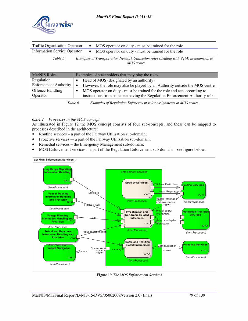
MarNIS Final Report D-MT-15
MarNIS/MT/Final Report/D-MT-15/DVS/05062009/version 2.0 (final) 79 of 139
Traffic Organisation Operator • MOS operator on duty - must be trained for the role
Information Service Operator • MOS operator on duty - must be trained for the role
Table 5 Examples of Transportation Network Utilisation roles (dealing with VTM) assignments at
MOS centre
MarNIS Roles Examples of stakeholders that may play the roles
Regulation
Enforcement Authority • Head of MOS (designated by an authority)
• However, the role may also be played by an Authority outside the MOS centre
Offence Handling
Operator • MOS operator on duty - must be trained for the role and acts according to
instructions from someone having the Regulation Enforcement Authority role
Table 6 Examples of Regulation Enforcement roles assignments at MOS centre
6.2.4.2 Processes in the MOS concept
As illustrated in Figure 12 the MOS concept consists of four sub-concepts, and these can be mapped to
processes described in the architecture:
• Routine services – a part of the Fairway Utilisation sub-domain;
• Proactive services -– a part of the Fairway Utilisation sub-domain;
• Remedial services – the Emergency Management sub-domain;
• MOS Enforcement services – a part of the Regulation Enforcement sub-domain – see figure below.
act MOS Enforcement Serv ices
Enforcement Services
Strategy Serv ices
(from Processes)
VTS Area Particulars
Inv estigation and
Non-Traffic Related
Enfocement
(from Processes)
ETP
Tracking data
Voyage information
Model output
information
Meteo and hydro
information
Traffic and Pollution
Related Enforcement
(from Processes)
Routine Serv ices
(from Processes)
Local Regulations
Information Prov ision
Serv ices
(from Processes)
Proactiv e Serv ices
(from Processes)
Vessel Nav igation
(from Processes)
Arriv al and Departure
Information Handling and
Prov ision
(from Processes)
Long Range Reporting
Information Handling
(from Processes)
LRR infoVessel Tracking
Information Handling
and Prov ision
(from Processes)
Voyage Planning
Information Handling and
Prov ision
(from Processes)
Communication
«flow»
Communication
«flow»
Vessel information
and awareness«flow»
Figure 19 The MOS Enforcement Services
MarNIS Final Report D-MT-15
MarNIS/MT/Final Report/D-MT-15/DVS/05062009/version 2.0 (final) 80 of 139
6.3 Services
As stated earlier MOS provides for the following services:
• Search and Rescue (SAR);
• Oil Pollution Preparedness, Response and Cooperation (OPRC);
• Maritime Assistance Services (MAS);
• Pro-active Vessel Traffic Management (VTM);
• Flag State responsibilities;
• Assistance to other Competent Authorities.
6.3.1 MOS and Search and Rescue (SAR)
6.3.1.1 IMO International Convention on Maritime Search and Rescue, 1979
The 1979 SAR Convention was aimed at developing an international SAR plan, so that, no matter where an
accident occurs, the rescue of persons in distress at sea will be co-ordinated by a SAR organization and,
when necessary, by co-operation between neighbouring SAR organizations.
Important for MOS, it is noted in the SAR Convention that parties are encouraged to enter into SAR
agreements with neighbouring States involving the establishment of SAR regions, the pooling of facilities,
establishment of common procedures, training and liaison visits. This principle is taken forward and
strengthened in the MOS concept.
Preparatory measures which should be taken, including the establishment of rescue co-ordination centres and
sub-centres, are provided in the Convention as are the inclusion of outline operating procedures to be
followed in the event of emergencies or alerts and during SAR operations.
Other areas addressed are the requirement for the rescue co-ordination centres to have the ability to receive
ship reports on their position, in order to facilitate a faster response, and to be aware of the resources
available in the area.
The principle task of a Maritime Rescue Coordination Centre (MRCC) is to coordinate search and rescue
operations. The SAR Convention would appear sufficient to provide a legal framework in combination with
provisions of SOLAS regarding the obligation of masters in the vicinity of a vessel in distress.
The use of AIS networks facilitates the tracking of vessels, and this is of great benefit for SAR purposes. The
position of a vessel can be readily determined as well as the position of vessels that can act as Search and
Rescue Unit (SRU).
The potential of AIS makes it suitable for VTM purposes. This dual use and the existing infrastructure of
MRCCs lead to the suggestion to combine the functions of VTM and SAR.
The functions of SAR need not to be changed, since these functions are performing satisfactorily. The
MRCC is now a part of a MOS Centre.
6.3.1.2 Mass rescue operations
In COMSAR /CIRC.31, IMO provided guidance for Mass Rescue operations (MROs). MROs are floods,
earthquakes, acts of terrorism, casualties in the off shore oil and gas industry, accidents involving releases of
hazardous substances and major aircraft and or ship accidents are examples which may need to use the same
resources as would be used to carry out mass maritime or aeronautical rescue operations. If there is a multi
jurisdiction, multi-mission and possibly international responses to a major incident it is necessary that there
is a need to know who is in charge and the roles of all who are involved and in what way interactions
between the rescuers need to take place.

MarNIS Final Report D-MT-15
MarNIS/MT/Final Report/D-MT-15/DVS/05062009/version 2.0 (final) 81 of 139
Again preparedness is critical to preventing heavy loss of life. This depends on levels of cooperation and
coordination, planning, resources and exercises that are required for preparedness.
A MOS Centre might act as a coordination centre for MROs. The structure of saving life at sea should be
maintained. Planning of MROs should begin as soon as MOS centre may act as a centre to coordinate
MROs. Further guidance for planning may be found in the annexes of the circular.
6.3.1.3 MOS and leisure craft
Most of the activities of present day MRCCs are directed to problems or rescue operations of the crew of
leisure craft. Between 80% and 95% of the number of operations is directed to leisure craft and often the
involvement leads to a rescue operation.
MarNIS made proposals for a more efficient reporting scheme for leisure craft. The scheme has three
components: website to report intended cruises and the safe return to the homeport, to download regional
weather information and a presentation layer for MOS operators to display positions of leisure craft equipped
with B-AIS. The use of the website is fully compatible with small hand held devices, such as PDA or an I-
phone.
SAR operations and routine voice traffic between small craft and coastal centres, require large resources
from operators. In order to reduce the voice traffic an important element in the concept is to automate the
information exchange process. If this can be achieved one result will be a reduced workload on the MOS
operators and hopefully an increase in the number of successful “life saving operations”. In order to achieve
this automated process there was a need for an underlying structure of AIS services and applications in order
to filter AIS information and extract elements from the AIS messages and transmit information to the small
craft via class B AIS or mobile phone.
One of the benefits from the Class B AIS is the possibility to monitor the movements of the small craft. The
class B supports text messaging similar to class A. Through use of AIS based applications and services the
AIS link can be used to distribute information to small craft inside a given area or to a selected group of
vessels. The information could relate to change in weather condition, MSI information or in general
information similar to that as embraced by NAVTEX, but shorter. One of the recommendations from the
work is a mandatory carriage requirement for Class B AIS on leisure craft. Another important element is to
increase the responsibility for own safety. Knowing that the help is close will make the personnel confident
that they will be saved and the risk is reduced.
To these ends a web site for small craft was developed whereby there is a scheme for reporting intentions
and essential data. Such information might result in the search starting earlier in a more relevant position. In
many cases the rescue situation will be avoided as the craft are located earlier. Accurate information, e.g.
number of persons onboard, will make the MOS centre able to focus their effort and composition of rescue
team and material.
An important function of the web site is to provide educational information to the small craft personnel such
as COLREG’s, Beaufort scale, how to interpret weather forecasts, procedures in case of emergency, etc. By
using the MOS small craft web site, the user should be granted easy and well arranged access to important
maritime information, and should be educated on the importance of this information. Relevant information
could be gathered on the web site for the MOS area.
6.3.1.4 Evacuation Software
Although calamities with ferries and cruise vessels do not occur with great frequency in European waters
there is a large measure of risk for passengers involved in the evacuation of vessels. The IMO set up rules for

MarNIS Final Report D-MT-15
MarNIS/MT/Final Report/D-MT-15/DVS/05062009/version 2.0 (final) 82 of 139
evacuation and research institutes have developed software programs to assess the design of ferries and
passenger vessels. In the meantime personal transponder systems have been developed and these systems are
capable, when armed, to indicate the position of the passengers and crew within a vessel.
Evacuation software was developed in MarNIS whereby once the master has activated the system the
position information can be sent to a central processing unit and the information displayed on the bridge.
When the master activates the emergency management system onboard to supervise the progress of the
passengers to the assembly stations, he automatically informs the relevant MOS, who in turn, through
contacting e.g. EMSA, will be able to locate the appropriate software and download the information,
displaying it on a screen in the MOS centre. When synchronized the SMC has the same information as the
master of the stricken vessel and possible measures can be directly discussed between master and SMC.
The status of the vessel will also be calculated and displayed in the MOS centre. When the danger for life is
substantially decreased, the MEM can take over to mitigate the consequences. If the flag State is the coastal
State all measures can be taken by the MEM with the advice of the MarNISrep. If the vessel’s flag differs
from the coastal State, the MEM and the MarNIS rep of the flag State may assist the coastal MOS with
advice, also coming from the owner and insurers of the damaged vessel.
The organization of the provision of software on evacuation can be best organized through EMSA.
There are two issues. The first issue is the preparation of plans for cooperation between SAR and passenger
ships. The second issue is the provision of the software.
MSC /Circ.1079 provide guidelines for the preparation for cooperation of SAR services and passenger ships.
The basis is a difference in treatment of vessels that operate in specific area and have to deal with a small
number of MOSs such as ferries and cruise vessels which operate worldwide. In the first method SAR plans
are in custody of the MOS Centre(s), while in the latter case a SAR data provider is appointed that transfers
the information to qualified users.
MarNIS proposes that:
• EMSA becomes the SAR data provider and
• That the distinction between sailing areas of passenger vessels is removed.
The index that is maintained by MRCC Falmouth should also being moved to EMSA. Update of information
is the obligation of the national MOS centres and the ship owners.
IMO is also engaged in rule making for passenger vessels. Research results indicate that a practical
application of software to assist the master and informs the MOS-operator is not far away. The involvement
of EMSA remains the same. EMSA acts as a SAR data provider. The software is downloaded in a repository.
Requirements need to be set on the use of a computer system that is able to run the software and is able to
synchronize with the same software on board the passenger vessel.
Optimum use should be made of a passenger transponder system. That system indicates the position of a
passenger inside the vessel when the system is armed. Technical problems seem to be solved, but problems
of privacy and continuous carriage of the (small) transponder by all passengers are not yet solved.
Communication technology has advanced to a state that broadband solutions are possible all over the globe,
provided there is coverage of communication satellites. The use of geostationary satellites may overcome
communication problems in remote areas.
6.3.2 MOS and Oil Pollution Preparedness, Response and Cooperation (OPRC)
Oil spilled at sea threatens individual organisms, resources in the immediate vicinity and the ecosystem as a
whole. It also poses a potential threat to the shore and to estuaries. Damage to the ecosystem will depend

MarNIS Final Report D-MT-15
MarNIS/MT/Final Report/D-MT-15/DVS/05062009/version 2.0 (final) 83 of 139
inter alia on the quantity and type of oil, the location where the oil is spilt and the time of year. Effects may
be direct or indirect.
It is recommended that OPRC operations be incorporated in the “under the one roof” principle of MarNIS so
that coordination between other emergency response activities such as Search and Rescue can take place in a
timely and efficient manner. Whilst respecting the priority placed on the saving of lives, much can be gained
where joined resources are implemented as at early an opportunity as possible.
6.3.3 MOS and Maritime Assistance Services (MAS)
MAS means a Maritime Assistance Service as defined in Resolution A950 (23), responsible for receiving
reports in the event of incidents and serving as the point of contact between the master and the authorities of
the coastal State.
The original objectives of MAS are:
• Receiving reports, consultations and notifications required by the IMO instruments referred to by the
relevant instruments;
• Monitoring the ship’s situation if a report as referred to above discloses an incident that may cause
the ship to be in need of assistance;
• Serving as a point of contact between the master and the coastal State concerned, if the ship’s
situation requires exchanges of information and the coastal State, but is not a distress situation that
could lead to a SAR operation;
• Serving as a point of contact between those involved in a marine salvage operation undertaken by
private facilities at the requests of parties having a legitimate interest in the ship and the coastal
State, if the coastal State concerned decides that it should monitor all phases of the operation.
When one compares the MOS centre as a monitoring and response centre and the objectives of MAS there is
a large degree of similarity.
The MEM is responsible for the organization of response actions in case a threat occurs to the interests of the
coastal State. The MEM organizes response to vessels in need of assistance when they are in other SRR but
outside the area where the interests of the coastal State are affected.
The MEM gets instruction from the MarNISrep when fundamental decisions need to be taken. Information
on incidents and accidents are reported to the MOS Centre and the SMC and the MEM determine whether it
is a case for SAR or it concerns a case of a vessel in need of assistance.
6.3.3.1 MOS centre and Places of Refuge
A Place of Refuge means a place where a vessel in need of assistance can take the action to enable it to
stabilize its condition and reduce the hazards to navigation, and to protect human life and the environment.
The MOS centre deals with the issue of Places or Refuge. This has been an important issue lately. The
underlying issue is the question of the procedures to be followed when a vessel is in need of assistance. Is
there a need to send the vessel to sea or will be a place of shelter along the coast provided? Taking a
damaged vessel to a place of refuge would have the advantage of limiting the coastline subjected to oil
pollution, but the area of the place of refuge may be more subjected to intense pollution.
The decision to use a Place of Refuge is consequently a political decision, which needs to be taken by the
MarNIS Rep. Once a decision has been taken the MEM and the experts gathered from the shipping

MarNIS Final Report D-MT-15
MarNIS/MT/Final Report/D-MT-15/DVS/05062009/version 2.0 (final) 84 of 139
inspectorate, class, and the representatives of the ship owner needs to implement a strategy to minimize the
damage to environment and vessel.
The legal context for intervention is provided by among others, by UNCLOS Art.221 and the intervention
Convention. The MOS Centre should operate in conformance with the Guidelines recommended by IMO in
Resolution 949 of March 5th, 2004.
An important issue is the determination of the state of the vessel. Are there persons in distress? If that is the
case rescue operations have always precedence over any other operation. The master may decide with the
assistance of the SMC of the SRR where the accident happened whether the vessel is in need of assistance.
In special cases the SMC may decide that he launches a rescue operation on the basis that the vessel is in a
remote place outside the range of rescue craft or helicopters.
6.3.4 MOS and Pro-active Vessel Traffic Management (VTM)
The MOS centre acts as a Vessel Traffic Management (VTM) centre. The term VTM is used rather than
Vessel Traffic Services (VTS) as the potential scope of VTM is wider. Within the MOS concept there is
reference to pro-active VTM and this is seen through both its ability to conduct preventive actions as well as
its role in providing the link between ship and shore, and ultimately the port of destination, through the
communication of updates and requests from both sides.
In respect of pro-active VTM a MOS Centre:
• Enables a more effective consideration of the needs of the environmental concerns and those of the
vessel through the introduction of Risk Indices and the concept of Alert and High Risk Ships, which
might ultimately enable the replacement or enhancement of static routing measures;
• Detects and forwards updated ETAs of ships that are bound for a European port;
• Takes care of the retrieval of ships’ AIS tracks through the storage of these tracks in a regional data
centre that acts as a repository.
VTS is in essence the provision of information to the traffic flow as well as advice and instruction, if need be
and permitted in accordance with the delineation of a coastal States waters. Due consideration is to be made
whether the vessel is in Internal Waters, the Territorial Sea, the Contiguous Zone, the Exclusive Economic
Zone (EEZ) or on the High Seas. For example, the Right of Innocent Passage is to be adhered to in
Territorial Seas and the principle of freedom of the High Seas should not be violated and remains the
overarching principle.
VTS are usually implemented in those ports and approaches where either the density/mix of traffic and the
nature of the environment and infrastructure warrant. They are dedicated to providing participating vessels
with an Information Service, Navigational Assistance Service, Traffic Organisation Service and/or support to
Allied Services. They will usually operate in the Internal Waters and the Territorial Sea where exceptions
may be “underwritten” by the coastal State in terms of providing instruction to vessels in approach
channels/areas. Some coastal VTS stations do exist however these have been situated in particularly sensitive
or high density areas such as the English Channel or in north-west France. A VTS requires the ability to
monitor (observe), and interact with, the traffic. With the emergence of coastal AIS networks the shore-based
services do have the capability to detect (cooperative) vessels so equipped in all EU waters within range
however other sensors are required to track and trace vessels in other areas, or indeed provide “non-
cooperative” means of tracking a particular vessel.
Whilst MOS intends to monitor all vessel movements in EU waters, outside of emergency situations it is not
required to track all vessels on a (near) real-time basis except where an authority has deemed a vessel to pose

MarNIS Final Report D-MT-15
MarNIS/MT/Final Report/D-MT-15/DVS/05062009/version 2.0 (final) 85 of 139
a particular risk, whether that be determined by the “maritime authorities” or others such as Customs or
Immigration.
A MOS Centre will manage traffic deemed to pose a potential threat to the coastal State and will initiate
measures in order to contain or mitigate potential risk depending on the circumstances. This will not
necessarily fall within the traditional VTS services as highlighted above. A distinction is to be made as to the
measures that can be taken dependant on a vessels’ location in relation to the coastal State.
When the passage of a vessel through the territorial sea is not considered innocent, the coastal State can
refuse passage. One of the reasons to refuse passage is that the vessel commits a wilful act of pollution.
Accidental pollution gives the coastal State the right to refuse passage and give the vessel instructions as to
where to go. Passage through the territorial sea which is not continuous and efficient may also lead to
intervention of a coastal State since the passage is not innocent.
The coastal State may adopt rules and regulations related to safe navigation during innocent passage. These
measures may comprise Traffic Separation Schemes (TSS) and routing measures as well as VTS. It is held
that violations against the rules of TSSs and VTSs don’t make the passage non-innocent. The coastal State
has other instruments to avoid danger to its interests.
The character and potential of VTS on the high seas has changed since the introduction of AIS. In the first
place the area placed under surveillance is larger and extends over the boundary of the territorial sea. If a
coastal VTS is established the available information of vessel behaviour is larger than is required and there is
tendency that this information will be used. The most urgent reason is to know what happened to vessels
which have been observed making no progress in the area and to establish that the vessel is not posing a
grave and imminent danger for the interests of the coastal State. But there are other reasons as well. This
takes away the local character of VTS and replaces it with a more general character.
VTSs in international waters dominantly have the task to provide information to the passing traffic. This
might be specific information, as traffic information but more general information may also be provided. The
VTS may also observe contraventions of international rules by vessels of a flag State and inform the flag
State. These contraventions are reported to the flag State in the hope that remedial action will be taken by the
flag State. VTSs at the high seas have the same objectives in principle as those in internal/territorial waters,
however are severely restricted as regards traffic organization and navigation assistance in that instructions
by the coastal State are not possible according to international law.
In developing a pro-active, or preventive, approach to VTM the following considerations need to be taken
into account:
• The implementation of full VTS functionality (according IMO/IALA) in a VTS in international
waters cannot be realised under the present international law;
• VTS may not give instructions to vessels sailing in international waters. VTS may give information
but needs to report contraventions to the flag State;
• There is a need to monitor traffic flows for vessels that may threaten the interest of the coastal state
even when they are in international waters and the coastal State may apply the instrument of the
Intervention Convention;
• There is a need to monitor traffic flows in order to detect a distress situation to rescue life in distress
at sea;
• There is a need to monitor traffic flows in order to detect vessels in need of assistance and to take
appropriate measures to remove the risk to the interests of the coastal State;
• There is a decreasing need to provide vessels with traffic information sailing in international waters,
based on the improved and accurate information;

MarNIS Final Report D-MT-15
MarNIS/MT/Final Report/D-MT-15/DVS/05062009/version 2.0 (final) 86 of 139
• There is more to win to monitor all traffic sailing along the coast in international waters for
symptomatic events ³ than to monitor all vessels in a delineated area. Some events may lead to
actions initiated by the coastal State such as a SAR and the application of the Intervention
convention with possible large consequences as well as the identification of vessels in need of
assistance;
• VTS may be established in international waters to provide information to the traffic flow. The
establishment of a VTS should comply with the recommendations of IALA and IMO regarding VTS.
6.3.4.1 Risk and Alert Values
Central to Pro-active VTM is the concept of risk and the application to vessels sailing in EU waters in order
to determine measures that may be taken against a vessel deemed to have a risk level above a predetermined
threshold.
The designation of a ship as a High Risk Ship needs to be based on the available information about facts and
circumstances, which can be considered as implying more than an average risk, based on, as much as
possible, generally accepted rules and standards, including a scientific method of risk analysis. A ship can be
designated as a High Risk Ship in the area of the EEZ of a Member State (200 miles from the coastline).
There may not yet be an incident or accident occurring, but a perceived danger exists that such an event may
occur with large environmental consequences with a much higher chance than is acceptable. This threat must
be taken away. So we are talking about the phase before intervention in the sense of the Intervention
Convention or article 221 of UNCLOS and article 19 of the Directive 2002/59/EC.
The MarNIS rep is in effect the competent authority who has the competences and powers to designate a ship
as a High Risk Ship (whether or not after the identification of that ship as a Alert Ship) and to decide which
measures should be taken on that ship (by instructions).
This subject is discussed in more detail in section 6.6, however following is an overview of how MOS can
manage risk and the measures that may be taken under the umbrella of Pro-active VTM.
6.3.4.2 Dissemination of ENC information through MOS
The fact that a ship does not carry the latest navigational charts on board might affect the overall risk
assessment performed by a MOS centre. The use of out-dated charts could be a reason for the relevant MOS
to initiate preventive measures to avoid incidents. To effectively fulfil its monitoring and accident avoidance
tasks a MOS centre must have the possibility to check the status of the navigational charts used onboard.
This could be done by a simple comparison between a chart inventory list (generated on board) and a chart
reference list of the latest official charts that are available.
A procedure that automatically or on request parses the chart inventory on board and transmits the
information from the ship to the relevant MOS centre is required. For an effective and reliable
implementation it is required that an ECDIS system with electronic navigational charts (ENCs) is used for
navigation rather than paper charts only. Thus ECDIS carriage requirement must be in place before
automatic reporting procedures providing information about the current status of the navigational charts can
be implemented.
6.3.4.3 Promulgation of NAVTEX messages
Up to now emergency and safety communications have been based on GMDSS. It is used for Search and
Rescue authorities ashore, as well as shipping in the immediate vicinity of the ship that is in distress, all will
be rapidly alerted to a distress incident so they can assist in a coordinated Search and Rescue operation with
the minimum of delay.
³ anything that accompanies X and is regarded as an indication of X''s existence
MarNIS Final Report D-MT-15
MarNIS/MT/Final Report/D-MT-15/DVS/05062009/version 2.0 (final) 87 of 139
The system also provides for urgency and safety communications and the dissemination of maritime safety
information, including navigational and meteorological warnings. This means that every ship will be able,
irrespective of the area in which it operates, to perform those communication functions considered essential
for the safety of the ship itself and of other ships operating in the same area.
Consideration is made of Safety to navigation messages that would have otherwise been broadcast by
NAVTEX, SafetyNET or AIS (ANSI). Although there are a number of other maritime broadcasts, such as
meteorological forecasts, prognosis and analysis, these are better served in pictorial or GIS formats rather
than by text. Also included is the need of vessels to report “Dangers to Navigation” for them to be re-
promulgated via the World Wide Navigation Warning Service (WWNWS).
Reference is made to the MarNIS deliverable D-HA9B4 for a full overview of the considerations made and
conclusions reached, including the potential role for Galileo.
6.3.5 MOS and Flag State responsibilities
MOS needs to put an organization in place that can respond to any serious situation, by immediately
activating an organization that can support decisions to safeguard the environment, and the vessel itself.
MOS acts in case the possible consequences of a calamity might affect the interests of a coastal State as a
calamity response organization under the guidance of a maritime emergency manager. This manager is
implementing major decisions from the MarNIS Rep. This is a person that takes decisions about the fate of
the vessel as and when required on behalf the Administration. The intervention is made under the
Intervention Convention.
If the vessel according to the coastal authorities of the SRR is in need of assistance, but there is no threat to
life at sea, international law determines that the flag State is responsible for adverse effects of the vessel to
the environment. If it is ascertained that the State responsible for the SRR, will take no action since there is
no danger for life the obligations of the flag State come to the forefront and based on art 219 UNCLOS, the
flag State can give instructions to the vessel to avoid adverse consequences for the environment, such as
spilling cargo oil or sinking of the vessel with bunkers and cargo oil.
The MarNIS representative needs to make decisions on a vessel flying the flag of the flag State, what needs
to be done to prevent pollution of the environment.
Close contact between the coastal MOS and the flag State MOS is essential to determine the responsibilities
of both centres, where the safety of life at sea is the most important issue. The recurrent question is whether
the crew and passengers of the vessel is in danger of losing their lives or the vessel is in need of assistance.
The flag State MOS may support the MOS of the coastal State with information on the casualty when it is
requested. The shipping inspectorate may provide technical details of the construction and operation of the
vessel important for a balanced response of the coastal State.
6.3.6 MOS and Assistance to Other Authorities
The MOS Centre is seen as the eyes, ears and voice of all authorities and not just those deemed to be
“traditional” maritime. Maritime Transport is ultimately affected by the manner in which the traffic is
enabled, as well as perceived, to perform its task within the constraints and requirements of all authorities
concerned with trade, the movement of persons, livestock and goods, as well as more recently according the
heightened awareness and subsequent control with respect security.
MarNIS Final Report D-MT-15
MarNIS/MT/Final Report/D-MT-15/DVS/05062009/version 2.0 (final) 88 of 139
To this end the MOS concept has been developed so as to provide the means for these concerned authorities
to gain more information on vessels of interest whilst at sea as well as to monitor their progress.
6.3.6.1 Monitoring for customs
In maritime transport, voyages from one port of an EU Member State to another, even without calling at any
intermediate non-EU port or free port or meeting another ship en-route, are always considered international
also when cargo transported is Internal Market cleared goods. A vessel is considered to leave the customs
territory when it leaves a Community port for another member State port.
These administrative procedures involve a wide set of EU and international legislation which include, in
particular, customs and tax rules, immigration, trade, statistics, environment and waste, phytosanitary
veterinary and health protection, security and safety. They have different objectives and rationales, and they
apply either to the transport service, the vessel and its crew or to the goods themselves. However, they all
hinder the free circulation of goods inside the Internal Market.
In 2002, the Commission services presented a guide to customs procedures for Short Sea Shipping in order
to make industry aware of the different procedures in the customs field applicable to Short Sea Shipping.
The simplified customs procedure of an "Authorized Regular Shipping Service" has been made available to
operators but most of them would like a further improvement of this facilitation, e.g. to have it linked to
companies or routes instead of ships. A survey conducted by Finnish customs found that only 43% of liner
services have authorized regular service permits.
Administrative procedures involved in shipping goods by sea within the EU today add to the trans-shipment
costs and complexities associated with multimodality.
Key for introducing such simplification is the availability of means in order to make sure that goods remain
in initial conditions. Actually the main reason put forward for maintaining controls on Internal Market goods
transported by sea, is the high risk of smuggling or frauds when the vessel leaves the port via uncontrolled
contacts with other vessels or calls in foreign ports.
However the rapid progress in positioning and communication technologies provides the technical means to
check if a maritime journey has been performed as declared by the ship Master. It was suggested to use the
ship surveillance systems for this purpose.
MarNIS has proposed to use the satellite toolkit as a tool that can assist in determining what satellites may
provide information about the whereabouts of vessels when they are outside the detection range of AIS base
stations. It is assumed that this information may supplement, or be supplemented by, space AIS information.
When a custom office in one of the member States receives an Entrance Profile (PEP) (see 5.4) they might
wish to check the statements of the master. When they request the national MOS, the MOS operator may
gather the data of the track of the vessel and may assess whether or not the vessel has called in a port that is
not reported (that will occur very seldom) or has had an illegal contact with another vessel in international
waters (that will occur seldom).The results of the assessment are reported to the custom office.
The Satellite ToolKit (STK) is a tool that determines and predicts what satellite can be used for space
observation of a particular sea area. The tool consists of a representation of suitable satellite orbits and when
a special sea area is indicated the tool determines which satellites may be used within a proper time frame.
If this technology is used to check positions of vessels in the frame work of checking the use of the European
maritime transport space without barriers, the i.e. Synthetic Aperture Images need to be correlated with other

MarNIS Final Report D-MT-15
MarNIS/MT/Final Report/D-MT-15/DVS/05062009/version 2.0 (final) 89 of 139
information such as AIS information or Radar information from shore based installations. The information of
space AIS can also be used when this system is up and running.
A worthwhile addition to the surveillance system is the use of small unmanned planes with Side Looking
Airborne Radar on board that stream the position data and the radar images to shore and then to the
requesting MOS centre to be analyzed. The small planes may be stationed in areas with known AIS coverage
problems.
These tools may be used on request of a MOS operator when making a recommendation to for example
customs about the track of a vessel that navigates from one European port to another. These tools are
operated by commercial providers. The time elapsed between the request of an image and the availability of
the image may very between 2 and 12 hours.
The MOS centre may have more expertise to assess the images of the toolkit, since they can also utilise the
results of AIS and space AIS. MOS operators may be more experienced judging the “normal behaviour” of
vessels than custom officers.
The same principles may be applied for immigration authorities.
6.3.6.2 Monitoring for health authorities
The ECDC (European Centre for Disease Prevention and Control) is responsible for the surveillance of
infectious diseases in the European Union and shall maintain the databases for epidemiological surveillance.
Data are collected by the ECDC for case-based reporting from the Member States for the routine surveillance
of the 46 diseases (listed in the Decisions 2002/253/EC and 2003/534/EC) as well as SARS, West Nile Fever
and Avian Influenza.
Health surveillance tasks include:
• Search, collect, collate, evaluate and disseminate relevant scientific and technical data;
• Coordinate and ensure the integrated operation of the dedicated surveillance networks;
• Develop integrated data collection systems covering all MS and all notifiable communicable
diseases, maintain the databases for surveillance and establish EU-wide standard case reporting;
• Initiate applied scientific studies and projects for the feasibility, development and preparation of its
activities;
• Closely cooperate with the organizations operating in the field of data collection;
• Monitor trends of diseases across Europe in order to provide a rationale for public health actions in
MS and disseminate the results to stakeholders for timely public health actions at EU and MS level;
• Support strengthening of national surveillance systems.
A MOS centre can contribute to the objectives of the ECDC as follows:
If health authorities or ECDC detect a threat to the health of other persons when the crew or passengers
contain a threat to passengers and crew or to other persons which they may come in contact with, the health
authorities may require the MOS, through the appropriate national authorities, to track a vessel in the
European reporting area so as to avoid the crew or passengers to contact non infected people until the health
authorities decide that the danger to persons no longer exists.
MOS operators may send progress reports of the position of the vessel to the parties who have requested the
information. Through MIM, the health authority has already received all pre-arrival information in the
relevant Entrance Profile (PEP).

MarNIS Final Report D-MT-15
MarNIS/MT/Final Report/D-MT-15/DVS/05062009/version 2.0 (final) 90 of 139
6.3.6.3 Monitoring for fishing authorities
Vessel Monitoring Systems (VMS) allow environmental and fisheries regulatory organizations to monitor,
minimally, the position, time at a position, and course and speed of fishing vessels. VMS systems are used in
all coastal member States and make it possible to follow objects when entering other countries territorial
waters and search and rescue regions (SRR). The information is transmitted via Inmarsat–C or Argos
(satellite communication system) systems every second hour and displays position or position/course/speed.
VMS is not compatible with the AIS format, but might be linked together with integrated AIS and radar
information and could be integrated into the tasks of the MOS.
6.3.6.4 Security monitoring
6.3.6.4.1 Security assessment of vessels at large
The MOS Centre has an overview of vessels in its monitoring area. Information of the position of vessels
outside the terrestrial AIS is available in the first instance through Long Range Reporting facilities. Through
techniques such as dead-reckoning the MOS operator is able to determine any suspicion of “illegal”
behaviour of the vessel concerned. The MOS operator should take the instantaneous weather conditions into
account and estimate the speed of the vessel under extreme weather conditions to avoid unnecessary
reporting.
The methods employed by the MOS-operator under 6.3.6.1 are essentially the same in this case.
6.3.6.4.2 Unlawful acts
The MOS may become aware of an aircraft known or believed to be subject to unlawful interference. The
MOS should declare an Alert Phase and advice the security authorities. The MOS starts the preparation for a
possible SAR-operation as appropriate. See also MSC 1073 and IAMSAR manual Vol 2.
Special signals have been developed for use by ships under attack or threat of attack from pirates or armed
robbers. Piracy/armed robbery attack is a category of distress message for all classes of selective call
equipment. For their own safety, ships may have to covertly send out the piracy/armed robbery message.
When the MOS becomes aware of such a situation, it should declare an Alert Phase, advise appropriate
responsible agencies as specified in the plans of operation and begin preparations for possible SAR
operations as appropriate. If the ship has sent covertly a message care should be taken in any communication
sent back to the ship as not to warn the pirates.
6.4 MOS and Surveillance Techniques
A number of surveillance techniques have been considered in MarNIS. Various reports consider the
advantages and disadvantages of various technologies such as Unmanned Aerial Vehicles (UAVs), Side
Looking Airborne Radar (SLAR), satellite Synthetic Aperture Radar (SLAR) as well as other land and
satellite based systems. In addition, the development of the Satellite Tool Kit (STK) has provided an efficient
and effective means for determining the appropriate surveillance sensors available to the MOS. Following is
an overview of a number of relevant considerations with respect the appropriate use of these key
technologies for MOS, through use of the STK as well as a few observations concerning the use of SAR and
SLAR for oil spill detection. A brief mention is made of the Web Map Services (WMS) as used for all test
and demonstration purposes for the MOS.
6.4.1 Satellite Tool Kit
The use of the Satellite Tool Kit (STK) to support the MOS operator and surveillance operations can increase
the operator’s global awareness about the ships position under radar and/or AIS coverage. Nevertheless, the
real added value is its capability to present in a single and clear interface the position information about the
vessel traffic fused with several monitoring and surveillance systems such as:

MarNIS Final Report D-MT-15
MarNIS/MT/Final Report/D-MT-15/DVS/05062009/version 2.0 (final) 91 of 139
• Earth Observation (EO) Satellites and its monitoring payloads;
• Aircrafts, Helicopters and UAV;
• Monitoring systems mounted on flying objects;
• Radars;
• Communication Systems;
• Satellite or in general flying objects EO images.
This is not the only added value; it should be noted that it is possible and recommended to use the
possibilities to arrange the display interface in such a way that it could help MOS to have a global
monitoring awareness using the strong reports and analysis capabilities of STK.
Taking into account the research activities performed during the MarNIS project, and the subsequent
deliverables produced on the surveillance systems, the following suggestions are derived:
• Outside the nominal range of optical surveillance systems and radars, the use of other devices is
indispensable;
• For immediate close to coast patrol purposes, the use of UAV and Aircraft is preferable to satellites
and vessels since the response time and the coverage area is greater;
• The use of AIS data to track the routes and receive additional information about the traffic appears
very important however it should be stressed that AIS works only with “collaborative ships” (i.e.
with ships that do not turn off the transmitter and do not have AIS failures). As the AIS signals’
range also depends on weather conditions, it appears that in order to arrange surveillance and
monitoring as discussed these fluctuations of range do not allow a thorough surface image of the sea
to be monitored;
• The use of satellites to monitor those areas not covered by AIS and radars appear to be the only
devices that could enhance the offshore awareness and additional surveillance layer over the covered
areas;
• There are an increasing number of satellites equipped with powerful and very high resolution
sensors. For customs and/or immigration surveillance, it appears that the fusion of long endurance
UAV with these new satellites will increase the monitoring capabilities of MOS;
• As a lot of different devices are used for surveillance purposes, the use of an interface or software
that can present in an easy and understandable way all the vessel traffic and the monitoring activities
fused together is indispensable.
6.4.2 SAR and SLAR
MarNIS compared Side Looking Airborne Radar (SLAR) and satellite Synthetic Aperture Radar (SLAR) for
oil spill detection at sea with the purpose to be able to provide recommendations on which system is best,
both in terms of costs and oil spill detection capability.
A brief technical description of the two systems is provided addressing the most important difference
between SAR and SLAR, i.e. spatial resolution. It is resolution that differentiates the two radars and explains
why SAR is required for oil spill detection with satellite systems whereas SLAR is sufficient for airborne
systems. Moreover, a comparison of airborne SLAR and satellite SAR is provided from both a technical and
an operational point of view. Taking into account the dominant technical parameters, a cost figure is derived
for SAR and SLAR in terms of cost per area covered (Euro/Km2). Accounting for the limitations of the
revisit times that satellites offer in a user specific surveillance scheme, this figure may be used to determine
which system is most cost effective.
It is motivated that from a technical and an operational point of view, a combination of SAR and SLAR is
the optimum solution, which agrees with the view of most sea states on oil spill surveillance. In this solution,
satellite SAR is used for surveillance and early warning in open seas, since in a very short time a wide area

MarNIS Final Report D-MT-15
MarNIS/MT/Final Report/D-MT-15/DVS/05062009/version 2.0 (final) 92 of 139
can be imaged. Near the coast, satellites are less useful because their revisit time over a certain area is fixed
so that the area cannot be monitored at any given time. There, aircraft play an important role because an
aircraft equipped with a SLAR system can always be flown (unless the weather conditions are too averse),
and the crew on board as well as other sensors can improve detection performance.
Some standard procedures that are followed by the service provider (normally a satellite centre), the
operators (the first persons analyzing the satellite data) and the end users (e.g. coast guard) when using both
satellites and aircraft to monitor oil spill pollution are described and a few examples of operating systems are
discussed, such as CleanSeaNet, which is a dedicated service of the European Maritime Safety Agency
(EMSA) for oil spill monitoring in European waters.
A comparison of airborne SLAR and spaceborne SAR in terms of technical parameters, most importantly
spatial and temporal coverage, has revealed that the two systems are complementary. SAR satellites with
their wide swaths have the advantage of covering large areas. On the other hand, their disadvantage is that
they are limited to a revisit time of 1-3 days with overflights at fixed local times in the morning and evening.
Aircraft have short revisit times of a few hours and can be operated at almost any time of the day but because
of their narrow swaths and relatively high cost are limited to surveillance of small areas. This has led to a
recommended and more or less commonly accepted surveillance strategy of satellite SAR and airborne
SLAR working together. With this strategy, SAR is used as an early warning system, preferably in the open
seas where the area to be covered is large and where there is enough time to react by sending out an aircraft
or vessel. Aircraft SLAR would be used in coastal seas, covering a less wide area with the possibility of
immediately starting an action.
A cost comparison has shown that the cost per Km2 for monitoring oil spill with SAR satellites is between
0.05-0.12 Euro/Km2. Regarding aircraft SLAR, the cost per Km
2 for monitoring oil spill is about 0.16
Euro/Km2. With these figures and a user dependent monitoring scheme, e.g. relying on combined SAR and
SLAR, the total cost per year may be compared for different EEZs.
6.5 Web Map Services (WMS)
For test and demonstration purposes widespread use was made of Web Map Services (WMS), where the
required information is given in geographical overlays, presented on top of the Electronic Navigation Chart.
The information displayed using WMS included meteorological and hydrographical conditions, AtoN (Aid
to Navigation) information, proposed routes, temporarily restricted/closed areas and berth/terminal
information, etc. depending on local conditions.
6.6 Risk
6.6.1 Risk-based approach
Central to the pro-active approach to VTM is the use of dynamic risk calculations. The risk assessment
model SAMSON (Safety Assessment Model for Shipping and Offshore on the North Sea) determines the
yearly risk based on a traffic database, traffic patterns, different models and accident statistics. The risk
calculated with the model is summarized over all traffic participants and all environmental conditions. In
order to calculate the risk for an individual ship for the prevailing environmental conditions the different
models used in SAMSON are converted to dynamic models.
In order to use risk in the daily practice of MOS and to minimise risk of vessels, a method has been designed
that fulfils a number of requirements of international environmental law. IMO has accepted the Guidelines

MarNIS Final Report D-MT-15
MarNIS/MT/Final Report/D-MT-15/DVS/05062009/version 2.0 (final) 93 of 139
on the incorporation of the precautionary approach in the context of specific IMO activities [Resolution
MEPC 67]. The important issue is that the precautionary approach shall be applied where there are threats of
serious or irreversible damage. It should not be used as a reason for postponing cost effective measures or
prevent environmental damage. A precautionary and anticipatory rather than a reactive approach is necessary
to prevent the degradation of the marine environment. This requires, inter alia, precautionary measures and a
comprehensive approach to the damaging impacts from air, land and water.
MarNIS has defined the notion of alert vessel. This vessel is defined as having much more risk than the
average ship and enabling the coastal authorities to take steps. An average value of the alert value is for good
weather about € 20 and the under limit of an alert vessel is € 50. The limit is thought to be depending on the
weather. When the weather is bad, >BF9 the limit value is € 500.
The alert values are automatically calculated. The AIS is used to convey the position of the vessel. The
dimensions of the vessel are provided by the AIS, which are sent at regular intervals. The MMSI number is
used to identify the vessel and to retrieve the nature and the weight of the cargo which is necessary to
calculate the alert value. The repeat time of the calculations is less than 1 minute. Consequently updates of
the alert values are provided in less than one minute, depending on the size of the area in the traffic displays
in front of the MOS operator.
6.6.2 The instructions of the MOS-operators
The MOS-operator may (on behalf of the competent authority) decide whether or not he makes a vessel a
High Risk Ship. There are factors assisting in the decision. One of the reasons of leaving the vessel
untouched is the presence of TSS. The options to develop an alternative track are not many. If the MOS-
operator thinks he should declare a vessel a High Risk Ship he should do so. The MarNISrep may give an
approval to declare a vessel HRS for defined cases. In extraordinary cases the MarNISrep can give his
consent to declare a vessel a HRS.
It is customary that an authority issues orders after the report that the vessel is declared a High Risk Ship.
When the master has acknowledged the receipt of the report the MOS operator may give instructions to the
master of the HRS.
The instructions of the MOS operator are based in accordance with the principles laid down in
MEPC/392/MSC 1023 whereby the guiding principle is that the distance from the coast is based on a
minimization of the risk costs and the exploitation costs of the vessel.
The principle mentioned above can be applied at various routes along the Atlantic coast. If the IMO
community abstains from static TSSs the environment as well as the operators can benefit from a win-win
situation.
6.6.3 Risk values for individual ships
Risk is frequency multiplied with consequence. Both, frequency and consequences can be affected by risk
reducing measures.
One part of the risk value of an individual ship is the probability or frequency of an accident for that ship on
the given time and location. Different types of accidents are taken into account when calculating the risk
value:
• Collision between two moving vessels;
• Foundering; the incident that a ships sinks due to the environmental conditions;
• Hull failure; the probability that a hole will occur in the hull of a ship;

MarNIS Final Report D-MT-15
MarNIS/MT/Final Report/D-MT-15/DVS/05062009/version 2.0 (final) 94 of 139
• Machinery failure; a failure that results in a drifting ship;
• Fire/explosion on board;
• A ramming contact; a contact with an object, coastline or grounding due to a navigational error;
• A drifting contact; a contact with an object, coastline or grounding due to an machinery failure;
The frequency of each type of accident depends on different influencing factors:
• ship characteristics
o type of ship
o size of ship
o age of the ship
o flag (Port State Control list, white, grey and black sub lists)
o navigation status
• environmental conditions
o wind (Beaufort)
o visibility
o current
o other traffic
o coastline
Other factors that play a crucial role include manning however there is a lack of detailed information from
both actual vessels and in the casualty databases; for this reason it cannot be implemented (yet). This means
that in each class (type, size, age, and flag) an average rate is used. In reality it will fluctuate around this
average value with good and bad ships.
The accident frequency for an individual ship is determined using so-called exposures and a casualty rate.
The exposures are the number of potential casualty sensitive situations in which a ship can be involved,
which could lead to an accident. For example for the accident type collision the exposure is an encounter
between two ships. By linking these exposures with the actual casualties from the accident database the so-
called casualty rates for the different accident types are derived.
Accident type Exposure
Collision Encounter
Foundering Nautical miles
Hull failure Nautical miles
Machinery failure Nautical miles
Fire/Explosions Nautical miles
Ramming contact Stranding Opportunity
Drifting contact Ramming Opportunity
Table 7 Accident types and corresponding exposures
The different exposures are determined taking into account different factors and mathematical models. The
calculated exposures are multiplied with the so-called casualty rate (CASRAT). The casualty rate is the
probability that a pre defined exposure type will lead to a real accident. So it is for example the probability
that an encounter, as defined within the model, will lead to a real collision. This “static” casualty rate is
determined using accident data from 1990-2003.
By multiplying the calculated exposure and the static casualty rate an average frequency is determined. To
include the influence of different factors, such as wind, visibility and flag of the ship, the average level of
frequency is multiplied with different factors to incorporate the influence of the different factors.

MarNIS Final Report D-MT-15
MarNIS/MT/Final Report/D-MT-15/DVS/05062009/version 2.0 (final) 95 of 139
P(i) = the probability of an accident type (i
EXP(i) = Exposure for a certain accident type (i)
CASRAT (i,type,size) = Casualty rate for a certain accident type (i), ship type and ship size
Fflag = multiplication factor for flag state
Fage = multiplication factor for age of the ship
Fwind = multiplication factor for wind
Fvis = multiplication factor for visibility
Fnav = multiplication factor for the navigation status
The multiplication model as it is used/ implemented to determine the Risk Value of an individual ship within
MarNIS has been validated.
6.6.4 Consequences
The consequences of an accident at sea can be divided into three main areas:
• Consequences for life;
• Consequences for the environment; pollution;
• Structural consequences.
The consequences are very important and the possible consequences vary with the type of casualty. For
example the consequences after a machinery failure are negligible as long as the incident occurs far enough
from the coast. Such a casualty (or better incident) will only have consequences when the drifting ship
strikes a rocky coast before an emergency towing vessel can arrive.
The consequences of a casualty can vary strongly, from little damage up to the case that the ship sinks as
result of the casualty and the whole crew and all passengers become at risk. Another scenario is that a cargo
tank or bunker tank is penetrated and an oil spill occurs that threatens the coast. In the consequence
calculations several scenario’s (from a small spill to a large spill with corresponding frequencies) are
considered for which the costs are estimated. The ship type and size plays an important role with respect to
the number of persons at risk and the probability and size of an oil spill.
For the current calculation only one type of oil is assumed. The draught of the ship is an indication of the
amount of cargo on board. In future when some global information is known about the type of oil (from
SSN++, AIS or other sources) the pollution risk model can be improved.
The casualties with the highest cost levels are those where the ship sinks after the casualty. This category is
considered as a separate scenario in the consequence calculations.
Influencing factors:
• Ship characteristics (variable):
o Amount of cargo oil;
o Amount of fuel oil;
o Type of oil;
o Number of crew;
P(i) = Fflag * Fage * Fwind * Fvis * Fnav * EXP(i) * CASRAT(i, type, size)

MarNIS Final Report D-MT-15
MarNIS/MT/Final Report/D-MT-15/DVS/05062009/version 2.0 (final) 96 of 139
o Number of passengers.
• Geographical layout:
o Distance to the coast.
• Environment (variable):
o Wind force (Beaufort);
o Wind direction;
o Type of coast.
• Risk Control Options :
o Location/capacity SAR (Search and Rescue);
o Location/capacity OPRC (Oil Pollution Response Coordination);
o Location ETV (Emergency Towing Vessel).
Depending on the type of consequences three different risk values are calculated:
� Loss of Life Risk Value
� Pollution Risk value
� Structural Risk Value
The total Risk Value is the sum of all three Risk Values:
6.6.5 Factors that need to be considered in the future
There are some factors that are not included in the risk calculating model from MarNIS that (could) have an
influence in determining the risk of a ship. This is due to different reasons. The main reason is that there is
not enough data available to determine a good relation between the factor and the probability of an accident.
Another reason is that the information (factor) is not available in “real-time”, because it is not part of the
AIS-message. For some factors it is also not possible to express then in monetary terms:
Some examples:
• Human factor / Quality of the crew / composition of the crew;
• Shipping company;
• Change of shipping company;
• Change of flag;
• Sea state.
It is a general accepted that the human factor, i.e. quality and composition of the crew, has an influence on
the performance of the ship. The measurement hereof requires further attention.
The sea state is not a separate factor; however it does have a relation with the combination of Beaufort class,
wind direction and tidal current. The sea state is also not (always) included in the accident databases used to
determine the casualty rates, so no solid conclusions can be drawn on the relation between sea state and
accident probability or severity of the consequences, at least not a conclusion that can be backed-up with
statistical data.
6.6.6 Implementation of risk calculations in a MOS centre
An important issue for a MOS centre is the overview of the shipping traffic within the area. Such a traffic
image is presented based on the received AIS-messages. Because a large monitoring area can contain
hundreds of ships it is necessary that the operator can concentrate on a limited number of targets. Therefore a
method will help to select risky ships. For pinpointing the ships with higher risk, the potential risk is
Risk Value = Pollution Risk value + Loss of Life Risk Value + Structural Risk Value
MarNIS Final Report D-MT-15
MarNIS/MT/Final Report/D-MT-15/DVS/05062009/version 2.0 (final) 97 of 139
calculated for each ship in the area. The risk depends on different parameters as the ship characteristics, the
environmental conditions, the geographical position and the presence of other traffic.
The required information comes from different sources that can be queried by the MOS centre. The only
“live” information available about the ships in the area is delivered by the AIS messages, therefore the model
must be able to predict the risk based on this AIS-data. The inputs from the AIS message used for this
purpose are:
• Call Sign;
• MMSI number;
• IMO-number;
• Navigation Status (AIS, 0-15);
• Geographical position (latitude, longitude;
• Speed over ground (knots);
• Course over ground (degrees);
• Heading (degrees);
• Ship type;
• Indication for length of ship (from antenna position (a+b));
• Actual draught (m);
• Type of Cargo.
The call sign and the IMO-number are two keys to find the ship in a precompiled database. This precompiled
database contains the average casualty rate of the ships based on the ship type, ship size, age of the ship and
the flag for all type of accidents and can be made available to the MOS via SSN++.
6.6.6.1 Calculated risk
All consequences are calculated based on the probabilities and the type of the ships. The costs are derived by
multiplying the costs of all possible consequences with the corresponding probability. The finally calculated
consequences are given in Euro’s per hour for three categories, namely:
• Costs of loss of lives per hour (Euro);
• Costs of pollution per hour (Euro);
• Costs of structural damage per hour (Euro);
• Type of casualty with major contribution.
These four items can be presented on the screen of the MOS operator and decisions can be taken based on
these values. The process can be replayed with the archived AIS-data, the targets with the calculated risk are
presented on the screen, see Figure 20:

MarNIS Final Report D-MT-15
MarNIS/MT/Final Report/D-MT-15/DVS/05062009/version 2.0 (final) 98 of 139
Figure 20 Screen dump of an area with AIS-targets
6.6.7 Alert / High Risk Ships
A risk approach is followed to select those ships in a monitoring area requiring more attention from the MOS
operator. This risk approach means that the potential risk is calculated for all ships present in a monitoring
area. In addition to this risk approach the operator must have the opportunity to select some ships that have
to be followed, e.g. ships that show suspicious behaviour or ships that have communication problems.
One of the new elements with in a MOS-centre is the pro-active approach on vessel traffic
monitoring/management. The risk index can be used to identify and designate High Risk Ships.
6.6.7.1 Operational process
6.6.7.1.1 Definitions
Following are some definitions regarding the “process”. These are not formal definitions, but just a
clarification of the different terms:
Alert Value:
Calculated value for each individual ship indicating the average risk costs per hour.
Alert Ship:
Vessel with an Alert Value above a certain threshold.
High Risk Ship:
Alert Ship indicated by the MOS-operator (as representative of the competent authority, in this case
on behalf of the MarNISrep) as High Risk Ship so action can be taken when necessary
6.6.7.2 Risk mitigating measures
There are two types of mitigating measures:

MarNIS Final Report D-MT-15
MarNIS/MT/Final Report/D-MT-15/DVS/05062009/version 2.0 (final) 99 of 139
• “Onshore” RCO: measure that can be taken by the MOS Centre to reduce the risk of the vessel, but
do NOT affect the ship’s freedom of the high seas (so the measure do not affect the ship) ; when the
vessel is in the territorial seas measures could be taken against the vessel when the passage of the
vessel is deemed non-innocent. Examples:
o Alerting SAR units, to reduce the response time;
o Alerting Oil Pollution Response units, to reduce the response time;
o Sending out an Emergency Towing Vessel, to prevent a possible stranding
• “Offshore” RCO: measure that can be taken to reduce the risk and does affect the ship’s right of
innocent passage or freedom of the high seas. Examples:
o Rerouting the vessel;
o Order ships to avoid a certain area;
o Stopping the ship.
6.6.7.3 Operational process to indicate an Alert Vessel and the declaration of a vessel as HRS
The general process to determine Alert and high risk ship can be described in 4 different steps.
Step 1: Calculating the alert value Based on the actual AIS-data received in the MOS Centre the individual risk value or alert value of all ships
present in the area is calculated using extra necessary ship data and models. The alert value is shown as a
number of the screen, next to the AIS-target. When one clicks on an AIS-target one can find the three
different parts of the calculated risk index: loss of life, pollution and structural damage, one can also find the
type of accident with the largest contribution to the risk value.
These extra values and information can help the MOS operator to get a better insight of the actual risk caused
by the specific ship, under the prevailing weather conditions and specific traffic situation.
Step 2: Compare the Alert Value with a threshold The calculated alert value of each ship in the area is compared with a given, predefined threshold. This
threshold may vary due to weather conditions.
Step 3: Automatic Assignment of an Alert Ship When the alert value of a ship is above the given threshold the ship will be assigned as an Alert Ship. This
process will be done automatically by the software. An Alert Ship will be indicated on the screen with a
colour code (red background).
An Alert Ship does not have any legal status. As a consequence the MOS operator (in his role as
representative of the competent authority) doesn’t possess the power to take action and give instructions
towards the ship that could interfere with her right of innocent passage or freedom of the high seas. The Alert
status can be used to take so-called “on-shore” risk control options, these are measures that a MOS operator
can always take and do not affect the ships right of free passage, e.g. send out an Emergency Towing Vessel
(ETV). So the Alert Status can help the MOS operator to make certain pro-active decisions that could help to
reduce the risk. Because the highs with a relative high risk are visible on the screen the MOS operator is
more aware of these vessels, and can monitor in a more effective, pro-active manner.
Step 4: Assign High Risk Ship Based on procedures and legislation the competent authority may designate a ship as a High Risk Ship. The
MOS-operator could receive extra information about a (Alert) ship, which may lead to the decision to assign
an Alert Ship as a High Risk Ship. A High Risk Ship has a formal legal status and provides the MOS
operator (as representative of the competent authority) with extra powers to act towards the ship, to take
measures that could interfere with the ships right of free passage, these being in line with those same powers

MarNIS Final Report D-MT-15
MarNIS/MT/Final Report/D-MT-15/DVS/05062009/version 2.0 (final) 100 of 139
afforded under the Intervention Convention. The MOS operator is now allowed to take so-called “off-shore”
Risk Control Options, such as rerouting or even stopping a vessel.
The flow diagram of the total process is given in the figure below:
AIS-dataAIS-data Ships dataShips data
Risk model
Alert Value
High Alert Ship
MOS Operator (competent authority)
High Risk Ship
Legislation
ThresholdThreshold
“Onshore” Risk Control Options:
(monitoring, reporting, response units, etc)
“Offhore” Risk Control Options(including actions towards the ship)
Process High Alert / High Risk based on nautical grounds
Figure 21 The process to determine Alert vessels and to declare a vessel a HRS
The decision to make an Alert Ship a High Risk Ship should be made by the MarNIS Representative through
the MOS operator. The MarNIS Rep may make a protocol as to which vessels may be made a HRS by the
MOS operator, based on their associated conditions. The MarNIS Rep may assign a vessel a HRS when
information is available that the environment is at risk much more than the average environmental risk. The
MarNIS Rep may decide that on the basis of other information obtained from other authorities. Generally a
ship needs to be a High Alert Ship before she can be appointed as a HRS.
When a MOS operator decides to make an alert ship a HRS, the MOS operator immediately informs the
master of the vessel. The master acknowledges the message and should implement the route instructions of
the MOS-operator, when they are issued. As said under exceptional circumstance a MOS operator is able to
“mark” High Alert Ship as HRS when the alert value is below the threshold, based on other information and
on indication of the MarNIS Rep.
6.6.7.4 Selection of route
The determination of a new track needs to be based on the principle of reason. This is similar to the ALARP
principle of a FSA embraced by IMO. This principle indicates that the risk should be minimized to a level
which is practicable and not to a minimum level, because of the costs involved.
The condition MarNIS proposes is that the risk costs and the exploitation costs of the vessel under
consideration should be minimized in order to find the optimum track. The risk costs are a function of the
weather (wind force and wind direction) all other static parameters in the risk equation for a given vessel and
cargo. The exploitation costs of a vessel comprise the direct costs and the capital costs.

MarNIS Final Report D-MT-15
MarNIS/MT/Final Report/D-MT-15/DVS/05062009/version 2.0 (final) 101 of 139
For vessels that are very old and which capital costs are small because the vessel is owned by the fourth or
fifth owner the capital costs may be much smaller than for newer vessels with the same transport capacity. It
transpired that the risk costs are nearly always larger than the reduction of capital costs due to the low ship
prices on the second hand market.
Figure 1: Calculation of the required distance from the coast as function of the BF number with W
wind
It becomes clear that the format of the risk index is particular suitable since it can directly used for a
comparison with exploitation costs. Both costs are expressed in a monetary unit.
Fig 1 shows the required distance for the tanker. The form of the curve is a bit peculiar. Low winds don’t
require large distances to the coast as could be expected. When the wind has increased to BF 4, the
expansion speed of the oil spill added to the wind drift of the spill leads to a large part of the coast that is
affected. The cleaning costs are now high since the spilling vessel is assumed to be towed away after 24
hours.
6.6.7.5 Route advice
The MOS operator needs to follow fixed procedures in order to give route instructions to an alert vessel:
• He needs a list of ETAs at the point where risk measures may be applied as well as the alert/risk
status of the vessel. This might be provided on special request by the SSN voyage server or by other
MOS-operators monitoring the relevant part of the SRR;
• He needs the weather forecast with the maximum accuracy possible from a weather bureau;
• He should have a tool to determine the alert/risk status of the vessel at the location he desires. A
possibility is to use fake targets on a similar traffic display with the predicted wind conditions. In
case there is doubt that the vessel will not reach an alert status, the MOS operator should be prudent
and abandon any measure he should have in mind;
• When he is convinced that the ship is an alert ship and that the weather conditions will not improve
for at least 6 hours he contacts the master of the alert vessel and notifies him that he is declared a
HRS. The master should confirm the message;
• When the vessel is at a distance where the ship needs to change course to achieve the position of the
recommended track the master is informed to change course to the assigned track.
• When the vessel is still in the SRR of the member State and the status “alert vessel” is not shown on
the traffic display the MOS-operator informs the master of the vessel and the master may proceed
according to the rules of the high seas taking into account the presence of IMO routing measures.
• When the MOS-operator is instructed by the MarNIS rep to declare a vessel a HRS he instructs the
vessel to take a distance of 15nm from the coast and keeps the vessel under continuous observation.

MarNIS Final Report D-MT-15
MarNIS/MT/Final Report/D-MT-15/DVS/05062009/version 2.0 (final) 102 of 139
• The MOS-operator informs the master of the vessel that his HR status is not applicable anymore and
that he may proceed according to the rules of the high seas taking into account the presence of IMO
routing measures.
6.7 Human Factors
At present traffic management and emergency response services in the maritime sector in Europe are maintained
by different organizations with various responsibilities in the majority of EU member States and Norway. This
often results in suboptimal use of technical, personnel and financial resources. This does not only apply to the
functions and procedures, but also to training of the personnel which are involved in these tasks. There is a need
to harmonize the roles and related responsibilities in a clear and efficient manner. Since maritime surveillance is
of the highest importance in ensuring the safe use of the sea and in securing Europe’s maritime borders it is
obvious that improvements and optimization of maritime surveillance activities meet challenges with respect to
safety of navigation, marine pollution, law enforcement and overall security. It stands to reason that the
personnel dealing with these matters should be prepared to conduct the related tasks in a sufficient manner. An
inventory of international requirements for training and qualification of personnel working in the
abovementioned services in the EU member States and Norway was conducted.
There is a tendency in human behaviour that people do not always question traditionally grown structures that
have been developed over long periods of time. SAR and VTS, to name two examples, were established at
different times. SAR has its roots in voluntary work carried out in coastal and often maritime communities,
beginning more than 150 years ago. VTS was a development based on technology in the military sector and its
civil usability was in the beginning more considered a by-product rather than a main task. Subsequently both
services have been developed completely separate from each other with no consideration of possible synergies
and commonalities. Since technology is available with respect to information exchange it becomes more obvious
to make use of the resulting possible options to combine these services for the sake of a higher efficiency and the
benefit of an increased level of maritime traffic safety, as the example in some member States show. A
successful outcome of such considerations depends largely on the willingness of the organizations dealing with
these services to combine their efforts. The decision making competence in this area lies with the member States.
What is needed on a European level is a commitment to common principles and guidelines to facilitate the
integration process. In order to achieve this MarNIS considered combining recognized existing training and
education schemes (e.g. agreed by IMO and IALA). Although those schemes are published and promoted for
years still not all member States comply with the requirements as laid down in the schemes. Nevertheless,
MarNIS stimulates the integration of tasks and responsibilities wherever this is feasible.
6.7.1 Manning and Training
For the identification of competences needed a review of current developments in the EU as well as studies
conducted by EMSA and EU member state authorities with regard to vessel traffic management was carried
out. Training requirements defined by IMO and IALA for SAR services and VTS were analyzed for
commonalities. In addition available job profiles in member states were reviewed, as well as training course
schemes.
Training schemes were developed for four levels of MOS operational personnel, namely:
• Assistant;
• Operator;
• Supervisor;
• Manager.
These training schemes consider two entry levels, namely existing personnel in one or more of the services
provided for by MOS and new personnel.

MarNIS Final Report D-MT-15
MarNIS/MT/Final Report/D-MT-15/DVS/05062009/version 2.0 (final) 103 of 139
Figure 22 MOS Training Requirements
Based on the analysis of the above mentioned material, generic job profiles have been developed for these
four levels of operational personnel. A critical review of essential skills and personal attributes is included
with the following elements being covered:
• General items (position, reporting to, qualifications)
• Job purpose (general outline of the functions)
• Key responsibilities (activities and tasks in VTS, SAR and OPRC related issues)
• Other duties (if applicable)
• Competencies required for effective job performance (behavioral, non-technical and technical
competencies)
Similarities in the training approach to SAR, VTS and OPRC were taken as:
• It is possible to differentiate between a general knowledge part of the training and specialized skills
that have to be trained;
• The general part of the training mainly focuses on issues that often require a nautical background
resp. a nautical background would facilitate this part of the training;
• Synergies between the different systems – VTS, SAR, MAS, OPRC – can mainly be achieved in the
general part only;
• The synergies mainly relate to nautical related issues, a general overview about the three systems
and their interaction, emergency response in general;
• There are only a very few overlaps between the contents of the specialised parts. Subsequently
potential synergies are not very high.
And subsequently with regard to the training material the following observations were made:
• The training for VTS and SAR is agreed on an IMO level. It is accepted globally;
• If the MOS concept is introduced the training measures have to be in line with the IMO
developments;
• This can be achieved in a modular structure that specifically for the specialized parts refers to the
standard course requirements;
• Since SAR training, however, is not at the same level as VTS training, discussions in IMO could
help bringing this training in line with the IALA VTS training. Such a step could facilitate the MOS
concept.
MarNIS Final Report D-MT-15
MarNIS/MT/Final Report/D-MT-15/DVS/05062009/version 2.0 (final) 104 of 139
The major commonality between the services is the preference for or the specific requirement of a nautical
background of an applicant. However, it has to be noted that this expertise has declined in Europe and will
decline even further in the future. Thus in education and training alternative measures have to be taken into
account, especially in countries, where services above are offered by civilian authorities. Special modular
courses focusing on essential nautical capabilities needed for operational duties in VTS, SAR, MAS and
OPRC are to be defined and executed prior to the operational level of duties to be taken care by an applicant.
The synergies in training of VTS, SAR, MAS and OPRC related tasks might not be very high because of the
high degree of specialist knowledge needed. However, synergies in the area of the administrative aspects,
overall legal framework, communication and integration of different allied services can be achieved. It is up
to the competent authorities to make use of this common infrastructure and the improvements in the
information flows amongst the parties involved. It is not a matter of technical limitation, but of willingness to
adapt to the MOS concept.
Another aspect that needs to be mentioned is the different approach in training of VTS and SAR. While VTS
training considers organizational levels of service, SAR follows a functional approach. However, in practice
this could be solved by bringing the SAR training in line with the VTS training structure. This would require
defining the basic training needs in SAR more accurately. As mentioned before, this can only be agreed on
within a global context.
6.8 Legal Considerations
This section puts forward the legal aspects of the different elements developed within the MarNIS project
and considered to require further attention in light of the current legal framework on an international and/or
European level. The topics considered are:
• High Risk Ships;
• National Coordination Centres and sub-centres;
• Powers and obligations of competent authorities and cooperation therewith;
• Regional cooperation between neighbouring member States;
• Maritime Information Management and the Single Window approach.
6.8.1 High risk ships
6.8.1.1 What is a High Risk Ship?
Risk studies have shown that in practice twenty percent of the ships cause two thirds of the perceived risks.
The risks encompass the expected loss of lives of crew and passengers, damage to the marine or coastal
environment, damage to the ship or its cargo and, as the case may be, threatening the water supply of
desalination units. Moreover ships can pollute the air more than necessary by using illegal fuel. Risks are
caused by the design, construction and use of a vessel and they may be aggravated by weather conditions,
heavy traffic, and specific cargo to a level that is considered too high. It is to be mentioned that the
maintenance of the vessel as well as the competence of the crew are major issues affecting the risk of a
vessel. Under certain circumstances the change of ownership or of the flag may also constitute an indication
of additional risk.
The designation of a ship as a High Risk Ship has to be founded on the available information about facts and
circumstances as instantaneous weather conditions, failures regarding that ship, its machinery, equipment,
cargo or crew, or any act, which can be considered as implying more than an average risk, based on, as much
as possible, generally accepted rules and standards, including a scientific method of risk analysis. There may
not yet be an incident or accident occurring, but a perceived danger exists that such an event may occur with
large environmental consequences with a much higher probability than is acceptable. This threat must be
MarNIS Final Report D-MT-15
MarNIS/MT/Final Report/D-MT-15/DVS/05062009/version 2.0 (final) 105 of 139
taken away. The fact that the ordinary, obligatory, information about a ship is lacking may also be a factor to
indicate a ship as a High Risk Ship. In addition, information resulting from Port State Control (PSC) might
be relevant, although until now there is little evidence that these data are relevant for calculating the risk of
accidents.4
In accordance with scientific methodologies, the different risks have been reduced to a common
denominator, based on statistics about accidents in the past, and therefore made expressible in a quantitative
method. With automated means and special software each ship can be given risk index, i.e. a number
expressing the risks it poses.
This number is generated and displayed within seconds and is shown to the vessel traffic management and
where necessary to any other interested party. The algorithm used in the software should be transparent in
order to allow it to be challenged and improved by anybody.
If the number exceeds a fixed threshold, the ship is automatically marked as a possible High Risk Ship. This
can be made visible by highlighting the ship on the monitor of the vessel traffic management. With these
data the competent authority can decide that the special regime for a High Risk Ship might apply, implying
more powers of public authorities. This is in line with the European Commission’s Communication of 3rd
December 2002 {COM (2002)681, final, page 13}, where such a specific regime is recommended.
On the other hand, the number quantifying the risk and indicating the level above which special powers may
be applied, implies that a ship that does not qualify as a High Risk Ship, and not fulfilling the strict criteria of
the Intervention Convention or of article 221 UNCLOS, is legally protected against a possibly arbitrary or
disproportionate intervention by a member State in whose jurisdiction it is travelling. If a competent
authority nevertheless designates a ship as a High Risk Ship, applying the relevant legal criteria, it needs a
special justification. The number quantifying the risk is a means for the decision-making process by the
competent authority, which is ultimately responsible for meeting the legal criteria.
A unified analysis for High Risk Ships within the EU and a harmonized regime based upon it, wherever
jurisdiction of a member State applies, might promote maritime traffic and transport as these ships move
along the coasts often sailing from one jurisdiction area to another. Moreover it prevents the potential for
disproportionate infringements by national authorities with the freedom of navigation. A level playing field
can thus be achieved. The dynamic character of ship movements justifies a uniform regime within the EU.
This does not exclude the extension of the regime for High Risk Ships to those flying the flag of a member
State sailing on the high seas. A similar system applies for instance to the shipping on the river Rhine based
on the Revised Convention for the Navigation of the Rhine (concluded at Mannheim on 17th October 1868).
6.8.1.2 A different legal regime
A High Risk Ship will be monitored more closely. This allows the authorities to judge whether specific
measures should be taken. Of course these must be proportional to the actual threat it aims to avert. It might
be necessary to think of additional legal powers. A competent authority should for instance have the power
to give instructions to the master of that ship to attain a certain navigational result, without diminishing the
responsibility of the master on how to attain that result. One could further think of an instruction to use the
services of a pilot or be escorted by tug-boats.
It might be necessary to foresee what to do if a master of a ship would disobey to comply with such an
instruction. In many EU-countries national legislation will allow authorities to enforce the result that was
4 see Sabine Knapp, Analysis of the Maritime Safety Regime, “Risk Improvement Possibilities for the Port State
Control Target Factor” (Paris MoU), Erasmus University Rotterdam, 2003/2004
MarNIS Final Report D-MT-15
MarNIS/MT/Final Report/D-MT-15/DVS/05062009/version 2.0 (final) 106 of 139
aimed at with the instruction with physical means. It is recommended to aim at a unified regime for the
powers of authorities within the EU, in particular as a ship often sails from the jurisdictional area of one
member State to another.
It might be commendable to mention that Article 19 in combination with Annex IV of the Directive
2002/59/EC allows for the intervention with physical means in case of an incident or accident. This reflects
the Intervention Convention being reformulated in article 221 UNCLOS. The notion of a High Risk Ship
implies that also in a prior phase, the power to intervene with a ship’s voyage plan may take place, as soon as
the quantified and dynamic risk analysis shows that such an incident or accident has an unacceptable
frequency and/or consequence. This is giving effect to article 197 UNCLOS that obliges ratifying States to
elaborate procedures and practices for the protection and preservation of the marine environment.
The proposal for new, additional powers with regard to High Risk Ships gives effect to the obligation of
States, formulated in Articles 204 and 207 UNCLOS. Article 204 obliges to survey activities that might
endanger the marine environment and Article 207 calls for the harmonization of States’ policies at the
appropriate regional level. Of course these powers are limited by the rules that establish the limits of the
jurisdictional powers of coastal States. These powers moreover are differentiated to different areas such as
the Territorial Sea, Contiguous Zone, Exclusive Economic Zone (EEZ), or any equivalent area, and the
Search and Rescue Region (SRR). However the flag State always has jurisdiction over a ship even on the
High Seas. The notion of High Risk Ships does not alter any of the existing jurisdictional powers.
Recapitulating: Competent authorities should have the power to give instructions to a High Risk Ship to
protect and preserve the marine and coastal environment and to prevent, reduce and control incidents and
pollution at sea and to minimise their impact. This power should be complemented by the power to enforce
the aimed result by the use of physical means, for instance in case of non-compliance.
As is presented in the Annex hereto attached, the application of articles 194, 197 and 237 of UNCLOS, as
well of article 174 of the EU-Treaty and the view of the Commission on the precautionary principle give the
EU more than sufficient legitimate grounds to adopt legislation as proposed for the implementation of the
MarNIS concept. These proposals are in accordance with international law, including the development of the
precautionary principle.
6.8.1.3 Informing the master of a ship and enforcement
In principle it is fair to inform the master of a ship of the fact that he is qualified as a High Risk Ship and is
therefore monitored with special scrutiny. He must know which legal regime is applicable to him.
It is possible that a ship is suspected of transporting illegal goods, for instance drugs, or for the illegal
immigration of foreigners. Such suspicions can be a reason to monitor the track of a ship with more than
ordinary scrutiny and therefore qualify it as a High Risk Ship. Evidence of illegal behaviour may thus be
gathered. In those cases the informing of the master would jeopardize the purpose of the monitoring. In those
cases the duty to inform the master should be exempted.
6.8.1.4 The dynamic element
The risk assessment is meant to be dynamic. New elements that may pose a risk can be added, such as air
pollution. Each incident or accident that will be evaluated can lead to the adaptation of the coefficients used
in the algorithm in the software that recommends designating a ship as a High Risk Ship. Of course the
decision to apply specific competences to a ship is the prerogative of a competent authority, a human being
responsible for applying the law in a specific case. The traffic management may become less burdensome
though as it is more directly linked to specific facts and circumstances that are actually present at a certain
moment.
MarNIS Final Report D-MT-15
MarNIS/MT/Final Report/D-MT-15/DVS/05062009/version 2.0 (final) 107 of 139
6.8.1.5 Possible legal consequences in case of non-compliance
One can think of two different types of possible legal consequences. The first is an intervention by public
authorities, based in the law within their jurisdiction. The second is within civil law.
The intervention by public authorities can be of an administrative nature. For instance: maritime authorities
request ships to follow a specific route. It can also be of a nature applying laws of criminal procedure. Police
can act against contraventions against the law, and start criminal proceedings, applying all sorts of
competences they have to that end. To harmonize the laws of EU-laws in this respect, may take quite a lot of
time. Where consultation or co-operation of the IMO is preferred, even more time may be required.
Civil law is less restricted to territorial jurisdiction. If damage is to be indemnified, questions about the guilt
of the parties involved play a role. The fact that the master of a ship knew in one way or the other that his
ship posed a risk, combined with inadequate behaviour in the light of this knowledge, can be an element in
allocating the responsibilities and hence the civil liability. Further insurance policies often contain the
element of ‘gross negligence’. In many jurisdictions inadequate behaviour of the master of a ship will, inter
alia, be judged against the background of the master’s knowledge of posing a high risk, particularly if this
knowledge is based on statistically established and scientifically elaborated data. If thence this behaviour
might be regarded as constituting ‘gross negligence’, the insurer might refuse to pay the damages fully.
These general principles are if civil liability applies, irrelevant of the jurisdiction in which they will be
judged.
6.8.1.6 Recommendations for the legal elements of High Risk Ships
In summary the following recommendations with respect the legal elements in support of High Risk Ships
are considered:
• A competent authority can designate a ship as a High Risk Ship if it is located within:
o the Territorial Sea, and if the passage of that ship is or will be not innocent in the sense of
article 19, paragraph 2, of UNCLOS, or if that ship is or can be a threat for the subjects as
referred to in article 21, paragraph 1, of UNCLOS;
o the Contiguous Zone in the sense of article 33 of UNCLOS, and if it is necessary to prevent
infringements of customs, fiscal, immigration or sanitary laws;
o the Exclusive Economic Zone in the sense of article 55 of UNCLOS and if that ship is, can
or will become a threat to the protection and preservation of the marine or coastal
environment;
o the Search and Rescue Region as referred to in the International Convention on Maritime
Search and Rescue of 1979, and if it is entitled according to international law to take
measures.
• A designation of a ship as a High Risk Ship can only be based on facts or circumstances as
instantaneous weather conditions, failures regarding that ship, its machinery, equipment, cargo or
crew, or any act, which can be considered as implying more than an average risk, based on, as much
as possible, generally accepted rules and standards, including a scientific method of risk analysis;
• A competent authority shall take all reasonable measures to inform the master of a ship forthwith of
any decision as mentioned under the first bullet, except when there are legitimate grounds not to do
so;
• Without prejudice to international law, competent authorities shall have the power to give
instructions to the master to attain a certain navigational result and, in case of non compliance, the
complementary power to take the necessary physical measures against a High Risk Ship to protect
and preserve the marine and coastal environment and to prevent, reduce and control incidents and
pollution at sea and to minimise their impact;
• The previous bullet applies equally to a ship in a designated area that, in accordance with
international law, has been qualified, temporarily or permanently, as a special area for the protection
and preservation of the marine environment.

MarNIS Final Report D-MT-15
MarNIS/MT/Final Report/D-MT-15/DVS/05062009/version 2.0 (final) 108 of 139
6.8.2 National co-ordination centres and sub-centres
In the MarNIS concept the co-ordination centres have also been referred to as Maritime Operational Service
Centre (MOSCs). It is to be preferred that co-ordination centres in all member States use the same name for a
national co-ordination centre.
6.8.2.1 Recommendations for the legal elements of National Co-ordination centres and sub-centres
In summary the following recommendations with respect the legal elements in support of national co-
ordination centres and sub-centres are considered:
• Member States shall install a national co-ordination centre, and can install sub centres for designated
geographical areas. Competent authorities shall co-ordinate the decision making process of their
powers through the intermediary of such a centre. International co-ordination shall take place only in
one centre;
• The competent authority that decides to take a measure with regard to a ship shall execute that
measure through the intermediary of that co-ordination centre, unless for reasons of important public
interest or, for reasons of urgency, another procedure must prevail;
• A co-ordination sub-centre shall inform the national co-ordination centre about all events that might
be relevant;
• In a national co-ordination centre the competent authorities shall settle the rules and procedures to
carry out their obligations and powers in the most effective way.
6.8.3 Powers and obligations of competent authorities and co-operation within the EU
To carry out the MarNIS concept, it is recommended that the basic obligations and powers of competent
authorities be ensured and be similar in the coastal member States. This concerns in particular the
information which competent authorities require a National Single Window to demand, collect, compose and
provide. This concerns also the minimum information which has to be provided by the master, operator,
agent, pilot or any other person or organisation involved with an individual ship and the format in which it
has to be delivered.
Every competent authority should be obliged to communicate the information it has at its disposal to other
competent authorities which need that information for the exercise of their tasks and obligations, whether on
request or on their own initiative, if, at least, that has not been carried out by the National Single Window.
A competent authority should be obliged to co-operate and co-ordinate its activities with competent
authorities of other member States and with the concerned authorities of the Community, on request or where
appropriate on its own initiative. Upon request they shall receive the information they may need for the
execution of their powers from any other competent authority within the Community.
If a competent authority can assume that the exertion of any of its powers, or the circumstances with respect
to shipping traffic or an individual ship, may affect the public interests of other member States, it should be
obliged to inform forthwith those other member States, and, where appropriate, the Commission or any other
organisation recognised by international law.
6.8.3.1 Recommendations for the legal elements of the powers of competent authorities
In summary the following recommendations with respect the legal elements in support of the powers of
competent authorities are considered:

MarNIS Final Report D-MT-15
MarNIS/MT/Final Report/D-MT-15/DVS/05062009/version 2.0 (final) 109 of 139
• Without prejudice to international law, a competent authority shall have appropriate powers with
respect to maritime traffic and transport in order to protect the public interests of the member States
and in particular to protect and to preserve the marine and coastal environment;
• These powers shall be at least:
o to instruct an information centre to demand, collect, compose and provide information;
o to communicate to other competent authorities the information these authorities are
authorized to receive; and,
o to give instructions to the master of a ship.
• The powers referred to under the previous bullet, shall apply:
o to any ship within the waters under sovereignty or jurisdiction of the member State and in
any other place where international law permits; and,
o wherever, to ships flying the flag of a member State.
6.8.4 Regional co-operation between neighbouring member States
6.8.4.1 Independent Regional consultative body or authority
In the event of an incident or accident in the sense of article 19 of the Directive 2002/59/EC, it might happen,
and has happened, that interests of more than one member State are at stake. For instance, a ship with an
actual threat of pollution of the marine environment, located within the jurisdiction of one coastal member
State, can in case of pollution and without a sufficient effective action of that coastal member State, lead to
unnecessary pollution within the jurisdictional area of another coastal member State. The latter may not
have the necessary powers to prevent that. Such a situation could be regarded as contrary to article 225 of
UNCLOS or to the rules for “Prevention of transboundary harm from hazardous activities”, adopted by the
International Law Commission at its fifty-third session (2001).
However, it is in the interest of all coastal member States, and in line with the EU Treaty, should the EU and
the coastal member States take care of and ensure a maximum of co-operation and prudence in taking
effective measures against ships. It belongs exclusively to the jurisdiction and the powers of the individual
coastal member State to decide about possible measures with regard to ships. That should remain unaltered.
This does not rule out to consider new obligations to inform authorities of other states or the EU in order to
allow to give their opinion and to prescribe that such opinion has to be taken into account when deciding
about such measures. On the contrary, such co-operation on a regional basis is called for in article 197
UNCLOS.
It would not make much sense to inform all EU member States in case of an incident or accident. Only
neighbouring states have an interest to know. Therefore it is proposed to oblige the member States in a
region to install an independent regional consultative body or authority where different member States within
a region co-operate in case of incidents or accidents. Primarily that body or authority has the task to
exchange information and support member States in their decision making process. It does not take away any
of the responsibilities of national authorities but can point to the interests of other member States in the
region. The permanent existence of such a consultative body or authority will facilitate their coming into
action in case of an incident or accident. Where such a body or authority do already exist they can continue
to fulfil their present task. Where necessary this task might be extended with new elements from EU-law.
As soon as a regional consultative body or authority becomes aware of such an event, it might express its
opinion to the State having jurisdiction, in particular in view of the interests of the participating States. After
an incident or accident an evaluation is always useful to gather experience and knowledge about how to deal
with possible future events. This is in line with article 197 of UNCLOS that recommends regional co-
operation.

MarNIS Final Report D-MT-15
MarNIS/MT/Final Report/D-MT-15/DVS/05062009/version 2.0 (final) 110 of 139
This is further meant to be in line with the European Commission’s Communication of 23rd
November 2005
{COM (2005)585final}, where the Commission echoes the wish of the
Temporary Committee of the European Parliament (MARE) to establish an operational framework making it
possible to intervene more effectively in the event of accidents and limit their possible consequences.
This approach is also in line with existing obligations such as those of the International Convention on Oil
Pollution Preparedness (OPRC). Its article 5 states that in case of an information of a pollution or threat
thereof, a Party “shall inform all States whose interests are affected or likely to be interested … with details
of its assessments and any action it has taken or intends to take … until the action taken has been concluded
or until joint action has been decided by such State”. It would be in accordance with the dynamic character
of international law to extend such regulations to other situations where incidents or accidents might touch
upon the interests of neighbouring EU member States.
6.8.4.1.1 Recommendations for the legal elements of a Regional consultative body or authority
In summary the following recommendations with respect the legal elements in support of a regional
consultative body are considered:
• For the purpose of this consideration the EU could be sub-divided into six regions: the Baltic Sea,
the Northern part of the North Atlantic, the North Sea, the Southern part of the North Atlantic, the
Mediterranean and the Black Sea (the geographical coordinates can be added in the main body or be
made explicit in an Annex).
Member States belonging to one region shall install an independent consultative body or authority
that will only operate in case of an incident or accident;
• A member State shall inform the consultative body or authority on his request about any information
he might need to fulfil his function;
• Regional consultative bodies or authorities shall, where appropriate, co-operate and support each
other.
6.8.4.1.2 Recommendation for the legal elements in case of incidents and accidents
The following recommendations with respect the legal elements in support of cases of incidents and
accidents are considered:
• In case a competent authority considers taking measures as referred to in Article 19 of Directive
2002/59/EC or according to any international law as referred to in Annex III, it shall inform
forthwith the relevant regional consultative body or authority and communicate all appropriate
information. It shall respond to any request of the consultative body or authority for additional
information;
• The member State under whose jurisdiction that ship is located, shall forthwith notify any other
States whose coasts are liable to be affected by an incident, the regional consultative body or
authority and those other States;
• If the consultative body or authority on the basis of whatever information has reasonable grounds to
believe that the interests of one or more other member States in the region are involved, he can
designate a ship within his region as a ship against which measures can be taken.;
• The consultative body or authority can give an advice to the member State within whose jurisdiction
a ship is located on how to prevent, eliminate or minimize any damage to the marine environment or
any coastal environment;
• After an incident the member State under whose jurisdiction the incident was dealt with, shall report
about the facts, the decision making process and the measures that have been taken, to the European
Maritime Safety Agency (EMSA). The Agency shall study the report, evaluate the incident and may
formulate recommendations on how to act in possible future cases;
• On request of one or more member States, the Commission, taking into account the opinion of the
Committee on Safe Seas and the Prevention of Pollution from Ships (COSS), shall exempt member
States, when in the opinion of the Commission an equivalent international agreement does exist.

MarNIS Final Report D-MT-15
MarNIS/MT/Final Report/D-MT-15/DVS/05062009/version 2.0 (final) 111 of 139
6.8.4.2 Regional agreements
In some regions of the EU, member States have already concluded bilateral or multilateral agreements to
support each other, having facilities in case of accidents etc. Sometimes non-EU countries participate in
these agreements, e.g. Morocco. It is proposed to build upon this experience and provide an overall
framework of regional co-operation. In an annex to a legal instrument one could explicit a minimum list of
the topics that are to be dealt with within such agreements.
6.8.4.2.1 Recommendations for the legal elements of Regional agreements
In summary the following recommendations with respect the legal elements in support of regional
agreements are considered:
• Member States that lie in each other’s proximity shall endeavour to conclude bilateral or, where
appropriate, multilateral agreements about the procedure that has to be followed, in case that a ship
is, can or will become an actual threat to the protection and preservation of the marine or coastal
environment and that ship may affect the public interests of the other member State involved. States
not being a member of the Union may participate in an Agreement;
• The Commission shall be informed of such agreements, when the EU is not already Party to them.

MarNIS Final Report D-MT-15
MarNIS/MT/Final Report/D-MT-15/DVS/05062009/version 2.0 (final) 112 of 139
7 VESSEL TRAFFIC MANAGEMENT IN PORTS
MarNIS has developed two key products as regards Vessel Traffic Management in ports, namely the Port
Assessment Tool for use by authorities in performing a self-assessment of risk, and the Portable Operational
Approach and Docking Support Systems (POADSS) for Pilots.
7.1 Port Assessment Tool
7.1.1 Introduction
Information gathering and documentation is essential for good management but not a priority in every
European port. Assessing risks and hazards besides the harbourmasters judgement of daily events is
something most ports do not carry out too often. The awareness and concern for a risk-based approach
should be encouraged. Objectivity and structure in the way of thinking about risk controls, possible
investments and focus in VTM policy can be improved in most ports.
This does not mean that today’s practice is not good or safe enough. It does however mean that a lot of ports
cannot meet the level of transparency and reporting requirements of modern society. Modern harbourmasters
will be asked to justify their decisions and policy based on data and good arguments more often than before.
The Port Assessment Tool should be seen in that context. A good example of this is the UK Port Safety
Marine Code that requires that ports execute a risk assessment. Several ports welcome the use of the Tool as
an answer to this requirement and these ports would actually use the Port Assessment Tool as soon as it is
made available. A European version of the UK Code could also be a possibility.
Although the goal has been to develop a tool that all European ports could use instantly, the final version of
the Port Assessment Tool should be seen as a tangible illustration of the functional ideas of port assessment.
The software can be used of course, but without an organisation that adopts the software and provides further
development for the future and a back office for support, the software cannot be seen as a market ready
product. Nevertheless the Tool is already in use by several ports.
7.1.2 Objectives and use of Port Assessment Tool
The objectives of the Port Assessment Tool can best be described as follows:
• Support harbourmasters and/or VTM managers to execute a self assessment on nautical safety, port
environment, port business and/or crisis management in a structured way;
• To improve the awareness of a risk based approach of VTM;
• To improve or support VTM information gathering and documentation;
• To encourage a structured method for hazard identification, risk control determination and applying
priorities;
• To encourage multi-disciplinary co-operation and safety awareness of harbourmasters and port
stakeholders5;
• To encourage transparency in policy making decisions;
• Completeness (sophisticated checklist).
The main user of the Port Assessment Tool will be the harbourmaster or the authority with comparable
responsibilities (e.g. VTM manager, Director of Safety, Security and Environment). The tool can be used by
one person however it is preferable that stakeholder panels are composed on the different themes within Port
Assessment Tool. The four themes are Nautical Safety, Crisis management, Port Environment and Port
5 Varying from theme to theme and depending on the local situation and organisation. One should think of pilots, VTS,
local masters, tugboat companies, terminal operators, inspectors, local authorities on environmental issues, port security
officers, ship’s agencies etc.

MarNIS Final Report D-MT-15
MarNIS/MT/Final Report/D-MT-15/DVS/05062009/version 2.0 (final) 113 of 139
Efficiency. The local situation, organisation, responsibilities and availability will determine the composition
of the panel(s).
In essence the Port Assessment Tool is a Management Support Tool that should constantly be used to
provide a background of the day-to-day business and should be used as a continuous management support
system, building up a “history” of hazard rankings. New hazards may occur and others may change or
disappear. The awareness of safety and risk management principles will grow and the bases for reporting or
justification to third parties is available.
7.1.3 Port Data Module
The objectives of the Port Data Module, besides the functional added value for the use of the Tool itself, are
best described in the following bullets:
• Find agreement among users or stakeholders on the baseline, including definitions;
• Sophisticated checklist for port data gathering;
• Central storage and/or documentation of port data;
• Encourage incident and accident registration;
• Create a base for developing a Port Entry Guide.
Test results:
• For smaller ports this module was of great value, because the information was not available in one
single document or not at all. The use of this module forces ports to make this basic port data
available and referable in a relatively simple and quick way;
• The use of the module was less time consuming than expected (half a day for test ports). The
paradox is that larger ports have more data to fill in, but this information is often directly available.
Smaller ports have less relevant information to fill in, but this information is often not directly
available;
• Incident and accident data is often not directly available, but the use of the Tool might be the trigger
to start registering this data. Provision of a standard form may be considered.
7.1.4 Operational Risk Management Module
The objectives of the Operational Risk Management Module can best be described in the following bullets:
• To support the user in the structure of risk management;
• To identify all hazards, evident and less evident hazards;
• To score the hazards in terms of risk (effects, probability) in order to compare hazards (ranking) and
to focus on priorities;
• To judge existing risk controls and to think about possible new or improved risk controls in order to
reduce risk or mitigate possible consequences;
• To provide arguments for new measures or agreement on a priorities shift in VTM policy or
investments.
An important basic assumption for the use of the application is that the Port Assessment Tool is not a
decision making machine, but a system that supports decisions and deliberation on VTM hazards and
controls. Another important keynote is that the system is based on the idea of self-assessment. If the user is
not honest or complete in using the tool, there will be no benefits in using the system. The objectivity the
system provides is due to the wide scope of data, hazards and controls the system offers and the
recommended use of stakeholder panels.

MarNIS Final Report D-MT-15
MarNIS/MT/Final Report/D-MT-15/DVS/05062009/version 2.0 (final) 114 of 139
7.1.5 Functional description
The Port Assessment Tool is comprised of three modules. These modules can be used together or on their
own. The Port Data Module is not within the software linked to the other two modules. There is however a
functional link between the accident/incident module and the Port Assessment Tool. Whenever an accident
or incident is registered in this module which resembles a hazard within the assessment module (or not), the
user will be asked whether an existing hazard assessment should be reviewed or whether the accident should
be added as a hazard in the assessment module.
As each module can be used in isolation there is no strict order for using the modules, however, if using all
the modules together there is a recommended approach to take which starts with defining the baseline of the
assessment. This is especially true when the user has chosen to use the recommended route of multi-
disciplinary co-operation and is going to execute a port assessment with the respective stakeholders. If the
user is an individual (e.g. only the harbourmaster) then the port data module is only information gathering
and documenting module, which is completely independent from the assessment process.
In most cases a harbourmaster will decide that the execution of a risk assessment is needed and that the use
of the Port Assessment Tool might help him. In the UK the reason to do so could be to meet the requirements
of the Port Marine Safety Code and in other countries there might be comparable demands for ports. Even
without these legal arguments, the execution of a thorough risk assessment and the use of a management
support system will often be the harbourmaster’s choice.
The question of whether the assessment process will be used for nautical safety only or also for
environmental protection, port efficiency or crisis management depends on the actual situation and the
responsibilities of the main users. If the harbourmaster has other responsibilities in the port besides nautical
affairs, he may choose to include these risks in his assessment as well.
After having made the decisions on what the subject of assessment will be and who is involved in the
process, the question is whether to use the port data module. There are two principal reasons for using this
module:
• When principal port data is not available in one document and the need is there to gather this data;
• When a large stakeholder panel is being formed that is not starting from the same knowledge level or
from different perspectives on the port. The module will help the panel to reach a common baseline,
expressed as a reminder in the baseline document.
The use of the port data module is addressed in the following paragraph as are the recommendations for the
use in practice.
The second module is the actual core of the Tool and is named the Operational Risk Assessment Module.
The use of this module is not meant for day-to-day business. The module should be used by managers with a
helicopter view. It is directed at eventual hazards that might occur in the future. So the users might base
themselves on the experience, but should also be able to be creative and imaginative with realistic
expectations.
The process for assessing nautical safety, environmental protection, efficiency or crisis management related
to a hazard is exactly the same. The terminology used for describing the consequences may differ between
areas therefore the assessors may adjust the scales and criteria used within the risk matrix. The descriptions
of the respective consequence categories and the timelines in the frequency categories are adjustable (even
free text).

MarNIS Final Report D-MT-15
MarNIS/MT/Final Report/D-MT-15/DVS/05062009/version 2.0 (final) 115 of 139
Figure 23 Port Assessment Tool
7.1.5.1 Identification of Hazards
The first step is to identify hazards. The second step is to describe these hazards in terms of the most likely
scenario and the worst credible scenario. The reason for describing (and later on scoring) these two scenarios
of one hazard is to come to a realistic and balanced risk score.
The worst credible scenario is the worst-case outcome of a particular hazard within the limits of credibility.
Sometimes the assessor has to make choices between different possibilities. A collision near the coast and
near the fairway might lead to an oil spill (on the beaches maybe) and/or to sinking at the fairway (leading to
suspension of the port. In theory both of these outcomes are possible and could occur simultaneously.
However, it would probably be more useful and realistic to assess situations that are less disastrous but still
severe.
The most likely scenario is the most obvious outcome given the particular described hazardous situation. A
collision between two ships in the vicinity of a port will often lead to rather limited effects like scratches and
material damage.
The reason why both the worst credible and most likely scenarios are taken into account in the assessment is
due to the fact that a hazard in the port might have different outcomes and effects, but it would not be
efficient to assess all variances of one situation.
7.1.5.2 Determination of Risk
Every hazard will be assessed looking at the consequences and the probability (frequency) or in other words,
every hazard will be translated into a qualitative determined risk.
The determination of risk is undertaken from four perspectives:
• People (injuries, fatalities, stress);
• Property (material or physical damage);

MarNIS Final Report D-MT-15
MarNIS/MT/Final Report/D-MT-15/DVS/05062009/version 2.0 (final) 116 of 139
• Planet or Environment (cost or severity of damage to nature and environment); and
• Port Business (delays, loss of revenues, bad publicity etc).
Having these four perspectives and a worst credible and most likely scenario the final risk score is
determined by these elements in the following way.
The values for people, planet, property and port business applied to the most likely scenario are summed and
the average is taken (X1). From these four values the maximum is also taken (X2).
The values for people, planet, property and port business applied to the worst credible scenario are summed
and the average is taken (Y1). From these four values the maximum is also taken (Y2).
Finally the risk score of that certain hazard is (X1 + X2 + Y1 + Y2)/ 4
THIS FORMULA IS RATHER STRAIGHTFORWARD AND THE REASON FOR HAVING CHOSEN THIS
CALCULATION IS;
• This approach respects the average and the extremes6;
• It is being used in comparable quality systems as well;
• The only reason to have a risk score is to compare it to the other risk scores. Other calculation
methods would have been equally sufficient.
The risk score in itself is not useful but compared to other risk scores becomes a valuable method of
comparison. The relative value influences the hazard ranking and indirectly the order and therefore priorities
in the related risk control options.
7.1.5.3 Determination of Causes
After having assessed a hazard the next step is Cause determination for that particular hazard. Causes are
often interlinked and addressed as cause chains. Causes in the field of pollution, business or security are
different, but the considerations may be assumed comparable to maritime safety causes determination.
In the tool a default list of causes is provided. Additional causes may be added as well. Based on the risk
scores of the related hazards, the overall cause list provided a weighted and interesting overview of the most
prominent and important causes considered.
The causes are categorised into:
� Management and planning
o Information failure;
o Traffic density.
� Skill and resources
o Fatigue;
o Quality and qualifications.
� Rules and regulations
o Failure to comply with local regulations.
� Infrastructure and hardware
o Communications failure (equipment).
� External factors
o Weather;
6 The pitfall in this method of self-assessment is that all risk scores tend towards an average. The possibility to compare
risk scores is essential and a calculation with regard to the maximum values is in that sense important.

MarNIS Final Report D-MT-15
MarNIS/MT/Final Report/D-MT-15/DVS/05062009/version 2.0 (final) 117 of 139
o Malicious act by third party.
� Sensors and ICT
o Limited traffic image, limited sensors.
The categorisation is comparable to the categories of risk control, where the external factors are the
exception, since these are seldom controllable by man.
7.1.5.4 Risk Control Options
Following the determination of (potential) causes, the next step is to determine measures to reduce the risk
and to mitigate the possible effects. The distinction has to be made between the risk controls already in
existence and the possible future risk control options.
The existing and possible future controls are categorised in the same way (except for external factors) as the
causes. As with the hazard identification and risk scoring, the added value of determining the risk controls
grows when the list of hazards starts to grow. With a significant list of hazards including a number of causes
and risk control options attached, the overview becomes more interesting.
7.1.5.5 Output
The Port Assessment Tool provides the user with a well-weighted and balanced cause list, comprising of
existing controls and a list of possible future controls. By ordering the control list based on this cumulative
risk weight, the list will become a priority list and the possible future control list the so-called To Do List.
To summarize the above, priorities are determined based on:
• Number of times a risk control option is being mentioned;
• The risk score of the related hazard;
• The weight the assessor has attached to that particular control in that particular (hazard-) context.
When all possible hazards have been assessed the overview of causes, existing controls and possible future
controls are of great value to the assessors. In the more simple listings it becomes clear where the priorities
lie and where the focus in terms of attention, training and investments should be directed.
All hazards are dated and a review date will be processed automatically. This supports the Review Process
because it is important that every hazard will be re-assessed and reconsidered after a certain period of time.
Actual circumstances may change, new risk controls might be put in place, existing controls might be
improved and (public) priorities might have changed. All hazards are to be reviewed every one or two years.
This will depend on the available time and workload, but taking the assessment process seriously will require
updating the hazards regularly. During the set up of the process the assessor can set the review date (which
will bring up reminders for certain hazards) himself.
The recommended method for maintaining safety awareness and keeping the assessment procedures current
is to organise monthly or bi-monthly meetings with the respective stakeholders. All review dates should then
be spread around this assessment calendar. The aim is to gain commitment and awareness amongst
stakeholders. If this whole procedure is felt as an obligation or an administrative procedure, it is of less/no
use. If this tool is the incentive to organise periodic discussions and reflections that go beyond the
operational day to day business, it will be functioning as intended.
7.1.5.6 Accident and Incident Module
Accident and incidents can be documented and reported using the accident/incident module. This module
provides a comprehensive form for inputting all possible data concerning an actual accident and/or incident.
As the generic categories of accidents and incident use the same terminology as the assessment module, the
link between an accident/incident and a certain hazard is easy to make. The module can alert the user that a

MarNIS Final Report D-MT-15
MarNIS/MT/Final Report/D-MT-15/DVS/05062009/version 2.0 (final) 118 of 139
comparable hazard has already been assessed and can suggest that this hazard should be reviewed. Another
alert the module might generate is that a comparable hazard has never been assessed and therefore that it
might be a good idea to do so. This module is highly focussed on (nautical) safety.
7.2 Portable Operational Approach and Docking Support Systems (POADSS)
POADSS is the abbreviation for a new generation of Portable Pilot Unit and it stands for Portable
Operational Approach Docking Support System. Within the MarNIS project this new concept and the
accompanying prototype has been developed, built and validated.
The main objective of the POADSS is to contribute to safer and more efficient movement of vessels in ports
and their approaches, with particular interest on improving port usability, accessibility and consequently
port’s availability.
The POADSS was developed, tested and trialled in the MarNIS project.
7.2.1 POADSS – Concept
The POADSS unit consists of two main elements, the onboard unit and the ashore unit:
• The onboard unit consists of a GNSS/IMU integrated component for the determination of the ship’s
position and relative movements independently of ship’s sensors and secondly an independent
component for presenting the available information and receiving and transmitting data to and from
the shore-based unit by means of mobile broadband;
• Ashore the information exchange is primarily organized by the POADSS (virtual) Ground Server
Station. This Server represents the Vessel Traffic Services (VTS) centre, a River Information
Services (RIS) centre, or a centre established by local or national authorities and/or pilot
organisation. In this centre the POADSS ashore unit acts as a client based information source.
Information sources afloat which are used outside the POADSS Server Station are Global Navigation
Satellite Systems at all times and AIS data directly from other vessels in some specific configurations.
Data received by the POADSS onboard via the ashore based station are the Real Time Kinematics correction
signals for the GNSS, VTS traffic image by AIS, pseudo AIS and video radar tracks, environmental data,
fairway data, Dynamic Under-keel Clearance (DUKC) data and other decision support information.
Transmitted data from the board unit to the shore server concerns position information and the relative
motions of the ship and the actual DUKC value. Thus, together with its own stored data, an independent
comprehensive overview of ship’s static and dynamic information data, as well the surrounding traffic image
and environmental conditions, will result in an overview onboard. Ashore a good overview will be available
of all relevant parameters of the particular ship on her passage. This overall information provides the pilot
and bridge team onboard with an excellent tool, besides the ship sensors for situational awareness and
tactical decision support; and delivers ashore the other involved VTM stakeholders the data for a
independent monitoring and strategic decision support resulting in an overall improvement of navigational
safety and efficiency in ports and their approaches.
With a variety of communications interfaces, the equipment is capable of receiving and transmitting data
between the onboard and ashore unit for traffic, port and fairway management. The effect will be to reduce
voice radio communications, to consult the required information at any desired time and to provide a
beneficial impact on the safety and efficiency of traffic flows.
7.2.1.1 Web Map Services (WMS)
Interoperability with the VTS centre is a key requirement of the POADSS. Data exchange is done by using a
broadband connection capable of handling all relevant VTS information. The most user-friendly way of

MarNIS Final Report D-MT-15
MarNIS/MT/Final Report/D-MT-15/DVS/05062009/version 2.0 (final) 119 of 139
presenting this information is done by using Web Map Services (WMS), where the required information is
given in geographical overlays, presented on top of the Electronic Navigational Chart.
POADSS includes compatibility between sea and inland waterway users and non-SOLAS ships by the use of
the overall VTS traffic image. This VTS traffic image is built up by means of WMS and composed of AIS,
pseudo-AIS and raw video radar tracks in a reliable and sufficient way and with an update rate of 5 seconds,
the overall VTS traffic image is available on the ENC of the POADSS.
WMS can also be used to provide additional information regarding meteorological and hydrographical
conditions, AtoN (Aid to Navigation) information, proposed routes, temporarily restricted/closed areas and
berth/terminal information, etc. depending on local conditions.
If the broadband connection is not present or can’t be established, the Traffic Image is available via the
mandatory ships AIS and corresponding Pilot Plug Connection or as a last option via the independent AIS
receiver in the Instrument Unit.
7.2.1.2 Dynamic Under Keel Clearance (DUKC)
A new element of the POADSS is the introduction of Dynamic Under Keel Clearance module. The Dynamic
Under Keel Clearance application is divided into two divisions. First division is the predicted DUKC,
computed for an individual ship for a specific route and specific time in a specific DUKC data Server ashore.
The predicted computed DUKC model is presented by means of graphics on the POADSS UIU (laptop)
during the passage and can be consulted at any given time by the bridge team. The DUKC for the remaining
part of the passage is recalculated at a regular time interval with the latest ships position, heading and speed
the DUKC on one side and using the latest meteorological/hydrographical sensor information on the other.
Second part of the DUKC application concerns the determination of the actual DUKC during the passage.
With the determination of the three dimensional position of the POADSS Instrument Unit (IU) with cm
accuracy and corresponding values of roll (heel) and pitch (trim) the actual Under Keel Clearance can be
computed. Crucial for an operational acceptable outcome is the exact determination of the position of the
POADSS IU in relation to the ship’s dimensions and ships gravity point.
The predicted DUKC and the actual UKC are presented both during the passage on the POADSS IUI in
graphical diagrams. Comparison of both values will give a clear indication on the actual UKC within an
acceptable safety limit of the predicted DUKC.
The Shore Server Station envisages services at the tactical and strategic level for the POADSS which needs a
common source of required and quality assured information concerning:
• VTM Stakeholders;
• Dynamic Passage Planning and resource management (Dynamic electronic charts, DUKC, Port,
lock, bridge, terminals, tugboats, linesmen);
• Services for Information, Planning, Navigation and Docking modes for performing the Dynamic
Passage;
• Reporting (Dynamics own Vessel, fairway, incidents).
7.2.1.3 Reference model
Figure 24 shows the reference model for the POADSS. The reference model shows the role and interaction
of the different actors in the POADSS system and how the main components are put together.
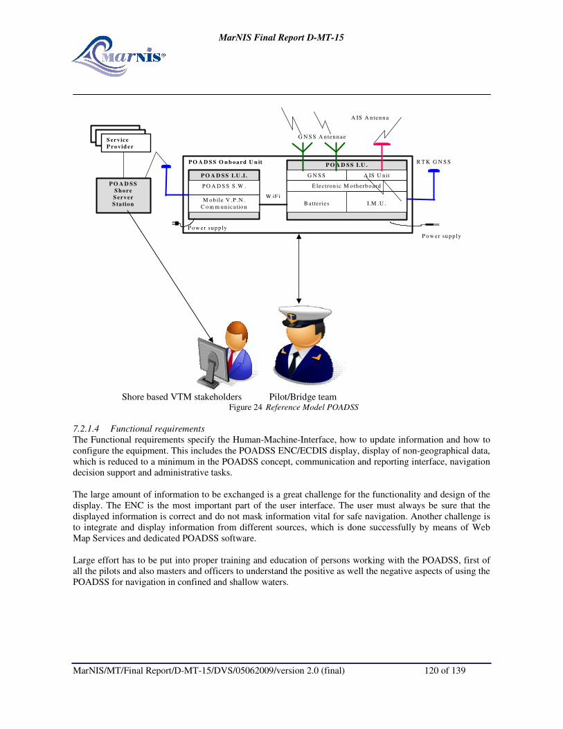
MarNIS Final Report D-MT-15
MarNIS/MT/Final Report/D-MT-15/DVS/05062009/version 2.0 (final) 120 of 139
P O A D S S O n b oard U n it
G N S S A IS U nit
I.M .U .
E lectron ic M otherboard
B atteries
A IS A n tenna
R T K G N S S
G N S S A n tennae
M ob ile V .P .N .
C om m un ication
P O A D S S S .W .
P O A D S S I.U .I .
P ow er supp ly
P ow er supp ly
P O A D S S
S h ore
S erver
S ta tion
P O A D S S I.U .
S erv ice
P rov id er
W iF i
S erv ice
P rovid er
Shore based VTM stakeholders Pilot/Bridge team
Figure 24 Reference Model POADSS
7.2.1.4 Functional requirements
The Functional requirements specify the Human-Machine-Interface, how to update information and how to
configure the equipment. This includes the POADSS ENC/ECDIS display, display of non-geographical data,
which is reduced to a minimum in the POADSS concept, communication and reporting interface, navigation
decision support and administrative tasks.
The large amount of information to be exchanged is a great challenge for the functionality and design of the
display. The ENC is the most important part of the user interface. The user must always be sure that the
displayed information is correct and do not mask information vital for safe navigation. Another challenge is
to integrate and display information from different sources, which is done successfully by means of Web
Map Services and dedicated POADSS software.
Large effort has to be put into proper training and education of persons working with the POADSS, first of
all the pilots and also masters and officers to understand the positive as well the negative aspects of using the
POADSS for navigation in confined and shallow waters.

MarNIS Final Report D-MT-15
MarNIS/MT/Final Report/D-MT-15/DVS/05062009/version 2.0 (final) 121 of 139
8 ASSESSMENT
8.1 Costs/benefits analysis
The CBA of MarNIS consists in the environmental, economic and financial assessment of MarNIS,
following a top-down approach. It focuses on a (macro) socio-economic Cost Benefit Analysis (CBA) of
MarNIS. Indeed, an important factor for the successful implementation of wide spread impact systems is to
convince users, policy makers and other stakeholders of the benefits and costs of the Integrated Maritime
Navigation Information Services System, which this Project is investigating. The environmental and
economic assessment provides inputs for a socio-economic cost benefit analysis (CBA). The results of such a
CBA can offer a strong argument as well as a clear justification for supporting the development and
implementation of MarNIS and can help in internal and external communication (within DG TREN, the
European Parliament, the Maritime sector and the European citizens).
In order to perform the CBA of MarNIS, it is of key importance to identify the specific components of the
MarNIS overall concept in order to evaluate step by step the costs and benefits of the MarNIS concept.
MarNIS consists of the three following components: the Maritime Information Management (MIM); the
traffic management in the Search and Rescue area of a Member State, better known by its main component
MOS: Maritime Operation Services; and the Port Traffic Management, or VTM in ports.
� In short MIM relies on the master or his agent to provide the required information once and on-time
and in an easier, uniform way to a NSW. This information is passed on to SSN++, the backbone of
the NSWs in Europe. Once the information has been submitted to one NSW, it is available to the
NSWs of the countries the vessel is to visit so that authorities will receive the information they
require in such a way it can be processed immediately. Data processing and analysis will thus be
performed more efficiently. At the same time, at the level of a port, a PSW acts as the intermediary
between the master or his agent and the authorities at shore when it comes to supplying information
relevant for entering the port.
� Within MarNIS, it is also proposed to establish MOS centres acting as the eyes and ears of the
authorities involved in the safety and security of maritime traffic in order to increase safety levels
and reduce threats to the marine environment. Within a legal framework, the MOS centres are
allowed to impose proactive measures on vessels creating relatively large risks. Alert Values and
High Risk Ships (HRS) are developed (on the basis of sophisticated safety model) in order to target
measures at these vessels imposing the largest risk (costs) on maritime traffic. The impacts are that
fewer ships and cargo will be lost and fewer people will lose their lives at sea. In addition, by
preventing accidents and reducing their consequences, fewer oil spills and chemical spills will occur.
By establishing a MOS as the eyes and ears of maritime authorities should also lead to smaller
consequences as the oil and chemical spilt is cleaned up quicker.
Finally, at the level of port traffic management, MarNIS introduces two concepts aimed at increasing
efficiency and safety of traffic. Firstly, MarNIS proposes to plan vessel voyages on the basis of berth
availability. This approach should enable a more efficient use of port facilities and enable vessels to optimise
sailing time by reducing the time spent waiting for port facilities to become available. Secondly, MarNIS has
developed the so-called POADSS: Port Operations and Approach Decision Support System. This system
improves existing systems as to enable pilots to very precisely monitor the Under Keel Clearance of a ship,
increasing safety levels. Eventually, this increases a port’s tidal window and thus increases the port’s
capacity. Altogether, MarNIS provides means to deal with the increasing demand for capacity while
simultaneously maintaining safety levels.

MarNIS Final Report D-MT-15
MarNIS/MT/Final Report/D-MT-15/DVS/05062009/version 2.0 (final) 122 of 139
On the basis of these three main components, the CBA of MarNIS can be performed. It is important to note
that a specific methodology was used in order to comply with the availability of data and statistics, the
conceptual nature of MarNIS and the uncertainty related to policy. Indeed, a two-scenario approach was
applied.
These scenarios provide the range of costs and benefits, which the project can be expected to bring. The
optimistic scenario includes the assumptions of what MarNIS will bring in the most favourable
circumstances, i.e. highest benefits and lowest costs. The conservative scenario indicates what the impacts of
MarNIS will be if the most conservative set of assumptions describes what happens. The conservative
scenario contains the assumptions yielding highest costs and lowest benefits. This two-scenario approach
captures the uncertainty of evaluating a conceptual project like MarNIS.
Based on this two-scenario approach, the CBA results indicate that MarNIS is a feasible investment from an
economic point of view. The IRR (Internal Rate of Return) of the CBA amounts to 5 % in the conservative
scenario and to 196 % in the optimistic scenario. The Benefit/Cost ratio is 1.0 and 7.6 respectively. There are
net benefits, even in the conservative scenario. The following graph shows the identified ranges for the costs
and benefits. This excludes benefits that could not be estimated. Figure 2: CBA outcomes
costs benefits balance
0.8
2.0
2.0
6.1
5.3
0
1
0
2
3
4
5
6
7
The CBA has been extended with both a conjecture analysis and a stakeholder analysis. The conjecture
analysis is included to assess two other impacts, which are not included in the CBA: the use of POADSS by
Ro/Ro vessels and risk reduction measures for HRVs. The results are expected to be positive. The results of
the stakeholder analysis are reproduced in the table below.
Table 1: Impact effect direction per stakeholder group for MIM, MOS, and PTM
Stakeholder group MIM MOS PTM
Shipping industry/businesses + + +
Port authorities +/- 0 +
National authorities +/- - 0
European citizens 0 + 0
MarNIS Final Report D-MT-15
MarNIS/MT/Final Report/D-MT-15/DVS/05062009/version 2.0 (final) 123 of 139
8.2 Acceptance Assessment
HA7b is dedicated to the acceptance assessment of MarNIS, following a bottom-up approach. Indeed,
another important issue for the successful implementation of the new Integrated Maritime Navigation
Information Services System is the acceptation of these systems/concepts by the targeted community of
users. That is why the main purpose of the HA7b activities is to investigate the acceptability by professionals
of all sectors of the maritime world, of all levels of practical experience, of all levels of responsibility,
namely:
1. “Authorities - Policy Level”;
2. “Authorities - Operation Level”;
3. “Research & Development - Education”;
4. “Maritime Industry”;
5. “Maritime Professionals”.
All these actors were gathered in Genoa and Lisbon for attending a general presentation and demonstration
of the concepts developed within MarNIS. They have been asked to give their opinion on how MarNIS fulfil
the following objectives:
� Improvement of safety and the protection of the environment;
� Improvement of security;
� Improvement of efficiency and reliability.
To provide a scientific evaluation of these feelings, a questionnaire-based method, supported by electronic
voting machines, has been used. The figures extracted from the electronic voting system and the “words”
expressed by the audience during the discussions following the voting sessions have been analysed to
perform the acceptance assessment of MarNIS.
As a final result, the average acceptance can be calculated, leading so to a “radar” graph based on a four-
levels scale where “0”, “1”, “2”, “3” correspond respectively to the qualitative answers “No”, “Perhaps”,
“Yes, Strongly”, and “Yes, definitely”. Then, the red pentagonal surface of the following graphs represents
how the attendees think the MarNIS concept makes it possible to meet the expected benefits listed here
above. Larger is the surface; stronger are believes and acceptance of the attendees.
Altogether, four days have been dedicated to voting sessions. Each day focused on specific components of
the MarNIS overall concept so that one global graph is provided per day.
Graph 1 shows the average acceptance of MarNIS at the end of Day 1 in Genoa based on the components
demonstrated, namely the Maritime Information Management, including the National Single Window,
SafeSeaNet++
, Pre-Entrance Profiles, Calculated Time of Arrival, Voyage Plan Server, and the European
Harbour Masters Committee Website. In addition, some topics have been detailed: NSW and PEP, MarNIS
Maritime Architecture, MOS, Voyage Plan Server and CTA Server.
The large red surface emphasizes a good acceptance of MarNIS by all the groups including practitioners and
R&D-Education institutes. It is positive for the MarNIS project and its future implementation.

MarNIS Final Report D-MT-15
MarNIS/MT/Final Report/D-MT-15/DVS/05062009/version 2.0 (final) 124 of 139
Graph 1: Average acceptance of MarNIS, Genoa, Day 1
0
0,5
1
1,5
2
2,5
3
Authorities - Policy Level
Authorities - Operation Level
R & D - EducationMaritime Industry
Maritime Professionals
Graph 2 highlights the average acceptance of MarNIS based on the demonstration of Day 2 in Genoa. This
demonstration focused on the MOS concept including the “Under one roof” principle for SAR, OPRC, MAS
and pro-active VTM. Moreover, specific sessions have been dedicated to the presentation of Common
Maritime Space and the MOS with the human factors and job profiles related aspects.
Once again, the attendees strongly believe that the implementation of MarNIS could help in reaching the
expected benefits. It has to be noticed that the “Authorities – Policy level” have more doubts than their
colleagues.
Graph 2: Average acceptance of MarNIS, Genoa, Day 2
0
0,5
1
1,5
2
2,5
3
Authorities - Policy Level
Authorities - Operation Level
R & D - EducationMaritime Industry
Maritime Professionals
Finally, the results of the Lisbon demonstrator gave less convincing results, as depicted on graphs 3 and 4. It
is due to the very specific and technical MarNIS components demonstrated in Lisbon.
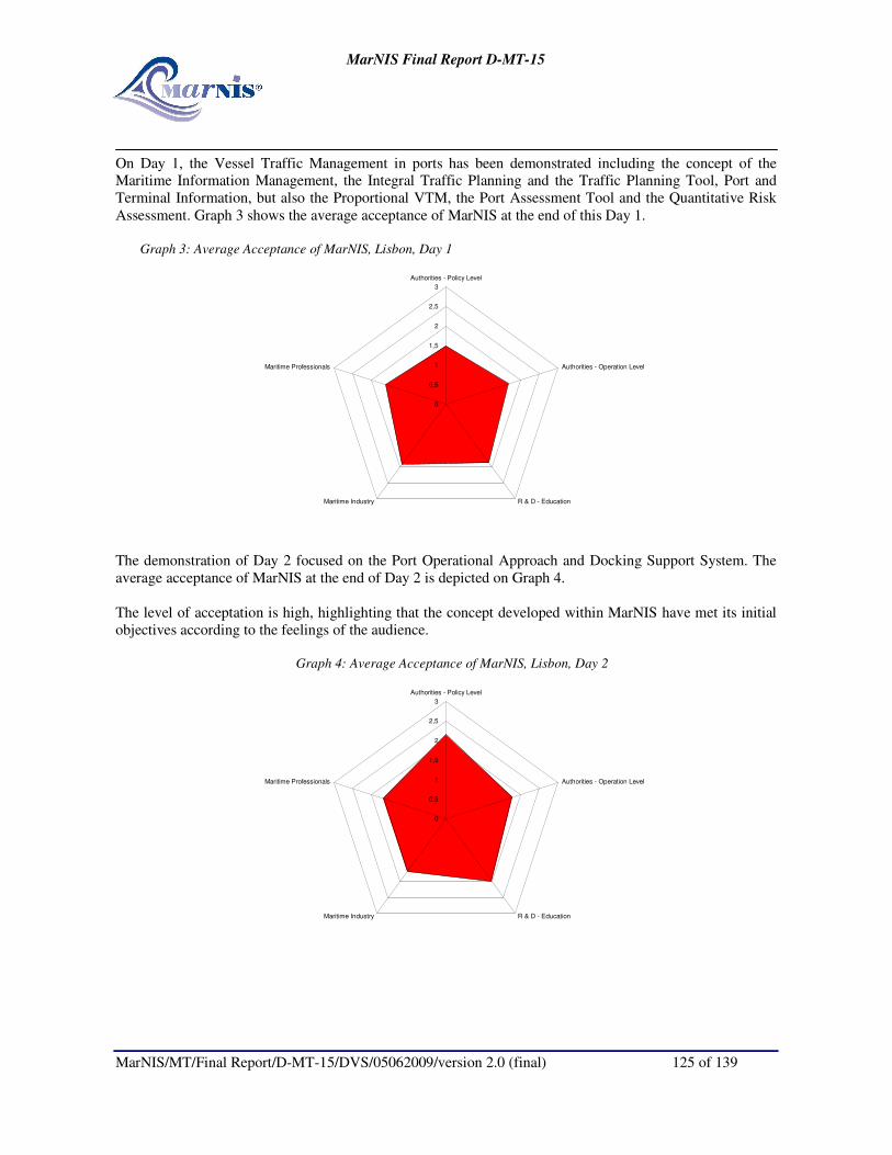
MarNIS Final Report D-MT-15
MarNIS/MT/Final Report/D-MT-15/DVS/05062009/version 2.0 (final) 125 of 139
On Day 1, the Vessel Traffic Management in ports has been demonstrated including the concept of the
Maritime Information Management, the Integral Traffic Planning and the Traffic Planning Tool, Port and
Terminal Information, but also the Proportional VTM, the Port Assessment Tool and the Quantitative Risk
Assessment. Graph 3 shows the average acceptance of MarNIS at the end of this Day 1.
Graph 3: Average Acceptance of MarNIS, Lisbon, Day 1
0
0,5
1
1,5
2
2,5
3
Authorities - Policy Level
Authorities - Operation Level
R & D - EducationMaritime Industry
Maritime Professionals
The demonstration of Day 2 focused on the Port Operational Approach and Docking Support System. The
average acceptance of MarNIS at the end of Day 2 is depicted on Graph 4.
The level of acceptation is high, highlighting that the concept developed within MarNIS have met its initial
objectives according to the feelings of the audience.
Graph 4: Average Acceptance of MarNIS, Lisbon, Day 2
0
0,5
1
1,5
2
2,5
3
Authorities - Policy Level
Authorities - Operation Level
R & D - EducationMaritime Industry
Maritime Professionals

MarNIS Final Report D-MT-15
MarNIS/MT/Final Report/D-MT-15/DVS/05062009/version 2.0 (final) 126 of 139
8.3 Conclusions
In conclusion it has to be noted that the Cost-Benefit Analysis as well as the acceptance assessment provide
positive and optimistic results regarding the concepts developed within MarNIS and the related expected
benefits.
These results are a springboard for the EU Commission in view of continuing the future of MarNIS and
highlighting the pertinent questions about its implementation in the coming years.
Two major messages have to be emphasized:
� First, even when considering the lowest benefits and highest costs namely the conservative scenario,
the CB ratio of MarNIS leads to net benefits;
� Secondly, the MarNIS concept and all its specific components, as demonstrated in Genoa and
Lisbon, are well accepted by the targeted community of users as well as the decision makers and the
R&D institutes.

MarNIS Final Report D-MT-15
MarNIS/MT/Final Report/D-MT-15/DVS/05062009/version 2.0 (final) 127 of 139
9 ANALYSIS OF PORT STATE CONTROL DATA
9.1 Introduction
Ship inspections performed by Port State Control (PSC) organizations and the decision by the European
Commission to establish a community vessel traffic monitoring and information system "to monitor
hazardous" ships are major measures for improving safety at sea and the protection of the environment.
Foundations of theses measure are for the latter, the processing in real time of an individual ship Alert Value
(AV) which reflects the risk value to which a given ship sailing in a given area at a given time is subject to,
and for the former, suitable criteria aiming at targeting the most risky vessels to be inspected.
Some developments have been performed in the past on each of these subjects, in particular respectively in a
previous European project (EMBARC) where a deterministic multiplicative AV model has been designed
and by PSC organizations (Paris MoU) on criteria aiming at characterizing High Risk Ships (HRS) to be
inspected.
The work in MarNIS had the two following objectives:
• To justify by statistical methods the multiplicative shape of the deterministic EMBARC AV model
and the values of some factors integrated in this model. More generally, this work consists in
contributing to the design of an AV model attached to any ship crossing a given area at a given time.
• To consider casualty-based criteria for the characterization of HRS to be inspected, in addition to the
detention-based criteria defined by PSC organizations.
The methods used for both objectives are on one hand the analysis, on a world-wide basis, of marine
casualties which occurred in the past and of yearly merchant fleet, and on the other hand the application of
statistical methods in order to analyse and assess the probability of a casualty (or the casualty rate).
Logistic regression, covariance analysis, multivariate approach have been applied by considering the three
physical ship variables type, size, age, and a fourth one being the casualty type. For all these variables,
statistics were available on a world-wide basis and although some simplifications were made and a rather
short period of analysis (6 years) used, the results obtained seem to be in line with logic and intuition.
As far as the first objective is concerned, logistic regression method and covariance analysis have been
applied in order to pinpoint the most important ship factors contributing to influence the most the probability
of a casualty. Considering three physical ship variables i.e. ship type, size and age, it has been shown that
ship type and size are the two most important variables influencing casualty rate, ship age coming in third
position. The shape of the deterministic EMBARC AV model is therefore statistically confirmed and the
values of the multiplicative factors to take account of ship age are close in practise in both models
(EMBARC model and statistical model).
For the second objective, the Paris Memorandum of Understanding (Paris MoU) establishes each year in its
annual report the traditional “Black-Grey-White” (BGW) lists of flags. These tables are based on processed
performances of flags over a 3-year past period, showing the full spectrum between quality flags and flags
with a poor performance. The performance of each flag is calculated by the Paris MoU on the basis of the
only numbers of inspected and detained ships flying the considered flag, using binomial calculus.
Furthermore, black listed flags are one of the criteria, among others, used by the Paris MoU for targeting
vessels for their inspections. Using the same binomial calculation method as mentioned above, but
considering casualties instead of detentions and a multivariate approach instead of considering the flag only,
it is possible to extend the Paris MoU detention-based BGW lists of flags to BGW lists of categories of
vessels with regards to their observed casualties on a given period. The approach described in this work,

MarNIS Final Report D-MT-15
MarNIS/MT/Final Report/D-MT-15/DVS/05062009/version 2.0 (final) 128 of 139
which is risk-oriented, is not in opposition to the one chosen by the Paris MoU but must be considered as
complementary and some Black categories of vessels found in this study may be added without any
difficulty, in some way to be discussed, to the set of criteria established by the Paris MoU for characterizing
HRS to be inspected.
At the time when a correspondence group has been set up by the Sub-Committee on Flag State
Implementation of IMO for defining “objectives, framework of mechanisms and methodology for a study on
the combination of casualty and Port State Control related data”, this work has been recognized by IMO in
its June 2008 session, as giving a valuable contribution for such a study.
9.2 Conclusions
Logistic regression method and covariance analysis showed that type and size are the two most important
variables influencing CASRAT, ship age coming in third position. The shape of the deterministic
multiplicative EMBARC AV model is consequently statistically confirmed and the values of the
multiplicative factors to take account of ship age are close in practise in both models (EMBARC model &
statistical model).
Although some simplifications and assumptions are made, when all casualty types are gathered, it emerges
(based only on the three above ship variables) that passenger vessels of large size, old tankers, cargo vessels
(most often of advanced age) of medium size and old bulk carriers of medium to large size belong to the
Black casualty-based list, which means that these categories of vessels have a high probability of a casualty.
Some of these Black categories of vessels may be added without any difficulty, in some way to be discussed,
to the set of Paris MoU criteria established in the NIR for characterizing HRS to be inspected.
9.3 Perspectives
One, amongst others, of the interest of the analysis was to demonstrate the possibility of application of
suitable statistical methods and concepts directed at our objectives.
Logistic regression, covariance analysis, risk concept, multivariate approach, seem to be promising methods,
if we refer to the results obtained by considering the three ship variables type, size, age, and a fourth one
being the casualty type: for all these variables, statistics were available on a world-wide basis and although
some simplifications made and a rather short period of analysis (6 years) the results obtained seem to be in
line with logic and intuition.
Perspectives are to generalize the above methods and analysis by adding other crucial ship variables such as
flag, company, classification society or recognized organisation, i.e. all entities which, somehow or other,
manage the ship and take account in particular of compliance to international regulation, maintenance of
equipments and the human element. However, one needs to have at one’s disposal these data recorded over a
large period (at least 10 years of recorded casualties and world fleet characteristics including the mentioned
variables).
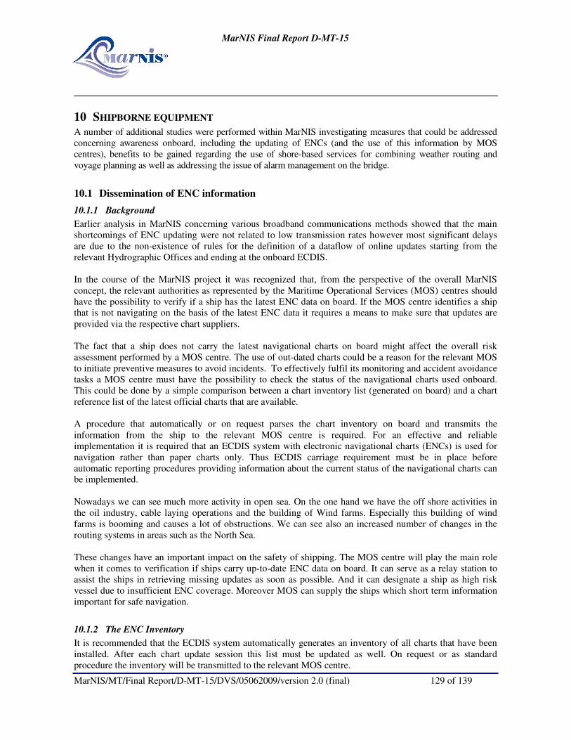
MarNIS Final Report D-MT-15
MarNIS/MT/Final Report/D-MT-15/DVS/05062009/version 2.0 (final) 129 of 139
10 SHIPBORNE EQUIPMENT
A number of additional studies were performed within MarNIS investigating measures that could be addressed
concerning awareness onboard, including the updating of ENCs (and the use of this information by MOS
centres), benefits to be gained regarding the use of shore-based services for combining weather routing and
voyage planning as well as addressing the issue of alarm management on the bridge.
10.1 Dissemination of ENC information
10.1.1 Background
Earlier analysis in MarNIS concerning various broadband communications methods showed that the main
shortcomings of ENC updating were not related to low transmission rates however most significant delays
are due to the non-existence of rules for the definition of a dataflow of online updates starting from the
relevant Hydrographic Offices and ending at the onboard ECDIS.
In the course of the MarNIS project it was recognized that, from the perspective of the overall MarNIS
concept, the relevant authorities as represented by the Maritime Operational Services (MOS) centres should
have the possibility to verify if a ship has the latest ENC data on board. If the MOS centre identifies a ship
that is not navigating on the basis of the latest ENC data it requires a means to make sure that updates are
provided via the respective chart suppliers.
The fact that a ship does not carry the latest navigational charts on board might affect the overall risk
assessment performed by a MOS centre. The use of out-dated charts could be a reason for the relevant MOS
to initiate preventive measures to avoid incidents. To effectively fulfil its monitoring and accident avoidance
tasks a MOS centre must have the possibility to check the status of the navigational charts used onboard.
This could be done by a simple comparison between a chart inventory list (generated on board) and a chart
reference list of the latest official charts that are available.
A procedure that automatically or on request parses the chart inventory on board and transmits the
information from the ship to the relevant MOS centre is required. For an effective and reliable
implementation it is required that an ECDIS system with electronic navigational charts (ENCs) is used for
navigation rather than paper charts only. Thus ECDIS carriage requirement must be in place before
automatic reporting procedures providing information about the current status of the navigational charts can
be implemented.
Nowadays we can see much more activity in open sea. On the one hand we have the off shore activities in
the oil industry, cable laying operations and the building of Wind farms. Especially this building of wind
farms is booming and causes a lot of obstructions. We can see also an increased number of changes in the
routing systems in areas such as the North Sea.
These changes have an important impact on the safety of shipping. The MOS centre will play the main role
when it comes to verification if ships carry up-to-date ENC data on board. It can serve as a relay station to
assist the ships in retrieving missing updates as soon as possible. And it can designate a ship as high risk
vessel due to insufficient ENC coverage. Moreover MOS can supply the ships which short term information
important for safe navigation.
10.1.2 The ENC Inventory
It is recommended that the ECDIS system automatically generates an inventory of all charts that have been
installed. After each chart update session this list must be updated as well. On request or as standard
procedure the inventory will be transmitted to the relevant MOS centre.

MarNIS Final Report D-MT-15
MarNIS/MT/Final Report/D-MT-15/DVS/05062009/version 2.0 (final) 130 of 139
The MOS checks the list of latest ENCs that have been published by the Hydrographic Offices with the
onboard status of ENCs and its updates. Then the result of this check can be passed to other authorities such
as Port State Control. Ships with charts that are not up-to-date might be requested to use other routes further
from the coast or further from dangerous objects.
Basically the ENC inventory created by the ECDIS system is a simple list of the installed ENCs. The ENC
Product Specification (S-57 Appendix B.1 ENC Product Specification) stipulates that ENC data must be
must be split into cells. Each cell of data must be contained in a physically separate, uniquely identified file.
Thus the ENC inventory that the ECDIS system should create could be a simple file list.
From a particular filename the Producer and the sequential update number of a particular cell can be derived.
In addition, the inventory should indicate the Edition number that is associated with each individual cell.
For example the entry “NL600021.000 Edition 1” would be sufficient to uniquely identify the first Edition of
this particular ENC cell produced by the Dutch Hydrographic office. The update number can be derived from
the file extension. After installation of the first update the new inventory entry of the dataset would be
“NL600021.001 Edition 1”.
10.1.3 Central database integrated with SafeSeaNet
The MarNIS concept envisages an expansion and strengthening of the role of SafeSeaNet (SSN) into what is
called SSN++. SSN++ will provide coastal authorities with information about those vessels crossing their
areas of jurisdiction. It will also merge the information and generate reports to all relevant authorities.
SSN++ serves as the central database of ship information. It seems a logical choice to use it also in other
safety related processes e.g. chart inspections. The chart reference list a MOS needs for verification could be
maintained and updated in the SSN++ central database.
The Regional ENC centres (RENCs) are associations of the national Hydrographic Offices (ENC producers).
They have been established to harmonise the production and distribution of official ENCs. There are two
European RENCs: “International Centre for ENCs” and “Primar”.
Via these RENCs the SSN++ system should be provided with all the information necessary to keep the ENC
reference list up-to-date. Then there is one integrated database available for others such as Port State Control
and MOS.
In addition to an ENC reference list the RENCs could provide SSN++ with the real ENC data. This would
allow the MOS centres to retrieve the chart data and display it. This could be useful to decide if a ship that
has not updated all its ENCs poses a risk to safety of navigation or not.
10.1.4 Potential ways to establish contact between ships and the MOS
There are several techniques to establish contact between ships and the MOS, nowadays we have GPRS,
Satellite, Wlan, WMAX and others to communicate. But we have to be realistic, most of these techniques are
relatively complex and expensive to establish. Almost all of them are exploited by commercial parties and it
is not the idea to set up authority base communication networks. Connection with private Wlan/ Wimax
networks requires also the right equipment and knowledge onboard of the ships. This means a long road in
changing standards and legislation.
More realistically a MOS could use the normal, already onboard, equipment for navigation. Let us think
about AIS, and Inmarsat C. The problem with AIS is that the information cannot be treated confidentially.
Basically everybody running an AIS transponder could read it. Moreover transmission capacity of AIS is

MarNIS Final Report D-MT-15
MarNIS/MT/Final Report/D-MT-15/DVS/05062009/version 2.0 (final) 131 of 139
very limited. For the time being Inmarsat C seems to be the most practical solution. The ships could send the
inventory list via E-mail (SMTP) or via the Internet (HTTP) to the relevant MOS centre.
10.1.5 Potential of NAVTEX
NAVTEX is an established service to send navigation information in textual format to the ships in a certain
region. It is also used to supply the ships with meteorological warnings and forecasts, as well as urgent
marine safety information.
Due to the fact that the information is available on short notice only and that it is valid for a relatively short
time it cannot be integrated into regular ENC data. However, it should be investigated if there are means to
show it in an ECDIS chart display. This would allow presenting the data in geo-spatial context rather than
just mentally integrating it.
The Hydrographic Offices are the producers of ENCs and their updates. As mentioned before these ENCs
and updates are sent to the RENC and VAR for distribution. The process has a time length of minimum one
week. So we have to be aware that very urgent information cannot be handled by this way and requires a new
and other service e.g. via a MOS.
10.2 Calculated Time of Arrival (CTA) Server
Traditionally marine weather forecast decision support systems for ship route planning are based on an
interaction between weather forecasting and ships dynamic behaviour in the specific forecasted conditions.
Many persons, including maritime officers, still consider today’s weather forecasts only reliable for a maximum
of 3 days, although today’s wind and wave forecasts have a high degree of accuracy of approximately 7-8 days.
MarNIS sought ways to better combine a weather forecasting system and a numerical ships calculations system
through the development of the so-called Calculated Time of Arrival (CTA) server. Whilst orientated as a
commercial service directed from a shore-based CTA-server directly to the vessel, the resulting “advice”
provides the master with an optimal route as well as the potential to inform shore-based authorities of any
potential deviation in ETA.
There’s a huge potential to use the extended forecasts in combination with the actual conditions for a specific
ship and a specific voyage. The basic idea of the CTA server is to give all ships access to a reliable tool for
visualising the weather forecast and accurate Expected Time of Arrival (ETA) calculations. The CTA server is a
proactive system that can alert the Master on events with respect to weather and give accurate calculations based
on an intelligent mixture of the best possible METOC information from shore and the Masters best experience
how to handle his ship in bad weather.
It can be said that this information and the master’s final voyage plan combine into early, reliable and transparent
ETA information. The CTA-server provides all stakeholders with access to the server with accurate ETA
information and a forum where they can communicate and interact, leading to more efficient resource
planning within the Shipping Community, increased safety and efficiency in sea transportation within Europe
and considerable potentials for lowering the Voyage Fuel Consumption.
10.3 Bridge Alert Management
Safe navigation, including collision and grounding avoidance, is the main task of the navigating officer in
charge to ensure the safety of sea transport during a ship's voyage. Modern ship bridges are highly-automated
human-machine systems. Safety and efficiency of the ship operations are dependent on the communication
between humans and machines during the accomplishment of the tasks. Humans can fulfil their assigned
monitoring, control and decision tasks most effectively when the information flow between themselves and

MarNIS Final Report D-MT-15
MarNIS/MT/Final Report/D-MT-15/DVS/05062009/version 2.0 (final) 132 of 139
machines is adapted to the human skills and abilities. In order to support the mariner effectively onboard;
there is a compelling need for a task- and situation-dependent representation of the information.
With the enlarged number of systems and sensors onboard, and the increase of automation a proliferation of
alarm signals on the bridge is associated. Alarm signals coming from various systems and sensors lead
sometimes to a confusing and difficult situation for the mariner to manage, which is distracting him from his
task to safely navigate the vessel. Redundant and superfluous audible and visual alarm announcements are
appearing on the bridge, without a central position for visualization and acknowledgement of alarms. To
enable the operator to devote his full attention to the safe navigation of the ship and to immediately identify
any abnormal situation, requiring action to maintain the safe navigation of the ship, an alarm management
harmonizing the handling, distribution and presentation of alarms on the bridge is necessary.
Field studies were performed on board of ships to investigate the situation with respect to the occurrence of
alarms and their handling by the bridge team. An outlook for a concept of future bridge alert management is
given, which includes prioritization, categorization and aggregation of alerts as well as a central alert
management human machine interface.

MarNIS Final Report D-MT-15
MarNIS/MT/Final Report/D-MT-15/DVS/05062009/version 2.0 (final) 133 of 139
11 POLICY RECOMMENDATIONS
The various research reports provided for a number of Policy Recommendations as well as recommendations on
a lower level geared towards technical and legal aspects. These recommendations are collated and reproduced
here below although the reader is invited to study the appropriate individual research reports in the case that
more background detail and justification be required.
11.1 Policy Recommendations
Following is a summary of the key recommendations as provided for in the Policy Recommendations and
Strategy report:
• The role of SafeSeaNet should be expanded and strengthened to include the generation of notifications
to coastal authorities on ships likely to pass through their areas of jurisdiction as well as facilitate the
consolidation of reports to all authorities.
• Recognising that the establishment of a “Single Window” can harmonize and simplify the exchange of
information between authorities and the maritime community, member States should introduce a Single
Window facility at the national level for the electronic collection, processing, storage and dissemination
of data.
• The reporting architecture should be widened to reflect the requirements of shore-based authorities for
more pro-active monitoring of vessels whilst ensuring the optimisation of the reporting requirements
placed upon vessels.
• Member States should be encouraged to provide pro-active services to ships in areas falling within their
Search and Rescue Regions for the purpose of preventing environmental pollution. To this end it is
recommended to implement the notions of high alert ships, high risk ships, co-ordination centres and the
co-operation between competent authorities within the EU into EU-legislation.
• To ensure that seaports achieve adequate planning and effective management of navigational risk,
member States should ensure that seaports within their jurisdiction conduct a strategic risk assessment at
regular intervals according a pre-defined method. This risk assessment should be used when
determining and implementing proportional vessel traffic management measures.
• A common policy should be developed with the purpose to establish/strengthen competent authorities in
the (coastal) member States for the effective exercise of national and international law with respect to
maritime traffic for the surveillance and eventual enforcement in all waters according the jurisdiction
afforded them.
• Member States should adopt laws, regulations and administrative provisions necessary to give the
competent authorities sufficient competences, obligations and responsibilities for the effective exercise
of national and international law with respect to maritime traffic.
• The competences, obligations and responsibilities of competent authorities should concern at least the
following subjects:
o The right to be informed and the obligation to provide information, also to other national and
international authorities;
o The relationship between a competent authority and a Central Information System;
o The competences and obligations to take measures;
o The cooperation with other national and international authorities.

MarNIS Final Report D-MT-15
MarNIS/MT/Final Report/D-MT-15/DVS/05062009/version 2.0 (final) 134 of 139
11.2 Technical Aspects
The following observations and recommendations are provided purely as further information in support of the
measures and recommendations. More detail may be found in the appropriate MarNIS research reports.
T1. Much work has been conducted in MarNIS with respect the use of technologies. These technologies
support and enable much of the MarNIS concept to become reality and are vital if the overall ambitions
of MarNIS are to be achieved. In support to the considerations and recommendations already provided
for in this document, the following considerations should be noted:
T2. It is recommended to give political support to the inclusion of safety related information in LRIT. It is
recommended that EMSA will co-ordinate LRIT and when available LRR information in Europe. It is
also recommended that EMSA should have the responsibility for managing and distributing the
information from regional centres such as North Sea, Scandinavian and Baltic Sea areas, Western
European Seaboard / Western Approaches, and Mediterranean.
T3. It is recommended that the radio-navigation derived position used for LRIT or LRR is an authenticated
position. There are two ways investigated for validation. The first is by using an authentication signal of
GALILEO. In this context we should consider EGNOS as part of GALILEO, and investigate whether
authentication can be provided by EGNOS until the GALIEO constellation is fully available and
accepted as part of the IMO WWRNS (World Wide Radio-Navigation Service).
T4. It is recommended that support is given to the evolution of the GALILEO SMS Concept to ensure
availability of service and therefore enable two-way short message communications from ship using
Omni directional antenna, suitable for all vessels, and having a truly global capability. The service will
also be able to provide bulletin broadcast of ANSI, NAVTEX, Weather and other safety messages. The
concept would also enable safety bulletin messages to be received by “GALILEO Navigation
Receivers” along with the navigation information.
T5. It is recommended that support is given to the evolution of Digital broadband gateways for key coastal
areas, bottlenecks and landfalls to provide terrestrial means of locating non-SOLAS and leisure vessels
as well as updating navigation publications including ECS/ECDIS. Such systems will also provide pay
as you go internet services for leisure and commercial applications, whilst also providing an inter vessel
communication possibility that would enable peer to peer exchange of information both ashore and on
board resulting in 100% transparency and equality of “key” information required for safety of
navigation.
T6. It is recommended that support is given to evolving GMDSS to enable it to facilitate 100% equality of
Long Range and Short-range information to all maritime user peer groups. This would include the Long
range and terrestrial broadband solutions.
T7. It is recommended that support is given to the discussion at IMO of how best to monitor the status of
vessels at sea to give warning of degradation of seaworthiness or on board critical systems that could
lead to an increase of risk to a particular vessel, or a vessel impact on surrounding traffic or the
environment. This is an area that can naturally extend from the ship-reporting directives.
T8. It is recommended that continued support is given to the EMSA Action Plan for Oil Pollution
Preparedness and Response as well as the existing regional agreements. It is also recommended that the

MarNIS Final Report D-MT-15
MarNIS/MT/Final Report/D-MT-15/DVS/05062009/version 2.0 (final) 135 of 139
exchange of integrated SAR and AIS data should be based on XML/GML and that the internet
connection should be based on the Web Map Service (WMS).
T9. An important issue for the diffusion of new services is initialising actions towards users, standardisation
bodies, lawmakers and politicians, for:
T10. Consolidation among all E-Maritime actors; a shared knowledge, background and practice, through
information circulation and continuing education.
T11. Creation of a Forum at standardisation level for the definition of worldwide-accepted standards, in order
to facilitate the adoption of new E-Maritime services based advanced satellite and Wireless Local Loop
(WLL) technologies.
T12. Aid to the definition of rules and laws that can improve the security and safety of maritime trade, while
ensuring the environmental protection at sea, that can get the maximum advantages from the advanced
technologies in terms of availability, reliability and security, especially whenever user liability is
concerned.
T13. Promotion of initiatives aimed at facilitating the adoption of the advanced satellite and WLL
technologies in those sectors where greater is the impact in terms of financial effort (e.g. small-medium
enterprises), at least at the start-up of the new services.
T14. A study on the integration of Radar, AIS and ECDIS and the possibility for fusion of these information
sources was performed and the following recommendations were derived from investigations as well as
observations made during voyages on board:
T15. The update of AIS information should be integrated in the operational procedures on board, e.g., the
update of the voyage related data should be carried out when preparing the bridge for sea. Presentation
of AIS information on a graphical display is a must to utilize the full potential of AIS and enhance the
radar information for collision avoidance. To include as default only activated AIS targets in the alarm
functionality and as optional include sleeping AIS targets. To adopt the proposed symbols for the
presentation of AIS information. To make mandatory the IMO Model course for AIS as soon as
possible.
T16. Better possibilities to enter and update the voyage related data are urgently required. If AIS is
interconnected with ECDIS then the voyage-related data ETA should be automatically updated in
suitable intervals or when changes occur.
T17. The period between the time, when a change in navigational information occurs and the time when the
update of an ENC reaches a vessel, may be long and may contribute to a decrease in safety of
navigation. Examination of the roles of public and commercial organisations involved in the update data
flow from the source to the vessels indicates that the most delays are caused on the level of charting
authorities. The delay between the physical change in real world and sending of the next update should
be available on the first following stated update date. It is recommended that the responsible authorities
of all the EU States with the sea and/or inland navigational responsibilities be required to produce the
ENC updates at the same dates and with the same frequency (14 days).

MarNIS Final Report D-MT-15
MarNIS/MT/Final Report/D-MT-15/DVS/05062009/version 2.0 (final) 136 of 139
11.3 Legal Measures
The following observations and recommendations are provided purely as further information in support of the
measures and recommendations. More detail may be found in the appropriate MarNIS research reports.
According to the MarNIS Concept w.r.t. Legal Measures:
L1. It is recommended to aim at a unified regime for the powers of authorities within the EU, in particular
considering that a ship often sails from the jurisdictional area of one member State to another.
L2. It is recommended to introduce a functionary in all member States of the EU in a certain standardized
manner. This functionary is responsible towards the authority on behalf of which he exerts the powers
and gives effect to any exertion of power by an authority against maritime traffic and transport. This is
to some extent comparable to the Secretary of State Representative (SOSREP) in the United Kingdom
or the ‘Préfet maritime’ in France.
With respect to the powers and obligations of competent authorities and co-operation within the EU:
L3. It is recommended that the basic obligations and powers of competent authorities be ensured and be
similar in the coastal Member States. This concerns in particular the information which competent
authorities require a National Single Window to demand, collect, compose and provide. This concerns
also the minimum information which has to be provided by the master, operator, agent, pilot or any
other person or organisation involved with an individual ship and the format in which it has to be
delivered.
L4. Every competent authority should be obliged to communicate the information of which it disposes to
other competent authorities which need that information for the exercise of their tasks and obligations,
whether on request or on their own initiative. If, at least, that has not been carried out by the National
Single Window.
L5. A competent authority should be obliged to co-operate and co-ordinate its activities with competent
authorities of other Member States and with the concerned authorities of the Community, on request or
where appropriate on its own initiative. Upon request they should receive the information they may
need for the execution of their powers from any other competent authority within the Community. If a
competent authority can assume that the exertion of any of its powers, or the circumstances with
respect to shipping traffic or an individual ship, may affect the public interests of other Member States,
it should be obliged to inform forthwith those other member States, and, where appropriate, the
Commission or any other organisation recognised by international law.
With respect to the legal elements of the powers of competent authorities:
L6. Without prejudice to international law, a competent authority should have appropriate powers with
respect to maritime traffic and transport in order to protect the public interests of the Member States
and in particular to protect and to preserve the marine and coastal environment.
L7. These powers should be at least:
• to instruct an information centre to demand, collect, compose and provide information;
• to communicate to other competent authorities the information these authorities are authorized to
receive, and
• to give instructions to the master of a ship.
MarNIS Final Report D-MT-15
MarNIS/MT/Final Report/D-MT-15/DVS/05062009/version 2.0 (final) 137 of 139
L8. The powers referred to under the previous bullet, should apply:
• to any ship within the waters under sovereignty or jurisdiction of the Member State and in any
other place where international law permits; and
• Wherever, to ships flying the flag of a Member State.
With respect to the legal elements of consultative bodies and regional agreements:
L9. For the purpose of this consideration the EU could be sub-divided into six regions: the Baltic Sea, the
Northern part of the North Atlantic, the North Sea, the Southern part of the North Atlantic, the
Mediterranean and the Black Sea (the geographical coordinates can be added in the main body or be
made explicit in an Annex). Member States belonging to one region should install an independent
consultative body or authority that will only operate in case of an incident or accident;
L10. A member State should inform the consultative body or authority on his request about any information
he might need to fulfil his function;
L11. Regional consultative bodies or authorities should, where appropriate, co-operate and support each
other.
With respect to the legal elements in case of incidents and accidents:
L12. In case a competent authority considers taking measures as referred to in Article 19 of Directive
2002/59/EC or according to any international law as referred to in Annex III, it should inform
forthwith the relevant regional consultative body or authority and communicate all appropriate
information. It should respond to any request of the consultative body or authority for additional
information;
L13. The member State under whose jurisdiction that ship is located, should forthwith notify any other
States whose coasts are liable to be affected by an incident, the regional consultative body or authority
and those other States;
L14. If the consultative body or authority on the basis of whatever information has reasonable grounds to
believe that the interests of one or more other member States in the region are involved, he can
designate a ship within his region as a ship against which measures can be taken.
L15. The consultative body or authority can give an advice to the member State within whose jurisdiction a
ship is located on how to prevent, eliminate or minimize any damage to the marine environment or any
coastal environment;
L16. After an incident the member State under whose jurisdiction the incident was dealt with, should report
about the facts, the decision making process and the measures that have been taken, to the European
Maritime Safety Agency (EMSA). The Agency should study the report, evaluate the incident and may
formulate recommendations on how to act in possible future cases;
L17. On request of one or more member States, the Commission, taking into account the opinion of the
Committee on Safe Seas and the Prevention of Pollution from Ships (COSS), should exempt member
States, when in the opinion of the Commission an equivalent international agreement does exist.
With respect to regional agreements:

MarNIS Final Report D-MT-15
MarNIS/MT/Final Report/D-MT-15/DVS/05062009/version 2.0 (final) 138 of 139
L18. Member States that lie in each other’s proximity should endeavour to conclude bilateral or, where
appropriate, multilateral agreements about the procedure that has to be followed, in case that a ship is,
can or will become an actual threat to the protection and preservation of the marine or coastal
environment and that ship may affect the public interests of the other member State involved. States
not being a member of the Union may participate in an Agreement;
L19. The Commission should be informed of such agreements, when the EU is not already Party to them.

MarNIS Final Report D-MT-15
MarNIS/MT/Final Report/D-MT-15/DVS/05062009/version 2.0 (final) 139 of 139
12 IMPLEMENTATION PLAN
Starting point of the development of the implementation plan is the MarNIS concept – consisting of
Maritime Information Management (MIM) and Maritime Operational Services (MOS) - as described here
above.
The principal objective for the development of an implementation plan on the MarNIS e-maritime concept is
the preparation of a proposal for the harmonised and coordinated pan-European implementation of the
MarNIS concept to increase safety, security, efficiency and reliability of the Maritime transport in Europe
which is in line with the e-Maritime and e-Navigation developments in the maritime environment.
The following phases are foreseen in the development of an implementation plan:
• Initialisation phase: definition of the global European landscape on organisational and operational
level, technical level, legislative level in the field of Maritime Operations and Information Services
within the context of the MarNIS concept;
• Awareness phase: Creating awareness and commitment on the MarNIS concept;
• Assessment phase: Assessment of the implications of the implementation of the MarNIS principles;
• Development of the integral pan-European implementation plan.
Full details of the proposal for the development of an Implementation Plan that has been realised in the
MarNIS project are provided for in Deliverable D-MT-18.