curriculum - duap.du.ac.bd · the curriculum covers introduction to the department and introducing...
TRANSCRIPT

CURRICULUM
Four-Year Integrated
Bachelor of Science (Honours) Degree in Geology
DEPARTMENT OF GEOLOGY
FACULTY OF EARTH AND ENVIRONMENTAL SCIENCES
UNIVERSITY OF DHAKA DHAKA-1000
BANGLADESH

1 | P a g e
PROLOGUE
This is my great pleasure to write this prologue for the first version of Bachelor of Science (BS)
Honours in Geology curriculum of the Department of Geology under the Faculty of Earth and
Environmental Sciences of University of Dhaka. Since its establishment in 1949, this department has
been the prime centre of excellence for teaching and research in various fields of Geology. Starting
with two year B.Sc. pass degree programme in 1949-50, the department subsequently introduced 1-
Year M.Sc. in Geology programme in 1957-58, 3-Year B.Sc. Honours in Geology programme in
1967-68, 4-Year BS Honours in Geology programme in 1996-97, and 1 year MS in Geology
programme in 1999-00. Currently the Department offers 4-Year BS Honours in Geology, 1-Year MS
in Geology (with specialization in different fields) along with MPhil and PhD courses. Graduates
from the department have been working with good reputation in geological and related professional
positions at different government and private organizations. A large number of graduates from the
department have also been working in the Geosciences Profession in different countries of the world.
Considering the need for giving state of the art education, comparable with other countries of the
world, the department introduced the 4-Year BS Honours course from the academic session 1995-96.
The BS programme of the department used to be run as per course syllabus prepared by Syllabus
Committee constituted by the Academic Committee. The committee prepares the syllabus as per
guidelines of respective Faculty and University of Dhaka which is subsequently approved by the
departmental Academic Committee, respective Faculty and Academic Council of University of
Dhaka. Syllabuses are normally prepared for three year with provisions for updating and modification
to keep pace with the development taking place in various areas of Geology as well as to align with
the national development needs. The department for the first time took a plan to prepare Course
Curriculum for 4-Year BS Honours programme, starting from the academic session 2016-17, instead
of Course Syllabus under the Institutional Quality Assurance Cell (IQAC) of Dhaka University
established under the Higher Education Quality Enhancement Project (HEQEP) funded by the
World Bank.
The Academic Committee gave the responsibility of leading and coordinating the efforts for preparing
course curriculum to the previously formed 3-member Self-Assessment Committee (SAC) to conduct
IQAC assigned activities. The committee started working on converting the course syllabus for the
period 2016-17, 2017-18 and 2018-19 into course curriculum for the same period. To accomplish the
goal, a number of workshops have been organized by the SAC and department with contributions
from resource persons from the Institute of Education and Research, University of Dhaka. All faculty
members, including part-time teachers for allied courses, of the department actively participated and
contributed in developing curriculum for the 66 theory, practical and field courses for the 4-Year BS
Honours programme in Geology. I am very glad that the curriculum is complete now and we are
going to provide it to the students and teachers of the department. I am sure this would contribute
significantly in improving the quality of education at the BS Honours level at the Department of
Geology.
Finally I would like to thank the Institutional Quality Assurance Cell of University of Dhaka, the Self-
Assessment Committee of Geology Department and all members of the Academic Committee of
Geology Department for making this effort successful. I strongly believe that this would mark a new
epoch towards providing quality geological education in meeting the challenges of 21st century.
Professor Dr. Kazi Matin Uddin Ahmed
Chairman

2 | P a g e
PREFACE
This curriculum of four-year integrated BS Honours in Geology has been prepared based on the
syllabus or, in other words, the initial course contents approved by the Academic Council of the
University of Dhaka. This is the outcome of several workshops where valuable contribution and
feedback were made by the curriculum experts from the Institute of Education and Research (IER) of
Dhaka University, institutional quality assurance experts from Institutional Quality Assurance Cell
(IQAC) of Dhaka University, Dean of the Faculty of Earth and Environmental Sciences and the
faculties of the Department of Geology of Dhaka University.
As a prelude to preparing the curriculum, the Self-Assessment Committee (SAC) of the Department
of the Geology, a Self-Assessment (SA) entity under IQAC has conducted structured questionnaire
survey on five different stakeholders through holding meetings and organizing workshops. The
stakeholders include the students of the SA entity, academic staff of the SA entity, alumni from
different professional organizations, employers from different professional organizations and non-
academic staff of the SA entity. Following the IQAC guideline, the SAC prepared a Self-Assessment
Report (SAR) based on the findings from the survey results. The SAR was peer reviewed by an
External Peer Review Team (EPRT) formed by the IQAC. This first ever SAR depicts basically the
present state of the SA entity.
The curriculum covers introduction to the department and introducing four-year BS programme in
Geology. The core of the curriculum is the Course Outline Development which has been structured in
the order of Course Number and Title, Credit Hours, Course Description, Course objectives/Learning
Outcomes, Course Contents, Instructional Strategies, Assessment and Reading Materials.
The present curriculum is the first of its kind in the history of the department of Geology since its
foundation in 1949. The development of the curriculum is a continuous process. Hence there will be a
scope for updating it from time to time in the future. The academic excellence of the department will
touch a new milestone and obviously will reach a shining horizon once the curriculum is
implemented.
The collective contribution and support of the Dean of the Faculty of Earth and Environmental
Sciences, Chairman and faculties of the Department of Geology, the University Grants Commission,
Ministry of Education and the World Bank helped immensely to unveil this curriculum in its present
form. All of them deserve highest appreciation. We owe a deep sense of gratitude to immediate past
Chairman of the Department of Geology, University of Dhaka Prof. Dr. Syed Humayun Akhter and
current Chairman of the Department of Geology, University of Dhaka Prof. Dr. Kazi Matin Uddin
Ahmed for their untiring and relentless effort throughout the preparation of this curriculum. We are
thankful to Dr. Mahfuzur Rahman Khan, Assistant Professor of the department for his generous
support in preparing this curriculum. Thanks are also due to duo Lecturers Mr. Md. Yousuf Gazi and
Mr Shakhawat Hossain for their great support in finalizing the curriculum. Thanks are also extended
to the non-academic staff of the department for their all-out cooperation.
Prof. Dr. Muhammad Qumrul Hassan
Director, SA Entity
Mohammad Saiful Islam
Associate Professor and Additional Director, SA Entity
Department of Geology
University of Dhaka
Dhaka, Bangladesh
3 | P a g e
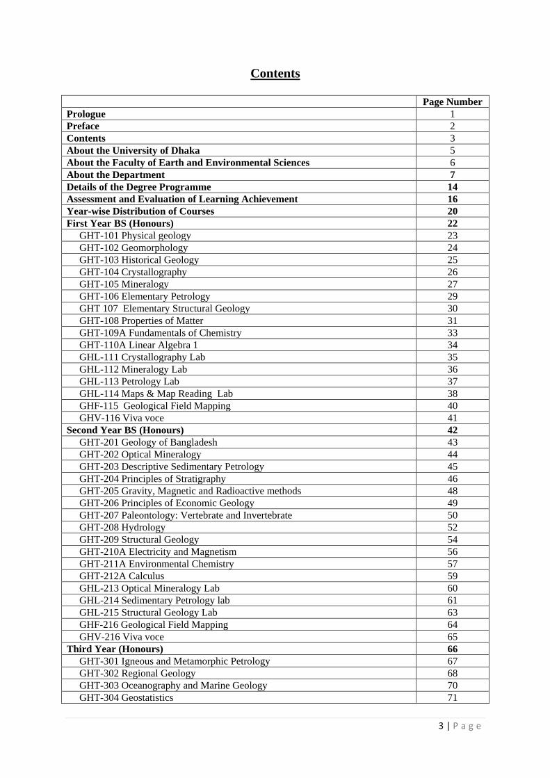
Contents
Page Number
Prologue 1
Preface 2
Contents 3
About the University of Dhaka 5
About the Faculty of Earth and Environmental Sciences 6
About the Department 7
Details of the Degree Programme 14
Assessment and Evaluation of Learning Achievement 16
Year-wise Distribution of Courses 20
First Year BS (Honours) 22
GHT-101 Physical geology 23
GHT-102 Geomorphology 24
GHT-103 Historical Geology 25
GHT-104 Crystallography 26
GHT-105 Mineralogy 27
GHT-106 Elementary Petrology 29
GHT 107 Elementary Structural Geology 30
GHT-108 Properties of Matter 31
GHT-109A Fundamentals of Chemistry 33
GHT-110A Linear Algebra 1 34
GHL-111 Crystallography Lab 35
GHL-112 Mineralogy Lab 36
GHL-113 Petrology Lab 37
GHL-114 Maps & Map Reading Lab 38
GHF-115 Geological Field Mapping 40
GHV-116 Viva voce 41
Second Year BS (Honours) 42
GHT-201 Geology of Bangladesh 43
GHT-202 Optical Mineralogy 44
GHT-203 Descriptive Sedimentary Petrology 45
GHT-204 Principles of Stratigraphy 46
GHT-205 Gravity, Magnetic and Radioactive methods 48
GHT-206 Principles of Economic Geology 49
GHT-207 Paleontology: Vertebrate and Invertebrate 50
GHT-208 Hydrology 52
GHT-209 Structural Geology 54
GHT-210A Electricity and Magnetism 56
GHT-211A Environmental Chemistry 57
GHT-212A Calculus 59
GHL-213 Optical Mineralogy Lab 60
GHL-214 Sedimentary Petrology lab 61
GHL-215 Structural Geology Lab 63
GHF-216 Geological Field Mapping 64
GHV-216 Viva voce 65
Third Year (Honours) 66
GHT-301 Igneous and Metamorphic Petrology 67
GHT-302 Regional Geology 68
GHT-303 Oceanography and Marine Geology 70
GHT-304 Geostatistics 71

4 | P a g e
GHT-305 Mineral Resources of Bangladesh and Subcontinent 73
GHT-306 Principles of Sedimentary Petrology 75
GHT-307 Principles of Hydrogeology 76
GHT-308 Micropaleontology and Palynology 78
GHT-309 Geophysics: Seismic and Electrical Methods 80
GHT-310 Principles of Petroleum Geology 82
GHT-311 Introduction to Remote Sensing and GIS 83
GHT-312 Geochemistry 85
GHL-313 Palaeontology and Micropalaeontology Lab 87
GHL-314 Igneous and Metamorphic Petrology Lab 88
GHL-315 Geological Map Lab 89
GHL-316 Remote Sensing and GIS Lab 90
GHF-317 Geological Field Mapping 92
GHV-318 Viva voce 93
Fourth Year BS (Honours) 94
GHT-401 Quaternary Geology 95
GHT-402 Environmental Geology 97
GHT-403 Sedimentology 98
GHT-404 Applied Hydrogeology 100
GHT-405 Tectonics and Geodynamics 102
GHT-406 Applied Petroleum Geology 104
GHT-407 Seismology and Geodesy 105
GHT-408 Exploration Geophysics 107
GHT-409 Mining Geology 109
GHT-410 Engineering Geology 110
GHT-411 Sustainable Resources Management 112
GHT-412 Coastal geology of Bangladesh 113
GHT-413 Research Methodology and Scientific Writing 115
GHL-414 Hydrogeology Lab 117
GHL-415 Geophysics Lab 118
GHL-416 Subsurface and Petroleum Geology Lab 119
GHL-417 Engineering Geology Lab 120
GHF-418 Geological Field/Project Work 121
GHV-419 Viva voce 123

Page 5 of 124
About the University of Dhaka
On the first day of July 1921 the University of Dhaka opened its doors to students with Sir P.J. Hartog as
the first Vice-Chancellor of the University. The University was set up in a picturesque part of the city
known as Ramna on 600 acres of land. The University started its activities with 3 Faculties, 12
Departments, 60 teachers, 877 students and 3 dormitories for the students. At present, the University
consists of 13 Faculties, 83 Departments, 12 Institutes, 20 residential halls, 3 hostels, and more than 56
Research Centres. The number of students and teachers has risen to about 37018 and 1992, respectively.
At the beginning a distinctive feature of the University of Dhaka was its non-affiliating, residential
character like that of the Oxford of England. However, since 1947 the University was given an
affiliating mandate in place of an exclusive residential-cum-teaching character. Currently, the University
enrolls more than 5,800 students, on merit basis, in the first year Honours Programme in different
Departments of the Faculties and the Institutes. Besides conducting teaching courses in the 4- year
Bachelor and 1-year Masters Programs, the University also trains up a large number of researchers in
different disciplines. More than 1262 PhD and 1217 MPhil Researchers have obtained their degrees
from this University.
The University of Dhaka is dedicated to the advancement of learning, and is committed to promoting
research in all fields of knowledge. As there are plans for further expansion of facilities, plans for new
avenues and opportunities, the course curricula are updated and new research projects are undertaken
every year. As the pioneer and the largest seat of learning in the country, the University of Dhaka has
taken the task to foster the transformation processes of the individual students and the country as a
whole through its educational and research facilities keeping up with demands of the day. The
University of Dhaka is at this moment one of the leading institutions of higher education in Asia.

Page 6 of 124
About the Faculty of Earth and Environmental Sciences
The Faculty of Earth and Environmental Sciences (FEES) is one of the newest faculties in the almost a
century old University of Dhaka. The FEES started functioning in 2008 with a vision to create new hub
of teaching and research in various fields of earth and environmental sciences to face the major
challenges environmental challenges of 21st Century and achieving sustainable development. The
Faculty started with two departments, Geology and Geography and Environment, and subsequent three
more, Disaster Sciences and Management, Oceanography, and Meteorology, have been included.
Currently FEES teaching and research programs includes all the major branches of earth and
environmental sciences encompassing aspects covering space to the center of the Earth. The Faculty is
led by a Dean, elected by all the teachers of constituting departments once in every two years.
Teachers and students in the Faculty of Earth and Environmental Sciences study the physical, chemical,
and biological systems of the earth. Using modern observational, analytical, and computational methods,
they examine how the planet's interior, surface, hydrosphere, biosphere, and atmosphere have evolved
since Earth was born in the solar system 4.6 billion years ago. Topics commonly studied in the
constituting departments include how plate movements cause earthquakes, volcanoes, and mountain
building; global climate change and how climate change and catastrophic events cause changes in
biodiversity; mass extinctions and patterns of evolution through Earth history; how and where economic
resources are generated on Earth; how these resources are located and used in modern society; aspects of
blue economy; harnessing marine resources; sustainable urbanization; disaster management; spatial
planning.
Dean’s Award
Students obtaining BS Honours in Geology with CGPA of 3.75 or above without taking any
improvement examination or readmission in any academic session shall be eligible for the Dean’s
Award under the Faculty of Earth and Environmental Sciences. In addition, the student must have
attendance record of 75% or more during the course of study.

Page 7 of 124
About the Department
Introduction
Geoscience education in Bangladesh has begun since the establishment of the Geology department in
Dhaka University on 23rd April, 1949. The department started with only a graduate programme (BSc
Pass) with the prime aim of providing trained geoscientists to be engaged in the profession of geological
mapping, surveying, exploration, extraction/production and management of country’s natural/mineral
resources. To fulfill the increasing demand of professional geoscientists, curricula l eading to MSc and
BSc honours degrees were introduced in 1957 and in 1967, respectively. Until now the Department
remains the largest academia in the country that offers state-of-the-art geoscience education.
Photograph: Department of Geology, University of Dhaka.
Degree Programmes
The Department currently offers degrees in Bachelor of Science (BS) with Honours, Master of Science
(MS), Master of Philosophy (MPhil) and Doctor of Philosophy (PhD) in Geology. The Department also
offers minor courses for Honours students of other disciplines.
The BS (Hons) is a four-year integrated programme consisting 126 credit hours of theory, practical, field
mapping, project and viva voce (oral) courses as majors and 20 credit hours of physics, chemistry and
mathematics courses as minors. The MS degree is a one-year programme based either on course work
(Group A) or on course work along with research (Group B). The MPhil is a two-year programme of
course work and research. The PhD programme essentially involves research work. The Department
enrolls 50 students in each academic year as first-year honours students.
Research Facilities
The Department presently has 27 academic staff with a wide range of research interest and expertise.
Good laboratory facilities are available in the fields of Sedimentology, Petrography, Optical Mineralogy,
Paleontology, GIS & Remote sensing, Geochemistry, Structure & Tectonics, Seismology, Geodesy,
Geo-resource Exploration, Geohazards, Geotechnical Engineering, Geophysics and Hydrogeology.
The Department also undertakes collaborative research programs with other departments and institutions
such as Geological Survey of Bangladesh (GSB), Bangladesh Oil, Gas and Mineral Corporation
(Petrobangla), Bangladesh Water Development Board (BWDB), Bangladesh Atomic Energy
Commission (BAEC), Department of Public Health Engineering (DPHE), Bangladesh University of
Engineering and Technology (BUET), Bangladesh Petroleum Institute (BPI) and other Non

Page 8 of 124
Governmental Organizations. The Department also maintains liaison with geology departments of other
universities home and abroad.
Museum
The Department has a geological museum, named after Shaheed Md. Abdul Muktadir, a martyr of
liberation war, who was a faculty of the Department until 1971. The museum has quite a large collection
of fossils, minerals, rocks, models, maps and charts. The museum is used as a teaching laboratory for
Mineralogy, Crystallography, Petrology, Paleontology and Structural Geology courses.
Photograph: Shaheed Muktadir Museum in the Department of Geology, University of Dhaka
Library
departmental seminar library has a modest collection of books, journals, geological and topographic
maps, aerial photographs and satellite imageries. The library provides reading facility only for the
departmental students.
Photograph: Seminar library, Department of Geology, University of Dhaka
Fieldwork
Students of the Department have to take a field mapping course in a geologically suitable area (Mostly
in the Chittagong Hill Tracts and Sylhet) in Bangladesh every year during BS (Hons) course. Standard
field equipments including geological hammer, survey apparatus, clinometer, Brunton pocket transit,
hand GPS, range finder, altimeter, binocular, etc. are available for fieldwork. The duration of the
fieldwork is 4 weeks spread over 4 academic years in BS (Honours).

Page 9 of 124
Photographs: Various activities during field work
Computer Laboratory
The Department has a good number of IBM compatible PCs which provide support for research in the
field of Remote Sensing, GW Modelling and other geological applications. Recently, the Department
has established a computer-based GIS laboratory equipped with Scanner, Digitizer, Laser Printer and
more PCs.
Remote Sensing and GIS Laboratory
This laboratory was established in 2006 with significant funding support from Columbia University, NY
and Geology Department of Dhaka University. The lab houses 20 high performance Desktop PCs build
into a Local Area Network through a Server that hosts the floating licenses of ArcGIS software.
Currently the lab is using the 9.2 version of this software. Both ArcGIS and Erdas Imagine software are
used to teach the 4th year students fundamental courses in Remote Sensing and GIS. The MS students
engaged in thesis research also uses this lab to facilitate spatial data interpretation relevant to their
research topics. Faculty members also makes good uses of the lab facilities in their research projects
creating and analyzing GIS data and digital processing of satellite imagery. This laboratory will be
housed in a dedicated room in the new 1st floor wing of the department once the construction is
completed.

Page 10 of 124
Cartographic Facilities
The department has a drafting section equipped with necessary cartographic and drafting gears. The
section provides necessary support to the students in preparing base maps and geological maps for field
work. The section also provides cartographic services in research activities of the department.
Hydrogeology and Environmental Geology Lab
The lab is equipped with Atomic Absorption Spectrometer (AAS), Ion Chromatograph (IC) UV-Visible
Spectrometer, Flame photometer, Total Organic Carbon (TOC) analyzer to conduct research for the
postgraduate students in the field of hydrogeology and environmental geology focusing environmental
pollution, groundwater contamination, water quality assessment and management of groundwater
resources.
Engineering Geology Lab
The Geology Department of Dhaka University has a Geological and Geotechnical Engineering
Laboratory equipped with the most technologically advanced testing equipment. The laboratory has
Fully Automated Cyclic Triaxial Testing Equipment, Universal Triaxial Testing Equipment, Direct
Shear Testing Equipment, Consolidation Testing Equipment, PS Logging Equipment. All these
equipment have been donated by the European Commission (EC) through United Nations Development
Programme (UNDP) under the Earthquake and Tsunami Preparedness Component of the
Comprehensive Disaster Management Programme (CDMP).

Page 11 of 124
TheCyclic Triaxial Testing Equipment is used for earthquake research to evaluate the liquefaction
potential of the subsurface geological materials subjected to earthquakes that include an evaluation of
the dynamic strength of the soil under the foundations of the civil engineering structures. Universal
Triaxial Test and Direct Shear Test Equipment are used to determine the shear strength parameters such
as internal friction angle and cohesion of geological materials. The shear strength parameters are
essential for the foundation design of the civil engineering structures, such as building, road, bridge,
tunnel, etc. These parameters are also necessary for slope stability analysis of mines and road cut in hilly
region. The Consolidation Test Equipment is used to evaluate the consolidation or settlement
characteristics of geological materials. Differential settlement under the foundations of civil engineering
structures can cause foundation failures. The PS Logger is used to determine the shear wave velocity of
the geological materials upto the depth of engineering bed rock. The shear wave velocity is important
for the preparation of engineering geological map which is used in seismic (earthquake) hazard and
vulnerability assessment.
Advanced Research Centre
The Delta Study Centre, a centre of excellence for advanced research in the field of Bengal delta, was
established within the framework of the department in 1991. The centre is equipped with moderate
computer facilities. The centre also provides research grant for the students to undertake MS research in
the above mentioned fields.
The Department of Geology has also an informal research group known as Geohazard Research Group
(GRG) consisting of faculty members to promote advance research pertaining to the Geoenvironmental
Hazards.
Dhaka University Earth Observatory
Bangladesh having situated in an active tectonic region bears, by and large, a character of earthquake
prone. The present seismicity and tectonic setting envisages that about 60% of the country falls in high
risk zone.
The Department of Geology of Dhaka University has initiated an extensive research on earthquake and
crustal dynamics in collaboration with Lamont-Doherty Earth Observatory (LDEO) of Columbia
University in New York, USA since 2000. The department is housed with the state-of-the-art technology
for monitoring earthquakes and three dimensional crustal deformations know as ‘Dhaka University
Earth Observatory (DUEO)’ established in February 2003. The observatory is equipped with digital
broadband seismograph and Global Positioning System (GPS). DUEO is a Foreign Affiliate Member of
‘Incorporated Research Institutions for Seismology (IRIS).
DUEO is a consortium formed in co-operation with Rajshahi University, Khulna University, Chittagong
University, Chittagong University of Engineering and Technology (CUET), Patuakhali Science and
Technology University (PSTU), Shajalal University of Science and Technology (SUST).
Dhaka University Earth Observatory operates network of 6 permanent seismic stations, 6 portable
seismographs and 18 continuous geodetic GPS stations in the country. The objectives of the Observatory
is to carryout research on crustal dynamics, plate motions and to monitor the seismic activity in
Bangladesh and surrounding countries, as well as to disseminate information of earthquakes to the
government and the public. Data is open to scientific community.
Numerical Simulation Lab
This laboratory was established in 2008 supported by Schlumberger. Schlumberger donated industry
standard Software -"Petrel" for Seismic to simulation workflow along with two high end workstations.
This software is used for 2D/3D Seismic Visualization and Interpretation, Geological modeling,
Reservation characterization and Reservoir Simulation.
Training, support to the research students and faculty members are provided under University-Industry
collaboration with assistance of Schlumberger. The MS students use this advanced lab for their research
work which helps them to enhance their capability for career in Industry and Research. Faculty members
also make good use of the lab facilities in their research projects.

Page 12 of 124
Photograph: Dhaka University Earth Observatory
Extracurricular Activities
Students of the department actively participate in the Departmental and interdepartmental indoor and
outdoor events of games, sports and other cultural activities regularly. There are a number of student
chapters of professional organizations including American Association of Petroleum Geologist (AAPG),
Soceity of Exploration Geophysicist (SEG), and Soceity of Petroleum Engineers (SPE). Besides, there is
a cultural club and a photographic club responsible for the arrangment of various cultural activities in
the department.
Photographs: Extracurricular activities by the students of the Geology Department
Scholarship
The department has a number of schlarships and a gold medal award funded under various trust funds
donated by alumni and families of former faculty members. ‘Parvez Smriti Scholarship,’ has been
established since 2000 by the family members of deceased faculty Mr. Parvez Hasan offering a monthly
award of Tk 350 to the student secyuring the highest CGPA at the BS final examinaiton during his MS
courses in the department. ‘Prof. Abdul Hai and Prof. Manzoor Hasan Scholarship’ has been established
in 2009 by former faculty Prof. Manzoor Hasan offering a one time award of Tk 10,000 to the student

Page 13 of 124
securing the hisghest GPA in 3rd Year Final Examination. ‘Shah Alam Mazumder Trust Fund’ has been
establsihed in 2017 by alumni Dr. Md Shah Alam Majumder to award Gold Medal to the student
securing the highest CGPA in BS Honours Final Examination. ‘Sabrina Sharmin Memorial Trust Fund’
has been establsihed in 2017 by the students of 32nd Geology Honours batch offering a one time award
of Tk 10,000 to the student securing the highest GPA in 1st Year Final Examination. Prof. M A Latif
Scholarship Fund has been set up at the Department in 2018 with contributions from the family
members of Prof. M A Latif. A monthly scholarship of Tk. 5000 will be awarded preferably to a female
student of 2nd year honours class, with provisions for reewal up to 4th year, based on economic
conditions and result of 1st Year Final Examination.
Career Opportunity
On completion of their BS honours degree, the graduates from this department are eligible to join
various governments, autonomous, private and multinational organizations. Major governmental and
autonomous organizations include: Geological Survey of Bangladesh (GSB), Petrobangla, Bangladesh
Petroleum Exploration Company (BAPEX), Bangladesh Water Development Board (BWDB),
Bangladesh Atomic Energy Commission (BAEC) and Department of Public Health Engineering
(DPHE). Other national and international organizations where geologists may build up there career are
Institute of Water Modelling (IWM), Centre for Geographic Information Services (CEGIS),
International Oil Companies (IOCs) and Mining companies. Besides, these graduates may also join the
cadre services through open competition conducted by the Bangladesh Public Service Commission
(PSC).
Fresh graduates also get opportunities to work in the different research projects carried out by the
faculties of the department in national and international level. Students with better academic records
may also pursue higher studies in the department leading to MS (in specialized fields) followed by
MPhil or PhD. After achieving the requisite academic qualification, they may be appointed as faculty in
the Universities of the country. In addition, a good number of graduates proceed to overseas universities
every year for higher studies.

Page 14 of 124
Department of Geology
Faculty of Earth and Environmental Sciences
University of Dhaka
Four Years Integrated BS (Honours) Degree in Geology
1. Title of the Programme:
Bachelor of Science with Honours in Geology
2. Duration of the Programme:
Four (4) Academic Sessions
3. Eligibility for Admission:
3.1 HSC or Equivalent degree in science group
3.2 Other conditions of admission are determined by the Academic Committee of the
Department prior to the advertisement for admission in each academic year.
4. Objectives of the Programme:
The major objectives of this integrated general and professional education programme are to
provide:
4.1 advanced knowledge and skills in geosciences;
4.2 practical training to geoscientists to be engaged in the profession of geologicalmapping,
surveying, exploration, extraction/production and management of country’s natural/mineral
resources;
4.3 providing training for identification and mitigation of geo-hazards;
4.4 Sound foundation required for further professional study in Geology leading to
specialization in specific area of Geology and applied geology.
5. Degree Requirements:
5.1 Students in Geology Honours programme are required to successfully complete a total of
140 credit which includes 128 credit hours of Geology Major Courses and 12 credit hours
allied courses (in the first and second academic sessions) in Physics, Chemistry, and
Mathematics. The Honours programme comprises Theory courses of 92 credit hours;
Practical/Seminar courses of 32 credit hours, Field Mapping course of 08 credit hours, and
viva vocé of 08 credit hours.
5.2 Obtaining of minimum cumulative grade point average (CGPA) of 2.5 on a scale of 4.0
without any F grade in any of the courses;
5.3 Completion of all requirements of the degree within 6 (Six) academic years from first
enrolment/admission.
6. Academic Year:
Under the Letter-Grading System, the BS Honours (Integrated) Degree in Geology at the University of
Dhaka is a programme of four academic sessions corresponding to twelve calendar months each. The
details of the academic session are as follows:
Thirty weeks for holding classes; 4 weeks for preparation time of examination; 6 weeks for
course final examination; and 12 weeks of vacation and holidays.

Page 15 of 124
Distribution of theory, practical, and other courses over the four academic sessions are as follows:
Academic
Year
Course Total No. of
Courses
Total Marks Credit Point
Year-1 Theoretical 10 500 20
Practical 4 200 8
Field Geology 1 50 2
Viva-voce 1 50 2
Total 16 800 32
Year-2 Theoretical 12 600 24
Practical 3 150 6
Field Geology 1 50 2
Viva-voce 1 50 2
Total 17 850 34
Year-3 Theoretical 12 600 24
Practical 4 200 8
Field Geology 1 50 2
Viva-voce 1 50 2
Total 18 900 36
Year-4 Theoretical 12 600 24
Practical 4 200 8
Seminar Course 1 50 2
Field Geology 1 50 2
Viva-voce 1 50 2
Total 19 950 38
Grand Total 70 3500 140
7. Contact Hours:
Total Duration of each two credit-hour Theory and Practical (Lab) course is 30 class-weeks. There will
be 30 class-hour lectures for each theory course and 60 class-hour work in the laboratory for each
Practical/lab course. Duration of each two credit-hour Field Mapping course is at least 01 week field
work which is equivalent to 60 class-hour work.

Page 16 of 124
Assessment and Evaluation of Learning Achievements
1. Distribution of marks for two credit-hour courses
1.1. Distribution of marks for theory courses
Nature of assessment Marks
i. Continuous assessment
a) Attendance 5
b) In-course examination/assignment
(At least one in-course examination) 15
ii. Course final examination 30
Total 50
1.2 Distribution of marks for each of the laboratory courses
Nature of assessment Marks
i. Continuous assessment 20
(Based on class performance, lab assignment, attendance)
ii. Lab final examination 30
Total 50
1.3 Distribution of marks for each of the geological field mapping courses
Nature of assessment Marks
i. Field assessment 10
ii. Field viva 10
iii. Field report 30
Total 50
1.4 Table for awarding marks for attendance in a theory course:
Attendance (%) Percentage of
Total Marks
Attendance (%) Percentage of
Total Marks
90 to 100 10 75 to <80 4%
85 to <90 8 60 to <75 2%
80 to <85 6 <60 0%
1.5 The duration of each in-course examination is 50 minutes. The nature of the test items will be
determined by the course instructor. The instructor will conduct at least one in-course
examination. Additionally, assignments can be evaluated by the instructor as part of the
continuous assessment. Moreover, the instructor may take more in-courses than specified
without increasing ratio of marks.
1.6 The academic committee will appoint a Course coordinator for each class at the beginning of the
academic session.

Page 17 of 124
1.7 An examination committee will be formed for each year’s course final examination. The
committee will be consisted of 4 (four) members including a chairperson, normally the Course
coordinator for the respective class, and two internal members from the department and one
external member from outside the department, all appointed by the departmental academic
committee.
1.8 The duration of course final examination is 2.5 hours for each two credit-hour theory course and
4 hours for each two credit-hour lab course.
1.9 Question paper of the course final examination for the theory courses will include a total of 7
(seven) sets of questions, each set carrying equal marks of 6 (six). Students can chose to answer
a maximum of any 5 (five) sets (either partial or full set) out of the seven. Each set of the
question should include at least two questions but no more than 4 questions. If a student answer
more than 5 (five) sets (either partial or full set) of question, the last set answered will not be
considered for evaluation. The questions in the course final examination should cover-all the
categories of cognitive domain including a few items which requires reflective thinking
1.10 For each theory course, the exam committee will appoint two separate question setters’ usually
among the course instructors. In case of a single instructor for a course, the exam committee
may appoint any faculty from the department as the second question setter.
1.11 The examination committee will set up the final question paper based on the two question
papers from the two examiners. However, the exam committee may add or drop any questions
or modify any questions set by the examiners. During the moderation the exam committee will
ensure the following-
A) Test item covering all the topics of the course outlines;
B) Test items fulfil the conditions as mentioned in sections 1.7 and 1.8.
1.12 Answer scripts of the in-course examination will be evaluated by the respective course
instructor.
1.13 Answer script for the course final examination will be scored by two examiners, usually the
course question setters. In case, any of the question setter is unable to examine the answer script
the exam committee can appoint any faulty from the department as the answer script examiner.
1.14 During the tabulation process if the difference between the marks from the two examiners for a
course be more than 20%, the answer script will be evaluated by a third examiner appointed by
the exam committee. Average of the nearest two marks will be considered as final score.
1.15 For laboratory curses, the course instructor will set the questions/lab exam items and evaluate
the answer scripts of practical examination preferably in the presence of the external member of
the examination committee.
1.16 For the field courses, the field team assigned by the academic committee will be responsible
for conducting the field course, assessing the student’s field performance, and evaluating the
field reports.
1.17 The Viva-Voce will be conducted by the examination committee on completion of all theory
and practical courses. In the viva voce for all but the 4th year final examination, the committee
members will assess the student’s knowledge in geology based primarily on the courses
completed during the academic session. In the final year viva voce, the student can be evaluated
based on all the courses taken throughout the four academic sessions.

Page 18 of 124
2. The Grading Systems:
2.1 Credit Hours (CH): Each two credit-hour course will be evaluated on a numerical scale of 50
marks. Total marks obtained by a student in a particular course will be converted to letter grade
& grade points using the following conversion table in 2.2.
2.2 Letter Grade (LG) and Grade Point (GP): Letter Grades, corresponding Grade Points shall be
assigned in accordance with marks obtained in a course as shown below:
Marks Obtained (%) Letter Grade Grade Point
80-100 A+ 4.00
75-79 A 3.75
70-74 A- 3.50
65-69 B+ 3.25
60-64 B 3.00
55-59 B- 2.75
50-54 C+ 2.50
45-49 C 2.25
40-44 D 2.00
<40 F 0.00
I *Incomplete
W Withdrawn
* Absence from the final examination shall be considered incomplete with the letter grade “I”.
2.3 Grade Point Average (GPA): The weighted average of the grade points obtained in all the
courses in an academic session by a student shall be calculated from the following equations:
2.4 Cumulative Grade Point Average (CGPA): The weighted average of the GPAs of a student in
all four year shall be calculated from the following equation:
and
Where GPi = grade point obtained in individual courses, CHi = credit-hours for respective courses,
GPAj = grade point average obtained in an academic session and TCHj = total credit-hours for that
academic session. Both the GPA and CGPA shall be rounded off up to 2 (two) places after decimal
as in the following example. GPA = 2.112 shall be rounded off as GPA = 2.11 and GPA = 2.115
will be rounded off as 2.12.
3. Examination:
3.1 General Outline:
The BS (Honours) Examinations shall consists of (i) 1st Year Final Examination at the end of first
academic session, (ii) 2nd Year Final Examination at the end of second academic session, (iii) 3rd
Year Final Examination at the end of third academic session, and (iv) 4th Year Final Examination at
the end of fourth academic session.

Page 19 of 124
3.2 Eligibility for Appearing in Examinations:
Eligibility of students will be decided based on the percentage of attendances in all the course during
the academic session as per following table:
% of Class Attendance Category Eligibility
75% and above Collegiate Eligible
<75 to 60% Non-collegiate Eligible with payment of
penalty fee
<60% Dis-collegiate Not eligible
4. Publication of Results:
Results will be prepared by the respective Examination Committee at the end of each academic
session showing GPA or CGPA obtained for the respective academic session. The transcript shall
show the course number, course title, credit-hour, letter-grade and grade points of individual
courses, GPA or CGPA of each academic session.
4.1 Promotions and Readmission:
In order to be eligible for promotion from one class to the next higher class, a candidate must secure
(i) at least 2.00 GPA, 2.25 and 2.25 CGPA in his/her 1st, 2nd, and 3rd year examinations respectively.
A candidate, who failed to appear at the course final examination or fails to obtain the required
GPA/CGPA for promotion to higher class, may be readmitted to the same class in the following
session on approval of the academic committee. A student can take readmission maximum two
times during the four year course.
4.2 Improvement of Grades
Students obtaining a letter grade of F in any course must take improvement examination with the
immediate following academic session. Students obtaining letter grade C or below in any course
shall be eligible for taking improvement examination with the immediate following academic
session. Students will be allowed to take improvement examinations twice for a particular course.
4.3 Award of Degree
The Degree of Bachelor of Science with Honours in Geology shall be awarded on the basis of
CGPA obtained by a candidate in 1st, 2nd, 3rd, and 4th year examinations. In order to qualify for the
degree, a candidate must obtain:
i) A minimum CGPA of 2.50, and
ii) A minimum GP of 2.00 in all courses.
Result of the students with letter grade “F” in any course will remain incomplete (I) and the degree
will be awarded after improving the grade.
4.4 Termination of Studentship:
Candidates failing to earn the required GPA or CGPA for promotion more than twice during the BS
Honours course shall be terminated from the programme.

Page 20 of 124
Year-wise Distribution of Courses
First Year
Course Number Course Name Credit
GHT101 Physical Geology 2
GHT102 Geomorphology 2
GHT103 Historical Geology 2
GHT104 Crystallography 2
GHT105 Mineralogy 2
GHT106 Elementary Petrology 2
GHT107 Elementary Structural Geology 2
GHT108A Properties of Matter 2
GHT109A Fundamentals of Chemistry 2
GHT110A Linear Algebra 2
GHL111 Crystallography Lab 2
GHL112 Mineralogy lab 2
GHL113 Petrology Lab 2
GHL114 Maps and Map Reading Lab 2
GHF115 Geological Field Mapping 2
GHV116 Viva voce 2
1st Year Total 32
Second Year
Course Number Course Name Credit
GHT 201 Geology of Bangladesh 2
GHT 202 Optical Mineralogy 2
GHT 203 Descriptive Sedimentary Petrology 2
GHT 204 Principles of Stratigraphy 2
GHT 205 Geophysics: Gravity, Magnetic, and Radioactive Methods 2
GHT 206 Principles of Economic Geology 2
GHT 207 Paleontology 2
GHT 208 Hydrology 2
GHT 209 Structural Geology 2
GHT 210A Electricity and Magnetism 2
GHT 211A Environmental Chemistry 2
GHT 212A Calculus 2
GHL 213 Optical Mineralogy Lab 2
GHL 214 Sedimentary Petrology Lab 2
CHL 215 Structural Geology Lab 2
GHF 216 Geological Field Mapping 2
GHV 217 Viva voce 2
2nd
Year Total 34

Page 21 of 124
Third Year
Course Number Course Name Credit
GHT301 Igneous and Metamorphic Petrology 2
GHT302 Regional Geology 2
GHT303 Oceanography and Marine Geology 2
GHT304 Geostatistics 2
GHT305 Mineral Resources of Bangladesh and Subcontinent 2
GHT306 Principles of Sedimentary Petrology 2
GHT307 Principles of Hydrogeology 2
GHT308 Micropaleontology 2
GHT309 Geophysics: Seismic and Electrical Methods 2
GHT310 Principles of Petroleum Geology 2
GHT311 Introduction to Remote Sensing and GIS 2
GHT312 Geochemistry 2
GHL313 Micropaleontology lab 2
GHL314 Igneous and Metamorphic Petrology Lab 2
GHL315 Geological Map Lab 2
GHL316 Remote Sensing and GIS Lab 2
GHF317 Geological Field Mapping 2
GHV318 Viva voce 2
3rd
Year Total 36
Fourth Year
Course Number Course Name Credit
GHT401 Quaternary Geology 2
GHT402 Environmental Geology 2
GHT403 Sedimentology 2
GHT404 Applied Hydrogeology 2
GHT405 Tectonics and Geodynamics 2
GHT406 Applied Petroleum Geology 2
GHT407 Seismology and Geodesy 2
GHT408 Exploration Geophysics 2
GHT409 Mining Geology 2
GHT410 Engineering Geology 2
GHT411 Sustainable Resources Management 2
GHT412 Coastal Geology of Bangladesh 2
GHS413 Research Methodology and Scientific Writing 2
GHL414 Hydrogeology Lab 2
GHL415 Geophysics Lab 2
GHL416 Subsurface and Petroleum Geology Lab 2
GHL417 Engineering Geology Lab 2
GHF418 Geological Field/Project Work 2
GHV419 Viva voce 2
4th
Year Total 38
Year Wise Total 32+34+36+38 140
Course Breakdown Theory: 92 Credits (Geology: 80 + Allied: 12); Seminar 2
Credits; Laboratory: 30 Credits; Field Mapping and
Project: 8 Credits; Viva Voce: 8 Credits
82+12+3
0+8+8
=140
[Note: The major courses are denoted by three-letter code as GHT for Geology Honours Theory;
GHS for Geology Honours Seminar; GHL for Geology Honours Lab/practical; GHF for Geology
Honours Field Mapping; and GHV for Geology Honours Viva vocé followed by a three-digit number
in Arabic numeral. The Allied courses are denoted by three-letter code followed by a three-digit
number and the letter A for allied].

Page 22 of 124
First Year BS (Honours)

Page 23 of 124
1. Course Number and Title: GHT-101 Physical geology
2. Credit Hours: 2
3. Course Description:
This course covers the major topics in physical geology including the scientific method, plate
tectonics, minerals, rocks and their formation processes, solid earth processes, natural disasters,
surface processes, climate change, and geologic time.
4. Learning outcomes:
At the end of the course the learners will be able to -
a. Compare and contrast weathering among different rock types and different environments.
b. Explain what causes earthquakes and earthquake destruction, and apply the correct procedures to
locate the source and calculate the magnitude of an earthquake.
c. Differentiate the internal structure and composition of the Earth.
d. Compare and contrast depositional and erosional environments, features, and processes
associated with streams and shorelines.
5. Course content: (Total 30 Classes)
Unit/Chapter No of Classes
Unit 1: Introduction to the Science of Geology 2
Unit 2: Historical Development 3
Unit 3: Origin of the Earth and the Solar System, Interior of the Earth, Earth’s
Surface Processes.
6
IN-COURSE – 1
Unit 4: Weathering, Erosion and Denudations 5
Unit 5: The Features of Continents and Oceans; Concepts of Plate Tectonics,
Isostasy, Diastrophism
6
IN-COURSE – 2
Unit 6: Earthquakes and Volcanism 6
6. Instructional Strategies:
Lecture, Discussion, Question-Answer, Presentation
7. Assessment:
Formative (40%): Incourse Examination/Assignment
Summative (60%): Course Final Examination
8. Reading Materials:
Textbook:
Plummer, C., Carlson, D., Hammersley, L. (2015) Physical Geology (15th Edition). McGraw-Hill Education
References:
Tarbuck, E. J., Lutgens F.K., Tasa, D. G. (2013) Earth: An Introduction to Physical Geology (11th Edition).
Pearson.
Montgomery, C.W. (1990) Physical Geology. William C Brown Pub.
Leet, L., & Leet L.D. (1982) Physical Geology (6th Edition). Prentice Hall.
Bradshaw, M.J. et al. (1978) The Earth’s Changing Surface. Hodder Arnold H&S.
========= O ========

Page 24 of 124
1. Course No. and Title: GHT-102 Geomorphology
2. Credit Hours: 2
3. Course Description:
This is a basic course on geomorphology required as partial fulfillment of the four-year B.S Honours
degree in Geology. The course contains fundamental knowledge and its application to identify
geomorphic features, units, tools and methods in order to visualize the various exogenetic and
endogenetic processes contributed to the formation of different landforms. Study of geomorphology
will help in landscape management and engineering construction.
4. Learning outcomes:
By the end of the course, the learners will be able to –
a. Introduce to the scope of geomorphology
b. Describe earth`s surficial processes, natural agents, resulting landforms and their origin
c. Explain fluvial, glacial, aeolian and coastal processes and resulting landform types.
d. Explain geomorphic features, methods and tools
e. Describe morphodynamic and morphometric units of Bangladesh
f. Express the significance of landscape management for various infrastructure development
5. Course contents: (Total 30 Classes)
Unit/Chapter No of Classes
Unit 1: Introduction and scope of geomorphology 2
Unit 2: Exogenetic and endogenetic processes, agents and their origin 3
Unit 3: Fluvial process weathering, erosion, transportation, and deposition of
sediments; the development of fluvial landforms
5
IN-COURSE – 1
Unit 4: Formation of glaciers, types, glacial epoch, causes and impacts of
glaciations, types of erosional and depositional features
5
Unit 5: Desert environment, works of wind, causes of arid environment, types of
dunes, loess and other aeolian deposits
5
IN-COURSE – 2
Unit 6: Coastal processes, classification of coasts, works of wave and tide coastal
landforms, classification of Bangladesh coastline
4
Unit 7: Physiographic divisions of Bangladesh – their morphological features,
origin, classification and management
4
6. Instructional strategies:
Lecture, discussion, question-answer and assignment
7. Assessment:
Formative (40%): Incourse Examination/Assignment
Summative (60%): Course Final Examination
8. Reading materials:
Textbook:
Huggett, R. (2011) Fundamentals of Geomorphology (3rd Edition). Routledge.
References:
Spencer, E.W. (1983) Physical Geology. Addison-Wesley Pub. Co.
Smith, D.G. (Ed.) (1982) The Cambridge Encyclopaedia of Earth Sciences. Cambridge University Press.

Page 25 of 124
Thornbury, W.D. (1968) Principles of Geomorphology. Wiley.
Strahler, A.N. (1963) The Earth Sciences. Joanna Cotler Books.
========= O ========
1. Course No. and Title: GHT-103 Historical Geology
2. Credit Hours: 2
3. Course Description:
Introduces historical geology which deals with geologic time, fossils, stratigraphic principles, and the
geologic history of whole earth. This is an introductory-level historical geology course with no
prerequisites. It creates a scope of studying laws of Historical Geology, Geological Time and
Geological Time Scale, origin of life and major physical and biological events and revolution of the
world.
4. Learning Outcomes:
A student who successfully completes this course should be able to:
a. Explain the evidence supporting the theory of plate tectonics
b. Answer queries related to fossil records for each of the major geologic eons and eras
c. Justify the evidence supporting the theory of evolution
d. Observe and utilize the geologic time scale for various purposes
e. Analyze how relative and absolute dating has been used to construct and refine the geological
time scale
f. Integrate an understanding fossil characterization and classification to infer the past
environments
g. Assess the contributions of historical geology to our evolving understanding of global change
and sustainability
5. Course Contents: (Total 30 Classes)
Unit/Chapter No of Classes
Unit 1: Plate Tectonics: Continental drift, evidences; plate motion and hot spots,
convection currents, plate boundaries and associated features, ocean basins and
subductions
4
Unit 2: Geologic Time: Fundamental geological laws and geological concepts,
relative and absolute age dating and their principles, Radiometric age dating,
Geological time scale, unconformities and their types.
4
IN-COURSE – 1
Unit 3: Stratigraphy: Time unit, rock unit, time-rock unit, Lithostratigraphy,
Biostratigraphy and Chronostratigraphy.
3
Unit 4: Precambrian: Divisions of Precambrian, Formation of earth, atmosphere,
origin of life; Origin of continents, Earth condition during Hadean, Precambrian
ice ages, indirect evidences of life, Precambrian Lagerstatten.
4
Unit 5: Paleozoic: Paleozoic divisions, Orogenesis, Assembly of Pangea,
Cambrian Explosion, Clastic Wedges, Evolution of life forms in different periods,
Index fossils and their uses, Marine vs. land life forms, Paleozoic reefs, Great
Permian Extinction.
4
IN-COURSE – 2

Page 26 of 124
Unit 6: Mesozoic: Divisions of Mesozoic, Orogenesis, Breakup of Pangea,
Cretaceous transgression, Reptiles and their dominance, Birds and mammals, K-T
Extinction
4
Unit 7: Cenozoic: Division of Cenozoic, Alpine- Himalayan Belt, Colorado
Plateau, Basin and Range, Pleistocene ice ages, Radiation of Mammals, Origin of
human
5
6. Instructional Strategies:
Lecture, Discussion, Question-Answer, Presentation
7. Assessment:
Formative (40%): Incourse Examination/Assignment
Summative (60%): Course Final Examination
8. Reading Materials
Textbooks
Wicander, R., & Monroe, J. (2016) Historical Geology (8th Edition). Cengage Learning.
References
Mintz, L.W. (1977) Historical Geology: The Science of a Dynamic Earth. Merrill.
Spencer, E.W. (1966) Basic Concepts of Historical Geology. Thomas Y. Crowell Co.
Gilluly, J., Woodford, A.O. and Judson, S. (year) Physical and Historical Geology.
========= O ========
1. Course No. and Title: GHT-104 Crystallography
2. Credit Hours: 2 Credits
3. Course Description:
The objective of this course is to present the basic concepts needed to understand the crystal structure
of materials. Fundamental concepts including lattices, symmetries, point groups, and space groups
will be discussed and the relationship between crystal symmetries and physical properties will be
addressed. The theory of X-ray diffraction by crystalline matter along with the experimental X-ray
methods used to determine the crystal structure of materials will be covered. Application of X-ray
diffraction to proteins, electron diffraction will be briefly discussed.
4. Learning Outcomes:
At the end of this course students should be able to:
a. Define concepts of the fundamental of crystallography such as lattice, point and space groups
b. Identify and describe different crystal system and classes and orient the crystals into stereonet on
the basis of crystallographic indices
c. Be familiar with Bragg’s Law and explain it’s the relation to crystal structure
d. Interpret and assign X-ray and electron diffraction patterns
5. Course contents: (Total 30 Classes)
Unit/Chapter No of Classes
Unit 1: Introduction and scope of crystallography 2
Unit 2: Crystalline State—Mechanics, Formation and Growth of Crystalline
Matter; ; Law of Constancy of Interfacial Angles; Reference Axes; Axial Ratio;
3

Page 27 of 124
Interaxial Relationships
Unit 3: Point Groups; Crystal Classes; Unit Cell; Space Lattices 3
IN-COURSE – 1
Unit 4: Systematic Study of Crystal Systems, Classes and Forms; Crystal Habits,
Aggregates and Composite Crystals; Crystal Notations—Coordinates;
5
Unit 5: Fourteen Bravais Lattices 1
Unit 6: Symmetry Elements and Operations; Combination of Symmetry
Operation; Interrelationship of Faces and Edges
4
IN-COURSE – 2
Unit 7: Law of Rational Indices; Miller Indices; Crystal Forms; Zones; Zone
Laws; Hermann-Mauguin Symbols
3
Unit 8: Twin Crystals and Twinning Laws; Common Method of Twinning;
Frequency of Twinning
1
Unit 9: Crystal Orientation Rules; Crystal Projections 3
Unit 10: X-ray Crystallography; Bragg Equation 3
6. Instructional strategies:
Lecture, discussion, question-answer and assignment
7. Assessment:
Formative (40%): Incourse Examination/Assignment
Summative (60%): Course Final Examination
8. Reading materials:
Textbook:
Klein, C. & Hurlbut, C. S. (1985) Manual of Mineralogy (after James D. Dana). Wiley.
Reference Books:
Gribbles, C.D. (1988) Rutly’s Elements of Mineralogy (27th Edition). Unwin Hyman.
Phillips, F.C. (1977) An Introduction to Crystallography. Longman Higher Education
Mason, B., & Berry, L.G. (1968) Elements of Mineralogy. Freeman, W. H. & Company
========= O ========
1. Course No. and Title: GHT-105 Mineralogy
2. Credit Hours: 2
3. Course Description:
The course introduces the students to the science of Mineralogy and its relations to allied sciences.
The Course deals with the formation, properties, classification, occurrences and uses of mineral
species, and associations.
4. Learning outcomes:
At the end of the course the learners will be able to
a. Define a mineral and explain how minerals form in nature;
b. Classify the mineral species;

Page 28 of 124
c. Describe physical and chemical properties of important mineral species;
d. Understand the origin and association of minerals
e. Know the economic importance and uses of minerals;
f. Determine the identifying properties of a mineral.
5. Course content: (Total 30 Classes)
Unit/Chapter No of Classes
Unit 1: Introduction and scope of Mineralogy 2
Unit 2: Study of Physical and Chemical Properties of Minerals 3
Unit 3: Genesis of Minerals and Environments of Mineral Formation 3
Unit 4: Classification of Minerals 3
IN-COURSE – 1
Unit 5: Detail Study of Important Mineral Species of the following classes-
Silicates, Native elements, Sulphides and Sulphosalts, Oxides and Hydrooxides,
Halides, Carbonates, Nitrate, Borates, Sulphates, Chromates, Molybdates,
Tungstates, Phosphates, Arsenates and Vanadates
9
IN-COURSE – 2
Unit 6: Paragenesis, Association, Occurrence and Uses of Minerals 2
Unit 7: Determinative Mineralogy: Physical and chemical methods; special
techniques/ instruments for mineral identification
6
6. Instructional Strategies:
Lecture, Discussion, Question-Answer, Presentation
7. Assessment:
Formative (40%): Incourse Examination/Assignment
Summative (60%): Course Final Examination
8. Reading Materials:
Textbook:
Berry, L.G., Mason, B. and Dietrich, R. V. (2004) Mineralogy: Concepts, Descriptions and Determinations.
CBS Publishers & Distributors Pvt. Ltd.
References:
Deer, W.A., Howie, R.A. &Zussman, J. (2013) An Introduction to the Rock-Forming Minerals (3rd Edition).
Mineralogical Society of Great Britain and Ireland.
Perkins, D. (2010) Mineralogy (3rd Edition). Pearson.
Hibbard, M.J. (2002) Mineralogy: A geologist’s point of view. McGraw-Hill Higher Education.
Gribbles, C.D. (1988) Rutley’s Elements of Mineralogy (27th Edition). Unwin Hyman.
Klein, C. & Hurlbut, C. S. (1985) Manual of Mineralogy (after James D. Dana). Wiley.
Read H.H. (Ed.) (1970) Rutley’s Elements of Mineralogy. T. Murby& Company.
Mason, B., & Berry, L.G. (1968) Elements of Mineralogy.Freeman, W. H. & Company.
Vanders, I. and Kerr, P. F. (1967) Mineral Recognition. John Wiley & Sons
========= O ========
Page 29 of 124
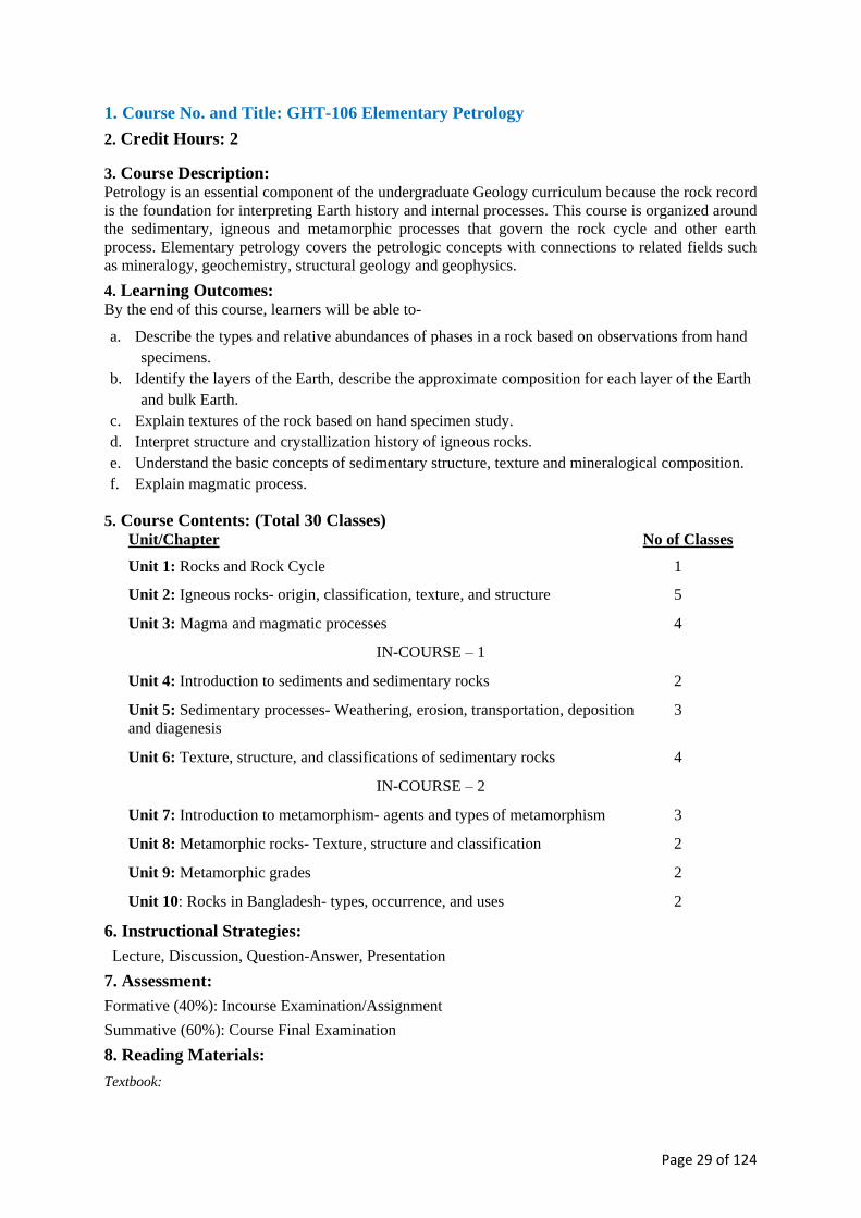
1. Course No. and Title: GHT-106 Elementary Petrology
2. Credit Hours: 2
3. Course Description: Petrology is an essential component of the undergraduate Geology curriculum because the rock record
is the foundation for interpreting Earth history and internal processes. This course is organized around
the sedimentary, igneous and metamorphic processes that govern the rock cycle and other earth
process. Elementary petrology covers the petrologic concepts with connections to related fields such
as mineralogy, geochemistry, structural geology and geophysics.
4. Learning Outcomes: By the end of this course, learners will be able to-
a. Describe the types and relative abundances of phases in a rock based on observations from hand
specimens.
b. Identify the layers of the Earth, describe the approximate composition for each layer of the Earth
and bulk Earth.
c. Explain textures of the rock based on hand specimen study.
d. Interpret structure and crystallization history of igneous rocks.
e. Understand the basic concepts of sedimentary structure, texture and mineralogical composition.
f. Explain magmatic process.
5. Course Contents: (Total 30 Classes) Unit/Chapter No of Classes
Unit 1: Rocks and Rock Cycle 1
Unit 2: Igneous rocks- origin, classification, texture, and structure 5
Unit 3: Magma and magmatic processes 4
IN-COURSE – 1
Unit 4: Introduction to sediments and sedimentary rocks 2
Unit 5: Sedimentary processes- Weathering, erosion, transportation, deposition
and diagenesis
3
Unit 6: Texture, structure, and classifications of sedimentary rocks 4
IN-COURSE – 2
Unit 7: Introduction to metamorphism- agents and types of metamorphism 3
Unit 8: Metamorphic rocks- Texture, structure and classification 2
Unit 9: Metamorphic grades 2
Unit 10: Rocks in Bangladesh- types, occurrence, and uses 2
6. Instructional Strategies:
Lecture, Discussion, Question-Answer, Presentation
7. Assessment:
Formative (40%): Incourse Examination/Assignment
Summative (60%): Course Final Examination
8. Reading Materials:
Textbook:

Page 30 of 124
Blatt, H., Ethler, E.G., and Tracy, R. (2005) Petrology: Igneous, Sedimentary and Metamorphic (3rd Edition).
W.H. Freeman.
Reference Books:
Pettijohn, F.J. (2004) Sedimentary Rocks (3rd edition). CBS Publisher.
Nackolds, S. R. et al. (1978) Petrology for students. Cambridge University Press.
Tyrrell, G.W. (1973) The Principles of Petrology. John Wiley & Sons.
========= O ========
1. Course Number and Title : GHT 107 Elementary Structural Geology
2. Credit Hours: 2
3. Course Description:
Structural geology is the study of deformation in the Earth’s crust. This deformation is heterogeneous:
it happens at various scales, locations, and times; this deformation produces identifiable structures in
the crust such as fractures and folds.
The objective of this course will be to introduce the fundamentals of structural geology including the
application of deforming forces to earth materials and the structures resulting from that deformation.
The course is designed for understanding the significance of studying structural geology; relation of
structural geology to other branches of geology; aims and objective; concept of scale and stages of
deformation. The course covers the physical properties of rocks in relation to mechanical principles;
common types of structures, viz., fold, fault, joint, unconformity, cleavage & schistosity, and
lineation. The student will learn to recognize and classify geologic structures associated with folding,
fracturing and geological processes of the lithosphere. Students can download the course contents,
schedule of lectures and ppt lecture files from the link to be provided at the beginning of this course.
4. Learning Outcomes :
By the end of the course, learners will be able to -
a. understand the significance of structural geology for studying geology
b. understand primary and secondary structures
c. know the brittle and ductile deformation and the forces responsible to produce different types
of structures
d. know the influence of different external factors on rock deformation
e. determine the attitude of structural elements and to plot on a map
f. identify and classify different types of folds, faults and joints
g. explain the causes of tectonic and non-tectonic process of folding
h. identify different kinds of unconformities and its relation to geological processes
i. recognize folds, faults, joints and unconformities in the field and to plot on a map
j. know types rock cleavage and lineation
k. develop good knowledge on the basic of principles of structural geology to better
understand the deformation process in advance structural geology course
5. Course Contents (Total 30 Classes)
Unit/Chapter No of Classes
Unit 1: Introduction to course content and schedule of lectures, definition of
common types of structures, Identification of structures from photographs/
sketches, etc., introduction – structure, structural geology, scope of the subject.
3
Unit 2: Objective of structural geology, relation of structural geology to other
branches of geology
2
Unit 3: Mechanical principles – force, pressure, stress & strain, physical properties
of rocks, stress-strain diagram, factors controlling rock behavior
3

Page 31 of 124
IN-COURSE - 1
Unit 4: Fold – definition, description and geometry, basic nomenclature, attitude
of planar and linear structures
3
Unit 5: Bases of fold classification - morphological classification, geometric
classification, genetic classification; causes of folding
5
IN-COURSE - 2
Unit 6: Fault; definition, description, types of faults, movements along fault plane,
fault terminology, fault classification – geometric and genetic, criteria of faulting
5
Unit 7: Joint – definition, description, classification and origin 2
Unit 8: Unconformity – definition, descriptions and types, field recognition,
distinguishing from faults
3
Unit 9: Cleavage and Schistosity –definition, descriptions, classification 1
Unit 10: Lineation – definition, description, types, origin 1
6. Instructional Strategies:
Lecture, Discussion, Question-Answer, Presentation
7. Assessment:
Formative (40%): Incourse Examination/Assignment
Summative (60%): Course Final Examination
8. Reading Materials:
Text books:
Billings, M. P. 1972. Structural geology. Prentice Hall College Div.
References:
Twiss R.J. and Moores, E. M. 1992. Structural Geology, Freeman.
Hills, E.S. 1972. Elements of Structural Geology. Chapman & Hall.
Spencer, E.W. 1969. Introduction to the Structure of the Earth. McGraw-Hill.
Ramsay, J.G. 1967. Folding and Fracturing of Rocks. McGraw-Hill.
========= O ========
1. Course No. and Title: GHT-108 Properties of Matter
2. Credit Hours: 2
3. Course Description: 43
This course will offer students an opportunity to understand the basic problems related to gravitational
field, surface tension of liquid, viscosity of liquid and gas and fluid dynamics.
4. Learning outcomes:
Upon completion of this course students will be able to:
a. Understand Newton’s law of gravitation and its application.
b. Understand surface tension of liquid and its effects on liquid.
c. Understand the viscosity of liquid and gaseous state of matter.

Page 32 of 124
d. Understand the problems related to streamline flow of liquid.
e. Apply the Newton’s law of gravitation to study the gravitational field and potential and, also
learn about the escape velocity and Kepler’s planetary laws of motion.
f. Understand the origin of surface tension and the role of surface tension in forming the different
types of liquid surface.
g. Learn to calculate the surface tension of water by capillary rise method and the surface tension of
mercury by sessile drop method.
h. Learn to calculate the coefficient of viscosity of liquid for streamline flow using Poiseulle’s
formula.
i. Understand the difference between streamline flow and turbulent flow and the physical
significance of Reynold’s number.
5. Course Content: (Total 30 Classes)
Unit/Chapter No of Classes
Unit 1: Gravitational Theory: Newton’s Law of Gravitation, Gravitational
Potential, Calculation of Potential, Calculation of Potential and Force in Simple
cases, Escape velocity, Planck Mass
5
Unit 2: Elementary Theory of Elasticity: Hooke’s Law, Elastic Moduli,
Relations between the Moduli, Bending of Beams, Torsion
5
IN-COURSE - 1
Unit 3: Surface Tension: Adhesive Force, Cohesive Force, Molecular theory of
Surface Tension, Capillarity, Surface Tension of a Mercury Drop, Variation of
Surface Tension with Temperature
6
Unit 4: Viscosity: Newton’s Law of viscosity forstreamline flow, Poiseulle’s
Formula, Applications, Variation of viscosity with Temperature
8
IN-COURSE - 2
Unit 5: Fluid Dynamics: Streamline Flow, Turbulence flow, Reynold’s number,
Bernoulli’s Theorem, Applications
4
6. Instructional Strategies:
Lecture, Discussion, Question-Answer, Presentation
7. Assessment:
Formative (40%): Incourse Examination/Assignment
Summative (60%): Course Final Examination
8. Reading Materials:
Reference Books:
Newman, F.W. & Searle, V.H.L.The general properties of Matter, Edward Arnold publishers.
Ahmed, S. & Nath, A.K.Mechanics and Properties of Matter
Mathur, D.S. Elements of Properties of Matter
Tabor D. Gases, Liquids and Solids, Cambridge University Press.
Sprackling, M.T. The Mechanical properties of Matter, Krieg Pub. Co.
========= O ========

Page 33 of 124
1. Course No. and Title: GHT 109A Fundamentals of Chemistry
2. Credit Hours: 2
3. Course Description:
The course is designed to provide knowledge and understanding of atomic structure, physical and
chemical behavior of atom and subatomic particles at different conditions. The focus of this course
will be on electronic and thermodynamic properties of different chemical species. The course is
expected to help students to understand the constituents of petroleum hydrocarbons, their occurrence,
separation, purification and utilization.
4. Learning Outcomes:
By the end of the course, learners will be able to-
a. Understand the electronic structure of atoms, properties of different fundamental particles and
the systematic way to learn about different elements.
b. describe interactions, hybridization and geometry of different chemical species
c. explain various states of matter and their dependency on temperature and pressure
d. demonstrate concepts of thermodynamics and different thermodynamic quantities
e. analyze electrolytes and electrolytic solutions using different electrochemical cells
f. Measure conductance, pH and buffer solution behavior.
g. know the basic reactions of aliphatic and aromatic hydrocarbons and the mechanisms of common
organic reactions
5. Course Contents: (Total 30 Classes)
Unit/Chapter No of Classes
Unit 1: Structure of Atom and Periodic Properties 7
Unit 2: Chemical Bonds 4
IN-COURSE - 1
Unit 3: States of Aggregation of Matter 3
Unit 4: Chemical Thermodynamics 3
Unit 5: Electro-Chemistry 3
IN-COURSE - 2
Unit 6: Chemical Reactions 3
Unit 7: Aliphatic and Aromatic Hydrocarbons 5
6. Instructional Strategies: Lecture, Discussion, Question-Answer, Presentation
7. Assessment:
Formative (40%): Incourse Examination/Assignment
Summative (60%): Course Final Examination
8. Reading Materials:
Text books:

Page 34 of 124
1. Chang R (2012) Chemistry (11th Edition), McGraw-Hill Education
2. Ebbing, D. and Gammon, S.D. (2016) General Chemistry, Cengage Learning
References:
1. J. M. Coxon, J. E. Fergusson and L. F. Philips. Edward Arnold, First Tear Chemistry, London
2. Koltz and Treichel General Chemistry: A molecular picture
3. Chemistry: A molecular nature of matter and change, Martin Silberberg, McGraw Hill.
4. A-level Chemistry, E. N. Ramsden
========= O ========
1. Course No. and Title: GHT 110A Linear Algebra 1
2. Credit Hours: 2
3. Course Description :
Matrices and Determinants: Matrices and Determinants: Notion of matrix. Types of matrices. Matrix
operations, laws of matrix Algebra. Determinant function. Properties of determinants. Minors,
Cofactors, expansion and evaluation of determinants. Application of matrices and determinants for
solving system of linear equations.
System of Linear Equations: Linear equations, System of linear equations (homogeneous and non-
homogeneous) and their solutions. Elementary row and column operations and row-reduced echelon
matrices. Invertible matrices. Block matrices.
Vector Spaces: Vectors in Rn and Cn: Review of geometric vectors in R2 and R3 space. Vectors in
Rn and Cn. Inner product. Norm and distance in Rn and Cn. Abstract vector space over R and C.
Subspace. Linear independence of vectors; basis and dimension of vector spaces. Row and column
space of a matrix; rank of matrices. Solution spaces of systems of linear equation.
Linear transformations: Definition of a linear transformation and Matrix representation of linear
transformations. Eigenvalues and eigenvectors. Cayley Hamiton theorem. Applications.
4. Learning outcomes:
Upon completion of this course, students will be able to:
a. Determine if a system of equations is consistent and find its general solution.
b. Apply solution methods of linear system
c. Interpret vectors in two and three-dimensional space both algebraically and geometrically.
d. Perform linear transformation and find the standard matrix representations.
e. Describe Learn Cayley Hamiton theorem and its Applications to Matrix algebra.
f. Apply linear algebra to various real world phenomena
g. Analyze determinants, cofactors and operations on matrix.
h. Recognize and apply various laws and theorems of Matrix algebra to solve problems.
i. Identify a linear system of equations in matrix form.
j. Compute the solution of the linear system by row operation and analyze the nature of various
solutions.
k. Apply different solution methods to solve network analysis and chemical balancing problems.

Page 35 of 124
5. Course Contents: (Total 30 Classes)
Unit/Chapter No of Classes
Unit 1: Matrices and Determinants 3
Unit 2: Application of matrices and determinants 4
Unit 3: Introduction to the system of linear equations and their solutions 3
IN-COURSE - 1
Unit 4: Applications of liner systems 4
Unit 5: Vector space axioms 3
Unit 6: Linear Independence, Span, Basis and dimension, Rank, Nullity 4
IN-COURSE - 2
Unit 7: Linear Transformation 3
Unit 8: A first look at eigenvalues and eigenvectors. Similarity and
diagonalizability, Caley-Hamilton theorem
4
6. Instructional Strategies: Lecture, Discussion, Question-Answer, Presentation
7. Assessment:
Formative (40%): Incourse Examination/Assignment
Summative (60%): Course Final Examination
8. Reading Materials:
Text book
H. Anton, and C. Rorres, Linear Algebra with Applications, 9thEdition.
References
S. Lipshutz, Linear Algebra, Schaum’s Outline Series, 4th Edition.
Linear Algebra, 4th Edition, by Friedberg, Insel & Spence, Prentice Hall
========= O ========
1. Course No. and Title: GHL-111 Crystallography Lab
2. Credit Hours: 2
3. Course Description:
This course covers the derivation of symmetry theory; lattices, point groups, space groups, and their
properties; use of symmetry in tensor representation of crystal properties, including anisotropy and
representation surfaces.
4. Learning outcomes:
By the end of the course, the learners will be able to:
a. Identify the relation between crystal symmetry and mineral properties.
b. Explain miller indices.
c. Apply crystal orientation rules.

Page 36 of 124
5. Course content: (Total 24 classes)
Unit/Chapter No of Classes
Unit 1: Crystal forms 6
Unit 2: Symmetry and Symmetry elements 6
Unit 3: Miller indices 5
Unit 4: Stereographic projection of crystals 7
6. Instructional Strategies:
Laboratory work, Demonstration, Discussion, Question-Answer
7. Assessment:
Formative (40%): Attendance, Laboratory work, Submission of assignment/Lab note book
Summative (60%): Practical Examination
8. Reading Materials:
Textbook:
Klein, C. & Hurlbut, C. S. (1985) Manual of Mineralogy (after James D. Dana). Wiley.
References:
Gribbles, C.D. (1988) Rutley’s Elements of Mineralogy (27th Edition). Unwin Hyman.
Phillips, F.C. (1977) An Introduction to Crystallography. Longman Higher Education.
Read H.H. (Ed.) (1970) Rutley’s Elements of Mineralogy. T. Murby & Company.
Mason, B., & Berry, L.G. (1968) Elements of Mineralogy. Freeman, W. H. & Company.
Wade, F.A. & Mattox, R.B. (1960) Elements of crystallography and mineralogy. Harper & Brothers
========= O ========
1. Course No. and Title: GHL-112 Mineralogy Lab
2. Credit Hours: 2
3. Course Description:
The course is designed to study the properties and identify important mineral species of different
Classes in hand specimen with particular emphasis on common rock forming minerals.
4. Learning outcomes:
At the end of the course the learners will be able to
a. Study the physical properties of a mineral in hand specimen;
b. Determine the characteristic properties by simple physical and chemical tests;
c. Know the systematic procedure for mineral identification and
d. Identify the common rock forming and economically important minerals in hand specimen.
5. Course content: (Total 24 Classes)
Unit/Chapter No of Classes

Page 37 of 124
Unit 1: Demonstration of common physical properties of minerals and systematic
procedure for mineral identification
2
Unit 2: Study the properties and identification of common rock forming and
economically important minerals of the following Classes:
i. Silicates
ii. Native Elements, Sulphides and Suphosalts, Suphates
iii. Halides, Oxides and Hydrooxides, Carbonates and Phosphates
10
6
6
6. Instructional Strategies:
Laboratory work, Demonstration, Discussion, Question-Answer
7. Assessment:
Formative (40%): Attendance, Laboratory work, Submission of assignment/Lab note book
Summative (60%): Practical Examination
8. Reading Materials:
Textbook:
Berry, L.G., Mason, B. and Dietrich, R. V. (2004) Mineralogy: Concepts, Descriptions and Determinations.
CBS Publishers & Distributors Pvt. Ltd.
References:
Deer, W.A., Howie, R.A. &Zussman, J. (2013) An Introduction to the Rock-Forming Minerals (3rd Edition).
Mineralogical Society of Great Britain and Ireland.
Perkins, D. (2010) Mineralogy (3rd Edition). Pearson.
Hibbard, M.J. (2002) Mineralogy: A geologist’s point of view. McGraw-Hill Higher Education.
Gribbles, C.D. (1988) Rutley’s Elements of Mineralogy (27th Edition). Unwin Hyman.
Klein, C. & Hurlbut, C. S. (1985) Manual of Mineralogy (after James D. Dana). Wiley.
Read H.H. (Ed.) (1970) Rutley’s Elements of Mineralogy. T. Murby& Company.
========= O ========
1. Course Title: GHL-113 Petrology Lab
2. Credit Hours: 2
3. Course Description:
This is a basic course on petrology laboratory required as partial fulfillment of the four-year B.S
Honours degree in Geology. The course deals with the description and identification of igneous,
metamorphic and sedimentary rock samples in hand specimen. The course is designed to impart
practical knowledge to describe physical characters, structure, texture, mineral composition and origin
of the rocks in hand specimen and thereby different types of igneous, metamorphic and sedimentary
rocks are identified and classified.
4. Learning outcomes:
By the end of the course, the learners will be able to –
a. Identify and classify different types of igneous, metamorphic and sedimentary rocks in hand
specimen

Page 38 of 124
b. Describe physical characters, structure, texture mineral composition and origin of all three types
of rocks.
c. Identify granite, syenite, gabbro, basalt, rhyolite, trachyte, obsidian, pitchstone etc.
d. Identify and classify clastic and non-clastic sedimentary rocks such as sandstone, shale
conglomerate, breccia, limestone etc.
e. Identify mica-schists, hornblende-schist, chlorite-schist, talc-schist, gneiss, quartzite, marble etc.
5. Course contents: (Total 24 Classes)
Unit/Chapter No of Classes
Unit 1: Description and identification of acid, intermediate, basic and ultra-basic
igneous rocks in hand specimen based on physical characters, structure, texture,
mineral composition and origin
9
Unit 2: Identification of clastic (sandstone, shale, conglomerate etc.) and non-
clastic (limestone) rocks in hand specimen based on physical characters, structure,
texture, mineral composition and origin
9
Unit 3: Study and identification of metamorphic rocks in hand specimen such as
gneiss, mica-schists, hornblende-schist, chlorite-schist, talc-schist, quartzite,
marble etc. on the basis of their physical characters, structure, texture, mineral
composition and origin
7
6. Instructional strategies:
Laboratory work, Demonstration, Discussion, Question-Answer
7. Assessment:
Formative (40%): Attendance, Laboratory work, Submission of assignment/Lab note book
Summative (60%): Practical Examination
8. Reading Materials:
Tyrrell, G.W. (1973) The Principles of Petrology, JHohn Wiley and Sons.
========= O ========
1. Course Number and Title : GHL-114 Maps & Map Reading Lab
2. Credit Hours : 2
3. Course Description:
This course is designed in accordance with the theory course GHT 107: Elementary Structural
Geology and to develop a good background for geological field mapping course. Laboratory exercises
will include practice of map scale computation and conversion; reproduction of map; bearing, azimuth
& location; construction of contour map and topographic profile; determination of dip & strike;
plotting structural data on a map; construction of geological cross-sections of representative
geological map exercise, interpretation of SOB topographic maps.
The lab period will be devoted to a review of previous assignments and demonstration on and hands-
on practice of new problem material. All assignments are to be done as independent work. This course
may provide a teaching assistant for the lab class whose main function is to assist students completing
the laboratory exercises, and to assist the course teachers.
4. Learning Outcomes:
By the end of the course, learners will be able to

Page 39 of 124
a. Understand the concept of map projections, datum plane and map scale.
b. Prepare base map for geological fieldwork and plot data on it.
c. locate position and objects on the map
d. Determine bearing/azimuth of the objects/features and measure distance of the objects from
reference point.
e. Construct contour map from spot heights and identify the geomorphic features.
f. Understand 3-dimensional orientation of linear and planar structures.
g. Explain the relation of outcrop patterns with topography and attitude of the geological structures.
h. Recognize and classify geologic structures associated with folding and fracturing of the
lithosphere.
i. Develop good background on landforms and its relations to subsurface geology.
5. Course Contents: (Total 24 classes)
Unit/Chapter No of Classes
Unit 1: Introduction to course contents, Introduction to map projection and datum,
maps and map scales, computation and conversion of scales
4
Unit 2: Map enlargement and reduction; bearing, azimuth, grid location 2
Unit 3: Construction of contours from spot heights, identification of geomorphic
features and measurement of slope angle from contour map
4
Unit 4: Dip and strike determination and plotting 1
Unit 5: Geological maps: Structural interpretation and constructing geological
cross section along with stratigraphic successions of representative geological
maps including horizontal, homoclines, folds, faults and unconformity
8
Unit 6: Topo sheet interpretation: Interpretation of topographic maps including
geological and structural interpretation, cultural interpretation, drainage pattern
identification and regional development interpretation
5
6. Instructional strategies:
Laboratory work, Demonstration, Discussion, Question-Answer
7. Assessment:
Formative (40%): Attendance, Laboratory work, Submission of assignment/Lab note book
Summative (60%): Practical Examination
8. Reading Materials:
Text books:
Beninson, G.M. (1990) An Introduction to Geological Structures and Map (5th Edition). Edward Arnold
Publishers.
References:
Borradaile, G. (2014) Understanding geology through maps. Elsevier.
Lisle, R.J. (2004) Geological Structures and Maps - A Practical Guide (3rd Edition). Elsevier Maltman, A.
(1990) Geological maps: An introduction. Open University Press.
Simpson, B. (1968) Geological Maps. Pergamon Press.
Platt, J.I. (1951) Selected Exercises upon Geological Maps. T. Murby Publishers.
========= O ========

Page 40 of 124
1. Course Number and Title: GHF-115 Geological Field Mapping
2. Credit Hours: 2
3. Course Description:
A seven days long field trip in the hill tracts region in Bangladesh where there are extensive exposure
of of Mio-Pliocene sedimentary strata. Emphasis will be on understanding and mapping large-scale
geological structures such as folds, faults, and unconformity. The students will learn how to measure
bed attitude at the outcrop scale, plot them on a map and deduce geological structure on the map.
They are required to understand the structure of their map area in three-dimensions and to establish a
geological history of their map area. Additionally, students will also learn to identify various
sedimentary rocks in the field.
4. Learning Outcomes:
By completing this course students will be able to –
a. Locate and map geological exposure
b. Measure bed attitude.
c. Map bed attitude data and deduce geological structure
d. Create a traverse map
e. Identify and differentiate various rock types.
5. Course Content:
Unit/Chapter
Unit 1: Preparation for field work- Expectations and reality in the field;
list of field equipment, and base maps; code of conduct in the field;
formation of various field committees.
Three one hour
long lectures
Unit 2: During the field work- Visit selected areas to view the general
geology and to learn field observation, documentation, and mapping skills;
Mapping exercise on a microscopic scale; standards and technique for
taking field notes; summarize and plot field data on the map at the end of
daily field trip
5 days field
work and 2 days
travel
Unit 3: After the Field- Instructions on laboratory analysis of field data,
completion of the geological map, and construction of geological cross
section showing large-scale geological structure; writing field report
Five one hour
long lectures
6. Instructional Strategies:
Laboratory work, Demonstration, Discussion, Question-Answer
7. Assessment:
Continuous assessment (40%)
Field conduct 20%
Field Viva 20%
Summative Assessment (60%)
Field report
8. Reading Materials:
Reference Books:
Lisle, R.J., Brabham, P.J., Barnes, J.W. & (2011) Basic Geological Mapping (5th Edition). Wiley-Blackwell.
Coe, A.L. (2010) Geological Field Techniques. John Wiley & Sons.

Page 41 of 124
Barnes, J.W. & Lisle, R.J. (2004) Basic Geological Mapping (4th Edition). John Wiley & Sons.
McClay, K.R. (1987) The Mapping of Geological Structures (Reprinted 2007). John Wiley & Sons.
Compton, R.R. (1962) Manual of Field Geology. Wiley.
Lahee, F.H. (1961) Field Geology (6th Edition). McGraw-Hill Book Co.
Low, J.W. (1957) Geological Field Methods. Harper & Bros.
========= O ========
1. Course No. and Title: GHV-116 Viva voce
Viva voce will be conducted towards the end of the academic year which will be covering the
complete syllabus. This will assess the student’s knowledge and understanding during the course of
their graduate programme. In doing so, the main objective of this course is to prepare the students to
face interview both at the academic and the professional arenas.

Page 42 of 124
Second Year BS (Honours)

Page 43 of 124
1. Course Number and Title: GHT-201 Geology of Bangladesh
2. Credit Hours: 2
3. Course Description:
This course is designed for students to develop an understanding of the overall geology and
stratigraphy of the Bengal Basin. The course deals with the developments in our understanding of the
tectonics, structural and stratigraphic classification of the Bengal Basin from the traditional views to
plate tectonic theory.
4. Learning Outcomes:
By the end of the course, students will be able to:
a. Describe the location and tectonic elements surrounding the Bengal Basin; identify and describe
the geomorphic/physiographic units/divisions of Bangladesh.
b. Describe the geo-tectonic subdivisions of the Bengal Basin-- the stable shelf, the deep basin and
the eastern fold belt.
c. Describe the stratigraphic succession of the various tectonic provinces of the Bengal Basin. And
explain the problems and prospects of Tertiary stratigraphy of Bangladesh based on Assam
stratigraphy.
d. Explain the evolution of the Bengal Basin in the light of the plate tectonic theory.
e. Evaluate the phases of the tectonic evolution of the Bengal Basin from Gondwanaland rifting
stage through the drifting stage to the collision stage.
f. Describe the proposed stratigraphic classification of the geo-tectonic provinces of the Bengal
Basin, especially the Chittagong–Tripura fold belt in the light of sequences
stratigraphic/allostratigraphic concept.
g. Describe the evolution of the Bengal (Ganges _Brahmaputra-Meghna- GBM) Delta.
5. Course Contents (Total 30 Classes)
Unit/Chapter No of Classes
Unit 1: Location and tectonic elements surrounding the Bengal Basin; geomorphic
divisions of Bangladesh
3
Unit 2: Tectonic subdivisions of Bengal Basin: the stable plat shelf, the deep basin
and the eastern fold belt
4
Unit 3: Tectonic and structural characteristics of the Chittagong-Tripura fold belt
(CTFB); stratigraphic succession of the stable shelf and deep –basin
(Lithostratigraphy)
4
IN-COURSE - 1
Unit 4: Tertiary stratigraphy of Bengal basin based on Assam stratigraphy:
problems and prospects
5
Unit 5: Geological evolution of the Bengal basin(structure and tectonics) in the
light of plate tectonic theory
5
IN-COURSE – 2
Unit 6: Revised/proposed stratigraphic succession of the CTFB in the light of
sequence stratigraphic concept (allostratigraphic classification)
3
Unit 7: Geological evolution of the Bengal (Ganges-Brahmaputra-Meghna,
GBM) Delta. Stages of evolution.
4

Page 44 of 124
6. Instructional Strategies:
Lecture, Discussion, Question-Answer, Presentation
7. Assessment:
Formative (40%): In-course Examination/Assignment
Summative (60%): Course Final Examination
8. Reading Materials:
Text books:
Reimann, K. U. (1993) Geology of Bangladesh. Gebruder Borntraeger Verlagsbuchhandlung, Science
Publishers.
References books:
Khan, F. H. (1991). Geology of Bangladesh. Wiley Eastern.
Alam, M.M & Curray, J.R.(2003) Sedimentary geology of the Bengal Basin, Bangladesh. Spec. Issue,
Sedimentary Geology, V 155, issue 3-4. Pp. 175-421.
========= O ========
1. Course Number and Title: GHT-202 Optical Mineralogy
2. Credit Hours: 2
3. Course Description:
The course will introduce Polarizing Microscope, Accessories and their Functions. It will cover the
properties of light, Index of Refraction, and Relief and Dispersion; Plane-Polarized Light in Minerals;
Slow and Fast Rays; Extinction Angle; Elongation and Anomalous Interference. Michel-Levy
Method; Plagioclase Feldspar Composition; Convergent-Polarized Light in Minerals; Optical
Indicatrices; Uniaxial and Biaxial Minerals; Interference Figures; Optic Signs; Study of Optical
Properties of common Rock-forming Minerals.
4. Learning Outcomes :
By the end of the course, learners will be able to
a. introduce Polarizing Microscope
b. describe properties of light
c. explain basic knowledge about light
d. identify rock forming minerals
5. Course Contents: (Total 30 Classes)
Unit/Chapter No of Classes
Unit 1: The Polarazing Microscope 3
Unit 2: Summary of the Properties of Light 4
Unit 3: Refraction 3
IN-COURSE - 1
Unit 4: Plane Polarized Light in Minerals: under polarized and crossed polarized
light without condenser and with normal magnification (10x)
10
IN-COURSE - 2

Page 45 of 124
Unit 5: Convergent Polarized Light in Minerals: under crossed polarized light and
condenser with high magnification (40x)
8
6. Instructional Strategies:
Lecture, Discussion, Question-Answer, Presentation
7. Assessment:
Formative (40%): Incourse Examination/Assignment
Summative (60%): Course Final Examination
8. Reading Materials
Text books:
Kerr, P. F. (1977) Optical mineralogy (4th Edition). McGraw-Hill College.
References:
Nesse, W. D. (1991) Introduction to Optical Mineralogy (2nd Edition). Oxford University Press.
Shelley, D. (1985) Optical mineralogy (2nd Edition). Elsevier Science Ltd.
========= O ========
1. Course Number and Title: GHT-203 Descriptive Sedimentary Petrology
2. Credit Hours:2
3. Course Description:
This course is designed for students of Bachelor of Science (Honours) in Geology to understand the
basics of sedimentary rocks. It includes systematic study of texture, structure, composition,
diagenesis, classification, origin, and provenance of sedimentary rocks.
4. Learning outcome:
At the end of the course student should be able to:
a. Explain the nature, occurrences, and origin of sedimentary rocks.
b. Determine/explain texture and other attributes of sediments
c. Identify sedimentary structures.
d. Characterize the composition of the sedimentary rocks and classify them
e. Evaluate depositional environments.
Assess the effect of postdepositional/diagenetic changes in sedimentary rocks.
f. Indicate provenance and relationships to tectonic settings.
5. Course content (Total 30 Classes)
Unit/Chapter No of Classes
Unit 1: Definition and concept of clastic and nonclastic sedimentary rocks 2
Unit 2: Texture and other properties and attributes of sedimentary rocks 4
Unit 3: Sedimentary structures – primary (erosional, depositional, biogenic), soft-
sediment deformation, and postdepositional
5

Page 46 of 124
IN-COURSE – 1
Unit 4: Diagenesis of sedimentary rocks – concretions, nodules, and other
diagenetic segregations
5
Unit 5: Composition of sedimentary rocks – framework grains, matrix, cement
and pores; Mineral and chemical composition of sedimentary rocks
4
IN-COURSE – 2
Unit 6: Classification of clastic sedimentary rocks (conglomerate, sandstone,
siltstone, and shale)
3
Unit 7: Classification of nonclastic deposits (limestone, dolomite, evaporites, chert
and iron-magnesium deposits)
5
6. Instructional Strategies:
Lecture, Discussion, Question-Answer, Presentation
7. Assessment:
Formative (40%): Incourse Examination/Assignment
Summative (60%): Course Final Examination
8. Reading Mate rials
Text books:
Tucker, M.E. (Ed.) (2001) Sedimentary petrology: an introduction to the origin of sedimentary rocks (3rd
edition). John Willy & Sons.
Reference books:
Scoffin, T.P. (1987) Introduction to carbonate sediments and rocks. The University of California.
Pettijohn, F.J., Potter, P.E., & Siever, R. (1973) Sand and sandstone. Springer Science & Business Media.
Folk, R.L. (1980) Petrology of sedimentary rocks. Hemphill Publishing Company
Pettijohn, F.J. (1975) Sedimentary rocks. Harper & Row Limited.
Blatt, H., Middleton, G.V., and Murray, R. (1980) Origin of sedimentary rocks. (2nd edn.) Prentice-Hall.
========= O ========
1. Course Number and Course Title : GHT-204 Principles of Stratigraphy
2. Credit Hours: 2
3. Course Description:
This Course is designed for the learners of Bachelor of Science majoring (with Honours) in Geology
to acquaint them with the fundamentals of Stratigraphy as an important branch of Geology. It
describes the position and relation of Stratigraphy to other allied sciences. The emphasis is given on
comprehending the basic tenets of Stratigraphy, namely, Laws of Superposition, Faunal (Floral)
Succession, Lateral Continuity, Horizontality, and Cross-cutting (discordant) Relationships. A very
important topic includes Stratigraphic Categories and their hierarchies in identifying/ recognizing the
rock strata at the outcrops and in the subsurface, and correlating them within the different parts of the
sedimentary basin, and/or chronostratigraphically regionally and globally. Recognition /
reconstruction of ancient successions / depositional environments remains another applied aspect of
the Course interpreted in terms of modern deposits and environments expounded in this Course.
4. Learning Outcomes:

Page 47 of 124
By the end of the Course, students will be able to
a. learn the fundamentals of stratigraphy and its recent developments
b. recognise / identify the mutual / interrelationships of rocks, i.e., their stratigraphic contacts ―
vertical and lateral; Walther’s Law of Facies Successions and aberrations; cyclic successions
c. explain categories of stratigraphic procedures ― litho-, bio-, chrono-, magneto-, seismic-, and
sequence stratigraphy
d. describe the fundamentals of litho-, biostratigraphic classifications, and chronostratigraphic units
e. learn stratigraphic correlation ― litho-, bio-, and chronostratigraphic correlations
f. learn the procedures of lithocorrelation from the outcrops and in the subsurface; biocorrelation
procedures and practices (employing biostratigraphic zones)
g. Learn the fundamentals of sedimentary facies and depositional environments.
5. Course Contents: (Total 30 Classes)
Unit/Chapter No of Classes
Unit 1: Fundamental of stratigraphy ― recent development 3
Unit 2: Stratigraphic contacts ― vertical and lateral; cross-cutting relationships;
Walther’s Law; cyclic successions
3
Unit 3: Lithostratigraphy ― procedures, practices, and correlation 4
IN-COURSE – 1
Unit 4: Biostratigraphy ― classification and correlation 3
Unit 5: Chronostratigraphy ― units, classification, and description 2
Unit 6: Facies ― concepts’ facies change; facies association(s), relations, and
facies sequences
5
IN-COURSE – 2
Unit 7: Depositional sedimentary environments ― concepts, elements and factors,
classification(s), individual description, recognition in ancient successions
8
6. Instructional Strategies:
Lecture, Discussion, Question-Answer, Presentation
7. Assessment:
Formative (40%): Incourse Examination/Assignment
Summative (60%): Course Final Examination
8. Reading Materials
Textbook(s) :
Boggs, S., Jr. (2014) Principles of sedimentology and stratigraphy. 5 edn., Pearson.
References :
Reineck, H.E. and Singh, I.B. (2012) Depositional sedimentary environments: with reference to terrigenous
clastics. Springer Science & Business Media.
Nichols, G. (2009) Sedimentology and stratigraphy. Wiley.
Catuneanu, O. (2006) Principles of Sequence Stratigraphy. Elsevier.

Page 48 of 124
Prothero, D.R. and Schwab, Fred (1996) Sedimentary geology: an introduction to sedimentary rocks and
stratigraphy. W.H. Freeman & Co.
Emery, D. and Myers, K. (1996) Sequence stratigraphy. Wiley-Blackwell.
Friedman, G.M., Sanders, J.E., and Kopaska-Merkel, D.C. (1992) Principles of sedimentary deposits:
stratigraphy and sedimentology. Macmillan Publ. Co.
Krumbein, W.C. and Sloss, L.L. (1963) Stratigraphy and sedimentation. 2 edn., W.H. Freeman & Co.
Weller, J. M. (1960). Stratigraphic principles and practice. Harper & Brothers.
========= O ========
1. Course Number and Title: GHT-205 Gravity, Magnetic and Radioactive methods
2. Credit Hours: 2
3. Course Description:
This course will introduce gravity, magnetic and radioactive fields of the earth, their variation,
measurements and utilization of measured data for explaining the subsurface and identification of ore
bodies and other mineral deposits.
4. Learning Outcomes : a. Explain gravity method and its historical development
b. Discuss Earth’s Gravity Field and its Variation
c. Describe Gravity-survey Instruments, their Types and Working Principles
d. Describe the Basic Principles and Theory of Magnetism; Geomagnetic Field and its
Variations
e. Describe the Magnetic-survey Instruments-their Types, Construction, and Working
Principles
f. Describe the Basic Principles and Theory of radioactive methods
g. Describe Radioactivity of rocks and minerals and measuring instruments
5. Course Contents (Total 30 Classes)
Unit/Chapter No of Classes
Unit 1: Gravity method and its historical development 2
Unit 2: Earth’s Gravity Field and its Variation;
Gravity Data Reduction
6
Unit 3: Gravity-survey Instruments their Types and Working Principles 3
IN-COURSE - 1
Unit 4: Basic Principles and Theory of Magnetism; Geomagnetic Field and its
Variations
6
Unit 5: Magnetic-survey Instruments-their Types, Construction, and Working
Principles
3
IN-COURSE - 2
Unit 6: Basic Principles and Theory of radioactivity 4
Unit 7: Radioactivity Measurement Instruments-their Types and Working 4

Page 49 of 124
Principles
6. Instructional Strategies:
Lecture, Discussion, Question-Answer, Presentation
7. Assessment:
Formative (40%): Incourse Examination/Assignment
Summative (60%): Course Final Examination
8. Reading Materials
Text books:
Reynolds, J.M. (2011) An introduction to Applied and Environmental Geophysics (2nd Edition). Wiley-
Blackwell
References :
Kearey, P., Brooks, M., & Hill, I. (2002) An introduction to geophysical exploration (3rd Edition). Wiley-
Blackwell.
Telford, W.M. et al. (1990) Applied Geophysics (2nd Edition). Cambridge University Press.
Sharma, P. V. (1986) Geophysical methods in geology (2nd Edition). Elsevier Science Ltd.
Paransis, D.S. (1979) Principles of Applied Geophysics. Chapman & Hall.
Dobrin, M. B. (1976) Introduction to geophysical prospecting (3rd Edition). McGrawHill
========= O ========
1. Course Number and Title: GHT-206 Principles of Economic Geology
2. Credit Hours: 2
3. Course Description:
This course is designed for understanding the principles and processes that give rise to various types
of Economic mineral deposits. Their localization, classification, conservation, mining and uses are
also addressed. The course includes the development of scientific knowledge and skills in the field of
Economic Geology to realize the importance of mineral resources in the construction of rocds,
buildings, bridges, industries, power plants, ports and other important infrastructures. Importance of
petroleum and coal as fossil fuels will also be addressed.
4. Learning outcomes:
By the end of the course, the learners will be able to –
a. Introduce to the scope and importance of mineral resource
b. Describe the formation of mineral deposits
c. Explain the modes of occurrences, stratigraphy, reserves, classification and localization of
economic mineral resources
d. Describe the processes of formation of magmatic, contact metasomatic, hydrothermal,
metamorphic, sedimentary and vocanogenic mineral deposits
e. Explain origin, localization, stratigraphy and reserves of coal, petroleum, placer, residual and
supergene enrichment deposits.
f. Understand the utilization, conservation and economic importance of mineral deposits to
infrastructure development in a modern society.

Page 50 of 124
5. Course Contents: (Total 30 Classes)
Unit/Chapter No of Classes
Unit 1: Introduction and scope of Economic Geology 2
Unit 2: Modes of occurrences of mineral deposits 2
Unit 3: Classification of mineral deposits 2
Unit 4: Ore localization and its controls 3
IN-COURSE - 1
Unit 5: Magmatic mineral deposits, their classification and processes of formation 2
Unit 6: Contact metasomatic process and resulting mineral deposits 2
Unit 7: Origin of hydrothermal solution and resulting mineral deposits 3
Unit 8: Cavity-filling and metasomatic replacement deposits 3
IN-COURSE - 2
Unit 9: Origin, mode of occurrence, ranks, chemical analysis and uses of coal 3
Unit 10: Residual, placer, supegene enrichment and sedimentary deposits 4
Unit 11: Utilization, conservation and economic importance of mineral deposits 2
6. Instructional strategies:
Lecture, discussion, question-answer and assignment
7. Assessment:
Formative (40%): Incourse Examination/Assignment
Summative (60%): Course Final Examination
8. Reading Materials:
Textbook:
Jensen, M.L., & Bateman, A.M. (1981) Economic mineral deposits (3rd Edition). John Wiley & Sons Inc.
Reference Books:
Pohl, W.L. (2011) Economic Geology: Principles and Practice. Wiley-Blackwell.
Smirnov, V.I. et al. (Eds.) (1983) Studies of mineral deposits. MIR Publishers.
========= O ========
1. Course Number and Title: GHT-207 Paleontology: Vertebrate and Invertebrate
2. Credit Hours:2
3. Course Description:
The course is designed to acquire the knowledge about the various types of fossils and their
significance. This will help the students to understand various morphological features of fossils; their

Page 51 of 124
classification, identification and distribution in geologic time. This course will concentrate on
important aspects of evolution, palaeoecology and extinction of the main invertebrate and vertebrate
groups of organisms.
4. Learning outcomes:
By the end of the course, the learners will be able to –
a. describe the world's past biodiversity;
b. outline the history of life on earth;
c. Develop new ideas about evolution and ecology.
d. determine the evolutionary identity of living and past organisms
e. understand the relative magnitude of changes happening in today’s world
5. Course contents: (Total 30 Classes)
Unit/Chapter No of Classes
Invertebrate (One credit hour)
Unit 1: Fossilization and fossil record, Nature and importance of fossil record;
Fossilization processes and modes of preservation
2
Unit 2: Taxonomy and Species concept Species concept with special reference to
paleontology, Taxonomic hierarchy, Theory of organic evolution interpreted from
fossil record
2
Unit 3: Invertebrates brief introduction to important invertebrate groups (Phylum-
Mollusca, Brachiopoda, Coelentrata, Arthopoda) and their biostratigraphic
significance, Significance of ammonites in Mesozoic biostratigraphy and their
paleobiogeographic implications Functional adaptation in trilobites and
ammonoids.
7
IN-COURSE - 1
Unit 4: Application of fossils in Stratigraphy -Biozones, index fossils, correlation
Role of fossils in sequence stratigraphy, Fossils and paleoenvironmental analysis,
Fossils and paleobiogeography, biogeographic provinces, dispersals and barriers
Paleoecology – fossils as a window to the evolution of ecosystems
3
Vertebrate (One credit hour)
Unit 5: Origin of life, Archean life: Earth’s oldest life, Transition from Archean to
Proterozoic, the oxygen revolution and radiation of life, Climate Change during
the Phanerozoic - continental break-ups and collisions Plate tectonics and its
effects on climate and life, Effects of life on climate and geology
2
Unit 6: Precambrian macrofossils – The garden of Ediacara, The Snow Ball Earth
Hypothesis
2
Unit 7: Paleozoic Life- The Cambrian Explosion. Biomineralization and
skeletalization Origin of vertebrates and radiation of fishes Origin of tetrapods -
Life out of water, Early land plants and impact of land vegetation
2
Unit 8: Mesozoic Life- Life after the largest (P/T) mass extinction, life in the
Jurassic, Rise and fall of dinosaurs Origin of birds; and spread of flowering plants;
Origin of mammals
3

Page 52 of 124
Unit 9: Cenozoic Life- Aftermath of end Cretaceous mass extinction – radiation of
placental mammals, Evolution of modern grasslands and co-evolution of hoofed
grazers, Rise of modern plants and vegetation Back to water – Evolution of
Whales, The age of humans Hominid dispersals and climate setting
3
IN-COURSE - 2
Unit 10: Vertebrates in biostratigraphy and the relevance of time to phylogenetic
reconstruction Plate tectonics and vertebrate biogeography, Vertebrate diversity,
disparity, and extinction.
2
6. Instructional strategies:
Lecture, discussion, question-answer and assignment
7. Assessment:
Formative (40%): Incourse Examination/Assignment
Summative (60%): Course Final Examination
8. Reading Materials:
Textbook:
Benton, M. (2014) Vertebrate palaeontology (4th Edition). Wiley-Blackwell.
Romer, A.S. (1966) Vertebrate paleontology. University of Chicago Press.
Reference Books:
Colbert, E.W. Colbert, E.H. (2001) Evolution of the Vertebrates: A History of the Backboned Animals through
Time. Wiley.
Laporte, LF. (Edition) (1978) Evolution and the Fossil Record: Readings from "Scientific American".
Moore, R.C. (Ed.) (1952) Invertebrate fossils. McGraw-Hill College.
Shrock, R.R., & Towenhofel, W.H. (1953). Principles of invertebrate paleontology. McGraw-Hill.
Wood, H. (1893) Paleontology Invertebrates. The Cambridge University Press.
========= O ========
1. Course Number and Title: GHT-208 Hydrology
2. Credit Hours: 2
3. Course Description :
The course deals with the Distribution of Water, Hydrologic Cycle, Watershed, Stream flow Analysis,
Flood and Drought, Hydrograph, Climate and Hydrology, Coastal Hydrology and Stochastic
Hydrology. The Hydrologic Cycle will cover Precipitation (Rainfall, Snow etc.), Runoff, Evaporation,
Evapotranspiration and Infiltration; Watershed part will focus on its Introduction and quantitative
Evaluation. Stream flow Analysis will include stream velocity, River-Stage and Discharge; Flood and
Drought part will cover different types of flood and drought and their causes and control. Hydrograph
part will focus on concepts and construction of its different components; Climate and Hydrology will
describe the relationship between climate and hydrology; Coastal Hydrology will cover the
hydrological phenomena and processes involved in the coastal area; Stochastic Hydrology will focus
on concepts, random variables and their applications in Hydrology.
4. Learning Outcomes:
By the end of the course, learners will be able to
a. introduce Hydrology, a branch of geology

Page 53 of 124
b. describe different components of Hydrologic Cycle and their importance
c. explain various aspects of watershed
d. analyze stream flow in terms of Velocity, River-Stage and Discharge
e. evaluate the significance and application of Hydrograph
f. determine the relationship between Climate and Hydrology
g. explain different hydrologic processes active in coastal areas
h. classify different types of Flood and Drought
i. explain the importance of Stochastic Hydrology in water resources management
5. Course Contents: (Total 30 Classes)
Unit/Chapter No of Classes
Unit 1: Introduction and scope, distribution of water 3
Unit 2: Hydrologic Cycle: Precipitation (Rainfall, Snow), Runoff, Evaporation,
Evapotranspiration and infiltration
5
Unit 3: Watershed: Introduction and Quantitative Evaluation 3
IN-COURSE - 1
Unit 4: Stream flow Analysis: Velocity, River-Stage and Discharge 3
Unit 5: Hydrograph and Unit Hydrograph 3
Unit 6: Climate and Hydrology 3
IN-COURSE - 2
Unit 7: Coastal Hydrologic Processes 3
Unit 8: Flood and Drought 2
Unit 9: Stochastic Hydrology 3
6. Instructional strategies:
Lecture, discussion, question-answer and assignment
7. Assessment:
Formative (40%): Incourse Examination/Assignment
Summative (60%): Course Final Examination
8. Reading Materials:
Text books:
Dingman, L. (2014) Physical Hydrology (3rd Edition). Waveland Press, Inc.
References:
Hornberger et.al. (2014) Elements of Physical Hydrology (2nd Edition). JHU Press
Shaw, E. M., Beven, K. J., Chappell, N. A., & Lamb, R. (2010) Hydrology in Practice (4th Edition). CRC Press.
Raghunath, H.M. (1987) Groundwater. New Age International.
Chow, V.T. (1964) Handbook of Applied Hydrology. McGraw-Hill.
Meinzer, O. E. (1949) Hydrology. Dover Publications.
Wisler, C.O. & Brater, E.F. (1959) Hydrology. John Wiley & Sons Inc.
========= O ========

Page 54 of 124
1. Course Number and Title: GHT-209 Structural Geology
2. Credit Hours : 2
3. Course Objectives and Descriptions :
Structural Geology examines the deformation of Earth’s crust and lithosphere. The overall goal is to
provide a good understanding of how Earth’s rocks deform at different levels of the lithosphere, to
introduce analysis methods and field characteristics.
This course is designed to develop an advanced understanding of deformation processes and
structures produced by displacement and deformation in the Earth's lithosphere at scales ranging from
microscopic to tectonic scales. The course includes planar and linear elements and their structural
coding; tectonites and fabric; criteria of younging direction; application of minor structures to major
structures; mechanics of deformation in extensional, strike-slip and contractional tectonic regimes;
stereographic projection and interpretation, stress and strain, lineaments, determination of principal
stress axes from petrofabric study.
Students can download the course contents, schedule of lectures and ppt lecture files from the link to
be provided at the beginning of this course.
4. Learning Outcomes:
By the end of the course, learners will be able to
a. develop skills to quantitatively analyze deformation of the earth’s crust
b. identify and map the superposed structures
c. understand the importance of determining bed’s face in relation to interpretation
d. determine and interpret major structures in complex structural setting
e. gain firm knowledge on stereographic plotting and interpretation of structural data
f. explain stress-strain relation to rock deformation
g. apply the knowledge of structural geology to other branches of geosciences
5. Course Contents: (Total 30 Classes)
Unit/Chapter No of Classes
Unit 1: Introduction to course content and schedule of lectures, concept of
structural elements and its grouping, coding of structural elements,
penetrative and non-penetrative structures, tectonites, fabric.
2
Unit 2: Top and bottom criteria 2
Unit 3: Minor structures (drag folds; cleavage & schistosity and lineation) and
their relation to major structures
4
Unit 4: Mechanics of folding, relations of thrust fault with folding, stereographic
projection-its principle, analysis and interpretation
4
IN-COURSE – 1
Unit 5: Stress analysis- stress theory, stress concept, stress components, stress
ellipsoid, rupture to stress relation, mechanism of faulting in relation to stress
ellipsoid, stress trajectories, role of stress trajectories in the development of
different kinds of faults.
5

Page 55 of 124
Unit 6: Strain analysis- strain theory, strain ellipsoid & strain ellipse,
homogeneous and inhomogeneous strain, finite and infinitesimal strain, geometry
of strain in two-dimension, geological significance of strains, measurement of
strains, determination of strain from stretched body
5
IN-COURSE – 2
Unit 7: Lineaments 2
Unit 8: Petrofabric study – principle, deformation mechanism, oriented sampling,
data analysis and interpretation
4
6. Instructional strategies:
Lecture, discussion, question-answer and assignment
7. Assessment:
Formative (40%): Incourse Examination/Assignment
Summative (60%): Course Final Examination
8. Reading Materials:
Text books:
Billings, M. P. 1972. Structural geology. Prentice Hall College Div.
Ramsay, J.G. and Huber, M.I. 1983. The techniques of Modern Structural Geology. Vol. 1: Strain Analysis.
Academic Press.
Ramsay, J.G and Huber, M.I. 1997. The techniques of Modern Structural Geology. Vol. 2: Folds and Fractures.
Academic Press.
References:
Fossen, H. 2016. Structural Geology. Prentice Hall College Division.
Ragan, D.M. 2009. Structural Geology and Introduction to Geometrical Techniques. Cambridge University
Press.
Hatcher, R.D. 1995. Structural Geology: Principles, concepts and problems. Prentice Hall. Hobbs, B.E. et.al.
1976. An outline of Structural Geology. John Wiley & Sons Inc.
Ramsay, J.G. 1967. Folding and Fracturing of Rocks. McGraw-Hill Badgley, P.C. 1965. Structural and
Tectonic Principles. Harper International.
Turner, F.J. and Weiss, L. E. 1963: Stuctural Analysis of Metamorphic Tectonics. McGraw-Hill, NY
Melvin Friedman 1962. Petrofabric techniques for the determination of principal stress directions in rocks. In:
State of stress in the Earth’s crust. Editor: Willium R. Judd. P.451-537.
========= O ========

Page 56 of 124
1. Course Number and Title : GHT-210A Electricity and Magnetism
2. Credit Hours: 2
3. Course Description and Objective:
Over the last century or so, electricity as well as magnetism has become an increasingly important and
integral part of our daily lives. Knowledge of the fundamentals of electricity magnetism and
application is increasingly necessary not only for the students who study Physics, Engineering and
Technology, but also for other disciplines. In this 2 credit course on electricity and magnetism,
fundamentals of electricity and magnetism and basic laws that govern the use of electricity and
magnetism have been introduced.
This course describes the basic phenomena of electricity and magnetism. It is designed for
Geology undergraduate students who have the concepts of intermediate level Vector Algebra,
Calculus and General Physics. It may consolidate the understanding of fundamental concepts
of Electricity and Magnetism more rigorously as needed for further studies in Physics,
Geophysics, Engineering and Technology. It also expand and exercise the students’ physical
intuition and thinking process through the understanding of the theory and applications of the
knowledge of this course to the solution of practical problems.
4. Learning Outcomes:
Completion of this course enables the successful students to demonstrate knowledge and
understandings of
a. The use of Coulomb’s law and Gauss’ law for the electrostatic force
b. The relationship between electrostatic field and electrostatic potential
c. The use of the Lorentz force law for the magnetic force
d. The use of Ampere’s law to calculate magnetic fields hence learning how an electric current can
produce magnetic field and that a changing magnetic field can produce and electric current.
e. The use of Kirchoff’s laws to work with simple electric circuits and calculate the current,
potential difference, and resistance in it.
f. The use of Faraday’s law in induction problems
g. The difference between alternating and direct current hence the basics of an a.c. generator
h. The basic laws that underlie the properties of electric circuit elements
5. Course contents (Total 30 Classes)
Unit/Chapter No of classes
Unit 1: Electrostatics: Electric Charge, Electric Field and Electric Potential,
Electric Dipole, Gauss’s Law, Density of Charge in a Polarized Dielectric,
Gauss’s Law for Charges in a Dielectric, Capacitance and Co-efficient of
Potential, Capacitance and Induction Energy of Charged Systems, Electrical
Images
5
Unit 2: Magnetostatics: Gauss’s Law for Magnetism, Magnetic Dipole, Energy
in a Magnetic Field.
4
IN-COURSE – 1
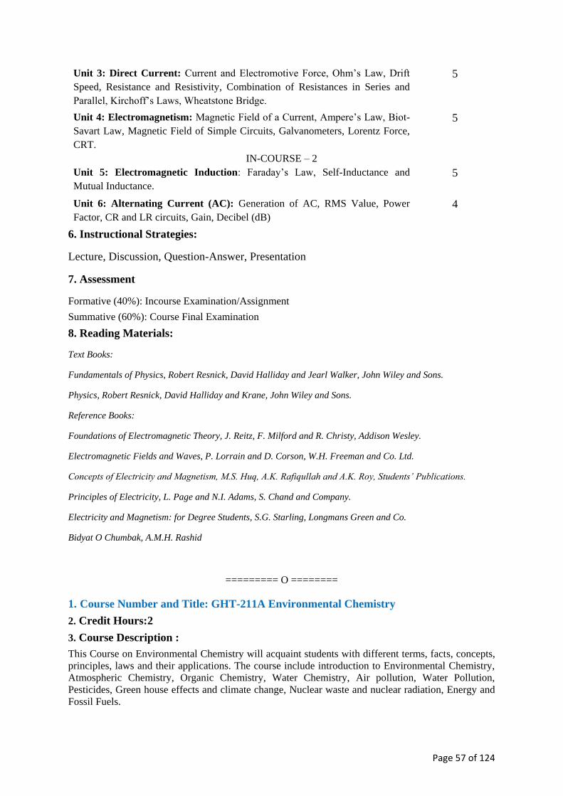
Page 57 of 124
Unit 3: Direct Current: Current and Electromotive Force, Ohm’s Law, Drift
Speed, Resistance and Resistivity, Combination of Resistances in Series and
Parallel, Kirchoff’s Laws, Wheatstone Bridge.
5
Unit 4: Electromagnetism: Magnetic Field of a Current, Ampere’s Law, Biot-
Savart Law, Magnetic Field of Simple Circuits, Galvanometers, Lorentz Force,
CRT.
5
IN-COURSE – 2
Unit 5: Electromagnetic Induction: Faraday’s Law, Self-Inductance and
Mutual Inductance.
5
Unit 6: Alternating Current (AC): Generation of AC, RMS Value, Power
Factor, CR and LR circuits, Gain, Decibel (dB)
4
6. Instructional Strategies:
Lecture, Discussion, Question-Answer, Presentation
7. Assessment
Formative (40%): Incourse Examination/Assignment
Summative (60%): Course Final Examination
8. Reading Materials:
Text Books:
Fundamentals of Physics, Robert Resnick, David Halliday and Jearl Walker, John Wiley and Sons.
Physics, Robert Resnick, David Halliday and Krane, John Wiley and Sons.
Reference Books:
Foundations of Electromagnetic Theory, J. Reitz, F. Milford and R. Christy, Addison Wesley.
Electromagnetic Fields and Waves, P. Lorrain and D. Corson, W.H. Freeman and Co. Ltd.
Concepts of Electricity and Magnetism, M.S. Huq, A.K. Rafiqullah and A.K. Roy, Students’ Publications.
Principles of Electricity, L. Page and N.I. Adams, S. Chand and Company.
Electricity and Magnetism: for Degree Students, S.G. Starling, Longmans Green and Co.
Bidyat O Chumbak, A.M.H. Rashid
========= O ========
1. Course Number and Title: GHT-211A Environmental Chemistry
2. Credit Hours:2
3. Course Description :
This Course on Environmental Chemistry will acquaint students with different terms, facts, concepts,
principles, laws and their applications. The course include introduction to Environmental Chemistry,
Atmospheric Chemistry, Organic Chemistry, Water Chemistry, Air pollution, Water Pollution,
Pesticides, Green house effects and climate change, Nuclear waste and nuclear radiation, Energy and
Fossil Fuels.

Page 58 of 124
4. Learning Outcomes:
By the end of the course, learners will be able to-
a. Introduce atmospheric chemistry, chemistry of water, toxic metals, organic chemistry &
pollutants, energy and fossil fuel, nuclear energy, nuclear radiation and nuclear waste.
b. Classify inorganic, organic and classical pollutants in the environment
c. Identify air pollution, water pollution, solid waste pollution, toxic metals, bad ozone & good
ozone
d. Describe greenhouse effect, climate change, nuclear energy, nuclear waste, energy, renewable
energy, fossil fuels and renewable fuels
e. Explain the origin of aerosols, smog, particulate matters, acid rains, ozone hole, global
warming and related phenomena
f. Analyze the features of water quality, organic pollutants and solid wastes
g. Express clear conceptions of pollutants and their effects on environment and on human health
5. Course Contents (Total 30 classes):
Unit/Chapter No of classes
Unit 1: Introduction to Environmental Chemistry 3
Unit 2: Introduction to Atmospheric Chemistry: The Troposphere and Air pollution,
Inorganic, Organic and Classical Air Pollutants, Particulate matters (PM), Aerosols,
Smogs and Regulations, Bad Ozone and Good Ozone, The Ozone Layer and The
Ozone Holes;
6
IN-COURSE - 1
Unit 3: Chemistry of Water: Ions in Water, Water Resources and Nutrients, Water
pollution, Toxic Metals Properties and Toxic Metal Analyses, Water Treatment and
water Analysis;
6
Unit 4: Introduction to Organic Chemistry: Organic Pollutants, Pesticides,
Analysing Organic Pollutants, Solid Waste Pollution, Persistent Organic Pollutants
(POPs)
6
IN-COURSE - 2
Unit 5: Greenhouse Effects and Climate Change 3
Unit 6: Energy and Fossil Fuels: Nuclear Energy, Nuclear Radiation, Nuclear
Waste, Renewable Energy and Renewable Fuels
4
6. Instructional Strategies:
Lecture, Discussion, Question-Answer, Presentation
7. Assessment:
Formative (40%): Incourse Examination/Assignment
Summative (60%): Course Final Examination
8. Reading materials

Page 59 of 124
Text Book:
Baird, C. & Cann, M. (2012) Environmental Chemistry (5th Edition). W. H. Freeman and Company.
Reference Books:
Manahan, Stanley E. “Environmental Science, Technology and Chemistry” (8th Edition). Boca Raton: CRC
press, LLC, 2000.
Girard, J. E. (2013) Principles of Environmental Chemistry (3rd Edition). Jones & Bartlett learning.
========= O ========
1. Course Number and Title: GHT-212A Calculus
2. Credit Hours: 2
3. Course Description:
Functions, graphs, limits of functions , derivatives, differentiation, applications of derivatives,
different theorems, functions of several variables, indefinite and definite integrals, applications of
integrations.
4. Learning outcomes:
By the end of the course, learners will be able to-
a. introduce with basic concept of calculus
b. describe different types of functions and their graphs
c. differentiate different types of functions
d. use derivative for practical problems of maxima and minima, rates, for calculating small
increments
e. differentiate partially functions of two or more variables integrate simple and complicated
functions
f. use reduction formulas for integration
g. apply definite integration for practical purposes, such as, for finding arc length, areas, volumes
and surfaces of solids of revolution.
5. Course Contents (Total 30 Classess)
Unit/Chapter No of classes
Unit 1: Functions and their graphs (polynomial) and rational functions, logarithmic
and exponential functions, trigonometric functions and their inverses, hyperbolic
functions and their inverses, combination of such functions).
4
Unit 2: Limits of functions: Definition. Basic limit theorems (without proofs).
Limit at infinity and infinite limits. Continuous functions. Properties of continuous
functions on closed and bounded intervals (no proof required)
2
Unit 3: Differentiation: Tangent lines and rates of change. Definition of derivative.
One-sided derivatives. Rules of differentiation (with applications). Related rates,
linear approximations and differentials. Taylor’s series. Successive differentiation
5

Page 60 of 124
IN-COURSE - 1
Unit 4: Leibnitz theorem. Rolle’s Theorem: Lagrange’s Mean Value Theorems.
Extrema of functions, problems involving maxima and minima.
4
Unit 5: Functions of two or more variables. Partial differentiation. 3
Unit 6: Integrals: Antiderivatives and indefinite integrals. Techniques of
integration. Definite integration using antiderivatives.
3
IN-COURSE - 2
Unit 7: Definite Integrals: Integration as a limit of a sum. The fundamental
theorem of calculus. Integration by reduction.
2
Unit 8: Application of integration: Plane areas. Volumes of solids of revolution.
Volumes by cylindrical shells. Volumes by cross-sections. Arc length and surface of
revolution.
5
6. Instructional Strategies
Lecture, Discussion, Question-Answer, Presentation
7. Assessment
Formative (40%): Incourse Examination/Assignment
Summative (60%): Course Final Examination
8. Reading Materials
Textbooks:
Anton, H., Bivens, I., David, S. : Calculus with Analytic Geometry (10th Edition). Wiley.
Reference Books:
Lang, S. (1998) A First Course in Calculus (5th Edition). Springer.
Swokowski, E.W. (1983) Calculus with Analytic Geometry (2nd Edition). Brooks/Cole.
Bers,L. & Karal, P. (1976) Calculus. Holt, Rinehart & Winston of Canada Ltd.
Thomas & Finney. Calculus
========= O ========
1. Course Number and Title: GHL-213 Optical Mineralogy Lab
2. Credit Hours: 2
3. Course Description:
The course provides a basic introduction to the optical properties of crystalline matter and to the
identification of minerals based on their optical properties using a polarizing microscope.
4. Learning outcomes:
By the end of the course, the learners will be able to:
a. Identify different parts of the polarizing microscope.

Page 61 of 124
b. Differentiate the optical properties of minerals.
c. Identify rock-forming minerals in thin sections.
d. Identify the double refraction that characterize anisotropic minerals.
e. Identify the minerals according to their optical properties
5. Course content (Total 24 Classes)
Unit/Chapter No of Classes
Unit 1: Polarizing microscope and its accessories 1
Unit 2: Identification of minerals based on their different optical properties 23
6. Instructional Strategies:
Laboratory work, Demonstration, Discussion, Question-Answer
7. Assessment:
Formative (40%): Attendance, Laboratory work, Submission of assignment/Lab note book
Summative (60%): Practical Examination
8. Reading Materials:
Textbook:
Kerr, P. F. (1977) Optical mineralogy (4th Edition). McGraw-Hill College.
References:
Nesse, W. D. (1991) Introduction to Optical Mineralogy (2nd Edition). Oxford University Press.
Shelley, D. (1985) Optical mineralogy (2nd Edition). Elsevier Science Ltd.
========= O ========
1. Course Number and Title: GHL-214 Sedimentary Petrology lab
2. Credit Hours: 2
3. Course Description:
This Course is designed [and intended] for learners / students of Bachelor of Science majoring in
Geology (Honours) for studying in detail the properties and attributes of sedimentary rocks, viz.,
clastics and nonclastics, in hand specimen and under the microscope. It broadly deals with the
determination/identification of texture, fabric, and sedimentary structures of the rocks. The
determination and documentation of types of stratal contact, inorganic, biogenic, imbrication, and
soft-sediment deformation structures, and top—bottom criteria form a major study of the Course. The
textural study includes mechanical analysis of conglomerates and sandstones, i.e., their particle-size
analysis, the graphical representation of data and statistical parameters in order to interpret the grain-
size parameters and their interrelationships. The Course includes separation of heavy minerals in
sandstones, microscopic study of light and heavy minerals, matrix, and cementing material.
Isodynamic technique/procedure/method is employed to study the magnetic/magnetically-susceptible
mineral species. The objective of the Course is to interpret the depositional environmental and
tectonic significance of the grain-size distribution and of the mineral suites, and classification of the
rock(s) under investigation.

Page 62 of 124
4. Learning outcome:
At the end of the course student should be able to:
a. Explain / describe laboratory analytical techniques including sample-preparation procedures,
dry- and wet-sieve methods, pipette analysis, graphical presentation and statistical analysis of
grain-size parameters, heavy-mineral separation, microscopic study and interpretation of
sedimentary rocks.
b. Determine / explain properties and attributes of sediment and sedimentary rocks, e.g., texture,
fabric, and other attributes of clastic and nonclastic rocks in hand-specimen and under
microscope (grain slides and thin-sections).
c. Characterize / identify the composition of the framework grains (minerals, lithic fragments),
matrices, and cement of the rock specimen / sample supplied; identify fossil content and biogenic
structures; name, classify, and suggest their origin.
d. Interpret the depositional environment of rock(s) under investigation.
5. Course content (Total 24 classes)
Unit/Chapter No of classes
Unit 1: Study of grain-size parameters and attributes – mechanical analysis
— sample preparation, dry- and wet-sieve analyses of sand and sandstone;
silt and clay analyses by using hydrometer / pipette, and particle-size
analyser; graphical representation and statistical analysis and
interrelationships of grain-size parameters, and their (environmental)
interpretation.
5
Unit 2: Separation / analysis of heavy minerals, preparation of individual
grain slides for the light and heavy minerals; microscopic study —
identification of the light and heavy minerals, matrices, and cementing
agent/material (use of resin and reagent), and interpretation of the heavy-
mineral suites (for correlation and provenance studies).
5
Unit 3: Thin-section [microscopic] study of clastic and nonclastic rocks —
preparation of rock slides (thin sections) to identify and characterise the
texture, structure, composition (framework grains / crystals, matrices
and/or cement) of the rock specimen supplied; mineral-suites; origin,
name, and classification of the rock based on thin-section petrography.
8
Unit 4: Carbonate analyses; coal petrography 4
6. Instructional strategies:
Laboratory work, Demonstration, Discussion, Question-Answer
7. Assessment:
Formative (40%): Attendance, Laboratory work, Submission of assignment/Lab note book
Summative (60%): Practical Examination
8. Reading Materials:
Textbook(s):
Same as in / as given for Course GHT 203: Descriptive Sedimentary Petrology
Reference books:

Page 63 of 124
Folk, R.L. (1980) Petrology of sedimentary rocks. Hemphill Publishing Company.
Milner, H.B. (1962) Sedimentary petrography (vols. I and II) (4th revised edition). George Allen & Unwin Ltd.,
London, (UK).
Bouma, A.H., (1969) Methods for the study of sedimentary structures. Wiley-Interscience, New York.
Carver, R.E., ed., (1971) Procedures in sedimentary petrology. Wiley-Interscience, New York; Sydney.
Tickell, F.G. (1965) The techniques of sedimentary mineralogy. Developments in sedimentology 4. Elsevier
Publ. Co., Amsterdam.
Carozzi, A. V. 1993. Sedimentary petrography. Upper Saddle River, NJ: Prentice-Hall. 263 pp.
Adams, A.E., W.S .eiznMkcaM ,ikd a . daoflid (891 4) Atlas of sedimentary rocks under the microscope.
Routledge.
Bromley, R. G. 1996. Trace fossils: Biology, taphonomy, and applications. Chapman and Hall, London, 361p.
========= O ========
1. Course Number and Title: GHL-215 Structural Geology Lab
2. Credit Hours: 2
3. Course Description:
This course is designed in accordance with the theory course GHT 209: Structural Geology and to
develop a good background for geological field mapping course. Laboratory exercises will be used
in measuring and describing geological structures, including numerical problems, thickness and
depth calculation, structural analysis with streonet; tectonics and plate tectonic problems.
The objective of this course will be to introduce the fundamentals of structural analysis including
kinematic and dynamic analytical techniques. The lab period will be devoted to a review of previous
assignments and demonstration on and hands-on practice of new problem material. All assignments
are to be done as independent work.
4. Learning Outcomes:
By the end of the course, learners will be able to
a. understand the 3-dimensional aspect of structural elements in complex geological set up.
b. solve different structural and tectonic problems.
c. determine the stratigraphic thickness and depth of the stratum in different field conditions.
d. apply knowledge in field geology.
e. explain the deformation process and determination of principal stress axes.
f. recognize and classify geologic structures associated with folding and
fracturing of the lithosphere.
5. Course Contents (Total 24 classes)
Unit/Chapter No. Of Classes
Unit 1: Introduction to course contents. 1
Unit 2: Numerical problems 6
Unit 3: Thickness and Depth calculation 6

Page 64 of 124
Unit 4: Structural analyses with stereonet 7
Unit 5: Problems related to tectonics, plate tectonics and Euler pole. 8
6. Instructional Strategies: Laboratory work, Demonstration, Discussion, Question-Answer
7. Assessment:
Formative (40%): Attendance, Laboratory work, Submission of assignment/Lab note book
Summative (60%): Practical Examination
8. Reading Materials
Text books:
Billings, M. P. 1972. Structural geology. Prentice Hall College Div.
Ragan, D.M. 2009. Structural Geology and Introduction to Geometrical Techniques. Blackwell.
References:
Rowland, S.M; Duebendorfer, E.M. and Schiefelbein, I.M. (2007) Structural Analysis and Synnthesis: A
Laboratory Course in Structural mGeology (3rd Edition). Elsevier.
Fossen, H. (2010) Structural Geology. Cambridge University Press.
Allison, D.T. (2015) Structural Geology Laboratory Manual (4th
Edition). University of South Alabama.
========= O ========
1. Course Number and Title: GHF-216 Geological Field Mapping
2. Credit Hours: 2
3. Course Description:
A seven days long field trip in the hill tracts region in Bangladesh where there are extensive exposure
of Mio-Pliocene sedimentary strata. Emphasis will be on understanding and mapping large-scale
geological structures such as folds, faults, and unconformity, identification and mapping of various
stratigraphic formations, identification and interpretation of sedimentary structures, and deduction of
processes producing those sedimentary structures.
4. Learning Outcomes: By completing this course students will be a able to –
a. Locate and map geological exposure.
b. Measure bed attitude.
c. Map bed attitude data and deduce geological structure.
d. Construct geological sections at exposure scale and correlate them.
e. Prepare a complete geological map showing various structures, and stratigraphic formations.
f. Identify and differentiate between various sedimentary structures.
g. Interpret the processes responsible for producing various sedimentary structures.
5. Course Content: Unit/Chapter
Unit 1: Preparation for field work- Expectations and reality in the field;
list of field equipment, and base maps; code of conduct in the field;
Three one hour
long lectures

Page 65 of 124
formation of various field committees.
Unit 2: During the field work- Visit selected areas to view the general
geology and to learn field observation,documentation, and mapping skills;
Mapping exercise on a mesoscopic scale; standards and technique for
taking field notes; construction of lithological columns, correlation of
lithological sections constructed at various locations, summarize and plot
field data on the map at the end of daily field trip.
5 days field
work and 2 days
travel
Unit 3: After the Field- Instructions on laboratory analysis of field data,
completion of the geological map, and construction of geological cross
section showing large-scale geological structure; writing field report.
Five one hour
long lectures
6. Instructional Strategies: Hands on exercise, on site lectures, and discussions.
7. Assessment: Continuous assessment (40%)
Field conduct 20%
Field Viva 20%
Summative Assessment (60%)
Field report
8. Reading Materials: Lisle, R.J., Brabham, P.J., Barnes, J.W. & (2011) Basic Geological Mapping (5th Edition). Wiley-Blackwell.
Coe, A.L. (2010) Geological Field Techniques. John Wiley & Sons.
Barnes, J.W. & Lisle, R.J. (2004) Basic Geological Mapping (4th Edition). John Wiley & Sons.
McClay, K.R. (1987) The Mapping of Geological Structures (Reprinted 2007). John Wiley & Sons.
Compton, R.R. (1962) Manual of Field Geology. Wiley.
Lahee, F.H. (1961) Field Geology (6th Edition). McGraw-Hill Book Co.
Low, J.W. (1957) Geological Field Methods. Harper & Bros.
Pettijohn, F.J. (2004) Sedimentary Rocks (3rd edition). CBS Publisher.
Tucker, M. E. (Ed.) (2013) Sedimentary petrology: an introduction to the origin of sedimentary rocks (3rd
Edition). John Wiley & Sons.
Boggs, S. Jr. (2014) Principles of sedimentology and stratigraphy (5th Edition). Pearson.
Reimann, K. U. (1993) Geology of Bangladesh. Gebruder Borntraeger Verlagsbuchhandlung, Science
Publishers.
Khan, F. H. (1991). Geology of Bangladesh. Wiley Eastern.
========= O ========
1. Course No. and Title: GHV-217 Viva voce
Viva voce will be conducted towards the end of the academic year which will be covering the
complete syllabus. This will assess the student’s knowledge and understanding during the course of
their graduate programme. In doing so, the main objective of this course is to prepare the students to
face interview both at the academic and the professional arenas.
========= O ========

Page 66 of 124
Third Year
(Honours)

Page 67 of 124
1. Course Number and Title: GHT-301 Igneous and Metamorphic Petrology
2. Credit Hours: 2
3. Course Description:
The course provides the students with the fundamental knowledge on the processes involved in the
formation of Igneous and Metamorphic rocks; their texture, structure, composition and classification.
It also deals with geological and economic importance of Igneous and Metamorphic rocks.
4. Learning outcomes:
At the end of the course the learners will be able to
a. Explain the processes and order of crystallization in magma;
b. Classify igneous rocks and describe different types of Igneous rocks;
c. Know the occurrence, association and origin of Igneous rocks;
d. Define Metamorphism and Metamorphic processes;
e. Classify metamorphic rocks and describe different types of Metamorphic rocks;
f. Describe and differentiate Metamorphic Zones, Facies and Grades;
g. Comprehend the geological and economic significance of Igneous and Metamorphic rocks.
5. Course content: (Total 30 Classes)
Unit/Chapter No of classes
Igneous Petrology
Unit 1: Magma: Composition, Constitution and Differentiation.
Unit 2: Reaction Relation and Crystallisation of Magma: Binary and Ternary
Systems.
Unit 3: Texture, Structure, and Classification of Igneous rocks.
Unit 4: Composition, Description and Occurrences of important Acid, Intermediate,
Basic and Ultrabasic Igneous rocks.
IN-COURSE - 1
Unit 5: Origin and Petrotectonic Associations of Igneous rocks.
Metamorphic Petrology
Unit 1: Metamorphism- Agents of Metamorphism; Metamorphic Processes.
Unit 2: Texture, Structure, Composition, Classification and description of
Metamorphic Rocks.
IN-COURSE - 2
Unit 3: Metamorphic Differentiation, Metasomatism and Granitisation.
Unit 4: Metamorphic Zones, Facies, and Grades; Mineral Assemblages and
important Reactions in different Facies.
Unit 5: Origin and Petrotectonic Association of Metamorphic rocks.
2
3
3
3
3
3
4
2
3
2
6. Instructional Strategies: Lecture, Discussion, Question-Answer, Presentation
7. Assessment : Formative (40%): Incourse Examination/Assignment
Summative (60%): Course Final Examination
8. Reading Materials:

Page 68 of 124
Textbook:
Best, M.G. (2002) Igneous and Metamorphic Petrology (2nd Edition). Wiley-Blackwell.
References:
Winker, H.G.F. (2013) Petrogenesis of Metamorphic Rocks (4th Edition). Springer Science & Business Media.
Philpotts, A. (2003) Petrography of Igneous and Metamorphic Rocks. Waveland Press.
Hyndman, D.W. (1985) Petrology of Igneous and Metamorphic Rocks (2nd Edition). McGraw-Hill international
series in the earth and planetary sciences.
Winter, J.D. (2001) An Introduction to Igneous and Metamorphic Petrology. Prentice Hall.
Best, M.G. and Christiansen, E.H. (2000) Igneous Petrology. Wiley-Blackwell.
Turner F.J. (1981) Metamorphic Petrology (2nd Edition). Hemisphere Pub. Corp.
Hatch, F.H. and Wells, A.K. (1973) The Petrology of Igneous Rocks (13th Edition). Thomas Murby& Co.
Spry, A. (1969) Metamorphic Textures.Pergamon Press.
Turner, F.J. and Verhoogan, J. (1960) Igneous and Metamorphic Petrology (2ndEditon). McGraw-Hill.
Bowen, N. (1928) The Evolution of Igneous rocks. Dover Publications.
========= O ========
1. Course Number and Title: GHT-302 Regional Geology
2. Credit Hours: 2
3. Course Description:
The course is designed to introduce to the students of Bachelor of Science (Honours) in Geology the
tectonic-geologic setting of the south Asian region, i.e., Indian subcontinent (Pakistan, India proper,
Nepal, Bhutan, Bangladesh and Myanmar) and the Himalayan Orogen as well as the Indian Ocean. It
systematically describes and discusses the Hadean to Cenozoic stratigraphy, geochemistry, structure
and tectonics of the various Cratonic blocks and platform deposits of the Indian protocontinent and
later geologic events. A major focus is given on physical (inorganic) and biological events of the
region including Gondwana and Deccan deposits as well as Cretaceous/Tertiary extinction events
(paleontological evolution of Gondwana flora, extinction of dinosaurs). It also entails the climatic
vicissitudes and amelioration during the Paleozoic- Mesozoic time and the corresponding deposits.
The Northeastern India particularly the Meghalaya/Shillong Massif, Assam Shelf and Tripura,
Manipur, Mizoram, Cachhar along with the Belt of Schuppen areas are also discussed highlighting the
tectonic-geologic episodes from Archean to Tertiary.
4. Learning Outcomes:
By the end of the Course, students will be able to
a. Understand the tectono-geologic framework of the South Asia.
b. Learn through stratigraphic and geochemical context the evolution of the South Asia
c. Know the origin of the Indian proto-continent: its cratons — shield, platform, intervening and
peripheral fold belts — and their secular and temporal variations and distributions
d. Unearth the ancient supercontinents and their break-ups through geologic times
e. Correlate local, regional, interregional, and global events sequentially (in terms of geologic
time), in particular

Page 69 of 124
f. Interpret the gaps (hiatuses) in the stratigraphic successions.
g. Analyze (compare and contrast) and correlate the evolution of continents, atmosphere,
hydrosphere (oceans), and biosphere
h. Recognize/identify the tectonic — geological evolution of the Himalayan Orogen and the
Indian Ocean
i. Apply this knowledge and comprehension to the potential occurrences and extensions of
mineral resources in order to exploit / mine these Earth resources.
j. Explain the Indo-Burman Orogen and the occurrences of flysch, molasse and ophiolite in Indo-
Burman fold belt.
k. Discuss the geology and tectonics of Shillong /Meghalaya craton, Assam, Mizoram, Tripura
and Cachhar and the Dauki Fault and their implications to the evolution of Bangladesh/Bengal
Basin.
5. Course Contents (Total 30 Classes)
Unit/Chapter No of classes
Unit 1: General introduction – Physiography, structure, and stratigraphy of the
Peninsular, Extra-peninsular, and Indo-Gangetic Trough
3
Unit 2: Hadean-Archaean synopsis of Indian subcontinent; Low- and high-grade
basement units; Archaean cratons of the Peninsular India
3
Unit 3: Geology and tectonics of the Dharwar craton; its subdivision; generalised
stratigraphy of the Dharwar Craton; description of the rock units (igneous,
sedimentary, and metamorphic) and their interpretation
3
Unit 4: Proterozoic — Eastern and Western Ghats Fold Belts; Vindhyan Geology;
evolution of the Cuddapah Basin
3
IN-COURSE - 1
Unit 5: Gondwana geology of the Indian subcontinent — meaning of the term
Gondwana; Geological evolution; climatic vicissitudes and amelioration (cold, glacial
to arid, semi-arid conditions through fluvial and lacustrine deposits); palaeontogical
characteristics; structure and stratigraphy, Damodar-Basin succession; coal deposits
of the Gondwanas; and major palaeontogical evolutions and extinctions
5
Unit 6: Deccan Continental Flood Basalt Province (DCFBP) — geology,
stratigraphy; Cretaceous — Tertiary (K/T) extinctions of dinosaur and other fauna
and flora
3
IN-COURSE - 2
Unit 7: The Himalayas: Geology, structure and subdivisions, Nappes, overthrusts,
plutonism and metamorphism; interpretation and Plate-tectonic evolution. Geology of
the Shillong/Meghalaya; the Dauki Fault, Archaean to Tertiary stratigraphy; Geology
of Assam—Arakan Basin; Structure and stratigraphy of the Assam Shelf/Upper
Assam Valley, the Schuppen Belt, The Assam—Arakan Fold Belt; Geology of
Tripura—Cachhar—Mizoram; Flysch, molasse and ophiolite and their occurrences in
the Indo-Burman Ranges; Accretionary prism — Palaeogene and Neogene
accretionary prisms in the Indo—Burman Orogen.
8
6. Instructional Strategies:
Lecture, Discussion, Question-Answer, Presentation
7. Assessments:

Page 70 of 124
Formative (40%): Incourse Examination/Assignment
Summative (60%): Course Final Examination
8. Reading Materials
Textbook:
Krishnan, M.S. (2006) Geology of India and Burma (6th Edition). CBS Publishers & Distributors.
References:
Sharma, R.S. (2009) Cratons and fold belts of India. Lecture Notes in Earth Sciences 127, Springer-Verlag,
Berlin (Germany).
Naqvi, S.M. (2005) Geology and evolution of the Indian plate: from Hadean to Holocene — 4 Ga to 4 Ka.
Capital Publishing Co., New Delhi, India, 450p.
Kumar, R. (1998) Fundamentals of Historical Geology and Stratigraphy of India. New Age.
Wadia, D.N. (1975) Geology of India (4th Edition). McGraw-Hill, Inc.
Gignoux, M. (1955) Stratigraphic Geology. W H Freeman.
Chibber, H.L. and Ramamirtham, R. (1934) The Geology of Burma. Macmillan and Co.
========= O ========
1. Course Number and Title: GHT-303 Oceanography and Marine Geology
2. Credit Hours: 2
3. Course Description:
This course is an applied course designed primarily for students. However, it also meets the need of
students in other fields, as a course that provides introduction to world oceans, basic understanding
in the physical, chemical and biological aspects of these oceans and various geological processes
that is going on in the oceans. Topics to be covered include world ocean and physical, chemical and
biological oceanography; physiography of world oceans; plate tectonics as it relates to oceans;
ophiolite complexes; coastal processes, deep sea sediments; mineralization in the oceans and
methods of ocean floor sampling.
4. Learning outcomes:
Upon successful completion of this course, the student will be able to: (Knowledge based)
a. know the different types of the world oceans and their fundamental properties;
b. classify and explain the physiographic provinces of the oceans;
c. understand the physical and other geological processes going on in the world oceans;
d. understanding of data acquisition methods in marine environments
e. interpret the various types of data that have been acquired in marine environments
f. use the data to manage the coastal environments.
5. Course contents: (Total 30 Classes)
Unit/Chapter No of classes
Unit 1: Introduction; Scope; Origin and Distribution of Oceans; 3
Unit 2: Ocean Morphology---Physical Features of Deep-ocean Floor-Ocean Ridges, 3
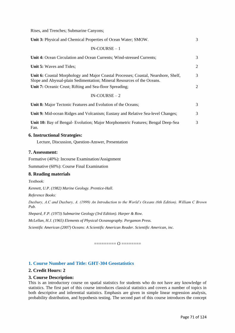
Page 71 of 124
Rises, and Trenches; Submarine Canyons;
Unit 3: Physical and Chemical Properties of Ocean Water; SMOW. 3
IN-COURSE – 1
Unit 4: Ocean Circulation and Ocean Currents; Wind-stressed Currents; 3
Unit 5: Waves and Tides; 2
Unit 6: Coastal Morphology and Major Coastal Processes; Coastal, Nearshore, Shelf,
Slope and Abyssal-plain Sedimentation; Mineral Resources of the Oceans.
3
Unit 7: Oceanic Crust; Rifting and Sea-floor Spreading; 2
IN-COURSE – 2
Unit 8: Major Tectonic Features and Evolution of the Oceans; 3
Unit 9: Mid-ocean Ridges and Volcanism; Eustasy and Relative Sea-level Changes; 3
Unit 10: Bay of Bengal- Evolution; Major Morphometric Features; Bengal Deep-Sea
Fan.
3
6. Instructional Strategies:
Lecture, Discussion, Question-Answer, Presentation
7. Assessment:
Formative (40%): Incourse Examination/Assignment
Summative (60%): Course Final Examination
8. Reading materials
Textbook:
Kennett, U.P. (1982) Marine Geology. Prentice-Hall.
Reference Books:
Duxbury, A.C and Duxbury, A. (1999) An Introduction to the World’s Oceans (6th Edition). William C Brown
Pub.
Shepard, F.P. (1973) Submarine Geology (3rd Edition). Harper & Row.
McLellan, H.J. (1965) Elements of Physical Oceanography. Pergamon Press.
Scientific American (2007) Oceans: A Scientific American Reader. Scientific American, inc.
========= O ========
1. Course Number and Title: GHT-304 Geostatistics
2. Credit Hours: 2
3. Course Description: This is an introductory course on spatial statistics for students who do not have any knowledge of
statistics. The first part of this course introduces classical statistics and covers a number of topics in
both descriptive and inferential statistics. Emphasis are given in simple linear regression analysis,
probability distribution, and hypothesis testing. The second part of this course introduces the concept

Page 72 of 124
of spatial statistics and expands on various techniques of spatial data analysis including
Geovisualization, Point Pattern Analysis, Spatial Interpolation (Inverse Distance Method, Kriging),
Spatial Regression, and Stochastic Simulations. Students are also introduced to basic features and
applications of a number of statistical and geostatistical software including SPSS, Matlab, Surfer, Arc
GIS Spatial Analyst, Rockware, R-programme, and Gems.
4. Learning Outcomes:
By completing this course students will be a able to –
a. Perform basic statistical calculations and graphical analyses
b. Recognize and apply some common probability distributions, and assess if underlying
assumptions for the distribution seem reasonable.
c. Analyse research questions based on statistical data, draw relevant conclusions, and be familiar
with the limitations of particular statistical methods.
d. Recognize spatial pattern in data
e. Compare and contrast various spatial estimation techniques
f. Formulate statistical models for simple spatial phenomena
5. Course Content: (Total 30 Classes)
Unit/Chapter No of classes
Unit 1: Introduction to statistics, data, variables, population, samples etc. 1
Unit 2: Summarizing Data – graphical and numerical methods (central tendency and
dispersion).
2
Unit 3: Probability and Probability Distribution: basic concepts and rules of
probability; binomial distribution, geometric distribution, hypergeometric distribution,
Poisson distribution, T-distribution, and normal distribution.
4
Unit 4: Estimation and Hypothesis testing: Estimation of population parameter from
sampling distribution, Hypothesis Testing (t-test and Chi-square test).
4
IN-COURSE - 1
Unit 5: Regression analysis: Detail of simple linear regression analysis and basics of
multiple regression analysis.
3
Unit 6: Spatial statistics: Spatial Statistics: Introduction, Scopes and Applications of
Geostatistics; Exploratory Data Analysis
2
Unit 7: Spatial Data Analysis: Geovisualization, Point Pattern Analysis, spatial
autocorrelation
4
IN-COURSE - 2
Unit 8: Spatial Interpolation: Proximity polygons, Nearest Neighbour, Inverse
Distance Weighted Method, Kriging, and Splines.
4
Unit 9: Introduction to Spatial Regression and Stochastic Simulations. 2
Unit 10: Geostatistical Software: Basic features and applications of the following
softwares – SPSS, Matlab, Surfer, Arc GIS Spatial Analyst, Rockware, R-programme,
sGems.
2
6. Instructional Strategies:

Page 73 of 124
Lecture, Discussion, Question-Answer, Presentation
7. Assessment:
Formative (40%): Incourse Examination/Assignment
Summative (60%): Course Final Examination
8. Reading Materials:
Textbook:
Mann, P. S. (2013). Introductory statistics (8th Edition). John Wiley & Sons
O'sullivan, David, and David Unwin (2014). Geographic information analysis (2nd Edition). John Wiley &
Sons.
Reference Books:
Montgomery, D. C., Peck, E. A., & Vining, G. G. (2015) Introduction to linear regression analysis. John Wiley
& Sons.
Remy, N., Boucher, A., & Wu, J. (2009) Applied geostatistics with SGeMS: A user's guide. Cambridge
University Press.
Vivand, R.S., Pebesma, E.J., Gomez-Rubio, V (2008) Applied Spatial Data Analysis with R. Springer.
Trauth, M.H. (2007) MATLAB Recipes for Earth Sciences. Springer.
Davis, J.C. (2002) Geostatistics and Data Analysis in Geology (3rd Edition).
Olea, R.A. (1999) Geostatistics for Engineers and Earth Scientists. Kluwer Academic Publishers.
Kitanidis, P.K. (1997) Introduction to Geostatistics: Applications in Hydrogeology. Cambridge University
Press.
Goovaerts, P. (1997) Geostatistics for Natural Resources Evaluation. Oxford University. Page 17 of 28
Wiley.Helsel, D.R. & Hirsch, R.M. (1992) Statistical Methods in Water Resources. Elsevier.
Isaaks, E.H. & Srivastava, R.M. (1989) An Introduction to Applied Geostatistics. Oxford University Press.
========= O ========
1. Course No. and Title: GHT-305 Mineral Resources of Bangladesh and Subcontinent
2. Credit Hours: 2
3. Course Description:
This is a course designed to impart scientific and technical knowledge on the distribution, occurrence,
stratigraphy, reserves, exploration, production/mining of various mineral resources of Bangladesh and
Sbucontinent. The aim of the course is to make the students acquainted with the uses of petroleum,
coal, ore deposits, placer, hard rock glass sand, limestone, china clay and other economic mineral
deposits in industries and infrastructure development of Bangladesh and Subcontinent.
4. Learning outcomes:
By the end of the course, the learners will be able to
a. Introduce to mineral resources of Bangladesh and subcontinent
b. Explain non-renewable and renewable energy sources

Page 74 of 124
c. Describe the occurrences, distribution, stratigraphic relationship, reserves and uses of mineral
deposits
d. Understand the geology and reserves of gas, oil and coal fields and their prospects in
mitigating energy crisis of Bangladesh and Subcontinent
e. Acquire technical knowledge to mine coal, hardrak, limestone, placer, glass sand, white clay
and many other ore deposits
f. Describe important ore deposits and energy resources, their occurrences, stratigraphic in
relationship, reserves, mining and uses in India
g. Compare and contrast between mineral resources of Bangladesh and India
5. Course contents (Total 30 Classes)
Unit/Chapter No of classes
Unit 1: Introduction to mineral resources of Bangladesh and Subcontinent 2
Unit 2: Petroleum resources of Bangladesh, their stratigraphy, properties, exploration
history, reserves, production and consumption
5
Unit 3: Coal deposits of Bangladesh, their origin, distribution, stratigraphic
relationship, reserves and mining.
4
IN-COURSE - 1
Unit 4: Importance of solar, wind, biomass and water resources in Bangladesh 2
Unit 5: Hard rock, Limestone, placer, china clay and glass sand deposits in
Bangladesh
4
Unit 6: Coal and Petroleum resources of India – their stratigraphy, reserves,
production and uses
4
IN-COURSE - 2
Unit 7: Iron, Aluminium and Copper ore deposits of India – their stratigraphic
relationship, origin, reserves, production and uses.
5
Unit 8: Contribution of mineral resources to industrial prosperity and economic
progress of India and Bangladesh
2
6. Instructional strategies:
Lecture, discussion, question-answer and assignment.
7. Assessment:
Formative (40%): Incourse Examination/Assignment
Summative (60%): Course Final Examination
8. Reading materials:
Textbook:
Imam, B (2005) Energy Resources of Bangladesh - Natural Gas, Oil and Coal. University Grants Commission
of Bangladesh.
Reference Books:
Racey, A. & Ridd, M.F. (2015) Petroleum Geology of Myanmar. Geological Society of London.
Tyner, W.E. (2012) Energy resources and economic development in India. Springer Science & Business Media.
Banarjee, D.K. (1998) Mineral Resources of India. World Press Private Limited.
Page 75 of 124
Sinha, R.K. and Sharma, N.L. (1970) Mineral Economics: A Text Book for University. Oxford & IBH Publishing
Company.
Beyschlag, F.H.A., et al. (1914) The Deposits of the Useful Minerals and Rocks. Macmillan and co., limited.
Rahman, A. () History of discoveries of mineral resources of Bangladesh (in Bangla).
========= O ========
1. Course Number and Title: GHT-306 Principles of Sedimentary Petrology
2. Credit Hours: 2
3. Course Description:
The Course is aimed at providing the learners of the Third Year Bachelor of Science majoring (with
Honours) in Geology with all the facets of the sedimentary rocks, such as from their origin, nature,
types, classifications, on the basis of megascopic/macroscopic down to microscopic properties and
attributes. The Course describes and discusses the procedures, practices of systematics of the
sedimentary rocks including sedimentary texture, fabric, interrelationships, structure, and composition
of the rocks. Types of fluids, fluid flows are also differentiated and related to the lithosomes.
Sediment gravity flows, their classification, and associated facies are also treated at some length.
Interpretation of provenance (source area/rock, relief, climate) is another major aspect of this Course.
4. Learning Outcomes :
By the end of the Course, students will be able to
a. Learn fundamental properties of fluids, their types, and explain the types of fluid motions and the
types of sediment gravity flows
b. Learn the concept of flow regimes; explain the types of sedimentary deposits in terms of the types
of fluid flow
c. Acquire / gain knowledge of the sediment texture, fabric, and packing; processes governing
sediment texture and other attributes
d. Identify / recognize and explain the kinds of sedimentary structures and the processes responsible
for their formation
e. Understand the differences between scalar and directional properties of sediment and their
palaeocurrent significance
f. Interpret the tectonic controls on sedimentation and basin formation and evolution.
5. Course Contents (Total 30 Classes)
Unit/Chapter No of classes
Unit 1: Sedimentary processes, properties of fluids, types of fluids and fluid motions 4
Unit 2: Flow regime — concept, definition, types; bed forms and interpretation; types
of fluid flows and their deposits (and associated facies)
4
Unit 3: Textural and other properties and attributes of sediment and their
measurement, interrelationships and representations; processes controlling these
properties and attributes
5

Page 76 of 124
IN-COURSE - 1
Unit 4: Sedimentary structures — primary depositional (inorganic — physical,
chemical biochemical, organic / biogenic), secondary / soft-sediment deformation
structures, and processes responsible for their development (interpretation)
4
Unit 5: Sediment gravity flows — their origin, types, classification, description, and
occurrences
IN-COURSE - 2
3
Unit 6: Palaeocurrent analysis —various attributes and directional properties of
sediment as criteria for palaeocurrent interpretation
5
Unit 7: Factors controlling sedimentation — tectonics, subsidence, climate, and sea-
level changes
5
6. Instructional Strategies:
Lecture, discussion, question-answer and assignment.
7. Assessment: Formative (40%): Incourse Examination/Assignment
Summative (60%): Course Final Examination
8. Reading Materials Text books:
Pettijohn, F.J. (1975) Sedimentary rocks. 3 edn., Harper & Row, Publishers, New York (USA), London (UK).
References:
Tucker, M. E. (ed.) (2013) Sedimentary petrology: an introduction to the origin of sedimentary rocks. 3 edn.
John Wiley & Sons.
Leeder, M.R. (1982) Sedimentology ― Process and product. 3 edn., Springer.
Scoffin, T. P. (1987) Introduction to carbonate sediments and rocks. The University of California.
Folk, R. L. (1980) Petrology of sedimentary rocks. Hemphill Publishing Company.
Friedman, G.T. and Sanders, J.E. (1978) Principles of sedimentology. Wiley.
Pettijohn, F. J., Potter, P. E., and Siever, R. (1973) Sand and sandstone. Springer Science & Business Media.
Blatt, Harvey, Middle, G.V., and Murray, Raymond (1980). Origin of sedimentary rocks. Prentice-Hal.
Twenhofel, W.H. (1960) Principles of sedimentation. 2 edn., McGraw-Hill.
Shrock, R.R. (1948) Sequence in layered rocks. McGraw-Hill.
========= O ========
1. Course Number and Title: GHT-307 Principles of Hydrogeology
2. Credit Hours: 2
3. Course Description: Introduction to the theory and principles of groundwater flow. Topics include Origin and Occurrence
of Groundwater: Distribution of Groundwater, Geologic Formations as Aquifers, Aquifer Systems
and Terminology; Aquifer properties; Darcy's Law; Hydraulic Conductivity and Hydraulic Head;
Homogeneity and Heterogeneity, Isotropy and Anisotropy; Flow Nets; Groundwater flow patterns;

Page 77 of 124
Recharge and Discharge; Groundwater-surface water interactions; Groundwater Flow Equation,
storage, and subsidence; Aquifer response to pumping; pumping tests and analytical solutions for flow
to a well (Thiem and Theis solutions); Linear superposition and image well theory; Variable Density
Flow; Flow in Unsaturated zones; Introduction to the concept of numerical modelling of groundwater
flow. Contaminant Transport: Advection, Diffusion, Dispersion, Fick’s law, Retardation, Ogata
Equation.
4. Learning Outcomes:
By completing this course students will be able to –
a. Describe the processes in the hydrologic cycle and explain how rates of each are quantified.
b. Estimate values of porosity, effective porosity, specific yield, specific retention, permeability,
and hydraulic conductivity for any given type of porous medium.
c. Distinguish between wells and piezometers, and explain what determines water levels as
measured by each.
d. Apply Darcy’s Law to describe the interactions between ground water discharge, hydraulic
conductivity, cross-sectional area of flow, and hydraulic gradient.
e. Draw plan view and cross-sectional flow nets based on boundary conditions and/or hydraulic
head data.
f. Calculate the flow of water to a well.
g. Interpret pumping test and slug test data to estimate aquifer transmissivity and storativity.
h. Describe the movement of contaminant in groundwater
i. Apply the contaminant transport equation to characterize/track a contaminant plume in
groundwater.
j. Evaluate quantitative solutions to hydrogeological problems to determine if they fall within a
reasonable range of values.
k. Evaluate quantitative solutions to hydrogeological problems to estimate sources of uncertainty
and magnitude of error.
5. Course Content: (Total 30 Classes)
Unit/Chapter No of classes
Unit 1: Introduction: Groundwater in hydrologic cycle, Origin and Occurrence of
Groundwater, Distribution of Groundwater, Geologic Formations as Aquifers, Aquifer
Systems and Terminology, Aquifer properties.
5
Unit 2: Principles of groundwater flow: Darcy's Law; Hydraulic Conductivity and
Hydraulic Head, Homogeneity and Heterogeneity, Isotropy and Anisotropy, Flow
Nets, Groundwater flow patterns, Recharge and Discharge, Groundwater-surface water
interactions, Groundwater Flow Equation, storage, and subsidence
IN-COURSE – 1
8
Unit 3: Aquifer response to pumping: Pumping tests and analytical solutions for
flow to a well (Thiem and Theis solutions); linear superposition and image well
theory, slug test.
5
Unit 4: Variable density flow and flow in unsaturated zone.
IN-COURSE - 2
4

Page 78 of 124
Unit 5: Introduction to the concept of numerical modelling of groundwater flow 4
Unit 6: Contaminant Transport: Advection, Diffusion, Dispersion, Fick’s law,
Retardation, Ogata Equation.
4
6. Instructional Strategies:
Lecture, discussion, question-answer and assignment.
7. Assessment:
Formative (40%): Incourse Examination/Assignment
Summative (60%): Course Final Examination
8. Reading Materials:
Textbook:
Fetter, C.W. (2014) Applied Hydrogeology (4th International Edition). Pearson.
Reference Book:
Kevin M. Hiscock, Victor F. Bense (2014) Hydrogeology: Principles and Practice (2nd Edition). Wiley.
Raghunath, H.M. (1987) Groundwater. New Age International.
Marsily, G. de (1986) Quantitative Hydrogeology: Groundwater Hydrology for Engineers. Academic Press.
Freeze, R.A. & Cherry, J.A. (1979) Groundwater. Prentice Hall.
========= O ========
1. Course Number and Title: GHT-308 Micropaleontology and Palynology
2. Credit Hours: 2
3. Course Description:
Micropaleontology covers all the major marine microfossil groups - foraminifera, coccolithophores,
dinoflagellates and ostracoda – as well as terrestrial pollen and spore communities. One of the most
fascinating aspects - and perhaps underappreciated by most people - is how landscapes change over
time in terms of the plant life that grows there. Students can learn much about the landscape itself,
the natural and human history of that landscape (including the changes it has undergone as a
result of natural or human processes), and of the changing climate and what impact that has upon
plant life. Flora - trees, flowers, grasses, mosses, lichen and even fungi have environmental conditions
that they prefer and other conditions in which they will not survive for very long. Moving from a dry
to wet climate (or vice versa), from temperate to ice age (or vice versa) and even whether and when
a piece of land was once tidal salt marsh but is now pasture, can all affect the makeup of the
landscape's flora.
4. Learning Outcomes:
On completion of this course, the student will be able to:
a. to reconstruct long-term macroevolutionary patterns,
b. short-term ecosystems perturbations and the relationship between climate, environments and
life.
c. to understand the Palaeoceanography and Palaeoclimatology and the evolution of the
biosphere.

Page 79 of 124
d. An appreciation of the importance of fossils; how they are used in biostratigraphy, recognition
of paleo environments and knowledge of patterns of evolution and extinction throughout the
Paleozoic, Mesozoic and Cenozoic.
e. The various microfossil groups of botanical and zoological origin by discussing their
morphology, taxonomy, mode of life, environments and stratigraphic distribution.
f. Emphasis is laid on groups of geological importance by elucidating their application for dating,
correlation and facies interpretation of sedimentary successions.
g. Increased evolutionary knowledge of Tertiary and Quaternary microfossils of Bangladesh
during this course.
5. Course contents: (Total 30 Classes)
Micropaleontology:
Unit/Chapter No of classes
Unit 1: Introduction to Microfossils, History of Micropaleontology, Taxonomic
classification, Precondition for fossilization, Application of Micropaleontology, Tools
and Techniques;
3
Unit 2: Study of evolution, biology, morphology, classification and application and
stratigraphic significance
3
Unit 3: Inorganic Walled Microfossils-Foraminifera, Ostracoda, Coccolithophore
(Calcareous Nannoplankton), Pteropods, Radiolarians, Diatoms (Siliceous),
Silicoflagellates,
12
Unit 4: Conodonts (Phosphatic)Organic Walled Microfossils-Acritarch and
Chitinozoa, Dinoflagellates,
IN-COURSE – 1
2
Unit 5: Environmental Micropaleontology-The roots of environmental
micropalaeontology; Environmental application of Micropaleontology; Foraminiferal
biofacies and their relationship to sea level change; Microfossils and sequence
stratigraphy; Thanatotopes; Indicator of environmental changes; Toxicology and
pollution identification; Potential Impacts on Calcifying by Ocean Acidification ;Ratio
parameter; Paleoceanography; Determination of environmental conditions using
foraminifers
2
Palynology:
Unit/Chapter No of classes
Unit 1: History of palynology; Maceration Techniques; 1
Unit 2: Plant Reproduction and Diversity; Pollen production and Pollen dispersal
(Pollination ecology); Nomenclature and systematic;
4
Unit 3: Morphology of spore-pollen; Palynostratigraphic zonation of Tertiary
succession of Bangladesh;
IN-COURSE – 2
2
Unit 4: Palynodebris and evaluation of hydrocarbon generation potential;
Applications.
1
6. Instructional Strategies:

Page 80 of 124
Lecture, discussion, question-answer and assignment.
7. Assessment: Formative (40%): Incourse Examination/Assignment
Summative (60%): Course Final Examination
8. Reading Materials Textbook:
Armstrong, H. & Brasier, M. (2005) Microfossils. Wiley.
Shukla, A. C., &Misra, S. P. (1975). Essentials of paleobotany. Vikas Publisher
Reference Books:
Cushman, J.A. (2013) Foraminifera: Their Classification and Economic Use, 4th Revised and Enlarged Edition.
Harvard University Press.
Bignott, G. (1985) Elements of Micropaleontology. Springer Science & Business Media. Brasier, M.D. (1980)
Microfossils. Chapman & Hall.
Ager, D.V. (1963) Principles of paleoecology: an introduction to the study of how and where animals and plants
lived in the past. McGraw-Hill.
Pokomy, V. (1963) Principles of Zoological Micropaleontology (Vol 1 & 2). University of California.
Markhovan, F.P. C.M.V. (1962) Post Paleozoic Ostracods (Vol 1 & 2). Elsevier.
========= O ========
1. Course Number and Title: GHT-309 Geophysics: Seismic and Electrical Methods
2. Credit Hours: 2
3. Course Description:
This course is designed to explain the concepts of seismic method, generation of seismic waves, their
types, elasticity of rocks, seismic source, receivers, data recording system, different steps of
processing. It also includes the introduction of electrical methods (e.g. resistivity, SP, IP, Telluric,
MT, EM), instruments, different arrays, procedures of data recording systems and interpretation of
acquired data.
4. Learning Outcomes:
a. Explain the concept of seismic method and discuss its historical development
b. Explain seismic theory
c. Explain the field procedures of carrying out seismic survey
d. Perform seismic data processing workflow
e. Interpret seismic data and identify geological features
f. Explain resistivity method and its principle
g. Describe electrode configurations and field procedures of electrical surveys
h. Differentiate the purpose of using different electrode configurations
i. Explain SP, IP, Telluric and MT methods
j. Describe the theory and field procedures of EM method
k. Explain the working principle, Application and Field procedure of GPR
l. Compare and contrast among above mentioned methods

Page 81 of 124
5. Course Contents (Total 30 Classes)
Unit/Chapter No of classes
Unit 1: Introduction and historical development of seismic methods 3
Unit 2: Principle and importance of seismic method 2
Unit 3: Seismic Theory (Theory of Elasticity and Wave Motion); Seismic Velocity;
Reflection and Refraction Wave-path Geometry
5
Unit 4: Seismic acquisition (Field layouts, equipments, Energy sources) 3
Unit 5: Introduction; Classification of Electrical methods
IN-COURSE – 1
2
Unit 6: Resistivity method: Elementary Theory; Potential
in Homogeneous and Inhomogeneous Media
3
Unit 7: Field Survey (Equipments; Electrode Configurations; Field Procedures) 3
Unit 8: SP, IP, Telluric, MT methods
IN-COURSE – 2
3
Unit 9: Electromagnetic methods: Theory and field procedures. 2
Unit 10: GPR: Working principles, application and Field procedures 2
6. Instructional Strategies:
Lecture, discussion, question-answer and assignment.
7. Assessment: Formative (40%): Incourse Examination/Assignment
Summative (60%): Course Final Examination
8. Reading Materials
Text books:
Telford, W.M. et al. (1990) Applied Geophysics (2nd Edition). Cambridge University Press
References:
Hart, B (2012) Introduction to Seismic Interpretation (1st Edition). AAPG.
Reynolds, J.M. (2011) An introduction to Applied and Environmental Geophysics (2nd Edition). Wiley-
Blackwell.
Brown, A (2011) Interpretation of Three-Dimensional Seismic Data (7th Edition). AAPG memoir 42.
M. Bacon, R. Simm, T. Redshaw (2007) 3D seismic interpretation (2nd edition). Cambridge.
Stacey, F.D. & Davis, P. (2008) Physics of the earth (4th Edition). Cambridge University Press.
Kearey, P., Brooks, M., & Hill, I. (2002) An introduction to geophysical exploration (3rd Edition). Wiley-
Blackwell.
Sheriff, R.E. & Geldert, L.P. (1995) Exploration Seismology (2nd Edition). Cambridge University Press.
Paransis, D.S. (1997) Principles of Applied Geophysics (5th Edition). Chapman & Hall.

Page 82 of 124
Sharma, P. V. (1986) Geophysical methods in geology (2nd Edition). Elsevier Science Ltd.
Dobrin, M. B. (1976) Introduction to geophysical prospecting (3rd Edition). McGrawHill.
Keller, G.V. & Frischnecht, F.C. (1966) Electrical Methods in Geophysical Prospecting. Pergamon Press.
Howell, B.F. (1959) Introduction to Geophysics. McGraw-Hill.
========= O ========
1. Course Number and Title: GHT-310 Principles of Petroleum Geology
2. Credit Hours: 2
3. Course Description:
This course is designed for students of Bachelor of Science (Honours) in Geology to understand the
basics of petroleum geology, such as formation of hydrocarbons, their classifications, migration, and
entrapping. Types and classifications of source rocks, reservoir rocks, seals, and traps. It is also
designed to learn the chemistry and/or chemical characterization/classification of hydrocarbons and
their occurrences and the principles involved.
4. Learning outcome:
The student should be able to:
a. Explain the concept of petroleum geology.
b. Interpret the occurrences and types of hydrocarbons in terms of secular and temporal
variations.
c. Evaluate/assess the hydrocarbon potential of a basin or part of the basin.
5. Course content (Total 30 Classes)
Unit/Chapter No of classes
Unit 1: Introduction to Petroleum Geology; scope, aims and objectives 2
Unit 2: Origin of petroleum –physical and chemical properties, types and
preservation of organic matter, bio- and geochemical degradation of organic matter
into kerogen, Generation of hydrocarbons; hydrocarbon kitchen (gas and oil
window); generative/depression.
3
Unit 3: Source rocks – total organic carbon (TOC), source rock maturity and
evaluation, types and depositional environments of source rocks.
5
Unit 4: Petroleum migration – primary and secondary migration, theories,
mechanism, and factors controlling migration.
IN-COURSE – 1
4
Unit 5: Reservoir rocks – porosity and permeability, capillary pressure; depositional
and diagenetic factors controlling reservoir porosity and permeability; reservoir
geometry and depositional environments; reserve estimation – volumetric method;
reservoir drive mechanism.
4
Unit 6: Petroleum traps and seals – structural, stratigraphic and combination traps;
detail evaluation of different trap types; relationship of trap and depositional
environments.
4

Page 83 of 124
Unit 7: Overpressure – subsurface temperature, pressure and overpressure
evaluation.
IN-COURSE – 2
3
Unit 8: Sedimentary basins and petroleum systems – petroleum prospect evaluation,
distribution of different basins.
5
6. Instructional strategies:
Lecture, discussion, question-answer and assignment.
7. Assessment:
Formative (40%): Incourse Examination/Assignment
Summative (60%): Course Final Examination
8. Reading Materials:
Text books:
Bjorlykke, K. (2015) Petroleum Geoscience- From Sedimentary Environments to Rock Physics (2nd edition).
Springer.
Reference books:
AAPG Treatise of Petroleum Geology (2000) Exploring for Oil and gas traps, AAPG
Hunt, J.M. (1996) Petroleum Geochemistry and Geology (2nd edition). W.H. Freeman and Co.
North, F.K. (1985) Petroleum Geology, Allen & Unwin.
Tissot, B.P. and Welte, B.H. (1984) Petroleum Formations and Occurrence (2nd edition). Springer.
Fisher, A.G. and Judson, S. (Ed.) (1975) Petroleum and Global Tectonics. Princeton University Press.
Tiratsoo, E.N. and Hobson, G.D. (1975) Introduction to Petroleum Geology. Scientific Press Limited.
========= O ========
1. Course Number and Title: GHT-311 Introduction to Remote Sensing and GIS
2. Credit Hours: 2
3. Course Description:
This course incorporates the basics of remote sensing, characteristics of remote sensors, and remote
sensing applications in academic disciplines and professional industries. This course is also designed
for understanding the basics of geographic information systems (GIS). The course also looks for the
various ways in which GIS and remote sensing have been integrated and used to analyze different
geological phenomena.
4. Learning Outcomes:
By the end of this course, learners will be able to-
a. Explain the principles of remote sensing.
b. describe remote sensing applications and history.
c. Evaluate the methods of digital image processing.
c. Analyze and explain remote sensing purposes, advantages, and limitations.

Page 84 of 124
d. Construct geographical information by processing digital remotely sensed data.
e. Justify the opportunities and available methods for integrating remote sensing and GIS.
f. Understand the basic concepts and application of GIS.
g. Analyze different spatial problems in GIS environment.
5. Course Contents: (Total 30 Classes) Part A: Introduction to Remote Sensing
Unit/Chapter Number of Class
Unit 1: Introduction and Scope 1
Unit 2: Concepts and Foundations of Remote Sensing 1
Unit 3: Air and Space-borne Remote Sensing 1
Unit 4: Data Acquisition 2
Unit 5: Aerial Photograph 1
Unit 6: Fundamentals of Photo Interpretations 2
Unit 7: Satellite Remote Sensing - Satellites and Sensor
Characteristics
2
Unit 8: Multispectral Remote sensing 2
Unit 9: Optical and Microwave Sensors and Selected
Application of Remote Sensing
2
IN-COURSE – 1
Part B: Introduction to GIS
Unit/Chapter Number of Class
Unit 1: Introduction and Scope 1
Unit 2: Fundamentals of GIS 1
Unit 3: Maps and Map Projections 2
Unit 4: Spatial Data Models 2
Unit 5: Raster and Vector Data Structures 1
Unit 6: Data Sources and Data Quality
IN-COURSE – 2
2
Unit 7: Spatial Data Input 1
Unit 8: Digitizing and Editing 1
Unit 9: Data Base, Database Management and Relational
Databases
2
Unit 10: Attribute Data and Basic GIS Analyses 2
6. Instructional Strategies:
Lecture, discussion, question-answer and assignment.
7. Assessment: Formative (40%): Incourse Examination/Assignment
Summative (60%): Course Final Examination
8. Reading Materials: Textbook:
Jensen, J.R. (2014) Remote Sensing of the Environment: An Earth Resource Perspective (Pearson New
International Edition). Pearson.
Longley, P.A., Goodchild, M.F., Maguire, D.J., Rhind, D.W. (2015) Geographic Information Science & System
(4th Ediiton). Wiley.

Page 85 of 124
Reference Books:
Kennedy, M. (2013) Introducing Geographic Information Systems with ArcGIS. A Workbook Approach to
Learning GIS (3rd Edition). Wiley.
Heywood, I., Cornelius, S., Carver, S. (2006) An Introduction to Geographical Information Systems (3rd
Edition). Pearson Prentice Hall.
Jensen, J.R. (2004) Introductory Digital Image Processing: A Remote Sensing Perspective (3rd Edition).
Prentice Hall.
Lillesand, T.M., Kiefer, R.W. and Chipman, J.W. (2004) Remote Sensing and Image Interpretation (5th Edition).
John Wiley and Sons.
Clarke, K.C., (2003) Getting Started with Geographic Information System (4th Edition). Prentice Hall.
Bonham-Carter, G.F. (1994) Geographic Information Systems for Geoscientists: Modeling with GIS. Elsevier
Science Publications.
========= O ========
1. Course Number and Title: GHT-312 Geochemistry
2. Credit Hours: 2
3. Course Description:
The course deals with the origin and evolution of the universe, solar system and extraterrestrial
matter. It studies the abundance, classification, distribution, migration of the chemical elements in the
lithosphere, hydrosphere and atmosphere of the Earth including biogeochemical cycles of the
elements and their environmental issues.
4. Learning Outcomes:
At the end of the course the learners will be able to
a. Explain the origin and migration of the chemical elements;
b. Interpret the geochemical laws governing the abundance distribution of the elements and
nuclides;
c. Understand the implications of geochemical classification of chemical elements;
d. Differentiate various geochemical processes;
e. Determine the age of the Earth and its components;
f. Conceive the importance of biogeochemical cycle;
g. Identify and address the pollution issues of the environment.
5. Course Contents: (Total 30 Classes)
Unit/Chapter No of classes
Unit 1: Introduction – Scope; abundances and theories of origin, and processes of
formation of chemical elements.
Unit 2: Geochemical classifications of elements.
Unit 3: Geochemical differentiation of the Earth’s core, mantle, crust (igneous,
sedimentary and metamorphic rocks).
Unit 4: Distribution and migration of elements in lithosphere, hydrosphere and
atmosphere; factors of migration.
IN-COURSE – 1
4
3
6
5

Page 86 of 124
Unit 5: Chemistry of aqueous solutions; transport of solute in aqueous systems;
mineral solubility and equilibria;
Unit 6: Geochemical reactions in aqueous systems; stability fields of water and
dissolved chemical species.
Unit 7: Carbonate system and chemical weathering.
Unit 8: Isotopes and types of isotopes; isotope fractionation; applications of isotope in
geology and geochronology.
IN-COURSE – 2
Unit 9: Environmental Geochemistry and Biogeochemical cycles of chemical
elements.
Unit 10: Environmental pollution, toxic pollutants and their impact on environmental
health and ecology.
2
2
2
4
1
1
6. Instructional Strategies: Lecture, Discussion, Question-Answer, Presentation
7. Assessment :
Formative (40%): Incourse Examination/Assignment
Summative (60%): Course Final Examination
8. Reading Materials:
Textbook:
Faure, G. (1992) Principles and Application of Inorganic Geochemistry (2nd Edition). Prentice Hall.
Reference:
Hoefs, J. (2015) Stable Isotope Geochemistry (7th Edition). Springer.
W.M. White (2013) Geochemistry. Wiley-Blackwell.
Albarede, F. (2003) Geochemistry: An Introduction. Cambridge University of Press.
Dickin, A.P. (1997) Radiogenic Isotope Geology. Cambridge University Press.
Krauskopf, K.B. & Bird, D.K. (1995) Introduction to Geochemistry (3rd Edition). McGraw-Hill.
Drever, J.I. (1988) The Geochemistry of Natural Waters (2nd Edition). Prentice Hall.
Rolfs, C.E. & Rodney, W.S. (1988) Cauldrons in the cosmos – Nuclear astrophysics. The University of Chicago
Press.
Lloyd, J.W. and Heathcote, J.A. (1985) Natural Inorganic Hydrochemistry in relation toGroundwater – An
Introduction (Edited by Heathcote, J.A.). Clarendon Press.
Henderson, P.(1982) Inorganic Geochemistry. Pergamon Press.
Mason, B.H. and Moore, C.B. (1982) Principles of geochemistry (4th Edition). John Wiley and Sons.
Rosler, H.J. and Lange, H. (1972) Geochemical tables. Elsevier Publishing Co.
Degens, E.T. (1965) Geochemistry of Sediments: A Brief Survey. Prentice-Hall.
========= O ========

Page 87 of 124
1. Course Number and Title: GHL-313 Palaeontology and Micropalaeontology Lab
2. Credit Hours: 2
3. Course Description:
The course is designed to study the multidisciplinary use and application of microfossils in
paleontological investigations. Coverage includes microfossils classified as animals (invertebrates and
vertebrates). Emphasis is placed on the morphology and taxonomy of several major groups including
foraminifers and ostracodes.
4. Learning outcomes: By the end of the course, the learners will be able to –
a. Explain how and why fossils were formed
b. Classify the different types of fossils based on their distinguished morphology.
c. Identify different morphological features of vertebrate & microfossils.
d. Explain depositional environment based on the presence of specific fossil.
5. Course content: (Total 24 Classes) Unit/Chapter No of Classes
Unit 1: Identification of fossil in hand specimen. 15
Unit 2: Identification of microfossils under microscope 15
7. Instructional Strategies: Laboratory work, Demonstration, Discussion, Question-Answer
8. Assessment: Formative (40%): Attendance, Laboratory work, Submission of assignment/Lab note book
Summative (60%): Practical Examination
9. Reading Materials:
Textbook:
Benton, M. (2014) Vertebrate palaeontology (4th Edition). Wiley-Blackwell. 2. Clarkson, E.N.K. (1998)
Invertebrate palaeontology and evolution (4th Edition).
Armstrong, H. & Brasier, M. (2005) Microfossils. Wiley.
Traverse, A. (2007) Paleopalynology (2nd Edition). Springer
References:
WileyBlackwell. Reference Books: 1. Colbert, E.W. Colbert, E.H. (2001) Evolution of the Vertebrates: A History
of the Backboned Animals through Time. Wiley.
Laporte, LF. (Edition) (1978) Evolution and the Fossil Record: Readings from "Scientific American".
Romer, A.S. (1966) Vertebrate paleontology. University of Chicago Press.
Moore, R.C. (Ed.) (1952) Invertebrate fossils. McGraw-Hill College.
Shrock, R.R., & Towenhofel, W.H. (1953). Principles of invertebrate paleontology. McGraw-Hill.
Wood, H. (1893) Paleontology Invertebrates. The Cambridge University Press
Cushman, J.A. (2013) Foraminifera: Their Classification and Economic Use, 4th Revised and Enlarged Edition.
Harvard University Press.

Page 88 of 124
Bhattacharya, K. and Majumdar, M.R. (2011) A Textbook of Palynology (3rd Revised Edition). New Central
Book Agency.
Jones T.P. and Rowe T.P. (1999) Fossil Plants and Spores: Modern Techniques. Geological Society.
Bignott, G. (1985) Elements of Micropaleontology. Springer Science & Business Media. Brasier, M.D. (1980)
Microfossils. Chapman & Hall.
Ager, D.V. (1963) Principles of paleoecology: an introduction to the study of how and where animals and plants
lived in the past. McGraw-Hill.
Pokomy, V. (1963) Principles of Zoological Micropaleontology (Vol 1 & 2). University of California.
Markhovan, F.P. C.M.V. (1962) Post Paleozoic Ostracods (Vol 1 & 2). Elsevier.
Arnold, C.A. (1947) An Introduction to Paleobotany. McGrew Hill.
========= O ========
1. Course Number and Title: GHL-314 Igneous and Metamorphic Petrology Lab
2. Credit Hours: 2
3. Course Description:
The course is designed to study the properties and identify common Igneous and Metamorphic rocks
in hand specimen and in thin section under petrographic microscope.
4. Learning outcomes:
At the end of the course the learners will be able to
a. Study the properties of Igneous and Metamorphic rocks in hand specimen and in thin section under
petrographic microscope;
b. Distinguish between the properties of Igneous and Metamorphic rocks;
c. Identify the common Igneous and Metamorphic rocks in hand Specimen as well as under
petrographic microscope.
d. Know the limitations and advantages of rock identification in hand specimen and under
petrographic microscope
5. Course content: (Total 24 Classes)
Unit/Chapter No of Classes
Unit 1: Study the properties and identification of common Igneous rocks in hand
specimen.
Unit 2: Study the properties and identification of common Igneous rocks in thin
section under petrographic microscope.
Unit 3: Study and properties and identification of common Metamorphic rocks in
hand specimen.
Unit 4: Study the properties and identification of common Metamorphic rocks in
thin section under petrographic microscope.
2
10
2
10
6. Instructional Strategies:
Laboratory work, Demonstration, Discussion, Question-Answer
7. Assessment :

Page 89 of 124
Formative (40%): Attendance, Laboratory work, Submission of assignment/Lab note book
Summative (60%): Practical Examination
8. Reading Materials: Textbook:
Best, M.G. (2002) Igneous and Metamorphic Petrology (2nd Edition). Wiley-Blackwell.
References:
Winker, H.G.F. (2013) Petrogenesis of Metamorphic Rocks (4th Edition). Springer Science & Business Media.
Philpotts, A. (2003) Petrography of Igneous and Metamorphic Rocks. Waveland Press.
Hyndman, D.W. (1985) Petrology of Igneous and Metamorphic Rocks (2nd Edition). McGraw-Hill international
series in the earth and planetary sciences.
Winter, J.D. (2001) An Introduction to Igneous and Metamorphic Petrology. Prentice Hall.
Best, M.G. and Christiansen, E.H. (2000) Igneous Petrology. Wiley-Blackwell.
Turner F.J. (1981) Metamorphic Petrology (2nd Edition). Hemisphere Pub. Corp.
Hatch, F.H. and Wells, A.K. (1973) The Petrology of Igneous Rocks (13th Edition). Thomas Murby& Co.
Spry, A. (1969) Metamorphic Textures.Pergamon Press.
Turner, F.J. and Verhoogan, J. (1960) Igneous and Metamorphic Petrology (2ndEditon). McGraw-Hill.
Bowen, N. (1928) The Evolution of Igneous rocks. Dover Publications.
========= O ========
1. Course Number and Title: GHL-315 Geological Map Lab
2. Credit Hours: 2
3. Course Description:
Understanding geological maps and deduction of subsurface geological information from surface
outcrops is an essential skill for geologist. This lab course involves studying geological maps,
construction of geological cross sections based on outcrop and borehole data as well as topography,
deduction of structural, structural, stratigraphic, and geological history from outcrop maps. This
course also include stereoscopic interpretation of aerial photograph for obtaining geological
information.
4. Learning Outcomes:
By completing this course students will be a able to –
a. Read and understand geological maps
b. Correlate outcrops to subsurface geology
c. Identify and interpret the sequences of geological events in a mapped area
d. Draw cross sections from both surface outcrop map and borehole information
e. Deduce structural and stratigraphic information from geological maps
f. Write report based on geological maps

Page 90 of 124
g. Visualize aerial photos in 3D using stereoscope and obtaining geological information from aerial
photos
5. Course Content: (Total 24 classes)
Unit/Chapter No of Classes
Unit 1: Understanding Geological Maps- Determination of Bed attitude and
identification of geological structure from surface exposure, deduction of
geological history and ordering past geological events from the map.
9
Unit 2: Geological map completion from incomplete data on surface exposure and
subsurface data in boreholes.
9
Unit 3: Interpretation of Geological Maps (Colombo Plan Maps). 2
Unit 4: Aerial Photograph Interpretation: Visual interpretation and Stereoscopic
interpretation, application in geology.
4
6. Instructional Strategies:
Laboratory work, Demonstration, Discussion, Question-Answer
7. Assessment:
Formative (40%): Attendance, Laboratory work, Submission of assignment/Lab note book
Summative (60%): Practical Examination
8. Reading Materials:
Reference Books:
Bennison, G.M. (2012) An Introduction to Geological Structures and Maps. Springer Science & Business
Media.
Miller, V.C (2003) Photogeology. Textbook Publishers.
Simpson, B. (2013) Geological Maps (Revised Edition). Elsevier.
Thomas, J.A.G. (1977) An Introduction to Geologic Maps (2nd Ediition). Allen and Unwin.
Blyth, F.G. (1965) Geological Maps and Their Interpretation. E. Arnold.
========= O ========
1. Course Number and Title: GHL-316 Remote Sensing and GIS Lab
2. Credit Hours: 2
3. Course Description:
This course focuses on the basics of Erdas Imagine software, different image processing techniques,
supervised and unsupervised classification of satellite images, geocoding and other tools to clear the
idea taught in theory part. This course is also designed for understanding the layout of geographic

Page 91 of 124
information systems (GIS) software. The course also looks for the various GIS operations, viz.
georefencing, geoprocessing, topology and other important techniques.
4. Learning Outcomes:
By the end of this course, learners will be able to-
a. To understand the applications of geographical information systems and sciences.
b. To provide learning experiences with real world problems.
c. To develop technical skills and competence in data and information acquisition, extraction,
management and analysis.
d. To describe how geographical information is used, managed, and marketed globally.
e. Analyze different spatial problems in GIS environment.
5. Course Contents: (Total 24 Classes)
Part A: Introduction to Remote Sensing
Unit/Chapter No of Class
Unit 1: Introduction to Software layout 1
Unit 2: Data entry, data query, extracting
information from satellite images.
1
Unit 3: Geocoding viz. image to image
registration
2
Unit 4: Supervised classification 2
Unit 5: Unsupervised classification 2
Unit 6: Image correction 2
Unit 7: Image enhancement 2
Part B: Introduction to GIS
Unit/Chapter No of Class
Unit 1: Introduction to Software layout, data
entry and data creation
3
Unit 2: Georefencing 2
Unit 3: Geoprocessing 4
Unit 4: Layout preperation 3
6. Instructional Strategies: Laboratory work, Demonstration, Discussion, Question-Answer
7. Assessment: Formative (40%): Attendance, Laboratory work, Submission of assignment/Lab note book
Summative (60%): Practical Examination
8. Reading Materials: Textbook:
Jensen, J.R. (2014) Remote Sensing of the Environment: An Earth Resource Perspective (Pearson New
International Edition). Pearson.
Longley, P.A., Goodchild, M.F., Maguire, D.J., Rhind, D.W. (2015) Geographic Information Science & System
(4th Ediiton). Wiley.
Reference Books:
Kennedy, M. (2013) Introducing Geographic Information Systems with ArcGIS. A Workbook Approach to
Learning GIS (3rd Edition). Wiley.

Page 92 of 124
Heywood, I., Cornelius, S., Carver, S. (2006) An Introduction to Geographical Information Systems (3rd
Edition). Pearson Prentice Hall.
Jensen, J.R. (2004) Introductory Digital Image Processing: A Remote Sensing Perspective (3rd Edition).
Prentice Hall.
Lillesand, T.M., Kiefer, R.W. and Chipman, J.W. (2004) Remote Sensing and Image Interpretation (5th Edition).
John Wiley and Sons.
Clarke, K.C., (2003) Getting Started with Geographic Information System (4th Edition). Prentice Hall.
Bonham-Carter, G.F. (1994) Geographic Information Systems for Geoscientists: Modeling with GIS. Elsevier
Science Publications.
========= O ========
1. Course Number and Title: GHF-317 Geological Field Mapping
2. Credit Hours: 2
3. Course Description:
A seven days long field trip in the hill tracts region in Bangladesh where there are extensive exposure
of of Mio-Pliocene sedimentary strata. Emphasis will be on understanding and mapping large-scale
geological structures such as folds, faults, and unconformity, identification and mapping of various
stratigraphic formations, identification and interpretation of sedimentary structures, and deduction of
processes producing those sedimentary structures.
4. Learning Outcomes: By completing this course students will be a able to –
a. Locate and map geological exposure.
b. Measure bed attitude.
c. Map bed attitude data and deduce geological structure.
d. Construct geological sections at exposure scale and correlate them.
e. Prepare a complete geological map showing various structures, and stratigraphic formations.
f. Identify and differentiate between various sedimentary structures.
g. Interpret the processes responsible for producing various sedimentary structures.
5. Course Content: Unit/Chapter
Unit 1: Preparation for field work- Expectations and reality in the field;
list of field equipment, and base maps; code of conduct in the field;
formation of various field committees.
Three one hour
long lectures
Unit 2: During the field work- Visit selected areas to view the general
geology and to learn field observation,documentation, and mapping skills;
Mapping exercise on a mesoscopic scale; standards and technique for
taking field notes; summarize and plot field data on the map at the end of
daily field trip
5 days field
work and 2 days
travel
Unit 3: After the Field- Instructions on laboratory analysis of field data,
completion of the geological map, and construction of geological cross
section showing large-scale geological structure; writing field report
Five one hour
long lectures

Page 93 of 124
6. Instructional Strategies: Hands on exercise, on site lectures, and discussions.
7. Assessment: Continuous assessment (40%)
Field conduct 20%
Field Viva 20%
Summative Assessment (60%)
Field report
8. Reading Materials: Lisle, R.J., Brabham, P.J., Barnes, J.W. & (2011) Basic Geological Mapping (5th Edition). Wiley-Blackwell.
Coe, A.L. (2010) Geological Field Techniques. John Wiley & Sons.
Barnes, J.W. & Lisle, R.J. (2004) Basic Geological Mapping (4th Edition). John Wiley & Sons.
McClay, K.R. (1987) The Mapping of Geological Structures (Reprinted 2007). John Wiley & Sons.
Compton, R.R. (1962) Manual of Field Geology. Wiley.
Lahee, F.H. (1961) Field Geology (6th Edition). McGraw-Hill Book Co.
Low, J.W. (1957) Geological Field Methods. Harper & Bros.
Pettijohn, F.J. (2004) Sedimentary Rocks (3rd edition). CBS Publisher.
Tucker, M. E. (Ed.) (2013) Sedimentary petrology: an introduction to the origin of sedimentary rocks (3rd
Edition). John Wiley & Sons.
Boggs, S. Jr. (2014) Principles of sedimentology and stratigraphy (5th Edition). Pearson.
Reimann, K. U. (1993) Geology of Bangladesh. Gebruder Borntraeger Verlagsbuchhandlung, Science
Publishers.
Khan, F. H. (1991). Geology of Bangladesh. Wiley Eastern.
========= O ========
1. Course No. and Title: GHV-317 Viva voce
Viva voce will be conducted towards the end of the academic year which will be covering the
complete syllabus. This will assess the student’s knowledge and understanding during the course of
their graduate programme. In doing so, the main objective of this course is to prepare the students to
face interview both at the academic and the professional arenas.
========= O ========

Page 94 of 124
Fourth Year BS (Honours)

Page 95 of 124
1. Course Number and Title: GHT-401 Quaternary Geology
2. Credit Hours: 2
3. Course Description:
This is a course designed to make the students aquatinted with the characteristics, climate change,
glacial Geology, classical models, geological history, stratigraphy, structure, Sedimentology,
Neotectonics and sea level changes and their impacts during Quaternary periods with reference to
global and Bangladesh perspectives. This course focuses on the development of scientific knowledge
in the field of Quaternary history and evolution of Bengal basin.
4. Learning Outcomes:
At the end of the course, the learners will be able to-
a. Introduce the scope and general characteristics of the Quaternary periods
b. Explain classical models like Alpine, North American, Siwalik etc.
c. Describe climatic and sea-level change, glacial and periglacial geology.
d. Compare and contrast between the Pleistocene and Holocene geological history of the Bengal
basin.
e. Analyze the types of Quaternary sediments, landforms, stratigraphy and depositional
environment of the Bengal basin.
f. Explain the concepts, criteria and implication of neotectonic activity to the Quaternary
landform development.
g. Explain the principal paleo-magnetic dating and Oxygen isotope analysis and their
implications in Stratigraphy.
h. Describe the soil profiles and Paelosols with emphasis on their micromorphology.
i. Analyze the impacts of Pleistocene-Holocene sea level changes along the coast of Bengal
Basin.
j. Evaluate economic importance of Quaternary deposits.
5. Course Contents: (Total 30 Classes) Unit/Chapter
No of Classes
Unit 1: Concept and general characteristics
1
Unit 2: Climate change and Glacial Geology
3
Unit 3: Classical Models: Alpine, NW European and North-American, Pluvial and
inter-pluvials.
3
Unit 4: Glacial effect and features
1
Unit 5: Quaternary Geology of the Bengal basin: Physical framework, geological
history, landforms, depositional environments and climatic episodes
2
Unit 6: Stratigraphic definition and physiographic sub-division of Bangladesh
IN-COURSE - 1
2
Unit 7: Quaternary Stratigraphy of Bangladesh: Madhupur, Barind, Panchghar,
Chalanbil, Greater Sylhet area, Mymensing area and Ganges delta.
6
Unit 8: Concept of neotectonics, criteria, overview and impacts of neotectonics to the
development of Quaternary landforms.
3

Page 96 of 124
Unit 9: Soil Profile, Paleosols and Micromorphology
IN-COURSE - 2
2
Unit 10: Principals, dating, application of paleomagnetism to plate tectonics with
respect to Bengal basin. Oxygen isotope analysis and its implications.
2
Unit 11: Shoreline geology, morphology, sea level changes global and Bangladesh
perspectives.
3
Unit 12: Mid-Holocene climatic episodes and Evidences of marine transgression in
around Dhaka city.
2
Unit 13: Economic importance of Quaternary deposits of Bangladesh 1
6. Instructional Strategies:
Lecture, discussion, question-answer and assignment.
7. Assessment:
Formative (40%): Incourse Examination/Assignment
Summative (60%): Course Final Examination
8. Reading Materials: Textbook:
Monsur, M.H. (1995) An Introduction to the Quaternary Geology of Bangladesh. Rehana Akhter Publisher.
Reference Books:
Low, J.J. and Walker, M.J.C. (2014) Reconstructing Quaternary environments (Revised Edition). Routledge.
Rashid, T. (2014) Holocene Sea-level Scenarios in Bangladesh. Springer Science & Business Media.
Tarling, D.H. (2012) Palaeomagnetism Principles and Applications in Geology, Geophysics and Archaeology.
Springer Science & Business Media.
Buol, S.W. et al. (2011) Soil genesis and classification (6th Edition). John Wiley & Sons.
Hoofs, J. (2009) Stable isotope geochemistry. Springer Science & Business Media.
Jacobs, J. A. (2005) Reversals of the earth’s magnetic field. Cambridge University Press.
Bowen, D.Q. (1981) Quaternary Geology: A Stratigraphic Framework for Multidisciplinary Work. Pergamon
Press.
McFlhinny, M.W. (1979) Palaeomagnetism and plate tectonics. CUP Archive.
West, R.G. (1977) Pleistocene Geology and Biology. Longman.
Irving, E. (1964) Palaeomagnetism and its application to geological and geophysical problems. Wiley.
========= O ========

Page 97 of 124
1. Course Number and Title: GHT-402 Environmental Geology
2. Credit Hours: 2
3. Course Description:
The course develop expertise in surface and shallow-subsurface processes that shape the
Earth and provide important soil and water resources and services for human and natural use.
Graduates will be prepared for employment opportunities that address environmental
implications of geological process and human activities on Earth. The concentration
empowers students to pursue positions with public, private, and non-profit organizations that
address environmental/natural resource management issues, regulatory agency compliance,
hazard identification and mitigation, and fundamental scientific investigations that can inform
natural resource policy and decision making and promote sound stewardship of Earth
resources. The curriculum also provides a strong foundation for those planning to continue on
to graduate studies.
4. Learning outcomes:
This course is designed to acquire the knowledge about the role of geology in the environmental
degradation. This will help the students to learn:
a. to evaluate the risk and damage potential from natural hazards such as floods, landslides,
volcanoes, or earthquakes.
b. to involved in a land-use planning process which assesses a potential dam site for safety, or the
impact a sanitary landfill would have on groundwater.
c. to examine earth materials like rocks, water, and soil for internal strength and the potential for
movement.
d. to learn how the various geological processes and related human activities are involved in
contaminating our ecosystem.
a. prevent and repair damage to our nation’s wetlands, streams, rivers, and shorelines. .
b. know the environmental impact on proposed land development and infrastructure projects, and
the potential impacts to the project from geologic conditions and hazards at the project site.
c. Know the disaster response plan for earthquakes, volcanic eruptions, floods, tsunamis, or
hazardous chemical spills.
d. can use geologic information in the planning process to identify areas of relative risk, safe
evacuation routes, and recovery actions.
5. Course contents: (Total 30 Classes) Unit/Chapter No of classes
Unit 1: Introduction; Concepts of Environmental Geology; Scope; 2
Unit 2: Hazardous Earth Processes and their Characteristics--- Flood; Landslide;
Earthquake; Volcanism; Coastal Hazards.
8
Unit 3: Hazard Mitigation and Management; 2
Unit 4: Human Interaction with the Environment
IN-COURSE - 1
2
Unit 5: Environmental Pollution and management 2
Unit 6: Waste Disposal and management 4
Unit 7: Geological Aspects of Environmental Health. 2

Page 98 of 124
Unit 8: Exploitation of Natural Resources and their Environmental Impacts
assessment;
IN-COURSE - 2
4
Unit 9: Land use and Planning; Environmental Laws; 2
Unit 10: Environmental Conservation. 2
6. Instructional Strategies:
Lecture, discussion, question-answer and assignment.
7. Assessment: Formative (40%): Incourse Examination/Assignment
Summative (60%): Course Final Examination
8. Reading materials
Textbook:
Montgomery, C.W. (1992) Environmental Geology (3rd Edition). W. C. Brown Publisher.
Reference Books:
Keller, E.A. (1992) Environmental Geology (6th Edition). C.E. Merrill Publication Co.
Patniaik, L.N. (1990) Environmental Impacts of Industrial and Mining Activities. Ashish Publishing House.
Howard, Arthur D, & Remson, I. (1978) Geology in Environmental Planning. McGrow Hill Inc.
Hattener-Frey, Holly A., and Travis, C. (1991) Health Effects of Municipal Waste. CRC Press.
========= O ========
1. Course Number and Title: GHT-403 Sedimentology
2. Credit Hours: 2
3. Course Description:
The Course is designed and developed for the learners in their Fourth Year Bachelor of Science class
majoring (with Honours) in Geology to understand and comprehend the fundamental principles and
applications of Sedimentology as an important branch of Geology. It shows the interrelationships of
Sedimentology and other allied disciplines. It describes and discusses the types of fluids, fluid flows,
and their deposits. Emphasis is placed on facies, facies associations, and facies relations including
construction of facies models to interpret ancient successions on the basis of study of modern
depositional sedimentary environments, namely, alluvial fans, stream-channel, delta, tidal—intertidal
to deep-sea turbidites and pelagic deposits. Reconstruction of basin and its evolution is interpreted
employing palaeocurrent analysis and tectonic backstripping along with role played by climate and
sea-level changes.
4. Learning Outcomes : By the end of the course, students will be able to —
a. Know about the historical development of Sedimentology as a specialized scientific sub-
discipline/branch of Geology discipline; they will come to know the interrelationship of
sedimentology and allied disciplines

Page 99 of 124
b. Learn about the process — response/product (cause and effect) relationships; facies sequences
and facies associations, and facies relationship
c. Describe and interpret facies; construct facies models
d. Have greater/mature comprehension (the concept) of sedimentary successions in the context of
basin evolution
e. Understand the concept of depositional sedimentary environments; their types and
classifications; identify/recognise ancient sedimentary environments; construct
depositional/facies models for respective environments
f. Discern palaeocurrent properties and attributes, procedures for palaeocurrent analysis, and
application of palaeocurrent data to basin analysis and assessment of its mineral-resource
potential
g. Gain comprehensive knowledge and techniques to interpret the interrelationships of
sedimentation, subsidence, tectonics, sea-level and climate change.
5. Course Contents: (Total 30 Classes)
Unit/Chapter No of classes
Unit 1: Introduction, process—response relations, scope, and applications 4
Unit2: Concept of facies, facies successions (sequence and association),
interpretations
4
Unit 3: Facies models — its construction, function, and applications 4
Unit 4: Cyclicity and its recognition in facies sequence, basin margin and deep-basin
facies and sequence
4
Unit 5: Depositional sedimentary environments — major continental, transitional,
and marine depositional environments
IN-COURSE - 1
4
Unit 6: Palaeocurrent and basin analysis — sediment properties and attributes as
tools or evidence of palaeocurrent; methods of analysis, and interpretation of
palaeocurrent data
5
Unit 7: Factors controlling sedimentation — principles; tectonics, subsidence,
climate and sea-level change; basin inversion.
IN-COURSE - 2
5
6. Instructional Strategies: Lecture, discussion, question-answer and assignment.
7. Assessment: Formative (40%): Incourse Examination/Assignment
Summative (60%): Course Final Examination
8. Reading Materials Text books :
Allen, P.A. and Allen, J.R. (2013) Basin Analysis: Principles and Application to Petroleum Play Assessment
(3rd edition). Wiley-Blackwell
Bridge, J. and Demicco, R. (2008) Earth Surface Processes, Landforms and Sediment Deposits (1st Edition).
Cambridge.

Page 100 of 124
Leeder, M.R. (1982) Sedimentology - Process and Product. Springer.
References :
Potter, P.E. and Pettijohn, F.J. (2013) Palaeocurrent and basin analysis. Springer Science & Business Media.
Reineck, H.E. and Singh, I.B. (2012) Depositional sedimentary environment: With Reference to Terrigenous
Clastics. Springer Science & Business Media.
Leeder, M.R. (2011) Sedimentology and Sedimentary Basins: From Turbulence to Tectonics (2nd Edition). John
Wiley & Sons.
Posamentier, H.W. and Walker, R.G. (2006) Facies models revisited. SEPM special publication volume 84.
Coe, A.L. (Ed.) (2003) The Sedimentary Record of Sea-Level Change. Cambridge University Press.
Posamentier, H.W. and Allen, G.P. (2000) Siliciclastic sequence stratigraphy – Concepts and Applications.
SEPM.
Selley, R.C. (2000) Applied Sedimentology. Elsevier
Reading, H. G. (Ed.) (1996). Sedimentary environments: processes, facies and stratigraphy (3rd Edition).
Wiley-Blackwell.
Prothero, D.R. and Schwab, Fred (1996) Sedimentary geology: An introduction to sedimentary rocks and
stratigraphy. W.H. Freeman & Co.
Emery, D. and Myers, K.J. (Eds.) (1996) Sequence Stratigraphy. Blackwell Science.
Walker, R.G. & James, N.P. (Eds.) (1992) Facies Models: Response to sea-level change. Geol. Assoc. Canada.
Selley, R.C. (1982) Introduction to sedimentology (2nd Edition). Academic Potter, P.E. and Pettijohn, F.J.
(2013) Palaeocurrent and basin analysis. Springer Science & Business Media.
Reineck, H.E. and Singh, I.B. (2012) Depositional sedimentary environment: with reference to terrigenous
clastics. Springer Science & Business Media.
Leeder, M.R. (2011) Sedimentology and Sedimentary Basins: From Turbulence to Tectonics (2nd Edition). John
Wiley & Sons.
Posamentier, H.W. and Walker, R.G. (2006) Facies models revisited. SEPM special publication volume 84.
Friedman, G.M. and Sanders, J.E. (1978) Principles of sedimentology. John Wiley & Sons, Inc. (USA).
========= O ========
1. Course Number and Title: GHT-404 Applied Hydrogeology
2. Credit Hours: 2
3. Course Description:
This is an advanced level course on the application of the knowledge of hydrogeology for water
resources development, monitoring, and management. This course also describes the hydrogeological
conditions of Bangladesh with special emphasis on groundwater resources availability, water quality,
and its sustainability.
4. Learning Outcomes:
By completing this course students will be able to -

Page 101 of 124
a. Explore, identify, and characterize aquifer/ aquifer systems, and assess groundwater resource
potential
b. Design and develop groundwater abstraction wells
c. Assess the quality of groundwater for domestic, agricultural, and industrial uses
d. Design groundwater monitoring system
e. Compare and contrast different methods of groundwater exploration, abstraction, and
monitoring
f. Predict vulnerability of aquifers to overdevelopment and contamination
g. Design strategies for contaminant remediation
h. Describe the hydrogeological conditions of Bangladesh
i. Interpret and present hydrogeological data
5. Course Content: (Total 30 Classes)
Unit/Chapter No of classes
Unit 1: Groundwater Resources Evaluation: Groundwater Exploration, Recharge
Estimation.
5
Unit 2: Aquifer Characterization: pump test, slug test etc. 3
Unit 3: Groundwater abstractions: Well Design, Well Completion and Well
Development
IN-COURSE - 1
3
Unit 4: Development and Management of Aquifer: Basin-wide Groundwater
Development, Groundwater overdraft and Groundwater Mining, Managed Aquifer
Recharge, Conjunctive Use Management, Integrated Water Resources Management.
5
Unit 5: Groundwater Quality and contamination: Water Chemistry and Water
Quality Parameters, Field and Lab measurement, Isotope Hydrology, Sources and
Types of Groundwater Pollution, Aquifer Remediation.
5
Unit 6: Urban Hydrogeology
IN-COURSE - 2
2
Unit 7: Groundwater Resources of Bangladesh: Hydrogeological Background;
Regional Groundwater Conditions; Present Groundwater Utilization; Groundwater
Development Potential; Planning and Management; Groundwater Withdrawal
Technologies.
7
6. Instructional Strategies:
Lecture, discussion, question-answer and assignment.
7. Assessment:
Formative (40%): Incourse Examination/Assignment
Summative (60%): Course Final Examination
8. Reading Materials:
Textbooks:
Fetter, C.W. (2000) Applied Hydrogeology (4th Edition). Pearson.

Page 102 of 124
Supplementary Reading materials:
Kevin M. Hiscock, Victor F. Bense (2014) Hydrogeology: Principles and Practice (2nd Edition). Wiley.
Howard, K. W., & Israfilov, R. G. (Eds.). (2012) Current Problems of Hydrogeology in Urban Areas, Urban
Agglomerates and Industrial Centres. Springer Science & Business Media.
Todd, D.K. (2006) Groundwater Hydrology (2nd Edition). Wiley.
Rahman and Ravenscroft (2003) Groundwater Resources and Development in Bangladesh. The University
Press Ltd.
Gupta, B.L. (1988) Water resources engineering and hydrology. Standard Publishers Distributors.
Raghunath, H.M. (1987) Groundwater. New Age International.
Bowen, R. (1986) Groundwater (2nd Edition). Springer.
Freeze, R.A. & Cherry, J.A. (1979) Groundwater. Prentice Hall.
========= O ========
1. Course Number and Title: GHT-405 Tectonics and Geodynamics
2. Credit Hours: 2
3. Course Description:
In this course basic concepts and theories of tectonics will be introduced. The megascopic structure of
the earth -oceanic and continental crust and lithosphere, and the asthenosphere, will be introduced and
compared. The basic dynamic potentials acting on the Earth (heat, gravity) will be examined, and
their diverse first order effects will be explored (isostasy, convection, exhumation, pluming). The
concepts of rifting and ocean formation will be examined, as will those of subduction and mantle
plumes. Processes of orogenesis will be described in depth. Additionally, the above mentioned
theoretical aspects will be applied in studying the tectonics of the Indian subcontinent.
4. Learning Outcomes:
By completing this course students will be able to -
a. Describe the tectonic processes that operate at plate boundaries and their effects on the plate
interior;
b. Explain the main forces that impact the Earth's surface and subsurface, what drives them and
how the Earth responds;
c. Describe models for the lithosphere and asthenosphere including their physical properties;
d. Identify various tectonic features and processes operating in the past based on appropriate
structural, metamorphic, geophysical, geochemical evidence
e. Apply the knowledge of tectonic processes explaining regional tectonic features
5. Course Content: (Total 30 Classes)
Unit/Chapter No of classes
Unit 1: Introduction to tectonics, basic concepts of tectonics and tectonic movements,
tectonic theories and their evolution.
5
Unit 2: Crustal Types and Crustal Provinces 4

Page 103 of 124
Unit 3: Mantle-plume Generation Mechanisms; Rifting and Drifting; Triple Junction
and Hot Spots
IN-COURSE - 1
6
Unit 4: Basin Formation and Subsidence Mechanism 4
Unit 5: Classification and Characteristics of Plate Margins; Plate Reconstruction 3
Unit 6: Tectonics and Magma Association; Ophiolites and Tectono-Stratigraphy.
IN-COURSE - 2
3
Unit 7: Plate-tectonic Evolution of the Bay of Bengal, Indo-Burman Ranges, Bengal
Basin and the Himalayas.
5
6. Instructional Strategies:
Lecture, discussion, question-answer and assignment.
7. Assessment:
Formative (40%): Incourse Examination/Assignment
Summative (60%): Course Final Examination
8. Reading Materials:
Textbook:
Condie, K.C. (1997) Plate Tectonics and Crustal Evolution (4th Edition). Butterworth-Heinemann.
Reference Books:
Schettino, A. (2015) Quantitative Plate Tectonics Physics of the Earth - Plate Kinematics – Geodynamics.
Springer.
Kearey, P., Klepeis, K.A., Vine, F.J. (2009) Global Tectonics (3rd Edition). Wiley-Blackwell.
Erickson, J. (2001) Plate Tectonics: Unraveling the Mysteries of the Earth (Revised Edition). Facts on File
Publishers.
Yeats, R.S., Seih, K. & Allen, C.R. (1997) The Geology of the Earthquake (Part 1 and Part 2), Oxford University
Press.
Busby, C.J. and Ingersoll, R.V. (1995) Tectonics of Sedimentary Basins. Blackwell.
Valdiya, K.S. (1984) Aspects of tectonics-Focus on South Central Asia. Tata McGraw-Hill Pub. Co.
Wilson, J.T., (1976) Continents Adrift and Continents Aground. W.H. Freeman & Co.
Badgley, P.C. (1965) Structural and Tectonic Principles. Harper & Row.
========= O ========

Page 104 of 124
1. Course Number and Title: GHT-406 Applied Petroleum Geology
2. Credit Hours: 2
3. Course Description:
This course is designed for students of Bachelor of Science (Honours) in Geology to understand the
fundamentals of applied petroleum geology. It includes methods of petroleum
prospecting/exploration, interpretation of geophysical and geochemical data, systematics of drilling,
drilling equipment and accessories, and various methods of drilling, mudlogging, interpretation of
wireline-log data; drill stem test (DST) and well completion. It also entails study of major petroleum
provinces in and around Bangladesh and adjacent offshore areas.
4. Course Objectives/Learning outcome:
a. Describe the application of surface and subsurface petroleum exploration methods.
b. Identify and delineate surface and subsurface hydrocarbon accumulations.
c. Detection of subsurface occurrences of hydrocarbons based on seismic and wireline-log data.
d. Evaluate petrophysical properties based on log data interpretation.
e. Construct and design a well bore. Risk evaluation of drilling and address drilling hazards.
f. Construct petroleum-system models in frontier areas.
g. Evaluate hydrocarbon habitats in and around Bangladesh.
5. Course content (Total 30 Classes)
Unit/Chapter No of classes
Unit 1: Introduction to subsurface and subsurface petroleum exploration methods,
aim and objectives.
2
Unit 2: Gravity and Seismic reflection method, role of seismic reflection
techniques – 2D and 3D seismic.
5
Unit 3: Fundamentals of petroleum exploration drillings; drilling rigs – component
systems of drilling rig, rotating system, hoisting system, mud circulation system,
BOP system. How to drill a well, performing casing and cementing.
4
Unit 4: Mud logging and well site geology – duties and responsibilities of well-
site geologist.
IN-COURSE - 1
4
Unit 5: Wireline logging and formation evaluation; Caliper log, resistivity log, SP
log, Gamma ray log, Sonic log, density log and neutron log; Wireline log
interpretation and hydrocarbon detection.
5
Unit 6: DST test and well completion 3
Unit 7: Blowout accident in petroleum exploration drilling- causes of blowout,
handling a blowout, case studies.
IN-COURSE - 2
3
Unit 8: Habitat of petroleum: Petroleum provinces in Bangladesh, source rock,
reservoir rock, trap and migration; Petroleum plays and prospects in Bangladesh –
conventional and unconventional plays; Petroliferous basins in the Bay of Bengal
– offshore Bangladesh, offshore Rakhain basin, Myanmar, offshore Krishna
Godavari basin, India.
4
6. Instructional strategies:

Page 105 of 124
Lecture, discussion, question-answer, presentation, assignment.
7. Assessment: Formative (40%): Incourse Examination/Assignment
Summative (60%): Course Final Examination
8. Reading Materials:
Text books:
Jahn, F., Cook, M., and Graham, M. (Eds.) (2008) Hydrocarbon Exploration and Production. Elsevier.
Reference books:
Terry, R.E., and Rogers, J.B. (2014) Applied Petroleum Reservoir Engineering (3rd edition). Prentice Hall.
Rider, M.H., & Kennedy, M. (2011) The Geological Interpretation of well logs (3rd edition). Rider-French.
Schlumberger Ltd. (1991) Log Interpretation, I, Principles. Schlumberger Educational Services.
Schlumberger Ltd. (1991) Log Interpretation, II, Application. Schlumberger Educational Services.
Imam, B. (2013) Energy Resources of Bangladesh (2nd edition). University Grants Commission of Bangladesh.
========= O ========
1. Course Number and Title: GHT-407 Seismology and Geodesy
2. Credit Hours: 2
3. Course Description:
Seismology is the study of earthquakes and seismic waves. Geodesy is the science of accurately
measuring and understanding the Earth’s geometric shape, its orientation in space, and its gravity
field- as well as the changes of these properties with time. In most cases, earthquake processes are
better understood by considering both seismic and geodetic information together. Up until recently
seismology was the main discipline enabling the systematic study of large global earthquakes.
Recent developments in space geodesy, notably in InSAR and GPS, have changed the picture, by
providing complementary information on earthquake source processes and novel constraints on the
earthquake cycle. Ultimately, comprehensive connections between seismology and space- based
geodesy underpinned by new cutting-edge methodologies will allow us to substantially advance our
understanding of both earthquakes and Earth structure.
The course is designed for undergraduate geology students to study seismology and earthquake
geology. The students will be enlightened about seismic waves; seismographs; historical and
instrumental seismicity; earthquake magnitude and intensity scales; earthquake safety rules;
geology of the earthquake-source region; paleoseismology; rupture dynamics; determination of
active faults; case histories of earthquakes on strike-slip; normal and reverse faults; focal
mechanism solutions. seismic cycle and recurrence- interseismic, coseismic and postseismic
ground deformations. Emphasize will be given on studying earthquake source mechanics;
introduction to deterministic and probabilistic seismic hazard assessment. The course will also
cover seismic and GPS networks and arrays; data storage and analysis; earthquake source
parameters; seismic hazard and risk assessments in and around Bangladesh.
4. Learning Outcomes : By the end of the course, learners will be able to

Page 106 of 124
a. know the basics of seismology; earthquake physics, earthquake engineering and
earthquake geology.
b. explain the concept and limitations of basic theory for seismic wave propagation.
c. use principles of seismic instrumentation to select suitable equipment for various
applications
d. understand the mechanics of earthquakes.
e. locate the earthquake source and calculate in detail the focal mechanism from
seismograms.
f. explain the tectonic process of occurring megathrust earthquakes in subduction zone.
g. understand the use and significance of GPS geodesy in studying earthquake
seismology.
h. asses earthquake hazards and risk in Bangladesh
5. Course Contents (Total 30 Classes) Unit/Chapter No of classes
Unit 1: Introduction, scope and history of seismology: definition of seismology,
historical background of the development of seismology; concept of earthquake
physics, earthquake engineering and earthquake geology.
2
Unit 2: Seismic waves and waves propagation: seismic energy propagation and body
waves, surface waves, normal modes, ambient noise seismology, attenuation of
seismic waves.
3
Unit 3: Earthquake and seismicity: earthquake occurrence and distribution; seismic
methods to determine passive sources of earthquakes, earthquake source parameters,
macro-seismic studies; magnitude and intensity; earthquake safety rules; earthquake
focal mechanism. Seismic instrumentations and networks.
IN-COURSE - 1
6
Unit 4: Earthquake geology: geology of earthquake source region; evidence from
earthquake distribution; rheology of the seismogenic continental crusts; model of a
continental fault zone; subduction zone; earthquake rupture dynamics, neotectonics,
active faults, faults and fault systems in Bangladesh.
7
Unit 5: GPS geodesy: Introduction, instrumentation, network, time series curves,
velocity profile; seismic cycle and recurrence- interseismic, coseismic and postseismic
ground deformations.
4
Unit 6: Case histories of earthquakes: brief history of the large-scale earthquake
events in the recent past; earthquakes on strike-slip fault; earthquakes on normal fault;
earthquakes on reverse fault. Cascadia subduction earthquakes and its analogy with
Indoburma subduction zone.DST test and well completion
IN-COURSE - 2
4
Unit 7: Seismic Hazard and Risk: Seismic hazard assessment, earthquake risk
analysis; identification and evaluation of earthquake sources; data storage and
analysis; networks and arrays; deterministic vs. probabilistic hazard methods and
assessments; seismic hazard and risk assessments in and around Bangladesh;
mitigation of earthquake hazards.
4
6. Instructional Strategies:
Lecture, discussion, question-answer and assignment.
7. Assessment:

Page 107 of 124
Formative (40%): Incourse Examination/Assignment
Summative (60%): Course Final Examination
8. Reading Materials
Text books:
Shearer, P.M. (2009) Introduction to Seismology (2nd
Edition). Cambridge University Press.
Yeats, R.S; Sieh, K. and Allen, C.R. (1997): The Geology of Earthquakes. Oxford University Press.
Müller, J., and Torge, W. (2012) Geodesy (4th
Edition). De Gruyter.
References:
Stein, S. and Wysession, M.M. (2003) An Introduction to Seismology, Earthquakes, and Earth Structure.
Wiley-Blackwell.Hofmann-Wellenhof, B. and Moritz, H. (2006) Physical Geodesy (2nd
Correction Edition).
Springer.
Vanicek, P. and Krakiwsky, E.J. (1987) Geodesy: The Concepts (2nd
Edition). Elsevier Science.
Kramer, S.T. (1996): Geotechnical Earthquake Engineering. Prentice Hall.
Khan, A.A. (2010): Earthquake, Tsunami and Geology of Bangladesh. University Grants Commission of
Bangladesh.
Scholoz, C.H. (2002): The Mechanics of Earthquakes and Faulting (2nd Edition). Cambridge University
Press.
Udías, A.; Madariaga, R. and Buforn, E. (2014): Source Mechanisms of Earthquakes: Theory and
Practice. Cambridge University Press.
Havskov, J. and Ottemollere, L. (2010): Routine Data Processing in Earthquake Seismology:
With Sample Data, Exercises and Software. Springer.
Havskov, J. and Alguacil, G. (2016): Instrumentation in Earthquake Seismology (2nd Edition). Springer.
========= O ========
1. Course Number and Title: GHT-408 Exploration Geophysics
2. Credit Hours: 2
3. Course Description:
This course will introduce geophysical wireline logs, principles, tools and their application in
identification of lithology, minerals, hydrocarbon, assessing groundwater quality, and identification of
different geological features.
It also involves the processing and interpretation of seismic, gravity, magnetic and electrical (e.g.
resistivity, SP, IP, Telluric, MT, EM) data and their application in petroleum industry, groundwater
exploration and engineering and environmental studies.
4. Learning Outcomes:
a. Describe geophysical well logging
b. Explain the principles of various Geophysical Logs and their application in geology
c. Perform petrophysical analysis for groundwater and petroleum exploration

Page 108 of 124
d. Explain the seismic data processing steps
e. Interpret 2D/3D seismic data
f. Interpret Resistivity Profiling and Resistivity Sounding Data
g. Describe the processing of gravity and magnetic data
h. Explain the qualitative and quantitative use of SP, IP, EM, gravity and magnetic data
i. Explain the application of Geophysical Methods in Engineering and Environmental Studies
5. Course Contents (Total 30 Classes) Unit/Chapter No of classes
Unit 1: Geophysical Well Logging 10
Unit 2: Petrophysical analysis 3
Unit 3: Seismic data processing
IN-COURSE - 1
2
Unit 4: Interpretation of Seismic data 5
Unit 5: Interpretation of Resistivity data 3
Unit 6: Use and Interpretation of SP, IP, and EM Data 3
Unit 7: Processing and Interpretation of Gravity and Magnetic Data
IN-COURSE – 2
2
Unit 8: Geophysical Methods in Engineering and Environmental Studies 2
6. Instructional Strategies:
Lecture, discussion, question-answer and assignment.
7. Assessment: Formative (40%): Incourse Examination/Assignment
Summative (60%): Course Final Examination
8. Reading Materials Text books :
Badeley, M.E. (1985) Practical Seismic Interpretation. Intl Red Cross
References :
Rider, M.H. & Kennedy, M. (2011) The geological interpretation of well logs (3rd Edition). Rider-French.
Gadallah, M.R. & Ray, F. (2009) Exploration Geophysics (1st Edition). Springer.
Krygowski, D. et al. (2004) Basic Well log analysis for Geologists (2nd edition). AAPG memoir 4.
Sheriff, R.E. & Geldert, L.P. (1995) Exploration Seismology (2nd Edition). Cambridge University Press.
Schlumberger Ltd. (1991) Log interpretation, I, Principles. Schlumberger Educational Services.
Schlumberger Ltd. (1991) Log interpretation II, application. Schlumberger Educational Services.
Telford, W.M. et al. (1990) Applied Geophysics (2nd Edition). Cambridge University Press.
========= O ========

Page 109 of 124
1. Course Number and Title: GHT-409 Mining Geology
2. Credit Hours: 2
3. Course Description:
This course will introduce; Fundamentals of Mining Geology; Classification of Mining Methods;
Mine Working and Mine Machinery; Alluvial Mining; Opencast mining; Underground Mining. Mine
Supports; Drilling; Explosives; Blasting technique ; Mine Atmosphere and Ventilation; Mine
Drainage and Pumping; Methods of Shaft Sinking; Haulage system of mining; Coal-mining Methods;
Mine Design; Reserve Calculation. Environmental Impact of Mining. Exploitation of Solid Mineral
Deposits of Bangladesh. Coal and Hard Rock Mining in Bangladesh.
4. Learning Outcomes:
a. Explain Fundamentals of Mining Geology
b. Discuss Classification of Mining Methods
c. Describe Mine Working and Mine Machinery
d. Discuss Alluvial Mining and Opencast mining
e. Explain Underground Mining and Mine Supports
f. Describe Drilling, Blasting and Explosives technique;
g. Describe Mine Atmosphere and Ventilation
h. Explain Mine Drainage and Pumping
i. Explain Shaft and Methods of Shaft Sinking
j. Explain Haulage system of mining
k. Discuss Coal-mining Methods and Mine Design;
l. Explain Reserve Calculation
m. Discuss Environmental Impact of Mining
n. Discuss Exploitation of Solid Mineral Deposits of Bangladesh
o. Explain Coal and Hard Rock Mining in Bangladesh.
5. Course Contents (Total 30 Classes)
Unit/Chapter No of classes
Unit 1: Fundamentals of Mining Geology 2
Unit 2: Classification of Mining Methods 2
Unit 3: Mine Working and Mine Machinery 2
Unit 4: Alluvial Mining and Opencast mining 2
Unit 5: Underground Mining and Mine Supports 3
Unit 6: Drilling, Blasting and Explosive technique
IN-COURSE - 1
3
Unit 7: Mine Atmosphere and Ventilation 2
Unit 8: Mine Drainage and Pumping 2
Unit 9: Shaft and Methods of Shaft Sinking 2
Unit 10: Haulage system of mining 2
Unit 11: Coal-mining Methods and Mine Design 2

Page 110 of 124
Unit 12: Reserve Calculation
IN-COURSE - 2
1
Unit 13: Environmental Impact of Mining 2
Unit 14: Exploitation of Solid Mineral Deposits of Bangladesh 1
Unit 14: Coal and Hard Rock Mining in Bangladesh 2
6. Instructional Strategies:
Lecture, discussion, question-answer and assignment.
7. Assessment: Formative (40%): Incourse Examination/Assignment
Summative (60%): Course Final Examination.
8. Reading Materials
Text books:
Boky, B.: Mining.
Arogyaswamy, R.N.P.: Courses in mining geology.
Peters, W.C.: Exploration and mining geology.
Maximov et al.: Short course of geological prospecting and exploration.
Lewis, R.S. and Clark, G.B.: Elements of mining.
References:
William Callier Peters; Exploration and Mining Geology
Banerjee P K and Ghosh Elements of Prospecting for Non-fuelMineral Deposits”
Erik Ronald, PG and Dawn Schippe, PG Mining Geology
========= O ========
1. Course Number and Title: GHT-410 Engineering Geology
2. Credit Hours: 2
3. Course Description:
This course will introduce Soil and Rock Mechanics; Surface and Subsurface Investigation; Sampling
and Sampling Methods; Field and Laboratory Tests. Geological Criteria for Site Selection,
Foundation Engineering, Construction Materials; River Training, Bank Protection and Flood Control;
Geological Considerations and Constructions of Dams, Reservoirs, Tunnel, Roads, Highways, Bridge,
and other Critical Facilities. Geologic Hazards in Engineering.
4. Course objectives/Learning Outcomes:
a. Explain Soil and Rock Mechanics
b. Discuss Surface and Subsurface Investigation
c. Describe Sampling and Sampling Methods
d. Differentiate Field and Laboratory Tests

Page 111 of 124
c. Describe the Geological Criteria for Site Selection
e. Explain the Basic Principles of Foundation Engineering
f. Describe selection of Construction Materials
g. Describe River Training, Bank Protection and Flood Control
g. Explain Geological Considerations and Constructions of Dams and Reservoirs
i. Explain Tunnel, Roads, Highways, Bridge, and other Critical Facilities
j. Geologic Hazards in Engineering
5. Course Contents (Total 30 Classes)
Unit/Chapter No of classes
Unit 1: Soil and Rock Mechanics 4
Unit 2: Surface and Subsurface Investigation 4
Unit 3: Sampling and Sampling Methods 3
Unit 4: Field and Laboratory Tests 2
Unit 5: Geological Criteria for Site Selection 2
IN-COURSE - 1
Unit 6: Basic Principles of Foundation Engineering
3
Unit 7: Selection of Construction Materials 2
Unit 8: River Training, Bank Protection and Flood Control 2
Unit 9: Geological Considerations and Constructions of Dams and Reservoirs 3
Unit 10: Tunnel, Roads, Highways, Bridge, and other Critical Facilities
IN-COURSE - 2
2
Unit 11: Geologic Hazards in Engineering 2
6. Instructional Strategies:
Lecture, discussion, question-answer and assignment.
7. Assessment: Formative (40%): Incourse Examination/Assignment
Summative (60%): Course Final Examination
8. Reading Materials Text books :
Denison, N.Y. Engineering geology and hydrology.
Das (1983) Introduction to Soil Mechanics.
Bowles, J.E. (1988) Foundation Analysis and Design (4th Ed.) McGraw Hill, N.Y.
John A. Hudson and John P. Harrison Engineering rock mechanics an introduction to the principles
B.H.G. Brady and E. T. Brown Rock Mechanics for underground mining
References
Blyth, F.G.H. and De Freitas, M.H. Geology for engineers.

Page 112 of 124
Graig R.F. (1983) Soil Mechanics
Denison, N.Y. Engineering geology and hydrology.
Legget, R.F. Geology and engineering.
Obert, Land Danvall, W.L. Rock mechanics and the design of structures in rock.
Ries, Hand Watson, T.L. Engineering geology
Schultz, J.R. and Cleaves, A.B. Geology in engineering
========= O ========
1. Course Number and Title: GHT-411 Sustainable Resources Management
2. Credit Hours: 2
3. Course Description:
Sustainable Resource Management deals with the protection of all natural resources. By taking this course
students will learn about various natural resources, their management issues, and the best practice that can
protect and preserve these resources. Discussions will be made on different sectors that play a role in the
abuse and preservation of natural resources, for example, how social systems affect the environment—how
people and organizations interact with natural resources, how values affect people’s views of the
environment, and how various societies differ in their treatment of it. Much of the coursework will be
based on research and field study, giving the students a first-hand experience in this exciting and endlessly
important field.
4. Learning Outcomes:
By completing this course students will be a able to -
a. Describe issues concerning the availability and sustainability of resources
b. Recognise theories, paradigms, concepts, and principles in resources management
c. Recognise the moral and ethical issues of investigations and appreciating the need for
professional codes of conduct
d. Plan and conduct environmental investigations including the use of secondary data and and
reporting the results of such investigation
e. Collect, record and analyse data using appropriate techniques in the field and in the laboratory
5. Course Content: (Total 30 Classes)
Unit/Chapter No of classes
Unit 1: Introduction to natural resources – types, consumption, demand, supply,
availability, and their sustainability
6
Unit 2: Principles of natural Resource Conservation and Management - theory and
approach
IN-COURSE - 1
6
Unit 3: The policy instruments for natural resource management and National
Resources Accounting
6
Unit 4: Environmental Economics and Policy Measuring Sustainability Systems
interconnectivity among Primary Sustainability challenges
6

Page 113 of 124
IN-COURSE - 2
Unit 5: Sustainability Solutions: Urbanization and Land Management; Problems and
Management of - Mineral, Energy, Soil, Water, and Coastal and Marine; Climate
Changes and Natural Resources Management
6
6. Instructional Strategies:
Lecture, discussion, question-answer and assignment.
7. Assessment:
Formative (40%): Incourse Examination/Assignment
Summative (60%): Course Final Examination
8. Reading Materials:
Textbook:
Cargill, M. & O'Connor, P. (2009) Writing Scientific Research Articles: Strategy and Steps. Wiley.
Walliman, N. (2011) Research Methods - The Basics. Routledge.
Reference Books:
Kumar R. (2010) Research Methodology: A Step-by-Step Guide for Beginners (3rd Edition). SAGE Publications
Ltd.
Saha, S.K. (2009) Research planning & proposal writing skill. AHDPH, Dhaka.
Kothari, C R (2004) Research Methodology: Methods and Techniques (2nd Edition). New Age International.
Katz M.Z. (2006) From research to manuscript: A guide to scientific writing. Springer.
Day, R.A. & Gastel, B. (2006) How to write and publish a scientific paper. Cambridge University Press.
========= O ========
1. Course Number and Title: GHT-412 Coastal geology of Bangladesh
2. Credit Hours: 2
3. Course Description:
As a delta understanding the coastal processes, dynamics, and coastal resources is fundamental for the
sustainable development of Bangladesh. The country has 580 km long coastline. This class is focused
on quantitative investigations into the origin/evolution of coastal landforms and the physical processes
responsible for their creation and modification. We will cover the following topics: geomorphic
classification of coasts, sediment description and analysis, Quaternary sea level fluctuation, coastal
resources, coastal hazards, and coastal zone management.
4. Learning Outcomes:
By completing this course students will be a able to -

Page 114 of 124
a. Describe coastal morphology, coastal zonation
b. Recognise coastal processes and their effects on shaping the coastal landforms
c. Quantify sediment budget, and erosion accretion rates in the coastal Bangladesh
d. Analyze and understand the effects of seas level fluctuations on coastal morphology
e. Evaluate and manage coastal resources hazards in Bangladesh
5. Course Content: (Total 30 Classes)
Unit/Chapter No of classes
Unit 1: Introduction to the coast of Bangladesh- morphology, zonation, ecological
subdivision and their characteristics
3
Unit 2: Estuaries- Physico-chemical characteristics and processes 2
Unit 3: Coastal processes- processes shaping the coastline; sediment characteristics,
budget, sources, transport, and fate of sediments; accretion, erosion, and subsidence
IN-COURSE - 1
4
Unit 4: Understanding the past and current sea level changes- climate change and
sea level rise in Bangladesh; Quaternary sea-level changes along the Coastal Belt of
the Bay of Bengal development of Bangladesh coastline.
5
Unit 5: Coastal resources of Bangladesh: mineral resources; fisheries; tourism;
forestry.
4
Unit 6: Coastal Hazards and pollution in Bangladesh: natural hazards (cyclone,
storm surges, coastal erosion, subsidence and flooding, sea water encroachment),
anthropogenic hazards & pollution; vulnerability of Bangladesh coastal area to
global warming and sea level rise.
IN-COURSE - 2
6
Unit 7: Coastal zone management: Conservation, management and adaptation to
coastal environment (structural and non-structural measures); coastal zone policy;
Assessment and Management Coastal Ecosystem; Land Use Change and Coastal
Management; Guidelines for coast development and management, Coast protection
– multistructure, beach nourishment, groans, coastal embankment etc, their problems
and remedies
6
6. Instructional Strategies:
Lecture, discussion, question-answer and assignment.
7. Assessment:
Formative (40%): Incourse Examination/Assignment
Summative (60%): Course Final Examination
8. Reading Materials:
Textbook:
Paul, B. & Rashid, H. (2016) Climatic Hazards in Coastal Bangladesh: Non-Structural and Structural
Solutions. Elsevier.

Page 115 of 124
Reference Books:
Masselink, G., Hughes, M. G. and Knight, J. (2014) Introduction to Coastal Processes and Geomorphology.
Routledge.
Ramanathan, A. L., Bhattacharya, P., Dittmar, T., Bala Krishna Prasad, M., Neupane, B. R. (Eds.) (2010)
Management and Sustainable Development of Coastal Zone Environments. Springer Science.
Kamphuis, J.W. (2000) Introduction to Coastal Engineering and Management. World Scientific.
========= O ========
1. Course Number and Title: GHT-413 Research Methodology and Scientific Writing
2. Credit Hours: 2
3. Course Description:
This course consists of two parts. In the first part students will be introduced to the concept of
research and common research methodologies in various fields of earth sciences. Students will design
research projects, identify required data, develop methodologies for collection, analysis, and
interpretation of data. In the second part, the course will emphasize on the procedure of writing
research articles, scientific reports and thesis. Discussions will be made on research ethics and
plagiarism.
4. Learning Outcomes:
By completing this course students will be a able to -
a. Describe and compare the major quantitative and qualitative research methods in earth
sciences
b. Identify appropriate research topics
c. Select and define appropriate research problem and parameters
d. Prepare a project proposal (to undertake a project)
e. Organize and conduct research (advanced project) in a more appropriate manner
f. Write a research article, report, and thesis
5. Course Content: (Total 30 Classes)
Part A: Theoretical aspect of research methodology
Unit/Chapter No of classes
Unit 1: Introduction to research and research methodology. 2
Unit 2: Survey and Designing the Sample: Planning of survey, Survey methods,
Survey guidelines,
Reducing Sources of Error in Sampling and Data Collection, Data Coding, Data-File
Construction, Reliability and validity
6
Unit 3: Data analysis and interpretation
IN-COURSE - 1
4

Page 116 of 124
Part B: Scientific writing
Unit/Chapter No of classes
Unit 1: Introduction to the formats of scientific articles, reports, and thesis. 2
Unit 2: Literature review techniques and procedure 2
Unit 3: Literature review techniques and procedure
IN-COURSE - 2
2
Unit 4: Ethical issues related to publishing, Plagiarism and Self-Plagiarism; Software
for detection of Plagiarism
1
Unit 5: (10 hours equivalent writing homework) writing a literature based scientific
article
6. Instructional Strategies:
Lecture, discussion, question-answer and assignment.
7. Assessment:
Formative (40%): Incourse Examination/Assignment
Summative (60%): Course Final Examination
8. Reading Materials:
Textbook:
Cargill, M. & O'Connor, P. (2009) Writing Scientific Research Articles: Strategy and Steps. Wiley.
Walliman, N. (2011) Research Methods - The Basics. Routledge.
Reference Books:
Kumar R. (2010) Research Methodology: A Step-by-Step Guide for Beginners (3rd Edition). SAGE Publications
Ltd.
Saha, S.K. (2009) Research planning & proposal writing skill. AHDPH, Dhaka.
Kothari, C R (2004) Research Methodology: Methods and Techniques (2nd Edition). New Age International.
Katz M.Z. (2006) From research to manuscript: A guide to scientific writing. Springer.
Day, R.A. & Gastel, B. (2006) How to write and publish a scientific paper. Cambridge University Press.
========= O ========

Page 117 of 124
1. Course Number and Title: GHL-414 Hydrogeology Lab
2. Credit Hours: 2
3. Course Description:
This is a complementary laboratory course for the theory courses titled GHT-208 (Hydrology), GHT-
307 (Principles of Hydrogeology), and GHT-404 (Applied Hydrogeology). In this course students will
solve simple and practical problems in hydrology and hydrogeology by analyzing and interpreting
hydrological, hydrogeological, and water quality data.
4. Learning Outcomes:
By completing this course students will be a able to –
a. Calculate catchment water budget
b. Use hydrological data for inflow, flood, and draught analysis
c. Use mathematical equation for simple groundwater flow and contaminant transport problem
d. Analyse and interpret borehole stratigraphy to understand and assess the relationship between
groundwater and its geological environment
e. Analyze pump test data to determine aquifer properties
f. Design groundwater well for water supply
g. Analyze and interpret water quality data
5. Course Content: (Total 24 classes)
Unit/Chapter No of classes
Unit 1: Catchment water budget analysis- interpretation of rainfall,
evapotranspiration, and runoff data. Construction and interpretation of unit
hydrograph. Rainfall-Runoff calculation.
5
Unit 2: Application of Darcy’s law, and groundwater flow, and transport equation
for solving problems in hydrogeology.
5
Unit 3: Interpretation of borehole data to construct aquifer maps. 4
Unit 4: Designing a pumping well and analysis of pumptest data to calculate aquifer
properties.
5
Unit 5: Water quality data- data organization, visualization, and interpretation. 5
6. Instructional Strategies:
Lecture, Practical exercises, Assignment, Discussions.
7. Assessment:
Formative (40%): Attendance, Laboratory work, Submission of assignment/Lab note book
Summative (60%): Practical Examination
8. Reading Materials:
Reference Books:
Dingman, L. (2014) Physical Hydrology (3rd Edition). Waveland Press, Inc.

Page 118 of 124
Fetter, C.W. (2014) Applied Hydrogeology (4th International Edition). Pearson.
Kruseman, G. P., Ridder, N. A. (1990) Analysis and evaluation of pumping test data (2nd Edition). IILRI.
Hounslow, A. (2018) Water quality data: analysis and interpretation. CRC press.
======== O ========
1. Course Number and Title: GHL-415 Geophysics Lab
2. Credit Hours: 2
3. Course Description:
This course is designed to give hand on experience in interpretation of wireline log data to identify
lithology and estimate petrophysical properties. It will also require students to interpret seismic and
other geophysical data for petroleum, groundwater exploration and other mineral deposits and
integrate them with log data to calculate in place volumes.
4. Learning Outcomes:
a. Perform petrophysical analysis
b. Perform log correlation, facies analysis and demarcate lithological boundaries
c. Interpret 2D/3D seismic data
d. Interpret Resistivity Profiling and Resistivity Sounding Data
e. Perform qualitative and quantitative analysis of SP, IP, EM data
f. Prepare gravity anomaly and magnetic map
5. Course Contents (Total 24 Classes) Unit/Chapter No of classes
Unit 1: Petrophysical analysis 2
Unit 2: Log correlation, Facies analysis 1
Unit 3: Seismic interpretation 3
Unit 4: Interpretation of resistivity data 2
Unit 5: Interpretation of SP, IP and EM data 2
Unit 6: Interpretation of gravity and magnetic data 2
6. Instructional Strategies:
Lecture, Practical exercises, Assignment, Discussions.
7. Assessment: Formative (40%): Attendance, Laboratory work, Submission of assignment/Lab note book
Summative (60%): Practical Examination
8. Reading Materials
Text books:
Badeley, M.E. (1985) Practical Seismic Interpretation. Intl Red Cross
References:

Page 119 of 124
Rider, M.H. & Kennedy, M. (2011) The geological interpretation of well logs (3rd Edition). Rider-French.
Gadallah, M.R. & Ray, F. (2009) Exploration Geophysics (1st Edition). Springer.
Krygowski, D. et al. (2004) Basic Well log analysis for Geologists (2nd edition). AAPG memoir 4.
Sheriff, R.E. & Geldert, L.P. (1995) Exploration Seismology (2nd Edition). Cambridge University Press.
Schlumberger Ltd. (1991) Log interpretation, I, Principles. Schlumberger Educational Services.
Schlumberger Ltd. (1991) Log interpretation II, application. Schlumberger Educational Services.
Telford, W.M. et al. (1990) Applied Geophysics (2nd Edition). Cambridge University Press.
======== O ========
1. Course Number and Title: GHL-416 Subsurface and Petroleum Geology Lab
2. Credit Hours: 2
3. Course Description:
This course is designed to introduce subsurface contour maps, isopach, isocore maps, depth maps and
fence diagrams to the students. This is an applied course with a prerequisite of preliminary command
over principles of petroleum geology and structural geology. It creates a scope of studying reservoir
characters of sandstone rock slides, their depositional and diagenetic features and overall reservoir
qualities under petrographic microscope
4. Learning Outcomes: A student who successfully completes this course should be able to:
a. Construct litho-facies maps structural maps and depth
b. Prepare isopach, isolith maps, clastic and non-clastic percentages and litological summaries
c. Construct stratigraphic panel diagrams from well information and interpret depositional
environments.
d. Select the location of oil gas wells from depth contours and their patterns
e. Relate contour patterns with geological features (e.g. fault)
f. Observe depositional features of sedimentary rocks
g. Determine diagenetic changes of the rock and identify their effects on the rocks
h. Infer overall reservoir characters
5. Course Contents (Total 24 Classes) Unit/Chapter No of classes
Unit 1: Introduction to course contents, Introduction to lithofacies maps, isopach,
isocore ,isolith maps , their differences, clastic and non-clastic percentage maps
5
Unit 2: Stratigrpahic maps and panel diagram construction from well information,
interpretation of depositional environments using the panel diagrams
2
Unit 3: Construction of depth structure maps, identification of faults and changes
of contours, oil gas well type determination and position identification, Seismic
interpretation
5
Unit 4: Depostional features of sedimentary rocks (framework grains, matrix,
cement, porosity, sorting) and diagnetic features (compaction, cementation,
pressure solution, replacement and dissolution) and determination overall reservoir
quality.
12

Page 120 of 124
6. Instructional Strategies:
Lecture, Practical exercises, Assignment, Discussions..
7. Assessment: Formative (40%): Attendance, Laboratory work, Submission of assignment/Lab note book
Summative (60%): Practical Examination
8. Reading Materials: Text Books
Leroy, L.W. & Low, W.J.: Graphic Problems in Petroleum Geology
References
Rider, M.H.: The geological interpretation of well logs
Schlumberger: Log interpretation. Vol. I, Principles.
Schlumberger: Log interpretation. Vol. II, Application.
======== O ========
1. Course Number and Title: GHL-417 Engineering Geology Lab
2. Credit Hours: 2
3. Course Description:
This is a complementary laboratory course for the theory course titled GHT-410 (Engineering
Geology). Engineering geology is a multidisciplinary field that combines geology and engineering.
Geologic data and principles are used with engineering principles and techniques in order to study and
work with rock and soil surficial materials and ground water. This is essential for the proper location,
planning, design, construction, operation and maintenance of engineered structures. Engineering
geology complements environmental geology and hydrogeology. The primary objectives of this lab is
to enable students to perform various engineering laboratory analysis to determine the engineering
properties of soils and rocks.
4. Learning Outcomes:
By completing this course students will be a able to –
a. Calculate the bulk properties of rocks and unconsolidated sediments such as density, void
ratio, water contents, and unit weights.
b. Perform a grain-size analysis, determine plastic and liquid limits, and classify soils using the
Unified Soil Classification System
c. Calculate soil consolidation magnitudes and rates under induced stress conditions
c. Determine soil strength parameters from in situ tests.

Page 121 of 124
5. Course Content: (Total 24 classes)
Unit/Chapter No of classes
Unit 1: Calculation of the bulk properties of rocks and unconsolidated sediments
such as density, void ratio, water contents, and unit weights
6
Unit 2: Grain-size analysis, determine plastic and liquid limits, and classify soils
using the Unified Soil Classification System
6
Unit 3: Calculation of soil consolidation magnitudes and rates under induced
stress conditions
6
Unit 4: Determination of soil strength parameters from in situ tests. 6
6. Instructional Strategies:
Lecture, Practical exercises, Assignment, Discussions.
7. Assessment:
Formative (40%): Attendance, Laboratory work, Submission of assignment/Lab note book
Summative (60%): Practical Examination
8. Reading Materials:
Textbook:
Bell, F.G. (2007) Engineering Geology (2nd Edition). Butterworth-Heinemann.
Reference Books:
Graig R.F. (2004) Soil Mechanics (7th Edition). CRC Press.
Bowles, J.E. (1988) Foundation Analysis and Design (4th Edition). McGraw Hill.
Blyth, F.G.H. and De Freitas, M.H. (1984) A Geology for Engineers (7th Edition). Taylor & Francis.
Das, B.M. (1983) Introduction to Soil Mechanics. Galgorita publishers.
Obert, Land Danvall, W.L. (1967) Rock mechanics and the design of structures in rock. Wiley.
Legget, R.F. (1962) Geology and engineering (International Student Edition). McGraw-Hill.
Schultz, J.R. and Cleaves, A.B. (1955) Geology in engineering. Chapman & Hall.
======== O ========
1. Course Number and Title: GHF-418 Geological Field/Project Work
2. Credit Hours: 2
3. Course Description:
A mufti-disciplinary field work/project work in a suitable location in Bangladesh. Emphasis will be
given on the study of all major branches of geology such as stratigraphy, sedimentology, Quaternary
geology, hydrogeology, environmental geology, geophysics, and petroleum geology. Students will
apply various geological, and geophysical tools in assessing the prospect for petroleum and
groundwater in a region and to identify potential environmental risks and hazards.

Page 122 of 124
4. Learning Outcomes: By completing this course students will be a able to –
a. Use the principles and knowledge of geology in the exploration of groundwater,
petroleum, and other geological resources.
b. Collect, analyse, and interpret geological and geophysical data.
c. Collect, analyse, and interpret hydrogeological data
d. Perform environmental risks and hazard analysis
e. Write a comprehensive scientific reports
5. Course Content:
Unit/Chapter No of classes
Unit 1: Preparation for field work
Expectations and reality in the field; list of field equipment, and base maps;
code of conduct in the field; formation of various field committees.
Three one hour long
lectures
Unit 2: During the field work
Visit selected areas to view the general geology and to learn field
observation, documentation, and mapping skills; standard procedure in using
geophysical tools in the field, collection of sediments, rocks and water
samples for laboratory analysis, identification and mapping of potential
environmental risks and hazards.
5 days field work
and 2 days travel
Unit 3: After the Field
Instructions on laboratory analysis of field data, data analysis and writing
field report.
Five one hour long
lectures
6. Instructional Strategies: Lecture, Practical exercises, Assignment, Discussions.
7. Assessment: Continuous assessment (40%)
Field conduct 20%
Field Viva 20%
Summative Assessment (60%)
Field report
8. Reading Materials:
Reference Books:
Lisle, R.J., Brabham, P.J., Barnes, J.W. & (2011) Basic Geological Mapping (5th Edition). Wiley-Blackwell.
Coe, A.L. (2010) Geological Field Techniques. John Wiley & Sons.
Barnes, J.W. & Lisle, R.J. (2004) Basic Geological Mapping (4th Edition). John Wiley & Sons.
McClay, K.R. (1987) The Mapping of Geological Structures (Reprinted 2007). John Wiley & Sons.

Page 123 of 124
Compton, R.R. (1962) Manual of Field Geology. Wiley. Lahee, F.H. (1961) Field Geology (6th Edition).
McGraw-Hill Book Co.
Low, J.W. (1957) Geological Field Methods. Harper & Bros.
========= O ========
1. Course No. and Title: GHV-419 Viva voce
Viva voce will be conducted towards the end of the academic year which will be covering the
complete syllabus. This will assess the student’s knowledge and understanding during the course of
their graduate programme. In doing so, the main objective of this course is to prepare the students to
face interview both at the academic and the professional arenas.
========= O ========