curriculum and assessment policy statement … sciences grades - 2 crriclm and assessment policy...
TRANSCRIPT

��������������������������
������������������������
���������������
SOC
IAL
SC
IEN
CE
S
Curriculum and Assessment Policy Statement
Intermediate PhaseGrades 4-6
National Curriculum Statement (NCS)

CAPS
CURRICULUM AND ASSESSMENT POLICY STATEMENT GRADES 4-6
SOCIAL SCIENCES

SOCIAL SCIENCES GRADES 4-6
2 CURRICULUM AND ASSESSMENT POLICY STATEMENT (CAPS)
DISCLAIMER
In view of the stringent time requirements encountered by the Department of Basic Education to effect the necessary editorial changes and layout to the Curriculum and Assessment Policy Statements and the supplementary policy documents, possible errors may occur in the said documents placed on the official departmental websites.
There may also be vernacular inconsistencies in the language documents at Home-, First and Second Additional Language levels which have been translated in the various African Languages. Please note that the content of the documents translated and versioned in the African Languages are correct as they are based on the English generic language documents at all three language levels to be implemented in all four school phases.
If any editorial, layout or vernacular inconsistencies are detected, the user is kindly requested to bring this to the attention of the Department of Basic Education.
E-mail: [email protected] or fax (012) 328 9828
Department of Basic Education222 Struben StreetPrivate Bag X895Pretoria 0001South AfricaTel: +27 12 357 3000Fax: +27 12 323 0601
120 Plein Street Private Bag X9023Cape Town 8000South Africa Tel: +27 21 465 1701Fax: +27 21 461 8110Website: http://www.education.gov.za
© 2011 Department of Basic Education
ISBN: 978-1-4315-0489-3Design and Layout by: Ndabase Printing Solution
Printed by: Government Printing Works

SOCIAL SCIENCES GRADES 4-6
CAPS
FOREWORD BY THE MINISTER
Our national curriculum is the culmination of our efforts over a period of seventeen years to transform the curriculum bequeathed to us by apartheid. From the start of democracy we have built our curriculum on the values that inspired our Constitution (Act 108 of 1996). The Preamble to the Constitution states that the aims of the Constitution are to:
• heal the divisions of the past and establish a society based on democratic values, social justice and fundamental human rights;
• improve the quality of life of all citizens and free the potential of each person;
• lay the foundations for a democratic and open society in which government is based on the will of the people and every citizen is equally protected by law; and
• build a united and democratic South Africa able to take its rightful place as a sovereign state in the family of nations.
Education and the curriculum have an important role to play in realising these aims.
In 1997 we introduced outcomes-based education to overcome the curricular divisions of the past, but the experience of implementation prompted a review in 2000. This led to the first curriculum revision: the Revised National Curriculum Statement Grades R-9 and the National Curriculum Statement Grades 10-12 (2002).
Ongoing implementation challenges resulted in another review in 2009 and we revised the Revised National Curriculum Statement (2002) and the National Curriculum Statement Grades 10-12 to produce this document.
From 2012 the two National Curriculum Statements, for Grades R-9 and Grades 10-12 respectively, are combined in a single document and will simply be known as the National Curriculum Statement Grades R-12. The National Curriculum Statement for Grades R-12 builds on the previous curriculum but also updates it and aims to provide clearer specification of what is to be taught and learnt on a term-by-term basis.
The National Curriculum Statement Grades R-12 represents a policy statement for learning and teaching in South African schools and comprises of the following:
(a) Curriculum and Assessment Policy Statements (CAPS) for all approved subjects listed in this document;
(b) National policy pertaining to the programme and promotion requirements of the National Curriculum Statement Grades R-12; and
(c) National Protocol for Assessment Grades R-12.
MRS ANGIE MOTSHEKGA, MP MINISTER OF BASIC EDUCATION

SOCIAL SCIENCES GRADES 4-6
CURRICULUM AND ASSESSMENT POLICY STATEMENT (CAPS)
SOCIAL SCIENCES GRADES 4-6
1CAPS
CONTENTS
SECTION 1: INTRODUCTION TO THE CURRICULUM AND ASSESSMENT POLICY STATEMENT .... 3
1.1 Background ..................................................................................................................................................... 3
1.2 Overview .......................................................................................................................................................... 3
1.3 General aims of the South African Curriculum ............................................................................................ 4
1.4 Time Allocation ................................................................................................................................................ 6
1.4.1 Foundation Phase ................................................................................................................................... 6
1.4.2 Intermediate Phase ................................................................................................................................. 7
1.4.3 Senior Phase........................................................................................................................................... 7
SECTION 2: INTRODUCTION TO SOCIAL SCIENCES ........................................................................... 8
2.1 What is Social Sciences? ............................................................................................................................... 8
2.2 Resources ........................................................................................................................................................ 8
2.3 Additional Resources ..................................................................................................................................... 9
2.4 History ............................................................................................................................................................ 10
2.4.1 What is History? .................................................................................................................................... 10
2.4.2 Specific aims of History ......................................................................................................................... 10
2.4.3 Skills and concepts of History ............................................................................................................... 10
2.4.4 Concepts in History ............................................................................................................................... 12
2.5 Geography ..................................................................................................................................................... 12
2.5.1 What is Geography? ............................................................................................................................. 12
2.5.2 A note on developing mapping skills and using maps across the Geography curriculum .................... 13
2.5.3 Specific aims of Geography CAPS for Intermediate and Senior Phases .............................................. 13
2.6 Projects .......................................................................................................................................................... 14
2.6.1 Projects in Geography........................................................................................................................... 15
2.6.2 Projects in History: Suggested topics.................................................................................................... 15
2.7 Time allocations and weighting of topics ................................................................................................... 16
2.8 Overview of topics ........................................................................................................................................ 17
SECTION 3: CONTENT OUTLINE AND ANNUAL TEACHING PLANS ................................................ 21
3.1 Intermediate phase Geography: Outline of what is to be taught ..................................................................... 21
3.2 Intermediate phase History: Outline of what is to be taught ............................................................................ 33

SOCIAL SCIENCES GRADES 4-6
2 CURRICULUM AND ASSESSMENT POLICY STATEMENT (CAPS)
SECTION 4: ASSESSMENT IN SOCIAL SCIENCES ............................................................................................ 46
4.1 Introduction ................................................................................................................................................... 46
4.2 Informal or Daily Assessment ...................................................................................................................... 46
4.3 Formal Assessment ...................................................................................................................................... 47
4.3.1 Formal assessment requirements of Social Science ............................................................................ 47
4.3.2 Types of formal assessment for Social Science.................................................................................... 47
4.4 Programme of Assessment .......................................................................................................................... 51
4.5 Recording and Reporting ............................................................................................................................. 52
4.6 Moderation of Assessment .......................................................................................................................... 53
4.7 General ........................................................................................................................................................... 53

SOCIAL SCIENCES GRADES 4-6
3CAPS
SECTION 1: INTRODUCTION TO THE CURRICULUM AND ASSESSMENT POLICY STATEMENT
1.1 Background
The National Curriculum Statement Grades R-12 (NCS) stipulates policy on curriculum and assessment in the schooling sector.
To improve implementation, the National Curriculum Statement was amended, with the amendments coming into effect in January 2012. A single comprehensive Curriculum and Assessment Policy document was developed for each subject to replace Subject Statements, Learning Programme Guidelines and Subject Assessment Guidelines in Grades R-12.
1.2 Overview
(a) The National Curriculum Statement Grades R-12 (January 2012) represents a policy statement for learning and teaching in South African schools and comprises the following:
(i) Curriculum and Assessment Policy Statements for each approved school subject;
(ii) The policy document, National policy pertaining to the programme and promotion requirements of the National Curriculum Statement Grades R-12; and
(iii) The policy document, National Protocol for Assessment Grades R-12 (January 2012).
(b) The National Curriculum Statement Grades R-12 (January 2012) replaces the two current national curricula statements, namely the
(i) Revised National Curriculum Statement Grades R-9, Government Gazette No. 23406 of 31 May 2002, and
(ii) National Curriculum Statement Grades 10-12 Government Gazettes, No. 25545 of 6 October 2003 and No. 27594 of 17 May 2005.
(c) The national curriculum statements contemplated in subparagraphs b(i) and (ii) comprise the following policy documents which will be incrementally repealed by the National Curriculum Statement Grades R-12 (January 2012) during the period 2012-2014:
(i) The Learning Area/Subject Statements, Learning Programme Guidelines and Subject Assessment Guidelines for Grades R-9 and Grades 10-12;
(ii) The policy document, National Policy on assessment and qualifications for schools in the GeneralEducation and Training Band, promulgated in Government Notice No. 124 in Government Gazette No. 29626 of 12 February 2007;
(iii) The policy document, the National Senior Certificate: A qualification at Level 4 on the NationalQualificationsFramework(NQF),promulgatedinGovernmentGazetteNo.27819of20July2005;

SOCIAL SCIENCES GRADES 4-6
4 CURRICULUM AND ASSESSMENT POLICY STATEMENT (CAPS)
(iv) The policy document, An addendum to the policy document, the National Senior Certificate: AqualificationatLevel4ontheNationalQualificationsFramework(NQF),regardinglearnerswithspecialneeds, published in Government Gazette, No.29466 of 11 December 2006, is incorporated in the policy document, National policy pertaining to the programme and promotion requirements of the National Curriculum Statement Grades R-12; and
(v) The policy document, An addendum to the policy document, the National Senior Certificate: AqualificationatLevel4ontheNationalQualificationsFramework(NQF),regardingtheNationalProtocolfor Assessment (Grades R-12), promulgated in Government Notice No.1267 in Government Gazette No. 29467 of 11 December 2006.
(d) The policy document, National policy pertaining to the programme and promotion requirements of the National Curriculum Statement Grades R-12, and the sections on the Curriculum and Assessment Policy as contemplated in Chapters 2, 3 and 4 of this document constitute the norms and standards of the National Curriculum Statement Grades R-12. It will therefore, in terms of section 6A of the South African Schools Act, 1996(ActNo.84of1996,) form the basis for the Minister of Basic Education to determine minimum outcomes and standards, as well as the processes and procedures for the assessment of learner achievement to be applicable to public and independent schools.
1.3 General aims of the South African Curriculum
(a) The National Curriculum Statement Grades R-12 gives expression to the knowledge, skills and values worth learning in South African schools. This curriculum aims to ensure that children acquire and apply knowledge and skills in ways that are meaningful to their own lives. In this regard, the curriculum promotes knowledge in local contexts, while being sensitive to global imperatives.
(b) The National Curriculum Statement Grades R-12 serves the purposes of:
• equipping learners, irrespective of their socio-economic background, race, gender, physical ability or intellectual ability, with the knowledge, skills and values necessary for self-fulfilment, and meaningful participation in society as citizens of a free country;
• providing access to higher education;
• facilitating the transition of learners from education institutions to the workplace; and
• providing employers with a sufficient profile of a learner’s competences.
(c) The National Curriculum Statement Grades R-12 is based on the following principles:
• Social transformation: ensuring that the educational imbalances of the past are redressed, and that equal educational opportunities are provided for all sections of the population;
• Active and critical learning: encouraging an active and critical approach to learning, rather than rote and uncritical learning of given truths;
• High knowledge and high skills: the minimum standards of knowledge and skills to be achieved at each grade are specified and set high, achievable standards in all subjects;
• Progression: content and context of each grade shows progression from simple to complex;

SOCIAL SCIENCES GRADES 4-6
5CAPS
• Human rights, inclusivity, environmental and social justice: infusing the principles and practices of social and environmental justice and human rights as defined in the Constitution of the Republic of South Africa. The National Curriculum Statement Grades R-12 is sensitive to issues of diversity such as poverty, inequality, race, gender, language, age, disability and other factors;
• Valuing indigenous knowledge systems: acknowledging the rich history and heritage of this country as important contributors to nurturing the values contained in the Constitution; and
• Credibility, quality and efficiency: providing an education that is comparable in quality, breadth and depth to those of other countries.
(d) The National Curriculum Statement Grades R-12 aims to produce learners that are able to:
• identify and solve problems and make decisions using critical and creative thinking;
• work effectively as individuals and with others as members of a team;
• organise and manage themselves and their activities responsibly and effectively;
• collect, analyse, organise and critically evaluate information;
• communicate effectively using visual, symbolic and/or language skills in various modes;
• use science and technology effectively and critically showing responsibility towards the environment and the health of others; and
• demonstrate an understanding of the world as a set of related systems by recognising that problem solving contexts do not exist in isolation.
(e) Inclusivity should become a central part of the organisation, planning and teaching at each school. This can only happen if all teachers have a sound understanding of how to recognise and address barriers to learning, and how to plan for diversity.
The key to managing inclusivity is ensuring that barriers are identified and addressed by all the relevant support structures within the school community, including teachers, District-Based Support Teams, Institutional-Level Support Teams, parents and Special Schools as Resource Centres. To address barriers in the classroom, teachers should use various curriculum differentiation strategies such as those included in the Department of Basic Education’s Guidelines for Inclusive Teaching and Learning (2010).

SOCIAL SCIENCES GRADES 4-6
6 CURRICULUM AND ASSESSMENT POLICY STATEMENT (CAPS)
1.4 Time Allocation
1.4.1 Foundation Phase
(a) The instructional time in the Foundation Phase is as follows:
SUBJECTGRADE R (HOURS)
GRADES 1-2 (HOURS)
GRADE 3 (HOURS)
Home Language 10 8/7 8/7
First Additional Language 2/3 3/4
Mathematics 7 7 7
Life Skills
• Beginning Knowledge
• Creative Arts
• Physical Education
• Personal and Social Well-being
6
(1)
(2)
(2)
(1)
6
(1)
(2)
(2)
(1)
7
(2)
(2)
(2)
(1)
TOTAL 23 23 25
(b) Instructional time for Grades R, 1 and 2 is 23 hours and for Grade 3 is 25 hours.
(c) Ten hours are allocated for languages in Grades R-2 and 11 hours in Grade 3. A maximum of 8 hours and a minimum of 7 hours are allocated for Home Language and a minimum of 2 hours and a maximum of 3 hours for Additional Language in Grades 1-2. In Grade 3 a maximum of 8 hours and a minimum of 7 hours are allocated for Home Language and a minimum of 3 hours and a maximum of 4 hours for First Additional Language.
(d) In Life Skills Beginning Knowledge is allocated 1 hour in Grades R – 2 and 2 hours as indicated by the hours in brackets for Grade 3.
1.4.2 Intermediate Phase
(a) The instructional time in the Intermediate Phase is as follows:
SUBJECT HOURS
Home Language 6
First Additional Language 5
Mathematics 6
Natural Sciences and Technology 3,5
Social Sciences 3
Life Skills
• Creative Arts
• Physical Education
• Personal and Social Well-being
4
(1,5)
(1)
(1,5)
TOTAL 27,5

SOCIAL SCIENCES GRADES 4-6
7CAPS
1.4.3 Senior Phase
(a) The instructional time in the Senior Phase is as follows:
SUBJECT HOURS
Home Language 5
First Additional Language 4
Mathematics 4,5
Natural Sciences 3
Social Sciences 3
Technology 2
Economic Management Sciences 2
Life Orientation 2
Creative Arts 2
TOTAL 27,5
1.4.4 Grades 10-12
(a) The instructional time in Grades 10-12 is as follows:
SUBJECT TIME ALLOCATION PER WEEK (HOURS)
Home Language 4.5
First Additional Language 4.5
Mathematics 4.5
Life Orientation 2
A minimum of any three subjects selected from Group B Annexure B, Tables B1-B8 of the policy document, National policy pertaining to the programme and promotion requirements of the National Curriculum Statement Grades R-12, subject to the provisos stipulated in paragraph 28 of the said policy document.
12 (3x4h)
TOTAL 27,5
The allocated time per week may be utilised only for the minimum required NCS subjects as specified above, and may not be used for any additional subjects added to the list of minimum subjects. Should a learner wish to offer additional subjects, additional time must be allocated for the offering of these subjects.

SOCIAL SCIENCES GRADES 4-6
8 CURRICULUM AND ASSESSMENT POLICY STATEMENT (CAPS)
SECTION 2: INTRODUCTION TO SOCIAL SCIENCES
2.1 WHAT IS SOCIAL SCIENCES?
The subject Social Sciences consists of History and Geography. Both History and Geography should be taught and assessed during every term of the school year. Although the two disciplines are kept separate, this curriculum is designed to complement the knowledge (content, skills and concepts) outlined in each.
Assessment marks for each subject should be shown separately on school reports – a score for History and another for Geography. They should then be added together and divided by two to give an average score for Social Sciences.
This Social Sciences curriculum aims to provide opportunities for learners to look at their own worlds with fresh, critical eyes and perhaps more importantly, it aims to introduce learners to a world beyond their everyday realities. Schools should be special places that provide learners with knowledge to which they would otherwise not have access.
The importance of depth of knowledge is recognised. Real knowledge demands that learners develop expertise and confidence as a result of in-depth learning. The topics in this curriculum specify pace through hours allocated. Times indicate the depth required.
Learners are trained to speculate, to debate, to make connections, to select, to prioritise and to persist, in tackling real issues and important questions.
It is essential in the teaching of both History and Geography that learners are encouraged to ask questions: Who? Where? What? Why? When? How? Should? Could? Is/Are? And, by the time they reach the Senior Phase: If? The questions learners ask give teachers a good indication of prior knowledge, perceptions, interests, insights and concerns.
Language is an important element of both History and Geography. Different forms of text (oral, written and visual) are central to both disciplines. Learning takes place through interaction with these texts. It is important to remember that every teacher is a language teacher.
Similarly, writing is a skill that is developed through these two subjects. Learners should write regularly, with a clear progression in length and complexity through the grades. The CAPS language documents specify levels of requirement for writing and should be consulted throughout. Evidence of learner’s work, including assessments, should be kept in the learner’s notebook.
2.2 RESOURCES
• Each learner should have a quality textbook and a neatly kept notebook. Textbooks must be suitable for the grade, context and language level of the learner. They should provide accurate content that is aimed at the development of the appropriate skills, concepts and values. Textbooks must include appropriate and adequate assessment activities. It should be noted that the order in which the content in the sub-topics is listed is a guideline only. LTSM writers need not cover these sub-topics in the exact order in which they appear in this document.
• Every Social Sciences classroom should have wall maps, a globe, access to a set of atlases and a dictionary, as well as access to a variety of reading books and visual material suitable for the grade.

SOCIAL SCIENCES GRADES 4-6
9CAPS
• Every teacher of Social Sciences should be familiar with the content to be taught, read widely on the content of the topics for the term and prepare lessons carefully.
2.3 ADDITIONAL RESOURCES
It is important to bring the world into the Social Sciences classroom. Visual resources can make information more accessible to many learners. Teachers should therefore:
• have magazines and newspapers available in the classroom for learners to use in their activities and acquire sets of pictures for classroom activities;
• try to obtain access to a TV/DVD and/or CD player to present appropriate audio and audio-visual material to learners; and
• try to use the Internet wherever possible. Many organisations and projects provide useful information through the Internet. Google Earth, for example, provides extensive aerial photographs. You-tube provides videos of many historical events.
Maps for map skills: It is important that learners work with maps of their own local area. The MapPack Project is part of the Department of Rural Development and Land Reform. It provides five free maps to every school on request. These include local maps – 1:10 000 orthophoto map (if available) and 1:50 000 topographic map, and then ‘zoom out’ to a 1:250 000 map (covering two-degree squares which include the local area), a provincial map (scale varies) and a national map (1:2 000 000).
Additional information, maps and aerial photographs are also available on request.
Contact: The MapPack Project, Private Bag X10, Mowbray, 7700. Fax: 021 689 1351.
Phone: 021 658 4300. Email: [email protected]. Web: www.ngi.gov.za
SOCIAL SCIENCES GRADES 4-6
10 CURRICULUM AND ASSESSMENT POLICY STATEMENT (CAPS)
2.4 HISTORY
2.4.1 What is History?
History is the study of change and development in society over time. The study of History enables people to understand and evaluate how past human action has an impact on the present and how it influences the future.
History is about learning how to think about the past, and by implication the present, in a disciplined way. History is a process of enquiry and involves asking questions about the past: What happened? When did it happen? Why did it happen then? It is about how to think analytically about the stories people tell us about the past and how we internalise that information.
The study of History also supports citizenship within a democracy by:
1. explaining and encouraging the values of the South African Constitution;
2. encouraging civic responsibility and responsible leadership, including raising current social and environmental concerns;
3. promoting human rights and peace by challenging prejudices involving race, class, gender, ethnicity and xenophobia; and
4. preparing young people for local, regional, national, continental and global responsibility.
2.4.2 SpecificaimsofHistory
The specific aims of History are to create:
• an interest in and enjoyment of the study of the past;
• knowledge, understanding and appreciation of the past and the forces that shape it;
• the ability to undertake a process of historical enquiry based on skills; and
• an understanding of historical concepts, including historical sources and evidence.
2.4.3 Skills and concepts of History
History is a process of historical enquiry. A rigorous process of enquiry enables learners to achieve the aims and demonstrate the skills in Table 2.3.1

SOCIAL SCIENCES GRADES 4-6
11CAPS
SpecificaimsandskillsofHistoryCAPSfortheIntermediateandSeniorPhases
ThespecificaimsofHistory Examples of the skills involved
• Finding a variety of kinds of information about the past. Being able to bring together information, for example, from text, visual material (including pictures, cartoons, television and movies), songs, poems and interviews with people; using more than one kind of written information (books, magazines, newspapers, websites).
• Selecting relevant information. Being able to decide about what is important information to use. This might be choosing information for a particular history topic, or, more specifically, to answer a question that is asked. Some information that is found will not be relevant to the question, and some information, although relevant, will not be as important or as useful as other information.
• Deciding about whether information can be trusted. Being able to investigate where the information came from: who wrote or created the information and why did they do it? It also involves checking to see if the information is accurate – comparing where the information came from with other information. Much information represents one point of view only.
• Seeing something that happened in the past from more than one point of view.
Being able to contrast what information would be like if it was seen or used from another point of view. It also requires being able to compare two or more different points of view about the same person or event.
• Explaining why events in the past are often interpreted differently.
Being able to see how historians, textbook writers, journalists, or producers and others come to differing conclusions from each other and being able to give a reason(s) for why this is so in a particular topic of history.
• Debating about what happened in the past on the basis of the available evidence.
Being able to take part in discussions or debates and developing points of view about aspects of history, based on the evidence that comes from the information available.
• Writing history in an organised way, with a logical line of argument.
Being able to write a piece of history which has an introduction, sets out the relevant information in a logical way and in chronological order, and comes to a conclusion that answers the question asked in a coherent way.
• Understanding the importance of heritage and conservation.
Being able to explain how and why people and events are publicly remembered in a community, town or city, province and the country. It also involves investigating how people and events in the past are commemorated in ceremonies, celebrations, museums and monuments.
Following these aims and skills is critical to every content topic. In order for learners to achieve these aims and demonstrate these skills, they will need to have a full grasp and understanding of the content. Memory skills remain important.

SOCIAL SCIENCES GRADES 4-6
12 CURRICULUM AND ASSESSMENT POLICY STATEMENT (CAPS)
2.4.4 Concepts in History
Historical sources and evidence: History is not ‘the past’ itself. It is the interpretation and explanation of information from various sources. Evidence is created when sources are used to answer questions about the past.
Multi-perspective approach: There are many ways of looking at the same thing in the past. Looking into the past may involve:
• the different points of view of people in the past according to their position in society;
• the different ways in which historians have written about them; and
• the different ways in which people today see the actions and behaviour of people in the past.
Cause and effect: The reasons for events and the results of these events. The consequences of events drive future events and help explain human behaviour.
Change and continuity: Over a period of time it is possible to contrast what has changed and what has remained the same. Closely related contrasts that are used to teach history are similarity and difference and then and now, which help to make sense of the past and the present.
Time and chronology: History is studied and written in sequence. It is important to be able to place events in the order in which they happened in time, and to consider their context. Timelines are often used to develop this concept.
2.5 GEOGRAPHY
2.5.1 What is Geography?
Geography is the study of the human and physical environment. Geography is an integrated discipline that examines both physical and human processes over space and time. Geography helps us to understand our complex world. It offers us a bridge between the human and physical sciences.
There are many branches of Geography. Physical Geography examines natural processes and features including the atmosphere, landforms, and ecosystems. Human Geography is concerned with the activities and impact of people on the earth.
The concept that unifies Geography is space. All geographical phenomena have a spatial dimension. They also operate in a continuously changing environment.
Geography therefore includes the study of:
• spatial patterns and trends: the location of people and places in the world;
• similarity and difference: how environments and lifestyles compare and the reasons for similarities and differences;
• movement: how and why people, goods, water, land and air move and change,
• Planet Earth: land, water and air;
• human settlement: where people live and why;

SOCIAL SCIENCES GRADES 4-6
13CAPS
• human activities: what people do, how the environment affects them and how they affect the environment;
• interdependence: the links between climate, vegetation, wildlife, resource distribution, and human settlement and activity; and
• change: the changing nature of people and places.
Geographical education contributes to literacy, oracy, numeracy and graphicacy or spatial literacy. It also supports the development of personal and social competence.
2.5.2 A note on developing mapping skills and using maps across the Geography curriculum
Geographers use maps, aerial views, globes, graphs, and drawings to help them interpret and present the world. These visual skills contribute to a kind of literacy called ‘graphicacy’. Graphicacy includes a range of skills associated with interpreting information presented in a visual way. Graphicacy may be considered to be an essential kind of literacy along with numeracy (mathematics), oracy (listening and speaking) and textual literacy (reading).
This CAPS curriculum places special focus on selected aspects of using and making maps and other visual sources for one term of each grade. These topics are designed to accomplish focussed and systematic development of skills. However, the use of maps is not confined to one term in a grade only. Learners are exposed to a mix of map use and geographical skills along with physical and human geography topics in each grade. Map use should be integrated into topics throughout each grade.
2.5.3 SpecificaimsofGeographyCAPSforIntermediateandSeniorPhases
This Geography curriculum aims to develop the knowledge (content, skills and concepts) of its learners. The content and the associated concepts outlined in Section 3 of this document must be integrated with the geographical aims and skills listed below.
The Geography curriculum aims to develop learners who:
Examples of the skills involved. Learners will be able to:
• Are curious about the world they live in 1. ask questions and identify issues
2. discuss and listen with interest
3. collect and refer to information (including newspapers books and, where possible, websites)
• Have a sound general knowledge of places and the natural forces at work on earth
1. read and use sources in order to assimilate information
2. use information to describe, explain and answer questions about people, places and the relationship between the two
• Understand the interaction between society and the natural environment
1. consider, synthesise and organise information
2. make links between cause and effect; change and continuity
3. acknowledge and appreciate diverse lifestyles and world views
• Think independently and support their ideas with sound knowledge
1. use geographical knowledge to solve problems
2. discuss and debate issues
3. recognise bias and different points of view
4. develop own ideas based on new knowledge
5. suggest solutions to problems

SOCIAL SCIENCES GRADES 4-6
14 CURRICULUM AND ASSESSMENT POLICY STATEMENT (CAPS)
The Geography curriculum aims to develop learners who:
Examples of the skills involved. Learners will be able to:
• Care about their planet and the well-being of all who live on it
1. engage with issues relating to the planet, its people and resources with knowledge and sensitivity
2. act responsibly towards people and the environment
• Understand and work with a range of sources – including maps, data and photographs
1. use and draw maps
2. identify and extract information from texts, atlases and other sources including visual sources such as photographs
3. work with data and statistics in the form of graphs, tables and diagrams
4. cross-reference information using different sources
• Observe and engage with phenomena in their own environment
1. develop observation, interviewing and recording skills through fieldwork
2. interview people and apply social skills
3. process, interpret and evaluate data
• Find out about places, people, events, and issues using different sources, e.g. books, people, photographs, the Internet
1. devise and frame questions
2. develop and apply research skills
3. analyse, process and present information
• Communicate ideas and information 1. speak in a clear and informed way
2. write in a structured and coherent way
3. draw maps, sketches, simple illustrations, graphs, and flow charts
4. provide reasoned explanations
• Make informed decisions and take appropriate action 1. work co-operatively and independently
2. plan and evaluate actions systematically and critically
2.6 PROJECTS
Learners complete one project in Social Sciences in each grade. They therefore do a project in either History or Geography in a given year.
Projects should be started towards the beginning of the term, and learners should be given a due date for handing in their projects. Teachers should make sure they have sufficient time for marking the projects before the formal assessments marks are due. Project progress must be regularly monitored by teachers.
This CAPS curriculum divides the projects between the two subjects as follows:
Intermediate Phase
Grade 4 – term 1 History project
Grade 5 – term 3 Geography project
Grade 6 – term 3 History project
Senior Phase
Grade 7 – term 1 Geography project
Grade 8 – term 3 Geography project
Grade 9 – term 3 History project

SOCIAL SCIENCES GRADES 4-6
15CAPS
2.6.1 Projects in Geography
All the Geography projects have a strong focus on field observation and research in the local environment. The Geography projects are specified as they form part of the essential knowledge required to complete the curriculum. Each project is identified and outlined at the relevant points in Section 3 of this CAPS curriculum document.
2.6.2 Projects in History: Suggested topics
The following are recommended project topics. (These can be expanded and adapted to suit the context of the learners. Teachers can use the textbook for further guidance):
History project for Grade 4 Term 1: Local history
A local history project must be done during this term. The outline below is a suggestion only. Teachers may select their own topic for the project based on the resources they have available.
The following class project will make the content for Term 1 more concrete for learners.
Suggested project topic: Make a museum display: An interactive museum of everyday objects with labels to give them meaning.
Find different kinds of information that show aspects of the local area.
• Information can be from the past and from the present.
• Learners should collect different kinds of information (pictures and photographs, written information and small objects) from home and their local area.
• Learners should label the information they have collected. The label should identify what kind of information it is and what it tells about the local area.
• Each learner should identify and interview one child or adult who has made a big or small difference for good in the area. Each learner should write down the name of the person and two to three sentences on what the person did to make a difference.
• Information gathered should be carefully arranged and displayed in a museum display in a corner of the classroom.
Notes:
1. In setting the projects up, there is a need to expand and explain the exact guidelines to be used in making a museum display and suggest an appropriate assessment exemplar.
2. Teachers should note that the word ‘sources’ has deliberately been changed to ‘how we find information about the past’ for Grades 4 – 6. The word ‘sources’ can be used if teachers feel that learners can grasp this concept.
History project for Grade 6 Term 3: Suggested project topic: Life story of a leader
1. Teachers should introduce this research project at the beginning of the term.
2. A due date should be set so that learners can hand in their project in good time so that it can be marked and recorded as part of the term mark and feedback can be given.

SOCIAL SCIENCES GRADES 4-6
16 CURRICULUM AND ASSESSMENT POLICY STATEMENT (CAPS)
3. Teachers should help learners to make their choice of a leader.
4. Learners should do some of the work during lesson time and some of the work for homework.
5. Teachers must monitor the progress of the learners during the term.
6. Teachers should assist learners to gather information.
7. Parents and local groups can be approached for information.
8. Each learner should select a person to write about. Learners should write a biography of any South African who has contributed to building democracy.
Ask and answer questions about the lives and qualities of good leaders
Once learners have selected a leader, they should ask: Why is he or she an example of a good leader?
Give examples of how this leader is an example of a good leader by explaining how he or she:
1. listens to people;
2. is a servant of the people and works for the good of others;
3. works with a team;
4. has courage;
5. is brave;
6. is dedicated and is wholeheartedly committed to his/her beliefs;
7. is dedicated and is wholeheartedly committed to others, and
8. is prepared to sacrifice or give up something for the sake of others.
Note: Provide guidelines on how to do research and how to write a short biography.
2.7 TIME ALLOCATIONS AND WEIGHTING OF TOPICS
Both subjects, History and Geography, should be taught and assessed in every term of the school year. Schools are free to organise their timetables within this constraint.
The total time allocated for Social Sciences is three hours per week. A term of 10 weeks is therefore allocated 30 hours of contact time. Within this framework, it follows that:
The time allocation for History is approximately 15 hours per 10-week term.
The time allocation for Geography is approximately 15 hours per 10-week term.

SOCIAL SCIENCES GRADES 4-6
17CAPS
Important note:
A suggested time allocation is given in hours for each topic and sub-topic. This is simply a guide, and need not be implemented rigidly. The suggested time allocations indicate the weighting or the depth of investigation required for each topic relative to other topics.
2.8 OVERVIEW OF TOPICS
History
SUMMARY: CONTENT OVERVIEW HISTORY INTERMEDIATE PHASE
Term Grade 4 Grade 5 Grade 6
1 Local history Hunter-gatherers and herders in Southern Africa
An African kingdom long ago in Southern Africa: Mapungubwe
2 Learning from leaders The first farmers in Southern Africa Explorers from Europe find Southern Africa
3 Transport through time An ancient African society: Egypt Democracy and citizenship in South Africa
4 Communication through time A heritage trail through the provinces of South Africa
Medicine through time
SUMMARY: CONTENT OVERVIEW HISTORY SENIOR PHASE
Term Grade 7 Grade 8 Grade 9
1 The kingdom of Mali and the city of Timbuktu in the 14th century
The Industrial Revolution in Britain and Southern Africa from 1860
World War II (1919-1945)
2 The Transatlantic Slave Trade The Mineral Revolution in South Africa
The Nuclear Age and the Cold War (1945-1990)
3 Colonisation of the Cape in the 17th and 18th centuries
The scramble for Africa: late 19th century
Turning points in South African history 1948 and 1950s
4 Co-operation and conflict on the frontiers of the Cape Colony in the early 19th century
World War I (1914-1918) Turning points in South African history 1960, 1976 and 1994
Geography
SUMMARY: CONTENT OVERVIEW GEOGRAPHY INTERMEDIATE PHASE
Term Grade 4 Grade 5 Grade 6
1 Places where people live (settlements)
Map skills (focus: Africa) Map skills (focus: World)
2 Map skills Physical features of South Africa Trade
(focus: South Africa and world)
3 Food and farming in South Africa Weather, climate and vegetation of South Africa
Climate and vegetation
around the world
4 Water in South Africa Minerals and mining in South Africa Population – why people live where they do (focus: South Africa and world)

SOCIAL SCIENCES GRADES 4-6
18 CURRICULUM AND ASSESSMENT POLICY STATEMENT (CAPS)
SUMMARY: CONTENT OVERVIEW GEOGRAPHY SENIOR PHASE
Term Grade 7 Grade 8 Grade 9
1 Map skills (focus: Local maps) Maps and globes
(focus: Global and local)
Maps skills
(focus: Topographic and orthophoto maps)
2 Earthquakes, volcanoes and floods Climate regions
(focus: South Africa and world)
Development issues
(focus: South Africa and world)
3 Population growth and change (focus: World)
Settlement
(Africa with a focus on South Africa)
Surface forces that shape the earth (Physical Geography)
4 Natural resources and
conservation in South Africa
Transport and trade
(focus: South Africa and world)
Resource use and sustainability (focus: World)
For reference purposes, all the topics in History and Geography from Grade 4 to Grade 12 are listed in full on the next two pages.
HISTORY CONTENT TOPICS GRADES 4 – 12
TERM GRADE 4
1 Local history
2 Learning from leaders
3 Transport through time
4 Communication through time
GRADE 5
1 Hunter-gatherers and herders in Southern Africa
2 The first farmers in Southern Africa
3 An ancient African society: Egypt
4 A heritage trail through the provinces of South Africa
GRADE 6
1 An African kingdom long ago in Southern Africa: Mapungubwe
2 Explorers from Europe find Southern Africa
3 Democracy and citizenship in South Africa
4 Medicine through time
GRADE 7
1 The kingdom of Mali and the city of Timbuktu in the 14th century
2 The Transatlantic Slave Trade
3 Colonisation of the Cape in the 17th and 18th centuries
4 Co-operation and conflict on the frontiers of the Cape Colony in the early 19th century
GRADE 8
1 The Industrial Revolution in Britain and Southern Africa from 1860
2 The Mineral Revolution in South Africa
3 The scramble for Africa: late 19th century
4 World War I (1914-1918)

SOCIAL SCIENCES GRADES 4-6
19CAPS
GRADE 9
1 World War II (1919-1945)
2 The Nuclear Age and the Cold War (1945-1990)
3 Turning points in South African history 1948 and 1950s
4 Turning points in South African history 1960, 1976 and 1994
TOPIC GRADE 10
1 The world around 1600
2 Expansion and conquest in the 15th – 18th centuries
3 The French Revolution
4 Transformations in Southern Africa after 1750
5 Colonial Expansion after 1750
6 The South African War and Union
GRADE 11
1 Communism in Russia 1900-1940
2 Capitalism and the USA 1900-1940
3 Ideas of race in the late 19th and 20th Century
4 Nationalism: South Africa, the Middle East and Africa
5 Apartheid South Africa: 1940s-1960s
GRADE 12
1 The Cold War
2 Independent Africa
3 Civil Society protests 1950s-1990s
4 Civil resistance 1970s-1980s: South Africa
5 The coming of democracy in South Africa and coming to terms with the past
6 The end of the Cold War and a new world order
GEOGRAPHY CONTENT TOPICS GRADES 4 – 12
TERM GRADE 4
1 Places where people live
2 Map skills
3 Food and farming in South Africa
4 Water in South Africa
GRADE 5
1 Map skills (focus: Africa)
2 Physical features of South Africa
3 Weather, climate and vegetation of South Africa
4 Minerals and mining in South Africa

SOCIAL SCIENCES GRADES 4-6
20 CURRICULUM AND ASSESSMENT POLICY STATEMENT (CAPS)
GRADE 6
1 Map skills (focus: World)
2 Trade (focus: South Africa and World)
3 Climate and vegetation around the world
4 Population – why people live where they do (focus: South Africa and World)
GRADE 7
1 Map skills (focus: local maps)
2 Earthquakes, volcanoes and floods
3 Population growth and change (focus: World)
4 Natural resources and conservation in South Africa
GRADE 8
1 Maps and globes (focus: Global and local)
2 Climate regions (focus: South Africa and world)
3 Settlement (Africa with a focus on South Africa)
4 Transport and trade (focus: South Africa and world)
GRADE 9
1 Maps skills (focus: topographic and orthophoto maps)
2 Development issues (focus: South Africa and world)
3 Surface forces that shape the Earth (Physical Geography)
4 Resource use and sustainability (focus: World)
TOPIC GRADE 10
1 The composition and structure of the atmosphere
2 Plate tectonics, folding, faulting, volcanoes and earthquakes
3 Population: structure, growth, and movement
4 Water in the world: oceans, flooding, water management
5 Geographical techniques: topographic maps, GIS
GRADE 11
1 Global air circulation, Africa’s weather and climate
2 Rocks and landforms, slopes, mass movements
3 Development: differences, issues, and opportunities
4 Resources and sustainability: soil, energy
5 Geographical techniques: topographic maps, aerial photos, orthophoto maps, GIS
GRADE 12
1 Climate and weather: cyclones, local climate
2 Geomorphology: drainage systems and fluvial processes
3 Rural and urban settlement
4 Economic geography of South Africa
5 Geographical techniques: topographic maps, GIS, synoptic weather maps

SOCIAL SCIENCES GRADES 4-6
21CAPS
SECTION 3
3.1 INTERMEDIATE PHASE GEOGRAPHY: OUTLINE OF WHAT IS TO BE TAUGHT
GRADE 4: INTERMEDIATE PHASE GEOGRAPHY - TERM 1
Topic: Places where people live
(Settlements)
Suggested contact time
One term/15 hours
Recommended resources
• Collections of pictures and photographs to show different kinds of settlements and settlement features
• Drawings or field sketches that show directions
• Stories about the lives of people in different settlements
• community members who have stories to tell
Content and concepts
• People and places * - 5 hours
- Places to live in: farm, village, town, city
- Work: jobs people do in different places **
- Buildings in different places and their uses – Buildings such as houses, animal shelters, shops, schools, clinics, banks, offices, places of worship, factories, garages and train stations
- Roads and footpaths – how they are used within settlements
• Landmarks and explaining the way - 3 hours
- Identifying landmarks – natural and human made
- Describing and drawing a short journey – such as the way to school ***
- Explaining how to get from one place to another – left, right, straight, landmarks and names of roads.
• People and their needs - 4 hours
- What all people need: Water, food, shelter, health care, energy
- Ways in which people meet their needs: Stories to describe how people in different places meet their needs ****
• Revision, assessment (formal and informal) and feedback should take place on an ongoing basis - 3 hours
Notes:
*The focus should be on the functions, resources and human activities of different settlements.
**Include primary, secondary and tertiary examples of human activities. There is no need to introduce this terminology at this level.
***Mapping skills are developed systematically in Term 2. This is a simple introduction and should focus on identifying and drawing a sequence of features and not on accuracy of mapping.
****Stories need not be case studies but should be based on real situations – both resourced and under resourced. (It is not necessary to cover all needs listed above.)
This content and the associated concepts must be integrated with the geographical aims and skills listed in Section 2. Learners should read and write regularly.
Evidence of learner’s work, including assessments, should be kept in the learner’s notebook.

SOCIAL SCIENCES GRADES 4-6
22 CURRICULUM AND ASSESSMENT POLICY STATEMENT (CAPS)
GRADE 4: INTERMEDIATE PHASE GEOGRAPHY - TERM 2
Topic: Map skills Suggested contact timeOne term/15 hours
Recommended resources• Objects and pictures to show side
and plan views• Blank maps: world (continents)
South Africa (with provinces)• Map of South Africa (political) • Globe (model of the world)• World map (flat wall map)• Map puzzles (where possible)
Content and concepts• Side views and plan views - 2 hours
- Side views and views from above of simple objects – such as a cup, hat, - shoe, box, apple - Plan views – such as table, classroom, simple buildings, trees and a sports field - Pictures showing side views and plan views
• Symbols and Keys * - 3 hours - Symbols as simple pictures or letters - Symbols on a simple large scale map - Keys as lists of symbols with their meanings on South African maps - Reading a map of a farm, village or part of town using symbols and a key - Drawing or completing own map using symbols and a key
• Grid references * - 2 hours - Concept of alpha-numeric grid references - Grid references for symbols on a simple grid - Reading and giving grid references on a simple, large scale map
• Compass Directions - 1 hour - north (N), south (S), east (E) and west (W) in local area - Compass directions (N, S, E and W) on a map **
• A map of South Africa *** - 2 hours - Sea and land on a map – how this is shown - Names of oceans along South Africa’s coastline - Provinces – names and locations on a map of South Africa - Main cities or towns of own province - Approximate location of own settlement on a map of South Africa
• A globe and map of the world *** - 2 hours - The world is round like a ball – a map is flat - Continents – their names and where they are on a globe and on a map of the world - Oceans – Pacific, Atlantic and Indian - South Africa – a country on the continent of Africa (location)
• Revision, assessment (formal and informal) and feedback should take place on an ongoing basis - 3 hoursNotes:* Examples of different settlements and settlement features (Term 1) should be integrated into these map skills topics.** Refer to maps of South Africa and the world with north at the top of the page.*** Learners should complete and colour blank maps. The focus here should be on transferring
information from a completed map to a map of their own.
This content and the associated concepts must be integrated with the geographical aims and skills listed in Section 2. Learners should read and write regularly. Evidence of learner’s work, including assessments, should be kept in the learner’s notebook.

SOCIAL SCIENCES GRADES 4-6
23CAPS
GRADE 4: INTERMEDIATE PHASE GEOGRAPHY - TERM 3
Topic: Food and farming in South Africa
Contact time
One term/15 hours
Recommended resources
• Pictures of different crops, animals and types of food that people eat
• Examples of foods – processed and unprocessed
• Photographs of people working on farms
• Flow diagrams with pictures to show food production processes
• Map of South Africa with provinces
Content and concepts
• People and food - 2 hours
- Food people eat – from plants and animals (classifying) *
- Ways people get their food – buying; growing; collecting, fishing, hunting
• Ways of farming - 3 hours
- Farming for self and family (subsistence farming)
- Farming crops and animals to sell (commercial farming)
- Growing food in towns and cities
• Crop and stock farming - 5 hours
- Crop farming – important crops of South Africa
- Case study of fruit farming in South Africa
- Stock farming – large stock, small stock and poultry
- Case study of stock farming in South Africa**
- Location of main crop and stock farming areas in South Africa (symbols on a map)
• Unprocessed and processed foods - 3 hours
- Concepts of unprocessed and processed foods – with examples
- How and why foods are processed – including cooking, drying, squeezing, cutting and mixing
- From farm to factory to shop to home: wheat fields to bread to sandwich (flow diagram)
• Revision, assessment (formal and informal) and feedback should take place on an ongoing basis - 2 hours
Notes
* This does not include learning about food groups and balanced diets. These are included in curricula for Life Skills and Natural Science and Technology.
** Poultry farming is included in stock farming. LTSM writers and teachers may choose to select chicken farming or any other kind of stock farming as a case study. Highlight the need to take care of animals.
This content and the associated concepts must be integrated with the geographical aims and skills listed in the Introduction.
Learners should read and write regularly.
Evidence of learner’s work, including assessments, should be kept in the learner’s notebook.

SOCIAL SCIENCES GRADES 4-6
24 CURRICULUM AND ASSESSMENT POLICY STATEMENT (CAPS)
GRADE 4: INTERMEDIATE PHASE GEOGRAPHY - TERM 4
Topic: Water in South Africa Suggested contact time
One term/15 hours
Recommended resources
• Pictures to illustrate sources of fresh water
• Illustrated flow charts of the natural water cycle and cycles of water use
• Stories of people collecting water/keeping water clean/polluting water/using water wisely
Content and concepts
• Uses of water - 2 hours
- Daily uses in personal lives
- Other uses – such as farming, factories, mines, electricity generation, gardens and recreation
• Water as a resource - 5 hours
- Salt water and fresh water on earth
- The natural water cycle: from sea to land and back to sea
- Fresh water in nature: rain, rivers, streams, wetlands, lakes and underground
- Storing water:
- Why people need to store water
- Ways of storing water – such as in dams, water tanks, buckets and pots
• How people get their water (access) - 3 hours
- Rivers, streams and springs – people collecting and carrying water directly from natural sources
- Boreholes and wells – getting water from underground
- Trucks with water containers for places that do not have other sources
- Taps – water travels along pipes from big dams to purification plants, reservoirs and finally to taps in communities, homes and other buildings
• Pollution and wastewater - 2 hours
- Personal, daily practices that pollute water
- Factory and farming waste
- Wastewater and sewage recycling
- The water use cycle: how water, taken from the natural cycle, is used and returned to the sea
• Revision, assessment (formal and informal) and feedback should take place on an ongoing basis - 3 hours
This content and the associated concepts must be integrated with the geographical aims and skills listed in Section 2.
Learners should read and write regularly.
Evidence of learner’s work, including assessments, should be kept in the learner’s notebook.
SOCIAL SCIENCES GRADES 4-6
25CAPS
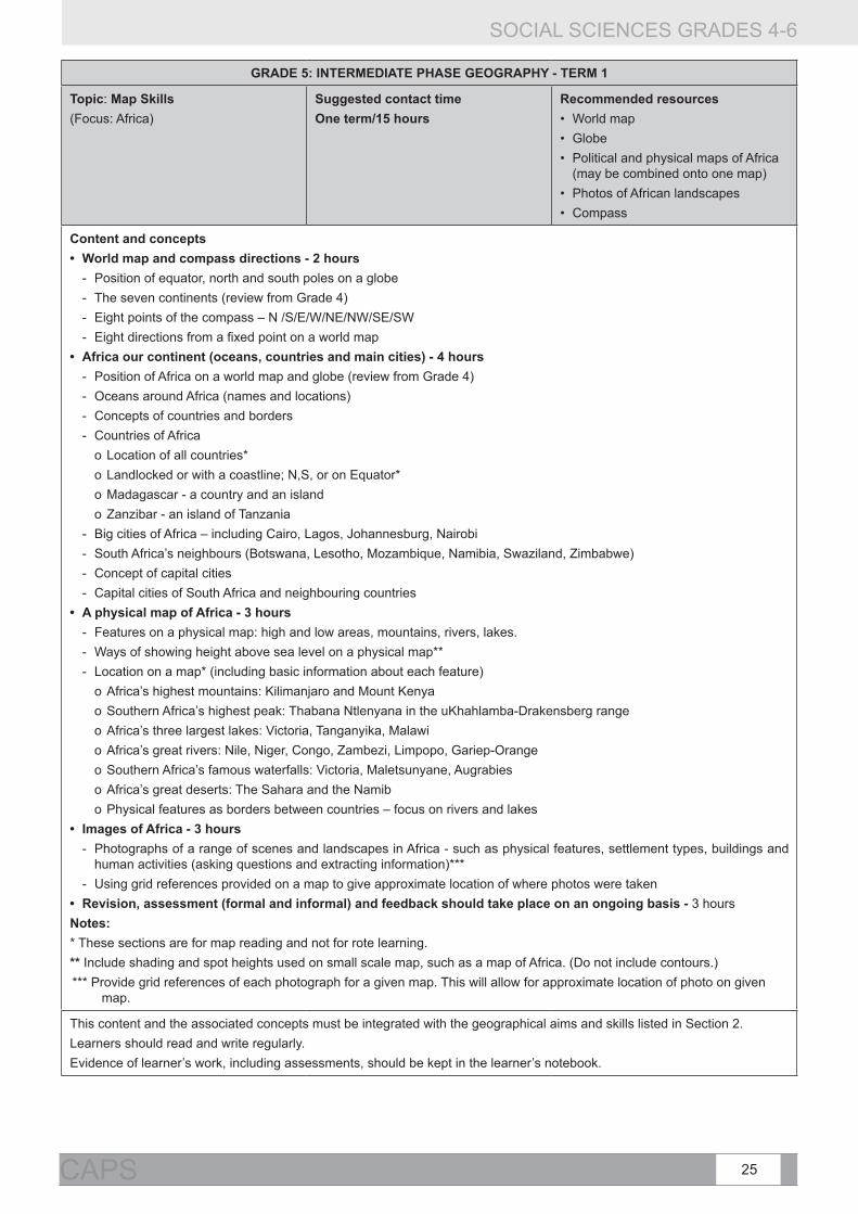
GRADE 5: INTERMEDIATE PHASE GEOGRAPHY - TERM 1
Topic: Map Skills (Focus: Africa)
Suggested contact timeOne term/15 hours
Recommended resources• World map • Globe• Political and physical maps of Africa
(may be combined onto one map)• Photos of African landscapes• Compass
Content and concepts• World map and compass directions - 2 hours
- Position of equator, north and south poles on a globe - The seven continents (review from Grade 4) - Eight points of the compass – N /S/E/W/NE/NW/SE/SW - Eight directions from a fixed point on a world map
• Africa our continent (oceans, countries and main cities) - 4 hours - Position of Africa on a world map and globe (review from Grade 4) - Oceans around Africa (names and locations) - Concepts of countries and borders - Countries of Africa
o Location of all countries* o Landlocked or with a coastline; N,S, or on Equator*o Madagascar - a country and an islando Zanzibar - an island of Tanzania
- Big cities of Africa – including Cairo, Lagos, Johannesburg, Nairobi - South Africa’s neighbours (Botswana, Lesotho, Mozambique, Namibia, Swaziland, Zimbabwe) - Concept of capital cities - Capital cities of South Africa and neighbouring countries
• A physical map of Africa - 3 hours - Features on a physical map: high and low areas, mountains, rivers, lakes. - Ways of showing height above sea level on a physical map** - Location on a map* (including basic information about each feature)
o Africa’s highest mountains: Kilimanjaro and Mount Kenyao Southern Africa’s highest peak: Thabana Ntlenyana in the uKhahlamba-Drakensberg rangeo Africa’s three largest lakes: Victoria, Tanganyika, Malawi o Africa’s great rivers: Nile, Niger, Congo, Zambezi, Limpopo, Gariep-Orangeo Southern Africa’s famous waterfalls: Victoria, Maletsunyane, Augrabies o Africa’s great deserts: The Sahara and the Namibo Physical features as borders between countries – focus on rivers and lakes
• Images of Africa - 3 hours - Photographs of a range of scenes and landscapes in Africa - such as physical features, settlement types, buildings and
human activities (asking questions and extracting information)*** - Using grid references provided on a map to give approximate location of where photos were taken
• Revision, assessment (formal and informal) and feedback should take place on an ongoing basis - 3 hoursNotes: * These sections are for map reading and not for rote learning.** Include shading and spot heights used on small scale map, such as a map of Africa. (Do not include contours.)*** Provide grid references of each photograph for a given map. This will allow for approximate location of photo on given
map.
This content and the associated concepts must be integrated with the geographical aims and skills listed in Section 2. Learners should read and write regularly. Evidence of learner’s work, including assessments, should be kept in the learner’s notebook.

SOCIAL SCIENCES GRADES 4-6
26 CURRICULUM AND ASSESSMENT POLICY STATEMENT (CAPS)
GRADE 5: INTERMEDIATE PHASE GEOGRAPHY - TERM 2
Topic: Physical features of South Africa
Suggested contact time
One term/15 hours
Recommended resources
• Photographs of rivers, mountains, coastlines and other landscapes in South Africa
• Pictures to show human activity in different physical environments
• Physical map of South Africa
Content and concepts
• South Africa from above (physical map) 2 hours
- High places and low places (review ‘sea level’ and ‘height above sea level’)
- Coastal plain, escarpment, plateau (concepts and location of features in South Africa)
- Location of the Highveld, Lowveld, Great Karoo, Little Karoo, Kalahari and Namaqualand
• Physical features - 3 hours
- Mountains, mountain ranges, valleys and hills, rivers, waterfalls, coastlines – capes and bays
- Location of main physical features in own province
- Location of selected physical features in South Africa – such as Table Mountain, the uKhahlamba-Drakensberg, Waterberg, Lake St. Lucia, Augrabies Falls, Cape Point, Algoa Bay * (map)
- Place names – how a selection of three places/areas in South Africa got their names **
• Rivers - 3 hours
- Where rivers begin and end – directions of flow from high areas to the sea
- Concept of river systems – tributaries and catchment areas
- Main rivers of South Africa – identifying the sources, major tributaries and directions of flow (map)
• Physical features and human activities - 4 hours
• Links between physical features, where people live and what they do (human activities)
• Ways in which human activities change physical landscapes – case studies to include:
o Impact of dams on the physical environment
o Road building
• Revision, assessment (formal and informal) and feedback should take place on an ongoing basis - 3 hours
Notes:
* Selected physical features should include a range of types of feature across South Africa.
** Select places associated with physical features
This content and the associated concepts must be integrated with the geographical aims and skills listed in Section 2.
Learners should read and write regularly.
Evidence of learner’s work, including assessments, should be kept in the learner’s notebook.
SOCIAL SCIENCES GRADES 4-6
27CAPS
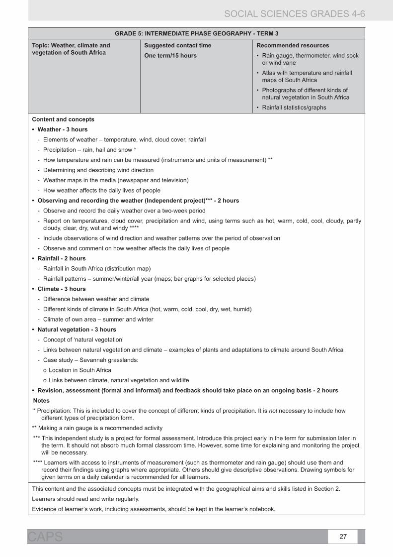
GRADE 5: INTERMEDIATE PHASE GEOGRAPHY - TERM 3
Topic: Weather, climate and vegetation of South Africa
Suggested contact timeOne term/15 hours
Recommended resources• Rain gauge, thermometer, wind sock
or wind vane
• Atlas with temperature and rainfall maps of South Africa
• Photographs of different kinds of natural vegetation in South Africa
• Rainfall statistics/graphs
Content and concepts• Weather - 3 hours
- Elements of weather – temperature, wind, cloud cover, rainfall
- Precipitation – rain, hail and snow *
- How temperature and rain can be measured (instruments and units of measurement) **
- Determining and describing wind direction
- Weather maps in the media (newspaper and television)
- How weather affects the daily lives of people
• Observing and recording the weather (Independent project)*** - 2 hours - Observe and record the daily weather over a two-week period
- Report on temperatures, cloud cover, precipitation and wind, using terms such as hot, warm, cold, cool, cloudy, partly cloudy, clear, dry, wet and windy ****
- Include observations of wind direction and weather patterns over the period of observation
- Observe and comment on how weather affects the daily lives of people
• Rainfall - 2 hours - Rainfall in South Africa (distribution map)
- Rainfall patterns – summer/winter/all year (maps; bar graphs for selected places)
• Climate - 3 hours - Difference between weather and climate
- Different kinds of climate in South Africa (hot, warm, cold, cool, dry, wet, humid)
- Climate of own area – summer and winter
• Natural vegetation - 3 hours - Concept of ‘natural vegetation’
- Links between natural vegetation and climate – examples of plants and adaptations to climate around South Africa
- Case study – Savannah grasslands:
o Location in South Africa
o Links between climate, natural vegetation and wildlife
• Revision, assessment (formal and informal) and feedback should take place on an ongoing basis - 2 hours Notes* Precipitation: This is included to cover the concept of different kinds of precipitation. It is not necessary to include how
different types of precipitation form.
** Making a rain gauge is a recommended activity
*** This independent study is a project for formal assessment. Introduce this project early in the term for submission later in the term. It should not absorb much formal classroom time. However, some time for explaining and monitoring the project will be necessary.
**** Learners with access to instruments of measurement (such as thermometer and rain gauge) should use them and record their findings using graphs where appropriate. Others should give descriptive observations. Drawing symbols for given terms on a daily calendar is recommended for all learners.
This content and the associated concepts must be integrated with the geographical aims and skills listed in Section 2.
Learners should read and write regularly.
Evidence of learner’s work, including assessments, should be kept in the learner’s notebook.

SOCIAL SCIENCES GRADES 4-6
28 CURRICULUM AND ASSESSMENT POLICY STATEMENT (CAPS)
GRADE 5: INTERMEDIATE PHASE GEOGRAPHY - TERM 4
Topic: Minerals and mining in South Africa
Suggested contact time
One term/15 hours
Recommended resources
• Map of South Africa to show distribution of main minerals across provinces
• Pictures to illustrate all sections of topic
Content and concepts
• Mineral and coal resources of South Africa - 4 hours
- Minerals as non-renewable resources
- Main minerals mined in South Africa and their uses – including gold, platinum, diamonds, iron ore, chrome, copper, silver and manganese
- Coal as a non-renewable resource
o How coal is formed*
o Uses of coal
o Location of mineral and coal mines and links to settlement patterns (map)
• Mining and the environment - 5 hours
- Concept of mining
- Ways of mining
o Open pit/ surface mining
o Shaft and deep level mining
- Impact of mining on the environment – examples to include:
o Pollution (water and air)
o Destruction of vegetation and wildlife
o Waste and waste disposal
• Mining and people - 3 hours
- Challenges of working in a deep gold mine – such as ventilation, heat, rock falls, dust
- Health and safety risks for miners – including silicosis
- Rules to protect health and safety of miners
• Revision, assessment (formal and informal) and feedback should take place on an ongoing basis - 3 hours
Notes
* Coal is formed from organic plant remains and is therefore not a mineral.
This content and the associated concepts must be integrated with the geographical aims and skills listed in Section 2.
Learners should read and write regularly.
Evidence of learner’s work, including assessments, should be kept in the learner’s notebook.

SOCIAL SCIENCES GRADES 4-6
29CAPS
GRADE 6: INTERMEDIATE PHASE GEOGRAPHY - TERM 1
Topic: Map skills
(Focus: World)
Suggested contact time
One term/15 hours
Recommended resources
• A set of atlases
• Globe
• Newspapers/magazines
• 360° protractor
Content and skills
• Latitude and longitude (degrees) - 4 hours
- Latitude and longitude on a globe (degrees)
- Concept of hemisphere
o Northern and southern hemispheres – divided by the equator
o Eastern and western hemispheres – divided by the Greenwich Meridian and 180° longitude
o Any place on the globe is in two hemispheres – north or south and east or west
o Location of South Africa in southern and eastern hemispheres
- Latitude and longitude on a map (degrees) – from a globe to a flat map
- Locate selected countries and cities in degrees of latitude and longitude
• Scale - 4 hours
- Concept of scale
o Small- and large-scale maps: different scales for different maps – from world maps to street maps *
o Line scales
o Word scales
- Measuring straight-line distances between cities on a South African and world map
• Atlases, global statistics and current events - 4 hours
- Kinds of information provided in an atlas
- How the content page of an atlas is organised
- Own province in an atlas: What information can a map give about a province?
- The world’s three: longest rivers/highest mountains/biggest deserts/biggest forests/biggest oceans**/ largest cities (population)/largest countries (area)
- Locate major current events or places in the news on a map (on-going throughout the year)
• Revision, assessment (formal and informal) and feedback should take place on an ongoing basis - 3 hours
Notes:
* Use word and line scales only.
** Note that all oceans join up to be one world ocean – it just has different names in different parts of the world.
This content and the associated concepts must be integrated with the geographical aims and skills listed in Section 2.
Learners should read and write regularly.
Evidence of learner’s work, including assessments, should be kept in the learner’s notebook.

SOCIAL SCIENCES GRADES 4-6
30 CURRICULUM AND ASSESSMENT POLICY STATEMENT (CAPS)
GRADE 6: INTERMEDIATE PHASE GEOGRAPHY - TERM 2
Topic: Trade
(Focus: South Africa and the world)
Suggested contact time
One term/15 hours
Recommended resources
• Daily goods for practical exchange activities
• Tables and graphs for data handling
Content and skills
• Why people trade - 2 hours
- Trade as the exchange of goods
- Trade as buying and selling of goods for money
- Exports and imports – between South Africa and the world
• What people trade - 2 hours
- Goods:
o Raw materials (primary products)
o Manufactured goods (secondary products)
- Skills and services
• Resources and their values - 4 hours
- Values of selected raw materials and manufactured goods
- Case studies *
o From cocoa to chocolate
o From gold to jewellery
• Fair trading - 4 hours
- Concepts of ‘unfair trade’ and ‘fair trade’
- The human cost of unfair trade – work and exploitation
- Fair trade – case study of a positive project
• Revision, assessment (formal and informal) and feedback should take place on an ongoing basis - 3 hours
* Case studies here should demonstrate how resources change their values through the manufacturing process, the costs along the way and where profits are most marked.
This content and the associated concepts must be integrated with the geographical aims and skills listed in Section 2.
Learners should read and write regularly.
Evidence of learner’s work, including assessments, should be kept in the learner’s notebook.

SOCIAL SCIENCES GRADES 4-6
31CAPS
GRADE 6: INTERMEDIATE PHASE GEOGRAPHY - TERM 3
Topic: Climate and vegetation around the world
Suggested contact time
One term/15 hours
Recommended resources
• Atlas
• World maps to show annual rainfall and summer and winter temperatures
• Graphs with monthly temperature and rainfall data
• Photographs of vegetation types
• Photographs of people in their environments
Content and concepts
• Climate around the world * - 4 hours
- Difference between weather and climate (review from Grade 5)
- Hot, mild and cold climates of the world - including January and July temperature maps
- Wet and dry areas of the world – including annual rainfall map
• Tropical rainforests ** - 3 hours
- Location on earth
- Climate: temperature and rainfall patterns (monthly averages)
- Natural vegetation and wildlife in a rainforest
- Deforestation – reasons, consequences with a case study
• Hot deserts - 3 hours
- Location on Earth
- Climate: temperature and rainfall patterns (monthly averages)
- Natural vegetation and wildlife in a desert
- How people live in a desert – examples of lifestyles
• Coniferous forests - 3 hours
- Location on earth
- Climate: temperature and rainfall patterns (monthly averages)
- Natural vegetation and wildlife in a coniferous forest
- Human activities – examples to illustrate links between the natural environment and the ways that people make a living
• Revision, assessment (formal and informal) and feedback should take place on an ongoing basis - 2 hours
Notes:
* Factors influencing temperature and rainfall along with climate regions of the world are studied in Grade 8. Here the focus is on understanding climate variation and on reading and cross-referencing information on different maps.
** Savannah grasslands in South Africa are included as a case study in Grade 5. Here three more natural regions are introduced in preparation for ‘Climate regions of the world’ in Grade 8.
This content and the associated concepts must be integrated with the geographical aims and skills listed in Section 2.
Learners should read and write regularly.
Evidence of learner’s work, including assessments, should be kept in the learner’s notebook.

SOCIAL SCIENCES GRADES 4-6
32 CURRICULUM AND ASSESSMENT POLICY STATEMENT (CAPS)
GRADE 6: INTERMEDIATE PHASE GEOGRAPHY - TERM 4
Topic: Population – Why people live where they do
(Focus: South Africa and the world)
Suggested contact time
One term/15 hours
Recommended resources
• Atlas
• Statistics South Africa: Census in brief
• Population distribution maps: South Africa and world
Content and concepts
• People and provinces in South Africa - 3 hours
- Population distribution and population density
- Population distribution in South Africa (distribution map)
- Total population figures for each province (reading graphs)
- Average population density for each province (reading graphs)
• Why people live where they do (South Africa) - 5 hours
- Reasons for location of settlements – such as climate, vegetation, natural features, laws (past and present), resources and human activities (such as mining, fishing and trade)
- Concepts of rural and urban
- Why people move from rural areas to towns and cities/urban areas
• People around the world - 4 hours
- Population distribution around the world (distribution map*)
- The influence of climate, water and mineral resources on global settlement **
- Major cities and their population sizes (map*)
- Case study of a major city to highlight the reasons for its location
• Revision, assessment (formal and informal) and feedback should take place on an ongoing basis - 3 hours
Notes:
* The same population map may be used for these two sub-topics.
** While climate, water and mineral resources are not the only influences on global settlement, the strong influence of these factors should be noted on the world population distribution map. This should include cross-referencing with maps that show climate, physical features and mineral resources.
This content and the associated concepts must be integrated with the geographical aims and skills listed in Section 2.
Learners should read and write regularly.
Evidence of learner’s work, including assessments, should be kept in the learner’s notebook.

SOCIAL SCIENCES GRADES 4-6
33CAPS
3.2 INTERMEDIATE PHASE HISTORY: OUTLINE OF WHAT IS TO BE TAUGHT
Rationale for selection of content
Topics from the NCS that teachers are comfortable teaching have been kept. Some of the NCS topics that work well in the classroom were based on ‘themes’. This means that it has been difficult to maintain chronological coherence through every topic in every year and through the phases.
Changes are based on the principle of ‘back to knowledge’ and have been made to:
1. allow for more depth in fewer topics;
2. allow for the development of History as a distinct discipline;
3. improve sequencing and increase chronological coherence within topics;
4. remove topics that are too cognitively demanding for the level; and
5. accommodate public comments.
SUMMARY TABLE OF HISTORY CONTENT
Term Grade 4 Grade 5 Grade 6
1 Local history Hunter-gatherers and herders in southern Africa
An African kingdom long ago in southern Africa: Mapungubwe
2 Learning from leaders The first farmers in southern Africa Explorers from Europe find southern Africa
3 Transport through time An ancient African society: Egypt Democracy and citizenship in South Africa
4 Communication through time A heritage trail through the provinces of South Africa
Medicine through time

SOCIAL SCIENCES GRADES 4-6
34 CURRICULUM AND ASSESSMENT POLICY STATEMENT (CAPS)
GRADE 4: INTERMEDIATE PHASE HISTORY - TERM 1
Topic: Local History Suggested contact time
One term/15 hours
This content must be integrated with the historical aims and skills and the associated concepts listed in Section 2
Background information: Teachers should note that the word ‘sources’ has deliberately been changed to ‘how we find information about the past’ for Grades 4 – 6. The word ‘sources’ can be used if teachers feel that learners can grasp this concept.
Focus: Finding out about the past and applying this knowledge to local history.
Content and concepts
Finding a variety of kinds of information about the history of a local area
• Howwefindoutaboutthepresentinalocalarea-2hours
- information from pictures
- information from writing
- information from stories and from interviews with people
- information from objects
• Howwefindoutaboutthehistoryofalocalarea-3hours
- information from pictures
- information from writing
- information from stories and interviews with people
- information from objects
• History project for Grade 4: Local history 7 hours
Revision, assessment (formal and informal) and feedback should take place on an ongoing basis - 3 hours
Learners should read and write for part of every lesson.
Evidence of learner’s work, including assessments, should be kept in the learner’s notebook.

SOCIAL SCIENCES GRADES 4-6
35CAPS
GRADE 4: INTERMEDIATE PHASE HISTORY - TERM 2
• Topic: Learning from leaders • Suggested contact time
• One term/15 hours
This content must be integrated with the historical aims and skills and the associated concepts listed in Section 2
Background information: The life stories of great leaders such as Mandela and Gandhi belong to all people all over the world. Their selection is based on their leadership qualities as human beings.
Focus: The qualities of good leaders, using the life stories of Nelson Mandela and Mahatma Gandhi as examples.
Content and concepts
• Ask and answer questions about the lives and qualities of good leaders - 2 hours
• A good leader:
- listens to people;
- is a servant of the people and works for the good of others;
- works with a team;
- has courage;
- is brave;
- is dedicated and is wholeheartedly committed to his or her beliefs;
- is dedicated and is wholeheartedly committed to others; and
- is prepared to sacrifice or give up something for the sake of others.
• Life stories of leaders who show the above qualities:
- Nelson Mandela - 5 hours
- Mahatma Gandhi - 5 hours
• Guiding questions:
- Why is he an example of a good leader?
- Is it always easy to be a good leader?
- Are leaders always popular?
- Are leaders always perfect?
- How can ordinary people follow the example of good leaders?
Revision, assessment (formal and informal) and feedback should take place on an ongoing basis - 3 hours
Learners should read and write for part of every lesson.
Evidence of learner’s work, including assessments, should be kept in the learner’s notebook.
Note: Teachers may add a local, provincial, national or international leader of their own choice if they have access to research material and if they have time. The leader must have contributed to the advance of democracy and human rights.

SOCIAL SCIENCES GRADES 4-6
36 CURRICULUM AND ASSESSMENT POLICY STATEMENT (CAPS)
GRADE 4: INTERMEDIATE PHASE HISTORY - TERM 3
Topic: Transport through time Suggested contact time
1 term/15 hours
This content must be integrated with the historical aims and skills and the associated concepts listed in Section 2
Focus: How transport has changed people’s lives over time on land, water and in the air.
Content and concepts
• Transport on land - 6 hours
- Animals
- Carts, wagons and coaches
- The bicycle
- The steam engine and the train
- The motor car
- Common forms of transport of people and goods on land today
• Case study: Environmental damage: exhaust fumes in a big city - 1 hour
• Transport on water - 4 hours
- Rafts, canoes and reed boats
- Some of the first sailing ships: Chinese junks, Arab dhows, caravels, British tall ships, clippers
- The first steamships
- Modern forms of water transport
• Transport in the air - 2 hours
- Balloons and airships
- Wright brothers and the invention of the first aeroplane
- Modern forms of air transport
Revision, assessment (formal and informal) and feedback should take place on an ongoing basis - 2 hours
Learners should read and write for part of every lesson.
Evidence of learner’s work, including assessments, should be kept in the learner’s notebook.

SOCIAL SCIENCES GRADES 4-6
37CAPS
GRADE 4: INTERMEDIATE PHASE HISTORY - TERM 4
Topic: Communication through time Suggested contact time
One term/15 hours
This content must be integrated with the historical aims and skills and the associated concepts listed in Section 2
Focus: How communication has changed over time, and how many forms of communication have stayed the same.
Content and concepts
• The oldest forms of human communication - 3 hours
- Language, symbols, songs, art and dance
• Sanhunter-gatherers(thefirstpeopleinsouthernAfrica)asanexample
• Change in modern forms of communication - 9 hours
- Postal system
- Radio
- Early typewriters before electricity
- Telegraph
- Telephone
- Camera
- Television
- Computer
- Internet
- Cell phone
Revision, assessment (formal and informal) and feedback should take place on an ongoing basis - 3 hours
Learners should read and write for part of every lesson.
Evidence of learner’s work, including assessments, should be kept in the learner’s notebook.

SOCIAL SCIENCES GRADES 4-6
38 CURRICULUM AND ASSESSMENT POLICY STATEMENT (CAPS)
GRADE 5: INTERMEDIATE PHASE HISTORY - TERM 1
Topic: Hunter-gatherers and herders in southern Africa Suggested contact time
One term/15 hours
This content must be integrated with the historical aims and skills and the associated concepts listed in Section 2
Background information: The content listed below applies to the last 10 000 years of the Later Stone Age. Older Stone Age periods go back over hundreds of thousands of years.
Farmers entered southern Africa about 1 700 years ago. Hunter-gatherers were not marginalised or out-competed, but shared the southern African farming landscape with farmers over much of the last 1 700 years.
Focus: The way of life of the hunter-gatherers and herders, the earliest inhabitants of southern Africa, and how we find out about them.
Content and concepts
South Africa from 10 000 thousand years ago: people of the Later Stone Age
• Howwefindoutabouthunter-gatherersandherders-2hours
- Stories
- Objects
- Rock paintings
- Books
- In the present we find out about them by observing living societies (ethnography)
• San hunter-gatherer society in the Later Stone Age - 8 hours
- Lived off the environment (A deep knowledge of the environment meant the San knew when wild resources were seasonally available. They moved to coincide with that availability.)
- The invention of the bow and arrow, which contributed to hunting effectiveness
- Social organisation: all things were meant to be shared equally within a group
- Plant medicines
- San beliefs and religion
- Rock art
o Where, when, how and why it was created
o Interpretations of rock art
o South African Coat of Arms and the Linton Rock Art Panel
• Khoikhoi herder society in the Later Stone Age - 2 hours
- Pastoral way of life
- How San and Khoikhoi shared the same landscape
Revision, assessment (formal and informal) and feedback should take place on an ongoing basis - 3 hours
Learners should read and write for part of every lesson.
Evidence of learner’s work, including assessments, should be kept in the learner’s notebook.
Note: LTSM writers should not include detail on modern San in the Kgalagadi or in Namibia.

SOCIAL SCIENCES GRADES 4-6
39CAPS
GRADE 5: INTERMEDIATE PHASE HISTORY - TERM 2
Topic:ThefirstfarmersinsouthernAfrica Suggested contact time
One term/15 hours
This content must be integrated with the historical aims and skills and the associated concepts listed in Section 2
Background information: The first farmers in southern Africa were Bantu-speakers and archaeology shows that they entered southern Africa between 2 000 and 1 700 years ago. The study of Iron Age archaeology provides a history for the majority of present-day southern African and South African citizens. The term ‘Iron Age’ is a convenient label for this period, as people made tools from iron, but all the other facets of these societies should not be ignored. Archaeologists therefore use terms such as ‘agriculturists’ or ‘farmers’. The entry of farmers did not end the occupation of hunter-gatherers. They in fact shared the landscape – in some instances in intermarriage and in cultural interaction (all the clicks in the Nguni languages, for example, are derived from Khoisan languages). Iron Age societies were highly fluid, flexible and had a great capacity for change. People could move, shift and change their affiliation if they were not happy. The popular idea that Bantu-speaking people lived in ‘tribes’ is incorrect and the term must be avoided, as it assumes societies were static and unchanging. Instead, ‘chiefdom’ is a better term, but it must be remembered that chiefdoms were fluid and flexible – they came and went, and political power and citizenship changed constantly. Indigenous societies were political and strategically, economically and technologically innovative before the colonial period. The myth that so frequently surfaces is the contrast between societies with writing (‘civilised, progressive, innovative’), with indigenous societies (“tribal, mired in a static traditionalism”). All people all over the world are equally politically, economically, strategically and technologically innovative, irrespective of when they live and where they live. Focus: The way of life of the first farmers of southern Africa and how we find out about them.Content and concepts• When,whyandwherethefirstAfricanfarmerssettledinSouthernAfrica-2hours
- Attitudes to land Interaction with Khoisan – principles of generous acceptance of other people. (In Iron Age society it was important for political power that leaders accepted strangers and integrated them into their own societies).
• How early African farmers lived in settled chiefdoms - 10 hours - Homesteads and villages - Agriculture: crops and livestock - Social, political and economic structures
o Roles of men, women, boys and girls (Children were economically active from an early age and took pride in contributing to the well-being of the community. In their teens they were initiated and educated into the responsibilities of adulthood.)
o A culture of co-operation, e.g. communal work parties during the ploughing season, helping a newcomer by lending calves for a year or two. This ensured the well-being and good social relations of the community as a whole.
o The role of the chiefo The role of cattle
• Tools and weapons from iron and copper - Division of labour: gender-based activity: men - Metal working (iron, smelting and fire technology, smithery)
• Pottery• Division of labour: gendered activity: women
- Day-to-day use - Use in ceremonies with the Lydenburg Heads as an example - Trade - Medicine and healing - Hunting
Revision, assessment (formal and informal) and feedback should be done on an ongoing basis 3 hoursLearners should read and write for part of every lesson. Evidence of learner’s work, including assessments, should be kept in the learner’s notebook. Note: Societies are never static, but change continuously over time. Change occurred more slowly long ago, whereas today change is usually more rapid. Between 900 and 1300 AD, chiefdoms became bigger, more organised and more complex. Learners will study these changes in Grade 6.

SOCIAL SCIENCES GRADES 4-6
40 CURRICULUM AND ASSESSMENT POLICY STATEMENT (CAPS)
GRADE 5: INTERMEDIATE PHASE HISTORY - TERM 3
Topic: An ancient African society: Egypt Suggested contact time
One term/15 hours
This content must be integrated with the historical aims and skills and the associated concepts listed in Section 2
Focus: The way of life in ancient Egyptian society.
Content and concepts
• TheNileRiverandhowitinfluencedsettlement-2hours
• Way of life in ancient Egypt - 8 hours
- Social structure in ancient Egypt
- Beliefs and religion
- Pharaohs
- Sphinx, pyramids and temples
- Hieroglyphics
- Mathematics and astronomy
- Medicine and physicians: diseases, anatomy, physiology and clinical examinations
• Case study : The tomb of Tutankhamen - 2 hours
- Discovery of the tomb, who, when, why
- What the discovery revealed about ancient Egyptian society
• The spread of Egypt’s advanced knowledge to other places, such as Europe and the Middle East - 1 hour
Revision, assessment (formal and informal) and feedback should take place on an ongoing basis - 2 hours
Learners should read and write for part of every lesson.
Evidence of learner’s work, including assessments, should be kept in the learner’s notebook.

SOCIAL SCIENCES GRADES 4-6
41CAPS
GRADE 5: INTERMEDIATE PHASE HISTORY - TERM 4
Topic: A heritage trail through the provinces of South Africa
Suggested contact time
1 term/15 hours
This content must be integrated with the historical aims and skills and the associated concepts listed in Section 2
Background information: We have a rich and diverse heritage that belongs to all South Africans today. Heritage can be tangible and intangible. Tangible heritage includes things we can see and touch. Intangible heritage includes things such as our family heritage, religion, praise poetry, music, songs, dance and festivals.
This heritage trail takes us to places in different parts of South Africa and looks at some of the things of significance that we have inherited from the past.
Focus: An example of heritage of significance from each province
Content and concepts
• The names of provinces and their capital cities on a map - 1 hour
• What heritage is - 2 hours
• Different examples of heritage from each province: 9 hours
- Heritage in sites of significance: Example: Cradle of Humankind: Gauteng
- Heritage in objects: Example: Golden objects at Mapungubwe: Limpopo
- Heritage in people’s achievements: Example: Frances Baard: Northern Cape
- Heritage in names of places: Example: Names of rivers, dams and towns: Free State
- Heritage and changing identities: Example: The Castle: Western Cape
- Heritage and indigenous medicine : Example: The healing properties of the aloe: Eastern Cape
- Heritage in architecture: Example: Stone-walled town of Kaditshwene: North West
- Natural heritage and indigenous knowledge systems (IKS): Example: Makhonjwa Mountains, the oldest in the world. Mountains and ancestors in IKS: Mpumalanga
- Heritage in art: Example: San Rock art in the Drakensberg: Kwazulu Natal
Revision, assessment (formal and informal) and feedback should take place on an ongoing basis - 3 hours
Learners should read and write for part of every lesson.
Evidence of learner’s work, including assessments, should be kept in the learner’s notebook.
Notes:
• The examples for each province are a guide. Other examples for each province may be chosen by LTSM writers. LTSM writers must clearly explain the concepts of heritage in context.
• Teachers may select further heritage examples from the province in which their school is situated if time allows and if resources are available.

SOCIAL SCIENCES GRADES 4-6
42 CURRICULUM AND ASSESSMENT POLICY STATEMENT (CAPS)
GRADE 6: INTERMEDIATE PHASE HISTORY - TERM 1
Topic: An African kingdom long ago in southern Africa: Mapungubwe
Suggested contact time
One term/15 hours
This content must be integrated with the historical aims and skills and the associated concepts listed in Section 2
Background information: This topic provides an opportunity to expand ideas about change and technological, social and political innovation. The period from 900 AD was increasingly about southern African interior societies becoming part of a much wider world through trade, commerce and cultural exchange. Mapungubwe was a complex society of a much larger political scale than had been seen before in southern Africa. There were changes in political power, leadership and authority and in organising, managing and maintaining that political power.
It is important to understand Mapungubwe in its historical context. This topic therefore provides a brief introductory overview of the settlements in the Limpopo Valley before Mapungubwe, and a brief concluding overview of Great Zimbabwe, which succeeded Mapungubwe as the centre of southern African trade.
The topic also includes Marco Polo’s travels, as he was a European explorer in Asia at the same time as Mapungubwe was at the height of its power. This provides a useful comparison of societies across some parts of the world in the same time period.
Focus: The main focus is on Mapungubwe, its internal structure and its trade within Africa and across the Indian Ocean.
Content and concepts
• Changes in societies in the Limpopo Valley between 900 AD and 1 300 AD: bigger, more organised and more complex - 1 hour
• Settlements in the Limpopo Valley before Mapungubwe: K2 and Schroda
• Mapungubwe:firststateinsouthernAfrica1220–1300-6hours
- King and sacred leadership
- First stone-walled palace
- Significance of Mapungubwe Hill
- First town
- Distinct social classes
- Golden rhinoceroses and other golden objects (symbols of royal power and political leadership)
- Trade across Africa and across Indian Ocean and beyond (globablisation)
- Goods traded
- People’s journeys on foot: routes, dangers, finding the way
- Today: World Heritage Site and Order of Mapungubwe
• Change and continuity in East Coast trade with settlements inland - 1 hour
• Great Zimbabwe
• European explorer in Asia at the same time as Mapungubwe was at its height - 3 hours
- European explorer Marco Polo and his travels
- Marco Polo’s influence on European traders and explorers
Revision, assessment (formal and informal) and feedback should take place on an ongoing basis - 3 hours
Learners should read and write for part of every lesson.
Evidence of learner’s work, including assessments, should be kept in the learner’s notebook.

SOCIAL SCIENCES GRADES 4-6
43CAPS
GRADE 6: INTERMEDIATE PHASE HISTORY - TERM 2
Topic:ExplorersfromEuropefindsouthernAfrica Suggested contact time
One term/15 hours
This content must be integrated with the historical aims and skills and the associated concepts listed in Section 2
Background information: The topics dealt with in term 1 included the kingdom of Great Zimbabwe. It is important to note that this complex Southern African society was at the height of its power at the same time as the European Renaissance occurred. Europeans had always been curious about Africa, but at this stage in European history, Europeans knew very little about Africa. Europeans only began to explore our continent about 600 years ago. The huge impact Europe later had on the continent of Africa (particularly the British impact on South Africa) will be studied in Grades 7, 8 and 9.
Focus: Changes in Europe which enabled Europeans to explore other parts of world, and their early exploration of the Southern African coast.
Content and concepts
• Reasons for European exploration: 8 hours
• The European Renaissance 15th and 16th centuries: a turning point in European history
- Case studies: The contributions of:
- Leonardo da Vinci
- Galileo
• New ideas and knowledge (including influence on Europe from elsewhere)
• Inventions: gunpowder, magnetic compass, caravel (including influence on Europe from elsewhere)
• Spreading the Christian religion
• Trade and making a profit
- European trade route to the East via southern Africa - 4 hours
- Dias and his crew encounter the Khoikhoi in Mossel Bay 1488
- The journey of Dias
- The journey of Da Gama VOC (Dutch East India Company) journeys
- Life of a sailor on a VOC ship
Revision, assessment (formal and informal) and feedback should take place on an ongoing basis - 3 hours
Learners should read and write for part of every lesson.
Evidence of learner’s work, including assessments, should be kept in the learner’s notebook.

SOCIAL SCIENCES GRADES 4-6
44 CURRICULUM AND ASSESSMENT POLICY STATEMENT (CAPS)
GRADE 6: INTERMEDIATE PHASE HISTORY - TERM 3
Topic: Democracy and citizenship Suggested contact time
One term/15 hours
This content must be integrated with the historical aims and skills and the associated concepts listed in Section 2
Background information: South Africa became a democracy for the first time in 1994 after many years of struggle against apartheid.
Focus: The meaning of democracy and good citizenship.
Content and concepts
• How people govern themselves in a democracy: our national government - 7 hours
- The first democratic government in South Africa 1994
- Political parties and voting in national elections
- The purpose of the Constitution
- The role of Parliament
- The importance of rules and laws
- The justice system and equality under the law
• Rights and responsibilities of citizens in a democracy
- Case study: Fatima Meer: a leader in building democracy
- The Constitutional Court
- Case study: Pius Langa: Chief Justice and Head of the Constitutional Court: 2005 – 2009
• Children’s rights and responsibilities - 2 hours
- Children’s Charter of South Africa
• National symbols since 1994 - 2 hours
- Coat of Arms
- National flag
- National anthem
History research project for Grade 6: A biography of a South African who has contributed to building democracy.
Class time for project work - 2 hours
Note: Textbooks should provide details on how to do a research project and write a biography.
Revision, assessment (formal and informal) and feedback should take place on an ongoing basis - 2 hours
Learners should read and write for part of every lesson.
Evidence of learner’s work, including assessments, should be kept in the learner’s notebook.

SOCIAL SCIENCES GRADES 4-6
45CAPS
GRADE 6: INTERMEDIATE PHASE HISTORY - TERM 4
Topic: Medicine through time Suggested contact time
One term/15 hours
This content must be integrated with the historical aims and skills and the associated concepts listed in Section 2
Background information: In South Africa, indigenous medicine is associated with the herbs, remedies (or muti) and advice imparted by sangomas or nyangas. Indigenous healing tends to take a holistic approach to illness and treats the patient’s spiritual and physical well-being together.
Western medicine is often contrasted with the approach taken by practitioners of indigenous medicine. Western medicine is associated with diseases of the physical body and is based on the principles of science, technology and knowledge developed mainly in Western Europe and Northern America. Western medicine has in the past often neglected the link between the spiritual and the physical, but a more holistic approach is now commonly part of the teaching in most Western medical schools.
Focus: The changing ways of treating illness
Content and concepts
• Indigenous healing in South Africa - 3 hours
- It is believed that illness has more than physical causes: illness has causes that can be cured in a holistic way by finding ways of setting the patient’s mind at rest, contacting ancestors, through dreams and indigenous medicine
- Not all indigenous practices involve spiritual healing. Some healers have a vast knowledge of medicinal plants. Many traditional healers use herbs and plants, not spirits, to cure patients. Western companies are continuously discovering more and more pharmaceutical uses for indigenous plants
- How people are identified and trained to be healers
• SomemodernWesternscientificmedicaldiscoveries-7hours
- The fight against infectious disease:
o Vaccination against smallpox and the role of Edward Jenner
o The connection between germs and disease and the role of Louis Pasteur
o The germs that cause TB and the role of Robert Koch
o The first antibiotic (penicillin) and the role of Alexander Fleming
o Casestudy:Abreakthroughinsurgery:thefirsthearttransplant
o Brief overview of discoveries which made this surgery possible: anaesthetics; avoiding infection; blood transfusions; X-rays;
o heart surgery: Christiaan Barnard and the world’s first heart transplant operation
• Link between holistic and Western forms of healing today - 2 hours
Revision, assessment (formal and informal) and feedback should take place on an ongoing basis - 3 hours
Learners should read and write for part of every lesson.
Evidence of learner’s work, including assessments, should be kept in the learner’s notebook.

SOCIAL SCIENCES GRADES 4-6
46 CURRICULUM AND ASSESSMENT POLICY STATEMENT (CAPS)
SECTION 4: ASSESSMENT IN SOCIAL SCIENCES
4.1 INTRODUCTION
Assessment is a continuous planned process of identifying, gathering and interpreting information about the performance of learners, using various forms of assessment. It involves four steps: generating and collecting evidence of achievement, evaluating this evidence, recording the findings and using this information to understand and thus assist the learner’s development in order to improve the process of learning and teaching.
Assessment should be both informal (assessment for learning) and formal (assessment of learning). In both cases regular feedback should be provided to learners to enhance the learning experience.
Guidelines for good assessment practices in History and Geography
The aims and skills in the subject must be applied to the content knowledge as well as to the tasks, projects, tests or examinations.
In assessing knowledge, teachers will be assessing the learner’s ability to achieve the aims and demonstrate the skills outlined in Section 2 of this document. To enable learners to achieve the aims and demonstrate the skills, they will need to have a full grasp and understanding of the content and concepts outlined in Section 3. Memory skills remain important.
Assessment usually involves writing. This means that learners should be taught writing skills and should be helped to practise them. Oral work, speaking, debating and drama can also be assessed and are sometimes very valuable for revision or preparation for written work.
Learners often experience difficulty in writing at length and in essay format. They need to be trained to select the information they want to include (only to choose what is relevant), to arrange the information (to put it in order together with other information) and to connect information (to make a logical sequence, or argument).
The quality of learners’ work depends on the care with which their tasks and questions are set. They should be given precise and detailed instructions, both to tell them what they must do and to tell them where they can find the information they need. It is often a good idea to break down substantial questions into a number of smaller ones, or steps.
Plagiarism (using someone else’s work and pretending it is one’s own) is a particular problem, whether it involves someone else doing the work, copying another learner’s work, or cutting and pasting from the Internet. It is essential that learners be trained to show whenever they quote something and to give their references. Likewise, teachers need to set learners an example by always giving the references for information and sources that they use.
4.2 INFORMAL OR DAILY ASSESSMENT
Assessment for learning has the purpose of continuously collecting information on learners’ achievement that can be used to improve their learning.
Informal assessment is a daily monitoring of learners’ progress. This is done through observations, discussions, practical demonstrations, learner-teacher conferences, informal classroom interactions, etc. Informal assessment may be as simple as stopping during the lesson to observe learners or to discuss with learners how learning is progressing. Informal assessment should be used to provide feedback to the learners and to inform planning for

SOCIAL SCIENCES GRADES 4-6
47CAPS
teaching, but need not be recorded. It should not be seen as separate from learning activities taking place in the classroom. Learners or teachers can mark these assessment tasks.
Self-assessment and peer assessment actively involve learners in assessment. This is important as it allows learners to learn from and reflect on their own performance. The results of the informal daily assessment tasks are not formally recorded unless the teacher wishes to do so. The results of daily assessment tasks are not taken into account for promotion and certification purposes.
Learners should read and write regularly, starting with sentences and paragraphs and building up to extended pieces of work. Much of this may be structured by working through activities provided in the textbook. Other reliable sources of information that may enrich the curriculum can be used with careful selection and discretion.
Evidence of learner’s work, including assessments, should be kept in the learner’s notebook.
4.3 FORMAL ASSESSMENT
All assessment tasks that make up a formal programme of assessment for the year are regarded as formal assessment. Formal assessment tasks are marked and formally recorded by the teacher for progression and certification purposes. All formal assessment tasks are subject to moderation for the purpose of quality assurance and to ensure that appropriate standards are maintained.
Formal assessment provides teachers with a systematic way of evaluating how well learners are progressing in a grade and in a particular subject. Examples of formal assessments include tests, examinations, practical tasks, projects, oral presentations, demonstrations, performances, etc. Formal assessment tasks form part of a year-long formal programme of assessment in each grade and subject.
4.3.1 Formal assessment requirements of Social Sciences
History and Geography must be assessed separately. The forms of assessment used should be appropriate for learners’ age and developmental level.
Learners must complete formal assessments each term for History and for Geography. Formal assessments include formally assessed tasks, along with projects and examinations. (Refer to programme of assessment on the next page.)
4.3.2 Types of formal assessment for Social Science
Projects
Learners complete one project in Social Sciences in each grade. They therefore do a project in either History or Geography in a given year. For more details on projects and when these are to be completed, refer to Section 2 of this document.
Tests and examinations
Tests and examinations for formal assessment should cover a substantial amount of content.
Tests and examinations must be completed under strictly controlled conditions.

SOCIAL SCIENCES GRADES 4-6
48 CURRICULUM AND ASSESSMENT POLICY STATEMENT (CAPS)
Each test and examination must cater for a range of cognitive levels. (Refer to the table in the section on planning for assessing later in this section.)
Cognitive level Percentage
Lower order:Knowledge and recall
30
Middle order: Comprehension and application
50
Higher order: Analysis, Evaluation and Synthesis
20
Tasks
Tasks should be designed to cover the content and concepts of the subject and include a variety of activities selected to assess the identified aims and skills.
Formal assessment tasks may include one or a combination of the activities listed below. This list may be extended:
• Writing short answers to questions (these may be single words, short phrases or sentences)
• Writing paragraphs and, from Grade 7, sequencing these into passages of extended writing
• Researching questions or topics
• Writing up a small piece of research
• Reading and summarising
• Listening and note-taking
• Recording observations
• Answering questions (short and/or longer responses)
• Asking questions (questions reveal insight)
• Completing worksheets
• Drawing and labelling
• Matching, sorting, listing, describing and comparing texts, graphs, maps, photographs, pictures
• Making connections between causes and effects
• Identifying similarities and differences
• Selecting and organising information
• Analysing and synthesising information
• Reading, completing and/ or drawing maps
SOCIAL SCIENCES GRADES 4-6
49CAPS
• Working with data (graphs and tables)
• Finding and/or working with sources
• Cross-referencing and comparing information
• Giving an explanation (orally, written or visually)
• Identifying and discussing issues
• Expressing and justifying a view
• Evaluating ideas and actions
• Detecting bias
• Doing a presentation (orally, written or visually)
• Making a model, poster or chart
• Interpreting photographs and writing captions
• Participating in a structured, prepared discussion, debate or role play.
Before handing out an assessment task to learners, teachers should ensure that they are able to answer all the questions themselves. When teachers set an assessment task, they should draw up a memorandum of answers and/or a rubric for the assessment. Refer to the seven-point rating code or scale of achievement when constructing a rubric.
Teachers should mark assessment tasks without delay. Learners should receive continuous, constructive feedback both informally and formally. Feedback should acknowledge strengths and identify areas of weakness for learner’s developmental needs. Action plans on how learners will be supported should accompany this feedback.
It is important that the feedback provided to learners encourages them to do better, and builds their self-confidence.
Planning for Assessment
Setting good assessment tasks can be very challenging and teachers are encouraged to use carefully selected textbooks as a guide, and to share good assessment tasks with teachers in other schools.
Follow these steps when designing your own task or activity:
1. Clarify the purpose of the assessment (Why?)
2. Decide on the task activity or activities (Form of assessment)
3. Decide on the content, concepts and skills to be assessed (What?)
4. Select a format for learner presentation (Clarify the method: How?)
Formal assessments must cater for a range of cognitive levels and abilities of learners as shown below. A formal assessment should include low, middle and high order activities or questions, with a weighting towards the cognitive level of the middle order.

SOCIAL SCIENCES GRADES 4-6
50 CURRICULUM AND ASSESSMENT POLICY STATEMENT (CAPS)
KN
OW
LED
GE
AN
D R
ECA
LL
CO
MPR
EHEN
SIO
N/
UN
DER
STA
ND
ING
APP
LIC
ATIO
N
CO
NC
EPTU
AL
REA
SON
ING
: AN
ALY
SIS
CO
NC
EPTU
AL
REA
SON
ING
:SY
NTH
ESIS
CO
NC
EPTU
AL
REA
SON
ING
:EV
ALU
ATIO
N
Low order Middle order High order
Absorb
Count
Define
Identify
Label
List
Match
Memorise
Name
Outline
Point out
Quote
Recite
Recognise
Repeat
Remember
Reproduce
Respond
Select
State
Trace
Classify
Compare
Convert
Discuss
Distinguish
Define
Demonstrate
Describe
Estimate
Explain
Generalise
Give examples
Illustrate
Infer
Interpret
Match
Paraphrase
Restate
Rewrite
Select
Summarise
Translate
Change
Compute
Construct
Demonstrate
Draw
Illustrate
Predict
Relate
Solve
Use
Breakdown
Differentiate
Discriminate
Investigate
Organise
Relate
Separate
Subdivide
Abstract
Arrange
Combine
Compile
Construct
Create
Design
Discuss
Formulate
Generalise
Generate
Group
Integrate
Organise
Summarise
Appraise
Conclude
Contrast
Create
Critique
Criticize
Decide
Dispute
Evaluate
Grade
Judge
Justify
Interpret
Support
Recommend

SOCIAL SCIENCES GRADES 4-6
51CAPS
4.4 PROGRAMME OF ASSESSMENT
The programme of assessment is designed to spread formal assessment tasks in all subjects in a school throughout a term.
Intermediate Phase
School-Based Assessment (SBA): 75% (including mid-year examination/test)
Year-end examination: 25%
Grade 4
Term 1History Project
Sch
ool-B
ased
Ass
essm
ent (
SB
A)
75%
Geography Task
Term 2History Task/Test
Geography Task/ Test
Term 3History Task
Geography Task
Term 4History Test/Examination Year-end test/examination
25%Geography Test/Examination
Grade 5
Term 1History Task
Sch
ool-B
ased
Ass
essm
ent (
SB
A)
75%
Geography Task
Term 2History Task/Test
Geography Task/Test
Term 3History Task
Geography Project
Term 4History Test/Examination Year-end test/examination
25%Geography Test/Examination

SOCIAL SCIENCES GRADES 4-6
52 CURRICULUM AND ASSESSMENT POLICY STATEMENT (CAPS)
Grade 6
Term 1History Task
Sch
ool-B
ased
Ass
essm
ent (
SB
A)
75%
Geography Task
Term 2History Task/Test
Geography Task/Test
Term 3History Project
Geography Task
Term 4History Test/Examination Year-end test/examination
25%Geography Test/Examination
4.5 RECORDING AND REPORTING
Recording is a process in which the teacher documents the level of a learner’s performance in a specific assessment task. It indicates learner progress towards the achievement of the knowledge as prescribed in the curriculum and assessment policy statements. Records of learner performance should provide evidence of the learner’s conceptual progression within a grade and his or her readiness to progress or being promoted to the next grade. Records of learner performance should also be used to verify the progress made by teachers and learners in the teaching and learning process.
Reporting is a process of communicating learner performance to learners, parents, schools, and other stakeholders. Learners’ performance can be reported in a number of ways. These include report cards, parents’ meetings, school visitation days, parent-teacher conferences, phone calls, letters, class or school newsletters etc. Teachers in all grades report in percentages against the subject. The various achievement levels and their corresponding percentage bands are as shown in the table below.
CODES AND PERCENTAGES FOR RECORDING AND REPORTING
Rating code Description of competence Percentage
7 Outstanding achievement 80 – 100
6 Meritorious achievement 70 – 79
5 Substantial achievement 60 – 69
4 Adequate achievement 50 – 59
3 Moderate achievement 40 – 49
2 Elementary achievement 30 – 39
1 Not achieved 0 – 29
Teachers will record actual marks against the task by using a record sheet and report percentages against the subject on the learners’ report cards.

SOCIAL SCIENCES GRADES 4-6
53CAPS
Social Sciences for Intermediate and Senior Phase learner reports:
Show History and Geography separately and together on school report, as in the example below:
Social Sciences
History %
Geography %
Average (Social Sciences)
4.6 MODERATION OF ASSESSMENT
Moderation refers to the process that ensures that the assessment tasks are fair, valid and reliable. Moderation should be implemented at school, district, provincial and national levels. Comprehensive and appropriate moderation practices must be in place for the quality assurance of all subject assessments.
4.7 GENERAL
This document should be read in conjunction with:
4.7.1 National policy pertaining to the programme and promotion requirements of the National Curriculum Statement Grades R – 12; and
4.7.2 The policy document, National Protocol for Assessment Grades R – 12.

SOCIAL SCIENCES GRADES 4-6
54 CURRICULUM AND ASSESSMENT POLICY STATEMENT (CAPS)
