current glider track and location 04/02/2011 @ 1409z glider position forecast waypoints current...
TRANSCRIPT

Current Glider Track and Location 04/02/2011 @ 1409Z
Glider Position Forecast
WaypointsCurrent Waypoint (CW) 4/02/11 ~1409ZG2 4/03/11G1 4/04/11
G1
G2
G6G3
G7
G4
CW
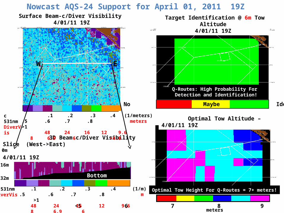
Nowcast AQS-24 Support for April 01, 2011 19Z
3D Beam-c/Diver Visibility Slice (West->East) 4/01/11 19Z
Target Identification @ 6m Tow Altitude4/01/11 19Z
No Maybe Identify
Optimal Tow Altitude – 4/01/11 19Z
Surface Beam-c/Diver Visibility 4/01/11 19Z
<5 6 7 8 9 10 11>
0m
16m
32m Bottom
Q-Routes: High Probability For Detection and Identification!
Optimal Tow Height For Q-Routes = 7+ meters!
c 531nmDiverVis
.1 .2 .3 .4 .5 .6 .7 .8 >1 48 24 16 12 9.6 8 6.9 6 <4.8
(1/meters) meters
c 531nmDiverVis
.1 .2 .3 .4 .5 .6 .7 .8 >1 48 24 16 12 9.6 8 6.9 6 <4.8
(1/m) m
meters
EW
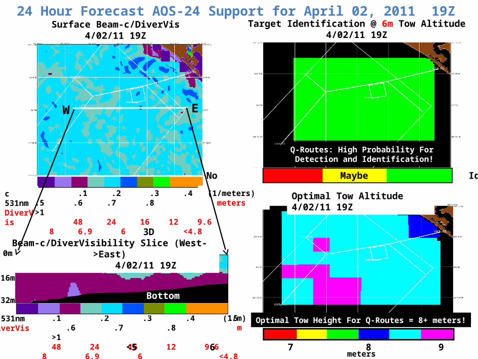
Target Identification @ 6m Tow Altitude4/02/11 19Z
c 531nmDiverVis
.1 .2 .3 .4 .5 .6 .7 .8 >1 48 24 16 12 9.6 8 6.9 6 <4.8
(1/m) m
24 Hour Forecast AQS-24 Support for April 02, 2011 19Z
EW
3D Beam-c/DiverVisibility Slice (West->East) 4/02/11 19Z
No Maybe Identify
Optimal Tow Altitude 4/02/11 19Z
Surface Beam-c/DiverVis4/02/11 19Z
<5 6 7 8 9 10 11>
0m
16m
32m Bottom
Q-Routes: High Probability For Detection and Identification!
Optimal Tow Height For Q-Routes = 8+ meters!
c 531nmDiverVis
.1 .2 .3 .4 .5 .6 .7 .8 >1 48 24 16 12 9.6 8 6.9 6 <4.8
(1/meters) meters
meters

c 531nmDiverVis
.1 .2 .3 .4 .5 .6 .7 .8 >1 48 24 16 12 9.6 8 6.9 6 <4.8
(1/m) m
48 Hour Forecast AQS-24 Support for April 03, 2011 19Z
EW
3D Beam-c/DiverVisibility Slice (West->East) 4/03/11 19Z
Target Identification @ 6m Tow Altitude4/03/11 19Z
No Maybe Identify
Optimal Tow Altitude 4/03/11 19Z
Surface Beam-c/DiverVis4/03/11 19Z
<5 6 7 8 9 10 11>
0m
16m
32m Bottom
Q-Routes: High Probability For Detection and Identification!
Optimal Tow Height For Q-Routes = 9+ meters!
c 531nmDiverVis
.1 .2 .3 .4 .5 .6 .7 .8 >1 48 24 16 12 9.6 8 6.9 6 <4.8
(1/meters) meters
meters
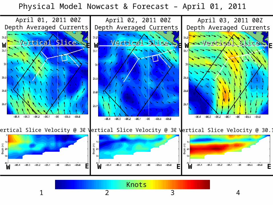
April 01, 2011 00ZDepth Averaged Currents
Physical Model Nowcast & Forecast – April 01, 2011
April 02, 2011 00ZDepth Averaged Currents
April 03, 2011 00ZDepth Averaged Currents
Vertical Slice Velocity @ 30.14N Vertical Slice Velocity @ 30.14N Vertical Slice Velocity @ 30.14N
0 1 2 3 4 5 Knots
EW Vertical SliceVertical Slice
EW
EW Vertical SliceVertical Slice
EW
EW Vertical SliceVertical Slice
EW

04/01/2011TIME SERIES @ 30.05N, 86.1W
FORECAST OVER NEXT 48 HOURS
04/02/11 1500 Local04/02/11 1500 Local 04/03/11 1500 Local04/03/11 1500 Local
HorizontalDiver Visibility
Forecast(Feet)
04/01/11 1500 Local 04/01/11 1500 Local
0 5 10 15 20 25 30 35 40 45
TIDESTIDES
34
33
32
31
30
OptimalTow
Altitude(Feet)
ModeledDepth
AveragedCurrents(Knots)
=Solid Line
Target ID?
ColorOf
Circle
No
?
Yes
Direction =Vectors
56
49
43
Depth = Surface

1. Surface and subsurface turbidity (beam-c) range from 0.2–0.6 m-1 in op-area for today (04/01/11 19Z) and 0.4-0.5 m-1 tomorrow (04/02/11 19Z). 0.3–0.6 m-1 in op-area for 48 hour forecast (04/03/11 19Z). (See Slides 2,3,4)
2. Surface and subsurface diver visibility (horizontal) range from 26–79 feet in op-area for today (04/01/11 19Z) and 31-39 feet tomorrow (04/02/11 19Z). 26 – 39 feet in op-area for 48 hour forecast (04/03/11 19Z). (See Slides 2,3,4)
3. Sytem Performance: Today (04/01/11 19Z), tomorrow (04/02/11 19Z) and 48 Hour Forecast (04/03/11 19Z) expect ID and Detection over 100% in Q-Routes.
4. Today (04/01/11 19Z) predicted tow heights range from 30-36 feet and tomorrow (04/02/11 19Z) and 48 hour forecast (04/03/11 19Z) predicted tow heights range from 33-36 feet in Q-Routes. (See Slides 2,3,4)
• Time Series at Surface for Location 30.05N and 86.1W: Horizontal Diver Visibility ranges from 43 to 60 feet during period starting
04/01/11 19Z to 4/3/11 19Z. Optimal Tow Height is ~33 feet during same 48 hour period yielding high probability of target ID. Surface currents during the same 48 hour period ranges from 0.5 to 2.8 knots.
SummarySummary
Note: Good satellite scenes collected on 3/25/11 and 4/01/11.

Contact Info:
Sherwin LadnerNaval Research LaboratoryStennis Space Center, MSEmail: [email protected]: 228-688-5754Cell: 228-380-1738
Feedback Very Important! •Positive or Negative•How are products being used?•Changes/Needs/Suggestions