cultural resources – archaeology technical report 3.0...
TRANSCRIPT

Cultural Resources – Archaeology Technical Report
3.0 – Methodology for Impact Evaluation
Table 3-1. Native American Coordination
Native American Contact Letter Sent Date of Reply Follow Up Results
Bernie Acuna Gabrielino-Tongva Tribe 1875 Century Park East, Ste. 1500 Los Angeles, CA 90067
07/02/2010 via U.S. mail 01/07/2011 via U.S. mail
n/a 01/24/2011: Voice mailbox full; also unable to reach by cell phone.
No further action necessary.
Cindi Alvitre Ti’At Society 6515 E. Seaside Walk, #C Long Beach, CA 90803
07/02/2010 via U.S. mail 01/07/2011 via U.S. mail
n/a 01/24/2011: Left message on machine.
No further action necessary.
Ron Andrade, Director Los Angeles Native American Indian Commission 3175 West 6th St., Room 403 Los Angeles, CA 90020
07/02/2010 via U.S. mail 01/07/2011 via U.S. mail
n/a 01/24/2011: Left message on machine.
No further action necessary.
Linda Candelaria, Chairwoman Gabrielino-Tongva Tribe 1875 Century Park East, Suite 1500 Los Angeles, CA 90067
07/02/2010 via U.S. mail 01/07/2011 via U.S. mail
n/a 01/24/2011: Left message on cell phone voicemail.
No further action necessary.
Robert Dorame Gabrielino Tongva Indians of California Tribal Council P.O. Box 490 Bellflower, CA 90707
07/02/2010 via U.S. mail 01/07/2011 via U.S. mail
n/a 01/24/2011: Spoke with Mr. Dorame.
01/24/2011: Mr. Dorame said he had not checked yet for sensitivity in the project area and would get back to SWCA. No further action necessary
Sam Dunlap Gabrielino Tongva Nation P.O. Box 86908 Los Angeles, CA 90086
07/02/2010 via U.S. mail 01/07/2011 via U.S. mail
n/a 01/24/2011: Spoke with Mr. Dunlap.
01/24/2011: Mr. Dunlap said he had not read the letter yet and would call or e-mail if he did have questions or concerns. No further action necessary
Anthony Morales Gabrielino/Tongva San Gabriel Band of Mission Indians P.O. Box 693 San Gabriel, CA 91778
07/02/2010 via U.S. mail 01/07/2011 via U.S. mail
n/a 01/24/2011: Left message on machine. 01/26/2011: Spoke with Mr. Morales.
01/26/2011: Mr. Morales expressed concern about sites present in the project area but did not specify which sites and where. He would like to be updated on the project as it continues. No further
C R E N S H A W / L A X T R A N S I T C O R R I D O R P R O J E C T Page 3-10 March 2011

Cultural Resources – Archaeology Technical Report
3.0 – Methodology for Impact Evaluation
C R E N S H A W / L A X T R A N S I T C O R R I D O R P R O J E C T Page 3-11 March 2011
action necessary.
John Tommy Rosas Tongva Ancestral Territorial Tribal Nation
07/02/2010 via e-mail 01/07/2011 via e-mail
n/a 01/24/2011: Left message on machine.
No further action necessary.
Andy Salas, Chairperson Shoshoneon Gabrielino Band of Mission Indians P.O. Box 393 Covina, CA 91723
07/02/2010 via U.S. mail 01/07/2011 via U.S. mail
01/19/2011: via e-mail
01/24/2011: Did not call due to correspondence via e-mail with Mr. Salas.
01/19/2011: Mr. Salas e-mailed, recommending a Native American monitor be present for all ground-disturbing activities. No further action necessary.

Cultural Resources – Archaeology Technical Report
4.0 – Affected Environment
4.0 AFFECTED ENVIRONMENT
4.1 Cultural Setting
4.1.1 Prehistoric Overview
The prehistoric chronology for the southern California coastal region has been divided into four periods: Early Man (ca. 11,000–6000 B.C.), Milling Stone (6000–3000 B.C.), Intermediate (3000 B.C.–A.D. 500), and Late Prehistoric (A.D. 500–Historic Contact) (Wallace, 1955; Wallace, 1978). The earliest accepted date for the beginning of human occupation in southern California is associated with approximately 13,000 year-old skeletal remains on Santa Rosa Island (Johnson et al., 2002). The antiquity of human occupation in the Los Angeles Basin has been the subject of long-standing and still unresolved debate, with several sets of skeletal remains potentially dating to the endterminal Pleistocene epoch (Erlandson et al. 2007:54). The economy during the Early Man period was a mixture of hunting and gathering, with an emphasis on aquatic resources in many coastal areas (e.g., Jones et al., 2002).
Subsistence patterns shifted around 6000 B.C. with the onset of a warm and dry climatic period that lasted about 3,000 years and coincided with the Milling Stone period. A greater emphasis was placed on hunting terrestrial mammals, marine mammals, and birds; collecting shellfish; fishing near the shore with barbs or gorges; processing yucca and agave; and extensively using seed and plant products (Kowta, 1969; Reinman, 1964). The Intermediate period, beginning about 3000 B.C., saw a wider use of plant foods, including acorns. An increasing variety and abundance of fish, land mammal, and sea mammal remains are found in sites from this period.
The Late Prehistoric period, beginning about 500 A.D., saw an increase in the use of plant food resources and in terrestrial and marine mammal hunting, as well as an associated increase in the diversity and complexity of material culture. This period witnessed an increase in population and the advent of larger, more permanent villages (Wallace, 1955).
4.1.2 Ethnographic Overview
The project area is located in Gabrielino/Tongva territory (Bean and Smith, 1978; Kroeber, 1925). The term Gabrielino refers to all people who were administered by the Spanish from Mission San Gabriel, those who were living in the Los Angeles Basin as well as those who were from surrounding areas (Bean and Smith, 1978; Kroeber, 1925). Many present-day Gabrielino identify themselves as descendants of the indigenous people of the Los Angeles Basin and refer to themselves as the Tongva (King, 1994). This term is used in this section to refer to the precontact inhabitants of the Los Angeles Basin and their descendants. The Tongva language, as well as that of the neighboring Juaneño/Luiseño, Tatataviam/Alliklik, and Serrano, belongs to Takic branch of the Uto-Aztecan language family, which can be traced to the Great Basin area (Mithun 2004:539, 543–544).
C R E N S H A W / L A X T R A N S I T C O R R I D O R P R O J E C T Page 4-1 March 2011

Cultural Resources – Archaeology Technical Report
4.0 – Affected Environment
Tongva lands encompassed the greater Los Angeles Basin and three of the Channel Islands: San Clemente, San Nicolas, and Santa Catalina. Their mainland territory reached Topanga Creek and the San Gabriel Mountains in the north, Lytle Creek in the east, and Aliso Creek in the south (Bean and Smith, 1978; Kroeber, 1925). Tongva society was organized along patrilineal non-localized clans, a characteristic Takic pattern. The Tongva established large, permanent villages in the fertile lowlands along rivers and streams and along the coast, as well as many smaller settlements throughout their territory.
The Tongva subsistence economy was based on gathering and hunting. The surrounding environment was rich and varied, and the group exploited mountains, foothills, valleys, and deserts as well as riparian, estuarine, and open and rocky coastal ecological niches. Acorns were a staple, supplemented by the roots, leaves, seeds, and fruits of a wide variety of flora. Freshwater and saltwater fish, shellfish, birds, reptiles, and insects, as well as large and small mammals, were also consumed (Bean and Smith, 1978; Kroeber, 1925; McCawley, 1996).
At the time of Spanish contact, the basis of Tongva religious life was the Chinigchinich cult, centered on the last of a series of heroic mythological figures. Chinigchinich gave instruction on laws and institutions and also taught the people how to dance, the primary religious act for this society. He later withdrew into heaven, where he rewarded the faithful and punished those who disobeyed his laws (Kroeber, 1925). The Chinigchinich religion seems to have been relatively new when the Spanish arrived. It was spreading south into the Southern Takic groups even as Christian missions were being built and may represent a mixture of native and Christian belief and practices (McCawley, 1996).
4.1.3 Historic Overview
The post-contact history of California is divided into three periods: the Spanish period (1781–1822), the Mexican period (1822–1848), and the American period (1848–present). The first European account of the area that would become the County of Los Angeles was by Portuguese navigator João Rodrigues Cabrilho (Juan Rodriguez Cabrillo, in Spanish), who led a Spanish expedition along the California coast in 1542–1543. Cabrillo noted the numerous campfires of the Tongva and thus named the area the “Bay of Smokes.” Spain’s presence in the region was intermittent for approximately the next 200 years (Chartkoff and Chartkoff, 1984).
The beginning of Spanish settlement in California occurred with the establishment of Mission San Diego, the first of 21 missions that were established in Alta California between 1769 and 1823. Mission San Gabriel, founded in 1771, represented the first sustained European occupation of the County of Los Angeles area and eventually became the most prosperous of Alta California’s missions (Johnson et al., 1972). On September 4, 1781, Governor Felipe de Neve granted the region’s first settlement, Nuestra Senora La Reina de Los Angeles, or the Pueblo de Los Angeles, with a vast territory covering approximately 28 square miles.
The Mexican period was an era of extensive interior land grant development and exploration by American fur trappers west of the Sierra Nevada. After Mexico won its
C R E N S H A W / L A X T R A N S I T C O R R I D O R P R O J E C T Page 4-2 March 2011

Cultural Resources – Archaeology Technical Report
4.0 – Affected Environment
independence from Spain in 1822, the territories of California were transferred to Mexican jurisdiction (Nevin, 1978). Agriculture would remain the area’s primary industry during the Mexican period well into the mid-1880s. The area of the planned Crenshaw/LAX Transit Corridor traverses portions of four ranchos that were settled during the Mexican period: Rancho las Cienegas (including portions of Crenshaw Boulevard), Rancho Cienega O’Paso de la Tijera (Leimert Park, Baldwin Hills), and Rancho Aguaje de Centinela/Rancho Sauzal Redondo (Inglewood, Westchester, Los Angeles International Airport).
With the signing of the Treaty of Guadalupe Hidalgo in 1848 that ended the Mexican-American War, California became a territory of the United States. Spurred by the discovery of gold in 1848 at Sutter’s Mill and the completion of the transcontinental railroad in 1869, thousands of settlers began immigrating to California. The County of Los Angeles (the county) was established on February 18, 1850, as one of 27 counties established in the months prior to California becoming a state. Many ranchos in the county were sold or otherwise acquired by Americans, and most were subdivided into agricultural parcels or towns. Nonetheless, ranching retained its importance, and by the late 1860s, Los Angeles was one of the top dairy production centers in the country (Rolle, 2003). By 1876, the county had a population of 30,000 (Dumke, 1944:7).
By the 1880s, railroads had established networks throughout the region, resulting in fast and affordable shipment of goods, as well as a means to transport new residents to the booming area. New residents included many health-seekers drawn to the area by the fabled climate. In the early to mid-1900s, population growth accelerated due to industry associated with both world wars, as well as emigration from the Midwest dust bowl states during the Great Depression. The county became one of the most densely occupied areas in the United States. The county’s mild climate and successful economy continued to draw new residents in the late 1900s, with much of the county transformed from ranches and farms into residential subdivisions surrounding commercial and industrial centers. Hollywood’s development into the entertainment capital of the world and southern California’s booming aerospace industry,were key factors in the growth of the Los Angeles metropolitan area. The project’s area of potential effects (APE) was subdivided and developed between the 1880s and 1910s and became fully urban by the 1940s.
4.2 California Historical Information System Records Search
A cultural resources records search for the Crenshaw/LAX Transit Corridor Project was performed by SWCA archaeologist Susan Underbrink at the California Historical Information System, South Central Coastal Information Center (SCCIC) on January 2, 2008 (Appendix C). The records search included a review of available documents and site records within a 0.25-mile radius of the project direct APE. In addition to official maps and records, the following sources of information were consulted as part of the records search:
National Register of Historic Places – Listed Properties (2006, updated to present)
California Register of Historical Resources (2006, and review of minutes from State Historic Resources Commission meetings thereafter)
C R E N S H A W / L A X T R A N S I T C O R R I D O R P R O J E C T Page 4-3 March 2011

Cultural Resources – Archaeology Technical Report
4.0 – Affected Environment
California Inventory of Historical Resources (1976)
California State Historical Landmarks (1996 and updates)
California Points of Historical Interest (1992 and updates)
Office of Historic Preservation Historic Property Directory and Determinations of Eligibility (2008)
4.2.1 Prior Studies within a 0.25-mile Radius of the Direct Area of Potential Effects
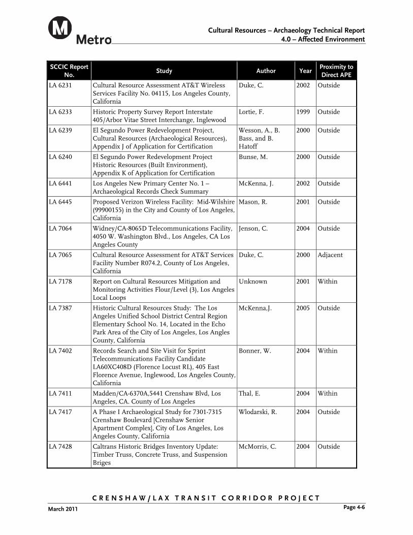
The SCCIC records search indicated that 50 cultural resource studies have been conducted within a 0.25-mile radius of the direct APE (Table 4-1). Fourteen of these studies are located within portions of the direct APE, and five are adjacent to the direct APE.
Table 4-1. Prior Cultural Resource Studies within a 0.25-mile Radius of the Direct APE
SCCIC Report No.
Study Author Year Proximity to Direct APE
LA 78 Evaluation of the Archaeological Resouces and Potential Impact of the Proposed Construction of Route 105 Freeway from El Segundo to Norwalk
Rosen, M. 1975 Within
LA 168 Draft Evironmental Impact Report in Accordance with Section 21151 of the Public Resources Code Storm Drain Bond Issue Project No. 9811, Inglewood Unit 1, Lines C and D
Miller, F. 1976 Outside
LA 597 Field Report on Site Near Stocker Avenue and Crenshaw Blvd., Los Angeles, California
Arris, R. 1949 Adjacent
LA 2838 Results of a Phase I Archaeological Study for the Proposed East Ventral Interceptor Sewer Project, East-West Alignment, Los Angeles County, California
Wlodarski, R 1993 Within
LA 3438 Report of Archeaological Survey for L.A. Cellular Site #775, 4401 Wilshire Boulevard, Los Angeles, Los Angeles County
Demcak, C. 1996 Outside
LA 3501 Archaeological Record Search and Impact Evaluation for the Los Angeles Wastewater Program Management (NOS-NCOS) Project, Los Angeles, California
Dillon, B. 1990 Outside
LA 3577 Report of Archaeological Survey for L.A. Cellular Site #675.3, 4401 Crenshaw Boulevard, Los Angeles, Los Angeles County
Demcak, C. 1996 Within
LA 3583 The Los Angeles Basin and Vicinity: A Gazetteer and Compilation of Archaeological Site Information
Buckman, B. 1974 Adjacent
LA 3587 Prehistoric Native American Cultural Sites in the Santa Monica Mountians
King, C. 1994 Adjacent
C R E N S H A W / L A X T R A N S I T C O R R I D O R P R O J E C T Page 4-4 March 2011

Cultural Resources – Archaeology Technical Report
4.0 – Affected Environment
C R E N S H A W / L A X T R A N S I T C O R R I D O R P R O J E C T Page 4-5 March 2011
SCCIC Report No.
Study Author Year Proximity to Direct APE
LA 3673 Historic Property Report North Outfall Relief Sewer (NORS)
Anonymous 1987 Adjacent
LA 3854 Phase I Archaeological Survey of a Corner Lost at 4305 Degnan Boulevard, Los Angeles, California 90008
Frierman, J. 1997 Outside
LA 3912 Historic Propety Survey Airport Boulevard – Manchester Avenue to N/O 98th Street
Unknown 1977 Outside
LA 3968 Archaeological Assessment for Pacific Bell Mobile Services Telecommunications Facility LA022-03, 2349 Crenshaw Boulevard, City and County of Los Angeles, California
McLean, D. 1998 Outside
LA 4336 Archaeological Investigations at 2441 Covina Hills Road – LA Cellular Facility No. 661.3 in the City of San Dimas, Los Angeles County California
Singer, C. and D. Morrill
1997 Outside
LA 4579 Cultural Resources Assessment for Pacific Bell Mobile Services Facility LA 579-01, County of Los Angeles, California
Duke, C. 1999 Within
LA 4667 Historic Resource Evaluation Report Exposition Boulevard Right-of-Way Regional Bikeway Project, Los Angeles County, California
Foster, J. 1999 Within
LA 4836 Pase I Archaeological Survey Along Onshore Portions of the Global West Fiber Optic Cable Project
Unknown 2000 Within
LA 4910 Paleontological and Archaeological Resources Reconnaisance of the Los Angeles International Airport (LAX) Property, Los Angeles County, California
Raschke, R. 1995 Outside
LA 5103 Negative Archaeological Survey Report: 491601 Inverson, G. 1999 Outside
LA 5106 Cultural Assessment for Pacific Bell Wireless Facility LA 922-01, County of Los Angeles, CA
Lapin, P. 2000 Outside
LA 5498 Negative Archaeological Survey Report: to widen the Northbound Route 405 off-ramp at Manchester Blvd. From a single lane to two lanes with a full shoulder retaining wall
Sylvia, B. 2001 Within
LA 5709 Review of Cultural Resource Assessment/Evaluation for Nextel Communications Site CA-7534-A, Los Angeles, Los Angeles County, California
McKenna, J. 2002 Outside
LA 5710 Cultural Resource Assessment AT&T Wireless Facility No. D432, Los Angeles County, California
Duke, C. 2002 Outside
LA 6230 Cultural Resource Assessment AT&T Wireless Services Facility No. D381C, Los Angeles County, California
Duke, C. 2002 Outside
Cultural Resources – Archaeology Technical Report
4.0 – Affected Environment
C R E N S H A W / L A X T R A N S I T C O R R I D O R P R O J E C T Page 4-6 March 2011
SCCIC Report No.
Study Author Year Proximity to Direct APE
LA 6231 Cultural Resource Assessment AT&T Wireless Services Facility No. 04115, Los Angeles County, California
Duke, C. 2002 Outside
LA 6233 Historic Property Survey Report Interstate 405/Arbor Vitae Street Interchange, Inglewood
Lortie, F. 1999 Outside
LA 6239 El Segundo Power Redevelopment Project, Cultural Resources (Archaeological Resources), Appendix J of Application for Certification
Wesson, A., B. Bass, and B. Hatoff
2000 Outside
LA 6240 El Segundo Power Redevelopment Project Historic Resources (Built Environment), Appendix K of Application for Certification
Bunse, M. 2000 Outside
LA 6441 Los Angeles New Primary Center No. 1 – Archaeological Records Check Summary
McKenna, J. 2002 Outside
LA 6445 Proposed Verizon Wireless Facility: Mid-Wilshire (99900155) in the City and County of Los Angeles, California
Mason, R. 2001 Outside
LA 7064 Widney/CA-8065D Telecommunications Facility, 4050 W. Washington Blvd., Los Angeles, CA Los Angeles County
Jenson, C. 2004 Outside
LA 7065 Cultural Resource Assessment for AT&T Services Facility Number R074.2, County of Los Angeles, California
Duke, C. 2000 Adjacent
LA 7178 Report on Cultural Resources Mitigation and Monitoring Activities Flour/Level (3), Los Angeles Local Loops
Unknown 2001 Within
LA 7387 Historic Cultural Resources Study: The Los Angeles Unified School District Central Region Elementary School No. 14, Located in the Echo Park Area of the City of Los Angeles, Los Angles County, California
McKenna,J. 2005 Outside
LA 7402 Records Search and Site Visit for Sprint Telecommunications Facility Candidate LA60XC408D (Florence Locust RL), 405 East Florence Avenue, Inglewood, Los Angeles County, California
Bonner, W. 2004 Within
LA 7411 Madden/CA-6370A,5441 Crenshaw Blvd, Los Angeles, CA. County of Los Angeles
Thal, E. 2004 Within
LA 7417 A Phase I Archaeological Study for 7301-7315 Crenshaw Boulevard [Crenshaw Senior Apartment Complex], City of Los Angeles, Los Angeles County, California
Wlodarski, R. 2004 Outside
LA 7428 Caltrans Historic Bridges Inventory Update: Timber Truss, Concrete Truss, and Suspension Briges
McMorris, C. 2004 Outside

Cultural Resources – Archaeology Technical Report
4.0 – Affected Environment
C R E N S H A W / L A X T R A N S I T C O R R I D O R P R O J E C T Page 4-7 March 2011
SCCIC Report No.
Study Author Year Proximity to Direct APE
LA 7713 Cultural Resources Assessment for AT&T Wireless Facility 950-004-132, Located at 8530 Airport Boulevard, City of Los Angeles, Los Angeles County, California
Kyle, C. 2004 Outside
LA 7715 Cultural Resources Records Search Results and Site Visit for Cingular Wireless Candidate EL-014-03 (Neutrogena Property), 5705 West 98th Street, Los Angeles, Los Angeles County, California
Bonner, W. 2005 Outside
LA 7727 Cultural Resources Records Search Results and Site Visit for Cingular Wireless Candidate EL-0073-01 (West Blvd), 1101 West Boulevard, Los Angeles, Los Angeles County, California
Bonner, W. 2005 Outside
LA 7753 Cultural Resources Records Search and Site Visit for T-Mobile Candidate LA03295B (Jamison Properties, Inc.), 4201 Wilshire Boulevard, Los Angeles, Los Angeles County, California
Bonner, W. 2006 Within
LA 7869 Cultural Resources Records Search and Site Visit for Sprint Nextel Candidate CA7731D (La Colima), 404 East Florence Avenue, Inglewood, Los Angeles County, California
Bonner, W. 2006 Within
LA 7909 Records Search and Field Reconnaissance for the Proposed Royal Street Communications LLC Wireless Telecommunications Site LA0259A (Bob’s Vacuum), Located at 4500 West Pico Boulevard, Los Angeles, California 90019
Wlodarski, R. 2006 Outside
LA 8001 Archaeological Survey Report Rosa Parks Villas, 2507 S. Bronson Avenue and 2440 Crenshaw Boulevard, Los Angeles, California
Wood, C. 2006 Outside
LA 8020 Technical Report: Cultural Resources Los Angeles Rapid Transit Project “Metro Rail” Core Study
Anonymous 1987 Within
LA 8255 Cultural Resources Final Report of Monitoring and Findings for the Qwest Network Construction Project State of California: Volumes I and II
Arrrington, C. and N. Sikes
2006 Within
LA 8507 Archaeological Survey Report for the Crenshaw Gateway Development, 4337-4347 West Adams Boulevard, Los Angeles, California
Wood, C. 2007 Outside
LA 8771 Cultural Resources Records Search and Site Visit Results for Royal Street Communications. LLC Candidate LA0252C (5360 Crenshaw), 5360 Crenshaw Boulevard, Los Angeles, Los Angeles County, California
Bonner, W. 2006 Outside
LA 8779 701 Hyde Park/LA-2639A, Cellular Antennas on Existing Rooftop, 701 E. Hyde Park Blvd., Inglewood, Los Angeles County, CA 90302
Billat, L. 2007 Outside
Source: South Central Coastal Information Center.

Cultural Resources – Archaeology Technical Report
4.0 – Affected Environment
4.2.2 Previously Recorded Archaeological Resources within a 0.25-mile Radius of the Direct Area of Potential Effect
The SCCIC records search indicated there are three previously recorded archaeological resources within a 0.25-mile radius of the direct APE (Table 4-2). Two are prehistoric resources, and one is of an unknown type because the site record is missing from the SCCIC. Of the three archaeological resources, one (CA-LAN-80) is located adjacent to the direct APE. The remaining two (CA-LAN-171 and CA-LAN-1336) are located within 0.25 mile of the direct APE.
Table 4-2. Previously Recorded Archaeological Resources within a 0.25-mile Radius of the Direct APE
Primary Number Trinomial Description Recorded by
and Year NRHP
Eligibility Proximity to Direct APE
P-19-000080 CA-LAN-80 Prehistoric: Artifact scatter and human remains
Ariss, R. 1949 Not evaluated Adjacent
P-19-000171 CA-LAN-171 Prehistoric: Human Remains
Heizer, R. 1950 Not evaluated Outside
P-19-001336 CA-LAN-1336 Unknown: Site record missing from SCCIC
Unknown Unknown Outside
Source: South Central Coastal Information Center.
CA-LAN-80 is a prehistoric burial site located immediately adjacent to the direct APE. It included two separate burial features that were discovered 3 feet and 11 feet below the original ground surface during. They were exposed in the excavation of the Broadway Store (now Wal-Mart) basement’s southeast corner in 1946. R. Ariss excavated the site in 1946, accessioned the collected materials at the Los Angeles County Museum (now the Natural History Museum of Los Angeles County), and formally recorded the site in 1949. The site consists of skeletal remains from at least two individuals, abalone shell, worked marine shell, an obsidian projectile point tip, a chert flake, and a schist groundstone artifact. Trace amounts of red ochre and charcoal were also present. The features were encountered in a distinct stratum beneath a layer of alluvial sediment. Based on the stratigraphy and his knowledge of local geography, Ariss (1949) suggested that the materials represented secondary burials deposited in a black clay and subsequently covered by flood sediments. The site has not been formally evaluated for National Register of Historic Places (NRHP) or California Register of Historical Resources (CRHR) eligibility.
CA-LAN-171 is a prehistoric burial site located approximately 0.25 mile west of the direct APE (although Brooks et al. [1990:62] place the site 0.3 mile west of Crenshaw Blvd.). It is referred to in the literature as the Angeles Mesa or Haverty site, after the neighborhood and construction firm associated with its discovery, respectively. The site was discovered during construction in 1924, reported by Chester H. Stock the same year, and formally recorded by Robert Heizer in 1950. It consists of at least eight sets of human remains that were found between 19 and 23 feet below surface. The remains were associated with a quartzite boulder and a small awl-like object and were found within a series of alluvial
C R E N S H A W / L A X T R A N S I T C O R R I D O R P R O J E C T Page 4-8 March 2011

Cultural Resources – Archaeology Technical Report
4.0 – Affected Environment
sediments (Stock, 1924). The dating of this important site has been the subject of some controversy, with reported ages ranging from approximately 50,000 to 2,700 years before present. Along with the nearby “Los Angeles Man” site and the skeletal remains from La Brea, the possibility that these remains date to the late Pleistocene epoch (i.e., more than 12,000 years ago) has long intrigued researchers. Although extensive dating by radiocarbon, amino acid racemization, and geomorphological means has yet to resolve the site’s age, it is probably safe to conclude that the skeletons are at least middle Holocene in age, and perhaps older (Brooks et al., 1990; Erlandson et al. 2007:54). The site has not been formally evaluated for NRHP or CRHR eligibility.
CA-LAN-1336 is an archaeological site located approximately 500 feet west of the direct APE, just southwest of CA-LAN-80. The site type, age, condition, and NRHP/CRHR eligibility status are unknown because its site forms are missing from the SCCIC.
4.2.3 California Historical Landmark
California Historical Landmark 363, known as Centinela Springs, is located less than 0.25 mile north of the direct APE. According to the landmark record, Centinela Springs once flowed from their source in a deep water basin that has existed since the Pleistocene epoch. Prehistoric animals, Native Americans, and early Historic-period Inglewood settlers were attracted to the springs by the pure artesian water. The springs and neighboring valley were named after the “sentinels” guarding cattle in the area. The springs are located within Centinela Park. No archaeological materials have been formally recorded in association with this landmark.
4.3 Sacred Lands File Search
SWCA contacted the California Native American Heritage Commission (NAHC) by letter dated June 15, 2010, requesting a review of the Sacred Lands File. The NAHC responded on June 28, 2010, and stated that the Sacred Lands File indicates the presence of Native American cultural resources within 0.5 mile of the project area.
4.4 Archaeological Survey
4.4.1 Survey Methods
SWCA archaeologist Cheryle Hunt conducted an archaeological survey of the approximately 8.5-mile-long direct APE on February 7, 2011. The survey included both intensive- and reconnaissance-level efforts. Ms. Hunt conducted a reconnaissance-level survey in highly developed portions of the direct APE, where buildings and pavement obscure the ground surface. In these portions of the APE, she examined all areas of exposed soil (e.g., in planters or other landscaped areas) for the presence of archaeological materials. Ms. Hunt examined the ground surface for artifacts (e.g., flaked stone tools, tool-making debris, stone milling tools, ceramics, fire-affected rock), soil discoloration that might indicate the presence of a cultural midden, soil depressions, and features indicative of the former presence of structures or buildings (e.g., standing exterior walls, postholes, foundations), and historic artifacts (e.g., metal, glass, ceramics). She conducted an intensive-level survey in areas of the direct APE that were unobstructed by standing buildings or structures, such as undeveloped lots or parklands. She surveyed
C R E N S H A W / L A X T R A N S I T C O R R I D O R P R O J E C T Page 4-9 March 2011

Cultural Resources – Archaeology Technical Report
4.0 – Affected Environment
C R E N S H A W / L A X T R A N S I T C O R R I D O R P R O J E C T Page 4-10 March 2011
these areas using pedestrian transects spaced no more than 7 feet apart, closely examining the ground surface for the presence of archaeological materials. Ms. Hunt navigated using project maps and aerial photographs. She documented her findings using field notes and digital photographs. All field notes, digital photographs, and records related to the current study are on file at SWCA’s Pasadena office.
4.4.2 Survey Results
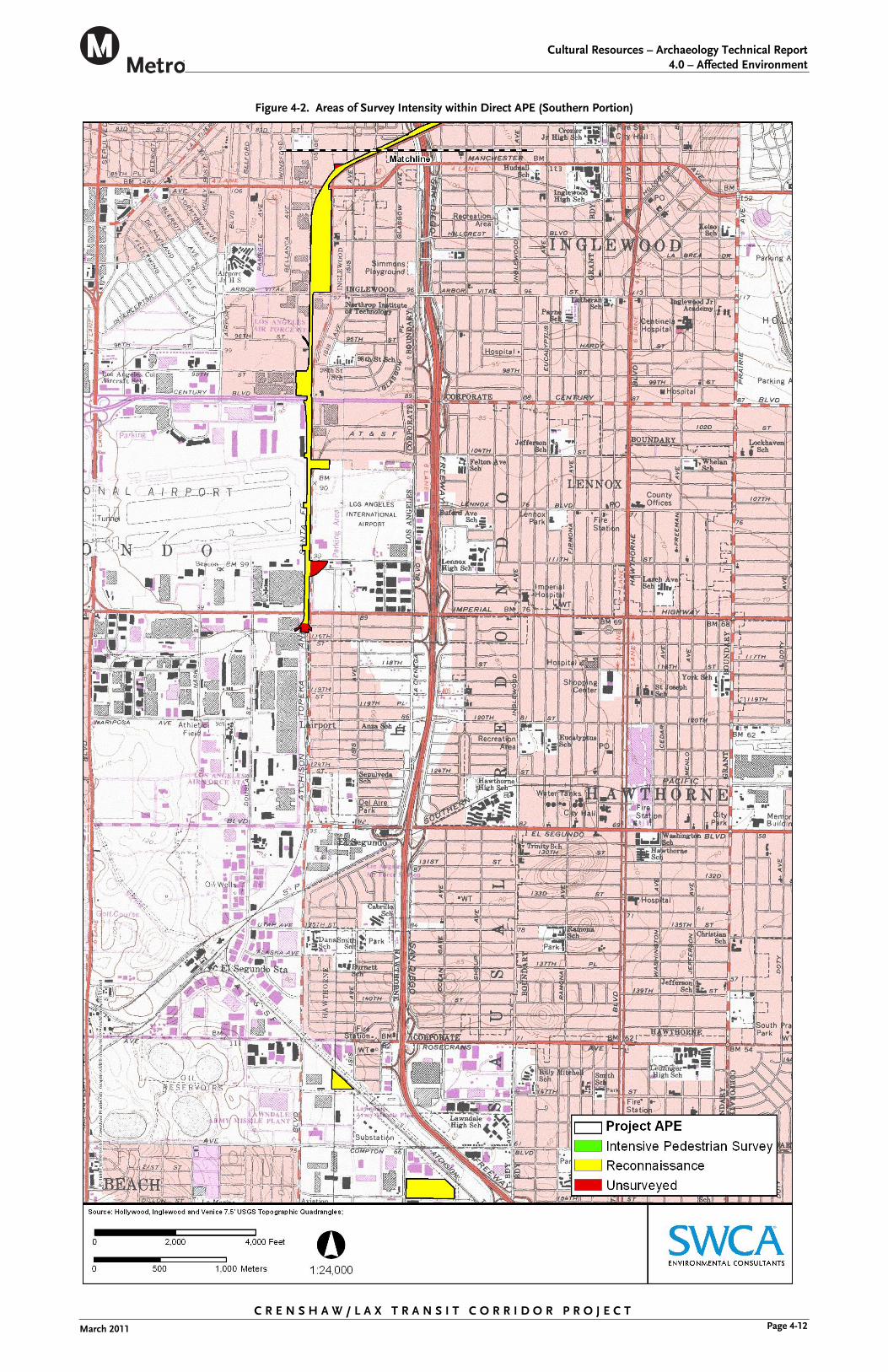
The SWCA archaeologist conducted intensive pedestrian survey within two areas of the direct APE (Figures 4-1 and 4-2). These areas consisted of undeveloped parcels and parklands. Ground visibility varied between 10 and 30 percent, as these areas contained ornamental landscaping, gravel, and modern refuse. They include the following locations:
Portions of Centinela Park located within the direct APE (Assessor’s Parcel Number [APN] 4013027901 and 4015015902).
Parcel located on Florence Avenue south of La Brea Avenue (APN 4016030014).
In addition, three areas of the direct APE could not be intensively surveyed because they were inaccessible due to the presence of fencing (see Figures 4-1 and 4-2). They include the following locations:
Parcel on Florence Avenue, south of Hindry Avenue (APN 4127024903).
Parcel on Aviation Boulevard south of 111th Street (APN 4129037913)
Parcel between Aviation Boulevard and Hornet Way (APN 4138001908).
The remainder of the approximately 8.5-mile-long direct APE contained extremely poor (less than 5 percent) ground visibility due to the presence of buildings and pavement and was subject to reconnaissance-level survey (see Figures 4-1 and 4-2).
The survey did not encounter any newly identified archaeological resources within the direct APE. The SWCA archaeologist attempted to re-locate a previously recorded site (CA-LAN-80) located immediately adjacent to the direct APE. Re-location of this site was attempted due to the presence of previously recorded, deeply buried human remains, indicating the potential for similar discoveries during ground-disturbing activities within the direct APE. The site remains covered by the building and parking lot, the construction of which led to the site’s discovery in 1946. The building currently houses a Wal-Mart. No evidence of the site is currently visible.

Cultural Resources – Archaeology Technical Report
4.0 – Affected Environment
Figure 4-1. Areas of Survey Intensity within Direct APE (Northern Portion)
C R E N S H A W / L A X T R A N S I T C O R R I D O R P R O J E C T Page 4-11 March 2011
Cultural Resources – Archaeology Technical Report
4.0 – Affected Environment
Figure 4-2. Areas of Survey Intensity within Direct APE (Southern Portion)
C R E N S H A W / L A X T R A N S I T C O R R I D O R P R O J E C T Page 4-12 March 2011

Cultural Resources – Archaeology Technical Report
5.0 – Impacts
5.0 IMPACTS
The direct area of potential effects (APE) is sensitive for historical resources, including both prehistoric and historic archaeological sites. Although no previously recorded cultural resources are located within the direct APE, there are two previously recorded prehistoric archaeological sites containing human remains within close proximity to the APE. One (CA-LAN-80) is immediately adjacent the direct APE, and the other (CA-LAN-171) is located approximately 0.25 mile from the direct APE. Both of these sites include human remains that were apparently buried by natural flood deposits, and both were discovered during construction-related excavation. At least one additional site containing deeply buried human remains, the “Los Angeles Man” site (Brooks et al. 1990:62; Moratto, 1984:52-53) is also known from the northern base of the Baldwin Hills (refer to Figure 4-1 to see the relationship of this landform to the APE). This area, including the segment of Crenshaw Blvd. between Rodeo Rd. and Slauson Ave., should be considered extremely sensitive for the discovery of deeply buried archaeological deposits containing human remains.
CA-LAN-80 is located immediately adjacent to the direct APE, and the full extent of the site was not determined at the time of its discovery. Therefore it is possible, perhaps even likely, that additional archaeological materials related to this site exist within the APE. These may be impacted by ground disturbance related to the construction of the proposed project.
In addition, historic data indicate that the direct APE was initially developed in the mid-1800s and that most parcels within the direct APE were occupied by commercial or residential buildings by the 1940s. This suggests there is a high potential to encounter previously unidentified historic archaeological sites, including building foundations, trash deposits, and the like, within the direct APE.
5.1 No-Build Alternative
5.1.1 Construction Impacts
The No-Build Alternative, in which the project site would remain in its existing condition, would not result in construction impacts to archaeological resources because no ground disturbance would occur.
5.1.2 Operational Impacts
The No-Build Alternative would not result in operational impacts to archaeological resources.
5.1.3 Cumulative and Indirect Impacts
The No-Build Alternative would not result in impacts to archaeological resources. Therefore, the No-Build Alternative would not contribute to a cumulative impact on these resources.
C R E N S H A W / L A X T R A N S I T C O R R I D O R P R O J E C T Page 5-1 March 2011

Cultural Resources – Archaeology Technical Report
5.0 – Impacts
C R E N S H A W / L A X T R A N S I T C O R R I D O R P R O J E C T Page 5-2 March 2011
5.2 Locally Preferred Alternative
5.2.1 Construction Impacts
The Locally Preferred Alternative (LPA) includes the construction of at-grade street, at-grade railroad, aerial, and below-grade light rail segments. All of these actions are likely to include ground-disturbing construction (grading, excavation, boring, etc.) that has the potential to alter, remove, or destroy previously unidentified archaeological resources and previously undiscovered portions of site CA-LAN-80 within the direct APE. Such damage to archaeological resources would represent a significant adverse, yet mitigable impact. Implementation of mitigation measure AR-1 (see Section 6.1) would reduce this impact to a less-than-significant level.
5.2.2 Operational Impacts
The LPA would not result in operational impacts to archaeological resources.
5.2.3 Cumulative and Indirect Impacts
The construction of the LPA, as stated above, has the potential to directly and adversely affect previously unidentified archaeological resources and previously undiscovered portions of site CA-LAN-80 within the APE. Because similar projects in the region may produce similar adverse effects, this would contribute to a cumulative impact to archaeological resources. However, implementation of AR-1 would reduce this impact to a less-than-significant level. Therefore, this alternative would not contribute to a cumulative impact on these resources.

Cultural Resources – Archaeology Technical Report
6.0 – Mitigation Measures
6.0 MITIGATION MEASURES
6.1 Construction Impacts Mitigation Measures
6.1.1 AR-1: Treatment of Undiscovered Archaeological Resources
A detailed cultural resources monitoring and mitigation plan (CRMMP) would be prepared prior to implementation of this project, similar in scope to the CRMMP that was prepared for Metro’s Eastside Gold Line Transit Corridor (Glenn and Gust, 2004). Implementation of a CRMMP during ground disturbance in highly sensitive archaeological areas would ensure that cultural resources are identified and adequately protected. If cultural resources are discovered or if previously identified resources are affected in an unanticipated manner, the CRMMP would also ensure that such resources receive mitigation to reduce the impact to less-than-significant levels. This plan would include, but not be limited to, the following elements, which are described briefly below:
Worker training
Archaeological monitoring
Scientific evaluation and mitigation of archaeological discoveries
Native American participation, as needed
Appropriate treatment of human remains, if applicable
Reporting of monitoring and mitigation results
6.1.2 Worker Training
Prior to initiation of ground-disturbing activities, a qualified archaeologist would conduct a short awareness training session for all construction workers and supervisory personnel. The session would explain the importance of and legal basis for the protection of significant archaeological resources. Each worker would also learn the proper procedures to follow in the event that cultural resources or human remains are uncovered during ground-disturbing activities. These procedures include work curtailment or redirection and the immediate contact of the supervisor and the archaeological monitor. It is recommended that this worker education session include visual representations of artifacts (prehistoric and historic) that might be found in the project vicinity and that it take place on-site immediately prior to the start of ground disturbance. Supervisory personnel may benefit from longer training sessions, while a brief (approximately 30- to 45-minute) training would suffice for non-supervisory workers. The brief training session may be conducted on-site using video, PowerPoint presentation, or similar media.
6.1.3 Archaeological Monitoring, Evaluation, and Mitigation
Due to poor surface visibility and archaeological sensitivity of the direct area of potential effects (APE), an archaeological monitor would be present during ground-disturbing activities within archaeologically sensitive areas to reduce the potential level of impact to buried archaeological resources to less-than-significant levels. This work would be
C R E N S H A W / L A X T R A N S I T C O R R I D O R P R O J E C T Page 6-1 March 2011

Cultural Resources – Archaeology Technical Report
6.0 – Mitigation Measures
completed under the direction of an archaeologist (principal investigator) who meets the Secretary of the Interior’s Professional Qualifications Standards for archaeology. An adequate number of monitors would be present to ensure that all earth-moving activities are observed; these monitors would be on-site during all grading activities for areas to be monitored.
During the original excavation of previously undisturbed soils, the archaeological monitor(s) would be on-site at a frequency determined by the principal investigator. Inspection frequency may vary based on the rate of excavation, the materials excavated, and the presence and abundance of artifacts and features. Full-time monitoring is warranted within one block of significant or unevaluated archaeological resources that are known or suspected to be present within the direct APE. Full-time monitoring is also warranted within the APE between Rodeo Road and Slauson Ave. due to the high potential for encountering previously undocumented buried human remains.
In the event that potentially significant archaeological resources are exposed during ground-disturbing activities, the project manager would be notified immediately and the archaeological monitor(s) would have the authority to divert or temporarily halt ground disturbance operations in the area of discovery to allow evaluation of the resources. Construction activities may continue in other areas.
The evaluation of such resources is typically accomplished through a test-level excavation designed to determine the horizontal and vertical extent of the resource and to characterize its contents. If the discovery proves to be potentially eligible for listing on the National Register of Historic Places (NRHP) or California Register of Historical Resources (CRHR) (as determined by the principal investigator) and project plans cannot be altered to avoid affecting the site, then an adverse effect would result. This adverse effect may be resolved through the implementation of a Memorandum of Agreement between Metro and the State Historic Preservation Officer.
Before construction activities are allowed to resume in an affected area, artifacts would be recovered and features recorded using professional archaeological methods. The principal investigator would determine the amount of material to be recovered for an adequate artifact sample for analysis. All cultural material collected during the construction monitoring program would be processed using professional archaeological methods. An appropriate sample of recovered materials, selected by the principal investigator, would be curated at a curation facility that meets Federal standards per 36 Code of Federal Regulations (C.F.R.) Part 79 and made available to other archaeologists and researchers for future study.
6.1.4 Native American Participation
If Native American cultural resources (i.e., prehistoric or ethnohistoric-period artifacts, food remains, or features associated with Native Americans) are exposed during project-related ground disturbance, Metro would contact the Shoshonean Gabrielino Band of Mission Indians and the Gabrielino/Tongva San Gabriel Band of Mission Indians. Both groups have expressed interest in the project. One or both of these groups would be asked to provide the services of a trained Native American consultant to monitor ground-
C R E N S H A W / L A X T R A N S I T C O R R I D O R P R O J E C T Page 6-2 March 2011

Cultural Resources – Archaeology Technical Report
6.0 – Mitigation Measures
C R E N S H A W / L A X T R A N S I T C O R R I D O R P R O J E C T Page 6-3 March 2011
disturbing work in the area containing the Native American cultural resources. This monitoring would occur on an as-needed basis and would be intended to ensure that Native American concerns are taken into account during the construction process.
6.1.5 Appropriate Treatment of Human Remains
The discovery of human remains is always a possibility during ground disturbance. A previously recorded prehistoric archaeological site (CA-LAN-80) that contains human remains is located immediately adjacent to the direct APE. A second previously recorded prehistoric site (CA-LAN-171) containing human remains is located approximately 0.25 mile west of the direct APE.
The State of California Health and Safety Code Section 7050.5 addresses the finding of human remains. This code section states that when human remains are encountered, no further disturbance shall occur until the County Coroner has made a determination of origin and disposition pursuant to Public Resources Code (P.R.C.) Section 5097.98. The County Coroner must be notified of the find immediately.
If the human remains are determined to be prehistoric, the Coroner will notify the Native American Heritage Commission (NAHC), which will determine and notify a Most Likely Descendant. The Most Likely Descendant shall complete the inspection of the site within 48 hours of notification and may recommend scientific removal and nondestructive analysis of human remains and items associated with Native American burials. It is important to note that impacts to human remains may remain significant even after mitigation.
6.1.6 Reporting
In the event that no cultural resources are discovered in the course of construction monitoring, a brief letter to that effect would be prepared by the consulting archaeologist indicating that the monitoring activities have been satisfied. In the event that previously unidentified cultural resources are discovered in the course of construction monitoring, a report following Archaeological Resource Management Report guidelines(OHP, 1990) that documents field and analysis results and interprets the data within an appropriate research context would be prepared.
6.2 Operation Impacts Mitigation Measures
Because operational impacts to archaeological resources are not expected for the Locally Preferred Alternative (LPA), no mitigation would be required.
Cultural Resources – Archaeology Technical Report
7.0 – Conclusions
7.0 CONCLUSIONS
This evaluation included a review of relevant archaeological records, a Native American coordination program, and an archaeological survey of the project’s direct APE. The background study identified no previously recorded cultural resources within the direct APE, although three previously recorded archaeological sites are located within 0.25 mile of the direct APE. Two of these sites (CA-LAN-80 and CA-LAN-177) are important because they contained prehistoric human remains. CA-LAN-80 is located immediately adjacent to the direct APE, thereby increasing the archaeological sensitivity of this portion of the project. In addition, the direct APE lies within a long-developed and highly urbanized portion of Los Angeles County, thereby increasing the potential for encountering previously unrecorded historic resources.
The Locally Preferred Alternative (LPA) will not have operational impacts to archaeological resources. However, construction of the LPA has the potential to alter, remove, or destroy previously undiscovered archaeological resources within the APE. The physical destruction of an archaeological resource that is eligible for listing in the National Register of Historic Places (NRHP) and Californa Regsiter of Historical Resources (CRHR) would result in an adverse effect under Section 106 regulations and a significant impact under the California Environmental Quality Act (CEQA). This would also contribute to a cumulative impact on archaeological resources.
To address potential impacts to previously undiscovered archaeological resources, the project would include the production and implementation of a detailed cultural resources monitoring and mitigation plan. After mitigation, potential construction and cumulative impacts would not be significant under the National Environmental Policy Act (NEPA), National Historic Preservation Act (NHPA), or CEQA.
C R E N S H A W / L A X T R A N S I T C O R R I D O R P R O J E C T Page 7-1 March 2011

Cultural Resources – Archaeology Technical Report
8.0 – References
8.0 REFERENCES
Ariss, R.M. 1949. Field Report on Site near Stocker Avenue and Crenshaw Blvd., Los Angeles California, Investigated 26 and 27 April 1946. Report submitted to Los Angeles County Museum. On file at South Central Coastal Information Center, California State University, Fullerton.
Bean, Lowell J., and Charles R. Smith. 1978. “Gabrielino.” In California, edited by Robert F. Heizer, pp. 538–549. Handbook of North American Indians, Vol. 8, William C. Sturtevant, general editor, Smithsonian Institution, Washington, D.C.
Brooks, Sheilagh, Richard A. Brooks, G.E. Kennedy, J. Austin, James R. Firby, Louis A. Payen, Peter J. Slota, Jr., Christine A. Prior, and R.E. Taylor. 1990. Journal of California and Great Basin Anthroplogy 12(1):60-83.
California Environmental Resources Evaluation System (CERES). 2009. Title 14, Article 9. Contents of Environmental Impact Reports: Sections 15120 to 15132. Website accessed on May 22, 2009. http://ceres.ca.gov/ceqa/guidelines/art9.html.
Chartkoff, Joseph L., and Kerry Kona Chartkoff. 1984. The Archaeology of California. Stanford University Press, Stanford, California.
Dumke, Glenn S. 1944. The Boom of the Eighties in Southern California. Huntington Library Publications, San Marino, CA.
Federal Highway Administration (FHWA). 2009. Section 4f Overview. Website accessed on May 22, 2009. http://www.environment.fhwa.dot.gov/4f/index.asp.
Glenn, Brian K. and Sherri Gust. 2004. Cultural Resource Monitoring and Mitigation Plan for the Los Angeles County Metropolitan Transportation Authority Eastside Gold Line Transit Corridor, Los Angeles, Los Angeles County, California. Report prepared by Cogstone Resource Management Inc. for UltraSystems Environmental, Inc. and Metropolitan Transportation Authority. On file at SWCA Environmental Consultants, South Pasadena.
Erlandson, Jon M., Torben C. Rick, Terry L. Jones, and Judity F. Porcasi. 2007. One if by Land, Two if by Sea: Who Were the First Californians? In California Prehistory: Colonization, Culture, and Complexity, edited by Terry L. Jones and Kathryn A. Klar, pp. 53-62. AltaMira Press, Lanham, MD.
Johnson, Paul C., Dorothy Krell, John S. Weir, Harry Downie, Adrian Wilson, Joe Seney, Philip Spencer, and France Carpentier. 1972. The California Missions A Pictorial History. Sunset Books, Lane Publishing, Menlo Park, California.
Johnson, J.R., T.W. Stafford, Jr., H.O. Ajie, and D.P. Morris. 2002. “Arlington Springs Revisited.” In: Proceedings of the Fifth California Islands Symposium, edited by D.R. Brown, K.C. Mitchell, and H.W. Chaney, pp. 541–545. Santa Barbara Museum of Natural History.
C R E N S H A W / L A X T R A N S I T C O R R I D O R P R O J E C T Page 8-1 March 2011

Cultural Resources – Archaeology Technical Report
8.0 – References
C R E N S H A W / L A X T R A N S I T C O R R I D O R P R O J E C T Page 8-2 March 2011
Jones, Terry L., Richard T. Fitzgerald, Douglas J. Kennett, Charles Miksicek, John L. Fagan, John Sharp, and Jon M. Erlandson. 2002. “The Cross Creek Site and Its Implications for New World Colonization.” American Antiquity 67:213–230.
King, Chester D. 1994. Native American Placenames in the Santa Monica Mountains National Recreation Area, Agoura Hills. Topanga Anthropological Consultants, California.
Kowta, Makoto. 1969. “The Sayles Complex, a Late Milling Stone Assemblage from the Cajon Pass and the Ecological Implications of Its Scraper Planes.” University of California Publications in Anthropology 6:35–69. Berkeley, California.
Kroeber, Alfred L. 1925. Handbook of the Indians of California. Bulletin 78, Bureau of American Ethnology, Smithsonian Institution. Government Printing Office, Washington, D.C. Reprinted 1976 by Dover Publications, Inc., New York.
McCawley, William. 1996. The First Angelinos: The Gabrielino Indians of Los Angeles. Malki Museum Press, Banning, California, and Ballena Press, Novato, California.
Mithun, Marianne. 2004. The Languages of Native North America. Cambridge University Press, Cambridge, Massachusetts. Originally published 1999.
Moratto, Michael J. 1984. California Archaeology. Academic Press, San Diego.
Nevin, David. 1978. The Mexican War. Time-Life Books, Alexandria, Virginia.
Office of Historic Preservation (OHP). 1990. Archaeological Resource Management Report (ARMR). California Office of Historic Preservation. Department of Parks and Recreation, Sacramento, California.
Reinman, Fred M. 1964. “Maritime Adaptations on San Nicolas Island, California.” University of California Archaeological Survey Annual Report 1963–1964:47–80.
Rolle, Andrew. 2003. California: A History, expanded 6th ed. Harlan Davidson: Wheeling, Illinois.
Stock, Chester A. 1924. “A Recent Discovery of Ancient Human Remains in Los Angeles, California.” Science 4 July:2–5.
Wallace, William J. 1955. “A Suggested Chronology for Southern California.” Southwestern Journal of Anthropology 11(3):215–230.
Wallace, William J. 1978. “Post-Pleistocene Archaeology, 9000 to 2000 B.C.” In California, edited by Robert F. Heizer, pp. 25–36. Handbook of North American Indians, Vol. 8, William G. Sturtevant, general editor, Smithsonian Institution, Washington, D.C.