cultural heritage evaluation report halton … · charles kennedy and richard bristol surveyed...
TRANSCRIPT

CULTURAL HERITAGE EVALUATION REPORT HALTON HILLS CULVERT #54C
(LOT 28, CONCESSION 9
GEOGRAPHIC TOWNSHIP OF ESQUESING) 27TH SIDE ROAD
TOWN OF HALTON HILLS, ONTARIO
July 2009
Prepared for: R. J. Burnside & Associates
Prepared by:
CULTURAL HERITAGE EVALUATION REPORT
HALTON HILLS CULVERT #54C/
(LOT 28, CONCESSION 9 GEOGRAPHIC TOWNSHIP OF ESQUESING)
27TH SIDE ROAD TOWN OF HALTON HILLS, ONTARIO
July 2009
Prepared for: R.J. Burnside & Associates Limited
292 Speedvale Ave West, Unit 7 Guelph, ON, N1H 1C4
Tel: 519 823 4995
Prepared by: Unterman McPhail Associates
Heritage Resource Management Consultants 540 Runnymede Road Toronto, ON, M6S 2Z7
Tel: 416-766-7333

TABLE OF CONTENTS
Page
1.0 INTRODUCTION 1 2.0 HISTORICAL SUMMARY 2.1 Township of Esquesing 2 2.2 McClure Property, Lot 28, Concession 9 (Fallbrook Farm) 5 2.3 Halton Culvert #54C 6 2.4 Stone Masonry Arch Bridges 8 3.0 CULTURAL HERITAGE LANDSCAPE DESCRIPTION 9 3.1 Area Context 9 3.2 Site 9 4.0 BUILT HERITAGE RESOURCE DESCRIPTION 11 4.1 Introduction 11 4.2 Halton Culvert #54C 11 4.2.1 Modifications 12 4.2.2 Comparative Analysis 12 5.0 EVALUATION OF HALTON CULVERT #54C 14 5.1 Introduction 14 5.2 Evaluation 14 5.3 Summary of Cultural Heritage Value 16 6.0 MITIGATION RECOMMENDATIONS 17 SOURCES APPENDIX A: Historic Maps and Photograph APPENDIX B: Ontario Ministry of Culture’s Bridge Survey Form APPENDIX C: Evaluation Criteria, Ontario Heritage Bridge Program (1983, rev 1991)

LIST OF FIGURES
Page
Figure 1. Location map of the Halton Culvert #54C [Google Maps 2009].
1
Figure 2. Aerial of the location of Halton Culvert #54 C [Microsoft Virtual Earth 2009 as adapted by Unterman McPhail Associates].
10

Cultural Heritage Evaluation Report: Halton Culvert #54C, 27th Side Road Page 1
(Lot 28, Concession 9, Geographic Township of Esquesing)
Town of Halton Hills, Ontario
Unterman McPhail Associates July 2009 Heritage Resource Management Consultants
1.0 INTRODUCTION
R.J. Burnside & Associates Limited retained Unterman McPhail Associates, Heritage Resource Management Consultants, on behalf of the Town of Halton Hills to undertake a cultural heritage evaluation report (CHER) for the Halton Culvert #54C —also referred to as the Silver Creek Bridge and Fallbrook Bridge—on behalf of the Town of Halton Hills. The Town of Halton Hills is preparing an environmental assessment to develop alternatives and undertake public consultation to address the structural deficiencies of the culvert on 27th Side Road. A 2008 condition survey indicated the structure has stone loss and mortar deterioration and the railing system does not meet current safety standards. The bridge has been identified as being deficient in respect to deck width, barrier and guide rail protection. The project is being planned as a Schedule B project in accordance with the requirements of the Municipal Class Environmental Assessment (Class EA) document (June 2000, amended September 2007). Halton Culvert #54C carries the 27th Side Road over a tributary of Silver Creek in the former Esquesing Township. The crossing is located on to the Bruce Trail and in proximity to the Bennett Heritage Trail. The Town of Halton Hills was created from part of the Township of Esquesing in January 1974 to become a separate municipality in the Regional Municipality of Halton.
Figure 1. Location map of the Halton Culvert #54C [Google Maps 2009].
Cultural Heritage Evaluation Report: Halton Culvert #54C, 27th Side Road Page 2
(Lot 28, Concession 9, Geographic Township of Esquesing)
Town of Halton Hills, Ontario
Unterman McPhail Associates July 2009 Heritage Resource Management Consultants
The Ministry of Culture’s Ontario Heritage Bridge List indicates the Halton Culvert #54C is not included as a heritage structure. The Town of Halton Hills confirms the culvert structure is not listed in a municipal inventory of cultural heritage resources, or designated under the Ontario Heritage Act. However, the Halton Culvert #54 is included in the Heritage Halton Hills heritage designation report prepared for the McClure-McKay House property at 14513-27th Side Road in December 2008. This designation report has not been presented to Council for approval at this time. This cultural heritage resource evaluation report includes a historical summary of the bridge and its setting, a summary of the heritage significance of the bridge, and a discussion of conservation recommendations. Historic maps and drawings are included in Appendix A. Appendix B contains the Ontario Ministry of Culture’s Bridge Survey Form and Appendix C has the Heritage Bridge Evaluation Criteria, Ontario Heritage Bridge
Program (1983, rev. 1991). 2.0 HISTORICAL SUMMARY
2.1 Township of Esquesing
The colony of Quebec was divided into the two provinces of Upper and Lower Canada in 1791. Upper Canada (now Ontario) was all the land lying west of the Ottawa River. The four original district names were changed in 1792 and Nassau became the Home District. The Gore District was formed in 1816 from parts of York County in the Home District and parts of the Niagara District. It included the two new counties of Wentworth and Halton with the district town in Hamilton. In 1838, parts of Halton County and parts of Home and Huron Districts were separated to form a new Wellington District. In 1842, Upper and Lower Canada united to form the Province of Canada and Upper Canada became known as Canada West. Canada West was divided into twenty districts, which were subdivided into counties, ridings and townships. As the larger districts were settled and its populations increased, they were divided into smaller districts. In 1849, the United Counties of Wentworth and Halton replaced the Gore District. Halton County became an independent county in 1853, when it separated from Wentworth County. Charles Kennedy and Richard Bristol surveyed Esquesing Township in Halton County into eleven concessions with thirty-two lots each in 1818. The township was divided into east to west concessions and north to south lots numbered east to west. The concessions were divided into lots of 200 acres each, and often sold as half lots of 100 acres. James Hume and Ronald MacDonald were among the first settlers in Esquesing Township in 1819. In 1819, the village of Esquesing (renamed Stewarttown in 1849) was the unofficial capital of the township on the west bank of the Credit River, and the township’s first post office was established in this location in 1820.
Cultural Heritage Evaluation Report: Halton Culvert #54C, 27th Side Road Page 3
(Lot 28, Concession 9, Geographic Township of Esquesing)
Town of Halton Hills, Ontario
Unterman McPhail Associates July 2009 Heritage Resource Management Consultants
Esquesing Township was settled quickly between 1820 and 1850. Smith’s Canadian
Gazetteer (1846) describes Esquesing as,
…a fine township, containing excellent land, and many good farms, which are
generally cultivated. Wheat of superior quality is grown in this and the adjoining
townships. The land is mostly rolling.1
Several small hamlets and villages were established by the middle of the 19th century to service local needs and as industrial centres. By 1858, Tremaine’s map included Acton, Limehouse, Speyside, Ballinafad, Silver Creek, Glen Williams, Georgetown, Stewarttown, and Norval and Ashgrove. In the northeast section, Ballinafad was established on the town line between Erin and Esquesing Townships. By 1877, this small village had with about 150 inhabitants, and contained a general store, post office, grocery, a blacksmith business, pump factory, wagon making business and a hotel.2 Georgetown, once known as Hungry Hollow, was founded in 1823, with the earliest settlers being the George Kennedy family. In 1837 the Barber Brothers established their woollen mills. By 1877, the village had a population of 1500 people and numerous manufacturers using the Credit River as a power source. The community was incorporated as a village in 1864. The Grand Trunk and the Hamilton and Northwestern railways passed through the community and contributed to its industrial and economic progress in the 19th century.3 The settlement of Fountain Green on the banks of Black Creek in the 1840s included a sawmill and limekiln. It was renamed Limehouse in 1857 when its post office opened. Despite its numerous industries, Limehouse’s population grew slowly compared to other settlements in the township. Silver Creek located on Concession 7, Lot 25 included two mills in 1858. By 1877, the community had an inn and church, and the mill was vacant, but a quarrying business was in operation. A lime kiln was operating on Fallbrook Trail north of 27th Side Road in 1877. Glen Williams was described as an energetic manufacturing village on the River Credit with about 500 people in 1877. The Charles Williams family was the first settler in the area in the 1820s. The advantage of water power resulted in the quick settlement of the village and area. First called Williamsburg, it was renamed Glen Williams when a post office was opened in 1852. The village contained the Williams Woolen Mill, which was first built by Jacob Williams in 1839. Charles William operated the business from 1854 to 1867 when it was destroyed by fire. The mill buildings were rebuilt in the same year and destroyed by fire again in 1875. Joseph Williams owned the Glen Williams flour mill and Charles Williams a sawmill that was built in 1825.4
1 W. H. Smith, Smith’s Canadian Gazetteer. Toronto: H & W Rowsell, 1846. 56. 2 Illustrated Historical Atlas of Halton County, 56. 3 Ibid. 4 Illustrated Historical Atlas of Halton County, 56; Library and Archives Canada. Post Offices and
Postmasters, Glen Williams. Access;--<http://www.collectionscanada. gc.ca/databases/post-offices/index-
e.html>.
Cultural Heritage Evaluation Report: Halton Culvert #54C, 27th Side Road Page 4
(Lot 28, Concession 9, Geographic Township of Esquesing)
Town of Halton Hills, Ontario
Unterman McPhail Associates July 2009 Heritage Resource Management Consultants
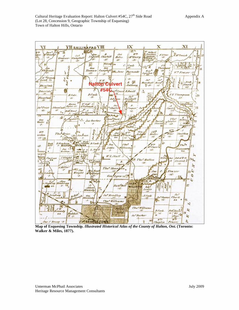
Roads and railways were crucial to a township’s economy and population in the nineteenth century. In the 19th century statute labour was used to clear and maintain roads. In Esquesing Township, two main roads were cleared in the 1830s. The first, known as the York Road, which eventually connected Little York (Toronto) to Guelph, reached Georgetown in 1832.5 The Gore District Council decided in the 1830s to build a road running northwards from Oakville to the Township of Erin through Esquesing and Trafalgar Townships, passing through Stewarttown and Georgetown. It was meant to ease the transportation of goods to and from Oakville. In 1837, this road was named the Garafraxa Road when it was extended into Garafraxa Township. In 1850-51 the Garafraxa Road was improved between Oakville and Stewarttown by becoming a plank/corduroy road. The planking was eventually extended to Georgetown, but was too expensive to maintain and eventually removed in the 1860s. The Rottenburg map (c1850) indicates both Concession 8 and Concession 9 in the northeast corner of Esquesing Township had been opened as a local roads north of Georgetown to about Lots 25/26; however a section of road around Lots 27 and 28 remained unopened. The roads then continued further northward. Concession 10 was open to the northern boundary of the township and beyond.6 Land records show the Township of Esquesing approved By-Law 215 to open up and confirm a certain allowance for a road westerly from Concession 8 through Lot 28 in Concession 9, Esquesing Township, in December 1871. This became the 27th Side Road, which is shown as an open “given” road on Esquesing Township map in the Illustrated Historical
Atlas of Halton County (1877). It ran from Concession 8 southeasterly to meet with a “given” road that ran north to south in the east half of Lot 28. This north-south road joined Concession 9 between Lots 25 and 26, and Lots 28 and 29, and forms the present Fallbrook Trail. The Esquesing Township map also shows a well-developed landscape with an extensive local road network, many farmsteads, small hamlets and villages, schools and churches. Two railway companies had lines in Esquesing Township, the Grand Trunk Railway and the Hamilton and Northwestern Railway. The Grand Trunk Railway had a line in the northern part of the township with stations in Georgetown, Limehouse and Acton, and the Hamilton and Northwestern Railway had a line that ran diagonally northwards through the township, passing just north of Stewarttown and through Georgetown. The township continued to be agricultural in character and use throughout the nineteenth century.
The first County Road System plan was put in place in October 1907. The Garafraxa Road was paved for the first time in 1932/3. Provincial Highways 7 and 25 both run through Esquesing Township crossing at Acton.7 Esquesing Township has experienced population growth and urban expansion in the twentieth century. Esquesing Township
5 John McDonald, Halton Sketches Revisited: Historical Tales of People and Events in North Halton. rev.
ed. (Norval: Moulin Publishing Ltd, 1996) 5; Illustrated Historical Atlas, 55. 6 Map of the Principal Communications in Canada West by Major Baron de Rottenburg [1850?].

Cultural Heritage Evaluation Report: Halton Culvert #54C, 27th Side Road Page 5
(Lot 28, Concession 9, Geographic Township of Esquesing)
Town of Halton Hills, Ontario
Unterman McPhail Associates July 2009 Heritage Resource Management Consultants
with Acton and Georgetown became the Town of Halton Hills in the Regional Municipality of Halton in 1974. 2.2 McClure Property, Lot 28, Concession 9 (Fallbrook Farm)
Land records indicate the Crown Patent for the east half of Lot 28, Concession 9 was acquired by the Canada Company in 1841. William McClure bought the east half of Lot 28, Concession 9, Esquesing Township from the Canada Company in 1854. Tremaine’s map (1858) shows William McClure as the owner of the east half of Lot 28, Concession 9 with a sawmill in the west part of the east half of Lot 28 at the surveyed right-of-way for Side Road 27th and a millpond located immediately north of 27th Side Road. A. Johnston owned the west part of Lot 28, Concession 9 in 1858. The Census Return (1861) notes 49-year old farmer William McClure was the owner of 100 acres of land of the east half of Lot 28, Concession 9. McClure, his wife 45-year old wife Elizabeth and nine children lived in a 1 storey stone house built in 1852. Tremaine’s map (1850) shows a mill pond north of the 27th Side Road right-of-way on the westerly part of the east half of Lot 28. A mill appears to have been in use at this location from 1850s to the early 1870s.8 Land records indicate William and Eliza Anne McClure sold 25 acres of the westerly quarter of the east half of Lot 28, Concession 9, lying west of a road allowance, which had been granted by William McClure to Council, together with buildings, appurtenances and all of the machinery in and belonging to the buildings being used for saw mill purposes. McClure sold 21 acres of land on Lot 28, Concession 9 to Joseph Smith and John MacDonald in September 1869.9 Smith and his wife sold their part to John MacDonald in 1871. The Census Return (1871) indicates 38-year old farmer John McDonald was owned 25 acres of land on Lot 28, Concession 9, which included two houses, one warehouse or factory and a barn. The industrial return notes Smith and McDonald operated a steam shingle mill, presumably on Lot 28, Concession 9. On the other side of Lot 28, Concession 9 Joseph Shortill acquired ownership of the west half in October 1871, deed registered in December 1871. On the east half, Charles Symon and David Allan bought the McDonalds property in 1872. Several land transactions for this property occurred in the mid 1870s. In December 1874, John McDonald sold the 75 acres of the east three-quarters of Lot 28 lying east of the road allowance (Fallbrook Trail) to David Symon Cooper. Samuel Irvine acquired ownership of 21 acres on the east half of Lot 28 from the estate of Charles Symon and James Symon in January 1877, deed registered in March 1877.10 The Illustrated Historical Atlas (1877) notes non-
8 T. Murison, McClure Log House (Fallbrook Conservation Are) Heritage Investigation Report 14513-27
Side Road Concession 9, Lot 28, Esquesing Township (March 12, 2008) 41. This report speculates that there is evidence of a mill head and dam north of the present bridge on Silver Creek and that the mill
structure was removed in early 1877. 9 Archives of Ontario. GSU 178993, Land Registry Office, Halton County, Esquesing Township Instrument
205H, September 29, 1869. 10 Land Registry Office, Halton County, Esquesing Township, Lot 28, Concession 9.

Cultural Heritage Evaluation Report: Halton Culvert #54C, 27th Side Road Page 6
(Lot 28, Concession 9, Geographic Township of Esquesing)
Town of Halton Hills, Ontario
Unterman McPhail Associates July 2009 Heritage Resource Management Consultants
resident S. Irvine as the owner of the mill property on Silver Creek, and D. Cooper as the owner of the property to its immediate east in Lot 28, Concession 9. Donald and Jessie MacKay acquired ownership of the Irvine property in February 1877, deed registered in March 1877, and settled on the property with their son William. The Illustrated Historical Atlas (1877) shows two sawmills located at the intersection of 27th Side Road and Concession 8. The 27th Side Road ran eastward from Concession 8 through Joseph Shortill’s property in Lot 28 on a west-east given road immediately north of the surveyed right-of-way for the side road. It connected with another given road (Fallbrook Trail) in the westernmost part of the east half of Lot 28, Concession 9. The 27th Side Road crossed the Silver Creek to the immediate west of the north-south as a given road in Lot 28, Concession 9. To the north Fallbrook Trail ran through Concession 9 to Lot 29 then east to Concession 9. To the south, it ran through Lot 27 in a meandering manner to the 25th Side Road. At the intersection of 27th Side Road and Fallbrook Trail there were two buildings located on the northwest corner and two buildings on the southwest corner of the intersection. The McKay family continued to own the property immediately of east of Halton Culvert #54C into the 20th century, selling the property 1943 to the Vaughan family. The Credit Valley Conservation Authority (CVC) bought the land in the area of the bridge in 1973. Tenants occupied the house until 2001.11 2.3 Halton Culvert #54C
Esquesing Township minutes reveal Council appointed a committee to examine a cross road between Lots 27 and 28, Concession 9 with a view to purchase the right-of-way for a road across the west half of Lot 28 in case the original road allowance cannot be made passable.12 James Harron, Provincial Land Surveyor, surveyed the road on November 29, 1871. Esquesing Township By-law 215 was registered on property title for Lot 28, Concession 9 on December 13, 1871 to open up and confirm a certain allowance for a road on Lot 28, Concession 9 across the west half and part of the east half of Lot 28. The road was described as crossing the west half and part of the east half of Lot 28, Concession 9 with land purchased from Joseph Shortill and John MacDonald, the owners of the west and east halves of Lot 28, respectively. Shortill received $128.00 in payment from the Township for his land, and McDonald received payment of $1.00 in consideration of the advantages to be derived by him from the opening up of a public highway through his property. The land parcel for the road was described as 2 acres, 1 rood and 11 perches, more or less, and 61 links wide.13
11 Fallbrook Farm Heritage Site Update (12 August 2008). 12 Archives of Ontario. Township of Esquesing Minutes 1821-1891 GS 3329 (11 November 1871). 13 Halton County Land Registry Office Abstract Index, Esquesing Township v. A-B ca. 1820-1958, Lot 28,
Concession 9, Instrument 815 (13 December 1871).
Cultural Heritage Evaluation Report: Halton Culvert #54C, 27th Side Road Page 7
(Lot 28, Concession 9, Geographic Township of Esquesing)
Town of Halton Hills, Ontario
Unterman McPhail Associates July 2009 Heritage Resource Management Consultants
Local history speculates there was a ford across the Silver Creek tributary to the north of the present bridge crossing prior to the construction of the road,14. The right-of-way for the 27th Side Road was cleared and opened by Esquesing Township in 1872 as a local road, and it would seem probable the tributary of Silver Creek was bridged at this time. The road would be described as a “given” road since its does not relate to the township survey. Esquesing Township minutes note David Allan, John McDonald and others petitioned the Esquesing Council in the early 1870s to improve and repair the road between Lots 27 and 28. Council minutes also note payment was authorized to James Marshall for repairing the bridge on Lot 28, Concession 9 on October 31, 1873. Three years later Council approved an $18.00 payment to a David Cooper for building a bridge on Lot 28, Concession 9 on October 16, 1876.15 Land records indicate David Symon Cooper had purchased the easterly 75 acres of the east half of Lot 28, Concession 9 from John McDonald in December 1874, therefore Cooper was a local property owner. The type and construction material of the 1876 bridge is not noted in the township minutes. The Township of Esquesing map in the Illustrated Historical Atlas of the County of Halton
(1877) shows an open road between Lots 27 and 28 Concession 9 that crossed Silver Creek. Township of Esquesing minutes record Joseph Shortill and David Cooper were paid for repairing the road between Lots 27 and 28, Concession 9 in December 1878. Shortill was remunerated for undertaking road improvements in the 1880s. Donald McKay was remunerated for repair work on the township roads in the 1890s and early 1900s.16 An historical photograph circa the early1900s shows Donald McKay, Sandy McKay and grandchildren, Sandy and Rachel, on a single arch stone bridge over the Silver Creek (Appendix A). The bridge is shown with a radiating voussoir of stone, coursed stone abutments, and a wood had railing consisting of six wooden posts set at regular intervals with a wooden hand rail, but no intermediate posts.17 A recollection of the McKay family indicates there were no guardrails at one time in he early 20th century.18 It is reported there was a heavy flood in July 1952 due to a severe thunderstorm and the floodwater swept over the top of the bridge and damaged the structure. It is suggested the concrete abutments and new deck were built at this time.19
14 T. Murison. op. cit., 37. 15 Archives of Ontario. Township of Esquesing Minutes 1821-1891 (6 October 1876). 16 Archives of Ontario. Township of Esquesing Minutes 1821-1891 and 1892-1914. 17 Fallbrook Farm Heritage Site (Update 12 August 2008). 18 Fallbrook Farm Heritage Site, Georgetown, Ontario, page 4 of 6. 19 T. Murison, op. cit., 37.
Cultural Heritage Evaluation Report: Halton Culvert #54C, 27th Side Road Page 8
(Lot 28, Concession 9, Geographic Township of Esquesing)
Town of Halton Hills, Ontario
Unterman McPhail Associates July 2009 Heritage Resource Management Consultants
2.4 Stone Masonry Arch Bridges
Romans developed the semicircular stone arch and it is one of the oldest forms of construction used for bridge structures. The masonry arch bridge is a semicircular design with abutments on each end, and it works in compression. The stability of the true (or voussoir) arch depends upon the compression between its wedge-shaped stones. This compression results in horizontal outward forces at the springing of the arch, which is supported by the foundation or abutments on the stone wall on the sides of the arch. Heavy walls on either side of the arch provide the horizontal stability. The surfaces of the stones used in the arch are cut to provide a very tight joint. The resistance to slipping between stones is provided by the compression force and the friction between the stones. In order to construct a masonry arch, a wooden frame is built before the arch allowing the stones in the arch to be set in position. This technique is referred to as centring; the wooden form supports both spans until they locked together at the top. Once the keystone in the arch is set and more material is built up against the sides of the arch the centring is removed. The more the wedge-shaped stones are compressed, the stronger the arch. For road bridges, the deck is carried on top of the semi-circular arch and the weight of the traffic on the deck is transferred through the structure as a vertical load to the abutments and foundations. Although used extensively in Europe, stone was not used widely in Ontario as a road bridge building material due to several factors, namely, a lack of skilled craftsmen and builders, the cost to quarry stone, and the difficulty of building the false work, or temporary scaffolding, to support the stonework during construction.20 Timber, rather than stone, became the principal bridge building material in the British North American colony, later Upper Canada, in the 19th century. Stone was used for the abutments and piers of bridges. The few stone bridges built in Ontario used the traditional form of an arch with wedge shaped voussoir stones in compression from the top load and from the stones on either side British engineers designed and constructed some stone masonry bridges in the colony in the early 19th century. The Chaudiere Bridge, designed by British engineers to include two stone arches at 57-ft. (35.2 m), was built in 1828 to span the Ottawa River between Bytown (Ottawa) and Wright’s Town (Hull).21 In 1838, British engineer David Stevenson commented on the state of bridge engineering in North America stating that generally, bridges were constructed entirely of wood, Although stone was available and plentiful in every part of the country, the consumption of time and money needed to erect a stone bridge was too great to warrant their erection. Many bridges consisted of wooden structures resting on stone piers.22
20 David J. Cuming, Discovering Heritage Bridges on Ontario’s Roads (Erin, Ont.: Boston Mills Press, 1982) 18. 21 Phyllis Rose, “Bridges”, Building Canada A History of Public Works (Toronto: University of Toronto
Press, 1988) 7. 22 Rose, 8. Original source: David Stevenson, Sketch of Civil Engineering in North America (London 1838)
224.

Cultural Heritage Evaluation Report: Halton Culvert #54C, 27th Side Road Page 9
(Lot 28, Concession 9, Geographic Township of Esquesing)
Town of Halton Hills, Ontario
Unterman McPhail Associates July 2009 Heritage Resource Management Consultants
A few stone arch bridges were built in Esquesing Township in the mid-to-late 19th century. This may be a result of ready access to local building stone, some skilled builders and the presence of local limekilns.
3.0 CULTURAL HERITAGE LANDSCAPE DESCRIPTION
3.1 Area Context
The Town of Halton Hills located in south central Ontario. It is bounded on the west and south by the Town of Milton, the Town of Erin on the north, and the Town of Caledon and City of Brampton in Peel Region to the east. It is an amalgamated community, consisting of the former Esquesing Township with two principal urban centres of Georgetown and Acton. The principal natural feature within the Town is the Niagara Escarpment, which runs diagonally across Halton Region from the southwest corner of Burlington to the northeast corner near Glen Williams. The area is also characterized by the watershed of the Credit River, which enters Halton in the northeastern corner near Glen Williams, and its several small tributaries including Silver Creek, as well as the associated deeply cut stream channels and wooded lands. The Credit River extends over 1500km from the Niagara Escarpment, emptying into Lake Ontario at Port Credit, Mississauga. The Silver Creek Conservation Area is the largest land holding of the Credit Valley Conservation Authority. It includes the headwaters of Silver Creek and natural lands containing a large escarpment valley, brooks, forests, and escarpment rocks. The Silver Creek CA is accessible by vehicle access from Town of Halton Hills 8th Line by 27th Side Road and 9th Line to Fallingbrook Trail. There is also trail access from the Terra Cotta Conservation Area. The glacial till and moraines cover the Niagara Escarpment in the north part of Halton. This area is at the junction of two of Ontario‘s major vegetation zones, namely, the Carolinian and the Great-Lakes-St. Lawrence. Silver Creek Conservation area has a mix of species from both zones. For the most part the lands in the geographic Township of Esquesing were developed for agricultural purposes in the early 19th century. The initial land clearing occurred in the early part of the 1800s, and by the 1850s, Tremaine’s map (1858) shows an established pattern of agricultural fields and rural gravel roads in Esquesing Township. Topographical maps indicate there has been little change in the rural agricultural land of the township. Scattered farm complexes, both former and present, with associated fields patterns continue to dot the landscape. Local roads both gravel and paved cross the township. 3.2 Site
Halton Culvert #54C is situated in the northeastern part of the geographic Township of Esquesing on 27th Side Road, which is a given road running west to east through the

Cultural Heritage Evaluation Report: Halton Culvert #54C, 27th Side Road Page 10
(Lot 28, Concession 9, Geographic Township of Esquesing)
Town of Halton Hills, Ontario
Unterman McPhail Associates July 2009 Heritage Resource Management Consultants
bottom part of Lot 28, Concession 9, in the Silver Creek Conservation Area. From the early 1870s onwards, 27th Side Road has connected the 8th Line to the west with the north-south given road in Lot 29, Concession 9, known as Fallbrook Trail to the east. Fallbrook Trail provided access to a mill site on Silver Creek in the 1860s, and to the 9th Line to the east.
Figure 2. Aerial of the location of Halton Culvert #54 C [Microsoft Virtual Earth 2009 as adapted by
Unterman McPhail Associates].
The Halton Culvert #54C spans a tributary of Silver Creek. The Silver Creek flows in a southerly direction in the northeast corner of Town of Halton Hills. In the vicinity of the bridge the stream flows from northeast to southwest. The banks of Silver Creek are steep and in a naturalized state with trees, vegetation and outcrops of limestone. The bed of the creek is limestone and it falls quickly to the south in the vicinity of the bridge crossing. Historically the creek was dammed with a millpond to the north of the bridge.
In the vicinity of the bridge, 27th Side Road follows a straight alignment to the creek crossing and then turns 90 degrees southward along the east side of the creek ravine before it turns eastward to meet Fallbrook Trail. The valley of Silver Creek is steep at the road crossing. The road slopes downwards to the bridge on the west side and rises on the east side. The road provides access to the Fallbrook Conservation Area from 8th Line. The road has a gravel surface.
Cultural Heritage Evaluation Report: Halton Culvert #54C, 27th Side Road Page 11
(Lot 28, Concession 9, Geographic Township of Esquesing)
Town of Halton Hills, Ontario
Unterman McPhail Associates July 2009 Heritage Resource Management Consultants
The Bruce Trail runs north to 27th Side Road west of Silver Creek and then follows 27th Side Road across Halton Culvert #54C to turn south along the east bank of Silver Creek. The Bennett Heritage Trail, officially opened on Canada Day in 1992, runs north-south on the west side of Silver Creek and crosses 27th Side Road to the west of the bridge. A parking area for hikers is provided on the south side of the road above the bridge structure. The Bennett Heritage Trail explores the 1300-hectare lands associated with Scottsdale Farm, now owned by the Ontario Heritage Trust. North of 27th Side Road the trail follows a fence line for a short way and there is a view of Silver Creek to the east. To the immediate east of the stone arch bridge on the curve of the road is the former McClure House and site within the Fallbrook Conservation Area. To the south of the house is a the driveway built into the side of a hill and then to its south an open field. To the north of the house is a substantial stonewall supporting an embankment. Higher up the hill to the north a continuous level ledge that suggests the presence of an earlier road or driveway.23 The Silver Creek Educational Centre buildings and facilities are located further to the east and accessed from Fallbrook Trail. 4.0 BUILT HERITAGE RESOURCE DESCRIPTION
4.1 Introduction
The following description of the Halton Culvert #54C is based on a site visit undertaken on March 27, 2009. Measurements are taken from the Municipal Structure Inspection Form (October 2, 2008) prepared by TSH. The bridge runs in an east to west direction without a skew angle. An Ontario Ministry of Culture Survey Form is found in Appendix B. 4.2 Halton Culvert #54C
The Halton Culvert #54C is a single span, semi-circular, stone arch road bridge that spans the non-navigable water of Silver Creek. An historical photograph from the early 20th century indicates the present structure was standing by the 1900-1910 time period (Appendix A). The Municipal Structure Inspection Report indicates a date of 1910. It is probable that the bridge was built in the late 19th century, since the 27th Side Road was opened in 1872. An historical report on the Fallbrook Farm suggests the current stone masonry arch bridge was built in the late 1870s.24 The structure is located on a rural road with a gravel surface. Its width is a single lane bridge, measuring 5 m (16-ft. 5-in.). A sign indicating the road narrows on the bridge is situated at the approach to the crossing. The total deck length is 5.3 m (17-ft. 5-in.). The span length measures 3.2 m (10-ft. 6-in.) .The abutments and wing walls are constructed of reinforced concrete. A clearance of
23 McGillivray- - Architect. 9. 24 T. Murison, op. cit.

Cultural Heritage Evaluation Report: Halton Culvert #54C, 27th Side Road Page 12
(Lot 28, Concession 9, Geographic Township of Esquesing)
Town of Halton Hills, Ontario
Unterman McPhail Associates July 2009 Heritage Resource Management Consultants
roughly 3.0 m (9-ft. 10-in.) is provided between the underside of the bridge and the water. The deck is a later addition of concrete with a gravel surface. There are no curbs. The railing system consists of ten (10) vertical wooden posts with three horizontal steel cables, total length of the railing system being measuring 9.2 m (30-ft. 2-in.). The railing system is failing in places and the road edge has eroded in certain locations. No sidewalks are provided on the bridge. The stone arch bridge is built in a functional manner in quarried limestone laid in courses with a vertical, voussoir of wedge shaped stones, particularly the keystone. The keystone is the most important stone in an arch bridge, and holds the arch together. The stones in the coursed walls and the voussoir are quarried with roughly squared edges.25 4.1.1 Modifications
Concrete abutments and deck have been added to the structure, possibly as early as the early 1950s. The railing system is a later addition. Early 20th century photographs show a board railing system. A former resident of the McClure Farm indicates the bridge was without railings at one point in the 20th century. The Town of Halton Hills has identified the structure to be in a deteriorating condition and deficient in terms of deck width, barrier protection and guide rail protection. 4.1.2 Comparative Analysis
Presently, the Halton Culvert #54C is the only stone arch road bridge under the jurisdiction of the Town of Halton Hills. A single span, stone masonry arch bridge, known as the Wildwood Bridge, once crossed Silver Creek to the south of the Halton Culvert #54 C on the 8th Line, or Wildwood Road, in the Town of Halton Hills.26 It was demolished in the latter part of the 20th century. It appears to be have been similar in design to the Halton Culvert #54C on 27th Side Road, with the exception of stone parapet walls. The Region of Waterloo, the Grand River Conservation Authority and the City of Hamilton have produced inventories of older bridge structures thus providing some limited comparative analysis of stone masonry arch road bridges in central Ontario. The Region of Waterloo’s publication Spanning the Generations: a study of old bridges in
Waterloo Region (May 2004) indicates the one span, stone masonry arch Mill Street Bridge, Cambridge (formerly Galt), was built in 1837. It has been repaired and reconstructed several times. It is the only surviving example of several stone bridges that
25 T. Mursion’s report speculates the stone used for the bridge was reused from an earlier dam structure
associated with the 19th century millpond to the north. 26 Photographs of the one span masonry arch bridge are found on the web site. Halton Images: Wildwood
Bridge.

Cultural Heritage Evaluation Report: Halton Culvert #54C, 27th Side Road Page 13
(Lot 28, Concession 9, Geographic Township of Esquesing)
Town of Halton Hills, Ontario
Unterman McPhail Associates July 2009 Heritage Resource Management Consultants
once crossed rivers in the municipality of Guelph. The one span Blair Stone Arch Bridge is abandoned, and only the arch remains. The Grand River Conservation Authority publication Grand Old Bridges: The Grand River Watershed Bridge Inventory (2004) also includes the Mill Street Bridge and Blair Bridge, as well as the two span, stone masonry arch Gow Bridge (1897), which spans the Speed River in Guelph. This structure is designated municipally (1990) and listed on the Canadian Register of Historic Places. The City of Hamilton’s Heritage Structure Assessment Report (2002) indicates one (1) pre-1867 stone masonry arch bridge is listed on the City’s heritage inventory, namely, the single span stone masonry arch on Wilson Street in Ancaster. The Ministry of Culture’s Ontario Heritage Bridge List (2006) contains fourteen (14) stone arch structures.27 For the most part, these bridges are located in Eastern Ontario, in population centres, and are more than one span in length with finished stone. The earliest structure on the Ontario Heritage Bridge List is the Lyndhurst Bridge (1856), Leeds & the Thousand Island Township. It is designated under Part IV of the Ontario Heritage
Act, and protected by a Heritage Trust Easement. Five (5) pre-1900 stone masonry arch structures are located in Ottawa and built in 1873. They are the Booth Street, Lloyd Street, Lett Street, Fleet Street (Pooley’s Avenue) and Laurier Avenue. Other Eastern Ontario bridges listed on the Ontario Heritage Bridge List include: the double span Gore Street Bridge over the Tay Canal (1901), Perth; the double span Beckwith Bridge (1873), Smith’s Falls; the five span Packenham Bridge (1901); the Wilton Bridge, Ernestown Township (1910); and, the single span Eganville Bridge (1903). Three (3) southwestern Ontario bridges listed on the Ontario Heritage Bridge List are: the double span Huron Street, Stratford (1885); the Church Street Bridge (1884) and the stone arch bridge and mill race on Queen Street (1865), which was reconstructed in 1995, both in St. Mary’s. MCL’s evaluation criteria for the Ontario Heritage Bridge Program (983, rev. 1991) states under the Technology Category, Criterion: Materials, Indicator b) stone (Appendix
C): Wrought iron and stone are afforded high priority because these materials are no
longer in use.
In evaluating road bridge structures, those bridges built in stone are afforded high priority because stone was never popular as a bridge building material in Ontario, and because stone is, for the most part, no longer in use as a building material.
27 Ontario Heritage Bridge List (2006) supplied by the Ministry of Culture.
Cultural Heritage Evaluation Report: Halton Culvert #54C, 27th Side Road Page 14
(Lot 28, Concession 9, Geographic Township of Esquesing)
Town of Halton Hills, Ontario
Unterman McPhail Associates July 2009 Heritage Resource Management Consultants
5.0 EVALUATION OF THE HALTON CULVERT #54C
5.1 Introduction
The Halton Culvert #54 C has not been assessed previously as part of the Ontario
Heritage Bridge Program and is not listed in the program. The bridge is not listed as a heritage resource by the Town of Halton Hills, and it is not designated under the Ontario
Heritage Act. The neighbouring McClure Farm at 14513-27th Side Road is a municipally listed cultural heritage resource. Steve Burke, Senior Planner-Policy Planning, Development and Sustainability, Town of Halton Hills consulted with Heritage Halton and reported that reasons for heritage designation under Part IV of the Ontario Heritage
Act for the McClure Farm are prepared, and include a reference to the stone masonry arch bridge at Silver Creek as part of the cultural heritage landscape. The document will be presented to the Council in the near future. The Ontario Heritage Trust visited the site in 2008. In a letter it has indicated that it considers the “historic stone bridge” over Silver Creek to be an integral and important part of a cultural heritage landscape encompassing the historic Fallbrook Farm and its associated heritage buildings and structures.28 The Heritage Trust requested that a cultural heritage evaluation report of the bridge as part of the Environmental Assessment process. The heritage attributes of the structure are summarized below using the evaluation criteria of the Ontario Heritage Bridge Program (1983, rev. 1991), namely, documentation, technology, bridge aesthetics and environment and historical associations. According to the Program, if a bridge scores a minimum of 60 points, it is considered to have cultural heritage value or interest, and it therefore eligible to be placed on the Ontario Heritage Bridge List. The full evaluation criteria are included in Appendix C. 5.2 Evaluation
Documentation
1. Builder: Little present information known, but may be elevated in score as knowledge increases. Although the Esquesing Township minutes indicate Council paid David Cooper, owner of the easterly part of the east half of Lot 28, Concession 9, was paid for the construction of a bridge on Lots 27 and 28, Concession 9 in October 1876, it can not be said with certainty that he was the builder of the current structure since the bridge material is not noted.29
2. Age: An historical photograph from the early 20th century indicates the present structure was standing by the 1900-1910 time period. The Municipal Structure
28 Letter to Fiona Christiansen, R. J. Burnside and Associates Limited from Thomas E. Wicks, Ontario
Heritage Trust (June 9, 2009). 29 T. Murison’s report speculates Donald McKay, who owned Fallbrook Farm, may have built the bridge
c1877 from the remnants of a former mill structure.

Cultural Heritage Evaluation Report: Halton Culvert #54C, 27th Side Road Page 15
(Lot 28, Concession 9, Geographic Township of Esquesing)
Town of Halton Hills, Ontario
Unterman McPhail Associates July 2009 Heritage Resource Management Consultants
Inspection Report indicates a date of 1910. It is probable that the bridge was built in the late 19th century, since the 27th Side Road was opened in 1872.
Technology
3. Materials: Stone is afforded high priority because it is was not used extensively as
a bridge building material in Ontario due to the lack of skilled craftsmen who could build stone bridges, the cost to quarry stone, and the difficulty of building false work, or temporary scaffolding, to support the stonework during construction. Stone was not normally used in bridge building and did not gain favour as a bridge building material.
4. Design/Style: The Halton Culvert #54C is a single span stone masonry arch bridge. Stone is considered to be an early and unique bridge building material in Ontario. It is the only surviving stone arch bridge in the Town of Halton Hills, and is considered to be rare as a survivor of a bridge type that was not widely built in Ontario.
5. Prototype: Examples of stone masonry arch bridges were built in Ontario on a
limited scale in the 19th century. Stone masonry arch bridges had been built for thousands of years.
6. Structural Integrity: The bridge has undergone no significant modifications and clearly exhibits its original stone arch form.
Bridge Aesthetics and Environment
7. Visual Appeal: The bridge is a local rural structure designed in a traditional and functional manner. It is an attractive structure and it fits within its site.
8. Location: The structure is located at its original location.
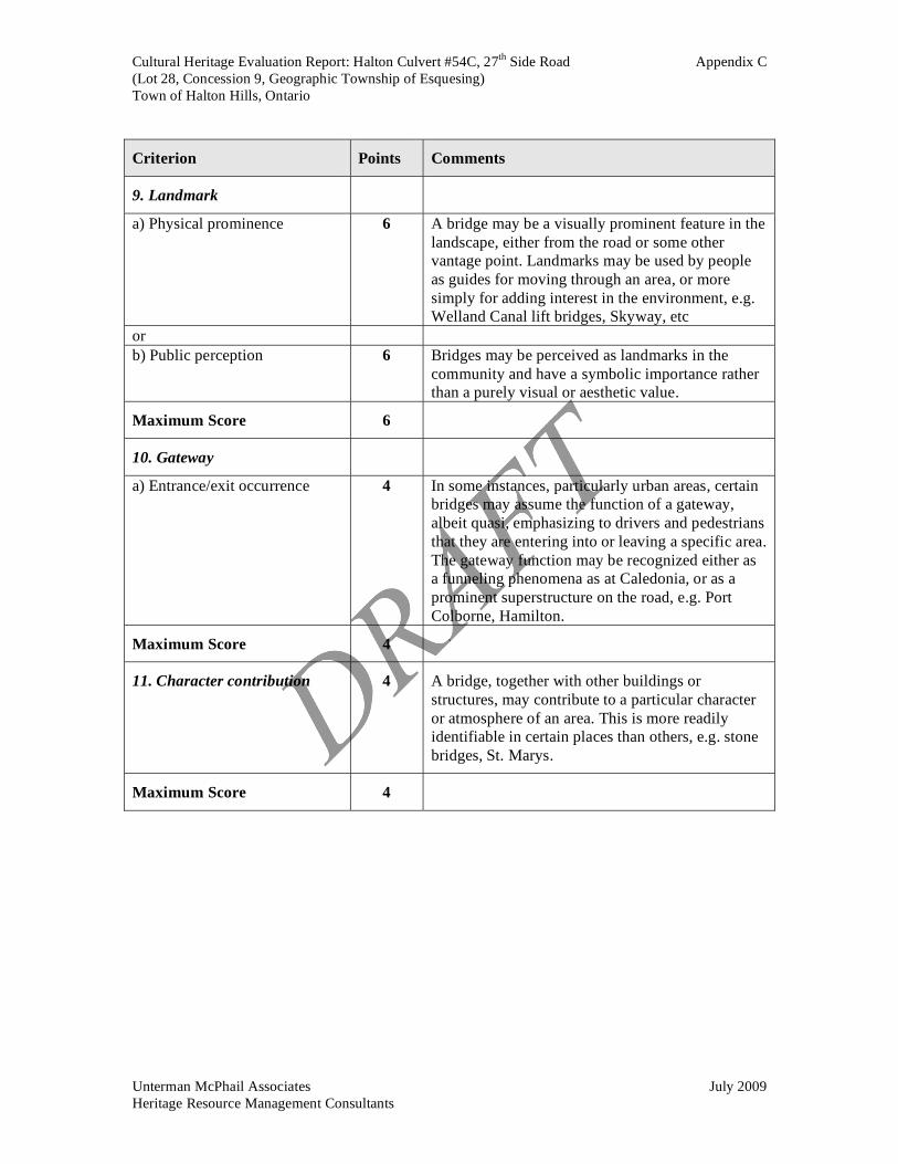
9. Landmark: The stone arch is a distinctive visual form in the landscape to the users of the Bruce Trail/Bennett Heritage Trail, the Fallbrook Conservation Area and 27th Side Road. It is on the Bruce Trail and is used as a guide for moving through the area and adds interest to the environment.
10. Gateway: The Halton Culvert #54C provides some gateway effect to the Fallbrook Conservation area due to its irregular approach on the east side.
11. Character: The natural and adjacent rural agricultural landscape establishes the character of the area and the stone arch bridge contributes to the this character.
Historical

Cultural Heritage Evaluation Report: Halton Culvert #54C, 27th Side Road Page 16
(Lot 28, Concession 9, Geographic Township of Esquesing)
Town of Halton Hills, Ontario
Unterman McPhail Associates July 2009 Heritage Resource Management Consultants
12. Historical Associations:
c.) Associated with theme: The bridge is associated with the historical theme of the 19th century development of road transportation in Esquesing Township. It is also historically associated with the cultural heritage landscape of the McClure Farm at 14513-27th Side Road, a municipally listed cultural heritage resource.
d) Associated with former bridges: The current stone arch bridge may be the original bridge.
Evaluation
General Category Criterion Maximum Score
Possible
Scoring
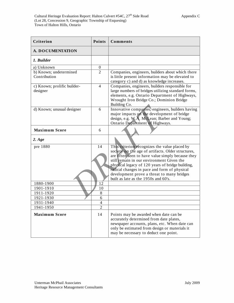
Builder 6 0 Documentation
Age 14 10*
Materials 4 4
Design/Style 16 16
Prototype 10 0
Technology
Structural Integrity 10 5
Visual Appeal 12 12
Integrity 4 4
Landmark 6 6
Gateway 4 4
Bridge Aesthetics and
Environment
Character
Contribution
4 4
Historical Historical Association 10 10
Total Score 100 75
* The bridge was scored using the c1900 date of construction. It is possibly a latter 19th century structure,
but documentation at this time is not conclusive. If the pre 1900 date of construction was applied it would increase the score to 79 points.
. 5.3 Summary of Cultural Heritage Value
The Council of Esquesing Township opened 27th Side Road in 1872 as part of the development of the local road system in the 19th century. The current stone arch bridge may be the first structure on the site; it is documented as having been built c1900 by a photograph. 27th Side Road provided access to the given road already established in Lot 28 Concession 9, now Fallbrook Trail. The one span, stone masonry arch structure was occasionally built in the 19th century, but was not a typical bridge type of its time. The Halton Culvert #54C has not undergone any significant modifications, and clearly exhibits its original form. Although a modest structure, the Halton Culvert #54C is considered to be well designed, and it contributes to the ambience and the natural and rural character of the area.
Cultural Heritage Evaluation Report: Halton Culvert #54C, 27th Side Road Page 17
(Lot 28, Concession 9, Geographic Township of Esquesing)
Town of Halton Hills, Ontario
Unterman McPhail Associates July 2009 Heritage Resource Management Consultants
The evaluation process indicates the Halton Culvert #54C scored 75 points, and therefore, this structure has cultural heritage value and is worthy of consideration for inclusion on the Ontario Heritage Bridge List.
6.0 MITIGATION RECOMMENDATIONS
The Town of Halton Hills indicates the existing bridge structure needs to be rehabilitated or replaced. The Halton Culvert #54C has been evaluated under the criteria of the Ontario Heritage Bridge Program (1983, rev. 1991). According to the OHBP, if a bridge scores a minimum of 60 points, it is considered to have cultural heritage value or interest. Given the demonstrated identified heritage value of the Halton Culvert #54C through the evaluation process of this report, it is proposed the following conservation measures be implemented. 1. The CHER for the Halton Culvert #54C is to be sent to the Ministry of Culture
(MCL) for review and consideration for inclusion on the Ontario Heritage Bridge List.
If the Halton Culvert #54C is listed on the Ontario Heritage Bridge List, the following statement from the OHBP is applicable. 2. Future repairs, rehabilitation and proposed replacement projects have the potential to
impact the listed heritage bridge and/or its associated cultural heritage landscape will be developed in accordance with the conservation options or strategies outlined in the Ontario Heritage Bridge Program (1991). They are listed below in descending order of preference, with options (g) and (h) being the least preferable.
a) Retention of the existing bridge with no major modifications undertaken;
b) Retention of the existing bridge with sympathetic modification; c) Retention of the existing bridge with sympathetically designed structure in
proximity;
d) Retention of existing bridge no longer in use for vehicular purposes but adapted for pedestrian walkways, cycle paths, scenic viewing, etc.
e) Relocation of bridge to appropriate new site for continued use (see c) or adaptive
re-use (see d)
f) Retention of bridge as a heritage monument for viewing purposes only;
Cultural Heritage Evaluation Report: Halton Culvert #54C, 27th Side Road Page 18
(Lot 28, Concession 9, Geographic Township of Esquesing)
Town of Halton Hills, Ontario
Unterman McPhail Associates July 2009 Heritage Resource Management Consultants
g) Salvage of elements/members of bridge for incorporation into new structure of for future conservation work or displays; and,
h) Full recording and documentation of structure if it is to be demolished.
The Halton Culvert #54C is worthy of consideration for municipal designation by the Town of Halton Hills. The following conservation measures should be implemented.
o If the Town retains the culvert within the road system, a full recording and documentation of the structure should be undertaken prior to any repair work and it should be repaired in a manner that is complementary to its heritage attributes.
o It the structure is to be closed, a full recording and documentation of the structure
should be undertaken prior to any repair work and retained for pedestrian, cycling or viewing purposes, i.e., options d) and f) of the OHBP listed above. I
o If the Halton Culvert #54C is to be rehabilitated a full recording and
documentation of the structure should be undertaken prior to any work, and a historic masonry specialist should be consulted for the masonry repairs.
o The Town of Halton Hills should erect an interpretation/commemorative plaque
for the bridge structure on-site.

Cultural Heritage Evaluation Report: Halton Culvert #54C, 27th Side Road
(Lot 28, Concession 9, Geographic Township of Esquesing)
Town of Halton Hills, Ontario
Unterman McPhail Associates July 2009 Heritage Resource Management Consultants
SOURCES CONSULTED
Archives of Ontario. Halton County Land Registry Office Abstract Index Esquesing Township v. A-B
c1820-1958 for Lot 28, Concession 9. Township of Esquesing Minutes 1821-1891 GS 3329. And Minutes 1892-1914 GS
3330. Census Returns, Halton County, Esquesing Township, 1861, 1871, 1881, 1891, 1891,
1901 and 1910. Ball, Norman, Building Canada A History of Public Works Toronto: University of
Toronto Press, 1988. Brown, Steven J. and Krista A. Taylor. “Roads: The Way In…And Out!” East Garafraxa
A History. Orton: The Corporation of the Township of East Garafraxa, 2006. Clarke, Gwen. Halton’s Pages of the Past. Acton: Dills Printing and Publishing, 1955 32- Crockett, John, Heritage Structure Assessment for the Transportation, Operations and
Environment Division of the City of Hamilton, September 19, 2002. Cuming, David J. Discovering Heritage Bridges on Ontario’s Roads. Erin, Ont.: The
Boston Mills Press, 1984. Gentilcore, R. Louis and Head, C. Grant. Ontario’s History in Maps. Toronto: University
of Toronto Press, 1984 Illustrated Historical Atlas of the County of Halton Ontario. Toronto: Walker & Miles,
1877. Letter to Fiona Christiansen, R. J. Burnside and Associates Limited, from Thomas E.
Wicks, Architectural Advisor, Special Projects, Acquisitions and Conservation Services, Ontario Heritage Trust (June 9, 2009).
McDonald, John. Halton Sketches Revisited: Historical Tales of People and Events in
North Halton. rev. ed. Norval: Moulin Publishing Ltd., 1996. McGillivray - Architect. Heritage Impact Statement for 14513 27 Sideroad, Town of
Halton Hills, Ontario. June 29, 2007.
Ministry of Culture. Appendix D – The Ontario Heritage Bridge List as of 2006. Ministry of Transportation and Ministry of Culture and Communications. Ontario
Heritage Bridge Program. Toronto, 1983, revised 1991.
Cultural Heritage Evaluation Report: Halton Culvert #54C, 27th Side Road
(Lot 28, Concession 9, Geographic Township of Esquesing)
Town of Halton Hills, Ontario
Unterman McPhail Associates July 2009 Heritage Resource Management Consultants
Murison, T. “McClure Log House (Fallbrook Conservation Are) Heritage Investigation Report 14513-27 Side Road Concession 9, Lot 28, Esquesing Township”. May 12, 2008.
Robinson Heritage Consulting. Grand Old Bridges: The Grand River Watershed Bridge
Inventory. Prepared for the Grand River Conservation Authority, April 6, 2004. Smith, W.H. Smith’s Canadian Gazetteer. Toronto: H & W Rowsell, 1846. Spanning the Generations: a study of old bridges in Waterloo Region. Phase 1:
Inventory. Region of Waterloo, May 2004. Spanning the Generations: a study of old bridges in Waterloo Region. Phase 2:Heritage
Assessment. Region of Waterloo, May 2004 TSH. Town of Halton Hills. 2008 Structural Condition Report for Culvert #54C (October
2, 2008). Town of Halton Hills Heritage Register (November 4, 2008). Websites
Credit Valley Conservation Authority, Silver Creek CA. Access:--<http://www.creditvalleycons.com/recandleisure/silvercreek.htm>. Fallbrook Farm Heritage Site. Georgetown, Ontario. The Friends of Fallbrook including:
Update 1 - What we've done to date Update 2 - Some information on the families Update 3 - MacKay Biography Update 4 - How do you decide if a site is worth preserving? Update 6 - The sawmill and other matters Update 7 - Walking the site Update 9 - Information on the Millrace and other matters Update 10 - Meeting Update 11 - Results of Meeting Update 12 - More discoveries at Fallbrook Update 13 - Survey report Update 14 - September 2008 Newsletter Update 18 - Aunt Rachel Schwann-McKay Update 19 - Ballinafad Community Roots, etc.
Access:--< http://www.electricscotland.com/history/canada/fallingbrook.htm>. Halton Images: Wildwood Bridge. Esquesing Historical Society. Access:-- :--<http://images.halinet.on.ca/details.asp?r=vs&ID=1990&number=4
Cultural Heritage Evaluation Report: Halton Culvert #54C, 27th Side Road
(Lot 28, Concession 9, Geographic Township of Esquesing)
Town of Halton Hills, Ontario
Unterman McPhail Associates July 2009 Heritage Resource Management Consultants
Wildwood Road Bridge c1950?. Esquesing Historical Society. Access: --<http://images.halinet.on.ca/details.asp?r=vs&ID=1990&number=5 Wildwood Bridge. Esquesing Historical Society. Access: --<http://images.halinet.on.ca/details.asp?r=vs&ID=1990&number=18 Canada’s Historic Places. Gow‘s Bridge Access:--<Http://historicplaces.ca/visit-viste/com-ful_e.aspx?id=5518. Livingstone, Dawn. “Are You the One?” Esquesing Historical Society. 7 Oct 2007,
http://www.esquesinghistoricalsociety.ca/join.html. Library and Archives Canada. Post Offices and Postmasters. Glen Williams. Access:-- < http://www.collectionscanada.gc.ca/ databases/post-offices/index-
e.html>. Maps and Photographs
Google Maps, 2009. Major Baron de Rottenburg. Map of the Principal Communications in Canada West.
c1850. Map 6.4 as reproduced in Ontario’s History in Maps by R. Louis Gentilcore and C. Grant Head, Toronto: University of Toronto Press, 1984.
Map of Esquesing Township. Illustrated Historical Atlas of the County of Halton, Ont.
(Toronto: Walker & Miles, 1877).
National Topographic Series: Brampton 30 M/12 1922, 1942, 1951, and 1995.
Tremaine’s Map of the County of Halton, Canada West, Geo. R Tremaine & Geo. C. Tremaine, 1858.
View of south elevation of the bridge c1921. Courtesy of Jim Kirkwood and Fallbrook
Campaign. Virtual Earth, Microsoft Corporation 2009. Contacts
Steve Burke, Senior Planner-Policy Planning, Development and Sustainability, Town of
Halton Hills. Ashley Manncuso, Clerk’s Department, Town of Halton Hills. Sandy McKay. Volunteer co-ordinator, Fallbrook Campaign.

Cultural Heritage Evaluation Report: Halton Culvert #54C, 27th Side Road
(Lot 28, Concession 9, Geographic Township of Esquesing)
Town of Halton Hills, Ontario
Unterman McPhail Associates July 2009 Heritage Resource Management Consultants
Tom Murison.

APPENDIX A:
HISTORICAL MAPS &
PHOTOGRAPH

Cultural Heritage Evaluation Report: Halton Culvert #54C, 27th Side Road Appendix A
(Lot 28, Concession 9, Geographic Township of Esquesing)
Town of Halton Hills, Ontario
Unterman McPhail Associates July 2009
Heritage Resource Management Consultants
View of south elevation of the bridge c1921. Copyright Jim Kirkwood, courtesy of Fallbrook
Campaign.

Cultural Heritage Evaluation Report: Halton Culvert #54C, 27th Side Road Appendix A
(Lot 28, Concession 9, Geographic Township of Esquesing)
Town of Halton Hills, Ontario
Unterman McPhail Associates July 2009
Heritage Resource Management Consultants
Major Baron de Rottenburg. Map of the Principal Communications in Canada West. c1850.

Cultural Heritage Evaluation Report: Halton Culvert #54C, 27th Side Road Appendix A
(Lot 28, Concession 9, Geographic Township of Esquesing)
Town of Halton Hills, Ontario
Unterman McPhail Associates July 2009
Heritage Resource Management Consultants
Tremaine’s Map of the County of Halton, Canada West, Geo. R Tremaine & Geo. C. Tremaine,
1858.
Cultural Heritage Evaluation Report: Halton Culvert #54C, 27th Side Road Appendix A
(Lot 28, Concession 9, Geographic Township of Esquesing)
Town of Halton Hills, Ontario
Unterman McPhail Associates July 2009
Heritage Resource Management Consultants
Map of Esquesing Township. Illustrated Historical Atlas of the County of Halton, Ont. (Toronto:
Walker & Miles, 1877).

Cultural Heritage Evaluation Report: Halton Culvert #54C, 27th Side Road Appendix A
(Lot 28, Concession 9, Geographic Township of Esquesing)
Town of Halton Hills, Ontario
Unterman McPhail Associates July 2009
Heritage Resource Management Consultants
National Topographic Series: Brampton 30 M/12 1922.

Cultural Heritage Evaluation Report: Halton Culvert #54C, 27th Side Road Appendix A
(Lot 28, Concession 9, Geographic Township of Esquesing)
Town of Halton Hills, Ontario
Unterman McPhail Associates July 2009
Heritage Resource Management Consultants
National Topographic Series: Brampton 30 M/12, 1951.

Cultural Heritage Evaluation Report: Halton Culvert #54C, 27th Side Road Appendix A
(Lot 28, Concession 9, Geographic Township of Esquesing)
Town of Halton Hills, Ontario
Unterman McPhail Associates July 2009
Heritage Resource Management Consultants
National Topographic Series: Brampton 30 M/12, 1995.

APPENDIX B:
HALTON CULVERT #54C
BRIDGE SURVEY FORM

Cultural Heritage Evaluation Report: Halton Culvert #54C, 27th Side Road Appendix B
(Lot 28, Concession 9, Geographic Township of Esquesing)
Town of Halton Hills, Ontario
Unterman McPhail Associates July 2009
Heritage Resource Management Consultants
BRIDGE NAME:
HALTON CULVERT #54C
Recorder Unterman McPhail
Associates
Ref. No.
Structure No. 54/C
HIGHWAY:
27TH
SIDE ROAD
Map: Google 2009 Date: March 27, 2009
Lot: E 28 Con: 9
Municipality: Halton Hills (geographic township of
Esquesing)
County / R.M.: Halton Region
1:50:000 Map Ref.: Brampton 30 M/12
Military Grid Ref.:
Air Photo Ref.:
Description: The Halton Culvert #54C is located in
the Town of Halton Hills to the north of Glen
Williams and Georgetown in the Fallbrook
Conservation Area. .
BRIDGE ENVIRONMENT & USES
Water/Road/Rail/Other Crossing:
The Hlaton Culvert #54C is located over Silver Creek, a tributary of the Credit River.
Surrounding Land-Uses & Landscape: The surrounding land use is natural with some pockets of former agricultural land,
now part of the Fallbrook Conservation Area owned by the Credit Valley Conservation Authority. A section of the Bruce
Trail and the Bennett Heritage Trail are located along Silver Creek at 27th
Side Road. The 19th
century McClure
Farmstead which is a municipally listed cultural heritage resource, is located on east side of the bridge at 14513-27th
Side
Road, Silver Creek flows in a southerly direction, tumbling down the slope over a bed of limestone.
Bridge Uses:
The Halton Culvert #54C carries vehicular traffic 27th
Side Road over Silver Creek.
DESIGN
Materials: Local limestone
Construction Techniques: Semicircular stone masonry arch.
Decorative Features: Coursed stone and radiating stone voussoir.
Landscape Quality: Prominent to travelers when approaching from east by road because the road curves to cross Silver
Creek; however, traffic volume is not great.
State of Preservation: The structure has been altered; and needs repair work to stone masonry.
Other Comments: The lack of skilled craftsmen in Ontario to build stone bridges, the cost of to quarry stone, and the
difficulty of building falsework, or temporary scaffolding, to support the stonework during construction resulted in few
Ontario bridges being built in stone [David J. Cuming, Discovering Heritage Bridges on Ontario’s Roads. 18]. Stone is
considered to be an early and unique bridge building material in Ontario.
Page 1 of 4

Cultural Heritage Evaluation Report: Halton Culvert #54C, 27th Side Road Appendix B
(Lot 28, Concession 9, Geographic Township of Esquesing)
Town of Halton Hills, Ontario
Unterman McPhail Associates July 2009
Heritage Resource Management Consultants
DIMENSIONS
Carriageway Width: 5 m (inside of railing) Longest Span: 3.2 m
No. of Lanes: One, posted narrow lanes Shortest Span: 3.2 m
Sidewalks: N/A Overall Length: Unknown
Capacity: Not posted Clearance:: Unknown
No. of Spans: One
HISTORY
Date Built: Built for Esquesing Township, probably in the late 1870s, exact construction date not verified,.
Engineer/Designer: Unknown.
Construction Firm: Possibly David Cooper, a local farmer.
Drawings/Specifications: None identified.
Photos: Historical photo of bridge c1early 1900s [Fallbrook Campaign]
Historical Association: Location on Silver Creek is associated with a 1850s mill and millpond owned by William McClure.
Opening of Side Road 27 was approved by by-law in December 1871 by the Esquesing Township Council, and road
constructed in 1872. The present bridge may have been built in late 1870s..
Previous Bridges: Possibly an earlier bridge at present site c1872. Local history inicates there may have been a ford at
Silver Creek to north of existing bridge structure.
Other Comments: The Town of Halton Hills indicates Halton Culvert #54C is the only stone masonry arch structure under
its jurisdiction.
PROPERTY RIGHTS & RESPONSIBILITIES
Owner: Town of Halton Hills Maintenance: Town of Halton Hills
PLANNED UNDERTAKING
The Town of Halton Hills is preparing an environmental assessment to develop alternatives and undertake public
consultation to address the structural deficiencies of the culvert on the 27th
Side Road. A 2008 condition survey indicated
the structure has stone loss and mortar deterioration and the railing system does not meet current safety standards. The
bridge has been identified as being deficient in respect to deck width, barrier protection and guide rail protection. The
project is being planned as a Schedule B project in accordance with the requirements of the Municipal Class
Environmental Assessment (Class EA) document (June 2000, amended September 2007).
GENERAL COMMENTS
Page 2 of 4

Cultural Heritage Evaluation Report: Halton Culvert #54C, 27th Side Road Appendix B
(Lot 28, Concession 9, Geographic Township of Esquesing)
Town of Halton Hills, Ontario
Unterman McPhail Associates July 2009
Heritage Resource Management Consultants
PHOTOS
View downstream from bridge showing the spring flow of the creek
and the natural vegetation and steep slope..
View upstream from bridge showing natural landscape and spring
flow of the creek as it tumbles down the stepped limestone.
View north to south elevation (downstream).
View south to north elevation.
Stone arch of bridge upstream side..
View southward to underside of the stone arch.
Page 3 of 4

Cultural Heritage Evaluation Report: Halton Culvert #54C, 27th Side Road Appendix B
(Lot 28, Concession 9, Geographic Township of Esquesing)
Town of Halton Hills, Ontario
Unterman McPhail Associates July 2009
Heritage Resource Management Consultants
PHOTOS
View easterly along 27th
Side Road to bridge
Trail plaque located northwest of bridge.
Dry stonewall associated with McClure Farmhouse in
background.
Front elevation of McClure Farmhouse 14513-27th
= Side Road.
Photograph of the subject bridge over Silver Creek circa early
1900s [Copyright 2007, Jim Kirkwood, permission courtesy of
Fallbrook Campaign].
Page 4 of 4

APPENDIX C:
EVALUATION CRITERIA
ONTARIO HERITAGE
BRIDGE PROGRAM
(1983, rev. 1991)

Cultural Heritage Evaluation Report: Halton Culvert #54C, 27th Side Road Appendix C
(Lot 28, Concession 9, Geographic Township of Esquesing)
Town of Halton Hills, Ontario
Unterman McPhail Associates July 2009
Heritage Resource Management Consultants
ONTARIO HERITGE BRIDGE PROGRAM
(1983, REV. 1991)
EVALUATION CRITERIA
Summary
General Category Criterion Maximum Score
Builder 6 Documentation
Age 14
Materials 4
Design/Style 16
Prototype 10
Technology
Structural Integrity 10
Visual Appeal 12
Integrity 4
Landmark 6
Gateway 4
Bridge Aesthetics and
Environment
Character
contribution
4
Historical Historical Association 10
Total Score 100
* Bridges that achieve the specified minimum score of 60 are eligible for inclusion on the Ontario Heritage Bridge List.
Cultural Heritage Evaluation Report: Halton Culvert #54C, 27th Side Road Appendix C
(Lot 28, Concession 9, Geographic Township of Esquesing)
Town of Halton Hills, Ontario
Unterman McPhail Associates July 2009
Heritage Resource Management Consultants
Criterion Points Comments
A. DOCUMENTATION
1. Builder
a) Unknown 0
b) Known; undetermined Contribution
2 Companies, engineers, builders about which there is little present information may be elevated to category c) and d) as knowledge increases.
c) Known; prolific builder-designer
4 Companies, engineers, builders responsible for large numbers of bridges utilizing standard forms, elements, e.g. Ontario Department of Highways, Wrought Iron Bridge Co.; Dominion Bridge Building Co.
d) Known; unusual designer 6 Innovative companies, engineers, builders having major impacts on the development of bridge design, e.g. W.A. McLean; Barber and Young; Ontario Department of Highways.
Maximum Score 6
2. Age
pre 1880 14 This criterion recognizes the value placed by society on the age of artifacts. Older structures, are often seen to have value simply because they still remain in our environment Given the physical legacy of 120 years of bridge building, radical changes in pace and form of physical development prove a threat to many bridges built as late as the 1950s and 60's.
1880-1900 12 1901-1910 10 1911-1920 8 1921-1930 6 1931-1940 4 1941-1950 2
Maximum Score 14 Points may be awarded when date can be accurately determined from date plates, newspaper accounts, plans, etc. When date can only be estimated from design or materials it may be necessary to deduct one point.

Cultural Heritage Evaluation Report: Halton Culvert #54C, 27th Side Road Appendix C
(Lot 28, Concession 9, Geographic Township of Esquesing)
Town of Halton Hills, Ontario
Unterman McPhail Associates July 2009
Heritage Resource Management Consultants
Criterion Points Comments
B. TECHNOLOGY
3. Materials
a) Wrought Iron or b) Stone
4 Wrought iron and stone are afforded high priority because these materials are no longer in use.
or c) Other (not normally in
use)
4 Category “Other” means only materials not
normally used in bridges or that have not gained
favour as well as unusual combinations of materials used in superstructure piers or abutments.
Maximum Score 4
4. Design/Style
a) Unique, or 16 The only one of its kind. It may be eccentric, odd, an exaggerated version by virtue of its size,
sophistication, use of a particular truss type, e.g.
Sioux Narrows, Burlington Skyway.
b) Typical; but rare as survivor, or
16 In any given period many bridges will be built which are typical of their age, being neither unique
nor unusual. The ravages of time, climate and
changing transportation requirements may have seen a number of such bridges disappear. The
survivors may now be rare.
c) Unusual 16 Included here are bridges of which only a small
number may have been built and perhaps a smaller number now remain, e.g. suspension spans, stone
arches.
Maximum Score 16
5. Prototype
a) Prototype, or 10 A bridge may possess a technological or stylistic
innovation or adaptation, which marks it as a first
of a type, an early example or an important improvement, e.g. Reinforced concrete bridge at
Massey; concrete bowstring arch, Etobicoke.
b) Early example 10
Maximum Score 10

Cultural Heritage Evaluation Report: Halton Culvert #54C, 27th Side Road Appendix C
(Lot 28, Concession 9, Geographic Township of Esquesing)
Town of Halton Hills, Ontario
Unterman McPhail Associates July 2009
Heritage Resource Management Consultants
Criterion Points Comments
6. Structural Integrity
a) No significant modifications 10 Bridges are often modified to remedy a variety of
deficiencies, i.e. structural, transportation, hydrological. Those that have escaped unchanged
are more often than not a rarity and thus of
importance in illustrating their original form. Many bridges may have been modified over the years to
the extent that they are no longer recognizable.
b) Sympathetic modifications 5 A few, however, may still be able to illustrate their
original form because of sympathetic modifications, e.g. QEW widening/Bronte Creek;
unobtrusive strengthening in Blackfriars Bridge; or
other renovation and repair work.
Maximum Score 10
C. BRIDGE AESTHETICS
AND ENVIRONMENT
7. Visual Appeal
a) Design merits 10 This criterion addresses the intrinsic worth of a structure beyond its technological and functional
characteristics. It may be an attractive structure
because it is well designed and admirably fitted to a particular site, e.g. Sioux Narrows, Massey, Bronte
Creek/QEW. Such a structure will always enhance
its environment rather than detract. The removal of
such a structure would be detrimental to the ambience of the setting.
b) Ornamentation/Decoration 2 Decoration or ornamentation, whether discreet or
ostentatious, adds visual interest to the structure. It may appear in sculptured forms, balustrading, light
standards, piers, cross members, portals, etc.
Maximum Score 12
8. Integrity
a) At original location 4 Original locations are often benchmarks in the past
development of a particular environment, and they
often contribute to a strong sense of place.
Maximum Score 4
Cultural Heritage Evaluation Report: Halton Culvert #54C, 27th Side Road Appendix C
(Lot 28, Concession 9, Geographic Township of Esquesing)
Town of Halton Hills, Ontario
Unterman McPhail Associates July 2009
Heritage Resource Management Consultants
Criterion Points Comments
9. Landmark
a) Physical prominence 6 A bridge may be a visually prominent feature in the
landscape, either from the road or some other vantage point. Landmarks may be used by people
as guides for moving through an area, or more
simply for adding interest in the environment, e.g. Welland Canal lift bridges, Skyway, etc
or
b) Public perception 6 Bridges may be perceived as landmarks in the
community and have a symbolic importance rather than a purely visual or aesthetic value.
Maximum Score 6
10. Gateway
a) Entrance/exit occurrence 4 In some instances, particularly urban areas, certain bridges may assume the function of a gateway,
albeit quasi, emphasizing to drivers and pedestrians
that they are entering into or leaving a specific area.
The gateway function may be recognized either as a funneling phenomena as at Caledonia, or as a
prominent superstructure on the road, e.g. Port
Colborne, Hamilton.
Maximum Score 4
11. Character contribution 4 A bridge, together with other buildings or
structures, may contribute to a particular character
or atmosphere of an area. This is more readily identifiable in certain places than others, e.g. stone
bridges, St. Marys.
Maximum Score 4

Cultural Heritage Evaluation Report: Halton Culvert #54C, 27th Side Road Appendix C
(Lot 28, Concession 9, Geographic Township of Esquesing)
Town of Halton Hills, Ontario
Unterman McPhail Associates July 2009
Heritage Resource Management Consultants
Criterion Points Comments
D. HISTORICAL
12. Historical Association
a) Associated with person/group 10 Associated with the life or activities of a person or group that has made a significant contribution to
the community, province or nation, e.g.
entrepreneurs, politicians, etc
or
b) Associated with event 10 Associated with a significant event that contributed
to the future activities of a community, province or
nation, e.g. road building programs, public work
projects.
or
c) Associated with theme 10 Associated with and illustrative of significant
patterns of cultural, social, political, economic or industrial history, e.g., Depression era, urban
growth.
or
d) Associated with former bridge
10 Associated with former bridges that have served the same site or locale, i.e. a traditional river
crossing
Maximum Score 10