cultural, environmental and historical controls of ... · dissected outwash plain along the south...
TRANSCRIPT

Cultural, environmental and historical controls ofvegetation patterns and the modern conservationsetting on the island of Martha’s Vineyard, USADavid R. Foster1*, Brian Hall1, Sylvia Barry1, Susan Clayden1 and Tim Parshall2 1Harvard
Forest, Harvard University, Petersham, MA, USA, and 2Kellogg Biological Station, Hickory
Corners, MI, USA
Abstract
Aim Long-term studies of landscape dynamics in relationship to changes in cultural,environmental and disturbance factors have great potential for increasing the under-standing of modern ecological conditions and improving the development of conserva-tion plans that incorporate historically important processes. In this study we compiledarchaeological, historical, palaeoecological and ecological information on Martha’sVineyard to investigate temporal and spatial variation in landscape pattern and process.Although < 250 km2, this island off the Massachusetts coast embraces remarkablegeographical variation and harbours uncommon plant and animal assemblages thatmake it a national priority for conservation.
Location The study embraces the entire island of Martha’s Vineyard, which lies c. 8 kmsouth of Cape Cod and the mainland of Massachusetts. The triangular-shaped islandcontains three major geomorphological regions: moraine forms a series of irregular andsubparallel ridges and hills 40 to over 80 m in elevation that terminate at the westernend of the island in high cliffs at Gay Head and Squibnocket; sandy glacial outwashoverlying moraine spreads down the northeastern end of the island forming a region oflow undulating hills and shallow depressions 15–30 m in elevation, and an extensiveoutwash plain stretches across the central and eastern part of the island and slopes gentlyfrom 30-m elevation in the north to < 3 m towards the southern coast where it isdissected by a series of north–south trending valleys that terminate in coastal ponds. Inall areas except the southwest corner the island is underlain by >100 m of Quaternaryand coastal plain sediments.
Methods Long-term records of vegetation, fire, natural disturbance and human activitywere compiled over the past 2000 years and across the physiographic variation on theisland. Palaeoecological interpretations of vegetation, fire, climate and land-use historyare based on a series of eleven stratigraphies from ponds, lakes and wetlands;archaeological data were compiled from recent surveys; historical data were assembledfrom census and town records, fire records, aerial photographs and cartographic series;and ecological information was derived from forestry and conservation surveys and fieldsampling of vegetation, soils and site characteristics. Extensive use was made of geo-graphical information systems and multivariate statistical analyses.
Results Spatial patterns in vegetation over the past 2000 years have varied stronglywith soils and physiography, which are also associated with major differences in fire andland-use history. Mesic hardwood forests that seldom burned occupy the westernmoraine, open oak-pine and hardwood forests occur on the frequently burned anddissected outwash plain along the south coast, and pine-oak forests cover the centraloutwash plain, which extends across much of the island and displays among the high-est charcoal values in New England. Although a relatively large Native Americanpopulation may have been an important source of fire ignitions there is no palynological
*Correspondence: Harvard Forest, Harvard University, PO Box 68, Petersham, Massachusetts 01366, USA. E-mail: [email protected]
Journal of Biogeography, 29, 1381–1400
� 2002 Blackwell Science Ltd

or archaeological evidence that this culture cleared substantial areas or directly alteredthe extent of forest cover. Shifts in forest composition and fire were associated withregional climate change during the pre-European period, whereas pronounced changes inforest cover and the development of extensive open-land areas of grassland, shrublandand heathland were driven by European land use.The contrasting characteristics, land-use histories and ownerships of different regions ofthe island yield contrasting conservation priorities and management directions. Themesic morainal forests have changed modestly in composition during the historicalperiod and can effectively support a distinct woodland flora if adequately protected. Thelarge outwash plain is broken by non-native plantations but could yield an effectivelandscape mosaic of oak and pine forests interrupted by extensive scrub oak barrens thatcould be maintained through prescribed fire or cutting. In contrast, the south shoregrasslands and shrublands are the product of intensive agricultural land use. Thesehabitats and their unusual suite of plants and animals require traditional land-usepractices, or their substitutes, in order to reverse the ongoing increase in woody speciesand to maintain these cultural landscapes.
Main Conclusion The biotic, edaphic, disturbance and historical diversity across thisrelatively small landscape is remarkable and yet poses many challenges to interpretationand conservation. The modern landscape can only be understood through knowledge ofits long-term past and can be best managed in the context of the natural and culturalfactors that have shaped it through time.
Keywords
New England, land-use history, natural disturbance, fire, conservation, pine, oak,grassland, cultural landscape.
INTRODUCTION
In all landscapes the pattern of vegetation and the distribu-tion of dominant species are determined by interactionsamong soils, natural disturbance processes, human land-useand lags in vegetation responses to historical events (Grimm,1984; Foster et al., 2003). Investigations of the relativeimportance of these factors and the manner in which theyhave interacted and changed through time are critical forinterpreting current ecological patterns as well as developingeffective conservation and management strategies (Motzkinet al., 1999; Landres et al., 1999; Swetnam et al., 1999). Formany reasons it is likely that relationships between factorssuch as vegetation, disturbance and soils, which vary spa-tially across landscapes, may change through time as theclimate or cultural environment change. However, it is sel-dom possible to decipher the underlying causes of landscapepatterns because of an inability to sample vegetation, dis-turbance and environmental processes in a consistent fashionover the many hundreds of years necessary to evaluate themeffectively.
Palaeoecology and related historical approaches provideamong the best means for developing the temporal and spatialrecord required for such analyses (cf. Brubaker, 1975;McLachlan et al., 2000; Parshall et al., 2003). Over the manyhundreds or thousands of years that can be reconstructedfrom sedimentary, archaeological and historical records itmay be possible to characterize disturbance regimes and to
evaluate the type and rate of biotic responses generated bychanges in disturbance, cultural activities and climate. Theapplication of these approaches to a suite of vegetation andlandscape features provides major insights into geographicaland ecological patterns and processes (Brubaker, 1975;Grimm, 1981; Parshall et al., 2002). When these studies arecombined with the richness of temporal information thatlinks the pre-historical and historical past with modern con-ditions, results may move from a level of general ecologicalinterest to one having direct bearing on the interpretationand management of important conservation landscapes(McLachlan et al., 2000; Motzkin & Foster, 2002).
The present study addresses ecological and conservationobjectives by examining long-term variation in landscapepattern and processes for the island of Martha’s Vineyard,located off the coast of Massachusetts (Fig. 1). The islandsupports many unusual plant and animal assemblages thatare threatened by development and are a focal point of localto national conservation and restoration activity [Massachu-setts Natural Heritage and Endangered Species Program(MNHESP), 2001; Goldstein 1997]. The Vineyard landmassis highly varied in geomorphology, soils and topographyand, although broadly covered with Pitch pine-oak veget-ation (Westveld, 1956), supports considerable variation invegetation composition and structure. The area has experi-enced a wide range of disturbances including severe wind-storms, fire and agricultural land use and has been identifiedas a likely location of intense pre-historical modification by
� 2002 Blackwell Science Ltd, Journal of Biogeography, 29, 1381–1400
1382 D. R. Foster et al.

Native burning, agriculture and land clearing (Cronon,1983; Vickery & Dunwiddie, 1997; but see Motzkin &Foster 2002). Consequently there is need to separate tem-poral and geographical variation in environmental, cultural
and disturbance processes in order to understand and con-serve important elements of the modern landscape.
In particular, we are interested in addressing a series ofgeneral and specific questions. Broadly we seek to know:
Figure 1 Geographical, political and historical characteristics and pollen sampling sites (dots) on the island of Martha’s Vineyard (see inset mapshowing the location relative to the southern New England mainland): (a) major place names referred to in the text; (b) topography and town
divisions; (c) general soils map after Fletcher & Roffinoli (1986) depicting the locations of coring sites: H, Harlock Pond; CTN, Cedar Tree Neck
Bog; D, Duarte Pond; LAG, Lagoon Pond; S, Slough Cove; Mtc, Mashacket Cove; JNP, Jobs Neck Pond; W, Watcha Pond; LCP, Long Cove
Pond; DB, Deep Bottom Cove; Md, Muddy Cove; (d) major surficial geological divisions (moraine, northern outwash over moraine andsouthern outwash) and fires during the historical period depicting three size classes, direction of fire movement (arrow) for a limited number of
fires, and the outline of the 1930 and 1946 fires, which were mapped from aerial photographs (Foster & Motzkin 2000) and which ignited in the
southwest and burned to the north and east to form triangular-shaped areas; (e) location of known archaeological sites (black areas) from theMiddle (2000–1000 B P) and Late (1000 B P to European contact) Woodland periods (Mulholland et al., 1998, 1999; Herbster & Cherau 2000).
Place names for the island and subregions, which may correspond to Indian regions or sachemships, are from Banks (1911); and (f) conservation
land (dark; i.e. protected from development for conservation purposes) and the location of major conservation properties discussed in the text.
� 2002 Blackwell Science Ltd, Journal of Biogeography, 29, 1381–1400
Vegetation patterns and modern conservation on Marthas Vineyard 1383

What are the patterns of soils, geomorphology, NativeAmerican activity and natural disturbance including fire andwind, and how do these relate to pre-historical and modernvegetation patterns? And, what is the influence of dramat-ically changing human land-use patterns on these relation-ships and on processes such as fire? Specific questionsconcern conservation priorities, notably the mesic forests,scrub-oak shrublands and sandplain grasslands that accountfor many of the distinctive and uncommon plant and animalassemblages on the island. How long have these vegetationassemblages existed? How have their abundance and char-acteristics changed through time? And, what natural andhuman factors are closely associated with their long-termdynamics and distribution? Based on answers to thesequestions it may be possible to craft approaches to theconservation or restoration of these distinctive assemblagesthat conform to their long-term history.
In order to address these questions we assembledarchaeological, palaeoecological, historical and geographicalinformation at an island-wide level and analysed the last twomillennia of vegetation, human activity and disturbancedynamics.
STUDY AREA
Physiography
Lying 8 km south of the Cape Cod mainland, the 22,260-haisland of Martha’s Vineyard comprises the largest landmassin Dukes County, Massachusetts (Fig. 1). The triangular-shaped island contains three major geomorphologicalregions (Fig. 1a,b). The moraine is formed of a series ofirregular and subparallel ridges and hills 40 to over 80 m inelevation that terminate at the western end of the island inhigh cliffs at Gay Head and Squibnocket. This region con-sists of folded and faulted Pleistocene materials, coastal-plain silts, sands and clays from the Gay Head moraine, andsands and gravels from the Martha’s Vineyard terminalmoraine (Fletcher & Roffinoli, 1986). Sandy glacial outwashoverlying moraine spreads down the north-eastern end of theisland forming a region of low undulating hills and shallowdepressions 15–30 m in elevation. An extensive outwashplain stretches across the central and eastern part of the is-land and slopes gently from 30-m elevation in the north to< 3 m towards the southern coast where it is dissected by aseries of north–south trending valleys that terminate incoastal ponds. Especially to the east and south the shorelineis fringed with barrier beaches and dunes. In all areas exceptthe southwest corner the island is underlain by more than100 m of Quaternary and coastal plain sediments (Fletcher& Roffinoli, 1986).
Soils vary in subtle ways in accordance to this geomor-phological template and exert a strong influence over vege-tation and ecological processes as well as the history of landuse and land cover (Fig. 1c). Deep and excessively drainedloamy coarse sands of the Carver series dominate much ofthe eastern half of the island on outwash and outwash overmoraine (Fig. 1c). These soils currently support woodland or
human development and have low water capacity, rapiddrainage and poor potential for agriculture or forest pro-ductivity (Fletcher & Roffinoli, 1986). In the south-easterncorner of this region the Carver soils are intermingled withwell-drained sandy loams of the Katama series, which havemoderate water-holding capacity, are well suited for culti-vation, pasture, or hay and currently support agriculture,open conservation land or housing. The western third of theoutwash plain includes Riverhead and Haven soils, sandyloams and very fine sandy loams, respectively, developed onoutwash or aeolian materials. These finer soils generallyoccupy level to sloping terrain, have higher moisture capa-city, and are better suited to agriculture than the Carver soilsthat predominate in the swales and valleys. Soils on thewestern and north-western hills are as variable and complexas the undulating glacial deposits and are comprised of threemajor series. Eastchop soils are excessively well drained towell-drained loamy sands formed on reworked outwash, tillor ice-thrust coastal-plain deposits and are drought-proneand poor for agriculture. In contrast, Chilmark and Nan-tucket soils are sandy loams underlain by clays, silts andsand with moderate water-holding capacity and are wellsuited for cultivation, hay and pasture.
Overall, moisture availability and suitability for agricul-ture varies among these types in the following fashion:Nantucket+Chilmark > Riverhead > Eastchop + Katama> Carver. Consequently, physiography and soils make threedistinct units: the western moraine with undulating hills andvariable, but generally moist, productive soils; the gentleterrain of droughty outwash soils over moraine to the north;and the broad and level outwash plain with primarily coarse-textured, droughty, and unproductive soils overall, butsomewhat finer, more productive soils in the west andextreme south-east (Fig. 1a,b,c).
Climate and hurricane history
Martha’s Vineyard has a moderate coastal climate. Winterand summer temperatures average 0 �C and 20 �C,respectively, and an annual precipitation of 120 cm gener-ates infrequent snow cover. Prevailing winds are from thenorthwest, trending to southwest in the summer, approxi-mately twenty thunderstorms occur annually, and the islandexperiences occasionally intense tropical and winter storms.North-easters are most important in winter, have strongnortherly winds, and may cause severe coastal erosion. Incontrast, hurricanes centre on the growing season (July toOctober) and may damage broad areas. Regionally, thesouth-eastern coast receives the highest frequency andintensity of tropical storms in New England with fifty-eighthurricanes impacting Martha’s Vineyard since 1620 (Fig. 2).Hurricanes generally trend north and east past the island anddisplay considerable variation in wind intensity and direc-tion, which is generally from the east to south (Boose et al.,2001). Multi-decadal periods of relatively frequent hurri-canes have been separated by comparable periods with fewstorms. The most intense storms (> F 2.0; five total)occurred more than a century ago. The greatest hurricane hit
� 2002 Blackwell Science Ltd, Journal of Biogeography, 29, 1381–1400
1384 D. R. Foster et al.

shortly after European settlement in 1635 and three sub-stantial storms (‡ F 2.0) occurred from 1770 to 1815. Incontrast, lengthy periods with no storms exceeding F 1.5occurred five times (1647–1698, 1728–1761, 1816–1841,1870–1924, 1961–91). The major ecological effect of hur-ricanes and north-easters include uprooting and breakage oftrees, reconfiguration of barrier beaches and shorelines,breaching of coastal ponds and salt spray damage to intol-erant species.
METHODS
Palaeoecology
To assess geographical patterns in vegetation compositionand dynamics across the geomorphological, edaphic, cul-tural and historical variability on the island the sedimen-tary records from eleven basins were compiled: two on thewestern moraine (Harlock Pond, Cedar Tree Neck Bog),two in the area of outwash over moraine (Duarte Pond,Lagoon Pond), and seven arrayed across the southerncoast and outwash plain (Muddy Pond, Deep BottomCove, Long Cove Pond, Watcha Pond, Jobs Neck Pond,
Mashacket Cove, Slough Cove; Fig. 1c). Two of the sitesare new to this study (Harlock and Duarte), whereas theothers were analysed and discussed by Stevens (1996). Thedata for Stevens’ sites were entered directly from her 1996thesis. The basins include glacial ice-block depressions(Harlock and Duarte), one sphagnum-shrub wetland (Ce-dar Tree Neck Bog) and the narrow heads of coastalponds, which are separated from the ocean by barrierbeaches.
The sites were selected to collect a significant amount oflocal pollen from vegetation within a kilometre (Prentice,1985; Jackson, 1990; Sugita, 1993, 1994; Jackson & Lyford,1999). The ice-block depressions and sphagnum wetland aresmall (< 5 ha) basins and coring sites in the coastal pondsare either small sub-basins or the upper ends of narrowponds that should act as small basins in terms of pollencollection (Stevens, 1996). The uppermost sediments weresampled with a polycarbonate tube (7-cm or 10-cm diam-eter) fitted with a piston, and deeper sediments were re-trieved using a 5-cm diameter Livingstone piston corer.Cores were subsampled and the organic content determinedby the percent weight loss on-ignition (LOI) at 550 �C(Bengtsson & Enell, 1986).
Figure 2 Tracks and timeline for hurricanes
impacting Martha’s Vineyard from 1635 to2001. Storm intensity corresponds to the
Fujita scale: F0, minor damage; branch
break; F1, modest damage, individual orsmall groups of trees blown down; F2,
extensive damage, large forest patches blown
down; F3, severe damage; most trees on
exposed sites blown down. Data andinterpretation come from Boose et al. (2001).
� 2002 Blackwell Science Ltd, Journal of Biogeography, 29, 1381–1400
Vegetation patterns and modern conservation on Marthas Vineyard 1385

Sediment samples were prepared for pollen analysis fol-lowing standard procedures (Faegri & Iversen, 1991), aknown number of marker grains was added, and pollen wasanalysed at 400· magnification until 500 tree and shrubpollen grains were identified. Pollen percentages are basedon a pollen sum of upland taxa, including trees, shrubs,herbs and Pteridophytes. Fossil pollen assemblages withineach core were classified using the constrained incrementalsum of squares method on square-root transformed pollenpercentages (Grimm, 1987). This and other analyses inclu-ded all upland pollen taxa that comprised more than 2% ofthe pollen sum for at least one sample and that are notassociated with wetland habitats [e.g. black gum (Nyssasylvatica), Ericaceae, sedge (Carex), sweet pepper bush(Clethra)]. This classification was used to establish objec-tively the onset of European land clearance and majorchanges in pollen throughout the record.
Past vegetation changes among sites were comparedthrough detrended correspondence analysis (DCA) of thefossil pollen assemblages with analyses specifically focusingon: individual sites, all sites for the pre-European period or theEuropean period, and all sites combined for both periods.Charcoal abundance was assessed using the point countmethod (Clark, 1982). Steven’s sites were dated at Beta Ana-lytic Laboratories (Miami) using conventional C-14 analysisof bulk samples, whereas calibrated AMS (accelerated massspectroscopy) radiocarbon dates of homogenized sedimentwere determined at the NSF University of Arizona, AMS La-boratory for Harlock and Duarte Ponds. All dates were cal-ibrated using Calib 4.3 (Stuiver et al., 2002). The Pb-210activity of sediments from Harlock and Duarte Ponds wasassessed at the Harvard Forest using standard procedures toprovide time control for the past 150 years (Binford, 1990).The rise in weed pollen serves to identify the initial transfor-mation of vegetation to European agriculture approximately325 years ago (Foster & Motzkin, 1999).
Fire
In addition to the long-term assessment of fire activity pro-vided by the sedimentary charcoal records detailed chron-ologies of all known fires from 1855 to present were compiledfrom: Dunwiddie & Adams (1994), Vineyard Gazette news-paper, Massachusetts Department of Environmental Man-agement, The Nature Conservancy (T. Chase, Pers. comm.),and Steve Vancour (Pers. comm.). These sources provide firelocation, an estimate of approximate size, and, less frequently,the major direction of fire spread. From the resulting data wecompiled a timeline and map of fire locations, sizes, andspread (cf. Foster & Motzkin, 1999). For purposes of carto-graphic display fires were categorized as: small (< 40 ha[< 100 acres]), medium (40–100 ha [100–1000 acres]), andlarge (> 400 ha [> 1000 acres]).
Land-use history
Many sources were used to characterize forest extent andagricultural land use since European settlement. The amount
of cultivated land, pasture and quantity of sheep came fromtax evaluations (1775–1860), state agricultural censuses(1860–1905), and federal censuses (1925–92). Estimates ofhistorical forest cover came from text and map sources:1840s and 1880s – United States Coast and Geodetic Survey(1848; 1897), 1907 – State Foresters Report (Rane, 1918)and 1938 – aerial photographs delineated by Janice Stone atthe University of Massachusetts at Amherst and digitizedafter being zoom-transferred to US Geologic Survey topo-graphic sheets; 1951 and 1971 landcover – MassachusettsMap Down project (MacConnell et al., 1991); 1985 –MassGIS (1985); 1992 – MassGIS (2001).
RESULTS
Prehistoric human activity
The abundant ethnohistoric sources and archaeological sitesyield considerable insight into the distribution, subsistencepatterns and potential impacts of native people on Martha’sVineyard (Ritchie, 1969; Mulholland et al., 1998, 1999;Chilton, 1999, 2000; Herbster & Cherau, 2000). An em-pirical model of artifact distribution places the majority ofprehistoric sites on well to excessively drained soils < 300 mfrom freshwater or 75 m from the coast (Mulholland et al.,1998). Associated tools, artifacts and plant and animalremains indicate that the Middle Woodland (2000–1000yrBp) and Late Woodland (1000 yrBp)1700 AD) periodcultures were semi-sedentary, subsisting on marine andterrestrial animal and plant resources, with only modesthorticulture (Bragdon, 1996; Mulholland et al., 1999;Herbster & Cherau, 2000; Chilton, 2000, 2002).
The population may have associated into regional dis-tributions with place names corresponding to knownarchaeological concentrations (Banks, 1911; Gookin, 1947;Cook, 1976; Mulholland et al., 1998; Fig. 1e). Major centresinclude Lake Tashmoo, Lagoon Pond and SengekontacketPond in the north, Squibnocket Pond and Menemsha Pond inthe south-west, Tisbury Great Pond and the head of OysterPond and Edgartown Great Pond on the south shore, andalong Katama Bay and on Chappaquidick in the southeast(Mulholland et al., 1998; Herbster & Cherau, 2000). Pollencores derived from water bodies adjacent to archaeologicalsites include Lagoon Pond, Duarte Pond, Muddy Pond andDeep Bottom Pond (Fig. 1c,e). However, there are few ar-chaeological sites near the south shore ponds, possibly be-cause these small ponds were isolated from the sea by barrierbeaches and therefore did not support the abundant shellfish,which were available in large ponds and occur in manymiddens (Mulholland et al., 1999). During historic timesresidents have opened these small ponds to the sea specificallyto promote saltwater incursion and shellfish production.
Maize which arrived in New England c. 1100 AD, was notwidespread until 1300 AD, and is uncommon in archaeolo-gical sites (Luedtke, 1988; Bragdon, 1996; Chilton, 1999,2000). Consequently, there is no evidence to support thepopularized notion of widespread slash and burn agriculture,sizable maize fields, or large permanent villages of agricul-
� 2002 Blackwell Science Ltd, Journal of Biogeography, 29, 1381–1400
1386 D. R. Foster et al.

turists, at least until European contact (Cronon, 1983;Denevan, 1992; Little, 1988). Indeed, the agriculture, perma-nent settlements and fortified villages documented in ethno-historic sources may have been induced by trading and otherinteractions with Europeans (Bragdon, 1996; Chilton, 1999).Thus, there is little reason to suspect that natives had the mo-tivationor tools to clear extensive areas of forest or to maintainsizable open vegetation beyond that associated with seasonalencampments (Motzkin & Foster, 2002). Nonetheless, deerare a major faunal remain in most archaeological sites and it isplausible that firewasactivelyused tomanipulate gamehabitat(cf. Day, 1953; Bragdon, 1996; E. Chilton, Pers. comm.).
European contacts occurred increasingly in the sixteenthand early seventeenth centuries and initiated major culturalchanges (Ceci, 1977). Contact period population estimatesfor Martha’s Vineyard range from 1500 (Ritchie, 1969) to3500 people (Banks, 1911; Cook, 1976). A major diseaseoutbreak in 1616–17 decimated populations up the NewEngland coast and by the time of extensive historical recordsIndian activity was likely substantially altered from that re-flected in archaeological sites (Bendremer, 1993; Bernstein,1993; Bragdon, 1996).
Historical land-use and land-cover dynamics
Commencing in 1641 with the first permanent settlement atEdgartown much of the island except the centre of the large
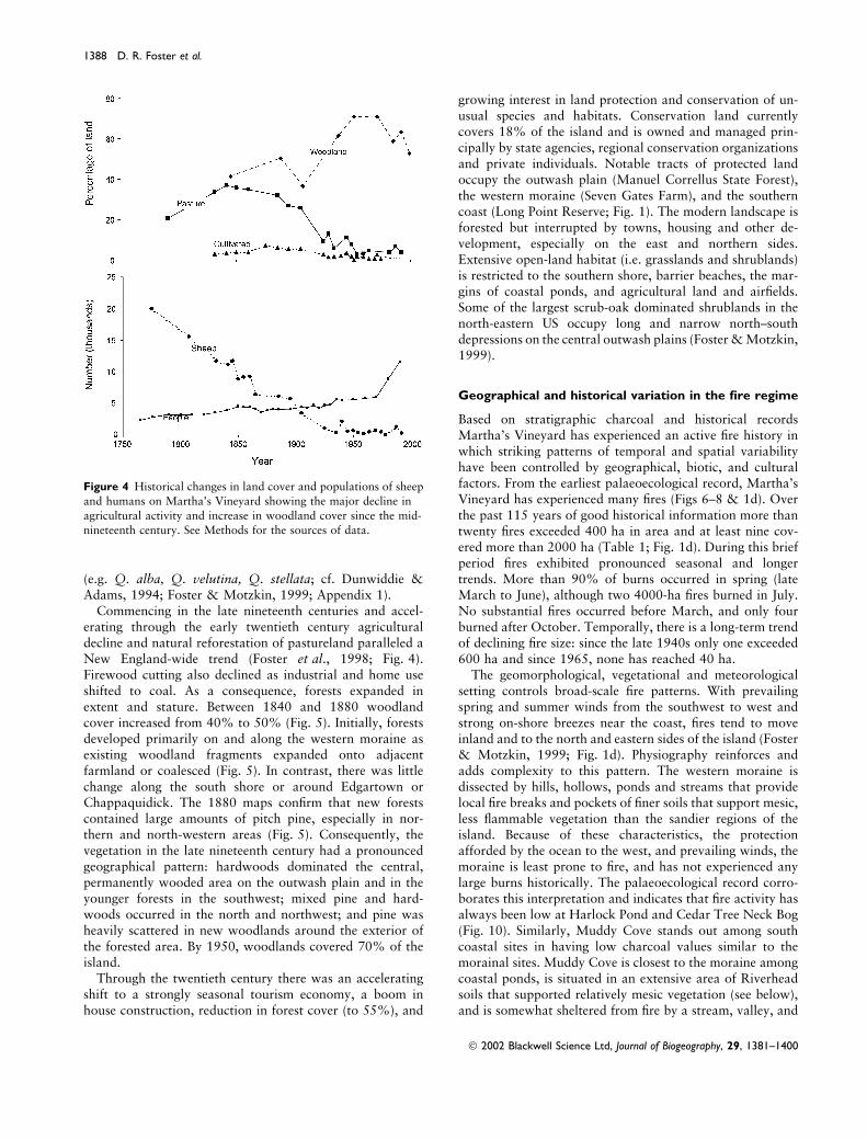
outwash plain was deforested and transformed (Figs 3–5).Agriculture and maritime activities provided subsistenceand economic bases and the human population concentratedon the island’s margins (Fig. 3). Extensive pastures weredeveloped on the western moraine, south shore, andChappaquidick, separated according to ownership or landuse by stone fences on the moraines and wooden or ditchfences on the outwash soils. Pastures supported diverselivestock and were grazed most heavily from 1775 to 1815when there were up to 20,000 sheep, 3500 cattle, 400 horsesand 800 pigs (Freeman, 1807; Banks, 1911; Fig. 4).
The growing population and industries, including abrickworks and whale oil factory, stressed the island woodsupply. In Edgartown an ordinance in 1683 limited thetaking of firewood on common land; in 1762 the island wasdescribed as holding as many inhabitants as the land couldcomfortably support (Banks, 1911); in 1788 residents com-menced substituting peat for firewood (Banks, 1911); and by1802 firewood was extensively imported from the mainland(Freeman, 1807). In 1848 woodland was restricted to smallpatches in inhabited areas and the large expanse on thecentral plain (Fig. 5). Sources from the eighteenth andnineteenth centuries corroborate that although the plain wasnever cleared of native growth that it was cut and burnedrepeatedly and became a broad tangle of gnarly scrub oak(Quercus ilicifolia, Q. prinoides) and sprouting tree oaks
Figure 3 Map of major cultural features, including buildings, agricultural fences and roads on Martha’s Vineyard in 1848, near the peak of
agricultural activity. Data are from the US Coast and Geodetic Survey (1848).
� 2002 Blackwell Science Ltd, Journal of Biogeography, 29, 1381–1400
Vegetation patterns and modern conservation on Marthas Vineyard 1387
(e.g. Q. alba, Q. velutina, Q. stellata; cf. Dunwiddie &Adams, 1994; Foster & Motzkin, 1999; Appendix 1).
Commencing in the late nineteenth centuries and accel-erating through the early twentieth century agriculturaldecline and natural reforestation of pastureland paralleled aNew England-wide trend (Foster et al., 1998; Fig. 4).Firewood cutting also declined as industrial and home useshifted to coal. As a consequence, forests expanded inextent and stature. Between 1840 and 1880 woodlandcover increased from 40% to 50% (Fig. 5). Initially, forestsdeveloped primarily on and along the western moraine asexisting woodland fragments expanded onto adjacentfarmland or coalesced (Fig. 5). In contrast, there was littlechange along the south shore or around Edgartown orChappaquidick. The 1880 maps confirm that new forestscontained large amounts of pitch pine, especially in nor-thern and north-western areas (Fig. 5). Consequently, thevegetation in the late nineteenth century had a pronouncedgeographical pattern: hardwoods dominated the central,permanently wooded area on the outwash plain and in theyounger forests in the southwest; mixed pine and hard-woods occurred in the north and northwest; and pine washeavily scattered in new woodlands around the exterior ofthe forested area. By 1950, woodlands covered 70% of theisland.
Through the twentieth century there was an acceleratingshift to a strongly seasonal tourism economy, a boom inhouse construction, reduction in forest cover (to 55%), and
growing interest in land protection and conservation of un-usual species and habitats. Conservation land currentlycovers 18% of the island and is owned and managed prin-cipally by state agencies, regional conservation organizationsand private individuals. Notable tracts of protected landoccupy the outwash plain (Manuel Correllus State Forest),the western moraine (Seven Gates Farm), and the southerncoast (Long Point Reserve; Fig. 1). The modern landscape isforested but interrupted by towns, housing and other de-velopment, especially on the east and northern sides.Extensive open-land habitat (i.e. grasslands and shrublands)is restricted to the southern shore, barrier beaches, the mar-gins of coastal ponds, and agricultural land and airfields.Some of the largest scrub-oak dominated shrublands in thenorth-eastern US occupy long and narrow north–southdepressions on the central outwash plains (Foster & Motzkin,1999).
Geographical and historical variation in the fire regime
Based on stratigraphic charcoal and historical recordsMartha’s Vineyard has experienced an active fire history inwhich striking patterns of temporal and spatial variabilityhave been controlled by geographical, biotic, and culturalfactors. From the earliest palaeoecological record, Martha’sVineyard has experienced many fires (Figs 6–8 & 1d). Overthe past 115 years of good historical information more thantwenty fires exceeded 400 ha in area and at least nine cov-ered more than 2000 ha (Table 1; Fig. 1d). During this briefperiod fires exhibited pronounced seasonal and longertrends. More than 90% of burns occurred in spring (lateMarch to June), although two 4000-ha fires burned in July.No substantial fires occurred before March, and only fourburned after October. Temporally, there is a long-term trendof declining fire size: since the late 1940s only one exceeded600 ha and since 1965, none has reached 40 ha.
The geomorphological, vegetational and meteorologicalsetting controls broad-scale fire patterns. With prevailingspring and summer winds from the southwest to west andstrong on-shore breezes near the coast, fires tend to moveinland and to the north and eastern sides of the island (Foster& Motzkin, 1999; Fig. 1d). Physiography reinforces andadds complexity to this pattern. The western moraine isdissected by hills, hollows, ponds and streams that providelocal fire breaks and pockets of finer soils that support mesic,less flammable vegetation than the sandier regions of theisland. Because of these characteristics, the protectionafforded by the ocean to the west, and prevailing winds, themoraine is least prone to fire, and has not experienced anylarge burns historically. The palaeoecological record corro-borates this interpretation and indicates that fire activity hasalways been low at Harlock Pond and Cedar Tree Neck Bog(Fig. 10). Similarly, Muddy Cove stands out among southcoastal sites in having low charcoal values similar to themorainal sites. Muddy Cove is closest to the moraine amongcoastal ponds, is situated in an extensive area of Riverheadsoils that supported relatively mesic vegetation (see below),and is somewhat sheltered from fire by a stream, valley, and
Figure 4 Historical changes in land cover and populations of sheep
and humans on Martha’s Vineyard showing the major decline in
agricultural activity and increase in woodland cover since the mid-nineteenth century. See Methods for the sources of data.
� 2002 Blackwell Science Ltd, Journal of Biogeography, 29, 1381–1400
1388 D. R. Foster et al.

pond to the west and north. These factors led to a reducedimportance of fire during pre-settlement times.
Across the drier and flatter outwash plain two distinctpatterns of fire occurrence are recorded in lake sedimentsand the historical record. The northern sites (Duarte andLagoon Pond) have extremely high charcoal values withrelatively little change from pre-European to historical times(Fig. 10). In contrast, the south coastal sites exhibit high tomoderate values during pre-European times that decline toc. 50% after European settlement. These sites exhibit one ofthe largest and most consistent declines in charcoal withEuropean settlement in New England (Patterson &Backman, 1988a,b; Stevens, 1996; Parshall & Foster 2002).
Differences in fire history between these two areas can beexplained by geography, human activity and vegetationhistory. With fires sweeping to the east and north, the dis-sected landscape, geographical location, on-shore winds andnarrow stretches of continuous land along the south shoreshelter the south coastal ponds from many fires. Conversely,Duarte and Lagoon Ponds are fully exposed to fires sweepingnortheast with prevailing winds across the plain expanse.The north coastal ponds supported greater pre-Europeanhuman habitation than the south coast, which may havefurther increased the incidence of fire. Over the last300 years differences in land use and land cover caused thesetwo areas to diverge further in fire activity. Whereas thenecks of land between south coastal ponds were cleared of
woodland, intensively grazed, and lightly plowed for pastureimprovement and crops, much of the area around Duarteand Lagoon Ponds and stretching for miles to the southremained in highly flammable scrub oak and woodlandvegetation (Fig. 5; Foster & Motzkin, 1999; Raleigh, 2000).Consequently, whereas fuel loadings around coastal pondswere cropped low, in the north they remained high. Thisland-cover shift was associated with greatly decreasing val-ues for charcoal in the south and only modest change in thenorth (Fig. 10). Historical data confirm a lower incidence offire along the south coast and its narrow necks of land andunderscore the tendency for fires to move north and eastacross the plain (Table 1; Figs 1c & 1d).
Long-term vegetation dynamics
Island-wide, the pre-European vegetation was wooded andcomprised fairly distinct compositional groups correspond-ing to the three physiographic regions: moraine, northernoutwash over moraine, and outwash plain. Long pollenrecords confirm that although geographical differences invegetation persisted, the composition in each region changedsubstantially on centennial time-scales. Following Europeansettlement compositional variation in vegetation decreased.
Broad-scale and long-term vegetation changes are wellsummarized by the DCA of all sites (Figs 7 & 8). Duringpre-European times the morainal sites are distinguished by
Figure 5 Historical changes in forest cover and open areas on Martha’s Vineyard. Data derived from the US Coast and Geodetic Survey (1848–1885), interpretation of 1938 aerial photographs, and MRLC-1992. Black dots indicating locations of pine trees are only available for the
nineteenth century maps.
� 2002 Blackwell Science Ltd, Journal of Biogeography, 29, 1381–1400
Vegetation patterns and modern conservation on Marthas Vineyard 1389

Harlock Pond - Moraine100
0
400
800
1200
1600
2000
22002300
0
20
40
60
80
100
120
140
160
180
Depth
(cm)
Age
607–73
686–83
1215–99
1868–170
2342–58
CAL YBP
Total
Pine
Tsug
a
20
Betula
Ostrya
-Car
pinus
40
Querc
us
Acer ru
brum
Carya
20
Fagu
s
20
Nyssa
Alnus r
ugos
a
20
Myrica
-Com
ptonia
Erica
ceae
Clethr
a
Poac
eae
Ambros
ia
Rumex
Pterid
ium
Monole
tesp
ore
1000
Charc
oal:P
ollen
%or
ganic
matt
er
Duarte Pond Outwash over Moraine
0
20
40
60
80
100
120
140
160
180
200
Depth
(cm)
0
200
400
600800
1000
16002000
25002700
Age
538541
971
2348
271440
Total
Pine
Tsug
aBetu
la
40
Querc
us
Carya
Fagu
sCas
tanea
Myrica
-Com
ptonia
Erica
ceae
20
Poac
eae
20
Ambros
ia
20
Rumex
Planta
go
20
Cyper
acea
e
Pterid
ium
Myriop
hyllu
m
Nymph
aea
4000
Charc
oal:P
ollen
100
% or
ganic
Cal yB
P
Southern Outwash Plain
0
10
20
30
40
50
60
70
80
90
Depth
(cm)
971–211
20
Pinus
Betula
40
Querc
us
Carya
Fagu
s
20
Myrica
/Com
ptonia
Erica
ceae
20
Poac
eae
20
Ambros
ia
Tubli
f lora
e
Legu
mes
Planta
go
20
Rumex
Pterid
ium
Cyper
acea
e
Ruppia
Pota
mogeto
n
Osmun
da
2000
Charc
oal:P
ollen
Cal yB
P
Analyst: S. Clayden
Analyst: N. Drake
Analyst: A. Stevens (1996)
Harlock Pond - Moraine100100
0
400
800
1200
1600
2000
22002300
0
20
40
60
80
100
120
140
160
180
Depth
(cm)
Age
607–73
686–83
1215–99
1868–170
2342–58
CAL YBP
Total
Pine
Tsug
a
20
Betula
Ostrya
-Car
pinus
40
Querc
us
Acer ru
brum
Carya
20
Fagu
s
20
Nyssa
Alnus r
ugos
a
20
Myrica
-Com
ptonia
Erica
ceae
Clethr
a
Poac
eae
Ambros
ia
Rumex
Pterid
ium
Monole
tesp
ore
1000
Charc
oal:P
ollen
%or
ganic
matt
er
0
400
800
1200
1600
2000
22002300
0
400
800
1200
1600
2000
22002300
0
400
800
1200
1600
2000
22002300
0
20
40
60
80
100
120
140
160
180
Depth
(cm)
Age
607–73
686–83
1215–99
1868–170
2342–58
CAL YBP
Total
Pine
Tsug
a
20
Betula
Ostrya
-Car
pinus
40
Querc
us
Acer ru
brum
Carya
20
Fagu
s
20
Nyssa
Alnus r
ugos
a
20
Myrica
-Com
ptonia
Erica
ceae
Clethr
a
Poac
eae
Ambros
ia
Rumex
Pterid
ium
Monole
tesp
ore
1000
Charc
oal:P
ollen
%or
ganic
matt
er
0
20
40
60
80
100
120
140
160
180
0
20
40
60
80
100
120
140
160
180
Depth
(cm)
Age
607–73
686–83
1215–99
1868–170
2342–58
CAL YBP
Total
Pine
Tsug
a
20
Betula
Ostrya
-Car
pinus
40
Querc
us
Acer ru
brum
Carya
20
Fagu
s
20
Nyssa
Alnus r
ugos
a
20
Myrica
-Com
ptonia
Erica
ceae
Clethr
a
Poac
eae
Ambros
ia
Rumex
Pterid
ium
Monole
tesp
ore
1000
Charc
oal:P
ollen
%or
ganic
matt
er
Duarte Pond Outwash over Moraine
0
20
40
60
80
100
120
140
160
180
200
0
20
40
60
80
100
120
140
160
180
200
Depth
(cm)
0
200
400
600800
1000
16002000
25002700
0
200
400
600800
1000
16002000
25002700
0
200
400
600800
1000
16002000
25002700
Age
538541
971
2348
2714
538541
971
2348
271440
Total
Pine
Tsug
aBetu
la
40
Querc
us
Carya
Fagu
sCas
tanea
Myrica
-Com
ptonia
Erica
ceae
20
Poac
eae
20
Ambros
ia
20
Rumex
Planta
go
20
Cyper
acea
e
Pterid
ium
Myriop
hyllu
m
Nymph
aea
4000
Charc
oal:P
ollen
100
% or
ganic
Cal yB
P
Jobs Neck Pond Southern Outwash Plain
0
10
20
30
40
50
60
70
80
90
Depth
(cm)
971–211
20
Pinus
Betula
40
Querc
us
Carya
Fagu
s
20
Myrica
/Com
ptonia
Erica
ceae
20
Poac
eae
20
Ambros
ia
Tubli
f lora
e
Legu
mes
Planta
go
20
Rumex
Pterid
ium
Cyper
acea
e
Ruppia
Pota
mogeto
n
Osmun
da
2000
Charc
oal:P
ollen
Cal yB
P
0
10
20
30
40
50
60
70
80
90
0
10
20
30
40
50
60
70
80
90
Depth
(cm)
971–211
20
Pinus
Betula
40
Querc
us
Carya
Fagu
s
20
Myrica
/Com
ptonia
Erica
ceae
20
Poac
eae
20
Ambros
ia
Tubli
f lora
e
Legu
mes
Planta
go
20
Rumex
Pterid
ium
Cyper
acea
e
Ruppia
Pota
mogeto
n
Osmun
da
2000
Charc
oal:P
ollen
Cal yB
P
Analyst: S. Clayden
Analyst: N. Drake
Analyst: A. Stevens (1996)
Figure 6 Representative pollen diagrams from the moraine (Harlock Pond), the northern outwash (Duarte Pond) and the southern coastal area(Jobs Neck Pond). Data from Jobs Neck Pond are from Stevens (1996).
� 2002 Blackwell Science Ltd, Journal of Biogeography, 29, 1381–1400
1390 D. R. Foster et al.

high percentages of beech, oak, birch and hickory, thenorthern outwash ⁄ moraine sites by higher pine, and thesouth shore outwash by intermediate levels of oak, hickory,birch, pine and lesser amounts of beech and grass(cf. Fig. 9). In the European period the variation is reducedas all sites exhibit a pronounced decline in tree pollen andincrease in grass, ragweed and sorrel. Northern andsouthern sites become more tightly grouped and are joinedby Cedar Tree Bog. Harlock Pond exhibits the leastamount of change and becomes an outlier. ConverselyMuddy Cove becomes an outlier as it exhibits substantialincreases in open-land taxa.
Western moraine (Harlock Pond and Cedar Tree Neck
Bog)
Morainal sites, in undulating terrain with a low fire fre-quency and pockets of fine-grained soils, supported distinct,mesic broad-leafed forests. Before European settlement oak(c. 30%) and beech (10%) were dominant with lesseramounts of red maple, black gum, hickory and hop horn-beam. Pine and open-land taxa (e.g. grass, bracken fern,weed taxa) were at the lowest of any sites. At Harlock Pondthe period from 2400 to 1540 yrBp exhibits little change,but c. 1500 yrBp apparently drier conditions prevail asbeech, red maple, and black gum decline and oak increasesabruptly to 40–45%. By 1000 yrBp, diverse and mesic foresthad developed. With European settlement the vegetationchanged less dramatically than elsewhere. Weeds and grasspollen increased to 5 or 10% and then declined to the pre-sent. Tree pollen declined and then rebounded as oakbecame increasingly dominant. Overall, the forests became
less diverse since the seventeenth century. Local impacts ofland use, including clearing, sheep grazing and watertable modification are seen in the substantial increases ininorganic sediments and bordering vegetation of sweetpepperbush, Ericaceae, and black gum at Harlock Pond.
South shore outwash
In comparison with the moraine the pre-European veget-ation is less mesic, has more pine and has a more openstructure. Oak is consistently less abundant (20%), pineranges from 15% to 25%, hickory and beech are less than5% and aquatic, wetland, or upland herbs (ditch-grass,sedge, Tubuliflorae, grass) range above 2–5%. Amongthese, grass consistently exceeds 5% and reaches 10% atsome sites. Although the cores are short and not well-dated, the pre-European vegetation change appears to beminimal (Stevens, 1996). Western sites (Muddy Coveand Deep Bottom Cove) are intermediate in vegetationbetween that of other south shore sites and morainal sitesas oak, beech and black gum are relatively higher, pine islow, and herb and grass values are low. After Europeansettlement the southern vegetation underwent modest tomajor changes as weeds and grass pollen increased andoak declined.
Northern outwash over moraine
The immediate pre-European vegetation at the northern siteswas characterized by abundant pine (20–35%) and oak(25–35%) and low amounts of other arboreal taxa excepthickory (3–5%). However, in the long record from Duarte
0
10
20
30
40
50
60
70
80
90
20 40 60 80 100 120 140 160 180 200Axis 1 scores
Axi
s 2
sco
res
HarlockCedar Tree
Muddy Deep BottomLong Cove
LagoonDuarte
Jobs Neck
Slough
MashacketWatcha
Moraine
South ShoreOutwash
Northern Outwash
Tsuga Pinus
Betula
Quercus
UlmusOstrya Carpinus
Carya
Fagus Castanea
Viburnum
Corylus Gramineae
AmbrosiaTubuliflorae
Chenopodiaceae
Plantago
RumexPteridium
Lycopodium
40 80
40
80
Axis 1
Axi
s 2
7
0
(a)
(b)Figure 7 Detrended Correspondence Ana-lysis (DCA) of the pre- and post-European
settlement period pollen data from all eleven
palaeoecological sites on Martha’s Vineyarddisplayed on the first two DCA axes. (a) The
centroids of samples for each site for the pre-
European period (filled circles) and Euro-
pean period (open circles). Sites come fromthe moraine, northern outwash and southern
outwash regions (see Fig. 1). (b) The distri-
bution of major taxa used in the analysis.
� 2002 Blackwell Science Ltd, Journal of Biogeography, 29, 1381–1400
Vegetation patterns and modern conservation on Marthas Vineyard 1391

Pond major shifts occurred in the relative abundance of tree,wetland and herb taxa. High oak (35–38%), low pine(15–20%), and relatively high sweet gale and Tubuliflorae(not shown) characterized the period from c. 2700–1000 yrBp. Since then and through initial European settle-ment pine increased and oak, sweet gale and Tubulifloraedeclined. After European settlement the vegetation changeddramatically as logging and clearing led to major declines inoak and pine and increases in sorrel, ragweed and grass to10–20%. In the recent past oak returned to approximatelypre-settlement values, herbs declined, and pine increased atLagoon Pond.
DISCUSSION
Landscape-scale controls on ecological processes and
the emergence of the modern setting for conservation
on Martha’s Vineyard
Despite its limited area Martha’s Vineyard embracesremarkable geographical, biological and cultural variation,which, in turn, create highly varied imperatives for conserva-
tion. In physical setting, the land ranges from rolling hills andexpanses of sandy outwash to coastal dunes, ponds and saltmarshes. Culturally, the landscape is equally varied as pre-historical activity and sites were unevenly distributed andmodern villages and development activity contrast sharply inappearance and history. The interaction among physical, bio-logical and cultural factors gives rise to a highly varied con-servation setting in which contrasting objectives range from theprotection of threatened populations on fragmented habitats tothe restoration of landscape-level variation in species-poor ve-getation types and from the maintenance of cultural landscapesto the desire to promote natural patterns and processes.
The long-term perspective on landscape developmentaffords insights into the background and emergence of eco-logical areas of contrasting conservation focus and owner-ship. The western moraine, with its rolling terrain includesone large private conservation area (Seven Gates Farm) thatharbours extensive and maturing mesic forests supporting arelatively rich assemblage of plants that are uncommon else-where on the island. The central plain, including the publiclyowned Manuel F. Correllus State Forest, supports one of thelargest expanses of scrub oak barrens and oak-pine forest in
0
40
80
120
Beech0
40
80
120
Oak
0
40
80
120
Hickory0
40
80
120
Birch
0
40
80
120
Pine0
40
80
120
Grass
40
80
120
Ragweed0
40
80
120
Sorrel0
100 200 100 200
Figure 8 The abundance of major taxa in all pre-European and historical samples from all palaeoecological sites, corresponding to the analysis
depicted in Fig. 7.
� 2002 Blackwell Science Ltd, Journal of Biogeography, 29, 1381–1400
1392 D. R. Foster et al.

Table 1 Major fires on Martha’s Vineyard from 1855 to 1990. Data compiled from the Vineyard Gazette (VG) newspaper, DEM (1994a,b),
and unpublished data of Tom Chase (TC) and Steve VanCour (SV) as modified from Dunwiddie & Adams (1994). Fires < 100 acres aregenerally excluded prior to 1950. After 1950, all fires > 20 acres are listed
Year Date Size (ac.) Location – landform
1855 4 ⁄ 6 large Willis Plain (Great Plains) (SV) – outwash
1867 4 ⁄ 26 4000 Near Lagoon (SV)
1875 7 ⁄ 9 7–10,000 Quompacha Bottom (SV) – outwash1883 8 ⁄ 11 Vineyard Haven town fire – moraine
1885 4 ⁄ 3 small Gay Head-Chilmark boundary – moraine
1886 5 ⁄ 2 1000 s Near Vineyard Haven, West Tisbury1889 3 ⁄ 24 4000 Quampeche Bottom – outwash
1892 4 ⁄ 8 5–8000 Near Middletown (VG), Lagoon Heights (SV)
1894 June large Location unknown (Gross, 1928; DEM, 1994b)
1900 4 ⁄ 26 5000 Scrubby Neck toward Edgartown – outwash (DEM, 1994b)1906 5 ⁄ 17 Innisfail Hotel (Oklahoma) burns in forest fire
1909 7 ⁄ 22 10000 On Plains (DEM, 1994b)
1914 12 ⁄ 24 1200 Western Great Plains to Katama – outwash
1916 5 ⁄ 18 12000 W. Tisbury to Farm Neck, Ocean Heights, and Edgartown – outwash1920 8 ⁄ 5 Large Vineyard Haven fire
1926 5 ⁄ 13 6400 West Tisbury toward Ocean Heights – outwash
1927 4 ⁄ 29 6400 From Dr Fisher Road to Edgartown – outwash1927 5 ⁄ 23 6400 From Dr Fisher Road toward Edgartown – outwash
1928 4 ⁄ 27 small Indian Hill Road – moraine
1929 4 ⁄ 5 2500 Watcha to Tiah’s Cove, Waldron’s Bottom, to Oyster Pond – outwash
1929 5 ⁄ 3 2560 Waldron’s Bottom – outwash1929 7 ⁄ 2 small Tashmoo ⁄ Herring Cr. – moraine
1930 5 ⁄ 9 200 West Chop – moraine
1930 5 ⁄ 16 5000 Between Edgartown and Oak Bluffs – outwash
1930 6 ⁄ 6 1000 N-NE through State Forest – outwash1932 Two fires in State Forest (DEM, 1994a)
1935 3 ⁄ 29 4000 Edgartown Great Pond to Katama – outwash
1936 Eight Fires, none in State Forest (DEM, 1994a)
1937 Chappaquidick (DEM, 1994a)1939 3 ⁄ 31 4000 Quampacha Bottom on Dr Fisher Road to VH Road (TC) – outwash
1940 5 ⁄ 17 >1000 State Forest near Edg. – VH Road. – outwash
1942 5 ⁄ 26 350 Job’s Neck Pond to Jayne’s Cove, G. Flynn – outwash1942 1200 Near Edgartown Great Pond (DEM, 1994b)
1944 240 In MFCSF (DEM, 1994b)
1946 4 ⁄ 19 5120 Head of Tisbury Great Pond towards Edg. ⁄ OB – outwash
1948 9 ⁄ 3 300 South & West towards Clevelandtown ⁄ Edg. Airport – outwash1951 10 fires on the Island (DEM, 1994b)
1954 4 ⁄ 9 1000 Between Barnes Road, Wing Road and Edgartown VH Road. – outwash
1954 5 ⁄ 29 2500 Tiah’s Cove, WT to Edgartown – outwash
1954 7 ⁄ 16 100 Chappaquiddick near four corners – eastern moraine1957 4 ⁄ 19 35 Near State Hwy at Deep Bottom – outwash
1957 5 ⁄ 3 100 North of Chilmark cemetery, toward Chilmark Pond – western moraine
1958 6 ⁄ 13 East and north from State Forest – outwash1959 4 ⁄ 24 25 Between Old Courthouse Road and State Highway – outwash
1959 5 ⁄ 8 500 West Tisbury Road near Deep Bottom – outwash
1960 4 ⁄ 22 25 Katama – outwash
1963 10 ⁄ 25 300 Quampache Bottom to WT Road – outwash1965 12 ⁄ 18 1200 Great Plains to Katama (TC) – outwash
1971 5 ⁄ 14 20 Oklahoma, Tisbury
1975 4 ⁄ 25 50 NE from Edgartown dump
1976 12 ⁄ 31 85 Edgartown: Herring Cr. Road. Katama Airfld – outwash1987 7 ⁄ 31 20 Oak Bluffs behind Crosslands Nursery (TC) – outwash
1987 July �8 State Forest
� 2002 Blackwell Science Ltd, Journal of Biogeography, 29, 1381–1400
Vegetation patterns and modern conservation on Marthas Vineyard 1393

New England and many uncommon lepidopteran and wildlifespecies. Finally, the grass and shrubland necks along the southcoast harbour an unusual array of open-land plants and ani-mals on properties largely managed by non-profit environ-mental organizations (e.g. The Trustees of Reservations) andprivate owners, many of who have no conservation protectionon their land. The current status, future trajectories andmanagement options for these distinct land areas can only beunderstood within the broad perspective of a geographical–historical study of the entire island.
A number of key observations regarding the long-termpatterns of vegetation dynamics emerge from the consid-eration of historical and ecological sources. First, landscape-scale variation in vegetation is long-standing and driven byvariation in soils and geomorphology that is also associatedwith substantial variation in fire and human activity.Although the specific structure of the vegetation on themoraine, northern outwash and southern coast have chan-
ged, in some cases in major ways, with climate and Europeanland use, the distinctiveness of each area has persistedthrough time. Secondly, in contrast to expectations raised byethnographic sources and historical, ecological and conser-vation literature, there is no evidence for the direct impact ofNative Americans on the vegetation, at least at the scaleresolved by pollen analysis. At the time of European settle-ment Martha’s Vineyard, like Nantucket and Cape Cod, waswooded with no substantial areas of grassland, shrubland orheathland. Indians may have been an important ignitionsource for fire, especially on areas of outwash. However,island-wide patterns of fire and vegetation were more obvi-ously controlled by physiography than apparent patterns ofhuman activity. Finally, European land use exerted majorimpacts on vegetation, soils, fire, and the environment andinitiated the formation of extensive open lands. Theseimpacts have important ramifications for ecological inter-pretation and conservation activity as the modern landscape
Figure 9 Maps of the average values for pollen taxa at each palaeoecological site during the pre-European period and after European
settlement. Taxa that do not occur on the island (e.g. Tsuga (hemlock) show no geographical pattern and little change through time. In contrast,weedy and other taxa indicative of open lands (e.g. Gramineae (grass), Ambrosia (ragweed), Rumex (sorrel) increase after European settlement
especially at outwash sites, whereas Pinus (pine) increases and Fagus (beech) and Carya (hickory) decline.
� 2002 Blackwell Science Ltd, Journal of Biogeography, 29, 1381–1400
1394 D. R. Foster et al.

bears strong evidence of the cumulative impacts of historicalprocesses.
Vegetation, human activity and important ecologicalprocesses, especially fire, sort out strongly according to thethree major physiographic divisions of the island, as des-cribed below.
Development of mature mesic forests on the moraine
Throughout the period preceding European settlement mesichardwood forests of oak, beech, red maple, hickory andblack gum dominated the rolling and hilly terrain of thewestern moraine. This region supported the lowest incidenceof fire on the island because of its windward location, lowNative American population (and presumably infrequentignitions), mesic vegetation and dissected terrain that inhib-ited the spread of fire. Indeed, the extremes in fire activityacross the island were remarkable; whereas the central plainexhibited some of the highest charcoal values in New Eng-land, charcoal values on the moraine around Harlock Pondwere more comparable with those on moist uplands inwestern Massachusetts (Patterson & Backman, 1988a; Fulleret al., 1998; Parshall & Foster 2002; Parshall et al., 2003).
Although much of the moraine was deforested and sub-jected to intense sheep grazing in the eighteen and nineteenthcenturies, the area rapidly reforested as agriculture declined(Ogden 1958; Foster & Motzkin, 1999). Today much of thearea is heavily forested, with scattered areas in pasture.Moist soils, an abundant seed source from fencerow andwoodlot trees, and protection from fire, wind and salt spraywere conducive to rapid succession and the recovery of amesic hardwood forest (Shaler, 1888; Dunwiddie & Adams,1994). Although there were modest declines in hickory andbeech and increases in oak and pine around Harlock Pond asa consequence of land use (Dunwiddie & Adams, 1994),forest composition changed only modestly through the
historical period. Today conservation areas such as WhitingHill on Seven Gates Farm, are notable for their extensiveolder forests with a mesic and relatively rich understory.These forests play an important role in island-wide biodi-versity because of their contrasting structure and composi-tion relative to most regions and their inferred similarity topre-historical morainal forests. The value of these stands islargely one of natural characteristics and therefore a policyof protection would serve to maintain and enhance theirstature and value.
Restoration of an oak barrens and woodland landscape
on the central plains
The environment, vegetation, and history of the centralplain and adjoining area of outwash soils over moraineprovide a striking contrast to the moraine. Occupyingcoarse, droughty soil, the pre-European vegetation acrossthe plain was dominated by pitch pine, oak trees and scruboak, presumably with an open ericaceous understory (cf.Foster & Motzkin, 1999; Eberhardt et al., 2003). Based onthe high charcoal values for Duarte and Lagoon Pond, theentire plain was apparently subjected to intense fires on anongoing basis. Through the historical period much of thearea was heavily cut and burned but the large central plainremained wooded because of the absence of surface waterfor grazing animals and poor soil suitability for crops(Foster & Motzkin, 1999; Dunwiddie & Adams, 1994). Thecontinuity of woody, scrub vegetation provided highlyflammable fuel loadings and consequently charcoal valuesand fires remained at high levels until the recent past. As aconsequence of this history, and despite changes in the rel-ative abundance of pine and oak and impacts includingcreation of fire breaks and plantations on portions of thestate property, the vegetation patterns and species compo-sition across much of the central plain appear to haveremained relatively similar over time.
The conservation priorities on the plain focus on theunusual extent of scrub oak barrens that forms a topo-graphically defined landscape element within the oak andpine forest. To maintain and restore this natural pattern aswell as the array of plant and animal assemblages manage-ment recommendations have included eliminating non-native plantations, re-introducing prescribed fire, and, in themany situations where fire is socially unacceptable, mowingto perpetuate the low stature scrub communities (Foster &Motzkin, 1998, 1999). The Correllus State Forest representsone of the largest conservation properties on the island andprotects some of the best sand plain scrub oak and oak-pinewoodland in the north-eastern US. Consequently, throughjudicious management there is the potential to restore aunique sandplain landscape mosaic (Adams, 1992).
Maintenance of cultural grasslands and shrublands along
the south coast
The south coast of Martha’s Vineyard includes coastalsandplain grass and shrublands, uncommon open-land plant
Mud
dy
Wat
cha
Lago
on
Ced
ar tr
ee
Har
lock
Dee
p bo
ttom
Long
pon
dJo
bs n
eck
Mas
hack
etSl
ough
Dua
rte
200
600
1000
1400
1800C
harc
oal :
Pol
len
× Pre--EuropeanEuropean
ECoastMoraine
W South shoreOutwash
North shoreOutwash/Moraine
××
×
×
××
××
×
××
Figure 10 Average values of charcoal to pollen ratios for pre-
European samples and samples since European settlement. Three
patterns correspond to major landforms and geography: morainalsites and the southern site closest to the moraine have low values
that decline with settlement; southern outwash sites have high values
that fall markedly with settlement; and northern outwash sites haveextremely high values that remain high after settlement.
� 2002 Blackwell Science Ltd, Journal of Biogeography, 29, 1381–1400
Vegetation patterns and modern conservation on Marthas Vineyard 1395

assemblages that are the focus of intense conservationactivity because they support a number of unusual plant andanimal species (Vickery & Dunwiddie, 1997; MNHESP,2001). Central to efforts at preservation or restoration ofthese communities is interpretation of the disturbanceregime that may have been responsible for initiating andmaintaining this successional vegetation in an otherwiseforested landscape (Dunwiddie, 1989, 1990, 1994; Motzkin& Foster, 2002). Indeed, the prevailing notion that thesecommunities have a lengthy pre-European history because ofIndian land-use practices including agriculture, villageclearing and burning, has led to active fire managementprograms by conservation organization and public agencies(Motzkin & Foster, 2002).
Results from this study provide insights into the dynamicsof these open-land communities and the factors controllingtheir distribution. Specific conclusions include: evidence forsubstantial areas of pre-European grassland is weak orambiguous and lends little support to the interpretation thatfire or Indian activity were important factors in creating pre-historical grasslands; open-land vegetation became abundantduring the post-European period and therefore its distribu-tion and characteristics are strongly tied to the pattern ofhistorical land use especially deforestation and grazing; and,maintenance of this successional vegetation may requireactive management through cultural activity including agri-culture. Maintenance of open-land habitats is critical forimportant species and is feasible because of the slow rate ofreforestation on windy and droughty sites.
Pre-European weed and grass pollen do reach 4–10% forsouth coastal sites and Duarte Pond. Although this pollensignature may indicate open-structured forest, patchywoodland or an open-land mosaic, interpretation remainsambiguous because of our inability to separate wetland andupland grass and sedge pollen (Stevens, 1996). Numerouslines of evidence do suggest a significant pollen signal fromwetlands. The ponds have gentle shores, fringing wetlandsand emergent vegetation; and historical documents describethem as supporting �meadows� (a vernacular term for openwetland; Foster, 1999), black grass and mowing areas(Freeman, 1807; Banks, 1911; Stevens, 1996; Raleigh,2000). The pollen data often includes numerous wetland andaquatic taxa such as Myrica ⁄ Comptonia (sweet gale), Nyssasylvatica, Carex (sedge), Acer rubrum (red maple) andRuppia but few pollen indicators of open landscape such asEricaceae or Pteridium (bracken fern; Fig. 6).
European settlement, clearing of the forests and wide-spread grazing by thousands of sheep and cows led to broad-scale establishment of pasture and related grasslands andmarked increases in grass, herbs, shrubs and weed speciesacross the island including the southern coast (Figs 3–5).Through the ensuing centuries upland areas currently sup-porting open vegetation experienced intense agricultureincluding grazing, plowing, mowing, burning and manureapplications. Consequently, European land use not onlycreated most areas of open vegetation, but it strongly shapedthe composition of all open areas. With farm abandonmentand reforestation open vegetation declined, paralleled by a
decline in weed, grass and non-arboreal pollen (NAP;Figs 6–8 & 9; see Motzkin & Foster, 2002).
The relationship between open vegetation, fire and Indianactivity is ambiguous. The presumed link between humanactivity and grassland is predicated on the belief that Indianswere agriculturalists occupying semi-permanent and con-centrated villages (Cronon, 1983). With little archaeologicalsupport for this contention, the major human impact on thepre-European landscape might have been fire. However,on Martha’s Vineyard, areas with consistent grass pollensupported neither the highest concentration of Indian sites orcharcoal. In contrast, northern sites supported many Indiansites and high fire activity, but high grass pollen only at Du-arte Pond. Meanwhile southern ponds, with few archaeolo-gical sites and lower fire activity, have the highest levels ofgrass pollen. Fire ecology studies do not provide strongsupport for the fire : grassland linkage, at least in NewEngland (Parshall & Foster 2002; Patterson et al., 1983).Although intense and repeated burning may maintain grass-lands by killing intolerant woody species, fire is relativelyineffective in creating new grassy areas in woodlands.
However, there are numerous caveats to this interpretation.The absence of archaeological sites may be due to destructionby an eroding southern coast or inadequate study. If the ve-getation did include a large herb component it might notproduce much charcoal when burned. Meanwhile, slow suc-cession on the exposed coast means that open vegetationcould be maintained with less frequent fire than requiredfurther inland (P. Dunwiddie, Pers. comm.). Whereas moistsoils and protection from the wind may aid reforestation onthe moraine, towards the coast reforestation may be slowbecause of dry soils, exposure to strong winds and salt spray,and limited upwind dispersal. Consequently, retention ofthese valuable open habitats should require relatively lowlevels of active maintenance, especially if they involve theapplication of historically relevant processes. Although fire isone approach, it is likely that the re-application of traditionalagriculture or its substitutes may be more likely to succeedecologically and socially. Such practices include grazing bysheep or cows, and mowing. Not only are these the distur-bances that initiated the open vegetation, but they are easilycontrolled and applied at whatever season is deemed mosteffective or desirable. In contrast, fire is difficult to use in themodern landscape because of safety and air quality concernsas well as laws that preclude its use during the most effectivetime of the year: the growing season (Dunwiddie, 1999).
CONCLUSION
On close examination the coastal landscape of Martha’sVineyard presents a great diversity of habitats, vegetationand ecological processes that change in complex fashionthrough time in response to changing land use and fire re-gimes linked to geography, topography and environment.The broad patterns of vegetation are strongly related to soilsand physiography, which also influence disturbance patternslike fire. Pre-European human impact on the vegetation isundetectable, although extreme differences in fire regimes
� 2002 Blackwell Science Ltd, Journal of Biogeography, 29, 1381–1400
1396 D. R. Foster et al.

occur across the relatively small landmass. Although igni-tions may be related to human activity and fire may be animportant element in shaping vegetation composition, itsoverall influence on vegetation structure appears to be slight.Consequently, significant human controls over vegetationand landscape process only emerge following Europeansettlement when woodlands were opened for agriculture.The legacies of this historical land-use activity persist inthe landscape and strongly shape the current characterof the vegetation and the management imperatives forconservation activity. Using history to interpret modernecological patterns yields a range of contrasting approachesto conservation on different portions of this highly variedlandscape.
ACKNOWLEDGMENTS
This research greatly benefited from the assistance andadvice of G. Motzkin, J. Burk, D. MacDonald, D. Recos, M.Mulholland, E. Chilton, R. Leahy, T. Simmons, M. Adams,J. Varkonda, B. Rivers, T. Chase, P. Van Tassel, andJ. Stone, comments from P. Dunwiddie, and cooperationfrom The Nature Conservancy, Massachusetts Departmentof Environmental Management, Department of Fisheries,Wildlife, and Environmental Law Enforcement (EcologicalRestoration Program), Trustees of Reservations, VineyardConservation Society, Sheriff’s Meadow, and Seven GatesFarm. Funding was received from the National ScienceFoundation, A.W. Mellon Foundation, The Nature Con-servancy Ecological Research Program, and Commonwealthof Massachusetts. This is a contribution of the HarvardForest Long-term Ecological Research Program.
REFERENCES
Adams, M.B. (1992) The State Forest: wasteland in thewoodland, new agenda for hope. Martha’s Vineyard Maga-zine, Fall ⁄ Holiday issue, pp. 13–19.
Massachusetts Natural Heritage and Endangered SpeciesProgram (MNHESP). (2001) Biomap – Guiding land conser-vation for biodiversity in Massachusetts. Executive Office ofEnvironmental Affairs, Boston.
Anonymous (1859) A visit to Martha’s Vineyard. Society for theProtection of New England Antiquities, Boston, MA.
Athearn, S. (1698) Map of Martha’s Vineyard. Dukes CountyHistorical Society, Edgartown.
Banks, C.E. (1911) The history of Martha’s Vineyard, DukesCounty, Massachusetts. 3 Vol. Dukes County HistoricalSociety, Edgartown, MA
Bendremer, J.C.M. (1993) Late woodland settlement andsubsistence in eastern Connecticut. PhD Thesis, Universityof Connecticut.
Bengtsson, L. & Enell, M. (1986) Chemical analysis. Handbookof Holocene palaeoecology and palaeohydrology (ed. B.Berglund), pp. 423–454. John Wiley and Sons, Chichester,UK.
Bernstein, D.J. (1993) Prehistoric subsistence on the southernNew England coast: the view from Narragansett Bay.Academic Press, San Diego.
Binford, M.W. (1990) Calculation and uncertainty analysis of210Pb dates for PIRLA project lake sediment cores. Journalof Paleolimnology, 3, 253–267.
Boose, E.R., Chamberlin, K.E. & Foster, D.R. (2001) Land-scape and regional impacts of hurricanes in New England.Ecological Monographs, 71, 27–48.
Bragdon, K.J. (1996) Native people of southern New England,pp. 1500–1650. University of Oklahoma Press, London.
Brubaker, L. (1975) Postglacial forest patterns associated withtill and outwash in northcentral upper Michigan. QuaternaryResearch, 5, 499–527.
Ceci, L. (1977) The effect of European contact and trade on thesettlement pattern of Indians in coastal New York: thearchaeological and documentary evidence. PhD Dissertation,City University of New York, NY.
Chilton, E.S. (1999) Mobile farmers of pre-contact southernNew England: the archaeological and ethnohistorical evi-dence. Current northeast paleoethnobotany (ed. J.P. Hart),pp. 157–176. Bulletin no. 494. New York State Museum,University of the State of New York, NY.
Chilton, E.S. (2000) The archaeology and ethnohistory of thecontact period in the Northeastern United States. Reviews inAnthropology, 30, 55–78.
Chilton, E.S. (2002) �Towns They Have None�: Diverse subsist-ence and settlement strategies in native New England.Northeast subsistence settlement change: AD 700–AD 1300(eds J. Hart and C. Reith). New York State Museum Bulletin,Albany, NY, in press.
Clark, R.L. (1982) Point count estimation of charcoal in pollenpreparations and thin sections of sediments. Pollen et Spores,24, 523–535.
Cook, S.F. (1976) The Indian population of New England in the17th century. Publications in Anthropology, 12, 1–91.University of California, Berkeley.
Crevecoeur, J.H. St John de (1784) Map of Martha’s Vineyard.Lettres d’un cultivateer Americain. London.
Cronon, W. (1983) Changes in the land. Indians, colonists andthe ecology of New England. Hill and Wang, NY.
Day, G.M. (1953) The Indian as an ecological factor in thenortheastern forest. Ecology, 34, 329–346.
DEM (1994a) The early years of Manuel F. Correllus StateForest. Draft unpublished report, Boston.
DEM (1994b) An ecosystem management plan for the ManuelF. Correllus State Forest. Draft unpublished report, Boston.
Denevan, W. (1992) The pristine myth: the landscape of theAmericas in 1492. Annals of the Association of AmericanGeographyraphers, 82, 369–385.
Dunwiddie, P.W. (1989) Forest and heath: the shaping of thevegetation on Nantucket Island. Journal of Forest History,July, 126–133.
Dunwiddie, P.W. (1990) Postglacial vegetation history ofcoastal islands in southeastern New England. NationalGeographic Research, 6, 178–195.
Dunwiddie, P.W. (1994) Martha’s Vineyard landscapes: thenature of change. The Vineyard Conservation Society,Vineyard Haven, MA.
Dunwiddie, P.W. (1999) Ecological management of sandplaingrasslands and coastal heathlands in southeastern Massachu-setts. Fire in ecosystem management: shifting the paradigmfrom suppression to prescription (eds T.L. Pruden and L.A.
� 2002 Blackwell Science Ltd, Journal of Biogeography, 29, 1381–1400
Vegetation patterns and modern conservation on Marthas Vineyard 1397

Brennan), pp. 83–93. Proceedings of the 20th Tall TimbersFire Ecology Conference. Tall Timbers Research Station,Tallahassee, Florida.
Dunwiddie, P. & Adams, M. (1994) Landscape change onMartha’s Vineyard and the Elizabeth Islands 1640–1993. Thenature conservancy. Massachusetts Field Office, Unpublishedreport, Boston, MA.
Eberhardt, R., Foster, D.R., Motzkin, G. & Hall, B. (2003)Conservation of changing landscapes: vegetation and land-use history of Cape Cod National Seashore. EcologicalApplications, in press.
Faegri, K. & Iversen, J. (1991) Textbook of Pollen Analysis.Blackwell Scientific Publications, Oxford, UK.
Fletcher, P.C. & Roffinoli, R.J. (1986) Soil survey of DukesCounty, Massachusetts. US Department of Agriculture SoilConservation Service. Washington, DC.
Foster, D.R. (1999) Thoreau’s country. Journey through a trans-formed landscape. Harvard University Press, Cambridge, MA.
Foster, D.R. (2000) Conservation lessons and challenges fromecological history. Forest History Today, Fall, 2–11.
Foster, D.R. & Motzkin, G. (1998) Ecology and conservation inthe cultural landscape of New England: lessons from nature’shistory. Northeastern Naturalist, 5, 111–126.
Foster, D.R. & Motzkin, G. (1999) Historical influences on thelandscape of Martha’s Vineyard – perspectives on themanagement of Manuel F. Correllus State Forest. HarvardForest Paper no. 23. Harvard Forest, Petersham, MA.
Foster, D. & O’Keefe, J. (2000) New England forests throughtime. Insights from the Harvard Forest Dioramas. HarvardForest and Harvard University Press, Petersham and Cam-bridge, MA.
Foster, D.R., Motzkin, G. & Slater, B. (1998) Land-usehistory as long-term broad-scale disturbance: regionalforest dynamics in central New England. Ecosystems, 1,96–119.
Foster, D.R., Swanson, F., Aber, J., Burke, I., Brokaw, N.,Tilman, D. & Knapp, A. (2003) The importance of land-useand its legacies to ecology and environmental management.Bioscience, in press.
Freeman, J. (1807) A description of Duke’s County. Collectionsof the Massachusetts Historical Society, 3, 38–95. SecondSeries 1815. John Eliot, Boston.
Fuller, J.L., Foster, D.R., McLachlan, J.S. & Drake, N. (1998)Impact of human activity on regional forest composition anddynamics in central New England. Ecosystems, 1, 76–95.
Goldstein, P.Z. (1997) Lepidopteran assemblages and themanagement of sand plain communities on Martha’sVineyard, Massachusetts. Grasslands of northeastern NorthAmerica: ecology and conservation of native and agricul-tural landscapes (eds P.D. Vickery and P.W. Dunwiddie),pp. 217–236. Massachusetts Audubon Society, Lincoln,MA.
Gookin, W.F. (1947) Capawack alias Martha’s Vineyard. DukesCounty Historical Society, Edgartown, MA.
Grimm, E.C. (1981) Chronology and dynamics of vegetationchange in the prairie-woodland region of southern Minne-sota, USA. New Phytologist, 93, 311–350.
Grimm, E.C. (1984) Fire and other factors controlling the BigWoods vegetation in Minnesota in the mid-NineteenthCentury. Ecological Monographs, 54, 291–311.
Grimm, E.C. (1987) Coniss: a FORTRAN program for stratigraph-ically constrained cluster analysis by the method of incremen-tal sum of squares. Computers and Geosciences, 13, 13–35.
Gross, A.O. (1928) The heath hen. Memoirs of the BostonSociety of Natural History, 6, 1–132, Boston.
Herbster, H. & Cherau, S.R. (2000) Archaeological reconnais-sance survey – Town of Edgartown, Martha’s Vineyard,Masachusetts. PAL Report 1106. Pawtucket, RI.
Jackson, S.T. (1990) Pollen source area and representation insmall lakes of the northeastern United States. Review ofPalaebotany and Palynology, 63, 53–76.
Jackson, S.T. & Lyford, M.E. (1999) Pollen dispersal models inQuaternary plant ecology: assumptions, parameters, andprescriptions. Botanical Review, 65, 39–75.
Landres, P.B., Morgan, P. & Swanson, F. (1999) Overview ofthe use of natural variability concepts in managing ecologicalsystems. Ecological Applicationslications, 9, 1179–1188.
Little, E.A. (1988) Where are the woodland villages on CapeCod and the Islands? Bulletin of the Massachusetts Archaeo-logical Society, 49, 72–82.
Luedtke, B.E. (1988) Where are the late woodland villagesin eastern Massachusetts? Bulletin of the MassachusettsArchaeological Society, 49, 58–65.
MacConnell, W.P., Goodwin, D.W. & Jones, K.M. (1991)Land-Use update for Massachusetts with area statistics for1971 and 1984 ⁄ 1985. Massachusetts Agricultural Experi-ment Station Research Bulletin Number 740. Amherst, MA.
Massachusetts Archives (1794) 1794 Map Series. Boston,Massachusetts.
Massachusetts Archives (1830) 1830 Map Series. Boston,Massachusetts.
Massachusetts Geographic Information System (MassGIS)(1985) Environmental Data Center, Massachusetts ExecutiveOffice of Environmental Affairs, Boston, MA. www.state.ma.us/mgis/massgis.htm.
Massachusetts Geographic Information System (MassGIS)(2001) Environmental Data Center, Massachusetts ExecutiveOffice of Environmental Affairs, Boston, MA. www.state.ma.us/mgis/massgis.htm
McLachlan, J., Foster, D. & Menalled, F. (2000) Anthropogenicties to late-successional structure and composition in fourNew England hemlock stands. Ecology, 81, 717–733.
Motzkin, G. & Foster, D. (2002) Grasslands, heathlands andshrublands in coastal New England: historical interpretationsand approaches to conservation. Journal of Biogeography, 29,1569–1589.
Motzkin, G., Patterson, W.A. III & Foster, D.R. (1999) Ahistorical perspective on pitch pine-scrub oak communities inthe Connecticut Valley of Massachusetts. Ecosystems, 2,255–273.
Mulholland, M., Binzen, T. & Donta, C. (1999) Community-wide archaeological reconnaissance survey of Oak Bluffs andWest Tisbury, Massachusetts. University of MassachusettsArchaeological Services. Report UM-254. EnvironmentalInstitute, University of Massachusetts, Amherst, MA.
Mulholland, M.T., Donta, C. & Arcuti, T.L. (1998) Commu-nity Archaeological Reconnaissance Survey of Chilmark,Massachusetts. University of Massachusetts ArchaeologicalServices. Report UM-255. Environmental Institute, Universityof Massachusetts, Amherst, MA.
� 2002 Blackwell Science Ltd, Journal of Biogeography, 29, 1381–1400
1398 D. R. Foster et al.

Ogden, J.G. III (1958) Wisconsin vegetation and climate ofMartha’s Vineyard, Massachusetts. PhD Dissertation, YaleUniversity, New Haven, CT.
Parshall, T. & Foster, D. (2002) Fire on the New Englandlandscape: vegetation, geography and human controls. Jour-nal of Biogeography, 29, 1305–1317.
Parshall, T., Foster, D., Faison, E., MacDonald, D. & Hansen,B. (2003) Long-term vegetation and fire dynamics of pitchpine-oak forests on Cape Cod, Massachusetts. Ecology, inpress.
Patterson, W.A. III & Backman, A.E. (1988a) Fire and diseasehistory of forests. Vegetation history (eds B. Huntley andT. Webb, III), pp. 603–632. Kluwer Academic Publishers,Dordrecht, The Netherlands.
Patterson, W.A. III & Backman, A.E. (1988b) Vegetation andfire history of Myles Standish State forest. University ofMassachusetts Cooperative Forestry Research Unit Reportno. 2, Amherst, MA.
Patterson, W.A. III, Saunders, K.E. & Horton, L.J. (1983) Fireregimes of Cape Cod National Seashore. USDI NPS North.Atlantic Region Office of Scientific Studies Report OSS83-1.
Prentice, I.C. (1985) Pollen representation, source area, andbasin size: toward a unified theory of pollen analysis.Quaternary Research, 23, 76–86.
Raleigh, L. (2000) Land-use history of Long Point Refuge. TheTrustees of Reservations, Vineyard Haven, MA.
Rane, F.W. (1918) Fourteenth annual report of the state forestof Massachusetts for the year 1917. State Printers, Wrightand Potter Printing, Boston.
Ritchie, A. (1969) The archaeology of Martha’s Vineyard. TheNatural History Press, Garden City, NJ.
Shaler, N.S. (1888) Report on the geology of Martha’s Vine-yard. Department of Interior, US Geol. Survey. SeventhAnnual Report of the Director, 1885–86, 297–363.
Stevens, A. (1996) The paleoecology of coastal sand plaingrasslands on Martha’s Vineyard, Massachusetts. PhD Thesis,University of Massachusetts, Amherst.
Strother, D.H. (1860) A summer in New England. Harper’sNew Monthly Magazine.
Stuiver, M., Reimer, P.J. & Reimer, R. (2002) Calib radio-carbon calibration, Version 4.3. Quaternary IsotopesLaboratory, University of Washington, Seattle.
Sugita, S. (1993) A model of pollen source area for an entire lakesurface. Quaternary Research, 39, 239–244.
Sugita, S. (1994) Pollen representation of vegetation in Quater-nary sediments: theory and method in patchy vegetation.Journal of Ecology, 82, 881–897.
Swetnam, T.W., Allen, C.D. & Betancourt, J.L. (1999) Appliedhistorical ecology: using the past to manage for the future.Ecological Applicationslications, 9, 1189–1206.
United States Coast and Geodetic Survey. (1848) Maps ofMartha’s Vineyard, Massachusetts. Woods Hole Oceanogra-phic Institute Archives. Woods Hole, MA.
United States Coast and Geodetic Survey. (1897) Maps ofMartha’s Vineyard, Massachusetts. Harvard Forest Archives,Petersham, MA.
Vickery, P.D. & Dunwiddie, P.W. eds. (1997) Grasslands ofnortheastern North America: ecology and conservation ofnative and agricultural landscapes. Massachusetts AudubonSociety, Lincoln, MA.
Westveld, M. (1956) Natural forest vegetation zones of NewEngland. Journal of Forestry, 54, 332–338.
BIOSKETCHES
David Foster is an ecologist and palaeoecologist interes-ted in long-term vegetation dynamics and the conserva-tion of dynamics landscapes.
Tim Parshall is currently an ecologist and researchassociate at Michigan State University’s Kellogg Biolo-gical Station. His research focuses on how to improve ourunderstanding of modern ecosystems by looking into thepast.
Brian Hall is a graduate from the State University of NewYork (SUNY) at Plattsburgh and SUNY College ofEnvironmental Science and Forestry in Syracuse, NewYork. He is a research assistant at the Harvard Forestspecializing in GIS-based analysis and data presentation.His work allows him to combine his background in plantecology with his lifelong interest in the cultural history ofNew England.
Sylvia Barry is a graduate of the University of California,Santa Cruz, and the University of Minnesota. She is aresearcher in palaeolimnology at the Harvard Forestinvestigating the response of forest ecosystems to pastclimate change.
Susan Clayden is a graduate student at the University ofNew Brunswick, Canada. Her past and ongoingpalaeo-ecological studies include work in New England,Canada and Siberia.
� 2002 Blackwell Science Ltd, Journal of Biogeography, 29, 1381–1400
Vegetation patterns and modern conservation on Marthas Vineyard 1399

Appendix 1 Historical quotes pertaining to the vegetation and appearance of the Great Plain on Martha’s Vineyard that containsManuel F. Correllus State Forest
1669 �…land (at) Meeshackett containing I judge 63 acres more or
Less Bound with the Shrubed plain or Comon Land on the North…� (A deedreference to T. Buchard’s holdings; Banks (1911). Note: Meeshackett is on the south-eastern
portion of the Great Plain, on the eastern side of Edgartown Great Pond. This represents
one of the earliest references to shrub plains in the north-eastern US)
1698 �a barren ragged plain of no town.� Athearn (1698), referring to the central portion of the Great Plain1784 �Tisbury Wood Land.� Crevecoeur (1784)
1794 �…vast plains of bitter oaks between Edgartown and Tisbury.��Waste Land, Tisbury.� Smith (Massachusetts Archives, 1794)
1807 �More than one half of these two townships (Edgartown and Tisbury)is covered with shrub oak and bitter oak, is of little or no value, and is not enclosed
(i.e. fenced).� Freeman (1807)
�All the houses are within a mile or two of the sea coast:the internal parts of the island will probably always remain without inhabitants.� Freeman (1807)
1830 �rather thick and interspersed with short stunted oak shrubbery with the
exception of a small part thereof which may be termed woodland…�Crapo (Massachusetts Archives, 1830)
1859 �Having passed from the township of Holmes Hole into Tisbury,
the road lay through what would have been an oak forest, except none of
the trees (exceeded) some four feet in height – (our guide) affirming
this to be their mature growth, and that no larger ones had grown sincethe forest was cleared by the original settlers.� Anonymous (1859)
1860 (From West Tisbury) �Toward the south and east it is a plain, chiefly
covered with a growth of stunted shrubbery…� Strother (1860).
This generally untillable area (the terrace drift or plain) of Martha’s Vineyard has an extent of about 33,000 acres. Atpresent about 25,000 acres of this area is covered by low, scrubby woods, principally composed of varieties of small oaks;
the remainder consists of abandoned fields which are slowly returning to the condition of forest. Frequent fires sweep over
the district, destroying the parts of trees which are above ground, but not injuring the roots, from which a tangle of stemsquickly springs up. Originally this region was heavily wooded…’ Shaler (1888)
1890 �…wide, level, sandy plains, covered with a growth of bear, chincapin and post oak scrub from
knee to waist high, so stiff and matted as to be almost impenetrable.� (Brewster, in Gross, 1928)
� 2002 Blackwell Science Ltd, Journal of Biogeography, 29, 1381–1400
1400 D. R. Foster et al.