cultural development geog 247 cultural geography ... · geog 247 cultural geography course...
TRANSCRIPT

2/19/2015
1
GEOG 247Cultural Geography
Course Introduction IVPhysical Aspects of Culture
Prof. Anthony GrandeHunter College-CUNY
©AFG 2015
Influences on Human Culture: Physical Geography and Cultural Development
Environmental Determinism
Possiblism
Many aspects of the physical (natural) environment influence the development of cultural traits.
– Astronomical Influences• Celestial dome; Earth-Sun relationships including the seasons
– Atmospheric Influences• Weather, climate and associated processes
– Geologic Influences• Surface landforms, soils, mineral deposits and associated
building and reduction processes
– Water Resources• Surface and underground supplies and associated processes
2
ASSIGNMENT DUE
First required exercise is due Thursday, February 19, 2015.
Focus is on cultural ecology and the theme “Human Adaption”.
You are comparing two areas with unique physical characteristics with regard to human interaction.
3
Observing and Reacting to Natural Events
4
People and Natural Events
• Volcanic eruptions
• Lightning
• Thunder
• Droughts
• Earthquakes
• Tsunamis
• Whirlpools
• Sinkholes
• Disease
• Assume a force more powerful than us (the gods) must be angry.
• Feel the need to appease the gods for human frailties and wrong-doings.
• Do things (make sacrifices) to please the gods either after the fact or on-going to prevent new occurrences.
5
Astronomical Observations
6
Chinese star chart from 940 AD
Astronomy is the oldest of the physical sciences. Came from people’s curiosity about day and night, the sun, the moon, and the stars.
The ancients saw over 1000 stars at night which moved in permanent groups (constel-lations) and seemed to rotate around a fixed point in the sky (today’s north celestial pole.)
Ancient astronomers conducted surveys of the positions and motions of stars and planets. They recorded their data and the data was used to build structures that were aligned with specific astronomical events.
The first known star catalog, containing 800 stars, was created in China in about 350 B.C. by Shih Shen.
OBSERVATION and RECORDING of natural phenomena is a CULTURAL EXERCISE.
Modern simplified sky chart

2/19/2015
2
AZTEC CALENDAR
The Aztecs developed a detailed stone solar calendar to let them know when to plant and harvest crops, as well as pray to the gods.
All rituals and sacrifices were governed by this calendar.
The 365-day calendar, divided into 18 months of 20 days. Each month is divided into four five-day weeks.(The five leftover days were considered unlucky days!)
7
Replica of an Aztec calendar on exhibit at Adler Planetarium and Astronomy Museum, Chicago.
Hindu System of Astrology
The 27 “Nakshatras” in the Hindu astrologic system (outer
ring) are constellations each of which represents 13.3º of the zodiac disc. The inner circle represents the 12 solar months.
8
Astronomical Lore
9
MODERN EXPLANATION The Earth revolves around the Sun. Revolution + Inclination +Parallelism = SEASONS
All cultures have attempt-ed to explain astronomical events, as the movement of the sun and the moon, solar and lunar eclipses, grouping of stars, align-ments and annual events.
Myths and legends came about to explain phenom-ena that were observed but could not be rational-ized at the time.
ORION Constellation
10The Archer (Arabia)
Atmospheric Influences
WEATHER: The state of the atmosphere at any one point in time.Weather influences people’s daily lives.
People can influence local weather by altering the natural landscape, esp. with regard to temperature and moisture.
CLIMATE: The average of all weather events at a particular location over a long period of time (50+ yrs).
Climate influences people’s response to regional conditions; responses becomes part of their identity.
Climates develop and change naturally but can be altered by the works of people.
11
CLIMATE
Factors of both Earth-Sun and Earth Environment influence climate development .
- latitude - solar energy
- moisture - wind direction
- topography - ocean conditions
Climates influence life and culture on earth.
- soil development, vegetation, biomes
- physical adaptations of animals
- culture traits of people (clothing, architecture, cuisine)
- development of technology (to deal with climate)
12
2/19/2015
3
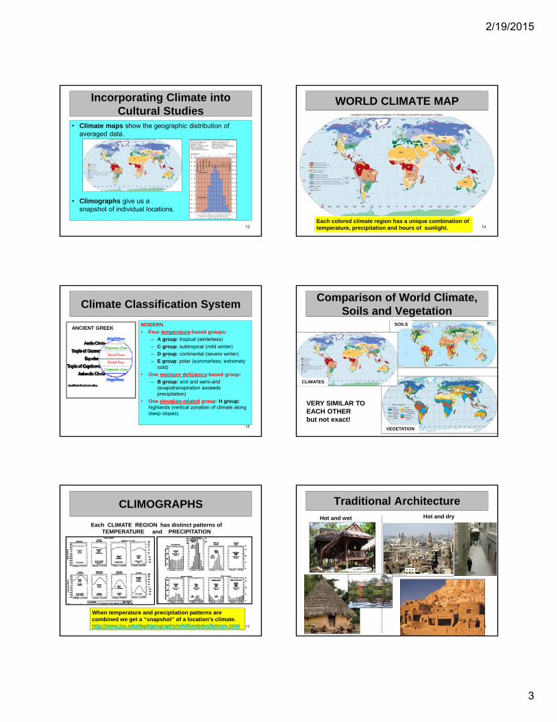
Incorporating Climate into Cultural Studies
• Climate maps show the geographic distribution of averaged data.
• Climographs give us a snapshot of individual locations.
13
WORLD CLIMATE MAP
14Each colored climate region has a unique combination of temperature, precipitation and hours of sunlight.
Climate Classification System
MODERN
• Four temperature-based groups:
– A group: tropical (winterless)
– C group: subtropical (mild winter)
– D group: continental (severe winter)
– E group: polar (summerless; extremely cold)
• One moisture deficiency-based group:
– B group: arid and semi-arid (evapotranspiration exceeds precipitation)
• One elevation-related group: H group: highlands (vertical zonation of climate along steep slopes)
15
ANCIENT GREEK
Comparison of World Climate, Soils and Vegetation
16
VERY SIMILAR TO EACH OTHER but not exact!
CLIMATES
SOILS
VEGETATION
CLIMOGRAPHS
17
Each CLIMATE REGION has distinct patterns of TEMPERATURE and PRECIPITATION
When temperature and precipitation patterns are combined we get a “snapshot” of a location’s climate.http://www.jsu.edu/dept/geography/mhill/webdes/bottom.html
Traditional Architecture
18
Hot and wet Hot and dry

2/19/2015
4
Traditional Architecture
19
Predominant cold wind direction
Cold and wet designs
?
Geologic Influences
TECTONIC (building)
1. Folding
2. Faulting
3. Volcanism
GRADATIONAL (reducing)
1. Mechanical and chemical weathering (in place)
2. Mass wasting (by gravity)
3. Agents of Erosion(erode → transport → deposit
take → move → place )
Running water
Moving ice
Wind
Wave action
Longshore currents20
NATURAL PROCESSES1. Mass movements (gravity)
2. Earthquakes (tension release)
3. Volcanism (heat, pressure)
4. Subsidence (sinking)
All the processes affect people.Attempts are made to explain them and then deal with them.
Folk Lore Explained
21
Intoxicating fumes escaping from fault lines put the Oracle into a trance who then seemed to speak with the voice of the gods.
Landforms and Land Use
22
Each topographic region has unique features. Each has advantages and disadvantages to human land use. They have influenced people’s decision-making and helped to create, with the addition of climate, cultural landscapes.
Landforms and Land Use
23
Why do people need to study (measure, monitor, map
and analyze) topographic regions?
Selective land use
Avoidance of harmful natural processes
Planning future activities
Insurance coverage
WHY?
Because of the possible effect on people.
Landforms and Land Use
24
When doing a landscape analysis, we look at the following physical factors:
1. Elevation (height above sea level)
2. Relief (vertical difference in elevation)
3. Slope angle (horizontal difference in elevation)
4. Valley shape (work of running water and gravity; V-shape or U-shape)
5. Climate conditions (climate and vegetation zones change with elevation)

2/19/2015
5
_________________________
25
5
1. Elevation (height above sea level)
2. Relief (vertical difference in elevation)
3. Slope angle (horizontal difference in elevation)
4. Valley shape (work of running water and gravity; V-shape or U-shape)
5. Climate conditions (climate and vegetation zones change with elevation; vertical zonation)
1
4
324
4
LANDFORMS
angle
Landforms and Land Use
26
When doing a landscape analysis, we look at the following human factors:
1. Unifier or barrier (people interacting with each other)
2. Assimilation or distinction (culture development)
3. Transportation and communication (ease/cost)
4. Population density (concentrations of people; development of cultural traits)
5. Economic utilization (perception and interaction with nature; farming, grazing, industry, mining, recreation, etc.; division of land)
6. Hazards (awareness; natural and man-made)
Valley in Swiss Alps
27
Plains of Kansas
28
Ganges River Delta
29
Rocky Shoreline
30

2/19/2015
6
Plateau of Ethiopia
31
BIOMES
Zones of LifeBiomes (ecoregions) are unique combina-tions of climate, water, flora, fauna and soils.
They are composed of many ecosystems.
People become part of these ecosystems, interacting with the parts.
They take; they change; they have made and continue to make an impact.
32
33
COLDDRY
HOTWET
HOTDRY
VERY COLD + DRY
MODERATE TEMP + PRECIP
HOT + DRY
HOT +
WET
HOT with WET & DRY SEASONS
BIOMESTropical Savanna
The tropical savanna of Africa is believed to be the world’s oldest human-used biome.
Year-round warmth, flat land, ample food supplies (from hunting and gathering) and available fresh water.
People followed the animals during the seasonal cycles.
34
Tropical-Wet Biomes
35
Layers of a tropical rainforest Forest floor of a tropical jungle
Deciduous Forest Biome
36

2/19/2015
7
Tundra Biome
37
Distribution of the Earth’s Water
38
Water is an integral part of all the earth’s biomes. Freshwater is most important.
ALL WATER JUST FRESHWATER JUST EASILY
USEABLE FRESHWATER
Water Resources on Land
39
Other than air people need water for survival before food.
A dependable source of fresh clean water makes a population grow and thrive.
Technology has allowed to store water behind dams, pump water out of the ground and transport it long distances.
40
Using Water
Human Imprint: Field Patterns
41
Desert Agriculture traditional and modern
What’s the premise for the circular shape?
Share your findings from Assignment 1
Unique physical areas:
1. High altitude plateau or mountain basin
2. Hot summer desert area
3. Middle latitude plains or steppes
4. River delta or area of coastal barrier islands
5. Steep-sloped (rugged) landform area
6. Sub-polar region
7. Tropical rainforest region
ASSESSMENT/spatial analysis:
• location on earth
• traditional/historic ethnic geog. of the area
• cultural identification including language and religion
• traditional housing, dress, food
• governing status
• aspects of acculturation and assimilation over time
• accessibility to the outside world and movement within the area
• economic base/livelihood
42

2/19/2015
8
NEXT
POPULATION
chapter 3
43