cruise report1 vessel: townsend · pdf filepacific islands fisheries science center ......
TRANSCRIPT
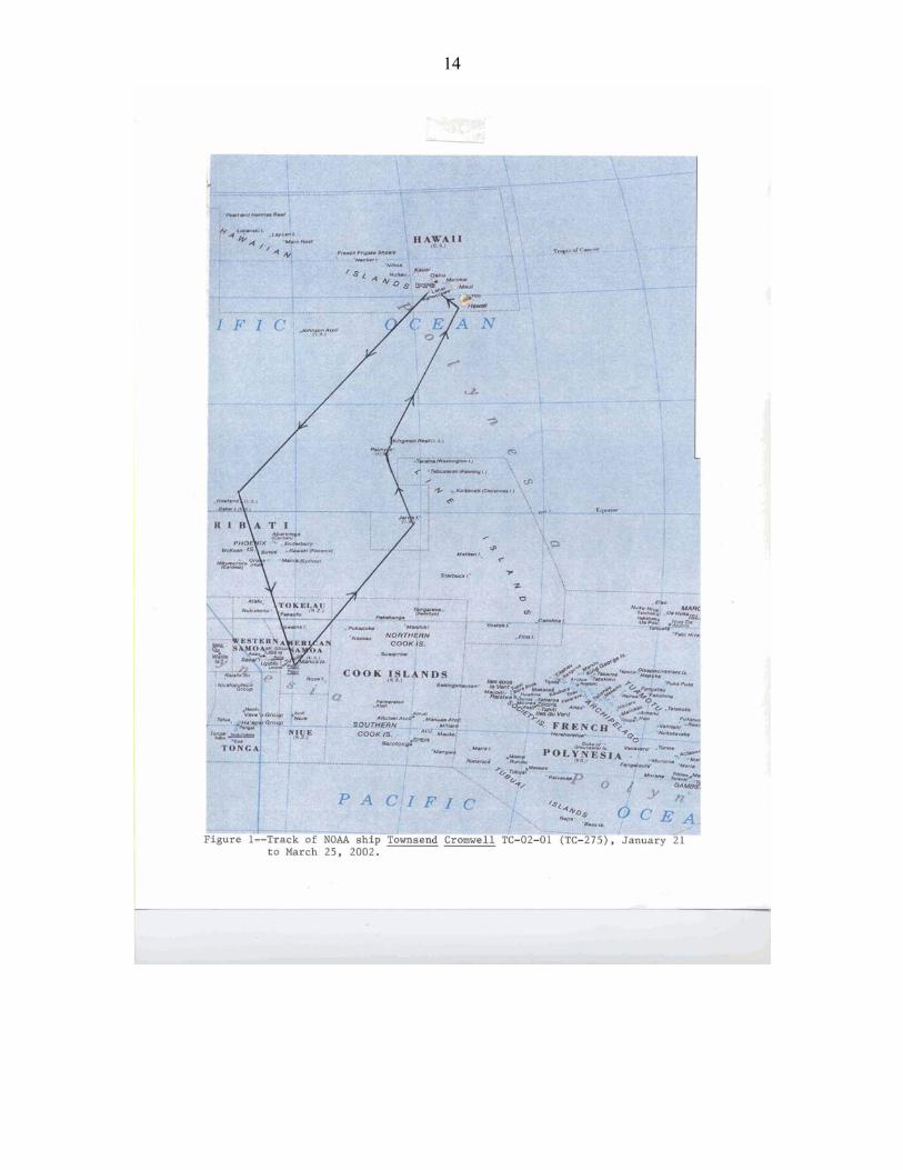
CRUISE REPORT1 VESSEL: TOWNSEND CROMWELL, Cruise 02-01 (TC-275) CRUISE PERIOD: 21 January − 25 March 2002 AREA OF OPERATION: U.S. Pacific Remote Island Areas (PRIAs), American Samoa TYPE OF OPERATION: Personnel from the Coral Reef Ecosystem Investigation (CRED),
Honolulu Laboratory (HL), National Marine Fisheries Service (NMFS), and NOAA conducted reef assessment/monitoring in waters surrounding the U.S. Pacific Remote Island Areas (PRIAs) and American Samoa.
ITINERARY: 21 January Embarked Brainard, Mundy, and Zgliczynski of NMFS, Holzwarth,
Kenyon, Chojnacki, and Hoeke of University of Hawaii (UH)−Joint Institute for Marine and Atmospheric Research (JIMAR), Maragos of USFWS, Godwin (Bishop Museum), and Vroom (UH-Botany). Departed Honolulu at 1015 en route to Howland (~ 1650 nmi).
21-28 January Conducted dive safety drills; tested Remote Underwater Digital
Acoustic Recorders (RUDARs); initiated moored Sontek acoustic Doppler current profilers (ADCPs) and Aanderaa current meters; prepped and painted Coral Reef Early Warning System (CREWS) buoys, subsurface moorings, and ARGOS SST buoys; modified towboards; analyzed habitat data tapes; and reviewed IKONOS imagery to determine potential mooring locations.
1 PIFSC Cruise Report CR-06-001 Issued 20 January 2006
Pacific Islands Fisheries Science Center 2570 Dole St. • Honolulu, Hawaii 96822-2396 (808) 983-5300 • Fax: (808) 983-2902
U.S. DEPARTMENT OF COMMERCE National Oceanic and Atmospheric Administration NATIONAL MARINE FISHERIES SERVICE/NOAA FISHERIES
2
28 January Arrived Howland (lat. 0˚48'N, long. 176˚38'W) at 1730 and conducted three Tethered Optical Assessment Device (TOAD) camera drift dives in conjunction with QTC acoustic seabed classification surveys. At 2100, conducted a 500-m, conductivity-temperature-depth (CTD) station E of Howland. Commenced ADCP transects around Howland.
29 January Departed Howland and arrived W side of Baker (lat. 0°12'N,
long. 176°29'W) at 0800. While towboard/mooring team (Brainard, Holzwarth, Kenyon, and Chojnacki) attempted to enter shallow reef flat on SE side of island, the jet boat was swamped by a wave in the surf zone washing coxswain Saunders, Holzwarth, Kenyon, and Chojnacki and numerous pieces of equipment overboard. The boat and all personnel remained safe but two regulators and some connector hoses for a pneumatic drill and a radio were lost overboard. Brainard and Holzwarth snorkeled into the shallow reef flat and conducted a habitat survey and evaluated potential SST buoy sites. Benthic (Maragos, Godwin, Vroom) and fish (Mundy, Zgliczynski) teams conducted two rapid ecological assessment (REA) stations on the previously inaccessible (because of rough sea conditions in 2000 and 2001) E and NE reef terraces and revisited a permanent station on W reef slope. Fish team conducted five shallow water CTDs to a depth of 30 m and deployed the RUDAR at lat. 0°11.822'N, long. 176°28.140'W. Benthic team conducted an additional rapid ecological assessment (REA) on the W side. Towboard team conducted towed-diver habitat surveys of E terrace and N reef slope to locate potential subsurface ADCP/CTD mooring sites. Hoeke and White conducted TOAD/QTC drift dives over E reef terrace and deep slope. Conducted three 500-m CTDs and multiple ADCP transects around Baker.
30 January Towboard team deployed subsurface ADCP/CTD mooring #3 in 19 m
of water over E terrace at lat. 0°11.403'N, long. 176°27.615'W. Fish and benthic teams conducted three REA stations. Benthic team established a new permanent station on the E terrace of Baker. Fish team recovered the RUDAR and conducted 18 shallow-water CTD stations around Baker. At night, the ship conducted four CTD stations to a depth of 500 m and ran repeated ADCP transects around Baker.
31 Jan Departed Baker enroute to Howland conducting ADCP transects.
Towboard team conducted three towed-diver habitat surveys around SE, E, N, and W sides of Howland. Towboard team (Kenyon, Chojnacki) conducted a drop dive over N reef terrace to collect samples for examining sexual coral reproductive status. Fish and benthic teams conducted two new REA dives on the previously inaccessible E and NE reef slopes and revisited one of the permanent stations on the W reef slope. Fish team deployed the RUDAR at lat. 0°48.370'N, long. 176°37.279'W and conducted 15 shallow-water CTD stations. Hoeke and White conducted TOAD camera and QTC acoustic habitat classification surveys along NE reef slope. The ship
3
conducted three CTDs to a depth of 500 m and repeated ADCP transects around Howland throughout the night.
1 February Towboard/mooring team (Brainard, Holzwarth, Chojnacki) surveyed
an area along S end of the steep reef slope on W side as a possible SST mooring site, conducted a towed-diver habitat survey of N reef terrace, and deployed ARGOS SST buoy #5 in 16 m of water at lat. 0°49.396'N, long. 176°37.458'W. Fish and benthic (w/ Kenyon) teams conducted REAs at permanent stations on W side. Benthic team established a third permanent site along W side. Fish team recovered the RUDAR. The ship departed Howland en route to Pago Pago, American Samoa.
6 February Arrived Pago Pago, American Samoa to end Leg I. Provided tours of
Townsend Cromwell to National Park Service employees. Met with Ray Tulafono, Director of the Department of Marine and Wildlife Resources, Tony Beeching, and Andy Cornish of DMWR.
7 February Provided tours of TOWNSEND CROMWELL to staff of DMWR,
Department of Commerce, American Samoa Community College marine science students, and Governor Sunia’s staff and cabinet. Participated in a reception in honor of the TOWNSEND CROMWELL’s visit to American Samoa hosted by the governor.
8 February Conducted cruise planning meetings with A. Cornish of DMWR.
Disembarked Mundy and Maragos. 9 February Embarked A. Cornish, E. Keenan, and R. Schroeder. Departed Pago
Pago. Conducted four, towed-diver habitat/fish surveys over Taema Bank and S shore of Tutuila. Conducted two fish and benthic rapid ecological assessment (REA) surveys. Conducted TOAD and QTC acoustic habitat classification surveys around N and E sides of Tutuila.
10 February Deployed surface velocity drifter buoy (#35645) at lat. 14º12.465'S,
long. 170º31.604'W on the NE side of Tutuila. Deployed Argos SST buoy #2 in 7.6 m of water off Aunuu Island at lat. 14º17.023'S, long. 170º33.737'W. Conducted three fish and benthic REAs along E and NE shores of Tutuila. Conducted four towed-diver habitat/fish surveys along SE, E, and NE reefs of Tutuila. Conducted QTC habitat classification surveys of SE banks of Tutuila. Departed Tutuila enroute to Ta’u Island. Deployed surface velocity drifter buoy (#35646) at lat. 14º15.174'S, long. 170º07.911'W midway between Tutuila and Manu’a Islands.
11 February Arrived Ta’u Island at 0730 to commence diving operations.
Conducted 6 towed-diver habitat/fish surveys along E, S, and W shores. Conducted three fish and benthic REAs. Conducted 19 shallow water CTD stations around W, S and E shores of Ta’u. Deployed
4
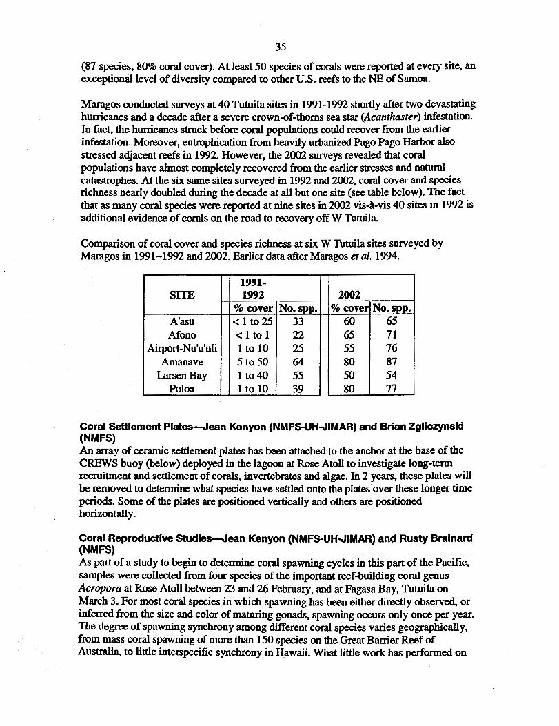
RUDAR along S shore of Ta’u. Conducted oceanographic surveys (CTD and ADCP) around Manu’a Islands throughout the night.
12 February Deployed Argos SST buoy #3 in 17 m of water on the reef slope on
the E side of Ta’u Island at14º14.140'S, 169º25.134'W. Conducted four towed diver habitat/fish surveys along N and NW sides of Ta’u. Conducted three fish and benthic REAs along N and W sides of Ta’u. Conducted 11 shallow-water CTDs around N shore of Ta’u. Recovered RUDAR with water in housing. Although data was secure, the water in the housing damage some of the integrated circuits. Conducted TOAD drift dive and QTC acoustic habitat classification surveys. Conducted oceanographic surveys (CTD and ADCP) around Manu’a Islands throughout the night.
13 February Transited to Olesega Island. Conducted six towed-diver habitat/fish
surveys along W, N, and NW reefs of Olesega and Ofu Islands. Conducted three fish and benthic REAs at W and NE sides of Olesega and NW side of Ofu. Conducted 20 shallow-water CTDs around N and E sides of Olesega and Ofu. Deployed RUDAR along E side of Olesega. Conducted TOAD camera operations and QTC acoustic habitat classification surveys around Ofu and Olesega. Conducted oceanographic surveys (CTD and ADCP) around Manu’a Islands throughout the night.
14 February Conducted six towed diver habitat/fish surveys along W, S, and E
shores of Ofu and Olesega. Conducted three fish and benthic REAs along S shore of Ofu. Recovered RUDAR. Conducted 19 shallow-water CTDs around S shore of Ofu and Olesega. Conducted TOAD/QTC operations during the evening. Conducted oceanographic surveys (CTD and ADCP) around Manu’a Islands throughout the night.
15 February Conducted two towed-diver habitat/fish surveys to 30-m depth along S
shore. Conducted fish and coral REA to 30-m depth along south side of Olesega. Conducted invertebrate survey of shallow reef flats along SE side of Ofu. Departed Manu’a Islands enroute to Pago Pago. Arrived Pago Pago at 1930. Met with Representative Wallace Thompson of Swain’s Island. Disembarked Keenan, Vroom, and Chojnacki.
16 February Embarked E. DeMartini, L. Preskitt, and J. Maragos. Met with W.
Thompson and Nancy Daschbach, manager of NOAA NMS Fagatele Bay. Departed Pago Pago at 0900 enroute to Swains Island.
17 February Arrived Swain’s Island at 1045. Conducted four towed-diver
habitat/fish surveys of NW, NE, and E reef slopes at two depths (8 m and 15 m). Conducted two fish and benthic rapid ecological assessments (REAs) along SW reef slope. Disembarked terrestrial
5
biologists Seamon and Fa’aumu ashore at SE side where they hiked to Taulaga, retrieved boat from island caretaker (Palapi), and shifted gear to Taulaga campsite by nightfall. Deployed RUDAR along reef slope on S side of island. Conducted gear tests with TOAD. Conducted ADCP and CTD oceanographic surveys around Swains Island.
18 February Conducted four towed-diver habitat/fish surveys along SE and SW
reef slopes. Conducted two fish and benthic REAs along SW reef slope. Established permanent benthic transect along SW reef slope and conducted fish and benthic REAs. Conducted fish and benthic roving diver survey. Recovered RUDAR. Conducted search for potential sites for ADCP mooring and SST buoy along SW reef slope. Terrestrial team set arthropod transect (ATR#1) from Taulaga to Namu; established, flagged, and surveyed Vegetation Transect (VTR) from SE of old Eli Jennings residence to Taulaga clearing; and checked and collected specimens from ATR #1.Conducted ADCP and CTD oceanographic surveys throughout the night.
19 February Conducted 14 shallow-water CTDs to a depth of 30 m around the
island at 0.35-nm spacing. Conducted three fish and benthic REAs on windward N and NE reef slopes. Surveyed for sites to deploy moorings and buoys. Deployed subsurface ADCP/CTD mooring #001 in a small hole in the SW reef slope at lat. 11º03.509'S, long. 171º05.455'W in 15.5 m of water. Two arrays of eight settlement plates were attached to the concrete mooring anchor. Deployed RUDAR along SW reef slope in 21 m of water. Terrestrial team created, marked, and surveyed vegetation transect #2—N from Taulaga to N coast, then SE to Namu (lagoon); conducted manual survey and collection of littoral (macro) insect fauna S from Taulaga shore access point; and checked and collected specimens from arthropod transect #1. Conducted ADCP and CTD oceanographic surveys throughout the night.
20 February Surveyed reef flat for potential SST buoy deployment sites. Conducted
invertebrate and algae surveys of reef flats on SW and SE sides of island. Conducted REA to a depth of 30 m to survey deeper fish and corals. Surveyed the brackish lake in the center of Swains Island for fish, algae, invertebrate, and corals. Conducted CTD survey in lake. Conducted two towed-diver habitat/fish surveys around NE reef slope. Collected coral core sample along SW reef slope. Established 2nd permanent coral transect station along SW reef slope. Recovered RUDAR from reef slope. Terrestrial team created arthropod transects #2 (littoral) and #3 (grassy clearing and agroforest edge in Taulaga); created, marked, and surveyed vegetation transect #3 along coast S from Taulaga; checked and collected samples from all anthropod transects; pulled all traps. Embarked terrestrial biologists Seamon and Fa’aumu. Departed Swains Island enroute to Pago Pago. Deployed
6
surface velocity drifter buoy #35650 at position lat. 11º07.261'S, long. 171º04.809'W.
21 February Arrived Pago Pago at 1730 to embark Beth Flint and Jeff Burgett of
USFWS and obtain some 55 gallon drums of gasoline for small boats. Departed Pago Pago en route to Rose Atoll.
22 February Arrived Rose Atoll. Disembarked Flint, Burgett, Seamon, and
Fa’aumu to Rose Island for terrestrial surveys. Transported Aanderaa current meter mooring thru reef pass into lagoon and anchored it in temporary location to await slack water. Located site for Coral Reef Early Warning System (CREWS) buoy near twin pinnacles in lagoon. Transported and moored CREWS mooring anchor. Conducted two fish and benthic REAs on NE and E reef slopes. Conducted ADCP and CTD oceanographic surveys around Rose Atoll throughout the night.
Terrestrial teams: DMWR created area feature of vegetation perimeter
(offset) around entirety of Rose Island; set single light trap in clearing (dominated by Boerhavia repens) in Tournefortia argentea forest. Light trap checked at 2030, 0100, and 0400—trap pulled after 0400 check. USFWS conducted maintenance of the 30-meter sampling grid, censused of active nests of all breeding birds using the two islands at the atoll, continued the study monitoring the response and recovery of the plant community following the eradication of the Polynesian rat (Rattus exulans), and continuation of a study evaluating the effects of iron enrichment from the 1993 wreck of the F/V JIN SHIANG FA on the coralline algae reef at Rose Atoll.
23 February Deployed CREWS buoy (SOSI #262-005) in 9.1 m of water in lagoon
at position lat. 14º33.084'S, long. 168º09.611'W. Deployed Aanderaa RCM9 current meter (SN417) in central portion of the high velocity entrance channel to Rose Lagoon at position lat. 14º32.111'S, long. 168º09.289'W in 6.1 m of water. Deployed two arrays of eight settlement plates around the anchor for the CREWS buoy. Conducted three fish and benthic REAs along SE and SW reef slopes. Conducted two towed diver habitat/fish surveys along SE and SW reef slopes at 10−15 m depths. Modified TOAD and conducted successful performance tests. Conducted ADCP and CTD oceanographic surveys around Rose Atoll throughout the night.
Terrestrial teams: DMWR established three arthropod transects (ATR),
each with five stations at 10 m intervals, each station with one yellow trap and one wet pitfall; ATR 1 in recently colonizing T. argentea area, coralline gravel substrate; ATR 2 in field dominated by dense ground cover of B. repens; ATR 3 begins in a clump of Pisonia grandis, ends under T. argentea forest, substrate moist soil; georeferenced and took dbh for all mature P. grandis; checked and collected captures from ATR 1-3; set a single light trap in a recently
7
colonizing T. argentea area on NW corner of Rose Island; trap checked at 0200 and 0600, when the trap was pulled. USFWS conducted bird and vegetation surveys and continued monitoring the recovery of the reef flats following a 1993 shipwreck.
24 February Conducted six towed-diver habitat/fish surveys of shallow water reefs
of fore reef slope around entire atoll. Conducted two fish and benthic REAs at reef slope sites and one permanent site at a lagoonal pinnacle. Removed derelict fishing seine net from reef slope on SE side of atoll. Modified TOAD and conducted successful performance tests. Conduc-ted ADCP and CTD oceanographic surveys around Rose Atoll throughout the night. Deployed surface velocity drifter buoy #35651 at position 14º36.335'S, 168º05.533'W.
Terrestrial teams DMWR rechecked and georeferenced ATRs 1−3
because of rain; created ATR 4 in very exposed, coralline gravel area (no vegetation) on E side; created ATR 5 under canopy of mature T. argentea forest, through patch of Cordia subcordata and Cocos nucifera; checked and collected samples from all ATR; set single light trap in P. grandis grove and checked at 2200 and pulled at 0400. continued surveys of birds, vegetation, rats and reef flats. USFWS conducted bird and vegetation surveys and continued monitoring the recovery of the reef flats following a 1993 shipwreck.
25 February Conducted two, deep (~ 30 m) towed-diver habitat/fish surveys around
NW and N reef slopes. Conducted four, towed-diver habitat/fish surveys across the central lagoon and around the perimeter of the lagoon. Conducted three benthic REAs at lagoonal pinnacles. Conducted three fish REAs at a reef slope site and two lagoonal pinnacles. Conducted 28 shallow-water CTDs around atoll perimeter, in the reef pass, and at several sites within the lagoon. Conducted ADCP surveys around Rose Atoll throughout the night.
Terrestrial teams: DMWR determined dbh and georeferenced the
locations of all C. subcordata, C. nucifera, and Hibiscus tiliaceus; determined locations for all recruits of these species; created 10-m radius (314 m2) circular plot in mature T. argentea forest, in which locations and dbh (locations only of recruits too small to have a reliably measured dbh) of all individual woody plants were recorded; checked all ATR, collected samples, and pulled ATR 1-3; continued surveys of birds, vegetation, rats and reef flats. USFWS conducted bird and vegetation surveys and continued monitoring the recovery of the reef flats following a 1993 shipwreck.
26 February Conducted four, deep (20−25 m) towed-diver habitat/fish surveys
around SE, SW, NE, and NW reef slopes. Conducted deep (30 m) fish and benthic REA of pinnacles on N reef slope. Conducted benthic surveys of reef flat. Conducted two fish REAs. Collected specimens of

8
two species of Acropora corals on the SW reef slope to examine reproductive status. Embarked terrestrial biologists Seamon, Fa’aumu, Flint, and Burgett. Departed Rose Atoll en route to Tutuila.
Terrestrial teams: DMWR created two additional 314 m2 circular plots,
one at ATR 1 station 5 and one at ATR 2 station 5; removed FAD debris from reef; hiked to Sand Island where another 314 m2 circular plot was created; determined dbh and locations for all other woody trees (T. argentea) present; checked and collected samples from ATR 4 and 5, then pulled remaining ATR. USFWS conducted bird and vegetation surveys and continued monitoring the recovery of the reef flats following a 1993 shipwreck.
27 February Arrived S shore of Tutuila. Scientists Fa’aumu and Seamon assisted in
securing permission to deploy SST buoy by contacting pulenu'u of Amanave village. Disembarked terrestrial biologists Seamon, Fa’aumu, Flint, and Burgett via small boat at Leone. Deployed SST buoy #4 in 27 m of water in Amanave Bay on a sand bottom at position 14º19.694'S, 170º50.006'W. Conducted four, towed-diver habitat/fish surveys around W and NW reef slopes. Conducted three fish and benthic REAs in Amanave, Poloa and Aoloau Bays. Modified and conducted successful tow tests with the TOAD. Conducted QTC and TOAD habitat mapping operations around northwest bank. The TOAD fouled hard onto reef severely damaging frame and bending steel I-beam on the ship. Electronic components and cameras continued to work throughout grounding. Deployed surface velocity drifter buoy #35649 at position 14º16.538'S, 170º54.923'W. Deployed surface velocity drifter buoy #35647 at position 14º23.846'S, 170º50.761'W.
28 February Arrived Pago Pago, American Samoa for fueling and resupply. Met
with Ray Tulafono and Tony Beeching of the Department of Marine and Wildlife Resources (DMWR). Met with Nancy Daschbach of Fagatele Bay National Marine Sanctuary to discuss observing and modeling oceanographic processes around Tutuila. DMWR hosted barbeque for CROMWELL scientists and crew.
1 March In port Pago Pago. Disembarked DeMartini. 2 March Embarked Ramzi Mirshak and Joe Chojnacki. Departed Pago Pago at
0930. Deployed Aanderaa current meter off Step’s Point, Tutuila in 21 m of water at position 14º22.499'S, 170º45.498'W. Conducted three, towed-diver habitat/fish surveys of Fagatele Bay, Larsen’s Bay and E along the S shore of Tutuila. Conducted three fish and benthic REAs at Neeosegi Cove near the road works projects, off the airport, and in Larsen’s Bay. Conducted QTC acoustic habitat mapping throughout the night. Made modifications to the TOAD to allow use as a drop camera.

9
3 March Installed swivel pin into reef in Fagasa Bay for attachment of SST
buoy #1 in 2 m of water at position 14º17.057'S, 170º43.320'W (buoy will be attached by Dr. Andy Cornish of DMWR). Conducted three, towed-diver habitat/fish surveys along central N shore of Tutuila. First tow was aborted because of hard grounding of towboard on rocky point. Conducted three fish and benthic REAs at Massacre Bay, Agapie Cove, and Afono Bay. Conducted 22 shallow-water CTDs to a depth of 30 m along central N shore. Conducted three drop camera deployments and QTC acoustic habitat mapping operations during the night.
4 March Deployed surface velocity drifter buoy #35648 at position 14º25.150'S,
170º36.112'W. Disembarked Andy Cornish, Linda Preskitt, and Ron Hoeke and embarked Peter Vroom and Dominique Horvath via small boat into Pago Pago. At 0900 departed Tutuila enroute to Jarvis Island of the U.S. Line Islands.
6 March A. Cornish installed SST buoy #1 at site established on 3 March.
DMWR recovered grounded surface velocity drifter #35645 from the E end of Tutuila for repairs and redeployment.
9 March Arrived Jarvis Island at 1215. Disembarked Horvath and White to
conduct terrestrial surveys of vegetation and birds. Deployed subsurface ADCP/CTD mooring (SOSI #002) in 15 m of water on the southwest reef terrace at position 0º22.750'S, 160º00.932'W. Conducted two fish and benthic REAs along reef slopes on west and south sides. Established permanent transect along south side. Collected specimens of one species of Acropora coral to determine sexual reproductive status. Conducted six shallow-water CTDs to a depth of 30 m. Conducted four CTDs to 500 m and conducted ADCP transects around Jarvis throughout the night.
10 March Conducted four, towed-diver habitat/fish surveys around entire island
at depths 8−16 m. Conducted three fish and benthic rapid ecological assessment surveys (one fish survey aborted as a result of aggressive and persistent sharks). Established permanent transect off small boat channel on west side. Deployed SST buoy #6 in 13.5 m of water on sand patch on east terrace at position 0º22.524'S, 159º58.422'W. Conducted nine shallow-water CTDs to a depth of 30 m around west half of island. Embarked Horvath and White. Departed Jarvis Island at 1845 enroute to Palmyra Atoll (395 nm).
9 March Arrived Jarvis Island at 1215. Disembarked Horvath and White to
conduct terrestrial surveys of vegetation and birds. Deployed subsurface ADCP/CTD mooring (SOSI #002) in 15 m of water on the southwest reef terrace at position 0º22.750'S, 160º00.932'W. Conducted two fish and benthic REAs along reef slopes on W and S
10
sides. Established permanent transect along S side. Collected specimens of one species of Acropora coral to determine sexual reproductive status. Conducted six shallow-water CTDs to a depth of 30 m. Conducted four CTDs to 500 m and conducted ADCP transects around Jarvis throughout the night.
10 March Conducted four, towed-diver habitat/fish surveys around entire island
at depths 8−16 m. Conducted three fish and benthic REAs (one fish survey aborted because of aggressive and persistent sharks). Established permanent transect off small boat channel on W side. Deployed SST buoy #6 in 13.5 m of water on sand patch on E terrace at position 0º22.524'S, 159º58.422'W. Conducted nine shallow water CTDs to a depth of 30 m around W half of island. Embarked Horvath and White. Departed Jarvis Island at 1845 enroute to Palmyra Atoll (395 nm).
12 March Arrived at Palmyra Atoll at 1200. Conducted three, towed-diver
habitat/fish surveys of E terrace (aborted early as a result of hazardous sea conditions) and two along the S reef slope. Conducted two fish and benthic REAs at SW reef terrace and inside E coral pools. Conducted eight shallow water CTDs to a depth of 30 m. Conducted four CTDs to 500 m at sites N, E, S, and W of atoll. During the fourth CTD, the winch controller failed, causing the CTD to two-block and then free fall. A quick response by Survey Tech Phil White, who rushed to secure the hydraulic pump, stopped the CTD at a depth of about 87 m. The ship’s crew used the capstan from the Oceo winch to haul the CTD aboard. Conducted ADCP current surveys throughout the night.
13 March Conducted six, towed-diver habitat/fish surveys along the S, SW, N,
and NW reef slopes and the W reef terrace (2). Conducted three fish and benthic REAs of NW reef slope, SW reef terrace, and near the entrance channel. Conducted two shallow water CTDs to a depth of 30 m along W reef terrace. Conducted a WOG drop camera drift dive. Conducted four CTDs to a depth of 500 m on S, E, N, and W sides of Palmyra Atoll.
14 March Surveyed multiple potential sites to deploy CREWS buoy. Deployed
enhanced CREWS buoy (SOSI #261-003) in 8.2 m of water on a sand bottom in a small lagoon at position 5º53.081'N, 162º06.170'W at 1815 HST (0415 UTC March 15). Installed two arrays of settlement plates over CREWS mooring anchor. Conducted three fish and benthic REAs. Conducted five shallow water CTDs to a depth of 30 m. Townsend Cromwell entered Palmyra Atoll and moored port side.
15 March In port Palmyra Atoll. Conducted algae and invertebrate surveys of
lagoon and reef flats on N side of Cooper Island. Surveyed shallow coral pools on E end of atoll. Townsend Cromwell hosted shoreside
11
barbeque for all hands and for The Nature Conservancy and USFWS crews ashore.
16 March Deployed Seabird SBE39 temperature and pressure recorder #0379 in
1.5 m of water in coral pools at E end of Palmyra lagoon at position 5º52.220'N, 162º02.705'W (the beginning of permanent coral transect PAL-15P established by Maragos in 2001). Conducted four, towed-diver habitat/fish surveys along NE reef slope and W terrace. Conducted three fish and benthic REAs over SE reef slope and W reef terrace. Conducted eight shallow-water CTDs to a depth of 30 m. Embarked Horvath from Palmyra Atoll shore party. Conducted one WOG drop camera drift dive to a depth of 70 m. Conducted two CTDs to a depth of 500 m on W, N, E, and S sides of Palmyra Atoll and ADCP transects between each station.
17 March Departed Palmyra Atoll enroute to Kingman Atoll. Arrived Kingman
Atoll at 0730. Deployed standard CREWS buoy (SOSI #262-006) in 8 m of water in the coral pools at the E end of Kingman Lagoon at position 6º23.544'N, 162º20.531’W. Conducted three fish and benthic REAs at one permanent site at the E end of the lagoon established in 2000 and two new sites in the lagoon. Conducted 15 shallow-water CTDs to a depth of 30 m in the lagoon. Conducted four CTDs to a depth of 500 m and ADCP transects around the perimeter of the atoll.
18 March Conducted six, towed-diver habitat/fish surveys: two in the lagoon
from S to SE to E to NE; four along the outer reef slope of the S side of the atoll from the E end to near the SW corner. Conducted three fish and benthic REAs along the NE inner barrier (backreef), a lagoonal patch reef, and at the CREWS buoy site. A permanent transect was established at the CREWS buoy site. Horvath and White conducted terrestrial surveys of Sand Island. Conducted four CTDs to a depth of 500 m and ADCP transects around the perimeter of the atoll.
19 March Conducted five towed-diver habitat/fish surveys: three along NE and
N outer reef slopes and two along the S inner reef slope and flat. Conducted three fish and benthic REAs along S barrier reef and two patch reefs. Departed Kingman Atoll at 1820 en route to Kawaihae, Hawaii.
24 March Arrived off Kawaihae, Hawaii. Disembarked Brainard, Zgliczynski,
Holzwarth, and Kenyon and towboard gear to conduct NMFS-NOS towboard/remote-sensing validation study. Departed Kawaihae en route to Honolulu.
25 March Arrived in Honolulu, Hawaii at 0730 to end TC-02-01. Disembarked
Schroeder, Chojnacki, Maragos, Vroom, Godwin, Horvath, and Mirshak.
12
CRUISE STATISTICS: Towed-diver habitat surveys 102 tows, ~ 310 km Towed-diver fish surveys 102 tows, ~ 310 km QTC acoustic habitat mapping ~ 1025 km Tethered Optical Assessment Device (TOAD/WOG) 26 dives, ~ 1300 digital photos, ~ 11 hours of video Fish REA surveys 90 stations Benthic REA surveys 90 stations Dives ~ 950 SCUBA, ~ 500 snorkel Permanent Transects Established 9: Howland Island, Baker Island, Jarvis Island, Palmyra Atoll, Kingman
Atoll, Rose Atoll, Swains Island (3) Coral cores (for growth rates) 3: Howland Island, Swains Island, Kingman Atoll Acroporid Coral Samples (to determine reproductive status): Howland Island, Tutuila Island, Rose Atoll, Swains Island, Jarvis Island, Palmyra Atoll, Kingman Atoll CREWS buoy deployments 3: Rose Atoll, Palmyra Atoll, Kingman Atoll Settlement plate deployments 6: Baker Island, Swains Island, Rose Atoll, Jarvis Island, Palmyra Atoll, Kingman Atoll SST buoy deployments 6: Howland Island, Tutuila Island (2), Aunuu Island, Ta’u Island, Jarvis Island Subsurface ADCP/CTD deployments 3: Baker Island, Swains Island, Jarvis Island Aanderaa RCM9 current meter deployments 3: Rose Atoll pass; Step’s Point (Tutuila Island); Kingman Atoll, La Paloma Channel Seabird SBE39 temperature and pressure recorder deployments 1: Palmyra Lagoon coral pools Surface Velocity Drifters 8: Tutuila Island (4), Ta’u Island, between Tutuila and Manu’a Group, Rose Atoll, Swains Island RUDAR acoustic recordings 6 stations (10 GB) Shallow water (30 m) CTDs 254 stations Deep water (500 m) CTDs 69 stations ADCP current profiles ~ 12,500 km Thermosalinograph transects ~ 11,500 km Terrestrial Surveys Swains Island, Rose Atoll, Jarvis Island, Palmyra Atoll, Kingman Atoll MISSIONS AND RESULTS: See Appendices A−I

13
SCIENTIFIC PERSONNEL: Russell Brainard, PhD, Chief Scientist—National Marine Fisheries Service/ NOAA Corps Stephani Holzwarth, Towboards—Joint Institute for Marine and Atmospheric Research JIMAR Jean Kenyon, Towboard and Coral Teams—JIMAR Brian Zgliczynski, Towboard and Fish Team—NMFS/NOAA Bruce Mundy, Fish Team—NMFS/NOAA Joe Chojnacki, Towboard Team—JIMAR Ronald Hoeke, Oceanography Team—JIMAR Jim Maragos, Coral Team—U.S. Fish and Wildlife Service, USFWS Scott Godwin, Benthic Team—Bishop Museum Peter Vroom, Benthic Team—UH Botany Ed DeMartini, Fish Team—NMFS/NOAA Robert Schroeder, Fish Team—JIMAR Elizabeth Keenan, Towboard Team—JIMAR Linda Preskitt, Benthic Team—UH Botany Andy Cornish, Coral Team—American Samoa Joshua Seamon, Terrestrial Team—American Samoa Ruth Utzurrum, Terrestrial Team—American Samoa Beth Flint, Terrestrial Team—USFWS Ramzi Mirshak, Oceanographer Team—JIMAR Dominique Horvath, Terrestrial Team—USFWS Siaifoi Fa’aumu, Terrestrial Team—American Samoa (/s/Russell Brainard) Submitted by: ____________________________ Russell Brainard Chief Scientist (/s/Samuel G. Pooley) Approved by: _____________________________ Samuel G. Pooley Science Director Pacific Islands Fisheries Science Center Attachments
14