cruise report rusalca 2015...cruise report: kathleen crane, arctic research program, cod, cpo, oar,...
TRANSCRIPT

Cruise Report: Kathleen Crane, Arctic Research
Program, COD, CPO, OAR, NOAA
RUSALCA 2015 NORTH: August 16-September 30, 2015 (East Siberian Sea-Makahrov Basin) SOUTH: October 9-19, 2015 (Bering Strait- Chukchi Sea)
RUSALCA NORTH
Introduction (Vladimir Ivanov, Cruise Coordinator)
The 2015 research cruise in the Arctic Ocean aboard RV Akademik Tryoshnikov was the tenth annual NABOS (Nansen and Amundsen Basins Observational System) expedition conducted by the International Arctic Research Center (IARC) and Institute of Marine Science (IMS) at the University of Alaska Fairbanks and Applied Physics Laboratory (APL) at the University of Washington, USA, in partnership with the Arctic and Antarctic Research Institute (AARI), St.-Petersburg, Russia. The main goal of the NABOS project is to provide a quantitative assessment of circulation and water mass transformation along the principal pathways that transport water from the Nordic Seas to the Arctic Basin. The two most recent NABOS (most recently NABOS-RUSALCA) cruises (2013 and 2015) were distinctive, as they took place amidst summer ice cover over the major part of the Arctic Ocean that was reduced/weakened substantially. Diminished sea ice causes changes in both the underlying ocean and overlying atmosphere. Documenting these changes was among the major objectives for the NABOS-RUSALCA 2015 cruise. The scope of these objectives and the opportunities for extended scientific research in the Arctic provided during NABOS expeditions prompted colleagues from US, European, and Asian scientific institutions to contribute to the program by sending along their personnel and equipment, thus making this cruise truly multidisciplinary and international and also falling under the new auspices of the Pacific Arctic Group’s Climate-Ecosystem Observatory (PAG CEO). Information collected during this cruise is unique and critical to understanding Arctic climate change. This report details the 2015 NABOS-RUSALCA-PAG cruise route, schedule, and meteorological and ice conditions, and briefly describes the observations conducted. During the expedition the following stations were undertaken: - 94 CTD stations with extensive chemical observations were carried out, - 8 deep-water moorings recovered with all major instruments providing full two-year long records, - 13 deep-water moorings deployed, - 3 ITPs, 2 O-buoys, 1 IMB and 1 AOFB deployed, - The initiation of the RUSALCA north biological component.
There was excellent collaborative work between the Alfred Wegener Institute (AWI), IARC and the Arctic and Antarctic Research Institution. Funding for the expedition came from the National Science Foundation, NOAA (Arctic Research Program), Roshydromet and AWI. For example, six deployed moorings off Severnaya Zemlya were AWI's and the seventh mooring deployed there
was IARC/AWI. Thanks to the new collaborative ties with NOAA, the program now has two cross-slope mooring sections deployed in the easternEurasian Basin.
There are several findings which are of great importance (like estimates of along-slope water transports, extensive ventilation of the ocean interior in summer due to, probably, reduced ice cover, and possibly upwelling of Atlantic Water in the East Siberian Sea –Makharov Basin. Unknown impacts to the program
Not everything went as the planners expected. For the extensive plans the funding was extremely tight, mostly due to an extra six days taken up by transits both to Archangelsk (a new requirement from the Russian Federation) and to the far East to merge with the Pacific Arctic RUSALCA region. The team had to pay for these extra requirements impacting the cruise plans. For example, the NABOS-RUSALCA North programw had to reduce the total number of CTD stations taken the between the standard NABOS cross-slope sections. This resulted in a less cohesive overall picture of the changes in Atlantic water. The NOAA Arctic Research Program funded part of the project, and carried out two cross-slope sections in the East Siberian Sea spending seven days for that work (fig 1) Because of ice the originally planned sections at ~165E and 170E were shifted eastward by ~5-7deg,which actually fit RUSALCA- North’s high priority transects in a better way. Unfortunately, because of ship time limitations, The NABOS-RUSALCA cruise had to cut a shallow-water part of its eastern-most cross-section. Biological stations, which were a central part of the RUSALCA joint program, are shown on fig 6.

Fig 1. Akademik Tryoshnifov transects, 2015
Table 1. NABOS-RUSALCA North CTD and Zooplankton Station Locations:
AT039 9,09 15:51 75 0,194 159 58,894 47 75,00323 159,9816
AT040 9,09 19:46 75 32,13 160 45,035 50 75,5355 160,7506
AT041 10,09 0:29 75 59,803 161 25,748 51 75,99672 161,4291
AT042 10,09 5:10 76 27,913 162 10,358 81 76,46522 162,1726
AT043 10,09 8:51 76 56,963 162 59,383 102 76,94938 162,9897
AT044 10,09 12:50 77 27,54 163 59,738 127 77,459 163,9956
AT045 10,09 16:16 77 49,993 164 39,068 222 77,83322 164,6511
AT046 10,09 20:34 78 10,561 165 22,331 294 78,17602 165,3722
AT047 10,09 23:18 78 19,997 165 41,654 377 78,33328 165,6942
AT048 11,09 2:12 78 33,034 165 56,645 539 78,55057 165,9441
AT049 11,09 6:03 78 38,355 166 13,45 866 78,63925 166,2242
AT050 11,09 8:15 78 41,245 166 24,488 1043 78,68742 166,4081
AT051 11,09 11:55 78 52,882 166 51,133 1584 78,88137 166,8522
AT052 11,09 17:38 79 4,175 167 26,8 2006 79,06958 167,4467
AT053 11,09 21:37 79 17,903 168 2,04 2367 79,29838 168,034
AT054 12,09 0:53 79 31,058 168 39,64 2585 79,51763 168,6607
AT055 13,09 18:37 79 59,929 177 59,762 1688 79,99882 177,996
AT056 14,09 1:07 79 40,081 177 7,858 1770 79,66802 177,131
The RUSALCA transects carried out on the 2015 NABOS-RUSALCA joint expedition

AT057 14,09 4:59 79 22,151 176 23,172 2074 79,36918 176,3862
AT058 14,09 8:39 79 9,19 175 51,542 2167 79,15317 175,859
AT059 14,09 14:48 78 55,976 175 1,948 2271 78,93293 175,0325
AT060 14,09 18:36 78 41,957 174 46,29 2219 78,69928 174,7715
AT061 14,09 22:10 78 26,201 173 59,356 1930 78,43668 173,9893
AT062 15,09 3:47 78 12,204 173 39,938 1630 78,2034 173,6656
AT063 15,09 7:17 77 59,299 173 13,586 1122 77,98832 173,2264
AT064 15,09 10:44 77 45,254 172 55,65 1069 77,75423 172,9275
AT065 15,09 15:47 77 32,436 172 35,216 954 77,5406 172,5869
AT066 15,09 19:08 77 21,366 172 11,704 739 77,3561 172,1951
AT067 15,09 22:10 77 9,586 171 47,257 446 77,15977 171,7876
AT068 16,09 3:18 77 5,424 171 40,298 389 77,0904 171,6716
AT069 16,09 6:36 76 47,287 171 9,484 295 76,78812 171,1581
AT070 16,09 11:43 76 14,092 170 16,77 227 76,23487 170,2795
AT071 16,09 16:47 75 48,968 169 27,287 149 75,81613 169,4548
On September 9, the ship began the transect along 160-165°E, from the shelf of the East Siberian Sea. This transect was completed the morning of September 12, and afterward a cluster of four ice buoys was deployed on ice ~50 miles to the northeast of the northern transect point. From the evening of September 13 until that of September 16, the transect at 175°E was carried out, from the deepest point over Chukchi Plateau toward the shelf of the East Siberian Sea.
Fig. 2. CTD transects across the Siberian Shelf-Basins
Fig 3.

Vertical cross-section of potential temperature (upper panel) and salinity (lower panel) at transect 4 across the East Siberian Shelf Break.
Fig. 4.
Vertical cross-section of potential temperature (upper panel) and salinity (lower panel) at transect 5
Hydrochemical sampling and measurements
Background and purpose
The main objectives of the Eurasian and Makarov Basins (EMB) observational network include improved understanding of ongoing changes in the (1) along-slope transport of Atlantic water by boundary currents; (2) interaction and mixing between Atlantic water branches and shelf waters, the interior of the deep basins, and the upper ocean; and (3) upper ocean circulation of the EMB. The primary role of the hydrochemistry program concerns the second research target—specifically, the formation of different types of halocline water in the eastern Arctic and their subsequent
modification through mixing. Mixing between Atlantic and Siberian shelf waters is of great concern for the formation of halocline waters that separate overlying sea ice cover from the heat stored in the core of the Atlantic layer (Steele and Boyd, 1998). Different mechanisms have been proposed for the formation of halocline waters, ranging from densification of shelf waters via brine release during sea ice formation (Aagaard et al., 1981; Steele et al., 1995) to the freshening and cooling of Atlantic waters through melting sea ice (Rudels et al., 1996; Steele and Boyd, 1998). These mechanisms produce separate branches of halocline water with different physical and chemical characteristics. As such, geochemical tracers can be used as tools for distinguishing between formation processes of halocline waters and their potential origins. However, mixing
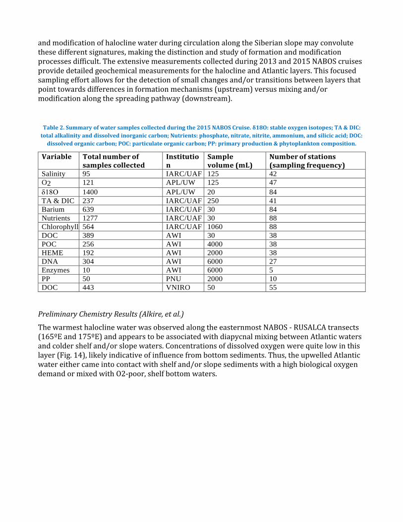
and modification of halocline water during circulation along the Siberian slope may convolute these different signatures, making the distinction and study of formation and modification processes difficult. The extensive measurements collected during 2013 and 2015 NABOS cruises provide detailed geochemical measurements for the halocline and Atlantic layers. This focused sampling effort allows for the detection of small changes and/or transitions between layers that point towards differences in formation mechanisms (upstream) versus mixing and/or modification along the spreading pathway (downstream).
Table 2. Summary of water samples collected during the 2015 NABOS Cruise. δ18O: stable oxygen isotopes; TA & DIC:
total alkalinity and dissolved inorganic carbon; Nutrients: phosphate, nitrate, nitrite, ammonium, and silicic acid; DOC:
dissolved organic carbon; POC: particulate organic carbon; PP: primary production & phytoplankton composition.
Variable Total number of samples collected
Institution
Sample volume (mL)
Number of stations (sampling frequency)
Salinity 95 IARC/UAF 125 42
O2 121 APL/UW 125 47
δ18O 1400 APL/UW 20 84
TA & DIC 237 IARC/UAF 250 41
Barium 639 IARC/UAF 30 84
Nutrients 1277 IARC/UAF 30 88
Chlorophyll 564 IARC/UAF 1060 88
DOC 389 AWI 30 38
POC 256 AWI 4000 38
HEME 192 AWI 2000 38
DNA 304 AWI 6000 27
Enzymes 10 AWI 6000 5
PP 50 PNU 2000 10
DOC 443 VNIRO 50 55
Preliminary Chemistry Results (Alkire, et al.)
The warmest halocline water was observed along the easternmost NABOS - RUSALCA transects (165ºE and 175ºE) and appears to be associated with diapycnal mixing between Atlantic waters and colder shelf and/or slope waters. Concentrations of dissolved oxygen were quite low in this layer (Fig. 14), likely indicative of influence from bottom sediments. Thus, the upwelled Atlantic water either came into contact with shelf and/or slope sediments with a high biological oxygen demand or mixed with O2-poor, shelf bottom waters.

7
Ice Tethered Profiler deployment in the Makhrov Basin
The first two ITPs were deployed during ice stations, both in about 1 m of ice. Since the search
for an appropriate ice floe at a third desired ITP location near 175°E and 80°N in the RUSALCA
area was unsuccessful, the third ITP was deployed in open water. Confirmation was received
from WHOI that all three ITPs are operating fine and have begun to telemeter profiles ashore.
Fig 5. Positions of Ice Tethered Profiler deployments.
Biological measurements
Sampling (Ershova et al)
The biological program of the NABOS-RUSALCA 2015 cruise was executed by the team of Elizaveta Ershova, Vladimir Gagarin, and Dmitry Kulagin. The main objectives for the biological team were to study the diversity, distribution, and productivity of zooplankton on the East-Siberian Sea shelf and the adjacent slope; to relate the distribution of zooplankton in the study region to the circulation of water masses; and to examine the population ecology of significant taxa using methods of molecular biology. Sampling of zooplankton was conducted along two longitudinal transects in the East-Siberian Sea, as well as opportunistically at a number of stations along the ship’s track (Fig. 24). The targeted species for genetic analysis included the copepods Calanus glacialis and Metridia longa, and the chaetognath Parasagitta elegans.
RUSALCA North region, deployment of ITP , CTD and zooplankton stations

8
Fig 6. Map of the biological sampling area.
Methods: Quantitative samples of mesozooplankton were collected using a Juday net with a mesh size of 180 μm and opening diameter of 37 cm, as well as a Bongo net with a mesh size of 180 μm and opening diameter of 60 cm (Fig. 25). The Juday net was used for collecting stratified samples at depth intervals ~0-25, 25-65, 65-131, 131-260 and 260-451 m. Exact intervals were determined by the hydrological characteristics at each station. The net was towed vertically with a wire speed of 0.5 m/sec, and closed at each designated depth with a messenger, which was propelled down the wire as the net ascended. Zooplankton samples were preserved using 10 % formalin for later processing in the laboratory. Additionally, qualitative samples were collected using a Bongo net hauled vertically from 100-200 m to the surface. These samples were examined under microscope, and organisms of interest were selected and preserved separately in 97 % ethanol. The remainder of the samples were pooled and preserved in 97 % ethanol.
Fig 6. Devices: Juday net (left), Bongo net (right).
Special attention was paid to the eastern shelf and slope areas, which are severely understudied. Ice observations during the cruise allowed for precise mapping of ice cover properties along the route, and appeared to be crucial for efficient ice navigation and for finding locations for ice buoys deployments. The NABOS-RUSALCA team considers this biological sampling a pilot project for the extensive measurements planned for the 2017 cruise in the region undergoing upwelling of Atlantic water probably providing heat to the upper ocean and thus preconditioning the Arctic Ocean against future sea ice development.
The NABOS – RUSALCA North team offers special thanks to the colleagues from AARI, who helped leverage the necessary permission to work within the Russian EEZ (which was a complicated task this year). Thanks also go to Roshydromet and NOAA’s International Office

9
the National Weather Service and the Office of Ocean and Atmospheric Research, who together helped to mobilize the permits for the operation.
RUSALCA SOUTH Nature and objectives of the project:
The Russian-American Long-term Census of the Arctic (RUSALCA) has been implemented by both the National Oceanic and Atmospheric Administration NOAA for the USA and the Alliance Group Ltd. for the Russian Academy of Sciences. The program was developed to monitor the changing fluxes of heat, salt, (fresh water) nutrients and marine life from the Bering Strait into the Pacific Arctic Ocean via the Chukchi Sea where sea ice loss was a maximum. Because the Bering Strait and the Chukchi Sea are shared water masses by both the USA and the Russian Federation, the coordinating parties decided that the best and most stable way to monitor this region was by the fully integrated cooperation of the science agencies in both of our countries. The RUSALCA program was the first project carried out during the implementation of the 2003 the Memorandum of Understanding between the US National Oceanic and Atmospheric Administration (NOAA) and the Russian Academy of Sciences (RAS). The project has also been endorsed by the Hydrometeorological Service of the Russian Federation (Roshydromet) under the auspices of the Memorandum of Understanding between Roshydromet and NOAA signed in 2005. Other U.S. agency participants in RUSALCA include the National Science Foundation, the Department of the Interior, and the Office of Naval Research.
The word RUSALCA means “mermaid” in Russian.
The first project expedition was conducted in the summer of 2004. It was a multi-disciplinary cruise intent on building a long-term repeat suite of observations of the region, from physical oceanography to marine ecosystems with the goal of monitoring the consequences of the loss of sea ice cover. Oceanographic mooring stations were first deployed in the western part of the Bering Strait in 2004. They were recovered and redeployed annually from 2005 until 2012. In addition to the three mooring stations in the western, Russian part of the Bering Strait, five more stations were serviced annually, starting in 2007. These were located in the eastern, US part of the Bering Strait.
A significant number of CTD stations (Conductivity, Temperature, and Density), along with benthic and water column biological stations, were taken in 2004 through 2012. Three large, multidisciplinary expeditions were successfully implemented in the years of 2004, 2009 and 2012 in the Beaufort, East-Siberian and Chukchi Seas. The 2009 research cruise was widely covered by the news media even prior to its completion, including internationally recognized mass media such as The New York Times and Reuters. More detailed information can be obtained on the following RUSALCA web sites at NOAA www.arctic.noaa.gov/aro/russian-american/, as well on the Alliance Group’s site www.rusalcaproject.com.
In 2013 the RUSALCA team did not go to sea to provide the scientific party the time to work on a decadal synthesis of results. The second decade of the RUSALCA Program will be coordinated primarily by NOAA, RAS, and Roshydromet and the Alliance Group. Annual to biannual expeditions will be organized to continue the research in the area of the Bering Strait and the seas and the Pacific-Arctic Ocean to the North. Multi-disciplinary and geographically more extensive research expeditions will be arranged every 2 to 4 years in the northern part of the East-Siberian, Chukchi and Beaufort Seas and in the Pacific Arctic Ocean.

10
Fig 1: Proposed transects for both RUSALCA South (Chukchi) and NABOS-RUSALCA North
In 2014, the RUSALCA team deployed a mooring in the Western Bering Strait (to replace one that was removed in 2012, carried out transects of the Distributed Biological Observatory (DBO) line 3 (also known as line Chukchi South CS), a Bering Strait transect and a Russian coastal transect located between the two named line CX across the Chukchi Sea from Russia to the USA. RUSALCA is the only expedition to date that has been able to cover the DBO from Russia to the USA. The DBO constitutes the U.S. and some of the Russian sentinel Arctic stations, a part of the Arctic Council’s endorsed Circumpolar Biodiversity Marine Monitoring Program. Data from the RUSALCA program are stored on the Alaska Ocean Observing System website and are being prepared for submission to the Arctic Council’s Conservation of Arctic Flora and Fauna (CAFF) working group’s data portal in Iceland.
In 2014, the RUSALCA needed special permission from the US National Security Council to continue operations. This was received on April 23, 2014. The main goal of RUSALCA 2014 was to redeploy a suite of instruments in the Russian waters of the Chukchi Sea. Instruments were purchased by the Alliance Group from EG &G, Sea Bird, Aanderaa, and Multi-electronic to complete the mooring. The equipment was laid out to replicate the previous mooring located at site A-1-2. Russian based equipment will allow us to be more flexible in our mooring activities, using the Russian ports of Anadyr and Provedenia.
In 2015 access to Russian Territorial Waters and the EEZ was obtained by by the Alliance Group in Moscow in July of 2015. The team was not allowed access to the Roshydromet research vessel “Professor Khromov” that is operated by a New Zealand Company (Heritage) and maintains many links in Anadyr, where the vessel is normally outfitted for its Arctic expeditions. Instead we were made aware of the Research Vessel Buynitskiy operated by the Russian Research Institute GOIN.

11
Unknown Changes in Russian Regulations
The Buynitskiy expeditions in the summer of 2015 also included a program with a German-Russian cooperation in the Laptev Sea prior to our use (which was delayed until October, because of weather and ship problems). In addition the Russian Federation changed some of its permission procedures to depart from Tiksi (which slowed down the German-Russian team). The expedition of the German-Russian team supported by Roshydromet and GEOMAR, and the Alfred Wegener Institute, was cut short, because of these delays and to allow the RUSALCA team to operate out of Anadyr roughly “on time”. Working between October 9-19 is really on the edge of possible success, weather wise in this region. Two weeks of bad weather hindered air transport of spare parts to the vessel, unknown to our team. In addition permission requirements to work out of the Russian Far Eastern port of Anadyr were also changed during the summer of 2015 requiring participants to obtain a Chukotka permit 60 days in advance of our arrival onto Russian soil. This change in the permission process was not known at the time of the team’s gathering into Nome prior to the expedition. All team members had Russian visas which were prepared at the first level by the Alliance Group; NOAA’s partner in Russia. The Alliance Group had dispatched to Anadyr and to Petropavlosk, two individuals from the company MBT (a spin off from the Russian Naval Research Lab), to research the Chukotka permit changed requirements.
Full permission to work in both the Russian Territorial Waters and its EEZ had been obtained in July of 2015. (Please see attached document).
Our colleagues were notified by the Anadyr Border Guards that they would make no exceptions to their 60 day permit requirement. Therefore with the combination of a 6 day delayed vessel and the possibility of delays-detainment on Russian soil without Chukotka permits led our team gathered in both Nome, Alaska and Anadyr, Russia to delay the RUSALCA mission until next summer, when everyone will still have their Russian visas, and there will be adequate time to obtain the 60 day lead time Chukotka permits.
Ship delays also would provide us only 4 days at sea; not enough time to reach the mooring in the Bering Strait and turn it around. We opted to keep the mooring in place to gather information throughout the winter.
Original Planning
A considerable amount of time and paperwork go into keeping the RUSALCA mission viable from both sides of our partnership. Steps were taken on both the U.S. and Russian sides to inform agencies and obtain entry permissions from the Russian Federation. Since RUSALCA is also a US government program, no formal State Department review needs to be carried out, but nevertheless, as a courtesy, the Arctic Research Program informs all the U.S. agencies of our plans within U.S. waters.
As during 2014, we had to apply for an Exemption from the U.S. National Security Council to carry out the RUSALCA 2015 south program. The information document follows:
Information for U.S. agencies regarding the 2015 RUSALCA expedition to Conduct Marine Scientific Research in Areas under National Jurisdiction of
United States of America
12
RUSALCA RECEIVED AN EXEMPTION FROM THE U.S. NATIONAL SECURITY COUNCIL FOR 2015 OPERATIONS. For more information contact Elizabeth McClanahan, NOAA International 1. General Information
1.1 Cruise name and/or #: RUSALCA-2015
1.2 Sponsoring institution: Russian Academy of Sciences, Alliance Group Ltd., National Oceanic and Atmospheric Administration of the USA (NOAA)
Name: Dr. Aleksey Ostrovskiy
Name of Director: Dr. Vitaly Keondjian, Alliance Group, Academician Nikolay P. Laverov, Vice-President of the Russian Academy of Sciences
1.3 Scientist in charge of the project (include CV and passport photo):
Name: Dr. Kathleen Crane
Address: 1315 East West Highway, Rm 2820 Silver Spring, MD 20910
Telephone: (301) 427-2471
Fax:
Email: [email protected]
1.4 Scientist(s) from coastal state involved in the planning of the project:
Name(s): Dr. Kathleen Crane
Address: 1315 East West Highway, Rm 2820, Silver Spring, MD 20910
2. Description of Project (Attach additional pages as necessary)
2.1 Nature and objectives of the project:
The Russian-American Long-term Census of the Arctic (RUSALCA) has been implemented by both the National Oceanic and Atmospheric Administration NOAA for the USA and the Alliance Group Ltd. For the Russian Academy of Sciences. The program was developed to monitor the changing fluxes of heat, salt, (fresh water) nutrients and marine life from the Bering Strait into the Pacific Arctic Ocean where sea ice loss was a maximum Because the Bering Strait and the Chukchi Sea are shared water masses by both the USA and the Russian Federation, the coordinating parties decided that the best and most stable way to monitor this region was by the fully integrated cooperation of the science agencies in both of our countries. The RUSALCA program was the first project carried out during the implementation of the 2003 the Memorandum of Understanding between the US National Oceanic and Atmospheric Administration (NOAA) and the Russian Academy of Sciences (RAS). The project has also been endorsed by the Hydrometeorological Service of the
13
Russian Federation (Roshydromet) under the auspices of the Memorandum of Understanding between Roshydromet and NOAA signed in 2005. Other U.S. agency participants in RUSALCA include the National Science Foundation, the Department of the Interior, and the Office of Naval Research.
The word RUSALCA means “mermaid” in Russian.
The first project expedition was conducted in the summer of 2004. It was a multi-disciplinary cruise intent on building a long-term repeat suite of multidisciplinary observations of the region, from physical oceanography to marine ecosystems with the goal of monitoring the consequences of the loss of sea ice cover. Oceanographic mooring stations were first deployed in the western part of the Bering Strait in 2004. They were recovered and redeployed annually from 2005 until 2012. In addition to the three mooring stations in the western, Russian part of the Bering Strait, five more stations were serviced annually, starting in 2007. These were located in the eastern, US part of the Bering Strait.
A significant number of CTD stations (Conductivity, Temperature, and Density), along with benthic biological stations, were taken in 2004 through 2012. Three large, multidisciplinary expeditions were successfully implemented in the years of 2004, 2009 and 2012 in the Beaufort, East-Siberian and Chukchi Seas. The 2009 research cruise was widely covered by the news media even prior to its completion, including internationally recognized mass media such as The New York Times and Reuters. More detailed information can be obtained on the following RUSALCA web sites at NOAA www.arctic.noaa.gov/aro/russian-american/, as well on the Alliance Group’s site www.rusalcaproject.com.
In 2013 the RUSALCA team did not go to sea to provide the scientific party the time to work on a decadal synthesis of results. The second decade of the RUSALCA Program will be coordinated primarily by NOAA, RAS, and Roshydromet and the Alliance Group. Annual to biannual expeditions will be organized to continue the research in the area of the Bering Strait and the seas and the Pacific-Arctic Ocean to the North. Multi-disciplinary and geographically more extensive research expeditions will be arranged every 2 to 4 years in the northern part of the East-Siberian, Chukchi and Beaufort Seas and in the Pacific Arctic Ocean. Access to Russian Territorial Waters and the EEZ as well as internal Russian coordination and permitting is maintained by the Alliance Group in Moscow. The research vessel we will use in 2015 if the Viktor Buynitskiy and is operated by Dr. Yury Sychev, GUIN.. Alliance Group will provide Chukotka permits for the science party, and is responsible for visa invitations. In 2015, the RUSALCA team will service a mooring in the Western Bering Strait (to replace one that was removed in 2012, and will carry out a biophysical transect of the Distributed Biological Observatory (DBO Line 3) across the Chukchi Sea from Russia to the USA. RUSALCA 2015 will also make a full biophysical transect of the Bering Strait. RUSALCA is the only expedition to date that has been able to cover the DBO from Russia to the USA.. The DBO constitutes the U.S. and some of the Russian sentinel Arctic stations, a part of the Arctic Council’s endorsed Circumpolar Biodiversity Marine Monitoring Program.
14
Data from the RUSALCA program are stored on the Alaska Ocean Observing System website and are being prepared for submission to the Arctic Council’s Conservation of Arctic Flora and Fauna (CAFF) working group’s data portal in Iceland. In September 2015 Oceanography Magazine will produce a special issue dedicated to the first decadeof the RUSALCA mission.
2.2 Relevant previous or future research cruises:
….RUSALCA-2004-2014 The RUSALCA Mission has become nearly routine, yet is a vital source of long term observations of the changing Chukchi Sea www.arctic.noaa.gov, www.rusalcaproject.com
2.3 Previously published research data relating to the project:
RUSALCA Publications

15

16
3.
3.1 Particulars of vessel: Name: Viktor Buynitskiy Nationality (Flag state): Russian Federation Owner: State oceanographic institute
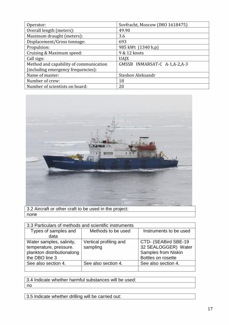
17
Operator: Sovfracht, Moscow (IMO 1618475) Overall length (meters): 49.90 Maximum draught (meters): 3.6 Displacement/Gross tonnage: 693 Propulsion: 985 kWt (1340 h.p) Cruising & Maximum speed: 9 & 12 knots Call sign: UAJX Method and capability of communication (including emergency frequencies):
GMSSB INMARSAT-C A-1,A-2,A-3
Name of master: Steshov Aleksandr Number of crew: 18 Number of scientists on board: 20
3.2 Aircraft or other craft to be used in the project:
none
3.3 Particulars of methods and scientific instruments
Types of samples and data
Methods to be used Instruments to be used
Water samples, salinity, temperature, pressure. plankton distributionalong the DBO line 3
Vertical profiling and sampling
CTD- (SEABird SBE-19 32 SEALOGGER) Water Samples from Niskin Bottles on rosette
See also section 4. See also section 4. See also section 4.
3.4 Indicate whether harmful substances will be used:
no
3.5 Indicate whether drilling will be carried out:
18
no
3.6 Indicate whether explosives will be used:
no
4. Installations and Equipment
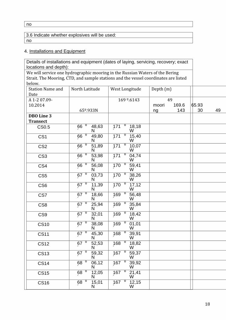
Details of installations and equipment (dates of laying, servicing, recovery; exact locations and depth):
We will service one hydrographic mooring in the Russian Waters of the Bering Strait. The Mooring, CTD, and sample stations and the vessel coordinates are listed below.
Station Name and Date
North Latitude West Longitude Depth (m)
A 1-2 07.09-10.2014
65º.933N
169 º.6143
mooring
169.6143
65.9330 49
49
DBO Line 3 Transect
CS0.5 66 º 48,63 ´ N
171 º 18,18 ´ W
CS1 66 º 49,80 ´ N
171 º 15,40 ´ W
CS2 66 º 51,89 ´ N
171 º 10,07 ´ W
CS3 66 º 53,98 ´ N
171 º 04,74 ´ W
CS4 66 º 56,08 ´ N
170 º 59,41 ´ W
CS5 67 º 03,73 ´ N
170 º 38,26 ´ W
CS6 67 º 11,39 ´ N
170 º 17,12 ´ W
CS7 67 º 18,66 ´ N
169 º 56,48 ´ W
CS8 67 º 25,94 ´ N
169 º 35,84 ´ W
CS9 67 º 32,01 ´ N
169 º 18,42 ´ W
CS10 67 º 38,08 ´ N
169 º 01,01 ´ W
CS11 67 º 45,30 ´ N
168 º 39,91 ´ W
CS12 67 º 52,53 ´ N
168 º 18,82 ´ W
CS13 67 º 59,32 ´ N
167 º 59,37 ´ W
CS14 68 º 06,12 ´ N
167 º 39,92 ´ W
CS15 68 º 12,05 ´ N
167 º 21,41 ´ W
CS16 68 º 15,01 ´ N
167 º 12,15 ´ W
19
CS17 68 º 17,98 ´ N
167 º 2,90 ´ W
CS18 68 º 18,94 ´ N
166 º 57,60 ´ W
CS19 68 º 19,90 ´ N
166 º 52,30 ´ W
5. Geographical Areas
5.1 Indicate geographical areas in which the project is to be conducted (with reference in latitude and longitude):
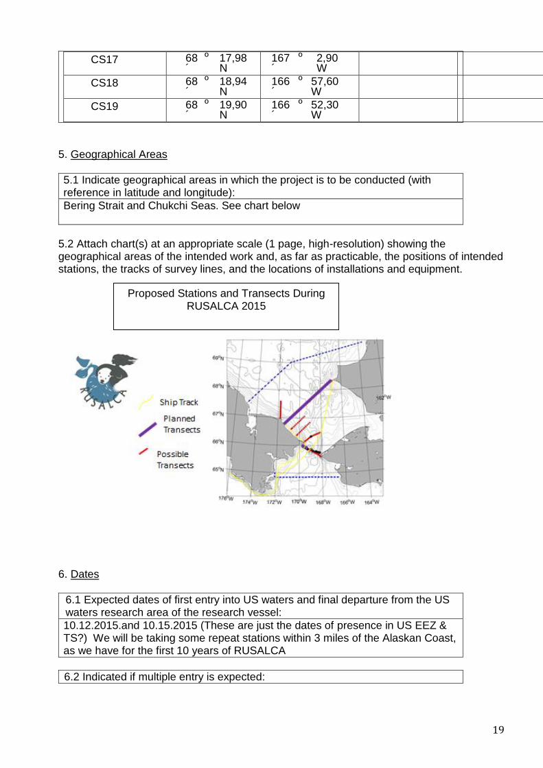
Bering Strait and Chukchi Seas. See chart below
5.2 Attach chart(s) at an appropriate scale (1 page, high-resolution) showing the geographical areas of the intended work and, as far as practicable, the positions of intended stations, the tracks of survey lines, and the locations of installations and equipment.
6. Dates
6.1 Expected dates of first entry into US waters and final departure from the US waters research area of the research vessel:
10.12.2015.and 10.15.2015 (These are just the dates of presence in US EEZ & TS?) We will be taking some repeat stations within 3 miles of the Alaskan Coast, as we have for the first 10 years of RUSALCA
6.2 Indicated if multiple entry is expected:
Proposed Stations and Transects During RUSALCA 2015

20
Possibly. Explain We don’t anticipate this, but situations change due to weather and RUSALCA has needed to go from one side of the strait to the other to avoid bad weather and to continue to sample.
7. Port Calls
7.1 Dates and names of intended ports of call:
10.09.2015 Anadyr. Embarkation of American and Russian scientists and equipment, 10.19.2015 Anadyr. Disembarkation of American and Russian scientists and equipment.
7.2 Any special logistical requirements at ports of call:
May take on provisions, may need barge to load equipment, people (Agent will handle these needs)
7.3 Name/Address/Telephone of shipping agent (if available):
If we need a shipping agent in Alaska, it will be Alaska Maritime Agencies, 4341 B. Street, Suite 101, Anchorage, Alaska 99503, 907-562-8808 phone, 907-562-8810 fax
8. Participation:
8.1 Extent to which coastal state will be enabled to participate or to be represented in the research project:
To a great extent as an equal partner sharing all major roles including leadership, planning, etc.
8.2 Proposed dates and ports for embarkation/disembarkation:
10.09.2015 depart Anadyr, 10.19.2015arrive Anadyr,
9. Access to data, samples and research results
9.1 Expected dates of submission to coastal state of preliminary reports, which should include the expected dates of submission of the final results:
No more than 30 days from the end date of the cruise.
9.2 Proposed means for access by coastal state to data and samples:
Electronic data carriers, mail, delivery by hand
9.3 Proposed means to provide coastal state with assessment of data, samples and research results or provide assistance in their assessment or interpretation:
Through the US institutions such as NOAA University of Washington, Woods Hole Oceanographic Institution, University of Alaska
9.4 Proposed means of making results internationally available:
Open web site access, publications, presentations at professional conferences, etc.
21
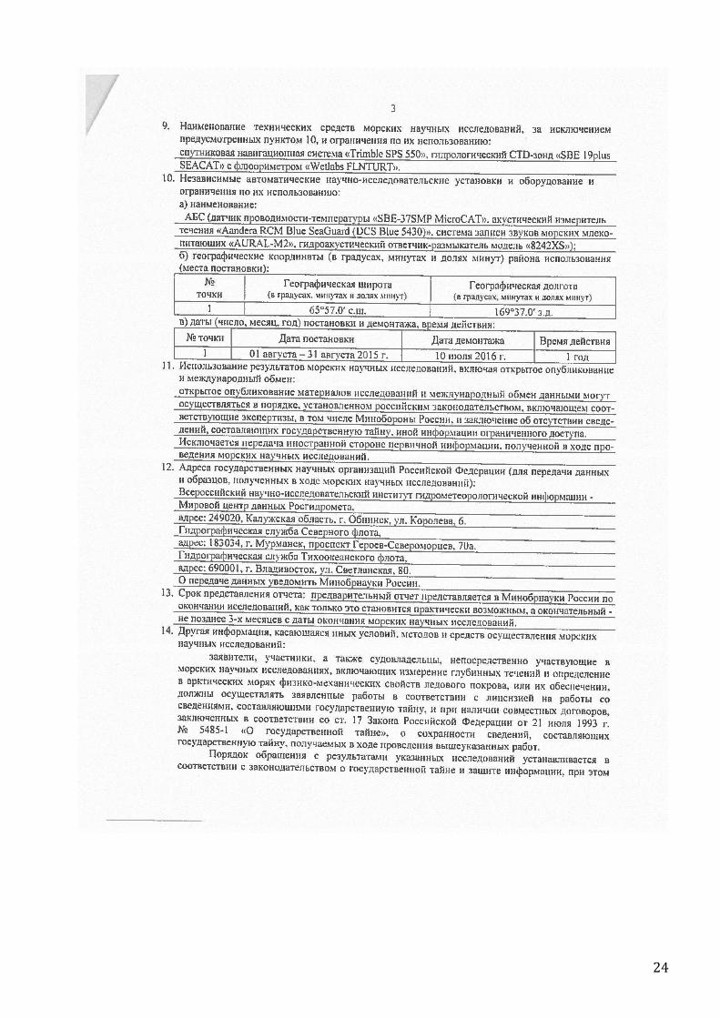
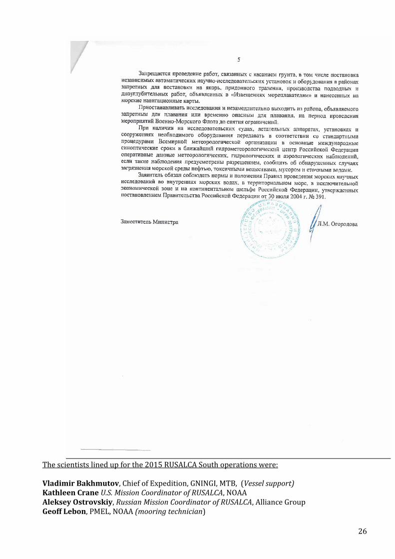
The Russian Permission to work in Russian Territorial waters and the EEZ in the Bering Strait and Chukchi Sea follows:
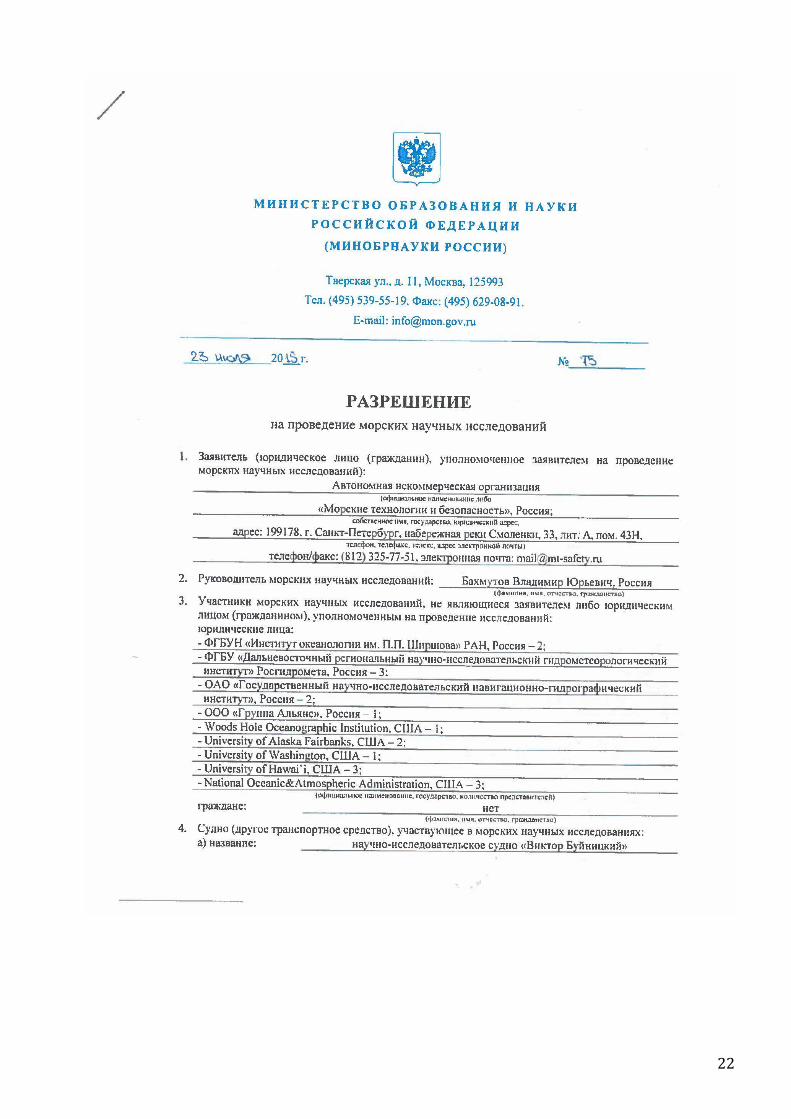
22

23
24

25
26
The scientists lined up for the 2015 RUSALCA South operations were:
Vladimir Bakhmutov, Chief of Expedition, GNINGI, MTB, (Vessel support) Kathleen Crane U.S. Mission Coordinator of RUSALCA, NOAA Aleksey Ostrovskiy, Russian Mission Coordinator of RUSALCA, Alliance Group Geoff Lebon, PMEL, NOAA (mooring technician)

27
Elizabeth Labunsky, U.S. Fish and Wildlife Service, (Seabird Observations) Calvin Mordy, University of Washington, PMEL, NOAA, Water Samples (productivity, nutrients, chemistry) Maria Pisareva, Woods Hole Oceanographic Institution and P. P. Shirshov Institution of Oceanology, (Physical Oceanography) Alexander Polshin, MTB, (vessel support and instrument tech operations) Kathleen Stafford, University of Washington, (Marine Mammal Observations, and mooring operations) Kevin Wood, University of Washington, PMEL, NOAA (Logistics and all around support)
Mooring operations. The mooring A1-2 was deployed on the Russian side of the Bering Strait at position of 65° 56.994' N, 169° 36.990' W on the 10 of July 2014. We will retrieve and replace this mooring in July, 2016 as part of the RUSALCA 2016 SOUTH program.

28
2 m line
RUSALCA 2014 Mooring to be Retrieved in July 2016 A1-2 – RUSSIAN Territorial Waters Latitude 65* 55.994’N Longitude -169* 36.990’W
SBE37, 43 depth S/N 37-12278, no cage !
EG&G ACOUSTIC RELEASE S/N 48597 Enable 602113 Disable 602130 Release 623721 Int. 11 Khz Reply 12 Khz
.
Mooring Anchor
AURAL Recorder 38m depth, S/N 00247LF
Floatation 37” Syntactic Float ½” Galv. Shackle ½” Galv. Shackle
SEAGUARD RCM Blue Current Meter 35m depth, S/N 5450 64
Floatation
A1-2
Bottom Depth 51 m. Anchor Dry Wt.= 2220 lbs
2.5 m line
1 m line
1 m line
29
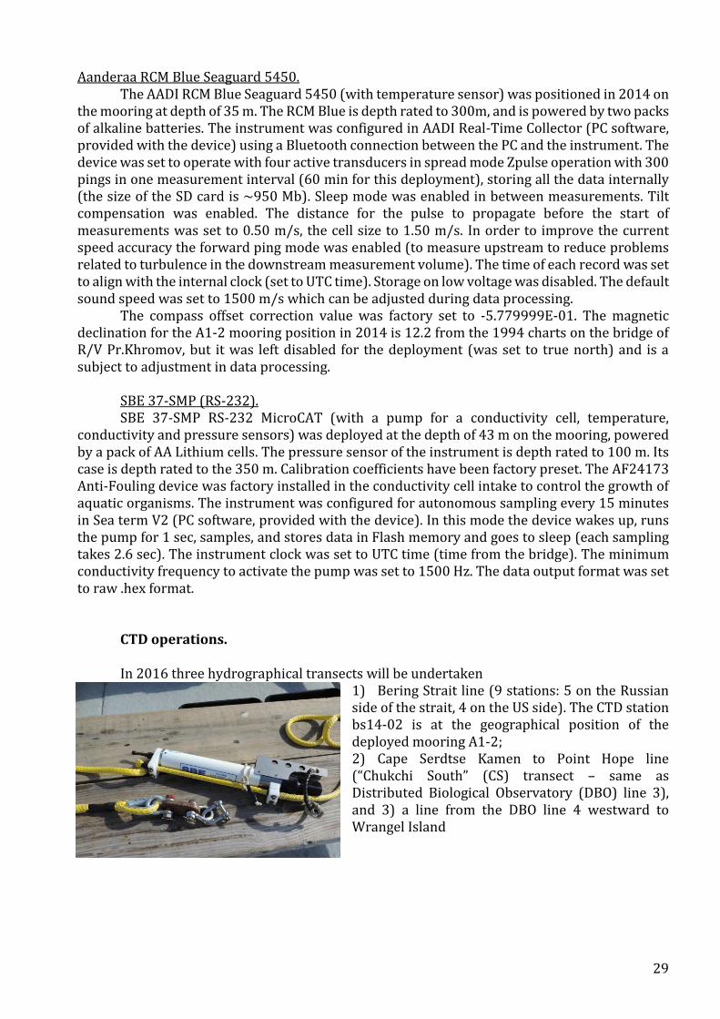
Aanderaa RCM Blue Seaguard 5450. The AADI RCM Blue Seaguard 5450 (with temperature sensor) was positioned in 2014 on
the mooring at depth of 35 m. The RCM Blue is depth rated to 300m, and is powered by two packs of alkaline batteries. The instrument was configured in AADI Real-Time Collector (PC software, provided with the device) using a Bluetooth connection between the PC and the instrument. The device was set to operate with four active transducers in spread mode Zpulse operation with 300 pings in one measurement interval (60 min for this deployment), storing all the data internally (the size of the SD card is ~950 Mb). Sleep mode was enabled in between measurements. Tilt compensation was enabled. The distance for the pulse to propagate before the start of measurements was set to 0.50 m/s, the cell size to 1.50 m/s. In order to improve the current speed accuracy the forward ping mode was enabled (to measure upstream to reduce problems related to turbulence in the downstream measurement volume). The time of each record was set to align with the internal clock (set to UTC time). Storage on low voltage was disabled. The default sound speed was set to 1500 m/s which can be adjusted during data processing.
The compass offset correction value was factory set to -5.779999E-01. The magnetic declination for the A1-2 mooring position in 2014 is 12.2 from the 1994 charts on the bridge of R/V Pr.Khromov, but it was left disabled for the deployment (was set to true north) and is a subject to adjustment in data processing.
SBE 37-SMP (RS-232). SBE 37-SMP RS-232 MicroCAT (with a pump for a conductivity cell, temperature,
conductivity and pressure sensors) was deployed at the depth of 43 m on the mooring, powered by a pack of AA Lithium cells. The pressure sensor of the instrument is depth rated to 100 m. Its case is depth rated to the 350 m. Calibration coefficients have been factory preset. The AF24173 Anti-Fouling device was factory installed in the conductivity cell intake to control the growth of aquatic organisms. The instrument was configured for autonomous sampling every 15 minutes in Sea term V2 (PC software, provided with the device). In this mode the device wakes up, runs the pump for 1 sec, samples, and stores data in Flash memory and goes to sleep (each sampling takes 2.6 sec). The instrument clock was set to UTC time (time from the bridge). The minimum conductivity frequency to activate the pump was set to 1500 Hz. The data output format was set to raw .hex format.
CTD operations. In 2016 three hydrographical transects will be undertaken
1) Bering Strait line (9 stations: 5 on the Russian side of the strait, 4 on the US side). The CTD station bs14-02 is at the geographical position of the deployed mooring A1-2; 2) Cape Serdtse Kamen to Point Hope line (“Chukchi South” (CS) transect – same as Distributed Biological Observatory (DBO) line 3), and 3) a line from the DBO line 4 westward to Wrangel Island

30
ARDEM bathymetry used for the base map: Danielson, S., M. Johnson, S. Solomon & W. Perrie, 2008. http://mather.sfos.uaf.edu/~seth/bathy/

31
Proposed transects for RUSALCA 2016 (green)
32
Suggested list of items to bring for Future Russian mooring recoveries: For RCM Blue Seaguard: new SD card (~1 Gb) (in case we are not formatting the old card at sea) hard drive for downloading data For SBE 37-SMP (RS-232): new Anti-foulant device for the conductivity cell ?.. (if redeploy the instrument)
This information is based on William Floering’s observations of what the R/V Khromov has available and the expectations of those collecting CTD and mooring instrument data in future years. The 8242 Acoustic release battery pack for the Russian Bering Strait mooring should be good for two years so if RUSALCA returns next year one will only need a zinc and release link to turn that piece of equipment around. If it stays out 2 years then one should plan on replacing the link, zinc and battery pack. The RCM 9-Blue current meter will need a new battery pack (comes with 2) each year of deployment. The data card can be downloaded or replaced with a new card depending on what is easiest in the somewhat controlled data access environment aboard the ship. The cage that came with this unit is not as robust as the cage available for other RCM 9 models. One might want to look into using a more robust cage. This could be an issue if the release failed and you had to drag the mooring up with the anchor attached to recover it. There were spare zincs for this unit in the box it was shipped in. The SeaBird SBE 37 did not come with a cage and is currently clamped to the mooring line. A suitable cage for this instrument should be provided for next year’s deployment. PMEL may have a suitable cage. RUSALCA will also need additional shackles to mount this new cage. The SBE 37 has an interesting battery pack that can be a challenge to figure out and has a circuit board on the base of the instrument that if damaged will keep the battery pack from working. You can simplify a battery exchange for this instrument if you order a new pack with batteries installed. Pack is good for one year deployment. There are also poison cells in the instrument that need to be replaced each year. These are anti-fouling cells to keep the conductivity cell clean. The Aural is handled by Kate Stafford, and would be the contact person for what is needed to turn that instrument around at sea. There are some set up menus in the SBE 37 and RCM9-Blue that are critical if you want to collect good data or even any data at all. It’s advisable to have someone on the cruise that has some knowledge of the set up for these two instruments. The same is true for the operation of the acoustic release deck set. It’s possible to enter incorrect codes, set up commands and frequencies into the deck set and not be able to range on or recover the mooring. One must also remember to disable the release in the water or it will remain in the “on” configuration and drain the battery power before return in a year to recover it. There are cables that are needed to download the data from the SBE and to talk to it to set it up and the RCM 9. For the mooring in general one needs to pay attention to the different metal types in the cages, shackles and mooring back bone line. Stainless steel has to be isolated from the galvanized metal to avoid electrolysis that could eat through one of the attachments and cause the mooring to break apart and float away. Also, there is a compass in the RCM 9 that needs to be
33
isolated from Ferris metal at least a half meter above the top of the instrument. If not one runs the risk of interfering with the compass and throwing off all the directions for the currents you are trying to measure. The nylon rope backbone currently deployed with this mooring could be used again next year for another deployment but I would take a couple extra pieces along in case there is damage to one of the sections. One 1 meter section was not deployed, that was the one that would have connected to the SBE37 cage if a cage had been available. That piece will be needed next year if a cage is located for the SBE. For CTD operations the following equipment will be needed:
Chinese fingers specific for the diameter wire on their conducting wire winch.
A proper pig tail that attaches to the end of the conducting wire and plugs into the CTD
PDIM. Right now this is a 3 pin wet mate able plug and one was in the CTD wooden box
when we left. It would be good to have a spare in case that pig tail was damaged.
A male dummy plug for the end of that pigtail when not plugged into the CTD and a
spare dummy plug for the PDIM in case the one you have gets lost. To make the
connection of the pigtail to the conducting winch wire you have two options. 3M makes
an epoxy mix potted model 82-F1 that provides a water tight seal on the wire. It takes
approximately 24 hours for this type to set up and be ready to put in the water. Another
option is to use layers of self-volcanizing electrical tape and liquid electrical tape. This
system works too and only requires a couple hours of drying time before deployment.
With both systems one needs butt splices, electrical tape and shrink tubing to make a
good water tight seal. There is a deck test cable in the CTD shipping box that is good for
testing the system separate from the winch wire.
It’s possible RUSALCA will have a rosette next year for the CTD and the oceo winch with
the conducting wire will work for the entire cruise. If not, RUSALCA will have to go back
to mounting the niskin bottles on a ¼ inch stainless wire and tripping the bottles with
messengers to get the water samples. PMEL suggests taking the supplies needed for the
wire method as a backup to the winch as its history of reliability is suspect. One would
need about 300 feet of stainless ¼ inch wire with an eye on each end.
Do not forget backup Messengers to trip the bottles and the nicopress fittings and nylon
lanyard material to rig the niskin bottles for a wire trip.
The same niskin bottles can be used on the rosette or on the wire but the lanyard (the
nylon line that hold the bottle open on deployment, is set up differently for the rosette
mount than it is for the wire mount.
It is a good idea to take at least 2 spare niskins as occasionally one will break.
Also bring springs or rubber bands that go inside the niskin bottles to close them.
If there is a problem with the winch wire or the water tight integrity of the pigtail splice,
fuses may blow in the CTD deck unit.
Take 10 or so spare fuses (there are two different ones for the deck unit) as one can
burn through a few trouble shooting a short in the conductive cable.
Take some extra rope or line for tying things on deck as there is little if any available on
the vessel.
Also bring extra shackles, both galvanized and stainless.
The two small plastic floats that were deployed do not take a normal safety shackle with
a cotter pin to secure it. They require smaller screw pin shackles that need to be seized
34
with stainless safety wire or something similar. Floering brought a SeaCatch release to
release the anchor from the crane when deployed. The Navy reps were interested in
obtaining one of those which cost about $1600. For one mooring you can use a piece of
suitable rope to hang the anchor and cut the rope to drop it; A cheap and effective way
to deploy the anchor.
Calvin Mordy mentioned that if possible it would be good to include a -40 portable freezer in the list of equipment to load. PMEL has those at the lab. PMEL also may have a conductive wire winch that could be loaded as a backup to the ships winch if it failed. There would be added shipping costs for this level of redundancy and right now I think our backup winch would require about 3K in upgrades to make it serviceable. The other side of this would be to insure our hydraulic fittings fit the ships hydraulic fittings and that will probably require some research. Lessons Learned 2015
Work consistently with the regulators of Chukotka permits in Anadyr, including the Border Guards and the FSB. Engage a legal entity in Anadyr to maintain up to date communication on any sudden changes in Permit protocols.
Make sure that all the permits are in good place one month ahead of the expedition.
Work much earlier in the season. October is really on the edge of operations by ships,
charter flights and regulations.
Hold a face to face meeting in the fall of 2015 or winter of 2016 with the Buynitskiy ship operators, the users, (Dr. Heidi Kassens of GEOMAR) the Arctic and Antarctic Research Institute, the Russian Naval Research Lab company MTB, the Alliance Group and the RUSALCA mission coordinators and assistants to iron out expectations, requirements and rules of procedure.