cruise report for pr1s and pr24 pr1s:a hydrographic ... · cruise report for pr1s and pr24 pr1s:a...
TRANSCRIPT

Cruise Report for PR1S and PR24
PR1S:A Hydrographic Section along 130-00'E
PR24:A Hydrographic Section from Mindanao SE to
Indonesia
6N :A Hydrographic Section from Mindanao SE to Palau
28 April 1994
R/V KAIYO
12 Feb. 1994 - 3 March 1994
Contents
1. Highlight
2. Summary of the observations and data files
3. Cruise track, stations and sampling depths
4. Preliminary results
5. Parameters, Contribution Institutions, and Personnel
6. Underway Measurement
7. Sampling/measurements equipments
8. CTD/Rosette hardware
9. Moorings
10. CTD/Rosette operation
11. CTD data processing
12. Sample water salinity measurements
13. Dissolved Oxygen determination
14. Nutrients measurements
15. Plant Pigments measurements
16. Drifters
17. Distribution of atmospheric and oceanic CO2
18. C-14 sample drawing
19. Weather and sea condition
20. Problems
21. Report on CTD system performance
Acknowledgements
List of Tables
Table 2-1 KYZZZZ94.SUM
Table 4-1 The average and the standard deviation of the properties below 3000
dbar
Table 5-1 List of parameters measured, the sampling group(s) responsible for
each, and the
principal investigator(s) for each.
Table 5-2 Cruise participants
Table 6-1 Sampling equipments
Table 7-1 The differences between water depth estimated summing of CTD
observation
plus altimeter reading and uncorrected echosounding depth
Table 8-1 Summary of RTM and RPM data. Average (upper raw) and Standard
deviation
(lower raw)
Table 11-1 Definition of noise and the number of noise detected by this
definition
Table 12-1 Summary of standardization
Table 12-2 cell factors
Table 13-1 Comparison of standards from JAMSTEC and SIO
Table 14-1 The standard deviation of the differences between duplicate samples
Table 14-2 The results of the quality control samples at the same depth
Table 14-3 The results of the repeat analysis as a range of concentration
Table 15-1 The Chl. a and Chl. b concentration.
Table 16-1 List of drifters deployed on this cruise

Table 19-1 Weather observation record
Table 21-1 Comparison between primary and secondary temperature sensors
Table 21-2 Salinity comparison between primary and secondary sensors
Table 21-3 CTD salinity from primary sensors at nominal depths
Table 21-4 Difference between CTD salinity and AUTOSAL salinity at selected
depths
List of Figures*
Figure 2-1 Track chart
Figure 4-1a Preliminary section of salinity along 6N taken from the CTD
stations
Figure 4-1b Preliminary section of temperature along 6N taken from the CTD
stations
Figure 4-2a Preliminary section of salinity along PR24 taken from the CTD
stations
Figure 4-2b Preliminary section of temperature along PR24 taken from the CTD
stations
Figure 4-3a Preliminary section of salinity along PR1S taken from the CTD
stations
Figure 4-3b Preliminary section of temperature along PR1S taken from the CTD
stations
Figure 8-1 Results from TCCOMP
Figure 9-1 The TMN mooring site
Figure 9-2 The TMS mooring site
Figure 9-3 The mooring line at TMN
Figure 9-4 The mooring line at TMS
Figure 9-5 The marker buoy
Figure 11-1 Computer systems for CTD data processing
Figure 11-2 total salinity spike area variability for time lag between
temperature and
conductivity at cast 6N021 and K1S181.
Figure 11-3 Pressure variability
Figure 11-4 Variability of deck pressure
Figure 11-5 Data flow of CTD data processing
Figure 14-1 Flow diagram for TRAACS800 nitrate method
Figure 14-2 Flow diagram for TRAACS800 nitrite method
Figure 14-3 Flow diagram for TRAACS800 silicate method
Figure 14-4 Flow diagram for TRAACS800 phosphate method
Figure 17-1 Distribution of atmospheric and oceanic CO2
Figure 21-1a
Figure 21-1b
Figure 21-2a
Figure 21-2b
Figure 21-3
Figure 21-4
Figure 21-5
1. Highlight
by K. Muneyama (4 March 1994)
Chief Scientist: Kei Muneyama, JAMSTEC,Japan
Co-Chief Scientist: Syaefudin, BPPT,Indonesia
Co-Chief Scientist: Michio Aoyama, JAMSTEC, Japan
Cruise: KAIYO-9307
Dates: 12 February to 3 March 1994
Ship: R/V Kaiyo
Ports of call: Marakal, Palau to Marakal, Palau
Although our first plan was to observe PR23, 7.30'N section between
Mindanao
and Palau, shiptime restricted us to carry out to observe this WOCE designated
section. We planned instead to observe (7-30'N,134-00'E) to (6-00'N,130-00'E)

to (6-00'N,127-30'E).
One day before we would leave Koror, Palau for the cruise, a sudden
request
were made for us to search 5 missing Japanese divers and one Palauan diving
instructor at a remote island some 60 n.miles apart. Next day R/V KAIYO left
Koror for search of the 6 missing persons. This search was kept for 5 days from
February 7 to 11. We started the WOCE cruise at (7-00'N,134-00'E) to (6-00'N,
130-00'E) to (6-00'N,127-30'E) on February 12 1994. As this section is not PR23
,we designated it simply 6N. This 6N section consists 15 stations(STN 1-15),
and required us 5 days for completion. Station spacing was 30 n.miles from the
start to the end of this section.
PR24 section is extended from K6N STN 15(6-00'N,127-30'E) to PR24 STN 20
(1-33.3'N,129-40.0'E). Station spacing was kept less than 30 n.miles in this
section. Stations 5,12,13,18 and 21 were excluded to save shiptime.
We added an optional section PR24-2 because current flows in this region are
known to be complex by the previous observation executed last year. We have
deployed ADCP moorings at 4-01.239'N,127-30.634'E and 3-10.793'N,128-27.367E
with double acoustic releasers for each mooring.
PR1S section (S means southern part of PR1) occupies between PR1S STN 1(
0-
45'N,130-00'E) and PR1S STN 25(10-00'N,130-00'E). The lack of shiptime has
forced
us to delete STNs 3, 5, 7, 10, 14, 22, 23, 24 and 25. We carried out
observations from 0-
45'N to 8-00'N on the 130E by 30 n.miles of station spacing. We deployed 8
surface
drifters between 2-00'N and 8-00'N on 130-00'E. We arrived at Koror on March
3rd.
A General Oceanics (GO) 36 position rosette water sampler with 12 liter
Niskin bottles has worked well with a Sea Bird Electronics CTD 9-11 plus deck
unit. If we did not have a 36 position rosette water sampler, our cruise track
had to be forced notably to change due to 5 days reduction for the unfortunate
accident. Our preliminary survey of PR24 region executed in 1992 has told us
a very steep topographic change. We installed two altimeters to the GO 36
position water sampler, one Benthos'model 2110-1 and another Datasonic PSA-900A.
Nevertheless we did not notice at one occasion that the wirecable was bent
almost rectangularly at the top of protection frame of the rosette as wirecable
was hooked to a Niskin bottle until the CTD/rosette surfaced obliquely.
We used 12 position rosette water sampler at PR24-2 section as the topography
there is very steep. We had paid attention to the length difference of CTD/
rosette water sampler between the reading of CTD pressure and the wire-out
measurement of the winch.
The analysis of CTD corrected by the Autosal indicate that they meet WHP
quality
guideline for precision and accuracy. Salinity measurement due to bottle
samplings has
shown ca. 0.001 PSS in accuracy and ca. 0.0005 PSS in precision. The precision
of
dissolved oxygen (DO.) measurement is ca. 0.5% and its accuracy is ca. 0.1% when
the
interlab comparison of the standard solution at ODF/SIO is adopted. The
precision of
nitrate analysis is ca. 0.4% , that of silicate analysis is ca. 0.4% and that of
phosphate
analysis is ca. 1.2% when experiments tried at duplicative water samples below
3000m
depth is adopted.

2. Summary of the observations and data files
by M. Aoyama ( 10 March 1994)
The ship's track is shown in Figure 2-1*.
Station positions and all scientific events are in the WOCE format KYZZZZ94.SUM
file
and shown in Table 2-1.
K6NZZZ94.SEA, K24ZZZ94.SEA and K1SZZZ94.SEA are the WOCE format ---.SEA
files for section 6N, PR24 and PR1S, respectively. The ---.SEA files for
section TM
(from Talaud Is. to Morotai Is.) are not reported.
The WOCE format ---.CTD files are named as follows;
1st digit: K ( This means KAIYO)
2nd and 3rd digits: line designator
4th and 5th digits: station number
6th digits: cast number
7th and 8th digit: the last two digits of the year
For example, the ---.CTD file name of the first cast at the station 15 on
section PR1S
becomes K1S15194.CTD.
In each ---.SUM, ---.SEA and ---.CTD files, we use "KY " as a ship code.
Sampling accomplished:
57 CTD/Rosette stations and 3 trial casts were occupied.
Number of water samples analyzed:
Salinity ca. 1600
Oxygen 1602
Nutrients ca. 1600
Plant Pigment 73
Number of water samples collected for shore-based analysis:
AMS radiocarbon ca. 220 (7 stations, all replicate samples)
8 drifters were deployed.
2 ADCP moorings were deployed.
Measurements of surface layer pCO2 and atmospheric pCO2 were made along the
entire
ship track.
3. Cruise Track, Stations and sampling depths
by M. Aoyama (5 March 1994)
The ship's track is shown in Figure 2-1*. Station positions are in the
KYZZZZ94.SUM file.
The sampling interval from 7-00N, 134-00E to 6-00N,127-00E was 30 nm. Sampling
continued from 6-00N, 127-00E to 2-40N, 129-00E with station interval 20 nm or
less
across the east mouth of the Celebes Sea along over the 3000 to 6000 meters
isobaths just
west of the Philippine trench. From 2-40N, 129-00E, we turned toward Talaud Is.
and
continue to sample at 20 nm interval or less. Stations include over the ridges
and trenches
between 2-40N, 129-00E and 2-52N, 128-42E. From 2-52N, 128-42E, we turned back
to
2-23N, 129-10E and continue to sample at approximately 20 nm interval until we
approach
1-33N,129-40E. Then we turned south to 0-45N, 130-00E and turned north to 8-00N,

130-00E. The sampling interval along 130-00E was at 30 nm .
The sampling depths shallower than 1000 meters were 10, 20, 30, 50, 75,
100, 125, 150,
200, 250, 300, 400, 500, 600, 700, 800, 900, and 1000 meters. Below 1000 meters,
the
vertical sampling interval is 250 meters and the deepest sampling depth will be
up to within
7-50 meters of the bottom. Although our rosette sampler used in section 6N, PR24
and
PR1S is 36 positions, 2 casts was not done at few stations deeper than 5000
meters due to
save the ship time. At the stations deeper than 5000 meters, we canceled some of
the
shallower sampling layers. Since the sea condition became hard at the station
PR1S-
19,20,21, we reduced the Niskin bottles to 30 (at PR1S-19,20), 24 (at PR1S-21)
to make
the CTD/Rosette operation safety. Since we used 12 position Rosette In the
section PR24-
2, the sampling depths were largely reduced.
4. Preliminary results
by M. Aoyama (22 April 1994)
The temperature and salinity section along 6N, PR24 and PR1S are shown in
Fig. 4-1a*,
1b*, Fig. 4-2a*,-2b*, and Fig. 4-3a*,-3b*. The densest water having almost the
same properties
are found below 4000 db among all stations at the interested area, where the
densest water
is 27.77 in sigma-theta, 34.679 to 34.680 in salinity, 1.245 to 1.240 in
potential
temperature. The average and the standard deviation for salinity, temperature,
dissolved
oxygen, silicate, nitrate and phosphate concentrations are summarized in table
4-1.
As shown in Table 4-1, the deep water properties below 5000 dbar at the stations
along
6N, PR24 and PR1S are 1.2395 in potential temperature, 34.6794 in salinity,
150.6
umol/kg in dissolved oxygen, 139.7 umol/kg in silicate concentration, 36.08
umol/kg in
nitrate concentration and 2.46 umol/kg in phosphate concentration. The salinity
decreased
to 34.6748 in the depth between 4000 to 3000 dbar and it becomes variable in
five times
magnitude larger than that below 5000 dbar.
The distinctive feature in the salinity section along PR1S is the saline
water below 4000
dbar around 4 degree north and 5 degree north (stations PR1S-12,13,15). This
saline
water is exceeding 34.680 in salinity.
Table 4-1 The average and the standrad deviation of the properties below 3000
dbar.
Range THETA SALNTY OXYGEN SILICAT NITRAT PHSPHT
dbar degree PSS umol/kg umol/kg umol/kg umol/kg
7600 - 4998 1.2395 34.6794 150.6 139.7 36.08 2.46

0.0029 0.0007 0.73 1.06 0.31 0.03
6001 - 4998 1.2403 34.6793 150.6 139.7 36.11 2.47
0.0024 0.0008 0.76 1.14 0.31 0.02
5003 - 3996 1.2447 34.6790 150.4 139.8 36.12 2.47
0.0042 0.0009 0.88 1.22 0.33 0.03
4003 - 2998 1.3060 34.6748 146.79 140.47 36.29 2.48
0.0482 0.0034 3.03 1.26 0.34 0.04
5. Parameters, Contribution Institutions, and Personnel
by M. Aoyama (4 March 1994)
The details for these factors are given in Tables 5-1 and 5-2.
Table 5-1: List of parameters to be measured, the sampling group(s) responsible
for each,
and the Principal Investigator(s) for each.
Parameter / Instr. Sampling Group Principal Investigator(s)
CTD/rosette JAMSTEC Yuji Kashino and
Kentaro Ando
Salinity JAMSTEC Takeshi Kawano
O2, NO3, NO2, PO4, SiO2 JAMSTEC Michio Aoyama
Mooring JAMSTEC/STM Kentaro Ando, Hidetoshi Watanabe
and Atsushi Ito
Plant Pigments BPPT Rusana Meisianti Djalimun
Surface Drifter JAMSTEC Shoichiro Nakamoto
CO2 MRI Hisayuki Y. Inoue
Radiocarbon* JAMSTEC Michio Aoyama
Cs-137 and Sr-90** JAMSTEC/MRI Michio Aoyama and
Katsumi Hirose
* Funding still Pending. ** Cancelled
Table 5-2: Cruise participants
Cruise participants with role and / or affiliation in parentheses.
Kei Muneyama JAMSTEC Chief Scientist
Syaefudin BPPT Co-Chief Scientist/CTD
Michio Aoyama JAMSTEC Co-Chief Scientist/O2,
Nutrients,C-14,Cs-137,
Sr-90
Takeshi Kawano JAMSTEC Salinity
Yuji Kashino JAMSTEC CTD Softwares
Kentaro Ando JAMSTEC CTD/rosette hardware/
Mooring
Yudi Anantasena BPPT CTD
Rusana Meisianti Djalimun BPPT Plant pigments
Akira Sonoda NME O2
Hiroshi Yamamoto NME CTD/Mooring
Koichi Takao NME Salinity
Atsuo Ito NME Salinity
Misumi Aoki NME O2

Hidetoshi Watanabe STM CTD/Mooring
Ranko Takeo STM O2
Takehiko Shiribiki STM O2
Keiko Komine STM Nutrients
Teruhisa Hattori STM CTD/Mooring
Hidekazu Ota KEEC Nutrients
Kiyotaka Nakao KEEC Nutrients
Kazuhiro Murakami KEEC CTD/CO2
Richard J. Bauman SBE CTD hardware/software support
note: JAMSTEC Japan Marine Science and Technology Center, Japan
BPPT Badan Pengkajian Dan Penerapan Teknologi (Agency for the Assessment
and Application of Technology of the Republic of Indonesia),
Indonesia
STM Sanyo Techno Marine, Inc., Japan
NME Nippon Marine Enterprises, Ltd., Japan
KEEC Kansai Environmental Engineering Center, Ltd., Japan
SBE Sea-Bird Electronics, Inc., United States of America
MRI Meteorological Research Institute, Japan
6. sampling/measurements equipments
by M. Aoyama (4 March 1994)
The details for these factors are given in Tables 6-1.
Table 6-1: Sampling Equipments
Small-Volume :One 36-place rosette (GO1016) with 12-liter bottles.
sampling One 24-place rosette (GO1016) with 30-liter bottles.
One 12-place rosette (GO1015) with 5-liter bottles for
backup.
CTD System: :One SBE-911plus CTD with altimeter and O2 sensor.
Another SBE-911plus with altimeter and O2 sensor for backup.
Two SBE-11plus deck units of sampling frequency at
24 Hz.
Winch and cable: Two Tsurumi Seiki TS-10PVCTD winches having 8000
meters cable of 10.6 mm diameter. The maximum
rolling load is 3800 kg x 47 m/minute.
Salinometer: :Two Guildline Autosal 8400B with HP 2804A quarts
thermometer.
One ampoule of IAPSO Standard Seawater per
station.
Oxygen Analysis:Carpenter method. Automated potentiometric
titration. Two ligs of Metrohm 716 DMS Titrino.
Nutrient Analysis:Bran Luebbe TRACCS 800 4 channels system.
Plant Pigments :Shimazu UV2000 Spectrophotometer
7.Underway Measurement
a. Navigation-GPS
by M. Aoyama (6 March 1994)
Navigation, ship position and velocity over the ground was provided throughout
the cruise
by a Magnavox MX4400 GPS receiver. Throughout the cruise, the positioning was
based

on the WGS-84 and in 3-D mode. Since we cloud get 4 satellites throughout the
cruise,
the HDOP was ranged from 1 to 2. Positions were logged in port Marakal at the
start and
the end of the cruise and a rms position error are as follows;
Pre-Cruise;
Mean position at Marakal harbor, Palau: 7-19.831N, 134-27.482E
Rms position error: N-S: 19 meters E-W: 29 meters
Post-Cruise;
Mean position at Marakal harbor, Palau: 7-19.???N, 134-27.???E
Rms position error: N-S: ?? meters E-W: ?? meters
b. Echosounding
by M. Aoyama (22 April 1994)
The water depth obtained by the multi-narrow beam echo sounder (General
Instrument) and
by using the CTD observation and altimeter equipped to CTD are summarized in
Table 7-1.
The differences are less than +/- 0.5 % at the most stations, while the
differences increased
up to 4 % at the stations at steep topography.
Table 7-1. The differences between water depth estimated summing of CTD
observation
plus altimeter reading and uncorrected echosounding depth.
Station number CTD plus altimeter echosounding Diff.
(uncorrected)
meter meter meter
6N 1 3188 3180 -8
6N 2 4129 4133 4
6N 3 3751 3798 47
6N 4 4017 4026 9
6N 5 4862 4852 -10
6N 6 5278 5258 -20
6N 7 5561 5539 -22
6N 8 5568 5541 -27
6N 9 5494 5470 -24
6N 10 5580 5567 -13
6N 11 5327 5349 22
6N 12 4642 4654 12
6N 13 5572 5547 -25
6N 15 3787 3782 -5
24 1 5370 5270 -100
24 2 5677 5733 57
24 3 6430 6390 -40
24 4 3987 4031 44
24 6 3172 3178 6
24 7 2479 2475 -4
24 8 2884 3003 119
24 9 2033 2060 27
24 11 3474 3483 9
24 12 3571 3551 -20
24 14 3488 3489 1
24 15 4163 4175 12
24 16 3408 3430 22
24 17 3594 3640 46
24 19 4735 4727 -8
24 20 4266 4270 4
1S 1 1473 1526 53

1S 2 3006 3020 14
1S 4 4114 4124 10
1S 6 4394 4395 1
1S 8 3996 4003 7
1S 9 3128 3120 -8
1S 11 4500 4508 8
1S 12 4712 4707 -5
1S 13 4816 4856 40
1S 15 5035 5031 -4
1S 16 5462 5436 -26
1S 17 5479 5456 -23
1S 18 5546 5516 -30
1S 19 5549 5521 -28
1S 20 5542 5514 -28
1S 21 5672 5636 -36
8. CTD/Rosette hardware
by K. Ando and M. Aoyama (6 March 1994)
(1) CTD/rosette systems
The 12-liters 36-positions intelligent GO rossette
ttached on the CTD were two temperature sensors, two conductivity sensors, one
DO
sensor, one pressure sensor and two altimeter sensors. The CTD and 36 position
rosette
were mounted within a stainless frame of dimension 1.7 m height x 2.2 meter
diameter.
The weight of the package in the air is 800 Kg when the 36 bottles of 12 liters
are full.
Thirteen to seventeen of the rosette bottles were fitted with the set of two SIS
digital
reversing thermometers and one SIS digital reversing pressure meter. The wire
was a
single conductor 10.6 mm steel rope manufactures by Rochester cables, and the
winch was
built by Tsurumi Seiki Japan. Since our winch was not of traction winch design
nor jumble
sheave design, we reduce the bottles from 36 to 30-24 when the swell became up
to 2 to
2.5 meters for the safety operation.
After a cast the rosette was pushed forward on a railway about 6 meters in
the shelter
that is modified standard sea carrier container with air conditioned and all
sampling was
performed there. Subsequently digital instruments were read and the TC sensors
was
cleaned by Triton-X detergent, fresh water and pure water at each cast.
The 5 liters 12-positions rosette water sampler with SBE9plus CTD for
6,800 meters
(secondary CTD system) was used on the line of TM to save the ship-time.
The sensors used attached on the primary CTD system and the secondary CTD
system are listed in (a) and (b).
(a) The sensors of the primary CTD system
The sensors used are listed below.
Primary temperature sensor: Model SBE3 for 10,500 meters S/N 031462
Primary conductivity sensor: Model SBE4 for 10,500 meters S/N 041045
Pump for primary sensor pair: Model SBE5 for 10,500 meters S/N 050846
Secondary temperature sensor: Model SBE3 for 10,500 meters S/N 031465

Secondary conductivity sensor: Model SBE4 for 10,500 meters S/N 041174
Pump for secondary sensor pair: Model SBE5 for 10,500 meters S/N 050847
Pressure sensor: Digiquarts pressure sensor for 10,500 meters S/N
41223
Primary Altimeter: Benthos model 2110-1 for 12,000 meters S/N 199
Secondary Altimeter: DATASONIC PSA-900A for 6,000 meters S/N 396
Dissolved Oxygen sensor: Model SBE13 for 10,500 meters S/N
130311
The calibrations of temperature, conductivity and pressure sensors were
conducted by NRCC in October 1993. The drift of temperature and
conductivity sensors are reported in Chapter 11.
Sensor performances during this cruise :
The differences of two sensors for temperature and conductivity are shown
in Figure 8-1*.
Though the calculation of these differences are performed by using the raw data
under 500 meters,
the maximum differences are within 0.001 C in temperature sensors and within
0.0002 S/m
in conductivity sensors.
(b) The secondary CTD system
The sensors used are listed below.
Primary temperature sensor : Model SBE3 for 6,800 meters S/N 031207
Primary conductivity sensor : Model SBE4 for 6,800 meters S/N 040960
Pump for primary sensor pair : Model SBE5 S/N 050484
Secondary temperature sensor : Model SBE3 for 6,800 meters S/N 031523
Secondary conductivity sensor : Model SBE4 for 6,800 meters S/N 041148
Pump for secondary sensor pair: Model SBE5 S/N 050863
Pressure sensor: Digiquarts pressure sensor for 6,885 meters S/N 43435
Altimeter: DATASONIC PSA-900A for 6,000 meters S/N 396
Dissolved Oxygen sensor: Model SBE13 for 6,800 meters S/N 130257
During the cast, we used the 32 of reversing thermometers (SIS RTM) and
17 of
reversing pressuremeters (SIS RPM). 5 of 32 RTM were broken during the cruise.
Since 8 of RTM were varied much and 2 of RTM began to drift, we basically
adapted the
data of stable 17 RTM data.
Since one RPM (RPM 10055) showed larger difference of 20 dbar, we do not
refer to the
data of RPM 10055.
A comparison result of CTD and RTM temperature and RPM pressure below
4000 dbar is
given in Table 8-1.
Table 8-1 Summary of RTM and RPM data. Average (upper raw) and Standard
deviation
(lower raw).
Range CTD-RTM CTD-RPM
dbar
7600 - 4998 0.003 -1.1
0.001 2.5
6001 - 4998 0.003 -1.1
0.001 2.6
5003 - 3996 0.004 -0.4
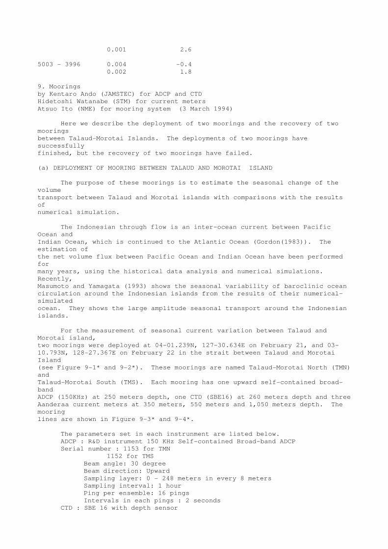
0.002 1.8
9. Moorings
by Kentaro Ando (JAMSTEC) for ADCP and CTD
Hidetoshi Watanabe (STM) for current meters
Atsuo Ito (NME) for mooring system (3 March 1994)
Here we describe the deployment of two moorings and the recovery of two
moorings
between Talaud-Morotai Islands. The deployments of two moorings have
successfully
finished, but the recovery of two moorings have failed.
(a) DEPLOYMENT OF MOORING BETWEEN TALAUD AND MOROTAI ISLAND
The purpose of these moorings is to estimate the seasonal change of the
volume
transport between Talaud and Morotai islands with comparisons with the results
of
numerical simulation.
The Indonesian through flow is an inter-ocean current between Pacific
Ocean and
Indian Ocean, which is continued to the Atlantic Ocean (Gordon(1983)). The
estimation of
the net volume flux between Pacific Ocean and Indian Ocean have been performed
for
many years, using the historical data analysis and numerical simulations.
Recently,
Masumoto and Yamagata (1993) shows the seasonal variability of baroclinic ocean
circulation around the Indonesian islands from the results of their numerical-
simulated
ocean. They shows the large amplitude seasonal transport around the Indonesian
islands.
For the measurement of seasonal current variation between Talaud and
Morotai island,
two moorings were deployed at 04-01.239N, 127-30.634E on February 21, and 03-
10.793N, 128-27.367E on February 22 in the strait between Talaud and Morotai
Island
(see Figure 9-1* and 9-2*). These moorings are named Talaud-Morotai North (TMN)
and
Talaud-Morotai South (TMS). Each mooring has one upward self-contained broad-
band
ADCP (150KHz) at 250 meters depth, one CTD (SBE16) at 260 meters depth and three
Aanderaa current meters at 350 meters, 550 meters and 1,050 meters depth. The
mooring
lines are shown in Figure 9-3* and 9-4*.
The parameters set in each instrunment are listed below.
ADCP : R&D instrument 150 KHz Self-contained Broad-band ADCP
Serial number : 1153 for TMN
1152 for TMS
Beam angle: 30 degree
Beam direction: Upward
Sampling layer: 0 - 248 meters in every 8 meters
Sampling interval: 1 hour
Ping per ensemble: 16 pings
Intervals in each pings : 2 seconds
CTD : SBE 16 with depth sensor

Serial number: 1282 for TMN
1283 for TMS
Sampling interval: 30 minutes
Current meters
:Aanderaa current meter model RCM-4 & RCM-5
Serial Number: 8306 for TMN 350 meters depth
4267 for TMN 550 meters depth
4557 for TMN 1,050 meters depth
8277 for TMS 350 meters depth
8637 for TMS 550 meters depth
4272 for TMS 1,050 meters depth
Interval: 60 minutes
Record device: IC memory
Releaser
:Benthos Model 865A-DB
Serial Number: 633 for TMN
666 for TMS
:Nichiyu
Serial Number: 4232 for TMN
4237 for TMS
In these mooring lines, we use two releasers for each line.
We hope the mooring lines would be released and recovered successfully
after one year mooring.
(B) EFFORTS OF RECOVERY AND DEPLOYMENT OF MARK BUOY
The two moorings deployed between Talaud and Morotai Islands in October
1992
cruise (Chief Scientist : Kei Muneyama, PI: Takiwaki and Watanabe) were
scheduled to be
recovered during this cruise. Unfortunately, these two moorings could not be
recovered
during this cruise.
On February 21, we tried to recover the mooring at 03-27.44N, 127-52.96E.
The
releaser responced and returned the release signals to us. But the buoys did
not appeare on
the sea surface. The depth of the releaser did not change at all. Having no
equipment to
recover the mooring line from sea bottom, we deployed the marker buoy for the
recovery
of a next chance near the mooring line.
February 22, the other mooring at 03-12.22N 128-26.89E was not released,
neither.
The situation of this mooring is the same as that on February 21. We also
deployed the
marker buoy. Figure 7-5* shows the mark buoys deployed near these two un-
recovered
moorings.
10. CTD/ Rossete operation
by SYAEFUDIN
WOCE '94 Cruise using two kinds of CTD/Rosettes, the big rosette and the
small rosette. The big
rosette is General Oceanic 1016 equipped with a 36 position Niskin bottles (12 l
volume)
and CTD Sea-Bird Electronics Inc. model SBE 9/11 plus CTD system, 15,000 Psi
Pressure and 10,500 depth used in track lines 6N, PR 24 and PR1S. The small
rosette is

General Oceanic 1015 equipped with a 12 position Niskin bottles (5 l volume) and
CTD
Sea-Bird Electronics Inc. model SBE 9/11 plus CTD system , 10,000 Psi Pressure
and
6,800 depth, only used in the track line PR24-2. Some Niskin bottles of both
rosettes are
equipped with RPM and RTM to measure pressure and temperature in the depth which
we
want.
Drive rosette out from container and check some bolts on the frame and
Niskin bottles and
than send HOME command from CR (Control Room) to the Rosette Setting Man (RSM)
on deck. HOME command is mean the position of firing bottles equipment is
located
between bottle number one and the last bottle (No. 12 for small rosette and no.
36 for big
rosette).
How to make HOME command in CR ??? are as follows :
C> SS4200> SEASAVE and return/enter (SEASAVE in dir. SS4200)
Display on sreen ........
SEASAVE Main Menu
- Display Archived Data
- Display Real-Time Data
- Serial Out put Setup
before running the PC please choose Serial Output Setup and press return/enter
if you want
to modify (in this cast output ASCII data = No)
Press Esc to exit editing and go to Main Menu...and choose Display archived Data
and
press Enter/Return to Select the Option which you want.....press Esc to Quit and
go to
Main Menu.
Choose Display Real-Time Data Set Up and press Enter/return to Modify.
In this Cast :
Store Data on Disk = Yes
Data File Path = C: WOCE94 Data File Name = Line.No. Cast.DAT.
Config File Path = C: SS4031 Config File [.CON]=10000AL2.CON
Display File [.DSP]=WOCE depth.DSP
Legend:
depth : depend on station depth File name : Down Cast and Up Cast
and than press F10 to Acquire Real-Time Data and send "HOME" Command to RSM on
deck.
After that We setup Niskin Bottles from no.1 to 36 (or 12 for small), check
kocks of
Niskin bottles must be closed and than setup RPM/RTM (Check battery) and write
S/N ,
offset of RPM on the log book. Make disconnected the tube from the bottom of T-
Sensor.
Tell to CR Rosette ready to deployment !!!!!!!!!!!!
Control tension meter, winch speed, wire out length and CTD pressure during
operation.
On the 10 m depth from sea level , winch stop for a moment and Winch Man (WM)
report
wire out length, tension to CR operator. CR operator write those data on the CTD

Operation Log Book (COLB) and watch the graphic display ot temperature ,
Dissolved
oxygen (D0) on screen (P.C) are those O.K. and than replay to WM with CTD
pressure .
Winch continued to go out with speed 0.5 m/s and WM tell wire out length,
tension and
winch speed to CR operator each 100 m depth reached 500 m. In the heavy
condition (if
sea water not quit) WM tell CR operator range of the tension meter. after
reached 200 m
increase winch speed to 0.75 m/s or 1.0 m/s if rang of CTD pressure and wire out
length
not large (approximately 30 - 50).
After reached 500 m depth increase winch speed to 1.5 m/s (CR operator must
watches the
CTD descent rate on screen). WM tell CR operator each 500 m depth and CR
operator
replay.
At the 300 m above sea bottom (estimated from sounding data and CTD pressure )
the
altimeter was read (Userpoly 1) in the status line exchanged CTD Deck Control
Unit
became channel 6 and tell WM to decrease winch speed to 0.5 m/s (better step by
step
command to winch speed be came 0.5 m/s). At the 50 m to the sea bottom Winch
stopped
for a moment to check altimeter reading. Winch continued to within 10 m - 20 m
(if flat sea
bottom topography) and 50 m- 100 m (in heavy condition and sea bottom not flat)
and CR
operator told CTD in that condition (xx meters to the sea bottom, CTD pressure)
to WM
and Bridge.
Checked Down Cast file exist or not, Press F1 (exit), Esc answer YES and Press
enter/return to make Up Cast File and than press F10 to Acquire Real-Time Data.
Firing
bottom sampling bottle number 1 and 2 , and winch continued go up to next
sampling
layer wich you want. At the 10 meters before sampling layer CR operator told WM
to
decrease Winch ters to the sea bottom, CTD pressure) to WM and Bridge.
Checked Down Cast file exist or not, Press F1 (exit), Esc answer YES and Press
enter/return to make Up Cast File and than press F10 to Acquire Real-Time Data.
Firing
bottom sampling bottle number 1 and 2 , and winch continued go up to next
sampling
layer wich you want. At the 10 meters before sampling layer CR operator told WM
to
decrease Winch speed to 0.5 m/s and on firing bottle equipped with RPM/RTM
please wait
1 minutes.
After finished all of bottles and CTD on deck press Control F1 to exit Acquire
Real-Time
Data and turn off CTD Deck Unit.
11. CTD data processing
by Y. Kashino (22 April 1994)

Introduction
The CTD data was acquired by SBE 911 plus system whose frequency was 24
Hz. This data was calibrated as much as possible on board and converted to WOCE-
format
CTD file. SEASOFT provided by Sea-Bird Electronics Inc. and some programs
developed
in JAMSTEC were used on this procedure. The programs developed in JAMSTEC were
coded in FORTRAN. (Microsoft FORTRAN compiler was used). We used SEASOFT ver.
4.200 except for SEASAVE. SEASAVE Ver. 4.031 was used because SEASAVE ver.
4.200 had a bug.
Although we have twin T and C sensors for CTD system, we report only the
result
of primary sensor. We used the result of secondary sensor to check up one of
primary
sensor. Although we have DO-sensor, we don't report the result because we
haven't
established calibration method of DO-sensor.
We don't also report the data when CTD was near surface (upper than 15 db)
because the pump of CTD was not active then.
Pre-cruise and post-cruise calibration for temperature and conductivity
sensors were
carried out at NRCC (Northwest Regional Calibration Center) in U.S.A. on 28
September
1993 and 26 March 1994. Post-cruise calibration for pressure sensor by dead
weight tester
was carried out at JAMSTEC on 21 April 1994. We check up and calibrated CTD data
considering these result except for one of post-cruise calibration for
conductivity sensor.
The reason why we didn't consider the result of conductivity sensor calibration
was that it
showed that its drift was too large and the value in Philippine basin calibrated
by this result
didn't agree with the values by Autosal on this cruise and value of historical
data.
a. Seagoing computer
We used 3 computer systems for data processing as follows (Fig.11-1*):
(1) System 1 (for data acquisition)
CPU: DECpc 466D2LP (IBM compatible computer)
with 8MB memory, 240MB hard disk and 3.5-inch floppy disk drive.
Optical disk: 3.5-inch and 5-inch optical disk drives.
We used 3.5-inch optical disk during data processing and 5-inch
optical
disk for backup of raw data from deck unit.
Other: This system is connected with deck unit.
(2) System 2 (for data processing)
CPU: DECpc 466D2LP
with 8MB memory, 240Mb hard disk, 3.5-inch floppy disk drive and
5-inch floppy disk drive.
Optical disk: 3.5-inch optical disk drive.
Plotter: Hewlett Packard 7475A Plotter (Paper size is A4)
Other: This system was connected with VAX station 4000 by LAN.
(3) System 3 (for data editing)
CPU: Hewlett Packard Vectra 386/20N (IBM compatible computer)
with 4MB memory, 52MB hard disk and 3.5-inch floppy disk drive.
Optical disk: 3.5-inch optical disk drive.

b. Data processing
(1) General
In order to remove noise in raw temperature, conductivity and pressure
data, we
developed software that replaced noise data by running mean. We defined the
noise as
shown in table 11-1. The result (also in table 11-1) is shown that there were
few noises
over criteria shown in table 11-1. (Temperature and conductivity data had no
noise!!)
When CTD decent rate becomes slow or reversal because of the pitch of the
ship,
water around rosette will go down faster than CTD and will be mixed with water
being
measured by CTD. This is called "shed wake" and will make error (See the part
III of
Chap. 18). We have developed program that finds shed wakes when CTD decent rate
is
less than 0.25 m/s and linearly interpolates pressure, temperature and
conductivity values in
the shed wake using its upper and lower values. If the number of the
interpolated values is
more than half of the number of observations in some 2db pressure bin, its
quality flags of
pressure, temperature and salinity should be 6 in CTD file.
After all on-board calibration, uniform pressure CTD profile data was
created by
same method as one of Millard and Yang (1992).
(2) Temperature
The results of laboratory calibrations for temperature sensors show that
CTD temperature
sensor tend to drift constantly with time (See Chap. 18). The difference between
twin
temperature sensors was almost constant (See Chap. 5). According to result of
post-cruise
calibration carried out on 26 March, drift of the temperature sensor was
+0.0025 (deg C).
Considering these result, we could estimate that offset correction added to the
value of
primary temperature sensor was +0.0020 (deg C) during this cruise.
Laboratory calibration executed on IPTS-68 unit, we converted raw
temperature value on
IPTS-68 to ITS-90 unit using formula (3) of Millard and Yang (1992) after the
offset
correction.
(3) Conductivity(salinity)
Conductivity value was corrected as follows:
Step 1. Sensor response correction.
Millard and Yang (1992) says that the sensor response correction between
temperature
and conductivity data should be done for Mark IIIb CTD and the lag is from 0.10
to 0.45

seconds. We checked how long time lag between T and C sensors is for SBE 911
plus
system. We determined time lag at the time when total salinity spike area was
minimum.
Total salinity spike area S is
N
S = sigma-(P(Li) - P(Ui))H(i).
i=1
N is the number of spike, P is pressure, H is height of spike and suffix U
and L mean
upper and lower boundary of spike. Fig. 11-2* is result at casts 6N-02, and
PR1S-18. The results show that time lag should be 0.8 steps, that is, 0.033
seconds. We used ALIGNCTD of SEASOFT for correction throughout this cruise.
Step 2. Cell thermal mass correction.
Sea-Bird Electronics Inc. recommend that conductivity cell thermal mass
effect should
be removed. We used CELLTM of SEASOFT to remove this effect.
This utility uses recursive filter determined in Lueck (1990).
Step 3. Cell factor correction.
We used Autosal to calibrate CTD conductivity sensor. We determined cell
factor by
linear regression between CTD conductivity when bottle was fired and
conductivity of
sampled water measured by Autosal for every casts. CTD conductivity was
corrected using
the equation as follows:
C(calibrated) = A x C(raw) + B.
A and B are slope and offset respectively.
Step 4. For salinity spike
Even if sensor response correction is done, the salinity spikes still
remain. When we
find a salinity spike lager than 0.01 PSU in some 2db pressure bin, quality
flag of salinity
should be 3 in CTD file.
(4) Pressure
Raw data from pressure sensor has short period oscilation (Fig.11-3*). We
used
FILTER of SEASOFT and filtered this oscilation by low pass filter that time
constant was
0.15 seconds.
The correction of pressure value for deck pressure was not carried out
because deck
pressure of our CTD was less than +/-0.4db during observation. (Fig. 11-4*)
The result of post-cruise calibration by dead weight tester are shown in
Fig. 11-5*. This
shows that the residual between CTD pressure and pressure by dead weight tester
is less
than 0.7 db and hysterisis is 0.2 db. We don't correct this small residual.

c. Data flow
(See Fig. 11-6*)
(1) SEASAVE (SEASOFT)
Acquires, displays and saves raw data from deck unit to disk. On this
cruise data was
stored in hard disk. We will use RAM disk for device saved raw data on
next WOCE
cruise.
(2) DATCNV (SEASOFT)
Converts raw, binary data output by SEASAVE to ASCII format data written
on
physical unit. When water is sampled, this program can output data to .ROS
file from that
time to some time. (On this cruise, this interval was 10 seconds.)
(3) ROSSUM (SEASOFT)
Edits .ROS file output by DATCNV and writes out a summary file to .BTL
file.
(4) TCCOMP (Made in JAMSTEC)
Compares values of primary and secondary sensors and plots histograms for
check of
sensor performance.
(5) SPLIT (SEASOFT)
Divides data into upcast data and downcast data. We used this utility to
acquire only
downcast data for save of disk space.
(6) NOISE (Made in JAMSTEC)
Finds noise data and replace it by running mean. This program can remove
unnecessary
surface data.
(7) ALIGNCTD (SEASOFT)
Corrects time lag between temperature sensor and conductivity sensor for
minimizing
salinity spiking error.
(8) FILTER (SEASOFT)
Uses low pass filter to remove short period oscillation in pressure data.
(9) CELLTM (SEASOFT)
Correct conductivity cell thermal effect using a recursive filter.
(10) FDSHDWK (Made in JAMSTEC)
Finds shed wake and interpolates data using the values of its upper and
lower
boundary.
(11) FSPIKE (Made in JAMSTEC)
Finds salinity spike.
(12) CALBC (Made in JAMSTEC)
Calibrates conductivity data by cell factor correction.
(13) AVGDAT (Made in JAMSTEC)
Calculates 2db pressure averaged data.
(14) MKCTD (Made in JAMSTEC)
Creates WOCE-CTD file.
d. Conclusion
We could acquire high quality CTD data satisfying WOCE requirement except
for the bin
where salinity spikes and shed wakes were. The accuracies of pressure,
temperature and
salinity were as follows:
Pressure: 1db
Temperature: 0.001 deg C
Salinity: 0.002 PSU (from 500m to 2000m depth)
0.001 PSU (deeper than 2000m depth)

Problems remain as follows:
(1) According to Millard and Yang (1992), time lag between temperature and
conductivity
sensors depends on CTD velocity. We haven't tested this point and used some
constant
value for time lag.
(2) Accuracy of parameters was not good when shed wakes appeared. We should
think
how to operate the CTD/Rosette not to make shed wakes.
References
Millard,R. and K.Yang, 1992, CTD calibration and processing methods used by
Woods
Hole Oceanographic Institution, Draft (April 20, 1992)
Lueck,R.G., 1990, Thermal inertia of conductivity cells: Theory., American
Meteorological Society, 741-755,
Table 11.1. Definition of noise and the number of noise detected by this
definition.
Pressure Temperature Conductivity
(db) (deg C) (S/m)
Noise definition
1. Range 0.5 <or 8000> 0 <or 32> 2 <or 8>
2. Difference from
previous step value 1.0 0.5 0.05
3. Difference from
running mean
(a) 0 - 400m 0.5 1.0 0.1
(b) 400 - 1000m 0.5 0.2 0.02
(c) 1000 - 2000m 0.5 0.1 0.01
(d) 2000m - 0.5 0.05 0.005
The number of noise 97 0 0
12. Sample water salinity measurements
by T. Kawano, K. Takao, A. Ito (22 April 1994)
a. Salinity Sample Bottles
The bottles in which the salinity samples are collected and stored
are 250 ml Phoenix brown glass bottles with screw caps. We checked the
integrity of same type bottles (125 ml) by following method.
1) fill bottles with pure water and screwed caps
2) keep bottles approx. 1 deg C for 12 hours
3) then keep bottles approx. 35 deg C for 12 hours
The volume change of pure water was less than 0.01 ml. This result
suggests that the salinity change by evaporation should be less than
0.001 practical salinity unit (PSU) in case of 250 ml bottles.
b. Salinity Sample Collection and Temperature Equilibration
Each bottle was rinsed three times with sample water and was filled
to the shoulder of the bottle. The caps was also thoroughly rinsed.
Salinity samples were stored for about 24 hours in the same laboratory
as the salinity measurement was made.
c. Instrument and Method
The salinity analysis was carried out by two Guildline Autosal
salinometer model 8400B, which were modified by addition of an Ocean
Science International peristaltic-type sample intake pump and a Hewlett

Packard quartz thermometer model 2804A with two 18111A quartz probes.
One probes measured an ambient temperature and another probe measured a
bath temperature. The resolution of the quartz thermometer was set to
0.001 deg C. Data of both the salinometer and the thermometer was
collected simultaneously by a personal computer. A double conductivity
ratio was defined as a median of 31 readings of the salinometer. Data
collection was started after 5 seconds and it took about 10 seconds to collect
31 readings by a personal computer.
Two salinometers were operated in the air-conditioned ship's
laboratory at a bath temperature of 24 deg C. An ambient temperature
varied from approximately 22 deg C to 25 deg C, while a variation of a
bath temperature was almost within +/- 0.001 deg C.
d. Standardization
Standardization was effected by use of 92 ampoules of IAPSO
Standard Seawater batch P123 whose conductivity ratio was 0.99994.
Standardization was made five times during the cruise. Summary is
listed on Table 12-1. Four of 92 ampoules were evidently of too high salinity
and four of these were dubious. These eight were not used as standards. A
standard deviation of these 84 ampoules was about 0.0003 PSU.
e. Sub-Standard Seawater
We also used sub-standard seawater which was deep-sea water
filtered by pore size of 0.45 micrometer and stored in a 20 liter cubitainer
made of polyethylene and stirred for at least 24 hours before measuring.
It was measured every six samples in order to check and correct the trend.
We measured 403 sub-standards and nine of which were dubious. A
standard deviation of the remaining 394 sub-standards was approximately
0.0004 PSU.
f. Replicate and Duplicate Samples
There were 47 pairs of replicate and duplicate samples drawn. We
used two types of rosette bottles and they were tripped at the bottom
of every station. One is a Niskin bottle equipped with an ordinary
rubber tube and another is that equipped with Teflon coated stainless
spring. We drawn two samples from the bottle with the rubber tube as a
replicate sample and one sample from the bottle with the spring as a
duplicate sample. All pairs of both replicate and duplicate samples were
from bellow 1450 m depth. There were two bad measurements of replicate
samples and there were also two bad measurements of duplicate samples.
Excluding these bad measurements, the standard deviation of 45 pairs of
replicate samples was 0.0005 PSU and that of 45 pairs of duplicate samples
was 0.0006 PSU. This results shows, as well as our precision of
measurements, that concerning about salinity there was no difference
between the bottle equipped with the rubber tube and that equipped with
Teflon coated stainless spring.
g. Cell-Factors
Cell-factors were calculated at each station by a linear regression
analysis using conductivity data below 700 m depth. Slopes and offsets are
listed on Table 12-2.
Table 12-1 Summary of Standardization
Autosal No. Standardize control No. of Ampoule Mean of 2Rt Station
1 718 13 1.99981 6N01 - 6N06
2 431 6 1.99990 6N07
2 419 12 1.99983 6N08 - 6N14
2 425 33 1.99987 6N15 - PR24-15
1 728 28 1.99989 PR24-16 -
PR1S-21
Mean of 2Rt --- Mean of double conductivity ratio

Table 12-2 Cell-factors
Station Slope Offset
6N-1 1.00041509 -0.00134506
6N-2 1.00048037 -0.00157996
6N-3 1.00053153 -0.00175232
6N-4 1.00045526 -0.00151759
6N-5 1.00023839 -0.00087788
6N-6 1.00040020 -0.00141283
6N-7 1.00015178 -0.00047281
6N-8 0.99990921 +0.00030041
6N-9 1.00058658 -0.00189294
6N-10 1.00067006 -0.00221524
6N-11 1.00023847 -0.00078544
6N-12 1.00014831 -0.00049095
6N-13 1.00046808 -0.00150333
6N-14 1.00046262 -0.00146277
6N-15 1.00045962 -0.00145261
PR24-1 1.00055720 -0.00177583
PR24-2 1.00023161 -0.00074566
PR24-3 1.00047907 -0.00154018
PR24-4 1.00024580 -0.00070473
PR24-6 1.00100610 -0.00314476
PR24-7 1.00002916 -0.00003811
PR24-8 1.00054847 -0.00164449
PR24-9 1.00044089 -0.00127227
PR24-11 1.00055051 -0.00170839
PR24-12 1.00017876 -0.00054066
PR24-14 1.00044016 -0.00140412
PR24-15 1.00016521 -0.00051373
PR24-16 1.00010761 -0.00036839
PR24-17 1.00055353 -0.00180407
PR24-19 1.00078538 -0.00249294
PR24-20 1.00053539 -0.00168593
PR1S-1* 1.00007889 -0.00015122
PR1S-2 1.00037540 -0.00117401
PR1S-4 1.00025666 -0.00075317
PR1S-6 1.00067952 -0.00213944
PR1S-8 1.00054777 -0.00173303
PR1S-9 1.00081087 -0.00251449
PR1S-11 1.00062591 -0.00196514
PR1S-12 1.00049917 -0.00145260
PR1S-13 1.00004944 -0.00004653
PR1S-15 1.00058576 -0.00173603
PR1S-16 1.00043451 -0.00129345
PR1S-17 1.00064930 -0.00198615
PR1S-18 1.00056519 -0.00173534
PR1S-19 1.00033201 -0.00096688
PR1S-20 1.00055058 -0.00168770
PR1S-21 1.00051912 -0.00155780
* Using conductivity data below 300m depth
13. Dissolved Oxygen determination
by A. SONODA, M. Aoki, R. Takeo and T. Shiribiki (22 April 1994)
Methods:
Oxygen samples were collected from Niskin bottles to calibrated dry glass
bottles, and
overflow it with 3 bottle volumes of sample water. The sub-sampling bottle
consists of the
ordinary BOD flask(ca. 200 ml) and glass stopper with long nipples that modified
Green

and Carritt(1966).
Sample were fixed dissolved oxygen immediately following the water
temperature at the
time of collection was measured for correction of the sample density.
The samples were analyzed ca. 2 hours later. The samples was determined by
Metrohm
piston buret of 10 ml with Pt electrode using whole bottle titration in the
laboratory
controlled temperature (ca. 20 deg. C).
The standardization did everyday and whenever change to new reagents. An
analytical
method was fundamentally done according to the WHP Operations and Methods
(Culberson,1991).
End point was evaluated by the second-derivative curve method with
computerization.
Instrument:
Titrator ; Metrohm Model 716 DMS Titrino/10 ml of titration vessel
Pt Electrode/6.0401.100
Software ; Data acquisition / Metrohm,METRODATA/6.6013.000
Endpoint evaluation / it was written in N88BASIC/MS-DOS(NEC/PC9801nc)
Reproducibility:
14 % of total samples was analyzed as replicates taken from same bottle.
And, in the
bottom layer at many stations, duplicates was analyzed. In addition, at PR24-16
and 1S-
01, different bottles fired at same depth, and duplicates was analyzed.
Replicates from 227 pairs of samples were obtained a standard deviation(2
sigma) of 0.96
umol/Kg(0.46% of D.O. maximum in this cruise). Duplicates from 43 pairs of the
bottom
layer samples taken from different bottles (# 1 and 2) fired at the same depth
had a mean
difference of 0.41 umol/Kg, and standard deviation(2 sigma) of 1.2 umol/Kg(0.55%
of
D.O. maximum in this cruise). And 8 samples of station PR24-16 from 3249 m was
obtained average of 147.9 umol/Kg, and standard deviation(2 sigma) of 0.98
umol/Kg(
0.66%),while 16 samples of station 1S-01 from 301 m was obtained average of
141.4
umol/Kg, and standard deviation(2 sigma) of 0.34 umol/Kg(0.24%). The results
from
duplicates of Niskin bottle #1 and #2 were indicated that the values of #2 is
smaller in
comparison with the values of # 1. However, to the end of this cruise, these
differences
became it gradually small.
Blank Determination:
The pure water blanks were determined in distilled water (Milli-RX12,
Millipore). The
result of the pure water blanks were obtained average of -0.0020 ml, and
standard
deviation of 0.0010 ml.
The amount of dissolved oxygen in the reagents was reported 0.0017 ml at
25.5 deg. C
(Murray et al.,1968). In our laboratory onboard ship, however room temperature
was
controlled at 18 - 21 deg.C. Therefore it was determined for this cruise.
Consequently, it
was obtained the amount of 0.0027 ml at 21 deg. C.
We could obtained 142 samples for seawater blank in this cruise. Seawater
blank were
measured at surface, the oxygen minimum and bottom layer of many station.
On the other hand, seawater blank were analyzed from all Niskin bottles at
the station TM-
10 and 1S-21. Vertical profiles of seawater blank were not significantly varied
with depth.
But it was suggested that were not conservative.
In this cruise, seawater blank was obtained average of 0.94 umol/Kg, and
standard
deviation (2 sigma ) of 0.72 umol/Kg. The precision was only obtained 0.75.28
umol/Kg
(n=5 ) at one time. It was suggested that seawater blank varied with each
sample. But we
could not determined at each depth that oxygen samples are taken in this cruise.
Therefore
we used average value (=0.94) for calculation of dissolved oxygen
concentrations.
Thiosulfate Standardization:
Measurement of standardization were used thiosulfate of 1 batch,4 bottles
and standards of
2 batch,18 bottles(#1 of 15 bottles,#2 of 3 bottles) in this cruise(about one
month). The
results of standardization was obtained average of 0.7230 ml, and standard
deviation of
0.0027 ml (0.37%). It was suggested that reagents probably were influenced by
laboratory temperature.
Comparison of standards from different institution:
Except the KIO3 standard solution, we used the titration system and
reagents of Scripps
Institution of Oceanography, Oceanographic Data Facility (SIO/ODF).
We show the result to the following table.
Table 13-1. Comparison of standards from JAMSTEC and SIO.
Institution Nominal Avg STD Rasio to
normality titer SIO/ODF
SIO/ODF .0100102 0.49527 .00004 -------
JAMSTEC1 0.0100200 0.49581 0.00011 1.00011
JAMSTEC2 0.0100200 0.49544 0.00012 0.99936
CSK 0.0100 0.49458 0.00010 0.99963
Blank 0.0100200 -0.00039 0.00020
References:
Culberson, C. H.(1991) Dissolved Oxygen,in WHP Operations and Methods, Woods
Hole., pp.1-15.
Culberson, C. H., G. Knapp, R. T. Williams and F. Zemlyak (1991) A comparison of
methods for the determination of dissolved oxygen in seawater(WHPO 91-2),
Woods Hole.
Horibe,Y., Y. Kodama and K. Shigehara (1972) Errors in sampling pocedure for the
of
dissolved oxygen by Winkler method,J.Oceanogr.Soc.Jpn., 28, 203-206.
Green, E. J. and D. E. Carritt (1966) An Improved Iodine Determination Flask
for
Whole-bottle Titrations, Analyst, 91, 207-208.
Murray, N., J. P. Riley and T. R. S. Wilson (1968) The solubility of oxygen in
Winkler
reagents used for the determination of dissolved oxygen, Deep-Sea Res., 15,
237-238.
14. Nutrients measurements
by K. Komine, H. Ota, K. Nakao and M. Aoyama (22 April 1994)

a. Equipment and techniques
The nutrients analyses were performed on Bran+Luebbe continuous flow analytical
system
Model TRAACS 800 (4 channels). The manifolds for the analysis are shown in Fig.
14-1*,
14-2*, 14-3* and 14-4* for the Nitrate + nitrite, nitrite, silicate and
phosphate,
respectively.TRAACS 800 was located in the container laboratory on deck the R/V
Kaiyo.
The laboratory temperature was maintained between 22-24 deg C.
The methods used were as follows:
1st channel
Nitrate + Nitrite: Nitrate in seawater is reduced to nitrite when a sample is
run through a
cadmium tube (1 mm diameter, 10 cm length) inside of which is coated with
metallic
copper. The nitrite produced is determined by diazitizing with sulfanilamide and
coupling
with N-1-naphthyl- ethylenediamine (NED) to form a colored azo dye which is
measured
spectrophotometrically at 550 nm using 3 cm length cell. Nitrite initially
present in the
sample is corrected.
2nd channel
Nitrite: The nitrite is determined by diazitizing with sulfanilamide and
coupling with N-1-
naphthyl- ethylenediamine (NED) to form a colored azo dye which is measured
spectrophotometrically at 550 nm using 5 cm length cell.
3rd channel
Silicate: The standard AAII molybdate-ascorbic acid method with the addition of
a 38-40 C
heating bath to reduce the reproducibility problems encountered when analyzing
samples at
different temperatures. The silicomolybdate produced is measured
spectrophotometrically at
630 nm using 3 cm length cell.
4th channel
Phosphate: The method of Murphy and Riley (1962) was used, but separate
additions of
ascorbic acid and mixed molybdate-sulfuric acid-tartrate and addition of a 38-40
deg C
heating bath. The phosphomolybdate produced is measured spectrophotometrically
at 880
nm using 5 cm length cell.
b. Sampling Procedures
Sampling for nutrients followed that for oxygen and C-14. Samples were
drawn into
polypropylene 100 ml small mouth bottles. These were rinced two to three times
before
filling. Most of the samples were then analyzed 3 to 5 hours after collection.
Samples were
stored in a refrigerator at 8 degree C when the TRAACS 800 was not available for
rapid analysis after collection. Polystilen 4 ml sample cups and glass 3 ml
sample cups were used. For the polystilen cups, we used the new polystilen cups
soaked by deionized water before use. After the glass cups were washed in the
hot detergents, they were rinced by deionized water, and kept in deionized

water. These were rinced two times before filling with analyte. Duplicate
analysis were carried out by using the both polystilen cup and glass cup for all
samples.
c. Calibration
The calibration of all the volumetric flasks used on the cruise were
checked before packing.
Calibration of the 6 Eppendorf micropippettes used during the cruise were
checked before
packing.
d. Nutrient standard
We prepared nutrient standards by following "an suggested protocol for
continuous flow
automated analysis of seawater nutrients" by L. I. Gordon etc. (1992). Nutrient
primary
standards were prepared from salts dried in oven/microwave oven and cooled over
silica
gel in a desiccator before weighing. The dry powder for the primary standard was
packed
in the nitrogen gas atmosphere. The precision of the weighing was ca. 0.1 %.
The concentration of A standard are 2500 uM for phosphate, 37500 uM for nitrate
and
2000 uM for nitrite, and that of B standard is 3500 uM for silicate.
A uniform set of seven mixed working standards were prepared in LNSW.
Concentrations
(umol/l) were: nitrate 52.5,45.0,37.5,30.0,15.0,7.5 and 0; nitrite
1.2,0,0.8,0,0.4,0 and 0;
silicate 240,210,175,140,70,35 and 0; phosphate 3.5,3.0,2.5,2.0,1.0,0.5 and 0
thereafter. Since we neglect the highest concentration of working standard in
the cruise, the
set of six mixed standards were used from the station PR24-3.
e. Duplicate samples and the estimation of the precision of the analysis
There were 43 pairs of duplicate samples drawn. The standard deviation of
the
differences between duplicate samples (43 paris) for nitrate, silicate and
phosphate is
shown in Table 14-1.
Quality control samples at the same depth were also drawn at 7 stations.
At each
station, samples were drawn form the 4 to 14 of Niskin bottles closed at the
same depth
and analyzed. The results of the quality control samples are summarized as a
range of
concentaration in Table 14-2.
We also made the 3 to 5 times of repeat analysis of one of the samples at
21 statinons.
The results of the repeat analysis are summarized as a range of concentration in
Table 14-3.
Table 14-1. The standard deviation of the differences between duplicate samples
(43 paris).
standard deviation mean concentration
umol/kg umol/kg
Nitrate 0.22 37
Silicate 0.6 142
Phosphate 0.03 2.54
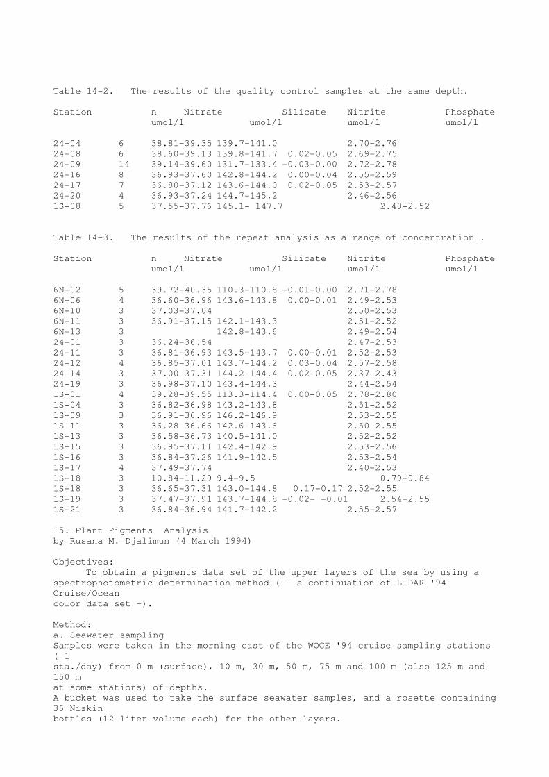
Table 14-2. The results of the quality control samples at the same depth.
Station n Nitrate Silicate Nitrite Phosphate
umol/l umol/l umol/l umol/l
24-04 6 38.81-39.35 139.7-141.0 2.70-2.76
24-08 6 38.60-39.13 139.8-141.7 0.02-0.05 2.69-2.75
24-09 14 39.14-39.60 131.7-133.4 -0.03-0.00 2.72-2.78
24-16 8 36.93-37.60 142.8-144.2 0.00-0.04 2.55-2.59
24-17 7 36.80-37.12 143.6-144.0 0.02-0.05 2.53-2.57
24-20 4 36.93-37.24 144.7-145.2 2.46-2.56
1S-08 5 37.55-37.76 145.1- 147.7 2.48-2.52
Table 14-3. The results of the repeat analysis as a range of concentration .
Station n Nitrate Silicate Nitrite Phosphate
umol/l umol/l umol/l umol/l
6N-02 5 39.72-40.35 110.3-110.8 -0.01-0.00 2.71-2.78
6N-06 4 36.60-36.96 143.6-143.8 0.00-0.01 2.49-2.53
6N-10 3 37.03-37.04 2.50-2.53
6N-11 3 36.91-37.15 142.1-143.3 2.51-2.52
6N-13 3 142.8-143.6 2.49-2.54
24-01 3 36.24-36.54 2.47-2.53
24-11 3 36.81-36.93 143.5-143.7 0.00-0.01 2.52-2.53
24-12 4 36.85-37.01 143.7-144.2 0.03-0.04 2.57-2.58
24-14 3 37.00-37.31 144.2-144.4 0.02-0.05 2.37-2.43
24-19 3 36.98-37.10 143.4-144.3 2.44-2.54
1S-01 4 39.28-39.55 113.3-114.4 0.00-0.05 2.78-2.80
1S-04 3 36.82-36.98 143.2-143.8 2.51-2.52
1S-09 3 36.91-36.96 146.2-146.9 2.53-2.55
1S-11 3 36.28-36.66 142.6-143.6 2.50-2.55
1S-13 3 36.58-36.73 140.5-141.0 2.52-2.52
1S-15 3 36.95-37.11 142.4-142.9 2.53-2.56
1S-16 3 36.84-37.26 141.9-142.5 2.53-2.54
1S-17 4 37.49-37.74 2.40-2.53
1S-18 3 10.84-11.29 9.4-9.5 0.79-0.84
1S-18 3 36.65-37.31 143.0-144.8 0.17-0.17 2.52-2.55
1S-19 3 37.47-37.91 143.7-144.8 -0.02- -0.01 2.54-2.55
1S-21 3 36.84-36.94 141.7-142.2 2.55-2.57
15. Plant Pigments Analysis
by Rusana M. Djalimun (4 March 1994)
Objectives:
To obtain a pigments data set of the upper layers of the sea by using a
spectrophotometric determination method ( - a continuation of LIDAR '94
Cruise/Ocean
color data set -).
Method:
a. Seawater sampling
Samples were taken in the morning cast of the WOCE '94 cruise sampling stations
( 1
sta./day) from 0 m (surface), 10 m, 30 m, 50 m, 75 m and 100 m (also 125 m and
150 m
at some stations) of depths.
A bucket was used to take the surface seawater samples, and a rosette containing
36 Niskin
bottles (12 liter volume each) for the other layers.

b. Filtration and extraction.
About 3 - 10 liters of seawater from each depth was filtered with Nuclepore
filter (47mm
diameter, 0.4 µm pore size from COSTAR Corp., Cambridge, Massachusetts, USA) to
trap the phytoplanktons. The filter(s) then soaked in the 6 ml of solvent N,N-
dimethylformamide (DMF, from WAKO PURE CHEMICAL INDUSTRIES, Ltd., Japan)
solution for 24 hours to extract the pigments.
c. Absorbance measurement and determination of pigments concentration.
By using a Shimazu UV-2200 spectrophotometer, the absorbance (OD units) of
extracted
solution of samples were measured at 603 nm, 625 nm, 647 nm, 664 nm, and 703 nm-
wavelength. The concentration of pigments (chlorophyll a and chlorophyll b) were
then
determined with formulae built by Moran (1981).
Results and discussion:
The concentration of each sample are shown n Table 15-1.
a. In some stations, where the sea states were heavy, sometimes there was no
rosette
seawater sampling for upper sea level. In stations of section PR24-2, where a
smaller
rosette (12 Niskin bottles of 5 liter volume) was used, sample was taken only
from the
surface (0 m) seawater.
b. samples from deeper layers were filtered faster than the upper ones. This
must be due to
the different concentrations of phytoplanktons at those layers.
c. The concentration of chlorophyll a and chlorophyll b were shown in the table.
Chlorophyll a was concentrated mostly at 50 - 100 meters depth, and the
concentration
became higher around the sea at the triangle formed by stations 6N-9, 6N-15 and
PR1S.
At most stations, no chlorophyll b was found at 0-30 meters of sea level except
for station
PR1S-13, and the concentration distribution pattern of chlorophyll b was similar
to one of
chlorophyll a.
Table 15-1. The Chlorophyll a and chlorophyll b concentration along the section
6N, PR24
and PR1S in 1994 KAIYO WOCE cruise.
Depth Niskin Bottle # Sample Volume Chl. a Chl. b
meter liter mg/m3 mg/m3
Station 6N-1
surface Bucket 10.0 0.051 -0.004
10 30 9.0 0.043 -0.000
30 28 9.0 0.067 0.001
50 27 9.0 0.132 0.010
100 25 9.0 0.165 0.048
Station 6N-4
surface Bucket 10.0 0.065 -0.003
10 36 9.0 0.061 -0.001
30 34 10.0 0.060 0.001
50 33 9.5 0.093 0.005
100 27 10.0 0.213 0.065

Station 6N-8
surface Bucket 10.0 0.117 -0.006
30 35 9.5 0.105 -0.001
50 34 10.0 0.096 0.001
100 32 9.5 0.232 0.045
Station 6N-11
surface Bucket 10.0 0.059 -0.004
30 35 10.0 0.061 0.004
50 34 9.0 0.183 0.026
75 33 9.0 0.342 0.076
100 32 9.5 0.263 0.058
125 31 10.0 0.169 0.061
150 30 9.0 0.054 0.007
Station 6N-14
surface Bucket 10.0 0.051 0.001
100 36 8.5 0.238 0.070
Station PR24-3
surface Bucket 10.0 0.040 -0.001
30 36 9.0 0.044 0.001
50 35 9.0 0.097 0.029
75 34 9.0 0.215 0.064
100 33 6.5 0.126 0.047
Station PR24-9
surface Bucket 10.0 0.213 -0.000
10 36 8.0 0.198 0.002
30 34 9.5 0.247 0.002
50 33 9.0 0.299 0.006
75 32 9.0 0.134 0.029
100 31 9.5 0.054 0.007
Station PR24-15
surface Bucket 10.0 0.171 0.002
10 36 8.0 0.162 0.002
30 34 9.5 0.199 -0.003
50 33 9.0 0.401 0.026
75 31 9.5 0.237 0.088
100 30 9.0 0.107 0.033
Station PR24-2-4
surface Bucket 10.0 0.172 -0.008
Station PR24-16
surface Bucket 10.0 0.116 -0.001
10 36 7.7 0.125 0.003
30 34 8.3 0.156 0.001
50 33 8.0 0.673 0.117
75 32 8.0 0.242 0.071
100 31 9.0 0.126 0.036
Station PR1S-1
surface Bucket 10.0 0.144 -0.004
10 36 8.0 0.127 -0.002
30 34 8.0 0.197 0.006
50 33 6.0 0.355 0.042
75 32 9.0 0.271 0.049
100 31 8.0 0.050 0.004
Station PR1S-8
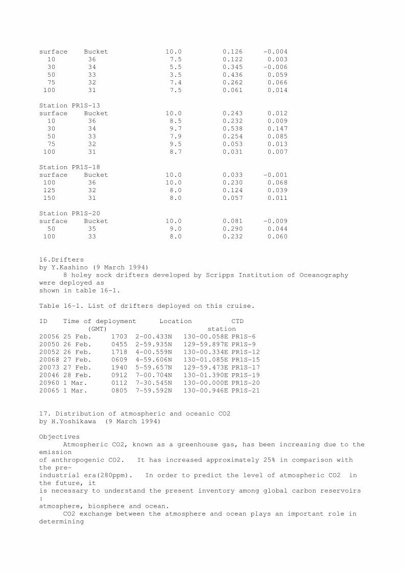
surface Bucket 10.0 0.126 -0.004
10 36 7.5 0.122 0.003
30 34 5.5 0.345 -0.006
50 33 3.5 0.436 0.059
75 32 7.4 0.262 0.066
100 31 7.5 0.061 0.014
Station PR1S-13
surface Bucket 10.0 0.243 0.012
10 36 8.5 0.232 0.009
30 34 9.7 0.538 0.147
50 33 7.9 0.254 0.085
75 32 9.5 0.053 0.013
100 31 8.7 0.031 0.007
Station PR1S-18
surface Bucket 10.0 0.033 -0.001
100 36 10.0 0.230 0.068
125 32 8.0 0.124 0.039
150 31 8.0 0.057 0.011
Station PR1S-20
surface Bucket 10.0 0.081 -0.009
50 35 9.0 0.290 0.044
100 33 8.0 0.232 0.060
16.Drifters
by Y.Kashino (9 March 1994)
8 holey sock drifters developed by Scripps Institution of Oceanography
were deployed as
shown in table 16-1.
Table 16-1. List of drifters deployed on this cruise.
ID Time of deployment Location CTD
(GMT) station
20056 25 Feb. 1703 2-00.433N 130-00.058E PR1S-6
20050 26 Feb. 0455 2-59.935N 129-59.897E PR1S-9
20052 26 Feb. 1718 4-00.559N 130-00.334E PR1S-12
20068 27 Feb. 0609 4-59.606N 130-01.085E PR1S-15
20073 27 Feb. 1940 5-59.657N 129-59.473E PR1S-17
20046 28 Feb. 0912 7-00.704N 130-01.390E PR1S-19
20960 1 Mar. 0112 7-30.545N 130-00.000E PR1S-20
20065 1 Mar. 0805 7-59.592N 130-00.946E PR1S-21
17. Distribution of atmospheric and oceanic CO2
by H.Yoshikawa (9 March 1994)
Objectives
Atmospheric CO2, known as a greenhouse gas, has been increasing due to the
emission
of anthropogenic CO2. It has increased approximately 25% in comparison with
the pre-
industrial era(280ppm). In order to predict the level of atmospheric CO2 in
the future, it
is necessary to understand the present inventory among global carbon reservoirs
:
atmosphere, biosphere and ocean.
CO2 exchange between the atmosphere and ocean plays an important role in
determining

the level of atmospheric CO2. The difference in partial pressure of CO2
between the
ocean and the atmosphere (delta-pCO2 ) is the driving force for air/sea CO2
exchange. During
the WOCE cruise, measurements of pCO2 were (will be) made to study the
interannual
change CO2 outflux.
Method
Measurements of the CO2 concentration in the background air and the air
equilibrated
with seawater were made using the MRI CO2 measuring system.
Air sample was taken from the top of the bridge at a flow rate of 15 l/min.
Sea water was
taken from the bottom of ship continuously, and introduced into the
equilibrator.
Equipment
We use the non-disersive infrared gas analyzer (BINOS 4, Germany) to
determine the
CO2 concentration. CO2 concentration will be reported based on the WMO X85
mole
fraction scale.
Result
Figure 17-1* is distribution of atmospheric and oceanic CO2 (preliminary
data). The CO2
trend upward along PR24. This could be caused by the strong upwelling in the
eastern
equatorial Pacific, and two competitive processes: biological activity and
temperature effect.
18. C-14 sample drawing
by M. Aoyama (6 March 1994)
All samples were drawn from 12 liter Niskin bottles followed that for
oxygen. Samples
were drawn into glass vials of ca. 200 ml. These were rinsed before filling and
overflowed
by two to three time of the vial volume. Then 0.2 ml of saturated HgCl2 solution
was
added and subsequently rubber cap and aluminum cap were clamped to vials.
Replicate samples were drawn from the same rosette bottle at all sampling
depths. The
sampling depths of radiocarbon samples shallower than 1000 meters were 30, 50,
100,
150, 200, 300, 400, 600, 800, 1000. Below 1000 meters the sampling interval was
500
meters.
19. Weather and sea condition
by E. Ukekura ( Chief officer, R/V kaiyo) and M. Aoyama
The 3 hourly weather records are tabulated in Table 19-1.
The Northeasterly trade wind was dominant and the weather was almost fine
except
sporadic heavy shower in the interested area during the cruise. It was usual
weather in the
western tropical Pacific and was almost easy.
The air temperature showed the diurnal variation, namely high in afternoon up to
28 to 30
degree Celsius low in evening to morning at 27 to 28 degree Celsius in fine day.
When the
heavy shower was observed, the air temperature decreased to 24 to 25 degree
Celsius.
The atmospheric pressure showed the semi-diurnal variation. The higher
pressure was
observed at 0000-0100 UTC and 1300-1500 UTC every day and the lower pressure
was
observed at 0600-0700 UTC and 1800-2000 UTC every day. The amplitude of the
semi-
diurnal variation was 2 to 3 hPa.
During the observation along section 6N, the wind speed was around 10 m/s
and the wave
height was around 2 meters. As the ship heads for south, the wind speed
decreased to 5 -
8 m/s, the wind direction become NNE to NNW and the wave height decreased to
around 1
meters. The Northeasterly trade wind becomes strong up to 10 to 15 m/s on 28
February
and 1 March at the stations from PR1S-17 and PR1S-21, producing the large wave
height
of 2.5 meters. At the same time, the satellite IR image by GMS Himawari observed
the
week low moving westerly at 5 degree North, 165 degree East. Since the westerly
moving
low was predicted to come near our interested area and the sea condition had
become hard
to operate the CTD/Rosette , R/V Kaiyo headed for Palau Is. in the evening on 1
March.
20. Problems
by K Muneyama and M. Aoyama
We had 4 times of a disconnection of seacable. We spent 2 to 3 hours for
fixing the disconnections. The most serious problem we encountered in this
cruise was a total loss of a cast data at one occasion. We monitored the
profiles of temperature,salinity and dissolved oxgen, and also watched reading
of CTD pressure. After CTD/rosette was retrieved on the deck, an operator has
intended to copy the file. Then he noticed that a size of datafile was zero
byte, however the header file had been stored. The cause of this accident might
be a computer virus, or a software bug,or an accidental mechanical failure.
But we still could not elucidate the cause.
We could not retrieve the 2 Aanderaa currentmetre moorings deployed in
October 1992 placed between Talaud and Morotai islands,eventhough each acoustic
releaser had worked normally.
This R/V Kaiyo is designed to have a wide open deck for setting up many
ship
boarding containers, and consequently rather small fixed laboratory space.
We provided a ship boarding container for a water sampling room with two air
conditioners. The CTD/rosette water sampler itself is narrowly kept in the
space, however operations for water sampling might be affected to be less
convenient and less efficient.
Dissolve Oxygen measurement of bottle samples has required us the
precisely controled
room temperature, however, the room temperature of the laboratory varied at 18
to 21 deg C in this occation. We need to have a better control of the room
temperature for more difficult analysis.
We have detected "the shed wake". This error could not be corrected.
21. REPORT ON CTD SYSTEM PERFORMANCE
RV KAIYO, WOCE 94 CRUISE, SBE 911plus Serial Number 09P8010-0319

By Richard Baumann, Technical Operations Manager, SEA-BIRD Electronics, Inc.,
Bellevue, WA USA (3 March 1994)
This report is a analysis of the performance of a SBE 911plus CTD system
during a WOCE
hydrography cruise on the Research Vessel KAIYO. The CTD system and vessel
belong
to the Japan Marine Science and Engineering Center (JAMSTEC). At their request,
Mr. R.
Baumann from Sea-Bird Electronics, Inc. (SBE) participated in the cruise to
help with any
problems that occurred with the CTD and to give his observations on the
operation and
performance of the CTD system.
This report was written during the cruise and is divided into four parts.
The first part is a brief description of the CTD system followed by a discussion
of the steps that SBE recommends be followed in the operation of the CTD and
the
subsequent analysis and calibration of the CTD data to achieve WOCE accuracy
specifications. The second part of the report is an analysis of the accuracy of
the data obtained during the cruise. The third section is a discussion of the
general operation of the CTD during the cruise with some examples of the data
taken. The fourth part is a brief conclusion.
PART I THE SBE 9plus CTD
The primary CTD underwater unit used for this cruise was a SBE 9plus, S/N
09P8010-
0319. This CTD has dual temperature and conductivity sensors and a 15,000 psia
Digiquartz pressure sensor. The main CTD and sensor housings are titanium
giving the
CTD system a depth capability of 10,500 meters. The CTD was delivered to
JAMSTEC in
October of 1993. The serial numbers and the factory calibration dates for the
sensors
mounted on this CTD as used on the cruise are:
Primary temperature sensor S/N 1462 calibrated 28 September 1993
Primary conductivity sensor S/N 1045 calibrated 09 September 1993
Secondary temperature sensor S/N 1465 calibrated 28 September 1993
Secondary conductivity sensor S/N 1174 calibrated 22 September 1993
Paroscientific Inc. 15,000 psia pressure sensor calibration dated 24 September
1993
Experience has shown that the calibration of the pressure sensor will
change as a slow drift
of offset with time (approximately 1 to 2 dbar per year). Before a cast the
pressure reading
on deck should be observed and this value used as an offset to zero the pressure
reading in
air.
The temperature sensors will tend to drift via a slowly increasing offset with
time. This
offset (which will be nominally the same at all temperatures) may be of either
sign and will
tend to be at a constant rate (from 0 to +/- 0.010 deg C per year) over periods
of years.
The temperature sensors on this CTD were calibrated monthly for a period of 9
months
before they were supplied with the CTD system. This is sufficient time to
determine their
initial drift histories and allows their drift to be predicted with reasonable
accuracy for
periods of months before they need to be calibrated to verify the actual drift
since their last
calibration. The drift histories of the temperature sensors on this CTD are
included as
Figures 21-1* and -2* in this report. Based on an examination of these
histories it is felt that
as of 15 February 1994 both of these sensors will be reading 0.0028 deg C low
(as
referenced to the 28 September 1993 calibration coefficients used at sea) and
that an offset
correction of +0.0028 deg C should be added to the factory calibrations for
each of these
sensors. This prediction of temperature sensor drift is supported by an
analysis in part
two of this report where it is shown that the two temperature sensors agree with
each to
within about 0.0006 deg C throughout the cruise.
Conductivity sensors tend to drift with use in two ways. One is a small
background drift
that can be considered uniform with time. This is thought to be a measure of
the gradual
fouling and aging of the platinum electrodes. Superimposed on this may be
larger fouling
events that are related to contact with biological material in the water as it
passes through
the cell. This type of fouling is seen as a larger shift in the conductivity
measurement
(towards lower conductivity) on top of the slower background drift. Rinsing
the
conductivity cell with a 2 to 5% solution of Triton detergent after each cast
will help
minimize the drift experienced during use. The error in the conductivity sensor
is a
function of the conductivity value and the correction is a slope adjustment to
conductivity.
After corrections have been made for the temperature and pressure sensors the
calculation
of the error in the conductivity measurement can be determined in two ways.
One is based
upon an analysis of the independent measurement of salinity from insitu water
samples
collected during the cruise. The other method is to have the conductivity
sensor calibrated
after the cruise and to base a correction on the observed drift. The first
method has the
advantage that it will tend to catch the aperiodic fouling events where the
second method
will average them over the duration of the cruise. An analysis of the CTD and
Autosal
salinity data from this cruise is given in the second part of this report.
To insure that the WOCE accuracy specifications are met it is necessary to
regularly
calibrate the temperature and conductivity sensors on the SBE 9plus CTD. SBE
would
recommend that this be at least once a year and for the highest accuracy,
calibrations
before and after each cruise would be appropriate. Regular calibrations will
also establish

histories of the performance of the temperature and conductivity sensors. These
histories
allow the drift of the temperature sensor to be predicted and verify the
operational
characteristics of the conductivity sensor.
The discussion above on calibrations is concerned with the static accuracy
of the CTD
system. This is the accuracy that the CTD and its sensors can obtain in a
uniform,
homogenous environment such as a calibration bath. The ocean, however, is not a
uniform
environment and the dynamic accuracy (the ability of the CTD to measure a
parameter as it
changes) of the CTD system must be considered. A full discussion of this
subject is
beyond the scope of this report but it is important to recognize that during
data processing
the appropriate corrections should be made for those errors that can be
corrected (cell
thermal mass, misalignment of temperature and conductivity data) and that the
data
containing errors that can not be corrected (shed wakes) be eliminated from
further data
processing. In part two of this report the analysis of data will be done in
deeper water
where gradients (and the resulting dynamic errors) are small.
The SBE 9plus as used in the cruise was removed from its factory supplied
cage and
mounted vertically in the middle of a General Oceanics Model 1016 36 position,
12 liter,
rosette water sampler. As mounted the CTD sensors had a good view of
unobstructed
water during down cast operation. SBE recommends that the CTD be lowered at a
drop
speed of between 1.0 and 1.5 meter per second. The CTD was deployed from an A-
frame
at the stern of the KAIYO and because of operational constraints was lowered at
a descent
rate of 0.5 meter per second (m/s) until a depth of 200 meters at which time
the rate was
increased to 1.5 m/s until within 200 meters of the bottom when the rate was
slowed to 0.5
m/s. During CTD operations the bow of the ship is normally turned into the wind
to help
maintain a stationary position during the cast. In this orientation the
predominant ship
motion is pitch which modulates the descent rate when the CTD is deployed over
the stern.
The coupling of the pitch of the ship with the descent rate can cause the CTD
to slow
down, stop or even reverse directions and move up towards the surface. When
this
happens the water that has been entrained by the rosette will continue to move
at the
original descent rate and will cause a mixing of the water being measured by the
CTD
sensors. This will contaminate the data to an extent where this data must be
removed from
future analysis. This problem is most severe in the upper ocean where vertical
gradients

are the largest but can also affect data in the deep ocean. Examples of this
type of data are
given in part three of this report.
PART II ACCURACY ANALYSIS OF THE SBE 9plus CTD
The CTD used for this cruise was equipped with dual temperature and
conductivity
sensors. This feature allows for the comparison of data from each sensor pair
as a check
of data quality. This check is best performed below the thermocline where
errors
associated with the strong gradients of temperature and salinity are at a
minimum.
COMPARISON OF TEMPERATURE SENSORS.
Table 21-1. contains a comparison of the temperatures reported by the
primary (T0) and
secondary (T1) sensors at two depths for selected casts throughout the cruise.
These data
points represent 10 second averages obtained when the CTD was stopped to collect
insitu
water samples. The temperatures in this table are as calculated using the 28
September
1993 calibration coefficients. The data show that the primary sensor is
reading
approximately 0.0006 deg C higher than the secondary sensor. This agreement
supports
the idea that both sensors have continued to drift at the rates predicted in
the first part of
this report. A post calibration of the sensors would determine the actual
adjustments
needed to bring these measured temperatures to the true temperature. The data
at 2000 dbar
show a higher variance then the data at 3000 dbar; which can be related to the
steeper
temperature gradient at that depth and the subsequent mixing of the water as the
CTD/water
sampler is stopped to collect a water sample (where the motion is that imparted
to the
instrument package by ship motion). With the good agreement shown between
sensors
either sensor could be used for subsequent data analysis.
COMPARISON OF SALINITY CALCULATED WITH PRIMARY AND SECONDARY
SENSOR PAIRS.
Table 21-2. contains a comparison of the salinity calculated using the
primary (S0) and
secondary (S1) sensor pairs at two depths for selected casts throughout the
cruise. These
data points represent 10 second averages obtained when the CTD was stopped to
collect
insitu water samples. Salinity was calculated using the data as recorded by
the SEASAVE
program; no further data processing was performed and no corrections have been
made to
the calibration coefficients. The data show good agreement with the primary
sensor pair
giving a salinity which is slightly larger (<0.001) than the secondary salinity
during the

first part of the cruise but which varies as the cruise progresses. Unlike
temperature whose
calibration should not significantly change during a 1 month cruise,
conductivity sensor
calibrations will change as the cell is used. A more complete description of
drift of a
conductivity sensor is contained in the first part of this report. With the
agreement
between salinity either pair could be used for subsequent data analysis.
COMPARISON OF THE DEEP SALINITY DATA BETWEEN CASTS
In the deep water (4000 dbar and below) of the area of the Pacific Ocean
where this survey
is located it is not expected that the salinity will vary significantly either
with location or
depth. If this assumption is true than the salinity values observed at these
depths can be
used to monitor the calibration drift of the conductivity sensors. Table 21- 3
is a
compilation of 10 second average CTD (primary sensor pair) salinity values for
all water
sample locations between 4000 and 5000 dbars. The salinity values in this table
have been
adjusted by -0.0029 psu from the values obtained with the factory calibration
coefficients
to reflected the predicted drift correction of +0.0028 deg C applied to the
temperature
sensor. The table shows agreement to within 0.0005 psu for depths between
4250 and
5000 for casts K6N021 through K6N121. After this cast there appears to be a
trend
towards lower salinity values with casts K6N131 being somewhat between and casts
K6N141 thru K1S122 being about 0.001 PSU lower than the initial values. This is
followed by casts K1S132 thru K1S182 being about 0.0015 lower than the initial
values.
The behavior is consistent with a conductivity cell which is gradually shifting
calibration as
it is used. Stations K6N091 and K1S172 were at the same location and the
approximate
0.0015 difference in salinity between the two stations supports the analysis
given here. At
the time of this report was written the Autosal salinity values were only
available through
station K24202. When this information and the post calibrations are available
there should
be sufficient information to determine the actual calibration of the
conductivity sensor at the
various stations.
Table 21- 3. clearly illustrates the ability of the SBE 911plus CTD
system to resolve
salinity to better than 0.0003 psu in the deep water where gradients (and the
resulting
dynamic errors) are low. Figure 21- 3. (which is discussed below) graphically
presents
this level of CTD precision for data points at or below 4000 dbar for stations
up to
K24031. Figure 21- 4 in the third section of this report shows the noise level
of the
unaveraged 24 hz salinity data in deep water to be about 0.001 psu.
COMPARISON OF CTD SALINITY WITH AUTOSAL SALINITY

Table 21- 4 lists the difference between CTD salinity (S0) and salinity
calculated from
insitu water samples between 4000 and 5000 meters for those casts for which
Autosal
salinity was available when this report was written. Figure 21- 3 shows this
data along
with the data from Table 21- 3 in a graphical format. It is easily seen that
the variance of
the averaged CTD salinity is much less than the salinity measured from the
insitu water
samples. Where Table 21- 3 suggests a slow change in the calibration of the
conductivity
sensor this trend is not obvious in the water bottle data available at the time
this report was
written.
PART III GENERAL PERFORMANCE AND EXAMPLES OF SBE 9plus CTD DATA
In part two of this report data were presented that represented 10 second
averages obtained
when the CTD was held at a depth to obtain a insitu water sample. Figure 21- 4
is a sample
of the full rate 24 hz data from which these averages were calculated. This
data is as
recorded by the SEASAVE program without subsequent post processing. The noise
level
for temperature ia less than 0.001 deg C and for salinity is approximately
0.001 psu
respectively. This data also shows the 0.1 dbar jitter in the pressure
measurement which is
removed by lowpass filtering pressure with a 0.15 second time constant. The
increased
variance of the signal during periods of low or negative descent rate is cause
by mixing
induced by the CTD/water sampler along the small local temperature gradient.
The
secondary sensor pair gives comparable data.
Figure 21- 5* is an example of shed wakes in the data that occur when the
motion of the
CTD/water sampler through the water column slows and allows the entrained water
to
overtake the sensor package and be measured as if it were new, undisturbed
water. The
data during these periods can not be easily corrected and should be removed from
subsequent data analysis.
PART IV CONCLUSIONS
Based on the evidence presented here this it appears that after the zero
offset of the pressure
sensor is adjusted for and a offset correction is added for the predicted drift
of the
temperature sensors, the CTD initially was giving a salinity which was about
0.002 psu
low of the average insitu samples. As the cruise progressed this difference
increased to
about 0.0035 psu.
In summary, the SBE 911plus CTD system used on this cruise showed the
same high

quality data which are typical of results obtained elsewhere. Temperature,
salinity, and
pressure that are within the WOCE requirements can be obtained from this data
set when
careful attention is paid to the calibration of the sensors. It is highly
recommended that the
temperature and conductivity sensors used be calibrated after the cruise to
confirm the
corrections made at sea.
Acknowledgements
by M. Aoyama (10 March 1994)
The cruise participants thanks "very very much" to the captain H. Tanaka
of R/V Kaiyo
and the 26 crew for their powerfull and heartfull supports during the cruise.
The deck crew
for the CTD/Rosette operation could handle the big Rosette ( of 2.2 meters
diameter, 1.8
meters height and almost 1000 Kg weights ) safely whenever the weather/sea
condition
becomes hard. The engineers/oilers also could operate the CTD winch well. The
engineers
and the oilers made many parts/materials to refine/ repair the
instruments/machines for the
observations. The boatswain and abledemans made the fine shellter for the
meteorological
observations for WOCE cruise. During the mooring, many of the crew supported
the deck
work and they often gave us the good comments/suggestions for the preparation
of
mooring. The radio operators and the cooks supported our living in the ship
heartfully.
During the pre-cruise stage, three analyst groups of salinity, dissolved
oxygen and
nutrients were largely supported by Mr. M . Mitsuya and Ms. H. Hamabe, the two
staffs of
the ocean-chemistry laborotory at Ocean Reseach Department, JAMSTEC.
The director T. Nakanishi at the Ocean Research Department , JAMSTEC and the
members at the Planning Department did the good arrangements to execute this
cruise in
the view point of the fund and on-shore laboratory space.
Mr. I. Asanuma, the chief scientist at LIDAR cruise carried out just before
this cruise,
helped us much for the good on deck arrangments of the container laboratories,
wiches
and railway of the Rosette operation.
This cruise have executed on the basis of the collaborative ocean research
framework
between Japan Marine Science and Technology Center (JAMSTEC) and Badan Pengajian
Dan Penerapan Teknologi (BPPT) since 1992.
This cruise is funded by the Japan-WOCE program with the Science and
Technology
Agency of Japan under the special coordinated funds and largery by some of the
projects of
JAMSTEC.
* All figures shown in PDF file.