crc-21-01 memorandum to: from
TRANSCRIPT
CRC-21-01 February 2, 2021
MEMORANDUM TO: Coastal Resources Commission FROM: Mike Lopazanski SUBJECT: Proposed Amendments to Ocean Hazard AEC - Beach Management Plans At the November 2020 CRC meeting, Staff outlined for the Commission a strategy for the development of local and subregional Beach Management Plans to replace both the Development Line and the Static Line Exception. Also outlined were additional provisions for regulatory relief associated with CRC-approved beach management plans and suggestions for further streamlining and simplifying the Ocean Hazard AEC rules. The strategy was based on Commission discussion of the recommendations of the Subcommittee on Development Line Implementation and Division staff. The proposed rule amendments incorporate the Commission’s guidance to:
• Retain State oversight in areas where beach nourishment projects are installed; • Reflect increased regulatory flexibility for construction setbacks where beach
communities demonstrate a local commitment to maintaining beach nourishment projects;
• Prevent beach nourishment projects from becoming a stimulus for new development in unsuitable areas;
• Minimize seaward encroachment of new or expanded structures; • Utilize the landward-most adjacent neighbor rule to limit seaward encroachment provided
that there is flexibility to address unique circumstances (curved shorelines, development around cul-de-sacs, or peculiar lot configurations) utilizing a sight-line or average line of construction approach.
Below is a summary of the more significant proposed amendments.

Beach Management Plans 15A NCAC 7H .1200 & .1202 Beach Management Plan Approval Procedures
• Replaces/improves Static Line Exception Process • Eligible for approval after initial beach fill project • Covers all pre-project vegetation lines within jurisdiction of plan • Provides Commission with a summary of past and future beach nourishment plans • Historic & projected volumetric losses from erosion/storms (NEW) • Anticipated maintenance triggers (NEW) • Long-term volumetric sand needs (NEW) • Annual monitoring protocols (NEW) • Additional identification of financial resources specifics (NEW) • Opportunity for public input on plan at local level, for consideration by CRC (NEW)
15A NCAC 7J .1202 Review of Beach Management Plan Approval Request
• Petitioner to provide a summary of the beach management plan to CRC (NEW) • DCM will provide the CRC a review and recommendation to grant or deny the request (NEW)
15A NCAC 7J .1203 Procedures for Approving A Beach Management Plan
• Remove provision for third parties to provide written/oral comments on the request at the CRC meeting (NEW)
15A NCAC 7J .1204 Review of Beach Management Plans
• Same provision for five-year review and reauthorization of beach management plans as Static Line Exception.
• The five-year progress report is prepared and presented to CRC by the local government (NEW)
• DCM will review and provide CRC with a recommendation on the reauthorization request (NEW)
• Remove provision for third parties to written/oral comments on the request at the CRC meeting (NEW)
15A NCAC 7J .1205 Revocation and Expiration of Beach Management Plan Approval
• No significant changes 15A NCAC 7J .1206 Local Govts and Communities with Approved Beach Management Plans
• No significant changes Enhanced Exceptions 15A NCAC 7J .0306 General Use Standards for Ocean Hazard Areas
• Structures 10,000 square feet or greater require a minimum setback of 120 feet or 60 times the erosion rate. (Already a benefit of Static Line Exception)
• Replacement of all structures 10,000 square feet or less require minimum setback of 30 times the erosion rate, with conditions (NEW)
• Replacement of structures 10,000 sf or less (with conditions) now allowed for structures built after 2009 in communities with a CRC-approved beach management plan (NEW)
• Under CRC-approved beach plan, an exception for small structures would be allowed where proposed structures cannot meet graduated setback from the Vegetation Line.
Other Proposed Changes 15A NCAC 7H .0104 Application of Erosion Rate Setback Factors
• Proposed for repeal as the provision (addressing lots created prior to 1979) are effectively the same as those in 15A NCAC 7H .0309(b) which allow for similar development of a structure no greater than 2,000 square feet.
• Repeal will remove provisions allowing for the use of erosion rates at the time the lot was platted in determining setbacks. While seldom used, this language has caused confusion for Staff and Local Permitting Officers.
15A NCAC 7H .0304 AECs Within Ocean Hazard Areas
• “First Line of Stable and Natural Vegetation” changed to “Vegetation Line” 15A NCAC 7H .0305 Definition and Description of Landforms
• “Static Vegetation Line” changed to “Pre-Project Vegetation Line” 15A NCAC 7H .0306(a)(6)
• Clarifying and simplify rule language related to the siting of structures in relation to primary and frontal dunes.
15A NCAC 7H .0306(b)
• Consolidating rules (moved) related to dune alteration in 15A NCAC 7H .0308(b)(1). 15A NCAC 7H .0306(k)
• Amending the required permit condition that requires structures to be relocated or removed within two years of becoming imminently threatened to eight years. This change mirrors provisions for the management of temporary erosion control structures (sandbags).
15A NCAC 7H .0308 Specific Use Standards for Ocean Hazard Areas
• “First Line of Stable and Natural Vegetation” changed to “Vegetation Line” • Relocated 15A NCAC 7H .0306(b)
15A NCAC 7H .0309 Use Standards for Ocean Hazard Areas: Exceptions
• Allow existing decks greater than 500 square feet to be replaced for safety reason. Per previous CRC approval.
• Allow fill not associated with dune creation per previous CRAC discussion and CRC approval.
• Allow application of pre-1979 lot provisions for small structure exceptions to apply in Inlet Hazard and Unvegetated Beach AECs (15A NCAC 07H.0309(b))
• “Static Vegetation Line” changed to “Pre-Project Vegetation Line”
15A NCAC 7H .0310 Use Standards for Inlet Hazard Areas • “First Line of Stable and Natural Vegetation” changed to “Vegetation Line”
15A NCAC 7J .1300 Development Line Procedures
• Repeal I look forward to discussing these proposed changes and receiving further guidance as Staff continue to develop these rules.
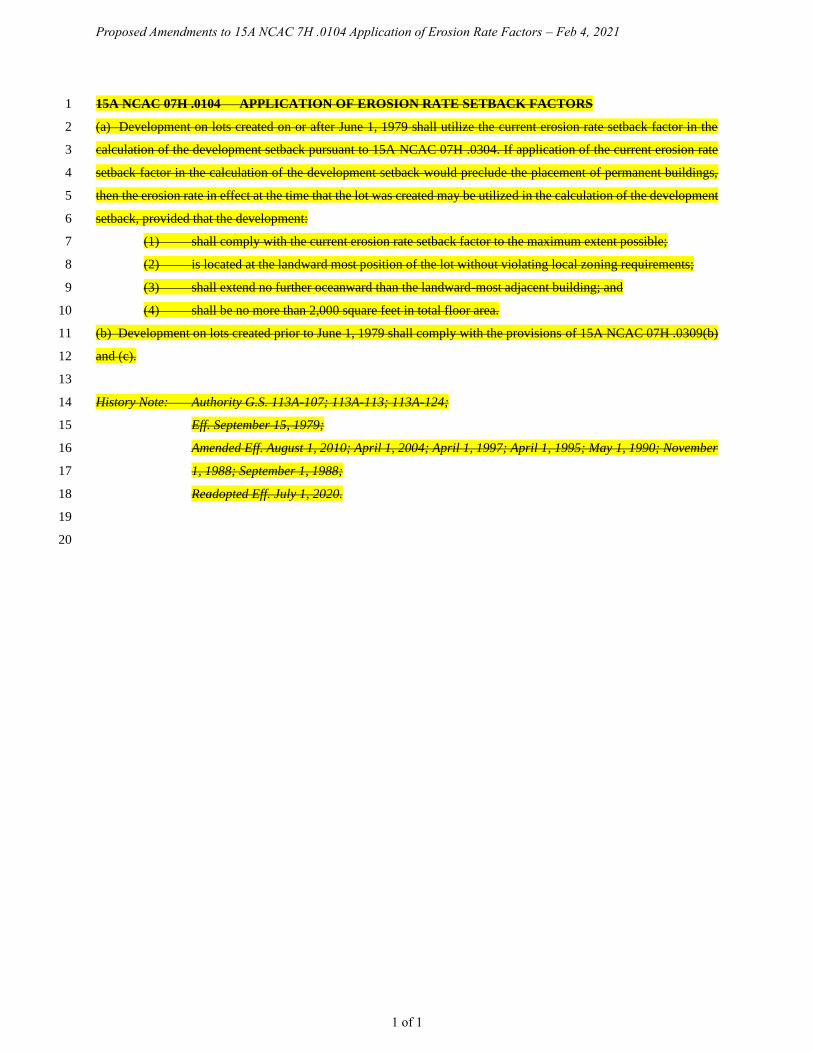
Proposed Amendments to 15A NCAC 7H .0104 Application of Erosion Rate Factors – Feb 4, 2021
1 of 1
15A NCAC 07H .0104 APPLICATION OF EROSION RATE SETBACK FACTORS 1
(a) Development on lots created on or after June 1, 1979 shall utilize the current erosion rate setback factor in the 2
calculation of the development setback pursuant to 15A NCAC 07H .0304. If application of the current erosion rate 3
setback factor in the calculation of the development setback would preclude the placement of permanent buildings, 4
then the erosion rate in effect at the time that the lot was created may be utilized in the calculation of the development 5
setback, provided that the development: 6
(1) shall comply with the current erosion rate setback factor to the maximum extent possible; 7
(2) is located at the landward most position of the lot without violating local zoning requirements; 8
(3) shall extend no further oceanward than the landward-most adjacent building; and 9
(4) shall be no more than 2,000 square feet in total floor area. 10
(b) Development on lots created prior to June 1, 1979 shall comply with the provisions of 15A NCAC 07H .0309(b) 11
and (c). 12
13
History Note: Authority G.S. 113A-107; 113A-113; 113A-124; 14
Eff. September 15, 1979; 15
Amended Eff. August 1, 2010; April 1, 2004; April 1, 1997; April 1, 1995; May 1, 1990; November 16
1, 1988; September 1, 1988; 17
Readopted Eff. July 1, 2020. 18
19
20
Proposed Amendments to 15A NCAC 7H .0304 AECs Within Ocean Hazard Areas -Feb 4, 2021
1 of 3
15A NCAC 07H .0304 AECS WITHIN OCEAN HAZARD AREAS 1
The ocean hazard AECs contain all of the following areas: 2
(1) Ocean Erodible Area. This is the area where there exists a substantial possibility of excessive erosion 3
and significant shoreline fluctuation. The oceanward boundary of this area is the mean low water 4
line. The landward extent of this area is the distance landward from the first line of stable and natural 5
vegetation line as defined in 15A NCAC 07H .0305(a)(5) to the recession line established by 6
multiplying the long-term annual erosion rate times 90; provided that, where there has been no 7
long-term erosion or the rate is less than two feet per year, this distance shall be set at 180 feet 8
landward from the first line of stable and natural vegetation. For the purposes of this Rule, the 9
erosion rates are the long-term average based on available historical data. The current long-term 10
average erosion rate data for each segment of the North Carolina coast is depicted on maps entitled 11
"North Carolina 2019 Oceanfront Setback Factors & Long-Term Average Annual Erosion Rate 12
Update Study" and approved by the Coastal Resources Commission on February 28, 2019 (except 13
as such rates may be varied in individual contested cases or in declaratory or interpretive rulings). 14
In all cases, the rate of shoreline change shall be no less than two feet of erosion per year. The maps 15
are available without cost from any Local Permit Officer or the Division of Coastal Management on 16
the internet at http://www.nccoastalmanagement.net. 17
(2) Inlet Hazard Area. The inlet hazard areas are natural-hazard areas that are especially vulnerable to 18
erosion, flooding, and other adverse effects of sand, wind, and water because of their proximity to 19
dynamic ocean inlets. This area extends landward from the mean low water line a distance 20
encompassing that area within which the inlet migrates, based on statistical analysis, and shall 21
consider such factors as previous inlet territory, structurally weak areas near the inlet, and external 22
influences such as jetties, terminal groins, and channelization. The areas on the maps identified as 23
Inlet Hazard Areas included in the report entitled INLET HAZARD AREAS, The Final Report and 24
Recommendations to the Coastal Resources Commission, 1978, as amended in 1981, by Loie J. 25
Priddy and Rick Carraway are incorporated by reference and are hereby designated as Inlet Hazard 26
Areas, except for: 27
(a) the location of a former inlet which has been closed for at least 15 years; 28
(b) inlets that due to shoreline migration, no longer include the current location of the inlet; 29
and 30
(c) inlets providing access to a State Port via a channel maintained by the United States Army 31
Corps of Engineers. 32
In all cases, the Inlet Hazard Area shall be an extension of the adjacent ocean erodible areas 33
and in no case shall the width of the inlet hazard area be less than the width of the adjacent 34
ocean erodible area. This report is available for inspection at the Department of 35
Environmental Quality, Division of Coastal Management, 400 Commerce Avenue, 36
Morehead City, North Carolina or at the website referenced in Item (1) of this Rule. 37

Proposed Amendments to 15A NCAC 7H .0304 AECs Within Ocean Hazard Areas -Feb 4, 2021
2 of 3
(3) Unvegetated Beach Area. Beach areas within the Ocean Hazard Area where no stable and natural 1
vegetation is present may be designated as Unvegetated Beach Areas on either a permanent or 2
temporary basis as follows: 3
(a) An area appropriate for permanent designation as an Unvegetated Beach Area is a dynamic 4
area that is subject to rapid unpredictable landform change due to wind and wave action. 5
The areas in this category shall be designated following studies by the Division of Coastal 6
Management. These areas shall be designated on maps approved by the Coastal Resources 7
Commission and available without cost from any Local Permit Officer or the Division of 8
Coastal Management on the internet at the website referenced in Item (1) of this Rule. 9
(b) An area that is unvegetated as a result of a hurricane or other major storm event may be 10
designated by the Coastal Resources Commission as an Unvegetated Beach Area for a 11
specific period of time, or until the vegetation has re-established in accordance with 15A 12
NCAC 07H .0305(a)(5). At the expiration of the time specified or the re-establishment of 13
the vegetation, the area shall return to its pre-storm designation. 14
The Commission designates as temporary unvegetated beach areas those oceanfront areas of Surf 15
City and North Topsail Beach in which the vegetation line as shown on the United States National 16
Oceanic and Atmospheric Administration imagery dated September 17, 2018 was destroyed as a 17
result of Hurricane Florence in September 2018. The designation AEC boundaries can be found on 18
the Division's website at 19
https://files.nc.gov/ncdeq/Coastal%20Management/GIS/unvegetated_beach_aec.pdf. This 20
designation shall continue until such time as the stable and natural vegetation has reestablished, or 21
until the area is permanently designated as an unvegetated beach area pursuant to Sub-Item (3)(a) 22
of this Rule. 23
(4) State Ports Inlet Management Area. These are areas adjacent to and within Beaufort Inlet and the 24
mouth of the Cape Fear River, providing access to a State Port via a channel maintained by the 25
Unites States Army Corps of Engineers. These areas are unique due to the influence of federally-26
maintained channels, and the critical nature of maintaining shipping access to North Carolina's State 27
Ports. These areas may require specific management strategies not warranted at other inlets to 28
address erosion and shoreline stabilization. State Ports Inlet Management Areas shall extend from 29
the mean low water line landward as designated on maps approved by the Coastal Resources 30
Commission and available without cost from the Division of Coastal Management, and on the 31
internet at the website at 32
https://files.nc.gov/ncdeq/Coastal%20Management/GIS/state_port_aec.pdf. 33
34
History Note: Authority G.S. 113A-107; 113A-107.1; 113A-113; 113A-124; 35
Eff. September 9, 1977; 36
Amended Eff. December 1, 1993; November 1, 1988; September 1, 1986; December 1, 1985; 37

Proposed Amendments to 15A NCAC 7H .0304 AECs Within Ocean Hazard Areas -Feb 4, 2021
3 of 3
Temporary Amendment Eff. October 10, 1996; 1
Amended Eff. April 1, 1997; 2
Temporary Amendment Eff. October 10, 1996 Expired on July 29, 1997; 3
Temporary Amendment Eff. October 22, 1997; 4
Amended Eff. April 1, 2020; July 1, 2016; September 1, 2015; May 1, 2014; February 1, 2013; 5
January 1, 2010; February 1, 2006; October 1, 2004; April 1, 2004; August 1, 1998. 6
7
8

Proposed Amendments to 15A NCAC 7H .0305 General Identification and Description of Landforms – Feb 4, 2021
1 of 3
15A NCAC 07H .0305 GENERAL IDENTIFICATION DEFINITION AND DESCRIPTION OF 1
LANDFORMS 2
(a) This Paragraph describes natural and man-made features that are found within the ocean hazard area of 3
environmental concern. 4
(1) Ocean Beaches. Ocean beaches are lands consisting of unconsolidated soil materials that extend 5
from the mean low water line landward to a point where either: 6
(A) the growth of vegetation occurs; or 7
(B) a distinct change in slope or elevation alters the configuration of the landform, whichever 8
is farther landward. 9
(2) Nearshore. The nearshore is the portion of the beach seaward of mean low water that is characterized 10
by dynamic changes both in space and time as a result of storms. 11
(3) Primary Dunes. Primary dunes are the first mounds of sand located landward of the ocean beaches 12
having an elevation equal to the mean flood level (in a storm having a one percent chance of being 13
equaled or exceeded in any given year) for the area plus six feet. Primary dunes extend landward to 14
the lowest elevation in the depression behind that same mound of sand commonly referred to as the 15
"dune trough". 16
(4) Frontal Dunes. The frontal dune is the first mound of sand located landward of ocean beaches that 17
has stable and natural vegetation present. 18
(5) Vegetation Line. The vegetation line refers to the first line of stable and natural vegetation, which 19
shall be used as the reference point for measuring oceanfront setbacks. This line represents the 20
boundary between the normal dry-sand beach, which is subject to constant flux due to waves, tides, 21
storms and wind, and the more stable upland areas. The vegetation line is generally located at or 22
immediately oceanward of the seaward toe of the frontal dune or erosion escarpment. The Division 23
of Coastal Management or Local Permit Officer shall determine the location of the stable and natural 24
vegetation line based on visual observations of plant composition and density. If the vegetation has 25
been planted, it may be considered stable when the majority of the plant stems are from continuous 26
rhizomes rather than planted individual rooted sets. Planted vegetation may be considered natural 27
when the majority of the plants are mature and additional species native to the region have been 28
recruited, providing stem and rhizome densities that are similar to adjacent areas that are naturally 29
occurring. In areas where there is no stable and natural vegetation present, this line may be 30
established by interpolation between the nearest adjacent stable natural vegetation by on-ground 31
observations or by aerial photographic interpretation. 32
(6) Static Vegetation Pre-project Vegetation Line. In areas within the boundaries of a large-scale beach 33
fill project, the vegetation line that existed within one year prior to the onset of project construction 34
shall be defined as the "static vegetation line". “pre-project vegetation line”. The "onset of project 35
construction" shall be defined as the date sediment placement begins, with the exception of projects 36
completed prior to the original effective date of this Rule, in which case the award of the contract 37
Proposed Amendments to 15A NCAC 7H .0305 General Identification and Description of Landforms – Feb 4, 2021
2 of 3
date will be considered the onset of construction. A static pre-project vegetation line shall be 1
established in coordination with the Division of Coastal Management using on-ground observation 2
and survey or aerial imagery for all areas of oceanfront that undergo a large-scale beach fill project. 3
Once a static pre-project vegetation line is established, and after the onset of project construction, 4
this line shall be used as the reference point for measuring oceanfront setbacks in all locations where 5
it is landward of the vegetation line. In all locations where the vegetation line as defined in this Rule 6
is landward of the static pre-project vegetation line, the vegetation line shall be used as the reference 7
point for measuring oceanfront setbacks. A static pre-project vegetation line shall not be established 8
where a static pre-project vegetation line is already in place, including those established by the 9
Division of Coastal Management prior to the effective date of this Rule. A record of all static pre-10
project vegetation lines, including those established by the Division of Coastal Management prior 11
to the effective date of this Rule, shall be maintained by the Division of Coastal Management for 12
determining development standards as set forth in Rule .0306 of this Section. Because the impact of 13
Hurricane Floyd in September 1999 caused significant portions of the vegetation line in the Town 14
of Oak Island and the Town of Ocean Isle Beach to be relocated landward of its pre-storm position, 15
the static pre-project line for areas landward of the beach fill construction in the Town of Oak Island 16
and the Town of Ocean Isle Beach, the onset of which occurred in 2000, shall be defined by the 17
general trend of the vegetation line established by the Division of Coastal Management from June 18
1998 aerial orthophotography. 19
(7) Beach Fill. Beach fill refers to the placement of sediment along the oceanfront shoreline. Sediment 20
used solely to establish or strengthen dunes shall not be considered a beach fill project under this 21
Rule. A "large-scale beach fill project" shall be defined as any volume of sediment greater than 22
300,000 cubic yards or any storm protection project constructed by the U.S. Army Corps of 23
Engineers. 24
(8) Erosion Escarpment. The normal vertical drop in the beach profile caused from high tide or storm 25
tide erosion. 26
(9) Measurement Line. The line from which the ocean hazard setback as described in Rule .0306(a) of 27
this Section is measured in the unvegetated beach area of environmental concern as described in 28
Rule .0304(3) of this Section. In areas designated pursuant to Rule .0304(3)(b) of this Section, the 29
Division of Coastal Management shall establish a measurement line by: 30
(A) determining the average distance the pre-storm vegetation line receded at the closest 31
vegetated site adjacent to the area designated by the Commission as the unvegetated beach 32
AEC; and 33
(B) mapping a line equal to the average recession determination in Part (A) of this 34
Subparagraph, measured in a landward direction from the first line of stable and natural 35
vegetation line on the most recent pre-storm aerial photography in the area designated as 36
an unvegetated beach AEC. 37

Proposed Amendments to 15A NCAC 7H .0305 General Identification and Description of Landforms – Feb 4, 2021
3 of 3
(10) Development Line. The line established in accordance with 15A NCAC 07J .1300 by local 1
governments representing the seaward-most allowable location of oceanfront development. In areas 2
that have development lines approved by the CRC, the vegetation line or measurement line shall be 3
used as the reference point for measuring oceanfront setbacks instead of the static vegetation line, 4
subject to the provisions of Rule .0306(a)(2) of this Section. 5
(b) For the purpose of public and administrative notice and convenience, each designated minor development permit-6
letting agency with ocean hazard areas may designate, subject to CRC approval in accordance with the local 7
implementation and enforcement plan as defined in 15A NCAC 07I .0500, an identifiable land area within which the 8
ocean hazard areas occur. This designated notice area shall include all of the land areas defined in Rule .0304 of this 9
Section. Natural or man-made landmarks may be considered in delineating this area. 10
11
History Note: Authority G.S. 113A-107; 113A-113(b)(6); 113A-124; 12
Eff. September 9, 1977; 13
Amended Eff. December 1, 1992; September 1, 1986; December 1, 1985; February 2, 1981; 14
Temporary Amendment Eff. October 10, 1996; 15
Amended Eff. January 1, 1997; 16
Temporary Amendment Eff. October 10, 1996 Expired on July 29, 1997; 17
Temporary Amendment Eff. October 22, 1997; 18
Amended Eff. April 1, 2020; April 1, 2016; April 1, 2008; August 1, 2002; August 1, 1998. 19
20
21
Proposed Amendments to 15A NCAC 7H .0306 General Use Standards for Ocean Hazard Areas – Feb 4, 2021
1 of 6
15A NCAC 07H .0306 GENERAL USE STANDARDS FOR OCEAN HAZARD AREAS 1
(a) In order to protect life and property, all development not otherwise specifically exempted or allowed by law or 2
elsewhere in the Coastal Resources Commission's rules shall be located according to whichever of the following is 3
applicable: 4
(1) The ocean hazard setback for development shall be measured in a landward direction from the 5
vegetation line, the static pre-project vegetation line, or the measurement line, whichever is 6
applicable. 7
(2) In areas with a development line, the ocean hazard setback shall be set in accordance with 8
Subparagraphs (a)(3) through (9) of this Rule. In no case shall new development be sited seaward 9
of the development line. 10
(3) In no case shall a development line be created or established on state owned lands or oceanward of 11
the mean high water line or perpetual property easement line, whichever is more restrictive. 12
(4) The ocean hazard setback shall be determined by both the size of development and the shoreline 13
long term erosion rate as defined in Rule .0304 of this Section. "Development size" is defined by 14
total floor area for structures and buildings or total area of footprint for development other than 15
structures and buildings. Total floor area includes the following: 16
(A) The total square footage of heated or air-conditioned living space; 17
(B) The total square footage of parking elevated above ground level; and 18
(C) The total square footage of non-heated or non-air-conditioned areas elevated above ground 19
level, excluding attic space that is not designed to be load-bearing. 20
Decks, roof-covered porches, and walkways shall not be included in the total floor area unless they 21
are enclosed with material other than screen mesh or are being converted into an enclosed space 22
with material other than screen mesh. 23
(5) With the exception of those types of development defined in 15A NCAC 07H.0309(a), 15A NCAC 24
07H .0309, no development, including any portion of a building or structure, shall extend oceanward 25
of the ocean hazard setback. This includes roof overhangs and elevated structural components that 26
are cantilevered, knee braced, or otherwise extended beyond the support of pilings or footings. The 27
ocean hazard setback shall be established based on the following criteria: 28
(A) A building or other structure less than 5,000 square feet requires a minimum setback of 60 29
feet or 30 times the shoreline erosion rate, whichever is greater; 30
(B) A building or other structure greater than or equal to 5,000 square feet but less than 10,000 31
square feet requires a minimum setback of 120 feet or 60 times the shoreline erosion rate, 32
whichever is greater; 33
(C) A building or other structure greater than or equal to 10,000 square feet but less than 20,000 34
square feet requires a minimum setback of 130 feet or 65 times the shoreline erosion rate, 35
whichever is greater; 36
Proposed Amendments to 15A NCAC 7H .0306 General Use Standards for Ocean Hazard Areas – Feb 4, 2021
2 of 6
(D) A building or other structure greater than or equal to 20,000 square feet but less than 40,000 1
square feet requires a minimum setback of 140 feet or 70 times the shoreline erosion rate, 2
whichever is greater; 3
(E) A building or other structure greater than or equal to 40,000 square feet but less than 60,000 4
square feet requires a minimum setback of 150 feet or 75 times the shoreline erosion rate, 5
whichever is greater; 6
(F) A building or other structure greater than or equal to 60,000 square feet but less than 80,000 7
square feet requires a minimum setback of 160 feet or 80 times the shoreline erosion rate, 8
whichever is greater; 9
(G) A building or other structure greater than or equal to 80,000 square feet but less than 10
100,000 square feet requires a minimum setback of 170 feet or 85 times the shoreline 11
erosion rate, whichever is greater; 12
(H) A building or other structure greater than or equal to 100,000 square feet requires a 13
minimum setback of 180 feet or 90 times the shoreline erosion rate, whichever is greater; 14
(I) Infrastructure that is linear in nature, such as roads, bridges, pedestrian access such as 15
boardwalks and sidewalks, and utilities providing for the transmission of electricity, water, 16
telephone, cable television, data, storm water, and sewer requires a minimum setback of 17
60 feet or 30 times the shoreline erosion rate, whichever is greater; 18
(J) Parking lots greater than or equal to 5,000 square feet require a setback of 120 feet or 60 19
times the shoreline erosion rate, whichever is greater; 20
(K) Notwithstanding any other setback requirement of this Subparagraph, construction of a 21
new building or other structure greater than or equal to 5,000 square feet in a community 22
with a static line exception CRC-approved Beach Management Plan in accordance with 23
15A NCAC 07J .1200 requires a minimum setback of 120 feet or 60 times the shoreline 24
erosion rate in place at the time of permit issuance, whichever is greater. The setback shall 25
be measured landward from either the static pre-project vegetation line, the vegetation line, 26
or measurement line, whichever is farthest landward; and 27
(L) Notwithstanding any other setback requirement of this Subparagraph, replacement of 28
single-family or duplex residential structures with a total floor area greater than 5,000 29
square feet, and commercial and multi-family residential structures a structure with a total 30
floor area no greater than 10,000 square feet, shall be allowed provided that the structure 31
meets the following criteria: 32
(i) the structure is in a community with a CRC-approved Beach Management Plan or 33
was originally constructed prior to August 11, 2009; 34
(ii) the structure as replaced does not exceed the original footprint or square footage; 35
(iii) it is not possible for the structure to be rebuilt in a location that meets the ocean 36
hazard setback criteria required under Subparagraph (a)(5) of this Rule; 37

Proposed Amendments to 15A NCAC 7H .0306 General Use Standards for Ocean Hazard Areas – Feb 4, 2021
3 of 6
(iv) the structure as replaced meets the minimum setback required under Part (a)(5)(A) 1
of this Rule; a minimum setback of 60 feet or 30 times the shoreline erosion rate, 2
whichever is greater; and 3
(v) the structure is rebuilt as far landward on the lot as feasible. 4
(6) If a primary dune exists in the AEC on or landward of the lot where the development is proposed, 5
the development shall be landward of the crest of the primary dune unless this the ocean hazard 6
setback, or development line, whichever is farthest from vegetation line, static vegetation line, or 7
measurement line, whichever is applicable. For existing lots, however, where setting the 8
development landward of the crest of the primary dune would preclude any practical use of the lot. 9
lot, development may be located oceanward of the primary dune. In such cases, the development 10
may be located landward of the ocean hazard setback, but shall not be located on or oceanward of a 11
frontaldune or the development line. The words "existing lots" in this Rule shall mean a lot or tract 12
of land that, as of June 1, 1979, is specifically described in a recorded plat and cannot be enlarged 13
by combining the lot or tract of land with a contiguous lot or tract of land under the same ownership. 14
(7) If no primary dune exists, but a frontal dune does exist in the AEC on or landward of the lot where 15
the development is proposed, the development shall be set landward of the frontal dune or ocean 16
hazard setback, or development line, whichever is farthest from the vegetation line, static pre-17
project vegetation line, or measurement line, whichever is applicable. 18
(8) If neither a primary nor frontal dune exists in the AEC on or landward of the lot where development 19
is proposed, the structure shall be landward of the ocean hazard setback or development line, 20
whichever is more restrictive. 21
(9)(8) Structural additions or increases in the footprint or total floor area of a building or structure represent 22
expansions to the total floor area and shall meet the setback requirements established in this Rule 23
and 15A NCAC 07H .0309(a). New development landward of the applicable setback may be 24
cosmetically, but shall not be structurally, attached to an existing structure that does not conform 25
with current setback requirements. 26
(10)(9) Established common law and statutory public rights of access to and use of public trust lands and 27
waters in ocean hazard areas shall not be eliminated or restricted.restricted nor shall such 28
development increase the risk of damage to public trust areas. Development shall not encroach upon 29
public accessways, nor shall it limit the intended use of the accessways. 30
(11)(10) Development setbacks in areas that have received large-scale beach fill as defined in 15A NCAC 31
07H .0305 shall be measured landward from the static pre-project vegetation line as defined in this 32
Section, unless a development line Beach Management Plan has been approved for the local 33
jurisdiction by the Coastal Resources Commission in accordance with15A NCAC 07J .1300. 15A 34
NCAC 07J .1300. 35
(12)(11) In order to allow for development landward of the large-scale beach fill project that cannot meet the 36
setback requirements from the static vegetation line, but can or has the potential to meet the setback 37

Proposed Amendments to 15A NCAC 7H .0306 General Use Standards for Ocean Hazard Areas – Feb 4, 2021
4 of 6
requirements from the vegetation line set forth in Subparagraphs (a)(1) and (a)(5) of this Rule, a A 1
local government, group of local governments involved in a regional beach fill project, or qualified 2
"owners' association" as defined in G.S. 47F-1-103(3) that has the authority to approve the locations 3
of structures on lots within the territorial jurisdiction of the association and has jurisdiction over at 4
least one mile of ocean shoreline, may petition the Coastal Resources Commission for a "static line 5
exception" an approved “Beach Management Plan” in accordance with 15A NCAC 07J .1200. The 6
static line exception shall apply to development of property that lies both within the jurisdictional 7
boundary of the petitioner and the boundaries of the large-scale beach fill project. This static line 8
exception shall also allow development greater than 5,000 square feet to use the setback provisions 9
defined in Part (a)(5)(K) of this Rule in areas that lie within the jurisdictional boundary of the 10
petitioner, and the boundaries of the large-scale beach fill project. If the request for a Beach 11
Management Plan is approved, the Coastal Resources Commission shall allow development 12
setbacks to be measured from a the vegetation line that is oceanward of the static pre-project 13
vegetation line under the following conditions: 14
(A) Development meets all setback requirements from the vegetation line defined in 15
Subparagraphs (a)(1) and (a)(5) of this Rule; 16
(B) Development setbacks shall be calculated from the shoreline erosion rate in place at the 17
time of permit issuance; 18
(C) No portion of a building or structure, including roof overhangs and elevated portions that 19
are cantilevered, knee braced, or otherwise extended beyond the support of pilings or 20
footings, extends oceanward of the landward-most adjacent building or structure. When 21
the configuration of a lot lot, street or shoreline precludes the placement of a building or 22
structure in line with the landward-most adjacent building or structure, an average line of 23
construction shall be determined by the Division of Coastal Management on a case-by-case 24
basis in order to determine an ocean hazard setback that is landward of the vegetation line, 25
a distance no less than 30 times the shoreline erosion rate or 60 feet, whichever is greater; 26
(D) With the exception of swimming pools, the development exceptions defined in Rule 27
.0309(a) of this Section shall be allowed oceanward of the static pre-project vegetation line; 28
and 29
(E) Development shall not be eligible for the exception defined in Rule .0309(b) of this 30
Section. 31
(b) No development shall be permitted that involves the removal or relocation of primary or frontal dune sand or 32
vegetation thereon that would adversely affect the integrity of the dune. Other dunes within the ocean hazard area 33
shall not be disturbed unless the development of the property is otherwise impracticable. Any disturbance of these 34
other dunes shall be allowed only to the extent permitted by 15A NCAC 07H .0308(b). 35
Proposed Amendments to 15A NCAC 7H .0306 General Use Standards for Ocean Hazard Areas – Feb 4, 2021
5 of 6
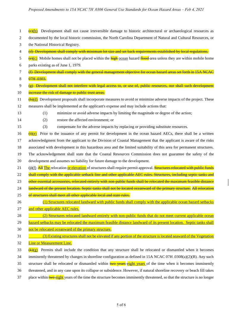
(c)(b) Development shall not cause irreversible damage to historic architectural or archaeological resources as 1
documented by the local historic commission, the North Carolina Department of Natural and Cultural Resources, or 2
the National Historical Registry. 3
(d) Development shall comply with minimum lot size and set back requirements established by local regulations. 4
(e)(c) Mobile homes shall not be placed within the high ocean hazard flood area unless they are within mobile home 5
parks existing as of June 1, 1979. 6
(f) Development shall comply with the general management objective for ocean hazard areas set forth in 15A NCAC 7
07H .0303. 8
(g) Development shall not interfere with legal access to, or use of, public resources, nor shall such development 9
increase the risk of damage to public trust areas. 10
(h)(d) Development proposals shall incorporate measures to avoid or minimize adverse impacts of the project. These 11
measures shall be implemented at the applicant's expense and may include actions that: 12
(1) minimize or avoid adverse impacts by limiting the magnitude or degree of the action; 13
(2) restore the affected environment; or 14
(3) compensate for the adverse impacts by replacing or providing substitute resources. 15
(i)(e) Prior to the issuance of any permit for development in the ocean hazard AECs, there shall be a written 16
acknowledgment from the applicant to the Division of Coastal Management that the applicant is aware of the risks 17
associated with development in this hazardous area and the limited suitability of this area for permanent structures. 18
The acknowledgement shall state that the Coastal Resources Commission does not guarantee the safety of the 19
development and assumes no liability for future damage to the development. 20
(j)(f) All The relocation or elevation of structures shall require permit approval. Structures relocated with public funds 21
shall comply with the applicable setback line and other applicable AEC rules. Structures, including septic tanks and 22
other essential accessories, relocated entirely with non-public funds shall be relocated the maximum feasible distance 23
landward of the present location. Septic tanks shall not be located oceanward of the primary structure. All relocation 24
of structures shall meet all other applicable local and state rules. 25
(1) Structures relocated landward with public funds shall comply with the applicable ocean hazard setbacks 26
and other applicable AEC rules. 27
(2) Structures relocated landward entirely with non-public funds that do not meet current applicable ocean 28
hazard setbacks may be relocated the maximum feasible distance landward of its present location. Septic tanks shall 29
not be relocated oceanward of the primary structure. 30
(3) Existing structures shall not be elevated if any portion of the structure is located seaward of the Vegetation 31
Line or Measurement Line. 32
(k)(g) Permits shall include the condition that any structure shall be relocated or dismantled when it becomes 33
imminently threatened by changes in shoreline configuration as defined in 15A NCAC 07H .0308(a)(2)(B). Any such 34
structure shall be relocated or dismantled within two years eight years of the time when it becomes imminently 35
threatened, and in any case upon its collapse or subsidence. However, if natural shoreline recovery or beach fill takes 36
place within two eight years of the time the structure becomes imminently threatened, so that the structure is no longer 37

Proposed Amendments to 15A NCAC 7H .0306 General Use Standards for Ocean Hazard Areas – Feb 4, 2021
6 of 6
imminently threatened, then it need not be relocated or dismantled at that time. This permit condition shall not affect 1
the permit holder's right to seek authorization of temporary protective measures allowed pursuant to 15A NCAC 07H 2
.0308(a)(2). 3
4
History Note: Authority G.S. 113A-107; 113A-113(b)(6); 113A-124; 5
Eff. September 9, 1977; 6
Amended Eff. December 1, 1991; March 1, 1988; September 1, 1986; December 1, 1985; 7
RRC Objection due to ambiguity Eff. January 24, 1992; 8
Amended Eff. March 1, 1992; 9
RRC Objection due to ambiguity Eff. May 21, 1992; 10
Amended Eff. February 1, 1993; October 1, 1992; June 19, 1992; 11
RRC Objection due to ambiguity Eff. May 18, 1995; 12
Amended Eff. August 11, 2009; April 1, 2007; November 1, 2004; June 27, 1995; 13
Temporary Amendment Eff. January 3, 2013; 14
Amended Eff. September 1, 2017; February 1, 2017; April 1, 2016; September 1, 2013. 15
16
17

Proposed Amendments to 15A NCAC 7H .0308 Specific Use Standards for Ocean Hazard Areas – Feb 4, 2021
1 of 8
15A NCAC 07H .0308 SPECIFIC USE STANDARDS FOR OCEAN HAZARD AREAS 1
(a) Ocean Shoreline Erosion Control Activities: 2
(1) Use Standards Applicable to all Erosion Control Activities: 3
(A) All oceanfront erosion response activities shall be consistent with the general policy 4
statements in 15A NCAC 07M .0200. 5
(B) Permanent erosion control structures may cause significant adverse impacts on the value 6
and enjoyment of adjacent properties or public access to and use of the ocean beach, and, 7
therefore, unless specifically authorized under the Coastal Area Management Act, are 8
prohibited. Such structures include bulkheads, seawalls, revetments, jetties, groins and 9
breakwaters. 10
(C) Rules concerning the use of oceanfront erosion response measures apply to all oceanfront 11
properties without regard to the size of the structure on the property or the date of its 12
construction. 13
(D) Shoreline erosion response projects shall not be constructed in beach or estuarine areas that 14
sustain substantial habitat for fish and wildlife species, as identified by natural resource 15
agencies during project review, unless mitigation measures are incorporated into project 16
design, as set forth in Rule .0306(h) of this Section. 17
(E) Project construction shall be timed to minimize adverse effects on biological activity. 18
(F) Prior to completing any erosion response project, all exposed remnants of or debris from 19
failed erosion control structures must be removed by the permittee. 20
(G) Permanent erosion control structures that would otherwise be prohibited by these standards 21
may be permitted on finding by the Division that: 22
(i) the erosion control structure is necessary to protect a bridge that provides the only 23
existing road access on a barrier island, that is vital to public safety, and is 24
imminently threatened by erosion as defined in Part (a)(2)(B) of this Rule; 25
(ii) the erosion response measures of relocation, beach nourishment or temporary 26
stabilization are not adequate to protect public health and safety; and 27
(iii) the proposed erosion control structure will have no adverse impacts on adjacent 28
properties in private ownership or on public use of the beach. 29
(H) Structures that would otherwise be prohibited by these standards may also be permitted on 30
finding by the Division that: 31
(i) the structure is necessary to protect a state or federally registered historic site that 32
is imminently threatened by shoreline erosion as defined in Part (a)(2)(B) of this 33
Rule; 34
(ii) the erosion response measures of relocation, beach nourishment or temporary 35
stabilization are not adequate and practicable to protect the site; 36
(iii) the structure is limited in extent and scope to that necessary to protect the site; and 37

Proposed Amendments to 15A NCAC 7H .0308 Specific Use Standards for Ocean Hazard Areas – Feb 4, 2021
2 of 8
(iv) a permit for a structure under this Part may be issued only to a sponsoring public 1
agency for projects where the public benefits outweigh the significant adverse 2
impacts. Additionally, the permit shall include conditions providing for mitigation 3
or minimization by that agency of significant adverse impacts on adjoining 4
properties and on public access to and use of the beach. 5
(I) Structures that would otherwise be prohibited by these standards may also be permitted on 6
finding by the Division that: 7
(i) the structure is necessary to maintain an existing commercial navigation channel 8
of regional significance within federally authorized limits; 9
(ii) dredging alone is not practicable to maintain safe access to the affected channel; 10
(iii) the structure is limited in extent and scope to that necessary to maintain the 11
channel; 12
(iv) the structure shall not have significant adverse impacts on fisheries or other public 13
trust resources; and 14
(v) a permit for a structure under this Part may be issued only to a sponsoring public 15
agency for projects where the public benefits outweigh the significant adverse 16
impacts. Additionally, the permit shall include conditions providing for mitigation 17
or minimization by that agency of any significant adverse impacts on adjoining 18
properties and on public access to and use of the beach. 19
(J) The Commission may renew a permit for an erosion control structure issued pursuant to a 20
variance granted by the Commission prior to 1 July 1995. The Commission may authorize 21
the replacement of a permanent erosion control structure that was permitted by the 22
Commission pursuant to a variance granted by the Commission prior to 1 July 1995 if the 23
Commission finds that: 24
(i) the structure will not be enlarged beyond the dimensions set out in the permit; 25
(ii) there is no practical alternative to replacing the structure that will provide the same 26
or similar benefits; and 27
(iii) the replacement structure will comply with all applicable laws and with all rules, 28
other than the rule or rules with respect to which the Commission granted the 29
variance, that are in effect at the time the structure is replaced. 30
(K) Proposed erosion response measures using innovative technology or design shall be 31
considered as experimental and shall be evaluated on a case-by-case basis to determine 32
consistency with 15A NCAC 07M .0200 and general and specific use standards within this 33
Section. 34
(2) Temporary Erosion Control Structures: 35
(A) Permittable temporary erosion control structures shall be limited to sandbags placed 36
landward of mean high water and parallel to the shore. 37

Proposed Amendments to 15A NCAC 7H .0308 Specific Use Standards for Ocean Hazard Areas – Feb 4, 2021
3 of 8
(B) Temporary erosion control structures as defined in Part (A) of this Subparagraph may be 1
used to protect only imminently threatened roads and associated right of ways, and 2
buildings and their associated septic systems. A structure is considered imminently 3
threatened if its foundation, septic system, or right-of-way in the case of roads, is less than 4
20 feet away from the erosion scarp. Buildings and roads located more than 20 feet from 5
the erosion scarp or in areas where there is no obvious erosion scarp may also be found to 6
be imminently threatened when site conditions, such as a flat beach profile or accelerated 7
erosion, increase the risk of imminent damage to the structure. 8
(C) Temporary erosion control structures shall be used to protect only the principal structure 9
and its associated septic system, but not appurtenances such as pools, gazebos, decks or 10
any amenity that is allowed under Rule .0309 of this Section as an exception to the erosion 11
setback requirement. 12
(D) Temporary erosion control structures may be placed waterward of a septic system when 13
there is no alternative to relocate it on the same or adjoining lot so that it is landward of or 14
in line with the structure being protected. 15
(E) Temporary erosion control structures shall not extend more than 20 feet past the sides of 16
the structure to be protected except to align with temporary erosion control structures on 17
adjacent properties, where the Division has determined that gaps between adjacent erosion 18
control structures may result in an increased risk of damage to the structure to be protected. 19
The landward side of such temporary erosion control structures shall not be located more 20
than 20 feet waterward of the structure to be protected, or the right-of-way in the case of 21
roads. If a building or road is found to be imminently threatened and at an increased risk 22
of imminent damage due to site conditions such as a flat beach profile or accelerated 23
erosion, temporary erosion control structures may be located more than 20 feet waterward 24
of the structure being protected. In cases of increased risk of imminent damage, the location 25
of the temporary erosion control structures shall be determined by the Director of the 26
Division of Coastal Management or the Director's designee in accordance with Part (A) of 27
this Subparagraph. 28
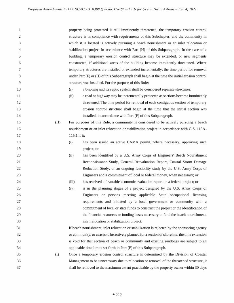
(F) Temporary erosion control structures may remain in place for up to eight years for a 29
building and its associated septic system, a bridge or a road. The property owner shall be 30
responsible for removal of any portion of the temporary erosion control structure exposed 31
above grade within 30 days of the end of the allowable time period. 32
(G) An imminently threatened structure or property may be protected only once, regardless of 33
ownership, unless the threatened structure or property is located in a community that is 34
actively pursuing a beach nourishment project, or an inlet relocation or stabilization project 35
in accordance with Part (H) of this Subparagraph. Existing temporary erosion control 36
structures may be permitted for additional eight-year periods provided that the structure or 37
Proposed Amendments to 15A NCAC 7H .0308 Specific Use Standards for Ocean Hazard Areas – Feb 4, 2021
4 of 8
property being protected is still imminently threatened, the temporary erosion control 1
structure is in compliance with requirements of this Subchapter, and the community in 2
which it is located is actively pursuing a beach nourishment or an inlet relocation or 3
stabilization project in accordance with Part (H) of this Subparagraph. In the case of a 4
building, a temporary erosion control structure may be extended, or new segments 5
constructed, if additional areas of the building become imminently threatened. Where 6
temporary structures are installed or extended incrementally, the time period for removal 7
under Part (F) or (H) of this Subparagraph shall begin at the time the initial erosion control 8
structure was installed. For the purpose of this Rule: 9
(i) a building and its septic system shall be considered separate structures, 10
(ii) a road or highway may be incrementally protected as sections become imminently 11
threatened. The time period for removal of each contiguous section of temporary 12
erosion control structure shall begin at the time that the initial section was 13
installed, in accordance with Part (F) of this Subparagraph. 14
(H) For purposes of this Rule, a community is considered to be actively pursuing a beach 15
nourishment or an inlet relocation or stabilization project in accordance with G.S. 113A-16
115.1 if it: 17
(i) has been issued an active CAMA permit, where necessary, approving such 18
project; or 19
(ii) has been identified by a U.S. Army Corps of Engineers' Beach Nourishment 20
Reconnaissance Study, General Reevaluation Report, Coastal Storm Damage 21
Reduction Study, or an ongoing feasibility study by the U.S. Army Corps of 22
Engineers and a commitment of local or federal money, when necessary; or 23
(iii) has received a favorable economic evaluation report on a federal project; or 24
(iv) is in the planning stages of a project designed by the U.S. Army Corps of 25
Engineers or persons meeting applicable State occupational licensing 26
requirements and initiated by a local government or community with a 27
commitment of local or state funds to construct the project or the identification of 28
the financial resources or funding bases necessary to fund the beach nourishment, 29
inlet relocation or stabilization project. 30
If beach nourishment, inlet relocation or stabilization is rejected by the sponsoring agency 31
or community, or ceases to be actively planned for a section of shoreline, the time extension 32
is void for that section of beach or community and existing sandbags are subject to all 33
applicable time limits set forth in Part (F) of this Subparagraph. 34
(I) Once a temporary erosion control structure is determined by the Division of Coastal 35
Management to be unnecessary due to relocation or removal of the threatened structure, it 36
shall be removed to the maximum extent practicable by the property owner within 30 days 37
Proposed Amendments to 15A NCAC 7H .0308 Specific Use Standards for Ocean Hazard Areas – Feb 4, 2021
5 of 8
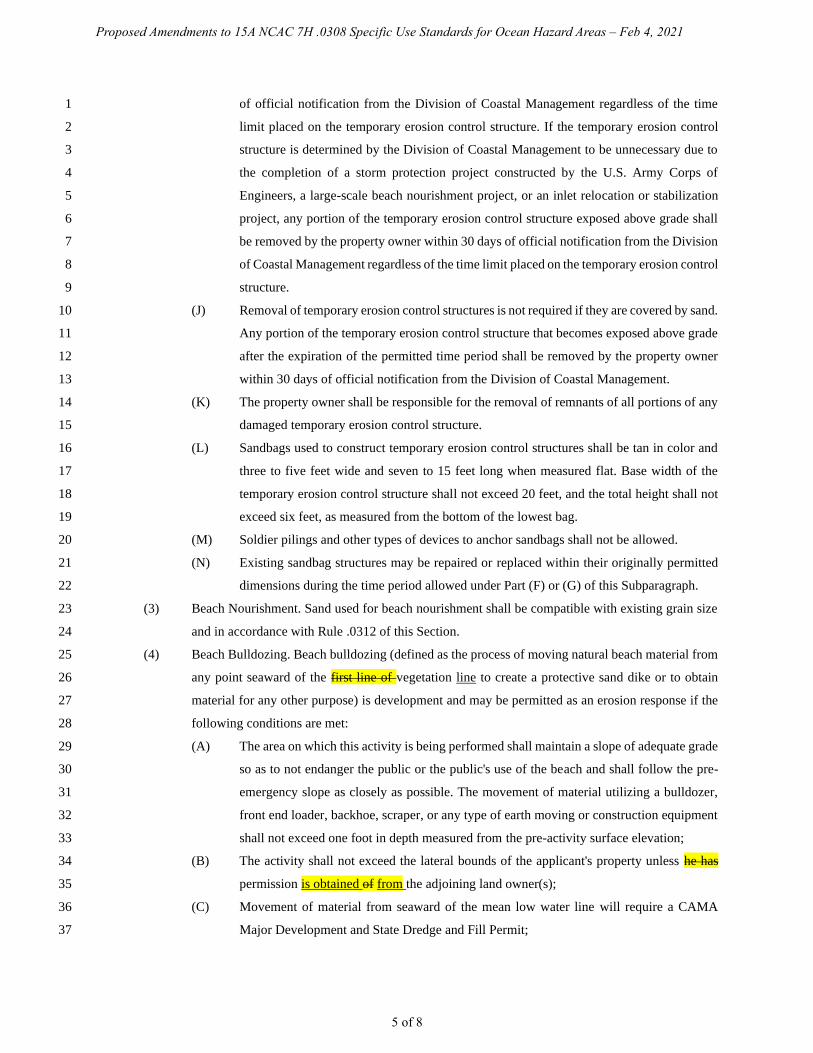
of official notification from the Division of Coastal Management regardless of the time 1
limit placed on the temporary erosion control structure. If the temporary erosion control 2
structure is determined by the Division of Coastal Management to be unnecessary due to 3
the completion of a storm protection project constructed by the U.S. Army Corps of 4
Engineers, a large-scale beach nourishment project, or an inlet relocation or stabilization 5
project, any portion of the temporary erosion control structure exposed above grade shall 6
be removed by the property owner within 30 days of official notification from the Division 7
of Coastal Management regardless of the time limit placed on the temporary erosion control 8
structure. 9
(J) Removal of temporary erosion control structures is not required if they are covered by sand. 10
Any portion of the temporary erosion control structure that becomes exposed above grade 11
after the expiration of the permitted time period shall be removed by the property owner 12
within 30 days of official notification from the Division of Coastal Management. 13
(K) The property owner shall be responsible for the removal of remnants of all portions of any 14
damaged temporary erosion control structure. 15
(L) Sandbags used to construct temporary erosion control structures shall be tan in color and 16
three to five feet wide and seven to 15 feet long when measured flat. Base width of the 17
temporary erosion control structure shall not exceed 20 feet, and the total height shall not 18
exceed six feet, as measured from the bottom of the lowest bag. 19
(M) Soldier pilings and other types of devices to anchor sandbags shall not be allowed. 20
(N) Existing sandbag structures may be repaired or replaced within their originally permitted 21
dimensions during the time period allowed under Part (F) or (G) of this Subparagraph. 22
(3) Beach Nourishment. Sand used for beach nourishment shall be compatible with existing grain size 23
and in accordance with Rule .0312 of this Section. 24
(4) Beach Bulldozing. Beach bulldozing (defined as the process of moving natural beach material from 25
any point seaward of the first line of vegetation line to create a protective sand dike or to obtain 26
material for any other purpose) is development and may be permitted as an erosion response if the 27
following conditions are met: 28
(A) The area on which this activity is being performed shall maintain a slope of adequate grade 29
so as to not endanger the public or the public's use of the beach and shall follow the pre-30
emergency slope as closely as possible. The movement of material utilizing a bulldozer, 31
front end loader, backhoe, scraper, or any type of earth moving or construction equipment 32
shall not exceed one foot in depth measured from the pre-activity surface elevation; 33
(B) The activity shall not exceed the lateral bounds of the applicant's property unless he has 34
permission is obtained of from the adjoining land owner(s); 35
(C) Movement of material from seaward of the mean low water line will require a CAMA 36
Major Development and State Dredge and Fill Permit; 37

Proposed Amendments to 15A NCAC 7H .0308 Specific Use Standards for Ocean Hazard Areas – Feb 4, 2021
6 of 8
(D) The activity shall not increase erosion on neighboring properties and shall not have an 1
adverse effect on natural or cultural resources; 2
(E) The activity may be undertaken to protect threatened on-site waste disposal systems as well 3
as the threatened structure's foundations. 4
(b) Dune Protection, Establishment, Establishment Restoration, and Stabilization. 5
(1) No development shall be permitted that involves the removal or relocation of primary or frontal 6
dune sand or vegetation thereon that would adversely affect the integrity of the dune. Other dunes 7
within the ocean hazard area shall not be disturbed unless the development of the property is 8
otherwise impracticable. Any disturbance of these other dunes shall be allowed only to the extent 9
permitted by this Rule. 10
(1) (2) Any new dunes established shall be aligned to the greatest extent possible with existing adjacent 11
dune ridges and shall be of the same configuration as adjacent natural dunes. 12
(2)(3) Existing primary and frontal dunes shall not, except for beach nourishment and emergency 13
situations, be broadened or extended in an oceanward direction. 14
(3)(4) Adding to dunes shall be accomplished in such a manner that the damage to existing vegetation is 15
minimized. The filled areas shall be replanted or temporarily stabilized until planting can be 16
completed. 17
(4)(5) Sand used to establish or strengthen dunes shall be of the same general characteristics as the sand 18
in the area in which it is to be placed. 19
(5)(6) No new dunes shall be created in inlet hazard areas. 20
(6)(7) Sand held in storage in any dune, other than the frontal or primary dune, shall remain on the lot or 21
tract of land to the maximum extent practicable and may be redistributed within the Ocean Hazard 22
AEC provided that it is not placed any farther oceanward than the crest of a primary dune, if present, 23
or the crest of a frontal dune. 24
(7)(8) No disturbance of a dune area shall be allowed when other techniques of construction can be utilized 25
and alternative site locations exist to avoid dune impacts. 26
(c) Structural Accessways: 27
(1) Structural accessways shall be permitted across primary or frontal dunes so long as they are designed 28
and constructed in a manner that entails negligible alteration of the primary or frontal dune. 29
Structural accessways shall not be considered threatened structures for the purpose of Paragraph (a) 30
of this Rule. 31
(2) An accessway shall be considered to entail negligible alteration of primary or frontal dunes provided 32
that: 33
(A) The accessway is exclusively for pedestrian use; 34
(B) The accessway is a maximum of six feet in width; 35
(C) The accessway is raised on posts or pilings of five feet or less depth, so that wherever 36
possible only the posts or pilings touch the dune. Where this is deemed by the Division of 37

Proposed Amendments to 15A NCAC 7H .0308 Specific Use Standards for Ocean Hazard Areas – Feb 4, 2021
7 of 8
Coastal Management to be impossible due to any more restrictive local, state, and/or 1
federal building requirements, the structure shall touch the dune only to the necessary; and 2
(D) Any areas of vegetation that are disturbed are revegetated as soon as feasible. 3
(3) An accessway that does not meet Part (2)(A) and (B) of this Paragraph shall be permitted only if it 4
meets a public purpose or need which cannot otherwise be met and it meets Part (2)(C) of this 5
Paragraph. Public fishing piers are not prohibited provided all other applicable standards of this 6
Rule are met. 7
(4) In order to preserve the protective nature of primary and frontal dunes a structural accessway (such 8
as a "Hatteras ramp") may be provided for off-road vehicle (ORV) or emergency vehicle access. 9
Such accessways shall be no greater than 15 feet in width and may be constructed of wooden 10
sections fastened together, or other materials approved by the Division, over the length of the 11
affected dune area. Installation of a Hatteras ramp shall be done in a manner that will preserve the 12
dune's function as a protective barrier against flooding and erosion by not reducing the volume of 13
the dune. 14
(5) Structural accessways may be constructed no more than six feet seaward of the waterward toe of the 15
frontal or primary dune, provided they do not interfere with public trust rights and emergency access 16
along the beach. Structural accessways are not restricted by the requirement to be landward of the 17
FLSNV as described in Rule .0309(a) of this Section. 18
(d) Building Construction Standards. New building construction and any construction identified in .0306(a)(5) of 19
this Section and 15A NCAC 07J .0210 shall comply with the following standards: 20
(1) In order to avoid danger to life and property, all development shall be designed and placed so as to 21
minimize damage due to fluctuations in ground elevation and wave action in a 100-year storm. Any 22
building constructed within the ocean hazard area shall comply with relevant sections of the North 23
Carolina Building Code including the Coastal and Flood Plain Construction Standards and the local 24
flood damage prevention ordinance as required by the National Flood Insurance Program. If any 25
provision of the building code or a flood damage prevention ordinance is inconsistent with any of 26
the following AEC standards, the more restrictive provision shall control. 27
(2) All building in the ocean hazard area shall be on pilings not less than eight inches in diameter if 28
round or eight inches to a side if square. 29
(3) All pilings shall have a tip penetration greater than eight feet below the lowest ground elevation 30
under the structure. For those structures so located on or seaward of the primary dune, the pilings 31
shall extend to five feet below mean sea level. 32
(4) All foundations shall be designed to be stable during applicable fluctuations in ground elevation and 33
wave forces during a 100-year storm. Cantilevered decks and walkways shall meet the requirements 34
of this Part or shall be designed to break-away without structural damage to the main structure. 35
36
History Note: Authority G.S. 113A-107(a); 113A-107(b); 113A-113(b)(6)a.,b.,d.; 113A-115.1; 113A-124; 37

Proposed Amendments to 15A NCAC 7H .0308 Specific Use Standards for Ocean Hazard Areas – Feb 4, 2021
8 of 8
Eff. June 1, 1979; 1
Temporary Amendment Eff. June 20, 1989, for a period of 180 days to expire on December 17, 2
1989; 3
Amended Eff. August 3, 1992; December 1, 1991; March 1, 1990; December 1, 1989; 4
RRC Objection Eff. November 19, 1992 due to ambiguity; 5
RRC Objection Eff. January 21, 1993 due to ambiguity; 6
Amended Eff. March 1, 1993; December 28, 1992; 7
RRC Objection Eff. March 16, 1995 due to ambiguity; 8
Amended Eff. April 1, 1999; February 1, 1996; May 4, 1995; 9
Temporary Amendment Eff. July 3, 2000; May 22, 2000; 10
Amended Eff. April 1, 2019; May 1, 2013; July 1, 2009; April 1, 2008; February 1, 2006; August 1, 11
2002. 12
13
14
Proposed Amendments to 15A NCAC 7H .0309 Use Standards for Ocean Hazard Areas: Exceptions
Feb 4, 2021
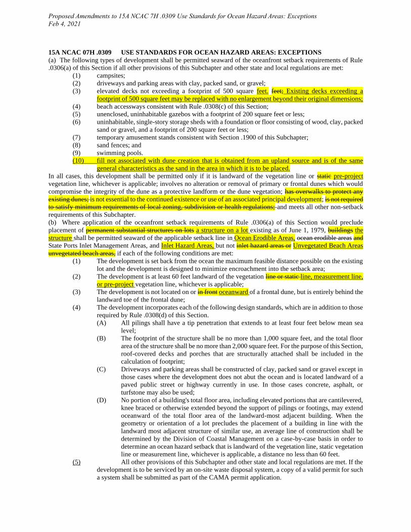
15A NCAC 07H .0309 USE STANDARDS FOR OCEAN HAZARD AREAS: EXCEPTIONS
(a) The following types of development shall be permitted seaward of the oceanfront setback requirements of Rule
.0306(a) of this Section if all other provisions of this Subchapter and other state and local regulations are met:
(1) campsites;
(2) driveways and parking areas with clay, packed sand, or gravel;
(3) elevated decks not exceeding a footprint of 500 square feet. feet; Existing decks exceeding a
footprint of 500 square feet may be replaced with no enlargement beyond their original dimensions;
(4) beach accessways consistent with Rule .0308(c) of this Section;
(5) unenclosed, uninhabitable gazebos with a footprint of 200 square feet or less;
(6) uninhabitable, single-story storage sheds with a foundation or floor consisting of wood, clay, packed
sand or gravel, and a footprint of 200 square feet or less;
(7) temporary amusement stands consistent with Section .1900 of this Subchapter;
(8) sand fences; and
(9) swimming pools.
(10) fill not associated with dune creation that is obtained from an upland source and is of the same
general characteristics as the sand in the area in which it is to be placed.
In all cases, this development shall be permitted only if it is landward of the vegetation line or static pre-project
vegetation line, whichever is applicable; involves no alteration or removal of primary or frontal dunes which would
compromise the integrity of the dune as a protective landform or the dune vegetation; has overwalks to protect any
existing dunes; is not essential to the continued existence or use of an associated principal development; is not required
to satisfy minimum requirements of local zoning, subdivision or health regulations; and meets all other non-setback
requirements of this Subchapter.
(b) Where application of the oceanfront setback requirements of Rule .0306(a) of this Section would preclude
placement of permanent substantial structures on lots a structure on a lot existing as of June 1, 1979, buildings the
structure shall be permitted seaward of the applicable setback line in Ocean Erodible Areas, ocean erodible areas and
State Ports Inlet Management Areas, and Inlet Hazard Areas, but not inlet hazard areas or Unvegetated Beach Areas
unvegetated beach areas, if each of the following conditions are met:
(1) The development is set back from the ocean the maximum feasible distance possible on the existing
lot and the development is designed to minimize encroachment into the setback area;
(2) The development is at least 60 feet landward of the vegetation line or static line, measurement line,
or pre-project vegetation line, whichever is applicable;
(3) The development is not located on or in front oceanward of a frontal dune, but is entirely behind the
landward toe of the frontal dune;
(4) The development incorporates each of the following design standards, which are in addition to those
required by Rule .0308(d) of this Section.
(A) All pilings shall have a tip penetration that extends to at least four feet below mean sea
level;
(B) The footprint of the structure shall be no more than 1,000 square feet, and the total floor
area of the structure shall be no more than 2,000 square feet. For the purpose of this Section,
roof-covered decks and porches that are structurally attached shall be included in the
calculation of footprint;
(C) Driveways and parking areas shall be constructed of clay, packed sand or gravel except in
those cases where the development does not abut the ocean and is located landward of a
paved public street or highway currently in use. In those cases concrete, asphalt, or
turfstone may also be used;
(D) No portion of a building's total floor area, including elevated portions that are cantilevered,
knee braced or otherwise extended beyond the support of pilings or footings, may extend
oceanward of the total floor area of the landward-most adjacent building. When the
geometry or orientation of a lot precludes the placement of a building in line with the
landward most adjacent structure of similar use, an average line of construction shall be
determined by the Division of Coastal Management on a case-by-case basis in order to
determine an ocean hazard setback that is landward of the vegetation line, static vegetation
line or measurement line, whichever is applicable, a distance no less than 60 feet.
(5) All other provisions of this Subchapter and other state and local regulations are met. If the
development is to be serviced by an on-site waste disposal system, a copy of a valid permit for such
a system shall be submitted as part of the CAMA permit application.

Proposed Amendments to 15A NCAC 7H .0309 Use Standards for Ocean Hazard Areas: Exceptions
Feb 4, 2021
(c) The following types of water dependent development shall be permitted seaward of the oceanfront setback
requirements of Rule .0306(a) of this Section if all other provisions of this Subchapter and other state and local
regulations are met:
(1) piers providing public access; and
(2) maintenance and replacement of existing state-owned bridges, and causeways and accessways to
such bridges.
(d) Replacement or construction of a pier house associated with an ocean pier shall be permitted if each of the
following conditions is met:
(1) The ocean pier provides public access for fishing and other recreational purposes whether on a
commercial, public, or nonprofit basis;
(2) Commercial, non-water dependent uses of the ocean pier and associated pier house shall be limited
to restaurants and retail services. Residential uses, lodging, and parking areas shall be prohibited;
(3) The pier house shall be limited to a maximum of two stories;
(4) A new pier house shall not exceed a footprint of 5,000 square feet and shall be located landward of
mean high water;
(5) A replacement pier house may be rebuilt not to exceed its most recent footprint or a footprint of
5,000 square feet, whichever is larger;
(6) The pier house shall be rebuilt to comply with all other provisions of this Subchapter; and
(7) If the pier has been destroyed or rendered unusable, replacement or expansion of the associated pier
house shall be permitted only if the pier is being replaced and returned to its original function.
(e) In addition to the development authorized under Paragraph (d) of this Rule, small scale, non-essential development
that does not induce further growth in the Ocean Hazard Area, such as the construction of single family piers and
small scale erosion control measures that do not interfere with natural oceanfront processes, shall be permitted on
those non-oceanfront in the Ocean Hazard Area along those portions of shoreline that exhibit features characteristic
of an Estuarine Shoreline. Such features include the presence of wetland vegetation, and lower wave energy and
erosion rates than in the adjoining Ocean Erodible Area. Such development shall be permitted under the standards set
out in Rule .0208 of this Subchapter. For the purpose of this Rule, small scale is defined as those projects which are
eligible for authorization under 15A NCAC 07H .1100, .1200 and 15A NCAC 07K .0203.
(f) Transmission lines necessary to transmit electricity from an offshore energy-producing facility may be permitted
provided that each of the following conditions is met:
(1) The transmission lines are buried under the ocean beach, nearshore area, and primary and frontal
dunes, all as defined in Rule .0305 of this Section, in such a manner so as to ensure that the
placement of the transmission lines involves no alteration or removal of the primary or frontal dunes;
and
(2) The design and placement of the transmission lines shall be performed in a manner so as not to
endanger the public or the public's use of the beach.
(g) Existing stormwater outfalls as of the last amended date of this rule within the Ocean Hazard AEC that are owned
or maintained by a State agency or local government, may be extended oceanward subject to the provisions contained
within 15A NCAC 07J .0200. Outfalls may be extended below mean low water and may be maintained in accordance
with 15A NCAC 07K .0103. Shortening or lengthening of outfall structures within the authorized dimensions, in
response to changes in beach width, is considered maintenance under 15A NCAC 07K .0103. Outfall extensions may
be marked with signage and shall not prevent pedestrian or vehicular access along the beach. This Paragraph does not
apply to existing stormwater outfalls that are not owned or maintained by a State agency or local government.
History Note: Authority G.S. 113A-107(a); 113A-107(b); 113A-113(b)(6)a; 113A-113(b)(6)b; 113A-113(b)(6)d;
113A-124;
Eff. February 2, 1981;
Amended Eff. April 1, 2020; June 1, 2010; February 1, 2006; September 17, 2002 pursuant to S.L.
2002-116; August 1, 2000; August 1, 1998; April 1, 1996; April 1, 1995; February 1, 1993; January
1, 1991; April 1, 1987.

Proposed Amendments to 15A NCAC 7H .0310 Use Standards for Inlet Hazard Areas – Feb 4, 2021
1 of 1
15A NCAC 07H .0310 USE STANDARDS FOR INLET HAZARD AREAS 1
(a) Inlet areas as defined by Rule .0304 of this Section are subject to inlet migration, rapid and severe changes in 2
watercourses, flooding and strong tides. Due to the this extremely hazardous nature of the Inlet Hazard Areas, all 3
development within these areas shall be permitted in accordance with the following standards: 4
(1) All development in the inlet hazard area shall be set back from the first line of stable natural 5
vegetation line a distance equal to the setback required in the adjacent ocean hazard area; 6
(2) Permanent structures shall be permitted at a density of no more than one commercial or residential 7
unit per 15,000 square feet of land area on lots subdivided or created after July 23, 1981; 8
(3) Only residential structures of four units or less or non-residential structures of less than 5,000 square 9
feet total floor area shall be allowed within the inlet hazard area, except that access roads to those 10
areas and maintenance and replacement of existing bridges shall be allowed; 11
(4) Established common-law and statutory public rights of access to the public trust lands and waters 12
in Inlet Hazard Areas shall not be eliminated or restricted. Development shall not encroach upon 13
public accessways nor shall it limit the intended use of the accessways; 14
(5) All other rules in this Subchapter pertaining to development in the ocean hazard areas shall be 15
applied to development within the Inlet Hazard Areas. 16
(b) The inlet hazard area setback requirements shall not apply to the types of development exempted from the ocean 17
setback rules in 15A NCAC 7H .0309(a), nor, to the types of development listed in 15A NCAC 7H .0309(c). 18
(c) In addition to the types of development excepted under Rule .0309 of this Section, small scale, non-essential 19
development that does not induce further growth in the Inlet Hazard Area, such as the construction of single-family 20
piers and small scale erosion control measures that do not interfere with natural inlet movement, may be permitted on 21
those portions of shoreline within a designated Inlet Hazard Area that exhibit features characteristic of Estuarine 22
Shoreline. Such features include the presence of wetland vegetation, lower wave energy, and lower erosion rates than 23
in the adjoining Ocean Erodible Area. Such development shall be permitted under the standards set out in Rule .0208 24
of this Subchapter. For the purpose of this Rule, small scale is defined as those projects which are eligible for 25
authorization under 15A NCAC 7H .1100, .1200 and 7K .0203. 26
27
History Note: Filed as a Temporary Amendment Eff. October 30, 1981, for a period of 70 days to expire on 28
January 8, 1982; 29
Filed as an Emergency Rule Eff. September 11, 1981, for a period of 120 days to expire on 30
January 8, 1982; 31
Authority G.S. 113A-107; 113A-113(b); 113A-124; 32
Eff. December 1, 1981; 33
Amended Eff. April 1, 1999; April 1, 1996; December 1, 1992; December 1, 1991; 34
March 1, 1988. 35
36
37

Proposed Amendments to 15A NCAC 7H .1200 Static Vegetation Line Exception Approval Procedures – Feb 4, 2021
1 of 2
SECTION .1200 – STATIC AND VEGETATION LINE EXCEPTION BEACH MANAGEMENT PLAN 1
APPROVAL PROCEDURES 2
3
15A NCAC 07J .1201 REQUESTING THE STATIC LINE EXCEPTION BEACH MANAGEMENT 4
PLAN APPROVAL 5
(a) A petitioner subject to a static pre-project vegetation line pursuant to 15A NCAC 07H .0305 may petition the 6
Coastal Resources Commission to for an to approve a Beach Management Plan exception to the static vegetation line 7
in accordance with the provisions of this Section. A "petitioner" shall be defined as: 8
(1) Any local government; 9
(2) Any group of local governments involved in a regional beach fill project; or 10
(3) Any qualified homeowner's association defined in G.S. 47F-1-103(3) that has the authority to 11
approve the locations of structures on lots within the territorial jurisdiction of the association, and 12
has jurisdiction over at least one mile of ocean shoreline. shoreline; or 13
(4) A permit holder of a large-scale beach fill project. 14
(b) A petitioner shall be eligible to submit a request for to approve a Beach Management Plan a static vegetation line 15
exception after the completion of construction of the initial large-scale beach fill project(s) as defined in 15A NCAC 16
07H .0305 that required the creation of a pre-project static vegetation line(s). For a static pre-project vegetation line 17
in existence prior to the effective date of this Rule, the award-of-contract date of the initial large-scale beach fill 18
project, or the date of the aerial photography or other survey data used to define the static pre-project vegetation line, 19
whichever is most recent, shall be used in lieu of the completion of construction date. 20
(c) A static vegetation line exception Beach Management Plan request applies to all the entire static pre-project 21
vegetation line lines within the jurisdiction Ocean Hazard Area in of the petitioner’s petitioner jurisdiction. including 22
segments of a static vegetation line that are associated with the same large-scale beach fill project. If multiple static 23
vegetation lines within the jurisdiction of the petitioner are associated with different large-scale beach fill projects, 24
then the static vegetation line exception in accordance with 15A NCAC 07H .0306 and the procedures outlined in this 25
Section shall be considered separately for each large-scale beach fill project. 26
(d) A static vegetation line exception request shall be made in writing by the petitioner. A complete static vegetation 27
line exception A Beach Management Plan request shall consist of a comprehensive document with supporting 28
appendices and data that includes include the following: 29
(1) A review summary of all beach fill projects in the area of the Beach Management Plan for which 30
the exception is being requested including the initial large-scale beach fill project associated with 31
the static pre-project vegetation line, subsequent maintenance of the initial large-scale projects(s) 32
and beach fill projects occurring prior to the initial large-scale projects(s). To the extent historical 33
data allows, the summary shall include construction dates, contract award dates, volume of sediment 34
excavated, total cost of beach fill project(s), funding sources, maps, design schematics, pre-and post-35
project surveys and a project footprint; 36

Proposed Amendments to 15A NCAC 7H .1200 Static Vegetation Line Exception Approval Procedures – Feb 4, 2021
2 of 2
(2) A review of the maintenance needed to achieve a design life of no less than 30 years of shore 1
protection. Plans The plan shall include anticipated maintenance event volume triggers and 2
schedules, long-term volumetric sand needs, annual monitoring protocols, an analysis of the impacts 3
of any erosion control structures, and any relevant maps, tables, diagrams, studies or reports. and 4
related materials including reports, maps, tables and diagrams for the design and construction of the 5
initial large-scale beach fill project that required the static vegetation line, subsequent maintenance 6
that has occurred, and planned maintenance needed to achieve a design life providing no less than 7
30 years of shore protection from the date of the static line exception request. The plans and related 8
materials shall be designed and prepared by the U.S. Army Corps of Engineers or persons meeting 9
applicable State occupational licensing requirements for said work; 10
(3) Documentation, including maps, geophysical, and geological data, to delineate the planned location 11
and volume of compatible sediment as defined in 15A NCAC 07H .0312 necessary to construct and 12
maintain the large-scale beach fill project defined in Subparagraph (d)(2) of this Rule over its design 13
life. This documentation shall be designed and prepared by the U.S. Army Corps of Engineers or 14
persons meeting applicable State occupational licensing requirements for said work; and 15
(4) Identification of the financial resources or funding sources necessary to fund the large-scale beach 16
fill project, project over its the project design life, life. such as dedicated percentage of occupancy 17
taxes, special tax districts and anticipated federal funding. 18
(e) Public Comment Requirements. The local jurisdiction shall provide an opportunity for public comments on the 19
Beach Management Plan prior to submission to the Coastal Resources Commission for approval. Written comments 20
on the Beach Management Plan shall be submitted to the Division along with the request to approve the Beach 21
Management Plan. 22
(e)(f) A request to approve a Beach Management Plan static vegetation line exception request shall be submitted to 23
the Director of the Division of Coastal Management, 400 Commerce Avenue, Morehead City, NC 28557. Written 24
acknowledgement of the receipt of a completed static vegetation line exception request, including notification of the 25
date of the meeting at which the request will be considered by the Coastal Resources Commission, shall be provided 26
to the petitioner by the Division of Coastal Management. 27
(f)(g) The Coastal Resources Commission shall consider a request to approve a static vegetation line Beach 28
Management Plan exception request no later than the second scheduled meeting following the date of receipt of a 29
complete request by the Division of Coastal Management, except when the petitioner and the Division of Coastal 30
Management agree upon a later date. 31
32
History Note: Authority G.S. 113A-107; 113A-113(b)(6); 113A-124; 33
Eff. March 23, 2009; 34
Amended Eff. April 1, 2016. 35
36
37

Proposed Amendments to 15A NCAC 7J .1202 Review of the Static Line Exception Request – Feb 4, 2021
1 of 1
15A NCAC 07J .1202 REVIEW OF THE STATIC LINE EXCEPTION BEACH MANAGEMENT PLAN 1
APPROVAL REQUEST 2
(a) The Petitioner Division of Coastal Management shall provide a summary of the prepare a written report of the 3
static line exception Beach Management Plan request to be presented to the Coastal Resources Commission. This 4
report summary shall include all of the elements required in 15A NCAC 7J .1201. 5
(1) A description of the area affected by the static line exception request; 6
(2) A summary of the large-scale beach fill project that required the static vegetation line as well as the 7
completed and planned maintenance of the project(s); 8
(3) A summary of the evidence required for a static line exception; and 9
(4) A recommendation to grant or deny the static line exception. 10
(b) The Division of Coastal Management shall provide the Commission a review of the Beach Management Plan 11
including a recommendation to grant or deny the request. The Division shall provide the petitioner requesting approval 12
of a Beach Management Plan the static line exception an opportunity to review the report recommendation prepared 13
by the Division of Coastal Management no less than 10 days prior to the meeting at which it is to be considered by 14
the Coastal Resources Commission. 15
16
History Note: Authority G.S. 113A-107; 113A-113(b)(6); 113A-124; 17
Eff. March 23, 2009. 18
19
20

Proposed Amendments to 15A NCAC 7J .1203 Procedures for Approving the Static Line Exception – Feb 4, 2021
1 of 1
15A NCAC 07J .1203 PROCEDURES FOR APPROVING THE STATIC LINE EXCEPTION A BEACH 1
MANAGEMENT PLAN 2
(a) At the meeting that approval of a Beach Management Plan the static line exception is considered by the Coastal 3
Resources Commission, the following shall occur: 4
(1) The Division of Coastal Management Petitioner shall orally present the report a summary of the 5
Beach Management Plan described in 15A NCAC 07J .1202. 6
(2) The Division of Coastal Management shall orally present its review of the Beach Management Plan 7
and its recommendation to grant or deny the approval request. A representative for the petitioner 8
may provide written or oral comments relevant to the static line exception . The Chairman of the 9
Coastal Resources Commission may limit the time allowed for oral comments. 10
(3) Additional parties may provide written or oral comments relevant to the static line exception request. 11
The Chairman of the Coastal Resources Commission may limit the time allowed for oral comments. 12
(b) The Coastal Resources Commission shall authorize a static line exception request approve a Beach Management 13
Plan following affirmative findings on each of the criteria presented in15A NCAC 07J .1201(d)(1) through (d)(4), the 14
Division of Coastal Management recommendation, and public comments submitted with the request to approve the 15
Beach Management Plan. 15A NCAC 07J .1201(d)(1) through (d)(4). The final decision of the Coastal Resources 16
Commission shall be made at the meeting at which the matter is heard or in no case later than the next scheduled 17
meeting. The final decision shall be transmitted to the petitioner by registered mail within 10 business days following 18
the meeting at which the decision is reached. 19
(c) The decision to authorize approve or deny a static line exception Beach Management Plan is a final agency 20
decision and is subject to judicial review in accordance with G.S. 113A-123. 21
22
History Note: Authority G.S. 113A-107; 113A-113(b)(6); 113A-124; 23
Eff. March 23, 2009. 24
25
26

Proposed Amendments to 15A NCAC 7H .1204 Review of the Large-Scale Beach-Fill Project and Approved Static
Line Exceptions – Feb 4, 2021
1 of 2
15A NCAC 07J .1204 REVIEW OF THE LARGE-SCALE BEACH-FILL PROJECT AND APPROVED 1
STATIC LINE EXCEPTIONS BEACH MANAGEMENT PLANS 2
(a) Progress Reports. The petitioner that received the static line exception Beach Management Plan approval shall 3
provide a progress report to the Coastal Resources Commission at intervals no greater than every five years from date 4
the static line exception Beach Management Plan is authorized. approved. The progress report shall address the criteria 5
defined in 15A NCAC 07J .1201(d)(1) through (d)(4) and be submitted in writing to the Director of the Division of 6
Coastal Management, 400 Commerce Avenue, Morehead City, NC 28557. The Division of Coastal Management 7
shall provide written acknowledgement of the receipt of a completed progress report, including notification of the 8
meeting date at which the report will be presented to the Coastal Resources Commission to the petitioner. 9
(b) The Coastal Resources Commission shall review a Beach Management Plan static line exception authorized 10
approved under 15A NCAC 07J .1203 at intervals no greater than every five years from the initial authorization in 11
order to renew its findings for the conditions defined in 15A NCAC 07J .1201(d)(2) through (d)(4). The Coastal 12
Resources Commission shall also consider the following conditions: 13
(1) Design changes Updates to the Beach Management Plan, including performance of past projects 14
and maintenance events, changes in conditions, and design changes to future projects. initial large-15
scale beach fill project and defined in 15A NCAC 07J .1201(d)(2) provided that the changes are 16
designed and prepared by the U.S. Army Corps of Engineers or persons meeting applicable State 17
occupational licensing requirements for the work; 18
(2) Design changes to the location and volume of compatible sediment, as defined by 15A NCAC 07H 19
.0312, necessary to construct and maintain the large-scale beach fill project defined in 15A NCAC 20
07J .1201(d)(2), including design changes defined in this Rule provided that the changes have been 21
designed and prepared by the U.S. Army Corps of Engineers or persons meeting applicable State 22
occupational licensing requirements for the work; and 23
(3) Changes in the financial resources or funding sources necessary to fund the large-scale beach fill 24
project(s)defined in 15A NCAC 07J .1201(d)(2). If the project has been amended to include design 25
changes defined in this Rule, then the Coastal Resources Commission shall consider the financial 26
resources or funding sources necessary to fund the changes. 27
(c) The Petitioner Division of Coastal Management shall orally present prepare a written summary of the progress 28
report and present it to the Coastal Resources Commission no later than the second scheduled meeting following the 29
date the report was received, except when a later meeting is agreed upon by the local government or community 30
submitting the progress report and the Division of Coastal Management. This written summary The Division of 31
Coastal Management shall provide the Coastal Resources Commission a review and recommendation from the 32
Division of Coastal Management of the progress report on whether the conditions defined in 15A NCAC 07J 33
.1201(d)(1) through (d)(4) have been met. The petitioner submitting the progress report shall be provided an 34
opportunity to review the recommendation written summary prepared by the Division of Coastal Management no less 35
than 10 days prior to the meeting at which it is to be considered by the Coastal Resources Commission. 36

Proposed Amendments to 15A NCAC 7H .1204 Review of the Large-Scale Beach-Fill Project and Approved Static
Line Exceptions – Feb 4, 2021
2 of 2
(d) The following shall occur at the meeting at which the Coastal Resources Commission reviews the static line 1
exception progress report: 2
(1) The Division of Coastal Management shall orally present the written summary of the progress report 3
as defined in this Rule. 4
(2) A representative for the petitioner may provide written or oral comments relevant to the static line 5
exception progress report. The Chairman of the Coastal Resources Commission may limit the time 6
allowed for oral comments. 7
(3) Additional parties may provide written or oral comments relevant to the static line exception 8
progress report. The Chairman of the Coastal Resources Commission may limit the time allowed 9
for oral comments. 10
11
History Note: Authority G.S. 113A-107; 113A-113(b)(6); 113A-124; 12
Eff. March 23, 2009. 13
14
15
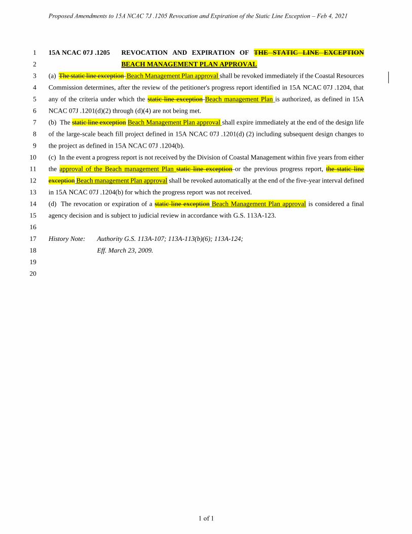
Proposed Amendments to 15A NCAC 7J .1205 Revocation and Expiration of the Static Line Exception – Feb 4, 2021
1 of 1
15A NCAC 07J .1205 REVOCATION AND EXPIRATION OF THE STATIC LINE EXCEPTION 1
BEACH MANAGEMENT PLAN APPROVAL 2
(a) The static line exception Beach Management Plan approval shall be revoked immediately if the Coastal Resources 3
Commission determines, after the review of the petitioner's progress report identified in 15A NCAC 07J .1204, that 4
any of the criteria under which the static line exception Beach management Plan is authorized, as defined in 15A 5
NCAC 07J .1201(d)(2) through (d)(4) are not being met. 6
(b) The static line exception Beach Management Plan approval shall expire immediately at the end of the design life 7
of the large-scale beach fill project defined in 15A NCAC 07J .1201(d) (2) including subsequent design changes to 8
the project as defined in 15A NCAC 07J .1204(b). 9
(c) In the event a progress report is not received by the Division of Coastal Management within five years from either 10
the approval of the Beach management Plan static line exception or the previous progress report, the static line 11
exception Beach management Plan approval shall be revoked automatically at the end of the five-year interval defined 12
in 15A NCAC 07J .1204(b) for which the progress report was not received. 13
(d) The revocation or expiration of a static line exception Beach Management Plan approval is considered a final 14
agency decision and is subject to judicial review in accordance with G.S. 113A-123. 15
16
History Note: Authority G.S. 113A-107; 113A-113(b)(6); 113A-124; 17
Eff. March 23, 2009. 18
19
20

Proposed Amendments to 15A NCAC 7J .1206 Local Governments and Communities with Approved State Vegetation
Line Exceptions – Feb 4, 2021
1 of 1
15A NCAC 07J .1206 LOCAL GOVERNMENTS AND COMMUNITIES WITH APPROVED BEACH 1
MANAGEMET PLANS STATIC VEGETATION LINES AND STATIC LINE 2
EXCEPTIONS 3
A list of CRC approved Beach Management Plans static vegetation lines in place for petitioners and the conditions 4
under which the pre-project static vegetation lines exist, including the date(s) the static pre-project vegetation line was 5
defined, shall be maintained by the Division of Coastal Management. A list of CRC approved Beach Management 6
Plans static line exceptions in place for petitioners and the conditions under which the Plans exceptions exist, including 7
the date the Plan exception was granted, approved, the dates the progress reports were received, the design life of the 8
large-scale beach fill project and the potential expiration dates for the Beach Management Plan static line exception, 9
shall be maintained by the Division of Coastal Management. Both the static pre-project vegetation line list and the 10
CRC approved Beach Management Plan static line exception list shall be available for inspection at the Division of 11
Coastal Management, 400 Commerce Avenue, Morehead City, NC 28557. 12
13
History Note: Authority G.S. 113A-107; 113A-113(b)(6), 113A-124; 14
Eff. March 23, 2009. 15
16
17

Proposed Amendments to 15A NCAC 7J .1300 Development Line Procedures – Feb 4, 2021
1 of 2
SECTION .1300 – DEVELOPMENT LINE PROCEDURES 1
2
15A NCAC 07J .1301 REQUESTING THE DEVELOPMENT LINE 3
(a) Any local government, group of local governments involved in a regional beach fill project, or qualified owner's 4
association with territorial jurisdiction over an area that is subject to ocean hazard area setbacks pursuant to 15A 5
NCAC 07H .0305 may petition the Coastal Resources Commission for a development line for the purpose of siting 6
oceanfront development in accordance with the provisions of this Section. A "qualified owner's association" is an 7
owner's association, as defined in G.S. 47F-1-103(3), that has authority to approve the locations of structures on lots 8
within the territorial jurisdiction of the association and has jurisdiction over at least one mile of ocean shoreline. 9
(b) A development line request shall apply to the entire large-scale project area as defined in 15A NCAC 07H 10
.0305(a)(7) and, at the petitioner's request, may be extended to include the entire oceanfront jurisdiction or legal 11
boundary of the petitioner. 12
(c) In determining where to position a requested development line, the petitioner shall use an adjacent neighbor sight-13
line approach, resulting in an average line of structures. In areas where the seaward edge of existing development is 14
not linear, the petitioner may determine an average line of construction on a case-by-case basis. In no case shall a 15
development line be established seaward of the most seaward structure within the petitioner's oceanfront jurisdiction. 16
(d) An existing structure that is oceanward of an approved development line may remain in place until damaged 17
greater than 50 percent in accordance with Rule .0210 of this Subchapter. At that time it may only be replaced landward 18
of the development line and shall meet the applicable ocean hazard setback requirements as defined in 15A NCAC 19
07H .0306(a). 20
(e) A request for a development line or amendment shall be made in writing by the petitioner and submitted to the 21
CRC by sending the written request to the Director of the Division of Coastal Management. A complete request shall 22
include the following: 23
(1) A detailed survey of the development line using on-ground observation and survey or aerial imagery 24
along the oceanfront jurisdiction or legal boundary, including; 25
(A) The development line, static vegetation line, mean high water line, and any other 26
information necessary for a review of the petitioner's proposed development line, such as 27
a pre-nourishment project mean high water line, local ordinances, or easements; and 28
(B) Surveyed development line spatial data in a geographic information systems (GIS) format 29
referencing North Carolina State Plane North American Datum 83 US Survey Foot, to 30
include Federal Geographic Data Committee (FGDC) compliant metadata; 31
(2) All local regulations associated with the development line; 32
(3) A record of local adoption of the development line by the petitioner; and 33
(4) Documentation of incorporation of a development line into local ordinances or rules and regulations 34
of an owner's association. 35
(f) Once a development line is approved by the Coastal Resources Commission, only the petitioner may request a 36
change or reestablishment of the position of the development line. 37

Proposed Amendments to 15A NCAC 7J .1300 Development Line Procedures – Feb 4, 2021
2 of 2
(g) A development line request shall be submitted to the Director of the Division of Coastal Management, 400 1
Commerce Avenue, Morehead City, NC 28557. Written acknowledgement of the receipt of a completed development 2
line request, including notification of the date of the meeting at which the request will be considered by the Coastal 3
Resources Commission, shall be provided to the petitioner by the Division of Coastal Management. 4
(h) The Coastal Resources Commission shall consider a development line request no later than the second scheduled 5
meeting following the date of receipt of a complete request by the Division of Coastal Management, unless the 6
petitioner and the Division of Coastal Management agree upon a later date. 7
8
History Note: Authority G.S. 113A-107; 113A-113(b)(6); 113A-124; 9
Eff. April 1, 2016; 10
Amended Eff. September 1, 2017. 11
12
13

Proposed Amendments to 15A NCAC 7H .0304 AECs Within Ocean Hazard Areas -Feb 4, 2021
1 of 3
15A NCAC 07H .0304 AECS WITHIN OCEAN HAZARD AREAS 1
The ocean hazard AECs contain all of the following areas: 2
(1) Ocean Erodible Area. This is the area where there exists a substantial possibility of excessive erosion 3
and significant shoreline fluctuation. The oceanward boundary of this area is the mean low water 4
line. The landward extent of this area is the distance landward from the vegetation line as defined 5
in 15A NCAC 07H .0305(a)(5) to the recession line established by multiplying the long-term annual 6
erosion rate times 90; provided that, where there has been no long-term erosion or the rate is less 7
than two feet per year, this distance shall be set at 180 feet landward from the first line of stable and 8
natural vegetation. For the purposes of this Rule, the erosion rates are the long-term average based 9
on available historical data. The current long-term average erosion rate data for each segment of the 10
North Carolina coast is depicted on maps entitled "North Carolina 2019 Oceanfront Setback Factors 11
& Long-Term Average Annual Erosion Rate Update Study" and approved by the Coastal Resources 12
Commission on February 28, 2019 (except as such rates may be varied in individual contested cases 13
or in declaratory or interpretive rulings). In all cases, the rate of shoreline change shall be no less 14
than two feet of erosion per year. The maps are available without cost from any Local Permit Officer 15
or the Division of Coastal Management on the internet at http://www.nccoastalmanagement.net. 16
(2) Inlet Hazard Area. The inlet hazard areas are natural-hazard areas that are especially vulnerable to 17
erosion, flooding, and other adverse effects of sand, wind, and water because of their proximity to 18
dynamic ocean inlets. This area extends landward from the mean low water line a distance 19
encompassing that area within which the inlet migrates, based on statistical analysis, and shall 20
consider such factors as previous inlet territory, structurally weak areas near the inlet, and external 21
influences such as jetties, terminal groins, and channelization. The areas on the maps identified as 22
Inlet Hazard Areas included in the report entitled INLET HAZARD AREAS, The Final Report and 23
Recommendations to the Coastal Resources Commission, 1978, as amended in 1981, by Loie J. 24
Priddy and Rick Carraway are incorporated by reference and are hereby designated as Inlet Hazard 25
Areas, except for: 26
(a) the location of a former inlet which has been closed for at least 15 years; 27
(b) inlets that due to shoreline migration, no longer include the current location of the inlet; 28
and 29
(c) inlets providing access to a State Port via a channel maintained by the United States Army 30
Corps of Engineers. 31
In all cases, the Inlet Hazard Area shall be an extension of the adjacent ocean erodible areas 32
and in no case shall the width of the inlet hazard area be less than the width of the adjacent 33
ocean erodible area. This report is available for inspection at the Department of 34
Environmental Quality, Division of Coastal Management, 400 Commerce Avenue, 35
Morehead City, North Carolina or at the website referenced in Item (1) of this Rule. 36
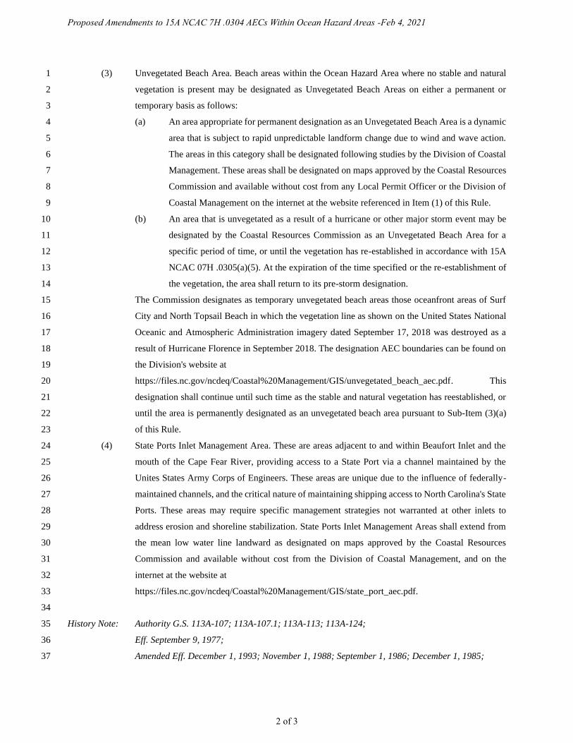
Proposed Amendments to 15A NCAC 7H .0304 AECs Within Ocean Hazard Areas -Feb 4, 2021
2 of 3
(3) Unvegetated Beach Area. Beach areas within the Ocean Hazard Area where no stable and natural 1
vegetation is present may be designated as Unvegetated Beach Areas on either a permanent or 2
temporary basis as follows: 3
(a) An area appropriate for permanent designation as an Unvegetated Beach Area is a dynamic 4
area that is subject to rapid unpredictable landform change due to wind and wave action. 5
The areas in this category shall be designated following studies by the Division of Coastal 6
Management. These areas shall be designated on maps approved by the Coastal Resources 7
Commission and available without cost from any Local Permit Officer or the Division of 8
Coastal Management on the internet at the website referenced in Item (1) of this Rule. 9
(b) An area that is unvegetated as a result of a hurricane or other major storm event may be 10
designated by the Coastal Resources Commission as an Unvegetated Beach Area for a 11
specific period of time, or until the vegetation has re-established in accordance with 15A 12
NCAC 07H .0305(a)(5). At the expiration of the time specified or the re-establishment of 13
the vegetation, the area shall return to its pre-storm designation. 14
The Commission designates as temporary unvegetated beach areas those oceanfront areas of Surf 15
City and North Topsail Beach in which the vegetation line as shown on the United States National 16
Oceanic and Atmospheric Administration imagery dated September 17, 2018 was destroyed as a 17
result of Hurricane Florence in September 2018. The designation AEC boundaries can be found on 18
the Division's website at 19
https://files.nc.gov/ncdeq/Coastal%20Management/GIS/unvegetated_beach_aec.pdf. This 20
designation shall continue until such time as the stable and natural vegetation has reestablished, or 21
until the area is permanently designated as an unvegetated beach area pursuant to Sub-Item (3)(a) 22
of this Rule. 23
(4) State Ports Inlet Management Area. These are areas adjacent to and within Beaufort Inlet and the 24
mouth of the Cape Fear River, providing access to a State Port via a channel maintained by the 25
Unites States Army Corps of Engineers. These areas are unique due to the influence of federally-26
maintained channels, and the critical nature of maintaining shipping access to North Carolina's State 27
Ports. These areas may require specific management strategies not warranted at other inlets to 28
address erosion and shoreline stabilization. State Ports Inlet Management Areas shall extend from 29
the mean low water line landward as designated on maps approved by the Coastal Resources 30
Commission and available without cost from the Division of Coastal Management, and on the 31
internet at the website at 32
https://files.nc.gov/ncdeq/Coastal%20Management/GIS/state_port_aec.pdf. 33
34
History Note: Authority G.S. 113A-107; 113A-107.1; 113A-113; 113A-124; 35
Eff. September 9, 1977; 36
Amended Eff. December 1, 1993; November 1, 1988; September 1, 1986; December 1, 1985; 37
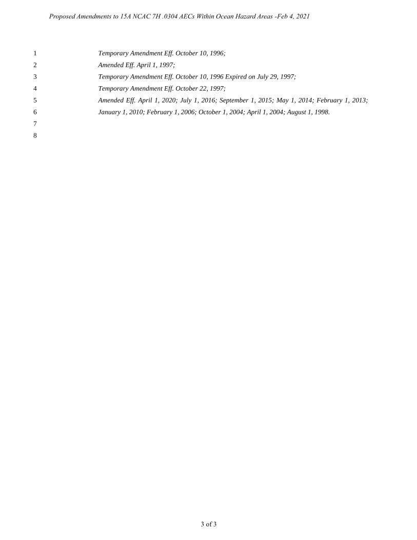
Proposed Amendments to 15A NCAC 7H .0304 AECs Within Ocean Hazard Areas -Feb 4, 2021
3 of 3
Temporary Amendment Eff. October 10, 1996; 1
Amended Eff. April 1, 1997; 2
Temporary Amendment Eff. October 10, 1996 Expired on July 29, 1997; 3
Temporary Amendment Eff. October 22, 1997; 4
Amended Eff. April 1, 2020; July 1, 2016; September 1, 2015; May 1, 2014; February 1, 2013; 5
January 1, 2010; February 1, 2006; October 1, 2004; April 1, 2004; August 1, 1998. 6
7
8
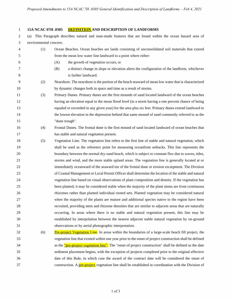
Proposed Amendments to 15A NCAC 7H .0305 General Identification and Description of Landforms – Feb 4, 2021
1 of 3
15A NCAC 07H .0305 DEFINITION AND DESCRIPTION OF LANDFORMS 1
(a) This Paragraph describes natural and man-made features that are found within the ocean hazard area of 2
environmental concern. 3
(1) Ocean Beaches. Ocean beaches are lands consisting of unconsolidated soil materials that extend 4
from the mean low water line landward to a point where either: 5
(A) the growth of vegetation occurs; or 6
(B) a distinct change in slope or elevation alters the configuration of the landform, whichever 7
is farther landward. 8
(2) Nearshore. The nearshore is the portion of the beach seaward of mean low water that is characterized 9
by dynamic changes both in space and time as a result of storms. 10
(3) Primary Dunes. Primary dunes are the first mounds of sand located landward of the ocean beaches 11
having an elevation equal to the mean flood level (in a storm having a one percent chance of being 12
equaled or exceeded in any given year) for the area plus six feet. Primary dunes extend landward to 13
the lowest elevation in the depression behind that same mound of sand commonly referred to as the 14
"dune trough". 15
(4) Frontal Dunes. The frontal dune is the first mound of sand located landward of ocean beaches that 16
has stable and natural vegetation present. 17
(5) Vegetation Line. The vegetation line refers to the first line of stable and natural vegetation, which 18
shall be used as the reference point for measuring oceanfront setbacks. This line represents the 19
boundary between the normal dry-sand beach, which is subject to constant flux due to waves, tides, 20
storms and wind, and the more stable upland areas. The vegetation line is generally located at or 21
immediately oceanward of the seaward toe of the frontal dune or erosion escarpment. The Division 22
of Coastal Management or Local Permit Officer shall determine the location of the stable and natural 23
vegetation line based on visual observations of plant composition and density. If the vegetation has 24
been planted, it may be considered stable when the majority of the plant stems are from continuous 25
rhizomes rather than planted individual rooted sets. Planted vegetation may be considered natural 26
when the majority of the plants are mature and additional species native to the region have been 27
recruited, providing stem and rhizome densities that are similar to adjacent areas that are naturally 28
occurring. In areas where there is no stable and natural vegetation present, this line may be 29
established by interpolation between the nearest adjacent stable natural vegetation by on-ground 30
observations or by aerial photographic interpretation. 31
(6) Pre-project Vegetation Line. In areas within the boundaries of a large-scale beach fill project, the 32
vegetation line that existed within one year prior to the onset of project construction shall be defined 33
as the “pre-project vegetation line”. The "onset of project construction" shall be defined as the date 34
sediment placement begins, with the exception of projects completed prior to the original effective 35
date of this Rule, in which case the award of the contract date will be considered the onset of 36
construction. A pre-project vegetation line shall be established in coordination with the Division of 37

Proposed Amendments to 15A NCAC 7H .0305 General Identification and Description of Landforms – Feb 4, 2021
2 of 3
Coastal Management using on-ground observation and survey or aerial imagery for all areas of 1
oceanfront that undergo a large-scale beach fill project. Once a pre-project vegetation line is 2
established, and after the onset of project construction, this line shall be used as the reference point 3
for measuring oceanfront setbacks in all locations where it is landward of the vegetation line. In all 4
locations where the vegetation line as defined in this Rule is landward of the pre-project vegetation 5
line, the vegetation line shall be used as the reference point for measuring oceanfront setbacks. A 6
pre-project vegetation line shall not be established where a pre-project vegetation line is already in 7
place, including those established by the Division of Coastal Management prior to the effective date 8
of this Rule. A record of all pre-project vegetation lines, including those established by the Division 9
of Coastal Management prior to the effective date of this Rule, shall be maintained by the Division 10
of Coastal Management for determining development standards as set forth in Rule .0306 of this 11
Section. Because the impact of Hurricane Floyd in September 1999 caused significant portions of 12
the vegetation line in the Town of Oak Island and the Town of Ocean Isle Beach to be relocated 13
landward of its pre-storm position, the pre-project line for areas landward of the beach fill 14
construction in the Town of Oak Island and the Town of Ocean Isle Beach, the onset of which 15
occurred in 2000, shall be defined by the general trend of the vegetation line established by the 16
Division of Coastal Management from June 1998 aerial orthophotography. 17
(7) Beach Fill. Beach fill refers to the placement of sediment along the oceanfront shoreline. Sediment 18
used solely to establish or strengthen dunes shall not be considered a beach fill project under this 19
Rule. A "large-scale beach fill project" shall be defined as any volume of sediment greater than 20
300,000 cubic yards or any storm protection project constructed by the U.S. Army Corps of 21
Engineers. 22
(8) Erosion Escarpment. The normal vertical drop in the beach profile caused from high tide or storm 23
tide erosion. 24
(9) Measurement Line. The line from which the ocean hazard setback as described in Rule .0306(a) of 25
this Section is measured in the unvegetated beach area of environmental concern as described in 26
Rule .0304(3) of this Section. In areas designated pursuant to Rule .0304(3)(b) of this Section, the 27
Division of Coastal Management shall establish a measurement line by: 28
(A) determining the average distance the pre-storm vegetation line receded at the closest 29
vegetated site adjacent to the area designated by the Commission as the unvegetated beach 30
AEC; and 31
(B) mapping a line equal to the average recession determination in Part (A) of this 32
Subparagraph, measured in a landward direction from the first line of stable and natural 33
vegetation line on the most recent pre-storm aerial photography in the area designated as 34
an unvegetated beach AEC. 35
36
History Note: Authority G.S. 113A-107; 113A-113(b)(6); 113A-124; 37
Proposed Amendments to 15A NCAC 7H .0305 General Identification and Description of Landforms – Feb 4, 2021
3 of 3
Eff. September 9, 1977; 1
Amended Eff. December 1, 1992; September 1, 1986; December 1, 1985; February 2, 1981; 2
Temporary Amendment Eff. October 10, 1996; 3
Amended Eff. January 1, 1997; 4
Temporary Amendment Eff. October 10, 1996 Expired on July 29, 1997; 5
Temporary Amendment Eff. October 22, 1997; 6
Amended Eff. April 1, 2020; April 1, 2016; April 1, 2008; August 1, 2002; August 1, 1998. 7
8
9

Proposed Amendments to 15A NCAC 7H .0306 General Use Standards for Ocean Hazard Areas – Feb 4, 2021
1 of 5
15A NCAC 07H .0306 GENERAL USE STANDARDS FOR OCEAN HAZARD AREAS 1
(a) In order to protect life and property, all development not otherwise specifically exempted or allowed by law or 2
elsewhere in the Coastal Resources Commission's rules shall be located according to whichever of the following is 3
applicable: 4
(1) The ocean hazard setback for development shall be measured in a landward direction from the 5
vegetation line, the pre-project vegetation line, or the measurement line, whichever is applicable. 6
(2) The ocean hazard setback shall be determined by both the size of development and the shoreline 7
long term erosion rate as defined in Rule .0304 of this Section. "Development size" is defined by 8
total floor area for structures and buildings or total area of footprint for development other than 9
structures and buildings. Total floor area includes the following: 10
(A) The total square footage of heated or air-conditioned living space; 11
(B) The total square footage of parking elevated above ground level; and 12
(C) The total square footage of non-heated or non-air-conditioned areas elevated above ground 13
level, excluding attic space that is not designed to be load-bearing. 14
Decks, roof-covered porches, and walkways shall not be included in the total floor area unless they 15
are enclosed with material other than screen mesh or are being converted into an enclosed space 16
with material other than screen mesh. 17
(3) With the exception of those types of development defined in 15A NCAC 07H.0309(a), no 18
development, including any portion of a building or structure, shall extend oceanward of the ocean 19
hazard setback. This includes roof overhangs and elevated structural components that are 20
cantilevered, knee braced, or otherwise extended beyond the support of pilings or footings. The 21
ocean hazard setback shall be established based on the following criteria: 22
(A) A building or other structure less than 5,000 square feet requires a minimum setback of 60 23
feet or 30 times the shoreline erosion rate, whichever is greater; 24
(B) A building or other structure greater than or equal to 5,000 square feet but less than 10,000 25
square feet requires a minimum setback of 120 feet or 60 times the shoreline erosion rate, 26
whichever is greater; 27
(C) A building or other structure greater than or equal to 10,000 square feet but less than 20,000 28
square feet requires a minimum setback of 130 feet or 65 times the shoreline erosion rate, 29
whichever is greater; 30
(D) A building or other structure greater than or equal to 20,000 square feet but less than 40,000 31
square feet requires a minimum setback of 140 feet or 70 times the shoreline erosion rate, 32
whichever is greater; 33
(E) A building or other structure greater than or equal to 40,000 square feet but less than 60,000 34
square feet requires a minimum setback of 150 feet or 75 times the shoreline erosion rate, 35
whichever is greater; 36
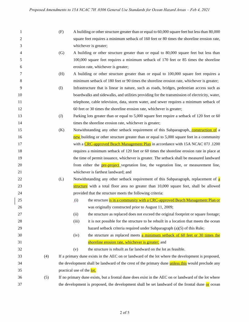
Proposed Amendments to 15A NCAC 7H .0306 General Use Standards for Ocean Hazard Areas – Feb 4, 2021
2 of 5
(F) A building or other structure greater than or equal to 60,000 square feet but less than 80,000 1
square feet requires a minimum setback of 160 feet or 80 times the shoreline erosion rate, 2
whichever is greater; 3
(G) A building or other structure greater than or equal to 80,000 square feet but less than 4
100,000 square feet requires a minimum setback of 170 feet or 85 times the shoreline 5
erosion rate, whichever is greater; 6
(H) A building or other structure greater than or equal to 100,000 square feet requires a 7
minimum setback of 180 feet or 90 times the shoreline erosion rate, whichever is greater; 8
(I) Infrastructure that is linear in nature, such as roads, bridges, pedestrian access such as 9
boardwalks and sidewalks, and utilities providing for the transmission of electricity, water, 10
telephone, cable television, data, storm water, and sewer requires a minimum setback of 11
60 feet or 30 times the shoreline erosion rate, whichever is greater; 12
(J) Parking lots greater than or equal to 5,000 square feet require a setback of 120 feet or 60 13
times the shoreline erosion rate, whichever is greater; 14
(K) Notwithstanding any other setback requirement of this Subparagraph, construction of a 15
new building or other structure greater than or equal to 5,000 square feet in a community 16
with a CRC-approved Beach Management Plan in accordance with 15A NCAC 07J .1200 17
requires a minimum setback of 120 feet or 60 times the shoreline erosion rate in place at 18
the time of permit issuance, whichever is greater. The setback shall be measured landward 19
from either the pre-project vegetation line, the vegetation line, or measurement line, 20
whichever is farthest landward; and 21
(L) Notwithstanding any other setback requirement of this Subparagraph, replacement of a 22
structure with a total floor area no greater than 10,000 square feet, shall be allowed 23
provided that the structure meets the following criteria: 24
(i) the structure is in a community with a CRC-approved Beach Management Plan or 25
was originally constructed prior to August 11, 2009; 26
(ii) the structure as replaced does not exceed the original footprint or square footage; 27
(iii) it is not possible for the structure to be rebuilt in a location that meets the ocean 28
hazard setback criteria required under Subparagraph (a)(5) of this Rule; 29
(iv) the structure as replaced meets a minimum setback of 60 feet or 30 times the 30
shoreline erosion rate, whichever is greater; and 31
(v) the structure is rebuilt as far landward on the lot as feasible. 32
(4) If a primary dune exists in the AEC on or landward of the lot where the development is proposed, 33
the development shall be landward of the crest of the primary dune unless this would preclude any 34
practical use of the lot. 35
(5) If no primary dune exists, but a frontal dune does exist in the AEC on or landward of the lot where 36
the development is proposed, the development shall be set landward of the frontal dune or ocean 37
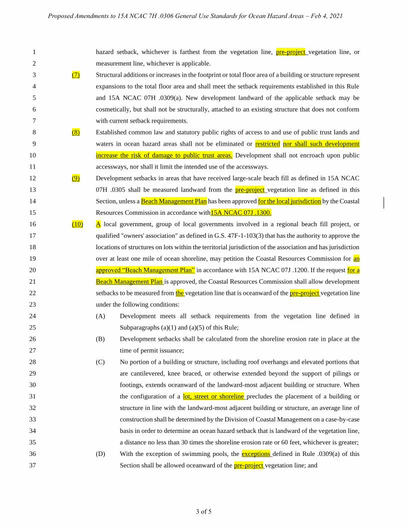
Proposed Amendments to 15A NCAC 7H .0306 General Use Standards for Ocean Hazard Areas – Feb 4, 2021
3 of 5
hazard setback, whichever is farthest from the vegetation line, pre-project vegetation line, or 1
measurement line, whichever is applicable. 2
(7) Structural additions or increases in the footprint or total floor area of a building or structure represent 3
expansions to the total floor area and shall meet the setback requirements established in this Rule 4
and 15A NCAC 07H .0309(a). New development landward of the applicable setback may be 5
cosmetically, but shall not be structurally, attached to an existing structure that does not conform 6
with current setback requirements. 7
(8) Established common law and statutory public rights of access to and use of public trust lands and 8
waters in ocean hazard areas shall not be eliminated or restricted nor shall such development 9
increase the risk of damage to public trust areas. Development shall not encroach upon public 10
accessways, nor shall it limit the intended use of the accessways. 11
(9) Development setbacks in areas that have received large-scale beach fill as defined in 15A NCAC 12
07H .0305 shall be measured landward from the pre-project vegetation line as defined in this 13
Section, unless a Beach Management Plan has been approved for the local jurisdiction by the Coastal 14
Resources Commission in accordance with15A NCAC 07J .1300. 15
(10) A local government, group of local governments involved in a regional beach fill project, or 16
qualified "owners' association" as defined in G.S. 47F-1-103(3) that has the authority to approve the 17
locations of structures on lots within the territorial jurisdiction of the association and has jurisdiction 18
over at least one mile of ocean shoreline, may petition the Coastal Resources Commission for an 19
approved “Beach Management Plan” in accordance with 15A NCAC 07J .1200. If the request for a 20
Beach Management Plan is approved, the Coastal Resources Commission shall allow development 21
setbacks to be measured from the vegetation line that is oceanward of the pre-project vegetation line 22
under the following conditions: 23
(A) Development meets all setback requirements from the vegetation line defined in 24
Subparagraphs (a)(1) and (a)(5) of this Rule; 25
(B) Development setbacks shall be calculated from the shoreline erosion rate in place at the 26
time of permit issuance; 27
(C) No portion of a building or structure, including roof overhangs and elevated portions that 28
are cantilevered, knee braced, or otherwise extended beyond the support of pilings or 29
footings, extends oceanward of the landward-most adjacent building or structure. When 30
the configuration of a lot, street or shoreline precludes the placement of a building or 31
structure in line with the landward-most adjacent building or structure, an average line of 32
construction shall be determined by the Division of Coastal Management on a case-by-case 33
basis in order to determine an ocean hazard setback that is landward of the vegetation line, 34
a distance no less than 30 times the shoreline erosion rate or 60 feet, whichever is greater; 35
(D) With the exception of swimming pools, the exceptions defined in Rule .0309(a) of this 36
Section shall be allowed oceanward of the pre-project vegetation line; and 37

Proposed Amendments to 15A NCAC 7H .0306 General Use Standards for Ocean Hazard Areas – Feb 4, 2021
4 of 5
(b) Development shall not cause irreversible damage to historic architectural or archaeological resources as 1
documented by the local historic commission, the North Carolina Department of Natural and Cultural Resources, or 2
the National Historical Registry. 3
(c) Mobile homes shall not be placed within the ocean hazard area unless they are within mobile home parks existing 4
as of June 1, 1979. 5
(d) Development proposals shall incorporate measures to avoid or minimize adverse impacts of the project. These 6
measures shall be implemented at the applicant's expense and may include actions that: 7
(1) minimize or avoid adverse impacts by limiting the magnitude or degree of the action; 8
(2) restore the affected environment; or 9
(3) compensate for the adverse impacts by replacing or providing substitute resources. 10
(e) Prior to the issuance of any permit for development in the ocean hazard AECs, there shall be a written 11
acknowledgment from the applicant to the Division of Coastal Management that the applicant is aware of the risks 12
associated with development in this hazardous area and the limited suitability of this area for permanent structures. 13
The acknowledgement shall state that the Coastal Resources Commission does not guarantee the safety of the 14
development and assumes no liability for future damage to the development. 15
(f) The relocation or elevation of structures shall require permit approval. 16
(1) Structures relocated landward with public funds shall comply with the applicable ocean hazard setbacks 17
and other applicable AEC rules. 18
(2) Structures relocated landward entirely with non-public funds that do not meet current applicable ocean 19
hazard setbacks may be relocated the maximum feasible distance landward of its present location. Septic tanks shall 20
not be relocated oceanward of the primary structure. 21
(3) Existing structures shall not be elevated if any portion of the structure is located seaward of the Vegetation 22
Line or Measurement Line. 23
(g) Permits shall include the condition that any structure shall be relocated or dismantled when it becomes imminently 24
threatened by changes in shoreline configuration as defined in 15A NCAC 07H .0308(a)(2)(B). Any such structure 25
shall be relocated or dismantled within eight years of the time when it becomes imminently threatened, and in any 26
case upon its collapse or subsidence. However, if natural shoreline recovery or beach fill takes place within eight years 27
of the time the structure becomes imminently threatened, so that the structure is no longer imminently threatened, then 28
it need not be relocated or dismantled at that time. This permit condition shall not affect the permit holder's right to 29
seek authorization of temporary protective measures allowed pursuant to 15A NCAC 07H .0308(a)(2). 30
31
History Note: Authority G.S. 113A-107; 113A-113(b)(6); 113A-124; 32
Eff. September 9, 1977; 33
Amended Eff. December 1, 1991; March 1, 1988; September 1, 1986; December 1, 1985; 34
RRC Objection due to ambiguity Eff. January 24, 1992; 35
Amended Eff. March 1, 1992; 36
RRC Objection due to ambiguity Eff. May 21, 1992; 37

Proposed Amendments to 15A NCAC 7H .0306 General Use Standards for Ocean Hazard Areas – Feb 4, 2021
5 of 5
Amended Eff. February 1, 1993; October 1, 1992; June 19, 1992; 1
RRC Objection due to ambiguity Eff. May 18, 1995; 2
Amended Eff. August 11, 2009; April 1, 2007; November 1, 2004; June 27, 1995; 3
Temporary Amendment Eff. January 3, 2013; 4
Amended Eff. September 1, 2017; February 1, 2017; April 1, 2016; September 1, 2013. 5
6
7

Proposed Amendments to 15A NCAC 7H .0308 Specific Use Standards for Ocean Hazard Areas – Feb 4, 2021
1 of 8
15A NCAC 07H .0308 SPECIFIC USE STANDARDS FOR OCEAN HAZARD AREAS 1
(a) Ocean Shoreline Erosion Control Activities: 2
(1) Use Standards Applicable to all Erosion Control Activities: 3
(A) All oceanfront erosion response activities shall be consistent with the general policy 4
statements in 15A NCAC 07M .0200. 5
(B) Permanent erosion control structures may cause significant adverse impacts on the value 6
and enjoyment of adjacent properties or public access to and use of the ocean beach, and, 7
therefore, unless specifically authorized under the Coastal Area Management Act, are 8
prohibited. Such structures include bulkheads, seawalls, revetments, jetties, groins and 9
breakwaters. 10
(C) Rules concerning the use of oceanfront erosion response measures apply to all oceanfront 11
properties without regard to the size of the structure on the property or the date of its 12
construction. 13
(D) Shoreline erosion response projects shall not be constructed in beach or estuarine areas that 14
sustain substantial habitat for fish and wildlife species, as identified by natural resource 15
agencies during project review, unless mitigation measures are incorporated into project 16
design, as set forth in Rule .0306(h) of this Section. 17
(E) Project construction shall be timed to minimize adverse effects on biological activity. 18
(F) Prior to completing any erosion response project, all exposed remnants of or debris from 19
failed erosion control structures must be removed by the permittee. 20
(G) Permanent erosion control structures that would otherwise be prohibited by these standards 21
may be permitted on finding by the Division that: 22
(i) the erosion control structure is necessary to protect a bridge that provides the only 23
existing road access on a barrier island, that is vital to public safety, and is 24
imminently threatened by erosion as defined in Part (a)(2)(B) of this Rule; 25
(ii) the erosion response measures of relocation, beach nourishment or temporary 26
stabilization are not adequate to protect public health and safety; and 27
(iii) the proposed erosion control structure will have no adverse impacts on adjacent 28
properties in private ownership or on public use of the beach. 29
(H) Structures that would otherwise be prohibited by these standards may also be permitted on 30
finding by the Division that: 31
(i) the structure is necessary to protect a state or federally registered historic site that 32
is imminently threatened by shoreline erosion as defined in Part (a)(2)(B) of this 33
Rule; 34
(ii) the erosion response measures of relocation, beach nourishment or temporary 35
stabilization are not adequate and practicable to protect the site; 36
(iii) the structure is limited in extent and scope to that necessary to protect the site; and 37
Proposed Amendments to 15A NCAC 7H .0308 Specific Use Standards for Ocean Hazard Areas – Feb 4, 2021
2 of 8
(iv) a permit for a structure under this Part may be issued only to a sponsoring public 1
agency for projects where the public benefits outweigh the significant adverse 2
impacts. Additionally, the permit shall include conditions providing for mitigation 3
or minimization by that agency of significant adverse impacts on adjoining 4
properties and on public access to and use of the beach. 5
(I) Structures that would otherwise be prohibited by these standards may also be permitted on 6
finding by the Division that: 7
(i) the structure is necessary to maintain an existing commercial navigation channel 8
of regional significance within federally authorized limits; 9
(ii) dredging alone is not practicable to maintain safe access to the affected channel; 10
(iii) the structure is limited in extent and scope to that necessary to maintain the 11
channel; 12
(iv) the structure shall not have significant adverse impacts on fisheries or other public 13
trust resources; and 14
(v) a permit for a structure under this Part may be issued only to a sponsoring public 15
agency for projects where the public benefits outweigh the significant adverse 16
impacts. Additionally, the permit shall include conditions providing for mitigation 17
or minimization by that agency of any significant adverse impacts on adjoining 18
properties and on public access to and use of the beach. 19
(J) The Commission may renew a permit for an erosion control structure issued pursuant to a 20
variance granted by the Commission prior to 1 July 1995. The Commission may authorize 21
the replacement of a permanent erosion control structure that was permitted by the 22
Commission pursuant to a variance granted by the Commission prior to 1 July 1995 if the 23
Commission finds that: 24
(i) the structure will not be enlarged beyond the dimensions set out in the permit; 25
(ii) there is no practical alternative to replacing the structure that will provide the same 26
or similar benefits; and 27
(iii) the replacement structure will comply with all applicable laws and with all rules, 28
other than the rule or rules with respect to which the Commission granted the 29
variance, that are in effect at the time the structure is replaced. 30
(K) Proposed erosion response measures using innovative technology or design shall be 31
considered as experimental and shall be evaluated on a case-by-case basis to determine 32
consistency with 15A NCAC 07M .0200 and general and specific use standards within this 33
Section. 34
(2) Temporary Erosion Control Structures: 35
(A) Permittable temporary erosion control structures shall be limited to sandbags placed 36
landward of mean high water and parallel to the shore. 37
Proposed Amendments to 15A NCAC 7H .0308 Specific Use Standards for Ocean Hazard Areas – Feb 4, 2021
3 of 8
(B) Temporary erosion control structures as defined in Part (A) of this Subparagraph may be 1
used to protect only imminently threatened roads and associated right of ways, and 2
buildings and their associated septic systems. A structure is considered imminently 3
threatened if its foundation, septic system, or right-of-way in the case of roads, is less than 4
20 feet away from the erosion scarp. Buildings and roads located more than 20 feet from 5
the erosion scarp or in areas where there is no obvious erosion scarp may also be found to 6
be imminently threatened when site conditions, such as a flat beach profile or accelerated 7
erosion, increase the risk of imminent damage to the structure. 8
(C) Temporary erosion control structures shall be used to protect only the principal structure 9
and its associated septic system, but not appurtenances such as pools, gazebos, decks or 10
any amenity that is allowed under Rule .0309 of this Section as an exception to the erosion 11
setback requirement. 12
(D) Temporary erosion control structures may be placed waterward of a septic system when 13
there is no alternative to relocate it on the same or adjoining lot so that it is landward of or 14
in line with the structure being protected. 15
(E) Temporary erosion control structures shall not extend more than 20 feet past the sides of 16
the structure to be protected except to align with temporary erosion control structures on 17
adjacent properties, where the Division has determined that gaps between adjacent erosion 18
control structures may result in an increased risk of damage to the structure to be protected. 19
The landward side of such temporary erosion control structures shall not be located more 20
than 20 feet waterward of the structure to be protected, or the right-of-way in the case of 21
roads. If a building or road is found to be imminently threatened and at an increased risk 22
of imminent damage due to site conditions such as a flat beach profile or accelerated 23
erosion, temporary erosion control structures may be located more than 20 feet waterward 24
of the structure being protected. In cases of increased risk of imminent damage, the location 25
of the temporary erosion control structures shall be determined by the Director of the 26
Division of Coastal Management or the Director's designee in accordance with Part (A) of 27
this Subparagraph. 28
(F) Temporary erosion control structures may remain in place for up to eight years for a 29
building and its associated septic system, a bridge or a road. The property owner shall be 30
responsible for removal of any portion of the temporary erosion control structure exposed 31
above grade within 30 days of the end of the allowable time period. 32
(G) An imminently threatened structure or property may be protected only once, regardless of 33
ownership, unless the threatened structure or property is located in a community that is 34
actively pursuing a beach nourishment project, or an inlet relocation or stabilization project 35
in accordance with Part (H) of this Subparagraph. Existing temporary erosion control 36
structures may be permitted for additional eight-year periods provided that the structure or 37

Proposed Amendments to 15A NCAC 7H .0308 Specific Use Standards for Ocean Hazard Areas – Feb 4, 2021
4 of 8
property being protected is still imminently threatened, the temporary erosion control 1
structure is in compliance with requirements of this Subchapter, and the community in 2
which it is located is actively pursuing a beach nourishment or an inlet relocation or 3
stabilization project in accordance with Part (H) of this Subparagraph. In the case of a 4
building, a temporary erosion control structure may be extended, or new segments 5
constructed, if additional areas of the building become imminently threatened. Where 6
temporary structures are installed or extended incrementally, the time period for removal 7
under Part (F) or (H) of this Subparagraph shall begin at the time the initial erosion control 8
structure was installed. For the purpose of this Rule: 9
(i) a building and its septic system shall be considered separate structures, 10
(ii) a road or highway may be incrementally protected as sections become imminently 11
threatened. The time period for removal of each contiguous section of temporary 12
erosion control structure shall begin at the time that the initial section was 13
installed, in accordance with Part (F) of this Subparagraph. 14
(H) For purposes of this Rule, a community is considered to be actively pursuing a beach 15
nourishment or an inlet relocation or stabilization project in accordance with G.S. 113A-16
115.1 if it: 17
(i) has been issued an active CAMA permit, where necessary, approving such 18
project; or 19
(ii) has been identified by a U.S. Army Corps of Engineers' Beach Nourishment 20
Reconnaissance Study, General Reevaluation Report, Coastal Storm Damage 21
Reduction Study, or an ongoing feasibility study by the U.S. Army Corps of 22
Engineers and a commitment of local or federal money, when necessary; or 23
(iii) has received a favorable economic evaluation report on a federal project; or 24
(iv) is in the planning stages of a project designed by the U.S. Army Corps of 25
Engineers or persons meeting applicable State occupational licensing 26
requirements and initiated by a local government or community with a 27
commitment of local or state funds to construct the project or the identification of 28
the financial resources or funding bases necessary to fund the beach nourishment, 29
inlet relocation or stabilization project. 30
If beach nourishment, inlet relocation or stabilization is rejected by the sponsoring agency 31
or community, or ceases to be actively planned for a section of shoreline, the time extension 32
is void for that section of beach or community and existing sandbags are subject to all 33
applicable time limits set forth in Part (F) of this Subparagraph. 34
(I) Once a temporary erosion control structure is determined by the Division of Coastal 35
Management to be unnecessary due to relocation or removal of the threatened structure, it 36
shall be removed to the maximum extent practicable by the property owner within 30 days 37

Proposed Amendments to 15A NCAC 7H .0308 Specific Use Standards for Ocean Hazard Areas – Feb 4, 2021
5 of 8
of official notification from the Division of Coastal Management regardless of the time 1
limit placed on the temporary erosion control structure. If the temporary erosion control 2
structure is determined by the Division of Coastal Management to be unnecessary due to 3
the completion of a storm protection project constructed by the U.S. Army Corps of 4
Engineers, a large-scale beach nourishment project, or an inlet relocation or stabilization 5
project, any portion of the temporary erosion control structure exposed above grade shall 6
be removed by the property owner within 30 days of official notification from the Division 7
of Coastal Management regardless of the time limit placed on the temporary erosion control 8
structure. 9
(J) Removal of temporary erosion control structures is not required if they are covered by sand. 10
Any portion of the temporary erosion control structure that becomes exposed above grade 11
after the expiration of the permitted time period shall be removed by the property owner 12
within 30 days of official notification from the Division of Coastal Management. 13
(K) The property owner shall be responsible for the removal of remnants of all portions of any 14
damaged temporary erosion control structure. 15
(L) Sandbags used to construct temporary erosion control structures shall be tan in color and 16
three to five feet wide and seven to 15 feet long when measured flat. Base width of the 17
temporary erosion control structure shall not exceed 20 feet, and the total height shall not 18
exceed six feet, as measured from the bottom of the lowest bag. 19
(M) Soldier pilings and other types of devices to anchor sandbags shall not be allowed. 20
(N) Existing sandbag structures may be repaired or replaced within their originally permitted 21
dimensions during the time period allowed under Part (F) or (G) of this Subparagraph. 22
(3) Beach Nourishment. Sand used for beach nourishment shall be compatible with existing grain size 23
and in accordance with Rule .0312 of this Section. 24
(4) Beach Bulldozing. Beach bulldozing (defined as the process of moving natural beach material from 25
any point seaward of the vegetation line to create a protective sand dike or to obtain material for any 26
other purpose) is development and may be permitted as an erosion response if the following 27
conditions are met: 28
(A) The area on which this activity is being performed shall maintain a slope of adequate grade 29
so as to not endanger the public or the public's use of the beach and shall follow the pre-30
emergency slope as closely as possible. The movement of material utilizing a bulldozer, 31
front end loader, backhoe, scraper, or any type of earth moving or construction equipment 32
shall not exceed one foot in depth measured from the pre-activity surface elevation; 33
(B) The activity shall not exceed the lateral bounds of the applicant's property unless 34
permission is obtained from the adjoining land owner(s); 35
(C) Movement of material from seaward of the mean low water line will require a CAMA 36
Major Development and State Dredge and Fill Permit; 37
Proposed Amendments to 15A NCAC 7H .0308 Specific Use Standards for Ocean Hazard Areas – Feb 4, 2021
6 of 8
(D) The activity shall not increase erosion on neighboring properties and shall not have an 1
adverse effect on natural or cultural resources; 2
(E) The activity may be undertaken to protect threatened on-site waste disposal systems as well 3
as the threatened structure's foundations. 4
(b) Dune Protection, Establishment, Restoration, and Stabilization. 5
(1) No development shall be permitted that involves the removal or relocation of primary or frontal 6
dune sand or vegetation thereon that would adversely affect the integrity of the dune. Other dunes 7
within the ocean hazard area shall not be disturbed unless the development of the property is 8
otherwise impracticable. Any disturbance of these other dunes shall be allowed only to the extent 9
permitted by this Rule. 10
(2) Any new dunes established shall be aligned to the greatest extent possible with existing adjacent 11
dune ridges and shall be of the same configuration as adjacent natural dunes. 12
(3) Existing primary and frontal dunes shall not, except for beach nourishment and emergency 13
situations, be broadened or extended in an oceanward direction. 14
(4) Adding to dunes shall be accomplished in such a manner that the damage to existing vegetation is 15
minimized. The filled areas shall be replanted or temporarily stabilized until planting can be 16
completed. 17
(5) Sand used to establish or strengthen dunes shall be of the same general characteristics as the sand 18
in the area in which it is to be placed. 19
(6) No new dunes shall be created in inlet hazard areas. 20
(7) Sand held in storage in any dune, other than the frontal or primary dune, shall remain on the lot or 21
tract of land to the maximum extent practicable and may be redistributed within the Ocean Hazard 22
AEC provided that it is not placed any farther oceanward than the crest of a primary dune, if present, 23
or the crest of a frontal dune. 24
(8) No disturbance of a dune area shall be allowed when other techniques of construction can be utilized 25
and alternative site locations exist to avoid dune impacts. 26
(c) Structural Accessways: 27
(1) Structural accessways shall be permitted across primary or frontal dunes so long as they are designed 28
and constructed in a manner that entails negligible alteration of the primary or frontal dune. 29
Structural accessways shall not be considered threatened structures for the purpose of Paragraph (a) 30
of this Rule. 31
(2) An accessway shall be considered to entail negligible alteration of primary or frontal dunes provided 32
that: 33
(A) The accessway is exclusively for pedestrian use; 34
(B) The accessway is a maximum of six feet in width; 35
(C) The accessway is raised on posts or pilings of five feet or less depth, so that wherever 36
possible only the posts or pilings touch the dune. Where this is deemed by the Division of 37
Proposed Amendments to 15A NCAC 7H .0308 Specific Use Standards for Ocean Hazard Areas – Feb 4, 2021
7 of 8
Coastal Management to be impossible due to any more restrictive local, state, and/or 1
federal building requirements, the structure shall touch the dune only to the necessary; and 2
(D) Any areas of vegetation that are disturbed are revegetated as soon as feasible. 3
(3) An accessway that does not meet Part (2)(A) and (B) of this Paragraph shall be permitted only if it 4
meets a public purpose or need which cannot otherwise be met and it meets Part (2)(C) of this 5
Paragraph. Public fishing piers are not prohibited provided all other applicable standards of this 6
Rule are met. 7
(4) In order to preserve the protective nature of primary and frontal dunes a structural accessway (such 8
as a "Hatteras ramp") may be provided for off-road vehicle (ORV) or emergency vehicle access. 9
Such accessways shall be no greater than 15 feet in width and may be constructed of wooden 10
sections fastened together, or other materials approved by the Division, over the length of the 11
affected dune area. Installation of a Hatteras ramp shall be done in a manner that will preserve the 12
dune's function as a protective barrier against flooding and erosion by not reducing the volume of 13
the dune. 14
(5) Structural accessways may be constructed no more than six feet seaward of the waterward toe of the 15
frontal or primary dune, provided they do not interfere with public trust rights and emergency access 16
along the beach. Structural accessways are not restricted by the requirement to be landward of the 17
FLSNV as described in Rule .0309(a) of this Section. 18
(d) Building Construction Standards. New building construction and any construction identified in .0306(a)(5) of 19
this Section and 15A NCAC 07J .0210 shall comply with the following standards: 20
(1) In order to avoid danger to life and property, all development shall be designed and placed so as to 21
minimize damage due to fluctuations in ground elevation and wave action in a 100-year storm. Any 22
building constructed within the ocean hazard area shall comply with relevant sections of the North 23
Carolina Building Code including the Coastal and Flood Plain Construction Standards and the local 24
flood damage prevention ordinance as required by the National Flood Insurance Program. If any 25
provision of the building code or a flood damage prevention ordinance is inconsistent with any of 26
the following AEC standards, the more restrictive provision shall control. 27
(2) All building in the ocean hazard area shall be on pilings not less than eight inches in diameter if 28
round or eight inches to a side if square. 29
(3) All pilings shall have a tip penetration greater than eight feet below the lowest ground elevation 30
under the structure. For those structures so located on or seaward of the primary dune, the pilings 31
shall extend to five feet below mean sea level. 32
(4) All foundations shall be designed to be stable during applicable fluctuations in ground elevation and 33
wave forces during a 100-year storm. Cantilevered decks and walkways shall meet the requirements 34
of this Part or shall be designed to break-away without structural damage to the main structure. 35
36
History Note: Authority G.S. 113A-107(a); 113A-107(b); 113A-113(b)(6)a.,b.,d.; 113A-115.1; 113A-124; 37

Proposed Amendments to 15A NCAC 7H .0308 Specific Use Standards for Ocean Hazard Areas – Feb 4, 2021
8 of 8
Eff. June 1, 1979; 1
Temporary Amendment Eff. June 20, 1989, for a period of 180 days to expire on December 17, 2
1989; 3
Amended Eff. August 3, 1992; December 1, 1991; March 1, 1990; December 1, 1989; 4
RRC Objection Eff. November 19, 1992 due to ambiguity; 5
RRC Objection Eff. January 21, 1993 due to ambiguity; 6
Amended Eff. March 1, 1993; December 28, 1992; 7
RRC Objection Eff. March 16, 1995 due to ambiguity; 8
Amended Eff. April 1, 1999; February 1, 1996; May 4, 1995; 9
Temporary Amendment Eff. July 3, 2000; May 22, 2000; 10
Amended Eff. April 1, 2019; May 1, 2013; July 1, 2009; April 1, 2008; February 1, 2006; August 1, 11
2002. 12
13
14
Proposed Amendments to 15A NCAC 7H .0309 Use Standards for Ocean Hazard Areas: Exceptions
Feb 4, 2021
15A NCAC 07H .0309 USE STANDARDS FOR OCEAN HAZARD AREAS: EXCEPTIONS
(a) The following types of development shall be permitted seaward of the oceanfront setback requirements of Rule
.0306(a) of this Section if all other provisions of this Subchapter and other state and local regulations are met:
(1) campsites;
(2) driveways and parking areas with clay, packed sand, or gravel;
(3) elevated decks not exceeding a footprint of 500 square feet. Existing decks exceeding a footprint of
500 square feet may be replaced with no enlargement beyond their original dimensions;
(4) beach accessways consistent with Rule .0308(c) of this Section;
(5) unenclosed, uninhabitable gazebos with a footprint of 200 square feet or less;
(6) uninhabitable, single-story storage sheds with a foundation or floor consisting of wood, clay, packed
sand or gravel, and a footprint of 200 square feet or less;
(7) temporary amusement stands consistent with Section .1900 of this Subchapter;
(8) sand fences; and
(9) swimming pools.
(10) fill not associated with dune creation that is obtained from an upland source and is of the same
general characteristics as the sand in the area in which it is to be placed.
In all cases, this development shall be permitted only if it is landward of the vegetation line or pre-project vegetation
line, whichever is applicable; involves no alteration or removal of primary or frontal dunes which would compromise
the integrity of the dune as a protective landform or the dune vegetation; is not essential to the continued existence or
use of an associated principal development; and meets all other non-setback requirements of this Subchapter.
(b) Where application of the oceanfront setback requirements of Rule .0306(a) of this Section would preclude
placement of a structure on a lot existing as of June 1, 1979, the structure shall be permitted seaward of the applicable
setback line in Ocean Erodible Areas, State Ports Inlet Management Areas, and Inlet Hazard Areas, but not
Unvegetated Beach Areas if each of the following conditions are met:
(1) The development is set back from the ocean the maximum feasible distance possible on the existing
lot and the development is designed to minimize encroachment into the setback area;
(2) The development is at least 60 feet landward of the vegetation line, measurement line, or pre-project
vegetation line, whichever is applicable;
(3) The development is not located on or oceanward of a frontal dune, but is entirely behind the
landward toe of the frontal dune;
(4) The development incorporates each of the following design standards, which are in addition to those
required by Rule .0308(d) of this Section.
(A) All pilings shall have a tip penetration that extends to at least four feet below mean sea
level;
(B) The footprint of the structure shall be no more than 1,000 square feet, and the total floor
area of the structure shall be no more than 2,000 square feet. For the purpose of this Section,
roof-covered decks and porches that are structurally attached shall be included in the
calculation of footprint;
(C) Driveways and parking areas shall be constructed of clay, packed sand or gravel except in
those cases where the development does not abut the ocean and is located landward of a
paved public street or highway currently in use. In those cases concrete, asphalt, or
turfstone may also be used;
(D) No portion of a building's total floor area, including elevated portions that are cantilevered,
knee braced or otherwise extended beyond the support of pilings or footings, may extend
oceanward of the total floor area of the landward-most adjacent building. When the
geometry or orientation of a lot precludes the placement of a building in line with the
landward most adjacent structure of similar use, an average line of construction shall be
determined by the Division of Coastal Management on a case-by-case basis in order to
determine an ocean hazard setback that is landward of the vegetation line, static vegetation
line or measurement line, whichever is applicable, a distance no less than 60 feet.
(5) All other provisions of this Subchapter and other state and local regulations are met. If the
development is to be serviced by an on-site waste disposal system, a copy of a valid permit for such
a system shall be submitted as part of the CAMA permit application.
(c) The following types of water dependent development shall be permitted seaward of the oceanfront setback
requirements of Rule .0306(a) of this Section if all other provisions of this Subchapter and other state and local
regulations are met:

Proposed Amendments to 15A NCAC 7H .0309 Use Standards for Ocean Hazard Areas: Exceptions
Feb 4, 2021
(1) piers providing public access; and
(2) maintenance and replacement of existing state-owned bridges, and causeways and accessways to
such bridges.
(d) Replacement or construction of a pier house associated with an ocean pier shall be permitted if each of the
following conditions is met:
(1) The ocean pier provides public access for fishing and other recreational purposes whether on a
commercial, public, or nonprofit basis;
(2) Commercial, non-water dependent uses of the ocean pier and associated pier house shall be limited
to restaurants and retail services. Residential uses, lodging, and parking areas shall be prohibited;
(3) The pier house shall be limited to a maximum of two stories;
(4) A new pier house shall not exceed a footprint of 5,000 square feet and shall be located landward of
mean high water;
(5) A replacement pier house may be rebuilt not to exceed its most recent footprint or a footprint of
5,000 square feet, whichever is larger;
(6) The pier house shall be rebuilt to comply with all other provisions of this Subchapter; and
(7) If the pier has been destroyed or rendered unusable, replacement or expansion of the associated pier
house shall be permitted only if the pier is being replaced and returned to its original function.
(e) In addition to the development authorized under Paragraph (d) of this Rule, small scale, non-essential development
that does not induce further growth in the Ocean Hazard Area, such as the construction of single family piers and
small scale erosion control measures that do not interfere with natural oceanfront processes, shall be permitted in the
Ocean Hazard Area along those portions of shoreline that exhibit features characteristic of an Estuarine Shoreline.
Such features include the presence of wetland vegetation, and lower wave energy and erosion rates than in the
adjoining Ocean Erodible Area. Such development shall be permitted under the standards set out in Rule .0208 of this
Subchapter. For the purpose of this Rule, small scale is defined as those projects which are eligible for authorization
under 15A NCAC 07H .1100, .1200 and 15A NCAC 07K .0203.
(f) Transmission lines necessary to transmit electricity from an offshore energy-producing facility may be permitted
provided that each of the following conditions is met:
(1) The transmission lines are buried under the ocean beach, nearshore area, and primary and frontal
dunes, all as defined in Rule .0305 of this Section, in such a manner so as to ensure that the
placement of the transmission lines involves no alteration or removal of the primary or frontal dunes;
and
(2) The design and placement of the transmission lines shall be performed in a manner so as not to
endanger the public or the public's use of the beach.
(g) Existing stormwater outfalls as of the last amended date of this rule within the Ocean Hazard AEC that are owned
or maintained by a State agency or local government, may be extended oceanward subject to the provisions contained
within 15A NCAC 07J .0200. Outfalls may be extended below mean low water and may be maintained in accordance
with 15A NCAC 07K .0103. Shortening or lengthening of outfall structures within the authorized dimensions, in
response to changes in beach width, is considered maintenance under 15A NCAC 07K .0103. Outfall extensions may
be marked with signage and shall not prevent pedestrian or vehicular access along the beach. This Paragraph does not
apply to existing stormwater outfalls that are not owned or maintained by a State agency or local government.
History Note: Authority G.S. 113A-107(a); 113A-107(b); 113A-113(b)(6)a; 113A-113(b)(6)b; 113A-113(b)(6)d;
113A-124;
Eff. February 2, 1981;
Amended Eff. April 1, 2020; June 1, 2010; February 1, 2006; September 17, 2002 pursuant to S.L.
2002-116; August 1, 2000; August 1, 1998; April 1, 1996; April 1, 1995; February 1, 1993; January
1, 1991; April 1, 1987.

Proposed Amendments to 15A NCAC 7H .0310 Use Standards for Inlet Hazard Areas – Feb 4, 2021
1 of 1
15A NCAC 07H .0310 USE STANDARDS FOR INLET HAZARD AREAS 1
(a) Inlet areas as defined by Rule .0304 of this Section are subject to inlet migration, rapid and severe changes in 2
watercourses, flooding and strong tides. Due to the extremely hazardous nature of the Inlet Hazard Areas, all 3
development within these areas shall be permitted in accordance with the following standards: 4
(1) All development in the inlet hazard area shall be set back from the vegetation line a distance equal 5
to the setback required in the adjacent ocean hazard area; 6
(2) Permanent structures shall be permitted at a density of no more than one commercial or residential 7
unit per 15,000 square feet of land area on lots subdivided or created after July 23, 1981; 8
(3) Only residential structures of four units or less or non-residential structures of less than 5,000 square 9
feet total floor area shall be allowed within the inlet hazard area, except that access roads to those 10
areas and maintenance and replacement of existing bridges shall be allowed; 11
(4) Established common-law and statutory public rights of access to the public trust lands and waters 12
in Inlet Hazard Areas shall not be eliminated or restricted. Development shall not encroach upon 13
public accessways nor shall it limit the intended use of the accessways; 14
(5) All other rules in this Subchapter pertaining to development in the ocean hazard areas shall be 15
applied to development within the Inlet Hazard Areas. 16
(b) The inlet hazard area setback requirements shall not apply to the types of development exempted from the ocean 17
setback rules in 15A NCAC 7H .0309(a), nor, to the types of development listed in 15A NCAC 7H .0309(c). 18
(c) In addition to the types of development excepted under Rule .0309 of this Section, small scale, non-essential 19
development that does not induce further growth in the Inlet Hazard Area, such as the construction of single-family 20
piers and small scale erosion control measures that do not interfere with natural inlet movement, may be permitted on 21
those portions of shoreline within a designated Inlet Hazard Area that exhibit features characteristic of Estuarine 22
Shoreline. Such features include the presence of wetland vegetation, lower wave energy, and lower erosion rates than 23
in the adjoining Ocean Erodible Area. Such development shall be permitted under the standards set out in Rule .0208 24
of this Subchapter. For the purpose of this Rule, small scale is defined as those projects which are eligible for 25
authorization under 15A NCAC 7H .1100, .1200 and 7K .0203. 26
27
History Note: Filed as a Temporary Amendment Eff. October 30, 1981, for a period of 70 days to expire on 28
January 8, 1982; 29
Filed as an Emergency Rule Eff. September 11, 1981, for a period of 120 days to expire on 30
January 8, 1982; 31
Authority G.S. 113A-107; 113A-113(b); 113A-124; 32
Eff. December 1, 1981; 33
Amended Eff. April 1, 1999; April 1, 1996; December 1, 1992; December 1, 1991; 34
March 1, 1988. 35
36
37

Proposed Amendments to 15A NCAC 7H .1200 Static Vegetation Line Exception Approval Procedures – Feb 4, 2021
1 of 2
SECTION .1200 – BEACH MANAGEMENT PLAN APPROVAL PROCEDURES 1
2
15A NCAC 07J .1201 REQUESTING BEACH MANAGEMENT PLAN APPROVAL 3
(a) A petitioner subject to a pre-project vegetation line pursuant to 15A NCAC 07H .0305 may petition the Coastal 4
Resources Commission to to approve a Beach Management Plan in accordance with the provisions of this Section. A 5
"petitioner" shall be defined as: 6
(1) Any local government; 7
(2) Any group of local governments involved in a regional beach fill project; or 8
(3) Any qualified homeowner's association defined in G.S. 47F-1-103(3) that has the authority to 9
approve the locations of structures on lots within the territorial jurisdiction of the association, and 10
has jurisdiction over at least one mile of ocean shoreline. 11
(b) A petitioner shall be eligible to submit a request to approve a Beach Management Plan after the completion of 12
construction of the initial large-scale beach fill project(s) as defined in 15A NCAC 07H .0305 that required the creation 13
of a pre-project vegetation line(s). For a pre-project vegetation line in existence prior to the effective date of this Rule, 14
the award-of-contract date of the initial large-scale beach fill project, or the date of the aerial photography or other 15
survey data used to define the pre-project vegetation line, whichever is most recent, shall be used in lieu of the 16
completion of construction date. 17
(c) A Beach Management Plan applies to all pre-project vegetation lines within the Ocean Hazard Area in of the 18
petitioner’s jurisdiction. 19
(d) A complete A Beach Management Plan shall consist of a comprehensive document with supporting appendices 20
and data that includes the following: 21
(1) A review of all beach fill projects in the area of the Beach Management Plan including the initial 22
large-scale beach fill project associated with the pre-project vegetation line, subsequent maintenance 23
of the initial large-scale projects(s) and beach fill projects occurring prior to the initial large-scale 24
projects(s). To the extent historical data allows, the summary shall include construction dates, 25
contract award dates, volume of sediment excavated, total cost of beach fill project(s), funding 26
sources, maps, design schematics, pre-and post-project surveys and a project footprint; 27
(2) A review of the maintenance needed to achieve a design life of no less than 30 years of shore 28
protection. The plan shall include anticipated maintenance event volume triggers and schedules, 29
long-term volumetric sand needs, annual monitoring protocols, an analysis of the impacts of any 30
erosion control structures, and any relevant maps, tables, diagrams, studies or reports. The plans 31
and related materials shall be designed and prepared by the U.S. Army Corps of Engineers or persons 32
meeting applicable State occupational licensing requirements for said work; 33
(3) Documentation, including maps, geophysical, and geological data, to delineate the planned location 34
and volume of compatible sediment as defined in 15A NCAC 07H .0312 necessary to construct and 35
maintain the large-scale beach fill project defined in Subparagraph (d)(2) of this Rule over its design 36

Proposed Amendments to 15A NCAC 7H .1200 Static Vegetation Line Exception Approval Procedures – Feb 4, 2021
2 of 2
life. This documentation shall be designed and prepared by the U.S. Army Corps of Engineers or 1
persons meeting applicable State occupational licensing requirements for said work; and 2
(4) Identification of the financial resources or funding sources necessary to fund the large-scale beach 3
fill project, over the project design life, such as dedicated percentage of occupancy taxes, special 4
tax districts and anticipated federal funding. 5
(e) Public Comment Requirements. The local jurisdiction shall provide an opportunity for public comments on the 6
Beach Management Plan prior to submission to the Coastal Resources Commission for approval. Written comments 7
on the Beach Management Plan shall be submitted to the Division along with the request to approve the Beach 8
Management Plan. 9
(f) A request to approve a Beach Management Plan shall be submitted to the Director of the Division of Coastal 10
Management, 400 Commerce Avenue, Morehead City, NC 28557. Written acknowledgement of the receipt of a 11
completed request, including notification of the date of the meeting at which the request will be considered by the 12
Coastal Resources Commission, shall be provided to the petitioner by the Division of Coastal Management. 13
(g) The Coastal Resources Commission shall consider a request to approve a Beach Management Plan no later than 14
the second scheduled meeting following the date of receipt of a complete request by the Division of Coastal 15
Management, except when the petitioner and the Division of Coastal Management agree upon a later date. 16
17
History Note: Authority G.S. 113A-107; 113A-113(b)(6); 113A-124; 18
Eff. March 23, 2009; 19
Amended Eff. April 1, 2016. 20
21
22
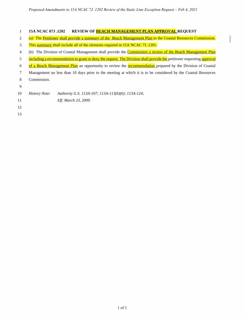
Proposed Amendments to 15A NCAC 7J .1202 Review of the Static Line Exception Request – Feb 4, 2021
1 of 1
15A NCAC 07J .1202 REVIEW OF BEACH MANAGEMENT PLAN APPROVAL REQUEST 1
(a) The Petitioner shall provide a summary of the Beach Management Plan to the Coastal Resources Commission. 2
This summary shall include all of the elements required in 15A NCAC 7J .1201. 3
(b) The Division of Coastal Management shall provide the Commission a review of the Beach Management Plan 4
including a recommendation to grant or deny the request. The Division shall provide the petitioner requesting approval 5
of a Beach Management Plan an opportunity to review the recommendation prepared by the Division of Coastal 6
Management no less than 10 days prior to the meeting at which it is to be considered by the Coastal Resources 7
Commission. 8
9
History Note: Authority G.S. 113A-107; 113A-113(b)(6); 113A-124; 10
Eff. March 23, 2009. 11
12
13

Proposed Amendments to 15A NCAC 7J .1203 Procedures for Approving the Static Line Exception – Feb 4, 2021
1 of 1
15A NCAC 07J .1203 PROCEDURES FOR APPROVING A BEACH MANAGEMENT PLAN 1
(a) At the meeting that approval of a Beach Management Plan is considered by the Coastal Resources Commission, 2
the following shall occur: 3
(1) The Petitioner shall orally present a summary of the Beach Management Plan described in 15A 4
NCAC 07J .1202. 5
(2) The Division of Coastal Management shall orally present its review of the Beach Management Plan 6
and its recommendation to grant or deny the approval request. 7
(b) The Coastal Resources Commission shall approve a Beach Management Plan following affirmative findings on 8
each of the criteria presented in15A NCAC 07J .1201(d)(1) through (d)(4), the Division of Coastal Management 9
recommendation, and public comments submitted with the request to approve the Beach Management Plan. The final 10
decision of the Coastal Resources Commission shall be made at the meeting at which the matter is heard or in no case 11
later than the next scheduled meeting. The final decision shall be transmitted to the petitioner by registered mail within 12
10 business days following the meeting at which the decision is reached. 13
(c) The decision to approve or deny a Beach Management Plan is a final agency decision and is subject to judicial 14
review in accordance with G.S. 113A-123. 15
16
History Note: Authority G.S. 113A-107; 113A-113(b)(6); 113A-124; 17
Eff. March 23, 2009. 18
19
20
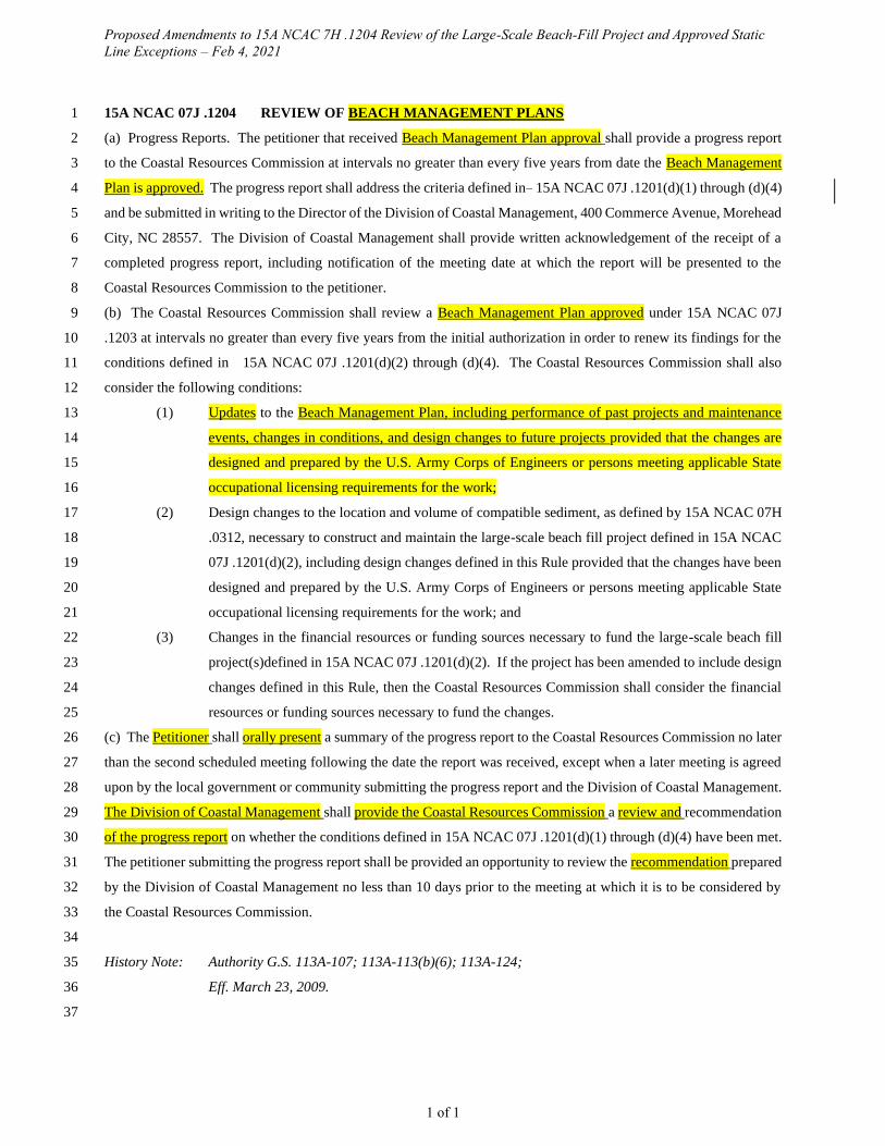
Proposed Amendments to 15A NCAC 7H .1204 Review of the Large-Scale Beach-Fill Project and Approved Static
Line Exceptions – Feb 4, 2021
1 of 1
15A NCAC 07J .1204 REVIEW OF BEACH MANAGEMENT PLANS 1
(a) Progress Reports. The petitioner that received Beach Management Plan approval shall provide a progress report 2
to the Coastal Resources Commission at intervals no greater than every five years from date the Beach Management 3
Plan is approved. The progress report shall address the criteria defined in 15A NCAC 07J .1201(d)(1) through (d)(4) 4
and be submitted in writing to the Director of the Division of Coastal Management, 400 Commerce Avenue, Morehead 5
City, NC 28557. The Division of Coastal Management shall provide written acknowledgement of the receipt of a 6
completed progress report, including notification of the meeting date at which the report will be presented to the 7
Coastal Resources Commission to the petitioner. 8
(b) The Coastal Resources Commission shall review a Beach Management Plan approved under 15A NCAC 07J 9
.1203 at intervals no greater than every five years from the initial authorization in order to renew its findings for the 10
conditions defined in 15A NCAC 07J .1201(d)(2) through (d)(4). The Coastal Resources Commission shall also 11
consider the following conditions: 12
(1) Updates to the Beach Management Plan, including performance of past projects and maintenance 13
events, changes in conditions, and design changes to future projects provided that the changes are 14
designed and prepared by the U.S. Army Corps of Engineers or persons meeting applicable State 15
occupational licensing requirements for the work; 16
(2) Design changes to the location and volume of compatible sediment, as defined by 15A NCAC 07H 17
.0312, necessary to construct and maintain the large-scale beach fill project defined in 15A NCAC 18
07J .1201(d)(2), including design changes defined in this Rule provided that the changes have been 19
designed and prepared by the U.S. Army Corps of Engineers or persons meeting applicable State 20
occupational licensing requirements for the work; and 21
(3) Changes in the financial resources or funding sources necessary to fund the large-scale beach fill 22
project(s)defined in 15A NCAC 07J .1201(d)(2). If the project has been amended to include design 23
changes defined in this Rule, then the Coastal Resources Commission shall consider the financial 24
resources or funding sources necessary to fund the changes. 25
(c) The Petitioner shall orally present a summary of the progress report to the Coastal Resources Commission no later 26
than the second scheduled meeting following the date the report was received, except when a later meeting is agreed 27
upon by the local government or community submitting the progress report and the Division of Coastal Management. 28
The Division of Coastal Management shall provide the Coastal Resources Commission a review and recommendation 29
of the progress report on whether the conditions defined in 15A NCAC 07J .1201(d)(1) through (d)(4) have been met. 30
The petitioner submitting the progress report shall be provided an opportunity to review the recommendation prepared 31
by the Division of Coastal Management no less than 10 days prior to the meeting at which it is to be considered by 32
the Coastal Resources Commission. 33
34
History Note: Authority G.S. 113A-107; 113A-113(b)(6); 113A-124; 35
Eff. March 23, 2009. 36
37
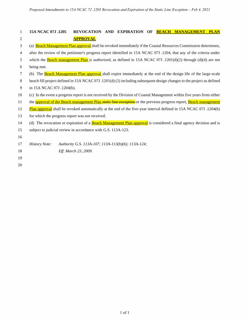
Proposed Amendments to 15A NCAC 7J .1205 Revocation and Expiration of the Static Line Exception – Feb 4, 2021
1 of 1
15A NCAC 07J .1205 REVOCATION AND EXPIRATION OF BEACH MANAGEMENT PLAN 1
APPROVAL 2
(a) Beach Management Plan approval shall be revoked immediately if the Coastal Resources Commission determines, 3
after the review of the petitioner's progress report identified in 15A NCAC 07J .1204, that any of the criteria under 4
which the Beach management Plan is authorized, as defined in 15A NCAC 07J .1201(d)(2) through (d)(4) are not 5
being met. 6
(b) The Beach Management Plan approval shall expire immediately at the end of the design life of the large-scale 7
beach fill project defined in 15A NCAC 07J .1201(d) (2) including subsequent design changes to the project as defined 8
in 15A NCAC 07J .1204(b). 9
(c) In the event a progress report is not received by the Division of Coastal Management within five years from either 10
the approval of the Beach management Plan static line exception or the previous progress report, Beach management 11
Plan approval shall be revoked automatically at the end of the five-year interval defined in 15A NCAC 07J .1204(b) 12
for which the progress report was not received. 13
(d) The revocation or expiration of a Beach Management Plan approval is considered a final agency decision and is 14
subject to judicial review in accordance with G.S. 113A-123. 15
16
History Note: Authority G.S. 113A-107; 113A-113(b)(6); 113A-124; 17
Eff. March 23, 2009. 18
19
20
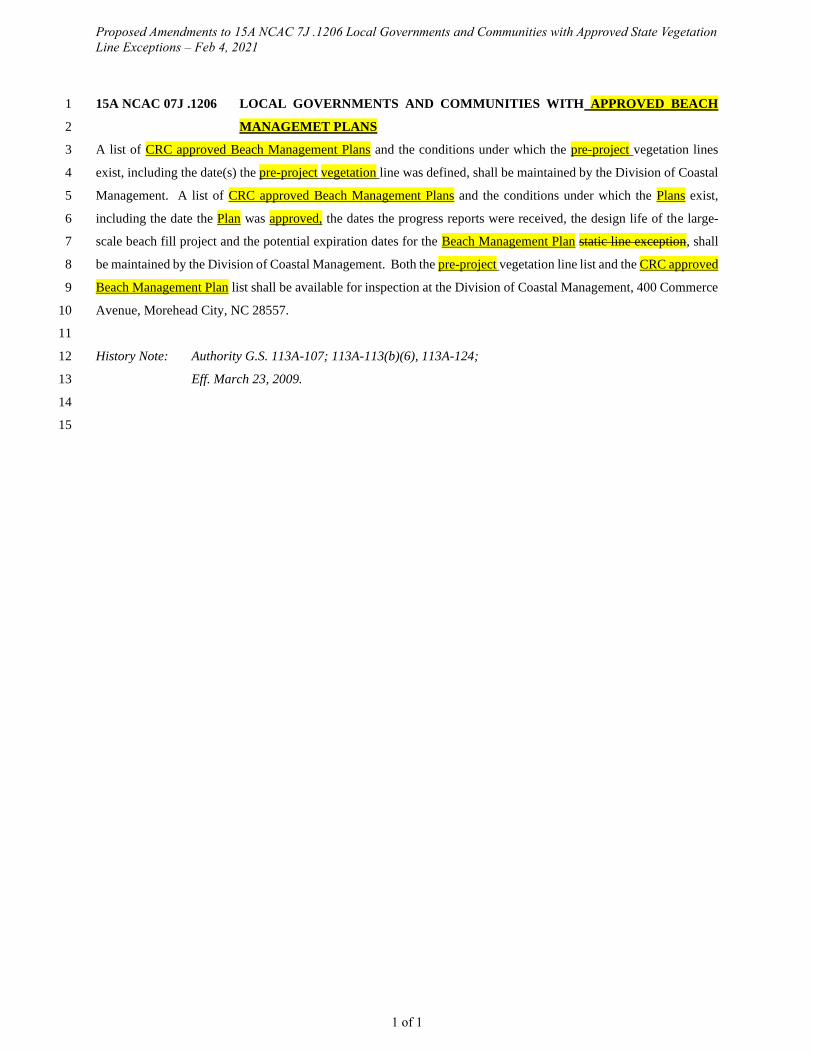
Proposed Amendments to 15A NCAC 7J .1206 Local Governments and Communities with Approved State Vegetation
Line Exceptions – Feb 4, 2021
1 of 1
15A NCAC 07J .1206 LOCAL GOVERNMENTS AND COMMUNITIES WITH APPROVED BEACH 1
MANAGEMET PLANS 2
A list of CRC approved Beach Management Plans and the conditions under which the pre-project vegetation lines 3
exist, including the date(s) the pre-project vegetation line was defined, shall be maintained by the Division of Coastal 4
Management. A list of CRC approved Beach Management Plans and the conditions under which the Plans exist, 5
including the date the Plan was approved, the dates the progress reports were received, the design life of the large-6
scale beach fill project and the potential expiration dates for the Beach Management Plan static line exception, shall 7
be maintained by the Division of Coastal Management. Both the pre-project vegetation line list and the CRC approved 8
Beach Management Plan list shall be available for inspection at the Division of Coastal Management, 400 Commerce 9
Avenue, Morehead City, NC 28557. 10
11
History Note: Authority G.S. 113A-107; 113A-113(b)(6), 113A-124; 12
Eff. March 23, 2009. 13
14
15