cranbury place conservation area - southampton.gov.uk · strengths, weaknesses ... cranbury place...
TRANSCRIPT
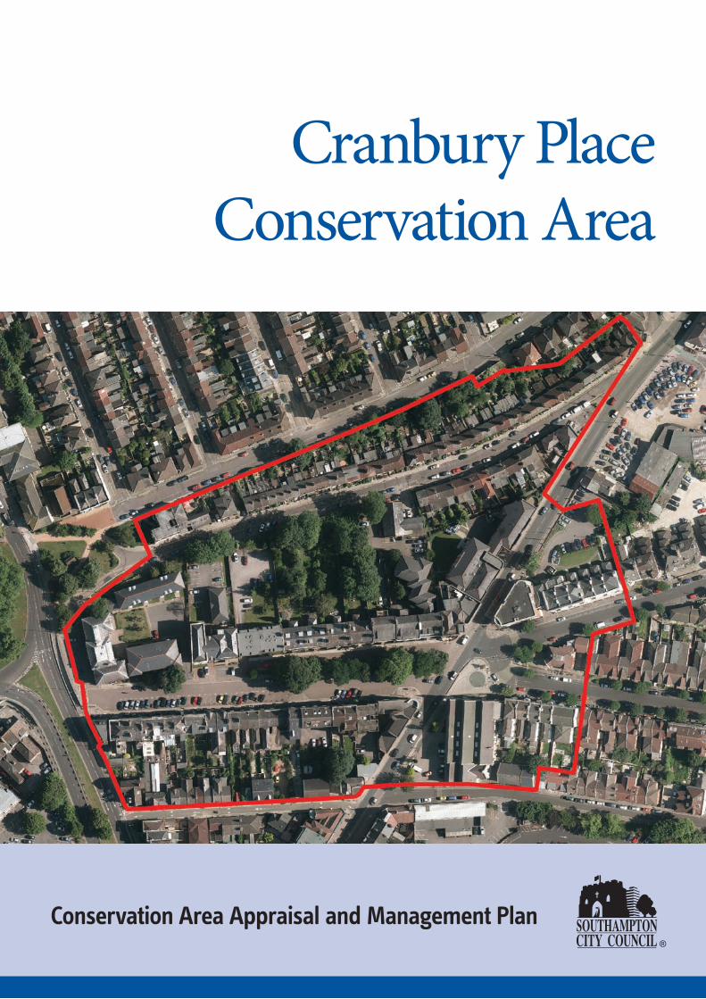
Cranbury Place Conservation Area
Conservation Area Appraisal and Management Plan

Contents
1. Introduction 3
2. Background and History 5
3. Character Appraisal 7
4. Strengths, Weaknesses, Opportunities and Threats 13
5. Changes which have affected the Conservation Area 14
6. Cranbury Place Conservation Area Management Plan 15
Front cover image: Aerial photograph, 2011 © Southampton City Council. Image above: Window on the first floor of No. 20 Cranbury Place.
Introduction The Cranbury Place Conservation Area, which includes Cranbury Place, Cranbury Terrace and parts of the adjacent streets of Cranbury Avenue, Denzil Avenue and Onslow Road and Lyon Street, was formally designated in 1977.
With Conservation Area designation comes extra controls. These controls cover the following:
• minor developments such as porches, extensions, satellite dishes and boundary walls are restricted and some cases require permission before they can be built whereas normally this would not be required;
• demolition of buildings requires approval before it can be undertaken; and
• works to trees require consent before they can be undertaken.
The objectives of these measures are to help preserve the special character and appearance of the area and maintain, or improve, its environmental quality. Whilst it is recognised that Conservation Areas must be allowed to evolve to meet changing demands, it is important that this occurs within a framework of controlled and positive management. The City Council will aim to review the Cranbury Place Conservation Area Appraisal and Management Plan every five years.
The National Planning Policy Framework (2012) states that in determining planning applications, local planning authorities should take account of:
• the desirability of sustaining and enhancing the significance of heritage assets and putting them to viable uses consistent with their conservation;
• the positive contribution that conservation of heritage assets can make to sustainable communities including their economic vitality; and
• the desirability of new development making a positive contribution to local character and distinctiveness.
This Conservation Area Appraisal and Management Plan is a material consideration for development control purposes and will be used to judge all future planning applications in the Conservation Area. The Plan is laid out in two sections. The first section highlights the key historical and architectural characteristics of the area, analyses the strengths, weaknesses, opportunities and threats involved, and looks at the changes affecting the Conservation Area which have taken place since the area was last appraised in 1986. The second half of the document establishes management policies that set a framework within which future development should take place.
The following work has been done to deliver this Conservation Area Appraisal:
• A photographic survey of all buildings in the Conservation Area
• An assessment of historic maps and a brief analysis of the facades of most of the buildings
• An assessment of the issues facing the Conservation Area
• An update of map data relating to the Conservation Area
• A review of the appropriateness of the Conservation Area boundary
• An assessment as to whether new development has made a positive, negative or neutral impact on the character of the Conservation Area
• The formulation of management policies for the area.
For any further information or advice please contact:
Historic Environment Team Southampton City Council Civic Centre Southampton SO14 7LY Telephone 023 8083 3192
3
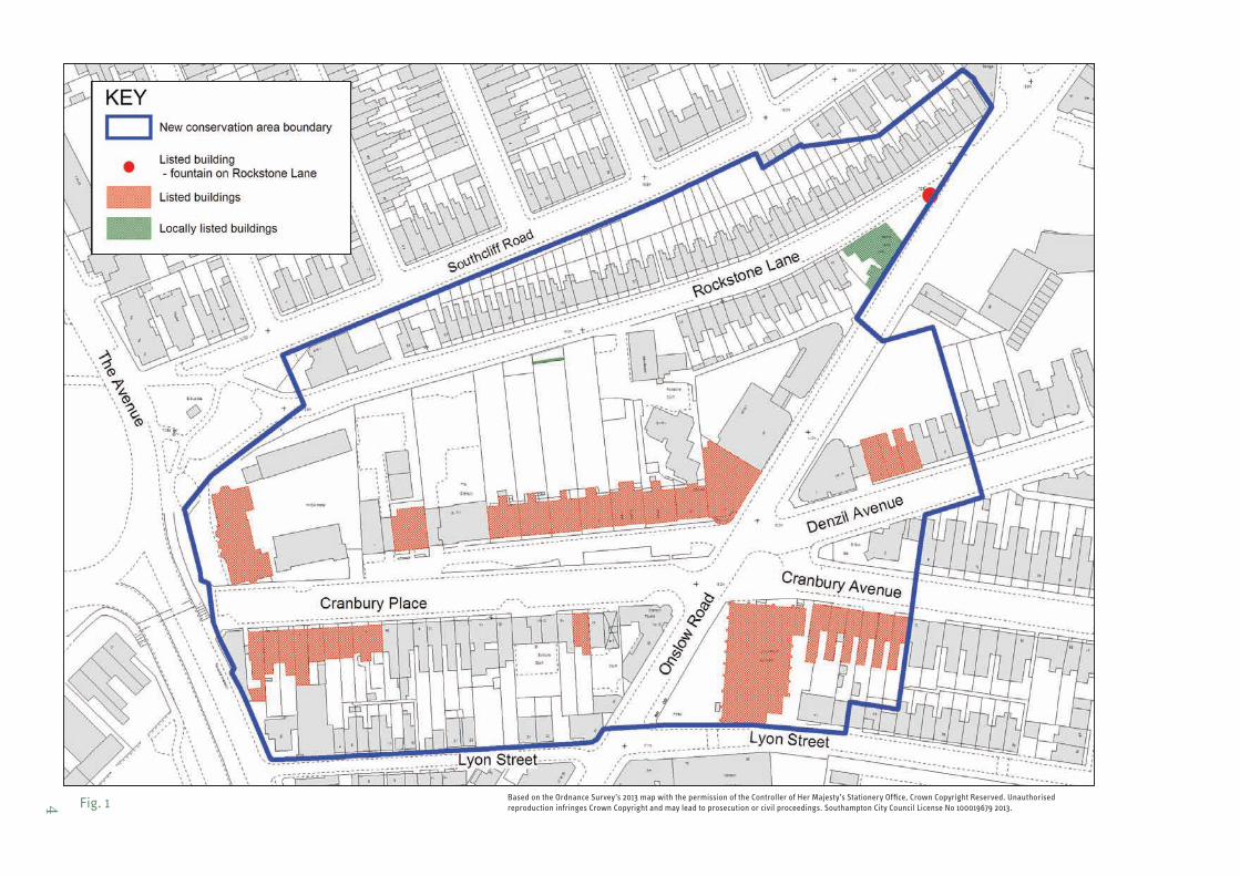
Based on the Ordnance Survey’s 2013 map with the permission of the Controller of Her Majesty’s Stationery Office, Crown Copyright Reserved. Unauthorised Fig. 1 reproduction infringes Crown Copyright and may lead to prosecution or civil proceedings. Southampton City Council License No 100019679 2013. 4
Background and history The following section briefly summarises the development of the Conservation Area.
Archaeology Very few excavations have been carried out in the immediate area. However, evidence from nearby sites suggest that there may be archaeology dating back to the early prehistoric period through to the late-medieval field systems. The number of houses with basements would suggest that any surviving archaeological deposits will be located in back gardens (however it should be noted that the buildings themselves, as Designated Heritage Assets, will hold archaeological potential).
18th Century In the 18th century the area would have been made up of fields. Bellevue House, built in 1768 for Nathaniel St Andre, physician to George I, stood just outside what is now the Conservation Area. Bellevue House had ceased to be a country house some time before 1842, having been sold in 1835 to John Watkins Drew, a businessman and for a time Director of the London & South-Western Railway Company. Drew, who probably developed some of the land surrounding the house, leased the property in 1854 to the Diocesan College (hence the site now being known as College Place). Bellevue House was demolished in 1886, just prior to Cranbury Terrace being built, to make way for other buildings of the expanding town.
19th century The area centred on Cranbury Place was, in the early 19th century, part of the Chamberlayne Estate. The main residence of the Chamberlayne family at Cranbury Park, Otterbourne, gave its name to three of the original streets in this location including Chamberlayne Place, so that for a short time the area was generally known as Chamberlayne Town. Chamberlayne Place was later absorbed into Cranbury Avenue. Denzil Avenue and Onslow Road were named in about 1850 as a compliment to General Denzil Onslow of the Grenadier Guards, whose daughter Amelia, had married Thomas Chamberlayne (1805 – 76).
The development formed part of Southampton’s expanding urban growth brought about by the construction of the Eastern Docks, the opening of the railway from London and the construction of the Cavalry Barracks in nearby London Road. The dwellings on the south side of Cranbury Place were the first to be built in about 1842 – 43 and these were soon followed by the construction of Cranbury Terrace and Cranbury Villa (now the YMCA Hostel).
Cranbury Terrace and Cranbury Place quickly developed into a fashionable residential area, and the distinctive brick dwellings had spacious well landscaped gardens.
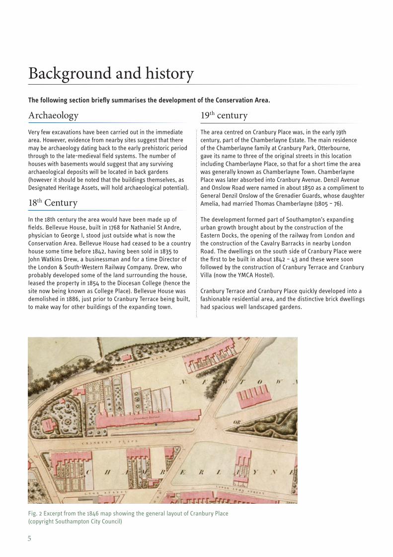
Fig. 2 Excerpt from the 1846 map showing the general layout of Cranbury Place (copyright Southampton City Council)
5
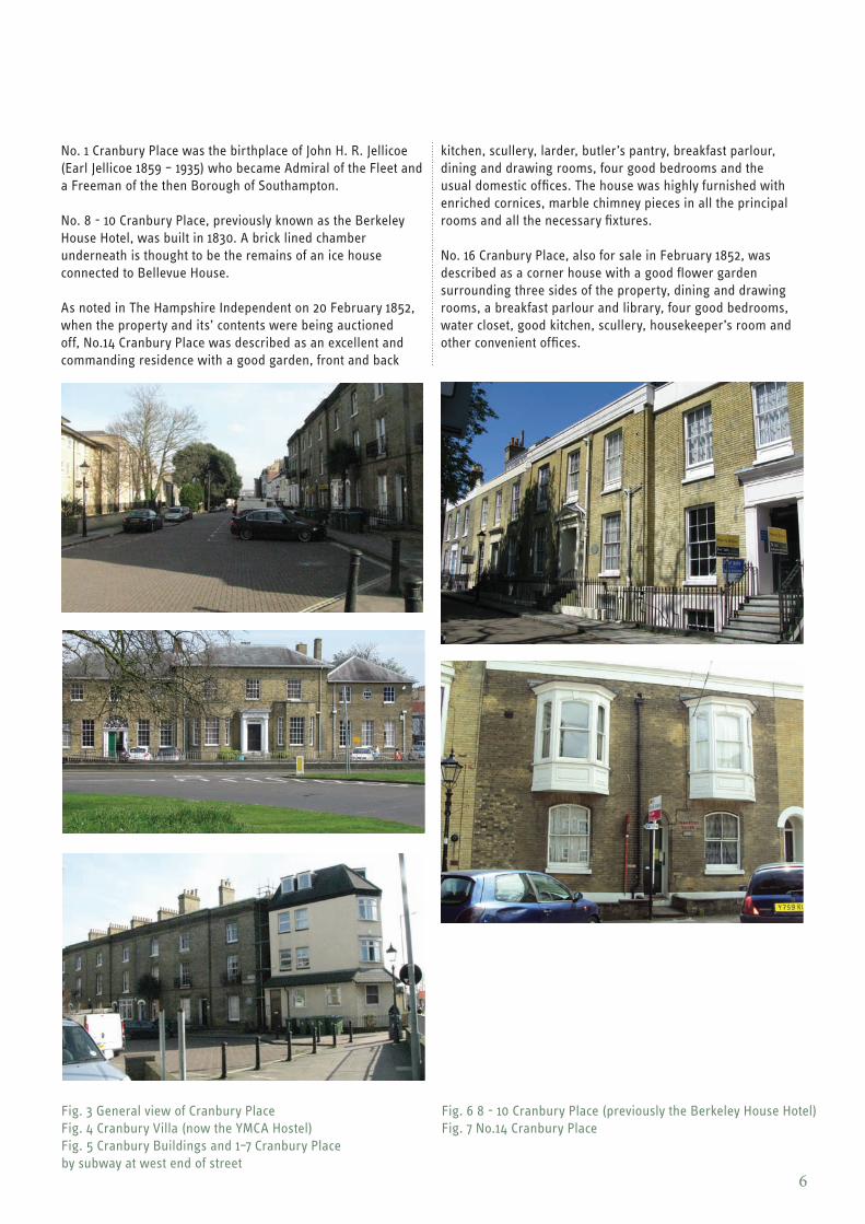
No. 1 Cranbury Place was the birthplace of John H. R. Jellicoe (Earl Jellicoe 1859 – 1935) who became Admiral of the Fleet and a Freeman of the then Borough of Southampton.
No. 8 - 10 Cranbury Place, previously known as the Berkeley House Hotel, was built in 1830. A brick lined chamber underneath is thought to be the remains of an ice house connected to Bellevue House.
As noted in The Hampshire Independent on 20 February 1852, when the property and its’ contents were being auctioned off, No.14 Cranbury Place was described as an excellent and commanding residence with a good garden, front and back
kitchen, scullery, larder, butler’s pantry, breakfast parlour, dining and drawing rooms, four good bedrooms and the usual domestic offices. The house was highly furnished with enriched cornices, marble chimney pieces in all the principal rooms and all the necessary fixtures.
No. 16 Cranbury Place, also for sale in February 1852, was described as a corner house with a good flower garden surrounding three sides of the property, dining and drawing rooms, a breakfast parlour and library, four good bedrooms, water closet, good kitchen, scullery, housekeeper’s room and other convenient offices.
Fig. 3 General view of Cranbury Place Fig. 4 Cranbury Villa (now the YMCA Hostel) Fig. 5 Cranbury Buildings and 1–7 Cranbury Place by subway at west end of street
Fig. 6 8 - 10 Cranbury Place (previously the Berkeley House Hotel) Fig. 7 No.14 Cranbury Place
6
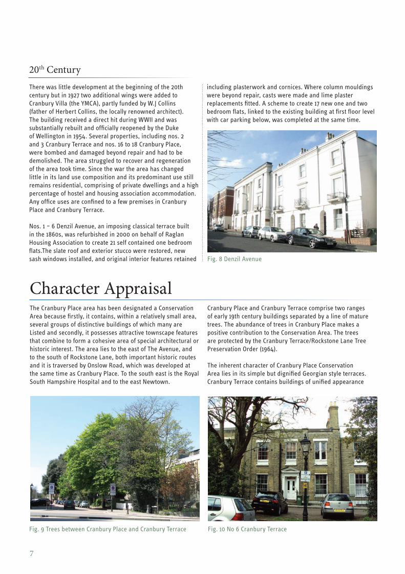
20th Century There was little development at the beginning of the 20th century but in 1927 two additional wings were added to Cranbury Villa (the YMCA), partly funded by W.J Collins (father of Herbert Collins, the locally renowned architect). The building received a direct hit during WWII and was substantially rebuilt and officially reopened by the Duke of Wellington in 1954. Several properties, including nos. 2 and 3 Cranbury Terrace and nos. 16 to 18 Cranbury Place, were bombed and damaged beyond repair and had to be demolished. The area struggled to recover and regeneration of the area took time. Since the war the area has changed little in its land use composition and its predominant use still remains residential, comprising of private dwellings and a high percentage of hostel and housing association accommodation. Any office uses are confined to a few premises in Cranbury Place and Cranbury Terrace.
Nos. 1 – 6 Denzil Avenue, an imposing classical terrace built in the 1860s, was refurbished in 2000 on behalf of Raglan Housing Association to create 21 self contained one bedroom flats.The slate roof and exterior stucco were restored, new sash windows installed, and original interior features retained
Character Appraisal The Cranbury Place area has been designated a Conservation Area because firstly, it contains, within a relatively small area, several groups of distinctive buildings of which many are Listed and secondly, it possesses attractive townscape features that combine to form a cohesive area of special architectural or historic interest. The area lies to the east of The Avenue, and to the south of Rockstone Lane, both important historic routes and it is traversed by Onslow Road, which was developed at the same time as Cranbury Place. To the south east is the Royal South Hampshire Hospital and to the east Newtown.
including plasterwork and cornices. Where column mouldings were beyond repair, casts were made and lime plaster replacements fitted. A scheme to create 17 new one and two bedroom flats, linked to the existing building at first floor level with car parking below, was completed at the same time.
Fig. 8 Denzil Avenue
Cranbury Place and Cranbury Terrace comprise two ranges of early 19th century buildings separated by a line of mature trees. The abundance of trees in Cranbury Place makes a positive contribution to the Conservation Area. The trees are protected by the Cranbury Terrace/Rockstone Lane Tree Preservation Order (1964).
The inherent character of Cranbury Place Conservation Area lies in its simple but dignified Georgian style terraces. Cranbury Terrace contains buildings of unified appearance
Fig. 9 Trees between Cranbury Place and Cranbury Terrace Fig. 10 No 6 Cranbury Terrace
7
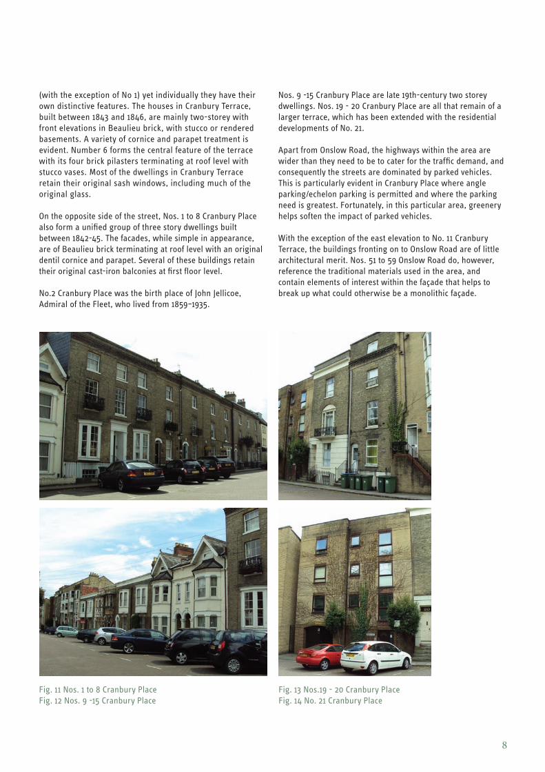
(with the exception of No 1) yet individually they have their own distinctive features. The houses in Cranbury Terrace, built between 1843 and 1846, are mainly two-storey with front elevations in Beaulieu brick, with stucco or rendered basements. A variety of cornice and parapet treatment is evident. Number 6 forms the central feature of the terrace with its four brick pilasters terminating at roof level with stucco vases. Most of the dwellings in Cranbury Terrace retain their original sash windows, including much of the original glass.
On the opposite side of the street, Nos. 1 to 8 Cranbury Place also form a unified group of three story dwellings built between 1842-45. The facades, while simple in appearance, are of Beaulieu brick terminating at roof level with an original dentil cornice and parapet. Several of these buildings retain their original cast-iron balconies at first floor level.
No.2 Cranbury Place was the birth place of John Jellicoe, Admiral of the Fleet, who lived from 1859–1935.
Nos. 9 -15 Cranbury Place are late 19th-century two storey dwellings. Nos. 19 - 20 Cranbury Place are all that remain of a larger terrace, which has been extended with the residential developments of No. 21.
Apart from Onslow Road, the highways within the area are wider than they need to be to cater for the traffic demand, and consequently the streets are dominated by parked vehicles. This is particularly evident in Cranbury Place where angle parking/echelon parking is permitted and where the parking need is greatest. Fortunately, in this particular area, greenery helps soften the impact of parked vehicles.
With the exception of the east elevation to No. 11 Cranbury Terrace, the buildings fronting on to Onslow Road are of little architectural merit. Nos. 51 to 59 Onslow Road do, however, reference the traditional materials used in the area, and contain elements of interest within the façade that helps to break up what could otherwise be a monolithic façade.
Fig. 11 Nos. 1 to 8 Cranbury Place Fig. 12 Nos. 9 -15 Cranbury Place
Fig. 13 Nos.19 - 20 Cranbury Place Fig. 14 No. 21 Cranbury Place
8
Since the widening of the Bellevue Terrace (now Dorset Street), Cranbury Place has benefited from being closed to vehicles at its western end resulting in a quieter environment, free from the usual hazards of through traffic. In contrast, Onslow Road is part of the radial route linking the city centre with Portswood, Swaythling, Bitterne Park and Eastleigh. The narrowness of the highway and heavy traffic flows creates problems of congestion, and divides the Conservation Area into two parts.
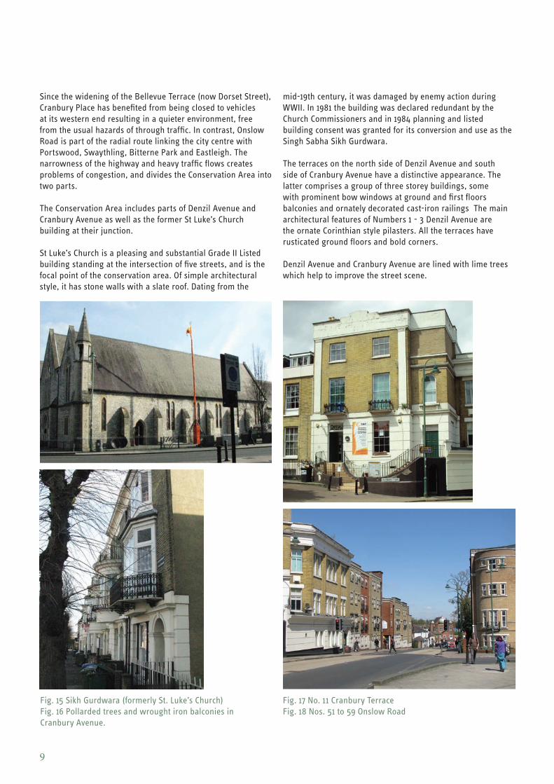
The Conservation Area includes parts of Denzil Avenue and Cranbury Avenue as well as the former St Luke’s Church building at their junction.
St Luke’s Church is a pleasing and substantial Grade II Listed building standing at the intersection of five streets, and is the focal point of the conservation area. Of simple architectural style, it has stone walls with a slate roof. Dating from the
mid-19th century, it was damaged by enemy action during WWII. In 1981 the building was declared redundant by the Church Commissioners and in 1984 planning and listed building consent was granted for its conversion and use as the Singh Sabha Sikh Gurdwara.
The terraces on the north side of Denzil Avenue and south side of Cranbury Avenue have a distinctive appearance. The latter comprises a group of three storey buildings, some with prominent bow windows at ground and first floors balconies and ornately decorated cast-iron railings The main architectural features of Numbers 1 - 3 Denzil Avenue are the ornate Corinthian style pilasters. All the terraces have rusticated ground floors and bold corners.
Denzil Avenue and Cranbury Avenue are lined with lime trees which help to improve the street scene.
Fig. 15 Sikh Gurdwara (formerly St. Luke’s Church) Fig. 17 No. 11 Cranbury Terrace Fig. 16 Pollarded trees and wrought iron balconies in Fig. 18 Nos. 51 to 59 Onslow Road Cranbury Avenue.
9
Lyon Street is a narrow one-way street which acts as an important boundary to the Conservation Area and to the edge of the early 19th century development of the area, thus separating it from the distinct triangle of development formed between Lyon Street, Bellevue Terrace and Onslow Road.
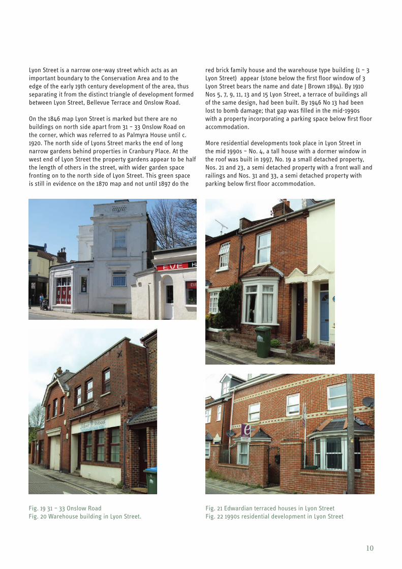
On the 1846 map Lyon Street is marked but there are no buildings on north side apart from 31 – 33 Onslow Road on the corner, which was referred to as Palmyra House until c. 1920. The north side of Lyons Street marks the end of long narrow gardens behind properties in Cranbury Place. At the west end of Lyon Street the property gardens appear to be half the length of others in the street, with wider garden space fronting on to the north side of Lyon Street. This green space is still in evidence on the 1870 map and not until 1897 do the
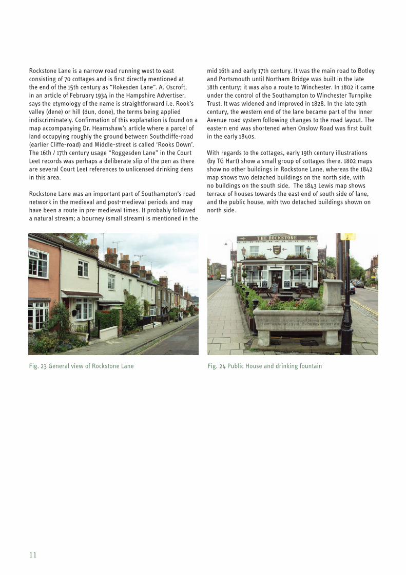
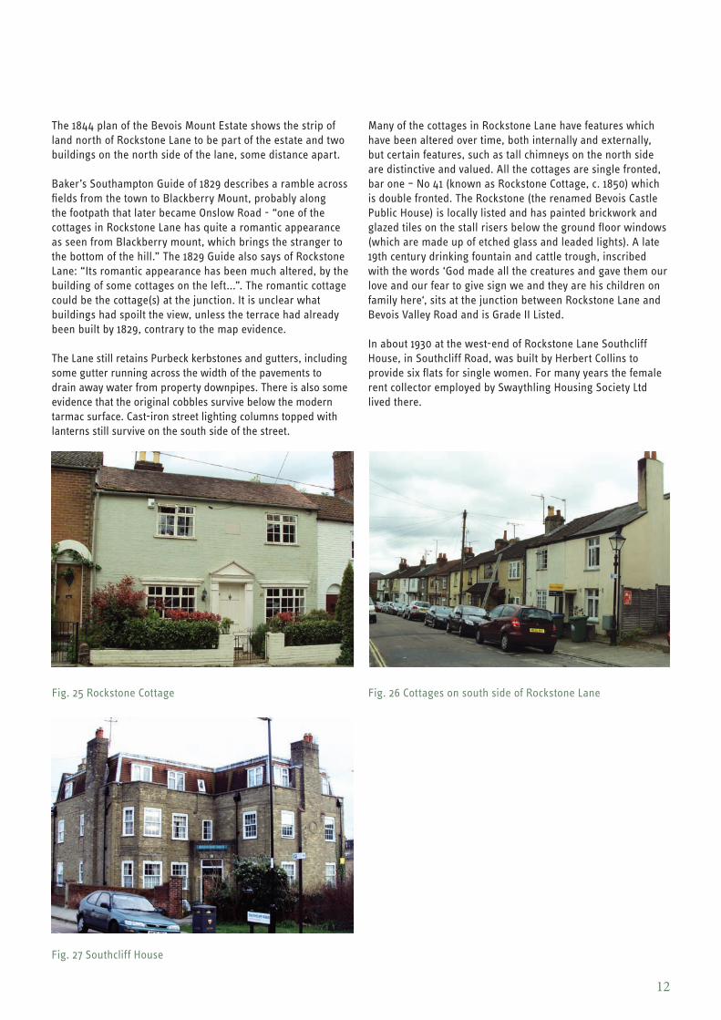
red brick family house and the warehouse type building (1 – 3 Lyon Street) appear (stone below the first floor window of 3 Lyon Street bears the name and date J Brown 1894). By 1910 Nos 5, 7, 9, 11, 13 and 15 Lyon Street, a terrace of buildings all of the same design, had been built. By 1946 No 13 had been lost to bomb damage; that gap was filled in the mid-1990s with a property incorporating a parking space below first floor accommodation.
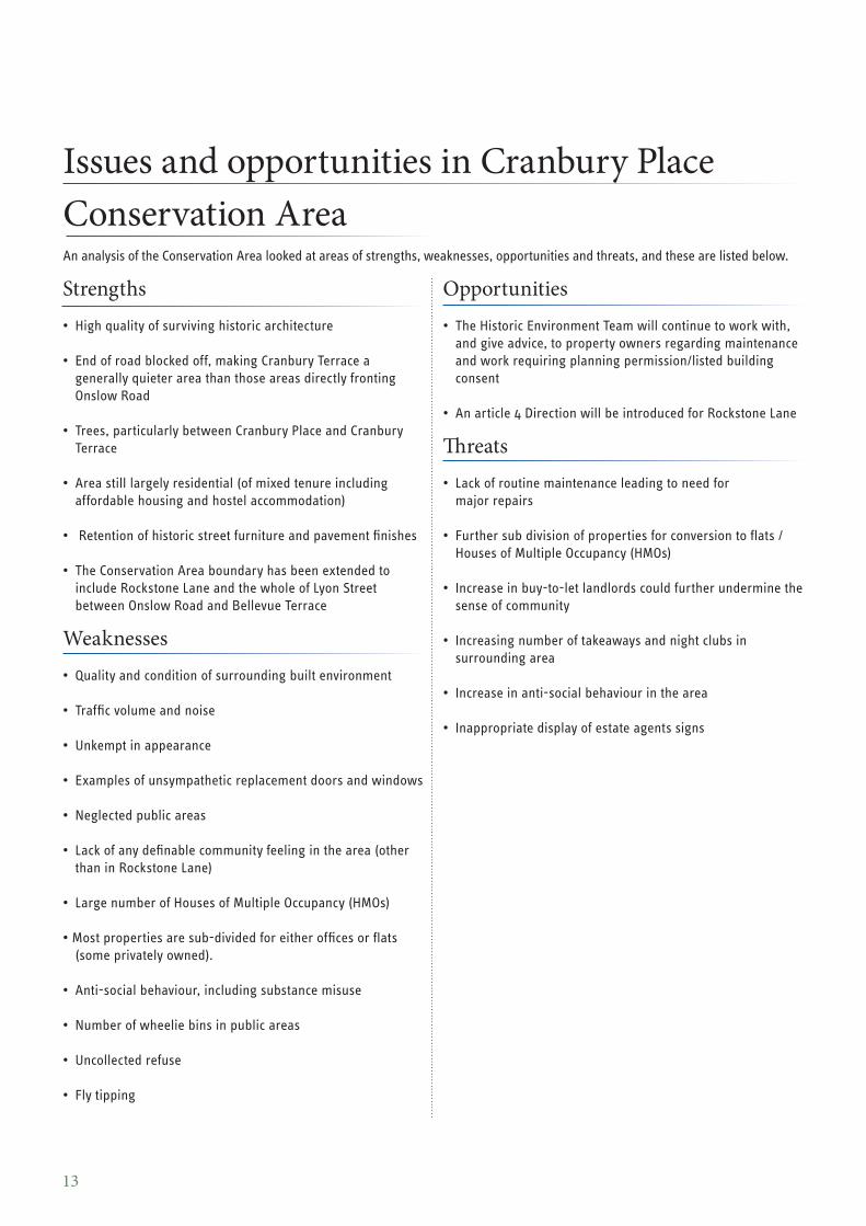
More residential developments took place in Lyon Street in the mid 1990s – No. 4, a tall house with a dormer window in the roof was built in 1997, No. 19 a small detached property, Nos. 21 and 23, a semi detached property with a front wall and railings and Nos. 31 and 33, a semi detached property with parking below first floor accommodation.
Fig. 19 31 – 33 Onslow Road Fig. 21 Edwardian terraced houses in Lyon Street Fig. 20 Warehouse building in Lyon Street. Fig. 22 1990s residential development in Lyon Street
10
Rockstone Lane is a narrow road running west to east consisting of 70 cottages and is first directly mentioned at the end of the 15th century as “Rokesden Lane”. A. Oscroft, in an article of February 1934 in the Hampshire Advertiser, says the etymology of the name is straightforward i.e. Rook’s valley (dene) or hill (dun, done), the terms being applied indiscriminately. Confirmation of this explanation is found on a map accompanying Dr. Hearnshaw’s article where a parcel of land occupying roughly the ground between Southcliffe-road (earlier Cliffe-road) and Middle-street is called ‘Rooks Down’. The 16th / 17th century usage “Roggesden Lane” in the Court Leet records was perhaps a deliberate slip of the pen as there are several Court Leet references to unlicensed drinking dens in this area.
Rockstone Lane was an important part of Southampton’s road network in the medieval and post-medieval periods and may have been a route in pre-medieval times. It probably followed a natural stream; a bourney (small stream) is mentioned in the
Fig. 23 General view of Rockstone Lane
mid 16th and early 17th century. It was the main road to Botley and Portsmouth until Northam Bridge was built in the late 18th century; it was also a route to Winchester. In 1802 it came under the control of the Southampton to Winchester Turnpike Trust. It was widened and improved in 1828. In the late 19th century, the western end of the lane became part of the Inner Avenue road system following changes to the road layout. The eastern end was shortened when Onslow Road was first built in the early 1840s.
With regards to the cottages, early 19th century illustrations (by TG Hart) show a small group of cottages there. 1802 maps show no other buildings in Rockstone Lane, whereas the 1842 map shows two detached buildings on the north side, with no buildings on the south side. The 1843 Lewis map shows terrace of houses towards the east end of south side of lane, and the public house, with two detached buildings shown on north side.
Fig. 24 Public House and drinking fountain
11
The 1844 plan of the Bevois Mount Estate shows the strip of land north of Rockstone Lane to be part of the estate and two buildings on the north side of the lane, some distance apart.
Baker’s Southampton Guide of 1829 describes a ramble across fields from the town to Blackberry Mount, probably along the footpath that later became Onslow Road - “one of the cottages in Rockstone Lane has quite a romantic appearance as seen from Blackberry mount, which brings the stranger to the bottom of the hill.” The 1829 Guide also says of Rockstone Lane: “Its romantic appearance has been much altered, by the building of some cottages on the left...”. The romantic cottage could be the cottage(s) at the junction. It is unclear what buildings had spoilt the view, unless the terrace had already been built by 1829, contrary to the map evidence.
The Lane still retains Purbeck kerbstones and gutters, including some gutter running across the width of the pavements to drain away water from property downpipes. There is also some evidence that the original cobbles survive below the modern tarmac surface. Cast-iron street lighting columns topped with lanterns still survive on the south side of the street.
Many of the cottages in Rockstone Lane have features which have been altered over time, both internally and externally, but certain features, such as tall chimneys on the north side are distinctive and valued. All the cottages are single fronted, bar one – No 41 (known as Rockstone Cottage, c. 1850) which is double fronted. The Rockstone (the renamed Bevois Castle Public House) is locally listed and has painted brickwork and glazed tiles on the stall risers below the ground floor windows (which are made up of etched glass and leaded lights). A late 19th century drinking fountain and cattle trough, inscribed with the words ‘God made all the creatures and gave them our love and our fear to give sign we and they are his children on family here‘, sits at the junction between Rockstone Lane and Bevois Valley Road and is Grade II Listed.
In about 1930 at the west-end of Rockstone Lane Southcliff House, in Southcliff Road, was built by Herbert Collins to provide six flats for single women. For many years the female rent collector employed by Swaythling Housing Society Ltd lived there.
Fig. 25 Rockstone Cottage Fig. 26 Cottages on south side of Rockstone Lane
Fig. 27 Southcliff House
12
Issues and opportunities in Cranbury Place Conservation Area An analysis of the Conservation Area looked at areas of strengths, weaknesses, opportunities and threats, and these are listed below.
Strengths • High quality of surviving historic architecture
• End of road blocked off, making Cranbury Terrace a generally quieter area than those areas directly fronting Onslow Road
• Trees, particularly between Cranbury Place and Cranbury Terrace
• Area still largely residential (of mixed tenure including affordable housing and hostel accommodation)
• Retention of historic street furniture and pavement finishes
• The Conservation Area boundary has been extended to include Rockstone Lane and the whole of Lyon Street between Onslow Road and Bellevue Terrace
Weaknesses • Quality and condition of surrounding built environment
• Traffic volume and noise
• Unkempt in appearance
• Examples of unsympathetic replacement doors and windows
• Neglected public areas
• Lack of any definable community feeling in the area (other than in Rockstone Lane)
• Large number of Houses of Multiple Occupancy (HMOs)
• Most properties are sub-divided for either offices or flats (some privately owned).
• Anti-social behaviour, including substance misuse
• Number of wheelie bins in public areas
• Uncollected refuse
• Fly tipping
Opportunities • The Historic Environment Team will continue to work with,
and give advice, to property owners regarding maintenance and work requiring planning permission/listed building consent
• An article 4 Direction will be introduced for Rockstone Lane
Threats • Lack of routine maintenance leading to need for
major repairs
• Further sub division of properties for conversion to flats / Houses of Multiple Occupancy (HMOs)
• Increase in buy-to-let landlords could further undermine the sense of community
• Increasing number of takeaways and night clubs in surrounding area
• Increase in anti-social behaviour in the area
• Inappropriate display of estate agents signs
13
Changes which have affected the Conservation Area The Cranbury Place Conservation Area was designated in September 1977 and was last reviewed by Southampton City Council in November 1986. Since then there has been a number of both positive and neutral changes which have had a significant impact on the character and appearance of the conservation area; these are listed below.
Positive A temporary timber building (used by the YMCA) fronting onto Cranbury Place has been removed since the area was last appraised in 1986.
1 – 6 Denzil Avenue, built in the 1840s, was refurbished in 2000 on behalf of Raglan Housing Association and is in the process of undergoing further alterations.
The site adjoining no. 1 Denzil Avenue was, when the area was last appraised, used for advertising purposes, with a hoarding running along Onslow Road frontage. This has now been removed and the site redeveloped for residential purposes.
Advertising hoardings on the corner site by nos. 21 – 22 Cranbury Place have, since the area was last appraised, been removed and the land redeveloped for residential use.
The alignment of the Denzil Avenue/Cranbury Avenue Junction has been re-arranged and the environment is improved as a result.
Nos. 31 and 33 Onslow Road have both been subject to extensive maintenance.
In 1981 St Luke’s Church was declared redundant by the Church Commissioners and in 1984 planning and listed building consent was granted for its conversion and use as a Sikh Gurdwara. The re-use of this building as another place of worship is considered preferable to any alternative use.
Neutral Some of the land at the bottom of long rear gardens of numbers 9 – 15 Cranbury Place, fronting on to Lyon Street, which was previously used for domestic garages and some car parking, has been developed for residential use. This has meant the loss of some rear gardens.
14
Cranbury Place Conservation Area Management Plan This section sets out how Southampton City Council will aim to firstly preserve, and secondly enhance, the features and details that contribute to the character of Cranbury Place Conservation Area in accordance with Section 72 of the Planning (Listed Building and Conservation Area) Act 1990.
It is important to note that there have been changes in permitted development rights (since 30 May 2013 until 2015/16) which allow the conversion of offices to residential uses without the need for planning permission (however Listed Building Consent will still be required if the building in question is listed). Proposals to change a family home (C3) into a small HMO (C4) also requires planning permission.
The policies below apply to non-Listed commercial properties and non-Listed residential properties where there is no Article 4 Direction in place. Listed building consent must be applied for in order to make any changes to a listed building which might affect its special interest. It should also be noted that maintenance and repairs to listed buildings do not require listed building consent provided that they are like-for-like.
1. Key theme: Preserve The most significant problem facing conservation areas is the gradual erosion of character and appearance, caused by small changes and alterations to specific details, for example windows, doors, front garden walls, etc. Individual alterations of this kind may have little immediate effect, but a street can gradually be transformed by the cumulative effect of these changes. This section contains guidance on specific features identified in the character appraisal as significant in the character of the area.
1.1 – 1.3 Windows
A building’s windows can have a greater effect on the overall appearance of its façade than any other single factor. Therefore, any replacement of windows has to be carried out with a high degree of sensitivity.
The incremental introduction of modern materials or finishes, such as uPVC, aluminium and stained, rather than painted, wood, has had an adverse effect on the appearance of some other parts of the Conservation Area. These new materials frequently have different profiles, glazing bars and other details and can seem particularly conspicuous if introduced to a property that is part of a terrace where similar amendments have not been carried out.
Policies: 1.1 On front elevations the City Council will support the
retention of existing traditional window types, details and materials.
1.2 On front elevations the City Council will support the repair of existing windows wherever possible, and on front elevations where uPVC windows need to be replaced,
traditional materials should normally be used rather than like-for-like replacement. The use of uPVC, aluminium and other materials or finishes inappropriate to the area will be opposed.
1.3 Wooden window frames which front or face a highway or open space must be painted white.
1.4 – 1.6 Wall Finishes
The majority of the early to mid 19th century buildings in the Conservation Area are built using Beaulieu brick (yellow).
Policies: 1.4. The City Council will support the retention and
conservation of existing and original external wall finishes as appropriate and will normally oppose the introduction of materials which are likely to be inappropriate or ill-suited to the character of the area e.g. timber cladding.
1.5 The City Council will normally oppose the painting of surfaces such as brickwork where this was not originally intended.
1.6 Mortar for render and pointing should be used in accordance with recommended lime-based mixes. The use of cement, in view of its hard and inflexible qualities which can damage bricks through spalling, is not acceptable.
1.7 – 1.8 Front Doors
On the older buildings in the conservation area the great majority of doors will be of wood, albeit with different patterns and detailing. It is usual for front doors to be painted. The aim
15
should be to match, wherever possible, the existing pattern for the particular property or group of properties, rather than to use or prescribe a ‘standard’ pattern. The substitution of original doors with doors constructed of uPVC or metal would be regarded as unsuitable and would detract from the appearance of the conservation area.
Policies: 1.7 The City Council will support the retention or reinstatement
of original or sympathetically designed external front doors and will discourage the use of doors of inappropriate size, design, colour or material.
1.8 Appropriate traditional style paint colours, such as dark green or purple brown, are recommended for use on front doors.
1.9 – 1.10 Rainwater goods
The use of uPVC rainwater goods can be unsightly and inappropriate on the facades of historic buildings.
Policies: 1.9 On front and side elevations where uPVC rainwater goods
need to be replaced, traditional materials i.e cast iron or aluminium (painted black) should normally be used rather than like-for-like replacement. If no records survive of the original materials then original designs present in neighbouring properties should be used.
1.10 The use of cast iron lookalike rainwater goods made from uPVC will be opposed. Aluminium rainwater goods painted black will normally be an acceptable alternative to uPVC.
1.11 – 1.14 Roofs, chimney stacks and pots
The majority of older properties in this area will have had slate roofs and clay tiles and in some cases these survive. Many of the roofs in the Conservation Area are concealed behind parapets.
Some slate and clay tile roofs have been replaced by modern interlocking tiled roofs, which may result in problems caused by the use of a heavier roofing material. The use of a variety of different coloured tiles can have a discordant visual effect especially where properties form part of a terrace.
Roof details such as ridge tiles, finials, decorative shaped slates or tiles and patterns are important and should be retained wherever possible or salvaged and reused where the roof has to be replaced.
Roof extensions often lead to the loss of existing historic fabric such as pitched roofs and chimneys, and can lead to an unacceptable increase in the bulk of properties.
Policies: 1.11 The City Council will support the retention and use of
traditional roofing materials (such as slate and clay tiles) and oppose the use of unsympathetic modern roofing
materials (such as interlocking concrete tiles).
1.12 Roof details such as ridge tiles and decorative roofing should be retained whenever possible.
1.13 The retention of chimney stacks and pots will be supported and their removal will normally be opposed.
1.14 The retention of barge boards will be supported and their removal will normally be opposed.
1.15 – 1.16 Railings
A number of 19th century buildings in the Conservation Area still have their original railings at the front of the properties. These wrought iron boundary railings act as one of the most important traditional elements between the buildings and the pedestrians, and emphasise principles of composition, such as symmetry, hierarchy and uniformity in the design of terraces and the appearance of streets and whole areas.
Policies: 1.15 The retention of wrought iron boundary railings will be
supported and their removal will be opposed.
1.16 Wrought iron boundary railings which front or face a highway or open space must be painted black.
1.17 – 1.18 Trees
The abundance of trees in Cranbury Place considerably enhances and complements the architectural qualities of the Conservation Area. Many of the trees are covered by the Cranbury Terrace/Rockstone Lane Tree Preservation Order (1964). Denzil Avenue and Cranbury Avenue are lined with pollarded lime trees which complement the dignified buildings and help to improve the street scene. The northern boundary of the Conservation Area, along Rockstone Lane, is currently well defined by the high brick walls and trees which largely conceal the relatively unattractive backs of the Cranbury Terrace properties.
Trees in conservation areas are subject to special control. Trees with a trunk diameter greater than 75mm at 1.5m above ground level are protected.
Anyone wishing to do works to trees in a conservation area must give the Local Planning Authority six weeks’ notice of their intention to lop, top, or fell the tree(s).
Policies:
1.17 The City Council will oppose the loss of trees in this area and will support Tree Preservation Orders as necessary.
1.18 The City Council will continue to support the good management of trees in this area and will encourage new and replacement planting of appropriate species to help maintain and enhance the character of the area, including
16
the replacement of dead or vandalised specimens.
1.19 – 1.20 Support the re-use of vacant buildings, sites and floor space
If buildings are vacant or partially vacant the likelihood of the fabric of the building deteriorating increases, which in turn can lead to an increase in buildings, or parts of buildings, standing empty due to their poor condition. The Historic Environment Team aim to support, where appropriate, the use of historic buildings either for their original purpose, as homes and/or for commercial purposes.
Policies: 1.19 The City Council will normally oppose any proposal which
involves the loss of living accommodation.
1.20 The City Council will work actively with owners wishing to utilise vacant buildings, sites and floor space within the Cranbury Place Conservation Area
Maintenance of historic properties
The Historic Environment Team is able to advise on the maintenance of historic properties and the protection of remaining and replacement of missing original architectural ornament, windows and fenestration details, and cast iron rainwater goods.
2. Key Theme: Enhance The Council recognises as priorities the following potential enhancements of the Conservation Area.
2.1 – 2.2 Street furniture
Street furniture such as street lighting, bollards, signage and cycle parking facilities can add to or detract from the visual character of the area
Policies: 2.1 The City Council will support the retention of historic
street furniture where this survives.
2.2 Unsightly and unnecessary street furniture will be prioritised for removal by the City Council, where possible.
2.3 – 2.6 Promote good quality new development and redevelopment
Not all elements of a Conservation Area will necessarily contribute to the predominant character of the area or the understanding of its’ historic development. Certain elements may detract from its character and appearance or may simply not contribute to it in a positive way.
Policies: 2.3 The City Council will oppose the redevelopment of
existing older properties unless it can be demonstrated that the redevelopment would positively enhance the character or appearance of the Conservation Area.
2.4 The City Council will support the highest possible standards of design and architecture with regards to new buildings to ensure that development adds to the Conservation Area’s unique qualities by respecting local scale, street patterns, elevations, windows, features and materials.
2.5 Traditional materials such as brick, clay tiles, slates, timber, stone, lead and render would usually be preferred, although in a few situations modern materials may be more appropriate e.g. lead substitute to prevent lead theft.
2.6 The City Council accepts the discreet addition of safety railings across windows and Juliet balconies as necessary safety features in certain designs, but will discourage their use as deliberate architectural embellishments.
2.7 – 2.10 Extensions
Extensions on elevations fronting the highway normally require planning permission and will generally be discouraged, particularly in relation to the older buildings in the area.
Where an extension is required, the design should match or complement the existing original building, not only in more obvious respects such as external materials, but also in the detail, such as brick bonding and pointing, window style and associated dressings.
Large roof additions can spoil the appearance of a house and look incongruous in the general street scene. Careful thought needs to be given to ensure that dormers and other roof additions do not dominate the roofscape, and as such it will largely be necessary to keep dormers to the rear roofscape.
Policies: 2.7 Extensions will be opposed where they would have an
adverse visual effect on the area.
2.8 Where small extensions are permitted they should match the existing original property in respect of design, materials and detail. The size of an extension should not overpower the original building size.
2.9 Large roof extensions will be opposed, particularly at the front, where they would have an adverse visual effect on the existing building or townscape, or where they would lead to the loss of original historic roofs or their features.
2.10 Where roof extensions are permitted they should match
17
the existing building in respect of design and materials.
2.11 Energy Efficiency
The introduction of appropriate energy efficient systems to historic buildings is supported by the Council and a Sustainable Development sub Guide for Historic Buildings and Conservation Areas is available from the Historic Environment Team.
Policy: 2.11 The Council will support energy efficiency in buildings
where appropriate and work with owners of historic buildings to improve the energy efficiency of buildings whilst retaining the character of the Conservation Area.
2.12 – 2.15 Management of Advertisements
Outdoor advertisements are controlled by the Town and Country Planning (Control of Advertisements) Regulations 2007.
As stated in the National Planning Policy Framework (2012), poorly placed advertisements can have a negative impact on the appearance of the built and natural environment.
Policies:
Advertisement consent will only be given where:
2.12 The scale, size, design, materials, colouring and luminance respects the character and appearance of the building or areas in which they are displayed;
2.13 There is no adverse effect on public safety including the safety of people using the highway;
2.14 In the case of large outdoor advertising hoardings and panels, they will only be permitted if they are intended to screen a site awaiting development.
2.15 The installation of skyline or parapet level signs on
buildings will not be permitted.
2.16 – 2.18 Satellite antennae, television aerials and air conditioning units
Poorly placed satellite antennae, television aerials and air conditioning units can have a negative impact on the appearance of the built and natural environment.
Policies 2.16 Television aerials should, where possible, be located
within the roof space of properties.
2.17 Satellite dishes require planning permission and the Local Planning Authority will require applicants to show locations which are unobtrusive, for example mounted in rear gardens.
2.18 The positioning of air conditioning units on the front and side elevations of properties will be opposed.
Future possibilities regarding enhancement of the Conservation Area
The Historic Environment Team would welcome discussions with local residents and businesses, community groups, amenity groups, developers and their agents regarding any further enhancement proposals for the area. Such joint action can offer significant practical, aesthetic and financial benefits.
18

For further information and advice please contact:
Historic Environment Team Southampton City Council Civic Centre Southampton SO14 7LY
Telephone 023 8083 3192
November 2013
08.13.24709