cowal gold operations mine life modification sections 5, 6 ... › wp-content › uploads ›...
TRANSCRIPT

SECTION 5Rehabilitation and Landscape Management Strategy
SECTION 6 Planning Framework and Modification Justification
SECTION 7 Summary of Environmental Management and
Monitoring Measures
COWAL GOLD OPERATIONS PROCESSING RATE MODIFICATION
Environmental Assessment 2018

Cowal Gold Operations Processing Rate Modification – Environmental Assessment
i
TABLE OF CONTENTS 5 REHABILITATION AND LANDSCAPE
MANAGEMENT STRATEGY 5-1 5.1 REHABILITATION PRINCIPLES AND
OBJECTIVES 5-1 5.1.1 Rehabilitation Principles 5-1 5.1.2 Rehabilitation Objectives 5-1
5.2 CGO REHABILITATION 5-2 5.2.1 Results of Rehabilitation
Investigations and Trials 5-2 5.3 REHABILITATION CONCEPTS FOR
THE MODIFICATION 5-11 5.3.1 Long-term Land Use
Strategy 5-11 5.3.2 Final Landform Concepts
and Rehabilitation Domains 5-13 5.4 REHABILITATION MANAGEMENT
PLAN 5-23 5.5 GENERAL REHABILITATION
PRACTICES AND MEASURES 5-24 5.5.1 Progressive and Interim
Rehabilitation 5-24 5.5.2 Soil Management 5-24 5.5.3 Plant Species Selection for
Revegetation 5-25 5.5.4 Seed Collection and Habitat
Enhancement Measures 5-25 5.5.5 Erosion and Sediment
Control 5-25 5.5.6 Weed and Pest Control 5-25 5.5.7 Management of Grazing
and Agriculture 5-26 5.5.8 Landscaping to Minimise
Visual Impacts 5-26 5.5.9 Bushfire Management 5-27
5.6 REHABILITATION INVESTIGATIONS AND TRIALS 5-27
5.7 REHABILITATION MONITORING 5-28 5.7.1 Rehabilitation Performance
Indicators and Completion Criteria 5-28
5.7.2 Ongoing Rehabilitation Evaluation 5-28
5.8 MINE CLOSURE AND LEASE RELINQUISHMENT 5-32
6 PLANNING FRAMEWORK AND
MODIFICATION JUSTIFICATION 6-1 6.1 LEGISLATIVE FRAMEWORK 6-1
6.1.1 Environmental Planning and Assessment Act, 1979 6-1
6.1.2 Other State Legislation 6-2 6.1.3 Environmental Planning
Instruments 6-4 6.1.4 Commonwealth Legislation 6-10 6.1.5 Plans, Licences and
Agreements that Require Revision 6-11
6.2 MODIFICATION JUSTIFICATION 6-11 6.2.1 Need for and Objectives of
the Modification 6-11 6.2.2 Consideration of the
Modification against the Objects of the EP&A Act 6-13
6.2.3 Consideration of the Consequences of not Carrying out the Modification 6-14
7 CONSOLIDATED SUMMARY OF
ENVIRONMENTAL MANAGEMENT AND
MONITORING MEASURES 7-1
LIST OF TABLES
Table 5-1 Primary and Secondary Rehabilitation Domains
Table 5-2 Quantitative Rehabilitation Performance Indicators and Completion Criteria
LIST OF FIGURES
Figure 5-1 Conceptual Final Landform and Proposed Final Land Use Areas
Figure 5-2 Conceptual Rehabilitation Domains
Figure 5-3 Conceptual Embankment Cross-section of Integrated Waste Landform
Figure 5-4 Conceptual Embankment Cross-section of Northern Waste Rock Emplacement
LIST OF PLATES
Plate 5-1 Perimeter Waste Rock Emplacement, Lake Protection Bund and Temporary Isolation Bund Rehabilitation (February 2018)
Plate 5-2 Northern Waste Rock Emplacement Rehabilitation (February 2018)
Plate 5-3 Rehabilitation on Perimeter and Southern Waste Rock Emplacements (February 2018)
Plate 5-4 Southern Waste Rock Emplacement Rehabilitation (February 2018)
Plate 5-5 Southern Waste Rock Emplacement Trial Area Performance including Trial Design
Plate 5-6 Northern Waste Rock Emplacement Trial Area Performance

Cowal Gold Operations Processing Rate Modification – Environmental Assessment
5-1
5 REHABILITATION AND LANDSCAPE MANAGEMENT STRATEGY
This section outlines the Rehabilitation and
Landscape Management Strategy for the
Modification. This strategy presents the overall
rehabilitation philosophy, principles and objectives
and describes the long-term land use strategy, final
landform and revegetation concepts and conceptual
rehabilitation domains. An overview of the status of
rehabilitation at the approved CGO and a summary
of the key findings from rehabilitation investigations
and trials to date is provided in Section 5.2.1.
The Rehabilitation and Landscape Management
Strategy presented would continue to be provisional
to allow for the consideration of results from future
rehabilitation investigations and trials (Section 5.6)
and rehabilitation monitoring (Section 5.7)
(consistent with current practice).
A revised MOP would be prepared to reflect the
Modification in consultation with and subject to
approval by the DRG.
The MOP would continue to be periodically
reviewed and updated over the life of the mine to
incorporate proposed rehabilitation concepts for
approval prior to implementation.
5.1 REHABILITATION PRINCIPLES AND OBJECTIVES
The approved CGO rehabilitation philosophy is to
operate as a non-intrusive land user and to create
stable rehabilitated landforms that increase the
areas of endemic vegetation in the mine area and
the status of land-lake habitats (Evolution, 2016).
This philosophy would remain unchanged for the
Modification and has led to the rehabilitation
principles and objectives as described in
Sections 5.1.1 and 5.1.2.
5.1.1 Rehabilitation Principles
The rehabilitation programme would include the
following general principles:
The rehabilitation of landforms is to be
progressive (where possible) and conducted in
accordance with approved plans.
Final landforms are to be stable in the
long-term and include native and/or endemic
vegetation characteristic of remnant vegetation
within the surrounding landscape.
Native and/or endemic groundcover,
understorey and tree species are to be used in
the rehabilitation programme.
Rehabilitation concepts are to be flexible to
allow for adjustments, based on investigations
and trials, to improve the programme.
The annual rehabilitation programme and
budget is to be prepared by a site team
incorporating senior management
representatives.
5.1.2 Rehabilitation Objectives
The rehabilitation objectives for the Modification
would include:
The water quality of Lake Cowal is not
detrimentally affected by CGO landforms.
Revegetating CGO landforms with selected
native and/or endemic vegetation that are
suited to the physiographic and hydrological
features of each landform, and which expand
on the areas of remnant endemic vegetation in
the surrounding landscape.
Designing final landforms so they are stable
and include revegetation growth materials that
are suited to the landform and support
self-sustaining vegetation.
The placement (wherever possible) of soils on
final landforms to enable the progressive
establishment of vegetation.
The expansion of habitat opportunities for
wetland and terrestrial fauna species. This
includes the design and implementation of
rehabilitation works at the New Lake
Foreshore in a manner consistent with the
NSW Wetlands Policy (DECCW, 2010d).
The selection of revegetation species in
accordance with accepted principles of
long-term sustainability (e.g. genotypic
variation, vegetation succession, water/drought
tolerances).
Grazing of land within ML 1535 and MLA 1 to
be excluded during operations and during
rehabilitation of the mine site. At lease
relinquishment, rehabilitated final landforms
are excluded from grazing, with some areas
suitable for grazing surrounding the
rehabilitated final landforms.

Cowal Gold Operations Processing Rate Modification – Environmental Assessment
5-2
Specific rehabilitation objectives have been
developed for the CGO final landforms resulting
from the Modification which consider the results of
rehabilitation investigations and trials undertaken at
the CGO to date. These objectives are described in
Section 5.3.2.
5.2 CGO REHABILITATION Approximately 330 ha of land within ML 1535 is
under rehabilitation (i.e. either shaped and covered
[i.e. with rock armour, topsoil and revegetation] or
rehabilitated and under maintenance). Areas
currently under rehabilitation include:
• temporary isolation bund (shaped, topsoiled
and revegetated with native tree species and
native and exotic grass species including
scattered aquatic species such as Lignum
[Muehlenbeckia florulenta], Rush
[Eleocharis sp.], River Cooba [Acacia
stenoplylla] and River Red Gum [Eucalyptus
camaldulensis]);
• lake protection bund (shaped, rock armoured,
topsoiled and revegetated with native tree
species and native and exotic grass species
including scattered aquatic species such as
Lignum, Rush sp., River Cooba and River Red
Gum);
• UCDS (rehabilitated and under maintenance);
• components of the ICDS (e.g. surface water
diversion structures) (rehabilitated and under
maintenance);
• portions of the northern and southern tailings
storage facilities (lower embankments shaped
and rock armoured and topsoiled [with
gypsum] and revegetated with native and
exotic grass species);
• perimeter waste rock emplacement (lower and
majority of upper outer batter slopes of
southern and eastern sections shaped, rock
armoured and topsoiled [with gypsum] with
revegetation including native tree and shrub
species and native and exotic grass species
establishing);
• southern waste rock emplacement lower, mid
and upper outer batter slopes of southern
section, lower slopes of eastern section and
some upper batter slopes of northern section
(shaped, rock armoured and topsoiled [with
gypsum] with revegetation including native and
exotic grass species establishing). The
southern section also includes a small area
direct seeded with native tree and shrub
species and Eucalypt and Acacia tree and
shrub species established within the
rehabilitation trial area;
• northern waste rock emplacement north facing
lower, mid and upper outer batter slopes
(shaped, rock armoured and topsoiled [with
gypsum] with revegetation including native and
exotic grass species and plantings of Eucalypt
and Acacia tree and shrub species established
across the rehabilitation trial area) (the
northern section also includes a small area
direct seeded with native tree and shrub
species);
• embankments of contained water storage D9
(shaped, rock armoured, topsoiled and
revegetated with native and exotic grass
species); and
• Bland Creek Palaeochannel Borefield water
supply pipeline (rehabilitated and under
maintenance).
Photographs of rehabilitation progress at the CGO
(including rehabilitation trial areas) are shown on
Plates 5-1 to 5-6.
5.2.1 Results of Rehabilitation Investigations
and Trials
Numerous rehabilitation investigations and trials
have been undertaken since construction of the
CGO commenced in 2005 to determine the most
appropriate rehabilitation methods, rehabilitation
materials and revegetation species likely to achieve
the rehabilitation objectives for the CGO’s final
landforms. Rehabilitation investigations and trials
that have been undertaken to date have focused on
the following key aspects relevant to the CGO:
• Rehabilitation Media
Investigations and trials assessing the
effectiveness of different surface cover
treatments (e.g. rock mulch, native
pasture hay, woodchips) and different
substrate types (e.g. oxide waste, subsoil
and topsoil) in stabilising landform slopes
and providing effective vegetation growth
medium.

LAKE COWAL
Perimeter Waste Rock Emplacement, LakeProtection Bund and Temporary Isolation
Bund Rehabilitation (February 2018)
Plate 5-1
HAL-
16-4
1_M
od14
_PR
M_
002A
CGO PROCESSING RATE MODIFICATION
Perimeter Waste RockEmplacement Rehabilitation
Lake Protection Bund Rehabilitation
Temporary Isolation Bund Rehabilitation
Source: Evolution (2018)

Northern Waste RockEmplacement Rehabilitation
Up-catchmentDiversion System
Clay Stockpile Subsoil Stockpile
Clay Stockpile
Southern Waste Rock EmplacementNorthern Waste Rock EmplacementRehabilitation Trial Area
Northern Waste Rock EmplacementRehabilitation (February 2018)
Plate 5-2
HAL-
16-4
1_M
od14
_PR
M_
003A
CGO PROCESSING RATE MODIFICATION
Source: Evolution (2018)

CGO PROCESSING RATE MODIFICATION
Southern Waste RockEmplacement Rehabilitation
Soil Stockpiles
Perimeter Waste RockEmplacement Rehabilitation
Temporary Isolation BundRehabilitation
Rehabilitation on Perimeter andSouthern Waste Rock Emplacements
(February 2018)
Plate 5-3
HAL-
16-4
1_M
od14
_PR
M_
004A
Source: Evolution (2018)

Southern Waste Rock EmplacementRehabilitation (February 2018)
Plate 5-4
HAL-
16-4
1_M
od14
_PR
M_
005A
CGO PROCESSING RATE MODIFICATION
Southern Waste RockEmplacement Rehabilitation
Southern Waste Rock EmplacementRe-profiling with Rock Mulch
Southern Waste Rock EmplacementRehabilitation Trial Area
Source: Evolution (2018)

2010
2012
2016
2018
Southern Waste Rock Emplacement Trial Design
Trial Area
No Subsoil Subsoil
R R+Wc R,T+Wc R+T T C R R+Wc R,T+Wc R+T T C R R+Wc R,T+Wc R+T T C R R+Wc R,T+Wc R+T T C
3 Tiered Batter (1:3) Single Continuous Slope (1:5) 3 Tiered Batter (1:3)Single Continuous Slope (1:5)
Trial Area
Trial Area
Trial Area
Southern Waste Rock EmplacementTrial Area Performance
including Trial Design
Plate 5-5
HAL-
16-4
1_M
od14
_PR
M_
006B
LEGENDRock mulchRock mulch + woodchipsRock + topsoil + woodchipsRock + topsoilTopsoilControl or No treatment
RR+WcR,T+ WcR+TTC
CGO PROCESSING RATE MODIFICATIONSource: Evolution (2018)

Trial Area
Trial Area
(looking south-west)
September 2016
February 2018
(looking south-west)
Northern Waste Rock EmplacementTrial Area Performance
Plate 5-6
HAL-
16-4
1_M
od14
_PR
M_
007B
CGO PROCESSING RATE MODIFICATION
Source: Evolution (2018)

Cowal Gold Operations Processing Rate Modification – Environmental Assessment
5-9
Investigation into the geochemical
suitability of rock armour material for the
outer batters/embankments of mine
landforms.
Water Management and Erosion Control on
Landform Slopes
Investigation into water management and
erosion control concepts including
hydrological and hydraulic modelling of
different CGO landform slope designs
(i.e. single slope compared with tiered
slope) and different surface treatments
(i.e. rock mulch or without rock mulch
surface treatments) under various rainfall
events.
Material Characterisation and Amelioration
Investigation into the chemical and
physical properties of soil resources and
the optimum rates of gypsum application
to improve suitability for plant growth and
use on rehabilitation areas.
Revegetation
Ongoing trials and research to determine
the most appropriate revegetation
species suited to substrate materials of
the CGO’s final landforms.
Appendix F of the Mine Life Modification provides a
detailed description of the results of these
investigations and trials.
Key Findings of Rehabilitation Investigations
and Trials
Key findings of the rehabilitation investigations and
trials conducted at the CGO to date include the
following:
The surface cover treatment/method most
likely to stabilise final landform slopes and
support long-term vegetation growth includes
(DnA Environmental, 2013a, 2013b; 2015):
rock mulch and gypsum-treated topsoil
cross-ripped along the contour of the
slope; and
a light to medium application of native
pasture hay or clean wheaten straw hay
as an immediate protective soil cover, if
vegetation establishment is not adequate.
The annual exotic grass Wimmera Ryegrass
(Lolium rigidum) present in the topsoil seed
bank establishes rapidly in high abundance
across rehabilitation areas, providing extensive
vegetation cover and soil/surface protection,
and a mulch/litter cover once it desists. As a
result, hay mulch is only considered necessary
in areas where Wimmera Ryegrass has not
established.
Direct seeding onto freshly topsoiled and deep
ripped rocky surfaces has resulted in higher
seedling densities compared with deep ripped
grassland areas (DnA Environment, 2018a).
Successful seedling establishment can be
obtained in areas where a Wimmera Ryegrass
cover crop has established by deep ripping
prior to direct seeding
(DnA Environmental, 2018a).
No obvious effects have been observed on the
growth rates of the tubestock in the northern
waste rock emplacement trial as a result of the
different topsoil depths or mulch treatments
(DnA Environmental, 2018b).
The inclusion of rock mulch in the surface
cover placed on CGO landform slopes
provides resistance to erosion and reduces
surface water flow velocities on landform
slopes during high rainfall events (Gilbert and
Associates, 2009).
Primary waste rock is suitable for use as rock
armour (or rock mulch) on landform slopes due
to the material being typically non-saline and
NAF (GEM, 2008; 2013; 2016). However,
primary waste rock materials with higher
reactive sulphide contents (greater than 0.5%
sulphur) are likely to present a risk of
developing saline conditions when oxidised
and these materials should either be excluded
from use as rock armour or blended with the
lower sulphur material in order to dilute the
reactive sulphides (GEM, 2008; 2013; 2016).
Due to the expected salinity and sodicity of the
oxide waste rock, this material is not suitable
for armouring the batter slopes of the waste
rock emplacements or IWL
(GEM, 2008; 2013; 2016).

Cowal Gold Operations Processing Rate Modification – Environmental Assessment
5-10
Due to the sodic and dispersive nature of the
oxide waste rock material, gypsum should be
spread on the surface of oxide waste rock
material (i.e. in particular on the southern
waste rock emplacement) prior to the
application of the rehabilitation cover materials
(e.g. rock mulch and gypsum-treated topsoil)
to assist with stabilising the underlying
substrate material (GEM, 2008; 2013;
2016; Barrick, 2014).
The majority of stockpiled soil resources at the
CGO are typically sodic and dispersive and
therefore require treatment with gypsum to
improve the soil structure and suitability for
plant growth (some soil stocks however may
require treatment with lime or a gypsum-lime
blend to reduce the acidity of the soil)
(McKenzie Soil Management, 2013).
Various methods for treating or ameliorating
soil at the CGO have been recommended by
McKenzie Soil Management (2013), including
treating soil stockpiles with gypsum (or other
relevant treatment material), treating strongly
sodic and dispersive soil stocks with gypsum in
a dedicated soil amelioration farm, treating soil
when re-applied to rehabilitation areas and
spreading gypsum on the surface of original
soil profiles prior to soil stripping.
Ameliorated soils are anticipated to improve
revegetation outcomes for the CGO final
landforms (due to improved soil properties for
plant growth) and may increase the number
and diversity of revegetation species able to be
used in the CGO rehabilitation programme
(i.e. additional species could be used that are
typically less tolerant to deficient soils)
(McKenzie Soil Management, 2013). Soil
conditioning (with gypsum) and the application
of surface cover treatments improves the
effectiveness of revegetation techniques
including direct seeding and tubestock planting
(DnA Environmental, 2013a).
The results from vegetation growth trials
undertaken to date indicate that seedlings of
select salt tolerant tree species continued to
grow when planted in a substrate including
CGO oxide and sulphide tailings
(Barrick, 2013b). As a result, it is considered
salt tolerant tree species would likely establish
and develop when planted on the top surfaces
of the TSFs.
The results from tree root growth assessments
of six year old trees planted in substrates
including topsoil, subsoil and oxide waste rock
indicate (DnA Environmental, 2017):
the root systems of the younger sapling
plants preferred to grow laterally on top of
dense clay oxide waste rock layers, but
were capable of growing down into
crumbly oxide waste rock layers;
as the tree and root system matures, the
stronger and larger roots were able to
penetrate the dense clay oxide waste
rock; and
the chemical characteristics of the oxide
waste rock has not been observed to be
a constraint to plant growth.
Appendix F of the Mine Life Modification provides a
detailed review of the results of the rehabilitation
investigations and trials which have led to these key
findings.
Based on the above key findings, the current
rehabilitation programme for the CGO includes:
The following surface cover treatment to
stabilise final landform slopes and support
long-term vegetation growth:
primary waste rock mulch and
gypsum-treated topsoil cross-ripped
along the contour of the slope; and
in areas where Wimmera Ryegrass has
not established, a light to medium
application of native pasture hay or clean
wheaten hay to provide an immediate
protective soil cover, if vegetation
establishment is not adequate.
The application of gypsum and then placement
of a layer of primary waste rock on areas of
oxide waste rock on the top surface (and
batters) of the southern waste rock
emplacement (which has largely been
constructed of oxide waste rock material) to
assist with stabilising the sodic and dispersive
characteristics of the oxide waste rock
material. This method may be subject to
further investigations and/or trials.

Cowal Gold Operations Processing Rate Modification – Environmental Assessment
5-11
Implementation of various soil amelioration
methods to improve the structure and function
of soil stocks and enhance suitability for plant
growth including:
spreading gypsum on the surface of
original soil profiles prior to soil stripping;
treating soil stockpiles with gypsum (or
other relevant treatment material); and
treating soil with gypsum when re-applied
to rehabilitation areas.
Continued rehabilitation investigations and
trials to determine:
the most effective combinations of the
rock mulch and topsoil cover system
materials;
the revegetation species most suited to
the top surfaces of the waste rock
emplacements and the TSFs; and
the most effective methods for managing
Wimmera Ryegrass to maintain its
benefits, yet provide for the
establishment of native and/or endemic
tree, shrub and grass species from seed
(Section 5.6).
The above methods would be continued for the
Modification.
5.3 REHABILITATION CONCEPTS FOR THE MODIFICATION
This section presents the rehabilitation concepts for
the Modification. Section 5.3.1 describes the
long-term land use strategy and presents the
conceptual post-mining landforms and Section 5.3.2
details the final landform design concepts and
conceptual rehabilitation domains. Figures 3-1 to
3-4 in Section 3 show proposed progressive
rehabilitation for the Modification.
5.3.1 Long-term Land Use Strategy
In accordance with Development Consent
(DA 14/98) Condition 3.8, a long-term land use
strategy has been developed for the CGO. The
strategy is relevant to land within ML 1535, the
CGO’s water supply pipeline (associated with the
Bland Creek Palaeochannel and Eastern Saline
Borefields) (Figure 1-2) and Evolution-owned land
outside ML 1535.
The long-term land use strategy would remain
unchanged for the Modification and would be
applied to the MLA 1 area, the modified landforms
which would result from the Modification (i.e. the
IWL) and the proposed Modification Offset Areas.
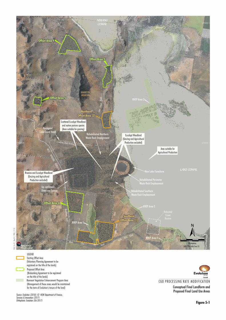
A conceptual view of the proposed long-term land
use areas and the conceptual post-mining landform
is shown on Figure 5-1.
At lease relinquishment, it is proposed that land use
within the ML 1535 and MLA 1 areas would include
fenced rehabilitation areas with grazing excluded
(i.e. elevated rehabilitated landforms such as
rehabilitated waste rock emplacements and the
IWL) and areas suitable for agricultural production
including managed grazing by livestock (i.e. flat
rehabilitation areas such as former infrastructure
areas) and fishing of lake areas (Figure 5-1).
Evolution-owned land outside the ML 1535 and
MLA 1 areas (with the exception of the
Compensatory Wetland and Biodiversity Offset
Areas) (Figure 5-1) would continue to be used for
farming/agricultural production by Evolution and/or
licensees that sign agreements to conduct
agricultural activities on Evolution-owned land. It is
anticipated that areas of lakebed country would be
available for fishing when inundated and may be
used for cropping and/or managed livestock grazing
when dry, consistent with existing and historical
uses of Lake Cowal. Consistent with the LMP, the
RVEP Areas (Figure 5-1) would continue to be
maintained for the term of Evolution’s tenure of the
relevant lands.
Some infrastructure may be retained and
transferred to local landholders for use following
lease relinquishment including electricity
infrastructure, water storages, pipelines, bores and
associated pump stations. Should the CGO’s Bland
Creek Palaeochannel Borefield, Eastern Saline
Borefield and the saline groundwater bores within
the ML 1535 area be retained for local use, the
pipelines would remain in place.
Alternatively, if the infrastructure is not required for
local use, the bores would be plugged, capped and
decommissioned in accordance with relevant
regulatory guidelines, the pump stations would be
removed and the pipelines raised and dismantled
for recycling. Infrastructure decommissioning
activities are described further in Section 5.3.2.
Long-term land uses would ultimately be subject to
consultation with relevant regulatory authorities and
key stakeholders including surrounding landholders.
RAILWAY
Bonehams Lane
Lake
Co
wal
Road
RVEP Area 3
RVEP Area 2
RVEP Area 4
RVEP Area 1
RelocatedCrown
Reserve
"
WEST WYALONG BURCHER
Blow ClearRoad
Uncle Bills Road
WAMBOYNEMOUNTAIN
LAKE COWAL
Lake
C
owal
Road
NERANGCOWAL
Area suitable forAgricultural Production
Rehabilitated NorthernWaste Rock Emplacement
RealignedLake Cowal Road
!
Up-catchmentDiversion System
!
Rehabilitated SouthernWaste Rock Emplacement
!New Lake Foreshore!
Rehabilitated PerimeterWaste Rock Emplacement
Riverine and Eucalypt Woodland(Grazing and Agricultural
Production excluded)
Travelling Stock Reserve
!
!
Eucalypt Woodland
(Grazing and AgriculturalProduction excluded)
Scattered Eucalypt Woodlandand native pasture species(Area suitable for grazing)
SouthernOffset Area (1)
NorthernOffset Area (2)
Offset Area 4
Offset Area 3
Offset Area 5
Offset Area 6
530000
5300
00
540000
5400
00
6280000 6280000
6290000 6290000
Conceptual Final Landform andProposed Final Land Use Areas
CGO PROCESSING RATE MODIF ICAT ION
Figure 5-1
0 2
Kilometres
±GDA 1994 MGA Zone 55
HAL-
16-4
1_M
od14
_PR
M_
217A
Source: Evolution (2018); © NSW Department of Finance,Services & Innovation (2017)Orthophoto: Evolution (Oct 2017)
LEGEND
Remnant Vegetation Enhancement Program Area(Management of these areas would be maintainedfor the term of Evolution's tenure of the land)
Existing Offset Area(Voluntary Planning Agreement to beregistered on the title of the lands)
Proposed Offset Area(Biobanking Agreement to be registeredon the title of the lands)

Cowal Gold Operations Processing Rate Modification – Environmental Assessment
5-13
Consistent with Development Consent (DA 14/98)
Condition 3.4(b) and the CGO’s approved BOMP,
long-term protection of the CGO’s existing Offset
Areas would be provided by a Voluntary Planning
Agreement registered on the title of the lands.
Long-term protection of the proposed Modification
Biodiversity Offset Areas would be provided by a
Biobanking Agreement between the Minister for the
Environment and the landowner to establish a
BioBank site (Appendix C). The Biobanking
Agreement would be registered on the title of the
Offset Areas so it is transferred to new owners if the
land is sold.
The CGO’s approved BOMP would be updated to
reflect the modified offset strategy for the
Modification.
5.3.2 Final Landform Concepts and
Rehabilitation Domains
The currently approved final landform design
concepts would remain unchanged for the
Modification. The CGO final landforms would be:
designed wherever possible to be compatible
with regional landscape features;
progressively constructed as a ROM operation
wherever possible and left with untrimmed
surface roughness to lower runoff coefficients
and promote water absorption and storage;
and
revegetated with native and/or endemic
vegetation communities, selected specifically
for their suitability to the created elevation,
aspect, substrate conditions and the overriding
objective of re-establishing a greater extent of
native and endemic vegetation within ML 1535
and MLA 1.
The rehabilitation concepts and objectives for the
existing CGO final landforms (including the waste
rock emplacements, TSFs, open pit, New Lake
Foreshore and site infrastructure areas) would
remain unchanged for the Modification and would
be applied to the modified landforms (i.e. the IWL).
The concepts and objectives are described below.
The Modification would not change the following key
final landforms at the CGO:
the final void;
rehabilitated waste rock emplacements
surrounding the final void to the north, east
and south;
areas surrounding the rehabilitated waste rock
emplacements and existing TSFs associated
with rehabilitated site infrastructure areas
(e.g. former process plant area and former soil
stockpile areas);
permanent water management features
(including the majority of the northern and
southern sections of the UCDS, and ICDS east
of the IWL); and
permanent lake isolation embankments to
hydrologically separate the open pit
development area and Lake Cowal during
mining and post-mining.
To allow for the proposed increase in processing
rate for the Modification, the existing TSFs would be
modified to form one larger TSF, which would also
accommodate mine waste rock (i.e. the IWL).
In addition, relevant soil stockpiles within ML 1535
would be relocated and new soil stockpiles would be
developed within ML 1535 and MLA 1.
The Modification would also involve relocation of
water management and other infrastructure
displaced by the larger IWL footprint (including
realignment of portions of the ICDS and UCDS, as
well as relocation of the approved contained water
storage D10, the explosives compound and
magazine) in alternative locations within ML 1535
and MLA 1.
The approved operations include the processing of
mineralised material and would therefore remove
the mineralised material stockpile as a component
of the northern waste rock emplacement landform
(dependent on market conditions).
Figure 3-4 shows the conceptual general
arrangement post-mining. Figure 5-1 shows the
conceptual final landforms and long-term land use
areas.
Consistent with the Division of Resources and
Energy’s (DRE’s) (2013) ESG3: Mining Operations
Plan (MOP) Guidelines September 2013 (MOP
Guidelines), conceptual rehabilitation domains have
been developed based on the CGO final landforms
(Table 5-1) shown on Figure 5-2. In summary the
conceptual rehabilitation domains for the
Modification include:
Domain 1A – Final Void;
Domain 2B – Permanent Water Management
Infrastructure;
Domain 3C – Infrastructure Area
– Grassland/Scattered Eucalypt Woodland;

210
2 2
220
230
230
230
240
240
240
220
230
240
220
230
210
220
v
v
v
v
v
LAKE COWAL
BURCHER RAILWAY
WEST WYALONG
Travelling Stock Reserve
Lake Cowal Road
Lake Cowal Road
Northern Waste RockEmplacement
Southern Waste RockEmplacement
Final VoidIntegrated Waste Landform
MLA 1
"Electricity
Transmission Line
"
RealignedLake Cowal Road
"
Up-catchment DiversionSystem
"
Up-catchment DiversionSystem
"
Up-catchment DiversionSystem
Bonehams Lane
ML1535
535000
5350
00
540000
5400
00
6275000 6275000
6280000 6280000
HAL-16-41_Mod14_PRM_207A
Conceptual Rehabilitation Domains0 1
Kilometres
±GDA 1994 MGA Zone 55
CGO PROCESSING RATE MODIF ICAT ION
Figure 5-2
LEGEND
Mining Lease Boundary (ML 1535)
Mining Lease Application Boundary (MLA 1)
Road
Source: Evolution (2018); © NSW Department of Finance,Services and Innovation (2017)
Rehabilitation Domains
Final Void
Permanent Water Management Infrastructure
Infrastructure Area- Grassland/Scattered Eucalypt Woodland
Integrated Waste Landform- Eucalypt Woodland
Waste Rock Emplacement- Eucalypt Woodland
New Lake Foreshore- Riverine Woodland/Freshwater Communities
Contour m AHD (2 m Interval)210
1A
2B
3C
4D
5D
6E

Cowal Gold Operations Processing Rate Modification – Environmental Assessment
5-15
Table 5-1
Primary and Secondary Rehabilitation Domains
Code Primary Domain Code Secondary Domain
1
2
3
4
5
6
Void
Permanent Water Management Infrastructure
Infrastructure
Integrated Waste Landform
Waste Rock Emplacements
New Lake Foreshore
A
B
C
D
E
Final Void
Permanent Water Management Infrastructure
Grassland/Scattered Eucalypt Woodland
Eucalypt Woodland
Riverine Woodland/Freshwater Communities
Domain 4D – Integrated Waste Landform
– Eucalypt Woodland;
Domain 5D – Waste Rock Emplacements
– Eucalypt Woodland; and
Domain 6E – New Lake Foreshore
– Riverine Woodland/Freshwater
Communities.
Due to the proposed integration of the northern
waste rock emplacement and the IWL, the
Woodland Corridor rehabilitation domain (previously
Domain 6D in the approved Rehabilitation and
Landscape Management Strategy [Evolution, 2016])
is no longer required.
The rehabilitation objectives and final landform and
revegetation concepts for each domain/key final
landform are described below and are consistent
with the rehabilitation principles (Section 5.1.1) and
rehabilitation objectives (Section 5.1.2) for the
Modification.
These concepts (and the long-term land use
strategy) may be revised and refined as necessary
throughout the life of the CGO based on the
outcomes of ongoing consultation with relevant
regulatory authorities and stakeholders and the
results of ongoing rehabilitation investigations and
trials.
Domain 1A – Final Void
The rehabilitation objectives for the final void would
remain unchanged for the Modification and are to
(Evolution, 2016):
create habitat opportunities for waterbirds at
the approximate level at which void water will
reach equilibrium, where feasible; and
leave the void surrounds safe (for humans and
stray stock).
At the completion of mining, the final void would be
surrounded on three sides by the revegetated waste
rock emplacements.
The approved maximum final depth of the final void
is approximately -331 m AHD (i.e. approximately
540 m below the natural surface level). The berm
widths and slope angles would continue to be
reviewed and monitored through ongoing
geotechnical studies and data collection during mine
development.
A description of the long-term hydrological
characteristics for the final void is presented in
Appendix B. Modelling indicates that the final void
water level would rise slightly from the final void
level predicted in the previous Cowal Gold
Operations Mine Life Modification Hydrological
Assessment (HEC, 2016), however is expected to
reach equilibrium well below spill level (Appendix B).
The process of trending towards this equilibrium is
expected to take several hundred years
(Appendix B). Predictions of average void salinity
confirm that salt concentrations in void waters would
slowly increase towards hyper-salinity (Appendix B).
A bund would be constructed around the perimeter
of the final void which would be planted with an
initial cover crop if necessary (to assist in stabilising
the bund following construction) and would then be
seeded with native and/or endemic Eucalypt
Woodland species. The final void would be
screened from public views on Lake Cowal Road by
the IWL and waste rock emplacements and would
be fenced upon completion of mining. Signposted
warnings to the public would also be placed along
the fence.
Domain 2B – Permanent Water Management
Infrastructure
The rehabilitation objective for the permanent water
management structures is to create stable systems
(i.e. acceptably low risk of environmental harm to
Lake Cowal).

Cowal Gold Operations Processing Rate Modification – Environmental Assessment
5-16
The Modification would involve minor changes to
existing permanent water management structures to
allow for the larger IWL footprint, including:
realignment of the western and northern
portions of the UCDS; and
modification of the ICDS and removal of ICDS
features within the IWL footprint.
The UCDS has been constructed to simulate
endemic drainage features in the region and
includes a low flow drainage path within a wider
floodplain (approximately 65 m wide). The channel
includes constructed features such as low flow and
overbank zones, meanders and pool/riffle
sequences. The northern extent of the UCDS
includes constructed rock outfalls at confluences
with existing natural drainage lines to minimise
erosion. At the completion of construction, the
UCDS was revegetated with riparian vegetation
including rapid germinating pasture species to assist
in stabilising the channel.
The realignment of the UCDS for the Modification
would be constructed consistent with the principles
outlined above to continue to minimise erosion.
The realigned UCDS would remain post-mining to
facilitate permanent drainage of adjacent areas
upslope of the site to Lake Cowal. In addition, new
ICDS features (low bunding and/or drains) would be
constructed east of the IWL to contain runoff
generated within the site catchment and would
remain post-mining.
Although some components of the Lake Isolation
System are permanent water management features
(i.e. the lake protection bund and first outer batter of
the perimeter waste rock emplacement which will
become the New Lake Foreshore at mine closure),
the rehabilitation objectives and concepts for the
New Lake Foreshore are different from the UCDS
and ICDS. Therefore, a separate Rehabilitation
Domain (6E) has been developed for the New Lake
Foreshore.
Domain 3C – Infrastructure Areas Post-operations, the rehabilitation objectives for the
infrastructure areas are to:
remove all infrastructure to ensure the site is
safe and free of hazardous materials (unless
an alternative arrangement is agreed between
Evolution, the ultimate landholder and relevant
regulatory authorities); and
establish vegetation communities (including
scattered Eucalypt Woodland species and
native and/or endemic pasture species) that
are suitable for managed grazing.
Infrastructure areas associated with the Modification
would largely remain the same as the existing
infrastructure areas at the approved CGO, with the
exception of relocation of soil stockpiles within
ML 1535, development of additional soil stockpiles
within ML 1535 and MLA 1, relocation of the
explosives compound and magazine and duplication
of the existing water supply pipeline across Lake
Cowal.
Existing infrastructure which would continue to be
used for the Modification would include the
workshop, storage areas, process plant (with
addition of a secondary crushing circuit),
administration area, internal roads, transmission line
and substation, borefields, water management
structures, contained water storages and
exploration areas.
The general rehabilitation concepts for the
infrastructure areas would remain unchanged for the
Modification. A summary of these rehabilitation
concepts is provided below.
The long-term objectives for site infrastructure
features will be discussed during the life of the CGO
and will be specifically reviewed in consultation with
the CEMCC and relevant regulatory authorities prior
to the final year of mine operations.
Workshop
At the completion of mining, the mine fleet would be
demobilised and removed from site. The workshop
would be dismantled at the end of mine life, at which
time the footprint area would be tested for
contamination from fuels and lubricants and any
contaminated soils removed for proper disposal in
accordance with EPA requirements. The area would
then be contour ripped, topsoiled and revegetated
with native and/or endemic Eucalypt Woodland and
pasture species.
Reagent and Fuel Storage Areas
Unused reagents and fuels at the completion of
processing would be returned to the supplier in
accordance with all relevant safety and handling
procedures. Storage areas would be tested for
contamination from fuels and chemicals and any
contaminated soils removed for proper disposal in
accordance with EPA requirements. The area would
then be contour ripped, topsoiled and revegetated
with native and/or endemic Eucalypt Woodland and
pasture species.
Cowal Gold Operations Processing Rate Modification – Environmental Assessment
5-17
Process Plant and Administration Area
The process plant and administration area buildings
would be dismantled and removed following the
cessation of processing.
The foundations and floors would be retained if a
suitable alternative use is agreed with the ultimate
landholder and regulatory authorities. Alternatively,
they would be broken and excavated for disposal in
the final void or as buried landfill in an approved
manner. If the foundations and floors are removed,
the area would then be contour ripped, topsoiled
and revegetated with native and/or endemic
Eucalypt Woodland and pasture species.
Internal powerlines, pipelines and the explosives
compound and magazine location would be
dismantled and removed. Where required these
areas would be topsoiled, contour ripped and
revegetated with native and/or endemic Eucalypt
Woodland and pasture species.
Internal Access Road and Other Roads
All internal roads would be contour ripped, topsoiled
and revegetated with native and/or endemic
Eucalypt Woodland and pasture species, unless
otherwise agreed with the ultimate landholder and
regulatory authorities.
Transmission Line and Substation
At the end of the mine life, the electricity
transmission line (from Temora to the CGO) would
be the property of the electricity utility and would
likely remain in place.
Water Supply Infrastructure
The long-term strategy and rehabilitation concepts
for the duplicate pipeline across Lake Cowal would
be the same as for the existing pipeline.
At the end of the mine life, the pipelines would either
be raised and dismantled for recycling or kept in
place if required for local use. If dismantled, the
sections of pipeline in the bed of Lake Cowal would
be raised when the lake is dry and disturbed areas
revegetated with endemic species. If this is not
possible due to successive high rainfall seasons,
any decision to remove the pipelines would be
discussed with the relevant regulatory authorities.
However, given the likely maintenance period for
CGO rehabilitation, it is likely that Lake Cowal would
be sufficiently dry at some stage during this period.
The Bland Creek Palaeochannel bores and
associated pump stations (including the eastern
pump station and diesel tank) may be transferred to
local landholders or, alternatively, dismantled and
the bores plugged, capped and decommissioned in
accordance with regulatory guidelines.
Given the water supply from the saline groundwater
supply bores within ML 1535 and the Eastern Saline
Borefield is highly saline, it is unlikely that these
bores would be suitable and/or requested for
ongoing future use by local landholders post-closure
of the CGO. Notwithstanding, consultation would
include discussions between Evolution, the
regulatory authority and local landholders regarding
potential transfer of the saline groundwater supply
borefield infrastructure for private use.
It is likely, however, that the saline groundwater
supply bores would be plugged, capped and
decommissioned in accordance with regulatory
guidelines and the associated pipelines and pump
systems dismantled. The saline groundwater supply
bores and pipeline in ML 1535 within Lake Cowal
would be plugged, capped, decommissioned and
removed during dry lake conditions and disturbed
areas revegetated with endemic species.
Contained Water Storages
Rehabilitation objectives for the contained water
storages (i.e. D1 to D10) are to either decommission
the infrastructure or retain the infrastructure for local
landholder use. Decommissioning of the contained
water storages would be undertaken to the
satisfaction of relevant regulatory authorities
including the DRG, EPA and DI-Water. Alternatively,
the contained water storages may be retained for
local landholder use upon agreement with Evolution
and the regulatory authorities.
Exploration Areas
All exploration drill holes would be plugged, capped
and decommissioned in accordance with regulatory
guidelines at the completion of exploration activities.
Access tracks and areas disturbed by exploration
activities would be revegetated in accordance with
the procedures adopted for the internal site roads.
Domain 4D – Integrated Waste Landform
The Modification would involve modifying the design
of the existing TSFs to form the IWL. The IWL would
integrate with the existing northern waste rock
emplacement and involve an extension to the
existing approved TSF footprint.

Cowal Gold Operations Processing Rate Modification – Environmental Assessment
5-18
Prior to commissioning of the IWL for tailings
storage, the existing NTSF and STSF (Section 2.6)
would continue to be used to store tailings. These
facilities would be raised to STSF Stage 7
(248.4 m AHD) and NTSF Stage 6 (240.5 m AHD).
The IWL would be constructed to a maximum height
of 245 m AHD.
Notwithstanding, the Modification would apply the
approved rehabilitation objectives for the existing
TSFs to the IWL which would be:
to establish a permanently stable landform;
during operations, stabilise embankments so
they provide minimal habitat value for bird life
(i.e. rock mulch or pasture cover);
post-operations, to establish vegetation
communities (including Eucalypt and Riverine
Woodland species and understorey species
such as Rush sp. and pasture species) which
are suited to the hydrological features and
substrate materials of the top surface of the
landform;
post-operations, to establish vegetation
communities (including native and/or endemic
Eucalypt Woodland, shrubland and grassland
species) similar to those remnants in the
surrounding landscape which are suited to the
substrate materials and slope of the
embankments; and
to exclude grazing and agricultural production.
The currently approved rehabilitation strategy for the
existing TSFs at the completion of processing would
also be applied to the IWL and would include the
following:
The decant areas would be allowed to dry and
the decant towers permanently capped with fill
and/or a concrete plug.
The underdrains would be grouted.
The tailings discharge pipes and monitoring
systems would be dismantled for re-use or
disposal with the bulk of CGO infrastructure.
The IWL would be fenced during operations to
prevent access by terrestrial wildlife, and this
fence would remain during rehabilitation and
post-mining to exclude grazing and agricultural
production.
Embankment Construction The NTSF and STSF would continue to be stage
constructed with the height of the embankments
raised in advance of the storage requirements. As
the storages fill, the embankments would be raised
in a series of upstream lifts, at a rate of
approximately 5 m per year. Each lift would
comprise an earth/rock fill embankment, with a clay
basal zone, supported by the dry tailings beach.
Construction of each lift would continue to involve
placement of an interim rock buttress cover on the
outer slope of the embankment to enhance stability.
Rehabilitation materials (e.g. rock mulch and
topsoil) on the existing TSF embankments would
continue to be stripped prior to placement of the
interim rock buttress. The stripped rehabilitation
materials would be either transferred to a new
rehabilitation area or stockpiled proximal to the IWL
for use during ongoing or final rehabilitation
activities.
The outer downstream embankment of the IWL
would be constructed using mined waste rock to
provide long-term stability. The overall final slope of
the outer downstream embankment of the IWL
would be 1(V):4(H).
Figure 5-3 shows a conceptual embankment
cross-section of the IWL, including rehabilitation
cover system concept.
Rehabilitation Cover System
The Modification would apply the existing
rehabilitation concepts for the top surface of the
TSFs to the top surface of the IWL. The top surface
of the IWL would include an upper and lower
catchment area. Each area would form a low,
internally draining landform, with drainage effected
by controlled placement of cover materials and a
number of shallow swales. The contained
catchments would minimise surface water runoff
from the top surface down the embankments. The
rehabilitation cover system materials for the top
surface would include a capillary break layer of rock,
and layers of gypsum-treated subsoil and topsoil.
The rehabilitation methods for the IWL
embankments would include spreading
gypsum-treated topsoil over the surface of the
embankment, cross-ripping along the contour of the
slope and then revegetating with native and/or
endemic Eucalypt Woodland, shrubland and
grassland species suited to slope and elevated
positions similar to those remnants in the
surrounding landscape.


Cowal Gold Operations Processing Rate Modification – Environmental Assessment
5-20
During operations, the TSF and IWL embankments
would be constructed so that they provide minimal
habitat value for bird life (i.e. rock mulch or pasture
cover only).
Revegetation Concepts
Similar to the revegetation concepts for the waste
rock emplacements, revegetation concepts for the
IWL would include selecting species suited to the
hydrological features and substrate materials of the
landform and would be based on results of
rehabilitation investigations and trials in consultation
with regulatory authorities.
Vegetation growth trials undertaken to date indicate
that salt tolerant tree species including Belah
(Casuarina cristata), Grey Box (E. microcarpa),
Bimble Box (E. populnea), Mugga Ironbark (E.
sideroxylon) and Buloke (Allocasuarina leuhmannii)
and shrub species including Green Wattle (Acacia
deanei), Western Golden Wattle (A. decora),
Weeping Myall (A. pendula), Wedge-leaf Hop-bush
(Dodonaea viscose ssp. cuneata) and Nitre
Goosefoot (Chenopodium nitrariaceum) may be
suitable for revegetation of the IWL top surface
(Evolution, 2016).
Based on the above, post-operation revegetation
concepts for the IWL include:
In the two central, occasionally wet areas,
planting species such as River Red Gum and
understorey species such as Rush sp.
On the remainder of the covered storage
surface, planting salt tolerant Eucalypt and
Riverine Woodland species (which may
include Belah, Grey Box, Bimble Box, Mugga
Ironbark and Buloke and shrub species
including Green Wattle, Western Golden
Wattle, Weeping Myall, Wedge-leaf Hop-bush
and Nitre Goosefoot).
On the IWL embankments, planting native
and/or endemic species suited to the slope
and substrate materials of the embankment.
Revegetation concepts would consider the results of
hydrological modelling predictions for the IWL
(i.e. plant species would be selected that are suited
to the hydrological conditions of the storages such
as inundated areas, dry areas and swales).
Rehabilitation trials would continue to be undertaken
to determine the most suitable revegetation species
for the top surface and embankments of the IWL.
A description of the rehabilitation trials that would be
undertaken for the Modification is provided in
Section 5.6.
Revegetation methods for the IWL would be
described in detail in the MOP which would be
prepared in consultation with and subject to
approval by the DRG.
Domain 5D – Waste Rock Emplacements
The Modification would not change the approved
rehabilitation objectives for the waste rock
emplacements, which are to:
stabilise batter slopes with rock armour
(primary waste rock mulch) to control surface
water runoff downslope and reduce erosion
potential in the long-term;
provide a stable plant growth medium able to
support long-term vegetation growth including
native and/or endemic Eucalypt Woodland,
shrubland and grassland species suited to
slope and elevated positions similar to those
remnants in the surrounding landscape; and
exclude grazing and agricultural production.
The approved final heights of the northern, southern
and perimeter waste rock emplacements
(308 m AHD, 283 m AHD and 223 m AHD,
respectively) would remain unchanged, as would
the footprints of the southern and perimeter waste
rock emplacements. The footprint of the northern
waste rock emplacement would be modified to fully
integrate with the IWL.
The Modification would involve temporarily
increasing the height of the existing mineralised
material stockpile adjacent to the northern waste
rock emplacement (up to approximately
320 m AHD). Consistent with the approved
operations, the Modification would involve the
processing of this mineralised material. Therefore,
the temporary mineralised material stockpile would
be progressively removed (dependent on market
conditions).
A conceptual cross-section of the northern waste
rock emplacement is shown in Figure 5-4 and is
also representative of the concept for the southern
waste rock emplacement.
Development of the waste rock emplacements
would continue to be consistent with currently
approved designs. The development of the
emplacements would meet the long-term goal of
directing potential seepage generated from waste
rock emplacement areas toward the open pit during
operation and post-closure.


Cowal Gold Operations Processing Rate Modification – Environmental Assessment
5-22
The waste rock emplacement batter slopes would
be constructed to 1(V):5(H) and rock armoured with
primary waste rock, topsoiled and cross-ripped
along the contour of the slope to provide long-term
slope stability, control surface water runoff
downslope and reduce erosion potential.
The Modification would not change the approved
rehabilitation concepts for the top surfaces of the
waste rock emplacements, which includes
managing drainage via a series of small shallow
basins (depressions) and via a rehabilitation cover
system that absorbs rainfall and comprises native
and/or endemic Eucalypt Woodland vegetation
(Evolution, 2016). The use of depressions would be
aimed at maximising internal drainage without
creating permanent ponding during normal and
heavy rainfall events (Evolution, 2016).
As described in Section 5.2.1, a layer of gypsum
and then primary waste rock may be placed over
oxide waste rock areas on the top surface (and
batters) of the southern waste rock emplacement
(which has largely been constructed of oxide waste
rock material) to assist with stabilising the sodic and
dispersive characteristics of the oxide waste rock.
Given the northern waste rock emplacement is
mainly constructed of primary waste rock material,
this practice is not required for this emplacement.
This method may be subject to further investigations
and/or trials.
A bund around the perimeter of the top surfaces of
the waste rock emplacements would also be
constructed to provide a contained catchment and
minimise surface water runoff from the top surface
down the batters.
Rehabilitation Cover System – Batters
The rehabilitation cover system for the waste rock
emplacement batters would not change for the
Modification and would include:
benign (primary) rock mulch; and
low salinity and gypsum-treated topsoil.
The rock mulch and topsoil layers would be
cross-ripped with approximately 10 tonnes per
hectare (t/ha) gypsum, followed by seeding with
native and/or endemic Eucalypt Woodland and
shrub species during suitable seasonal conditions.
To stabilise areas where an adequate vegetation
cover has yet not established, a layer of locally
harvested seed bearing native pasture hay (or clean
wheaten hay) would be spread to provide soil
protection and soil stability for vegetation
establishment. Cross-ripping along the contour of
the slope is proposed to create ‘troughs and banks’
to minimise the potential for erosion downslope and
enhance vegetation establishment within the
troughs.
The benign (primary) rock mulch used in the cover
system would be sourced from development of the
open pit and would include suitable non-saline
material. As no change to the open pit is proposed,
there would be no change to the waste rock
geochemistry of the approved CGO. A description of
the chemical characteristics of primary waste rock is
provided in Section 5.2.1.
Results of rehabilitation investigations and trials
would continue to inform and refine CGO
rehabilitation concepts including rehabilitation
materials and revegetation species. It is expected
that the northern waste rock emplacement
rehabilitation trial would continue to inform the most
suitable applications of rock mulch and topsoil and
plant species suited to the substrate materials.
Revegetation Concepts
The Modification would not change the currently
approved revegetation concepts for the waste rock
emplacements. Revegetation aims to re-establish
native and/or endemic Eucalypt Woodland, shrub
and grassland communities similar to those
remnants which persist on similar landforms in the
regional landscape (e.g. Wamboyne Mountain,
Fellmans Hill and Billy’s Lookout). Suitability of
revegetation species would include consideration of
the physiographic and hydrological features of the
landform and performance relative to both stability
and surface rehabilitation materials (subject to
availability).
Results of rehabilitation trials, in particular the trial
on the northern waste rock emplacement
(Section 5.6), would continue to be used to
determine the revegetation species suited to the
cover system materials for the waste rock
emplacement batters.

Cowal Gold Operations Processing Rate Modification – Environmental Assessment
5-23
Revegetation species considered suitable for
revegetation of the CGO waste rock emplacements
have been developed by DnA Environmental (2016)
with assistance from Diversity Native Seeds (a local
native seed supplier) (Evolution, 2016). These
species are associated with woodlands on low
ridges and hills in the local landscape. A selection of
these species have been used in the northern waste
rock emplacement rehabilitation trial and would also
be used in the large scale substrate profile trials
(Section 5.6).
Consistent with the approved Rehabilitation and
Landscape Management Strategy, revegetation
species lists developed for the waste rock
emplacements may be refined based on results of
rehabilitation investigations and trials
(Evolution, 2016).
Domain 6E – New Lake Foreshore
The Modification would not change the approved
New Lake Foreshore components associated with
the approved CGO (i.e. the height of the perimeter
waste rock emplacement would remain unchanged
and there would be no change to the temporary
isolation bund or the lake protection bund). As a
result, the rehabilitation concepts for the New Lake
Foreshore would remain unchanged for the
Modification.
A summary of the approved New Lake Foreshore
rehabilitation concepts is provided below.
Similar to the design of the northern and southern
waste rock emplacements, the outer batter slopes of
the perimeter waste rock emplacement and the
temporary isolation bund have been constructed at
1(V):5(H).
Construction of the lake isolation embankments has
been completed and the temporary isolation bund
and the lake protection bund have been topsoiled
and revegetated with native and exotic grass
species and scattered aquatic species such as
Lignum, Rush sp., River Cooba and River Red
Gums. The outer batter slopes of the lake protection
bund have been rock armoured to further protect
against wave action from lake level rises.
As described in the approved Rehabilitation and
Landscape Management Strategy, the temporary
isolation bund is a short-term feature and at the
completion of operations is proposed to be
reworked (breached) by light machinery (i.e. small
excavator and bob cat) when the level of the lake is
lower than the bund, to create a series of low
mounds (Evolution, 2016). The mounds would
comprise a mixture of inert bund rock and lakebed
sediments (Evolution, 2016).
The revegetation concepts for the New Lake
Foreshore would also remain unchanged for the
Modification.
Rehabilitation of the New Lake Foreshore would be
an iterative process and revegetation species would
continue to be selected in consideration of Lake
Cowal’s hydrological regime (wetting and drying
cycles), species occurring in relevant reference sites
(including lake and slope woodland communities),
species performance during revegetation trials and
species suitability to substrate conditions.
Subject to these parameters, species may be
selected from the following vegetative suites:
• fringing lake vegetation on the foreshore
batters (i.e. Eucalypt dominated woodland
including River Red Gum, River Cooba, Wilga
[Geijera parviflora], Kurrajong [Brachychiton
populneus], Green Wattle and Grey Box); and
• freshwater habitats (i.e. Foxtail [Austrostipa
densiflora], Rush, Cane Grass [Eragrostis
australasica] and Lignum).
Revegetation trials that have been undertaken on
the New Lake Foreshore have included native grass
establishment, hand broadcasting of Red River
Gum seed and tubestock and planting of wetland
species such as Lignum and Rushes from tubestock
and cuttings (Evolution, 2016).
DnA Environmental (2018a) has observed that
since 2005 there has been a significant increase in
ecological function in the lake foreshore
rehabilitation sites largely due to the increase in
ground cover from plants which have established
as a result of seed dispersal from flood events,
natural regeneration from the topsoil stored seed
bank and seed applied by hand broadcasting. DnA
Environmental (2018a) notes that monitoring results
indicate the rehabilitated lake foreshore sites are
comparable to their relevant reference sites.
5.4 REHABILITATION MANAGEMENT PLAN
In accordance with CGO Development Consent
(DA 14/98) Condition 2.4(c), a RMP has been
developed for the CGO which details the
rehabilitation management measures and
rehabilitation monitoring programme currently
implemented at the CGO.
The RMP would be revised (where necessary) to
reflect the rehabilitation concepts and modified
rehabilitation domains for the Modification as
described in Section 5.3.

Cowal Gold Operations Processing Rate Modification – Environmental Assessment
5-24
The rehabilitation management measures detailed
in the RMP would continue to apply for the
Modification and would include (but not be limited
to) those detailed in Section 5.5 below.
5.5 GENERAL REHABILITATION PRACTICES AND MEASURES
5.5.1 Progressive and Interim Rehabilitation
Consistent with CGO Development Consent
(DA 14/98) Condition 2.4(b), rehabilitation of final
landforms or disturbed areas would be undertaken
progressively as soon as reasonably practicable
following disturbance and would include interim
rehabilitation measures. Progressive rehabilitation
would aim to minimise erosion and sedimentation
potential and minimise visual impacts of CGO
landforms.
Interim rehabilitation measures may include:
Rock mulch application as soon as practicable
following completion of landform shaping to
minimise the potential for windblown dust from
waste rock surfaces and to reduce the
potential for soil erosion from rainfall.
Topsoiling and establishment of a cover crop
on landform areas available for rehabilitation
and on long-term soil stockpiles to minimise
the area exposed for dust generation.
Application of native pasture hay or clean
wheaten hay on areas where the initial cover
crop has not yet established to assist with
stabilising the soil surface and minimising the
loss of topsoil resources.
In addition to these measures, the safeguards and
dust management controls described in the AQMP
would be implemented to minimise dust generated
from exposed areas and from general mining
activities.
5.5.2 Soil Management
The currently approved strategies/objectives for
management of soil resources, as detailed in the
SSMP, would continue to be implemented for the
Modification and would include:
characterisation of the suitability of material for
rehabilitation works prior to stripping;
stripping and storing soil resources selectively
according to their suitability for rehabilitation
purposes;
stripping and storing soil resources in such a
manner that their long-term viability is
maintained;
providing sufficient subsoil and stable topsoil
resources for rehabilitation purposes; and
progressively rehabilitating final landforms as
soon as practical once constructed to final
design.
Soil management for the Modification would focus
on soil stripping required for additional disturbance
areas and ongoing soil stockpile management and
soil amelioration measures.
As described in Section 5.3.2, rehabilitation
materials (e.g. rock mulch and topsoil) on the
existing TSF embankments would be stripped prior
to construction of the interim rock buttressing of the
TSF embankments. The stripped rehabilitation
materials would be either directly transferred to a
new rehabilitation area or stockpiled proximal to the
IWL for use during ongoing or final rehabilitation
activities.
The currently approved general protocol for
management of stockpiled soils includes soil
handling measures that optimise the retention of soil
characteristics (in terms of nutrients and
micro-organisms) favourable to plant growth. The
protocol would continue to be applied for the
Modification and would include:
leaving the surface of the completed soil
stockpiles in a “rough” condition to help
promote water infiltration and minimise erosion
prior to vegetation establishment;
deep ripping soil stockpiles and seeding (if
necessary) to maintain soil organic matter
levels, soil structure and microbial activity;
treating soil stockpiles with gypsum to reduce
dispersiveness during stockpiling;
installing signposts for all soil stockpiles with
the date of construction and type of soil; and
recording details of all soil stockpiles on a site
database which includes the location and
volume of each stockpile and the stockpile
maintenance records (e.g. ameliorative
treatment, weed control, seeding).
Long-term topsoil stockpiles have been constructed
up to approximately 3 m in height. Subsoil
stockpiles vary in height as determined by storage
volumes and available space within the footprint of
approved disturbance areas.

Cowal Gold Operations Processing Rate Modification – Environmental Assessment
5-25
Soil amelioration methods would continue to be
implemented for the Modification and would be
guided by the results of McKenzie Soil
Management’s (2013) Cowal Gold Mine Soil
Stockpile Characterisation Assessment.
These methods may include:
• spreading gypsum on the surface of original
soil profiles prior to soil stripping;
• deep-ripping and applying gypsum (or other
relevant treatments) to existing and proposed
soil stockpiles;
• applying gypsum to soil during re-application
on rehabilitation areas; and
• treating strongly sodic and dispersive soil
stocks with gypsum, or acidic soils with lime or
a gypsum-lime blend, in a dedicated soil
amelioration farm.
A detailed description of the CGO’s soil amelioration
methods is provided in the RMP.
A soil inventory would continue to be maintained to
track soil resource stocks available for rehabilitation.
Details of estimated soil resource accounting
(availability and requirements for rehabilitation)
would be detailed in the revised CGO MOP.
The CGO’s approved SSMP would continue to be
used to guide soil management for the Modification.
5.5.3 Plant Species Selection for Revegetation
As described in Section 5.3.2, the CGO’s final
landforms would be revegetated with native and/or
endemic vegetation communities, selected
specifically for their suitability to the created
elevation, substrate conditions and the overriding
objective of re-establishing a greater extent of
endemic vegetation within ML 1535 and MLA 1. The
revegetation concepts for the Modification landforms
are described in Section 5.3.2.
Consistent with the approved CGO, revegetation
concepts would continue to be informed by the
results of rehabilitation investigations, trials and
monitoring and the rehabilitation programme refined
in consultation with relevant regulatory agencies.
5.5.4 Seed Collection and Habitat Enhancement
Measures
A Vegetation Clearance Protocol (VCP) has been
developed for the approved CGO and would
continue to be applied for the Modification.
During the preliminary habitat assessment phase of
the VCP, trees may be examined for their provision
of seed to be used in the rehabilitation programme.
Where available, seed would be collected and
habitat features (i.e. hollows and logs) would be
salvaged for use in rehabilitation or habitat
enhancement programmes within ML 1535, MLA 1
and/or within the Biodiversity Offset Areas and
RVEP areas (Figure 5-1). Seed may also be
collected from surrounding vegetation on
Evolution-owned lands.
5.5.5 Erosion and Sediment Control
The erosion and sediment control systems detailed
in the ESCMP would continue to be implemented for
the Modification.
The ESCMP details sediment and erosion control
systems developed to control the movement of
sediment and salinity from areas disturbed by
mining activities and maintain downstream
(Lake Cowal) water quality. These measures would
remain unchanged for the Modification.
Rehabilitation monitoring at the approved CGO also
includes monitoring of erosion incidence on
rehabilitation areas (Section 5.7). Erosion
monitoring and measures to control erosion on
rehabilitation areas would continue to be undertaken
for the Modification.
5.5.6 Weed and Pest Control
Weed Control
Weeds would continue to be managed in
accordance with measures described in the LMP
and RMP (and BOMP). The CGO’s weed
management programme is aimed at minimising the
possibility of new weed incursion and controlling the
spread of any existing noxious weeds on-site
(including rehabilitation areas) and on all
Evolution-owned land.
The weed management programme includes the
following measures:
• identification of weeds by annual site
inspections and recording weed presence in
an annual weed survey report;
• communication with other
landholders/leaseholders and regulatory
authorities to keep weed management
practices in line with regional weed control
activities;

Cowal Gold Operations Processing Rate Modification – Environmental Assessment
5-26
mechanical removal of identified noxious
weeds and/or the application of approved
herbicides in authorised areas (herbicide use
in wetland areas would be strictly controlled);
implementation of follow-up site inspections to
determine the effectiveness of the weed
control measures; and
where practicable, prevention of the
establishment of new weeds on
Evolution-owned land by minimising seed
transport of weed species (measures may
include the use of a vehicle hygiene/wash
down procedures [if considered necessary]).
Rehabilitation monitoring at the approved CGO also
evaluates floristic diversity and documents the
presence of exotic plant species in the rehabilitation
areas. If present, weed incursion is recorded and
control measures implemented where necessary.
These measures would remain unchanged for the
Modification.
Pest Control
Evolution would continue to undertake pest control
activities in accordance with procedures detailed in
the FFMP, LMP, RMP and BOMP, including:
regular property inspections to assess the
status of pest populations;
mandatory pest control for declared pests
(i.e. rabbits, feral pigs, wild dogs and foxes) in
accordance with Pest Control Orders under the
NSW Local Land Services Act, 2013, and
management of plague locust species
including the Australian Plague Locust
(Chortoicetes terminifera), Migratory Locust
(Locusta migratoria) and the Spur-throated
Locust (Austracris guttulosa);
inspections to assess the effectiveness of
control measures implemented and review of
these if necessary; and
documenting pest sightings and control
measures in a Pest Register and marking the
location of sightings on a map.
Evolution undertakes pest control activities in
conjunction with adjacent landholders for more
effective pest control. This process is facilitated via
consultation with local landholders and landholder
groups.
These measures would remain unchanged for the
Modification.
5.5.7 Management of Grazing and Agriculture
Grazing and cropping activities would continue to be
excluded within ML 1535 during operation and
rehabilitation of the CGO, in accordance with the
LMP. The fence along the perimeter boundary of
ML 1535 would continue to be maintained to
prevent access by stock and minimise the potential
for damage to rehabilitation areas.
These management measures would also be
applied to the proposed MLA 1 area. Once the MLA
has been granted, the new ML area would be
fenced, however the fence adjoining the ML 1535
boundary would be removed to facilitate the
proposed operations within the new ML area. The
LMP would be updated to reflect this.
As described in Section 5.3.2, rehabilitation
objectives for the waste rock emplacements and the
IWL involves exclusion of grazing and agricultural
production from these areas post-mining. The IWL
would be fenced during operations, and this fence
would remain post-closure.
Evolution-owned lands outside the CGO area (with
the exception of RVEP Areas and Northern and
Southern Offset Areas) is farming/agricultural
production by Evolution and/or licensees that sign
agreements to conduct agricultural activities on
Evolution-owned land (Section 5.3.1). The proposed
Modification Offset Areas would also have grazing
and cropping excluded.
5.5.8 Landscaping to Minimise Visual Impacts
Progressive rehabilitation of waste rock
emplacements would continue to be undertaken to
reduce the contrast between the CGO landforms
and the surrounding landscape. This includes
progressive rehabilitation with selected native
and/or endemic grass, shrub and/or tree species.
These progressive rehabilitation methods would
also be applied to the IWL.
Vegetation screens have been planted along
sections of the western, southern and northern
boundaries of ML 1535 to break up continuous
views from Lake Cowal Road. The vegetation
screens include endemic plants that are compatible
with the existing surrounding vegetation. Vegetation
screens may be implemented within the proposed
MLA 1 area if considered necessary.
Maintenance of the vegetation screens
(e.g. replacement of plant losses) is undertaken in
these areas where necessary. An increase in
screening effect over time as plants grow, would
continue as a result.

Cowal Gold Operations Processing Rate Modification – Environmental Assessment
5-27
These measures would remain unchanged for the
Modification.
5.5.9 Bushfire Management
Bushfire management at the CGO includes fuel
management strategies, planning and
implementation procedures for hazard reduction and
strategies for reducing fire hazards and related risks
on-site and on Evolution-owned land. These
strategies and procedures would continue to be
implemented for the Modification.
5.6 REHABILITATION INVESTIGATIONS AND TRIALS
Rehabilitation at the CGO would continue to be an
iterative process, whereby the results of
rehabilitation trials and monitoring would continue to
inform and refine the rehabilitation programme in
consultation with relevant regulatory agencies.
Rehabilitation trials and research proposed for the
Modification would be an extension of the trials that
have been undertaken to date and would include:
Rehabilitation Media
Northern waste rock emplacement
trial-continued investigation into the
effectiveness of various applications
associated with the rock mulch, topsoil
depth and hay cover materials in
stabilising landform slopes
(i.e. controlling erosion) and providing a
suitable medium for revegetation.
Implementation of substrate profile trials
to investigate revegetation species suited
to the top surface rehabilitation materials
of CGO final landforms, including the
proposed IWL and waste rock
emplacements, to refine revegetation
objectives.
Revegetation
Continued investigation of the most
effective methods for direct seeding
rehabilitation areas following the
establishment of the initial Wimmera
Ryegrass cover crop.
A summary of the proposed rehabilitation
investigations and trials is provided below. Detailed
design of the proposed trials would be provided in
the revised MOP and results reported in the Annual
Review.
Rehabilitation Media
Northern Waste Rock Emplacement Trial
As described in Section 5.2, a rehabilitation trial
area has been established on the northern slopes of
the northern waste rock emplacement to investigate
the performance of various applications associated
with the rock mulch, topsoil and hay cover materials.
The trial includes plots assessing different topsoil
depths, applications of seed bearing native pasture
hay compared with clean wheaten straw hay or no
hay with select native and/or endemic tubestock
planted across all plots.
Results from this trial are anticipated to inform the
most effective combination of rock mulch, topsoil
and hay cover materials for final landform slopes
and inform the suitability of selected Eucalypt and
Acacia revegetation species. Erosion incidence will
continue to be monitored to confirm the
effectiveness of the cover materials in stabilising
landform slopes in the long-term.
Substrate Profile Trial
Revegetation trials would continue to be undertaken
for the Modification to assess the performance of
select native and/or endemic tree and shrub species
in various CGO substrate materials including tailings
and waste rock.
Large scale substrate profile trials are proposed to
be undertaken for the Modification to expand on the
trials that have been conducted to date and would
include various topsoil, subsoil and waste rock
depths and various tailings types (e.g. oxide tailings
and sulphide tailings) compared with a control
(topsoil only).
Given the existing TSFs (and the proposed IWL)
would continue to be operational and dynamic
landforms, the opportunity to implement
rehabilitation trials on the top surface of these areas
is currently unavailable. Once an area on the top
surface of the TSFs or IWL becomes available, the
trial would be implemented.
As the southern waste rock emplacement will reach
the final approved design height in 2019, the trial
component relevant to the waste rock emplacement
top surface cover materials would be implemented
on an area on its top surface.
The objective of this trial would be similar to the
previous vegetation growth trials and would assess
the performance of select revegetation species in
various material combinations and depths
associated with the IWL and waste rock
emplacement top surfaces.
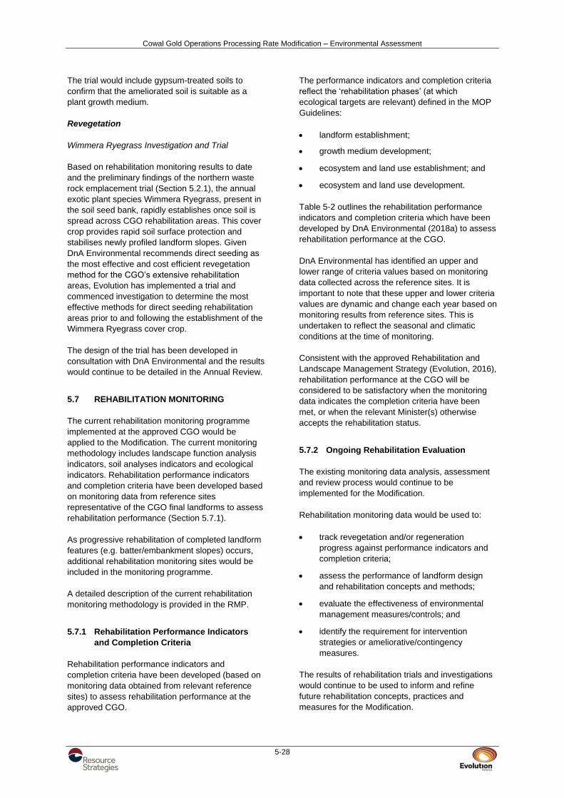
Cowal Gold Operations Processing Rate Modification – Environmental Assessment
5-28
The trial would include gypsum-treated soils to
confirm that the ameliorated soil is suitable as a
plant growth medium.
Revegetation
Wimmera Ryegrass Investigation and Trial
Based on rehabilitation monitoring results to date
and the preliminary findings of the northern waste
rock emplacement trial (Section 5.2.1), the annual
exotic plant species Wimmera Ryegrass, present in
the soil seed bank, rapidly establishes once soil is
spread across CGO rehabilitation areas. This cover
crop provides rapid soil surface protection and
stabilises newly profiled landform slopes. Given
DnA Environmental recommends direct seeding as
the most effective and cost efficient revegetation
method for the CGO’s extensive rehabilitation
areas, Evolution has implemented a trial and
commenced investigation to determine the most
effective methods for direct seeding rehabilitation
areas prior to and following the establishment of the
Wimmera Ryegrass cover crop.
The design of the trial has been developed in
consultation with DnA Environmental and the results
would continue to be detailed in the Annual Review.
5.7 REHABILITATION MONITORING
The current rehabilitation monitoring programme
implemented at the approved CGO would be
applied to the Modification. The current monitoring
methodology includes landscape function analysis
indicators, soil analyses indicators and ecological
indicators. Rehabilitation performance indicators
and completion criteria have been developed based
on monitoring data from reference sites
representative of the CGO final landforms to assess
rehabilitation performance (Section 5.7.1).
As progressive rehabilitation of completed landform
features (e.g. batter/embankment slopes) occurs,
additional rehabilitation monitoring sites would be
included in the monitoring programme.
A detailed description of the current rehabilitation
monitoring methodology is provided in the RMP.
5.7.1 Rehabilitation Performance Indicators
and Completion Criteria
Rehabilitation performance indicators and
completion criteria have been developed (based on
monitoring data obtained from relevant reference
sites) to assess rehabilitation performance at the
approved CGO.
The performance indicators and completion criteria
reflect the ‘rehabilitation phases’ (at which
ecological targets are relevant) defined in the MOP
Guidelines:
landform establishment;
growth medium development;
ecosystem and land use establishment; and
ecosystem and land use development.
Table 5-2 outlines the rehabilitation performance
indicators and completion criteria which have been
developed by DnA Environmental (2018a) to assess
rehabilitation performance at the CGO.
DnA Environmental has identified an upper and
lower range of criteria values based on monitoring
data collected across the reference sites. It is
important to note that these upper and lower criteria
values are dynamic and change each year based on
monitoring results from reference sites. This is
undertaken to reflect the seasonal and climatic
conditions at the time of monitoring.
Consistent with the approved Rehabilitation and
Landscape Management Strategy (Evolution, 2016),
rehabilitation performance at the CGO will be
considered to be satisfactory when the monitoring
data indicates the completion criteria have been
met, or when the relevant Minister(s) otherwise
accepts the rehabilitation status.
5.7.2 Ongoing Rehabilitation Evaluation
The existing monitoring data analysis, assessment
and review process would continue to be
implemented for the Modification.
Rehabilitation monitoring data would be used to:
track revegetation and/or regeneration
progress against performance indicators and
completion criteria;
assess the performance of landform design
and rehabilitation concepts and methods;
evaluate the effectiveness of environmental
management measures/controls; and
identify the requirement for intervention
strategies or ameliorative/contingency
measures.
The results of rehabilitation trials and investigations
would continue to be used to inform and refine
future rehabilitation concepts, practices and
measures for the Modification.

Cowal Gold Operations Processing Rate Modification – Environmental Assessment
5-29
Table 5-2 Quantitative Rehabilitation Performance Indicators and Completion Criteria
Rehabilitation Phase
Aspect or Ecosystem Component
Completion Criteria Performance Indicators Unit of Measurement Lake Foreshore
Ecosystem Range 2017
Grassland Ecosystem Range
2017
Hill Ecosystem Range 2017
Slopes Ecosystem Range 2017
Performance indicators are quantified by the range of values obtained from replicated reference sites Lower Upper Lower Upper Lower Upper Lower Upper
Landform establishment and stability
Landform slope, gradient
Landform suitable for final land use and generally compatible with surrounding topography
Slope Degrees 1 5 4 6 2 7 1 4
Active erosion Areas of active erosion are limited
Number of rills/gullies Number 0 0 0 0 0 0 0 0
Cross-sectional area of rills/gullies
Square metre (m2) 0 0 0 0 0 0 0 0
Growth medium development
Soil chemical, physical properties and amelioration
Soil properties are suitable for the establishment and maintenance of selected vegetation species
pH pH 6.73 6.77 5.90 6.10 4.50 5.80 7.75 8.32
EC < deciSiemens per
metre (dS/m) 0.065 0.091 0.066 0.082 0.045 0.151 0.297 0.503
Organic Matter % 1.4 1.8 3.2 3.4 4.6 21.0 3.0 3.4
Phosphorous Parts per million (ppm) 14.4 20.3 13.1 28.2 9.8 42.3 14.8 25.6
Nitrate ppm 4.4 11.0 3.4 9.0 1.5 8.1 5.5 6.9
Cation Exchange Capacity
Centimoles of positive charge per kilogram
(Cmol+/kg) 10.1 21.0 8.6 10.1 7.1 10.2 33.5 51.3
Exchangeable Sodium Percentage
% 3.1 3.5 2.5 6.0 1.6 3.3 2.3 8.9
Ecosystem and Land Use Establishment
Landscape Function
Analysis (LFA)
Landform Stability
and Landscape
Organisation indices
Landform is stable and performing as designed
LFA Stability % 42.7 70.0 67.5 70.5 60.9 73.5 54.7 76.0
LFA Landscape Organisation
% 51 88 100 100 77 100 56 100
Vegetation diversity Vegetation contains a diversity of species comparable to that of the local remnant vegetation
Diversity of shrubs and juvenile trees
Species/area 3 4 1 1 1 4 3 4
% population 100 100 100 100 98 100 97 100
Total species richness Number/area 35 37 31 38 9 42 22 41
Native species richness > Number/area 20 29 24 26 9 38 21 35
Exotic species richness < Number/area 8 15 7 12 0 5 1 6
Vegetation density Vegetation contains a density of species comparable to that of the local remnant vegetation
Density of shrubs and juvenile trees
Number/area 41 274 1 1 32 379 31 59
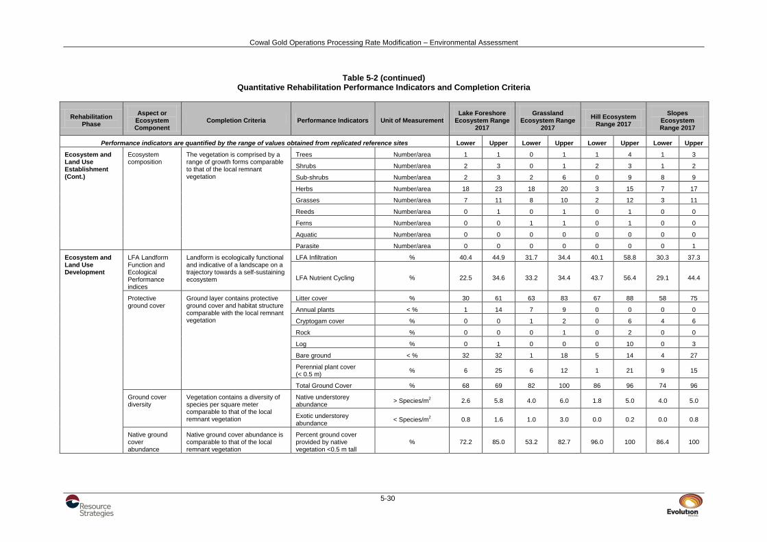
Cowal Gold Operations Processing Rate Modification – Environmental Assessment
5-30
Table 5-2 (continued) Quantitative Rehabilitation Performance Indicators and Completion Criteria
Rehabilitation Phase
Aspect or Ecosystem Component
Completion Criteria Performance Indicators Unit of Measurement Lake Foreshore
Ecosystem Range 2017
Grassland Ecosystem Range
2017
Hill Ecosystem Range 2017
Slopes Ecosystem Range 2017
Performance indicators are quantified by the range of values obtained from replicated reference sites Lower Upper Lower Upper Lower Upper Lower Upper
Ecosystem and Land Use Establishment (Cont.)
Ecosystem composition
The vegetation is comprised by a range of growth forms comparable to that of the local remnant vegetation
Trees Number/area 1 1 0 1 1 4 1 3
Shrubs Number/area 2 3 0 1 2 3 1 2
Sub-shrubs Number/area 2 3 2 6 0 9 8 9
Herbs Number/area 18 23 18 20 3 15 7 17
Grasses Number/area 7 11 8 10 2 12 3 11
Reeds Number/area 0 1 0 1 0 1 0 0
Ferns Number/area 0 0 1 1 0 1 0 0
Aquatic Number/area 0 0 0 0 0 0 0 0
Parasite Number/area 0 0 0 0 0 0 0 1
Ecosystem and Land Use Development
LFA Landform Function and Ecological Performance indices
Landform is ecologically functional and indicative of a landscape on a trajectory towards a self-sustaining ecosystem
LFA Infiltration % 40.4 44.9 31.7 34.4 40.1 58.8 30.3 37.3
LFA Nutrient Cycling % 22.5 34.6 33.2 34.4 43.7 56.4 29.1 44.4
Protective ground cover
Ground layer contains protective ground cover and habitat structure comparable with the local remnant vegetation
Litter cover % 30 61 63 83 67 88 58 75
Annual plants < % 1 14 7 9 0 0 0 0
Cryptogam cover % 0 0 1 2 0 6 4 6
Rock % 0 0 0 1 0 2 0 0
Log % 0 1 0 0 0 10 0 3
Bare ground < % 32 32 1 18 5 14 4 27
Perennial plant cover (< 0.5 m)
% 6 25 6 12 1 21 9 15
Total Ground Cover % 68 69 82 100 86 96 74 96
Ground cover diversity
Vegetation contains a diversity of species per square meter comparable to that of the local remnant vegetation
Native understorey abundance
> Species/m2 2.6 5.8 4.0 6.0 1.8 5.0 4.0 5.0
Exotic understorey abundance
< Species/m2 0.8 1.6 1.0 3.0 0.0 0.2 0.0 0.8
Native ground cover abundance
Native ground cover abundance is comparable to that of the local remnant vegetation
Percent ground cover provided by native vegetation <0.5 m tall
% 72.2 85.0 53.2 82.7 96.0 100 86.4 100

Cowal Gold Operations Processing Rate Modification – Environmental Assessment
5-31
Table 5-2 (continued) Quantitative Rehabilitation Performance Indicators and Completion Criteria
Rehabilitation Phase
Aspect or Ecosystem Component
Completion Criteria Performance Indicators Unit of Measurement Lake Foreshore
Ecosystem Range 2017
Grassland Ecosystem Range
2017
Hill Ecosystem Range 2017
Slopes Ecosystem Range 2017
Performance indicators are quantified by the range of values obtained from replicated reference sites Lower Upper Lower Upper Lower Upper Lower Upper
Ecosystem and Land Use Development (Cont.)
Ecosystem growth and natural recruitment
The vegetation is maturing and/or natural recruitment is occurring at rates similar to those of the local remnant vegetation
Shrubs and juvenile trees 0 - 0.5 m in height
Number/area 15 236 1 1 1 364 7 12
Shrubs and juvenile trees 0.5 – 1 m in height
Number/area 4 7 0 0 1 17 5 9
Shrubs and juvenile trees 1 - 1.5 m in height
Number/area 2 2 0 0 0 5 7 7
Shrubs and juvenile trees 1.5 – 2 m in height
Number/area 2 4 0 0 0 3 4 8
Shrubs and juvenile trees >2 m in height
Number/area 13 30 0 0 0 53 8 23
Ecosystem structure
The vegetation is developing in structure and complexity comparable to that of the local remnant vegetation
Foliage cover 0.5 – 2 m % cover 6 13 0 0 0 6 0 17
Foliage cover 2 – 4 m % cover 0 3 0 0 0 11 8 10
Foliage cover 4 – 6 m % cover 4 4 0 0 0 16 3 7
Foliage cover >6 m % cover 0 7 0 0 5 29 0 20
Tree diversity Vegetation contains a diversity of maturing tree and shrubs species comparable to that of the local remnant vegetation
Tree diversity
Species/area 1 2 0 0 2 5 1 2
% 100 100 0 0 100 100 100 100
Tree density Vegetation contains a density of maturing tree and shrubs species comparable to that of the local remnant vegetation
Tree density Number/area 2 12 0 0 6 59 11 26
Average diameter at breast height (dbh)
centimetre 23 50 0 0 11 50 11 12
Ecosystem health
The vegetation is in a condition comparable to that of the local remnant vegetation
Live trees % population 100 100 0 0 57 100 88 91
Healthy trees % population 0 92 0 0 16 100 64 85
Medium health % population 8 100 0 0 0 39 4 27
Advanced dieback % population 0 0 0 0 0 26 0 0
Dead Trees % population 0 0 0 0 0 36 9 12
Mistletoe % population 0 0 0 0 0 0 0 4
Flowers/fruit: Trees % population 33 100 0 0 12 50 0 8
Hollows: Trees % population 0 50 0 0 0 33 0 0
Source: DnA Environmental (2018a)

Cowal Gold Operations Processing Rate Modification – Environmental Assessment
5-32
In addition to the above, in accordance with the
CGO’s Development Consent (DA 14/98),
rehabilitation (and overall environmental)
performance at the CGO is independently assessed
via the Independent Environmental Audit process
and the Independent Monitoring Panel inspection
and review process. Results of these processes are
reported quarterly to the CGO’s CEMCC and are
publicly available on the CGO website.
These measures would remain unchanged for the
Modification.
5.8 MINE CLOSURE AND LEASE
RELINQUISHMENT
Upon cessation of mining operations, tenure of
ML 1535 and MLA 1 would be maintained by
Evolution until such a time when lease
relinquishment criteria have been met and the
relevant Minister(s) accepts the rehabilitation status
of the site. It is anticipated that lease relinquishment
criteria would include:
Rehabilitated landforms are stable and
consistent with the nominated post-mining land
use which has been developed in consultation
with relevant regulatory agencies and key
stakeholders.
The water quality of Lake Cowal has not been
detrimentally affected by the final landforms.
Rehabilitated final landforms are indicative of a
landscape on a trajectory towards a
self-sustaining ecosystem and comprise
self-sustaining native and/or endemic species
characteristic of remnant vegetation
communities in the surrounding landscape.
All ML 1535 and MLA 1 conditions (including
public safety considerations) and Development
Consent (DA 14/98) conditions have been
satisfied.
Hard-stand and infrastructure components
have been removed (unless otherwise agreed
with the ultimate landholder and regulatory
authorities).
The Strategic Framework for Mine Closure
published by the Australian and New Zealand
Minerals and Energy Council and Mineral
Resources Council of Australia (2000) and the
Leading Practice Sustainable Development
Program for the Mining Industry – Mine Closure
published by the Commonwealth Department of
Industry, Innovation and Science (2016) would be
used as a guide for mine closure.
Mine closure concepts and management measures
would continue to be developed via the MOP in
consultation with the DRG and other relevant
regulatory authorities.

Cowal Gold Operations Processing Rate Modification – Environmental Assessment
6-1
6 PLANNING FRAMEWORK AND MODIFICATION JUSTIFICATION
This section outlines the statutory requirements
relevant to the assessment of the Modification and
its justification (i.e. the need for the Modification on
economic, social and environmental grounds when
considered against the objects of the EP&A Act).
6.1 LEGISLATIVE FRAMEWORK
Development Consent for the CGO and the Bland
Creek Palaeochannel Borefield water supply
pipeline was granted by the NSW Minister for Urban
Affairs and Planning under Part 4 of the EP&A Act
on 26 February 1999 (DA 14/98) (Section 2.1).
Development Consent (DA 2011/64) for the
operation of the Eastern Saline Borefield was
granted by the Forbes Shire Council on
20 December 2010 (Section 2.1).
6.1.1 Environmental Planning and Assessment
Act, 1979
This EA has been prepared to support a request to
modify Development Consent (DA 14/98) under
section 75W of the EP&A Act.
The request to modify Development Consent
(DA 14/98) in the manner generally described in this
EA, was made prior to the cut-off date of 1 March
2018. As a result, this Modification may be
determined under section 75W of the EP&A Act, in
accordance with clause 3BA of Schedule 2 of the
Environmental Planning and Assessment (Savings,
Transitional and Other Provisions) Regulation
20173.
Before its repeal, section 75W of the EP&A Act
stated:
75W Modification of Minister’s approval
(1) In this section:
Minister’s approval means an approval to
carry out a project under this Part, and
includes an approval of a concept plan.
modification of approval means changing
the terms of a Minister’s approval, including:
(a) revoking or varying a condition of the
approval or imposing an additional
condition of the approval, and
3 It is noted that the CGO was taken to be an approved
project under the Part 3A of the EP&A Act pursuant to clause 8J of the Environmental Planning and Assessment Regulation 2000 for the purpose of a modification application made under section 75W.
(b) changing the terms of any determination
made by the Minister under Division 3 in
connection with the approval.
(2) The proponent may request the Minister to
modify the Minister’s approval for a project.
The Minister’s approval for a modification is
not required if the project as modified will be
consistent with the existing approval under this
Part.
(3) The request for the Minister’s approval is to be
lodged with the Director-General. The Director-
General may notify the proponent of
environmental assessment requirements with
respect to the proposed modification that the
proponent must comply with before the matter
will be considered by the Minister.
(4) The Minister may modify the approval (with or
without conditions) or disapprove of the
modification.
…
Table 1-1 in Section 1 provides a comparison of the
Modification with the currently approved CGO.
In general, there would be no change to the existing
functionality of the CGO due to the Modification, as
the Modification would involve:
continued mining in the existing open pit for
the extraction of gold-bearing ore and waste
rock;
continued use of existing waste rock
emplacements in addition to the proposed IWL
for the placement of waste rock extracted from
the open pit;
continued use of existing ore processing
infrastructure, along with the installation of a
secondary crushing circuit within the existing
process plant area; and
continued storage of tailings on-site within the
existing TSFs and within the IWL.
The Modification would involve no change to the
following key components of the existing CGO:
life of the CGO;
mining methods;
extent and depth of the open pit;
lake isolation system;
maximum waste rock emplacement heights;
cyanide leaching circuit;
cyanide destruction method;
approved cyanide concentration limits in the
aqueous component of the tailings slurry;
Cowal Gold Operations Processing Rate Modification – Environmental Assessment
6-2
water supply sources;
approved daily or annual extraction limits of
the Bland Creek Palaeochannel Borefield;
site access road;
power supply;
exploration activities; or
hours of operation.
Given that key environmental management
measures and design principles (e.g. lake isolation
system) for the currently approved CGO would be
maintained for the Modification, limited additional
environmental impacts are predicted in comparison
to the currently approved CGO.
Where additional impacts are predicted
(e.g. potential for increased emissions), additional
management measures are proposed
(i.e. implementation of additional haul road
watering) to mitigate potential impacts of the
Modification.
As such, it is considered that the Modification would
result in limited environmental consequence in
comparison with the currently approved CGO.
Given this, and given that the Modification would not
generally change the functionality of the approved
CGO, approval for the Modification is sought as a
modification to Development Consent (DA 14/98)
under section 75W of the EP&A Act.
6.1.2 Other State Legislation
In addition to the EP&A Act, the following NSW Acts
may be applicable to the Modification:
Aboriginal Land Rights Act, 1983;
BC Act;
Contaminated Land Management Act, 1997;
Crown Lands Act, 1989 (Crown Lands Act);
Dams Safety Act, 1978;
Dams Safety Act, 2015;
Dangerous Goods (Road and Rail Transport)
Act, 2008;
Explosives Act, 2003;
FM Act;
Heritage Act, 1977;
Mining Act, 1992;
NPW Act;
Native Vegetation Act, 2003;
Noxious Weeds Act, 1993;
Roads Act, 1993;
Water Management Act, 2000; and
Work Health and Safety (Mines and Petroleum
Sites) Act, 2013.
Relevant licences or approvals required under these
Acts would continue to be obtained for the CGO as
required. Key plans, licences and agreements that
would require revision to incorporate the
Modification are outlined in Section 7.
Additional details on the likely requirements of key
Acts are provided in the sub-sections below.
Under the NSW Mining Act, 1992, environmental
protection and rehabilitation are regulated by
conditions of mining leases, including requirements
for the submission of a MOP prior to the
commencement of operations, and subsequent
Annual Environmental Management Reports (or
Annual Reviews).
The current MOP would require revision to reflect
the Modification.
Roads Act, 1993
Works or structures that disturb the surface of a
public road or connect a road to a classified road
require consent under section 138 of the NSW
Roads Act, 1993. The Roads Act, 1993 applies to all
public roads in NSW, and is typically administered
by the local council for local roads.
The Modification would involve the realignment of
Lake Cowal Road around MLA 1 and also a number
of other minor road treatments on local roads.
If the Modification is approved, Evolution would
apply to the relevant roads authority for the
necessary consents under section 138 of the Roads
Act, 1993 for the new infrastructure within the public
road network.
Detailed design for any roadworks would be
undertaken in accordance with the Austroads Guide
to Road Design and to the satisfaction of the Bland
Shire Council or Lachlan Shire Council (where
relevant).

Cowal Gold Operations Processing Rate Modification – Environmental Assessment
6-3
Protection of the Environment Operations
Act, 1997
The PoEO Act and the NSW Protection of the
Environment Operations (General) Regulation, 2009
set out the general obligations for environmental
protection for development in NSW, which is
regulated by the EPA.
The CGO operates under EPL 11912, granted
under the PoEO Act. The EPL contains conditions
that relate to emission and discharge limits,
environmental monitoring and reporting.
Approval of the Modification may necessitate a
variation of EPL 11912 such as updates to
environmental monitoring sites.
Crown Lands Act, 1989
The Crown Lands Act, 1989 aims to ensure that
Crown land is managed for the benefit of the people
of NSW.
For any Crown land directly affected by the
Modification (e.g. the existing TSR), Evolution would
enter into necessary leases or licences under the
Crown Lands Act, 1989.
Evolution has been consulting with DI - Crown
Lands about the proposed relocation of a portion of
the existing TSR, and will continue with consultation
regarding this matter.
Water Management Act, 2000
The NSW Water Management Act, 2000 contains
provision for the licensing, allocation, capture and
use of water resources.
Water sharing plans establish rules for sharing
water between different users and between the
various environmental sources (namely rivers or
aquifers).
Evolution would continue to use the existing WALs
under the Water Management Act, 2000 for the
Modification.
Biodiversity Conservation Act, 2016
The BC Act was recently enacted by the NSW
Parliament to replace:
the Threatened Species Conservation Act,
1995;
the Nature Conservation Trust Act, 2001; and
the animal and plant provisions of the NPW
Act.
The overarching objective of the BC Act is to
'maintain a healthy, productive and resilient
environment for the greatest well-being of the
community, now and into the future, consistent with
the principles of ecologically sustainable
development'.
One of the main purposes served by the BC Act is
to prescribe the approach to be followed for
conducting assessment of biodiversity for different
activities and developments (see Part 7 of the
BC Act).
This Modification proposes to modify a development
consent that was granted before the
commencement of the BC Act and, more
specifically, before the commencement of Part 7,
Division 4 of the BC Act. Section 7.17(1) of the
BC Act states that:
(1) Subsection (2) applies to an application for
the modification of a development consent, or
State significant infrastructure approval, that
was granted after the commencement of this
Division.
Because the development consent for the CGO was
not granted 'after the commencement of this
Division', section 7.17 of the BC Act will not apply to
this Modification. This is consistent with the SEARs
(Attachment 2).
One of the regulations made under the BC Act is the
Biodiversity Conservation (Savings and Transitional)
Regulation, 2017 (BC Savings Regulation). Clause
28 of the BC Savings Regulation states that:
(1) The former planning provisions continue to
apply (and Part 7 of the new Act does not apply) to the determination of a pending or interim planning application.
The phrase 'pending or interim planning application'
is defined within clause 27(1) of the BC Savings
Regulation. The application made by Evolution for
this Modification satisfies the criteria contained in
the definition of 'pending or interim planning
application' in clause 27(1) of the BC Savings
Regulation.
As such, it enjoys the benefit of the savings
provision in clause 28 of the BC Savings Regulation
which provides that the former planning provisions
continue to apply to the determination of this
Modification.

Cowal Gold Operations Processing Rate Modification – Environmental Assessment
6-4
6.1.3 Environmental Planning Instruments
State environmental planning policies and local
environmental plans that may be relevant to the
Modification are discussed below.
It is noted that many of the clauses from the
environmental planning instruments that are
considered below impose conditions precedent on
the relevant consent authority when determining an
application for development consent. Given that
this Modification is a modification application under
section 75W, rather than an application for
development consent, the Minister (or delegate)
would not, strictly speaking, need to be satisfied of
these conditions precedent before determining
Evolution's application in respect of this
Modification.
State Environmental Planning Policy (Mining,
Petroleum Production and Extractive Industries)
2007
The Mining SEPP regularises the various
environmental planning instruments that previously
controlled mining activities.
Clause 5(3) of the Mining SEPP gives it primacy
where there is an inconsistency between the
provisions of the Mining SEPP and the provisions of
any other environmental planning instrument
(excluding the State Environmental Planning Policy
[Major Projects] 2005, the State Environmental
Planning Policy No. 14 [Coastal Wetlands] and the
State Environmental Planning Policy No. 26 [Littoral
Rainforests]).
Part 1 – Clause 2
Clause 2 of the Mining SEPP outlines the aims of
the SEPP, including the following of relevance to the
Modification:
(a) to provide for the proper management and
development of mineral, petroleum and
extractive material resources for the purpose
of promoting the social and economic welfare
of the State, and
(b) to facilitate the orderly and economic use and
development of land containing mineral,
petroleum and extractive material resources,
and
(c) to establish appropriate planning controls to
encourage ecologically sustainable
development through the environmental
assessment, and sustainable management, of
development of mineral, petroleum and
extractive material resources.
The Modification is considered to be generally
consistent with the aims of the Mining SEPP
because it is a Modification which:
improves the financial resilience of the CGO,
provides job security for local mine employees
and contractors, and continues to stimulate
demand in the local and regional economy;
involves the continued orderly economic use
and development of land containing mineral
resources;
has been developed in consideration of
environmental planning instruments and the
ecologically sustainable development (ESD)
principles (Section 6.2.2); and
involves proper and sustainable management
of the State’s mineral resources (i.e. gold
reserves [Section 2.14]) in a manner that
minimises environmental impacts as the
Modification has been designed such that
there would be no change to key existing
environmental management measures (e.g.
lake isolation system) and where additional
impacts are predicted, appropriate mitigation
measures are proposed (Section 4).
Part 2 – Clause 7
Clause 7(1) states:
(1) Mining Development for any of the following
purposes may be carried out only with
development consent:
…
(b) mining carried out:
...
(ii) on land that is, immediately before the
commencement of this clause, the
subject of a mining lease under the
Mining Act 1992 or a mining licence
under the Offshore Minerals Act 1999,
...
(d) facilities for the processing or transportation of
minerals or mineral bearing ores on land on
which mining may be carried out (with or
without development consent), but only if they
were mined from that land or adjoining land,
…
The existing CGO and the Modification comprises
the continuation of mining activities within the
existing ML 1535. The Modification would also
require development within MLA 1 which would be
considered activities ancillary to mining. MLA 1 is
located on land where development for the
purposes of industry is permissible under the Bland
Local Environmental Plan 2011 (Bland LEP).

Cowal Gold Operations Processing Rate Modification – Environmental Assessment
6-5
Part 3 – Clause 12
Clause 12 of the Mining SEPP requires that, before
determining an application for consent for
development for the purposes of mining, petroleum
production or extractive industry, the consent
authority must:
(a) consider:
(i) the existing uses and approved uses of
land in the vicinity of the development,
and
(ii) whether or not the development is likely
to have a significant impact on the uses
that, in the opinion of the consent
authority having regard to land use
trends, are likely to be the preferred
uses of land in the vicinity of the
development, and
(iii) any ways in which the development may
be incompatible with any of those
existing, approved or likely preferred
uses, and
(b) evaluate and compare the respective public
benefits of the development and the land uses
referred to in paragraph (a) (i) and (ii), and
(c) evaluate any measures proposed by the
applicant to avoid or minimise any
incompatibility, as referred to in
paragraph (a) (iii).
The existing land use within ML 1535 consists of
mining activities associated with the existing CGO.
Lands surrounding ML 1535, including MLA 1 and
Evolution-owned lands are predominantly used for
agriculture (e.g. livestock grazing and grain
cropping) with some areas forming the biodiversity
offsets and RVEP for the existing CGO.
The Modification would involve the continuation of
mining activities within ML 1535 and would therefore
not change the existing land use within ML 1535.
The Modification would not change the CGO water
supply borefields and the proposed duplicate
pipeline would be constructed within the existing
40 m pipeline corridor, therefore no change to the
existing surrounding land uses would occur as a
result of the duplicate pipeline.
The Modification would result in a land use change
(i.e. ancillary to mining activities) to the MLA 1 area.
The Modification would also result in a land use
change (i.e. to conservation) to the proposed
Modification Biodiversity Offset Areas
Consideration of the potential impacts of the
Modification on the other land uses is summarised
in Section 4.7.2.
Part 3 – Clause 14
Clause 14(1) of the Mining SEPP requires that,
before granting consent for development for the
purposes of mining, petroleum production or
extractive industry, the consent authority must
consider whether or not the consent should be
issued subject to conditions aimed at ensuring that
the development is undertaken in an
environmentally responsible manner, including
conditions to ensure the following:
(a) that impacts on significant water resources,
including surface and groundwater resources,
are avoided, or are minimised to the greatest
extent practicable,
(b) that impacts on threatened species and
biodiversity, are avoided, or are minimised to
the greatest extent practicable,
(c) that greenhouse gas emissions are minimised
to the greatest extent practicable.
In addition, Clause 14(2) requires that, without
limiting Clause 14(1), in determining a development
application for development for the purposes of
mining, petroleum production or extractive industry,
the consent authority must consider an assessment
of the greenhouse gas emissions (including
downstream emissions) of the development, and
must do so having regard to any applicable State or
national policies, programmes or guidelines
concerning greenhouse gas emissions.
The potential impacts of the Modification on
groundwater and surface water resources including
measures to minimise potential impacts are
discussed in Sections 4.1 and 4.2 and
Appendices A and B, respectively.
The potential impacts of the Modification on
threatened species and biodiversity including
measures to minimise potential impacts are as
described in Section 4.3 and Appendix C.
Greenhouse gas emission estimates for the
Modification are described in Section 4.11.1, and
Appendix F.
Part 3 – Clause 15
Clause 15 of the Mining SEPP requires that:
(1) Before granting consent for development for
the purposes of mining, petroleum production
or extractive industry, the consent authority
must consider the efficiency or otherwise of
the development in terms of resource
recovery.

Cowal Gold Operations Processing Rate Modification – Environmental Assessment
6-6
(2) Before granting consent for the development,
the consent authority must consider whether
or not the consent should be issued subject to
conditions aimed at optimising the efficiency of
resource recovery and the reuse or recycling
of material.
(3) The consent authority may refuse to grant
consent to development if it is not satisfied
that the development will be carried out in
such a way as to optimise the efficiency of
recovery of minerals, petroleum or extractive
materials and to minimise the creation of
waste in association with the extraction,
recovery or processing of minerals, petroleum
or extractive materials.
The Modification, specifically the construction and
operation of a new secondary crushing circuit,
would maximise the efficiency of gold recovery from
the CGO process plant (e.g. through improved
economics of scale).
Evolution has presented information on the
Modification to the DRG during the development of
this EA (Section 1.4). It is in Evolution’s financial
interest to maximise the efficiency of gold recovery
and minimise the production of waste that requires
disposal.
Part 3 – Clause 16
Clause 16(1) of the Mining SEPP requires that,
before granting consent for development for the
purposes of mining or extractive industry that
involves the transport of materials, the consent
authority must consider whether or not the consent
should be issued subject to conditions that do any
one or more of the following:
(a) require that some or all of the transport of
materials in connection with the development
is not to be by public road,
(b) limit or preclude truck movements, in
connection with the development, that occur
on roads in residential areas or on roads near
to schools,
(c) require the preparation and implementation, in
relation to the development, of a code of
conduct relating to the transport of materials
on public roads.
Gold product would continue to be transported from
the CGO by road.
The processing rate increase would require
additional deliveries of some process consumables.
No new process consumables would be required for
the Modification. Additional heavy vehicle deliveries
would be undertaken in accordance with the ADG
Code.
The Modification would result in an additional 10
employees/contractors and a short-term
construction phase involving 100 employees.
Employee movements would continue to be
managed via the use of buses.
Given the above, and with the implementation of the
road treatment measures proposed (Section 4.9), it
is considered that the Modification would not result
in any material change to potential road transport
impacts.
Part 3 – Clause 17
Clause 17 of the Mining SEPP requires that before
granting consent for development for the purposes
of mining, petroleum production or extractive
industry, the consent authority must consider
whether or not the consent should be issued subject
to conditions aimed at ensuring the rehabilitation of
land that will be affected by the development. In
particular, the consent authority must consider
whether the conditions of the consent should:
(a) require the preparation of a plan that identifies
the proposed end use and landform of the
land once rehabilitated, or
(b) require waste generated by the development
or the rehabilitation to be dealt with
appropriately, or
(c) require any soil contaminated as a result of
the development to be remediated in
accordance with relevant guidelines (including
guidelines under section 145C of the Act and
the Contaminated Land Management Act
1997), or
(d) require steps to be taken to ensure that the
state of the land, while being rehabilitated and
at the completion of the rehabilitation, does
not jeopardize public safety.
Rehabilitation at the CGO is conducted in
accordance with the RMP and the MOP. The RMP
would be revised to reflect the rehabilitation
concepts for Modification (Section 5.3).
Consistent with the currently approved rehabilitation
strategy, rehabilitation objectives for the
Modification would include final landforms that are
stable and are revegetated with native and/or
endemic species that are suited to the landform
(Section 5). The management of tailings and other
wastes is described in Sections 2, 3 and 4.
A new MOP would be prepared to reflect changes in
mining operations as a result of the Modification.
The new MOP would be developed in accordance
with the MOP Guidelines and would include a
detailed description of proposed mining and
rehabilitation activities.

Cowal Gold Operations Processing Rate Modification – Environmental Assessment
6-7
State Environmental Planning Policy No 33
– Hazardous and Offensive Development
The State Environmental Planning Policy
No. 33 – Hazardous and Offensive Development
(SEPP 33) is applicable to the whole of NSW.
Clause 13 of SEPP 33 requires that in determining
an application to carry out development for the
purposes of a potentially hazardous industry, the
consent authority (in this case the NSW Minister for
Planning) must take into account:
(a) current circulars or guidelines published by the
Department of Planning relating to hazardous
or offensive development, and
(b) whether any public authority should be
consulted concerning any environmental and
land use safety requirements with which the
development should comply, and
(c) in the case of development for the purpose of
a potentially hazardous industry—a
preliminary hazard analysis prepared by or on
behalf of the applicant, and
(d) any feasible alternatives to the carrying out of
the development and the reasons for choosing
the development the subject of the application
(including any feasible alternatives for the
location of the development and the reasons
for choosing the location the subject of the
application), and
(e) any likely future use of the land surrounding
the development.
A PHA, HAZOP and a FHA were completed for the
approved CGO.
The PHA concluded that the highest risks to the
environment, public safety and public property from
the approved CGO were associated with the
following scenarios (ANSTO Safety and
Reliability, 1997):
spillage of material during transport;
a major spillage of material from on-site
storage tanks coincident with catastrophic
bund failure;
spillage of diesel fuel onto the ground outside
the mine site;
wildlife entering the tailings storages following
damage to the fence;
birds using the tailings storages when an
accidental release of cyanide occurs; and
release of hazardous material in the event of a
fire.
The PHA included a number of recommended risk
reduction measures relevant to the environment and
public safety that have been incorporated into the
approved CGO design to reduce the likelihood or
the consequences of incidents that could cause
damage.
The recommended risk reduction measures relevant
to the environment and public safety have been
incorporated into relevant approved CGO
management plans. No hazardous events or
incidents have occurred at the CGO since the
commencement of operations that have changed
the assumed consequence and likelihood ratings
described in the PHA.
The scope of the HAZOP study included storage
and/or handling areas relevant to dangerous goods,
hazardous materials and/or materials with the
potential for off-site impact. The HAZOP study also
included a review of the monitoring, control, alarm
and shutdown systems associated with the cyanide
process. Control measures to maintain cyanide
concentrations within compliance levels were also
proposed. No hazardous events were determined
during the study that had not been previously known
and which had the potential for significant off-site
risk (Pinnacle Risk Management, 2004a).
The FHA concluded that the risks associated with
the approved CGO complied with the HIPAP No. 4
Risk Criteria for Land Use Safety Planning
(DoP, 2011b) and HIPAP No. 6 Guidelines for
Hazard Analysis (DoP, 2011c) for tolerable fatality,
injury, irritation and societal risk (Pinnacle Risk
Management, 2004b).
The annual use of some process reagents would
increase due to the Modification, however the
operational activities and the existing management
measures described in the PHA, HAZOP and FHA
would generally remain unchanged.
Additional heavy vehicle deliveries would be
undertaken in accordance with the ADG Code.
A hazard identification review relevant to the
Modification and a description of hazard prevention
and mitigation measures that would be implemented
is provided in Section 4.11.5.
In addition, and as described in Section 3.5.2, the
Modification would not change:
the existing cyanide destruction methods
currently used at the CGO (i.e. either Caro’s
Acid or the INCO process); or
the approved CNWAD concentration limits of the
aqueous component of the tailings slurry
stream (Section 2.5.2).

Cowal Gold Operations Processing Rate Modification – Environmental Assessment
6-8
The mitigation and management measures
described in the CMP (including the cyanide
monitoring process) would continue to be
implemented for the Modification.
In consideration of the above, the Modification
would not change the potential impact mechanisms
to the environment, public and public property, and
their associated consequences or likelihoods, to the
extent that risk levels would change from those
previously assessed in the PHA, HAZOP or FHA.
Subsequently, no change to the overall PHA,
HAZOP or FHA risk assessment findings would
result from the Modification.
Notwithstanding, the CGO’s approved
environmental management plans and monitoring
programmes would be reviewed, and if necessary,
revised by Evolution, to include the Modification and
manage any associated environmental risks.
With regard to the other considerations under
Clause 13(b), (d) and (e) of SEPP 33:
consultation with relevant authorities has been
undertaken during preparation of this EA, as
described in Section 1.4;
alternatives to the Modification are described in
Section 6.2.1; and
no change to the proposed future use of the
land surrounding the CGO would occur as a
result of the Modification except for the
MLA 1 area and the proposed Modification
Biodiversity Offset Areas. (Section 4.7.2).
State Environmental Planning Policy No. 44
– Koala Habitat Protection
State Environmental Planning Policy No. 44 (Koala
Habitat Protection) (SEPP 44) requires councils in
certain LGAs to consider whether land subject to a
development application comprises “potential Koala
habitat” or “core Koala habitat”.
Since the CGO is State Significant Development to
which Division 4.1 of Part 4 of the EP&A Act
applies, the Minister is the consent authority
(Section 6.2.2) rather than the Council.
The CGO on the western side of Lake Cowal is
located within the Local Government Area of Bland,
which is not listed in SEPP 44. Therefore SEPP 44
does not apply to clearance at the mine site.
The pipeline duplication on the eastern side of Lake
Cowal is located within the Local Government Area
of Forbes which is listed in SEPP 44. Of the
SEPP 44 preferred feed trees, only River Red
Gum (E. camaldulensis) is present along the
pipeline duplication corridor within River Red Gum
Forest (Moderate Condition) (LA191). Less than
0.4 ha of River Red Gum Forest (Moderate
Condition) (LA191) which meets the definition of
potential koala habitat would be cleared for the
pipeline duplication within the Local Government
Area of Forbes.
No Koalas have been recorded in the River Red
Gum Forest associated with the pipeline duplication,
therefore no core koala habitat would be cleared.
State Environmental Planning Policy No. 55
– Remediation of Land
State Environmental Planning Policy No. 55
(Remediation of Land) (SEPP 55) aims to provide a
State-wide planning approach to the remediation of
contaminated land. Under SEPP 55, planning
authorities are required to consider the potential
adverse affects on contamination on the suitability
of the site for its proposed purpose.
“Contaminated land” in SEPP 55 has the same
meaning as in Part 7A of the EP&A Act as follows:
contaminated land means land in, on or under
which any substance is present at a concentration
above the concentration at which the substance is
normally present in, on or under (respectively) land
in the same locality, being a presence that presents
a risk of harm to human health or any other aspect
of the environment.
Clause 7(1) states that a consent authority must not
consent to the carrying out of any development on
land unless:
(a) it has considered whether the land is
contaminated, and
(b) if the land is contaminated, it is satisfied that
the land is suitable in its contaminated state
(or will be suitable, after remediation) for the
purpose for which the development is
proposed to be carried out, and
(c) if the land requires remediation to be made
suitable for the purpose for which the
development is proposed to be carried out, it
is satisfied that the land will be remediated
before the land is used for that purpose.

Cowal Gold Operations Processing Rate Modification – Environmental Assessment
6-9
Clause 7(2) of SEPP 55 provides that before
determining an application for consent to carry out
development that would involve a change of use of
land, the consent authority must consider a report
specifying the findings of a preliminary investigation
of the land concerned, carried out in accordance
with the contaminated land planning guidelines.
A Land Contamination Assessment has been
prepared and is provided in Appendix G.
Bland Local Environmental Plan 2011
The CGO mining area is located wholly within the
Bland LEP area.
Clause 1.2(2) of the Bland LEP outlines the aims of
the plan, including the following of relevance to the
Modification:
(a) to protect, enhance and conserve agricultural
land through the proper management,
development and conservation of natural and
man-made resources,
(b) to encourage a range of housing,
employment, recreation and facilities to meet
the needs of existing and future residents of
Bland,
(c) to promote the efficient and equitable
provision of public services, infrastructure and
amenities,
(d) to conserve, protect and enhance the
environmental and cultural heritage of Bland,
...
The Modification is generally consistent with these
objectives, as the development would facilitate the
continued employment of the approved workforce at
the CGO (including employees from the Bland Local
Government Area) and would be operated in a
manner that would minimise potential impacts on
natural resources, soils, water resources,
agricultural land and environmental heritage.
Permissibility
Clause 2.3(2) of the Bland LEP relevantly provides:
The consent authority must have regard to the
objectives for development in a zone when
determining a development application in respect of
land within the zone.
The area of the CGO (incorporating the
Modification) is zoned as RU1 “Primary Production”.
“Open cut mining” is permissible with consent on
lands zoned as RU1 “Primary Production”.
Zone Objectives
Part 2 of the Bland LEP outlines the land use
objectives for lands zoned as RU1 “Primary
Production” as follows:
To encourage sustainable primary industry
production by maintaining and enhancing the
natural resource base.
To encourage diversity in primary industry
enterprises and systems appropriate for the
area.
To minimise the fragmentation and alienation
of resource lands.
To minimise conflict between land uses within
this zone and land uses within adjoining
zones.
To ensure that development on land within
this zone does not unreasonably increase the
demand for public services or public facilities.
The Modification is considered to be generally
consistent with the above zone objectives, as
detailed management and mitigation measures
would be implemented where practicable, to
minimise the potential impacts of the Modification on
other land uses and the environment, including Lake
Cowal. As the Modification would result in short-
term additional demand for employees/contractors
during the construction phase, and only minor
additional ongoing employment, it is expected that
the Modification would not unreasonably increase
the demand for public services or public facilities.
Forbes Local Environmental Plan 2013
The Forbes Local Environmental Plan 2013 (Forbes
LEP) is applicable to all land within the Shire of
Forbes. The CGO water supply borefields
(including the Bland Creek Palaeochannel borefield
and Eastern Saline Borefield) and pipeline are
located within the Forbes LEP area.
Clause 1.2(2) of the Forbes LEP outlines the aims
of the plan, including the following of relevance to
the Modification:
(a) to encourage and manage ecologically
sustainable development within the Forbes
local government area;
...
(c) to reinforce the rural character of Forbes
whilst promoting sustainable development;
(d) to protect Forbes’ agricultural land for
continued agricultural production whilst
allowing for planned expansion at the urban
fringe;
...

Cowal Gold Operations Processing Rate Modification – Environmental Assessment
6-10
(f) to protect, enhance and conserve the natural
environment, including the Lachlan River,
Lake Forbes, wetlands, native vegetation,
environmentally sensitive land and other
natural features that provide habitat for flora
and fauna, provide scenic amenity and that
may prevent or mitigate land degradation;
The Modification is generally consistent with these
objectives, as the development would facilitate the
continued employment of the approved workforce
and would be operated in a manner that would
minimise potential impacts on natural resources,
soils, water resources and agricultural land.
A consideration of the Modification against the
principles of ESD has been provided in
Section 6.2.2.
Permissibility
Clause 2.3(2) of the Forbes LEP relevantly
provides:
The consent authority must have regard to the
objectives for development in a zone when
determining a development application in respect of
land within the zone.
The currently approved development area for the
CGO water supply borefields and pipeline is zoned
as RU1 “Primary Production”. The Modification
would not change the currently approved
development area of the CGO water supply
borefields and pipeline because the pipeline
duplication would be constructed adjacent to the
existing pipeline and within the existing 40 m
pipeline corridor.
“Open cut mining” and “water supply systems” are
permissible with consent on lands zoned as RU1
“Primary Production”.
Zone Objectives
Part 2 of the Forbes LEP outlines the land use
objectives for lands zoned as RU1 “Primary
Production” as follows:
To encourage sustainable primary industry
production by maintaining and enhancing the
natural resource base.
To encourage diversity in primary industry
enterprises and systems appropriate for the
area.
To minimise the fragmentation and alienation
of resource lands.
To minimise conflict between land uses within
this zone and land uses within adjoining
zones.
To provide opportunities for intensive and
extensive agriculture in appropriate locations
consistent with the environmental capability of
the land.
The Modification is considered to be generally
consistent with the above zone objectives, as the
Modification would not change the existing land
uses within or surrounding the CGO water supply,
borefields or pipeline. Further, detailed management
and mitigation measures would be implemented
where practicable, to minimise the potential impacts
of the Modification on other land uses and the
environment, including Lake Cowal.
6.1.4 Commonwealth Legislation
Environment Protection and Biodiversity
Conservation Act, 1999
Relevant components of the Modification were
referred to the DEE (Reference 2017/7989). The
DEE’s Referral decision (dated 6 November 2017)
was that the Modification is a controlled action, and
therefore, approval under the EPBC Act is required.
The controlled action will be assessed under the
assessment bilateral agreement with the NSW
Government, and as such, this EA has also been
prepared to address the DEE’s assessment
requirements, which are included in the SEARs
(Attachment 2).
A reconciliation against the SEARs and the DEE’s
assessment requirements is provided in Tables 1-1
and 1-2.
National Greenhouse and Energy Reporting
Act, 2007
The National Greenhouse and Energy Reporting
Act, 2007 (NGER Act) introduced a single national
reporting framework for the reporting and
dissemination of corporations’ greenhouse gas
emissions and energy use. The NGER Act makes
registration and reporting mandatory for
corporations whose energy production, energy use
or greenhouse gas emissions meet specified
thresholds.
Evolution currently reports annual greenhouse gas
emissions and energy consumption from the CGO
to the federal government in accordance with the
NGER Act requirements. This reporting would be
continued for the Modification.

Cowal Gold Operations Processing Rate Modification – Environmental Assessment
6-11
6.1.5 Plans, Licences and Agreements that
Require Revision
Management/Monitoring Plans
Some management plans (e.g. the NMP and
IACHMP) would require revision to reflect updated
environmental management measures or changes
to CGO Development Consent (DA 14/98)
conditions resulting from the Modification.
Mining Operations Plan
As detailed in Section 6.1.2, a new MOP would be
prepared to reflect the Modification. The new MOP
would be developed in accordance with the MOP
Guidelines and would include a detailed description
of proposed mining and rehabilitation activities.
6.2 MODIFICATION JUSTIFICATION
A description of the need for and objectives of the
Modification and a justification of the carrying out of
the Modification in the manner proposed is provided
below. The discussion is provided having regard to
the biophysical, economic and social considerations
including consideration of alternatives, the principles
of ESD, the consistency of the Modification with the
objectives of the EP&A Act and the consequences
of not carrying out the Modification.
6.2.1 Need for and Objectives of the
Modification
Recent feasibility studies have identified potential
opportunities to maximise the ore processing
capacity of the CGO’s existing processing plant.
On this basis, Evolution proposes to increase the
CGO’s approved ore processing rate of 7.5 Mtpa to
9.8 Mtpa.
The Modification would improve the financial
resilience of the CGO against rising operational
costs, such as electricity or other external economic
factors.
The Modification would include a small increase in
the operational workforce and would assist to
facilitate the continuity of employment for the
existing CGO workforce, providing job security for
local mine employees and contractors, and to
continue to stimulate demand in the local and
regional economy.
The Modification would include the implementation
of mitigation measures, and management measures
(including performance monitoring), to minimise
potential impacts on the environment and
community (Section 4).
The cost benefit analysis estimated the incremental
(i.e. in comparison to the approved CGO) net
production benefits of the Modification to Australia
(over and above the economic benefits of the
approved CGO) to be some $62 M (present value)
and to NSW to be some $27 M (Appendix I). The
Modification would result in additional contributions
to regional and NSW output and business turnover
and household income. Contributions to the regional
economy were estimated to include:
the CGO itself being located within the region
and the direct economic activity that it brings
including direct employment and wages;
expenditure by the CGO on inputs to production
that can be sourced from the region such as
repairs and maintenance etc.; and
expenditure of employee wages in the regional
economy.
Consideration of Alternatives to the Modification
The Modification involves the continuation of mining
at the CGO within the E42 ore deposit.
Proposed changes to the CGO for the Modification
(i.e. IWL and secondary crushing circuit) have been
designed in consideration of environmental and
operational constraints.
Detail of these constraints, and where relevant,
alternatives considered, are provided below.
CGO Location and Open Pit Development
As the location of mining is constrained by the E42
ore deposit, alternative mining locations are not
considered further in this EA. No change is
proposed to the open pit as part of the Modification.
Tailings Storage Facilities/Integrated Waste
Landform
Additional tailings storage capacity is required as
part of the Modification as the annual rate of tailings
rise associated with the processing rate increase
would be incompatible with the existing NTSF and
STSF.
An IWL is proposed to be developed to facilitate
emplacement of both tailings and waste rock as part
of the Modification.

Cowal Gold Operations Processing Rate Modification – Environmental Assessment
6-12
The tailings could alternatively be accommodated in
a new TSF located outside of ML 1535. However,
the IWL was selected as it would contain tailings
storage to within ML 1535, would result in improved
factors of safety of IWL free standing embankments
relative to TSF embankments and has a lower
operational cost basis relative to new a TSF.
Waste Rock Emplacement Areas
No additional waste rock would be produced over of
the life of the Modification. Waste rock would be
emplaced at the IWL in addition to the existing
waste rock emplacements.
A waste rock balance was conducted for the
Modification and it was found that the volume of
waste rock required for the IWL is offset by the
volume of waste emplacement that is foregone from
the portion of the northern waste rock emplacement
that is displaced by IWL development. The outer
embankment of the north-eastern portion of the IWL
would be constructed to form an integrated landform
with the adjacent northern waste rock emplacement.
Ore Processing Schedule and Infrastructure
The processing schedule includes an increase in
the ore processing rate up to 9.8 Mtpa (Table 3-1).
The Modification mine schedule has been
developed such that no change to the existing ore
processing or cyanide destruction methods would
be required.
The upgrades to the existing ore processing
infrastructure (i.e. secondary crushing circuit) are
proposed to increase throughput of ore at the CGO
process plant on an annual basis. The modified
CGO would recover additional ounces of gold on an
annual basis. Were the upgrades to the existing ore
processing infrastructure not to be implemented,
additional annual gold recovery and the associated
additional annual royalties to the State of NSW
would not be generated.
External Water Supply
As the Modification would involve a processing rate
increase, the annual groundwater demand would
similarly increase.
There would be no change to the existing daily or
annual extraction limits from external water supplies
for the Modification, or the existing Groundwater
Contingency Strategy used to manage groundwater
levels in the Bland Creek Palaeochannel. As such,
no additional impacts to other groundwater users
are predicted due to the Modification (Appendix A).
HEC (2018) (Appendix B) considers the existing
water supply sources would meet the water
requirements for the Modification. Additional water
from the Lachlan River largely supplies this
additional demand for the Modification. As for the
existing CGO, this additional demand would be met
by purchasing temporary water available from the
regulated Lachlan River trading market.
Given that the continued use of existing external
water supply sources is predicted to meet the water
requirements for the Modification, and not result in
additional impacts to other users, alternative water
supplies have not been considered further in this
Modification.
The Modification includes duplication of the existing
water supply pipeline from Bore 4 (on the eastern
side of Lake Cowal) to the CGO. The new pipeline
would be designed to supply all the external water
for the CGO, with the existing pipeline to be retained
to provide additional contingency capacity, be left on
standby or decommissioned. Some minor
alterations to the alignment of the pipeline were
incorporated into the conceptual location to reduce
biodiversity impacts, which is assessed in the
Biodiversity Assessment Report and Biodiversity
Offset Strategy (Appendix C).
Final Void and Landforms
A final void would form part of the final landform of
the Modification. This is consistent with the final
landform concept for the approved CGO.
The final void would continue to act as a localised
groundwater sink and, therefore, any groundwater
seepage from the TSFs and IWL and the waste rock
emplacements would continue to migrate towards
the final void.
Justification for the IWL, in consideration of
environmental constraints, is provided in the
sub-sections above.
In addition, the final landforms of the CGO have
been designed to be compatible with the
surrounding landscape. The IWL assists with this
objective as it is lower in height than the approved
TSFs and integrates with the northern waste rock
emplacement. In addition, the CGO final landforms
would be revegetated with native and/or endemic
species characteristic of remnant vegetation within
the surrounding landscape (Section 5.3.2).

Cowal Gold Operations Processing Rate Modification – Environmental Assessment
6-13
Other Infrastructure
Construction of the IWL results in the displacement
of several infrastructure features which are
proposed to be relocated as part of the Modification
(e.g. portions of the UCDS and ICDS, soil
stockpiles, D10 contained water storage, explosives
compound and explosives magazine).
Realignment of portions of the UCDS and ICDS is
required as part of the Modification to maintain the
design objectives of the existing water management
system.
Relocation of soil stockpiles to the north of ML 1535
is required as part of the Modification as the IWL
displaces a number of existing stockpiles.
Establishment of a new Mining Lease to
accommodate these stockpiles is required, along
with relocation of a portion of Lake Cowal Road and
the TSR. Given the lack of available space on ML
1535, no viable alternative to MLA 1 was available
for the Modification. Relocation of the soil
stockpiles would allow soil to continue to be stored
to provide rehabilitation media for the CGO.
The footprints for the relocated explosives
compound and magazine have been adjusted to
minimise clearance of woodland vegetation.
No Modification
Consideration of the potential consequences of not
proceeding with the Modification is provided in
Section 6.2.3.
6.2.2 Consideration of the Modification against
the Objects of the EP&A Act
Section 1.3 of the EP&A Act describes the objects
of the EP&A Act as follows:
(a) to promote the social and economic welfare of
the community and a better environment by
the proper management, development and
conservation of the State's natural and other
resources,
(b) to facilitate ecologically sustainable
development by integrating relevant
economic, environmental and social
considerations in decision-making about
environmental planning and assessment,
(c) to promote the orderly and economic use and
development of land,
(d) to promote the delivery and maintenance of
affordable housing,
(e) to protect the environment, including the
conservation of threatened and other species
of native animals and plants, ecological
communities and their habitats,
(f) to promote the sustainable management of
built and cultural heritage (including Aboriginal
cultural heritage),
(g) to promote good design and amenity of the
built environment,
(h) to promote the proper construction and
maintenance of buildings, including the
protection of the health and safety of their
occupants,
(i) to promote the sharing of the responsibility for
environmental planning and assessment
between different levels of government in the
State
(j) to provide increased opportunity for
community participation in environmental
planning and assessment
The Modification is considered to be generally
consistent with the objects of the EP&A Act,
because it is a Modification which:
incorporates measures for the management and conservation of resources including water, agricultural land and natural areas (Section 4);
facilitates development of the State’s mineral
resources (i.e. gold resources) (Sections 2
and 3);
includes measures to minimise potential
amenity impacts associated with noise,
blasting, air quality and visual impacts on
surrounding land uses (Section 4);
would support social and economic welfare of
the community through ongoing stimulation of
the regional economy;
would support the provision of community
services and facilities through significant
contributions to State royalties, State taxes,
Commonwealth tax revenue and any
applicable contributions to local councils;
incorporates a range of measures for the
protection of the environment, including
threatened species and other species of native
animals and plants and their habitats
(Section 4);
incorporates relevant ESD considerations in
the design, planning and assessment of the
Modification, through:
incorporation of risk assessment and
analysis at various stages in the
Modification design, environmental
assessment and decision-making;
adoption of high standards for
environmental and occupational health
and safety performance;

Cowal Gold Operations Processing Rate Modification – Environmental Assessment
6-14
consultation with regulatory and
community stakeholders;
assessment of potential greenhouse gas
emissions associated with the
Modification; and
optimisation of the economic benefits to
the community arising from the
development of the Modification;
would allow for the orderly and economic use
and development while maintaining existing
land uses on Evolution-owned lands (e.g.
grazing and conservation);
would incorporate measures for the
management of Aboriginal cultural heritage
consistent with relevant Permits and Consents;
is a State Significant Development Project that
would be determined by the Minister (or
delegate), however, consultation with other
levels of government and a range of
stakeholders has been undertaken and issues
raised have been considered and addressed
where relevant (Section 1.4);
is a Controlled Action, therefore would involve
regulation at Commonwealth Government
level, if approved; and
includes public involvement and participation
through the EA consultation process
(Section 1.4), the public exhibition of the EA
document and DP&E assessment of the
Modification in accordance with the
requirements of the EP&A Act.
6.2.3 Consideration of the Consequences of
not Carrying out the Modification
Were the Modification not to proceed, the following
consequences are inferred:
The existing CGO would continue to operate,
as currently approved.
There would be no additional employment for
the existing CGO workforce, thereby forgoing
job security for local mine employees and
contractors.
The incremental net benefit would be foregone
if the Modification is not implemented.
Additional tax revenue from the Modification
would not be generated.
Additional royalties to the State of NSW would
not be generated.
The additional potential social and
environmental impacts for the Modification
described in this EA would not occur.

Cowal Gold Operations Processing Rate Modification – Environmental Assessment
7-1
7 CONSOLIDATED SUMMARY OF
ENVIRONMENTAL
MANAGEMENT AND
MONITORING MEASURES
Groundwater
Existing groundwater monitoring and management
measures, as detailed in the WMP and the
SWGMBMP would continue for the Modification.
The WMP and the SWGMBMP would be updated,
as required, to incorporate the Modification and the
recommendations made by Coffey (2018), including:
Continued groundwater monitoring to validate the predictive modelling, particularly in the vicinity of the open pit, TSF/IWL and ML 1535 saline groundwater supply borefield (when in use).
Continued monitoring of groundwater salinity in the Bland Creek Palaeochannel Borefield to assess potential saline migration.
A final pit void water balance post-mine closure would be conducted to assess long-term water levels in the pit void and the potential impact on groundwater quality in the immediate vicinity of the pit void.
Establishment of new monitoring bores and piezometres to replace those that would be displaced by the IWL.
The existing Groundwater Contingency Strategy
(Section 4.1.1), as described in the WMP, would
continue to be implemented to manage groundwater
levels within the Bland Creek Palaeochannel. No
additional groundwater licences are required.
It is anticipated that Evolution would also be
required to seek a variation to EPL 11912.
Surface Water
Existing surface water management measures and
monitoring as detailed in the WMP, SWGMBMP and
ESCMP would continue for the Modification. The
WMP and SWGMBMP and ESCMP would be
updated to reflect the Modification.
The UCDS and ICDS would be modified, as
required, to accommodate the IWL.
Runoff from the soil stockpile area in MLA 1 would
be directed to a currently approved sediment basin
to be constructed at the eastern boundary of the
stockpile area (Appendix B). The upslope stockpile
diversions and the sediment basin would be
constructed and maintained in accordance with the
WMP and ESCP.
Geochemistry
Waste rock geochemistry investigations (North
Limited, 1998; Environmental Geochemistry
International Pty Ltd, 2004; GEM, 2008; 2013; and
2016) have been conducted for the waste rock
mined at the CGO, which have classified waste rock
NAF. The results indicate:
oxide waste rock will typically be saline but NAF; and
primary waste rock will typically be non-saline and NAF, however sulphate salts will be generated if exposed to surficial weathering processes.
As the waste rock is typically NAF, no specific acid
rock drainage management measures have been
required at the CGO. However, due to the potential
for saline seepage occurring from the waste rock
emplacements, the waste rock emplacements have
been constructed to direct any permeating waters
towards the open pit (Section 2.4.2).
Biodiversity
Potential impacts to flora and fauna are currently
managed through implementation of measures
included in the FFMP, TSMP, BOMP, RMP, CWMP,
LMP and AQMP (Section 4.3.2). These measures
would continue to be implemented and
management plans would be updated where
relevant.
Four land-based offset areas are proposed for the
Modification, and provide a “like-for-like” offset
outcome. The offset areas have a combined area of
486.5 ha. Ecosystem and species credits generated
from the four proposed offset areas would meet
(and exceed) the credit requirements of the
Modification (Appendix C).
Rehabilitation
A Rehabilitation and Landscape Management
Strategy has been developed for the Modification
(Section 5). The strategy details the overall
rehabilitation philosophy, principles and objectives
and describes the long-term land use strategy, the
conceptual rehabilitation domains and final landform
and revegetation concepts.
A RMP has been developed for the CGO which
details the rehabilitation management measures
and rehabilitation monitoring programme currently
implemented at the CGO. The RMP would be
revised (where necessary) to reflect the
rehabilitation concepts for the Modification as
described in Section 5.3.

Cowal Gold Operations Processing Rate Modification – Environmental Assessment
7-2
The current rehabilitation management measures
and rehabilitation monitoring programme
implemented at the approved CGO would be
applied to the Modification. The current monitoring
methodology includes landscape function analysis
indicators, soil analyses indicators and ecological
indicators.
The soil management measures described in the
existing SSMP would continue to be implemented
for the Modification. Details of soil stripping
procedures and soil re-handling activities would
continue to be provided in the MOP. In addition,
erosion and sediment control systems detailed in
the ESCMP would also continue to be implemented
for the Modification.
Aboriginal Cultural Heritage Assessment
A new AHIP (and/or a variation to existing
Permits/Consents) would be sought as part of the
Modification for the proposed MLA 1 area.
The approved IACHMP would be reviewed and
revised as necessary to include the Modification and
any recommendations made by Niche Environment
and Heritage (2018), including:
Salvage excavation of known oven sites to
collect dating samples prior to disturbance
(i.e. Lake Cowal 2017-057, Lake Cowal
2017-030, Lake Cowal 2017-012, Lake Cowal
2017-055 and Lake Cowal 2017-037).
Salvage excavation of sites Lake Cowal
2017-023 (if required, otherwise avoidance)
and Lake Cowal 2017-036, prior to any further
disturbance.
Surface collection of visible artefacts at known
sites prior to any surface disturbance, if
required, otherwise avoidance.
Existing management measures currently
employed at the CGO would continue to be
implemented for the Modification.
The background distribution of artefactual
material would be managed in accordance with
the requirements of Permits and Consents and
the approved IACHMP.
Items collected would be analysed consistent
with current requirements and protocols.
In the unlikely event that human skeletal remains are identified during the life of the CGO (incorporating the Modification), ground disturbance works in the vicinity of the human skeletal remains would cease immediately and the discovery immediately reported to the NSW Police. If it is suspected that the remains may be of Aboriginal origin then this would also be reported to the NSW Police. Evolution would then contact the OEH and representatives of the Aboriginal community. Work would not recommence in the location of the remains unless authorised in writing by the OEH.
Evolution would continue to allow access to the Temporary Keeping Place for all RAPs, consistent with the protocols in the currently approved IACMP.
Evolution would continue to involve the RAPs in relevant matters regarding the Modification.
Measures to avoid and minimise potential additional
impacts to Aboriginal heritage are described in
Section 4.4.2.
The mitigation and management measures for
potential residual impacts have been developed in
consultation with the RAPs. The consultation
process with RAPs is described in Section 4.4.1 and
Appendix D.
Noise
The existing mitigation, management and
monitoring measures described in the NMP would
continue to be implemented for the Modification.
The NMP would be reviewed and revised to
incorporate the Modification. This would include
additional provisions in accordance with the
Voluntary Land Acquisition and Mitigation Policy
and provisions to consult with nearby landowners
prior to construction of the pipeline duplication and
Lake Cowal Road realignment.
It is anticipated that Evolution would also be
required to seek a variation to EPL 11912.
Blasting
Blast monitoring and management would continue
in accordance with the currently approved BLMP.
The typical blast design details and the average
blasting frequency for the existing CGO operations
would remain unchanged for the Modification
(Section 3.3), and the location of blasts would not
change relative to privately-owned receivers.
Cowal Gold Operations Processing Rate Modification – Environmental Assessment
7-3
Air Quality
The existing mitigation, management and
monitoring measures described in the AQMP would
continue to be implemented for the Modification. In
addition, additional haul road watering would be
undertaken during construction of the IWL.
The AQMP would be revised as necessary for the
Modification. This may include review and
rationalising the number and/or location of dust
deposition gauges in consultation with the EPA and
DP&E.
Visual Amenity
Mitigation and management measures described in
the LMP would continue to be implemented for the
Modification. In addition, progressive rehabilitation
would continue for the Modification.
Road Transport
The Road Transport Assessment has examined the
likely road transport implications of the Modification.
It concluded that the Modification can be
satisfactorily accommodated by the existing road
network, with acceptable impacts on the capacity,
condition, safety and efficiency of the road network,
subject to some minor road treatments (Table 4-20),
including:
signage;
guide posts; and
localised pavement upgrades and surface
sealings.
A Traffic Management Plan would be prepared and
implemented in consultation with the relevant
Councils and the RMS to manage the movement of
trucks transporting gravel from the CGO during
haulage campaigns.
A Construction Traffic Management Plan would also
be prepared and implemented to manage the
vehicles associated with the pipeline and Lake
Cowal Road realignment construction.
Socio-Economics
Consistent with the existing CGO Development
Consent (DA 14/98), prior to closure of the CGO,
Evolution would work with local shire councils and
the community to prepare a workforce phase-out
plan to minimise potential impacts associated with
CGO employment cessation.
Public Safety
The Modification would not change the potential
impact mechanisms to the public and public
property, and their associated consequences or
likelihoods, to the extent that risk levels would
change from those previously assessed in the PHA,
HAZOP or FHA.
Greenhouse Gas Emissions
Evolution would continue to calculate and report
annual greenhouse gas emissions and energy
consumption from the CGO in accordance with its
existing requirements under the Commonwealth
National Greenhouse and Energy Reporting System
(Appendix F).
Historic Heritage
No historic heritage items would be potentially
impacted by the Modification.