cover proceeding - eprints.upnyk.ac.ideprints.upnyk.ac.id/15154/1/proceeding penuh.pdf · formasi...
TRANSCRIPT

PROCEEDING
1st International Conference of Energy
and 7th Indonesia – Malaysia
Geoheritage Conference
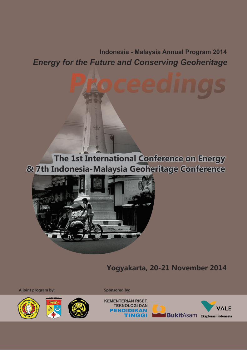
“Energy for the Future and Conserving Geoheritage”
Yogyakarta, 20-21 November 2014
A Joint Program:
PROCEEDING
1st International Conference of Energy and
7th Indonesia – Malaysia Geoheritage Conference
Theme:
“Energy for the Future and Conserving Geoheritage”
Yogyakarta, 20-21 November 2014
Reviewers:
1. Prof. Dr. Ir. C. Danisworo, M.Sc. (Indonesia)
2. Prof. Dr. Mohd Shafeea Leman, FASc. (Malaysia)
3. Prof. D. Haryanto, M.Sc., Ph.D. (Indonesia)
4. Prof. Dr. Kamal Roslan Mohamed (Malaysia)
5. Dr. Ir. Jatmika Setiawan, M.T. (Indonesia)
Editors:
1. Dr. Ir. C. Prasetyadi, M.Sc.
2. Adi Sulaksono, S.T.
A Joint Program :
Universitas Pembangunan Nasional “Veteran” Yogyakarta
Universiti Kebangsaan Malaysia
Badan Geologi, Kementerian Energi dan Sumberdaya Mineral RI
CONTENS
Part – 1
Energy and Stratigraphy
1. Source Rocks Characterizationin Benakat Gully, Limau, and Jemakur-Tabuan Graben,
North-South Palembang Sub-Basin, South Sumatra Basin. M. Syaifudin, Eddy A. Subroto,
Dardji Noeradi, Asep H. P. Kesumajana ............................................................................ 1-7
2. Gasifier-Batubara Mini Untuk Menunjang Ketersediaan Energi pada UMKM
di Daerah Istimewa Yogyakarta. Yenny Sofaeti, Dra.M.Si dan Prof. Dr. Bukin Daulay, M.Sc ............................................... 8-15
3. Identifikasi Reservoar Berdasarkan Analisa Fisika Batuan pada Lapangan “Higienis” Formasi Bekasap, Cekungan Sumatera Tengah, Provinsi Riau. Nana Higiana Hasanah ... 16-24
4. Emissions from Biomass Open Burning on the Peat Soil in Indonesia: Integrating Modis Imagery and GIS Data. Utami Ayu, Chih-Hua Chang ........................... 25-32
5. Source Rock from Miocene Coal of Balikpapan Formation Based on Organic
Petrography Analysis, Kutai Basin, Sangata – East Kalimantan. Basuki Rahmad, Sugeng Raharjo, Suprapto, Ediyanto, Noviani Klistyantika ................................................ 33-40
6. Correlation Study of Source Rock and Oil in Limau Graben, South Sumatera Basin :
Source Rock and Oil Characterization and Potency of Lemat Formation as Hydrocarbon Source Rocks. M. Syaifudin, Eddy A. Subroto, Dardji Noeradi, Asep H. P. Kesumajana ... 41-47
7. Pendekatan Identifikasi Umur Relatif Satuan Vulkanostratigrafi Berdasarkan Analisa
Kelurusan Tiap Satuan : Studi Kasus Gunung RRA, Jambi. Rizkhy Ridoh Alamsyah, Sapto Trianggono Nurseto, Agus Harjanto, C. Danisworo ................................................. 48-54
8. Petrophysical Analysis and Modeling, and Dynamic Simulation in Development
of “Victory” Low Resistivity Play in “Papa” Field, Kutai Basin, East Kalimantan.
Edo Pratama ....................................................................................................................... 55-62
9. Biozonasi Foraminifera Plankton Formasi Ngrayong, Bulu, Wonocolo, Ledok, dan
Mundu, Kecamatan Tambakboyo dan sekitarnya, Kabupaten Tuban, Provinsi Jawa Timur. M. Sultan Maulanasyah, Mahap Maha, Achmad Subandrio ............ 63-70
10. Porosity Characteristic on Carbonate Facies of Jonggrangan Formation. Ari Wibowo, Fery Andika Cahyo, Sugeng Widada, Achmad Subandrio .................................................. 71-78
11. Pengaruh Intrusi Andesit Basaltik terhadap Variasi Nilai Reflektan Vitrinit (Rvrandom)
Pada Batubara Bukit Asam. Fany Ardila, Agditya Priksawan, Basuki Rahmad, C. Danisworo ........................................................................................... 79-86
12. Aplikasi Fault and Fracture Density (FFD) terhadap Studi Zona Prospek Panas Bumi :
Studi Kasus Gunung RRA, Jambi. Rizkhy Ridoh Alamsyah, Sapto Trianggono Nurseto,
Agus Harjanto, C. Danisworo ............................................................................................. 87-94
13. Share Intrinsic Value Valuation Analysis of Company Mining Sector : Study
Empirical PT. Bumi Resources Tbk (Bumi) in the Indonesia. Marlina Widiyanti, Jatmika Setiawan ................................................................................................................ 94-101
14. Geologi dan Permodelan Reservoir 3D 4160 Lapisan “X” Lapangan “Y” Formasi
Bekasap, Cekungan Sumatera Tengah. Nur Arief Nugroho, Jatmika Setiawan, Deddy Kristanto, Haryadi ................................................................................................... 102-109

CONTENS
Part – 2
Geoheritage, Applied Geoscience and Technology
1. Warisan Geologi Formasi Singa, Kepulauan Langkawi, Malaysia. Mohamad Hanif Kamal Roslan, Che Aziz Ali, Kamal Roslan Mohamed ............................ 111-118
2. Geo-Archaeological Heritage of Yogyakarta : A Reflection of Javanese
Ancestor’s Geological Sense. Adi Sulaksono, C. Prasetyadi .............................................. 119-126
3. Issues and Challenge for Conservation at the Urban and Suburban Areas : Case Study
of Hulu Langat. Tanot Unjah, Mohd Shafeea Leman, Kamal Roslan Mohamed, Che Aziz Ali, Noebert Simon ............................................................................................... 127-134
4. Perubahan Aras Laut Kuaterner di Barat Daya Semenanjung Malaysia : Bukti
Litologi Sampel Gerudi. Habibah Jamil, Mohamad Hidayat Mohd Jafar, Maisarah Mustar May ......................................................................................................................... 135-142
5. Penerapan Ilmu Geologi dalam Kajian Sistem Air Tanah di Gunung Kendil Dan Umbul Ponjong Kecamatan Ponjong – Gunungkidul. Jatmika Setiawan .................... 143-150
6. Rintisan Geotapak Pulau Ular : Mengenali Geologi Langkawi. Kamal Roslan Mohamed, Che Aziz Ali, Tanot Unjah, Mohamad Hanif Kamal Roslan ............................................... 151-158
7. Determinationn of Ancient Volcanic Eruption Centre Based on Gravity Methods
In Gunungkidul Area Yogyakarta. Agus Santoso, Sismanto, Ary Setiawan, Subagyo Pramujoyo ............................................................................................................ 159-166
8. Assessment of Aquifer Type on Hydrogeologic System in the Ngoro , Mojokerto District and Gempol, Pasuruhan District. Gunawan Nusanto, Suyono ................................ 167-174
9. Stability Analysis of Single Slope on Soft Rock Using Saptono’s Chart Stability. S. Saptono ........................................................................................................................... 175-182
10. Analysis of the Merapi Ash from the Kinarejo Area as a Drilling Cement Additive. William Tehusiarana, Sari Wulandari Hafsari ................................................................... 183-190
11. Geomorphological Response Variable of Upstream of Progo Drainage Area. Ev. Budiadi, T. Listyarini R.A ............................................................................................. 191-198
12. Aplikasi Metode Geomagnetik untuk Identifikasi Persebaran Batuan Beku Dasit di
Gunung Siwareng Kabupaten Sleman Daerah Istimewa Yogyakarta.
Cimby Wicaksono RNA, Ahmad Nur Fauzi ......................................................................... 198-205
13. Ngalang River Exposed Geohistory of Southern Mountains. Hita Pandita, Sukartono ...... 205-212
14. Inspection of Gandang Dam. Puji Pratiknyo ....................................................................... 212-219
15. The Role of Top-soil on the Land Reclamation of Calcite Mining at Karst Environment.
Mohammad Nurcholis, Dahono Bhuwana Rukti, Anton Sudiyanto, Iin P. Handayani ........ 220-227
The 1st International Conference on Energy & 7th Indonesia-Malaysia Geoheritage Conference
212
INSPECTION OF GONDANG DAM
By : Puji Pratiknyo
Geological Engineering Department, UPN “Veteran” Yogyakarta.
HP : 0811259588. E-mail : [email protected].
ABSTRACT
Gondang dam is the one of dams in Bengawan Solo River Region. The dam site in
Gondang Lor village, Sugio district, Lamongan regency, East Java Province. The Gondang
dam is water reservoir to supply water at adjacent dam area.
The dam must be keep in save condition. One of inspection works to know the dam
condition is geotechnical research. The aim of geotechnical research si to get data about
physical and mechanical of dam material. The data of dam material is used to evaluate the
dam savety.
The conclusion of geotehnical reserach result is the dam material is proper to earth
dam material.
Key word:
Inspection; dam; save; material; proper.
1. Introduction
Bengawan Solo river area, is an area with potential water resources. Water resources
management (WRM) aims to supply a variety of needs in the community, in addition to
anticipate impending water scarcity in the dry season for the long term, it is one of the
strategies that will be done by storing runoff and rainwater through building dams or other
water reservoir that serves to recharges groundwater in an effort to conserve the water
resources. Gondang Dam is one of the dams in the region of the Solo River in Gondang Lor
village, Sugio sub-district, Lamongan regency, East Java. Need some inspection to determine
the condition of the dam. One inspection on Gondang Dam is a geotechnical investigation.
Geotechnical investigation was to obtain data of the physical and mechanical properties of
soil or rock dam material. The goal is to get the parameters that are used for dam safety
evaluation in accordance with the geological conditions and physical properties of soil or
rock.
2. Methodology
This investigation using methods such as drilling in the core zone or impermeable dam
body and laboratory testing of soil samples, with the following details:
a. Drilling
3-point core drilling: BG-1 with a depth of 25 meters, BG-2 with a depth of 30 meters and BG-3 with a depth of 20 meters.
Standard penetration test
Field permeability test
Undisturb sample
The 1st International Conference on Energy & 7th Indonesia-Malaysia Geoheritage Conference
213
b. Laboratory tests that includes :
Index Test for embankment material :
Natural Water content
Unit Weight
Specific Gravity
Grain Size Analysis
Atteberg Limit Mechanical Properties for embankment material :
Triaxial CU Test
Consolidation Test
Permeability Test
3. Location
Gondang Dam is located in Gondang Lor village, Sugio sub-district, Lamongan
regency, East Java Province. Access to this dam can be reached from the junction of UNISDA
Sukodadi then turn to the south about 8 kilometers until the end of the T-junction. From the
T-junction then turn to the west approximately 10 kilometers. Along this path, there is a
boundary between Sukodadi sub-district and Sugio sub-district. There are signs that direct
way to Gondang Dam (turn to the south). From signs about 3 kilometers to the end of the T-
junction and then turn to the west about 1 kilometer.
4. Investigation
4.1 Geology Of Gondang Dam
Gondang Dam was built on the Gondang River, tributary of Bengawan Solo in 1987
in Lamongan Regency. Flow region of Gondang Dam is Gondang village, Daliwangun,
Buluplapak, Wudi, Wonokromo and Sekidang. Wide of Gondang Dam is 6.60 hectares
with a depth of about 29 meters. In physiographic, Lamongan northern and southern parts
classified to the Rembang Zone (van Bemmelen, 1949) which is composed by exposure of
sediment is rich in carbonate elements.
While the central part of the region is classified into Randublatung Zone where
surface appearance is low, but in fact it is a depression (basins) are covered by sediments
which result from the weathering and erosion of older rocks in Kendeng Zone and
Rembang Zone.
The geological history of Lamongan began about 37 million years ago (Oligocene
period). At that time the area, Lamongan Regency, was still a sea (part of East Java Basin).
Furthermore sedimentation process occurs sequentially to upward which rich in carbonat
elements. This process occurs until approximately 19 million years (until the Paleocene
period). At approximately 1.8 million years ago there was a tectonic activity (Plio-
Pleistocene orogenesis) which led to the lifting of Lamongan Regency come to the surface.
The 1st International Conference on Energy & 7th Indonesia-Malaysia Geoheritage Conference
214
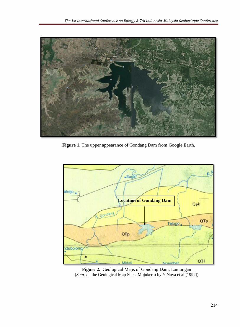
Figure 1. The upper appearance of Gondang Dam from Google Earth.
Figure 2. Geological Maps of Gondang Dam, Lamongan (Source : the Geological Map Sheet Mojokerto by Y Noya et al (1992))
Location of Gondang Dam
The 1st International Conference on Energy & 7th Indonesia-Malaysia Geoheritage Conference
215
Based on the Geological Map Sheet Mojokerto by Y Noya et al (1992) above, the
location of study have stratigraphic arrangements that composed by :
a. Lidah Formation (QTL), consist of claystone that have an insert of calcareous
sandstones and limestones.
b. Pucangan Formation (QTp), which consist of breccia, tuffaceous sandstones that
have insert of claystone and conglomerates.
c. Kabuh Formation (Qpk), consisting of sandstone, tuffaceous have an insert
claystone, conglomerates and tuff.
d. Alluvium (Qal), consists of cobblestone, gravel, sand, silt, and mud.
Topographic conditions of Lamongan Regency can be viewed from a height region
above sea level and slope steepness. Lamongan Regency consists of lowland and swampy
with a height of 0-25 meters with an area of 50.17% of the total area, with a height of 25-
100 meters land area of 45.68% and the remaining, 4.15%, is land with a height of over
100 meters from the surface sea water. Gondang Dam itself, including to area with low
topography.
4.2 Result of Drilling
Drilling conducted at 3 points, there are BG-1 with a depth of 25 meters, BG-2 with
a depth of 30 meters, and BG-3 with a depth of 20 meters. The location of each drilling
point in Gondang Dam depicted in Figure 3.
Based on the drilling results in 3 points of Gondang Dam ( BG-1, BG-2, and BG-3),
it can be seen the type of soil or rock as follows:
BG – 1
00.00 – 01.40 m Sand, loose, gray.
01.40 – 10.00 m Sandy clay (silt), stiff to very stiff, greyish-brown, the value
of N (SPT) = 12-17.
10.00 – 16.00 m Clay, stiff to very stiff, gray-brown there is little sand, the
value of N (SPT) = 16 - 18.
16.00 – 25.00 m Claystone, dense, gray-brown, the value of N (SPT) = 24 – 35
BG – 2
00.00 – 01.60 m Sand, loose, gray.
01.60 – 03.00 m Sandy clay (silt), stiff gray-brown, the value of N (SPT) = 15.
03.00 – 03.40 m Cobbly sand, stiff, brownish gray.
03.40 –06.45 m Sandy clay (silt), stiff, brownish gray, the value of N (SPT) =
15 -20.
06.45 – 27.00 m Clay, stiff-very stiff, gray-brown depths of 18-19, soft-stiff,
the value of N (SPT) = 15 - 19.
27.00 – 30.00 m Claystone, dense, gray-brown, the value of N (SPT) = 31 - 34.
The 1st International Conference on Energy & 7th Indonesia-Malaysia Geoheritage Conference
216
BG – 3
00.00 – 01.60 m Sand, solid half-off, greyish at a depth of 0 to 0.3 m are soil
filler, and asphalt residua.
01.60 – 12.00 m Clay, gray-brown, stiff-very stiff, there is a little sand, the
value of N (SPT) = 14-19.
12.00 – 20.00 m Claystone, dense, gray-brown, the value of N (SPT) = 20-34.
4.3 Test Laboratory
Soil mechanics laboratory tests of Gondang dam performed on 3 point drill, drill
point BG-1 with a depth of 25 meters, BG-2 with a depth of 30 meters and BG-3 with a
depth of 20 meters.
On laboratory analysis, the index test properties consisting of water content, unit
weight, the specific gravity, grain size and atterberg, also mechanical properties
consisting of Triaxial CU, Consolidation and permeability tests.
5. Conclusion
From the foregoing description can be summarized as follows:
1. Gondang Dam is a earthdam, Zonal Dam type, Dam Core Vertical. At the core
(impermeable zone) consists of silt and clay, including fine-grained soil. On the
outside (pass zone) consists of a pile of limestone fragments.
2. Results of field investigation in the form of drilling, SPT, and permeability testing, soil
/ rock in Gondang Dam consists of :
The core of dam body
A fill of soil material, from top to the bottom, on BG-1 to a depth of 24 meters, the
BG-2 to a depth of 27 meters, and the BG-3 to a depth of 12 meters, composed of :
Depth, on the BG-1: 0 - 1.4m; BG-2: 0 - 1.6 m; BG-3: 0 - 1.6 m: in the form of
sand, gray, are off.
Depth, on BG-1 : 1,4 – 10 m; BG-2 : 1,6 -6,4 m : in the form of silt, brownish-gray colored, stiff to very stiff, the value of N (SPT) = 12-17.
Depth, on BG-1 10 – 16 m; BG-2 6,4 – 27 m; BG-3 1,6 – 12 m : in the form of clay, brownish-gray colored, stiff to very stiff, there is a little sand, the value of
N (SPT) = 16-18.
Bedrock palm of dams (BG-1 at a depth of 16-25 m ; BG-2 at a depth of 27-30 m ;
BG-3 at a depth of 12-20 m) in the form:
Claystone, gray brown, hard, the value of N (SPT) = 24-35.
The 1st International Conference on Energy & 7th Indonesia-Malaysia Geoheritage Conference
217
Core permeability coefficient dam body (soil embankment) ranged 2,34E-05 cm /
sec - 5,49E-05 cm / sec, palms dam bedrock ranges 4,69E-05 cm / sec - 6,51E-05
cm / sec.
3. Based on the grain size, permeability values and the results of laboratory analysis of
soil samples filler, it can be seen that the soil filler in dam core is still appropriate
when applied as a soil filler material for impermeable zone on earth dam type.
References:
Ir. Shirley LH, 1987, Penuntun Praktis Geoteknik dan Mekanika Tanah (Penyelidikan
Lapangan dan Laboratorium), NOVA – Bandung.
Ir. Suyono Sosrodarsono dan Kazuto Nakazawa, 1988, Mekanika Tanah & Teknik Pondasi,
Cetakan 4, Pradnya Paramita, , Jakarta.
Ir. I.W. Nortier & Ir. F. Vink, 1980, Ilmu Konstruksi Untuk Ahli Bangunan dan Ahli
Bangunan Air, Jilid 2, Bhratara Karya Aksara, Jakarta.

The 1st International Conference on Energy & 7th Indonesia-Malaysia Geoheritage Conference
218
Figure 3. Layout Drilling Point of Gondang Dam
Intake tower
Outlet
Spillway weir
BG-1 (25 m)
BG-3 (20 m) BG-2 (30m)
Bore hole location Geotechnicaly Investigation
BG- : Bore hole. Distance among bore holes : Conduit ~ BG-1 = 180 m BG-1 ~ BG-2 = 125 m BG-2 ~ BG-3 = 120 m
180 m
The 1st International Conference on Energy & 7th Indonesia-Malaysia Geoheritage Conference
219
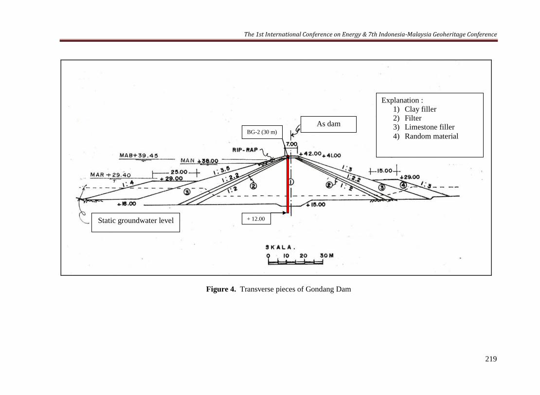
Figure 4. Transverse pieces of Gondang Dam
BG-2 (30 m)
+ 12.00
Explanation :
1) Clay filler
2) Filter
3) Limestone filler
4) Random material
As dam
Static groundwater level

The 1st International Conference on Energy & 7th Indonesia-Malaysia Geoheritage Conference
220