countryside stewardship facilitation fund 2017 - national … · 2018-02-08 ·...
TRANSCRIPT

Countryside Stewardship Facilitation Fund 2017 -
National RoundMap and brief outline of groups and
priorities to be delivered

CS FF Ref County Facilitation Group Name Members Ha’s
010008 Northumberland South Tyne 16 11002
020010 Cumbria Borrowdale 12 5874
020011 Cumbria Bowness 15 1980
030012 Yorks Esk Valley 52 10514
030013 Yorks Yorkshire Farm Fora 14 3441
040007 Cheshire Lower Dane 24 4620
040006 Cheshire Dane Headwater 12 2653
040008 Lancs Pendle Hill 21 3093
040009 Ches Sandstone 40 4575
040012 Lancs Abbeystead - Wyre Rivers Trust 13 4364
050006 Staffs South West Peak 14 2414
050007 Derbyshire Hope Valley 27 3538
050008 Lincs Linc’s Chalk – Great Eau 7 2262
050009 Lincs Linc’s Heaths 6 10182
050010 Lincs Linc’s Wolds 18 8484
050011 Leics Welland Floodplain 5 840
060007 Shrops Land, Life and Livelihoods 28 4149
060008 Staffs River Mease Catchment 15 5065
060009 Staffs Churnett Valley 27 1429
070013 Warks Arden Farmers 14 6446
070014 Worcs Malvern Hills 6 3064
070015 Glocs Severn Vale 18 2560
100003 Surrey Greenscape 9 2381
100004 Oxon Happy Valley 9 2340
110008 Somerset Blackdown Hills 54 4332
110009 Wilts DELTA 29 20460
110010 Somerset Exmoor Coastal 15 6938
110012 Somerset Quantock Hills 9 3428
120008 Devon Dartmoor 34 6500
120009 Somerset Earne & Yealme 14 3132
120010 Cornwall Fal Valley 16 1860
130004 Dorset Brit & Hooke 17 4038
130006 IoW East Yar 10 1863
130007 Hants Wallop Group 20 4550
140009 Kent East Kent Sustainable Farming Group 4 1554
140013 E Sussex Pevensey Levels 41 5001
140012 E Sussex Rother Valley 31 8667
716 179593
Thirty Seven Successful Groups

CSFF 010008 South TyneMembers will seek to address flood risk management and water quality. The South Tyne catchment
suffers from rapid and damaging run off along with high sediment loads rich in metals. Natural Flood
Management (NFM) techniques significantly slow water flow and reduce flood impacts down-stream.
Also slowing the flow of water allows sediments in suspension to drop out which improves water
quality. I will hold workshops and demonstrations for members that show NFM options operating in
practice. Cumbria County Council, Northumberland County Council and Northumbrian Water are all
prioritising the south Tyne for Natural Flood Management.
NFM is not just about flooding and water quality as the suite of techniques used also address other CS
priorities as they deliver improved and more connected habitat through the creation of wetland
scrapes, the management of moorland and hedgerows, new riparian woodland and improved
woodland management. The synergies involved will provide improved biodiversity across the
catchment supporting important populations of breeding waders, woodland birds, moorland birds and
mammals.
By taking a catchment based approach and looking at the whole landscape, farmer members will be
supported with knowledge and encouraged to work together to collaborate on schemes that involve
whole river corridors.
Through a series of workshops farmer members will focus specifically on measures that will:
- Increase riparian woodland
- Reduce agricultural diffuse pollution
- Connect habitats
- Reduce sediment movement
- Improve water quality
- Improve flood management
Group
Members
Length of
Agreement
Area of Group -
Hectares
16 3 11002
Contact: Douglas Phillips
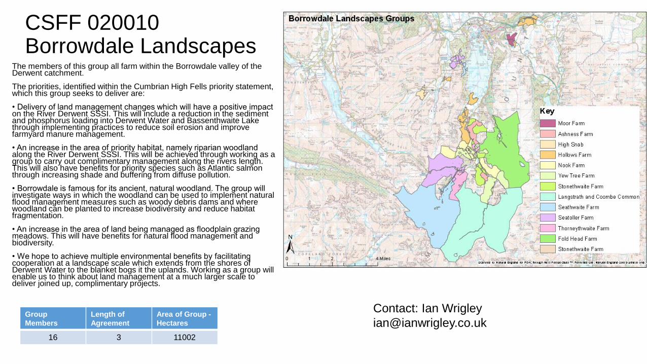
CSFF 020010Borrowdale Landscapes
The members of this group all farm within the Borrowdale valley of the Derwent catchment.
The priorities, identified within the Cumbrian High Fells priority statement, which this group seeks to deliver are:
• Delivery of land management changes which will have a positive impact on the River Derwent SSSI. This will include a reduction in the sediment and phosphorus loading into Derwent Water and Bassenthwaite Lake through implementing practices to reduce soil erosion and improve farmyard manure management.
• An increase in the area of priority habitat, namely riparian woodland along the River Derwent SSSI. This will be achieved through working as a group to carry out complimentary management along the rivers length. This will also have benefits for priority species such as Atlantic salmon through increasing shade and buffering from diffuse pollution.
• Borrowdale is famous for its ancient, natural woodland. The group will investigate ways in which the woodland can be used to implement natural flood management measures such as woody debris dams and where woodland can be planted to increase biodiversity and reduce habitat fragmentation.
• An increase in the area of land being managed as floodplain grazing meadows. This will have benefits for natural flood management and biodiversity.
• We hope to achieve multiple environmental benefits by facilitating cooperation at a landscape scale which extends from the shores of Derwent Water to the blanket bogs it the uplands. Working as a group will enable us to think about land management at a much larger scale to deliver joined up, complimentary projects.
Group
Members
Length of
Agreement
Area of Group -
Hectares
16 3 11002
Contact: Ian Wrigley

CSFF 020011 Bowness Peninsula
The Bowness on Solway Peninsula is a highly designated landscape including: 3 SSSI
lowland raised bogs with their breeding bird assemblages (which make up ¾ of the South Solway Mosses SAC and NNR), the Upper Solway Flats and Marshes SSSI and Solway Firth MCZ, the Solway Coast AONB and Hadrian’s Wall World Heritage Site. CS priorities to maintain and restore the following habitats can all be delivered:
Lowland raised bogs, purple moor grass and rush pasture, coastal saltmarsh, coastal and floodplain grazing marsh, saline lagoons, ancient and native woodland, and arable field margins.
As well as habitat creation, to extend and link priority habitat, increase connectivity and reduce fragmentation for:
• Declining species marsh fritillary butterfly, willow tit, natterjack toad
• Breeding waders, lapwing, redshank and curlew
• Increased opportunities for farmland birds and pollinators through arable options
• Land management to address water and soli quality issues through CSF
Group
Members
Length of
Agreement
Area of Group -
Hectares
15 3 1980
Contact: Ian Wrigley

CSFF 030012 Esk Valley
The group have assessed the range of CS priorities for the North York Moors and Cleveland Hills NCA25 and narrowed these down to those relevant to the Esk Valley
1- Protected aquatic species and associated riparian habitats Fresh Water Pearl Mussels (FWPM) and migratory fish Sediment is a major factor in the lack of juvenile FWPM & migratory fish recruitment, the aim is to help build and expand the scope of the local Pearl Mussel and Salmon Recovery Project as well as CSF in the area.
2 -Water (sediment but also nitrate, phosphate & carbon) - Polarisation of farm systems with some getting more intense potentially concentrating issues. Group working may help this imbalance.
3 - SSSI/SAC/SPA habitats primarily heather moorland, most is in HLS Agreements begin to expire in 2019.
4 - Breeding wader assemblages -Some important populations opportunities to address poor CS uptake on inbye.
5 - Landscape (Walls, hedges, trees and traditional buildings) Iconic National Park landscape, discconect between mainteinence costs and reward for public goods and addressing potential deterioration post ES.
6 - Priority habitats (non SSSI) such as meadows and aincient woodland. Polarisation as mentioned in 2 creates opportunities for expansion of habitats and to address poor CS uptake.
Group
Members
Length of
Agreement
Area of Group -
Hectares
52 3 10514
Contact: Fraser Hugill

CSFF 030013 Yorkshire Farm Fora
The primary aim will be to deliver the following Countryside Stewardship top priorities:
Biodiversity - arable field margins, lowland meadow and lowland calcareous grassland.
Landscape - field margins & buffers, hedgerows, trees, permanent grassland and stubbles.
Water - Water quality, reducing soil erosion & run off.
Priority species - corn buttercup, pheasant's eye, red hemp-nettle, shepherds needle, turtle dove, lapwing and corn bunting.
Wild pollinator and farm wildlife package - sowing nectar mixes and winter bird food mixes, increasing flowers on grassland, managing hedgerows, and for this group, arable margins.
The group will deliver these key priorities seeking to increase species diversity and abundance in arable plants, grasslands and pollinators. The project will also deliver benefits for other priority species such as turtle dove, lapwings, grey partridge and pollinators as some of the plant species provide feed sources. Links will be built with the North York Moors Turtle Dove project and the RSPB to maximise the positive benefits for bird species. The project will involve bee experts and Butterfly Conservation to explore the relationship between arable field margins, arable flowers and bees/butterflies and how each can successfully support the other.
The group will deliver additional benefits including:
Multiple Environmental Benefits - Soil structure & water options (around margins and buffers) & establishing low-intensity grassland.
Arable field margins, winter stubbles, permanent grassland, hedgerows and trees positively contribute to landscape quality and meet landscape character priorities along with Howardian Hills AONB and the North York Moors National Park Management Plan objectives.
Group
Members
Length of
Agreement
Area of Group -
Hectares
14 3 3441Contact: Frances Standen

CSFF 040006 Dane Headwater
The group footprint spans an area of land rising from 260m at its lowest point up to 550m at its highest. Consequently, land use is varied which is reflected in the diversity of habitats and species it supports. Two common priorities have been identified across all group holdings; water and wading birds. In addition to this a significant area ancient clough woodland is managed by the group. The following priorities will be taken forward;
Water:
This group will take a holistic approach to reducing water pollution (specifically phosphate and pesticide) events and reducing flood risk.
Facilitators will work to identify opportunities where it is possible to satisfy both of these objectives in tandem. For example, where soil erosion during storm events is leading to sediment and phosphate enrichment within water courses.
Wading birds:
The group area is a nationally valuable stronghold for wading birds including snipe, curlew & lapwing. As a group we would like to improve the monitoring of such species as and take steps to improve the habitats they depend on; blanket bog, upland heath and rush pasture.
There will be overlap between improving conditions for these species and delivering multiple water benefits.
Woodland
The ancient clough woodlands of the upper Dane are a refuge for our most threatened woodland birds. This group will work cooperatively to preserve these and address the following management issues; deer pressure and woodland connectivity. Facilitators will work with the group to draw up woodland planting plan for the area and coordinate a group wide deer management plan.
Contact: Jim Pimblett
Group
Members
Length of
Agreement
Area of Group -
Hectares
24 3 2653

CSFF 040007Lower Dane & TributariesPriorities
1. Flood Risk Management
2. Woodland Creation and Management
3. Water Quality Improvement: Reducing nitrates, phosphates, sediment and pesticides in watercourses and the Sandbach Flashes SSSI
4. Biodiversity: Focusing upon wetlands and wet grassland management for lapwing and curlew and improving the biodiversity value of riparian areas.
5. Landscape and the Historic Environment: Particularly hedgerows and hedgerow trees.
The Lower Dane and Northwich tributaries are complex landscapes where we propose a proactive approach addressing: flood risk alleviation, water quality recovery and hydro morphological restoration through nature based solution are considered key objectives. Over 500 properties are at significant (1%) river flood risk in Northwich, 25 in Winsford, 25 - 50 in Crewe and around 50 at sewer flood risk in Middlewich. Alongside the decline in water quality from nutrient enrichment, hydro morphological impacts from HS2 (EU WFD) will require offset. Members agree that their land is crucial in tackling these issues.
The Weaver Gowy Catchment Action Plan sets out the measures to restore the river-system, attempting to balance economy and the needs of people with the landscape and biodiversity. Key objectives to consider include: woodland creation and water attenuation along and around watercourses and increasing opportunities for priority habitat wet woodland for declining priority willow tit and swamp lookout spider. Fundamentally, these types of measures will address multiple objectives and yield multiple benefits. We have members in the right area of the catchment to deliver these priorities and have identified other farmers we’d like to approach as the project develops. Group
Members
Length of
Agreement
Area of Group -
Hectares
24 3 4620Contact: Carl Smethurst

CSFF 040008 Pendle Hill
.
Group
Members
Length of
Agreement
Area of Group -
Hectares
21 3 3093
Contact: Sarah Robinson
Our group priorities are
• Management of upland calcareous grassland - manage stock levels, inputs and timing of grazing to
improve species diversity, carry out sensitive scrub management to ensure grassland interest is
maintained whilst retaining some scrub as cover and as song posts
• Management and restoration of upland and lowland meadow - using techniques developed in the
AONB members will restore species diversity and re-introduce traditional meadow management.
This has synergy with water quality, wading birds and wild pollinator objectives
• Management of ancient and semi natural woodland including stock-proofing, removal of invasive
species and increasing diversity to support woodland flora and birds
In addition members will:
• restore and manage native woodland by enclosing clough woodlands, removing invasive species,
and creating woodland extensions and linkages
• Improve natural flood risk management, particularly via woodland and hedgerow restoration and
creation, also installation of leaky dams, woody debris and exclusion of stock
Members will encourage and support
• Wading bird habitat by altering the management of wet grasslands - synergy with meadow
restoration, upland restoration and natural flood risk management
• Wild pollinators and farm wildlife via package options such as sowing pollinator patches, increasing
species diversity in grasslands,
• Restoration of hedgerows and dry stone walls across members landholdings to improve ecological
networks, reduce flood risk and improve landscape character.

CSFF 040009 Sandstone Ridge Farmers Network
.
Group
Members
Length of
Agreement
Area of Group -
Hectares
40 3 4575Contact: Dr Nicola Hall
The CS Priorities identified for the area that the Network will work towards enhancing and
protecting include the following:
BIODIVERSITY - The Network will focus on the maintenance and restoration of
unimproved acid and neutral grassland, and ancient woodland, which support Priority
Species such as lapwing and willow tit, and also others such as nightjar, adder, raven,
peregrine and red kite.
WATER- the FF area has high CS priority status for water quality targets, so group
targeting will be to reduce nitrates, phosphates, sediment and pesticides in water, and
opportunities for improving the biodiversity in riparian areas. The farms typically are rich in
field ponds which provide vital foci for biodiversity in the landscape.
HISTORIC ENVIRONMENT - designated built heritage sites and undesignated small-scale
features are prevalent in the landscape, like quarries, caves, rock graffiti, stiles, wells, and
springs; the Network will raise awareness of the value of these assets and examine options
for their improved maintenance, access and interpretation.
WOODLAND - the group will target measures tleading to the extension and improved
management of woodland on the ridge, in particular ancient woodland, PAWS sites and
plantation woodlands, and promote management for target Priority Species within the
woodland bird assemblage, and opportunities for using woodland to help target Water
Quality and flood risk. LANDSCAPE - The core semi-natural habitats of the Ridge are
joined together by a landscape fabric of hedgerows, hedgerow trees, sandstone walls and
sandstone lined banks. The maintenance and restoration of these features will be a priority
for the group and a key delivery mechanism for improving habitat for Priority Species such
as bats and dormice.
OTHER PRIORITIES - The Network will take the opportunity to consider other priorities of
common interest such as keeping alive traditional rural skills, diversification opportunities
linked to quality of place, and co-ordinated ways to improve the offer and experience for the
increasing numbers of visitors to the area.

CSFF 040012Abbeystead Farmer Group .
Group
Members
Length of
Agreement
Area of Group -
Hectares
13 3 4364
Contact: Tom Myerscough
The members of the group will aim to deliver a suite of Countryside Stewardship priorities
across the land which is held by the members. The group will work with partners that have
expertise in relevant fields to ensure that delivery follows best practice. Guidance from
WRT will focus upon the water environment and catchment management with particular
reference to faecal matter, sediment, pesticides and nutrients entering watercourses. Our
partners will provide guidance on blanket bog, upland heathland and upland hay meadow
restoration, forestry options and habitat creation for terrestrial species. We will also ensure
that members have access to training and evidence about safeguarding zones, climate
change resilience and natural capital.
Whilst covering each of the priorities as outlined above we will highlight the synergies
between them and educate the members on how the creation or restoration of these
habitats will contribute significantly to improvements in water quality, air quality and FCRM.
The creation of these habitats will also support priority species such as black grouse,
lapwing, breeding waders and woodland birds. We will also work to address flood and
coastal risk issues, although not identified as a priority in the statement it is clear that the
flooding which was sustained by populations within the Wyre catchment in 2015 and 2016
would make it a priority so we will seek to reduce the amount and rate at which surface
water run off enters watercourses, reduce the erosion of soil and slow the movement of
floodwaters on upland floodplains.

CSFF 050006 South West Peak Farmers
.
Group
Members
Length of
Agreement
Area of Group -
Hectares
14 3 2414
Contact: Jeff Simms
The group's collective landholding falls within The South West Peak National Character Area (NCA 53). Group
members have worked together to identify the following Countryside Stewardship priorities they will be
delivering as follows:-
1) Biodiversity - Members will share knowledge, maintain, restore, link and create the following priority
habitats; - blanket bog; - upland fens, flushes and swamps; - hay meadows - purple moor grass and rush
pasture; - upland heath. - woodland planting to buffer and link existing woodlands within priority woodland
habitat networks.
The group will also focus on activities to help priority breeding wader assemblage.
2) Water - reduce sediment from soil erosion and runoff. - reduce the amount and rate of surface water run-off;
- slow the movement of floodwaters from the headwaters.
3) Landscape - Understand the importance of stone walls, hedgerows, bankside trees as landscape features; -
Research and record the value of traditional barns and farmsteads
4) Historic environment - Work to restore and protect archaeological features by removing scrub and bracken
5) Synergies - Management of low-intensity wet rush pasture in the catchments of the Goyt, Churnet,
Manifold and Dane in locations will benefit breeding waders, water quality, flood risk and biodiversity.
Restoring blanket bog, wet heath and upland mire habitats using moorland re-wetting options and seasonal
livestock exclusion within South Pennines Moors SPA will benefit flood risk, carbon storage, water quality and
biodiversity. choosing options to diversify the moorland fringe including: moorland management, enclosed
rough grazing, management of rough grazing for birds and low-input grassland options where these will
benefit landscape character, water quality and biodiversity.

CSFF 050007 Hope Valley Farmers
.
Group
Members
Length of
Agreement
Area of Group -
Hectares
27 3 3538
Contact: Choe Palmer
The area covered by the Hope Valley Farmers area is in the Dark Peak NCA 51.
Breeding wader species are identified as a key priority, particularly lapwing, curlew
and snipe. Many member's farms support breeding / feeding populations of wader
species or suitable habitat.
The area contains five SSSIs and is bordered by the Dark Peak SSSI /SAC / SPA.
Focusing on habitats to buffer, enhance and potentially extend designated sites will
be a priority.
The group will deliver against the following priority habitats:
Blanket bog, upland heath, flushes (Abney and Offerton Moor, Win Hill)
Lowland dry acid grassland / lowland meadows - conserving and restoring
important grassland sites will be a priority through improved management and
restoration.
Ancient and native woodland: priority deciduous woodland sites are widespread in
the HVF area and most members have woodlands on their farm. Training will focus
on woodland management and establishment, signposting to CS and Woodland
Trust funding to manage, enhance and extend woodlands.
Riparian habitat: the River Derwent and Noe run through the HVF area and several
group members own /control riverside habitat.
Actions - Training on nutrient/ grazing management on riverside field to reduce
diffuse pollution risk and impacts from bank erosion/poaching and linking to the
work of the Severn Trent Derwent Catchment Officer (Margaret Baile) for additional
support and funding.
Pollinators: encouraging the establishment of herbal leys, promoting planting of and
rotational cutting of hedges, allowing scrub to develop and conservation of
unimproved grassland will be key actions to support pollinators.
Landscape: maintenance and restoration of stone walls and hedgerows are a
priority - events on management/restoration and the Hedgerow and Boundary Grant
will be organised.
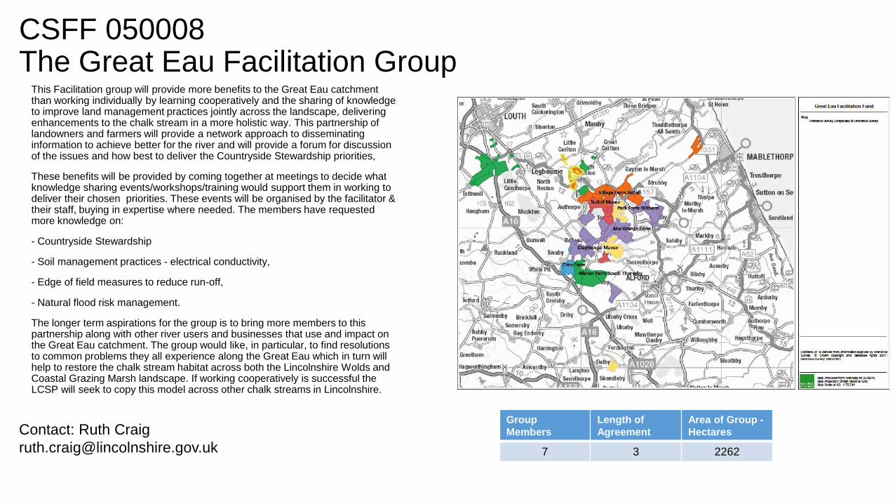
CSFF 050008 The Great Eau Facilitation Group
This Facilitation group will provide more benefits to the Great Eau catchment than working individually by learning cooperatively and the sharing of knowledge to improve land management practices jointly across the landscape, delivering enhancements to the chalk stream in a more holistic way. This partnership of landowners and farmers will provide a network approach to disseminating information to achieve better for the river and will provide a forum for discussion of the issues and how best to deliver the Countryside Stewardship priorities,
These benefits will be provided by coming together at meetings to decide what knowledge sharing events/workshops/training would support them in working to deliver their chosen priorities. These events will be organised by the facilitator & their staff, buying in expertise where needed. The members have requested more knowledge on:
- Countryside Stewardship
- Soil management practices - electrical conductivity,
- Edge of field measures to reduce run-off,
- Natural flood risk management.
The longer term aspirations for the group is to bring more members to this partnership along with other river users and businesses that use and impact on the Great Eau catchment. The group would like, in particular, to find resolutions to common problems they all experience along the Great Eau which in turn will help to restore the chalk stream habitat across both the Lincolnshire Wolds and Coastal Grazing Marsh landscape. If working cooperatively is successful the LCSP will seek to copy this model across other chalk streams in Lincolnshire.
Group
Members
Length of
Agreement
Area of Group -
Hectares
7 3 2262
Contact: Ruth Craig

CSFF 050009 Linc’s HeathsThe area covers two NCAs: Southern Lincolnshire Edge and the Fens. The following priorities have been identified and will be delivered by the group members:
1. Maintenance and / or restoration of floodplain grazing marsh, lowland calcareous grassland, lowland meadows, ancient and native woodland and arable field margins. (Synergies with 5. and 6.)
2. Maintenance of Potterhanworth Wood SSSI.
3. Land management options and capital works to benefit priority bird species.
4. The wild pollinator and farm wildlife package by retaining and extending nectar flower mixes, enhancing existing field corners and margins by slot seeding wild flowers, the provision of winter bird food through wild bird seed mixes and overwintered stubbles, managing hedgerows and the creation of skylark plots.
5. Reducing flood risk by reducing the amount and rate of surface water runoff to the Carr Dyke, Delphs and Scopwick Beck.
6. Reducing the amount of nitrate entering the Lincolnshire Limestone to the west of the area. This area is significant as it has the potential to impact groundwater quality, which in turn poses a particular risk to public water supply boreholes.
7. Retaining and enhancing Scheduled Monuments and other above and below ground archaeological features.
8. Management of existing priority woodlands and possible establishment of new. (Depending on placement this has synergies with 5. and 6.)
9. Maintenance of the key landscape features for the NCAs; hedgerows, hedgerow trees, field margins, permanent grassland, permanent pasture and stone walls. (Synergies with 5. and 6.)
Group
Members
Length of
Agreement
Area of Group -
Hectares
6 3 10182
Contact: Barney Parker

CSFF 050010 Linc’s Wolds
The project area is covered by the Lincolnshire Wolds NCA (& is within the AONB). The following priorities have been identified and will be delivered by the group members:
1. Maintenance and / or restoration of lowland calcareous grassland, lowland meadows, ancient and native woodland, riparian habitat and arable field margins. (Synergies with 5. and 6.)
2. Habitat creation to contribute to improvements in water and air quality.
3. Restoration and maintenance of relevant SSSIs.
4. Land management options and capital works to benefit priority bird species; corn bunting, lapwing, willow tit and turtle dove.
5. The wild pollinator and farm wildlife package by retaining and extending nectar flower mixes, enhancing existing field corners and margins by slot seeding wild flowers, the provision of winter bird food through wild bird seed mixes and overwintered stubbles, managing hedgerows and the creation of skylark plots.
6. Water quality issues; in particular elevated nitrate concentrations on the chalk outcrop.
7. Reducing soil erosion and surface water run off in the catchment of the River Bain and Lymn rivers and their tributaries.
8. Retaining and enhancing Scheduled Monuments and other high priority SHIINE sites such as deserted medieval villages and ridge and furrow.
9. Management of existing priority woodlands and possible establishment of new. (Depending on placement this has synergies with 5. and 6.)
10. Maintenance of the key landscape features for the NCAs; hedgerows, hedgerow trees, field margins, permanent grassland. This would be delivered in conjunction with the Lincs Wolds AONB Management Plan (Synergies with 5. and 6.)
Group
Members
Length of
Agreement
Area of Group -
Hectares
18 3 8484
Contact: Barney Parker

CSFF 050011Welland Flood PlainThe majority of the group sits within the Northamptonshire Vales National Character Area. The NCA consists of a series of low-lying clay vales and river valleys, including the valleys of the river Welland and its tributaries. The area is 10 per cent urban, and settlement is often visually dominant.
Key priorities for this area in terms of Countryside Stewardship include floodplain grazing marsh, lowland Fens, lowland meadows, reed beds, lowland calcareous grassland, ancient and native woodland, riparian habitats and arable field margins.
The area in which the group falls is a medium priority for water quality, with local priorities including phosphate and sediment issues within watercourses.
The following priority species have also been recorded: corn bunting, lapwing, and turtle dove. Great crested newt have also been recorded. The woodland bird assemblage is also a target, with records of tree pipit, marsh tit, lesser redpoll and lesser spotted woodpecker.
The Wild Pollinator & Farm Wildlife Package is expected to be a major element of the scheme for members to deliver.
Multiple environmental benefits are thus able to be addressed in this area, in line with priorities listed above. Measures to improve water quality can be put in place through Countryside Stewardship and Catchment Sensitive Farming guidance, often whilst benefiting pollinators and bird life.
Group
Members
Length of
Agreement
Area of Group -
Hectares
5 3 840Contact: Andrew Brown

CSFF 060007Land, Life and LivelihoodsPriorities: Biodiversity, Water and Woodland, with cross-cutting multiple environmental benefits.
-Priority habitats will be maintained/restored by connecting parcels of land. This will increase the natural capital of the uplands delivering multiple environmental benefits.
- Increasing the extent of purple moor grass/rush pastures; upland flushes/swamps; upland heathland; upland hay meadows; ancient/native woodland and riparian habitats will deliver priority species (including lapwing, curlew, lesser horseshoe bat, small pearl-bordered fritillary). (Maps 3-6 show Curlew monitoring & breeding/foraging areas).
-Planting new woodland will: - buffer/link existing woodlands and other semi-natural open habitats within priority woodland habitat networks- reduce/intercept diffuse pollution from agriculture- increase infiltration of heavy rain into the ground, reduce erosion, and 'slow -the-flow'.
- Linking-up dingles (steeply-sided valleys/gullies which are reservoirs of biodiversity) will help reduce nutrients/sediment in the Clun catchment, protect relocation sites for Freshwater Pearl Mussel (FPM) and reduce nutrient input to the Upper Teme.
- Areas of the catchment will be explored for 'slowing-the-flow' and water pollution mitigation opportunities - e.g. tree planting, creation of upland flushes, rush pasture/ponds and changes in farm management - to reduce soil erosion and help flood risk in Rivers Clun, Unk & Folly Brook, upstream of Clun.
- Local interest in landscape history will provide opportunities to promote orchard restoration, linking species-rich hedgerows etc. A strong 'sense of place' exists in the Clun Forest. Scheduled Ancient Monuments lie in our area (Offa's Dyke, Iron-Age hillforts/settlements and Bronze-age barrows, the care of which is included in our plans.
Group
Members
Length of
Agreement
Area of Group -
Hectares
28 3 4149
Contact: Joy Greenall

CSFF 060008River Mease CatchmentThe River Mease Catchment crosses the following CS statements of priority: Mease and Sences (NCA 072); Leicestershire and South Derbyshire Coalfields (NCA071); and the Leicestershire Vales (NCA094). We will predominantly focus on top priorities relevant to the River Mease Catchment.
Biodiversity: Options to restore or maintain SSSIs, particularly targeting the River Mease. Riparian habitat, grassland options and arable field margin creation to extend or link priority habitat to increase connectivity and reduce fragmentation. The WPFWP would be promoted as a valuable component on arable, mixed and pastoral farms. Promoting attention to detail with the habitat management would benefit the priority species.
Water: Targeted land management options and capital works to improve water quality. CSF priority area options and capital works to help control the source or the movement of potential pollutants including nutrients, sediment and pesticides. Resource protection training will help maximise the available opportunities from the CS options and capital works.
Historical environment: To consider the HEFER when preparing applications and feasibly follow option and management guidance. Utilising options and capital works to protect and preserve the historical heritage.
Woodland: Prepare woodland management plans to identify management works to meet agreed objectives. Strategically undertake woodland planting to achieve biodiversity, water quality or flood risk objectives.
Landscape: The landscape features would be considered when drawing up applications. Preserving and managing a mosaic of priority landscape features to maintain the local landscape.
Multiple environmental benefits: The overall aim will be to secure balanced agreements that achieve multiple environmental benefits.
Group
Members
Length of
Agreement
Area of Group -
Hectares
15 3 5065
Contact: Nigel Baskerville

CSFF 060009Churnett Valley
Group
Members
Length of
Agreement
Area of Group -
Hectares
27 3 1429
The Group will focus on biodiversity particularly
for ancient and native woodlands, priority grasslands, lowland meadow,
Purple-moor-grass and rush pasture; priority species (birds, willow tit,
redstart, pied flycatcher, marsh tit) and other priority habitats found in the area –
Lowland Acid Grassland, Heathland, Lowland Fen).
Woodland will be a primary target, which overlaps with other priorities
particularly biodiversity and water.
The group will look to increase the quality and amount of these key habitat types
Within the valley, looking for opportunities to buffer, connect and restore habitats.
Restoring high quality grasslands, scrubby fringes and rough grassland near
to existing key sites and features, especially the Churnett/Coombes Valley SSSIs
Will deliver multiple benefits. As central features of the focus area, these SSSIs
Will be a target for the group including identifying areas to benefit woodland edge
birds through scrub development and look to better connect the valleys’ woodlands
through prudent hedge and tree planting.
There will also be activities related to water to combat issues with water quality in the
River Churnet and contribute to flooding issues such as tree and hedge planting
providing multiple benefits, reducing run off and slowing the flow. We will also look at
opportunities to better manage the upper reaches of the River Churnet and Endon
Brook around the town of Leek to address flood risk. Measure that contribute to the
farm wildlife and pollinator package will be developed, as will measures to control
invasive species.
Contact: Ann Cantrell

CSFF 070013 Arden Farmers
Group
Members
Length of
Agreement
Area of Group -
Hectares
14 3 6446
Contact: Ian Jelley
This project will increase the coverage of wild bird and pollinator habitat across the
Arden landscape character area in Warwickshire. This will be achieved by
supporting farmers to make simple changes to their land management practices
based on the principles of the FPAWP and including other key habitats.
The other habitats we will be targeting include floodplain grazing marsh, lowland
meadow, ancient and native woodland, wood pasture and parkland with veteran
trees and arable field margins, all of which are CSS priority habits. In addition
hedgerows, woodland edge and scrub, winter bird food, bird and pollinator nesting
areas and over wintering habitat will also be targeted.
This approach will benefit a variety of species including the CSS priority species;
corn bunting, lapwing, turtle dove, brown hairstreak and lesser horseshoe bat. By
working at a landscape scale we will also be able to identify key populations of
species on landholdings within the group. That will enable us to encourage
landowners to create complimentary habitat for the rarest species and ensure that
there are bigger, better, more joined up areas for wildlife.
As there are several priority areas for flooding and water quality in the area a key
additional benefit of this approach will be improvements to the CSS priorities for
water including water quality, air quality and flood risk management via more
effective river catchment management.
By operating at a landscape scale this network will deliver multi-environment
benefits including biodiversity net gain, healthier soils, improved water quality and
profitable sustainable farming.

CSFF 070014 Malvern Hills
Group
Members
Length of
Agreement
Area of Group -
Hectares
6 3 3064
Contact: Paul Esrich
Establishing and managing buffer and riparian strips and hedgerow planting and restoration within
the Teme and Leadon catchments to enhance landscape character, protect the historic
environment and improve habitat connectivity. This will benefit lesser and greater horseshoe bats.
Woodland planting will buffer and link existing semi-natural habitats to reduce diffuse pollution and
alleviate flooding.
Enhancing and expanding woodland in locations where well-managed woodlands benefit
landscape character, biodiversity, water quality and flood risk, including climate change adaptation
and resilience. We will look for opportunities to revert PAWS to broadleaf woodland, buffer
woodland SSSIs and deliver improved woodland management. This will benefit lesser and greater
horseshoe bats and woodland bird assemblages.
Creating and expanding permanent low-intensity and species-rich and calcareous grassland
where it will increase habitat connectivity, protect historical features, enhance landscape
character, benefit water quality and reduce flood risk. This will support and buffer grassland
SSSIs and enable greater soil conservation as well as benefit a range of invertebrates.
Restoring and enhancing wood pasture and parkland will contribute to the preservation of the
historic environment, improve habitat connectivity and support good SSSI status and landscape
character and support veteran tree longevity. Lesser and greater horseshoe bat and woodland
assemblage birds will benefit from provision of additional habitat.
Enhancing, expanding and restoring traditional orchards will increase core habitat connectivity,
support historic landscape character and directly increase habitat for orchard specialist species
including noble chafer and mistletoe marble moth and supporting habitat for woodland
assemblage bird species and lesser and greater horseshoe bats.

CSFF 070015Severn Vale Guardians
Group
Members
Length of
Agreement
Area of Group -
Hectares
18 3 2560
Contact: Sarah Wells
The facilitator will help farms deliver options worked up collaboratively at a landscape
scale, to deliver the priorities of the Severn and Avon Vales National Character Area
106. This will include Biodiversity, Priority Habitats and Species Protection;
improvements to Water Quality and reducing Flood Risk; Woodland Restoration;
Riparian Management; Boundary restoration and Soil Management. The Group aims to
link the land between Slimbridge and Walmore Common, including maintaining and
extending the provision of 'Functionally Linked Land' and land to support the breeding
success of curlews and survival of European eel. We will work with farmers around
Upper Severn SSSI, Walmore Common SSSI and Frampton Pools SSSI to develop
sustainable land management practices which will benefit the long term protection of
Ramsar sites and internationally important populations of wintering wetland birds. The
project will address wintering sites on the Estuary and breeding sites in the Vale around
Coombe Hill focussing on land management which will support populations of Eurasian
curlew, common crane and European eel. There will be a focus on water protection, soil
structure, organic matter, and water and reducing point source and diffuse water
pollution from agriculture. Improving soil management can benefit bird species that feed
on soil invertebrates and increase soil infiltration to reduce flood risk. The group will
support delivery in the Catchment Sensitive Farming priority area by identifying
measures to reduce surface pesticides and concentration of phosphates. The Group will
work with farmers and partners to address issues identified in the Walmore Diffuse
Water Pollution Plan.

CSFF 100003 Greenscape
Group
Members
Length of
Agreement
Area of Group -
Hectares
9 3 2381
Contact: Jude Keene
Priority habitats - Maintenance, restoration and creation of ancient and native woodland, wood pasture and
parkland with veteran trees and arable field margins where providing connectivity.
SSSI - 334ha of SSSI located in project area.
Priority species - Butterfly species including pearl-bordered fritillary, small pearl-bordered fritillary, brown
hairstreak and wood white. Bechstein bat and hazel dormouse, key mammal species.
Woodland bird assemblage - Identify and target a number of specific priority bird species – undertaking site
surveys will update and/or fill in gaps in survey data for the area.
Water - Western side of area EA flood risk management priority. Significant areas of high and lower priority
for CS water – flood risk and key areas for FC planting for flood reduction.
Woodland management - Synergies with biodiversity and water priority actions. The area includes the full
range of priority woodlands, aim to bring woodlands back into sustainable management.
Woodland planting - Group will assess opportunities for new planting for biodiversity, to create wildlife
corridors and for water quality and flood risk where appropriate.
Landscape - Features surrounding woodland areas including hedgerows, hedgerow trees, in-field trees,
bankside trees and permanent grassland will be integrated into the project as a priority.
Historic environment - Limited knowledge of historic environment features among members – assessments
of sites will be undertaken to identify and plan for features that may exist in the area.
Climate change - Habitat maintenance, restoration and creation plans and activities shaped by the need to
create future landscapes with resilience to climate change and to protect vulnerable features and species.

CSFF 100004 Happy Valley
Group
Members
Length of
Agreement
Area of Group -
Hectares
9 3 2340
Contact: Giles and Judith
[email protected], [email protected]
Priority Habitats - Key priorities are to maintain, restore and create native woodland,
riparian habitats and lowland meadows. There are also small areas of lowland fen
and wood pasture within the project area. We will seek to improve the connectivity of
these habitats to encourage priority species and improve water quality.
Priority Species - We have a keen interest in encouraging farmland birds, including
corn bunting and willow tit. We will increase provision of the 'big three'.
Improving native woodland will encourage woodland birds, bats and butterflies.
We will restore wet areas of farmland to encourage breeding waders. We will also
give consideration to levels of predator control in the valley as a possible strategy for
increasing fledging success.
We will improve the management of hedges, ponds and margins to provide for
pollinators and wild birds (and other species).
Water - Improving water quality is a high priority, with bringing back brown trout a key
aim. The catchment is a priority for phosphates and pesticides, which we will reduce
by improving soils and acting on the principles of water-friendly farming.
Woodland - We will run training courses to increase landowners' confidence in
managing woods and hedges (linking with improving habitat for farmland birds). We
will plant trees to increase habitat connectivity, reduce flooding and clean water.
Multiple benefits - We will target the creation/expansion of wetland, woodland, hedges
and low-input grassland to achieve multiple benefits (such as natural flood
management).
We will identify ways to increase resilience to climate change.

CSFF 110008 Blackdown Hills
Group
Members
Length of
Agreement
Area of Group -
Hectares
54 3 4332
Contact: Gavin Saunders
The Blackdown Hills is an AONB and an NE Focus Area.
The group will deliver the top CS priorities within the NCA, varying between farmer clusters depending on the farm
type, environmental issues and interests of farmers and landowners:
Biodiversity - Important spring-line mire (187ha) & habitat mosaics, ancient semi-natural (427ha) and wet
woodlands, lowland heath (162ha), species-rich hedgerows and riparian habitats all occur. All six priorities for
restoration will be addressed. Significant populations of priority butterfly species and lesser horseshoe bat
maternity roosts occur. There are several SSSI’s and Quants SAC.
Water - The headwaters of the four rivers (failing WFD) are a flood mitigation, natural flood management and water
quality priority area. Existing initiatives to encourage targeted tree planting and woodland/track management will
be promoted.
Historic Environment - Numerous monuments (including WW2 sites) have issues linked to invasive scrub
encroachment (two Scheduled Monuments at risk). Undesignated traditional farm and non-domestic buildings are
abundant.
Woodland - The area is a FC 'Woodland into Management' target area. Existing farm/wet woodlands are a
particular priority. There are also opportunities for planting for biodiversity, water quality and flood risk.
Landscape - The top priorities are species-rich hedges/hedgerow trees, permanent pasture and bankside features.
The area is characterised by small, traditionally-managed farms with medieval field boundaries up the valley sides.
Multiple Environmental Benefits
The river catchments are a key location for this approach. The area is well wooded and there are significant
opportunities to bring undermanaged woodlands back into management, unlocking multiple benefits and
supporting farm businesses' sustainability.

CSFF 110009 DELTA
Group
Members
Length of
Agreement
Area of Group -
Hectares
29 3 20460
Contact: Jemma Batten
Management of priority habitats: - Grassland: chalk grassland, lowland meadows
and floodplains - Lowland fen - Reedbeds and riparian habitats - Arable field
margins
Support for priority species: - Birds: corn bunting, lapwing, turtle dove, stone
curlew, redshank, curlew, snipe. - Invertebrates: Duke of Burgundy, brown
hairstreak, marsh fritillary, shrill carder bee, Desmoulin's whorl snail. Mammals:
lesser horseshoe bat - Arable plant assemblage. Wild Pollinator and Farm Wildlife
Package
Improved water quality: - Phosphate and nitrate in the Hampshire Avon catchment -
Sediment in the Hampshire Avon catchment - Groundwater drinking sources near
Tidworth affected by nitrate and pesticides - The River Avon affected by phosphate,
nitrate and sediment
Flood risk management: - River Wylye catchment and tributaries - Hampshire
Avon catchment and tributaries between Salisbury and Upavon, and tributaries
above Enford
Protection for the historic environment, both Scheduled Monuments and SHINE
sites, especially scrub management which is a perennial issue on SPTA
Landscape conservation: - Permanent grassland - Field margins and buffers -
Bankside trees - Hedgerows
Multiple environmental benefits: - Creating new wetland habitat along the River
Bourne, the Upper Avon and River Wyle. - Creating low input herb-rich grassland
habitat in locations where this will increase the habitat connectivity in situations
where it will reduce rates of surface run-off, reduce soil erosion and increase soil
infiltration rates. - Establishing features to reduce rates of surface run off, reduce
soil erosion, and increase soil infiltration rates in the Hampshire Avon catchment.

CSFF 110010 Exmoor Coastal
Group
Members
Length of
Agreement
Area of Group -
Hectares
15 3 6938
Contact: Adam Lockyear
Management of Moorland, grassland, woodland and landscape features are main
themes bringing together priorities with strong synergies. Focusing on improving:
quality, function and connectivity between these features/habitats.
Flood risk: Including NFM such as woody dams, field scale measures, assessing
soil structure and function and practical demonstrations. Following advice set out in
"Soils and NFM, Devon and Cornwall"
Priority habitats: Woodlands, moorland, heathland, purple moor-grass and rush
pasture and species rich grassland habitats. Including SSSIs: Exmoor Coastal
Heaths and Exmoor Coast and Woods.
Priority species: Woodland bird assemblage, fritillary butterflies, bats. Close
synergy with the habitats described above.
Historic environment: The area is know as Lorna Doone country, this important
cultural heritage will be promoted. There are also many below ground features and
Principal Archaeological Landscapes which should be promoted and preventing
damage is of specific concern when considering NFM and land management
practices.
Landscape: Features within Exmoor Landscape Character assessment. The
coastal landscape and steep valleys parallel to the coast with enclosed grassland
and woodlands are unique. Consideration of the landscape within the management
of priority habitats and when exploring opportunities for NFM or woodland creation
will be included within events.
Promoting management of habitats and features for multiple benefits including
environmental opportunities such as flood management, biodiversity or commercial
benefits that improve the resilience of businesses such as grazing management or
woodfuel will bring together the CS priorities. Launch event discussions highlighted
interest in small scale woodland machinery, scrub management on steep slopes
and trialling cell grazing in uplands.

CSFF 110012 Quantock Hills
Group
Members
Length of
Agreement
Area of Group -
Hectares
9 3 3428
Contact: Ben Thorne
Habitats:
Heathland management - this area is designated SSSI, events will support private
landowners and commoners in coordinating and sharing management work and
experience.
Traditional orchards - improving the condition and promoting the planting of new
traditional orchards.
Ancient and native woodland management - members will look to bring small farm
woodlands back into management and improve their habitat value. Members will
also look at opportunities for increasing woodland planting and management of
young woodlands.
Wood pasture and parkland - there are several large parkland estates surrounding
the Quantock Hills, preserving the veteran trees and historic landscape value will
form part of the delivery.
Species:
Woodland bird assemblage is a local priority and has close synergies with the
woodland priorities above.
Lesser and greater horseshoe bats are a high priority and linked to the grassland
habitats and historic landscape through traditional buildings. Traditional hedge
management will also be a target for delivery.
On arable holdings surrounding the hills delivery will also target pollinator habitats.
The southern area is a target for water quality and delivery will work with CSF and
Hills to Levels. Flood risk management will be targeted for delivery by members
with close synergies to woodland and grassland management.
Landscape is an important target with close synergies to the priorities above
particularly hedgerows, trees, banks and permanent grassland.
The historic environment will be targeted to deliver active management of SM and
RPG, linked to the habitats above. Traditional buildings which have significant
landscape, historic and habitat value will be targeted for active management.

CSFF 120008 Dartmoor
Group
Members
Length of
Agreement
Area of Group -
Hectares
34 3 6500
Contact: Chris Giles
We will be working to make landscape scale enhancements between commons and home
farms within specific river catchments. These catchments have been selected because of the
wide range of CS priorities and opportunities that they contain. Our aim is to explore, identify
and implement ways to improve and integrate enhancement across the following CS priorities:
Wetland - Blanket bog (maintenance and restoration)
- Upland fen and flushes (maintenance and restoration)
- Riparian habitats associated with priority rivers including wet woodland
- Purple moor grass and rush pasture (maintenance and restoration)
- Flood and Coastal Risk Management with focus on natural flood management and soils
Species - Curlew- Marsh fritillary - Willow tit - Bog hoverfly
Grassland - Purple moor grass and rush pasture (maintenance and restoration)
- Hay meadows (maintenance)
Species - High Brown fritillary - Pearl bordered fritillary
Woodland - - Ancient and native woodland (maintenance and restoration)
- Explore opportunities to bring more woodland into sustainable management and creation
where appropriate. Options for natural regeneration in river valleys
Historic environment - - Premier Archaeological Landscapes (PALS) - This is a Dartmoor
designation established to protect historic landscapes that include a number of associated and
often internationally important monuments
- Designated features - Scheduled Monuments
- Designated and undesignated traditional farm buildings and non-domestic historic buildings
Landscape - Historic field boundaries - Stone-faced banks, earth banks, stone walls, hedgerow
trees - Fundamental landscape features as recognized in the Dartmoor NCA and Dartmoor
LCA

CSFF 120009 Earne & Yealm
Group
Members
Length of
Agreement
Area of Group -
Hectares
14 3 3132
Water Priorities Control faecal bacteria, specifically from manures, in the Erme catchment affecting
the bathing water at Mothercombe.
Control faecal bacteria for shellfish and reduce flood risk in the River Yealm upstream of Yealmpton.
Objectives: 1. Reduce water run=-off 2. Reduce Soil Erosion 3. Slow water movements
Biodiversity Priorities Maintenance of priority habitats: Blanket bog, Upland heathland, Upland fen
and flushes, Purple moor grass and rush pastures, Ancient and native woodland.
Restoration of priority habitats: Blanket bog, Upland heathland, Purple moor grass and rush
pastures, Ancient and native woodland.
Restoration or maintenance of SSSI: South Dartmoor SSSI, Piles Copse
Priority Species: Lapwing (last known location on Dartmoor), Cirl Bunting, Greater/Lesser Horseshoe
Bat, various fritillary species, Redstart.
Promotion of Wildlife Pollinator and Farm Wildlife package to promote the highest priority species.
Aiming to support habitat management for woodland bird assemblage.
Historic Environment Priorities: Manage plant growth and scrub around features, Specifically
Scheduled Monuments, traditional farm buildings and SHINE features. Restore and preserve
historic building and features. Maintain below ground archaeology features.
Woodland Priorities: Maintain and increase moorland fringe woodland.
Key synergies between priorities: reinforce moorland management techniques in diverse group area
to benefit water quality of the Earne & Yealm catchments and enhance biodiversity of habitats and
species. Enhance existing fringe woodland locations to aid flood control and biodiversity,
Management of traditional heritage assets, hedgerows and stone face banks for landscape
character, heritage protection and water quality.
Contact: James Wotton
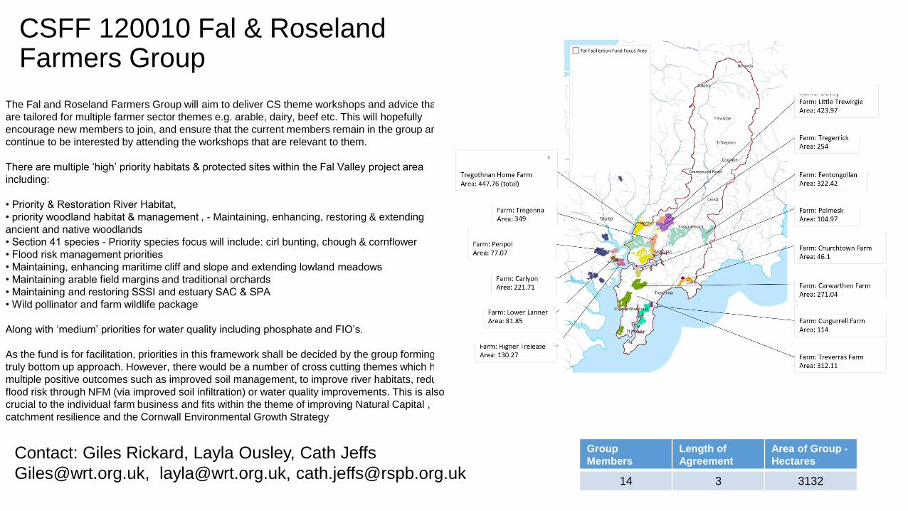
CSFF 120010 Fal & Roseland Farmers Group
Group
Members
Length of
Agreement
Area of Group -
Hectares
14 3 3132
The Fal and Roseland Farmers Group will aim to deliver CS theme workshops and advice that
are tailored for multiple farmer sector themes e.g. arable, dairy, beef etc. This will hopefully
encourage new members to join, and ensure that the current members remain in the group and
continue to be interested by attending the workshops that are relevant to them.
There are multiple ‘high’ priority habitats & protected sites within the Fal Valley project area
including:
• Priority & Restoration River Habitat,
• priority woodland habitat & management , - Maintaining, enhancing, restoring & extending
ancient and native woodlands
• Section 41 species - Priority species focus will include: cirl bunting, chough & cornflower
• Flood risk management priorities
• Maintaining, enhancing maritime cliff and slope and extending lowland meadows
• Maintaining arable field margins and traditional orchards
• Maintaining and restoring SSSI and estuary SAC & SPA
• Wild pollinator and farm wildlife package
Along with ‘medium’ priorities for water quality including phosphate and FIO’s.
As the fund is for facilitation, priorities in this framework shall be decided by the group forming a
truly bottom up approach. However, there would be a number of cross cutting themes which have
multiple positive outcomes such as improved soil management, to improve river habitats, reduce
flood risk through NFM (via improved soil infiltration) or water quality improvements. This is also
crucial to the individual farm business and fits within the theme of improving Natural Capital ,
catchment resilience and the Cornwall Environmental Growth Strategy
Contact: Giles Rickard, Layla Ousley, Cath Jeffs

CSFF 130004 Brit & Hooke
Group
Members
Length of
Agreement
Area of Group -
Hectares
17 3 4038
Contact: Alex Butler
Members farm within one or more of five neighbouring catchments
(Hooke, Brit, Wraxall, Mangerton and Simene); a pastoral landscape
that forms a coherent unit (see Plan A). Improved pasture, maize,
diary, beef and sheep are characteristics common to members and
have encouraged a focus on event topics.
Statements of Priorities (SoPs) 134 and 139 identify water quality
issues on the Simene, Brit and Mangerton (West Dorset Rivers) and
the Hooke, which are 'high priority' for surface nitrates, sediment and
phosphate. SoPs 134, 139 and 140 also refer to the Hooke, Brit and
Wraxall as priorities for flood management. Members will address the
above issues and a preparatory FF meeting has already led members
to discuss how to share and promote best practice maize
management. More herbal leys (GS4) and grass margins (SW2),
whilst reducing nutrient inputs, should also support pollinators and
increase connectivity between semi-natural grassland.
Members manage a hub of four SSSIs (SoP lowland meadow and
native woodland), totalling 329.40ha (most of which is a SAC), plus an
additional 12 SNCIs. SoP priority species on members holdings
include Marsh Fritillary, Lesser Horseshoe Bat and Marsh Tit. Other
indicator species (not listed in SoPs) characteristic of the area and
more tangible to members include: wax cap fungi, Dipper, Dormouse,
and Barn Owl (each representing priority habitats). Priority landscape
features includes: permanent pasture, hedgerows and hedgerows
trees. Members are already managing land to conserve these
habitats, species and landscape features and there is scope develop
collaborative management to further conserve wildlife and increase
landscape connectivity.

CSFF 130006 East Yar
Group
Members
Length of
Agreement
Area of Group -
Hectares
10 3 1863
Contact: Richard Grogan
The habitats to be maintained or created will be characteristically the river
and its floodplain and habitats and will include :
lowland fens, floodplain grazing marsh, reed beds, ancient and native
woodland, riparian habitats associated with priority rivers (Upper eastern
Yar and Wroxall stream), lowland calcareous grassland and arable field
margins.
The floodplain of the river Yar and its hinterland includes one SSSI -
Alverstone Marshes - and twelve SINCs incorporating the priority habitats
described above. The area incorporates four sites managed as nature
reserves by NGOs including the Wildlife Trust
Priority species include farmland birds including turtle dove, skylark and
yellowhammer and wetland species including lapwing and kingfisher.
Water vole, Brown trout and European eel will be target species in the
watercourses and in the wider landscape, field cricket, nightingale, barn
owl and early gentian with mammals such as red squirrel, Bechstein bat,
common dormouse, hedgehog and brow

CSFF 130007 Wallop Group
Group
Members
Length of
Agreement
Area of Group -
Hectares
20 3 4550
Contact: Alison Cross
Water - everything has potential to impact on water. As a WHOLE catchment group we
have control of inputs, good and bad. We can improve water quality and biodiversity of
whole Wallop Brook. Improving soil health will address water quality and improve
productivity.
Biodiversity
Priority habitats/species/Woodland
Adjacent to Wallop Brook (tributary of River Test SSSI), we’ll build on previous good
work. Some tree planting can help keep the river cool, provide natural flood
management and help water quality. We’ll enhance remaining areas of chalk
grassland and encourage new areas using donor seed from existing habitat.
Maintain/enhance our corn bunting, stone curlew and grey partridge populations. Will
survey with volunteers and continue work with RSPB who are monitoring stone
curlew. Will deploy management techniques to benefit these species where possible.
Will work with Red list Revival to focus effort and establish baseline against which we
can measure our success. Creating more pollinator habitat will also benefit these
species.
Historical Plantlife data shows much of the area to be of national importance for its
arable flora.. We will work with Plantlife to gain better understanding of current
situation and help inform management.
Historic Environment away from river valley, the Wallop Catchment would once have
been a chalk downland landscape. Historic evidence suggests there was little
woodland but hedgerows would have been key historic boundaries. We’ll select
locations to enhance these boundaries, strengthening the weakened landscape
character, improving biodiversity (potential brown hairstreak) and delivering wider
benefits such as windbreaks and water retention.
Landscape - away from river valley, the Wallop Catchment would once have been a
chalk downland landscape. Historic evidence suggests there was little woodland but
hedgerows would have been key historic boundaries. We will select locations to
enhance these boundaries, strengthening the weakened landscape character,
improving biodiversity and delivering wider benefits such as windbreaks and water
retention.

CSFF140009 East Kent Sustainable Farming Group
Group
Members
Length of
Agreement
Area of Group -
Hectares
4 3 1554
Contact: Debbie Reynolds
The East Kent Sustainable Farming Group has members within two Countryside Stewardship Statement of
Priority regions, the Norths Downs and the Wealden Greensand.
The overriding emphasis of the group is to respond to the top water priorities, highlighted in both Priority
Statements and address principle causes for water quality failure identified in the Water Framework
Directive (WFD); low flow, low dissolved oxygen, high phosphates and poor fish populations.
Identification of management options and capital works that will address top priorities in the regional
statements across the holdings is key to achieving positive results. The KSCP has a good working
relationship and communication channel with the Environment Agency. This combined with local land
knowledge and links to existing restoration projects along the River Stour will ensure interactions between
members, other landowners and organisations are sustained with a prospective view to expand delivery
across other/neighbouring holdings.
The (upper) Stour River catchment covers an extensive area and has a large number of tributaries and
ditch systems that feed into the main river system.
North Downs Priority Statement
- Develop capital works projects or land management practices to reduce phosphate, nitrate, sediment and
faecal bacteria in the Stour. Increase flow and improve fish populations.
- Identify woodland planting opportunity that will reduce and intercept diffuse pollution, improve infiltration to
reduce flood risk and improve biodiversity
Wealden Greensand Priority Statement
- Restore/create riparian habitats associated with the Stour, a priority river
- Reduce amount and rate of surface run-off, soil erosion and arable cultivation passes in the Stour
catchment between Ashford and Charing
- Identify woodland planting opportunity that will reduce and intercept diffuse pollution, improve infiltration to
reduce flood risk and improve biodiversity
It is anticipated that additional top priorities such as improved habitat management for priority species will
be achieved resulting from increased enthusiasm and understanding of the specific species needs within
the facilitation group with particular reference to farmland birds and aquatic/marginal plant species.

CSFF140013 Pevensey Levels
Group
Members
Length of
Agreement
Area of Group -
Hectares
41 3 5001
Contact: Lucy Carnaghan
Biodiversity- of the 4 priority habitats, 2 are present - floodplain grazing marsh and
associated fresh water ditches; wet grassland.
SSSI - the project area is in un-favourable recovering condition. Also RAMSAR & SAC
designated. It is a key priority to extend and link existing habitats to increase
connectivity and reduce fragmentation - to use fringing to buffer access and create
natural ecotones to manage predators, introduce wet grassland expertise and rush
control, address Crassula sp. issue across the levels - whilst contributing to significant
improvements in water and air quality, flood and coastal risk management.
Priority Species - of the six listed, all are present. Landowners in the respective areas
will be provided with guidance and specialist training on how to manage for them -
identification and landowner surveys.
The Wild Pollinator and Farm Wildlife Package - the grassland options should be
deliverable on all farms applying, and the facilitator would ensure there is a level of co-
ordination between neighbouring holdings
Water - Wallers Haven, Manxey and Hankham levels, east of Windmill Hill and north
east of Herstmonceux - options to reduce the amount and rate of surface water run off,
reduce soil erosion and slow the movement of water should be deliverable on holdings
in these areas, with the facilitator co-ordinating same.
Working with SEW & CSF to address phosphate and pesticide issues in the Pevensey
catchment.
Historic environment - mainly below ground - options would be selected to remove and
control scrub, with facilitator co-ordinating.

CSFF140012 Rother Valley Farmers
Group
Members
Length of
Agreement
Area of Group -
Hectares
31 3 8667
Contact: Colin Hedley
The Rother Valley combines arable farmland with a narrow floodplain grazing marsh/fen
and wooded valleys. The underlying aquifer is essential to the area. Poor continuity
between river and land, highly erodible soils and sediment issues generate much debate.
For all these reasons (and more) the RVFG will deliver the following CS priorities:
Biodiversity: Priority Habitats: - Lowland heathland - Lowland dry acid grassland
- Ancient and native woodland - Floodplain grazing marsh and associated ditch, fen and
riparian habitats (Rother Valley SNIC designation) - Arable field margins
Priority Species: - Lapwing - Turtle Dove - Pearl-bordered fritillary - Brown hairstreak
- Field cricket Plus S41 species, e.g., water vole, southern damselfly
Arable Plant Assemblage: An important arable plant assemblage exists, e.g. nationally
endangered Red-tipped Cudweed; Wild Snapdragon and Corn Spurrey.
The Wild Pollinator and Farm Wildlife Package: This will be applicable to many holdings
and the principle of providing year round and spatial requirements will be promoted.
Water Quality: - Nitrate in drinking water sources - Phosphate and sediment in surface
waters - Pesticide residues reaching/accumulating in rivers. The above impacts on fish/wider
species diversity and riverine ecology in addition to Southern Water's abstraction at
Hardham.
Historic Environment: Historic canalisation of parts of the Rother (e.g. stone locks); historic
parkland (e.g. Petworth); traditional farm buildings;
Woodland Management and Planting: ASNW, plantation and broadleaved woodland is
present with considerable potential for new woodlands to counter erosion and flood risk.
Landscape:
Hedgerows; Trees; Permanent grassland; field margins; sunken lanes are important features