country report of the hydrographic … · country report of the hydrographic department, royal thai...
TRANSCRIPT
COUNTRY REPORT OF THE HYDROGRAPHIC DEPARTMENT,
ROYAL THAI NAVY (HDRTN)
FOR
THE 7 th NIOHC,
PATTAYA, THAILAND
1. Hydrographic Office / Service :
1

Hydrographic Department, Royal Thai Navy (HDRTN) located in Bangkok, THAILAND
Established in 1921. (Fig. 1). Director General : VADM. Saneh Soontonmongkol
Principle Tasks including : - Surveying and Producing of Navigational Charts in Thai Waters - Aids to Navigation Maintenance - Oceanographic Survey and Tidal Prediction - Marine Meteorological Forecast - Standard Time Keeping - Navigational Equipment Procurement and Maintenance
Fig. 1 Hydrographic Department, Royal Thai Navy
2. Surveys : Hydrographic Department, Royal Thai Navy (HDRTN) is a national authority responsible for various hydrographic services of Thailand. The main tasks are to provide services to serve marine navigational safety in Thai waters , military defense requirements and sustainable country development. To support such mentioned roles, HDRTN has been conducted the hydrographic survey in Thai waters for nautical chart production covering the gulf of Thailand and Andaman sea . The activities and developments during the period of 2003-2006 are as follows:
2

3
1) Hydrographic Survey Activities
During the year 2003-2006 the HDRTN has conducted 34 hydrographic surveys. The results of this surveys were implemented for production of nautical charts and other charts utilized in the navy. Type of survey 2003 2004 2005 2006 Habour survey 1 6 4 2 Coastal survey 4 2 1 2 Off-shore survey
- - - -
Survey for update chart
- 3 3 6
Total 5 11 8 10 HDRTN has tried its best to improve the hydrographic survey to meet the standard of the IHO (International Hydrographic Organization) by conducting survey based on WGS 84 and improving the habour survey by using the multi-beam echo sounder. Hydrographic Surveys has been performed by using a vessel named “HTMS. Chandhara” (Fig.2). In FY 2005, HDRTN prioritized hydrographic survey on the Andaman coast to update all charts covering 6 provinces, attacked by the Tsunami, for the safety of navigation. 16 areas along the western coast of Thailand from Ranong province to Trang province were selected to re-survey after the Tsunami in the year 2005 to gather new data for updating charts in each attacked area as follows:
Area Effected by Tsunami
Number of chart produced
Ranong 2 Phang-nga 5
Phuket 2 Krabi 2 Trang 1

Satun 4 Total 16
(Fig.3) including.
- Phuket deep sea port and Phuket west coast - Sounding and shore positioning 16 areas from Ranong to
Satul (Provinces) as follows - Ranong river Entrance - Tablamu ,Khao Lak and Taimuang (Villages) of Phangna Province - Phrathong Passage, Phangna - Phayam Passage, Ranong - Krabi Entrance and Siboya Village Entrance - Phi Phi Island, Similan Island, and Surin Island - Kantang Entrance of Trang Province - Entrance Bouy of Satul Province - Rawi Island, Aadang Island, and Tarutao Island of Satul Province
Fig. 2 HTMS. CHANDHARA
4

5
Fig. 3 Areas attacked by Tsunami and re-surveyed
3. New Charts and Updates; Paper chart production activities: The surveys mentioned above were used to produce Thai nautical charts and other related charts in Thai waters. Nautical charts produced during the year 2003- 2006 are shown as below: Type of production 2003 2004 2005 2006
New chart - 1 - 2 New publication 2 5 4 4
New edition 14 10 5 5 New print 5 - 2 1
Total 21 16 11 12
3.1 Paper Charts produced in 2006 2 New Charts - No. 169, Entrance to Thai Petrochemical Industry Port, 1:22,000, WGS84 - No. 170, Thai Petrochemical Industry Port, 1:12,000, WGS84 4 New Publication Charts : - No. 156 , Laem Chabang Port, 1:10,000, WGS84 - No. 335A , Ao Man and Approaches, 1:8,000, WGS84 - No. 352 , Ko Khai Yai to Ko Phayam, 1:60,000 , Indian 1975 - No. 358 , Ao Patong, 1:10,000, WGS84
5 New Edition Charts : - No. 115 , Ao Sattahip and Approaches, 1:40,000, Indian 1975 - No. 117A , Laem Thoraphim to Ko Saba, 1:40,000, Indian 1975 - No. 309 , Ko Rawi to Satun, 1:200,000 , Indian 1975 - No. 116 , Ko Samet, 1:20,000, WGS84 - No. 147 , Ko Lan to Laem Phatthaya, 1:25,000, Indian 1975
6
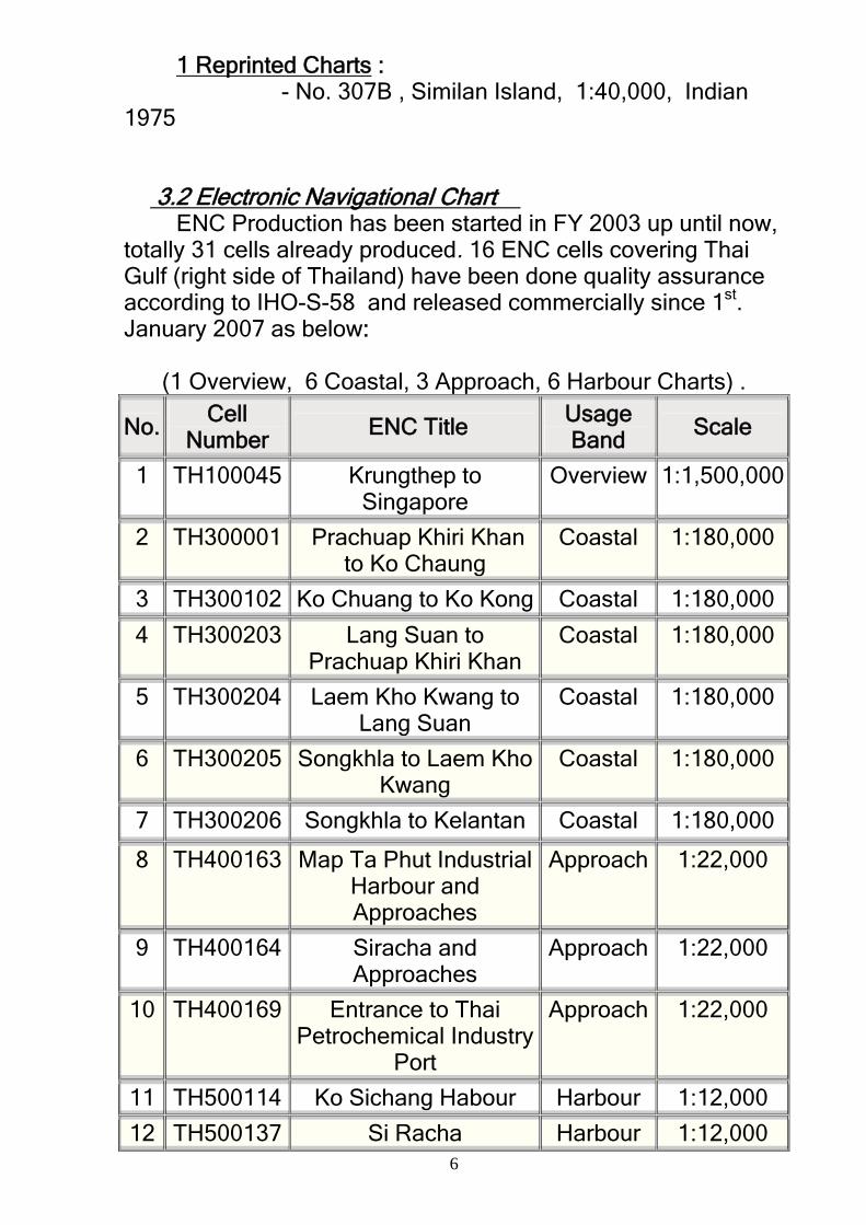
1 Reprinted Charts : - No. 307B , Similan Island, 1:40,000, Indian 1975 3.2 Electronic Navigational Chart
ENC Production has been started in FY 2003 up until now, totally 31 cells already produced. 16 ENC cells covering Thai Gulf (right side of Thailand) have been done quality assurance according to IHO-S-58 and released commercially since 1st. January 2007 as below:
(1 Overview, 6 Coastal, 3 Approach, 6 Harbour Charts) .
No. Cell Number
ENC Title Usage Band
Scale
1 TH100045 Krungthep to Singapore
Overview 1:1,500,000
2 TH300001 Prachuap Khiri Khan to Ko Chaung
Coastal 1:180,000
3 TH300102 Ko Chuang to Ko Kong Coastal 1:180,000
4 TH300203 Lang Suan to Prachuap Khiri Khan
Coastal 1:180,000
5 TH300204 Laem Kho Kwang to Lang Suan
Coastal 1:180,000
6 TH300205 Songkhla to Laem Kho Kwang
Coastal 1:180,000
7 TH300206 Songkhla to Kelantan Coastal 1:180,000
8 TH400163 Map Ta Phut Industrial Harbour and Approaches
Approach 1:22,000
9 TH400164 Siracha and Approaches
Approach 1:22,000
10 TH400169 Entrance to Thai Petrochemical Industry
Port
Approach 1:22,000
11 TH500114 Ko Sichang Habour Harbour 1:12,000
12 TH500137 Si Racha Harbour 1:12,000

7
13 TH500156 Laem Chabang Port Harbour 1:12,000
14 TH500157 Map Ta Phut Industrial Harbour
Harbour 1:12,000
15 TH500170 Thai Petrochemical Industry Port
Harbour 1:12,000
16 TH50115A Sattahip Commercial Port
Harbour 1:12,000
The mariners can visit HDRTN website for more details and also download ENC monthly update file every on the 5thof the month on www.navy.mi.th/hydro/chartservice. 14 cells covering
Andaman coast (left side of Thailand have been planed to produce in 2007.
Fig. 16 ENCs covering Thai Gulf, already released
commercially 3.3 INT Charts Activities

8
For INT Chart in Area J, HDRTN is responsible for 4 INT Charts on the Andaman Coast which were informed to National Hydrographic Office of India for consideration of INT Chart No. as follows.
INT No. Producer National No. Scale 1 :
*** TH 362 700,000 *** TH - 300,000 *** TH 335 20,000 *** TH 335A 20,000
Note *** = INT Chart number will be assigned by NIOHC.
4. New Publication and Updates :
- Tide Table 2007 - Table of Moon – Sun Rise/Set 2007
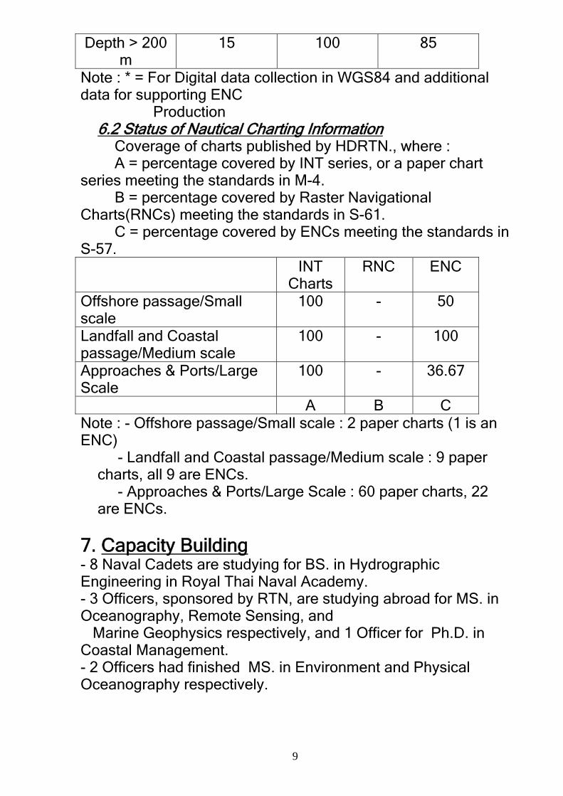
5. Marine Safety Information Notice to Mariners both in Thai and English languages have been distributed daily through the Navy Radio Station and Radio Station for Navigation (Bangkok Radio). The information issued to mariners are mostly concerned with Chart correction, Aids to Navigation status, Ship wrecks, Navy Exercise, and Oil & Gas Exploration Activities. 6. S-55 (latest update - table) 6.1 Status of Hydrographic survey of all navigable waters, including internal waters, out of the limits of the EEZ. Survey coverage, where : A = percentage which is adequately surveyed. B = percentage which requires re-survey at larger scale or to modern standards. C = percentage which has never been systematically surveyed. A B C Depth < 200
m 100 70 * -
9
Depth > 200 m
15 100 85
Note : * = For Digital data collection in WGS84 and additional data for supporting ENC Production 6.2 Status of Nautical Charting Information
Coverage of charts published by HDRTN., where : A = percentage covered by INT series, or a paper chart
series meeting the standards in M-4. B = percentage covered by Raster Navigational
Charts(RNCs) meeting the standards in S-61. C = percentage covered by ENCs meeting the standards in
S-57. INT
Charts RNC ENC
Offshore passage/Small scale
100 - 50
Landfall and Coastal passage/Medium scale
100 - 100
Approaches & Ports/Large Scale
100 - 36.67
A B C Note : - Offshore passage/Small scale : 2 paper charts (1 is an ENC)
- Landfall and Coastal passage/Medium scale : 9 paper charts, all 9 are ENCs. - Approaches & Ports/Large Scale : 60 paper charts, 22 are ENCs.
7. Capacity Building- 8 Naval Cadets are studying for BS. in Hydrographic Engineering in Royal Thai Naval Academy. - 3 Officers, sponsored by RTN, are studying abroad for MS. in Oceanography, Remote Sensing, and Marine Geophysics respectively, and 1 Officer for Ph.D. in Coastal Management. - 2 Officers had finished MS. in Environment and Physical Oceanography respectively.

- 1 Officer had completed multibeam training course in Singapore, sponsored by IHO CBC
Fig. 5 HTMS. SUK, an oceanographic survey vessel 8. Oceanographic Activities 8.1 Oceanographic Survey : Conducting 1 surveys in the Gulf of Thailand by HTMS. Suk (Fig.5),
8.2 Tidal Recording and Prediction : 8.2.1 Maintenance of 12 Tidal Stations and conducting the tidal prediction on 26 sites for production
of Tide Table Year 2007 8.2.2 Establishment of digital tidal station network for
tsunami warning on the Andaman coast, comprising of 9 tidal stations (Fig.6) including :
- Paknam Ranong - Ko (Island) Tarutao - Ko Surin - Ko Miang - Kuraburi - Kantang - Ao (Bay) Taplamu - Ko Tapaonoi - Ko Rachanoi
10

Fig .6 Digital Tidal stations installed along the Andaman Coast
8.3 Coastal Engineering Activities : 8.3.1 Surveying for Erosion Study in Naval Bases. 8.3.1 Conducting 8 small surveys for supporting 2 Royal Projects concerning erosion study in Chonburi, Nakhonsrithammarat and Pang-nga Provinces. 9. Other Activities : 9.1 Aids to Navigation Activities 9.1.1 Maintenance of Aids to Navigation in Thai Water by HTMS. Suriya (Fig.7) including 14 Lighthouses, 70 Beacons, 2 Leading Lights, 60 Lit Buoys, and 32 Unlit Buoys.
11

9.1.2 Establishment of more Aids to Navigation on the Andaman Coast after Tsunami attack : - Installation of 4 more large buoys and 32 more medium size ones. - Installation of 3 new Leading Lights in Khao Lak and Ranong - Installation of a new unlit Beacon in Ao Tablamu 9.1.3 Establishment of 3 AIS base stations in Bangkok, Chonburi and Songkla Provinces to monitor and control the status of Ko Phai and Ko Chuang lighthouses (AtoN AIS). More AtoN AIS are planned to install on the rest of them in the near future.
Fig.7 HTMS. SURIYA
9.2 Meteorological Activities : Meteorological Division (located in Sattahip, Chonburi Province) has performed the weather forecast to support Naval Operation including Naval Aviation. Wave Analysis Model had been applied for wave prediction whereas the Storm surge has been predicted by using Princeton Ocean Model. 9.3 Navigational Aids Activities : Navigational Aids Division responsible for procurement of navigational equipments including distribution and maintenance solely for supporting naval vessels and combat units. 4803 navigational charts and 625 publications were distributed to Naval vessels , whereas 8189 charts and 4594 publications were sold to the public respectively. 9.4 Standard Time Keeping Activity:
12

13
Navigational Aids Division is also responsible for Standard Time Maintenance with Cesium Clock including standard time and International time services through the phone and Internet. 10. Conclusion HDRTN is the Thai national organization responsible for hydrographic activities and production of nautical charts and ENCs covering Thai waters. During the past five years, it has developed its survey method and cartographic process rapidly even sometimes gets difficulty on limited budget. Like many HOs, HDRTN is planning to have full automated survey and cartographic process in the near future to fulfill its requirements and meet IHO Standard. New modern equipments (e.g. more multi-beam systems, DGPS Base Stations) and also an under construction hydrographic vessel will be completed and commissioned in the next two years. As a member of IHO, it also looks forward to developing co-operation with other hydrographic organization not only regionally but also globally. HDRTN has been solving its best to enhance capacity in the field of hydrography for the benefit of all mariners and its beloved country.