country: burkina faso project document climate...
TRANSCRIPT

UNDP Environmental Finance Services Page 1
United Nations Development Programme
Country: Burkina Faso
PROJECT DOCUMENT1
Project Title: Strengthening Climate Information And Early Warning Systems in Africa for
Climate Resilient Development and Adaptation to Climate Change: Burkina Faso
UNDAF Outcome(s):
UNDAF Pillar 1 Outcome 4 By 2015, national institutions and local communities use an integrated
approach for sustainable natural resource management and take into account adaptation to climatic
change
UNDAF Pillar 1 Outcome 5 By 2015, national authorities and local communities are better prepared and
can respond efficiently to emergencies and natural catastrophes
UNDP Strategic Plan Environment and Sustainable Development Primary Outcome: strengthened
national capacities, including the participation of women to prevent, reduce, mitigate and cope with the
Impact of the systemic shocks form natural hazards.
UNDP Strategic Plan Secondary Outcome: Strengthened capacity of developing countries to mainstream
Climate change adaptation policies into national development plans.
Expected CP Outcome(s):
1) Contribute to achieving the MDGs and the establishment of sustainable growth
2) Reinforce the government and its institutions
Expected CPAP Output(s):
Outputs for catastrophe management include:
1) The response capacity of national prevention institutions at national and local levels are
reinforced
2) Catastrophe management institutions at national and decentralized levels are better equipped and
able to respond to emergencies
Executing Entity/Implementing Partner:
Permanent Secretariat for the National Advisory on the Environment and Sustainable Development (SP / CONEDD)
Implementing Entity/Responsible Partners:
Ministry of Transport (MT), Ministry of Environment and Sustainable Development (MEDD),
Ministry of Social Action and National Solidarity (MASSN), Ministry of Agriculture (MAHRH),
Ministry of Communication (MC), Ministry for the Promotion of Women (MPF)
1For UNDP supported GEF funded projects as this includes GEF-specific requirements

UNDP Environmental Finance Services Page 2
Programme Period: 2013-2017
Atlas Award ID: 00074218
Project ID: 00086732
PIMS ID: 5104
Start date: September 2013
End Date: September 2017
Management Arrangements NIM
PAC Meeting Date 31 July 2013
Agreed by (Government):
Date/Month/Year
Agreed by (Executing Entity/Implementing Partner):
Date/Month/Year
Agreed by (UNDP):
Date/Month/Year
Brief Description
It is expected that as climate change unfolds, the variability of the frequency and intensity of climate
related shocks will increase, thereby necessitating key economic sectors to adapt. In a developing
country such as Burkina Faso, climate change impacts are exacerbated by limited outreach mechanisms
to local levels and a country dependence on subsistence agriculture. For Burkina Faso, improving
Climate Information (CI) and developing an Early Warning System (EWS) is an effective way to build
the general population’s weather /climate risk awareness, so that they prepare accordingly and better
manage long-term climate change risks, and associated uncertainties. Currently, a national EWS/CI for
multi-risk forecasting (e.g. floods, droughts, strong winds) and the capacities to produce and disseminate
weather/climate information does not exist in Burkina. In order to have an effective system, it is
necessary to improve the existing network of weather/climate monitoring infrastructure and to help build
technical and operational capacitiesto efficiently produce and deliver targeted forecasts for planning and
decision-making. This project, with financing from the Least Developed Country Fund (LDCF) will
address such needs. One component of the project will be used to improve weather, climate and
environmental monitoring. A second component will be used to strengthen/develop national systems to
package forecast warnings based on user-needs and to effectively disseminate warnings and other
relevant information and data to assist decision-making processes. In conjunction with other ongoing
initiatives of relevance outlined in this project document, LDCF resources are expected to enhance the
adaptive capacity of vulnerable populations throughout Burkina to respond to extreme weather events as
well as to facilitate long-term climate resilient development planning at the national and sectoral levels.
Total resources required $ 64,690,525
Total allocated resources: $ 64,690,525
GEF/LDCF $ 3,600,000 Government (Grant) $ 53,550,000 Government (Cash) $ 40,525 UNDP (Grant) $ 5,600,000 USAID (Grant) $ 1,900,000

UNDP Environmental Finance Services Page 3
TABLE OF CONTENTS
1 Situation analysis .............................................................................................................................. 7
1.1 Problem statement .................................................................................................................. 7
1.2 Preferred solution ................................................................................................................... 9
1.3 Barriers to achieving the solution ........................................................................................ 10
1.3.1 Insufficient coverage of weather, climate and hydrological monitoring infrastructure required
to support the generation of reliable forecasts .................................................................................... 10
1.3.2 Slow data transmission from manual hydro-meteorological infrastructure ............................ 10
1.3.3 Poor long-term budget planning ............................................................................................. 10
1.3.4 Insufficient technically skilled human resources .................................................................... 11
1.3.5 Limited synergy amongst EWS-related initiatives / agencies ................................................. 11
1.3.6 Inconsistent cross-sectoral information dissemination and data sharing ................................ 11
1.3.7 Limited capacity and no standard operating procedure to disseminate warnings ................... 12
1.3.8 Need for weather/climate information to be tailored to user-needs ........................................ 12
2 Strategy ........................................................................................................................................... 13
2.1 Project rationale and policy conformity ............................................................................. 13
2.2 Country ownership: country drivennessand country eligibility ...................................... 16
2.2.1 Country drivenness ................................................................................................................. 16
2.2.2 Country eligibility ................................................................................................................... 18
2.3 Design principles and strategic considerations................................................................... 19
2.3.1 On-going relevant national and regional related initiatives .................................................... 19
2.3.2 Baseline projects and financing .............................................................................................. 22
2.3.3 National and local benefits ...................................................................................................... 24
2.3.4 UNDP comparative advantage ................................................................................................ 25
2.4 Project Objective, Outcomes and Outputs/Activities ........................................................ 26
2.4.1 Baseline Component 1, Without LDCF Intervention.............................................................. 27
2.4.2 Adaptation Alternative Component 1, With LDCF Intervention ............................................ 30
2.4.3 Baseline Component 2, Without LDCF Intervention.............................................................. 35
2.4.4 Adaptation Alternative Component 2, With LDCF Intervention ............................................ 37
2.5 Key indicators, risks and assumptions ................................................................................ 44
2.6 Cost-effectiveness .................................................................................................................. 46
2.7 Sustainability ......................................................................................................................... 53
2.8 Replicability ........................................................................................................................... 54
2.9 Stakeholder involvement ...................................................................................................... 55
2.9.1 Stakeholder baseline analysis .................................................................................................. 55
2.9.2 Stakeholder involvement plan ................................................................................................. 58
2.9.3 Expected benefits .................................................................................................................... 58
3 Project Results Framework ........................................................................................................... 60
4 Total Budget and Workplan ......................................................................................................... 63

UNDP Environmental Finance Services Page 4
5 Management Arrangements .......................................................................................................... 67
6 Monitoring Framework and Evaluation ...................................................................................... 71
7 Legal Context .................................................................................................................................. 74
8 Annexes ........................................................................................................................................... 75
Annex1: Risk Analysis .......................................................................................................................... 75
Annex2: Cofinance and Direct Project Cost Agreements ................................................................. 78
Annex 3: References ............................................................................................................................. 83
Annex 4: Key assessment reports ........................................................................................................ 84
Annex 5: Minutes from Meeting between DGM and Private Sector Representatives ................. 140
Annex 6a: Existing Water Level Monitoring Networks(Source: DGRE, Burkina Faso) ............. 142
Annex 6b: Existing Flow Meter Monitoring Networks (Source: DGRE, Burkina Faso) ............. 143
Annex 6c: Proposed ADCP Monitoring Network ............................................................................ 144
Annex 7a: Existing Weather Monitoring Networks ........................................................................ 145
Annex 7b: Proposed Weather Monitoring Networks ...................................................................... 146
Annex 8: Climate Zones in Burkina (Generale Directorate on Meteorology, 1998)..................... 147
Annex 9: Flooding sites (circles) and soil infiltration potential (GIRE Programme, 2001) ......... 148
Annex 10: Stakeholder involvement plan ......................................................................................... 149
Annex 11: Terms of Reference ........................................................................................................... 166
Annex 12: Capacity Assessment Scorecard ...................................................................................... 175
Annex 13: Environmental and Social Screening Procedure ........................................................... 180
Annex 14: Responses to Donor Comments ....................................................................................... 192

UNDP Environmental Finance Services Page 5
List of Acronyms
ASECNA MeteorologicalForecast Center
CAP ConsolidatedAppealProcess
CCC Communication pour un Changement de Comportement
CES Conseil Économique et Social
CI Climate Information
CILSS Comité Inter états de Lutte Contre la Sécheresse au Sahel
CNLES Comité National de Lutte Contre les Effets de la Sécheresse
CNSA National Advisory on Food Security
CONASUR National Advisory for Emergency and Rehabilitation
CORESUR Regional Advisory for Emergency and Rehabilitation
CPAP Country Program Action Plan
CPD Country Program Document
CSO Civil Society Organization
DCIME (Departmental Division on the Understanding of Environmental Information and
Monitoring, Division du Développement des Compétences, de l’Information et
du Monitoring de l’Environnement)
DGPA General Directorate on Fishing and Aquaculture
DGPC Direction Générale de la Protection Civile
DGPEDD Direction Générale de la Préservation de l'Environnement et du Développement
DGPS General Directorate on Sanitary Protection
DGPSA Direction Générale de la Prévision et des Statistiques Agricoles
DGM General Directorate on Meteorology
DGRE General Directorate on Water Resources
DGPV General Directorate on Vegetable Production
EWS Early Warning System
HDI HumanDevelopment Index
IPC Indice de Perception de la Corruption
MAF/CAO Cadre d’Accélération des OMD
MAHRH Ministère de l’Agriculture de l’Hydraulique et de Ressources Halieutique
MASSAN Ministère de l’Action Sociale et Solidarité Nationale
MATDS Ministère de l’Administration Territoriale et de la Décentralisation
MDG Millenium Development Goals
MEDD Ministère de l’Environnement et du Développement Durable
MNRC, Mécanisme National et Régional de Coordination des secours d’urgence et de la
réhabilitation
MPF Ministère de la Promotion de la Femme
MRA Ministère des Ressources Animales
NAPA National Adaptation Programme of Action
NGO Non-GovernmentalOrganization
OCHA Bureau de la Coordination des Affaires Humanitaire
PANA Programme d’Action National d’Adaptation
PNSR Programme National du Secteur Rural
PDNA Post DisasterNeedsAssessment
PIB Produit Intérieur Brut / Gross Domestic Product

UNDP Environmental Finance Services Page 6
PMA Paquets Minimum d’Activités
PRSP PovertyReductionStrategyPaper
RGPH Recensement Général de la Population et de l’Habitat
RRC Réduction de Risques et Catastrophes
SAAGA Radar and Cloud Seeding Center for Aeronautical Aviation
SAP Système d’Alerte Précoce
SCADD Stratégie de Croissance Accélérée et de Développement Durable
SISA System Intégré System d’Alert
SMART Standardized Monitoring and Assessment of Relief and Transition
SNSA Stratégie Nationale de Sécurité Alimentaire
SNU Système des Nations Unies
SP/CONEDD Permanent Secretariat for the National Advisory on the Environment and
Sustainable Development
SONAGESS Société Nationale de Gestion du Stock de Sécurité Alimentaire
UGP Unité de Gestion de Projet
UNDAF Plan Cadre des Nations Unies pour l’Aide au Développement
UNDP United Nations Development Program
UNISDR United Nations International Strategy for Disaster Reduction
WFP World Food Program

UNDP Environmental Finance Services Page 7
1 SITUATION ANALYSIS
1. Burkina Faso is highly exposed to extreme weather and climate change impacts, most notably
floods, droughts, strong winds (e.g., harmattan trade winds from the Sahara)and strong variability in the
duration of the rainy and dry seasons. All of these impacts have made it difficult to manage natural
resource-based productive sectors including agriculture, fisheries, and forestry. They have also
compounded the difficulty of planningfor food security, health epidemicsand water resource management,
particularly dam/hydropoweroperations (NAPA 2007).For instance, heavy rainfall in 2009 was
responsible for flooding crops, washing away 22,220 hectares of farmland, breaking 15 dams and
destroying 42,000 homes (PDNA 2010). Also, during hot and dry periods, Burkina becomes victim to the
spread of vector-borne diseases including meningitis and cholera, where in March 2010 alone, a
meningitis outbreak caused 193 fatalities2.
2. It is predicted that extreme weather risks and associated losses are expected to increase in
Burkina Faso34. To build the country’s capacity to plan for such detrimental impacts/events, this project
willstrengthenexistingEarly Warning Systems (EWS)and improveclimate information (CI)
collection/transmission. The project objective supports the overall goal of increasing the resilience of the
most vulnerable populations by empowering them with knowledge on weather forecasts andclimate
scenarios which enables them to take preventive measures against expected impacts. However,in Burkina
Fasocapacities to strengthen adaptation during crises/catastrophes related to extreme weather at
decentralized levels are relatively limited; communes and decentralized line Ministries have limited
knowledge of adaptation needs and options. Furthermore, although post-disaster management
mechanisms exist, there is no top-down and bottom-up approach to make Burkina’s socio-economic
sectors less vulnerable to weather/climate-related risks; no standard two-way communication system is
available to fully engage local level populations to find optimal use of EWS/CI to prepare for extreme
weather risks and for adaptation to climate change.
1.1 Problem statement
3. In Burkina Faso, one of the challenges for enhanced planning and management based on EWS/CI
stems from a limited network of hydro-meteorological monitoring infrastructure which can consistently
transmit data at a fast enough frequency to effectively provide weather forecasts and help to predict climate
scenarios. A lack of meteorological and hydrological monitoring stations has meant that many important
regions and populations vulnerable to climate hazards are not monitored e.g. drought conditions (e.g., soil
moisture) are not monitored for important agricultural lands, intense rainfall is not monitored in areas prone
to landslides and flooding, and rapid rises in rivers as a precursor to flooding go unnoticed. As a result,
many potentially threatening hazards have not been anticipated and some foreseen consequences have not
been mitigated. A prime example is the 2009 major flood event, one of the most destructive floods in
Burkina history, where Burkina was unable to alert the population.Furthermore, where stations exist, they
are often manually operated and do not report measurements for several weeksafter the climate hazards have
passed. Equipment failure is also common and regular checks and maintenance areoften neglected due to
insufficient funds and poor budget planning resulting in poor quality and unreliable data for decision-
making.
2 Burkina Faso: Meningitis International Federation’s Disaster Relief Emergency Fund (DREF) 3IPCC, 2012, Managing the Risks of Extreme Events and Disasters to Advance Climate Change Adaptation.
Cambridge University Press, Cambridge UK 4GFDRR report, April 2011.Vulnerability, Risk Reduction, and Adaptation to Climate Change, Burkina Faso,
Climate Risk and Adaptation Country Profile.
UNDP Environmental Finance Services Page 8
4. Additionally satellite data is not fully exploited to forecast rainfall, soil moisture or monitor severe
weather due to limited equipment required to download and visualize data effectively. Burkina was a
recipient of the African Monitoring of the Environmental for Sustainable Development (AMESD) and
Africa Adaptation Project (AAP) project until 2012 which provided a satellite receiving station for the
reception of environmental data specific to Burkina. However, these programsfocused on procuring
equipment and did not include sufficient capacity reinforcement for technical personnel on how they could
effectively interpret and display the data for end users. By not establishing the groundwork for how to
deliver satellite data services such as preparing drought risk maps, Burkina Faso currently does not have the
know-how and remaining visualization equipment to produce useful maps and analyses which can assist
long-term risk planning.
5. The radar network for monitoring rainfall is also limited in Burkina Faso; two radar exist at airports
located in Ougadougou and BoboDioulasso and are operated and maintained by the Radar and Cloud
Seeding Center for Aeronautical Aviation program (SAAGA). Both radarhave been installed to aid air
traffic control, however, only the radar in Bobo is currently functional. (Another radar is housed within the
Met Service building, however, this radar is used for African Monsoon Multidisciplinary Analysis (AMMA)
research purposes only.)The radar has ceased functioning in Ouagadougou due to poor budget planning for
recurring costs such as maintenance and spare parts.
6. With the African Adaptation Programme (AAP), Burkina Faso benefited from financial support to
up-scale the number of existing weather stations and capacity development activities to set up equipment,
training on maintenance and also dissemination of climate data. However this program did not cover the
advanced techniques necessary to improve technical capacity and human resources required to prepare
weather forecasts for the coming 1-7 days using a combination of Numerical Weather Prediction (NWP)
models and predictions either from neighbouring countries or international centres. In situations where
forecasts are externally sourced, forecasters are dependent on the applicability of the forecasts to local
conditions and restricted in their ability to apply local observations to develop better forecasts (i.e., data
assimilation). In the case of Burkina Faso, regional seasonal forecasts, such as the ACMAD’s PRESAO
forecasts are currently utilized by DGM, however, such forecasts are not sufficiently downscaled and
localized to be appropriate for all of Burkina’s three climate zones, nor useful for any further localized
analysis that can aid adaptation planning.
7. Burkina also lacks tailored weather and climate products for specific socio-economic sectors. The
forecasts and climate information are given in the same standard formats for different users and this restricts
their interpretation and application. For example, agricultural extension officers require information about
the start of the rains, or the frequency of days with rain, whereas those monitoring floods require
information on rainfall intensity. Extracting these particular attributes from forecasts is currently not
possible;weather forecasts are published in bulletins and on television with data concerning the next 24
hours. They provide general information on the minimum and maximum temperature of the current and next
day, the quantity of rainfall (mm) and the state of visibility in different geographical regions. In the context
of an EWS for Burkina, it is necessary to havemore refined spatial and temporal estimatesof expected
rainfall intensityand wind speeds to outline with greater certainty, regions at risk. Furthermore, there is a
limited database of climate information required for long-term planning and better management of water
storage, crop selection and cultivation cycles.
8. There are also limited trained technical personnel with the skills required to maintain an
observational network, generateweather forecasts and climate predictions and interpret data in ways that
non-technical stakeholders from various socio-economic sectors can understand. The lack of trained
personnel is compounded by the fact that current technical staff are close to retirement. Without sufficient
technical expertise it is more likely to have gaps in data collection and an absence of hydro-meteorological
equipment maintenance. In the case of Burkina, human capacity is required to:
Take manual measurements and transmit information by post;

UNDP Environmental Finance Services Page 9
Replace components of the observing networks when they fail;
Manage and run forecast models;
Determine how users best understand data and design information packages that address user-needs;
Be able to combine, manipulate and overlay different data to identify areas at risk.
9. In terms of communicating EWS/CI messages, consultations with NGOs/CSOs during project
preparation indicated that local populations do not always understand the technical jargon associated with
weather forecasts. Also, they do not understand the limitations of forecasting in terms of prediction
uncertainty. Furthermore, weather forecasts are currentlydisseminated in the media (TV, radio, written
press, all of which can be public or private), however, there is no mechanism to make the flow of climate
information and alerts more efficient and standardized. Most significantly, due to various absent or false
alarms (as seen in 2008, 2009 and 2010), confidence in alerts must be rebuilt.
10. Furthermore, Burkinabé women, just as women in general, are more vulnerable to the effects of
climate change relative to men; they constitute the majority of the world’s poor (two-thirds, O’Brien 2008)
and are more dependent for their livelihood on natural resources that are threatened by climate change,
particularly those living in rural regions who have limited mobility. The gendered division of household
labour means that women are responsible for the majority of subsistence household chores; women are
generally charged with the responsibility to secure water, food and fuel for cooking and heating and often
have very little time to devote to alternative sources of income due to domestic and farming responsibilities;
in addition, they may be excluded from some activities due to cultural norms, or due to lack of capital and
ownership arrangements that confer all rights to men in the family (Buhl 2005; Eriksen et al. 2005, Eriksen
et al. 2007). This inequality is compounded by a lack of opportunities arising from limited access to
education and information services which prohibit participation in decision-making. Due to all of these
reasons, it is thus important to identify gender-sensitive strategies to ensure women are included in measures
designed to improve their resilience and capacity to adapt to climate change (UN Women Watch 2008).
1.2 Preferred solution
11. The preferred (normative) solution for Burkina Fasois to improve national and decentralized
capacities to better manage and plan for extreme weather and climate-related risks through the
development of an Early Warning System (EWS) and enhanced Climate Information (CI). Specifically,
the solution will include:
Enhancing the capacity of the hydro-meteorological services and networks to monitor and predict
climate variability and extreme weather events;
Ensuring the sustainability of new investments in hydro-meteorological infrastructure including
recurring costs associated with expanded networks and new services;
Developing a rapid and targeted delivery of climate information including early warnings based
on user-needs, both public and private;
Formalizing an efficient communication dissemination protocol involving local focal points to
distribute climate/weather information to vulnerable populations (including women) and;
Strengthening capacities of agencies involved with EWS/CI production and dissemination on
technical, institutional and human resource levels, emphasizing local agency capacity development.

UNDP Environmental Finance Services Page 10
1.3 Barriers to achieving the solution
However, this normative solution is hindered by a number of institutional, financial, technological and
informational barriers including:
1.3.1 Insufficient coverage of weather, climate and hydrological monitoring infrastructure
required to support the generation of reliable forecasts
12. In Burkina Faso there has been a steady decline in infrastructure dedicated to monitoring the
climate, hydrology, environment and severe weather (e.g. meteorological and hydrological observing
stations, satellite receivers etc.) over the last 20-30 years. Whilst this situation has been ameliorated by
specifically targeted project interventions, this has often benefitted a particular aspect of the early warning
system (e.g. African Monitoring of the Environment for Sustainable Development, AMESD,5which has
improved the use of satellite data).
13. Consequently, forecasting local weather/climate risks is presently limited by insufficient
localizedhydro-meteorological data required for model‘ground-truthing’ /validation. Based on
Stakeholder discussions during project development, limited coverage of hydro-meteorological
monitoringhas been identified as a key barrier for risk planning; there is widespread agreement in Burkina
that monitoring networks must be expanded throughout the country, in particular the vulnerable agro-
ecological regions (NAPA, 2007).
14. The sparse monitoring network inBurkina can be explained by several practical constraints:
i) Limited financial support to purchase new equipment or rehabilitate existing equipment;
ii) Need for reliable power sources required to transmit data and perform maintenance;
iii) Insufficient security of the equipment necessary to prevent against theft. Much of the
equipment requires fencing and security guards;
iv) Limited trained personnel required for equipment operation and maintenance. Many
technicians/engineers have retired or are in the process of retiring;
v) Limited means to conduct field validations including equipment calibration, station
maintenance and data quality checks.
1.3.2 Slow data transmission from manual hydro-meteorological infrastructure
15. Data from manual meteorological and hydrological monitoring stations or instruments are
primarily collected on a daily basis by manual observers which have been trained by DGM/DGRE,
recorded on paper, and sent once a month by mail to the principal NHMS offices in Ouagadougou. Very
few automatic, real-time flow or weather measurementsare collected currently. (An exception is the real-
time data collected from 6 automatic, agro-meteorological stations provided through the NAPA1 project).
This prevents decision-making for extreme events occurring with short lead time (e.g., flash floods).
Currently, there are also no SMS/GPRS data communication systems in place to improve the rate of
transmission of manual data collection.
1.3.3 Poor long-term budget planning
16. The maintenance of monitoring equipment, the human capacity to use and repair this equipment,
process data and develop early warning packages, all require sustainable financing mechanisms and
capacity development. Costs to support operation and maintenance as well as salaries and capacity
5http://www.amesd.org/index.php?start=25

UNDP Environmental Finance Services Page 11
building for technical public servants within the NHMS are recurring annual expenditures which require
planning and budgeting. At present, given the public nature of hydro-meteorological goods/services in
Burkina, these expenditures are generally regarded as recurring public expenses which are covered by
annual government budget lines. However, the NHMS often struggles to pay for the maintenance and
upgrade of existing equipment6 due to poor long-term budget planning. Insufficient budgeting has led to
the inability of SAAGA to cover maintenance costs for the radar in Ouagadougou and approximately 40%
of the hydrological equipment to become non-operational.
1.3.4 Insufficient technically skilled human resources
17. Additional human resources are required so that enough technical expertise is available for
equipment maintenance/operation and data analysis/modeling/forecasting. In Burkina, human resources
are one of the main limiting factors for equipment operation, particularly when new equipment is
procured. In fact, it is imperative to continue operation of existing equipment when new infrastructure is
placed on-line so that climate/weather monitoring services are not interrupted. Furthermore, running
forecast models is a highly skilled task and requires many years of education and training. Currently, this
skill is housed within the ASECNA program used solely for aviation purposes in Burkina. Skills must be
gradually transferred by ASECNA to DGM over the course of this project in order for the national
population to receive targeted forecasts which relate to their specific socio-economic activities (e.g.,
fishing, subsistence agriculture).
1.3.5 Limited synergy amongst EWS-related initiatives / agencies
18. Burkina does not have a clear legal mandate for the issuing of warnings because the existing
alerts for famine and dam management act independently. There is limited coordination between projects
and within technical and government institutions to conform alert production and dissemination to one
standard protocol. This has led to parallel roles in alert generation and a lack of information sharing and
lessons learned. For instance, although a basic agro-meteorological information system exists in Burkina,
this system is under-performing and leaves farmers without reliable information for day to day land
management and agricultural practices. Furthermore, there is little collaboration with regional EWS
initiatives, such as with ACMAD’s regional EWS project, VigiRiSC (African Early Warning and
Advisory Climate Services, AEWACS). The implication is that regional alert programs do not build off of
localized national alert projects and the projects progress in a compartmentalized fashion.
19. Further down the alert dissemination chain, various NGOs/CSOs act independently to
disseminate alert information without being able to report to consistent focal points that can be held
accountable for alert communication. Furthermore, feedback from end-users required to validate and
improve alerts is entirely lacking in Burkina.
1.3.6 Inconsistent cross-sectoral information dissemination and data sharing
20. There is nocentralization of hydro-meteorological / environmental data due to various institutions
acting as information producers with limited means to transfer data efficiently between institutions. Most
of the existing environmental data is not archived securely and awareness of information databases at
different departments and institutions is limited. As concluded during Stakeholder conversations, all the
information required to assess vulnerability and calculate risks needs to be transparent and accessible
through a centralized portal. Accessible data can enable correlations of weather and hydrology data with
other important environmental variables (such as the spread of water-borne diseases) or the creation of
environmental variable maps; moreover, interdisciplinary data analysis can have broader relevance and
6see WMO Global Framework for Climate Services

UNDP Environmental Finance Services Page 12
application for local intervention planning and monitoring, as well as fostering a culture of knowledge
generation for the future.
21. There is also a need to facilitate data sharing with countries in the region. The majority of West
African countries depend on regional climatic zones which have similar weather and climate patterns.
Regional forecasts from international and regional centres simulate weather and climate across
countriese.g. seasonal forecasts produced through PRESAO and ACMAD. Similarly, the hydrologic
network is linked between countries (Benin, Mali, Niger, Togo, Cote d’Ivoire, Ghana) because
watersheds and rivers traverse country boundaries; rain patterns upstream must be communicated to
downstream Burkina. Consequently hydrological models are lacking appropriate boundary and initial
conditions because Burkina does not have centralized data to share and a centralized server which can
facilitatethe storage and receipt of international data.
1.3.7 Limited capacity and no standard operating procedure to disseminate warnings
22. The Government of Burkina Faso has an established decentralized governance system on commune
(district) levels to support local communities. However, the budgets available to decentralized governments
are limited and consequently they do not have the financial means to buy communication equipment or
work with NGOs/CSOs and private media to reach out to local populations and provide them risk
information. Also, local community focal points / representatives do not have an official role in
communication protocols and community members do not have a means to provide feedback to local
representatives on the efficacy of communication.
23. At their local branch levels, the Burkina Disaster Risk Management Unit, CONASUR and
NGOs/CSOs (CPF, SOS Sahel, etc) currently have limited technical capacity to disseminate alert
messages and the means to plan for catastrophes. The provincial, departmental and local branches of
CONASUR do not have the capacity to interpret, simplify and relay technical, meteorological and
climatological information and alerts. Also, many dissemination agencies do not have the physical means
to communicate efficiently so that information can be relayed from national to local levels and vice versa.
Based on Stakeholder consultations, aStandard Operating Procedure (SOP) through which CONASUR,
communication agencies (e.g., SIG) and NGOs/CSOs can have a formalized role in the alert/information
communication loop is necessary.
1.3.8 Need for weather/climate information to be tailored to user-needs
24. Burkina does not have the technical capacity to generate weather forecasts and climate
predictions which are useful to socio-economic sectors (e.g., agricultural, livestock, construction) for
planning purposes. The lack of coordination between agencies has not enabled the integration of satellite
imagery which can significantly aid in providing national coverage of useful information, such as soil
moisture for livestock and cultivation planning. Also, there is no capacity to provide forecasts per region
which is necessary for local planning. Weather bulletins must be tailored to specific sectors in an
appropriate, non-technical language, responding to local needs and priorities.If products are tailored
appropriately, then various sectors will support weather/climate services and ensure their sustainability. It
should be noted that if the government sees the utility and indispensability of climate services, its
financial support is more likely ensured.
25. Stakeholder discussions during project development indicated that forecasts/predictions should be
translated into specific hazards experienced by different sectors and users e.g. heat units for livestock or
wind speeds for agriculture. This information should then be combined with known vulnerabilities to
identify areas and communities at risk. Furthermore, the warnings are often too technical for end-users. A
breakdown exists in message dissemination because clarification is needed between the producers and
communicators of EWS messages. Collaboration between the communication agencies (local, regional

UNDP Environmental Finance Services Page 13
and national) and the alert generation agencies must take place so that weather forecasting jargon can be
simplified for the general public. Simplified alerts must also be translated into all national languages.
2 STRATEGY
26. No single initiative can completely remove all of the barriers aforementioned. Nonetheless, this
project (hereafter referred to as the LDCF2 project) will work in conjunction with other EWS/CI-related
initiatives to build off of their advances in removing these barriers7.
The LDCF2 projectaims to address the above barriersby achieving the following two outcomes:
27. Outcome 1 of the project will procure new climate/weather and hydrological monitoring
equipment and the rehabilitation of existing infrastructure. It will also build capacity for more efficient
data transmission/treatment and for equipment operation and maintenance.
28. Outcome 2 will strengthen national and local capacities to effectively use and efficiently
disseminate hydro-meteorological and environmental information/alerts. EWS/CI will be targeted to end-
users so that they can build resilience to extreme weather / climate risks through adaptation measures. The
integration of EWS/CI into long-term development plans will also be facilitated.
29. By achieving these outcomes, the project will strengthen the capacity of national and sub-national
entities to monitor climate change, generate reliable hydro-meteorological information (including
forecasts) and combine this information with other environmental and socio-economic data to improve
evidence-based decision-making for early warning and adaptation responses. On a local level, the project
will help Burkina Faso communities (particularly the most vulnerable ones and targeting women)to adapt
and build resilience to climate-induced impacts by providing them with climate/weather riskinformation
and an understandingrequired for anticipatory and autonomous adaptation.
2.1 Project rationale and policy conformity
30. The Government of Burkina Faso became a signatory to the United Nations Framework
Convention on Climate Change(UNFCCC)in 1992 and is classified among the non-Annex 1 parties.
Burkina developed and submitted their National Adaptation Programmes of Action (NAPA) in 2007 and
is entitled to benefit from the LDC Fund for the implementation of NAPA priority measures. In
implementing priority interventions identified in the NAPAs, the project is consistent with the Conference
of Parties (COP-9) and also satisfies criteria outlined in the UNFCCC Decision 7/CP.7 and GEF/C.28/18.
The project has been endorsed by the national UNFCCC and GEF focal points.
31. The project responds to priorities and actions identified in the National Adaptation Programmes
of Action (NAPA) of Burkina Faso. The NAPA clearly identifies the need for EWS in their number 1
priority action, "Strengthening prevention systems and early warning systems for food security".
32. This project is specifically aligned with NAPA objectives including i) increased knowledge and
understanding of climate variability and change-induced risks at the country level and in targeted
vulnerable areas, ii) strengthened adaptive capacity to reduce risks to climate-induced economic losses
andiii) successful demonstration, deployment, and transfer of relevant adaptation technologies. The
7Note that with the approval of this initiative,Burkina Faso will have two (2) initiatives under implementation and
financed by the LDCF that are based on the priority project profiles identified in the country’s NAPA. To avoid
confusion, the first NAPA follow up project will be referred to as the LDCF1 project and the current one on
EWS/CI, the subject of this project document will be referred to as the LDCF2 project.)

UNDP Environmental Finance Services Page 14
Burkina NAPA also articulates the need for securing, transferring and installing critical technologies, as
well as developing the necessary systems for climate change-related information to permeate into
decision-making processes. The technologies and capacity building required to achieve these aims will
increase the capacity of the national early warning network to forewarn and rapidly respond to extreme
climate events.
33. Burkina has also defined national actions and policies oriented to creating a basis for sustainable
development. The Poverty Reduction Strategy Papers (PRSPs) in Burkina include the Strategic
Framework for the Fight against Poverty (CSLP) and the Rural Development Strategy (SDR). Since
2000, Burkina Faso has tried to combat poverty through the CSLP. The Framework was revised in 2003
and takes into account the Millennium Development Goals (MDGs). Under the revised Framework,
specific Priority Action Programmes (PAPs) were developed to achieve the objective of poverty reduction
by 2015. Major objectives of the PAPs include substantially reducing poverty, increasing the Gross
Domestic Product per capita (GDP / H) and increasing Burkinabe life expectancy from 54 (2002) to 60
years (2015). However, ten years have passed since the CLSP was revised, and the results are not
sufficient. Overall, poverty has declined significantly, however, still at least four out of ten Burkinabe are
considered to be in poverty.
34. In 2008, a peer review of the CSLP 2004-2008 was conducted,and concluded that “environment
should be strengthened together with the economic and social pillars of sustainable development.” In
response, a new strategy, the Strategy for Accelerated Growth and Sustainable Development (SCADD,
2011-2015) was developed and is currently being implemented. The difference with the SCADD is that it
focuses on the role of local authorities and requires revisiting decentralization policies. It also promotes
the implementation of a Budget Programme to enable new dynamic programming, evaluations, resource
allocations and implementations of development activities. SCADD is driven to improve result
management, strengthen national leadership and improve the participation of non-state actors.
35. The four strategic axes of the SCADD include:
Accelerating economic growth based on infrastructure development;
Establishing human capital and social protection;
Strengthening the economic, political and administrative dimensions of national and local
governance and;
Accounting for cross-cutting priorities: gender, population, environmental planning and capacity
building
36. Burkina Faso has also developed a Poverty Environment Initiative (PEI) to create links between
poverty and the environment. PEI-Burkina, formulated by the UNDP Country Office (CO), is supporting
sectoral policies to integrate environment and climate change as a cross-cutting issue in revised
development plans. It is also contributing to the SCADD process by providing documentation and
information to the SCADD Secretariat and has been integrated into the Ministry on the Environment’s
three-year plan, which is an integral part of Burkina Faso’s Rural Sector programme (PROSDRp).
37. Burkina Faso is furthermore focusing on addressing access of the poor to social protection. The
Government implemented an emergency management unit, the National Council for Emergency and
Rehabilitation (CONASUR) equipped with a permanent secretariat in 2006. Its primary mandate is to
mitigate the effects of disasters on populations and adhere to the National Multi-risk Contingency Plan for
Preparation and Response to Catastrophes (2008) and the National Civil Protection Policy adopted in
2010. The national contingency plan for disaster preparedness and response aims to: i) clarify the
relationship / responsibilities between the State technical services and humanitarian partners ii) facilitate
the coordination of and enable alignment of sector plans iii) identify and reduce most likely risks iv)

UNDP Environmental Finance Services Page 15
provide a general framework for joint planning covering emergency risks v) integrate the process of
prevention, preparedness and response emergency plans and programs in national development and vi)
reduce the response time and the number of casualties. These mandated activities by CONASUR support
the elaboration of EWS for natural catastrophes.
LDCF conformity
This project is fully consistent with LDCF objectives and priorities:
38. Component 1 of this project supports LDCF/SCCF area objective 3 by promoting the transfer and
adoption of adaptation technologies. The technologies to be adopted in this project include hydro-
meteorological infrastructure required to support a national EWS.
39. Component 2 of this project supports LDCF/SCCF area objective 2 by increasing the adaptive
capacity to respond to the impacts of climate change, including variability, at local, regional and national
levels. Specifically, Component 2 will facilitate mainstreaming EWS/CI into development frameworks
(PEI, SCADD) to support adaptive measures in vulnerable areas. Furthermore, Component 2 of this
project promotes strengthened awareness of adaptation and climate risk reduction measures at the local
level.
40. Outcomes 1 and 2 of this project are aligned with the GEF/LDCF portfolio level
outcomes/outputs, namely
Disaster prevention and response improved through updated and expanded DRM policies and plans
that incorporate climate change risks and incentivize lower-risk development and;
Capacity development at the local level to implement climate-related disaster prevention measures
GEF conformity
41. The project has been designed to meet overall GEF requirements in terms of design and
implementation. For example:
Sustainability: The project has been designed to be sustainable at village and at national levels by
building the capacity of local information dissemination organizations (e.g., CODESUR), extending the
hydro-meteorological network nationally and developing an open-access data portal to enhance the utility
of EWS/CI. Standard Operating Procedures will be put into place for alert communication and equipment
operation and maintenance and can be easily followed after project completion. Training will also be
provided to tailor climate product services geared towards public/private user-needs.
Monitoring and Evaluation: The project is accompanied by an effective and resourced M&E framework,
that will enable an on-going adaptive management of the project, ensuring that lessons are learnt,
management decisions are taken based on relevant and up-to-date information, and regular progress
reports are available for concerned parties.
Replicability: Great attention has been paid in the project design to ensure that lessons are replicable,
sufficient training builds capacity to transfer expertise into other initiatives and that necessary replication
mechanisms are in place.
Stakeholder involvement: Following on from the NAPA process, the design of this project was
undertaken in a participatory manner. Moreover, the design of the project has ensured the appropriate
involvement of stakeholders (actors and users) in project development and implementation (See Section
2.9).

UNDP Environmental Finance Services Page 16
Multi-disciplinary approach: the project will undertake a number of activities to ensure various
Ministries, NGOs/CSOs are fully engaged, have capacities built and can contribute to an efficient EWS
and the delivery of climate products useful to a range of socio-economic sectors and end-users.
Gender equality: the project Outcomes will contribute to an understanding of weather/climate related
risks and required adaptation responses. Public awareness campaigns and the integration of women’s
groups (e.g. Women in Law and Development in Africa,WILDAF) will strengthen gender equality in
terms of women’s ability to react to extreme weather and adapt to climate change. The project has also
ensured and will continue to ensure that women are part of interventions and management committees
and can voice their suggestions/concerns on the effectiveness of EWS/CI with the development of an end-
user feedback mechanism.
Complementary approach: In order to build upon existing plans and avoid the duplication of efforts, the
project will work in conjunction with relevant on-going projects in Burkina Faso and will create a multi-
agency platform to ensure synergy among EWS agencies and with EWS-related initiatives.
42. This project is also aligned with the GEF Result Based Management Framework for Adaptation
to Climate Change by including activities which are aligned with key GEF indicators.
Incorporating climate information, warning, and climate change projections into DRM plans, policies
and programmes (GEF indicator 1.1 and 4.4, Project Output 2.3)
Strengthening stakeholder comprehension, particularly those most vulnerable, of alerts and climate
information by clarifying technical forecast jargon in training sessions (GEF indicator 1.2, Project
Output 2.2)
Sustaining the technical and operational capacity built within DGM, DGRE and CONASUR and the
availability of skills and resources beyond the project lifetime through the development of Standard
Operating Procedures (GEF indicator 4.3, Project Outputs 1.6, 2.1, 2.5)
43. The proposed project has been prepared fully in line with guidance provided by GEF and the
LDCF Trust Fund. The project follows the guidance from the ‘Programming Paper for Funding the
Implementation of NAPA’s under the LDC Trust Fund (GEF/LDCF 2006). The project focus is also
aligned with the scope of expected interventions as articulated in the LDCF programming paper and
decision 5/CP.9. As climate impacts fall disproportionately on the poor, the project recognizes the links
between adaptation and poverty reduction (GEF/C.28/18, 1(b), 29).
2.2 Country ownership: country drivennessand country eligibility
44. This EWS/CI project is not associated with any particular sector; rather, it is intended to intervene
nationally by producing early warnings and climate information to support many areas such as food
security / agriculture, water management, health and energy.
2.2.1 Country drivenness
45. The project has been formulated based on Burkina’sNational Framework for Climate Services.
This framework was developed in late July 2012 following a three-day workshop led by the World
Meteorological Organization. The workshop involved numerous governmental and non-governmental
institutions concerned with hydro-meteorological information who together outlined a roadmap for the
establishment of climate services. The roadmap has been used to help identify suitable investments and
capacity building activities. Annex 5 shows the conclusions from the WMO climate services workshop
indicating recommended activities to establish an EWS and outlining the lead institution and funding
sources.

UNDP Environmental Finance Services Page 17
46. The project is also fully aligned with the UNDAF outcomes, which address adaptation to climate
change specified in the National Strategy on Climate Change as a matter of priority and the need to
prepare local communities against natural catastrophes. Similarly, this project will coincide with the CP
Outcomes and CPAP Outputs by reinforcing government institutions to produce/deliver EWS/CI so that
national and decentralized levels are better equipped to handle emergencies.
47. The Project is linked to country priorities of the UNDAF outcome 2.1 “Improved sustainable
natural resource utilization and food security”, 2.2 “Improved access to sustainable livelihoods
opportunities in an innovative and competitive private sector”, and UNDAF outcome 2.3 "Improved
access to sustainable basic infrastructure”. EWS/CI will support all outcomes by providing forecasts
(short-term and seasonal) based on end-user needs.
48. The project also directly addresses priorities in the Second National Communication (SNC) for
Burkina Faso (2008) created under the UNFCCC and developed with the support of the Ministry on the
Environment and Sustainable development (MEDD). Key areas of vulnerability in Burkina identified in
the SNC include water resources, agriculture and forestry.
49. The project addresses the urgent and immediate activities identified in the NAPA, and is in line
with the priority sectors identified in GEF/LDFC (2006). Notably, this project focuses on urgently needed
adaptive capacities in the most vulnerable agro-ecological zones in Burkina Faso, and addresses priorities
identified in the agriculture and food security sectors. It builds local community adaptation capacities as
well as strengthens Commune and decentralized government services to be able to address adaptation in a
well informed and knowledgeable way.Specifically, the project’s formulation has been driven to address
urgently needed adaptive capacities in vulnerable agro-ecological zones defined in Burkina’s NAPA
(2007) (See Section 2.3.4), and addresses the top NAPA priority. It will build local community adaptation
capacities as well as strengthens Commune and decentralized government services to be able and address
adaptation in a well informed and knowledgeable way. The systemic capacity to address adaptation in
Burkina will be strengthened through targeted interventions at the policy, planning and budgeting levels.
50. Burkina Faso also has developed a unique NAPA coordination unit which drives three NAPA
adaptation projects under the supervision of SP/CONEDD (The Permanent Secretary for the Council on
the Environment and Sustainable Development) which is a government body attached to the Ministry for
the Environment and Sustainable Development (MEDD). The UNDP CO has served as the implementing
agent for the NAPA projects with the support of the Burkina government and has delivered these three
projects in a timely manner.
51. The SP/CONEDD has also signed a partnership combining key institutions to support the
National Framework for Climate Change research initiatives. Partnership members include DGM, the
National Research Institution for Environment and Agriculture and the University of Ouagadougou.
Together, these ministries have been represented by an ad-hoc working group for climate change. The
group has jointly conducted climate change research, namely, climate trend studies, climate scenarios,
vulnerability assessments and evaluations of adaptation costs using tools for mid and long-term
adaptation planning. The tools which the group has utilized include R-Climdex for climate trends; the
ENSEMBLE approach for climate scenarios; and the CROP WAT, Ricardian and T21 models for climate
vulnerability and adaptation (V&A) assessments. Advantages of the working group partnership include;
1) climate data sharing and mainstreaming for research and planning, 2) open-access use of sophisticated
climate analysis tools for the national institutions involved in the collaboration.
52. Burkina Faso has furthermore demonstrated significant country drivenness by implicating the
private sector during the project design phase. Between December 2012 and March 2013, the CO and the

UNDP Environmental Finance Services Page 18
Met Service organized a workshop with private sector representatives to see their needs for tailored
climate products. Eighteen different representatives gathered to discuss their interest in tailored climate
products. Potential clients for weather/climate service products include the mining, building construction
and cotton sectors. Details of this initiative are detailed in Annex 5.
53. In addition, the project is designed to be an integral part of, and support to, the on-going
development process in Burkina Faso and supports the decentralized governance system. It will also
support the integration of climate and environmental information into established policies and programs
(e.g. The National Environment Plan, DCIME).
2.2.2 Country eligibility
54. In 1992 Burkina Faso signed and ratified the Rio Declaration on Environment and Development.
The development and adoption of a series of strategies, action plans and programs has occurred pursuant
to the Rio Declaration:
The National Action Programme to Combat Desertification (PAN / LCD), the first strategy
framework developed and implemented in Burkina Faso, under the International Convention on the
fight against Desertification (UNCCD), was signed and ratified in December 1995;
The National Strategy and Action Plan on Biological Diversity was developed in 1999 and adopted
by the Government in early 2001;
The first national communication under the United Nations Framework Convention on Climate
Change (UNFCCC), submitted by Burkina Faso in November 2001 was finalized in April 2006.
55. Burkina Faso ratified the Kyoto Protocol on 16 November 2001. It became effective in February
2002. Consequently, Burkina Faso developed its National Adaptation Plan of Action, NAPA, published in
2007 in accordance with the requirements outlined in the UNFCCC COP 7, which listed 21 urgent and
immediate adaptation needs expressed by the local populations. Out of those needs, five were identified
as priorities. This project will build the capacity for climate change adaptation planning by implementing
the number one NAPA priority which clearly identifies the need for development of an Early Warning
Systems (EWS) for food security.
Relevant national legal frameworks
56. Relevant legislative provisions relevant to NAPA priorities, the environment and climate change
impacts include
Articles 14, 29, 30 and 101 from the Burkina Faso Constitution:
".... The wealth and natural resources belong to the people. They are used for the improvement of
their living conditions .... ";
".... the right to a healthy environment is recognized, the protection, defense and promotion of the
environment are a must for all ... ";
".... every citizen has the right to initiate an action or join a collective action as a petition against the
acts, injuring public property, adversely affecting the interests of social communities, undermining
the environmental or cultural or historical heritage ... ";
".... The law determines the fundamental principles of the protection and promotion of the
environment ... ".
Other relevant legislative texts related to environmental management:

UNDP Environmental Finance Services Page 19
Law No. 014 of 23 May 1996 -96/ADP on agrarian and land reorganization in Burkina Faso;
Law No. 005-97/ADP of 30 January 1997 on the Code of the Environment in Burkina Faso;
Act nb 002-2001/AN 8 February 2001 framework law on water management, law -94/ADP No. 023
of 19 May 1994 on the Code of Public Health in Burkina Faso;
Law No. 022-2005/AN of 21 June 2005 on public health code in Burkina Faso;
Law No. 034-2002/AN of 14 November 2002 on the relative orientation law pastoralism in Burkina
Faso.
Decree No. 97-054-/PRES/PM/MEF of 6 February 1997 on the terms and conditions of application of
the agrarian and land reorganization in Burkina Faso;
Decree No. 2001/PRES/PM/MEE of 17 July 2001 on the scope, content and procedure of the study
and the environmental impact statement;
Decree No. 2001-185/PRES/PM/MEE of 7 May 2001 laying down standards for discharges of
pollutants into the air, water and soil;
Burkina Faso has also signed a certain number of international conventions and agreements related to the
environment. These include:
The African Convention on the Conservation of Nature and Natural Resources ratified by Decree 68-
277 of 23 November 1968
The Convention on Wetlands of International Importance especially as Waterfowl Habitat, ratified by
Burkina Faso by year zatu VII 2 of 23 August 1989 Framework Convention on Climate Change
ratified by Decree 93-287 RU September 20, 1993;
The Convention on Biological Diversity ratified by Decree 93-292 of 20 September 1993 UK;
The International Convention to Combat Desertification in Countries Experiencing Serious Drought
and / or Desertification ratified by Decree 95-569 of the UK December 29, 1995;
2.3 Design principles and strategic considerations
2.3.1 On-going relevant national and regional related initiatives
57. This project will build on and complement existing Early Warning System related programs in
Burkina Faso. Existing alert programs are used for famine and hydropower in Burkina Faso. Alerts for
food security are coordinated by the Direction of Production and Rural Economy (DGPER) in the
Ministry of Agriculture and Hydraulics with assistance from several national / regional institutes and
technical and financial partners. In the regions around dams, DGRE provides alerts for 15 national dams
when water is insufficient for irrigation or when reservoir levels need to change to mitigate floods for
downstream residents. Because the current alert systems are targeted to specific risks in localized areas,
neither of these alert programs is capable ofgenerating multi-risk warnings on a national scale.
58. At present there are many projects and programmes – both climate and non-climate related –
which support EWS/CI. In order to ensure that the LDCF funds are used in a strategic manner, the LDCF
project will build upon the initiatives and partnerships already in place. For instance, a partnership has
been signed between the Departmental Division on the Understanding of Environmental Information and
Monitoring DCIME (Division du Développement des Compétences, de l’Information et du Monitoring de
l’Environnement), the National Meteorological Service, DGM, and the University of Ouagadougou to
generate and disseminate climate data for local and national planning, downscaling, and climate
vulnerability and adaptation multi-sector analysis.

UNDP Environmental Finance Services Page 20
59. Other related initiatives are promoting food security and adaptation to climate change activities.
These related initiatives include the following:
60. An on-going NAPA priority initiative that has already been funded through GEF-LDCF (LDCF1)
is entitled Reducing vulnerability to climate change by strengthening prevention schemes and
managing food security crises in the Oursi and Boulsa zones. The LDCF1 project has a component to
develop a small-scale EWS to support food security. Thus far, 10 manual synoptic weather stations and 6
automatic agro weather stations have been installed. In partnership with DGM, the LDCF1 project is
training farmers to make better use of seasonal forecasts and local daily climate data to improve
agriculture practice. Thus far, the LDCF1 project has shown good results as a pilot project.The LDCF2
project will place additional weather stations in complementary locations to those planned by the LDCF1
initiative in order to establish national monitoring coverage and will effectively be used to scale-up the
LDCF1 project.
Other adaptation to climate change related initiatives in Burkina include the following:
UNDP/DANIDA’s Adaptation to climate change for the improvement of human security in
Burkina Faso ($870,000, based on a NAPA priority): This project has been successful in raising
awareness of decision makers to adverse effects of CC and adaptation measures and has
implicated many of the same NGOs/CSOs in project implementation due to their experience and
knowledge of CC;
Japan’s Capacity reinforcement to better plan and implement developmental programs and
projects linked to climate change ($2.9m, based on a NAPA priority): This project is involved
with reinforcing the capacity and strategic planning of adaptation to CC, yet, on a global level by
looking at the portfolio of CC projects in Burkina and ensuring their synergy;
UNDP-GEF (LDCF)’s Capacity reinforcement for adaptation and vulnerability reduction to
climate change ($3.4m): This project stresses good adaptation practices and best available
technologies for agro-pastoralism in 6 pilot areas. The EWS/CI project can serve to feed the
needs of these agro-pastoralists;
61. Future related projects building resilience to climate change within Burkina Faso which have yet
to be implemented include 1) a UNDP-GEF/LDCF financed project, Integrating Climate Resilience into
Agricultural and Pastoral Production for Food Security in Vulnerable Rural Areas Through the
Farmers Field School Approach which will build resilience for agro-pastoral communities to climate
change impacts; and 2) the UNDP $9.5m (2013-2016) Multi-year program for the resilient restoration
of means of existence and for the reduction of Risks and Catastrophes in Burkina Faso which will
build resilience of vulnerable populations to crises and catastrophes in the Sahel and Northern regions of
Burkina Faso. Details of linkages to these two projects will be elaborated as the LDCF2 project is
implemented.
62. Furthermore, a significant related initiative is WMO’s Global Framework for Climate Services
(GFCS). Just before the beginning of the LDCF2 project preparation, the GFCS funded a workshop in
Burkina to establish a framework for climate services at the national level. This initiative was a first step
to improving communication between different sectors (health, agriculture, food security, private) on their
needs for climate services. Other goals of this project are to: strengthen capacity for disaster risk
reduction and early warning, perform large-scale data recovery and digitization, develop National Climate
and Health Working Groups, partner climate services and water resources management.

UNDP Environmental Finance Services Page 21
63. This LDCF project is also related to similar initiatives developing climate information and Early
Warning Systems in Africa. To date, 10 African countries including Benin, Burkina Faso, Ethiopia,
Liberia, Malawi, Sierra Leone, São Tomé & Príncipe, Tanzania, Uganda and Zambia are in the process of
detailing best practices and plans to develop EWS/CI. These projects will work in coordination through a
regional team of experts to be hired between the projects. Their role will be to enhance the cost-effective
hiring of specialized technical staff, coordinate data and information collection (including inter-country
data sharing where feasible), training (on equipment operations & maintenance and the development of
weather forecasts / climate predictions) and the effective use of communication and standard operating
procedures.
64. Details of activities, which will benefit through the multi-country programme are described in
section 2.6. For Burkina Faso, equipment procurement / rehabilitation Outputs 1.1, 1.2, 1.3, 1.4 and 1.5
will be enhanced by exploiting the common pool of regional experts to assist with acquiring the most
appropriate/cost-effective technology/equipment and optimal placement/design of hydrological and
meteorological monitoring networks. Outputs 1.6 as well as activities under Outputs 2.1 and 2.2 will also
use the regional expertise to maximize training on infrastructure operation and maintenance and the
development of tailored warnings/advisories/forecasts/climate predictions. Specifically, regional support
can be used to engage multi-national corporations to invest in climate services (e.g., the mining and
building construction industries) in Activity 2.2.3 which includes a pilot study to explore the economic
viability of tailored forecasts / predictions. Further benefits of a regional approach can also be pursued
through Output 2.4 where international data transfer can be facilitated to assist with cross-boundary
hydro-meteorological forecasts / predictions. Similarly, through Output 2.6, countries can share
knowledge on effective warning and communication strategies and integrate warnings issued by
neighbouring countries in the case of shared watersheds.
65. Other regional related projects focusing on adaptation and/or climate monitoring include the
following:
Africa Adaptation Programme (AAP) – Burkina Faso (Funded $2.9m by Japan): This project is
mainstreaming climate change information into national development policies, including disaster risk
reduction actions. The LDCF2 project will serve to generate EWS/CI for integration into policies8
and policy formulation frameworks, therefore completing the work that was started with the Govt of
Japan funding;
Centre Regional de Formation et d'Application en Agrométéorologie et Hydrologie Opérationnelle
(AGRHYMET, $4m) and the Permanent Inter-state Committee for Drought Control in the Sahel
(CILSS): AGRHYMET developed the CILSS International Committee to invest in research which
promotes food security and fights against droughts and desertification in the Sahel. In February 2013,
they launched an adaptation to climate change project in West Africa to improve climate information.
AGRHYMET hydrological and agro-meteorological monitoring data and forecasts, as well as satellite
data will be used to enhance EWS/CI in Burkina.
Permanent Inter-state Committee for Drought Control in the Sahel (CILSS, $13.25 funded by the EU,
FFEM, CRDI and CILSS): This project is contributing to sustainable land management and capacity
reinforcement for adaptation to climate change in West Africa in order to achieve the MDGs.
Climate for Development in Africa Programme (ClimDev-Africa): Promoting the use of climate
information for development;
8"http://www.adaptationlearning.net/project/strengthening-capacity-address-climate-change-adaptation-concerns-
preparation-and-implementa" http://www.adaptationlearning.net/project/strengthening-capacity-address-climate-
change-adaptation-concerns-preparation-and-implementation

UNDP Environmental Finance Services Page 22
SERVIR project: Developing an integrated platform for data service discovery, acquisition, sharing,
and use;
Global Climate Observing System (GCOS): Coordinating body for the climate observing system
worldwide;
ReliefWeb (2011-2013): Information database providing Food Insecurity in the Sahel;
Global Information and Early Warning System (GIEWS) (FAO): Information website providing data
on Food Security worldwide including information specific in Burkina Faso
2.3.2 Baseline projects and financing
66. This project will build off of on-going grass-roots based projects which focus on participative
community involvement. These projects are considered to be baseline for the LDCF2 project. Links with
local awareness groups established through the USAID WA-WASH and UNDP COGEL projects will be
exploited to facilitate warnings and community feedback required to improve the effectiveness of alerts.
These significant baseline projects, along with support from the PNGT3 National Land Management
Programme, the Poverty and Environment Initiative and the Ministry of Sustainable Devevelopment (see
table 1 below) will be used to support and co-finance the LDCF2 project. The baseline projects which will
co-finance the LDCF2 project are detailed below and summarized in Table 1.
The UNDP COGEL project – The UNDP financed project Consolidation of the Local
Environmental Governance was approved in October 2011 for $4.0m with UNDP core funds
(TRAC) plus $630K from the Government. Operating at both national and sub-national levels,
the project focuses on strengthening relevant structures and community based organisations to
integrate a practical approach to sustainable development and natural resource management as a
means to roll-out the National Strategy for Accelerated Growth. The project is focused on the
regions of eastern and central-northern Burkina. This project will serve to co-finance this project
for $4m.
The WA-WASH project of USAID aims to improve access to potable and treated water in 4 West
African countries including Burkina Faso, Niger, Mali and Ghana. Project financing is 28 M USD
for all countries. Sub-projects aim to improve the agricultural productivity and life conditions in
rural, farming regions by promoting sustainable agricultural and water management activities.
Capacity reinforcement and microfinance mechanisms are also used to ensure the sustainability of
the projects. These rural projects use ground-based support representatives. Co-financing for this
project is $1.9m.
PNGT3 – National Land Management Programme (World Bank co-financed under its
Community Based Rural Development Project). The third phase of this project will begin in June
2013. The project supports rural communes in planning and implementing local development
activities with a participatory and sustainable approach. PNGT works on the community level to
give resources and support to local populations for their case specific needs. The Project
contributes to the second phase of the National Programme for Decentralized Rural Development.
It has three main components: A) strengthening capacity for decentralized rural development; B)
local development financing; and C) rural land tenure reform. Behind the project’s
implementation is an investment of $103m, of which $73m were committed by the World Bank.
Some 3,000 villages have been covered by the implementation of more than 18,000 micro
projects and various capacity building activities. Many of these micro projects are located within
the LDCF project zones. Co-financing provided by the PNGT3 project is $53.5m.

UNDP Environmental Finance Services Page 23
UNDP’s Poverty Environment Initiative (PEI): PEI-Burkina, formulated by the UNDP CO,
supports sectoral policies integrating environment and climate change as a cross-cutting issue into
revised development plans. The LDCF2 project plans to facilitate updates to the PEI by linking
early warnings and climate information with poverty reduction. Co-financing for this LDCF2
project by UNDP PEI is $1.6m.
Ministry of Sustainable Development (MEDD) will support the LDCF2 project with their existing
budget used to promote environmentally-focused projects such as for sustainable water supply
and reforestation. MEDD will provide $40,525 in cash co-financing.
Table 1: Sources, Purposes and Amounts of Co-financing from Baseline Projects Sources of Co-
financing
Name of Co-
financier(s) Purpose Amount ($)
COGEL Project UNDP To exploit the established local dialogue chains and
the catastrophe response mechanisms on-the-
ground. In return, the LDCF2 project will support
regions build resilience to CC with EWS/CI
$4m
WA-WASH Project US AID To help farmers plan for droughts and rainy seasons
and good water management practices and to
exploit the extended network of local NGOs/CSOs
implicated in WA-WASH
$1.9m
National Land
Management
Programme, PNGT
Phase III project
World Bank To assist the PNGT project by providing local
populations with EWS/CI for planning purposes.
The LDCF2 project will exploit the communication
mechanisms with the local populations the PNGT
project has reinforced
$53.55m
Poverty Environment
Initiative
UNDP To assist PEI-Burkina to create a link between
poverty and the environment. The LDCF2 project’s
link with PEI will facilitate the integration of
EWS/CI into revised SCADD and PEI policies
$1.6m
Ministry on
Sustainable
Development
MEDD To support the LDCF2 project using existing
government budget lines
$40,525
Total Co-financing $61,090,525
67. Otherwise, various development partners and projects in Burkina Faso are investing in: i)
hydrological and meteorological infrastructure and training in the country to support the DGM and DGRE
to address their current capacity gaps; and ii) providing disaster risk reduction to support the national and
regional capacity of Burkina’s Disaster Risk Management Unit, CONASUR. These baseline projects are
detailed in Section 2.4.
68. Overall, the total amount of funding requested, as articulated in the Letter of Endorsement and
not including project preparation and agency fees is USD 3,600,000. The project is designed to build on
the core baseline projects providing co-financing aforementioned and others described subsequently in
Section 2.4. As indicated in Table 1 above, co-financing for this project includes more than $61m.
69. Financing will be used to support the DGM and DGRE manage meteorological and hydrological
data in a way that is relevant to addressing climate change in the country. In spite of the good foundation
of baseline and related initiatives / projects, there is a need to address issues related to the: i) collection of
meteorological and hydrological data, as well as data analysis, storage and management; ii) editing and
packaging of weather and climate forecasts for use in early warning systems and long-term development

UNDP Environmental Finance Services Page 24
plans; and iii) collaboration between EWS agencies, particularly to facilitate data exchange. There is a
particular need to: i) strengthen the accuracy and localization of forecasting; ii) link national weather and
climate information and early warning systems to existing communitiesand appropriate communication
channels; and iii) develop innovative mechanisms for sustaining these weather and climate forecasting
and warning systems.
2.3.3 National and local benefits
70. This project supports national development goals and plans to achieveMillennium Development
Goals (MDGs) 1, 3, 6 and 7.
MDG 1: Eradicate extreme poverty and hunger –This project aims to improve EWS nationally,
providing useful climate information such as seasonal forecasts to 77% of the population who are
rural and work with small-scale agriculture of which 53% are in poverty (NAPA 2007). Seasonal
forecasts can enable the rural population to take adaptive farming measures to ensure productivity
MDG 3: Promote gender equality and empower women – EWS/CI will be tailored to end-user needs,
in particular the needs of women who have little access to farming, particularly on fertile land.
Women focused NGOs have been implicated in the project (the Women in Law and Development in
Africa organization, WILDAF and the Women’s Forestry Assocation).
MDG 6: Combat HIV/AIDS, malaria and other diseases – Malaria and other vector-borne diseases are
heavily linked with climate variables such as temperature. This project will provide open-access data
for institutions such as the Ministry of Health to use climate/weather forecasts to be able to predict the
spread of such diseases.
MDG 7: Ensure environmental sustainability – The foundation of this project is to ensure
environmental sustainability by integrating EWS/CI into national policies, planning and decision-
making. Such endeavors can assist in the sustainable use of natural resources through good water
management practices.
71. Specifically, this project will be used to extend the national hydro-meteorological service
networks and to build capacity for institutions throughout Burkina Faso on national, regional and local
levels. On national levels, the project will be used to build capacity in DGM, DGRE, DCIME and
CONASUR. This accounts for 530 people whowill gain operational and technical capacities. 72. Data sharing will also extend weather/climate information to the Ministries of Health and
Agriculture which account for 20,000 beneficiaries.
73. On regional and local levels, the capacity of EWS/CI focal points will be built within
CONASUR, the Direction of Communication (SIG) and NGOs/CSOs to disseminate EWS/CI. This
accounts for 840 beneficiaries.
74. On a local level, Burkina’s NAPA has outlined that, currently, the extreme northern, eastern and
western regions in addition to the central plateau are particularly vulnerable and require improved rapid
warnings for food security and extreme weather events (NAPA 2007, Figure 1). During the project
planning phase, five tentative localities have been outlined based on the NAPA and the responses from
NGOs during the capacity assessment held during the second workshop. Further analysis to validate and
specify the choice of zonesto gauge project indicators will be conducted by DCIME during project
implementation.
North, Oursi,

UNDP Environmental Finance Services Page 25
Central plateau, Boulsa,
East, Diapaga,
Southwest, Nouna
South, Diébougou
75. These regions will benefit from the project by being able to have a targeted Early Warning
System for their specific risk(s) (e.g., flooding, droughts, strong winds). Also, they will be able to exploit
tailored weather bulletins, agricultural advisories, and the alert feedback mechanism to help improve the
efficacy of alerts. Within the pilot zones, the project is expected to provide alerts and climate information
nationally to over 70% rural and 90% urban people and an estimated 65% of whom will be women in the
target communities.
Figure 1: Five project target zonesrepresenting vulnerable agro-ecological areas in Burkina Faso
(Source: Burkina Faso NAPA 2007)
76. The private sector will also be potential beneficiaries from the project. During project
preparation, contact with 12 companies has been made who have all stated their interest in using tailored
weather/climate products. The LDCF2 project could therefore provide benefits to an additional 2,000
people.
77. Finally, activities for this project will build EWS agency capacity to inform long-term
development plans for disaster risk prevention, environmental information use (DCIME) and Burkina’s
PRSP documents, the SCADD and PEI. These benefits have long-term positive benefits for the entire
country.
2.3.4 UNDP comparative advantage
78. The proposed project is aligned with UNDP’s comparative advantage, as articulated in the GEF
matrix, in the area of capacity building, providing technical and policy support as well as expertise in
project design and implementation. Additionally UNDP has close links with the Government, as well as a
high level of experience managing other LDCF projects in the region, in particular those with an early
warning component.

UNDP Environmental Finance Services Page 26
79. UNDP is already conducting several programs and initiatives that directly relate to capacity
building within the DRM and other EWS-related initiatives. The UNDP-Burkina Faso Country Office is
therefore already connected to important government agencies that will be instrumental in implementing
this project e.g. the NHMS and disaster management. A prime example is the UNDP BCPR ($1.23m)
project which will build institutional capacity development in disaster risk management nationally and
regionally in two pilot sites.
80. UNDP is also working on CI/EWS in many countries and many sectors, strengthening its
capability to coordinate and provide flexibility to handle changing needs between countries. The country
offices are supported by Regional Technical Advisors at UNDP offices in Pretoria, as well as by policy,
adaptation, economics and climate modeling experts in New York, Cape Town and Bangkok. A network
of global Senior Technical Advisors provide additional technical oversight and leadership helping to
ensure that programs on the ground achieve maximum policy impact.There are other LDCF, SCCF and
Adaptation Fund -financed projects within the region with similar objectives currently supported by
UNDP, which means that there is substantial in-house technical expertise within UNDP that can be
brought to bearto support the Government with the project.
UNDP’s comparative advantage in implementing this project is also underpinned by UNDP’s energy and
environment program strategy which aims to mainstream environment and disaster prevention measures
into national and local development policies, strategies and plans with an overarching role of capacity
development.In fact, in Burkina Faso, UNDP has a very large programme of projects focusing on
governance, decentralisation, local development, gender, environment and energy and HIV-AIDS. The
UNDP Country Programme counts on several partnerships within and outside the UN System which are
described in the Country Programme Document (CPD). The entire CPD foresees investments of at least
$40.6 million over four years. The Country Office in Ouagadougou works actively with the government
and donors to build national capacity. More specifically, the cluster Environment & Poverty Reduction is
currently managing some 25 projects, including those financed by GEF. Among non-GEF projects are
flagship programs such as the UNDP/UNCDF ACRIC, UNDP PTMF and the UNDP COGEL. Besides
core resources, UNDP Burkina Faso also manages funds from the EU, DANIDA, Bill & Melinda Gates
Foundation and JICA. The proposed capacity development activities in all components of the LDCF2
project will benefit from UNDP’s overarching and strategic role in this area, helping to ensure that related
outcomes are sustainable in the long-term.
2.4 Project Objective, Outcomes and Outputs/Activities
Project Objective9
The project objective is to strengthen the weather, climate and hydrological monitoring capabilities,
early warning systems and available information for responding to extreme weather and planning
adaptation to climate change in Burkina Faso.
81. The project aims to secure, transfer and install critical monitoring technologies in conjunction
with developingweather risk / climate change information service delivery to strengthen decision-making
processes and long term planning. A set of complementary outcomes and outputs will be used to
strengthen monitoring and forecasting capabilities as well as to build capacity within technical agencies to
combine cross-sectoral data to improve evidence-based decision-making. National and decentralized
9Objective (Atlas output) monitored quarterlyERBM and annually in APR/PIR

UNDP Environmental Finance Services Page 27
authorities (prefects, communities, women-focused organizations, NGOs/CSOs, media, farmers’
associations) and the private sector have been important stakeholders in defining these outcomes and
outputs during project development. These Stakeholders will continue to be consulted during project
implementation and will be provided with the space and opportunity to contribute to the design of project
activities.
Component 1: Transfer of technologies for climate, weather and environmental monitoring
Outcome 1: Enhanced capacity of national hydro-meteorological services (DGM/DGRE) and
environmental institutions (DCIME) to monitor extreme weather and climate change(droughts, floods,
strong winds)
Co-financing amounts for Outcome 1: $24,236,210
LDCF project grant requested: $2,424,700
2.4.1 Baseline Component 1, Without LDCF Intervention
82. Regional early warning systems are in place in Burkina Faso to produce alerts for food insecurity
(by the Direction of Production and Rural Economy (DGPER) in the Ministry of Agriculture) or to notify
residents near any of the 15 national dams that they are at risk for flooding or when water is insufficient
for irrigation (alerts provided by DGRE). The existing food security EWS uses agro-climatic data and
partnerships between the NHMS and the Ministry of Agriculture. Currently, DGM contributes data for
agricultural planning including daily/monthly/annual rainfall, air/soil temperature, water vapour levels,
and wind speed, among others. To acquire this data, DGMcollaborates with various regional and
international partners.10
83. The General Directorate on Water Resources (DGRE) is responsible for operating and
maintaining a surface hydrological monitoring network of 71 water level meters, 11 manual flow meters
and 1 Acoustic Doppler Current Profiler (ADCP) flow meter. Paid observers11take manual readings once
a day at minimum. Data is sent either weekly or monthly via post or telephone to DGRE, often resulting
in critical delayswhich have made early warnings for flooding practically impossible. An exception is
DGRE’s management of hydropower operations (dam spillways and reservoir levels). They are currently
capable of generating automatic alerts to the populations located around the dams through radio
communication.The DGRE’s annual operation and maintenance budget for the hydrological network is
~US$ 81,000.
84. At present, a number of challenges limit the DWRM’s water resource monitoring and assessment
capacity. Coverage of the country is very limited. All hydrological equipment is manual which prevents
rapid warnings for inundation and flash floods from being generated and disseminated. Some flow gauges
have been damaged during floods and others have been poorly maintained. At present, approximately
60% of the equipment is not functioning. DGRE has existing hydrological modelling software, HECRES
and MIKEBASIN. They have been trained by external experts during recent years over weekly
increments. However, this limited training has not enabled them to make the flood or water management
models fully operational
10Christian Aid report. Nov. 2010. “EWS Networks in Mali and Burkina Faso.” Accessible at:
http://community.eldis.org/.59e99ac1 11 Observer salaries are paid by government budget lines

UNDP Environmental Finance Services Page 28
Table 2.Status of existing hydrological equipment under the DGRE (see Annex 6 for location and
operation status of existing equipment).
Station type Existing Fully operational
Water level (stage) measuring equipment 71 60
Manual flow meters 11 7
Acoustic Doppler Current Profiler (ADCP) flow
meters
1 Not deployed because lack of
understanding on how to use
equipment
85. Baseline projects related to water resources include i) the GFDRR project Mainstreaming disaster
reduction and CCA in Burkina Faso ($4.5m, ending in 2014) which has established a pilot study early
warning system and purchased hydro-meteorological equipment including hydrological flow meters and
rain gauges in the pilot zones and ii) the WHYCOS (World Hydrological Cycle Observing System)
project. Local watershed modelling initiatives under WHYCOS, the Volta-HYCOS and Niger-HYCOS
projects, are focusing on cross-boundary watersheds by exploiting and sharing satellite information
related to hydrology to model common drainage basins which traverse country boundaries.
86. The General Directorate on Meteorology (DGM) is responsible for establishing and maintaining
the weather and climate observation network in Burkina Faso. This includes data collection, analysis and
exchange as well as the production of weather and climate information and products (including warnings)
to support social and economic development. ASECNA, the regional Meteorological Forecast Center, is
an operational arm of DGM which is concerned with forecasting for aviation and launching the
radiosondes in Ouagadougou and Bobo once per day. Presently, only ASECNA has the capacity to
produce forecasts. SAAGA, the Radar and Cloud Seeding Center for Aeronautical Aviation, is
responsible for radar operation.
87. The weather and climate observation network managed by the DGM includes 20 synoptic, 20
agro-meteorological and 8 climate stations as well as 100 rain gauges. Two satellite receivers, one at
DCIME and one at DGM exist. Two radar exist at airports located in Ougadougou and BoboDioulasso.
Both radar have been installed to aid air traffic control, however, only the radar in Bobo is currently
functional.
88. Presently, observation stations do not cover the spatial variability of the three different climate
zones (See Figures in Annexes 6 through 9). Most existing stations are obsolete and in need of
rehabilitation (with the exception of newly acquired stations acquired through the NAPA1 project). DGM
has limited spare parts and insufficient maintenance and calibration equipment. There is a shortage of
modern and/or automated monitoring stations. As a result, data is transmitted from existing
weather/climate and hydrological stations typically once a month. This inhibits the use of hydro-
meteorological information for making early warning systems and long-term development plans.
89. In addition, the one radiosonde launch per day does not adhere to WMO recommendations to
monitor the atmospheric vertical profile twice per day (at noon and midnight) to effectively contribute to
regional forecasting models. Furthermore, the radar in Ouagadougou has ceased functioning due to poor
budget planning for recurring costs such as maintenance and spare parts. Repair is quite expensive
because SAAGA is dependent on an American company to send qualified personnel and spare parts to
perform maintenance.
Table 3.Status of existing meteorological stations under the General Directorate on Meteorology in
Burkina Faso.
Station type Existing Fully operational

UNDP Environmental Finance Services Page 29
Synoptic, manual 20 0
Agro-meteorological, manual 20 (6 automatic) 7
Climate, manual 8 5
Rainfall gauges 100 60
Radar 2 1
Radiosonde 2 2
Satellite receiving stations 2 2
Table 3 above includes meteorological equipment funded bythe following baseline projects:
90. Under the Africa Adaptation Programme, 10 manual synoptic weather stations and 6 automatic
agro-climate stations (supplied by ADCON) have been installed in two agro-ecological zones. The new
automatic ADCON stations have been placed next to existing manual synoptic stations and are
functioning well. The plan is to displace these automatic stations once DGM gains enough capacity to
maintain them.
91. The European Union funded project Preparation for the Use of MSG in Africa (PUMA) made
available data and products from EUMETSAT’s latest satellites, promoting African National
Meteorological and Hydrological Services to provide accurate weather forecasts, monitor extreme
weather phenomena, and improve disaster management. The African Monitoring of the Environment for
Sustainable Development (AMESD) initiative takes PUMA a stage further by significantly extending the
use of remote sensing data to environmental and climate monitoring applications. For West Africa,
ECOWAS adopted the theme of water resource management and the management of crops and pastures.
The project was entrusted to the Niamey-based Regional Centre for Training and Application of
Agrometeorologyand Operational Hydrology (AGRHYMET). Funding for this project ended in 2012 and
will continue in 2013 under the MESA project. The MESA project will enable DCIME to have access to
satellite data.
92. The MESA project in coordination with the Group on Earth Observations (GEO) AfriGEOSS
initiative is building satellite data acquisition capacity in Burkina Faso. As Burkina is one of the 22
members of the AfriGEOS initiative, they are able to exploit regional education and training programmes,
have greater access to open-source software and systems and more easily share data internationally.
93. The Famine Early Warning Systems Network (FEWS NET) funded by the U.S. Agency for
International Development (USAID) is an information system designed to identify problems in the food
supply system that could potentially lead to famine or other food-insecure conditions. The FEWS NET
data portal provides access to geo-spatial data, satellite image products, and derived data products in
support of FEWS NET monitoring needs throughout the world. Burkina Faso in one of the participating
countries of FEWS NET and currently exploits the satellite image products.
94. The African Center of Meteorological Application Development (ACMAD) is in the process of
implementing a regional project called ViGIRisC in Burkina. This initiative is developing capacity within
National Meteorological Agencies and facilitating coordination of other Met Agencies within West
Africa. The goal of the ViGIRisC project is to build forecasting expertise within West Africa’s National
Meteorological Services and train them to establish an EWS for the region. Burkina Faso is already an
active member of this regional project.
95. Despite the support of the associated baseline projects, infrastructure and knowledge on the
implementation of modern weather, climate and hydrological forecasting is still required. No repair tools

UNDP Environmental Finance Services Page 30
or manuals are available, in particular for automated equipment. Very little equipment if any (none in the
case of DGRE) is automated. Furthermore, despite investment in computer equipment through existing
projects, limited training in relevant software has been provided to DGM and DGRE personnel. This
prevents the development of modern weather forecasting and climate change modelling capabilities. Also,
little data from Burkina Faso is transmitted internationally through the Global Telecommunications
Network (GTS). This is as a result of the obsolete and inadequate status of meteorological infrastructure
in the country. Weather and climate observations from Burkina Faso are therefore not being effectively
incorporated into regional and global circulation models which decreases the accuracy of these models for
the Burkina context.
2.4.2 Adaptation Alternative Component 1, With LDCF Intervention
96. Under this component the Government of Burkina Faso will use LDCF resources to procure,
install and/or rehabilitate critical infrastructure required to build and strengthen the climate-related
observational network nationally for multi-risk purposes (floods, droughts, and strong winds). All existing
EWS projects are focused on predicting floods, famine or best dam management practices in
localizedgeographical areas. In contrast, this component will focus on establishing national hydro-
meteorological monitoring capabilities in order to produce EWS/CI for the three climate zones in
Burkina, particularly the most vulnerable agro-ecological zones indicated by the NAPA.
97. Data will be communicated by improving transmission (for existing manual stations) through
SMS or GPRS connections (in the case of automatic weather stations). Data will also be transmitted
through the acquisition of CB radios provided for key information producers. Existing written records
will be digitized and all data will be stored in secured servers housed within each information production
agency. Treated, comprehensible data will be transmitted to an open-access data server (see Component
2).
98. In addition, this component will address current equipment failures (radar in Ouagadouou) and
insufficiencies (need for an additional radiosonde launch). The concrete output and activities of this
component include training required to support the sustainability of monitoring infrastructure.The outputs
address the needs highlighted by EWS information production agencies during bilateral consultations held
during project preparation phase between September and November 2013 (See Annex 4 and 5).
99. Salaries for DGM, DGRE and DCIME are covered under existing Ministry of Transport, Ministry
of Water and Ministry on the Environment (SP/CONEDD) budget lines respectively. New recruited
personnel will be mandated to stay in their specified positions after being trained for 5 years in order to
ensure knowledge sharing as per the TORs.
100. Specifically. LDCF funds will build on the above mentioned baseline projects in the following
manner:
Create a formalized partnership between DCIME, DGM and the University of Ouagadougou for
climate data collection and dissemination by implicating all these parties in the EWS/CI project:Each
of these agencies has a large role in the LDCF2 project and has been consulted during Stakeholder
consultations to get feedback on their capacity reinforcement and equipment needs in order to
effectively implement the project.
Establish a strong synergy with the GFDRR project in order to complement the activities for
developing EWS: It should be noted that the development of EWS in the GFDRR project is on a
limited scale in pilot areas. In fact, the budget for hydro-meteorological equipment is 3 times less than
that of the LDCF2 project. As a result, the LDCF2 project will expand the EWS initiative to the

UNDP Environmental Finance Services Page 31
national scale by focusing on larger agro-ecological zones and building off the equipment acquisitions
to expand weather/climate/hydrological monitoring networks nationally.
Reinforce collaboration with AMESD/MESA,FEWS NET and the recently launched SERVIR12
program at the regional level which have assisted in reinforcing satellite reception equipment at
DCIME:In all of these satellite datainitiatives, there have been no measures to build capacity to
effectively visualize and analyze the data to produce multi-risk alerts specific to Burkina.The LDCF2
project will complement these projects by enabling DCIME to exploit the satellite data to create risk
vulnerability maps for multi-risk events including floods, droughts and strong winds.The LDCF2
project will focus on producing short-term seasonal forecast mappings as well as long-term
projections of climate change risks.
Build off theViGIRisCproject (ACMAD) by using their knowledge on EWS in the region and
exploitingknowledge sharing opportunities sponsored by theViGIRisC project: The LDCF2 project
includes funds to send DGM personnel to ViGIRisC’s training courses for West Africa.
Build on the existing WHYCOS regional hydrology project: The National Hydrological Service
(DGRE) has gained experience in watershed modeling in two watersheds, Volta and Niger. The
LDCF2 project will reinforce the existing hydrological modeling expertise by updating modeling
licenses, adding new equipment to assist with downscaling and training new technical personnel.
101. Following feasibility assessments and stakeholder consultations conducted between September
2012 and April 2013 (see Annex 4 and 5), LDCF resources will be used to achieve the following outputs:
Output 1.1: and installation of 100 water level monitors to be placed on 11 manual, hydrological stations
and 8 acoustic Doppler flow meters (ADCP) for the National Hydrological Service (DGRE). All
equipment will include data transmission/processing/storage facilities which will feed into hydrological
forecasting models.
Under Output 1.1an increase in the coverage of the hydrological monitoring network nationally will lay
the foundation to better calibrate hydrological models, generate locally relevant flood forecasts, monitor
sharp rises and increases in river flow, and generate projections of expected changes water resource
availability. In turn this allows the NHMS to identify dangerous floods before they occur, issue warnings
to populations and dam managers downstream and alert communities at risk.
Equipment acquisition will provide appropriate means to transfer data to a central server. Manual station
data will continue to be collected with volunteer data observers (generally water level readers). New
automatic flow meters (ADCPs) will be outfitted with GPRS connections so data can be related to DGRE
in real-time. Such fast transmission of data can enable early warnings for short lead-time events such as
flash floods. Digitization of written hydrological records will improve the availability of data for climate
predictions and analyses.
Indicative activities include:
1.1.1 Procurement of 100 water level meters to be placed on 11 manual, hydrological stations and
8acoustic Doppler flow meters (ADCP). Stations costs include fencingand full-time local security
guards to prevent theft. (For locations of 11 hydrological stations where the water level markers
will be placedsee Annex 7). Salaries for existing security guards are paid by existing government
budget lines. It is assumed that the government will continue to support salaries for newly
12http://www.servir.net/africa/index.php?option=com_frontpage&Itemid=1
UNDP Environmental Finance Services Page 32
recruited guards based on proper budget planning by DGRE (See Output 1.6 which includes
capacity reinforcement for sustainable budgeting and planning).
1.1.2 Field monitoring and evaluation annually to validate flow (i.e., discharge) calculations based on
comparing river heights with river flows (i.e., rating curves).
1.1.3 Purchase of privileged phone systems (CB radios) and SMS communication services to enable
fast transmission of manually collected hydrological data.
1.1.4 Purchase of a secure data server to build a long-term flow database which can help in the
prediction of flood probabilities and to assist with data quality control.
1.1.5 Digitization of written hydrological data to be stored in the secure data server for the use of
generating climate predictions and analyses.
1.1.6 Renewal and purchase of hydrological modelling licenses (MIKE BASIN) including training for
three (3) DGRE engineers with modelling software.
1.1.7 Knowledge sharing between the Water Study and Information Center (DEIE) and DGREon
hydrological modelling.
Output 1.2: Procurement and installation of 40 automatic climate stations, 10 automatic synoptic stations
with telemetry and 100 rain gauges for the National Weather Service (DGM), including improved data
transmission/processing/storage facilities. (For existing and proposed station arrangements, see Annexes
8 and 9)
During the preparatory phase, stakeholders prioritized the procurement of Automatic Weather Stations
(AWS) using GPRS mobile telecommunicationsystems. Based on the experiences of the LDCF1 project
in Burkina Faso (which had a component on procuring 10 manual synoptic stations and 6 automatic agro-
climate stations)the DGM has already been trained on manual and automatic equipment operation and
maintenance.In their budgets they weighed the future running costs and the ease of maintenance. As a
result of this analysis, DGM decidedthat they need to procure automatic synoptic and climate stations to
complement their existing installations. Their feasibility analysis also detailed the required number of
stations and where they should be located (See Annex 9). Specific locations are still under negotiation and
will be finalized during project implementation. A future feasibility study during implementation has been
included in project design to enable DGM to meet with end-users, private and public to determine the best
station placement. Fences and local security guards have been budgeted in Output 1.2 to prevent theft and
GPRS / SMS transmission mechanisms have been budgeted to provide hourly / daily data transmission.
Written meteorological data will be digitized to create longer time series for climate statistical analysis.
Indicative activities include
1.2.1 Procurement of 40 automatic climate stations, 10 automatic synoptic stations and 100 rain gauges.
Four of the 10 synoptic stations will be placed in Djibo, Diapaga, Leo, and Niangoloko in order to
have a synoptic station in each Burkina region. Costs include station testing every 3 months and a
comprehensive inspection annually over the course of the project. Continual monitoring costs will
be incorporated into government budget lines by the end of the project.
1.2.2 Field consultations with village representatives during project implementation prior to equipment
installation to verify weather equipment are installed in useful and secure locations.
1.2.3 Construction of secure fencing around weather stations to prevent theft of solar panels, mercury
from thermometers, rainfall gauges, etc. Enclosure costs are approximately 500,000 FCFA (1,000
USD) per station.Costs include recruitment of full-time locally-employed security guards at each
station. Salaries for existing security guards are paid by existing government budget lines. It is
assumed that the government will continue to support salaries for newly recruitedguards based on

UNDP Environmental Finance Services Page 33
proper budget planning by DGM (See Output 1.6which includes capacityreinforcement for
sustainable budgeting and planning).
1.2.4 Purchase of radio systems (CB radios) and SMS communication to enable fast transmission of
manual data from existing weather stations.
1.2.5 Purchase of a secure data server i) to build a long-term database to assist in climate risk and
climate change predictions and ii) to centralize data from rain gauges and agro-meteorological
stations, managed by the Department of Agriculture and private mining companies after it has
been quality checked.
1.2.6 Digitization of written meteorological data to create longer time series for detecting climate
change trends. Data will be stored in the secure data server financed by LDCF funds.
Output 1.3: Rehabilitation of the radar in Ouagadougou including acquisition of spare parts and
knowledge sharing to build self-sufficiency within SAAGA to be able to undertake radar operation and
maintenance (125,800 USD)
This includes the first initiative in Burkina to build sustainability with radar equipmentrepair. Burkina
Faso is now dependent on importing specialized technicians from the United States for complicated
repairs every time one of the two radar mal-functions.Consequently, LDCF funds will be used to contract
in aradar specialist to train SAAGA on how to become more self-sufficient with radar repairs and to
ensure that recurring costs are well-understood and included in government budget lines.
1.3.1 Radar repair and acquisition of necessary tools and spare parts by/from radar specialists and
other vendors including solar electricity equipment to enable data transmission when there are
local power failures.
1.3.2 2 week training for 3 SAAGA technicians on radar maintenance and operation principles to build
capacity to become self-sufficient
1.3.3 Purchase of microwave link (to circumvent internet failures) to enable hourly transmission of
radar data to the EWS centralized data server (See Component 2)
1.3.4 Purchase of power surge prevention equipment to prevent electrical blow-outs
1.3.5 Transfer of radar images from ASCENA to DNM’s operational forecast center
Output 1.4: Radiosonde equipment for ASECNA to provide one more sounding at midnight (in addition
to at noon) to generate vertical, atmospheric profile information for generating weather forecasts
according to WMO standards
Upper air monitoring through radiosondes are useful for sampling the vertical atmospheric profile to
update regional and global forecast or climate models. Through Output 1.4 LDCF funds will be used to
add an additional upper air sounding at midnight every day to improve forecasting capability
(http://www.meteolafleche.com/emagramme.html). By launching two radiosondes per day, Burkina Faso
will be in agreement with WMO guidelines. The radiosonde information will be shared with international
data collection agencies (University of Wyoming, http://weather.uwyo.edu/upperair/sounding.html) to
improve numerical weather prediction at international centers and downloaded by DGM. Due to
ASECNA’s sources of private funding from the aviation sector, covering recurring costs is not seen as an
issue after the project ends.Similarly, ASECNA also acts as the operational arm of DGM so there are no
foreseen conflicts with data sharing between the agencies.

UNDP Environmental Finance Services Page 34
1.4.1 Hydrogen and balloon equipment to provide aradiosonde launch at midnight.
1.4.2 Training for 2 night-time technicians; 1 general operator and 1 hydrogen operator.
Output 1.5: Equipment for improved satellite imaging and data visualization for the Departmental
Division on the Understanding of Environmental Information and Monitoring (DCIME).
LDCF resources will be used for the procurement of satellite data analysis equipment and the
enhancement of data/image processing facilities. The potential uses of satellite data and imagery for
planning and management purposes in the context of food security and water management will be
established based on user needs (e.g., short-term disaster management, long-term climate scenario
modeling).
1.5.1 Equipment and training for DCIME for improved satellite imaging, data analyses and
visualization,and quality control for EWS/CIpurposes (e.g. soil moisture, NDVI etc).
1.5.2 Satellite image validation including field observations to improve satellite data integration into
EWSfor multi-agency usevia the open-access EWS server housed at DCIME (see Component 2).
Output 1.6: Training for DGM (4 engineers / 4 technicians) and DGRE (3 engineers) on equipment data
communication/treatment, operation and maintenance (O&M) and maintenance/monitoring principles
including development of Standard Operating Procedures (SOPs) for equipment and capacity
reinforcement for long-term budgeting.
102. Under Output 1.6, training will stress that cost-effective technologies are utilized, which are able
to interface with existing systems and which minimize dependence on external suppliers of hard and
software. Training will be provided annually due to the staggered procurement of equipment.Capacities
for all information production agencies to plan long-term budgets for O&M will also be reinforced
because as indicated in Section 1.1, an inability to plan for recurring costs has been the cause of
inoperability in Burkina (as evidenced by the non-functional radar in Ouagadougou).
103. It must be noted that salaries for DGM/DGRE are currently covered under existing Ministry of
Transport and Ministry of Water budget lines respectively. The staff of DGM and DGRE are considered
government officials, engaged as permanent staff. Thus, they have fixed contracts for life, are salaried
employees and get their salaries from the national budget. Each ministry must annually define lines in the
national budget for specific activities such as Operation and Maintenance costs for General Directorates
like DGM and DGRE. Through Output 1.4, the capacity of DGM and DGRE will be reinforced to plan
for recurring costs in order to ensure long-term financing from the Burkina government. Also, new
recruited personnel will be mandated to stay in their specified positions for 5years in order to ensure
knowledge sharing as per the TORs (Annex 11).
104. Also, due to the approaching retirement of DGM technical personnel the Government of Burkina
intends to use the LDCF2 project as an opportunity to create a properly trained pool of local experts to
support the collection/use of meteorological/climatological data (See Output 2.1).
1.6.1 Training for at least 3 DGRE engineers on flow meter information collection, data treatment
(including data quality check) and operation and maintenance (O&M) tasks. Standard Operating
Procedures (SOPs) will be put into place for equipment operation, data storage and collection.
1.6.2 Training of at least 4 engineers / 4 technical officers within DGM to operate and maintain the
new automatic climate and synoptic stations. Training will focus on information collection, data

UNDP Environmental Finance Services Page 35
treatment (including data quality checks) and operation and maintenance (O&M) tasks. Standard
Operating Procedures (SOPs) will be put into place for equipment operation, data storage and
collection.
1.6.3 Capacity reinforcement for DGM/DGRE/DCIME by a National financial expert on sustainable
budgeting and planning for Operation and Maintenance of EWS monitoring and IT equipment
(weather stations, flow meters, satellite receiving stations, servers).
Component 2: Hydro-meteorological weather and climate information integrated into development
plans and early warning systems
Outcome 2:
Efficient and effective use of hydro-meteorological and environmental information for making early
warnings andseasonalforecasts which feed into long-term development plans
Co-financing amounts for Outcome 2: Approximately $36,354,315
LDCF project grant requested: $995,300
2.4.3 Baseline Component 2, Without LDCF Intervention
105. Much of the value of early warnings (whether a user changes their actions or lives/assets are
safeguarded) is dependent on the packaging, communication and dissemination of those warnings.
Presently, Burkina does not have the ability to produce weather forecasts for the coming 1-7 days or
seasonally using a combination of Numerical Weather Prediction (NWP) models and predictions.
Weather forecasts are published in bulletins and on television with data concerning the next 24 hours.
They provide general information on the minimum and maximum temperature of the current and next
day, the quantity of rainfall (mm) and the state of visibility in different geographical regions. However, it
is necessary to have more refined spatial and temporal estimates of expected rainfall intensity and wind
speeds to outline with greater certainty, regions at risk.
106. Burkina Faso also does not have the capacity to target weather/climate products to end-users.
Through WMO’s Global Framework for Climate Services, Burkina has taken the first steps to formalize
the needs of various socio-economic sectors for weather/climate information. However, this framework
has yet to be implemented. Furthermore, there is a limited database of climate information required for
long-term planning and better management of water storage, crop selection and cultivation cycles. Early
warning systems for food security use information from the major international food security monitoring
systems such as the USAID-sponsored Famine Early Warning System (FEWS NET) and AGRHYMET
are used by Burkina, however this information is not sufficiently downscaled and crop-specific for
localized contexts (e.g. for subsistence farmers).
107. Furthermore, current EWS-related activities related to Component 2 deal predominantly with
building capacity within CONASUR on national and regional levels (not local). Consequently, local
disaster risk management units have limited technical and operational capacities.
Projects building DRM capacity on national and regional levels include the following:
UNDP National Capacity development for natural disaster risk management in Burkina
Faso with $1.23m of funding from UNDP and BCPR. The project has three components; 1.

UNDP Environmental Finance Services Page 36
Institutional capacity development in disaster risk management 2. Integrated information system
management at national and two regional levels (2 pilot sites: ‘les HautsBassins’ and the North)
3. Mainstreaming of Disaster Risk Management in National strategy. The project is therefore
active in reinforcing the capacity of CONASUR.
The GFDRR project Mainstreaming disaster reduction and CCA in Burkina Faso has$4.5m of
financing, ending in 2014. It will accomplish the following goals relevant to Component
2:Strengthen CONASUR, improve its relations with other institutions; Strengthen the response
capacity of CONASUR institutions; Implement climate change adaptation actions at the village
level.13
The UNDP CO-executed project, National capacity building for disaster management and
crisis recovery in Burkina Faso This 3-year, $1.8m project seeks to strengthen preparedness,
response, and disaster risk management through provision of additional resources (human
resource, financial, and material); develop an integrated information system on disaster risk and
tools for DRR at various levels; integrate DRR into relevant frameworks and plans; and support
the formulation of a national disaster management and recovery system with consultation from
technical and financial stakeholders and partners.14 The project focuses on strengthening the
capacity of CONASUR and COPROSUR on the national and regional levels.
108. In addition, communication mechanisms to decentralized agencies/NGOs/CSOs, particularly
those most vulnerable are weak. Local capacity to understand alerts and the utility of climate information
for adaptive planning is also extremely limited. Nonetheless, there are significant grass-roots based
projects which involve communities. These important baseline projects include the UNDP-COGEL,
USAID WA-WASH, WB PNGT3 and the UNDP PEI projects which will be built upon and are providing
co-financing as described in Section 2.3.2.
109. There have also been limited efforts to strengthen the link between CONASUR and DGM/DGRE
to establish a streamlined alert procedure. Alert generation is compartmentalized and managed by
different Ministries for food security or dam management. There is very little synergy among EWS-
related initiatives and between EWS agencies. Also, data is not shared between weather/climate
information production agencies. As a result, there is a need to formalize alert communication into one
national Standard Operating Procedure (SOP) for multi-risk events.
110. It should be emphasized that currently, the Direction of Communication has well-developed
methods for disseminating information and alerts to the general public on national, regional and local
levels. However, there is little coordination between the information production institutions (DGM,
DGRE and DCIME) and the Direction for Communication. Also, during project preparation, the
Direction of Communication expressed their confusion with technical forecasts and their need to simplify
this information for end-users. This project will help to bridge the gap in message dissemination and
clarification between the producers and communicators of EW messages through the Outputs of
Component 2.
111. At the same time, the following existing means of communication will be exploited for
disseminating alerts:
13 (http://www.gfdrr.org/gfdrr/ca_projects/detail/3838)
14http://www.pnud.bf/FR/fcrises.html

UNDP Environmental Finance Services Page 37
A mailing list which provides messages to a broad audience including ministers, ambassadors, NGOs
and community organizations (already existing at SIG);
A call center which is operational and funded since the end of September 2012, consisting of 4 people
on-line 24 hours a day, 7 days a week (already existing at SIG);
Toll-free telephone numbers for inquiries (already existing at SIG and CONASUR);
A website for general information (already existing at SIG);
112. Despite the support of the baseline projects outlined previously, additional support is required to:
i) increase the accuracy, timeliness and applicability of weather and climate forecasts; ii) enhance
awareness at all levels on the impacts of climate change on socio-economic development and the
importance of weather and climate information to assist local communities and sectors to adapt to these
impacts; and iii) strengthen coordination procedures and communication channels for sharing and
disseminating weather and climate information to decision-makers in government, private sector, civil
society, development partners and local communities. This will make the work of DGM, DGRE and
DCIME more visible and better appreciated by other government ministries and local communities.
2.4.4 Adaptation Alternative Component 2, With LDCF Intervention
113. This project outcome will be used to ensure that multi-risk EWS/CI is used effectively by being
communicated clearly to end-users and integrated into disaster mitigation planning. In order to improve
the current lack of coordination amongst EWS agencies, this component will include the formalization of
a multi-agency synergy platform (Comité Inter institutionnelet Multi Disciplinaire de promouvoir la
Synergie, CIMS) with the specific task of promoting a synergy amongst agencies and EWS-related
initiatives. Data sharing amongst information producers and the DRM will be facilitated. Forecasting
capacity will also be developed under this component through internal and external knowledge sharing
sessions. Based on the forecasting expertise built through this project and additional capacity building
measures, information producers will develop the skills to tailor early warning and climate information
products on short-term and seasonal scales for both public and private user-needs.
114. Additionally, a Standard Operating Procedure (SOP) for alert communication and a formalized
national alert guide with thresholds will be developed for the first time in Burkina through this
Component. Activities will focus on improving local technical and operational capacities to disseminate
alerts and to understand the technical jargon of weather bulletins and other climate-related information, as
well as provide input into the design of tailored advisories and information products. A feedback
mechanism (via SMS, toll-free numbers and local EWS focal points) will be provided to ensure that end-
users are engaged and are able to provide their suggestions on how to improve communication and alerts.
To ensure that alerts are received by end-users, they will be provided through multiple media outlets in all
national languages.
115. Specifically. LDCF funds will build on the above mentioned baseline projects in the following
manner:
Ensure no duplication of activities reinforcing CONASUR’s capacities: During the project
preparation phase, CONASUR evaluated the activities proposed in the LDCF2 project. The outputs
and activities of both the UNDP/BCPR project and the LDCF2 project are in alignment to build
capacity within CONASUR and to integrate disaster prevention strategies into national planning and
policies to the fullest extent possible. The LDCF2 project differentiates itself by working on building
the capacity of CONASUR’s decentralized branches in local departments, CODESUR offices, and
within locally-represented NGOs/CSOs. Furthermore, primary activities for the UNDP/BCPR project
have a narrower focus assisting pilot regions and working to improve food security.

UNDP Environmental Finance Services Page 38
Build a strong synergy with the GFDRR project in order to complement the activities building
CONASUR’s capacity nationally. The GFDRR project is also conducting parallel activities which can
support the LDCF2 project such as strengthening local legal frameworks and conducting analytical
studies on disaster risk. Consequently, the LDCF2 project will build a synergy with the GFDRR
project by taking into account any studies or new policy developments and incorporating lessons
learned from the GFDRR pilot studies.
Complement the UNDP-CO project by building the capacity of CONASUR: Rather than focus on
national and regional capacity building, the LDCF2 project will stress training and knowledge
transfer to the local focal points within CODESUR. The UNDP-CO project also focuses on building
the response and recovery capacity of CONASUR which balances the LDCF2 project’s goal of
improving the preventive and warning capacities of CONASUR. Overall, the LDCF2 project will
capitalize on the work of the UNDP CO project by building off their pilot work and their studies (e.g.,
a study on the resilience capacity of the most vulnerable).
Collaborate with the COGEL project: Since 2011, the COGEL project has been building the
resilience of populations to climate change in the regions of eastern and central-northern Burkina.
Due to its significant ground-based experience, the LDCF2 project will exploit the local dialogue
chains already implemented in the UNDP COGEL project to assist with alert dissemination.
Furthermore, the LDCF2 project will build off the catastrophe response mechanisms developed on-
the-ground under the COGEL project.
Build off the USAID WA-WASH project: USAID has made significant progress in coordinating local
NGOs in specific areas for climate change related initiatives. The LDCF2 project will build off the
local coordination mechanisms already in place. NGOs already implicated in USAID initiatives can
play a support role in alert and information dissemination. In return, USAID local projects would
benefit greatly from extreme weather forecasts to help farmers plan for droughts and rainy seasons.
Flood alerts can also be used by the communities to ensure that potable water wells are properly
covered and sealed to prevent water contamination.
Build a strong synergy with the National Program for Rural Development (PNGT3) project:The
PNGT3 projecthas developed strong communication mechanisms with numerous local populations in
rural areas spread across Burkina.Many of these rural areas are located in the vulnerable agro-
ecological zones where the LDCF2 project will be targeting its alerts. In effect, the LDCF2 project
will build off the community level communication mechanisms to launch the public awareness
campaign on EWS/CI planned under Component 2 of this project. In return, the PNGT3 project will
be able to exploit EWS/CI to support their concrete development activities which aim to build
resilience to climate change.
Support the development of Burkina’s Poverty Environment Initiative by building the capacity of
EWS agencies to integrate EWS/CI into the SCADD and PEI policies as well as specific sectoral
policies.Following feasibility assessments and stakeholder consultations conducted between
September 2012 and January 2013 (see Annex 4), LDCF resources will be used to achieve the
following outputs:
Output 2.1:DGM, DGRE and DCIME capacity to make and use climate forecasts (on hourly, daily and
seasonal timescales) is strengthened by training 7 engineers and 4 specialized technicians, updating the
National Water Information System Plan (SNIEau) and promoting national and regional knowledge
sharing. (The Government will assist with recruitment and will mandate that trained personnel must
remain working within their respective institution for at least 5years after training. Training of personnel
will occur on national and regional levels.)

UNDP Environmental Finance Services Page 39
116. Output 2.1 will link to ongoing activities at the NHMS and will ensure a formalized
collaboration with regional and international forecast centers for data sharing. Based on conclusions from
the second project preparation workshop, it is envisioned that ASECNA will continue to forecast during
the beginning of the project. Simultaneously, they will train DGM forecasters internally and transfer their
skills to DGM over the course of the project. Capacity development is also included for DGM and DGRE
to formalize an alert guide for extreme weather and to map hydro-meteorological risks. Data from models
will be shared between DGM and the University of Ouagadougou’sLaboratory of Climatologyin order to
share expertise on weather/climate forecasting. Data sharing withregional NHMSs will help with forecast
model calibration. Knowledge sharing with regional training program such as ACMAD’s ViGIRisC will
be supported.
2.1.1 Acquisition of Synergie forecasting system (MeteoFrance) to combine satellite data, radar images
and model outputs for nowcasting, daily/weekly forecasts and seasonal forecasts.
2.1.2 Knowledge sharing for DGM on Numerical Weather Prediction models (e.g., WRF and
COSMO)with international centers (e.g., MeteoFrance) and regional centers (ACMAD,
responsible for the African Early Warning and Advisory Climate Services, AEWACS or
ViGIRisC project and for the ClimDevAfrica programme) to build forecasting expertise.
2.1.3 Capacity development for DGM and DGRE to build a formalized alert guide and thresholds for
extreme weather events, most notably drought, flooding and strong wind probabilities.
2.1.4 Capacity development within DCIME to map hydro-meteorological risks. Existing maps (e.g.,
World Bank 2007 inundation project) will be exploited in this project to see where vulnerable
populations have been under-served by observations and warnings.
2.1.5 Validation study by DCIME on the most vulnerable zones and villages.
Output 2.2: Tailored agricultural and extreme weather risk advisories that link climate, environmental
and socio-economic information on short-term and seasonal timescales are developed to support end-user
needs and to promote sustainable financing mechanisms, including research development of a mobile-
phone based advisory platform
117. Output 2.2 will strengthen DGM, DGRE and DCIME’s capacities to tailor early warnings and CI
to public and private end-users from various socio-economic sectors. A pilot project will be implemented
to demonstrate the potential for targeted service delivery of climate/weather information products (e.g.,
for weather-index based insurance for the cotton industry). No other projects are building climate service
delivery at the moment. GFCS is planning to build this capacity during or after project implementation.
2.2.1 Four (4) annual collaboration sessions between the technical staff of DGM/DGRE/DCIME and
private sector representatives to see the needs for tailored climate products.
2.2.2 Feasibility study and capacity development for the technical staff of DGM/DGRE/DCIME to
generate targeted forecasts and a suite of products geared towards user-needs both public and
private.
2.2.3 Pilot study to demonstrate the economic potential of tailoring and selling weather/climate
information to different agricultural sectors (e.g., cotton), the mining industry, building
construction industry and a range of private sector clients (See TORs Annex 11 and notes from
private sector meeting Annex 5).
2.2.4 Capacity reinforcement by a National financial expert for DGM/DGRE/DCIME on establishing
sustainable cost-recovery mechanisms with revenues generated from selling tailored
weather/climate products and risk maps.

UNDP Environmental Finance Services Page 40
2.2.5 Household surveys of targeted users of climate information conducted to understand the social
and economic costs and benefits of using advisories and warnings to mitigate risks associated
with agriculture and water management.
2.2.6 Quarterly roundtable meetings between DGM, DGRE, DCIME, the Ministry of Health and the
Ministry of Agriculture for long-term development planning for various socio-economic sectors
(e.g., agricultural/fishing/livestock).
Output 2.3: Development of a multi-agency platform to enhance cooperation (CIMS) and to resolve lack
of coordination and data sharing amongst agencies and with EWS-related initiatives
This involves developing a formalized synergy for all EWS agencies to resolve their lack of coordination.
In-house focal points dedicated to the LDCF2 project will be assigned in each agency. Agencies will also
use the existing multi-disciplinary (GTP) platforms to ensure that the LCDF2 project has good synergy
with related EWS initiatives and to ensure the project is properly informed by a cross-sector
Environmental Impact Assessment process at the beginning of project implementation. Currently, no
other project is considering the lack of synergy between EWS agencies for any EWS or CI – related
initiatives.
2.3.1 Creation of a multi-agency platform (Comité Inter institutionnel et Multi Disciplinaire de
Promouvoir la Synergie, CIMS) within CONASUR composed of key EWS actors such as focal
points from the Multidisciplinary Working Groups (GTPs) who are currently responsible for
alerts, CONASUR, CPF, and other organizations representing national and local levels. The
purpose of the observatory will be to oversee the development of EWS so that i) there are no
redundancies amongst EWS agencies, ii) any institutional conflicts are resolved, and iii) there is
coordination with other EWS-related initiatives (in particular, the UNDP-BCPR, UNDP-CO and
the GFDRR projects) on mainstreaming disaster reduction in Burkina Faso, in terms of discussion
and knowledge sharing.
2.3.2 Capacity building for the Multidisciplinary Working Groups (GTPs), who are responsible for
current alerts on dam management and famine, on how to generate alerts specific to extreme
hydro-meteorological events.
2.3.3 Environmental Impact Assessment conducted at the beginning of project implementation which
implicates all sectors, organizations and beneficiaries involved in EWS.
2.3.4 Quarterly meetings and reports by CIMS on synergy building development.
Output 2.4: Development of an open-access EWS data portal for sharing data cross-sectorally, including
facilitating internet access and mobile phone services with a Public Private Partnership (PPP) and
transferring data into the Global Telecommunication System.
Data sharing can enable climate information to have broader relevance (such as relating weather variables
with health impacts) and enables the establishment of appropriate initial and boundary conditions for
hydro-meteorological models.A high performance data server (to stock environmental data and
dissemination of data) is already located at DCIME. This project will store all EWS-related information
including monitoring and alert dissemination data on the server for open-access data sharing. It will serve
to assist the integration of hydro-meteorological climate information into disaster management systems
and development plans. It will also store an inventory of concrete preventive measures for catastrophes
according to specific alert levels and climate information produced. Furthermore, it will build links with
the catastrophe databases in Burkina managed by the China and Japan National Centers for Catastrophes
and link to the open access spatial data from the UN Office for Outer Space Affaires (UN OOSA) and the

UNDP Environmental Finance Services Page 41
UN SPIDER project which is concerned with developing the capacity of countries to use an open network
of all types of space-based information to support disaster management activities. All data will be
integrated into the international system for meteorological data collection/analysis, the Global
Telecommunication System (GTS).
2.4.1 Development of existing HPC server at DCIME to serve as the EWS centralized data server (See
Figure 2) including connection with China and Japan National Centers for Catastrophes and link
to the open access spatial data from the UN Office for Outer Space Affaires (UN OOSA) and the
UN SPIDER project. It will be an open-access data portal to all EWS information production
agencies (DGM, DGRE, DCIME, ASECNA, SAAGA) and CONASUR and data can be
transmitted rapidly between institutions, NGOs/CSOs, to other ministries within Burkina (e.g.,
Ministry of Health) and abroad. For data sharing abroad, a password-protected FTP connection
could be established. All data will be transmitted to GTS.
2.4.2 Integration of satellite data specific to EWS by DCIME from national (output 1.5), regional and
international programs MSG, Eumestat, Météosat.
2.4.3 Establishment of a Public Private Partnership and service level agreement between
DGM/DGRE/DCIME and SONABEL, an internet and mobile phone service provider,
minimizing start-up costs for mobile phone plans and modems as well as increasing bandwidth
for internet connections.
Figure 2: EWS centralized database
Output 2.5: Capacities for CONASUR and DCIME to conduct field inspection/validation, assimilate
forecasts and monitoring into existing development planning, PRSPs (SCADD and PEI) and the National
Multi-risk Plan are built through local and regional collaborations and support from the Multi-agency
Synergy Committee (CIMS).
In order for the national DRM, CONASUR, to integrate forecast information into their planning, this
activity includes operational capacity building for CONASUR from national to local levels via knowledge
sharing. The Output will also support DCIME to incorporate environmental data into national policies and
for both CONASUR and DCIME to have the capacity to validate risk maps / prevention strategies in the
field. Climate monitoring information from Component 1 and forecasts from Output 2.1 will be
combined to identify regions where risks are currently high and likely to get worse.
• DGM
• DGRE
• DCIME
• ASECNA
• SAAGA
Information Producers
• DGM
• DGRE
Hydro-meteoAlert Generators CONASUR
Focal Point AlertDissemination
EWS Open Access
Database
(HPC Server
DCIME)

UNDP Environmental Finance Services Page 42
2.5.1 Integration of EWS/CI into the next PRSPs (SCADD (2015) and PEI (2015)) is facilitated by the
Multi-agency Synergy Committee (CIMS) (Output 2.3) who will have the role to promote as a
national priority the use of EWS/CI to help prepare for crises/catastrophes.
2.5.2 Capacity building and knowledge sharing for CONASUR and DCIME to mainstream EWS/CI
and adaptation measures into disaster risk management plans(the National Multi-risk Plan) and
risk maps, including validation of disaster prevention strategies and vulnerable zones in the field.
2.5.3 EWS capacity development meetings between CONASUR and regional disaster risk management
(DRM) units such as the Department of Humanitarian and Social Affairs of ECOWAS, the
International Federation of Red Cross IFRC, and with neighboring national DRMs (ANPC in
Benin) to strengthen EWS on local levels.
2.5.4 Development of the next decree on environmental data by DCIME formalizing the integration of
environmental information into national policies and plans.
Output 2.6: Communication channels and standard procedures for issuing warnings by CONASUR, SIG,
NGOs/CSOs are enabled through public/private partnerships with radio, newspaper, television and mobile
phone servicesincluding the development of a feedback mechanism via toll-free numbers, SMS and
contact with local EWS focal points and field analysis on the utility of early warning advisories and
warnings.
118. Output 2.6 will build upon the existing capacity of the Direction of Communication (SIG) and
CONASUR in their ability to collectively use sms, emailing, a call center, toll-free numbers, and
radio/television/press (both public and private) to disseminate alerts in all national languages. CB radio
communication systems will be provided to all EWS information dissemination agencies that require
them, particularly on decentralized levels. This output will also include the development of a SOP for
alert communication and training for focal points from all dissemination agencies on alert understanding.
Furthermore, an information chain with a feedback mechanism for local populations to communicate with
the focal points for alert generation and dissemination will be formalized. They will be able to
communicate by sms, toll-free numbers or direct contact with their EWS local representatives.15. This will
build on the work undertaken by the GFDRR, UNDP CO and UNDP BCPR projects in working with
locals and exploiting existing communication mechanisms with locals (if any). Also, it will build off the
communication capabilities currently housed within the Direction of Communication.
2.6.1 Provision of privileged communication systems (CB radios) to CONASUR (main and local
branches), a representative of the Directorate of Communication and the focal points of relevant
NGOs (CPF and COS3C) to build their warning transmission capacity.
2.6.2 Group training for leaders of all NGO/CSO dissemination agencies on alert signification.
2.6.3 Development of a standardized communication operation procedure (SOP) involving all EWS
agencies from national to local levels and the establishment of local EWS focal points. DGM with
assistance from DGRE will act as the agency responsible for alert generation and CONASUR will
be the responsible focal point for alert dissemination.
2.6.4 Implementation of a formalized feedback mechanism so that local focal points in NGOs and
government representatives in each department and in critical communes can relay lessons
learned and suggestions/comments on alert transmission and climate information products (e.g.
useful seasonal bulletins).End-users will be able to provide feedback by SMS, toll-free numbers
or contacting their local EWS focal points (See Figure 4).
15CABI

UNDP Environmental Finance Services Page 43
2.6.5 Training for the Directorate on Communication and the Government Information Service (SIG)
and equipment to improve their understanding and means to effectively disseminate alerts (e.g.,
various risk level flags such as yellow, red or green) through multiple media outlets (e.g., SMS,
toll-free number, local radio, public/private media, vocal messages by mobile phone and
television announcements).
2.6.6 Field visits and stakeholder consultations undertaken to understand how users of early warning
advisories and warnings use the information for managing climate and weather related risks and
how their decision frameworks affect the interpretation of advisories and warnings.
2.6.7 Market research for mobile-phone platform development to integrate EWS/CI into agricultural
advisories (See TOR).
Output 2.7: Rural community capacity to adapt to climate shocks is strengthened by promoting
understanding of alert signals and disaster risk prevention planning and gauging the receipt of alerts in a
gender disaggregated survey
Currently, the alert systems for famine and dam management are not well-understood or trusted by the
general population. This output will include training for the local focal points to relay the utility of
weather/climate information to build the resilience of local populations to climate change. A public
awareness campaign will focus on the same task with the ability for communities to get involved in
project implementation and provide feedback by sms, toll-free numbers or contacting their local EWS
focal points in the target agro-ecological zones.
2.7.1 Local CONASUR focal points, SIG and NGO/CSO representatives at the village level, are
provided training to better understand the technical jargon of weather bulletins, effective alert
communication and the use of climate information to build the resilience of local populations to
climate change (i.e., for adaptation purposes such as rainwater harvesting, the development of
short cycle crops and sustainable management of water resources).
2.7.2 Project public awareness campaign is developed in each of the vulnerable agro-ecological zones
to promote the utility of climate information and the Early Warning System for adaptation to
climate change and to introduce concrete ways in which the communities can get involved in
project implementation and provide feedback (feedback by sms, toll-free numbers or contacting
their local EWS focal points).
2.7.3 Gender disaggregated survey on receipt of alerts, differentiated by type (floods, droughts, strong
winds) in all of the pilot zones.

UNDP Environmental Finance Services Page 44
Figure 3: Standard operating procedure for alert generation/ communication (Conclusion from PROJECT
PREPARATION Workshop 2, Ouagadougou, Burkina Faso November 2012)
2.5 Key indicators, risks and assumptions
Key indicators, risks and assumptions are indicated in the Project Results Framework and Risk Log in
Annex 1. Indicators have been developed to be Specific, Measurable, Achievable, Realistic and
Timebound (‘SMART’) and are indicated in the Project Results Framework.Risks and recommended
countermeasures were identified during bilateral consultations during the project preparation phase.
Key risks and assumptions underlying project development include the following:
RISKS RISK
LEVEL
MITIGATION MEASURE
Burkina Faso does not have
enough government financing to
continue monitoring and to cover
recurring O&M costs
Medium -By making EWS/CI more useful to various socio-
economic sectors (e.g. health, agriculture, building
construction, cotton, mining), this will push the
Government to include stable, core budget lines
for climate/weather services due to their cross-
sectoral importance
-Capacity for long-term planning and budgeting
on EWS monitoring and IT equipment will be
built in all information production agencies.
Lack of qualified personnel
within the NHMS to operate and
maintain new equipment, data
transmission/treatment/storage
processes and forecasting
models
High -A major part of the project is to strengthen the
technical capacity of human resources with O&M
and data transmission/analysis/storage.
-Personnel will be supported through knowledge
sharing opportunities to gain expertise (e.g.,
ACMAD, Météo France). Collaborations with
regional EWS initiatives (Benin, Mali, Niger) will
also be developed
-The Government will assist with recruitment and
will mandate that trained personnel must remain
• DGM
• DGRE
• DCIME
• ASECNA
• SAAGA
Information Producers
• DGM
• DGRE
Hydro-meteoAlert
Generators • CONASUR
Focal Point Alert
Dissemination
• SIG
• DPC
• NGOs(CPF, COS3C…)
• Rural populations
• Private/ public sector
AlertDissemination
and Use
End-user feedback mechanism
through multiple media outlets

UNDP Environmental Finance Services Page 45
working within their respective institution for at
least 5 years after training.
Natural disasters damage
infrastructure (particularly
floods)
Medium Robust infrastructure will be procured and training
will be provided for repair and maintenance with
the provision of spare parts in each information
production agency
Data sharing is hindered by lack
of coordination / willingness of
agencies to share data or by
technical constraints (e.g.,
bandwidth issues or local mobile
telecommunication networks)
Low -An open-access data portal for information
producers will be developed where knowledge
will be shared for cross-sectoral use (e.g., health,
agriculture planning).
-A Public Private Partnership and service level
agreement between the information production
agencies and SONABEL, an internet and mobile
phone service provider, will be established with
regards to minimizing start-up costs for mobile
phone plans andmodems as well as increasing
bandwidth for internet connections.
Procurement and installation of
hydro-meteorological
equipment, including hardware
and software, is delayed because
of complications with the release
of funds and/or national
procurement procedures.
Low -Funds will be distributed directly to the
Directorates (DGM/DGRE/DCIME/CONASUR)
by their respective Ministry so that they can have
sufficient upfront funding to perform their
activities such as procurement.
Procurement will be staggered to reduce the risk
that a large quantity of funds cannot be released.

UNDP Environmental Finance Services Page 46
ASSUMPTIONS
There is sufficient political support and capacity within the EWS
agencies for successful execution and implementation of the
project
Forecasts will be improved by local data assimilation collected
from new climate/weather monitoring infrastructure
Manual equipment rehabilitated with enhanced SMS
communication systems will not limit transmission of hydro-
meteorological data
There is and will continue to be sufficient qualified personnel
within the NHMS to handle the new equipment, data
transmission/storage/treatment and to prevent continuity breaks in
national hydro-meteorological services. (Recruitment of technical
personnel by the Government will mandate that new trained
personnel must stay within their agency for 5 years to support
knowledge sharing.)
Data sharing and alert/climate information communication will not
be hindered by lack of coordination between agencies or by
technical constraints such as bandwidth issues or local mobile
telecommunication networks.
Ministries have a vested interest to fully integrate climate
information into their poverty reduction strategies and disaster risk
management plans due to the utility of EWS/CI for long-term
planning cross-sectorally
Natural disasters (e.g., floods, strong winds) may damage
infrastructure. Sufficient spare parts and tools have been procured
to assist with equipment repair.
NHMS will acquire enough capacity to tailor climate products to
different socio-economic sectors (e.g., subsistence agriculture,
cotton, mining, building construction) by the end of the project.
False alarms may occur but enough awareness has been provided
to end-users to understand the reality of forecasting uncertainty and
to inform them how they can get involved to improve early
warnings and tailor CI suited to their needs
2.6 Cost-effectiveness
Outcome 1: Enhanced capacity of national hydro-meteorological services (DGM/DGRE) and
environmental institutions (DCIME) to monitor extreme weather and climate change(droughts, floods,
strong winds)
119. Other baseline projects were evaluated to see what relevant activities they are supporting. This
project builds on the existing initiatives in terms of equipment acquisitions (building off of the LDCF1
project).To ensure cost-effectiveness for Outcome 1, it was critical to evaluate the equipment purchases.
An assessment of existing equipment was made, noting the manufacturer, whether it is still working and
whether the NHMS has an interest in continuing with particular makes/models. The NHMS weighed
current costs against the costs of potentially cheaper solutions and the added costs of training
personnel(See Annex 4). They also weighed the option on the use of manual and/or automatic

UNDP Environmental Finance Services Page 47
stations.Training costs can be particularly high if new automatic stations are acquired and the EWS
agency has had no experience using the equipment. Therefore, it was quite important for the cost
estimates to include accurate training and operation and maintenance costs. Twenty-five percent (25%) of
the running costs were designated for spare parts.
Outcome 2:
Efficient and effective use of hydro-meteorological and environmental information for making early and
seasonal warnings which feed into long-term development plans
120. In terms of cost-effectiveness for Component 2, a key design component was to try to consolidate
the training programs and knowledge sharing sessions which are required to improve EWS/CI message
dissemination. A coherent training programme was emphasized where one activity can cost effectively
satisfy more than one of the needs identified, such as group training for NGO/CSO focal points. Also,
other baseline programs involving capacity building for the DRM, CONASUR, were evaluated in order to
ensure that money has been spent wisely.
121. To facilitate decisions on cost-effectiveness, a baseline self-capacity assessment was conducted
during the project preparation phase. The assessment enabled alert production and dissemination agencies
to prioritize their needs (see Section 2.8). Due to project budget limitations, it was necessary to select
from the long-list of equipment / capacity building needs and identify those within the scope and cost-
effectiveness of this project. In response, a set of criteria to prioritize needs / requested activities was
formulated. The criteria were also used to assess the relevance of the LDCF2 project to tackle these
priority needs, given its overall objective. Annex 4 shows the criteria for cost-effective adaptation
interventions.
122. Finally, the chosen set of activities was reviewed in a validation workshop involving all
stakeholders and the multi-stakeholder EWS focus group committee. Based on group consensus,
Outputs/Activities were revised accordingly. The Outputs outlined have been chosen based on their
financial feasibility. They have been chosen over alternative ways to address project barriers as shown in
Table 5 below. A summary of the co-financing strategy, indicating sources, purposes and amounts was
described in Table 1.
123. This LDCF project is not a standalone project; it is part of a wider multi-country programme that
will implement similar initiatives on climate information and Early Warning Systems in at least 10
countries in Africa (including Benin, Burkina Faso, Ethiopia, Liberia, Malawi, Sierra Leone, São Tomé &
Príncipe, Tanzania, Uganda and Zambia). Synergies between these projects will be used to enhance the
cost-effective hiring of specialized technical staff, coordination of data and information (including inter-
country sharing where feasible), training (operations & maintenance of equipment; forecasting
techniques; tailored advisories and warnings), and effective use of communications and standard
operating procedures.
124. By surveying the technical support needs for each country during the project preparation phase, a
set of common specialized technical staff were identified, each with particular skills related to the
development of hydroclimatic observing systems, the effective design and implementation of standard
operating procedures and tailored warnings/advisories, as well as the communication of
advisories/warnings. Hiring 3-4 full-time technical staff, which can provide the needed support for all
countries, will be more cost effective than hiring the same staff as consultants for each country and all
projects will benefit from the diverse technical support that will be provided. Further benefits include time
saved on HR procurement procedures (e.g. for hiring, advertising etc.) and the ability to compare and
standardize support across countries where possible. UNDP will directly undertake the recruitment for all
project staff who will support all countries in this multi-country programme.

UNDP Environmental Finance Services Page 48
125. Training and capacity building for operations and maintenance of the hydromet infrastructure and
for modeling and forecasting (Outputs 1.1 - 1.6 and 2.1) can be conducted at the regional level, bringing
together participants from all countries to encourage knowledge sharing and the development of
collective skills. This has several advantages, namely: i) promoting the sharing of information and
learning between countries; ii) encouraging discussions of best practices i.e. what works, reasons for
failure etc; and iii) increasing the effective pool of skilled resources which each country can draw upon
(increasing the potential for future trainings to be conducted by experts within the region). Such activities
will be closely coordinated with other regional and international partners/centres e.g. WMO/GFCS,
ACMAD, AGRHYMET etc.
126. Regional collaboration will facilitate the integration of warnings issued by neighbouring countries
e.g. in the case of shared watersheds. Data sharing abroad will similarly be supported by the regional
component when cross-boundary hydro-meteorological data transfer between national data portals
(Output 2.4) is required to update forecasting models. Regional support will also be used to help
strengthen the development of standard operating procedures in Burkina (both the procedures themselves
and their legal basis), for the issuing and communication of warnings/advisories, supporting Output 2.6 of
this project. In the case of mobile (cellular) communications (which may be used for both disseminating
alerts and the collection of data used to generate alerts), the regional support programme will leverage
collective bargaining for data services, as well as engaging with corporate social responsibility
programmes to enhance services where possible. Finally, when tailoring products to the private sector in
Output 2.2, the regional component can facilitate the engagement of multi-national corporations in
multiple countries to make continual investments in hydro-meteorological / climate services which are
geared to specific needs (e.g. cotton cultivation seasonal forecasts or localized, short-term weather
forecasts for construction activities).

UNDP Environmental Finance Services Page 49
Table 5: Demonstration of Cost-effectiveness for each proposed Output indicating the project barrier addressed by each Output
OUTPUTS Barrier Addressed Alternatives Considered
1.1 Procurement and
installation or rehabilitation of
100 water level monitoring
stations with telemetry, 2
automatic Doppler flow meters
with data transmission
capabilities and data processing
and storage facilities to feed
hydrological models.
Lack of hydrological
monitoring infrastructure
required to improve forecasts,
validation and monitoring
Slow transmission of
hydrological information
from manual hydro-
meteorological infrastructure
Alternative 1: Expand the hydrological monitoring network based on a cross-border watershed
approach; however, this requires cross-border data sharing and more financial resources. This
project lays a foundation for future initiatives to model hydrology in river basins by establishing
good monitoring networks to build off of.
Alternative 2: Different equipment manufacturers can be used. However, DGRE and DGM (see
Output 1.2) have experience with the current models which were chosen based on previous cost-
effectiveness studies (Annex 4). Using different models could increase the training and
maintenance costs by 20% according to Stakeholder discussions.
1.2 Procurement and
installation of 40 automatic
climate stations and 10
automatic synoptic stations
with telemetry, including
improved data
transmission/processing/storage
facilities.
Lack of weather and climate
monitoring infrastructure
required to improve forecasts,
validation and monitoring
Slow transmission of climate
information from manual
hydro-meteorological
infrastructure
Alternative 1: Only use manual stations and incorporate SMS communication services: DGM
believes that it is more difficult to manage telephones required for SMS data transmission which
can be easily lost or damaged. Also, as shown in Annex 4, DGM weighed two options, one with
only manual stations and the second with only automatic. The options are competitive, so for EWS
in Burkina, it is more cost-effective to use automatic stations. Using automatic stations also
reduces the need to pay and train manual observers at each station.
Alternative 2: Use stations with cheaper sensors to decrease the cost of spare parts: If sensors do
not adhere to WMO standards, WMO will not consider the station data in regional and global
models. As a result, the country’s data would not be assimilated to improve the regional and
international forecasting models the country will exploit and downscale.
Alternative 3: Acquiring more equipment to improve national coverage: This option was
considered as per the feasibility studies and development plans which demanded more monitoring
equipment. However, this project is focusing on capacity development for service delivery which
is lacking in Africa rather than excessive procurement. Good and targeted service delivery of
EWS/CI is more likely to ensure the sustainability of continued monitoring and the use of tailored
EWS/CI into long-term development plans.
1.3 Rehabilitation of the radar
in Ouagadougou including
acquisition of spare parts and
knowledge sharing to build
radar O&M self-sufficiency
Lack of extreme weather
monitoring infrastructure
required to improve severe
weather warnings and
potential flooding
Alternative 1:Lightning detection systems: At present, there is considerable variability around the
costing for lightning detection. Besides startup costs, which in some cases are a significant portion
of the project budget, the costs of implementing new technologies, training and maintenance, as
well the requirement for ground based observations (for calibration) and the untested nature of the
technology in Africa were significant concerns.
1.4 Radiosonde equipment for
ASECNA to provide one more
sounding at midnight
Lack of atmospheric
monitoring infrastructure
required to improve forecasts
Alternative 1: No additional radiosonde launch would reduce costs. However, the launching
station and capacity to launch exists. An additional sounding adheres to WMO standards (one
launch at noon and another at midnight) and ensures the integration of this data into global
databases which are used to generate global and regional forecasting products.
1.5 Equipment for improved Inability to obtain and use Alternative 1: SADIS ($50,000) is a satellite data distribution system. The system works well, but
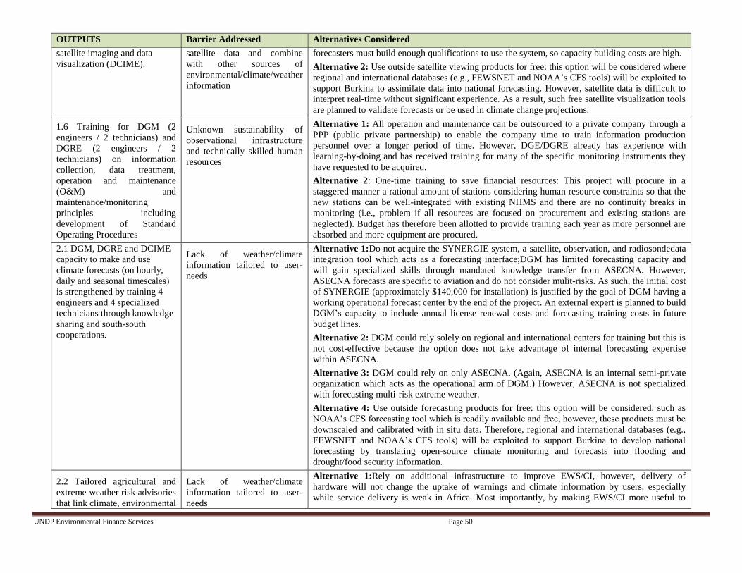
UNDP Environmental Finance Services Page 50
OUTPUTS Barrier Addressed Alternatives Considered
satellite imaging and data
visualization (DCIME).
satellite data and combine
with other sources of
environmental/climate/weather
information
forecasters must build enough qualifications to use the system, so capacity building costs are high.
Alternative 2: Use outside satellite viewing products for free: this option will be considered where
regional and international databases (e.g., FEWSNET and NOAA’s CFS tools) will be exploited to
support Burkina to assimilate data into national forecasting. However, satellite data is difficult to
interpret real-time without significant experience. As a result, such free satellite visualization tools
are planned to validate forecasts or be used in climate change projections.
1.6 Training for DGM (2
engineers / 2 technicians) and
DGRE (2 engineers / 2
technicians) on information
collection, data treatment,
operation and maintenance
(O&M) and
maintenance/monitoring
principles including
development of Standard
Operating Procedures
Unknown sustainability of
observational infrastructure
and technically skilled human
resources
Alternative 1: All operation and maintenance can be outsourced to a private company through a
PPP (public private partnership) to enable the company time to train information production
personnel over a longer period of time. However, DGE/DGRE already has experience with
learning-by-doing and has received training for many of the specific monitoring instruments they
have requested to be acquired.
Alternative 2: One-time training to save financial resources: This project will procure in a
staggered manner a rational amount of stations considering human resource constraints so that the
new stations can be well-integrated with existing NHMS and there are no continuity breaks in
monitoring (i.e., problem if all resources are focused on procurement and existing stations are
neglected). Budget has therefore been allotted to provide training each year as more personnel are
absorbed and more equipment are procured.
2.1 DGM, DGRE and DCIME
capacity to make and use
climate forecasts (on hourly,
daily and seasonal timescales)
is strengthened by training 4
engineers and 4 specialized
technicians through knowledge
sharing and south-south
cooperations.
Lack of weather/climate
information tailored to user-
needs
Alternative 1:Do not acquire the SYNERGIE system, a satellite, observation, and radiosondedata
integration tool which acts as a forecasting interface;DGM has limited forecasting capacity and
will gain specialized skills through mandated knowledge transfer from ASECNA. However,
ASECNA forecasts are specific to aviation and do not consider mulit-risks. As such, the initial cost
of SYNERGIE (approximately $140,000 for installation) is justified by the goal of DGM having a
working operational forecast center by the end of the project. An external expert is planned to build
DGM’s capacity to include annual license renewal costs and forecasting training costs in future
budget lines.
Alternative 2: DGM could rely solely on regional and international centers for training but this is
not cost-effective because the option does not take advantage of internal forecasting expertise
within ASECNA.
Alternative 3: DGM could rely on only ASECNA. (Again, ASECNA is an internal semi-private
organization which acts as the operational arm of DGM.) However, ASECNA is not specialized
with forecasting multi-risk extreme weather.
Alternative 4: Use outside forecasting products for free: this option will be considered, such as
NOAA’s CFS forecasting tool which is readily available and free, however, these products must be
downscaled and calibrated with in situ data. Therefore, regional and international databases (e.g.,
FEWSNET and NOAA’s CFS tools) will be exploited to support Burkina to develop national
forecasting by translating open-source climate monitoring and forecasts into flooding and
drought/food security information.
2.2 Tailored agricultural and
extreme weather risk advisories
that link climate, environmental
Lack of weather/climate
information tailored to user-
needs
Alternative 1:Rely on additional infrastructure to improve EWS/CI, however, delivery of
hardware will not change the uptake of warnings and climate information by users, especially
while service delivery is weak in Africa. Most importantly, by making EWS/CI more useful to

UNDP Environmental Finance Services Page 51
OUTPUTS Barrier Addressed Alternatives Considered
and socio-economic
information on short-term and
seasonal timescales are
developed to support end-user
needs and to promote
sustainable financing
mechanisms, including
research development of a
mobile-phone based advisory
platform.
various sectors in the country, this pushes the Government to include stable, core budget lines for
climate/weather services due to their cross-sectoral importance
2.3 Development of a multi-
agency platform to resolve lack
of coordination and data
sharing amongst agencies and
with EWS-related initiatives.
Lack of synergy between
agencies and lack of
coordination amongst EWS
initiatives
Alternative 1: If nothing is done, the current EWS initiatives will continue to work independently
(for zonal famine and dam management) and little national capacity will be built.
Alternative 2: No platform to formalize synergy: this is currently the case in all other EWS and
CC-related projects. For the case of the UNDP-CO project, this has led to a delay in project
implementation and a lack of coordination with other on-going projects.
2.4 Development of an open-
access EWS data portal for
sharing data cross-sectorally
and internationally, including
data integration into the Global
Telecommunication System
Inconsistent cross-sectorial
information dissemination and
data sharing across and within
country borders
Alternative 1: Have separate data portals for each agency to ensure security: however, this would
prohibit the easy use of data across agencies and an easy collaboration for international data
sharing
Alternative 2: Do nothing, however watersheds and rivers traverse country boundaries and rain
patterns upstream must be communicated to downstream Burkina. Therefore, with this option
models would lack appropriate boundary and initial conditions because Burkina would not be able
to utilize trans-national data.
2.5 National and local capacity
for CONASUR and DCIME to
assimilate forecasts and
monitoring into existing
development planning
(SCADD and PEI) and disaster
management systems is built.
Limited capacity to
disseminate warnings on local,
decentralized levels
Unknown sustainability of
observational infrastructure
and technically skilled human
resources
Alternative 1: Build CONASUR capacity without coordination with other initiatives will lead to
redundant activities and a waste of financial resources.
2.6 Communication channels
and standard procedures for
issuing warnings by the DRM
unit, NGOs/CSOs are enabled
Limited capacity to
disseminate warnings on local,
decentralized levels
Alternative 1: Enable each information dissemination agency to disseminate alerts by obtaining
alerts from DGM directly: With this option, there is no central focal point for all NGOs, CSOs to
report to for high level questions and to clarify disaster prevention strategies. Also, on the feedback
chain there would be no clear contact for end-user comments/suggestions. Developing a Standard
Operating Procedure is therefore the best mechanism for effective communication (SOP).
2.7 Rural community capacity
to adapt to climate shocks is
strengthened by promoting
Limited capacity to
disseminate warnings on local,
decentralized levels
Alternative 1: Do nothing, if the locals are not informed on the utility of EWS/CI, alerts will
continue to be misunderstood. Also, users will continue to lack confidence in alerts if the
uncertainty of forecasts is not conveyed to the general public. Furthermore Output 2.7 includes

UNDP Environmental Finance Services Page 52
OUTPUTS Barrier Addressed Alternatives Considered
understanding of disaster risk
prevention planning and alert
signals
training and a public awareness campaign for decentralized NGOs to inform local populations
about the potential of EWS/CI to assist them in building resilience to climate extremes

UNDP Environmental Finance Services Page 53
2.7 Sustainability
127. This project represents an effort to upscale the number one priority identified in Burkina Faso’s
NAPA (developing an early warning system)to the national scale based on the Roadmap for the
Establishment of a National Framework for Climate Services developed by the WMO in July 2012. It will
also serve to develop an EWS for multi-risk forecasting (concerning floods, droughts, strong winds) and
tailored climate information so that a vast variety of stakeholders can exploit the weather/climate
information produced. The project furthermore supports the MDGs in terms of aiming to reduce poverty
reduction by enabling the rural populations (for which more than half are in poverty) to take preventive
actions when weather or climate-induced risks are forecasted.
128. Various activities support the project’s sustainability after the support of the LDCF ends
including:
The development of a multi-agency platform to promote synergy (Comité Inter institutionnel et Multi
Disciplinaire pour Promouvoir la Synergie, CIMS) for synergy building;
Use of existing Interdisciplinary Working Groups (GTPs) to support alert generation;
Staggered approach to equipment procurement and training;
Station placementbased on meetings with local representatives and the private sector;
Development of Standard Operating Procedures (SOPs) for equipment operation and maintenance
and data storage and collection;
Knowledge sharing with international and regional training centers;
Development of an open-access data portalto share data across country boundaries and with other
ministries;
Building capacity for local focal points and NGO/CSO representatives at the village level to better
communicate and understand alerts;
Capacity building and knowledge sharing strategymandates that newly recruited technical personnel
who receive training must remain within their ministries for at least 5 years as per their TORs;
Capacity building to incorporate recurring costs into government budget lines;
Collaboration of DGM with DGRE, DCIME, NGOs (CPF, COS3C) and the Ministry on Agriculture
will ensure forecast bulletin or alert information is provided in useful quantitative units (e.g., crop
yield, area of flood plain, wind velocity) for the economic sectors (e.g., agricultural) and the rural
populations who are most vulnerable;
Leverage of revenue-generating tailored EWS and CI products to ensure long-term financial
sustainability
Making EWS/CI more useful to various sectors in the country pushes the Government to include core
budget lines for climate/weather services due to their cross-sectoral importance
129. Overall, the main factors affecting the financial sustainability of the project beyond the duration
of the LDCF grant include the ability of the agencies to develop cost-recovery mechanisms and the
potential lack of coordination with existing EWS projects which can delay the project and waste financial
resources. Project design has included Outputs/Activities to address these risks:
130. Output 2.2 will develop the capacity of information producers to tailor climate products based on
public/private needs. Sectors such as the cotton, building construction and mining sectors have already
showed interest and evidence from other African initiatives (CABI in Niger) has indicated that ‘pay for
weather/climate information’ systems can be profitable. Funds have also been allocated to launch a pilot
project to test the viability tailored weather/climate products andmobile-phone based platforms to
distribute agricultural advisories to a wide, ‘pay-for-service’ audience.

UNDP Environmental Finance Services Page 54
131. Output 2.3 stresses formalizing a synergy among several projects concerned with EWS-related
initiatives through the development of a multi-agency platform (Comité Inter institutionnelet Multi
Disciplinaire de Promouvoir la Synergie, CIMS). CIMS will be created to oversee any inefficiencies
amongst EWS initiatives and to coordinate and consolidate the projects. Such an approachis more likely
to ensure successful implementation and eliminate any risk that activities are duplicated, wasteful and in
the worst case counterproductive. Also this approach tries to prevent the development of isolated projects
without comprehensive, integrated, adaptation actions which will continue to hinder the social and
economic development of Burkina Faso.
2.8 Replicability
132. The originality of this project is that it will be the first to attempt to build national networks for
hydro-meteorological monitoring and alert dissemination and to provide support to tailor climate products
in Burkina Faso. The needs for capacity building (both equipment and human resources) are too great to
cover the entire country. As a result, the efficacy of EWS/CI will be tested in the most vulnerable agro-
ecological zones as outlined in Burkina’s NAPA. Lessons learned from these pilot zones in terms of
EWS/CI will be transferred in between the network of decentralized and national level focal pointsto be
established through this project (associated within both CONASUR, NGOs and CSOs). The pilot zones
are therefore a means to further improve alerts nationally. Any activity or improvement to an activity can
be easily replicated because the core network of national hydro-meteorological services and
communication mechanisms are being developed in this project and can easily be built upon.
133. Furthermore, specific attention has been given to the limitations of local agencies to disseminate
information. A national SOP for communication will be developed as a result which will include an
important mechanism to share lessons learned will be the feedback mechanism developed in Output 2.6.
The feedback mechanism canenable end-users to give direct comments and suggestions on the efficacy
and utility of EWS/CI to the focal points for alert generation and dissemination (DGM/DGRE and
CONASUR respectively).For instance, the alert generation and dissemination focal points can be
contacted via SMS.
134. There are also various mechanisms of knowledge transfer so that the agencies become more self-
sufficient and less reliant on outside agencies for repair. The learning-by-doing approach will be
reinforced on local, regional and international levels. For example, links with international (e.g.,
MeteoFrance) and with regional (ACMAD, responsible for the African Early Warning and Advisory
Climate Services, AEWACS or ViGIRisC project and for the ClimDevAfricaprogramme) centers will
help build national forecasting expertise. Expertise can be easily transferred to new personnel because
civil servants in Burkina are mandated to remain in the Ministry. Also, as a security measure, Terms of
Reference have been created to ensure that personnel who are hired to support this project must transfer
knowledge within their respective agency after receiving specialized training. Training recipients are
outlined below:
DGM/DGRE technicians/engineers for operation and maintenance
DGM forecasters for regional and international training
DGRE hydrological modelers
SAAGA radar technicians
CONASUR disaster risk personnel
DCIME risk mapping personnel
SIG/NGO/CSO communication teams, nationally and decentralized
UNDP Environmental Finance Services Page 55
Local CONASUR focal points and NGOs/CSOs representatives at the village level to better
communicate alerts and inform the general population how provide feedback to designated focal
points for EWS/CI
Training for information producers on how to develop a suite of revenue-generating tailored climate
products
135. Data will be accessible to all pertinent agencies, particularly those like the Ministry of Health
who require weather data to make analyses on the spread of diseases with respect to weather variables
such as temperature. Data sharing across borderswill also be facilitated by creating ftp password access.
Overall, data sharing will promote the regular use of EWS/CI so that more agencies will realize its
potential and utility.
136. The pilot program to test tailoring climate products for specific socio-economic sectors can be
easily be up-scaled to address other private sector interests/needs. Similarly, the market research
conducted under this project to support the development of a mobile-phone based platform for
agricultural advisories can easily be extended as public awareness on the utility of EWS/CI is heightened.
137. Finally, UNDP’s Adaptation Learning Mechanism (ALM) will be used as a dissemination and
sharing tool that is accessible by all and constantly updated will the most recent information from the
project. As stated in the TOR, the project management unit will be required to contribute to ALM on a
regular basis noting case studies, successes and challenges.
2.9 Stakeholder involvement
2.9.1 Stakeholder baseline analysis
138. During project preparation, a series of three workshops and extensive bilateral consultations were
organized.
The inception workshop held during September 2012 was used to identify relevant EWS agencies
involved with climate and hydro-meteorological information production as well as agencies that
should be implicated in alert dissemination to vulnerable populations, most notably farmers and rural
women. It was also used to detail the baseline of EWS-related initiatives (outlining gaps, successes
and failures) and identify potential co-financing sources including institutions who are
managing/developing relevant on-going/planned EWS related initiatives
The second mission workshop was used to 1) to validate Early Warning System (EWS) costs
provided by each agency in Burkina Faso 2) to perform a capacity assessment of all information
production and dissemination agencies and 3) to formalize the roles of each EWS agency in
information dissemination.Results from the self-assessment on capacity and prioritized needs are
detailed in Annex 4.
Subsequently, the final validation workshop was used to confirm the Management Arrangements,
partnerships, project indicators, risks, assumptions, synergy mechanisms and project outputs and
budgets.
139. Interventions with the Disaster Risk Management Agency, CONASUR, and rural-based
NGOs/CSOs who have experience with existing alert programs for famine and dam management was
particularly critical. These consultations have ensured the proposed project is grounded in local realities
whilst being aligned to national policies.Detailed meetings were held to determine equipment needs (type,
quantity, placement) and to prioritize procurements over the four-year project duration.

UNDP Environmental Finance Services Page 56
140. The project outcomes, outputs and activities listed in Section 2.3 are based upon the
recommendations of the Stakeholders given the technical, operational and financial constraints of the
project.Findings from each mission are detailed in the Key Assessment Reports (Annex 4).
141. Discussions have already taken place about the cost-effectiveness of moving a small number of
stations to locations beneficial to the cotton production sector (A 20 km radius for one weather station can
potentially serve a number of private clients.) The idea is to place a few stations in locations which can
both serve the expansion of the national network and target cotton private sector clients. If climate
information is requested from the private sector, it can serve as a source of revenue to DGM which can
enable the EWS to be more financially sustainable in the future. However, a condition for the station
location in the context of this project is also that placement must provide benefits to the most vulnerable
in addition to the private sector.
142. The effective monitoring of the impacts of gender differentiated capacity for adaptation will be
required for ensuring scale up actions are sufficiently sensitive to the needs of the poorest and most
vulnerable. Consequently, gender-focused NGOs/CSOs( the Women in Law and Development in Africa
organization, WILDAF and the Women’s Forestry Association) have been implicated in project
development and will continue to be involved in project implementation. These gender-focused
NGOs/CSOs will help to identify the efficiency of alert dissemination to women and the utility of climate
information for women in the aforementioned target communities such as with the gender disaggregated
survey planned in Output 2.7.
The following table shows the list of consultations which have taken place with providers and users of
EWS information to develop a user-driven Early Warning System. The role and participation of each
agency is indicated by the column headings describe in the legend.
Column Heading Legend
National Inception & Validation Workshops – involved in inception (September 2012) and validation
(April 2013) workshops. The National Inception Workshop involved 50 participants in total. The
Validation Workshop involved 40 participants.
Role Identification and Capacity Assessment Workshop – involved in workshop (November 2012) which
included 30 participants and representation from 6 climate information producing agencies and 14
information dissemination agencies.
Involvement in Baseline Assessment – consulted during project development to perform self-capacity and
needs prioritization assessments
Role Identification – Identification in institutional arrangement
Risk/Barrier Analysis – consulted on their specific institutional risks or barriers for a successful EWS
Policy/ Strategic alignment to priorities – institution has policies/strategies which are aligned with EWS
Co-financing Identification – other projects to support and be supported by EWS project financially
Gender representation – organization which is concerned with promoting the involvement of rural women
in project development and the dissemination of alerts to the female rural population
Upscale / Sustainability planning – consulted on how to maintain and replicate EWS
Document Endorsement – signatures obtained from government and UNDP CO

UNDP Environmental Finance Services Page 57 Page 57
Table 6: Stakeholder Involvement Matrix, Burkina Faso
Stakeholder
Nat
ion
al
Ince
pti
on
&
Val
idat
ion
Wo
rksh
op
s
Cap
acit
y
Ass
essm
ent
Wo
rksh
op
Inv
olv
emen
t in
Bas
elin
e
Ass
essm
ent
Ro
le
Iden
tifi
cati
on
Ris
k/B
arri
er
An
aly
sis
Po
licy
/ S
trat
egic
alig
nm
ent
to
pri
ori
ties
Co
-fin
anci
ng
Iden
tifi
cati
on
Gen
der
rep
rese
nta
tio
n
Up
scal
e /
Su
stai
nab
ilit
y
pla
nn
ing
Do
cum
ent
En
do
rsem
ent
Federal/Sector
Direction Générale
de la Météo
(DGM)
X X X X X X X
(SP/CONEDD)
DCIME
X X X X X X X
Direction Générale
de la Resource en
Eau (DGRE)
X X X X X X X
Direction Générale
de
l’Environnement
(DGE)
X X X X X X X
Direction of
Communication
X X X X X X X
Direction de la
Protection Civile
X X X X X X X
National Advisory
for Emergencies
and Rehabilitation
(CONASUR)
X X X X X X X X
General Direction
on Health and
Sanitation
X X X
Technical / ResearchInstitutions
Water Study and
Information Center
(DEIE)
X X X X
Private Sector
ASECNA X X X X X X X
SAAGA X X X X X X X
Regional/Sector
Rural
Confederationof
Burkina Faso,
Confédération
Paysanne du Faso
(CPF)
X X X X X X X X
NGOs/CSOs
Coalition X X X X X X X

UNDP Environmental Finance Services Page 58 Page 58
Stakeholder N
atio
nal
Ince
pti
on
&
Val
idat
ion
Wo
rksh
op
s
Cap
acit
y
Ass
essm
ent
Wo
rksh
op
Inv
olv
emen
t in
Bas
elin
e
Ass
essm
ent
Ro
le
Iden
tifi
cati
on
Ris
k/B
arri
er
An
aly
sis
Po
licy
/ S
trat
egic
alig
nm
ent
to
pri
ori
ties
Co
-fin
anci
ng
Iden
tifi
cati
on
Gen
der
rep
rese
nta
tio
n
Up
scal
e /
Su
stai
nab
ilit
y
pla
nn
ing
Do
cum
ent
En
do
rsem
ent
d’Organisation des
Sociétés Civiles
sur le Changement
Climatique
(COS3C)
SOS Sahel X X X X
INADES X X X
WILDAF (Women
in Law and
Development in
Africa)
X X X X
Women’sForestry
Assocation
X X X X
Donor Partners
World Bank X X
UNDP COGEL X X
USAID X X X X X
2.9.2 Stakeholder involvement plan
143. The Stakeholders identified during project preparation will continue to be implicated in project
implementation. A Stakeholder involvement plan has been created to provide a framework to guide
interaction between implementing partners and the key stakeholders, particularly end-users to validate
project progress. All Stakeholders involved in the baseline self-capacity assessment will be addressed
again in order to track the efficacy of Stakeholder capacity building both operationally and technically.
Also, the women’s interest organizations, the Women in Law and Development in Africa organization,
WILDAFand the Women’s Forestry Association, will continue to be implicated and consulted in order to
ensure women are properly engaged/warned.These gender-focused NGOs/CSOs will conduct the gender
disaggregated survey indicating the receipt of alerts and utility of weather/climate information planned in
Output 2.7. Details of the Stakeholder Involvement Plan are indicated in Annex 10.
2.9.3 Expected benefits
144. The largest economic benefits are expected from building capacity of the climate/environmental
information production agencies to tailor climate products to the needs of various socio-economic sectors
(e.g., agriculture, health cotton, mining). By the project enabling a pilot study on tailoring climate
services and market research on the potential for mobile phone-based agricultural advisories, the
foundations will be set for self-sustainable NHMS. For instance, although Burkina’s cotton sector has
become less productive over the years (NAPA 2008), it can take advantage of improved local forecasts of
winds, rain and temperature. The mining sector also represents a likely large private sector client for early
warning services and tailored forecasts.
UNDP Environmental Finance Services Page 59 Page 59
145. Together with satellite imagery used for land-use planning and monitoring, tailored climate
products can also provide significant local environmental benefits, such as detailing best water
management practices which is crucial to help Burkina’s fight against desertification. At the local level,
early warnings and climate hazard mapping can provide economic benefits by reducing losses of
agricultural produce, infrastructure (roads and bridges) and disruption to people’s livelihoods.
146. Communities will also immediately benefit from the Standard Operating Procedure to be
implemented for alert communication. The total population benefiting from these developments has the
potential to grow hugely if warnings extend to a reasonable percentage of the total population e.g. through
a mobile phone relay. Also, the feedback mechanism can enable the communication mechanism to be
improved via end-user comments/suggestions.
147. In addition, this project will build a multi-agency platform whose sole role will be to ensure that
there is synergy amongst EWS related initiatives. This will support the elimination of duplicate roles and
wasted financial and human resources.Furthermore, it is expected that the open-access data portal will
facilitate data sharing between ministries/agencies and potentially international institutions.
148. Many of the beneficiaries will be women, especially within the agriculture sector who do not
have access to information, yet are most vulnerable to food insecurity and climate change due to their
dependence on natural resources for subsistence household chores and their limited access to education
and information services which prohibit participation in decision-making. The project has and will
continue to target women by implicating women-focused NGOs/CSOs, the Women in Law and
Development in Africa organization, WILDAF and the Women’s Forestry Associationin order to ensure
women are properly engaged/warned and are receiving useful weather/climate information.
149. The UNDP Environmental and Social Screening template has been applied to ensure
environmental and social safeguards are in place. According to this checklist, the project is considered
Category 2 where no further safeguards must be incorporated because no environmental or social risks are
foreseen (See Annex 13).
150. Environmental safeguards being applied include the following:
Tailoring EWS/CI to support better farming, water and coastal management practices
Consulting local reps to find best station/equipment placement
151. Social safeguards being applied include the following:
Mandating station placement/equipment must benefit the most vulnerable, not only the private sector
Including women representation organizations
Facilitating feedback from marginalized populations with the communication feedback mechanism

UNDP Environmental Finance Services Page 60
3 PROJECT RESULTS FRAMEWORK
This project will contribute to achieving the following Country Programme Outcome as defined in CPAP:
CPAP OUTPUT 1: The response capacity of national prevention institutions at national and local levels are reinforced
CPAP OUTPUT 2: Catastrophe management institutions at national and decentralized levels are better equipped and able to respond to emergencies
Country Programme Outcome Indicators:
Early warning system (EWS) and contingency plans.
Primary Applicable Key Environment and Sustainable Development Key Result Area (same as that on the cover page, circle one): Promote climate change adaptation
Applicable GEF Strategic Objective and Program:
OBJECTIVE 2: Increase adaptive capacity to respond to the impacts of climate change, including variability, at local, national, regional and global level
Applicable GEF Expected Outcomes:
Outcome 2.1: Increased knowledge and understanding of climate variability and change-induced risks at country level and in targeted vulnerable areas
Outcome 2.2: Strengthened adaptive capacity to reduce risks to climate-induced economic losses
Applicable GEF Outcome Indicators:
Relevant risk information disseminated to stakeholders
Type and no. monitoring systems in place
% of population covered by climate change risk measures
Indicator Baseline Targets
End of Project
Source of verification Risks and Assumptions
Project Objective16
To strengthen the climate
monitoring capabilities,
early warning systems
and available
information for
responding to climate
shocks and planning
adaptation to climate
change in Burkina Faso.
1.Capacity as per capacity
assessment scorecard
(BASELINE: 74;
TARGET: 161) (see
Annex 12)
2.Domestic finance
committed to the relevant
institutions to monitor
extreme weather and
climate change
1.Limited capacity to
generate EWS and CI
on a national scale for
extreme hydro-
meteorological
phenomena
Limited disaster risk
prevention capacity
onlocal levels within
CONASUR
No Standard Operating
Procedure (SOP) for
alert communication by
ANPC with the support
of NGOs/CSOs
Current score: 74
2.Existing budget plans
do not have sufficient
funds to maintain and
1. Capacity assessment TARGET score
161 for all combined EWS agencies
2. TARGET: 30% increase in domestic
financing for equipment operation and
maintenance across all institutions
1. Capacity assessment
scores
2. Ministry budget
lines for recurring costs
Burkina has enough government financing
to continue monitoring and will consider
recurring O&M costs for new infrastructure
in government budget lines because of the
utility of EWS/CI.
There is sufficient political support and will
within the EWS agencies to reinforce
existing capacities for successful execution
and implementation of the project.
16Objective (Atlas output) monitored quarterlyERBM and annually in APR/PIR

UNDP Environmental Finance Services Page 61
operate environmental
monitoring
infrastructure
Indicator Baseline Targets
End of Project
Source of verification Risks and Assumptions
Outcome 117
Enhanced capacity of
national hydro-
meteorological services
(DGM/DGRE) and
environmental
institutions (DCIME) to
monitor extreme weather
and climate change
(droughts, floods, strong
winds)
1.% national coverage
for climate/weather
monitoring
2.Frequency and
timeliness of climate-
related data availability
(BASELINE: monthly;
1.Currently, there is 25
% national coverage for
climate/weather
monitoring with respect
to the optimal
arrangements defined
in DGM/DGRE
feasibility reports and
WMO standards.
Twenty synoptic
stations, 20 agro-
meteorological stations,
8 climate stations, 100
rain gauges, 71 water
level meters and 11
manual flow meters are
in place.
Meteorological
stations: 142 manual, 6
automatic
Hydrological stations:
82 manual, 0 automatic
2.Data from manual
weather and
hydrological stations is
collected monthly and
transmitted by post.
1. Increase to75 % NHMS optimal
monitoring arrangements as defined in
feasibility studies, 8 Acoustic Doppler
Current Profilers (ADCPs) for flow
measurements, 40 automatic climate
stations, 10 automatic synoptic stations
with telemetry and 100 additional rain
gauges
Meteorological stations: 242 manual,
56 automatic
Hydrological stations: 93 manual, 8
with telemetry
2. TARGET for data transmission
frequency: daily
1.Review of budget
spent on equipment
procurement and
rehabilitation and data
held on servers to show
that new equipment is
operational
2.Analysis of data
frequency transmission
using storage servers
within each
information production
agency
Procurement and installation of hydro-
meteorological equipment, including
hardware and software, is delayed because
of complications with the release of funds
and/or national procurement procedures.
Manual equipment rehabilitated with
enhanced SMS communication systems will
enable transmission of data to NHMS at
least daily.
There is and will continue to be sufficient
qualified personnel within the NHMSto
handle the new equipment, data
transmission/storage/treatment to prevent
continuity breaks in monitoring.
Natural disasters (e.g., floods, strong winds)
may damage infrastructure. Sufficient spare
parts and tools have been procured to assist
with equipment repair.
Outcome 2
Efficient and effective
use of hydro-
meteorological and
coastal information for
making early warnings
and seasonal forecasts
which feed into long-
1.% of population with
access to improved
climate information and
flood, drought, strong
windand coastal
warnings (disaggregated
by gender)
1.There are existing
EWS initiatives for
regional dam
management and
famine alerts, however,
a national alert system
concerned with extreme
hydro-meteorological
1. 50 % increase in population who
have access to improved EWS/CI
Women: 8%
Men: 15%
2. At least 2 of the PRSP policy briefs
1.
a) Gender
disaggregated survey
on receipt of alerts
b) Record of
debriefings by
CONASUR post
extreme weather events
Data sharing and alert/climate information
communication will not be hindered by lack
of coordination between agencies or by
technical constraints such as bandwidth
issues or local mobile telecommunication
networks.
17All outcomes monitored annually in the APR/PIR. It is highly recommended not to have more than 4 outcomes.

UNDP Environmental Finance Services Page 62
term development plans
2. Development
frameworks (SCADD,
PEI) that integrate
climate information in
their formulation of
proverty reduction
strategies and links
between poverty and the
environment at local
levels (BASELINE: No
integration; TARGET
Integration into the
revised SCADD and PEI
in 2015)
3. Sector-specific EW
products and strategies
that integrate climate
risks (agriculture, health,
and cotton production
sectors)
phenomena is lacking.
There is also a limited
understanding of
technical alert jargon
(alerts are not
translated into all
national languages).
There is also no
mechanism for end-
users (most vulnerable
populations) to be
involved in the alert
process to ensure its
sustainability.
Women: 5%
Men: 10%
2.Development
frameworks do not
incorporate any
EWS/CI products such
as risk maps or climate
change predictions into
long-term planning
3. Sector specific
strategies do not
include EWS/CI
because the quality of
weather forecasts and
climate predictions are
poor and not tailored
for specific uses,
particularly seasonal
forecasts.
incorporate analyses of risk maps
and/or climate change projections
influencing long-term planning
proposals
3. Development of at least 2 tailored
climate products and presentation of
market research plan on how to
implement mobile phone based
agricultural advisories, both supporting
targeted weather/climate service
delivery
c) CONASUR record
of end-user feedback
2.Review of SCADD,
and PEI documents to
validate incorporation
of risk, weather and/or
climate information
3.Partnerships formed
between information
producers and the
Ministries of Health
and Agriculture,
private sectors, NGOs
and women
organizations to
support
weather/climate service
delivery
Ministries have a vested interest to fully
integrate climate information into
theirpoverty reduction strategies and disaster
risk management plans.
NHMS will acquire enough capacity to
tailor climate productsto different socio-
economic sectors (e.g., subsistence
agriculture, cotton, mining, building
construction) by the end of the project.
False alarms may occur but enough
awareness has been provided to end-users to
understand the reality of forecasting
uncertainty and to inform them how they
can get involved to improve early warnings
and tailor CI suited to their needs

UNDP Environmental Finance Services Page 63
4 TOTAL BUDGET AND WORKPLAN
Award ID: 00074218
Project
ID(s): 00086732
Award Title: Early Warning Systems Africa, Burkina Faso
Business Unit: BFA10
Project Title:
Strengthening Climate Information And Early Warning Systems in Africa for Climate Resilient Development and Adaptation to Climate Change Early
Warning System, Burkina Faso
PIMS no. 5104
Implementing Partner
(Executing Agency) SP/CONEDD
SOF (e.g. GEF)
Outcome/Atlas
Activity
Responsible
Party/
Implementing
Agent
Fund
ID
Donor
Name
Atlas
Budgetary
Account
Code
ATLAS Budget
Description
Amount
Year 1
(USD)
Amount
Year 2
(USD)
Amount
Year 3
(USD)
Amount
Year 4
(USD)
Total
(USD)
See Budget
Notes:
OUTCOME 1:
Enhanced capacity of
national hydro-
meteorological
services
(DGM/DGRE) and
environmental
institutions (DCIME)
to monitor extreme
weather and climate
change (droughts,
floods, strong winds)
SP/CONEDD 62160 LDCF
72300 Materials & Goods 496,800 444,600 467,600 422,600 1,831,600 a
75700
Training,
Workshops &
Conferences 92,000 49,000 39,000 39,000 219,000
b
72400
Communication&
Audio Visual
Equip 0 20,200 0 0 20,200
c
72800
Information
Technology
Equipment 42,600 54,000 28,000 28,000 152,600
d
71300
National
Consultants 21,000 21,000 21,000 21,000 84,000 e
71400
Contractual
Services
Individuals 33,300 33,000 3,000 48,000 117,300
f
sub-total LDCF 685,700 621,800 558,600 558,600 2,424,700
OUTCOME 2:
Efficient and
effective use of
hydro-meteorological
and environmental
Total Outcome 1 685,700 621,800 558,600 558,600 2,424,700
72300 Materials & Goods 60,000 60,000 g
SP/CONEDD 62160 LDCF 75700
Training,
Workshops &
Conferences $116,500 $136,500 $109,500 $ 108,800 $471,300
h
74500
Miscellaneous
Expenses 5,000 5,000 3,000 3,000 16,000 n

UNDP Environmental Finance Services Page 64
information for
making early
warnings and
seasonal forecasts
which feed into long-
term development
plans
72400
Communication&
Audio Visual
Equip 27,000 27,000 19,000 19,000 92,000
i
72800
Information
Technology
Equipment 69,000 64,000 42,000 42,000 217,000
j
71300
National
Consultants 36,000 31,000 36,000 36,000 139,000 l
sub-total GEF 313,500 263,500 209,500 208,800 995,300
Total Outcome 2 313,500 263,500 209,500 208,800 995,300
PROJECT
MANAGEMENT
UNIT
SP / CONEDD
62160
LDCF
71300 National
Consultants 20,000 30,000 30,000 30,000 110,000 m
74500 Miscellaneous
Expenses 14,641 9,641 14,641 9,641 48,564 n
72500 Supplies 5,000 5,000 5,000 5,000 20,000 o
74599
UNDP Cost
Recovery Chrgs -
bills
358.95 358.95 358.94 358.94 1,435.78 p
sub-total 40,000 45,000 50,000 45,000 180,000
Total
Management 40,000 45,000 50,000 45,000 180,000
PROJECT TOTAL 1,039,200 930,300 818,100 812,400 3,600,000
Summary of
Funds:18
Amount
Year 1
Amount
Year 2
Amount
Year 3
Amount
Year 4 Total
National Land Management Programme,
PNGT Phase III project (World Bank)
$13,387,500 $13,387,500 $13,387,500 $13,387,500 $53,550,000
Poverty Environment Initiative (UNDP) $400,000 $400,000 $400,000 $400,000 $1,600,000
WA-WASH Project (US AID) $475,000 $475,000 $475,000 $475,000 $1,900,000
Government Budget Line - Ministry on
Sustainable Development $10,225 $10,100 $10,100 $10,100 $40,525
GEF 1,039,200 930,300 818,100 812,400 3,600,000
TOTAL $15,311,925 $15,202,900 $15,311,925 $15,085,000 $60,690,525
18Summary table should include all financing of all kinds: GEF financing, cofinancing, cash, in-kind, etc...

UNDP Environmental Finance Services Page 65
Budget Note Description of cost item (Activity and Output number)
a. Procurement of 100 water level markers on 11 hydrological stations and 8 automatic Doppler flowmeters including tools and spare
parts for operation and maintenance of hydrological equipment(1.1)
Procurement of 40 automatic climate stations,10 automatic synoptic stations and 100 rain gauges including tools and spare parts
for operation and maintenance of meteorological equipment(1.2)
Construction of secure fencing around weather stations and recruitment of security guards to prevent theft (1.2)
Acquisition of necessary tools for radar repair (1.3)
Purchase of power surge prevention equipment to prevent electrical blow-outs (1.3)
Hydrogen and radiosonde equipment for additional daily launch at midnight in Ouagadougou (1.4)
Equipment for satellite image validation (1.5)
Operating expenses to conduct at least 20 field consultations to verify hydrological equipment placement (1.1)
Operating expenses to conduct at least 30 field consultations to verify meteorological equipment placement (1.2)
b. Meeting costs for at least 20 field consultations to verify hydrological equipment placement (1.1)
Meeting costs for at least 30 field consultations to verify meteorological equipment placement (1.2)
Knowledge sharing between the Water Study and Information Center and DGRE on hydrological modelling (1.1)
2 week training by on radar maintenance and operation principles (1.3)
2 week training for night-time radiosondetechnicians, 1 general operator and 1 hydrogen operator (1.4)
Training for DGRE/DGM technicians on flow meter/weather station information collection, data treatment and O&M. O&M tasks
to be documented in Standard Operating Procedures. (1.6)
c. Purchase of CB radios and SMS communication services to enable fast transmission of data from manual equipment for
DGM/DGRE (1.1, 1.2)
d. Purchase of secure data servers for DGM/DGRE to build long-term data records and to store treated/quality controlled data (1.1,
1.2)
Acquisition of data-downloading device and data digitization equipment for use by DGM/DGRE/DCIME (1.1, 1.2, 1.3)
Renewal and purchase of additional hydrological modelling licenses (MIKE BASIN) (1.1)
Purchase of microwave link for SAAGA to enable fast transmission of radar data to EWS centralized data server (1.3)
Transfer of radar images from ASCENA to DNM’s operational forecast center (1.3)
Equipment for improved satellite imaging and data visualization (DCIME) (1.5)
e. Local consultants for organising and conducting equipment surveys/reports, identifying and liaising on procurement of equipment
with line ministries and facilitating NHMS etc. training programs.
National expert on hydrological and flood forecast modelling (See TORs)*** (1.1)
f. Radar expert for repair of radar in Ouagadougou, repair training and long-term recurring cost planning (See TORs) ***(1.3)
Cost of 4 audits @ $3000 each (total for LDCF project: $12000).
Cost of an Independent Mid-term evaluation @ $30000.
Cost of an Independent Terminal evaluation @ $45000.
g. Field support equipment for Disaster Risk Management Unit to be able to prepare populations for weather/climate risks
h. Training to improve national weather forecasting capabilities including capacity building for national technical experts through
regional knowledge sharing programs
Capacity development for DGM/DGRE to build a formalized alert guide and thresholds for extreme weather events
Capacity development for DCIME to map hydro-meteorological risks
Four (4) annual collaboration sessions between the technical staff of DGM/DGRE/DCIME and private sector representatives to see
the needs for tailored climate products

UNDP Environmental Finance Services Page 66
Capacity development for the technical staff of DGM/DGRE/DCIME to generate targeted forecasts
Quarterly roundtable meetings between DGM, DGRE, the Ministry of Agriculture and the Ministry of Health for long-term
development planning for various socio-economic sectors
Conferences to introduce mobile-phone platform development to integrate EWS/CI into agricultural advisories
Quarterly meetings by the multi-agency platform, CIMS, composed of designated focal points, to coordinate EWS-related projects
and agencies (See TORs)
Capacity building for Technical Support Group on how to generate alerts specific to extreme hydro-meteorological events
Integration of EWS/CI into the next PRSPs (SCADD (2015) and PEI (2015)) is facilitated by the Multi-agency Synergy
Committee (CIMS) (Output 2.3) who will have the role to promote as a national priority the use of EWS/CI to help prepare for
crises/catastrophes
Capacity building for CONASUR and local CONASUR focal points (decentralized units) and mainstream EWS/CI and adaptation
measures into planning
EWS capacity development meetings between CONASUR with regional disaster risk management (DRM) units
Elaboration of existing decree on environmental data by DCIME
Group training for leaders of all dissemination agencies (CONASUR, SIG, NGOs/CSOs) on alert signification
Capacity building between CONASUR and local focal points for implementation of a formalized feedback mechanism
Project public awareness campaignby NGOs/CSOs on the utility of EWS/CI for climate change resilience
i. Communication equipment for pilot study on tailoring climate/weather products
Communication equipment for market research for mobile phone platform development
CB radios for CONASUR local branches, NGOs/CSOs and the Direction of Communication (SIG)
Communication feedback mechanism equipment
Communication equipment for the Direction of Communication (SIG)
Communication equipment for public awareness campaign on the utility of EWS/CI for climate change resilience
j. Acquisition of SYNERGIE system (MeteoFrance) for weather forecasting (2.1)
Information technology equipment for validation study on most vulnerable zones (DCIME)
Development of existing HPC server at DCIME to serve as EWS centralized server
IT equipment for integration of satellite data from national, regional and international programs
IT equipment for the Direction of Communication to disseminate alerts through the enhancement of their existing call center
l. Local consultants to assist with tailoring forecasts, monitor the utility of forecasts/predictions for end-users and the efficacy of the
Standard Operation Procedure for alert communication. Organise workshops, meetings and feedback sessions from users of
forecasts and SOPs
Cost for National expert team to conduct an Environmental Impact Assessment at project inception (estimated to be $20k) *
m. Salaries for the project management unit including the Project Manager, Financial and Administrative Assistant and Indemnity
fees for the Project Coordinator
n. Miscellaneous, Insurance, bank charges and other sundries for project coordinating unit.
o. Cost of office supplies and disposables
p. Direct Project Costs for UNDP CO to assist SP/CONEDD with payment processes, manufacturer selection, equipment
procurement, preparation and management of contracts, and purchase order assistance
* Assuming national expert fee: $250 per day
*** Assuming contractual service fee: $4000 flight/visas, hotel $155, daily expenses $75 and salary $1000 per day for 13 days - $20,300

UNDP Environmental Finance Services Page 67
5 MANAGEMENT ARRANGEMENTS
152. The execution modality for this project will be UNDP’s National Implementation Modality. The
implementing partner for this project will be the Permanent Secretary for the National Environmental and
Sustainable Development Council (SP/CONEDD) who will have project ownership and appoint a Project
Manager (PM), paid for by the project, to coordinate project operations, in accordance with Decree 2007-
776, the projects/programmes of category A. The main beneficiaries of this project will be the Ministry of
Transport, Infrastructure and Development (MT), the Ministry of Environment and Sustainable
Development (MEDD), the Ministry of Social Action and National Security (MASSN), the Ministry of
Communication (MC) and Civil Society Organizations (CSOs) / Non-Governmental Organizations
(NGOs) who will be responsible for the delivery of results in their respective departments / organizations.
The Project Steering Committee (COPIL), led by the SG MEDD, will be responsible for approving
program activities. Based on the approved activities, the Project Manager will ensure the provision of
funds to all institutions/organizations for their respective activities. All executing agencies will be
responsible for managing tasks related to their institution/organization. A Memorandum of Understanding
and Terms of Reference (TOR) indicating the role of each executing agency will be developed under the
guidance of Project Manager during project implementation. A full capacity assessment of the IP was
conducted in May 2013 (see document attached with submission). A Letter of Agreement (Annex 2)
describes all additional services required of UNDP beyond its role in oversight between the Ministry of
Water and UNDP. The Ministry of Water has requested UNDP to assist with payment processes,
manufacturer selection, equipment procurement, preparation and management of contracts, and purchase
order assistance. The direct project costs associated with technical or administrated services requested of
UNDP are detailed in the Total Budget Work Plan (TBWP, Section 4).
153.
154. The Stakeholder Involvement Table indicating the key inputs of all project partners during project
implementation is indicated in Table 6.
155. A diagram detailing the Management Arrangements, including the responsible decentralized
agencies and support committees/organizations, is presented below. The roles and responsibilities of the
parties involved in managing the project are described below.

UNDP Environmental Finance Services Page 68
156. The Project Steering Committee (COPIL) established by a ministerial order will be directed by
the General Secretariat of the Ministry on the Environment and Sustainable Development (MEDD) and
will be responsible for approving the reports and activities. It will also provide guidance for proper
implementation of the project.Other members of COPIL will include UNDP, senior officers from the
Ministry of Transport, Ministry of Environment and Sustainable Development (MEDD), Ministry of
Social Action and National Solidarity (MASSN), the Ministry of Agriculture (MAHRH), the Ministry of
Communication, the Direction of Civil Protection (DPC) and the Ministry for the Promotion of Women
(MPF). The COPIL will be responsible for making management decisions for the project in particular
when guidance is required by the Project Manager. The COPIL plays a critical role in project monitoring
and evaluations by quality assuring these processes and products, and using evaluations for performance
improvement, accountability and learning. It i) ensures that required resources are committed, ii)
arbitrates on any conflicts within the project and iii) negotiates a solution to any problems with external
bodies. In addition, it approves the appointment and responsibilities of the Project Manager and any
delegation of its Project Assurance responsibilities.Based on the approved Annual Work Plan, the COPIL
can also consider and approve quarterly plans (if applicable) and approve any essential deviations from
Executive:
(SG MEDD)
Project Organization Structure
Project Manager /
Project Coordinator
(SP/CONEDD- Implementing
Partner)
Project
Assurance
UNDP Burkina,
UNDP GEF
Project Support
Focal Points
Multi-agency synergy
committee (CIMS)
Interdisciplinary Working
Group (GTP)
Regional component
Support
GroupAdministrative
Assistant, Monitoring
and Evaluation expert,
Accountant
EWS Information
Production Agencies
(DGM, DGRE, DCIME,
SAAGA, ASECNA…)
EWS/CI Information
DisseminationAgencies
(CONASUR, SIG, CSO,
NGOs…)
Senior Supplier:
UNDP
Senior Beneficiaries:
Ministry of Transport,
MEDD, MASSN,
NGOs/CSOs
Project SteeringCommittee
Coordination
Entities
Donors (World
Bank, USAID,
MEDD)
WMO Regional
Focal Point
Implementing Institutions
(Responsible Parties)

UNDP Environmental Finance Services Page 69
the original plans. In accordance with Decree 2007-776, the Committee will be 2 times per year, during
each semester and can include a maximum of 20 participants.
157. Potential members of the COPIL are reviewed and recommended for approval during the PAC
meeting. Representatives of other stakeholders can be included in the Committee as appropriate. The
Committee contains four distinct roles which have been filled as follows:
1) An Executive: individual representing the project ownership to chair the group.
General Secretariat of the Ministry on the Environment and Sustainable Development
(SG MEDD)
2) Senior Supplier: group representing the interests of the parties concerned which provide funding
for specific cost sharing projects and/or technical expertise to the project. The Senior Supplier’s
primary function within the COPIL is to provide guidance regarding the technical feasibility of
the project and alignment of the outcomes/outputs with the LDCF.
UNDP
3) Senior Beneficiary: group of individuals representing the interests of those who will ultimately
benefit from the project. The Senior Beneficiary’s primary function within the COPIL is to ensure
the realization of project results from the perspective of project beneficiaries.
Ministry of Transport, Ministry on the Environment and Sustainable Development, the
Ministry of Social Action and National Security (MASSN) and NGOs/CSOs including
the Federal Farmer Confederation (CPF) as well as others to be determined during the
Inception Workshop
4) The Project Assurance role supports the Project Board Executive by carrying out objective and
independent project oversight and monitoring functions in line with UNDP and GEF/LDCF
policies and procedures.
UNDP Burkina and UNDP-GEF
158. Project Manager: The Project Manager has the authority to run the project on a day-to-day basis
on behalf of the Implementing Partner within the constraints laid down by the Board. The Project
Manager’s prime responsibility is to ensure that the project produces the results specified in the project
document, to the required standard of quality and within the specified constraints of time and cost.
159. Project Coordinator: A representative from SP/CONEDD who will support the PM with overall
administration and maintaining a liaison with UNDP. In accordance with Decree 2007-776, the Project
Coordinator for a Class A project is appointed by the Minister in charge of project supervision. The
designated officer must concurrently perform his usual tasks with those specific to this project in terms of
management and coordination. The project will be responsible for paying the indemnities for the Project
Coordinator.
160. Support Group: The project will support an administrative assistant, an accountant and an expert
in Monitoring and Evaluation (See TORs) to assist with project management.
161. Information Production: The technical information production agencies including the National
Met Service (DGM), the National Hydrological Service (DGRE), the Departmental Division on the
Understanding of Environmental Information and Monitoring (DCIME) as well as technical groups
within DGM (SAAGA - radar and ASECNA –radiosondes) will be responsible for collecting all
weather/climate data and producing all forecasts/predictions/risk maps. At times of alert, all information
production agencies will transmit their data to DGM and DGRE who together will be responsible for
generating the appropriate alert fordistribution by the Disaster Risk Management unit, CONASUR.
UNDP Environmental Finance Services Page 70
162. Information Dissemination: Agencies will support the dissemination of information from the
national to decentralized levels. The project will establish a Standard Operating Procedure (SOP) for alert
communication to ensure information dissemination is efficient at the decentralized levels. The Disaster
Risk Management Unit, CONASUR, will serve as the principal contact point to receive alert information
from information producers (see above). CONASUR will be responsible for the distribution of alert
information to the Governmental Information Service (SIG) and to local actors in NGOs/CSOs (eg, CPF,
COS3C, WILDAF, SOS Sahel, etc)serving as decentralization support. Representatives ofCONASUR’s
decentralized branches (CORESUR, COPROSUR and CODESUR) and representatives of SIGand key
NGOs / CSOs will work together as a team with public / private media and local representatives in
targeted regions (prefects, communes) to ensure that EWS/CIalerts are distributed to local people in a
streamlined and understandable manner. The support team will also be responsible for ensuring that the
feedback mechanism that allows end-users to play an active role is effective and that the comments /
concerns / suggestions from end-users are included in the project implementation.
163. Project Support: Regular technical project support will be provided by focal points from the
General Directorate on Meteorology (DGM), the General Directorate on Water Resources (DGRE) the
National Advisory for Emergencies and Rehabilitation (CONASUR) and Departmental Division on the
Understanding of Environmental Information and Monitoring (DCIME) who will meet periodically with
the Project Manager. They will provide project administration, management and technical support to the
PMas required by the needs of the individual project or Project Manager. The project will also facilitate
coordination with the already established Interdisciplinary Working Groups (GTPs) which include
technical specialists currently generating alerts for famine and dam operations in Burkina Faso. Similarly,
coordination will be promoted with the Multi-agency Committee for Synergy (Comité Inter
institutionnelet Multi-disciplinaire de promouvoir la Synergie, CIMS) to be established through this
project to ensure EWS-related initiatives are well-coordinated.
164. As per discussions with the GEF Secretariat, this initiative is part of a multi-country set of NIM
projects supported by UNDP-GEF. In response to LDCF/SCCF Council requirement that a regional
component would be included to enhance coordination, increase cost effectiveness and, most importantly,
benefit from a regional network of technologies, a cohort of technical advisors and a project manager will
be recruited to support each of the national level project teams. In particular they will support countries to
develop robust adaptation plans and provide technical advice, training and support for accessing,
processing and disseminating data for early warning and national/sectoral planning related purposes on a
systematic basis. The cost of these project staff has been prorated across all country project budgets and
recruitment of these posts will be undertaken by UNDP-GEF (HQ) in coordination with all UNDP
Country Offices.

UNDP Environmental Finance Services Page 71
6 MONITORING FRAMEWORK AND EVALUATION
The project will be monitored through the following M&E activities. The M&E budget is provided in the
table below. The M&E framework set out in the Project Results Framework in Part III of this project
document is aligned with the AMAT and UNDP M&E frameworks.
Project start: A Project Inception Workshop will be held within the first 2 months of project start with
those with assigned roles in the project organization structure, UNDP country office and where
appropriate/feasible regional technical policy and program advisors as well as other stakeholders. The
Inception Workshop is crucial to building ownership for the project results and to plan the first year
annual work plan.
The Inception Workshop should address a number of key issues including:
Assist all partners to fully understand and take ownership of the project. Detail the roles, support
services and complementary responsibilities of UNDP CO and Regional Coordinating Unit (RCU)
staff (i.e. UNDP-GEF Regional Technical Advisor) vis-à-vis the project team. Discuss the roles,
functions, and responsibilities within the project's decision-making structures, including reporting and
communication lines, and conflict resolution mechanisms. The Terms of Reference for project staff
will be discussed again as needed.
Based on the project results framework and the LDCF related AMAT set out in the Project Results
Framework in Section III of this project document, and finalize the first annual work plan. Review
and agree on the indicators, targets and their means of verification, and recheck assumptions and
risks.
Provide a detailed overview of reporting, monitoring and evaluation (M&E) requirements. The
Monitoring and Evaluation work plan and budget should be agreed and scheduled.
Discuss financial reporting procedures and obligations, and arrangements for annual audit.
Plan and schedule Steering Committee meetings. Roles and responsibilities of all project organisation
structures should be clarified and meetings planned. The first Steering Committee meeting should be
held within the first 12 months following the inception workshop.
An Inception Workshop report is a key reference document and must be prepared and shared with
participants to formalize various agreements and plans decided during the meeting.
Quarterly:
Progress made shall be monitored in the UNDP Enhanced Results Based Management Platform.
Based on the initial risk analysis submitted, the risk log shall be regularly updated in ATLAS.
Risks become critical when the impact and probability are high. Note that for UNDP/GEF projects,
all financial risks associated with financial instruments such as revolving funds, microfinance
schemes, or capitalization of ESCOs are automatically classified as critical on the basis of their
innovative nature (high impact and uncertainty due to no previous experience justifies classification
as critical).
Based on the information recorded in Atlas, a Project Progress Reports (PPR) can be generated in the
Executive Snapshot.
Other ATLAS logswill be used to monitor issues, lessons learned. The use of these functions is a key
indicator in the UNDP Executive Balanced Scorecard.
Annually: Annual Project Review/Project Implementation Reports (APR/PIR): This key report is
prepared to monitor progress made since project start and in particular for the previous reporting period
(30 June to 1 July). The APR/PIR combines both UNDP and GEF reporting requirements.

UNDP Environmental Finance Services Page 72
The APR/PIR includes, but is not limited to, reporting on the following:
Progress made toward project objective and project outcomes - each with indicators, baseline data and
end-of-project targets (cumulative)
Project outputs delivered per project outcome (annual).
Lesson learned/good practice.
AWP and other expenditure reports
Risk and adaptive management
ATLAS QPR
Periodic Monitoring through site visits: UNDP CO and the UNDP-GEF region-based staff will conduct
visits to project sites based on the agreed schedule in the project's Inception Report/Annual Work Plan to
assess first hand project progress. Other members of the Project Board may also join these visits. A Field
Visit Report/BTOR will be prepared by the CO and UNDP RCU and will be circulated no less than one
month after the visit to the project team and Project Board members.
Mid-term of project cycle: The project will undergo an independent Mid-Term Review at the mid-point
of project implementation (expected to be in October 2015). The Mid-Term Review will determine
progress being made toward the achievement of outcomes and will identify course correction if needed. It
will focus on the effectiveness, efficiency and timeliness of project implementation; will highlight issues
requiring decisions and actions; and will present initial lessons learned about project design,
implementation and management. Findings of this review will be incorporated as recommendations for
enhanced implementation during the final half of the project’s term. The organization, terms of reference
and timing of the mid-term review will be decided after consultation between the parties to the project
document. The Terms of Reference for this Mid-term review will be prepared by the UNDP CO based on
guidance from the Regional Coordinating Unit (RCU) and UNDP-GEF. The LDFC/SCCF AMAT as set
out in the Project Results Framework in Section III of this project document) will also be completed
during the mid-term evaluation cycle.
End of Project: An independent Terminal Evaluation will take place three months prior to the final PB
meeting and will be undertaken in accordance with UNDP-GEF guidance. The terminal evaluation will
focus on the delivery of the project’s results as initially planned (and as corrected after the mid-term
review, if any such correction took place). The terminal evaluation will look at impact and sustainability
of results, including the contribution to capacity development and the achievement of global
environmental benefits/goals. The Terms of Reference for this evaluation will be prepared by the UNDP
CO based on guidance from the Regional Coordinating Unit and UNDP-GEF.The LDFC/SCCF AMAT
as set out in the Project Results Framework in Section III of this project document) will also be completed
during the terminal evaluation cycle. The Terminal Evaluation should also provide recommendations for
follow-up activities and requires a management response, which should be uploaded to PIMS and to the
UNDP Evaluation Office Evaluation Resource Center (ERC).
Learning and knowledge sharing: Results from the project will be disseminated within and beyond the
project intervention zone through existing information sharing networks and forums.
The project will identify and participate, as relevant and appropriate, in scientific, policy-based and/or any
other networks, which may be of benefit to project implementation though lessons learned. The project
will identify, analyze, and share lessons learned that might be beneficial in the design and implementation
of similar future projects.
There will be a two-way flow of information between this project and other projects of a similar focus.
Audit: This project will be audited in accordance with UNDP Financial Regulations and Rules and
applicable audit policies.

UNDP Environmental Finance Services Page 73
Table 5: ProjectMonitoring and Evaluation workplan and budget
Type of M&E activity Responsible Parties Budget US$
Excluding project team staff
time
Time frame
Inception Workshop
and Report
Project Manager
PIU (Project Implementation Unit)
UNDP CO, UNDP GEF
Indicative cost: 10,000
Within first two
months of project start
up
Measurement of Means
of Verification of
project results.
UNDP GEF RTA/Project Manager
will oversee the hiring of specific
studies and institutions, and delegate
responsibilities to relevant team
members.
PIU, esp. M&E expert
To be finalized in Inception
Phase and Workshop.
Start, mid and end of
project (during
evaluation cycle) and
annually when
required.
Measurement of Means
of Verification for
Project Progress on
output and
implementation
Oversight by Project Manager
PIU, esp. M&E expert
Implementation teams
To be determined as part of
the Annual Work Plan's
preparation.
Indicative cost is 20,000
Annually prior to
ARR/PIR and to the
definition of annual
work plans
ARR/PIR Project manager
PIU
UNDP CO
UNDP RTA
UNDP EEG
None Annually
Periodic status/
progress reports
Project manager and team None Quarterly
Mid-term Review Project manager
PIU
UNDP CO
UNDP RCU
External Consultants (i.e. evaluation
team)
Indicative cost: 30,000 At the mid-point of
project
implementation.
Terminal Evaluation Project manager
PIU
UNDP CO
UNDP RCU
External Consultants (i.e. evaluation
team)
Indicative cost : 45,000 At least three months
before the end of
project
implementation
Audit UNDP CO
Project manager
PIU
Indicative cost per year:
3,000 (12,000 total)
Yearly
Visits to field sites UNDP CO
UNDP RCU (as appropriate)
Government representatives
For GEF supported
projects, paid from IA fees
and operational budget
Yearly for UNDP CO,
as required by UNDP
RCU
TOTAL indicative COST
Excluding project team staff time and UNDP staff and travel expenses US$ 117,000
(+/- 5% of total GEF
budget)

UNDP Environmental Finance Services Page 74
7 LEGAL CONTEXT
Standard text has been inserted in the template. It should be noted that although there is no specific statement on the
responsibility for the safety and security of the executing agency in the SBAA and the supplemental provisions, the
second paragraph of the inserted text should read in line with the statement as specified in SBAA and the
supplemental provision, i.e. “the Parties may agree that an Executing Agency shall assume primary responsibility
for execution of a project.”
This document together with the CPAP signed by the Government and UNDP which is incorporated by reference
constitute together a Project Document as referred to in the SBAA and all CPAP provisions apply to this document.
Consistent with the Article III of the Standard Basic Assistance Agreement, the responsibility for the safety and
security of the implementing partner and its personnel and property, and of UNDP’s property in the implementing
partner’s custody, rests with the implementing partner.
The implementing partner shall:
a) put in place an appropriate security plan and maintain the security plan, taking into account the security
situation in the country where the project is being carried;
b) assume all risks and liabilities related to the implementing partner’s security, and the full implementation of the
security plan.
UNDP reserves the right to verify whether such a plan is in place, and to suggest modifications to the plan when
necessary. Failure to maintain and implement an appropriate security plan as required hereunder shall be deemed a
breach of this agreement.
The implementing partner agrees to undertake all reasonable efforts to ensure that none of the UNDP funds received
pursuant to the Project Document are used to provide support to individuals or entities associated with terrorism and
that the recipients of any amounts provided by UNDP hereunder do not appear on the list maintained by the Security
Council Committee established pursuant to resolution 1267 (1999). The list can be accessed via
http://www.un.org/Docs/sc/committees/1267/1267ListEng.htm. This provision must be included in all sub-contracts
or sub-agreements entered into under this Project Document.

UNDP Environmental Finance Services Page 75
8 ANNEXES
Annex1: Risk Analysis
# Description of the risk Potential consequence Countermeasures / Mngt response Type
(Risk category)
Environmental
Financial
Operational
Organizational
Political
Regulatory
Strategic
Other
Probability
&
Impact
(1-5, low to
high)
Owner Submitted
updated by
Last
Update
Status
1 Burkina Faso does not
have enough government
financing to continue
monitoring and to cover
recurring O&M costs
Warnings become less
accurate and useful on a
national level
By making EWS/CI more useful to
various sectors, this pushes the
Government to include stable, core
budget lines for climate/weather
services due to their cross-sectoral
importance
Capacity for long-term planning and
costing will be built in all information
production agencies.
Organizational,
Strategic,
Financial
P=3
I=4
2 Data sharing is hindered
by lack of coordination /
willingness of agencies
to share data or by
technical constraints
(e.g., bandwidth issues or
local mobile
telecommunication
networks)
Threat to sustainability
of climate information
collection.
Threat to vulnerable
population’s ability to
adapt to climate change
(particularly for
agricultural production)
An open-access data portal for
information producers where
knowledge will be shared for cross-
sectoral use (e.g., health, agriculture
planning).
A Public Private Partnership and
service level agreement between the
information production agencies and
SONABEL, an internet and mobile
phone service provider, will be
established with regards to minimizing
start-up costs for mobile phone plans,
modems as well as increasing
bandwidth for internet connections.
Strategic P = 2
I = 2

UNDP Environmental Finance Services Page 76
# Description of the risk Potential consequence Countermeasures / Mngt response Type
(Risk category)
Environmental
Financial
Operational
Organizational
Political
Regulatory
Strategic
Other
Probability
&
Impact
(1-5, low to
high)
Owner Submitted
updated by
Last
Update
Status
3 Lack of qualified
personnel within the
NHMS to operate and
maintain new equipment,
data
transmission/treatment/st
orage processes and
forecasting models
May limit/delay project
implementation
A major part of the project is to
strengthen institutional and technical
capacity for planning, designing and
implementing Early Warning Systems
Personnel will be supported through
knowledge sharing opportunities to
gain expertise (e.g., ACMAD, Météo
France). Collaborations with
international EWS initiatives (Benin,
Mali, Niger) will also be developed
The Government will assist with
recruitment and will mandate that
trained personnel must remain
working within their respective
institution for at least 5 years after
training.
Operational,
Strategic
P=3
I=2
4 Procurement and
installation of hydro-
meteorological
equipment, including
hardware and software,
is delayed because of
complications with the
release of funds and/or
national procurement
procedures.
Threat to operational
sustainability of project
Funds will be distributed directly to
the Directorates by their respective
Ministry so that they can have
sufficient upfront funding to perform
their activities such as procurement
Procurement will be staggered to
reduce the risk that a large quantity of
funds cannot be released
Operational P = 3
I = 3
5 Continuity breaks in Existing manual stations Procurement will be staggered to Operational P = 3

UNDP Environmental Finance Services Page 77
# Description of the risk Potential consequence Countermeasures / Mngt response Type
(Risk category)
Environmental
Financial
Operational
Organizational
Political
Regulatory
Strategic
Other
Probability
&
Impact
(1-5, low to
high)
Owner Submitted
updated by
Last
Update
Status
National Hydro-
meteorological services
due to the work required
with new equipment
installation and other
project needs
may become neglected
because efforts are
focused on project
development
ensure continuity and a gradual
increase for required capacity building
Sufficient personnel will be hired to
maintain existing and acquired
equipment
I = 3
6 Natural disasters damage
infrastructure
(particularly floods)
Threat to operational
sustainability of project
Weather network
becomes less extensive
and representative for
forecasting
Robust infrastructure will be procured
and training will be provided for
repair and maintenance with the
provision of spare parts in each
technical, information production
agency.
Operational P = 2
I = 2
7 False alarms Decreased confidence in
alerts
Capacity building for technical
institutions is included in the project.
Feedback mechanisms engage end-
users and enable lessons learned to be
relayed to the alert generation team so
that alerts can be improved and the
uncertainty associated with alerts can
be understood.
Strategic,
Operational
P = 3
I = 3

UNDP Environmental Finance Services Page 78
Annex2: Cofinance and Direct Project Cost Agreements

UNDP Environmental Finance Services Page 79
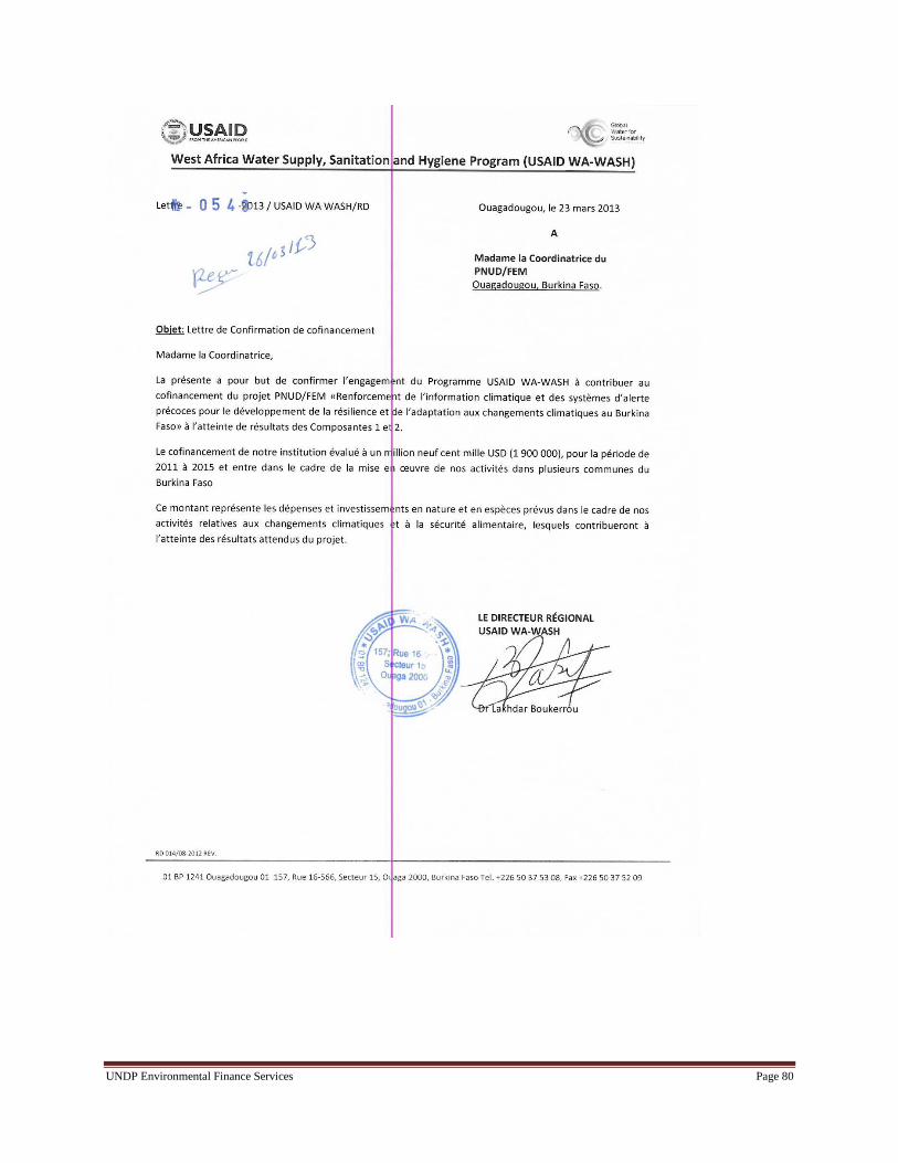
UNDP Environmental Finance Services Page 80

UNDP Environmental Finance Services Page 81

UNDP Environmental Finance Services Page 82

UNDP Environmental Finance Services Page 83
Annex 3: References
Buhl, S. 2005. Gender equality? No! What do Fulbe women really want? In Homewood, K. (ed.) Rural
Resources and Local Livelihoods in Africa, James Currey, Oxford, pp. 137- 154.
CONASUR, 2002. Banque de données à références spatiales en matière d’alerte précoce
Eriksen, S., J.T. Klein Richard, K. Ulsrud, L.O. Naess, K. O’Brien 2007.Climate Change Adaptation and
Poverty Reduction: Key interactions and critical measures, GECHS Report.
Eriksen, S., Brown, K. and Kelly, P.M. 2005.The dynamics of vulnerability: locating coping strategies in
Kenya and TGeographicalJournal, 171(4): 287-305.
GFDRR report, April 2011. Vulnerability, Risk Reduction, and Adaptation to Climate Change, Burkina
Faso, Climate Risk and Adaptation Country Profile.
O’Brien, K. et al. 2008. Disaster Risk Reduction, Climate Change Adaptation and Human
SecurityGECHS Report.
Post-DisasterNeedsAssessment (2010). Inondations du 1erSeptembre 2009 au Burkina Faso, Evaluation
des dommages, pertes et besoins de construction, de reconstruction et de relèvement.
United Nations Women Watch 2008. 52nd session of the Commission on the Status of Women
“Gender perspectives on climate change,” Issues paper for interactive expert panel on Emerging issues,
trends and new approaches to issues affecting the situation of women or equality between women and
men.
http://www.un.org/womenwatch/daw/csw/csw52/issuespapers/Gender%20and%20climate%20change%2
0paper%20final.pdf

UNDP Environmental Finance Services Page 84
Page 84
Annex 4: Key assessment reports
Roadmap
For the Establishment of a National Framework
for Climate Services in Burkina
Conclusions of Works
Ouagadougou, Tuesday July 31 2012

UNDP Environmental Finance Services Page 85

UNDP Environmental Finance Services Page 86

UNDP Environmental Finance Services Page 87

UNDP Environmental Finance Services Page 88

UNDP Environmental Finance Services Page 89

UNDP Environmental Finance Services Page 90

UNDP Environmental Finance Services Page 91
Page 91
Strengthening climate information and early warning systems in
Africa for climate resilient development and adaptation to climate
change –Burkina Faso
ASSESSMENT REPORTS
Authors : Dr. Cara Tobin and Dr. Pascal Yaka

UNDP Environmental Finance Services Page 92
Tables and Annexes
Tables
Table 1: Mission 1 Program and Findings: Preparation of EWS project in Burkina Faso (10 Sep 2012
– 20 Sep 2012)
Table 2: Revised Project Outcomes and Outputs
Annexes
Annex I: Inception Workshop Agenda
Annex II: List of participants at the Inception workshop for EWS project, PPG phase 11th September
2012, Ouagadougou, Burkina Faso
Annex III: Workshop Minutes
Annex IV: Mission 2 Schedule
Annex V: Agenda for the PROJECT PREPARATION Role Identification and Capacity Assessment
Workshop
Annex VI: Meeting Minutes from the PROJECT PREPARATION Role Identification and Capacity
Assessment Workshop
Annex VII: Participation List from the PPG Role Identification and Capacity Assessment Workshop
Annex 5: Minutes from meeting between DGM and private sector representatives
Annex 6: Existing Water Level Monitoring Network
Annex 7: Existing Flow Meter Monitoring Network
Annex 8: Existing Weather Monitoring Network
Annex 9: Proposed Flow Monitoring Network
Annex XI: Results for Self-Assessments on Capacity/Need Prioritization

UNDP Environmental Finance Services Page 93
Executive summary Mission 1:
Afirst mission was undertaken to support the Burkina UNDP Country Office with the design of an
Early Warning System (EWS) and climate information project to be financed by the LDCF. An
interactive workshop and bilateral consultations involving the producers, operators and end-users of
EWS as well as other key stakeholders were held between the 11th and 20th of September. The primary
tasks of the workshop and consultations were 1) to detail the baseline of Early Warning Systems in
Burkina Faso , 2) to develop a work plan to develop the UNDP project document for the LDCF
financed project on climate information and EWS for climate resilient development, and 3) to identify
potential co-financing sources including institutions who are managing/developing relevant on-
going/planned EWS related initiatives in order to ensure the UNDP-GEF/LDCF EWS project can
leverage and mutually support (and be supported by) other projects.
Key findings from the mission include:
There is a lack of data centralization due to various institutions acting as information producers
with limited means to transfer data efficiently between institutions (data are often transmitted by
post). In response, an open-access web-based portal to store data will be developed in this project.
It is difficult to produce weather forecasts for short-term alerts or long-term development
planning which are specific to the different administrative regions of Burkina Faso due to the
unrepresentative network of hydro-meteorological stations throughout the country. Through this
project, weather forecasters working for the General Directorate of Meteorology (DGM) will be
trained to use European/American forecast products. DGM could be trained to provide more
useful forecasts to socio-economical sectors (e.g., agricultural, natural disaster
management)which can detail extreme meteorological events (floods, hot winds, dusty periods) as
well as particular climatic events (drought and rainy periods).
There is a lack of coordination with existing EWS initiatives which provide alerts for famine and
dam management. This project can use the existing Interdisciplinary Working Groups platforms
(GTP) to generate alerts.
There is a lack of technical means to disseminate warnings and lack of a standardized information
paths from national to local levels and vice versa. This project should enable a formalized
information chain from national to local levels and build capacity communication local focal
points to provide alerts.
A lack of automatic weather and hydrological monitoring equipment and the existence of old
equipment requiring repair will be resolved by procuring and rehabilitating hydro-meteorological
infrastructure. Consultations with the DGM and the Ministry of Water provided details of the
quantity (and locations in some cases) of stations/gauges required to enable a better representation
of climate and environmental variables.
Information producers in DGM and the Ministry of Water (DGRE) require training on
information collection, data treatment and the operation and maintenance of equipment.
There is a need to create a synergy between EWS agencies and between EWS-related initiatives.
There is a need to build technical capacity within CONASUR to be able to respond to
catastrophes at their local branch levels. The provincial, departmental and local branches of
CONASUR do not have the capacity to interpret, simplify and relay technical, meteorological and
climatological information and alerts. Also, they do not have the physical means to communicate
efficiently so that information can be relayed from national to local levels and vice versa.
Conclusions from consultations and the workshop indicate that it is recommended to organize
capacity building for the decentralized branches to improve their understanding of hydro-
meteorological forecasts. Also, CONASUR’s capacity to communicate could be improved by
providing CB radio systems to the local offices.

UNDP Environmental Finance Services Page 94
1. Initial activities, workshop and consultations
An interactive national workshop on Early Warning Systems (EWS) was held on the 11th September
2012 at the Ministry of Environment in Ouagadougou, Burkina Faso. The purpose of the workshop
was to bring together the producers of hydro-meteorological information, the technical and financial
EWS partners, those in charge of disseminating alerts and parties concerned with the management of
catastrophes and natural disasters to present the intended scope of the project (as cleared by
LDCF/Council) to facilitate the exchange of ideas on how to best elaborate, implement and develop a
sustainable EWS in Burkina Faso.
Bilateral consultations took place with technical institutions (the Water and Information Study
Institute (DEIE), the SAAGA program, and the Meteorological Forecast Center (CMP/ASECNA)),
government departments (the Direction of Communication, the General Directorate on Civil
Protection, and the National Advisory on the Environment and Sustainable Development,
SP/CONEDD), bilateral/multilateral donors (World Bank, UNDP) and NGOs (the Civil Society
Organization on Climate Change, the Farmers Confederation of Burkina Faso).The purpose of these
meetings was to inform the relevant institutions and departments of the scope of the proposed LDCF
project, to understand the role of key EWS actors, elicit ideas on details that could be factored into the
LDCF project during the design phase so as to ensure that the LDCF financed project coordinates and
complements other ongoing and planned initiatives. The needs and estimated costs for developing and
facilitating EWS capacity and efficiency were also discussed.
1.1 Inception workshop
The workshop involved 51 participants from organizations ranging from technical institutions such as
the General Directorate on Meteorology (DGM) to institutions concerned with disaster and risk
management (the National Advisory for Emergencies and Rehabilitation, CONASUR) as well as the
Farmer’s Confederation of Burkina Faso which is a platform which represents 14 rural organizations.
Working sessions were not deemed necessary for the workshop because the World Meteorological
Organization led a 3-day workshop at the end of July 2012 to discuss the needs for climate services in
Burkina Faso. The WMO workshop discussed the lead institutions, timelines and funding sources for
various climate service activities such as the establishment of a severe weather EWS and
identification of target NGOs that can serve as channels for disseminating weather information to
vulnerable communities. The roadmap generated at the WMO workshop is being used to help identify
suitable investments and capacity building activities by this project.Annex II shows the agenda for the
workshop.
1.1.1 Key sectors / users of climate information
Through the workshop and consultations, key sectors/users of climate information and EWS were
identified. These institutions or organizations are detailed below.
The National Advisory for Emergencies and Rehabilitation (CONASUR) supports the prevention
and management of natural catastrophes and the rehabilitation of impacted parties on national,
regional, and local levels. They are currently responsible for providing alerts in accordance with
the risk and catastrophe plan of the Department of Civil Protection.
The Department of Civil Protection is the overseeing body for plans to prevent and react to
catastrophes. Like its operating arm, CONASUR, it is decentralized with focal points located
nationally, regionally, provincially and locally.
The National Weather Service (DGM) is the parent organization for two private organizations, the
Meteorological Forecast Center (ASECNA) concerned with forecasting for aviation and cloud
seeding and SAAGA concerned with collecting radar data (Radar and Cloud Seeding Center for

UNDP Environmental Finance Services Page 95
Aeronautical Aviation SAAGA). These organizations need to be better coordinated in the LDCF
project.
In the context of this project, the Ministry of Water (DGRE) is responsible for managing
hydropower operations (dam spillways and reservoir levels). They currently provide automatic
alerts to the populations located around the dams through radio communication.
The Water Study and Information Center (DEIE) is a technical institute responsible for all
hydrological modeling.
SP/CONEDD, DCIME is in charge of storing and disseminating environmental data for planning
adaptation to climate change activities at all levels. Every 4 years, they produce a report on the
state of the environment in Burkina Faso.
The Direction of Communication is responsible for managing all public media services (radio,
television, newspaper) and coordinating with private media services.
The Rural Confederation of Burkina Faso coordinates with 14 rural organizations concerned with
agricultural and livestock production.
The Civil Society Organization on Climate Change is an NGO with 40 members who concentrate
on influencing political leaders and training local societies on adaptation to climate change
principals. They promote techniques for adaptation to climate change.
1.1.2 Scope of project
The general consensus from the workshop and bilateral consultations is tobuild Early Warning
services throughout the entire country based on the needs of the principal end-users: the rural
populations including farmers and agro-pastoralists. The aim of this project is to develop an Early
Warning System (EWS)for natural catastrophes, including floods, ,strong and hot winds as well as
seasonal alerts for droughts during rainy periods. Targeted areas which have previously suffered from
droughts or floods and are considered vulnerable agro-ecological zones (NAPA 2008) will serve as
project indicators by comparing alert communicationin these areasafter the development of EWS over
present day alerts.

UNDP Environmental Finance Services Page 96
1.2 Initial consultations
Meetings were conducted with the UNDP Country Office and key representatives of bilateral/multilateral organizations represented in Burkina in order to
facilitate the design of the EWS. Details of these consultations are indicated in Table 1.
Table 1: Mission Program and Findings: Preparation of EWS project in Burkina Faso (10 Sep 2012 – 20 Sep 2012)
Day/Date Time Meetings/Activities Findings
Mon 10 Sep 2012 8:00–18:00 Workshop Planning, NC/IC/Aki Agenda, budget and key speaker finalization for the inception workshop
Tues 11 Sep 2012 09:00-
14:00
Inception Workshop See Workshop Minutes Annex III
17:00-
18:15
SP/CONASUR Role of CONASUR is to provide alerts during natural catastrophes
Need for privileged communication systems (FLOTTE)
Need training, a formalized, communication chain and means of data transfer
with information providers
18:30-
20:00
Direction de la Protection Civile Have multi-risk plan to deal with various catastrophes. This project falls under
natural catastrophe planning & management
Lack of assigned roles in EWS
Need flood risk maps for the country
Need for privileged communication systems (FLOTTE)
Wed 12 Sep 2012 09:30-
10:45
Programme SAAGA Radar requires expensive operation and maintenance because only specialists
from the US have the capacity to do O&M.
Radar in Ouagadougou is not functioning because they require O&M training.
Power surges damage electricity transmission so they would like solar power
capability.
Need a formalized way to provide radar images to DGM
11:00-
12:00
ASECNA Like the DGM, they have a role in weather forecasting
Training on weather forecasting products, equipment and software is
necessary
Need to hire personnel for 24 hour-7 day weather forecasting
12:30-
14:00
Direction Générale de la Resource en Eau
(DGRE)
They perform hydrological modeling for several watersheds and generate a
yearly hydrological atlas and bi-weekly hydrological bulletin
Only manual flow meters are used; Volunteers to measure flows are lacking
and data quality is questionable due to human error
Require additional automatic flow meters and boats to obtain the readings
Require training with hydrological modeling software (HECRES and

UNDP Environmental Finance Services Page 97
MIKESHE)
Need for CB radios, otherwise known as privileged communication systems
(FLOTTE)
16:00-
17:30
SP-CONEDD/DCIME Have satellite thanks to AMESD project (2010)
Involved with UN-SPIDER, PUMA and EMMA projects
Produce a state of the environment report every 4 years
Need mode of transport and GPS units to validate satellite data in remote
terrain
Need training to update their capacity for environmental data analysis
Need EWS focal points and accessibility for all data
Need workshops with other data producers to enhance coordination
Thurs 13 Sep 2012 8:30- 9:30 Secretariat Général Ministère de la
Communication
They have an international mailing list, call center, toll-free number and
website and work with public/private media, nationally and locally
Call center will be operational at the end of September 2012
Need better coordination with information producers because they do not
receive forecast information systematically.
They do not understand technical warning messages so they are unable to
simplify the messages for end-users
Need computer equipment to make functional call center 24 hours / 7 days per
week
Need training with information producers in order to understand warnings and
means of transport to do warnings.
9:45-11:00 Rural Confederation of Burkina Faso,
Confédération Paysanne du Faso (CPF)
Include 14 structures ranging from livestock to agricultural production
Now insufficient data transfer to rural population. Warnings come too late and
forecasts are not accurate.
Can use local offices to disseminate warnings
Due to their local influence, they must be included on boards of project and in
all training workshops
Local population listen more to local radio so messages must be in local
languages on local stations
Have themed workshops already (last one on Climate Change) and have the
capacity to provide training on EWS to rural end-users
11:30-
13:00
Direction Générale de la Météo (DGM) They require automatic weather stations (synoptic and climatologic), numbers
are costs to be provided
Their capacity to provide forecasts is limited so they need training with
regional and international models (e.g., COSMO)
PANA project is planning to install weather stations. These stations will be in
addition to have a better network.

UNDP Environmental Finance Services Page 98
Need regional forecasts with a shorter lead-time (6 hours for EWS)
Need one more launch per day for soundings in Ouagadougou
16:00-
18:00
PANA Institutional arrangement discussion: this project should be implemented as
Category B where country becomes autonomous structure
Must collaborate with UNDP COGEL project for co-financing
For regional component, could work with ACMAD and Agrhymet
Fri 14 Sep 2012
10:00-
11:30
Direction Générale de la Production, et des
Statistiques sur l’Elevage (DGPSE)
This institution provides statistics on livestock farming
They study the movements of pastoralists and their livestock
They would like to see EWS alerts transferred to all livestock owners, even in
the most remote regions, and will assist with the information dissemination
process
Mon 17 Sep 2012
15 :30-
16 :30
Coalition d’Organisation des Sociétés Civiles
sur le Changement Climatique (COS3C)
(NGO), linked with SOS-SAHEL
Founded in 2010 (40 members), their role is to influence politics to put
Climate Change (CC) on initiatives, to help in CC policy writing and to aid
with techniques to adapt to CC
They manage meetings on CC and on regional down to local levels if funding
becomes available
They work with other NGOs (IUCN and Christian Aid)
They are limited in their means of transport to disseminate information
Thurs 20 Sep 2012
11:00-
12:00
UNFCCC Point Focal + SP (OFP/FEM) UNFCCC is in full support of the project and SP/CONEDD is here to help
with administrative and political difficulties
Warns that results must be simple and concrete otherwise there will be no trust
in the EWS
Must decide if want an experimental or operational approach
Must interview people to see if they understand alerts
12:00-
13:00
Service de l’Information
Gouvernementale(SIG)
This service is part of the Ministry of Communication
They have the capacity to provide alerts if new telecommunication and
computer equipment are provided for the call center and a high bandwidth
cable is provided to improve telecommunication
They have experience is giving alerts and reporting
Must sign convention among partners to define who does what
13:00-
14:00
BanqueMondiale (Emmanuel Nikiéma) Inundation risk maps exist from another World Bank project, must contact
WB to exploit and update this information
PNGT project is community based and driven (e.g., building shallow wells,
schools, vaccination, etc)
PNGT project can serve as source of co-financing
Building companies can be private sector source of revenue
Can work with DGM and WB to improve the communication of local weather
measurements

UNDP Environmental Finance Services Page 99
18 :00-
18 :30
UNDP COGEL (Alexis Kaboré), Climate
change 2012-2015
COGEL is a program to build resilience of people to CC in eastern and
central-northern Burkina
They are implementing communication channels with villages
Sustainable management of natural resources is not easily transferrable to rural
regions
Can be another source of co-financing
UNDP Environmental Finance Services Page 100
2. Project development
2.1 Current and past EWS-related activities
The proposed EWS will need to complement the existing alert programs already in place for famine
and hydropower in Burkina Faso. Alerts coordinated by the Direction of Production and Rural
Economy (DGPER) in the Ministry of Agriculture and Hydraulics are provided for food security
including several national / regional institutes and technical and financial partners (including
AGHRYMET, FEWSNET, OXFAM, and the World Food Program). Alerts are also coordinated by
DGREwho provides alerts for 15 national dams when water is insufficient for irrigation or when
reservoir levels need to change to mitigate floods for downstream residents. Neither of these alert
programs is concerned with extreme weather warnings on a national scale.
There has been significant devastation caused by floods in 2008, 2009 and 2010. However, flood
alerts have been generally absent or false so that reactive decision-making has not been possible. A
prime example is the 2009 major flood event, one of the most destructive floods in Burkina history,
where no alert was disseminated to the population.
Knowledge and information sharing platforms (Groupe de Travail Pluridisciplinaire, GTP) created
under the existing EWS programs for food security and dam management must be exploited in this
project. These platforms consist of interdisciplinary working groups which share knowledge for
decision-making. The working groups consist of members from numerous institutions including
DGRE, DGM, the Direction of Production and Rural Economy (DGPER), the Ministry on the
Environment and the National Advisory for Emergencies and Rehabilitation (CONASUR). Based on
consultations, it was deemed redundant and unnecessary to create other EWS platforms specific to
this project.
In the case of catastrophes, some relevant institutions such as NGOs and social organizations,
mobilize to assist and take some preventive actions. In terms of donors,the World Bank (WB) has
been active in flood projects. Previously, they generated potential inundation zones maps in 2007 for
Burkina Faso. These maps will be exploited in this project.
CONASUR is the operational governmental institute responsible for emergency and rehabilitation
actions. CONASUR has implemented flood security measures in 6 vulnerable zones and has
identified flood zones in the region of Burkina’s capital, Ouagadougou. CONASUR’s role with
catastrophe management includes i) organizing meetings with parties concerned with natural
catastrophe prevention and management, ii) providing internal training courses to their decentralized
agencies on regional, provincial and local levels, and iii) annually organizing an open dialogue with
local mayors on the prevention and management of natural catastrophes. In 2007, CONASUR adopted
a multi-risk contingency plan to improve preparation and responses to catastrophes.
National policies which support the elaboration of EWS for natural catastrophes include the National
Civil Protection Policy, adopted in 2010 and Burkina’s NAPA. This project is fully in-line with the
NAPA strategy in terms of strategic planning for adaptation to climate change in the long-term. Due
to complementary NAPA initiatives, the meteorological network is in the process of being expanded:
15 automatic weather stations are being installed. This project will place additional stations in
complementary locations to those planned by the NAPA initiative.
Furthermore, this project will integrate into the National Framework for Climate Services. This
framework was developed recently in late July 2012 following a three-day workshop led by the World
Meteorological Organization. The workshop involved numerous governmental and non-governmental

UNDP Environmental Finance Services Page 101
institutions concerned with hydro-meteorological information who together outlined a roadmap for
the establishment of climate services.
This project will also build off of regional EWS-related efforts. Formalizing a solid collaboration with
ACMAD’s ViGIRisC (African Early Warning and Advisory Climate Services (AEWACS)) project is
recommended. ACMAD provides seasonal forecasts issued during the PRESAO meetings to the
DGM. The aims of the ViGIRisC project are: (i) to provide a needs assessment for climate risk
identification in terms of Early Warning Systems and (2) to identify opportunities for EWS
improvement in Africa for climate risk reduction. This project will coordinate with ViGIRisC to gain
knowledge on EWS in the region. In addition, the second phase of ViGIRisC will include the
installation of pilot EWSs in selected countries and regions. This project could exploit the ViGIRisC
project at the regional level by using ACMAD facilities, and taking part in ACMAD’s forecast
training courses for West Africa.
In spite of the current EWS initiatives within the country and regionally, a formalized mechanism for
EWS and transmitting alerts is lacking. Such a mechanism must take into account lessons learned
from the existing EWS-related initiatives and place more emphasis on implementing EWS in regions
of Burkina Faso which are considered vulnerable to extreme weather. Based on conclusions from the
workshop, a platform containing representatives from DGM, DGRE, SP CONEDD and CONASUR
will manage the implication of the actors of existing EWS-related projects in order to reinforce
collaboration and facilitate discussion and knowledge sharing.
Moreover, currently, there is no formal communication mechanism to officially disseminate alerts. A
formal communication mechanism must include a standardized flow for information for issuing
warnings from national to local levels and vice versa. Warnings must be issued in all local languages
(through both governmental and non-governmental agencies). Consultations indicated that appropriate
local institutions must be assigned responsibilities for warning transmission in order to ensure EWS is
decentralized and efficient.
2.2 Other interventions and their successes/failures
Currently, the Direction of Communication has well-developed methods for disseminating
information and alerts to the general public on national, regional and local levels. However, there is
little coordination between the technical data production institutions and the Direction for
Communication. Also, the media expressed their confusion with technical forecasts and their need to
simplify this information for end-users. This project can help to bridge the gap in message
dissemination and clarification between the producers and communicators of EW messages.
The following means of communication could be exploited for disseminating alerts:
A mailing list which provides messages to a broad audience including ministers, ambassadors,
NGOs and community organizations;
Acall center which is operational since the end of September 2012, consisting of 4 people on-line
24 hours a day, 7 days a week;
A toll-free telephone number for inquiries;
A website for general information
It must be emphasized that CONASUR has significant technical capacity constraints because their
regional and local offices currently lack a means to communicate with the local populations and an
understanding of EWS alerts and required actions. This project could build capacity on all levels

UNDP Environmental Finance Services Page 102
within CONASUR by procuring privileged communication systems and enabling capacity building
for CONASUR’s local branches to communicate hydro-meteorological alerts.
There are also no organized debriefings with the National Meteorology and Hydrology Services (e.g.,
DGM, DGRE, scientists (modeling laboratories), decisions makers (CONASUR, Ministry of Public
Health, Ministry of Planning) and donors (UNDP, World Bank) or NGOs before or after flood events
to integrate lessons learned. Consultations showed support for the idea of having CONASUR organize
debriefings post natural catastrophes.
2.3 Limitations of current capacity and existing systems
Weaknesses and limitations of current EWS systems and their capacity include the following:
Poor local catastrophe prevention in the field by CONASUR. Within the past 5 years, there have
been floods in various regions in Burkina. CONASUR was unable to preventively act or use
forecasts appropriately. As a result, potential damage was not anticipated and some foreseen
consequences were not limited. In contrast, after the flood events, management of the catastrophes
to assist local populations has been more or less well organized;
A need to assimilate forecasts and monitoring into existing development planning, Poverty
Reduction Strategy Papers (PRSPs) and disaster management systems;
No formalized communication chain between information producers and the Direction of
Communication to officially disseminate alerts through multiple sources of media;
Poor understanding of alerts and scientific jargon by the Direction of Communication;
Poorly utilized local focal points within CONASURto effectively decentralize information
dissemination;
Poor coordination between hydrological and meteorological information providers (rain gauge
information is not incorporated into the HECRES and MIKE BASIN hydrological models used by
DGRE);
Lack of clear collaboration between technical and governmental institutions, namely the DGM,
the DGRE, and the institutions responsible for disseminating alerts such as the Direction of
Communication;
Weather forecasting data is weak and not quantitative in terms of rainfall intensity and wind
velocities per various regions of Burkina;
Lack of useful forecasts for the agricultural sector detailing drought and rainy periods to enable
long-term development plans.
2.4 EWS components, existing and proposed
The existing EWS components and their insufficiencies (if any) include the following.
Multiple manual flow meter measurements (See Annex V for hydrological
monitoring locations.)
o No automatic, real-time flow measurements prevent decision-making for
alerts because collection time takes days to weeks. This hinders the ability to
provide sudden warnings for threats such as floodplain inundation.
10 automatic synoptic weather stations, 6 automatic agro-meteorological stations, 13
manual agro-meteorological stations, 9 manual climatologic stations and 120 rain
gauges (See Annex VI for locations of existing meteorological stations.)
o The observation network is not dense enough to see the evolution of
meteorological variables or to have sufficient information for reliable short-

UNDP Environmental Finance Services Page 103
term weather forecasts and long-term seasonal forecasts. The network is also
not to norm with WMO standards: One synoptic station every 100 km and 1
rain gauge every 8 km is recommended.
2 radar (Bobo and Ouagadougou):
o The radar in Ouagadougou is not functioning because of electrical problems
and due to the incapacity of the technicians to repair the equipment. (Only
technicians from the US have the capacity to perform repairs.)
1 sounding per day:
o Two launches per day (one at noon and another at midnight) are standard
world-wide to have enough atmospheric profile information to serve as input
for ASECNA weather forecasts.
2 satellite receiving stations (1 at ASECNA, 1 at DCIME)
o The number of satellites is sufficient and the satellites are functioning;
however, technical knowledge of weather forecasting and software for
environmental data analysis is lacking.
Daily 24 hour forecast indicates weather orientation in general
o No forecasts are provided per region and none provide quantifications of
rainfall or wind intensity. Both aspects are necessary for local planning
during periods of extreme weather.
Weekly hydropower bulletins and an annual report on hydrological resources
o These bulletins show the dam levels and the availability of reservoir water to
prevent crises linked to the absence or abundance of water. The annual report
provides information on the state of water bodies. However, no frequent
weather bulletins exist at the scale of the country which can assist EWS
planning.
Flood risk maps from a 2007 World Bank study
o These maps are potentially outdated considering development in the past 5
years. The maps will be updated in this project.
Annual meeting organized by CONASUR and provided by DGM are used to present
seasonal rainfall forecasts to local mayors in terms of rainfall below-near-or above
average.
o The forecasts are not considered reliable and precise enough for proper
cultivation/livestock planning.
Needs for the EWS components include:
Approximately 150 rain gauges, 30 automatic climatic weather stations, 4 automatic synoptic
weather stations, 100 manual flowmeters and 2 automatic Doppler flow meters (See Annex VII
for proposed weather station locations.)
Repair of the radar in Ouagadougou
Training for radar technicians on operation and maintenance
Training in Numerical Weather Prediction (e.g., COSMO/WRF) for weather forecasters at DGM
and ASECNA
One more sounding launch per day to obtain atmospheric profile measurements required for
weather forecasting

UNDP Environmental Finance Services Page 104
Purchase of solar electricity equipment and protection against power surges which damage
electricity transmission
Improving the understanding of forecasts by the Direction of Communication and local
CONASUR branches in terms of clarifying scientific jargon (in meteorology and hydrology) and
simplifying messages for dissemination
Privileged telephone communication systems (FLOTTE) to facilitate EWS message dissemination
Institutions with specific roles in EWS to clarify tasks, the chain of information dissemination and
data validation
Preparation of updated risk maps (e.g., flood inundation maps) for the entire country
Additional equipment for the emergency call center including telephones and computers
Mobile phone services to translate SMS messages into multiple languages and to provide vocal
messages for warnings to the general public
Translation of all warnings and weather bulletins into all national languages
Financial capacity for NGOs and the Farmer’s Confederation to inform the local populations
about EWS with their decentralized structures and presence on the ground regionally, provincially
and locally
Conclusions from the workshop and consultations demonstrated that ministries are well aware that
they must properly inform rural populations so that they can act in advance to evacuate, cultivate in
advance and protect livestock. They will ensure that the project is decentralized in order to get alerts
to the regions more effectively. To accomplish this, the established vertical chain of government from
a national level (Government, Ministry) to the local level (Municipality, Village) will be exploited
and appropriate local institutions will be informed, consulted and included in warning transmission.
Furthermore, the project will build Early Warning services based on the needs of the principal end-
users; coordination with the Farmer’s Confederation and the Civil Society Organization on Climate
Change has already begun. These collaborations will enable dialogue with the local communities to
detail their needs for a properly functioning and efficient EWS. By enabling these organizations to
inform the communities of this project through workshops, users will become self-enabled and
motivated to make the alert system more effective.
2.5 Capacity of forecasts and needs for improvement
The DGM currently provides a 24 hour weather forecast indicating weather orientation in general. No
forecasts are provided per region and none provide quantifications of rainfall or wind intensity. Both
aspects are necessary for local planning during periods of extreme weather. An agro-meteorological
bulletin, elaborated every 10 days, is also produced. It summarizes the meteorological conditions in
the past and makes qualitative weather forecasts. Furthermore, DGM is supported by the insurance
association, SONAR, which sponsors the publication of a meteorological bulletin on national
television. This television weather bulletin is watched and appreciated by a variety of audiences in
Burkina.
Currently, qualified DGM personnel are lacking to ensure that a forecasting team is present and
capable of providing forecasts 24 hours per day 7 days per week. Furthermore, forecasters are lacking
numerical weather prediction skills which are better adapted to the topographical complexities of
Burkina and which can be used to refine current weather forecasts. (Forecasters working with satellite
images or wind data are exceptions).
The DGM therefore requires significant weather forecasting training. Collaboration should be
formalized between this project, the ViGIRisC project training center and European and American

UNDP Environmental Finance Services Page 105
forecasting centers in order to enhance the training available. It is also feasible that the DGM partakes
in regional weather forecast training organized by ACMAD and other international centers.
2.6 Operation and maintenance gaps
DGM annually detail maintenance needs in terms of equipment needed or in need of repair. However,
DGM currently have a tight budget and are only able to perform operation and maintenance through
the financial support of ASECNA. They expect that with this project after infrastructure has been
procured or rehabilitated and their personnel have been trained, they can recover some recurring costs
by selling climate information products to the private sector.
To date it has not been possible to collect needs and costs for operation and maintenance from
information producers due to their busy schedules. The National Consultant has booked meetings in
the future with DGM (Re: meteorological stations), DGRE (Re: hydrological stations), ASECNA (Re:
sounding discussion) and the program SAAGA (Re: radar discussion). He is also frequently
corresponding with them via email in order to engage them in the project.
2.7 Information access and dissemination
There is a lack of data centralization due to various institutions acting as information producers.
Furthermore, awareness of data located at different departments, institutions, NGOs and other
stakeholders is limited.
There are also limited means to transfer data efficiently between EWS agencies. Data from
meteorological and hydrological stations or instruments are primarily collected on a daily basis,
recorded on paper, and sent once a month by mail to regional offices and to the central data
production office of DGM or DGRE in Ouagadougou. An open access portal to store data and secure
data servers was therefore deemed necessary to ensure transparent databases for all EWS information
production actors and efficient inter-departmental data exchange.
A formalized system through which CONASUR and the DGPC can receive hydro-meteorological
information in a privileged manner does not exist. These national DRR agencies are thereby not able
to anticipate the consequences of extreme weather phenomena and to plan accordingly. Currently,
they must look at general information emails between members of the interdisciplinary working
groups (GTPs) to have an idea on the current monitoring of famine alerts.
Furthermore, there is a need to collaborate with countries in the region in terms of hydro-
meteorological data sharing. The majority of West African countries depend on regional climatic
zones which have the same weather patterns progressively. Regional forecasts track weather patterns
on international-and regional scales such as with PRESAO forecasts (ACMAD). Similarly, the
hydrologic network is linked between countries (Burkina, Mali, Niger, Benin, Cote d’Ivoire, Ghana)
because watersheds and rivers traverse country boundaries; rain patterns upstream must be
communicated to downstream Burkina. Models are lacking appropriate boundary and initial
conditions because Burkina has not been able to utilize trans-national data.
Conclusions from the workshop also indicated that information must be easily accessed so that
institutions can make correlations of weather and hydrology data with other environmental variables.
Often, interdisciplinary data analysis can have broader relevance and application for local intervention
planning and monitoring in the case of hydro-meteorological disaster risk.
2.8 Locations for hydro-meteorological infrastructure
Maps of the locations of the existing rain gauge and weather station networks are provided in
Annexes V and VI. A map of the proposed weather station network is provided in Annex VII

UNDP Environmental Finance Services Page 106
(proposed locations for rain gauges have not been finalized). Further bilateral consultations between
the national consultants and the key institutions are necessary to clarify the exact location of new
equipment or equipment to be rehabilitated.
2.9 Potential private sector clients
A key aspect of workshop and consultation discussions revolved around leveraging project funds so
that the resulting EWS system is sustainable in the long-term. Regular revenues from the purchase of
EWS products by the private sector could help the project to develop cost-recovery mechanisms such
as to cover the costs of operation and maintenance. However, it is essential to obtain more detail about
the existing and potential of private sector interest in climate information. Consultations to see if any
formalized partnerships with the private sector can be created are planned. At this point of the project,
a list of potential private sector clients who may be willing to pay for climate products has been
outlined. They include:
i. Agro businesses (e.g., cotton industries like SOFITEX, sugar industry like SOSUCO,
Mineral Water Industry like LAFI, BARAGUI, YIRMANI) - Value-added climate risk
information such as the location of specific seasonal rainfall/temperature forecasts,
strong winds, droughts, and floods can be of value to these private entities in adjusting
their sowing/harvesting production behaviors.
ii. Hotel industry and tourism - The hotel and tourism industries are the two leading
private sectors interested in climate information. Real-time rainfall, temperature and
flood warning information are requested by hotel and tourism operators.
iii. Building (BTP) companies - For BTP companies, climate risk information can be of
value in planning construction activities.
iv. Civil aviation - There has been discussion about opening domestic flights covering the
13 regions of Burkina. Real-time weather information can potentially be useful for
flight operation and planning.
v. Insurance companies - Further discussions will be engaged with insurance companies
(e.g., Colina, Sonar, General des Assurances, UAB) to identify their interests in
climatic risk and weather information. Potentially, risk hazard forecast maps can be
purchased by insurance companies to enable them to set more accurate premiums and
payout calculations.
vi. Mobile phone companies - Telmob, Telecel, and Zain have the potential to be
interested in providing weather forecasts over the phone.
vii. Mining - The emerging mining industry in Burkina has the potential to be interested in
EWS due to the risks meteorological phenomena can pose on installations and
productivity.
viii. Hydropower industry – SONABEL is a most likely user of EWS alerts due to their
need to operate turbines and reservoirs according to extreme weather behavior.
2.10 Outcomes and outputs
The outcomes identified in the Project Identification Framework have remained virtually the same.
The general concept of the outputs has remained the same while the quantities of
infrastructure/personnel to procure/rehabilitate/train have changed based on departmental-specific
needs. Table 2 below details the revised Outcomes and Outputs.
Table 2: Revised Project Outcomes and Outputs
OUTCOMES OUTPUTS

UNDP Environmental Finance Services Page 107
1. Enhanced capacity of
national hydro-
meteorological services
(NHMS) and environmental
institutions to monitor
extreme weather and climate
change
1.1 Procurement and installation or rehabilitation (in case of existing) of
approximately 100 hydrological monitoring stations with telemetry and 2
automatic Doppler flow meters with archiving and data processing facilities.
1.2 Procurement and installation of 30 automatic climatologic stations, 150
rain gauges and 4 automatic synoptic stations. All stations/gaugeswill be
equipped with telemetry, archiving and data processing facilities.
1.3 Rehabilitation of the radar in Ouagadougou. Training on radar operation
and maintenance.
1.4 Radiosonde equipment to provide one more sounding per day; two
soundings will adhere to WMO standards to be able to provide atmospheric
profile information every 12 hours so that weather forecasts can be updated.
1.5 Equipment for satellite imaging and data visualization is required; the
two satellites (at ASECNA and DCIME) function well but data treatment is
lacking.
1.6 Training of at least 4 engineers or technical officers to maintain and
repair equipment, computer infrastructure and telecommunications,
including cost-effective technologies to interface with existing
equipment/software.
2. Efficient and effective use
of hydro-meteorological and
environmental information
for making early and
seasonal warnings and long-
term development plans
2.1 NHMS capacity to make and use climate forecasts (on hourly, daily and
seasonal timescales) is strengthened by training at least 10 forecasters.
2.2 Tailored sector-specific early warning products that link climate,
environmental and socio-economic information on short-term and seasonal
timescales are developed, based on identified user needs from NGO and NC
consultations.
2.3 National capacity for CONASUR to assimilate forecasts and monitoring
into existing development planning, PRSPs and disaster management
systems is built, including coordination with systems and warnings
developed by other initiatives.
2.4 Communication channels and procedures for issuing warnings (through
both governmental and non-governmental agencies) are enabled through
radio, newspapers, mobile phones, television and social media outlets with
warnings disseminated in local languages.
2.5 Plans for sustainable financing for the operation and maintenance of the
installed EWS are developed and implemented, including public and private
financing options to assist cost-recovery mechanisms.

UNDP Environmental Finance Services Page 108
Executive summary Mission 2:
The second mission was undertaken to support the UNDP Country Office to engage with climate
information and Early Warning System stakeholders to finalize design aspects of the UNDP-
GEF/LDCF financed project. The primary tasks of this mission were 1) to validate Early Warning
System (EWS) costs provided by each agency in Burkina Faso 2) to perform a capacity assessment of
each EWS agency and 3) to formalize the roles of each EWS agency in information dissemination. All
three tasks were facilitated by holding a workshop among the stakeholders including the producers,
operators and end-users of climate information and EWS and conducting individual meetings with the
key representatives of the EWS agencies. In addition to the co-financing sources identified during the
first mission, this mission was also used to target additional sources of co-financing to ensure the
project can leverage and mutually support (and be supported by) other projects.
An interactive national workshop on the use of climate information and Early Warning Systems (CI-
EWS) was held on the 21st September 2012 at the Ministry of Environment in Ouagadougou, Burkina
Faso to bring together the producers of hydro-meteorological information, those in charge of
disseminating alerts and parties concerned with the management of catastrophes and natural disasters,
in order to contribute towards the final design phase of the EWS project. The workshop was used to
present the detailed scope of the project, which has been formulated during 2 months of individual
consultations with relevant agencies following the inception workshop in September (see Agenda,
Annex II). The capacity of all agencies involved in CI-EWS information production and
dissemination was also assessed during the workshop with participants answering one of two
questionnaires, a questionnaire for i) climate, hydro-meteorological information producers and ii)
information and alert dissemination agencies, particularly the NGOs and civil society organizations
(CSOs) at the ground level. The goal of the questionnaires was to identify the capacity of their
respective agency with respect to CI-EWS tasks and to prioritize their needs. The workshop was also
used for informal discussions to interactively decide who would be the focal points from each agency
for generating and disseminating alerts. Focal points were chosen based on their human resource and
technical capacity to provide efficient alert dissemination.
I. The workshop involved 30 participants from organizations ranging from technical institutions
such as the National Meteorological Service (DGM) to institutions concerned with disaster and risk
management (the National Advisory for Emergencies and Rehabilitation, CONASUR) as well as the
Farmer’s Confederation of Burkina Faso which is a platform which represents 14 rural organizations.
Overall, 6 agencies involved with information production and 14 agencies involved with information
dissemination were represented (See Annex IV for participant list).
II. Bilateral consultations also took place with key CI-EWS information production agencies,
including the General Directorate for Meteorology (DGM), the SAAGA program (a government
agency focused on aviation forecasting), the Meteorological Forecast Center (CMP/ASECNA), the
General Directorate on Water Resources (DGRE), the primary disaster risk management agency,
CONASUR, as well as NGOs. These consultations were used to validate and prioritize the financial
needs of these agencies for developing and facilitating EWS capacity and efficiency based on cost
estimates they each prepared following the inception workshop. Meetings were also conducted with
ground-based and decentralized NGOs including the Civil Society Organization on Climate Change,
the Women in Law and Development in Africa organization (WILDAF) and the Women’s Forestry
Association in order to ensure that each organization is implicated in the project to enhance alert
provision to vulnerable end-users, most notably rural women. Finally, additional multilateral donors
(USAID) were consulted to see if the LDCF financed project coordinates and complements their
ongoing and planned initiatives.
3.1 Key findings

UNDP Environmental Finance Services Page 109
The workshop was effective in providing a discussion forum to formalize the roles of CI-EWS
agencies in the information dissemination chain. Agreement was reached to use the General
Directorate on Meteorology (DGM) partnered with the General Directorate on Water Resources
(DGRE) to generate alerts. Alerts will be based on data from DGM and DGRE in addition to data
provided by the SAAGA program (radar), ASECNA (soundings) and any environmental information
provided by DCIME (Division of Environmental Information, Monitoring and Evaluation). Alerts will
be distributed to one central agency, CONASUR, before dissemination. CONASUR will be
responsible for alert dissemination, alert training to NGOs and will provide alert information to the
Direction of Communication and relevant NGOs such as the Farmer’s Confederation of Burkina Faso.
For a schematic of the proposed information chain with a feedback mechanism for end-users to
CONASUR and DGM via their current toll-free numbers, see Annex V.
1. Other findings in terms of project development as highlighted in the workshop include:
Need for coordination meetings within CONASUR nationally and within their
decentralized offices regionally (CORASUR and COPRASUR)
CONASUR will use their toll-free number to advise the public during alert periods
Lack of strategy to ensure continuity of forecasting; ASECNA is recommended to
continue forecasting during the beginning of the project until DGM forecasting
capacity is built.
Both DGM and ASECNA should become part of a trans-agency National Forecasting
Center team to be supported by this project.
All information production agencies should take part in contributing data and efforts
to create joint forecasting bulletins to be organized by DGM. Bulletins will include i)
a 24 hour forecast for the different weather regimes in Burkina including precipitation
intensity, temperature, and wind speed, ii) a 10 day agro-meteorological forecast
bulletin showing the same weather information specific for agricultural zones, and iii)
a seasonal rainfall forecasting bulletin for July, August and September.
Both DGM and ASECNA will send personnel to the African Center of
Meteorological Applications for Development’s (ACMAD) regional centers for
forecasting training financed by the project “Vigilance et GestionIntégrée du
RisqueClimatique” (VigiRisC) with a regional center for Burkina located in Niger.
Need to formalize agreement between ASECNA and DGM for transfer of forecasting
skills with the overall goal of strengthening weather forecasting nationwide
Need to include additional project Output (2.6) to ensure synergy between CI-EWS
agencies, particularly between information producers and dissemination agencies; a
workshop recommendation was to create a specific committee to ensure synergy
between agencies involved with generating or disseminating hydro-meteorological
alerts
Must ensure that CONASUR, the principal dissemination agency has the technical
capacity and human resources to distribute warning (e.g. sufficient personnel and a
computer server to store alert maps, alerts in all national languages and statistics on
disaster risk prevention to judge alert efficiency spatially)
Project should collaborate with the Multidisciplinary Working Group (GTP) for data
sharing. (The GTP generates early warning alerts currently for famine management.)
Project should collaborate with China and Japan National Centers for Catastrophes
because they have a comprehensive database on catastrophes in Burkina. (The
specific programs and data will be identified by DCIME in the next couple weeks)
Should include Ministry of Health (DGPS) in alert dissemination. (DGPS already has
strong ties with DGM due to previous joint workshops connecting climate and health
effects.)
Should enable open access to spatial information data from the UN Office for Outer
Space Affaires (UN OOSA) and the UN SPIDER project which is concerned with

UNDP Environmental Finance Services Page 110
developing the capacity of countries to use an open network of all types of space-
based information to support disaster management activities.
Need to elaborate a national protocol to formalize the roles of the CI-EWS actors
Must enable NGOs to collect user feedback in the form of a reverse information
dissemination chain through training and improved telephone communication systems
2. During the workshop, a capacity assessment questionnaire was used to ask a representative
from each organization the following questions. The primary goals of the assessment were to detect
potential weaknesses within each CI-EWS organization and to find any overall consensus as to which
capacity building issues are most pressing for the group as a whole.
3. The baseline capacity assessment involved two questionnaires, i) one designed for climate,
hydro-meteorological information producers and ii) the second designed for information and alert
dissemination agencies, particularly the NGOs and civil society organizations (CSOs) at the ground
level. The goal of the questionnaires was to identify the capacity of their respective agency with
respect to CI-EWS tasks and to prioritize their needs. A previous assessment for the Africa
Adaptation Program (AAP) by UNDP (2011) and another assessment by the WMO (2012) were used
to assess the capacity of institutions in Burkina; however, these studies were primarily focused on
climate variability / change issues. Questions posed to the agencies/organizations are listed in Tables
5a and 5b.
Table 5a) Information production agencies
2.1 To what extent do you have necessary human resource capacity for an Early Warning System (EWS)(e.g.,
weather forecasters)? If capacity is lacking, please specify enumerated, prioritized needs (1 being most needed)
in the Comments column.
2.2 To what extent do you know the costs of operation and maintenance for existing equipment?
2.3 To what extent are you familiar with cost-recovery mechanisms to pay for the costs of operation and
maintenance? In Comments column, provide examples of current cost recovery mechanisms you utilize.
2.4 To what extent are you willing to sell your climate products to the private sector for revenue to support
operation and maintenance costs given that the products must be tailored to private sector needs?
2.5 To what extent are you familiar with the roles of other information producers?
2.6 To what extent do you share data with other climate information producers? In Comments column, please
indicate who you collaborate with and with whom you are lacking collaboration.
2.7 To what extent do you think it is necessary to collaborate with other climate information producers?
2.8 To what extent do you currently collaborate with the private sector? In Comments column, provide
examples of how you work with the private sector.
2.9 What is your level of capacity for managing donor funds? If you have existing capacity, in Comments
column, provide examples of how you work with donor funds currently.
Table 5b) Information dissemination agencies
1.1 To what extent is your agency capable of disseminating alerts?
1.2 To what extent are you able to understand the hydro-meteorological alerts currently, in order to be able to
simplify them for local populations?
1.3 What is your level of technical resources to disseminate alerts (e.g., privileged Flotte telephone
communication systems, CB radios)? If capacity is lacking, please specify enumerated, prioritized needs (1
being most needed) in the Comments column.
1.4 What is your level of human resource capacity? If capacity is lacking, please specify enumerated, prioritized
needs (1 being most needed) in the Comments column.
1.5 To what extent are you capable of providing alerts in local languages?
1.6 To what extent are you able to provide messages through different sources of media? Please note in
Comments which media works best for rural populations where you have experience (e.g., radio, sms) with
1being the media source that is most effective?
1.7 What is your technical capacity to inform local population organizations of Early Warning System (EWS)

UNDP Environmental Finance Services Page 111
to make them more involved in this project? If capacity is lacking, please specify enumerated, prioritized needs
to perform training (1 being most needed) in the Comments column.
1.8 Excluding your own organization, what is your level of capacity to coordinate with either the local
CONASUR focal points, the Rural Confederation of Burkina Faso or the Civil Society Organization on Climate
Change (COS3C)? Please indicate in Comments if collaboration would be useful and why.
1.10 What is your existing capacity to hold joint training workshops for your decentralized offices with other
environmental-related organizations? (This question is asked to try to streamline alert dissemination to local
regions.)
1.11 Based on your experience, to what extent are local populations currently provided alerts? Please note in
comments what alerts are provided, when have alerts been provided or lacking, and who has provided the alerts.
1.12 Based on your experience, to what extent are local populations aware of climate change?
1.13 To what extent are local populations aware of ADAPTATION to climate change and how a weather
warning can help them become more resilient to the impacts of climate change?
4. Results from the baseline capacity assessment are provided in two formats:
i) Matrix with color and number coded capacity indicating scores of 1 (red, poor
capacity/knowledge/experience) to 5 (green, good capacity/knowledge/experience), Tables 1 and 3
ii) Bar chart indicating average capacity for all information producers/distributors collectively,
Tables 2 and 4
Information producers
5. Based on the numeric capacity assessment scores, it is clear that the agencies have similar
capacities based on each question. On average information producers have low capacity to i) budget
operation and maintenance costs, ii) establish cost-recovery mechanisms and iii) tailor products for
the private sector. These three needs will be addressed by the project Outputs 2.2 and 2.5.
6. General written comments provided in the Information Producer questionnaire by DGM,
DGRE, DCIME, ASECNA, SAAGA, DEES, DGPV are in alignment with the numeric scores.
Summarized comments include:
Not sure of Operation and Maintenance costs
Lack knowledge on how to establish cost-recovery mechanisms
Other than semi-private organizations that deal with aviation, (SAAGA), agencies are not
familiar with how to tailor weather/climate products
Data sharing needs to be improved and extended to all information producers and to outside
agencies (e.g., Ministry of Health)
Other than semi-private organizations (SAAGA), the agencies have an average capacity to
manage donor fund
Information distributors
7. Based on the numeric capacity assessment scores, it is clear that the agencies have similar
capacities based on each question. On average information distributors have low capacity to i)
understand alert jargon, ii) to translate alerts into local languagues (alerts are too technical and
unclear), and iii) to communicate effectively. Training for the NGOs/CSOs and CONASUR from
national to local sectors to clarify jargon and translate alerts will be provided in this project through
project Output 2.4. In terms of communication capacity, some NGOs/CSOs cited a prioritized need to
have better technical resources to disseminate alerts while others already have this capability. The
final budget will reflect the required equipment costs based on each agencies needs in Output 2.4.
8. Furthermore CONASUR and the NGOs/CSOs already have capacity to transmit information.
Most use radio, but more communication mechanisms are welcome (e.g., sirens). These organizations
already have experience with collective training. The average consensus is that the local population

UNDP Environmental Finance Services Page 112
will need to be informed on how EWS/CI can help them adapt to climate change. The last output, 2.7,
of this project will provide information workshops at the local level and a public awareness campaign
to inform users on the potential benefits of EWS/CI.
9. General written comments provided in the Information Dissemination questionnaire by
CONASUR, SIG, CPF, COS3C, SOS Sahel, INADES, DGPEDD, DGFF/MEDD, DEP/MAIDS,
DGPA, DGPS, DGPV, UNPCB are in alignment with the numeric scores. Summarized comments
include:
Need training for comprehension of alerts
Some (not all) need priveledged communication systems (CB radios, Flotte systems)
Local understanding of climate change is strong but local understanding of adaption measures
is average, particularly on how to adapt to extreme weather events
10. Findings from individual consultations with information producers include the following:
Costs for maintaining and operating both radar in Ouagadougou and Bobomust be
included in any cost assessment
Human resource costs for an additional sounding at midnight must include overtime
rates for 1 general operator and 1 hydrogen operator
In order to have an additional sounding, ASECNA needs an approval agreement from
their General Director (ASECNA DG)
Costs of delivering data to DGM by post for manual weather stations are lacking in
DGM’s initial cost estimate
SAAGA has enough personnel for radar operation and maintenance but they require
training
There is a need to elaborate a national policy on environmental information for
DCIME
11. Specifications by primary information producers
DGM proposes to have four automatic synoptic stations and a mix of either classical or automatic
climatological and agro stations. They will provide the NC with a clarified cost estimate indicating
how many classical and automatic agro-meteorological and climatological stations they require. DGM
does not feel that they can be completely reliant on automatic stations yet because of the difficulty in
training personnel. Maps of existing and proposed stations are depicted in Annexes VI and VII.
New station location is currently being discussed. The village locations of the stations to be acquired
in this project were previously identified (Annex VI). Current discussion revolves around whether it is
cost-effective to move a small number of stations to locations beneficial to the cotton production
sector (A 20 km radius for one weather station can potentially serve a number of private clients.) The
idea is to place a few stations in locations which can both serve the expansion of the national network
and target cotton private sector clients. If climate information is requested from the private sector, it
can serve as a source of revenue to DGM which can enable the EWS to be more financially
sustainable and scaled-up in the future. However, a condition for the station location in the context of
this project is also that placement must provide benefits to the most vulnerable in addition to the
private sector. Accordingly, the DGM is now looking at station location options based on the potential
of cotton production and other private sector interest.
Exact locations will be determined by conducting a local study and through village consultations with
each mayor during project implementation. The goal of the local studies and consultations will be to
ensure the station location is secure and prohibits theft as much as possible. Also, village
representatives will be consulted to ensure the location can provide useful information for agriculture
or to better predict floods. The four synoptic stations under this project will be placed within four

UNDP Environmental Finance Services Page 113
different regions within Burkina to complement the existing stations in order to make sure each region
has a representative station. The IC also clarified that USAID has a clear interest in this project and is
planned to be a co-financing institution. Locating stations near USAID ground-based presence could
enable the infrastructure to be better supported because USAID has made significant progress in
coordinating local NGOs in specific areas for climate change related initiatives. These NGOs could
potentially support the necessary security and data collection / transmission measures for new stations
and could profit from the data at the same time. The General Director of Meteorology agreed to
engage with USAID when station location would be decided on a local level.
Discussion also revolved around station inspection. It is foreseen that station surveillance will be
required every 3 months and a comprehensive inspection will take place annually. These costs have
been included.
At the time of the mission, a representative from ADCON telemetry GMBH, the provider of 10
synoptic and 6 agro-meteorological stations mandated through the NAPA project, was training
personnel at DGM. The new automatic ADCON stations have been placed next to the 10 existing
synoptic stations and are functioning well. The plan is to displace these automatic stations once DGM
gains enough capacity to maintain them. Furthermore, it is envisaged that ADCON stations will be
procured in this project because they are relatively low-cost, they are functioning well presently and
DGM personnel have already been trained on how to use and manage these automatic stations. DGM
will provide the NC with a map indicating where the new 6 agro-meteorological stations are located.
Rain gauges and agro-meteorological stations, managed by the Department of Agriculture and private
companies such as mining, have already been installed in addition to the DGM Met Service network.
It was discussed that DGM will serve to centralize this additional hydro-meteorological data.
Currently, an institutional rule is being developed which will oblige any institution collecting climate
or weather data in Burkina to provide a copy to DGM.
DGRE detailed that the 2 new Doppler flow meters to be procured in this project will be rotated
within the Mouhoun and Comoé watersheds which are flood prone regions. Addditonal flow meters
are required and will be detailed in subsequent meetings. DGRE will also generate an updated map for
the project indicating the revised locations of manual flow measurement stations.
12. Experiences from Disaster Risk Management Agency, CONASUR
An in-depth bilateral consultation with CONASUR discussed the reasons that other disaster risk
management projects have not been successful. Lack of coordination and good management from the
outset were cited as issues. (Note: more information will be obtained on this specific project by the
NC.) CONASUR wants to prevent a lack of coordination and poor management by ensuring that the
roles of different agencies are formalized. Furthermore, CONASUR expressed that the difficulties
experienced in other DRM projects can be mitigated by including coordination meetings on a regional
and national scale during project development. They will provide the consultants with the costs for
these coordination meetings.
13. Engaging with NGOs to implicate the most vulnerable
The Farmer’s Confederation of Burkina Faso (CPF) was consulted a second time to discuss their
needs for training. They had requested training for their regional focal points so that they can easily
understand the information and various levels of alerts before dissemination to their decentralized
branches known as CORESUR regionally and COPRESUR provincially. The Civil Society
Organization on Climate Change (COS3C) was also consulted to discuss their current capacity and

UNDP Environmental Finance Services Page 114
their needs to disseminate information. They require better telephone communication systems and
want to be included in the training for focal points along with CPF so that they can spread awareness
and understanding of alerts and how to respond to them.
In general, the NGOs have different technical capacities and it was seen that a ‘father’ organization
such as CPF, does not automatically transfer skills to confederation members (such as CPF to
COS3C). Training should therefore be provided to focal points from all relevant NGOs so that they
will all have the same knowledge base on EWS alerts. Each organization will then be responsible for
transferring these skills to their decentralized representatives.
Two female organizations were also consulted in order to ensure that rural women are prioritized in
this project. Both WILDAF and the Women’s Forestry Association (WFA) work with women in rural
regions to ensure they have capacity to farm and can be a part of the associated fruit tree and farm
product chain. WILDAF is involved with promoting the rights of women in rural sectors while the
WFA trains women in proper agricultural production techniques and environmental awareness
education. WILDAF has been in existence in Burkina since 1992 and has an extensive network of
local focal points and thereby a large radius of influence. Neither of the female organizations have the
means to disseminate warnings due to communication difficulties; however, both are concerned with
assuring that women receive alerts. Both organizations could be used to validate the effectiveness of
EWS in helping vulnerable rural populations; their role would be to inform the project if and how
populations receive alerts and how they can be improved.
14. Project indicators
The project will build Early Warning services throughout the country based on the needs of the
principal end-users, including rural populations, farmers and producers of agricultural products.
Targeted areas, which have suffered significant flood damage in the past, have been additionally
identified in the second workshop. These areas can be used to provide project indicators by comparing
the effectiveness of the improved alerts proposed by this project over present day alerts. Agencies
familiar with the local regions including the NGOs and CONASUR suggested the following areas to
be used for project indicators during the second mission workshop: Bama (Hamet), Duri (Seno),
Sebba (Yagha), Bouroum (Namentenga), Kaya (Sanmatenga), Sissili villages (Leo), Tabou (To),
communes of Dedougou and Sanaha, villages of Torouh, Nemena, and Gayer as well as populations
surrounding the dams such as Bagne and Zig.
15. Detailed costs
Final detailed cost estimations are in the process of being collected from all CI-EWS actors.
Consultations during the second mission were used to validate that all operation and maintenance
costs have been included. Also, agencies were asked to prioritize their needs in the Comments column
of the questionnaires to facilitate annual budget planning. The final cost estimate will distribute the
costs over the course of the three year project, prioritizing the tasks most necessary. The final project
preparation report will provide a detailed financial breakdown for the components, outputs and
activities of this project.
16. Discussion on EarthNetworks technology
EarthNetworks presented their total lightning technology to the UNDP CO and the project consultants
during this mission. An ADCON representative who was present to train DGM with the new NAPA
weather stations was also present. The lightning sensor network, known as the Earth Networks Total
Lightning Network (ENTLN), is the world’s largest lightning detection network detecting both in-
cloud (IC) and cloud-to-ground (CG) lightning. Because phase changes within clouds are indicative of

UNDP Environmental Finance Services Page 115
storm development, the IC detection technology can provide forecasts for rain events. According to
EarthNetworks, their technology is quite comparable with radar at a fraction of the cost. In addition to
their technology, EarthNetworks can provide hardware, data processing and nowcasting and/or
forecasting with the assistance of regional control centers. In developing countries such as Brazil,
EarthNetworks provides their forecasting products using a web-based interface.
Discussion with EarthNetworks revolved around the power required for the stations. EarthNetworks
potential plan would be to install their sensors on existing cell phone towers. Accordingly,
EarthNetworks met with SONABEL, the sole controller of cell phone towers, who is an agency
independent from all mobile companies in Burkina Faso. Together both agencies discussed ways in
which SONABEL can leverage EarthNetwork’s data and applications.
Some complications in implementing an EarthNetworks system in the context of this project might
include obtaining cell phone tower space. EarthNetworks could either rent cell phone tower space and
data transfer capabilities or the government could mandate that the cell phone companies provide the
data transfer service free of charge since warnings are a public good. In addition, installation on cell
towers is not generally compliant with WMO standards for installation. Furthermore, a need for
observers and technicians and provision for site clearance and security might be costs additional to
standard equipment.
.

UNDP Environmental Finance Services Page 116
Annex I: Inception Workshop Agenda
Inception workshop for EWS project, Renforcement de l’information climatique et des systèmes d’alerte
précoce en Afrique Occidentale et Centrale pour le développement de la résilience et de l’adaptation aux
changements climatiques
11th September 2012, Ministry on the Environment, Ouagadougou, Burkina Faso.
8 :30h – 09:00h
Acceuil / Enregistrement Participants
Cérémonie d’Ouverture 09:00h – 09 h 30 -Introduction,Maitre de Ceremonie-
Allocution,Representant du PNUD (Mr DIOP)
- Discours d’ouverture par le SG MEDD
09:30 h – 09:45h Suspension - Retrait des Autorités/ Pause Café
09:45 h – 12:30 h
-Objectifs et Programme de l’Atelier (CI)
-Presentation du Contexte/Formulation du Projet
(PANA)
- Presentation DGM sur le Cadre Service
climatique
- Presentation des acteurs clés en matière
d’hydrologie, secours d’urgence et protection civile
(DGRE, CONASUR, DGPC)
- Presentation de CONASUR sur le secours
d’urgence
- Presentation DGRE sur l’hydrologie
- PresentationDGPC sur la protection civile
-Questions / Reponses
12 :30h – 13:00h
Proposition d’agenda de prise de contact avec les
acteurs clés et les Termes de Reference sur les
échanges avec les institutions clés (CN)
13 :00h – 14:00h
Fin atelier / Dejeuner

UNDP Environmental Finance Services Page 117
Annex II: List of participants at the Inception workshop for EWS project, project preparation phase 11th September 2012, Ouagadougou, Burkina Faso
MINISTERE DE L’ENVIRONNEMENT BURKINA FASO
ET DU DEVELOPPEMENT DURABLE Unité – Progrès – Justice
--------------
SECRETARIAT PERMANENT DU CONSEIL
NATIONAL POUR L’ENVIRONNEMENT ET
DU DEVELOPPEMENT DURABLE
---------------
UNITE DE COORDINATION
DES PROJETS DU PANA
ATELIER DE LANCEMENT DE LA FORMULATION DU PROJET « RENFORCEMENT DE L’INFORMATION CLIMATIQUE ET DES SYSTEMES D’ALERTE PRECOCES EN AFRIQUE OCCIDENTALE ET CENTRALE POUR LE DEVELOPPEMENT DE LA RESILIENCE ET DE L’ADAPTATION AUX CHANGEMENTS
CLIMATIQUES » 11 SEPTEMBRE 2012 A OUAGADOUGOU
LISTE DES PRESENCES
N° Nom et Prénom(s) Structure Contact
Téléphone Mail
01 DABIRE Jean Louis DGFF / MEDD 70 15 38 62 [email protected]
02 KI/THIOMBIANO Colette COS3C 70 35 66 80 [email protected]
03 SAYORE Ousséni Pierre DGPSE/ MRA 70 26 76 01 [email protected]
04 LIEHOUN Mama Christine DPCIE SP/ CONEDD 70 24 69 73 [email protected]
05 DIESSONGO WayaIsidore APEDD 78 48 24 55 [email protected]

UNDP Environmental Finance Services Page 118
06 KONFE Abdoulaye AMR/FIAB 78 89 43 60 [email protected]
07 BAMOUNI B. Eric JOURNAL ACTUALITE 76 91 52 83 [email protected]
08 OUATTARA Damie DGPER SAP 70 52 22 11 [email protected]
09 GADO DJIBO Hassane FONDATION 2iE 77 95 51 05 [email protected]
10 TOE Paul DEP/MS 70 26 22 91 [email protected]
11 COULIBALY Sibiri DGPC/MATDS 70 20 61 18 [email protected]
12 NAKOHOUN Pascal DGRE/MAH 70 29 57 92 [email protected]
13 NABI T. Joseph SP/CONEDD 76 00 11 89 [email protected]
14 TRAORE D. Gnazé SAF/SP/CONEDD 70 07 04 48 [email protected]
15 TIEMTORE S. Gilbert ONATEL 70 20 13 28 [email protected]
16 ZIDA Mathurin CIFOR 50 30 47 42 [email protected]
17 BARRY Fanta INERA 70 60 60 00 [email protected]
18 OUEDRAOGO René DCPM 70 24 04 09 [email protected]
19 SIRI Djakalia SOS Sahel International 70 78 44 77 [email protected]
20 BAMA Joël DEES/MEDD 70 19 16 48 [email protected]
21 MINOUNGOU L. Germaine DGSR/MRA 71 94 55 71 [email protected]
22 OUEDRAOGO Ousséni INADES-Formation 70 24 65 58/
50 34 28 29
[email protected]@fasonet.bf

UNDP Environmental Finance Services Page 119
23 PORGO Issoufou CPF 70 24 50 46 [email protected]
24 SAWADOGO Adama DEP/MATDS 79 17 47 54 [email protected]
25 BARRO Fatimata CN/PANA 70 63 63 23 [email protected]
26 SANGARE Dominique ASECNA 70 34 54 77 [email protected]
27 SIMPORE Jean USAID/ WA-WASH 70 12 35 71 jsimpore@globalwasters-net
28 DIASSO Antoine Agence Faso BAARA 70 23 86 92 [email protected] [email protected]
29 SINOU Idrissa UNPCB 70 27 80 07/76 61 25 80 [email protected]
30 OUARMA Boukaré DEP/MEDD 76 73 97 27 [email protected]
31 ZOURE Siaka PROGRAMME SAAGA 72 49 35 76 [email protected]
32 DIANE Aboubakar SP/CONASUR 70 32 37 79 [email protected]
33 BAZIE BaliliAugustin SP/CONASUR 76 68 48 78 Eizab.balilia@gmail .com
34 SAVADOGO Boukary DEP/MAH 70 72 37 02 [email protected]
35 TRAORE Louis Blanc SP/CONEDD 70 26 79 51 [email protected]
36 YAMEOGO Georges BUNEE 70 26 32 70 [email protected]
37 COULIBALY Sambou SG/MEDD 70 23 12 87 [email protected]
38 YOUGBARE Mamadou DEP/MASSN 70 65 09 86 [email protected]
39 NAKOULMA Guillaume DGMet 78 82 73 38 [email protected]

UNDP Environmental Finance Services Page 120
40 GARANE Ali Jacques DGM 76 67 45 95 [email protected]
41 BONI Joseph MEDD/SG 78 33 81 36 [email protected]
42 KOUBIZARA Henri Mairie de po/AMBF 70 25 90 59 [email protected]
43 TOBIN Cara PNUD 68 12 95 62 [email protected]
44 KOAMA André SP/C0NEDD 70 42 40 45 [email protected]
45 OUEDRAOGO Rasmané DPE/SP CONEDD 70 95 95 44 [email protected]
46 KY-ZERBO Alain Xavier PANA 70 12 00 54 [email protected]
47 KOGACHI Aki PANA SP CONEDD PNUD
48 YAKA Pascal PNUD 75 40 00 11 [email protected]
49 SENI TAMINI Tene SP/CONEDD 70 18 17 41 [email protected]
50 OUEDRAOGO Watta DAPRE 70 26 64 78 [email protected]
51 KOUBAGUIE Léontine PANA 78 33 51 21 [email protected]

UNDP Environmental Finance Services Page 121
Annex III: Workshop Minutes
Introduction
Sur invitation du secrétaire Général du Ministre de l’Environnement et du Développement Durable
(MEDD), un atelier national sur les Systèmes d’Alerte Précoce intitulé «Renforcement de
l’information climatique et des systèmes d’alerte précoce en Afrique Occidentale et Centrale pour le
développement de la résilience et de l’adaptation aux changements climatiques» s’est tenu le 11
Septembre 2012 dans la salle de conférence du Ministère de l’Environnement et du développement
Durable à Ouagadougou, Burkina Faso.
L’organisation de l’atelier a été assurée par le SP CONEDD.
L'objectif de cet atelier national était de réunir les structures productrices d’informations d’alerte
précoce hydrométéorologique, celles chargées des disséminations de ces types d’informations, celles
en charge de la gestion des catastrophes et désastres naturelles ainsi que des Partenaires Techniques et
Financiers pour leur informer du présent projet et échanger avec eux sur les stratégies de son
élaboration, sa mise en œuvre, son fonctionnement et sa pérennisation.
I. Deroulement de l’atelier
1. Ceremonie d’ouverture La cérémonie d’ouverture et la gestion des échanges pendant l’atelier ont été présidées par le secrétaire
General du Ministère de l’Environnement et du développement Durable.
Dans son intervention, il a rappelé la vulnérabilité du Burkina Faso face aux variations/changements
climatiques et plus particulièrement, aux extrêmes météorologiques. Il a souligné le fait que le projet
d’alerte précoce tel que défini dans la note conceptuelle est conforme aux priorités identifiées dans le
cadre du Programme d’action national d’adaptation à la variabilité et aux changements climatiques du
Burkina Faso, qui œuvre à mettre en place un système de collecte d’informations nécessaires sur les
changements climatiques et l’alerte précoce, pour accompagner le processus de prise de décisions. Il a
donc exhorté vivement aux participants à l’atelier à des débats très fructueux afin d’aboutir au terme
des travaux, à des propositions pertinentes et susceptibles de renforcer le contenu du document de
projet, dans le sens d’une réelle promotion du système d’alerte précoce au niveau national et local.
Il eu aussi, l’allocution du Directeur pays adjoint / PNUD BURKINA FASO, qui a rappelé les actions
du PNUD en faveur des programmes de lutte contre les extrêmes climatique et météorologiques au
Burkina, l’assistance aux personnes démunies et de l’adaptation aux changements climatiques. Il a
aussi confirmé le soutien ferme du PNUD pour l’élaboration et la mise en œuvre du présent projet.
2. Participants à l’atelier
L’atelier a regroupé 51 participants provenant de différentes institutions et organisations. (voir en
annexe la liste des participants). Celles-ci ont été invités en tenant compte de leur implications
pertinentes dans les Systèmes d’alerte Précoces afin de présenter leurs expériences et leurs stratégies.
3. Synthèse des présentations pendant l’atelier
Un résumé des présentations des représentants des institutions clé invitées est fourni ci-dessous.
Au début, la Consultante Internationale, àprésenté les objectifs de l’atelier ainsi que les TDR du projet
en ces différentes composantes. Après ce fut le tour des institutions suivantes :
Coordination Nationale des Projets PANA (structure relevant du SP/CONEDD) – PANA
Coordination of all projects in the National Adaptation Programme of Action (NAPA)
UNDP Environmental Finance Services Page 122
Cette structure est chargée de la coordination des Programmes d’Action National d’Adaptation
(PANA) à la variabilité et aux changements climatiques du Burkina Faso. Dans leur présentation, son
coordonateuràrappelé les différents projets que sa structure a contribué à la mise en œuvre. En ce
moment, il travaillé sur le programme PANA Programmatique afin de donner au gouvernement des
orientations en terme de projets et activités à promouvoir sur l’horizon 2025 à 2050.
CONASUR :Conseil national de secours d’urgence et de réhabilitation (CONASUR),
structure interministérielle à caractère social et humanitaire. Dans sa présentation, son Secrétaire
Permanent a fait savoir que sa structure est chargée de d’Assurer le plaidoyer, la mobilisation et le
soutien en faveur de la prévention et de la gestion de secours d’urgence et de réhabilitation, d’Assurer
la coordination des actions humanitaires, Veiller à l’intégration des risques de catastrophes dans les
plans et programmes de développement… En outre, c’est une structure décentralisée en Conseil
Régional de Secours d’Urgence et de Réhabilitation (CORESUR) au niveau régional, en Conseil
Provincial de Secours d’Urgence et de Réhabilitation (COPRoSUR) au niveau provincial, en Conseil
Départemental de Secours d’Urgence et de Réhabilitation (CODESUR) au niveau régional. En son
sein figure, des ONG, la croix rouge, des Partenaires Techniques et Financiers…
National Weather Service –
Le Directeur Général de la Météorologie a présenté une synthèse des résultats de l’atelier du Cadre
National sur les Services Climatiques ; organisé avec le soutien de l’Organisation Météorologique
Mondial (OMM). Il est ressorti la pertinence et l’importance des EWS hydrométéorologique en termes
de priorité pour la protection des populations et l’assistance météorologique.
Department of Civil Protection –
Cette structure est chargée de la planification et de l’organisation des premiers secours. Elle intervient
dans les opérations de secours en cas de sinistres ou de catastrophes, ceci, en coordination avec le
CONASUR.
Elle est structuré de façon décentralisée (national, régional, provincial, communal) et dispose de
différents plans d’organisation des opérations de secours.
Direction Générale des Ressources en Eau (DGRE)
Son représentant à l’atelier àprésenté les différents méthodes déjà utilisé en termes de EWS (ouverture
des vannes, alerte donnée sur les radios communautaires) sur la montée des eaux au niveau de certains
barrages (Darou, Leri, Sourou, Bagré). Il a également sollicité une automatisation du système de
gestion de la côte d’alerte sur la montée des eaux du barrage, le renforcement des capacités pour une
meilleure surveillance et l’implantation de station de veille et d’alerte en nombre suffisant.
4. Synthèse des échanges (questions – réponses) pendant l’atelier
Concernes et questions posé par les agences de SAP incluaient la qualité et l’acquisition des données
nécessaires à la réalisation du projet, le montant et le mode de financement du projet, la possibilité de
rallonger le budget initial, la connexion des EWS sur la famine ou la sécurité alimentaire, le
rattachement institutionnel, le rattachement à des programmes existants, l’équipement des barrages, les
gestion des populations autour des barrages, la prise en compte des règles sur la décentralisation dans
ce projet, les activités à prévoir dans ce projet, les stratégies de communication à développer et des
commentaires sur l’importance des EWS, sur les plans de gestion des risques, la qualité des prévisions
météorologiques, la surveillance des barrages.
En fin de travaux, le consultant national a présenté et expliqué les questionnaires à adresses aux
institutions clés devant intervenir le projet EWS, ainsi que l’agenda pour des partenaires clé qui seront
contacté pour des entretiens bilatéraux.

UNDP Environmental Finance Services Page 123
Annex IV: Mission 2 Schedule
Mission 2 Program for the Consultants:Elaboration of EWS project in Burkina Faso
(19Nov 2012 – 23Nov 2012)
Day/Date Time Meetings/Activities Findings
Mon 19 Nov 2012 15:00–
16:00
ASECNA - Cost of operating personnel for a sounding launch at midnight
- Verification of cost items
- Need for agreement of ASECNA DG to approve sounding
16:00-
17:00
DGRE (Directorate General for Water
Resources)
- Verification of cost items
- Request to update hydrological monitoring station map
- They will place the Doppler flow meters in the Mouhoun et Comoé
catchments
17:00-
18:15
DGM - Verification of operation and maintenance costs
- Request for updated maps on proposed location of 6 PANA agro-
meteorological weather stations (10 PANA stations have been placed with
existing synoptic stations)
- Stations are placed logistically so that there is a station in each region of
Burkina
- Clarification on frequency of station inspections
Tues 20 Nov 2012 11:00 -
12:00
SAAGA - Have enough personnel for radar but they need training
- Will give us O&M costs for radar in Ouaga and Bobo
- They will prioritize costs in order to distribute costs over 3 year project
13:00 -
14:00
EarthNetworks - Presentation of total lightning technology
- Discussion on costs
- Questions from ADCON representative on cost of transmitting data,
quality of sensors and power needs

UNDP Environmental Finance Services Page 124
14:00 -
15:00
CPF (Rural Confederation of Burkina Faso) - Validation of needs for workshops
- Existing relevant initiatives
- Sharing of contact information of NGO promoting women, WILDAF
16:00 -
18:00
CONASUR - Verification of costs
- Need for coordination meetings regionally and nationally
- Problems with current UNDP project including little coordination and
unclear roles
- Trucks need repair
Wed 21 Nov 2012 8:30-15:00 WORKSHOP - Presentation of meeting conclusions since the first mission
- Presentation of proposed project outcomes, outputs and major activities
- Prioritization of needs and rapid self-capacity assessment for all
organizations
- Interactive discussion amongst two groups, 1) information dissemination
and 2) information production. Discussion formalized the roles and key
focal points for agencies along the information dissemination chain
15:00-
18:00
Meeting amongst consultants - Tallying of capacity assessment results
- Distribution of workshop materials by email to workshop participants
- Organization of private sector workshop
Thurs 22 Nov 2012 11:00-
12:00
USAID - WA-WASH project in 4 countries (28 M USD total, 4 M USD for Climate
Change)
- Projects are on ground level and they could use extreme weather forecasts
to help locals plan for droughts or rainy seasons
14:30-
15:30
DCIME - Discussed budget details
- Need to elaborate a national policy on environmental information
BanqueMondiale (Emmanuel Nikiéma) - Email exchange to confirm 3rd phase of PNGT and its support for the
project
18:00-
19:00
Coalition d’Organisation des Sociétés Civiles
sur le Changement Climatique (COS3C)
- Discussion on current capacity and needs of the Coalition to disseminate
information

UNDP Environmental Finance Services Page 125
- Need for training and better telephone communication systems
- All training will be to train the NGO focal points so that they can continue
training on local levels
Fri 23 Nov 2012
09:00-
10:00
DGM (General Director for Meteorology) - Clarification that all synoptic stations will be classical, not automatic
- DG will provide a new cost estimate clarifying which stations which will
automatic or classical
- Classical stations will be placed because of the difficulty in training
personnel
- Will perform a location study for where to put the stations within each
identified village
- Will confirm with local regions where to put stations to ensure their
security and that the locations will provide useful information
- Can collaborate with USAID in the local villages identified in order to
insure their implication in supported station placement
- 10 ADCON stations for PANA projects located next to synoptic weather
stations are planned to be moved in some years after sufficient training
- Will use local rain gauges and temperature measurements placed by the
Ministry of Agriculture and the mining sector but due to their lack of
quality check on data recording, this data will be placed in a secondary
database
10:00-
11:00
Women’s Forestry Association, CNRST - They work with a group of poor women and teach them to apply fruit and
other production techniques. Also, they promote environmental education
- This organization will be used to validate the effectiveness of EWS to help
these vulnerable populations
- They will let us know if these populations received the alert, how they
received it and how it can be improved
- They do not have the means to disseminate warnings due to
communication difficulties
10:00-
11:00
Meeting with Monsieur Diop, Adjoint
Representative of UNDP, Aki Kogachi and
AlainKy-Zerbo of UNDP
- Update on project and the workshop during the second mission
- Outline of weekly deliverables on important sections of the draft report
- AK, Must ensure synergy between project agencies and dissemination

UNDP Environmental Finance Services Page 126
agencies should have the technical capacity (e.g., server)
- AK, Different actors will be together to see who is most technically
capable of immediately providing an alert with sufficient human resources
14 :00-
16 :00
WILDAF (Women in Law and Development in
Africa organization)
- They promote the rights of women in rural sectors
- They are interested in assuring the women will receive alerts
- They do not have the means to disseminate warnings due to
communication difficulties
- They will let us know if these populations received the alert, how they
received it and how it can be improved
EU - Meeting the week of 3rd December
UNDP COGEL (Alexis Kaboré), Climate
change 2012-2015 - On mission, meeting will take place after 26th Nov with NC
Private Sector Workshop at UNDP to take place
the 14th Dec 2012
- Terms of Reference written
- Private sectors identified
- UNDP will have significant presence to reinforce the importance of
working with the private sector for the sustainability of the project
- Both private sector and information producers will be present

UNDP Environmental Finance Services Page 127
Annex V: Agenda for the project preparation Role Identification and Capacity Assessment Workshop
Workshop for EWS project :
Conclusions des entretiens, étude de capacité et formalisation du projet
21st November 2012, Ministry on the Environment, Ouagadougou, Burkina Faso.
08:30h – 09:00h
Accueil / Enregistrement Participants
09:00h – 11:00h
-Présentation des conclusions des entretiens
- Composants et activités du projet
- Timing de projet
- Formalisation des rôles des acteurs dans la dissémination d’information
- Vérification des rôles des différentes institutions clés intervenant dans les
échanges/élaborations des données
- Intervention des acteurs et recommandations
11:00h – 11:30h
Suspension - Retrait des Autorités / Pause-Café
11:30h – 13:00h
- Introduction et explication des questionnaires
- Evaluations des capacités et priorisation des besoins
- Synthèse / Questions
- Collecte des réponses des questionnaires/ Fin atelier
13:00h – 14:00h
Déjeuner

UNDP Environmental Finance Services Page 128
Annex VI: Meeting Minutes from the project preparation Role Identification and Capacity
Assessment Workshop
Sur invitation du PANA, un atelier national sur les Systèmes d’Alerte Précoce intitulé «Formulation
du document du projet d’un système d’alerte précoce en matière d’adaptation aux changements
climatiques» s’est tenu le 21 novembre 2012 dans la salle de conférence du Ministère de
l’Environnement et du développement Durable à Ouagadougou, Burkina Faso.
L'objectif de cet atelier national était de présenter aux différentes structures intervenant dans le SAP
hydrométéo et dont la plupart avaient assisté à l’atelier de lancement, les résultats des travaux des
consultants sur l’élaboration du SAP hydrométéo au Burkina, de recueillir leurs avis, leurs critiques
et leurs suggestions une meilleure conception de ce projet ainsi que des perspectives qu’il susciterait.
II. Déroulement de l’atelier
I.1 Cérémonie d’ouverture
L’ouverture et la gestion des échanges pendant l’atelier ont été présidées par le Coordonateurdu
PANA. Dans son intervention, il a rappelé le processus de conception du SAP depuis le premier
atelier tenu le 11 septembre 2012 et a fait savoir aux participants que les consultants par cette
occasion voudraient exposer les résultats de leurs travaux et qu’ils leur revenaient de vérifier si leurs
préoccupations ont été prises en compte, si les analyses effectuées traduisent la réalité des faits et de
proposer des pistes pour améliorer le travail effectué et des perspectives liés au projet.
I.2 Participants à l’atelier
L’atelier a regroupé 30 participants provenant de différentes institutions et organisations. (Voir en
annexe la liste des participants). Celles-ci ont été invitées en tenant compte de leurs implications
pertinentes dans les Systèmes d’alerte Précoces hydrométéo.
I.3 Synthèse de la présentation effectuée pendant l’atelier
La consultante internationale a présenté les résultants des travaux menés de concert avec le consultant
national. Essentiellement, il s’est agi de partager des résultats sur les conclusions des entretiens avec
les différentes institutions/organisations intervenant dans le SAP du Burkina Faso, de présenter les
acquis, les forces ainsi que les limités et les difficultés des institutions intervenant dans le SAP, leurs
besoins en terme de renforcement des capacités pour la production et la dissémination d’informations
sur les Systèmes d’Alerte Précoce (SAP), de définir les rôles clés des institutions/organisations au
plan national et au niveau décentralisé.
Après ce fut le tour aux participants de poser des questions, de formuler des suggestions et des
recommandations pour la suite des travaux :
I.4 Synthèse des échanges (questions – réponses) pendant l’atelier
Les questions posées concernaient essentiellement le choix de type de stations (automatiques ou
manuels), la qualité des prévisions météorologiques, l’intégration du ministère de la santé dans le
dispositif du SAP, la prise en compte de la voie retour (réponses à fournir aux usagers du SAP), les
liens entre producteurs agricoles et météorologistes sur le terrain, les structures additionnelles aux

UNDP Environmental Finance Services Page 129
groupes de disséminateurs et d’utilisateurs d’informations sur le SAP hydrométéo, la formation sur le
jargon météorologique, la traduction des informations SAP en langue nationale, la synergie entre les
groupes producteurs et disséminateurs d’informations SAP. Une recommandation a été formulée pour
l’acquisition de données et informations issues des technologies spatiales.
Des réponses appropriées ont été apportées aux questions ci-dessus.
Par la suite un questionnaire a été distribué aux participants afin que les réponses qu’ils y apporteront
puissent servir à l’évaluation de la priorisation de leurs besoins en renforcement de capacité.
Enfin, il a été institué deux groupes de travaux. Un premier groupe formé des potentiels producteurs
d’information SAP hydrométéo ont été constitué afin d’analyser le schéma présenté par les
consultants sur les structures producteurs d’informations hydrométéo et celles habiletés à fournir des
alertes hydrométéo. Le second groupe était chargé de critiqué le schéma présenté par les consultants
sur les structures chargées de la dissémination de l’information et de définir la stratégie pour mieux
disséminer les alertes hydrométéo.
Les résultats des travaux des deux groupes ont été présentées en plénière par leurs rapporteurs, puis
critiquer et approuvés (voir partie annexe).
Rapport de synthèse des travaux du Groupe de producteurs d’information hydrométéo
Synergie de toutes les structures productrices d’informations hydrométéorologiques
Centraliser tous les équipements ou les produits dérivés à l’ASECNA (Déport des images
RADAR du programme SAAGA et des images Satellitaires de la DGM) car étant déjà le centre
national principal de prévision
Déployer un prévisionniste de la DGM et un élément du programme saaga au sein des quarts de
l’ASECNA pour une élaboration collective des prévisions et une suivie du RADAR.
Former tous les producteurs d’infos à l’exploitation du RADAR météo et des images satellitaires
Envoyer des prévisionnistes se former à l’EAMAC ou à l’ACMAD au sein du projet VigiRisc
La DGM est la seule structure habilitée à lancer l’alerte sur les phénomènes météorologiques.
La DGRE est la seule structure habilitée à lancer l’alerte sur les phénomènes hydrologiques.
Etaientreprésentés :
La DGM
La DCIME
L’ASECNA
Service de Statistiqueenvironnementale
Le Programme SAAGA
Rapport de synthèse des travaux du Groupe des Disséminateurs des alertes
Libellé de travail :
1) Définition des stratégies de dissémination des alertes
2) Désignation des structures chargées de coordonner la dissémination des alertes.

UNDP Environmental Finance Services Page 130
Les structures membres du Groupe des disséminateurs des alertes, présentes à l’atelier :
Direction générale de la pêche et de l’Aquaculture ;
ConfédérationPaysanne du Faso ;
SP/CONASUR ;
INADES Formation ;
DEP/MATDS ;
SOS Sahel ;
Ministère des ressourcesAnimales ;
Systèmed’Information du Gouvernement ;
SONABEL ;
FASO BAARA ;
Direction générale des forêts et de la faune ;
UNPCB.
1) Définition des stratégies de dissémination des alertes
Les membres du Groupe ont déterminé les stratégies suivantes pour la dissémination des alertes vertes
les utilisateurs finaux :
La communication de masse : masse média (radio, presse écrite, TV)
Les TIC : téléphone (Appels et SMS) ; Internet (sites web et mails) ;
Les productions périodiques : les rapports spécifiques (santé et sécurité), les bulletins
d’information, les annuaires statistiques, etc.
Les cadres ordinaires de concertation, de rencontre ;
Le cadre administratif (Correspondances administratives)
2) Désignation des structures chargées de coordonner la dissémination des alertes.
Deux stratégies ont dicté le choix des structures chargées de la dissémination des alertes :
Réception et certification des alertes : CONASUR ;
structures principales chargées de la dissémination et de la diffusion des alertes : CONASUR et
SIG
Recommandation de l’atelier :
Dans le cadre de la surveillance des risques de catastrophes pour le système d’alerte précoce du
Burkina Faso, les participants à l’atelier «Formulation du document du projet d’un système d’alerte
précoce en matière d’adaptation aux changements climatiques» s’est tenu le 21 novembre 2012 à
Ouagadougou suggèrent que le Système des nations Unies (UNDOSA et UNSPIDER) approche les
nations spatiales (APSCD, JAXA, NDRC) pour mettre à la disposition du pays des données et
informations issues des technologies spatiales.

UNDP Environmental Finance Services Page 131
Annex VII: Participation List from the project preparation Role Identification and Capacity Assessment Workshop
MINISTERE DE L’ENVIRONNEMENT BURKINA FASO
ET DU DEVELOPPEMENT DURABLE Unité – Progrès – Justice
--------------
SECRETARIAT PERMANENT DU CONSEIL
NATIONAL POUR L’ENVIRONNEMENT ET
DU DEVELOPPEMENT DURABLE
---------------
UNITE DE COORDINATION
DES PROJETS DU PANA
ATELIER POUR LA FORMULATION DU DOCUMENT DU PROJET D’UN SYSTEME D’ALERTE PRECOCE EN MATIERE D’ADAPTATION AUX
CHANGEMENTS CLIMATIQUES »
21NOVEMBRE 2012 A OUAGADOUGOU
LISTE DES PRESENCES
SEE PDF DOCUMENT ATTACHED
Day/Date Time Meetings/Activities Findings
Fri 19 Apr 2013 8:30–9:00 UNDP Resident Representative, Mr. Diop - Goal of Validation workshop
- Areas requiring clarification, Implementation Arrangement, budget,
Terms of Reference, risks and project indicators
- Clarification on role of project CTAs
9:00-10:00 Meeting with UNDP and NAPA focal point,
Aki Kogachi
- Terms of Reference
- Project execution structure
- Statute A project
- ADCON contact information and costs for stations already purchased

UNDP Environmental Finance Services Page 132
under NAPA 1 project
16:00-
18:00
DGM -
Mon 22 Apr 2013 8:00 -10:00 CONASUR - x
11:00 -
13:00
DGRE - x
14:30 -
16:30
SP/CONEDD and UNFCCC focal point for
BKF, Mr. AugustinKabore
- Chief Technical Advisors
9:00 -14:00 Validation workshop - x

UNDP Environmental Finance Services Page 133
RAPPORT DE SYNTHESE
ATELIER NATIONAL DE VALIDATION "Système d’Alerte Précoce
(SAP) en vue de promouvoir la résilience aux extrêmes climatiques et
l’adaptation au changement climatique au Burkina Faso"
OUAGADOUGOU, LE 23 AVRIL 2013
Rapporteur :
Dieudonné Pascal YAKA, Consultant Système d’Alerte Précoce, PNUD
Sommaire
I. Introduction ................................................................................................................................ 134
II. Objectif de l’atelier .................................................................................................................. 134
III. Déroulement de l’atelier .......................................................................................................... 134
III.1 Cérémonie d’ouverture...................................................................................................... 134
III.2 Participants à l’atelier ....................................................................................................... 135
III.3 Synthèse de la présentation effectuée pendant l’atelier .............................................. 135
III.4 Synthèse des échanges (questions – réponses, commentaires) pendant l’atelier ......... 136
IV. Clôture de l’Atelier .................................................................................................................. 137
V. Annexe : ...................................................................................................................................... 137

UNDP Environmental Finance Services Page 134
I. Introduction
Sur invitation du Secrétaire Permanent du Conseil National sur l’Environnement et du
Développement Durable (SP/CONEDD), un atelier de validation du document du projet "Système
d’Alerte Précoce (SAP) en vue de promouvoir la résilience aux extrêmes climatiques et l’adaptation
au changement climatique au Burkina Faso" s’est tenu le 23 avril 2013 dans la salle de conférence du
Ministère de l’Environnement et du développement Durable à Ouagadougou, Burkina Faso.
L’organisation de l’atelier a été assurée par le SP CONEDD.
II. Objectif de l’atelier
L'objectif de cet atelier est de procéder à la validation du document général du projet, notamment les
activités définies, les produits à concevoir, les résultats attendus, les incertitudes, les risques et
comment y palier, le suivi ainsi que l’évaluation des activités, l’arrangement institutionnel et les
stratégies de gestion pérenne du projet.
III. Déroulement de l’atelier
III.1 Cérémonie d’ouverture
La cérémonie officielle d’ouverture a été présidée par Monsieur Sambou COULIBALY, Secrétaire
Général (SG) du Ministère de l’Environnement et du Développement Durable (MEDD), qui avait à
ses côtés Monsieur Maleye DIOP, Directeur Adjoint de Programme au PNUD, et Mr Mamadou
Honadja, Secrétaire Permanent du Conseil National pour l’Environnement et le Développement
Durable (SP/CONEDD).
Le directeur Adjoint de Programme au PNUD dans son allocution, a mentionné que ce projet participe
à la construction d’un système efficient et pérenne qui permettra l’élaboration d’informations sur les
risques hydrométéorologiques, la transmission d’alerte aux populations et aux structures de
protections civiles afin de mieux contrôler et de palier aux conséquences négatives des désastres
hydrométéorologiques.
Par ailleurs, il a porté à l’attention des participants que le PNUD, en sa qualité de l’agence
d’exécution du FEM, voudrait rassurer de sa ferme détermination à travailler étroitement avec les
acteurs nationaux pour assurer l’élargissement des partenariats et la mobilisation des ressources
financières pour la mise en œuvre du PNA.
Pour finir, Il a félicité au nom du PNUD le Burkina Faso pour ses initiatives et son engagement dans
le domaine des changements climatiques et souhaitée que le présent atelier offre l’opportunité aux

UNDP Environmental Finance Services Page 135
parties prenantes au projet de consolider sa pertinence et sa cohérence avec les défis et enjeux actuels
du pays.
Le SG du MEDD dans son discours d’ouverture à remercier les participants pour leur présence,
rappelé la pertinence et l’importance du projet pour le Burkina Faso, notamment sa conformité aux
priorités et orientations stratégiques du Burkina Faso qui œuvre depuis quelques années à mettre en
place un système de collecte d’informations nécessaires sur les changements climatiques, pour
accompagner le processus de prise de décisions.
Il a souligné le fait que ce projet constitue donc une contribution hautement appréciable au
renforcement des capacités du Burkina Faso à faire face aux changements climatiques.
A cet effet, il a remercié au nom du Ministre de l’Environnement et du Développement Durable, les
Partenaires Techniques et Financiers, notamment le FEM et le PNUD pour leur accompagnement et
leur soutien.
Pour finir ses propos, il a exhorté les participants à débattre de façon fructueuse afin d’aboutir à des
propositions pertinentes et susceptibles de renforcer le contenu du document de projet, dans le sens
d’une réelle promotion du système d’alerte précoce au niveau national et local.
III.2 Participants à l’atelier
L’atelier a regroupé une cinquantaine de participants provenant de différentes institutions et
organisations. (Voir en annexe la liste des participants). Celles-ci ont été invitées en tenant compte de
leur implication pertinente dans les Systèmes d’alerte Précoces hydrométéorologique et ce, depuis le
début du processus.
La gestion des échanges pendant l’atelier ont été présidée par le SP/CONEDD. Il a présenté
l’agenda de l’atelier, procédé à son adoption par l’ensemble des participants. Après que chaque
participant ait décliné son identité, les consultants ont été invités à faire leur présentation.
III.3 Synthèse de la présentation effectuée pendant l’atelier
La consultante internationale a présenté les points clés du document général du projet élaboré de
concert avec le consultant national, à savoir le cadre logique, l’arrangement institutionnel et les
stratégies de pérennisation du projet.

UNDP Environmental Finance Services Page 136
Après ce fut le tour des participants de poser des questions d’éclairage et de formuler des suggestions
diverses sur la présentation et le contenu du document.
III.4 Synthèse des échanges (questions – réponses, commentaires) effectués pendant
l’atelier
Les questions posées portaient essentiellement sur la forme dont le document a été présenté à savoir la
présentation de la page de garde du document (y faire figurer le coût global du projet, l’apport du
gouvernement, la durée – le date de démarrage – la date de clôture du projet), du cadre logique (le
rendre plus aéré), la présence de fautes d’orthographes et la formulation incorrecte de certaines
phrases.
Quant au contenu du document, les interrogations portaient sur l’existence d’indicateurs sur la
productivité, la conception d’un cadre de concertation formel sur l’adaptation aux changements
climatiques, l’engagement des ministères de tutelle à former des cadres pour pérenniser le projet, la
période de référence pour l’acquisition et l’installation du matériel météorologique, l’acquisition de
serveur et du logiciel «SYNERGIE» pour la Direction Général de la Météorologie, le déport des
images radar au Centre de Prévision Météorologique (CPM) de l’ASECNA, l’arrangement
institutionnel du projet et le rôle des différents acteurs, l’affinement du cadre logique, la suppression
des « risques » non pertinentes, l’implication effective des acteurs dans le projet (ministère de la
santé, de l’agriculture, des ressources, des Directions des Études et de la Planification des ministères
de tutelle), la flexibilité dans l’exécution des tâches définies dans le projet, la prise en compte des
savoirs traditionnelles en matière de communication et des attentes des utilisateurs finaux, la
formulation des indicateurs sur la base de règles mesurables.
Des réponses appropriées ont été apportées aux questions ci-dessus.
Il est à souligner que le document fourni aux participants pour appréciation est un extrait du document
général du projet, traduit de l’anglais en français, d’où la présence de certaines incohérences pour ce
qui est de la forme. En outre, le document général du projet a été formulé suivant un plan (modèle)
fourni par le Fonds Mondial de l’Environnement (FEM) qui devra évaluer le dit document en vu de sa
soumission au comité d’évaluation pour appréciation et approbation.
Les suggestions concernant le contenu (nouveau matériels à prendre en compte) et les commentaires
en vu de rendre le document générale davantage consistent seront prises en compte par l’équipe des
consultants.
Les participants ont convenu que la gestion du projet sera classée dans la Catégorie A, dont les règles
de gestion sont déjà préétablies par un décret ministériel et n’ont pas jugé nécessaire de recourir à des
experts internationaux pour l’exécution des activités du projet. Ils ont convenu que l’expertise

UNDP Environmental Finance Services Page 137
nationale, sous-régionale et le partenariat régionale entre institutions devrait plutôt être valorisée. Le
recours à un expert international ne se fera que si la nécessité s’impose, notamment lorsque l’expertise
nationale et régionale fera défaut.
Les participants ont désapprouvés la création d’un groupe d’expert international (Assistants
Techniques Régionaux) d’environ quatre à cinq personnes devant agir au plan régional sur des
questions liées à la Prévision du temps et du climat, de communication, d’hydrologie, de mobilisation
des finances…). En effet, ils trouvent cette option non pertinente en termes d’apport objectif à la
réalisation des activités prévues et des produits à élaborer. Par ailleurs, les fonds devant être alloués
au fonctionnement de ce groupe d’expert est exorbitant (environ 10% de l’enveloppe global). Par
ailleurs, cela ne provient par d’une demande exprimées par les états concernés par le projet.
IV. Clôture de l’Atelier
Le SP/CONEDD, président de séance, a clôturé les travaux de l’atelier de validation de l’atelier en
remerciant les participants pour leur dévouement en terme de réflexion, de proposition et
d’implication personnelle pour la validation du document du projet et les a invité à toujours resté
disponibles pour toutes sollicitations ultérieures concernant l’aboutissement du présent projet.
Les contacts des consultants ont été transmises aux participants afin qu’ils leur fassent parvenir
constamment leurs suggestions et préoccupations.
V. Annexe :
Liste des participants

UNDP Environmental Finance Services Page 138
FEASIBILITY STUDIES (BURKINA FASO)
Burkina Faso: SNIEau (DGRE)
And
Global Project For Modernization and Reform of Burkina Faso’s National Meteorological
Service, October 2007 (DGM)
Plan de conception et de mise en œuvre du Système
National d’Information sur l’Eau (SNIEau) Nov 2004 Translation : Concept plan for implementing a National Water Information System
Chapter 2.3 (entitled “The hydrometric Network”) and more precisely the sub-chapter 2.3.6 that we
highlighted was closer to a “to do list” rather than a list of equipment so I did not take it into account.
I focused on chapter 3 (entitled “The information centres on water”) and, in particular on the sub-
chapter 3.7 (entitled “Needs in human resources, equipments and infrastructures”).
Equipment (p.111)
A. On a central Level
- Five computers (amongst these, two powerful ones, able to contain the CIEau original and a copy of
it).
- Five “onduleurs”, inverters (?)
- Two laptops for information exchange and formation.
- Three external hard drives (100GB) for copies of the CIEau.
- Commercial software (for databases and the SIG).
- A Software such as the WINISIS Software is recommended for the management of the
Documentation Centre.
- One A-3 size scanner, one A-0 plotter (“table traçante”), one A-0 digitalizer (“table à digitaliser).
- One colour A-3 size printer, one N/B A-4 size laser printer.
- One network for the computers and printers’ connexion.
- One powerful photocopier with a printer (“avec tireuse”).
- A specific Internet connexion, with unlimited access and specific email address.
B. At the level of each DRAHRH
- One computer with inverter (“onduleur”).
- One external hard drive (40GB).
- One colour A-3 size printer.
- One Internet connexion, with specific email address.
Human Resources (p.110)
To make the SNIEau work they need:
A. On a central Level

UNDP Environmental Finance Services Page 139
- Two Computer Specialists (engineer level), one more specialized in computers and the second in
cartography.
- Two Engineers specialized in water (hydrologist, hydro geologist or GR) having practical
experience with computers and databases.
- Two permanent data input Operators.
- One document centre Manager, trained in electronic libraries management.
- Two Assistants for the document centre Manager (in case of sickness, vacation, etc.).
B. At the level of each DRAHRH
- One Engineer specialized in water (hydrologist, hydro geologist or GR) or high level Technician
having a long experience and trained to use the SNIEau database and able to use Excel (maybe an
agent who is already working in the DRAHRH and who could be trained).
Infrastructure(p.112)
- One computer room (large enough for 3 people, the A-0 plotter (“table traçante”), the A-0 digitalizer
(“table à digitaliser) and storing space. The room has to be air-conditioned at any time.
- A suite of room for the Documentation Centre (an archive room, a desk room and a reading room).
- Two working desks, each for two people.
- The electric wiring should systematically include grounding-type plugs.
- The computer cabling for the mini computer network.
- A telephone line with Internet access.
Global Project For Modernization and Reform of Burkina Faso’s National
Meteorological Service, October 2007
From:Chapter 6, which is a summary table of what is necessary to the accomplishment of the project
as it is described in chapters 4 and 5. Chapter 4 is entitled “Details of the different components
necessary for the first stage of the project” and chapter 5, “Requirements necessary to the project’s
success”
Equipment &Human Resources
See summary table from chapter 6 (in this table, “service” designate tasks that require human
resources, the rest in only equipments).

UNDP Environmental Finance Services Page 140
Annex 5: Minutes from Meeting between DGM and Private Sector Representatives
Introduction
Sur invitation du PNUD et en partenariat avec le SP/CONEDD, un atelier relatif au projet «Renforcement de
l’information climatique et des systèmes d’alerte précoces pour le développement de la résilience et de l’adaptation au
changement climatique au Burkina » s’est tenu le 1 mars 2013 dans salle de la réunion 5ème étage du PNUD à
Ouagadougou, Burkina Faso.
L'objectif de cet atelier était d’assurer une meilleure implication du secteur privé dans l’élaboration du projet.
Déroulement de l’atelier
I.1 Cérémonie d’ouverture
L’ouverture et la gestion des échanges pendant l’atelier ont été présidées par monsieur Maleye DIOP, représentant
adjoint pays du PNUD au Burkina Faso.
Dans son intervention, il a rappelé le but et la pertinence de l’atelier et souhaiter une meilleure implication du secteur
privé dans le processus de pérennisation du projet.
Il a part la suite rappelé l’agenda de l’atelier qui a été approuvé à l’unanimité et adopté. Essentiellement, l’agenda
comportait :
une brève introduction du projet Système d’Alerte Précoce, effectué par le consultant national, une présentation sur
l’assistance météorologique et climatologique ainsi que la localisation/positionnement des stations
hydrométéorologique et la production de type de produits/informations hydrométéorologiques, effectuée par le
Directeur Général de la Météo du Burkina.
I.2 Participants à l’atelier
L’atelier a regroupé 18 participants provenant de différentes institutions (PNUD, DGM, DGRE, PNGT) et diverses
structures/sociétés privées (BTP, mines, coton).
I.3 Synthèse de la présentation effectuée pendant l’atelier
Le consultant nationale a présenté succinctement, la pertinence et l’importance du présent projet SAP pour le Burkina,
les activités menées jusque là, les résultants sommaires des entretiens menés avec les différentes
institutions/organisations intervenant dans le SAP et la l’impérieuse nécessité d’impliquer le secteur privé pour une
pérennisation et un meilleur fonctionnement du projet.
Par la suite le Directeur Général de la Météorologie (DGM) àprésenté aux participants, les activités menées au sein de
la DGM, les démembrements de la DGM, les produits élaborés, le réseau national de collecte et d’archivage des
données météorologiques et une proposition sur la localisation/positionnement des stations hydrométéorologiques en
tenant compte des besoins spécifiques du secteur privé, notamment les sociétés cotonnières.
Après ce fut le tour aux participants de poser des questions diverses et de recevoir des réponses appropriées. Avant à
la clôture de l’atelier, il a été institué que le consultant national prendra attache avec les différents participants pour
des échanges bilatéraux en vue d’une meilleure intégration des besoins, des préoccupations du secteur privé dans la
production de produits/information hydrométéorologiques.
II. Synthèse des échanges bilatéraux avec les différents participants.
Pour le secteur minier, les besoins en terme d’information météorologiques sont essentiellement la force et la direction
du vent, la température du sol, l’humidité de l’air, la pression atmosphérique. A noter aussi, les besoins d’information
sur la qualité de l’air (PM 2,5, PM 10, SO2). A ce niveau, il faut noter que les données ont été collectées
essentiellement par des échanges sur Internet, téléphone car malgré l’insistance du consultant national à les rencontrer,
tous sont fréquemment hors de Ouaga avec un programme de temps très chargé. Ce qui ne permet pas des possibilités

UNDP Environmental Finance Services Page 141
d’échange bilatéraux. Des échanges avec la Chambre des Mines du Burkina (CMB) a permis de recueillir un
répertoire plus exhaustif des personnes évoluant dans ce secteur.
Pour le secteur Bâtiment – Travaux Public, les participants à l’atelier ont promis de se référer à leur supérieur
hiérarchique pour qu’ils définissement le spécialiste à mesure de fournir des informations appropriées au consultant
national. A ce jour, malgré l’insistance et plusieurs rappels des consultant national, aucun d’eux ne s’est montré
disponible pour des échanges bilatéraux. En général, leurs besoins sont relatifs à une prévision de temps de « grande »
précision pour leur permettre de se protéger ou de mettre à l’abri leurs matériaux des intempéries du temps/climat.
Pour le secteur cotonnier, il faut souligner quant l’atelier, seul Union National des Producteurs du Coton du Burkina
(UNCP) était présent. La SOFITEX était absente. Par la suite une investigation du consultant national a permis de
retrouver l’adresse email du Directeur Général. Un email à donc été envoyé au DG de la SOFITEX et est resté sans
réponse.
Des échanges via Internet avec la Coordonatrice de l’UNPC, Madame Delphine ZOUNGRANA/OUEDRAOGO, ont
permis de notifier leur préoccupation qui se présente comme suit :
la carte No3 a été retenue comme étant la plus proche des besoins en termes de répartition de stations
météorologiques, moyennant les changements sur les localités suivantes:
**Onze (11) Localités supprimées: Garango, Nobéré, Kassou, Ouakara, Wona, Tiébélé, Bomborokuy, Kié, Gassan,
Gao et Boura.
**Onze (11) Localités en remplacement de celle supprimées: Yamba, Diabo, Nadiagou, Matiakoali, Diapaga,
Logobou, Loumana, Niangoloko; Karagasso-Vigué, Niankorodougou et yé.
En terme d’information, Les producteurs souhaiteraient recevoir toutes les informations sur les prévisions
pluviométriques et les analyses (comparatives aux autres campagnes ou non) y afférentes afin d'adapter leur calendrier
culturale en conséquence.
Ces informations pourront être transmises avant le début de la campagne et tout au long de la campagne par divers
canaux en vue d'une large diffusion (exemple SMS téléphonique, communiqués radio et/ou télé, etc...)
III. Recommandation:
Les secteurs privés dans leur grand ensemble sont intéressés par l’assistance hydrométéorologique. Leur implication
serait judicieuse pour la pérennisation du projet, dont le but essentiel est la prévention contre les extrêmes
hydrométéorologiques pour une meilleure protection des hommes et de leurs biens contre les désastres naturelles.
Les échanges/consultations avec le secteur privé et les autres secteurs pourraient/devraient se poursuivent durant la
phase d’exécution du projet.
IV. Annexe :
Annexe1 : Liste des participants
Annexe2 : TDR Atelier
Annexe3 : Propositions de cartes de localisation de stations météorologique

UNDP Environmental Finance Services Page 142
Annex 6a: Existing Water Level Monitoring Networks(Source: DGRE, Burkina Faso)
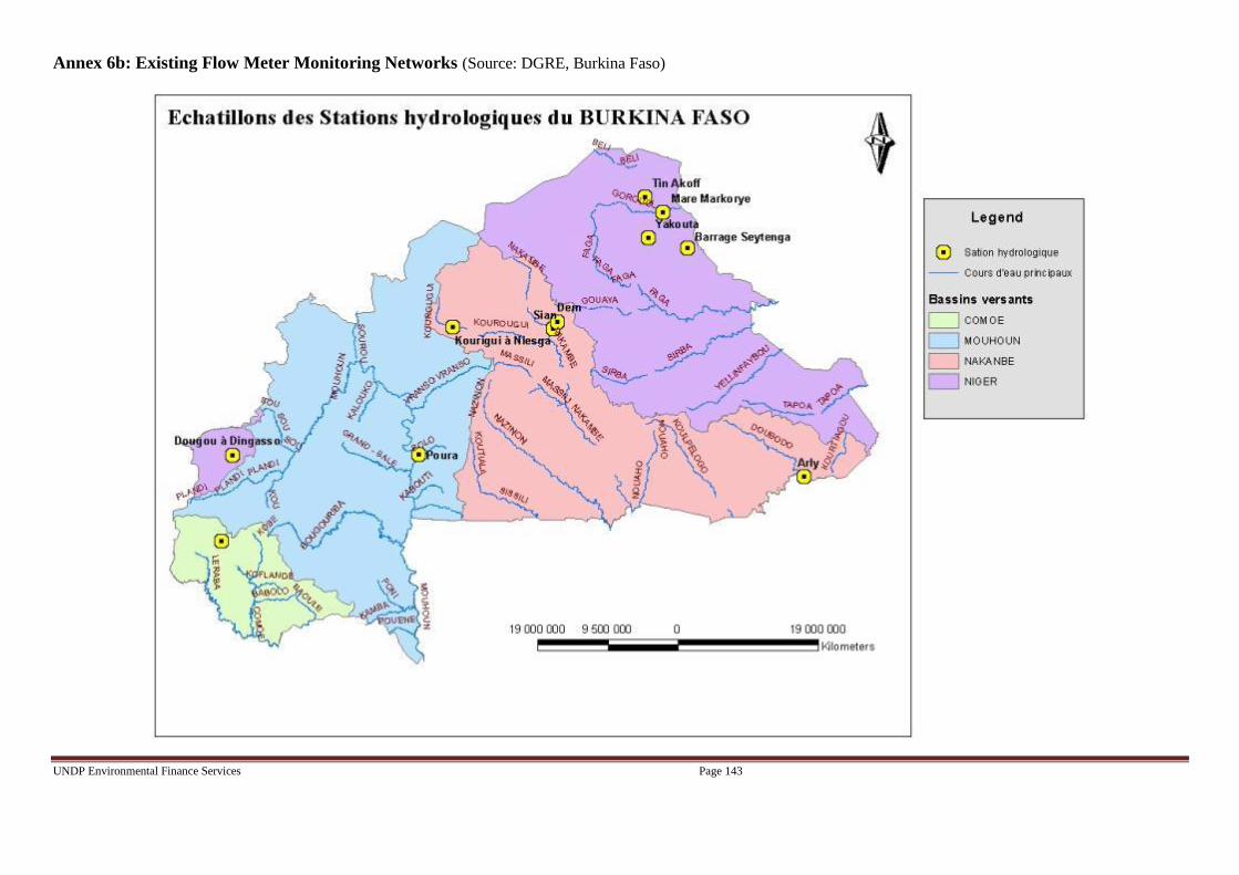
UNDP Environmental Finance Services Page 143
Annex 6b: Existing Flow Meter Monitoring Networks (Source: DGRE, Burkina Faso)

UNDP Environmental Finance Services Page 144
Annex 6c: Proposed ADCP Monitoring Network
(Red triangles) (Source: DGRE, Burkina Faso)

UNDP Environmental Finance Services Page 145
Annex 7a: Existing Weather Monitoring Networks
(Source: National Weather Service, Global Project to Modernize and Reform the Weather Network, 2007)

UNDP Environmental Finance Services Page 146
Annex 7b: Proposed Weather Monitoring Networks
(Source: National Weather Service, Global Project to Modernize and Reform the Weather Network, 2007)
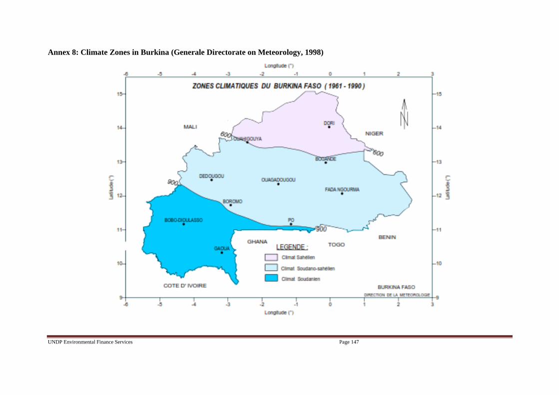
UNDP Environmental Finance Services Page 147
Annex 8: Climate Zones in Burkina (Generale Directorate on Meteorology, 1998)

UNDP Environmental Finance Services Page 148
Annex 9: Flooding sites (circles) and soil infiltration potential (GIRE Programme, 2001)

UNDP Environmental Finance Services Page 149
Annex 10: Stakeholder involvement plan
Background
Stakeholder consultation has been a key feature in the design of this LDCF Proposal, and stakeholders have been involved in identifying and
prioritizing the proposed intervention activities. Details of the stakeholder engagement during the project preparation Phase were provided in
Section 2.9 above. On-going public consultation is critical for successful implementation. This section outlines some of the key consultation
principles and processes at a strategic level that will need to be translated into practical action during the project implementation. It provides
guidance based on the initial stakeholder analysis, conducted as part of the project preparation process, and the consultations so far. This can be
used to define exact activities that will form part of a communications and consultation strategy developed during the inception period of
implementation.
Objectives
The stakeholder consultation during project implementation will be expected to support all outcomes. Overall, the objective of the consultation
plan is to provide a framework to guide and promote two way engagements between the key Project Beneficiaries (DGM, DGRE, DCIME and
CONASUR)and the end-users with whom the project will engage and directly impact upon.
It is proposed that several more specific objectives for consultation are adopted:
1. To ensure a general vision and understanding of the project and its expected outcomes by all concerned stakeholders;
2. To engage key stakeholders in planning, implementing and monitoring of specific interventions;
3. To ensure consistent, supportive and effective communication (information, documentation, sharing, lessons learned and feedback) processes
with key beneficiaries as well as the wider public including subsistence farmers and pastoralists.
4. To influence and ensure strategic level support for project implementation from state and non-state organizations and international agencies
through engagement in effective community, private sector and donor forums or platforms.
In deliveringthese objectives, there are a number of simple qualitative considerations that need to be taken into account when planning engagement
processes and what they should be seeking to achieve:
Identify constraints and solutions: As a two way engagement, the consultation process should be used as an opportunity to identify with
stakeholders possible constraints to or with the project’s implementation and to work with the stakeholders in finding sustainable solutions.
Managing expectations: The LDCF investment is relatively minor, compared to the adaptation demands facing the country. It will be
important that consultations take due consideration to manage expectations of stakeholders and stakeholder groups.
Partnerships for co-financing: The LDCF seek to add value to their investments by building on existing and parallel projects that represent co-
financing and consultations should consider opportunities for partnerships that will leverage co-financing into innovative approaches or
technologies that may improve efficiencies and enhance impact.
Stakeholders

UNDP Environmental Finance Services Page 150
Stakeholders include a range of types of groups, all with their own interests and concerns. They have different roles to play in the project and the
Table 6 below indicates key stakeholders and their possible roles.
Activities planned during implementation and evaluation
During implementation, the communication and consultation process should be divided into three main phases, being:
Phase 1 – this is the mobilization phase in the first year of the project. The fine details of the activities and implementation structures will be
designed, partnerships for action will be forged and stakeholder engagement will focus around these design processes.
Phase 2 – represents the main implementation phase where investments will be made on the ground in the target areas and stakeholder
consultation about engagement will focus on output oriented action.
Phase 3 – represents the completion of the project and the plans for scale-up and long-term sustainability of the LDCF investments. Consultation
will focus on learning, bringing experience together and looking at processes for continued post-project impact.
Phase I – Developing a strategy and action plan
At mobilization, a simple communications strategy should be developed. Key principles to be considered in the development of the strategy
include:
Who? Implementers need to understand the stakeholders well – their needs, the impacts of interventions on each stakeholder group, the
opportunities for contribution/engagement, and their power/influence. Whilst, as part of the project preparation, a stakeholder analysis
was carried out, during this phase this should be reviewed as stakeholders should be seen as dynamic. The stakeholders that may be
involved in or affected by the project are multiple, diverse; so an effective stakeholder identification process will be an important
contributor to identifying key factors for success and risks to mitigate.
Gender: In engagement with the project implementation, it will be important to consider the different ways that the early warning products are
easily accessed, understood and used by both women and men.The project implementer will continue to implicate gender-focused
NGOs/CSOs (WILDAF, the Women’s Forestry Association) in order to ensure all sexes have access to useful weather/climate
information, can interpret it and can receive feedback through consultation processes in selected areas of implementation.These
NGOs/CSOs will be responsible for conducting a gender-disaggregated survey indicating receipt of alerts/climate information.
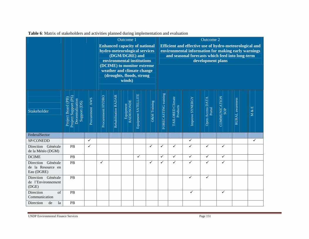
UNDP Environmental Finance Services Page 151
Table 6: Matrix of stakeholders and activities planned during implementation and evaluation
Outcome 1
Enhanced capacity of national
hydro-meteorological services
(DGM/DGRE) and
environmental institutions
(DCIME) to monitor extreme
weather and climate change
(droughts, floods, strong
winds)
Outcome 2
Efficient and effective use of hydro-meteorological and
environmental information for making early warnings
and seasonal forecasts which feed into long-term
development plans
Stakeholder
Pro
ject
Bo
ard
(P
B)
Pro
ject
Su
pp
ort
(P
S)
Dec
entr
aliz
atio
n
Su
pp
ort
(D
S)
Pro
cure
men
t A
WS
Pro
cure
men
tt H
YD
RO
Reh
abil
itat
ion
RA
DA
R
Eq
uip
men
t
RA
DIO
SO
ND
E
Eq
uip
men
t S
AT
EL
LIT
E
O&
M T
rain
ing
FO
RE
CA
ST
ING
tra
inin
g
TA
ILO
RE
D C
lim
ate
Pro
du
cts
Imp
rov
e S
YN
ER
GY
Op
en-A
cces
s D
AT
A
Po
rtal
CO
MM
UN
ICA
TIO
N
SO
P
RU
RA
L a
war
enes
s
M &
E
FederalSector
SP/CONEDD
Direction Générale
de la Météo (DGM)
PB
DCIME PB
Direction Générale
de la Resource en
Eau (DGRE)
PB
Direction Générale
de l’Environnement
(DGE)
PB
Direction of
Communication
PB
Direction de la PB

UNDP Environmental Finance Services Page 152
Outcome 1
Enhanced capacity of national
hydro-meteorological services
(DGM/DGRE) and
environmental institutions
(DCIME) to monitor extreme
weather and climate change
(droughts, floods, strong
winds)
Outcome 2
Efficient and effective use of hydro-meteorological and
environmental information for making early warnings
and seasonal forecasts which feed into long-term
development plans
Stakeholder
Pro
ject
Bo
ard
(P
B)
Pro
ject
Su
pp
ort
(P
S)
Dec
entr
aliz
atio
n
Su
pp
ort
(D
S)
Pro
cure
men
t A
WS
Pro
cure
men
tt H
YD
RO
Reh
abil
itat
ion
RA
DA
R
Eq
uip
men
t
RA
DIO
SO
ND
E
Eq
uip
men
t S
AT
EL
LIT
E
O&
M T
rain
ing
FO
RE
CA
ST
ING
tra
inin
g
TA
ILO
RE
D C
lim
ate
Pro
du
cts
Imp
rov
e S
YN
ER
GY
Op
en-A
cces
s D
AT
A
Po
rtal
CO
MM
UN
ICA
TIO
N
SO
P
RU
RA
L a
war
enes
s
M &
E
Protection Civile
National Advisory
for Emergencies and
Rehabilitation
(CONASUR)
PB
General Direction
on Health and
Sanitation
PS
Technical / Research
Institutions
Water Study and
Information Center
(DEIE)
PS
Private Sector
ASECNA PS

UNDP Environmental Finance Services Page 153
Outcome 1
Enhanced capacity of national
hydro-meteorological services
(DGM/DGRE) and
environmental institutions
(DCIME) to monitor extreme
weather and climate change
(droughts, floods, strong
winds)
Outcome 2
Efficient and effective use of hydro-meteorological and
environmental information for making early warnings
and seasonal forecasts which feed into long-term
development plans
Stakeholder
Pro
ject
Bo
ard
(P
B)
Pro
ject
Su
pp
ort
(P
S)
Dec
entr
aliz
atio
n
Su
pp
ort
(D
S)
Pro
cure
men
t A
WS
Pro
cure
men
tt H
YD
RO
Reh
abil
itat
ion
RA
DA
R
Eq
uip
men
t
RA
DIO
SO
ND
E
Eq
uip
men
t S
AT
EL
LIT
E
O&
M T
rain
ing
FO
RE
CA
ST
ING
tra
inin
g
TA
ILO
RE
D C
lim
ate
Pro
du
cts
Imp
rov
e S
YN
ER
GY
Op
en-A
cces
s D
AT
A
Po
rtal
CO
MM
UN
ICA
TIO
N
SO
P
RU
RA
L a
war
enes
s
M &
E
SAAGA PS
Cotton
Regional/
Sector
Rural Confederation
of Burkina Faso,
Confédération
Paysanne du Faso
(CPF)
DS
NGOs / CSOs
COS3C DS
SOS Sahel DS
INADES DS
WILDAF DS

UNDP Environmental Finance Services Page 154
Outcome 1
Enhanced capacity of national
hydro-meteorological services
(DGM/DGRE) and
environmental institutions
(DCIME) to monitor extreme
weather and climate change
(droughts, floods, strong
winds)
Outcome 2
Efficient and effective use of hydro-meteorological and
environmental information for making early warnings
and seasonal forecasts which feed into long-term
development plans
Stakeholder
Pro
ject
Bo
ard
(P
B)
Pro
ject
Su
pp
ort
(P
S)
Dec
entr
aliz
atio
n
Su
pp
ort
(D
S)
Pro
cure
men
t A
WS
Pro
cure
men
tt H
YD
RO
Reh
abil
itat
ion
RA
DA
R
Eq
uip
men
t
RA
DIO
SO
ND
E
Eq
uip
men
t S
AT
EL
LIT
E
O&
M T
rain
ing
FO
RE
CA
ST
ING
tra
inin
g
TA
ILO
RE
D C
lim
ate
Pro
du
cts
Imp
rov
e S
YN
ER
GY
Op
en-A
cces
s D
AT
A
Po
rtal
CO
MM
UN
ICA
TIO
N
SO
P
RU
RA
L a
war
enes
s
M &
E
Women’sForestryAs
socation
DS
Donor Partners
World Bank PS
UNDP COGEL
UNDP PEI
UNDP GEF PB
USAID PS
End users
UNDP Environmental Finance Services Page 155
Why? Implementers need be clear about the purpose of the consultation process as so that the right stakeholders make the right inputs to the planned
activities. During Phase I, theProject Manager with the support of the Technical Support Committee and the Decentralization Support
Groups will seek to have secured the support and commitment of key stakeholders required for project implementation.
Implementers should make key stakeholders aware of the plan and its intended activities and outcomes and make clear their role and scope for
contributing to project decisions and activities.
What? In planning stakeholder involvement, the strategy should make as much use of existing mechanisms (institutions and process) as possible, avoiding
establishing project oriented structures.
Types of consultation mechanisms:
Preparation meetings with NGOs/CSOs to be implicated in alert communication;
Initial consultation meetings in target regions;
Information briefings for government and co-financing institutions;
Initiation of public awareness campaign on EWS and the utility of CI for private sector representatives
Phase II - Consultation through implementation
Once implementation begins, public consultations should become more of an ongoing exchange of information, and there are two main purposes for the
various mechanisms outlined under Phase II:
to gather information from beneficiaries and stakeholders about the impact and effectiveness of the planned adaptation packages (efficient and reliable
EWS) to support adaptive management; and
to provide interested government and donor stakeholders and the general public with information about the progress and impact of the project as it is
implemented.
The first purposerelates to engagement for effective implementation and monitoring, whilst the latter is more concerned with information dissemination,
‘public relations’ and expectation management. Good public relations will also help encourage collaboration with respect to the objective of the LDCF
project.
Phase III - Project completion and scale up promotion
This will be a process of ensuring completion, hand-over and long-term sustainability of the LDCF investment. Consultation will focus on bringing
experience together, sharing key lessons learnt (through the UNDP ALM and other forums) and looking at processes for promoting scale up of this project in
order to have efficient and reliable EWS in the country.

UNDP Environmental Finance Services Page 156
Annex X: Weather stations desired by DGRE to support hydrological modelling (Source: DGRE)

UNDP Environmental Finance Services Page 157
Annex XI: Results for Self-Assessments on Capacity/Need Prioritization Conducted during Mission 2
Table 1: Results for each Information Production agency
Matrix with color and number coded capacity indicating scores of 1 (red, poor capacity/knowledge/experience) to 5
(green, good capacity/knowledge/experience) for each Information Production agency
1 2 3 4 5
Nul Faible Moyen FortTrès
Fort
Structure DGM ASECNA SAAGA DCIME DEES
DG des
Produc
tions
végétal
es
2.1
Quel est le niveau de vos capacités en ressources
humaines (ingénieurs, techniciens…) ? Si les capacités
font défaut, veuillez spécifier les besoins selon leur
priorité (1 étant le besoin le plus urgent) dans la
colonne réservée aux commentaires.
3 2 3 2 3 3
2.2
Avec quelle précision connaissez-vous les coûts de
fonctionnement et de maintenance des équipements
existants ?
1 4 1 3 3
2.3
Dans quelle mesure connaissez-vous les mécanismes de
recouvrement de coûts pour le paiement des coûts de
fonctionnement et de maintenance ? Dans la colonne
réservée aux commentaires, veuillez donner des
exemples de mécanismes de recouvrement de coûts
que vous employez actuellement ?
2 2 1 3 1
2.4
Dans quelle mesure êtes-vous disposé à vendre vos
produits climatologiques au secteur privé en vue
d’obtenir des revenus pouvant alléger les coûts de
fonctionnement et de maintenance étant donné que les
produits doivent être adaptés aux besoins du secteur
privé ?
2 1 1 2 1
2.5
Dans quelle mesure connaissez-vous les rôles des
autres fournisseurs/producteurs d’informations ? 4 4 5 3 3 4
2.6
Dans quelle mesure partagez-vous des données avec les
autres fournisseurs/producteurs d’informations
climatiques ? Dans la colonne réservée aux
commentaires, veuillez indiquer avec qui vous
collaborez et avec qui la collaboration fait défaut.
3 2 4 4 2 5
2.7
Dans quelle mesure jugez-vous la collaboration avec les
autres fournisseurs/producteurs d’informations
climatiques nécessaire ?
4 2 4 4 1 4
2.8
Dans quelle mesure collaborez-vous actuellement avec
le secteur privé ? Dans la colonne réservée aux
commentaires, veuillez donner des exemples de la
manière dont vous travaillez avec le secteur privé. Citez
ces secteurs privés.
2 5 2 4 2 1
2.9
Quel est le niveau de vos capacités en matière de
gestion de fonds émanant des bailleurs ? Si vous
disposez de capacités, veuillez donner des exemples de
la manière dont vous employez actuellement les fonds
des bailleurs dans la colonne des commentaires.
1 4 5 4 3 4
Question Indicateur de capacités
Situation de référence: Niveau réel des
capacités/connaissances
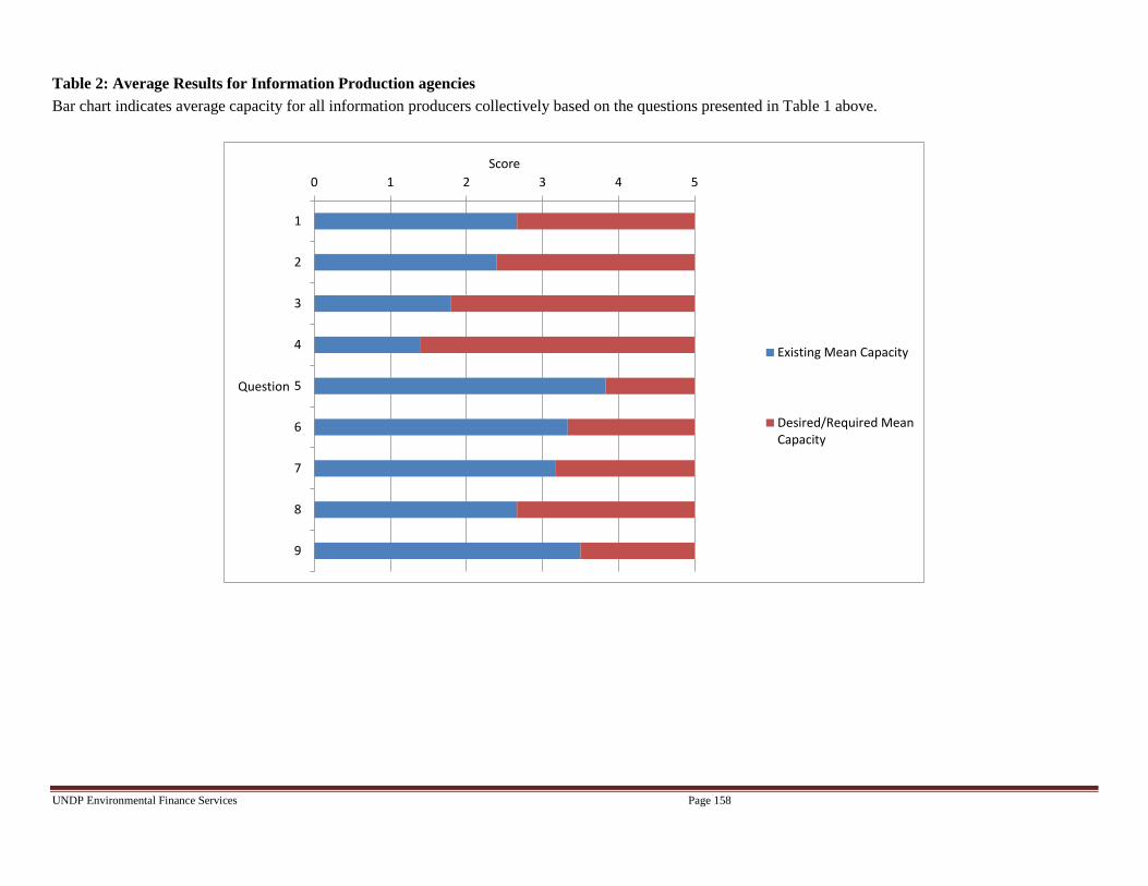
UNDP Environmental Finance Services Page 158
Table 2: Average Results for Information Production agencies
Bar chart indicates average capacity for all information producers collectively based on the questions presented in Table 1 above.
0 1 2 3 4 5
1
2
3
4
5
6
7
8
9
Score
Question
Existing Mean Capacity
Desired/Required MeanCapacity

UNDP Environmental Finance Services Page 159
Table 3: Results for each Information Dissemination agency
Matrix with color and number coded capacity indicating scores of 1 (red, poor capacity/knowledge/experience) to 5 (green, good capacity/knowledge/experience)
for each Information Dissemination agency
1 2 3 4 5
Nul Faible Moyen FortTrès
Fort
Structure CONASUR SIG CPFSOS
Sahel
INADES
Formati
on
DGPEDD
(Comite de
CONASUR)
DGFF/ME
DD
DEP/M
AIDSDGPA DGPS DGPV
1.1Quel est le niveau des capacités de votre organisme
dans la diffusion des alertes ?3 5 5 2 2 2 3 3 3 3 5
1.2
Dans quelle mesure êtes-vous actuellement capable de
comprendre les alertes hydrométéorologiques afin de
les simplifier pour les populations locales ?
3 2 5 2 2 3 4 2 2 1 3
1.3
Quel est le niveau de vos capacités en ressources
techniques pour diffuser des alertes (ex., les systèmes
téléphoniques privilégiés Flotte) ? Si les capacités font
défaut, veuillez spécifier les besoins selon leur priorité
(1 étant le plus besoin le plus urgent) dans la colonne
réservée aux Commentaires.
2 5 4 2 1 3 3 2 3 5
1.4
Quel est le niveau de vos capacités en ressources
humaines ? Si les capacités font défaut, veuillez spécifier
les besoins selon leur priorité (1 étant le plus besoin le
plus urgent) dans la colonne réservée aux
Commentaires.
3 4 4 3 3 2 1 2 4 1 3
1.5
Quel est le niveau de vos capacités dans la fourniture
d’alertes en langues locales?3 4 3 3 4 1 1 2 2 1 2
1.6
Quel est le niveau de vos capacités dans la diffusion de
messages à travers différents médias ? Veuillez noter
dans la colonne réservé aux Commentaires lequel des
médias que vous maîtrisez est le plus adapté aux
populations rurales (ex., la radio, les textes) 1
représentant le média le plus efficace?
3 5 5 3 3 3 3 2 2 3 4
1.7
Quel est le niveau de vos capacités techniques dans
l’organisation de fomation visant à mieux impliquer les
populations locales dans ce projet de Système d'Alerte
Précoce? Si les capacités font défaut, veuillez spécifier
les besoins selon leur priorité pour la tenue de
formation (1 étant le plus besoin le plus urgent) dans la
colonne réservée aux Commentaires.
3 2 5 3 1 3 4 2 4 2 4
Question Indicateur de capacités
Situation de référence: Niveau réel des
capacités/connaissances

UNDP Environmental Finance Services Page 160
1 2 3 4 5
Nul Faible Moyen FortTrès
Fort
Structure CONASUR SIG CPFSOS
Sahel
INADES
Formati
on
DGPEDD
(Comite de
CONASUR)
DGFF/ME
DD
DEP/M
AIDSDGPA DGPS DGPV UNPCB
1.8
En dehors de votre propre organisation, quel est le
niveau de vos capacités dans la coordination soit avec
les points focaux locaux de la CONASUR, la
Confédération rurale du Burkina Faso soit les
organisations de la société civile sur les changements
climatiques (COS3C) ? Veuillez indiquer dans la colonne
réservée aux Commentaires si une collaboration serait
utile et pourquoi.
4 4 4 4 3 2 3 2 3 2 3 3
1.9
Quel est le niveau réel de vos capacités dans
l’organisation d’ateliers conjoints avec d’autres
organisations du secteur environnemental (cette
question est posée en vue de rationaliser la diffusion
d’alertes) ?
4 2 5 4 2 3 3 2 3 4 3 3
1.10
Selon votre expérience, quel est le niveau actuel des
capacités des populations locales dans la réaction aux
alertes? Veuillez noter dans la colonne réservée aux
commentaires la date à laquelle les alertes ont été
émises ou absentes et indiquez le fournisseur d’alertes.
4 2 2 3 2 1 2 2 2
1.11
Selon votre expérience, quel est le niveau de conscience
des populations des changements climatiques ? 4 4 4 3 3 4 3 2 1 3 4 2
1.12
Quel est le niveau de connaissance des populations des
mesures d’ADAPTATION aux changements climatiques
et de quelle façon un avertissement météorologique
peut-il les aider à devenir plus résilientes aux impacts
des changements climatiques ?
3 4 3 2 2 1 2 1 1 3 3 2
Question Indicateur de capacités
Situation de référence: Niveau réel des
capacités/connaissances

UNDP Environmental Finance Services Page 161
Table 4: Average Results for Information Dissemination agencies
Bar chart indicates average capacity for all information distributors collectively based on the questions presented in Table 3 above.
0 1 2 3 4 5
1
2
3
4
5
6
7
8
9
10
11
12
Score
Question
Existing Mean Capacity
Desired/Required MeanCapacity

UNDP Environmental Finance Services Page 162
Annex XII: Vulnerable agro-ecological zone assessment (NAPA 2008)
A GIS analysis based on multiple sources of environmental degradation data were used to select ten representative areas in terms of vulnerability to climate
change and extreme weather events (floods, strong winds) in each of the three agro-climatic zones of the country. Subsequently, socio-economic criteria,
including the poverty of the population and socio-cultural considerations were applied. This allowed five areas to be retained as shown in Figure 1.
Figure 1: The most vulnerable representative agro-ecological areas in Burkina Faso (Source: Burkina Faso NAPA)

UNDP Environmental Finance Services Page 163
Figure 2: Risk of inundation (Source: DGM, Burkina Faso)
0.001 0 0.001 Milles
CARTE DES ZONES A RISQUES D' INONDA TION
DU BURKINA FASO
Aucun risque d'inondation
Risque d'inondation léger
Risque d'inondation moyen
Risque d'inondation sévère
Risque d'inondation très sévère

UNDP Environmental Finance Services Page 164
Prioritisation Process
165. To facilitate decisions on cost-effectiveness, a baseline capacity assessment was conducted during
the project preparation Phase. The assessment enabled alert production and dissemination agencies to
prioritize their needs (see Section 2.8). Due to project budget limitations, it was necessary to select from
the long-list of equipment / capacity building needs and identify those within the scope and cost-
effectiveness of this project. In response, a set of criteria to prioritize needs / requested activities was
formulated. The criteria were also used to assess the relevance of this LDCF project to tackle these
priority needs, given its overall objective. Table 3 shows the criteria for cost-effective adaptation
interventions.
Tables 3a and 3b: Criteria for inclusion of activity in LDCF-GEF project
3a) Criteria for Selection of Information Production Activities
The activity needed is within the scope (scale, cost and timeframe) of this project including the
time it takes for procurement, installation and training;
Requested acquisition / rehabilitation of hydro-meteorological infrastructure includes a mix of
manual and automatic stations to ensure that data collection is not hindered by training needs
associated with automatic stations;
At least two supplier costs (where applicable) have been compared for new hydro-meteorological
infrastructure;
The placement of hydro-meteorological infrastructure represents the best network representation
based on user-needs (public and private) and providing national coverage;
Requirements for operation and maintenance (O&M) are not complex. The need for outsourcing
O&M is limited;
Capacity can be built in the relevant sectors to participate fully in the intervention;
The activity has a high likelihood to achieve replication and sustainability;
There is a strong alignment of the activity to national and sub-national adaptation priorities;
The agency involved in alert production has Monitoring and Evaluation mechanisms (M&E) in
place;
3b) Criteria for Selection of Information Dissemination Activities
Capacity can be built in the relevant agency to assist with dissemination;
Agency has the capability to disseminate information to a broad range of people,
including the most vulnerable and women;
The agency has mechanisms in place to transfer knowledge to decentralized branches;
The agency is already trained in adaptation to climate change principles;
Any equipment demanded for communication is necessary for improved alert
dissemination;
The activity has a high likelihood to achieve replication and sustainability;

UNDP Environmental Finance Services Page 165
3b) Criteria for Selection of Information Dissemination Activities
There is a strong alignment of the activity to national and sub-national adaptation priorities;
If applicable, the activity enables EWS/CI to be integrated into national policies and planning;
Alert communication mechanism is able to reach women and other vulnerable populations

UNDP Environmental Finance Services Page 166
Annex 11: Terms of Reference
A. Comité de Projet
Le comité de projet est responsable des décisions relatives à l’orientation d’un projet lorsque des
directives sont sollicitées par le Chef de Projet. Le Comité de Projet joue un rôle essentiel dans le suivi et
les évaluations liés au projet en assurant la qualité de ces processus et produits, et en utilisant les
évaluations pour améliorer la performance, la recevabilité et l’apprentissage. Il s’assure que les ressources
nécessaires sont engagées, arbitre les conflits dans le cadre du projet et négocie une solution à tous les
problèmes survenant avec les corps extérieurs. De plus, il approuve la désignation et les responsabilités
du Chef de Projet et toute délégation de ses responsabilités dans le cadre de l’Assurance du Projet. Sur la
base de l’approbation du Plan de Travail Annuel, le Comité de Projet peut également examiner et
approuver les plans trimestriels (le cas échéant) et aussi entériner toute dérogation majeure aux plans
initiaux.
Le Comité de Projet (CP) devrait comporter des représentants intra nationaux et nationaux pour orienter
et superviser le projet. Le CP sera installé dans les locaux du SP/CONEDD et présidé par le Secrétaire du
SP/CONEDD. Le CP se réunira chaque année pour discuter du projet et approuver les plans de travail
annuels. Le CP comprendra des représentants du PNUD, du FEM-PNUD, des hauts responsables des
ministères des Transports, des Infrastructures et du désenclavement, de l’Environnement (MEDD), du
Ministèredel’Action Sociale et de la Solidarité Nationale (MASSAN), du Ministèredel’Agriculture
(MAHRH), du Ministèredela Communication, de la Direction de la Protection Civile (DPC) et du
Ministèrede la Promotion de la Femme (MPF), du Ministère de la Communication. Le Coordonnateur
national du Projet (CNP) sera un membre d’office du CP chargé de rédiger les comptes rendus. Les
membres potentiels du Comité de Projet sont passés en revue et recommandés pour approbation pendant
la réunion du CEP. Les représentants des autres parties prenantes peuvent être intégrés comme il convient
dans le Comité.
Le CP sera chargé de:
Superviser et approuver les plans de travail annuels et les exigences à court terme en matière
d’expertise
Superviser les activités du projet en assurant le suivi des progrès et en approuvant les rapports
annuels
Réviser et approuver les plans de travail ainsi que les plans financiers et les rapports
Fournir des conseils stratégiques aux institutions de mise en œuvre afin de garantir l’intégration
des activités du projet dans les objectifs nationaux et infranationaux de résilience climatique et de
développement durable.
Assurer une coordination inter-structures et une diffusion transversale des résultats stratégiques
Assurer la pleine participation des parties prenantes aux activités du projet
Aider à l’organisation des revues du projet et des contrats de prestation de services au titre de
l’assistance technique
Fournir des orientations au Chef de Projet
B. Chef de projet
Le Chef de Projet devra rendre compte au Comité de Projet et diriger l’équipe de projet dans la
planification et la réalisation du projet. Le CP sera hébergé par le SP/CONEDD et sera chargé de conduire
le projet au quotidien au nom du Partenaire de mise en œuvre, selon les conditions établies par le Comité.
La responsabilité principale du Chef de projet est de s’assurer que le projet produit les résultats spécifiés
dans le descriptif de projet, selon la norme de qualité requise et dans les limites imposées en matière de
temps et de coût. Le CP sera responsable de la gestion financière et des décaissements, et sera tenu de

UNDP Environmental Finance Services Page 167
rendre compte au gouvernement et au PNUD Le CP se réunira chaque mois avec le Comité de soutien
technique qui sera composé de points focaux issus des organismes de production et de dissémination
d’informations émanant du SAP et du CONASUR.
Responsabilités
• Assurer un partenariat efficace entre les bureaux sous-nationaux et les structures nationales
participantes
• Gérer les ressources financières en collaboration avec le Coordonnateur national du projet (CNP)
en vue de réaliser les résultats conformément aux produits et aux activités spécifiés dans le
descriptif du projet
• Diriger l’élaboration et la mise en œuvre des plans de travail annuels axés sur les résultats et des
cadres logiques, tels qu’approuvés par la direction
• Assurer la liaison avec les activités connexes et parallèles avec la coopération des ministères et
des bureaux d’exécution
• Assurer le suivi des activités du projet, y compris des questions financières, et élaborer des
rapports d’activités mensuels et trimestriels, et organiser des évaluations mensuelles et
trimestrielles des progrès réalisés
• Appuyer le CNP dans l’organisation des réunions d’équipe et des conférences d’apprentissage
• Coordonner la répartition des rôles au sein de l’équipe et organiser les systèmes de contrôle et de
suivi
• Rendre compte et fournir des retours d’informations sur les stratégies, les activités et l’avancement
du projet ainsi que les obstacles rencontrés par Comité de Projet
• Organiser une réunion tous les trimestres avec le Comité de soutien technique
C. Coordonnateur national de Projet
Le Chef de Projet désignera un Coordonnateur national du projet qui sera responsable de l’administration
globale du projet. Le CNP rend compte au ministère de l’Eau et assure la liaison avec le PNUD. Le CNP
sera logé au sein du ministère de l’Eau et sera chargé de:
• Contrôler et coordonner quotidiennement la mise en œuvre des activités du projet
• Recruter et superviser le personnel technique et le personnel chargé de la formation, tel que requis
pour la mise en œuvre du projet
• Nouer et conserver des relations étroites avec les organismes étatiques compétents, le PNUD, les
ONG, la société civile, les organisations internationales et les partenaires de mise en œuvre du
projet
• Coordonner de manière optimale l’équipe du projet dans l’exécution de ses devoirs en assurant
une utilisation efficiente et efficace des ressources
• Coordonner les intrants dans les plans de travail annuels axés sur les résultats et les cadres
logiques, tel que requis par la direction.
• Procéder à la répartition annuelle du plan de travail pour l’ensemble des objectifs du projet; et
préparer des plans de travail trimestriels.
• Coordonner les intrants dans tous les rapports de projet, tel que requis (incluant les rapports
annuels sur le projet, le rapport initial, les rapports trimestriels et le rapport final)
• Élaborer des rapports de situation et financiers trimestriels pour commentaires et approbation par
le Chef de Projet
• Coordonner la mise en place d’équipes de travail sous-nationales.

UNDP Environmental Finance Services Page 168
• Organiser des réunions d’équipe annuelles pour partager les expériences et les enseignements tirés
D. Comité de soutien technique (Suivi et évaluation)
Le Comité de soutien technique sera composé des points focaux de la Direction générale de météorologie
(DGM, de la Direction Générale des Ressources en Eau (DGRE) du Comité National de Secours
d’Urgence et de Réhabilitation (CONASUR) et de l’Observatoire National de l’Environnement (DCIME),
du Système d’Information du Gouvernement (SIG). Ils se réuniront périodiquement avec le CP pour
apporter des conseils techniques. Ils fourniront également un appui au CP dans l’administration et la
gestion du projet, selon les besoins du projet lui-même ou du Chef de Projet. Dans le cas où il existe des
dissensions dans le groupe, la décision finale appartient au CP.
E. Assistant financier et administratif
Un assistant administratif et financier devra rendre compte au CNP et sera recruté par le SP/CONEDD.
Ses responsabilités seront les suivantes:
• Créer et mettre à jour les dossiers relatifs au projet et les systèmes de comptabilité tout en veillant
à la compatibilité avec les procédures comptables financières du SP/CONEDD et du PNUD.
• Préparer les révisions budgétaires du projet et soutenir l’élaboration des plans annuels de travail
• Traiter les demandes de paiement à des fins de règlement incluant les avances trimestrielles aux
partenaires de mise en œuvre à l’issue d’un examen conjoint
• Mettre à jour les plans financiers, élaborer des rapports de situation, des rapports d’étape et
d’autres rapports financiers
• Procéder aux formalités de clôture financière du projet, notamment la présentation de rapports
finaux, le transfert et la cession des équipements, le traitement des révisions semi-définitives, et le
soutien à l’équipe professionnelle dans l’élaboration des rapports d’évaluation finaux
• Soutenir l’attribution des marchés dans des délais rapides et veiller aux autres droits admissibles
au personnel, aux experts et aux consultants en préparant des plans de recrutement annuels.
• Recueillir et mettre à jour les informations relatives au projet et établir des procédures de contrôle
des documents
• Administrer les réunions du Comité de Projet
• Administrer le contrôle des révisions du projet
• Produire, copier et distribuer tous les rapports de projet
• Fournir de l’aide dans l’utilisation du système ATLAS pour le suivi et le rapportage
F. Expert en suivi-évaluation Recrutement d’agent contractuel à plein temps
L’expert en suivi-évaluation devra rendre compte et apporter son soutien au CNP, au CP et aux équipes
de projet dans la préparation des systèmes de suivi-évaluation nécessaires pour le suivi et l’évaluation de
la qualité des progrès, l’identification, la collecte, l’analyse, la documentation et la vulgarisation des
enseignements tirés par le biais d’une réunion annuelle sur le projet, et soutenir la préparation des
justificatifs du projet pour le partage des informations à travers le mécanisme d’apprentissage en matière
d’adaptation (ALM) du PNUD.
Responsabilités
• Établir la stratégie globale de suivi-évaluation axée sur les résultats selon les plans de suivi-
évaluation spécifiés dans le descriptif du projet.
• Orienter et coordonner la revue du cadre de résultats du projet, notamment :

UNDP Environmental Finance Services Page 169
a. Fournir des conseils techniques pour la révision des indicateurs de performance;
b. Faciliter la revue annuelle des risques organisée par le CP;
c. Évaluer le niveau de réalisation des objectifs.
• Préparer des modèles de rapport et soutenir le CNP dans l’élaboration des rapports nécessaires.
Orienter les équipes du projet dans la préparation de leurs rapports périodiques conformément aux
formats de rapport approuvés. Cela inclut les rapports d’activités trimestriels, les rapports annuels
de projet, les rapports initiaux et les rapports techniques spéciaux.
• Promouvoir la planification et le suivi participatifs des activités en informant les institutions de
formation sur le contenu du projet.
• Aider le CNP à rassembler les rapports techniques et autres documents du projet et contribuer à
l’ALM.
G. Comité interinstitutionnel et multidisciplinairede promouvoir la Synergie (CIMS)
La plateforme multi-agences (Comité interinstitutionnel et multidisciplinaire, CIMS) sera créée dans le
cadre du projet afin d’assurer une synergie entre les agences SAP et entre les initiatives liées au SAP au
cours de la mise en œuvre du projet. Cette plateforme sera un groupe multidisciplinaire composé de
points focaux des ministères/organisations concernés au niveau national et local. Les membres doivent
représenter au minimum les organisations suivantes: CONASUR (représentants nationaux et locaux), la
Direction Générale de l’Environnement (DGE), la Direction Générale de l’habitat et de l’Urbanisme
(DGHU), la DGRE, la DGM, le ministère de la Santé (DNSP), la Direction du Conseil agricole et de la
Formation professionnelle (DICAF), l’Office national de la sécurité alimentaire (ONASA), the Ministère
de la Décentralisation (DAT), et les ONG, OSC, . Ils travailleront dans le cadre du projet périodiquement
(de préférence, avant les périodes de risque météorologique/climatique élevé) et rendront compte au
Comité de Projet et au Bureau de Pays du PNUD.
Les rôles des points focaux seront les suivants:
• Assurer la coordination et la collaboration entre les agences SAP
• Assurer la synergie entre les initiatives liées au SAP
• Résoudre les problèmes de dédoublement
Les livrables doivent inclure:
• La soumission d’un rapport initial du projet pendant le premier trimestre au Comité de Projet et
au BP du PNUD indiquant
les projets nécessitant une synergie avec la justification
les agences nécessitant des efforts de collaboration avec la justification
le plan d’action requis pour mettre en œuvre les activités visant le renforcement des synergies
• Les rapports semestriels actualisés devront être soumis au Comité de Projet et au BP du PNUD,
pour montrer la manière dont la synergie a été créée/renforcée
• Un rapport de synthèse final sur le renforcement de la synergie et la manière dont cela peut être
prolongé au-delà du projet
H. Spécialiste en prévisions météorologiques à identifier à travers lepartenariat sous régional Le
spécialiste soutiendra le projet en fournissant une expertise en matière de prévisions météorologiques sur
une période courte (alerte précoce, sur une base quotidienne et hebdomadaire). Le spécialiste formera les

UNDP Environmental Finance Services Page 170
responsables concernés dans l’utilisation et le traitement des données d’observation météorologiques, la
prévision et la mise au point de spécifications pour les prévisions basées sur la réduction d’échelle à
adapter selon les zones climatiques spécifiques nationales. Il contribuera à former le personnel de la DGM
dans l’interprétation des risques hydrométéorologiques et des scénarios de vulnérabilité pour l’évaluation
des efforts d’atténuation et de mobilisation et rendra compte à l’unité de gestion du projet.
Responsabilités
• Préparer les spécifications concernant les données météorologiques et le protocole de collecte de
données.
• Revoir la qualité et l’utilité des données existantes et fournir des conseils concernant les exigences
relatives à la collecte et à la sauvegarde des données
• Examiner les modèles numériques de prévision météorologique et recommander le (s) meilleur
modèle (s) pour le pays d’utilisation, compte tenu des capacités techniques, financières et
opérationnelles du service météorologique
• Fournir des spécifications relatives à la formation et un protocole pour la prévision
météorologique numérique
• Concentrer les prévisions sur les menaces les plus pertinentes relatives aux phénomènes
météorologiques extrêmes (inondations, sécheresses, vents forts))
• Établir une collaboration avec le service hydrologique, la DGRE et la DCIME afin d’assurer le
partage des données pour les prévisions de phénomènes météorologiques extrêmes (ex. la mesure
de l’intensité des pluies et les données satellitaires sur l’humidité du sol)
• Travailler avec la DGRE afin de mettre au point des critères et des procédures d’utilisation
normalisées pour définir les seuils d’alerte
• Planifier le partage de connaissances (y compris les prévisions financières) indiquant les
possibilités de formation continue de l’OMM qui devraient être exploitées au niveau régional et
international
I. Spécialiste des risques et vulnérabilités liés au climat/ spécialiste des plateformes d’informations
climatiquesà identifier à travers le partenariat sous régional
Le climat affecte presque toutes les activités humaines. Sa variabilité inhérente, notamment les
phénomènes météorologiques extrêmes (comme les inondations, les sécheresses et les ouragans), affecte
également les systèmes terrestres et biologiques dont dépend la survie de la société. La sensibilisation du
public sur les impacts du climat exige que la météorologie fournisse des informations climatiques
pertinentes à un groupe d’usagers diversifié de manière opportune et efficace. Le climatologue spécialisé
combine souvent une vaste expérience dans le domaine des sciences sociales et une connaissance
approfondie des sciences physiques, de la théorie fournie par la communauté des chercheurs, et des
données environnementales générées et contrôlées selon des modèles afin de répondre aux questions
spécifiques des clients. Le spécialiste soutiendra le projet en apportant une analyse de scénarios
climatiques sur des délais plus longs (en termes de saison et plus). Le spécialiste formera les responsables
concernés sur l’utilisation et le traitement des données d’observation climatique et sur l’élaboration de
scénarios de vulnérabilité et de risque climatiques. Il contribuera à former le personnel de la DGM, de la
DGRE et de la DCIME sur les aspects relatifs à l’analyse des risques climatiques, le renforcement des
capacités et la planification climatique intégrée et rendra compte à l’unité de gestion du projet.
Responsabilités

UNDP Environmental Finance Services Page 171
• Examiner la qualité et l’utilité des données existantes. Décrire les besoins en données et les cadres
analytiques pour les examens de risque et de vulnérabilité. Soutenir la DGM/DCIME/DGRE à
entreprendre les analyses
• Surveiller les techniques d’observation et de mesure visant à maintenir l’intégrité et la
représentativité des bases de données à court et long terme pour une évaluation exacte et objective
des changements climatiques
• Préparer les spécifications relatives aux données climatiques et un protocole de collecte de
données
• Étudier les tendances climatiques de la zone et préparer des prévisions météorologiques
• Modéliser les impacts potentiels sur les analyses de sensibilité et de vulnérabilité climatiques dans
un contexte de croissance démographique et économique
• Aider à la préparation des scénarios climatiques futurs ainsi que leur évaluation à des fins de
planification, incluant les évaluations des impacts climatiques et les analyses d’arbitrage.
• Soutenir les producteurs d’informations en vue d’identifier les options stratégiques et pratiques de
mise en œuvre visant à intégrer les initiatives de résilience climatiques selon leur potentiel
d’atténuation, leur rentabilité, leurs avantages connexes, leur faisabilité politique et leur
acceptation par le public
• Assister l’unité de gestion du projet dans l’élaboration de plans de résilience climatique basés sur
l’analyse d’options, et les enseignements tirés de la phase pilote de mise en œuvre.
• Planifier le partage des connaissances (y compris les estimations financières) indiquant les
possibilités de formation sur les risques et les vulnérabilités climatiques qui devraient être
exploitées, tant au niveau régional qu’international.
• Participer aux ateliers des parties prenantes et aux réunions du Comité de projet et y faire des
exposés le cas échéant
J.Spécialiste de la durabilité du Radar Contrat de maintenance et de transfert de compétence
Un spécialiste sera engagé pendant deux semaines pour former l’ASECNA en matière de réparation de
leur radar qui existe à Ouagadougou. Ils rendront compte à la DGM. La liste des livrables requis
comprend:
Responsabilités
• Rapports de formation
• Planifier pour un financement durable du radar y compris les pièces de rechange
• Accord sur des mécanismes d’appui plus rentables
K. Spécialiste de la plateforme des informations climatiques (Contrat institutionnel au niveau
national)
Ce spécialiste aidera à la mise en place de la résilience au climat dans les différents secteurs socio-
économiques à travers le Burkina Faso en analysant les investissements du secteur privé et en menant une
étude pilote. Le spécialiste appuiera le développement d’une plateforme d’informations climatiques viable
qui fournira des données de climat et de marché fiables et à temps pour une gamme de producteur socio-
économiques et autres parties prenantes telles que les prestataires des assurances.Des investissements
sélectionnés seront choisis sur la base de leur capacité à valoriser la capacité d’adaptation des populations
locales.(e.g. agriculture) et les intérêts du secteur privé (e.g. coton et secteur minier). Le consultant fixera

UNDP Environmental Finance Services Page 172
le travail de terrain pour tester l’investissement le plus viable pour les produits qui s’adaptent au climat
dans une étude pilote.
Responsabilités
• Identifier les secteurs et branches d’activités nécessitant un accès aux informations climatiques, la
fréquence requise d’accès, la volonté et l’engagement à payer pour obtenir des informations
climatiques améliorées
• Identifier les modalités d’accès à l’information actuellement utilisées incluant la capacité en matière
de technologie de l’information et de la communication (TIC), l’accès aux médias et le coût d’accès
• Examiner la capacité à traiter et traduire les données en analyses de risques adaptées aux différents
besoins et exigences des utilisateurs finaux
• Analyser les modèles de revenus actuels
• Identifier les phases nécessaires pour la mise en place d’une plateforme d’informations climatiques
• Identifier les facteurs essentiels à la réussite des plateformes d’informations climatiques
• Élaborer une étude pilote avec l’appui de laDGM, la DGRE la DCIME pour mettre en œuvre la
plateforme d’informations climatiques la plus viable financièrement et profitable à un maximum de
bénéficiaires
• Après la mise en œuvre de l’étude pilote, évaluer les résultats de celle-ci et rédiger un rapport
synthétisé pour le PMU, la DGM, la DGRE la DCIME
L. Spécialiste en développement de technologies de l’information et en d’entreprise basé sur les
plateformes de téléphonie mobile (marché international, de courte durée, 2 semaines par an durant les 2
dernières années)
Le renforcement de la résilience face aux phénomènes météorologiques extrêmes, aux impacts des
changements climatiques et à l’insécurité alimentaire est un défi majeur au Burkina. En fournissant des
informations climatiques et des prévisions météorologiques aux agriculteurs par voie de téléphonie
mobile, la résilience des populations les plus vulnérables peut être améliorée. Pour faciliter la diffusion
des informations climatiques (IC) et les messages des systèmes d’alerte précoce (SAP), un spécialiste doit
être recruté pendant un mois afin de conduire des études de marché et des études techniques sur la
manière de relier les IC/SAP aux plateformes de téléphonie mobile.
Les responsabilités du spécialiste doivent inclure:
• Travailler avec les prestataires de téléphonie mobile, la, DGM, la DGRE, la DCIME et le
ministère de l’Agriculture pour examiner la manière dont les informations et les alertes sur le
climat peuvent être fournies au grand public à moindre coût par SMS ou par système de
messagerie vocale
• Réaliser une étude de marché sur les besoins spécifiques des agriculteurs béninois, incluant les
informations spécifiques nécessaires sur les fruits / légumes à différents moments de l’année
• Élaborer une étude de faisabilité sur la manière dont le Burkina peut intégrer les informations et
les alertes sur le climat dans les plateformes de téléphonie mobile existantes, par exemple la
banque de données du Centre international pour l’agriculture et les sciences biologiques de
CABI/Plantwise et d’autres initiatives connexes
• Formuler un plan pour aider le Burkina à mieux intégrer le projet FPMA avec le projet pilote
pour la résilience climatique (PPCR) et la manière d’établir un lien avec les initiatives régionales
et internationales

UNDP Environmental Finance Services Page 173
M. Spécialiste en modélisation hydrologique à identifier à travers le partenariat sous régional
L’hydrologue travaillera en étroite collaboration avec la DGRE pour développer la capacité de
modélisation hydrologique pour la prévision des crues avec les logiciels HECRES et MIKE BASIN. Le
spécialiste doit avoir une expertise dans la gestion de bassins hydrographiques et d’équipements de
contrôle hydrologique et être en mesure d’intégrer les opérations de barrage dans les modèles.Le candidat
doit avoir une bonne connaissance de l’étalonnage des équipements hydrologiques. Il doit aussi bien
connaitre les techniques et équipements classiques et modernes de collecte de données hydrologiques,
notamment avoir des connaissances actualisées sur la télédétection et la technologie de transmission de
données.
Ses responsabilités sont:
• prendre en compte les impacts potentiels de la variabilité climatique et les changements sur les
ressources en eau ainsi que les incertitudes des effets des modèles climatologiques
• apporter un appui-conseil sur l’évaluation des inondations potentielles extrêmes et de la
sécheresse, les prévisions et les alertes.
• Conduire une enquête sur les méthodes de calcul de la PMP/PMF(Précipitation Maximale
Probable/Crue Maximale Probable) et les autres méthodes de calcul d’inondation
• Fournir les meilleures pratiques disponibles basées sur les normes nationales pour l’estimation
des données de conception hydrologiques pour les cas d’inondations graves
• Fournir les simulations de modélisation sur l’accroissement du stress lié à l’eau au cours de la
sécheresse en vue d’assurer une gestion réelle des ressources en eau dans de pareilles
circonstances
• Evaluer les besoins en information hydrologique pour contribuer à la formulation des normes sur
les mesures et le traitement des données et formuler des propositions pour la conception et
l’évaluation d’un réseau de suivi
• Calibrer et tester les modèles hydrologiques HECRES et MIKE BASIN en utilisant les produits
issus des modèles météorologiques de préférence sous forme de grille
• Développer des seuils d’alerte pour les inondations et la sécheresse en collaboration avec la
DGM/DGRE
N. Formation en matière d’installation, d’exploitation et d’entretien d’infrastructures
météorologiques structure d’exécution qui sera assurée conjointement avec le fournisseur des
stations météorologiques
En raison de l’achat de nouvelles stations météorologiques, un expert est requis pour renforcer les
capacités de la DGM en matière d’exploitation et de maintenance des stations météorologiques. Ses
fonctions incluent:
• Installer les stations synoptiques et climatiques automatiques
• Former la DGM en exploitation de stations, notamment les exigences en matière de transmission/
stockage/ traitement de données
• Former la DGM en entretien et réparation de stations à l’aide de pièces détachées
• Renforcer les capacités de la DGM en matière de budgétisation de coûts récurrents

UNDP Environmental Finance Services Page 174
O. Formation en matière d’installation, d’exploitation et d’entretien d’infrastructures de suivi
hydrologique structure d’exécution qui sera assurée conjointement avec le fournisseur des stations
hydrologique
En raison de l’acquisition du nouveau matériel hydrologique à travers ce projet, un expert est requis pour
renforcer les capacités de la DGRE en matière d’exploitation et d’entretien du matériel. Ses fonctions
incluent:
• Installer les stations de mesure du débit et des niveaux d’eau
• Former la DGRE sur la manière d’utiliser les équipements notamment les exigences en matière de
transmission/ stockage/ traitement de données
• Former la DGRE en entretien et réparation es équipements à l’aide de pièces détachées
• Renforcer les capacités de la DGRE en matière de budgétisation de coûts récurrents
P. Renforcement des capacités des experts techniques nationaux Partenariat sous régional et
collaboration nationale
Une série d’opportunités de partage de connaissances sera offerte au personnel technique qualifié pour
soutenir la collecte d’informations hydrométéorologiques et le développement d’un système d’alerte
précoce multirisque national. Une formation professionnelle et pratique (c.-à-d. l’apprentissage par la
pratique) sera dispensée par les agences nationales, régionales et internationales sur les dernières
pratiques et techniques.
Le personnel sera recruté au niveau des institutions suivantes:
DGM
• Formation en matière d’étalonnage, d’exploitation et de maintenance d’équipements de suivi
météorologique
• Modélisation climatique et analyse de données climatiques
• Prévisions météorologiques numériques

Micro Evaluation des IP du PNUD/CEFOR 175
Annex 12: Capacity Assessment Scorecard
CAPACITY ASSESSMENT SCORECARD
PROJECT: STRENGTHENING CLIMATE INFORMATION AND EARLY WARNING SYSTEMS IN AFRICA FOR CLIMATE RESILIENT
DEVELOPMENT AND ADAPTATION TO CLIMATE CHANGE
This capacity assessment scorecard will be adapted and applied to:
PROJECT OUTCOME 1: Enhanced capacity of national hydro-meteorological services (DGM/DGRE) and environmental institutions (DCIME)
to monitor extreme weather and climate change (droughts, floods, strong winds)
PROJECT OUTCOME 2: Efficient and effective use of hydro-meteorological and environmental information for making early warnings and
seasonal forecasts which feed into long-term development plans
The scorecard is arranged according to functional capacities for agencies to both monitor and forecast climate-related hazard information, share
and package such information with relevant agencies, disseminate both warnings and advisories based on such information and provide
appropriate legal and procedural frameworks.
To establish the baseline capacity stakeholders are asked to score their understanding of the existing capacity, where they would like to move the
capacity to in the project timeframe, and how they would prioritize each capacity.
The scoring can be adapted and locally defined. The standard scale is:
1. No evidence of capacity
2. Anecdotal evidence of capacity
3. Partially developed capacity
4. Widespread, but not comprehensive capacity
5. Fully developed capacity

Micro Evaluation des IP du PNUD/CEFOR 176
CAPACITY OF AGENCIES TO PRODUCE INFORMATION
Capacity Indicator
Baseline: Level of Existing Capacity
Target level
of Capacity
in the project
timeframe
Priority
of
Capacity
(h/m/l)
1 2 3 4 5
Capacity to service the observational infrastructure e.g. hydrological and
meteorological stations, radar, upper air monitoring, satellite technology etc. 2 5 H
Capacity to generate weather/climate forecasts e.g. Numerical weather
prediction (1-7 days), seasonal forecasts etc. 2 4 M
Capacity to utilize internationally and regionally available monitoring and
forecast products 2 5 M
Capacity to send local observations to international centres 2 5 L
Capacity to record and use national/local observations for monitoring current
meteorological and hydrological hazards in a timely manner 3 5 H
Capacity to record and use national/local observations to forecast future
meteorological and hydrological hazards in a timely manner 2 5 H
Capacity to utilise satellite information for climate and environmental
monitoring. 3 5 H
Capacity to form partnerships with key stakeholders to ensure effective delivery
of agricultural/hydrological support services 3 5 H
Capacity to be able to monitor the cost of operations and maintenance of
current equipment 2 5 H
Capacity to assess and understand key stakeholder’s needs for climate
information 2 5 H
Capacity to enable a free flow of information (e.g. generate, and provide access
to data and information to partners and other users) 2 5 H
Capacity to plan cost recovery mechanisms 2 4 H
Capacity to sell products to the private sector 1 5 H

Micro Evaluation des IP du PNUD/CEFOR 177
CAPACITY OF AGENCIES TO PACKAGE INFORMATION
Capacity Indicator
Baseline: Level of Existing Capacity
Target level
of Capacity
in the project
timeframe
Priority
of
Capacity
(h/m/l)
1 2 3 4 5
Capacity to fully understand impacts of climate variability and change on food
security (e.g. on fisheries , crop production, livestock, etc) 3 5 H
Capacity to fully understand impacts of climate variability and change on water
resources and flooding (e.g. dam management and flood risk modelling) 3 5 H
Capacity to combine climate monitoring and forecast information with current
agricultural assessments to provide agriculturally specific advisories 2 5 H
Capacity to combine climate monitoring and forecast information with current
hydrological assessments to provide hydrologically specific advisories 2 4 H
Capacity to partner with national government structures and academic
institutions to develop tailored, sectorally specific information and packaged
products
2 4 M
Capacity to feed climate information into policy briefs and long-term strategies 2 5 H
Capacity to analyze relevant data/information for policy strategies such as
agricultural production, infrastructure development, credit, insurance and
marketing
1 3 M
Capacity to feed climate information, forecasts and tailored information to
disaster risk management agencies and frameworks 2 5 H
Capacity of disaster risk management agencies to assess information in a timely
manner 2 5 H

Micro Evaluation des IP du PNUD/CEFOR 178
CAPACITY OF AGENCIES TO DISSEMINATE INFORMATION
Capacity Indicator
Baseline: Level of Existing Capacity
Target level
of Capacity
in the project
timeframe
Priority
of
Capacity
(h/m/l)
1 2 3 4 5
Capacity to disseminate warnings and advisories in local languages 3 5 M
Capacity to disseminate alerts in a wide range of media (e.g., privileged
telephone communication systems, CB radios, SMS alerts etc.) 3 5 H
Capacity for district and community focal points to understand the content of
warnings and advisories 2 5 H
Capacity to establish and sustain mechanisms to raise awareness on the impacts
of climate shocks and long-term change 2 4 M
Capacity to coordinate with government agencies to respond to warnings 2 4 H
Capacity to coordinate with CSOs to respond to warnings 2 4 H
Capacity to disseminate warnings and advisories to the district level or
community focal points 2 5 H
Capacity of local populations to understand climate change and it’s long term
effects 2 4 M
Capacity to receive feedback on the usefulness of alerts from affected
communities 1 4 H

Micro Evaluation des IP du PNUD/CEFOR 179
CAPACITY OF LEGISLATIVE AND GOVERNANCE FRAMEWORK
Capacity Indicator
Baseline: Level of Existing Capacity
Target level
of Capacity
in the
project
timeframe
Priority
of
Capacity
(h/m/l)
1 2 3 4 5
Capacity for national coordination of emergency response activities 3 4 L
Capacity of standard operating procedures to guide the production,
dissemination and response to warnings 1 5 H
Capacity of legislative system to mandate designated authorities e.g. which
authority will disseminate warnings, which will produce warnings etc. 1 3 L
Capacity of multiple agencies to contribute to the issuing of warnings through
national structures e.g. disaster management committees etc. 3 5 M
BASELINE: 74; TARGET: 161

Micro Evaluation des IP du PNUD/CEFOR 180
Annex 13: Environmental and Social Screening Procedure
UNDP Environmental and Social Screening Template
(December 2012)
QUESTION 1:
Une évaluation ou étude environnementale et sociale combinée a-t-elle déjà été réalisée pour le
projet envisagé par les partenaires d’exécution ou le/les donateur(s) ?
Cochez une réponse et suivez les instructions :
NON Passez à la Question 2 (ne pas remplir le Tableau 1.1)
OUI Aucun étude environnementale et sociale complémentaire n’est nécessaire si la
documentation existante satisfait les normes d’assurance qualité du PNUD, et que les
recommandations de gestion environnementale et sociale sont intégrées dans le projet. Vous
devez donc suivre les étapes suivantes pour achever la procédure d’examen :
1. Utiliser le Tableau 1.1 ci-dessous pour évaluer la documentation existante. (Il est
recommandé que cette évaluation soit conduite conjointement au bureau, par le
Promoteur du projet et les points focaux concernés).
2. S’assurer que le Document de projet reprend bien les recommandations énoncées dans
l’étude environnementale et sociale du partenaire chargé de la mise en œuvre.
3. Résumer l’information pertinente figurant dans l’étude environnementale et sociale du
partenaire d’exécution dans l’Annexe A.2 du présent formulaire d’examen préalable, en
choisissant la Catégorie 1.
4. Soumettre l’Annexe A au CEP, accompagnée de toute la documentation utile.
Note : Des orientations supplémentaires sur l’utilisation des systèmes nationaux d’évaluation
environnementale et sociale sont fournies dans l’Annexe B.
TABLEAU 1.1 : LISTE DE CONTRÔLE POUR L’EXAMEN DE L’ASSURANCE
QUALITÉ DE L’ÉTUDE ENVIRONNEMENTALE ET SOCIALE EXISTANTE Oui/Non
1. L’évaluation/étude répond-elle à ses termes de référence, en ce qui concerne tant la
procédure que de son contenu ?
2. L’évaluation/étude fournit-elle une évaluation satisfaisante du projet proposé ?
3. L’évaluation/étude contient-elle l’information nécessaire à la prise de décision ?
4. L’évaluation/étude décrit-elle des mesures spécifiques de gestion environnementale et
sociale (par exemple : mesures d’atténuation, suivi, plaidoyer, et renforcement des
capacités) ?
5. L’évaluation/étude identifie-t-elle les besoins de capacité des institutions chargées de
la mise en œuvre des questions de gestion environnementales et sociales ?
6. L’évaluation/étude a-t-elle été menée à travers un processus consultatif, avec un fort
engagement des parties prenantes, notamment en tenant compte du point de vue des hommes

Micro Evaluation des IP du PNUD/CEFOR 181
et des femmes ?
7. L’évaluation/étude considère-t-elle l’adéquation du coût et du montage financier en
ce qui concerne les questions de gestion environnementale et sociale ?
Tableau 1.1 (suite) Pour toute réponse « non », décrivez ci-dessous comment la question a été ou sera
résolue (par exemple, modifications apportées ou étude complémentaire effectuée).
QUESTION 2 :
Tous les produits et activités décrits dans le Document du projet relèvent-ils des catégories
suivantes ?
Passation des marchés (dans ce cas ils doivent se conformer à l’Éthique des achats et au Guide des
achats écologiques du PNUD)
Élaboration d’un rapport
Formation
Évènement/atelier/réunion/conférence (voir le Green Meeting Guide)
Communication et diffusion des résultats
Cochez une réponse et suivez les instructions :
NON Passez à la Question 3
Oui Aucune étude environnementale et sociale complémentaire n’est nécessaire. Sélectionnez
la Catégorie 1 dans l’Annexe A.2 et soumettez le formulaire rempli (Annexe A) au CEP.
QUESTION 3 :
Le projet proposé comprend-il des activités et produits qui soutiennent des processus de
planification en amont susceptibles d’avoir des impacts environnementaux et sociaux potentiels ou

Micro Evaluation des IP du PNUD/CEFOR 182
d’être vulnérables à un changement environnemental et social (voir des exemples dans le Tableau
3.1) ? (À noter que des processus de planification en amont peuvent intervenir à des niveaux
mondiaux, régionaux, nationaux, locaux et sectoriels)
Cochez la réponse appropriée et suivez les instructions :
NON Passez à la Question 4.
OUI Suivez les étapes suivantes pour achever la procédure d’examen :
1. Ajustez, si nécessaire, la conception du projet pour y intégrer l’appui du PNUD au(x)
pays, afin de veiller à ce que les questions environnementales et sociales soient
correctement prises en compte pendant le processus de planification en amont. Voir à la
Section 7 de cette note d’orientation l’élaboration des services, outils, orientations et
approches d’intégration environnementaux et sociaux pouvant être utilisés.
2. Résumez l’appui à l’intégration environnementale et sociale dans l’Annexe A.2, Section
C du Formulaire d’examen préalable et cochez la « Catégorie 2 ».
3. Si le projet proposé comprend UNIQUEMENT des processus de planification en amont,
l’examen préalable est terminée, et vous pouvez soumettre au PAC le Formulaire
d’examen préalable environnemental et social rempli (Annexe A). Si des activités de mise
en œuvre en aval font également partie du projet, continuez avec la Question 4.
TABLEAU 3. 1 EXEMPLES DE PROCESSUS DE PLANIFICATION EN
AMONT AYANT DES IMPACTS ENVIRONNEMENTAUX
ET SOCIAUX POTENTIELS EN AVAL
Cocher la/les
case(s)
appropriée(s)
1. Appui à l’élaboration ou révision de stratégies, politiques, plans et programmes
au niveau mondial.
Par exemple, renforcement des capacités et soutien en matière de négociations et
d’accords internationaux. D’autres exemples peuvent comprendre la
gouvernance de l’eau au niveau mondial ou un projet mondial lié aux OMD.
2. Appui à l’élaboration ou révision de stratégies, politiques, plans et programmes
au niveau régional.
Par exemple, renforcement des capacités et soutien en matière de programmes et
planification transfrontaliers (gestion de bassins versants, migration, eaux
internationales, développement et accès à l’énergie, adaptation au changement
climatique, etc.)
3. Appui à l’élaboration ou révision de stratégies, politiques, plans et programmes
au niveau national.
Par exemple, renforcement des capacités et soutien en matière de politiques,
plans, stratégies et budgets de développement nationaux, plans et stratégies
basés sur les OMD (par exemple SRP/DSRP, MAAN), plans sectoriels.
X
4. Appui à l’élaboration ou révision de stratégies, politiques, plans et programmes
au niveau infranational/local.
Par exemple, renforcement des capacités et soutien en matière de plans de
développement et cadres réglementaires de niveau district ou local, plans
X

Micro Evaluation des IP du PNUD/CEFOR 183
TABLEAU 3. 1 EXEMPLES DE PROCESSUS DE PLANIFICATION EN
AMONT AYANT DES IMPACTS ENVIRONNEMENTAUX
ET SOCIAUX POTENTIELS EN AVAL
Cocher la/les
case(s)
appropriée(s)
urbains, plans d’aménagement et d’affectation des terres, plans sectoriels,
plans de développement provinciaux, fourniture de services, fonds
d’investissement, conseils et méthodes techniques, implication des parties
prenantes.
QUESTION 4 :
Le projet proposé comprend-il l’exécution d’activités en aval qui pourraient avoir des impacts
environnementaux et sociaux potentiels ou être vulnérables au changement environnemental et
social ?
Pour répondre à cette question, vous devez d’abord sélectionner les réponses appropriées dans le Tableau
4.1. Si la réponse à toutes les questions du Tableau 4.1 est « Non » ou « Ne s’applique pas », la réponse à
la Question 4 est « NON ». Si vous répondez « Oui » à l’une des questions du Tableau 4.1 (même un seul
« Oui » peut être le signe d’une question importante à prendre en compte dans une nouvelle étude et une
nouvelle gestion) alors la réponse à la Question 4 est « OUI »:
NON Pas d’étude et gestion environnementales et sociales complémentaires exigées pour les
activités en aval. Sélectionnez la « Catégorie 1 » dans l’Annexe A.2 et soumettez le Formulaire
d’examen préalable environnemental et social au CEP.
OUI Suivre les étapes suivantes pour achever la procédure d’examen :
1. Consultez la Section 8 de cette note d’orientation pour déterminer l’étendue de l’étude et
de la gestion environnementales et sociales complémentaires qui serait nécessaires pour le
projet.
2. Révisez le Document du Projet pour y inclure des mesures de gestion environnementale et
sociale. Lorsqu’une activité complémentaire d’étude et de gestion environnementales et
sociales ne peut être entreprise avant le CEP, un plan pour l’entreprendre dans un délai
acceptable après l’approbation du CEP (par exemple en tant que première étape du projet)
doit être défini dans l’Annexe A.2.
3. Sélectionnez la « Catégorie 3 » dans l’Annexe A.2, et soumettez au CEP le Formulaire
d’examen préalable complété (Annexe A) ainsi que la documentation utile.
TABLEAU 4.1 : QUESTIONS COMPLÉMENTAIRES VISANT À DÉTERMINER LA
NÉCESSITÉ ET L’ÉTENDUE POSSIBLE D’UNE ÉTUDE ET D’UNE
GESTION ENVIRONNEMENTALES ET SOCIALES COMPLÉMENTAIRES
1. Biodiversité et ressources naturelles Réponse
(Oui/Non/

Micro Evaluation des IP du PNUD/CEFOR 184
TABLEAU 4.1 : QUESTIONS COMPLÉMENTAIRES VISANT À DÉTERMINER LA
NÉCESSITÉ ET L’ÉTENDUE POSSIBLE D’UNE ÉTUDE ET D’UNE
GESTION ENVIRONNEMENTALES ET SOCIALES COMPLÉMENTAIRES
Ne s’applique pas)
1.1 Le projet proposé donnera-t-il lieu à une transformation ou dégradation de
l’habitat modifié, de l’habitat naturel ou de l’habitat essentiel
Non
1.2 Des activités de développement sont-elles prévues au sein de zones
protégées par la loi (par exemple réserve naturelle, parc national) dans un
but de protection ou de conservation de la biodiversité ?
Non
1.3 Le projet proposé présente-t-il un risque d’introduction d’espèces
étrangères invasives ?
Non
1.4 Le projet implique-t-il l’exploitation de forêts naturelles ou le
développement de plantations en dehors d’un système indépendant de
certification forestière garantissant une gestion durable de la forêt (tel que,
par exemple, le PEFC – Système de reconnaissance des certifications
forestières– ou les processus mis en place ou acceptés par l’autorité
environnementale nationale compétente) ?
Non
1.5 Le projet implique-t-il la production et la pêche de populations de
poissons ou d’autres espèces aquatiques en dehors d’un système
indépendant de certification garantissant la durabilité (tel que, par
exemple, le système de certification du Marine Stewardship Council, ou
les certifications, normes, ou processus mis en place ou acceptés par
l’autorité environnementale nationale compétente) ?
Non
1.6 Le projet implique-t-il une importante extraction, dérivation ou retenue
d’eaux de surface ou souterraines ?
Par exemple, construction de barrages, réservoirs, aménagements de
bassins versants, extraction d’eaux souterraines.
Non
1.7 Le projet présente-t-il un risque de dégradation des sols ? Non
2. Pollution Réponse
(Oui/Non/
Ne s’applique pas)
2.1 Le projet proposé donnera-t-il lieu à un rejet de polluants dans
l’environnement dû à des circonstances normales ou exceptionnelles,
susceptible d’avoir des impacts négatifs locaux, régionaux ou
transfrontaliers ?
Non
2.2 Le projet proposé donnera-t-il lieu à la production de déchets qui ne
peuvent être récupérés, réutilisés, ou éliminés d’une manière satisfaisante
du point de vue environnemental et social ?
Non
2.3 Le projet proposé impliquera-t-il la fabrication, le commerce, le rejet
et/ou l’utilisation de produits chimiques ou dangereux soumis à une
mesure internationale d’interdiction ou d’abandon progressif ?
Par exemple, DDT, PCB et autres produits chimiques cités par les
conventions internationales telles que la Convention de Stockholm sur les
polluants organiques persistants ou le Protocole de Montréal.
Non
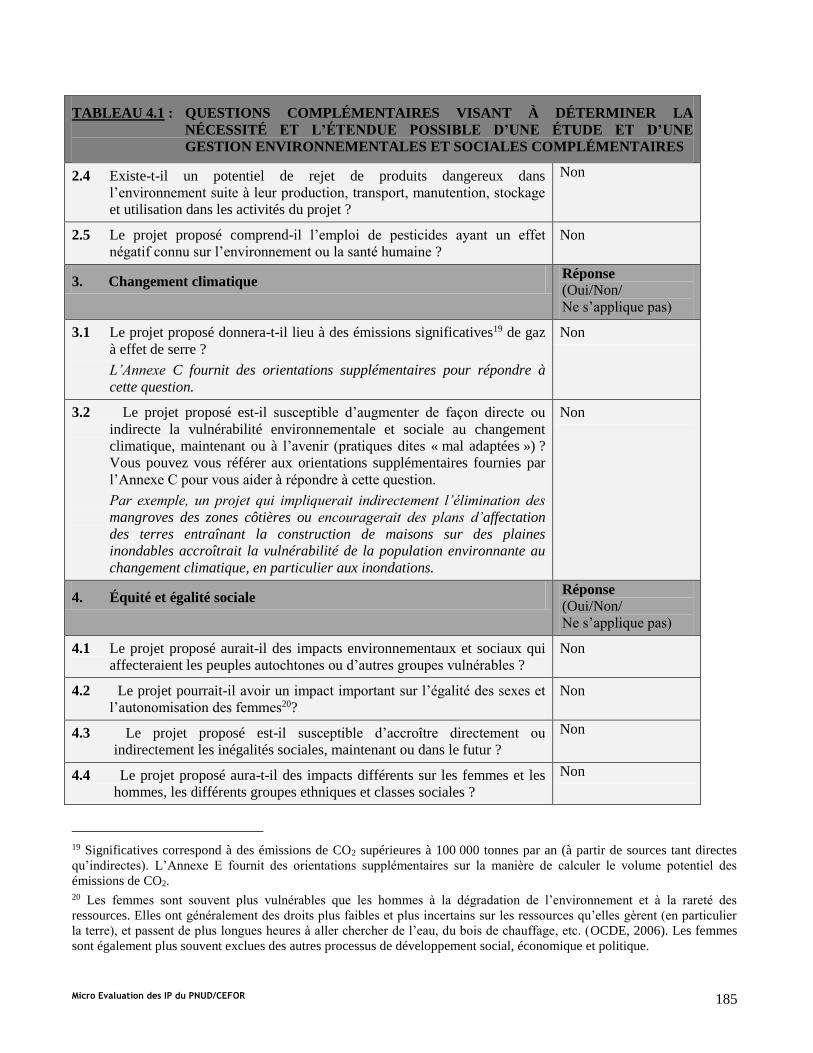
Micro Evaluation des IP du PNUD/CEFOR 185
TABLEAU 4.1 : QUESTIONS COMPLÉMENTAIRES VISANT À DÉTERMINER LA
NÉCESSITÉ ET L’ÉTENDUE POSSIBLE D’UNE ÉTUDE ET D’UNE
GESTION ENVIRONNEMENTALES ET SOCIALES COMPLÉMENTAIRES
2.4 Existe-t-il un potentiel de rejet de produits dangereux dans
l’environnement suite à leur production, transport, manutention, stockage
et utilisation dans les activités du projet ?
Non
2.5 Le projet proposé comprend-il l’emploi de pesticides ayant un effet
négatif connu sur l’environnement ou la santé humaine ?
Non
3. Changement climatique Réponse
(Oui/Non/
Ne s’applique pas)
3.1 Le projet proposé donnera-t-il lieu à des émissions significatives19 de gaz
à effet de serre ?
L’Annexe C fournit des orientations supplémentaires pour répondre à
cette question.
Non
3.2 Le projet proposé est-il susceptible d’augmenter de façon directe ou
indirecte la vulnérabilité environnementale et sociale au changement
climatique, maintenant ou à l’avenir (pratiques dites « mal adaptées ») ?
Vous pouvez vous référer aux orientations supplémentaires fournies par
l’Annexe C pour vous aider à répondre à cette question.
Par exemple, un projet qui impliquerait indirectement l’élimination des
mangroves des zones côtières ou encouragerait des plans d’affectation
des terres entraînant la construction de maisons sur des plaines
inondables accroîtrait la vulnérabilité de la population environnante au
changement climatique, en particulier aux inondations.
Non
4. Équité et égalité sociale Réponse
(Oui/Non/
Ne s’applique pas)
4.1 Le projet proposé aurait-il des impacts environnementaux et sociaux qui
affecteraient les peuples autochtones ou d’autres groupes vulnérables ?
Non
4.2 Le projet pourrait-il avoir un impact important sur l’égalité des sexes et
l’autonomisation des femmes20?
Non
4.3 Le projet proposé est-il susceptible d’accroître directement ou
indirectement les inégalités sociales, maintenant ou dans le futur ?
Non
4.4 Le projet proposé aura-t-il des impacts différents sur les femmes et les
hommes, les différents groupes ethniques et classes sociales ?
Non
19 Significatives correspond à des émissions de CO2 supérieures à 100 000 tonnes par an (à partir de sources tant directes
qu’indirectes). L’Annexe E fournit des orientations supplémentaires sur la manière de calculer le volume potentiel des
émissions de CO2. 20 Les femmes sont souvent plus vulnérables que les hommes à la dégradation de l’environnement et à la rareté des
ressources. Elles ont généralement des droits plus faibles et plus incertains sur les ressources qu’elles gèrent (en particulier
la terre), et passent de plus longues heures à aller chercher de l’eau, du bois de chauffage, etc. (OCDE, 2006). Les femmes
sont également plus souvent exclues des autres processus de développement social, économique et politique.

Micro Evaluation des IP du PNUD/CEFOR 186
TABLEAU 4.1 : QUESTIONS COMPLÉMENTAIRES VISANT À DÉTERMINER LA
NÉCESSITÉ ET L’ÉTENDUE POSSIBLE D’UNE ÉTUDE ET D’UNE
GESTION ENVIRONNEMENTALES ET SOCIALES COMPLÉMENTAIRES
4.5 Y a-t-il eu des problèmes pour impliquer les femmes et certains autres
groupes clés de parties prenantes dans la conception du projet ?
Non
4.6 Le projet aura-t-il des implications spécifiques en matière de droits de
l’homme pour les groupes vulnérables ?
Non
5. Démographie Réponse
(Oui/Non/
Ne s’applique pas)
5.1 Le projet pourrait-il donner lieu à un afflux important de population au
sein de la (des) communauté(s) affectée(s) ? Non
5.2 Le projet proposé pourrait-il entraîner une importante réinstallation,
volontaire ou non, de populations ?
Par exemple, des projets ayant des avantages environnementaux et
sociaux (par exemple, zones protégées, adaptation au changement
climatique) ayant un impact sur le peuplement, et en particulier sur
certains groupes désavantagés qui s’y trouvent.
Non
5.3 Le projet proposé peut-il conduire à une augmentation significative de la
densité de population, qui pourrait affecter la durabilité environnementale
et sociale du projet ?
Par exemple, un projet ayant pour but le financement d’une infrastructure
touristique dans une zone donnée (par exemple, zone côtière, montagne)
peut conduire à une augmentation significative de la densité de
population, qui pourrait avoir des impacts environnementaux et sociaux
graves (par exemple, destruction de l’écologie de la zone, pollution
sonore, problèmes de gestion des déchets, charge de travail plus
importante pour les femmes).
Non
1. Culture Réponse
(Oui/Non/
Ne s’applique pas)
6.1 Le projet est-il susceptible d’affecter de façon significative les traditions
culturelles des communautés concernées, y compris les rôles respectifs
des hommes et des femmes ?
Non
6.2 Le projet proposé donnera-t-il lieu à des interventions physiques (pendant
la construction ou la mise en œuvre) qui affecteraient des zones ayant une
importance physique ou culturelle connue pour les groupes autochtones et
d’autres communautés manifestant des demandes culturelles stables et
reconnues ?
Non
6.3 Le projet proposé entraînera-t-il la « scission » physique d’une
communauté ?
Par exemple, à cause de la construction d’une route, d’une ligne
électrique ou d’un barrage divisant une communauté.
Non
2. Santé et sécurité Réponse

Micro Evaluation des IP du PNUD/CEFOR 187
TABLEAU 4.1 : QUESTIONS COMPLÉMENTAIRES VISANT À DÉTERMINER LA
NÉCESSITÉ ET L’ÉTENDUE POSSIBLE D’UNE ÉTUDE ET D’UNE
GESTION ENVIRONNEMENTALES ET SOCIALES COMPLÉMENTAIRES
(Oui/Non/
Ne s’applique pas)
7.1 Le projet proposé serait-il susceptible d’accroître ou d’entraîner
l’accroissement de la vulnérabilité aux tremblements de terre, aux
affaissements et glissements de terrain, à l’érosion, aux inondations ou à
des conditions climatiques extrêmes ?
Par exemple, les projets de développement au sein d’une plaine inondable
ou d’une zone sujette aux glissements de terrains.
Non
7.2 Le projet entraînera-t-il des risques accrus pour la santé suite à un
changement dans les conditions de vie et de travail ? En particulier,
risque-t-il de conduire à une augmentation de l’infection par le
VIH/SIDA ?
Non
7.3 Le projet proposé nécessitera-t-il des services de santé supplémentaires,
notamment le dépistage ? Non
3. Socio-économie Réponse
(Oui/Non/
Ne s’applique pas)
8.1 Le projet proposé peut-il avoir des impacts susceptibles d’affecter
l’aptitude des femmes et des hommes à utiliser, mettre en valeur et
protéger les ressources naturelles et d’autres actifs du capital naturel ?
Par exemple, des activités qui pourraient conduire à la dégradation ou à
l’épuisement des ressources naturelles dans des communautés qui en
dépendent pour leur développement, leurs moyens d’existence et leur
bien-être ?
Non
8.2 Le projet proposé est-il susceptible d’affecter de manière significative le
régime foncier et/ou les modes de propriété traditionnels et culturels ? Non
8.3 Le projet proposé peut-il affecter de façon négative le niveau des revenus
ou les opportunités d’emploi des groupes vulnérable ? Non
9. Effets cumulatifs et/ou secondaires Réponse
(Oui/Non/
Ne s’applique pas)
9.1 L’emplacement du projet proposé est-il soumis à des plans d’affectation
des terres actuellement approuvés (exemples : routes, peuplements) qui
pourraient affecter la durabilité environnementale et sociale du projet ?
Par exemple, de futurs plans pour la croissance urbaine, le
développement industriel, l’infrastructure de transport, etc.
Non

Micro Evaluation des IP du PNUD/CEFOR 188
TABLEAU 4.1 : QUESTIONS COMPLÉMENTAIRES VISANT À DÉTERMINER LA
NÉCESSITÉ ET L’ÉTENDUE POSSIBLE D’UNE ÉTUDE ET D’UNE
GESTION ENVIRONNEMENTALES ET SOCIALES COMPLÉMENTAIRES
9.2 Le projet proposé donnera-t-il lieu à un développement secondaire ou
induit qui pourrait avoir des effets environnementaux et sociaux, ou un
effet cumulatif avec d’autres activités existantes ou prévues dans la
région ?
Par exemple, une nouvelle route traversant un espace forestier aura des
impacts environnementaux et sociaux directs liés au déboisement et aux
terrassements associés à la construction et à la réinstallation potentielle
des habitants. Il s’agit là d’impacts directs. En plus, la nouvelle route
devrait aussi entraîner de nouveaux développements commerciaux et
domestiques (maisons, magasins, entreprises). À leur tour, ceux-ci auront
des impacts indirects (ceux-ci sont parfois qualifiés d’impacts
« secondaires » ou « induits »). Si des développements semblables sont
prévus dans le même espace forestier, l’effet cumulatif doit alors être pris
en considération.
Non

Micro Evaluation des IP du PNUD/CEFOR 189
ANNEXE A.2 : RÉSUMÉ DE L’EXAMEN PRÉALABLE ENVIRONNEMENTAL
ET SOCIAL
(à remplir après avoir terminé l’Annexe A.1)
Nom du projet proposé :
A. Résultat de l’examen préalable environnemental et social
Sélectionnez un des points suivants :
Catégorie 1. Aucune action complémentaire n’est nécessaire.
Catégorie 2. Une étude et une gestion complémentaires sont nécessaires. D’éventuels avantages, impacts
et/ou risques environnementaux et sociaux sont associés au projet (ou à une de ses composantes), mais ils
sont essentiellement indirects ou à très long-terme, et sont dès lors extrêmement difficiles si pas impossibles
à identifier ou évaluer directement.
Catégorie 3. Une étude et une gestion complémentaires sont nécessaires. Le projet (ou une de ses
composantes) comporte des impacts ou des risques environnementaux et sociaux potentiels qu’il est possible
de s’identifier avec un degré raisonnable de certitude. Si la Catégorie 3 est cochée, sélectionnez une ou
plusieurs des sous-catégories suivantes :
Catégorie 3a : Les impacts et les risques sont limités en taille. Ils peuvent être identifiés avec un degré
raisonnable de certitude et souvent être pris en charge par l’application de pratiques modèles standards. Ils
nécessitent néanmoins une étude et une évaluation complémentaires minimales et ciblées afin d’identifier et
déterminer si une étude environnementale et sociale complète est nécessaire (dans ce cas, le projet passerait
dans la Catégorie 3b).
Catégorie 3b : Les impacts et les risques pourraient être importants, rendant nécessaire une étude
environnementale et sociale complète. Dans ce cas, un travail de détermination de la portée devra être
entrepris pour identifier le niveau et l’approche les plus appropriés pour cette évaluation.
B. Questions environnementales et sociales (pour les projets nécessitant une étude et une gestion
environnementales et sociales complémentaires)
Dans cette section, dressez la liste des questions environnementales et sociales clés éventuellement soulevées par
le projet. Cela peut comprendre aussi bien les opportunités environnementales et sociales qui peuvent être saisies
pour renforcer le projet, que les risques qui doivent être gérés. Vous pouvez utiliser les réponses fournies dans le
Tableau 4.1 comme base pour ce résumé, ainsi que toute étude et gestion complémentaire effectuée.
Ce projet appuie au développement d'un système d'alerte précoce (SAP) et il vise à améliorer une meilleure collection d’information sur le
climat (IC) au Burkina Faso. Le premier volet de ce projet consiste à l'acquisition des équipements de surveillance de l’environnement
avec l’accent sur les aspects météorologique et hydropique. Ces équipements doivent être placés prenant en compte des principales
recommandations à l’issue de consultations participative avec les populations locales ainsi que les représentants des acteurs décentralisés.
Le choix de placement des équipements favorisera des endroits qui maximisent les bénéfices locales de l’information du temps / des
données climatiques utilisées pour soutenir les activités d'adaptation (par exemple, la sélection de type de culture / fourrage, la rotation des
cultures, les pratiques de stockage de l'eau). Le régime foncier n'est pas considéré comme un problème parce que les sites sont détenus par
le gouvernement.

Micro Evaluation des IP du PNUD/CEFOR 190
Composante 2 de ce projet consacre au renforcement des capacités et le développement des mécanismes de partage de données et de
communication. Aucun d'entre eux n’aura des impacts sociaux ou environnementaux. D'autre part, le projet appuie la révision de la
SCADD et l’intégration de SAP / IC dans les politiques nationales dans le but de promouvoir les initiatives de l'adaptation aux
changements climatiques. Les révisions de politique nationale ne sont pas obligatoires, cependant SAP / IC devrait être un outil de la
planification en vue de favoriser la société résiliente au changement climatique. Les informations climatiques adaptés aux besoins de
différent secteurs servirons à élaborer une planification à long terme afin d’améliorer la sécurité alimentaire ainsi que les autres secteurs y
relatif à la question de la pauvreté.

Micro Evaluation des IP du PNUD/CEFOR 191
C. Étapes suivantes (pour les projets nécessitant une étude et une gestion environnementales et sociales
complémentaires) :
Dans cette section, vous devez résumer les actions qui seront entreprises pour prendre en charge les questions
énumérées ci-dessus. Si votre projet comprend des composantes relevant des Catégories 2 ou 3, les prochaines
étapes devraient comprendre une étude et une gestion environnementales et sociales complémentaires, et les
résultats de ce travail devront également être résumés ici. Des orientations utiles peuvent être trouvées à la
Section 7 pour la Catégorie 2, et à la Section 8 pour la Catégorie 3.
Les garanties environnementales étant appliquées sont les aspects suivants:
1) Adapter SAP / IC pour mieux soutenir les activités de secteur agricole et les pratiques de gestion des terres et d'eau
2) Communiquer avec le gouvernement local ainsi que les acteurs décentralisés afin de trouver le meilleur positionnement/attribution des
stations / des équipements
Les garanties sociales étant appliquées sont les suivantes:
1) Assurer la concertation participative avec la population locale et les représentants des acteurs décentralisés dans le choix de placement
des stations / des équipements
2) Maximiser les bénéfices générés par l’installation des équipements à l’endroit de la population le plus vulnérable aux effets néfaste des
changements climatiques
3) Assurer la participation des organisations représentent les femmes
3) Faciliter les commentaires des populations marginalisées avec le mécanisme rétroactif de communication
D. Signatures
Promoteur du projet Date
CEP Date
Directeur du programme Date

Micro Evaluation des IP du PNUD/CEFOR 192
Annex 14: Responses to Donor Comments
United States Government Comments
Burkina Faso: Strengthening Climate Services and Early Warning Systems in Burkina Faso for Climate Resilient Development and
Adaptation to Climate Change
Include detailed activities related to production of
climate/hydrological information, communications and
sustaining this work and retaining expertise, particularly
under component 2.
The production of climate/hydrological information is addressed in
Output 2.2. A feasibility study following by a pilot study (Activities
2.2.2 and 2.2.3) will be used to demonstrate the economic potential of
tailoring and selling weather/climate information to different
agricultural sectors (e.g., cotton), the mining industry and the building
construction industry. A workshop between the information
production agencies and representatives from the private sector has
indicated that more frequent and longer time scale national bulletins
can be revenue-generating products (e.g., seasonal forecasts to predict
the rainy season or daily forecasts to indicate maximum wind speeds
for cotton cultivation). The LDCF project will reinforce the capacity
of the DGM/DGRE/DCIME (Output 2.2 p 36) to produce such
tailored climate products and hence the attractiveness of products that
the private sector is willing to pay for. Tailoring products to the
private sector will thus serve as a way to gain revenue and recover
costs. Cost recovery funds can help with equipment O&M costs and
modernization of equipment. Outputs 2.6 and 2.7 (p 50-51) focus on
the communication of information including the development of a
Standard Operating Procedure (SOP) to clearly identify the role of the
Disaster Risk Management unit (CONASUR) and how there will be a
chain of communication with NGOs/CSOs down to the local level
(mayors). Also, Output 2.7 includes a public awareness campaign to
inform the local populations on the utility of this information for
adaptation to climate change. Expertise in generating hydro-
meteorological information will be retained by mandating all trained
technicians/engineers within the NHMS to remain in their position for
10 years to ensure knowledge sharing. This and the development of
new products and a diversified sector is expected to help retain trained
staff.
Maintain close relationships and establish partnerships with
relevant organizations working on climate and
hydrometeorological services in the project region and make
use of lessons learned from related efforts. This will
strengthen capacity and connectivity within the broader
region.
This project is using the Global Framework for Climate Services
established by WMO as a related initiative. Under this project, WMO
already developed a National Framework for Climate Services in
Burkina following a three-day workshop led by WMO in late July
2012. A pilot project is planned to occur in Burkina (funding
approximately $2.65m) with the goals of developing National Climate
and Health Working Groups and partnering climate services and water
resources management. This project will ensure there is a solid
collaboration with EWS-related projects supporting climate and
hydrometeorological services in the west African region including
ClimDevAfrica (climate information in Africa), AGRHYMET
(agriculture), ViGIRisC (establishment of vigilance systems for
climate risk), Niger-Hycos and Volta-Hycos (transboundary
hydrological modeling in the Niger and Volta watersheds) and
AMESD (satellite data retrieval to assist with food security forecasts).
Describe how the project will ensure that the production of
information is driven by the needs of the users and delivered
through appropriate user-friendly channels
As discussed during the workshop between the information
production agencies and private sector representatives, service
delivery of climate/weather information products will be targeted
towards the cotton, building construction and mining industries who
have already expressed interest in purchasing tailored products
(Annex 4). User-friendly communications, SMS services and the
Governmental Information Service (SIG) will be supported to provide
user-driven information and make it accessible. SIG already has
numerous effective ways of communicating to the general public (call

Micro Evaluation des IP du PNUD/CEFOR 193
center, toll-free number, etc See Section 2.4.4 p 35), but they rarely
collaborate with NHMS. The LDCF project will develop a partnership
between SIG, the DRM (CONASUR) and the information producers
to generate alerts rapidly. End-user feedback on the utility of
information will be highly valued in project implementation and
thereafter by including a feedback chain to enable end-users to voice
their needs/concerns to local EWS focal points (Activity 2.6.4 p 40).
Include clear explanations of how local communities and
women will be involved in shaping the project and describe
how the project will benefit vulnerable populations and
individuals.
Under Activity 2.6.3 (p 39) grass-roots based NGOs/CSOs and local
mayors will be trained on how to most efficiently and effectively
communicate alerts and information. A Standard Operating Procedure
(SOP) for communication will be developed to clearly define the roles
of each agency in the EWS/CI communication chain. The SOP will
include designating EWS/CI focal points which the local communities
can contact. End-user feedback on the efficacy and speed of EWS/CI
alerts will be made possible by including a feedback chain to enable
end-users to voice their needs/concerns to the local EWS/CI focal
points (Activity 2.6.4 p 40). Furthermore, local populations will be
used to assess the project indicators (See Project Results Framework
Section 3). In the beginning of the project, a gender dis-aggregated
survey will be conducted to determine how many people receive alerts
(highlighting women). This same survey will be conducted at the end
of the project once the EWS system has been implemented. The
Stakeholder Involvement Plan (Section 2.9 p 52 Annex 5) describes
how women-focused NGOs/CSOs (WILDAF and the Women's
Forestry Association) will be responsible for conducting the survey in
order to ensure that women receive alerts. Furthermore, during the
preparation phase (see Annex 4, Key assessment report and section
2.9 Stakeholder Baseline Analysis p 52) these women-focused
NGO/CSOs were fully integrated into the participatory design
process.
Activities related to data stewardship should be expanded to
include a plan for data sharing throughout the region and
globally.
As evidenced by Burkina's active role in the Niger-Hycos and Volta-
Hycos projects (international watershed hydrological model
development projects), transboundary data sharing is quite critical for
Burkina. Weather patterns move progressively over the region (p 12).
This project will facilitate data sharing by using an existing server at
DCIME as a centralized EWS information server (Output 2.4, p 37).
Technical NHMS, research organizations and the Disaster Risk
Management Unit (CONASUR) will be able to have privileged access
to this information. An ftp connection will also be established to
facilitate data sharing regionally. Globally, data will be communicated
to the Global Telecommunication System in Activity 2.4.1 (p37).
Furthermore, the database will serve to build links with the
catastrophe databases in Burkina managed by the China and Japan
National Centers for Catastrophes and link to the open access spatial
data from the UN Office for Outer Space Affaires (UN OOSA) and
the UN SPIDER project which is concerned with developing the
capacity of countries to use an open network of all types of space-
based information to support disaster management activities.
Clearly articulate the sectors that will benefit from the
project, and include considerations of the adaptation
priorities and needs of local communities.
The capacity of climate/environmental information production
agencies (DGM/DGRE/DCIME) to provide rapid alerts and tailor
climate products to the needs of various socio-economic sectors will
be reinforced providing benefits to approximately 150 people within
these respective ministries (e.g., agriculture, health, cotton, Section
2.3.4 p 22) (Approximately 340 people will benefit in the NHMS and
the DRM, see Section 2.3.4 p24). Similarly the decentralized
information dissemination agencies will be trained to understand
EWS/CI technical jargon so that it can be relayed simply to local
populations. This entails that approximately 840 people in local
CONASUR branches, NGOs/CSOS will become beneficiaries of the

Micro Evaluation des IP du PNUD/CEFOR 194
project. Data sharing will also extend weather/climate information to
the Ministries of Health and Agriculture which account for 20,000
beneficiaries. By the project enabling a pilot study on tailoring climate
services and market research on the potential for mobile phone-based
agricultural advisories, Burkina farmers can take advantage of
improved local forecasts of winds, rain and temperature.
Together with satellite imagery used for land-use planning and
monitoring, tailored climate products can also provide significant
local environmental benefits, detailing best water management
practices which is crucial to help Burkina’s fight against
desertification.
At the local level, early warnings and climate hazard mapping can
provide economic benefits by reducing losses of agricultural produce,
infrastructure (roads and bridges) and disruption to people’s
livelihoods. The selected target zones are considered the most
vulnerable agro-ecological zones as identified in Burkina's NAPA
(2007).
Communities will also immediately benefit from the Standard
Operating Procedure to be implemented for alert communication. The
total population benefiting from these developments has the potential
to grow immensely if warnings extend to a reasonable percentage of
the total population e.g. through a mobile phone relay. Also, the
feedback mechanism can enable the communication mechanism to be
improved via end-user comments/suggestions. Finally, during project
development it was indicated that at least 12 private sector industries
or companies, spanning a range of sectors, can benefit from EWS/CI.
The proposal requests funding for an “appropriately
equipped hydrological boat for comprehensive profiling of
salinity”. We request UNEP and UNDP to explain why this
platform was chosen over lower cost platforms.
In this project, one Zodiac inflatable boat (for the Hydrological
Service, DGRE B) will be purchased because it is the most cost-
effective method to deploy instruments at different locations for
hydrological monitoring, as opposed to having 6 or so permanent
fixed structures which would be more costly.
General comments on PIFs
Given the similarity between all the PIFs, it is recommended
to develop one regional PIF OR conduct more in-depth
analysis of gaps and needs for each country.
The outputs for this LDCF project have been tailored to address the
gaps and needs for the NHMS, (DGM (including ASECNA (radio-
soundings) and SAAGA (Radar)), DGRE and DCIME) as well as the
Disaster Risk Management Unit (CONASUR), relevant NGOs/CSOs
(see Stakeholder section 2.9 p 51) and local communities in Benin.
The gaps and needs of these key early warning institutions and end-
users of early warning system information have been identified
through multi-stakeholder consultations conducted including the
inception workshop held during September 2012 which was used to
identify relevant EWS agencies involved with climate and hydro-
meteorological information production as well as agencies that should
be implicated in alert dissemination to vulnerable populations, most
notably farmers and rural women. This workshop was also used to
detail the baseline of EWS-related initiatives (outlining gaps,
successes and failures) and identify potential co-financing sources
including institutions who are managing/developing relevant on-
going/planned EWS related initiatives. A second mission workshop in
November 2012 was used to 1) to define and validate Early Warning
System (EWS) costs provided by each agency in Benin 2) to perform
a capacity assessment of all information production and dissemination
agencies and 3) to formalize the roles of each EWS agency in
information dissemination. Results from the self-assessment on
capacity and prioritized needs are detailed in Annex 4. Thirdly, and
most recently, the final validation workshop was held in April 2013
and was used to confirm the Management Arrangements, partnerships,
project indicators, risks, assumptions, synergy mechanisms and
project outputs and budgets.

Micro Evaluation des IP du PNUD/CEFOR 195
Long term data records require sustainability and therefore
need more detail for output 2.5 (sustainable financing) and
how it will overcome barriers.
Long-term data records will be reinforced by digitizing data in
Component 1 (Activities 1.1.5 and 1.2.6 p 29) and having designated
servers for data storage, including back-up methods, in each
information production agency. In order to ensure that data will
continue to be collected, several design aspects to ensure project
financial sustainability have been made (See Sustainability Section
2.7 p 49 for more details). 1) Equipment procurement will be
staggered so that enough technical support is available to continue
operation and maintenance of existing equipment and to be trained on
new equipment installations. This will prevent any interruptions in
equipment operation/data collection. 2) Continued support for
monitoring will be established by developing a framework for
DGM/DGRE/DCIME to properly plan sustainable government budget
lines including cost recovery mechanisms (Output 1.4 p 32). To date,
all equipment operation and maintenance is funded by existing
government budget lines. 3) Tailoring products to the private sector
will also serve as a way to recover costs in the long term. Significant
capacity building regionally will be supported so that cross-sectoral
weather/climate/hydrological products can be delivered. By making
EWS/CI more useful to various sectors, this pushes the Government
to include core budget lines to support monitoring equipment
operation and maintenance due to the cross-sectoral importance of
EWS/CI (e.g., health epidemics linking to temperature trends,
agricultural advisories based on rain patterns)
Ensure that integration of hydro-met system, satellite, gauges
and radars is considered. Radars are expensive to install and
maintain and can exceed national budgets.
Burkina Faso is using a mix of technologies because the radar and
radiosonde launching station are already installed and the costs of
rehabilitation and training are considered to offer a cost effective
solution for providing these data. Radar data is generated by SAAGA,
one operational arm of the Met Service while radiosonde data is
generated by another operational arm, ASECNA. Data, such as is the
case presently, will be transferred to DGM. In the case of the radar
data where power outages have been frequent, a microwave link will
be used to improve data transmission (Activity 1.3.3 p30). This
project will also support satellite data use and analysis through its
capacity reinforcement for the environmental data institution
(DCIME). Finally, to integrate all of this information, Burkina Faso
will procure the SYNERGIE system (MeteoFrance).
Projects will be challenged by a lack of IT infrastructure
(bandwidth, etc.) to collect, analyse, exchange and archive
data.
Significant IT equipment has been included in Component 1 for data
downloading, data archive and exchange and in Component 2; the
already existing server at DCIME will be configured to exchange data
between ministries/organizations (Activity 2.4.1 p38). Back-up
servers will also be acquired where appropriate. For new IT
developments training in data transmission/storage/usage will be
provided by a Communications expert in Output 1.6 (p 32), for DGM,
DGRE and DCIME. It is recognized that bandwidth is limited in
Burkina Faso and is listed as a risk in the Project Results Framework
Section 3 and the Risk Analysis Annex 1. To improve bandwidth, an
activity has been developed to establish a public-private partnership
and service level agreement between DNM and the mobile
service/internet service provider (SONABEL) with regards to
standardizing start-up costs for servers and modems as well as
increasing bandwidth for internet connections.
There is a lack of workstations to make forecasts, access
global products for downscaling etc.
The SYNERGIE (MeteoFrance) forecasting interface will be procured
under Component 2.1 (p36) including required IT equipment to
handle forecast visualization, data assimilation and downscaling. Data
in SYNERGIE comes from a combination of weather station,
radiosonde and satellite observations. There is significant budget
allotted to training for DGM/ASECNA and use of the SYNERGIE
system as well as budget and an activity to plan for license renewal

Micro Evaluation des IP du PNUD/CEFOR 196
after completion of the project. ASECNA, who is already performing
forecasting and familiar with forecasting technologies such as
SYNERGIE, will assist in continual knowledge sharing with DGM
(ASECNA acts as an operational arm of DGM). Three (3) work
stations for data collection/use and forecasting will be procured under
Activity 2.1.1 p 36.
There is a lack of private capital to support the large costs of
modernisation.
A workshop was conducted in the beginning of March 2013 (see
meeting notes in Annex 5 p139) including the information production
agencies, DGM/DGRE/DCIME and private sector representatives
from the cotton, building construction, and mining industries. All 3
sectors show high potential for future investment in tailored
weather/climate products. Specifically, the building industry needs
high quality forecasts to know when to shelter their building materials
while the cotton industry requires rain gauge information near specific
cotton plots in order to plan their cultivations. Revenues obtained
from selling tailored products to the private sector can help with
equipment O&M costs and costs to continue to modernize equipment.
Recurring costs for weather/climate/environmental monitoring will be
included in national budget lines in order to ensure their financial
sustainability.
Specific details on which hazards are important and where
should be included.
Burkina Faso hazards include floods, drought, and strong winds (e.g.,
harmattan trade winds from the Sahara desert). Target vulnerable
areas experience all of these risks to some degree depending on the
climate regime (3 regimes, see Figure 8, Annex 4 p140) as detailed in
the Burkina NAPA (2007). The most northern climate regime closer
to the Sahara experiences more drought and harmattan winds while
the southern regimes have experienced more severe flooding. This
was discussed during workshops and considered when deciding target
EWS activities.
More analyses of climate needs to be included in
determining where hydromet stations should be located.
Climate stations with the role of measuring climate variables (namely
temperature and rainfall) will be procured and DGM has conducted
feasibility studies to see where these specific stations should be best
placed. They have concluded that they need a climate station in each
of the provinces and a rain gauge in each of the departments (Global
Project For Modernization and Reform of Burkina Faso’s National
Meteorological Service, October 2007, Annex 4) and this assessment
will be built on (refined through discussions during implementation)
to determine hydromet locations.
To ensure that the appropriate climate observations are recorded and applied, the following considerations should be included:
Clear descriptions of the types of observations that are
required and how they will feed into an EWS appropriately.
Weather stations will measure temperature, rainfall, soil moisture,
evapotranspiration and pressure variables on the surface or in the case
of wind, 2 or 10 m above the surface each hour. These measurements
will be important for making assessments of current
agrometeorological conditions. Flow meters and water level meters
will provide discharge measurements every hour, and will feed into
flood monitoring and forecasts. Radar will be used to measure rainfall
droplets at a rate of every 10 minutes and then averaged every hour in
order to identify locations at risk of flash flooding (combined with
monitoring of saturated soils). Radiosondes will give a vertical profile
of atmospheric variables including temperature and pressure two
times a day (at noon and midnight in accordance with WMO
standards) which will support daily weather forecast generation using
both external forecasting products (e.g., COSMO, NCEP GFS, and
ECMWF) and allowing subjective analyses of these forecasts by
trained meteorologists. For climate analyses, climate stations
measuring rainfall and temperature and satellite images used to detect
images of the Earth's surface on a daily basis will be used to predict
climate trends, the occurrence of flood/drought periods, and soil

Micro Evaluation des IP du PNUD/CEFOR 197
moisture measurements to identify long dry periods.
Provide data to world climatic data centres. Yes, climate/meteorological data will be supplied to GTS (Activity
2.4.1 p38) (Global Telecommunication System) – the international
system for met data collection/analysis and hydrological data will be
provided to the WHYCOS project (World Hydrological Cycle
Observing System, WMO). BKF provides data to WHYCOS through
its on-going Niger-Hycos and Volta-Hycos projects.
Clearly distinguish between weather and climate
observations and how they are used.
Weather observations will be used in hydro-meteorological models to
produce daily forecasts for predicting extreme and severe weather and
potentially for deriving weather-related seasonal forecasts such as for
dry spells etc. They also form the basis for monitoring the current
state of the atmosphere and surface conditions and long-term, are
accumulated to be used for climate studies. Climate observations will
be used for long-term predictions (on the order of years) and will be
provided to planners (DCIME, Ministry of Agriculture etc) and will
feed into the next PRSPs (SCADD and Burkina's PEI). Output 2.1 p
35 and Output 2.3 p 38. Both weather and climate observations may
also be used within downscaling models for predicting the future
seasonal and long-term climate, depending on the methodology used.
Details should be provided on whether additional funding for
procurement of technology can be accessed.
The project will build off of existing initiatives which are in the
process of procuring equipment. The first LDCF financed project
supporting Burkina' NAPA installed 10 manual synoptic weather
stations and 6 automatic agro-climate stations in two agro-ecological
zones (See Baseline Section 2.4.1 p 25). A GFDRR project has also
purchased hydro-meteorological equipment including hydrological
flow meters and rain gauges in pilot zones (Section 2.4.1 p 25).
Additionally funding to maintain and operate the equipment will be
provided by the government in their budget lines. New equipment is
not planned in the immediate future but has been outlined in the
feasibility studies of DGM and DGRE (See Annex 4) and future
funding sources will be identified where they exist.
Project goals include mitigation of flood/drought losses but
have insufficient hydrological modeling described in the PIF.
Hydrological modeling with HECRES and MIKEBASIN models (to
provide watershed modeling and hydropower/pipeline modeling
respectively) has been added since the PIF. Current capacityfor
hydrological modeling in Burkina Faso is low and will need to be
built during the project. Please see Output 1.1 for details.
Include considerations of how capacity of hydrological
services (and agriculture) can be improved e.g. issue flood
and drought monitoring and early warnings.
Hydrological services in Burkina Faso need to be improved because
current technical capacity is weak. The hydrological service (DGRE)
has focused on hydropower/dam management modeling up until now.
This project will be used to collect more hydrological measurements
(flow and water level) and combine this information with
upstream/downstream watershed models in order to predict floods and
potential periods of droughts (e.g., when reservoir levels are low). The
project document now considers/identifies a range of capacities that
need to be built to improve flood and drought warnings.
Address links and gaps between representatives of hydromet
and agriculture e.g. will the meteorological data work with
hydrological/agricultural models, or will it require
manipulating?
The NHMS and the agriculture sector already work together to
produce alerts for famine. The alerts are produced by multi-
disciplinary working groups (GTPs). The GTPs will continue to be
used in this project for technical support. Data will still likely require
manipulating, especially with the generation of new products.
Generally, the hydrological/agricultural models require temperature,
rainfall, wind, evapotranspiration and soil moisture inputs on daily to
monthly timescales, which are provided by existing stations, though it
is sometimes difficult to obtain continuous daily data (this will be
improved through new AWS and AWLS fitted with GPRS modems).
New stations will also expand the network coverage measuring these
weather/climate characteristics.
In Component 2 there is a need to articulate the types of Burkina Faso requires early warnings on short-term scales, (hourly,
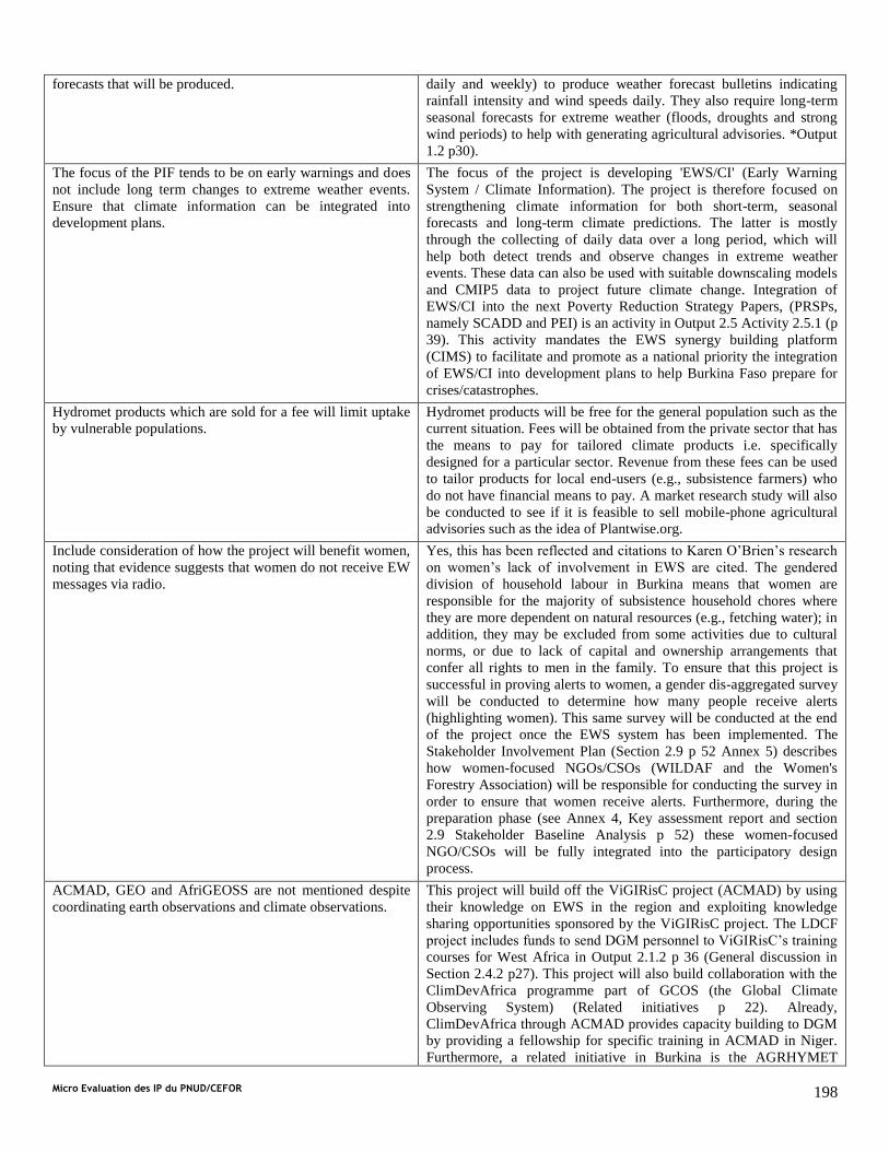
Micro Evaluation des IP du PNUD/CEFOR 198
forecasts that will be produced. daily and weekly) to produce weather forecast bulletins indicating
rainfall intensity and wind speeds daily. They also require long-term
seasonal forecasts for extreme weather (floods, droughts and strong
wind periods) to help with generating agricultural advisories. *Output
1.2 p30).
The focus of the PIF tends to be on early warnings and does
not include long term changes to extreme weather events.
Ensure that climate information can be integrated into
development plans.
The focus of the project is developing 'EWS/CI' (Early Warning
System / Climate Information). The project is therefore focused on
strengthening climate information for both short-term, seasonal
forecasts and long-term climate predictions. The latter is mostly
through the collecting of daily data over a long period, which will
help both detect trends and observe changes in extreme weather
events. These data can also be used with suitable downscaling models
and CMIP5 data to project future climate change. Integration of
EWS/CI into the next Poverty Reduction Strategy Papers, (PRSPs,
namely SCADD and PEI) is an activity in Output 2.5 Activity 2.5.1 (p
39). This activity mandates the EWS synergy building platform
(CIMS) to facilitate and promote as a national priority the integration
of EWS/CI into development plans to help Burkina Faso prepare for
crises/catastrophes.
Hydromet products which are sold for a fee will limit uptake
by vulnerable populations.
Hydromet products will be free for the general population such as the
current situation. Fees will be obtained from the private sector that has
the means to pay for tailored climate products i.e. specifically
designed for a particular sector. Revenue from these fees can be used
to tailor products for local end-users (e.g., subsistence farmers) who
do not have financial means to pay. A market research study will also
be conducted to see if it is feasible to sell mobile-phone agricultural
advisories such as the idea of Plantwise.org.
Include consideration of how the project will benefit women,
noting that evidence suggests that women do not receive EW
messages via radio.
Yes, this has been reflected and citations to Karen O’Brien’s research
on women’s lack of involvement in EWS are cited. The gendered
division of household labour in Burkina means that women are
responsible for the majority of subsistence household chores where
they are more dependent on natural resources (e.g., fetching water); in
addition, they may be excluded from some activities due to cultural
norms, or due to lack of capital and ownership arrangements that
confer all rights to men in the family. To ensure that this project is
successful in proving alerts to women, a gender dis-aggregated survey
will be conducted to determine how many people receive alerts
(highlighting women). This same survey will be conducted at the end
of the project once the EWS system has been implemented. The
Stakeholder Involvement Plan (Section 2.9 p 52 Annex 5) describes
how women-focused NGOs/CSOs (WILDAF and the Women's
Forestry Association) will be responsible for conducting the survey in
order to ensure that women receive alerts. Furthermore, during the
preparation phase (see Annex 4, Key assessment report and section
2.9 Stakeholder Baseline Analysis p 52) these women-focused
NGO/CSOs will be fully integrated into the participatory design
process.
ACMAD, GEO and AfriGEOSS are not mentioned despite
coordinating earth observations and climate observations.
This project will build off the ViGIRisC project (ACMAD) by using
their knowledge on EWS in the region and exploiting knowledge
sharing opportunities sponsored by the ViGIRisC project. The LDCF
project includes funds to send DGM personnel to ViGIRisC’s training
courses for West Africa in Output 2.1.2 p 36 (General discussion in
Section 2.4.2 p27). This project will also build collaboration with the
ClimDevAfrica programme part of GCOS (the Global Climate
Observing System) (Related initiatives p 22). Already,
ClimDevAfrica through ACMAD provides capacity building to DGM
by providing a fellowship for specific training in ACMAD in Niger.
Furthermore, a related initiative in Burkina is the AGRHYMET

Micro Evaluation des IP du PNUD/CEFOR 199
initiative which incorporates satellite data (formerly the AMESD
project and now the MESA project) to improve climate information
and the WHYCOS (World Hydrological Cycle Observing System)
projects (Niger-HYCOS) which exploit and share satellite information
related to hydrology to model common drainage basins which traverse
country boundaries (Section 2.4.2 p27).
There is a need to include WMO and the GFCS initiative. The GFCS initiative (WMO) is very active in Burkina Faso and is
considered an on-going related initiative (Section 2.3.1 p 20). In July
2012, the GFCS funded a workshop in Burkina Faso to establish a
framework for climate services at the national level (See conclusions
Annex 4+E41). This initiative was a first step to improving
communication between different sectors (health, agriculture, food
security, private) on their needs for climate services. Other goals of
this project are to: strengthen capacity for disaster risk reduction and
early warning, perform large-scale data recovery and digitization, and
develop National Climate and Health Working Groups, partner
climate services and water resources management. Due to the related
initiatives of GFCS with the LDCF project, the WMO regional focal
point is considered a coordination entity in the Implementation
Arrangement. As such, the project will relay project developments to
the WMO focal point to ensure there is synergy with WMO activities.
Clarify how it plans to promote coordination between
ministries at both the national and provincial level. We
appreciate the involvement of multiple government agencies
and institutions as this EWS will not only require input from
various sector experts but also produce information
applicable to numerous ministries and institutions.
Synergy with other initiatives, particularly those housed in the
Disaster Risk Management Unit (CONASUR) was voiced as a major
issue during project development. As a result, in Component 2, an
Output has been developed to create a Multi-agency and Inter-
disciplinary platform for Synergy (CIMS) to ensure coordination with
other EWS agencies (from national down to local levels) and synergy
with EWS-related initiatives to maximize project complementarity.
This includes early warnings already in place for famine. Technical
focal points from information production and dissemination agencies
will form a technical support group. They will work with the already
formed GTPs, Technical Working Groups, which produce alerts for
famine and dam management and include focal points from cross-
sector institutions/organizations. The Disaster Risk Management
agency, CONASUR, will have a decentralization support committee
including representatives on regional (prefect), local community
levels (mayors), and representatives from NGOs/CSOs to help with
information and alert dissemination.
Outline how users will be involved both in the design of the
EWS and in deciding what information is produced from the
EWS as well as how information will be disseminated. Better
results can be achieved by ensuring that climate information
and early warning system products are user-driven and
communicated to users through various innovative channels
The Burkina Faso EWS/CI includes the development of a feedback
mechanism in the Standard Operating Procedure for communication
to be implemented. The feedback mechanism via SMS and toll-free
numbers to designated EWS focal points will ensure that end-users are
engaged and are able to provide their suggestions on how to improve
communication and alerts. They will also be able to get involved in a
pilot study to demonstrate how best agricultural weather advisories
should be customized to their needs. Climate/weather products that
are service-based and end-user driven, such as weather bulletins and
SMS agricultural advisories (Plantwise.org) will be developed under
Output 2.2.
Clarify how it will communicate results, lessons learned and
best practices identified throughout the project to the various
stakeholders both during and after the project; and
The Multi-agency and Inter-disciplinary platform for Synergy (CIMS)
will hold regular information, lessons learnt and good practices
meetings to strengthen collaboration among EWS agencies and EWS-
related initiatives. From a project development point of view, the
UNDP Monitoring and Evaluation mechanism will be used to track
project progress with the quantitative indictors outlined in the Project
Results Framework (See Section 3).
Engage local stakeholders, including community-based
organizations and environmental NGOs in both the
All relevant NGO/CSOs including women representing NGOs
(WILDAF) have been consulted during project development and will

Micro Evaluation des IP du PNUD/CEFOR 200
development and implementation of the program continue to be engaged through the Stakeholder Implementation Plan.
Also, Output 2.7 is dedicated to working with the local stakeholders
through a public awareness campaign and holding workshops in the
target EWS regions in order to get local stakeholder input.
Germany comments on the PIF “Strengthening Climate Services and Early Warning Systems in the Gambia for Climate
Resilient Development and Adaptation to Climate Change- 2nd Phase of the GOTG/GEF/UNEP LDCF NAPA Early Warning
Project”
A robust strategy to ensure sustainability of project,
particularly with reference to investments in infrastructure
and climate services, should include commitments from
partners as well as an assessment of risks related to the
sustainability of investments.
In terms of risks for the sustainability of this project, the Validation
workshop concluded that there are 2 main risks which must be
accounted for (See Risk Analysis Annex 1). It is possible that Burkina
Faso will not have enough government financing to continue
monitoring and to cover recurring O&M costs. It is also possible that
there will be a lack of qualified personnel within the NHMS to operate
and maintain new equipment, data transmission/treatment/storage
processes and forecasting models. To combat these risks, this project is
focused on making EWS/CI useful to various sectors (e.g., agriculture,
health, and economics) (See Activities 2.2.2 and 2.2.5 p 37). By
developing products that are user-driven the EWS/CI responds directly
to national needs (e.g., targeted agricultural advisories to improve the
cotton sector's production). Through this approach, the Government will
gain incentives to include budget lines to provide continual support for
climate/weather/environmental monitoring due to its cross-sectoral
importance and profitability (even if just the potential for profit is
demonstrated by the end of the project). Furthermore, in Activity 1.6.3,
capacity for long-term operation and maintenance planning and
budgeting will be built in all information production agencies through
regional support training. Co-financing agreements have already been
agreed upon to support the project as well (Table 1 p 23). The Ministry
on Sustainable Development has agreed to support the project with
approximately $40,000 while the World Bank PNGTIII project will be
co-financing the project for $54 m. In both cases, the Ministry and the
World Bank see the utility of weather/climate information to help the
local populations adapt to weather risks and a changing climate.
As the proposed project requires very specialized technical
expertise on meteorology (hardware and software), provide
detailed information on how expertise and comparative
advantages of partners is incorporated in the project
Significant technical capacity building is included for DGM in Output
2.1 (p 37). At the moment, the majority of forecasting skills are housed
within ASECNA, the operational arm of DGM concerned with civil
aviation. ASECNA will be responsible for transferring their forecasting
skills and sharing their hardware (work stations) and software with
DGM. Furthermore, Activity 2.2.2 (p 37) will support knowledge
sharing for DGM on Numerical Weather Prediction models (e.g., WRF
and COSMO) with international centers (e.g., MeteoFrance) and
regional centers (ACMAD, responsible for the African Early Warning
and Advisory Climate Services, AEWACS or ViGIRisC project and for
the ClimDevAfrica programme) to build forecasting expertise.
Additionally, it should be noted that 10% of the budget will be used to
support a pool of technical regional experts whose role will be to
support this project full-time in the fields of hydrology,
meteorology/climatology forecasting and prediction, and
communication systems. (See TORs in Annex 6).
The additional cost reasoning should be outlined more
clearly. Much of the investment is for the weather related
observational network and brings considerable co-benefits
for economic activities, logistics and transport. However, a
baseline development of maintaining and upgrading of
infrastructure is not described. Please elaborate on the
climate and climate change related benefits in comparison
to the business as usual investment.
Approximately, 60% of the hydro-meteorological equipment is
functional. Equipment is not functioning because there have been
insufficient government funds to maintain and operate the hydro-met
stations. To have better infrastructure, LDCF resources in Component 1
will be used to procure, install and/or rehabilitate critical infrastructure
required to build and strengthen the climate-related observational
network nationally for multi-risk purposes (floods, droughts, and strong
winds) (Output 1.1 and 1.2 p 35). All existing EWS projects are focused
on predicting floods, famine or best dam management practices in

Micro Evaluation des IP du PNUD/CEFOR 201
localized geographical areas. In contrast, this component will focus on
establishing national hydro-meteorological monitoring capabilities in
order to produce EWS/CI for the three climate zones in Burkina,
particularly the most vulnerable agro-ecological zones indicated by the
NAPA.
Through this project, the weather and hydrological equipment will be
upgraded by increasing the frequency of data transmission (via SMS or
GPRS) and procuring complementary automated equipment to the
existing manual equipment. Data transmission is expected to go from 1
month to 1 day (Activity 1.1.4 and 1.2.4 p 33 and 35 respectively)
where equipment is installed. Capacity building will initially be
provided by the equipment manufacturers (generally for 2 weeks after
installation). Capacity will continue to be built to maintain and operate
equipment with regional technical support training on at least a biannual
basis (See TORs Annex 6). Furthermore, equipment has been budgeted
to include the cost of spare parts (approximated to be 25% of running
costs if not known) and field trip validation costs to verify equipment
operations are also included (Output 1.1 and 1.2 p 33 and 35).
An up to five percent fee for “National implementation” is
mentioned. Strong partner involvement and ownership in
the implementation of this project is important but should
not be at the expense of overall project management fees.
Please outline how the five percent fee relates to the
agency fees.
The Project Management Costs are the costs to run the project by the
National Implementing Partner (The Permanent Secretariat for the
National Advisory on the Environment). These funds will be used to
support the Project Coordinator, Financial and Administrative Assistant,
Indemnity fees for the Project Coordinator, and will cover in-country
logistics and supplies. These costs are distinct from Agency fees which
are to provide oversight and quality assurance of the project-- which in
this case is by UNDP (through its country office, region based staff and
HQ-based staff).
Recommend targeting the amount of people that should be
reached through communication channels in sub-
component 2.2 (quantification) and to make sure that the
most vulnerable populations are reached.
On a local level, Burkina’s NAPA has outlined that, currently, the
extreme northern, eastern and western regions in addition to the central
plateau are particularly vulnerable and require improved rapid warnings
for food security and extreme weather events (NAPA 2007, Figure 1 p
24). During the project planning phase, five tentative localities having a
total population of approximately 4 million people have been outlined
based on the NAPA and the responses from NGOs during the capacity
assessment held during the second workshop. Further analysis to
validate and specify the choice of zones to gauge project indicators will
be conducted by DCIME during project implementation (Activity 2.1.5
p 36). NGOs/CSOs who are grass-root based will be implicated in this
project to make sure the most vulnerable are reached (See Stakeholder
Implementation Plan Section 2.9.1 p 52). Also, the project is being by
co-financing institutions, such as the World Bank's PNGT3 project,
which has developed significant ground based presence through their
project in the target vulnerable zones which will be exploited for
information dissemination (See Discussion in Section on Adaptation
Alternatives p 35).
It is recommended to explain the selection process i.e.
definition of the “most vulnerable communities” in Output
3.2.
Five tentative localities have been chosen to target and test EWS/CI
(Section 2.3.4, National and Local Benefits p 25). These are areas
defined by the BKF NAPA (2007) as vulnerable agro-ecological zones.
The local people's vulnerability is in reference to their inability to be
food secure and/or to have been greatly impacted by weather/climate
risks such as drought or floods.
The World Bank’s comments on LDCF EWS PIFs
There is concern that approving these
projects based on a template is at the
expense of more robust proposals
(perhaps more targeted) and could pose
a reputational risk to the GEF.
Throughout the project preparation activities there have been extensive consultations with
stakeholders and government in Burkina Faso to ensure that all outputs address identified
needs and barriers specific to Burkina Faso. Where aspects of the original PIF were
deemed not appropriate they have been removed and all remaining components and
outputs have been modified to accommodate the concerns articulated in the

Micro Evaluation des IP du PNUD/CEFOR 202
comment.Burkina can be considered to be a step forward from many other countries in
Africa with regards to EWS/CI because WMO has already conducted a workshop to
support the development of a framework for climate services. Project development has
taken this into consideration as well as other baseline initiatives which have purchased
equipment (e.g., LDCF financed NAPA and GFDRR project). Consequently, Component 1
deals with specific equipment procurement/rehabilitation and training needs for
DGM/DGRE and DCIME (the Met, Hydrological and Environmental Data service
respectively). Outputs include radar repair and an additional radiosonde launch. The
second component deals with how the data collected will be targeted to the subsistence
farmers and the potential private sector clients (building, mining and cotton). The project
will build off regional initiatives (ViGIRisC, AMESD) and baseline projects (UNDP-
COGEL, WA-WASH USAID). All risks, assumptions, outputs and indicators are specific
to Burkina.
There is insufficient assessment of
current state of hydro-met sector, past
failures and their causes.
This question relates to several aspects of the project, including the radar in Ouagadougou,
which will be repaired as part of this project. The cause of radar failure was lack of
technical capacity and spare parts to perform repairs. As requested by government, this
project will build specialized capacity within SAAGA in order to be self-sufficient with
regard to radar repairs and have the ability to plan for recurring costs (Output 1.3 p 36).
Whilst it is recognised that this is no guarantee that the radar will remain operational after
repair, this is considered a cost-effective solution, which will move towards self-
sufficiency in the long-term. Hydro-meteorological equipment failure has also been caused
by a lack of technical personnel to maintain and operate the equipment. Many technical
personnel have recently retired. This project includes significant technical recruitment
considering the needs to maintain/operate new equipment and run forecasting models.
Terms of reference mandate that any new personnel who are trained must remain in their
respective institution for at least 5 years in order to ensure knowledge sharing (See TORs
Annex 6). Capacity will continue to be built to maintain and operate equipment with
regional technical support training on a biannual basis (See TORs Annex 6). Furthermore,
equipment has been budgeted to include the cost of spare parts (approximated to be 25% of
running costs if not known) and field trip validation costs to verify equipment operation
are considered (Output 1.1 and 1.2 p 33 and 35). Furthermore, in Activity 1.6.3, capacity
for long-term operation and maintenance planning and budgeting will be built in all
information production agencies through regional support training.
There is insufficient consideration of the
limitations of current capacity, which
currently prevents many of the proposed
activities in some countries.
A thorough baseline assessment has been undertaken during the project preparation phase
to identify the main limitations and barriers to the proposed outputs and activities. Where
technical and human capacity is weak, outputs and suggested activities have been adapted
to address these weaknesses. Even with capacity building activities, which are listed in the
Replicability Section 2.8 p 50, it is still expected that activities, building on these training
and knowledge sharing opportunities, will encounter difficulties due to existing barriers.
These barriers are present in all projects of this nature and include slow data transmission
from manual hydro-meteorological infrastructure, institutional cooperation, poor long-term
budget planning, and insufficient technically skilled human resources (Section 1.3 p 9). As
a result, the design reflects what has been learned from trying to tackle these barriers
through other projects (See Baseline initiatives Section 2.4.2 p 30) and identified in the
risks of the Project Results Framework (Section 3 p 60). Countermeasures and
management responses to these limitations are listed in the Risk Analysis (Annex 1 p77).
Cost estimates are unrealistic and do not
include variation between countries and
O&M (operations & management) costs.
Costs are based on budgets provided by each national agency during project development
(DGM, SAAGA, ASECNA, DGRE, DCIME, CONASUR and CPF See Annex 4). The
choice of equipment/technology/approach has been based on a cost-effectiveness
evaluation (See Section 2.6 p 45). Costs have been weighed against the intensive time and
expenses required for training with new equipment where appropriate. In each of their
respective budgets both future running costs and the ease of maintenance were considered.
For DGM, they want to automate the meteorological network and based on their success
with automatic stations under the LDCF financed NAPA1 project, only automatic weather
stations will be procured (Output 1.2). In contrast, DGRE has more limited experience so a
mix of automatic and manual equipment has been proposed (See Output 1.1 p 34).
Repairing the radar and launching an additional radiosonde were considered cost-effective
given the benefits derived from continuing these operations. All costs for monitoring
equipment, IT equipment (to support DCIME with satellite data visualization and the

Micro Evaluation des IP du PNUD/CEFOR 203
procurement of the SYNERGIE system for forecasting) are based on a combination of
government estimates and supplier costs – making allowances for local taxes etc.
Operational and training costs in terms of supporting data transmission through
SMS/GSM, training manual observers and security for hydro-meteorological stations, are
included. Maintenance costs such as to re-calibrate rating curves or sensors on weather
stations as well as basic upkeep and the costs for associated field visits have been included
(Output 1.1 and 1.2). Costs for purchasing spare sensors and parts (25%) are also included.