corridor management and background inventorybackground
TRANSCRIPT

UNLVLANDSCAPE ARCHITECTURE & PLANNING RESEARCH
Corridor Management and
Background Inventory
Corridor Management and
Background Inventory
Chapter One — Corridor Management and Background Inventory
TABLE of CONTENTSSECTION ONE: Introduction ...............................................................................1.1SECTION TWO: Elements of Landscape and Aesthetics .......................1.3SECTION THREE: Background Inventory .................................................... 1.20


1.1
Chapter One — Corridor Management and Background Inventory
SECTION ONE: Introduction
THE VISION
Nevada has a renewed commitment to landscape and aesthetics for the state’s highways. In 2002, the Nevada Department of Transportation (NDOT) adopted the Landscape and Aesthetics Master Plan, raising the bar for context-sensitive design.
“We envision a system of state highways that reflect the land and people of Nevada. We believe that Nevada should have high-ways that are aesthetically pleasing, as well as safe and cost effective. Therefore, no state highway is complete until landscape and aesthetics are considered and addressed.”
Pattern and Palette of Place, 2002, p.10-11
Today, it is the policy of the State of Nevada to consider landscape and aesthetics in conjunction with other design factors in all transportation projects. Furthermore, NDOT recognizes that suc-cessful projects result when local communities, the public, other permitting agencies, and the private sector participate in the planning, design, construction, and maintenance of transportation projects. Partnerships are imperative to ensure Nevada’s highway system expresses the unique heritage, culture, and environment of the state and its communities.
Purpose of the Corridor PlanThe Southern US 95 and US 93 Landscape and Aesthetics Corridor Plan is based on the vision and recommendations of the Master Plan. This plan establishes the vision for landscape and aesthetics for each highway, synthesizing his-toric, current, and future conditions to improve the visual appearance of each corridor. The plan
describes the vision, not the promise, for high-way landscape and aesthetic treatments and en-hancements. Implementation of the vision will be achieved through the combined efforts of local governments, private citizens, civic groups, and the business community.
As shown in illustration 2, the corridor includes US 95 from the California state line near Cal Nev Ari to the US 95/US 93 intersection, US 93 from Railroad Pass east to Hoover Dam, and US 95 north of Las Vegas from Kyle Canyon to the Clark County line.
The Corridor Plan identifies major design themes and materials to be used in landscape and aes-thetic treatments. It also recommends the level of treatment to be applied to highway features in the corridor, providing a broad cost estimate of treatments, and outlining strategies for funding of construction and long-term maintenance.
SECTION ONE: Introduction
(2) Southern US 95 and US 93 Corridor.
(1) Western Highways Corridor.
Figure 1 - Overall Corridor Planning Process
INTERPRETATION OF THEME DESIGN GUIDELINES
DEVELOP LANDSCAPE DESIGN SEGMENT OBJECTIVES TO BE
APPLIED
THEME
DETERMINE AND DESCRIBE THEME FOR
EACH LANDSCAPE DESIGN SEGMENT
DEVELOP PROGRAM OF FACILITIES AND
TYPES OF TREATMENT
DIRECT AND REVIEW INDIVIDUAL PROJECTS IN ACCORDANCEWITH THE CORRIDOR PLAN RECOMMENDATION
PROJECT DESIGN PROCESS CORRIDOR PLANNING
ESTABLISHDESIGN
GUIDELINES
INITIATE NDOT PROJECT
DESIGN
DETERMINE LEVEL OF TREATMENT WITH
PRIORITIES
ESTIMATEPROJECT COSTS
MANAGEINDIVIDUAL DESIGN PROJECT PROCESS
DETERMINE THE VISION, POLICIES, PROCESS, AND PLANNING GUIDELINES
POLICIES
POLICIESPROGRAM
PARTNERSHIPSCONTEXTFUNDING
SPECIFIC PROJECT
MASTER PLANNING
THIS DOCUMENT

1.2
Chapter One — Corridor Management and Background Inventory
The Corridor Plan is a method for improving the aesthetic qualities of the state’s highways, partic-ularly in relation to adjacent cities, communities, and neighborhoods. The Corridor Plan is intended to affect both existing highways as well as future expansion projects. Landscape and aesthetic treat-ments identified and prioritized in the Corridor Plan may be funded from a variety of sources. As a general rule, up to three percent of total highway construction costs on all new construction and capacity improvements may be allocated to land-scape and aesthetic treatments. Funding for the retrofit of landscape and aesthetic improvements to existing highways is based on community part-nerships and the opportunity for communities to match State funds with a share of local money, Federal monies, or in-kind contributions. The Cor-ridor Plan is a public/private partnership initiative. This unique initiative is guided by the partnership policy outlined in the NDOT Landscape and Aes-thetics Master Plan, which states
“Local communities, the public, other per-mitting agencies, and the private sector are encouraged to be involved in planning, design, construction, and maintenance of transportation projects to express the unique heritage, culture and environment of the state and its communities.”
Pattern and Palette of Place, 2002, p. 12
Furthermore, NDOT will work with local govern-ments, private citizens, civic groups, and the busi-ness community to develop cooperative agree-ments for funding the design, construction, and maintenance of landscape and aesthetic improve-ments identified in this Corridor Plan. In locations where recommendations exceed NDOT’s normal financial responsibility and the community de-sires the elevated level of aesthetic treatment, NDOT will engage the community to create part-nerships to find additional funding.
CORRIDOR DESIGN MANAGEMENT
This plan is a useful management tool for design-ing highway projects because it provides specific recommendations, programs, and a description of the intended result. The Corridor Plan establishes a theme or central design idea. Projects within each landscape design segment are guided by a theme, associated design objectives, examples that illustrate interpretation of the theme, and a program of facilities with common definitions. Design guidelines, estimated costs, and project priorities establish the viability of the final corridor plan. NDOT will use the Corridor Plan as one of the tools to manage the design of the highway. Prior to designing specific projects, NDOT and the design consultant should review the Corridor Plan to understand how the project level design fits within a particular landscape design segment. Implementa-tion of the designated treatment levels may depend on partnerships and funding opportunities. Overall, the vision and intent of the themes and treatment levels should be considered as the guide through-out the design process. Figure 1 (page 1.1), outlines the steps that are necessary in order to achieve the desired outcome for this corridor.
PUBLIC PARTICIPATION
Early and continuous public involvement has been critical to the success of the Landscape and Aes-thetics Corridor Plan. NDOT fostered extensive public dialogue at every stage of planning and de-velopment. This engaged communities and helped to develop local support.
The public participation process provided stake-holders with a forum for sharing knowledge of their communities, identifying opportunities for enhancing the landscape and aesthetics of the cor-
ridor, creating design objectives and guidelines for highways in their area, and prioritizing prospective projects. The public participation process ensured:
• Identification of issues and concerns to each community
• A method, strategy, and action plan to ad-dress community concerns
• Opportunities for the public to express their level of support for the Corridor Plan
• Release of full information about the Corri-dor Plan through public meetings, the Cor-ridor Plan Web site, and fact sheets
The public process involved a multi-layered ap-proach to encourage maximum participation.
• A Technical Review Committee (TRC), com-posed of a broad range of stakeholders, contributed significant local agency and community knowledge
• The public was able to identify issues, help establish priorities, ask questions, and pro-vide input at two public meetings
• A fact sheet was widely distributed to provide general information about the corridor plan
• The public visited a corridor planning Web site to learn more about planning activities
• Individual stakeholder meetings were con-ducted to ensure that all those who needed to be included were involved
• A media relations strategy was developed to encourage even greater participation
Public participation and community involvement are important components of the planning pro-cess because they have helped to ensure that the recommendations outlined in this Corridor Plan reflect the ideas and suggestions of local commu-nity members.
SECTION ONE: Introduction
(2) A series of public meetings were held throughout the corridor planning process to gather information from local residents and stakeholders.
(1) The Technical Review Committee (TRC) allowed representatives of various agencies to review intermediate reports and provide valuable information regarding the corridor.

1.3
Chapter One — Corridor Management and Background Inventory
SECTION TWO: Elements of Landscape and Aesthetics
The Elements of Landscape and Aesthetics pro-vide the framework used to define the purpose and intent of highway corridor improvements. These elements, described on the following pag-es, include varying intensities of softscape and hardscape, statewide signage, rest area facilities, native wildflower program, approaches to address outdoor advertising, scenic byways, anti-littering campaigns, and a Main Street approach. NDOT currently incorporates some of these elements; however, many others are redefined. In some cas-es, new facility types are established. LANDSCAPE TREATMENT TYPES
A Landscape Treatment Type includes a Softscape Type and a Structures and Hardscape Type. Every section of NDOT rights-of-way has a Landscape Treatment Type associated with it to define its design character and maintenance requirements. Softscape treatments vary from a simple ground cover treatment to more elaborate ornamental plant material. Similarly, structures and hardscape treatments range from standard category to land-mark quality. Used in combination, these treat-ment levels establish the design character within the corridor. The matrix of possible combinations of softscape types and structures and hardscape treatments is shown in Figure 2.
SECTION TWO: Elements of Landscape and Aesthetics
Figure 2
GROUND TREATMENT
NATIVE PLANT REVEGETATION
ENHANCED NATIVE
REGIONALLY ADAPTED
REGIONAL ORNAMENTAL
STA
ND
ARD
ACC
ENTU
ATE
D
FOCA
L
LAN
DM
ARK
STRUCTURES AND HARDSCAPETYPES AND TREATMENTS
SOFT
SCA
PETY
PES
AN
D T
REA
TMEN
TS
LANDSCAPE TREATMENT TYPES

1.4
Chapter One — Corridor Management and Background Inventory
Native Plant Revegetation SoftscapeA palette of native southern Mojave plant materials, including Creosote Bush/Bursage or Blackbrush, should be used to re-establish disturbed areas along the roadway. Seeding should be interspersed with mature plantings to create an estab-lished plant community character. Plantings should be sparse and infrequent, and require only temporary irrigation to en-sure plant survival. Enriching the soil with mulch and other amendments is required, and preparation techniques include roughening grade for seed siting and amending the soils with mulch and topsoil.
Total Cost: $1.20 - $1.40 sf L & A Cost: $0.00 sf
Ground TreatmentGround treatments along the roadway provide erosion and dust control. This treatment includes uniform applications of rock mulch or variable sizes of stone, combined with textures that match the existing environment. In rural areas, palettes are derived from natural patterns found in playas, foothills, or ephemeral drainages. In urban environments, various forms of aesthetic rock treatment are used to create patterns and textures. Irrigation is not included in this treatment.
Total Cost: $1.20 - $1.40 sf L & A Cost: $0.00 sf
Note: These photographs show examples of softscape types and treatments.
SECTION TWO: Elements of Landscape and Aesthetics
Softscape Types and TreatmentsSoftscape types and treatments are compositions of plant ma-terials including trees, shrubs, perennials, grasses, and ground treatments. Although the treatments require varying levels of irrigation, an overall emphasis has been placed on water con-servation. NDOT requires cooperative long-term maintenance agreements with local stakeholders for irrigated landscapes. The following descriptions and photographic examples define the specific softscape types that may be utilized in sections of the corridor. Plant palettes and guidelines are described begin-ning on page 3.42.

1.5
Chapter One — Corridor Management and Background Inventory
Enhanced Native SoftscapeThis treatment accentuates change by introducing a greater diversity of plant materials from the southern Mojave plant palette. Organized in greater densities, trees are used to in-crease vertical diversity. Special ground treatments for drain-age and erosion control are included. Drip irrigation is re-quired to assure plant survival.
Total Cost: $1.50 - $1.70 sf L & A Cost: $0.30 - $0.50 sf
Regionally Adapted SoftscapeCombinations of Mojave and related desert plants form this landscape palette. A greater density and variety of plant ma-terials are combined to create a layering effect. Trees provide a distinct overstory, while shrubs and perennials form a thick understory. Plants are selected for color, texture, seasonal change, and form. For this landscape type to survive, drip ir-rigation to individual plants is required.
Total Cost: $2.40 - $2.90 sf L & A Cost: $1.20 - $1.70 sf
Regional Ornamental Softscape Regional ornamental landscape includes a diversity of plant species, some of which are imported to this region. Orna-mental landscape introduces taller and denser plant materi-als, such as species of pine and palm trees. The regional orna-mental landscape includes shade, varieties of form and color. It provides a dynamic contrast to the arid landscapes of natu-rally-occurring plant species. In the regional ornamental land-scape, vegetation patterns and compositions are designed to reflect aesthetic and cultural qualities. Zoned drip irrigation systems are required.
Total Cost: $3.70 - $6.50 sf L & A Cost: $2.50 - $5.30 sf
Note: These photographs show examples of softscape types and treatments.
SECTION TWO: Elements of Landscape and Aesthetics

1.6
Chapter One — Corridor Management and Background Inventory
Standard Structures and HardscapeA standard treatment is simple and functional. Color and pro-portional adjustments improve aesthetic quality. Standard structure design is economical and satisfies vehicle move-ment requirements. However, it does little to establish de-sign character or placemaking. NDOT standards for surface treatment and lighting include painted finishes, fractured fin formliners and overhead poles with cobra head illumination or high mast area lighting. Regular trash and graffiti removal maintenance programs are necessary.
Total Cost: $115 - $120 sf L & A Cost: $0 sf
Accentuated Structures and HardscapeCorridor pattern design is defined by a unified system of ma-terials and textures. Adding accents and special finishes to built structures facilitates and enhances placemaking. These elements can include transportation art and the application of high quality finishes and color to highway structures. Drain-age details and water harvesting techniques can be enhanced through the use of decorative rock and contour grading.
Total Cost: $132 - $142 sf L & A Cost: $17 - $27 sf
Note: These photographs show examples of structure and hardscape types and treatments.
SECTION TWO: Elements of Landscape and Aesthetics
Structures and Hardscape Types and TreatmentsThe following classifications define the common language of highway facility design. Bridges, retaining walls, noise walls, pedestrian crossings, pedestrian fencing, railings, barrier rail-ings, lighting, and transportation art are included in these classifications.

1.7
Chapter One — Corridor Management and Background Inventory
Focal Structures and HardscapeFocal structures and hardscape treatments facilitate the ex-pression of a specific design character. Structures consist of self-weathering materials, integrated color or textural finishes, and may include detailed formliners on structural surfaces. Patterns consist of a motif-based multi-surface design. Barrier rails utilize custom construction and include designs that are artistically incorporated into the structure, ultimately elevating an engineered form to a work of art. Up-graded lighting elements combine form and function to in-clude lower height standards and decorative elements.
Total Cost: $180 - $195 sf L & A Cost: $65 - $80 sf
Landmark Structures and HardscapeLandmark treatments call attention to qualities that highlight something unique. Extensive design treatments are used on bridge structures, retaining walls, acoustic walls, barrier rails, and pedestrian crossings. Unique formliner treatments on structural surfaces denote the special importance of the place. Subject and composition, combined with placement, denote the importance of transportation art. Elaborate light-ing provides special nighttime effects.
Total Cost: $225 - $270 sf L & A Cost: $110 - $155 sf
Note: These photographs show examples of structure and hardscape types and treatments.
SECTION TWO: Elements of Landscape and Aesthetics

1.8
Chapter One — Corridor Management and Background Inventory
StandardNative Revegetation
Accentuated
Enhanced Native
Focal
Regionally Adapted
Accentuated
Enhanced Native Standard
Enhanced NativeFocal
Regionally Adapted
COMMUNITY GATEWAY
Enhanced Native
Focal
SECTION TWO: Elements of Landscape and Aesthetics
The following diagram illustrates how varying degrees of softscape treatments and structures and hardscape treatments may be appropriately applied over a section of the corridor.

1.9
Chapter One — Corridor Management and Background Inventory
FocalRegionally Adapted
AccentuatedRegional Ornamental
LandmarkRegional Ornamental
AccentuatedEnhanced Native
SECTION TWO: Elements of Landscape and Aesthetics
1.10
Chapter One — Corridor Management and Background Inventory SECTION TWO: Elements of Landscape and Aesthetics
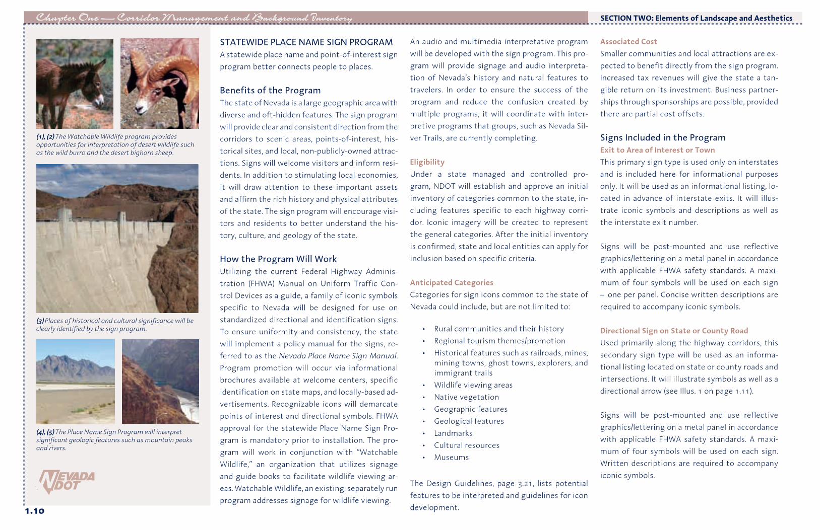
STATEWIDE PLACE NAME SIGN PROGRAMA statewide place name and point-of-interest sign program better connects people to places.
Benefits of the ProgramThe state of Nevada is a large geographic area with diverse and oft-hidden features. The sign program will provide clear and consistent direction from the corridors to scenic areas, points-of-interest, his-torical sites, and local, non-publicly-owned attrac-tions. Signs will welcome visitors and inform resi-dents. In addition to stimulating local economies, it will draw attention to these important assets and affirm the rich history and physical attributes of the state. The sign program will encourage visi-tors and residents to better understand the his-tory, culture, and geology of the state. How the Program Will WorkUtilizing the current Federal Highway Adminis-tration (FHWA) Manual on Uniform Traffic Con-trol Devices as a guide, a family of iconic symbols specific to Nevada will be designed for use on standardized directional and identification signs. To ensure uniformity and consistency, the state will implement a policy manual for the signs, re-ferred to as the Nevada Place Name Sign Manual. Program promotion will occur via informational brochures available at welcome centers, specific identification on state maps, and locally-based ad-vertisements. Recognizable icons will demarcate points of interest and directional symbols. FHWA approval for the statewide Place Name Sign Pro-gram is mandatory prior to installation. The pro-gram will work in conjunction with “Watchable Wildlife,” an organization that utilizes signage and guide books to facilitate wildlife viewing ar-eas. Watchable Wildlife, an existing, separately run program addresses signage for wildlife viewing.
An audio and multimedia interpretative program will be developed with the sign program. This pro-gram will provide signage and audio interpreta-tion of Nevada’s history and natural features to travelers. In order to ensure the success of the program and reduce the confusion created by multiple programs, it will coordinate with inter-pretive programs that groups, such as Nevada Sil-ver Trails, are currently completing. EligibilityUnder a state managed and controlled pro-gram, NDOT will establish and approve an initial inventory of categories common to the state, in-cluding features specific to each highway corri-dor. Iconic imagery will be created to represent the general categories. After the initial inventory is confirmed, state and local entities can apply for inclusion based on specific criteria. Anticipated CategoriesCategories for sign icons common to the state of Nevada could include, but are not limited to:
• Rural communities and their history • Regional tourism themes/promotion• Historical features such as railroads, mines,
mining towns, ghost towns, explorers, and immigrant trails
• Wildlife viewing areas• Native vegetation• Geographic features• Geological features• Landmarks• Cultural resources• Museums
The Design Guidelines, page 3.21, lists potential features to be interpreted and guidelines for icon development.
Associated CostSmaller communities and local attractions are ex-pected to benefit directly from the sign program. Increased tax revenues will give the state a tan-gible return on its investment. Business partner-ships through sponsorships are possible, provided there are partial cost offsets. Signs Included in the ProgramExit to Area of Interest or TownThis primary sign type is used only on interstates and is included here for informational purposes only. It will be used as an informational listing, lo-cated in advance of interstate exits. It will illus-trate iconic symbols and descriptions as well as the interstate exit number. Signs will be post-mounted and use reflective graphics/lettering on a metal panel in accordance with applicable FHWA safety standards. A maxi-mum of four symbols will be used on each sign – one per panel. Concise written descriptions are required to accompany iconic symbols. Directional Sign on State or County RoadUsed primarily along the highway corridors, this secondary sign type will be used as an informa-tional listing located on state or county roads and intersections. It will illustrate symbols as well as a directional arrow (see Illus. 1 on page 1.11).
Signs will be post-mounted and use reflective graphics/lettering on a metal panel in accordance with applicable FHWA safety standards. A maxi-mum of four symbols will be used on each sign. Written descriptions are required to accompany iconic symbols.
WILD BURRO
(1), (2) The Watchable Wildlife program provides opportunities for interpretation of desert wildlife such as the wild burro and the desert bighorn sheep.
(3) Places of historical and cultural significance will be clearly identified by the sign program.
(4), (5) The Place Name Sign Program will interpret significant geologic features such as mountain peaks and rivers.

1.11
Chapter One — Corridor Management and Background Inventory
Scenic Overlook or ViewpointThis sign type will be located prior to pull-offs, il-lustrating symbols and descriptions as well as the distance to the pull-off (see Illus. 2). Signs will be post-mounted and use reflective graphics/lettering on a metal panel in accordance with applicable FHWA safety standards. A maxi-mum of two symbols will be used on each sign. Concise written descriptions are required to ac-company iconic symbols. The Design Guidelines, page 3.21, lists potential features to be interpreted and guidelines for icon development.
SECTION TWO: Elements of Landscape and Aesthetics
HOOVER DAM BOULDER CITY COLORADO RIVER RAILROADSPIRIT MOUNTAIN
(1) The statewide Place Name Sign Program uses a family of iconic symbols specific to Nevada to identify features such as railroads, historic buildings, and geo-graphical points of interest.
(2) Directional signs on state or county roads use a family of iconic symbols along with a directional arrow. This type of sign uses a maximum of four symbols.
SCENIC VIEWPOINT2 MILES
(3) Signs for a scenic overlook or viewpoint use a maximum of two symbols along with the distance to the pull-off.

1.12
Chapter One — Corridor Management and Background Inventory SECTION TWO: Elements of Landscape and Aesthetics
ROAD SERVICES PROGRAM
Road services are an important component of any roadway corridor experience. They are even more critical in areas of Nevada where long distances separate developed areas. A complete description of road service facilities and their program com-ponents is provided in the Design Guidelines, pag-es 3.16-3.18. These service areas provide travelers with designated spaces to rest, interpret history and geography, and discover information about nearby activities and communities. Two road service facilities of specific importance within the corridor include activity pull-offs and community rest areas. Activity pull-offs provide access to activities adjacent to the highway, and are located in areas where motorists commonly pull over to watch or participate in roadside activ-ities. Providing structured parking improves the roadside safety and reduces disturbance to the fragile roadside vegetation. Community rest areas are integrated within the town structure to serve residents and visitors. Community rest areas function like a pocket park or town square, providing a central location for visitors to learn more about local tourism oppor-tunities, piquing their desire to further explore the community. Central locations or areas con-nected to community centers provide appropri-ate sites. Partnerships with towns, counties, or other organizations are required to site the facili-ties outside of the right-of-way.
(1) The road services program utilizes shaded picnic areas, interpretive signage, and viewing platforms to provide safe and comfortable rest areas and road pull-offs along the corridor.
(2) Significant road services facilities, such as welcome centers and gateway rest areas, should use desert colors, materials, and plants in an architecturally significant way to add visual interest and attract visitors.
(3) A roadside pull-off provides a safe place for motorists to stop and rest for brief periods.
(4) A complete rest area includes separate parking areas for automobiles and trucks, rest room facilities and picnic areas.
(5) Viewpoints and point of interest sites allow travelers to view unique natural or cultural features from a safe location off the highway.
Roadside Pull-Off
Complete Rest Area
Viewpoint andPoint of Interest

1.13
Chapter One — Corridor Management and Background InventorySECTION TWO: Elements of Landscape and Aesthetics
Type Description Landscape Treatment Program Elements
ROADSIDE PULL-OFF
Roadside pull-offs provide facilities for drivers to exit the highway for a brief period. Facilities and minimal parking are provided to accommodate the abbreviated stay. (Referred to as “Rest Stop” under former NDOT naming con-ventions.)
• Native Plant Revegetation to Enhanced Native Softscape Types• Standard Hardscape Type
• Site-specific interpretive signage• No toilets or running water• Trash containers• Limited car and Recreational Vehicle parking• Scenic overlooks• Located according to travelers’ needs and unique site features• Shade canopy (vegetation or structure)
VIEWPOINTS AND POINTS
OF INTEREST
Viewpoints and points of interests present opportunities to view unique vistas, geologic and historic features, or cultural landmarks. Interpretive elements are integrated into the site design, and Place Name Signage and Travel Information elements are provided to establish the relationship between highway and place. Typically, the length of stay is short and parking is limited.
• Native Plant Revegetation to Enhanced Native Softscape Types• Standard to Accentuated Hardscape Types
• Located according to travelers’ needs and unique site features• Site-specific interpretive signage• Toilets with running water only where available• Handicap accessible• Picnic tables and shade structures• Trash containers• Paved car and Recreational Vehicle parking• Telescopes/viewfinders• Nature walks or short trails• Seating Areas• Shade canopy (vegetation or structure)
BASIC REST AREAAND
COMMUNITY REST AREA
Basic Rest Areas are located throughout the state offering site specific inter-pretive information. They offer limited restroom facilities and may or may not include running water, depending on availability. Typically, these rest areas are located adjacent to scenic views, unique historical, cultural or environmental features. Community rest areas provide facilities within the town’s infrastruc-ture and function as a pocket park or town square.
• Enhanced Native Softscape Type• Standard to Accentuated Hardscape Types
• Located according to traveler’s needs and unique site features
• Site-specific interpretive signage• Toilets with running water only
where available• Emergency call box• Handicap accessible• Picnic tables and shade structures• Trash containers
• Paved car and Recreational Vehicle parking• Paved truck parking• Nature walks or short trails• Seating Areas• Shade canopy (vegetation or structure)• Local community information
COMPLETEREST AREA
Complete Rest Areas are typically located at 60 mile intervals throughout the state and are usually situated outside of developed areas. They feature fully-operable facilities in combination with interpretive information on regionally significant cultural and historical sites. Complete Rest Areas also provide trav-elers with picnic facilities and include children’s play areas and pet areas.
• Regionally Adapted Softscape Type• Focal Hardscape Type
• Regional interpretive signage• Running water and flushing toilets• Emergency call box and telephones• Drinking fountains• Vending machine services (at manned sites)• Handicap accessible• Picnic tables and shade structures• Trash containers• Bicycle storage units
• Recreational Vehicle dump station• Paved car and Recreational Vehicle parking• Paved truck parking• Telescopes/viewfinders• Interpretive and overlook features• Children’s play area• Pet rest facilities• Shade canopy (vegetation or structure)• Local community information
GATEWAY REST AREA
Gateway facilities convey first impressions and identity. Special features may be incorporated to highlight the area through design interpretation of the place. Gateways may be associated with any level of rest stop in the list-ing. The incorporation of local community information regarding amenities, events and interpretative elements, improves the interface between the high-way and the communities it serves.
• Regionally Adapted Softscape Type• Landmark Hardscape Type
Program elements are consistent with the type of Road Service Area provided.
Specific elements include:• Regional services information• Interpretation of regional sites and features• Information on regional recreational attractions
WELCOME CENTER
Welcome centers are located along major entry routes to the state. They offer introductions to the state and travelers can find access to useful travel infor-mation. Welcome centers include a staffed information kiosk.
• Regionally Adapted Softscape Type• Landmark Hardscape Type
• Located at major entry routes to state• Informational Services• Staffed visitor center• State-wide interpretive signage• Running water/flushing toilets• Emergency call box and telephones• Drinking fountains• Vending machine services• Handicap accessible• Picnic areas and shade structures
• Trash containers• Bicycle storage units• Paved car and Recreational Vehicle parking• Paved truck parking• Improved trails• Children’s play area• Pet rest facilities• Shade canopy (vegetation or structure)• Telescopes/viewfinders
ROAD SERVICES PROGRAM

1.14
Chapter One — Corridor Management and Background Inventory
NATIVE WILDFLOWER PROGRAM
Inspired by a vision of native plant species along rights-of-way to enhance the beauty of the land, the FHWA has adopted two programs to promote the use of naturally-occurring forbs and grasses in a particular region, state, or ecosystem. The Surface Transportation and Uniform Relocation Assistance Act (STURAA) of 1987 requires that at least one-quarter of 1% of funds expended for any Federal-aid highway system landscape project be utilized for native wildflower plantings. The sec-ond, voluntary program is “Operation Wildflower.” It promotes the use of native wildflowers through a cooperative relationship between the National Council of State Garden Clubs and State highway agencies.
In addition, the FHWA recognizes that native forbs and grasses can also provide:
• Reduced maintenance requirements for es-tablished native plants in comparison with non-native species
• Reduced roadside fire hazards• Reduced use of herbicides when native
plants are successfully established• Improved erosion control through drought-
tolerant species• Improved relationship between the high-
way corridor and the regional character of the landscape
The University of Nevada’s revegetation report supports the use of forbs and grasses in highway rights-of-way (refer to Technical Appendix pages A.4-A.13). Forbs and grasses that are appropriate to specific regions and ecosystems require “little or no maintenance ... (and) create defensible space for wildfire along the highway corridors” (Tueller,
Post, Noonan, 2002). As part of the wildflower pro-gram, plants should be utilized that do not cre-ate a fire hazard or become overly attractive to wildlife.
INVASIVE AND NOXIOUS WEED CONTROL Invasive species can have devastating effects on a landscape’s economic and environmental qual-ity. Invasive species decrease diversity and can out-compete native species. The Nevada State Department of Agriculture maintains a list of noxious weeds that should be contained through a revegetation program along the corridor. The list can be referenced at the following site: www.agri.state.nv.us/nwac/nv_noxweeds.htm. “Nevada’s Coordinated Invasive Weed Strategy”, produced by the University of Nevada, also identi-fies additional species that have the potential to negatively impact Nevada’s environmental quality. NDOT’s continued coordination with the Nevada Weed Action Committee provides an organized effort for invasive and noxious weed control. Due to the frequency of invasive weeds along the corridor, control measures are necessary for any new landscape design project. Abiding by the best procedures and management practices for success-ful revegetation is one suggested control method. Additional suggested procedures include:
• Tailoring revegetation procedures to spe-cific plant community types
• Making recommendations for site and soil preparation
• Including site appropriate revegetative practices
• Providing for adequate weed maintenance to allow for revegetation establishment
OUTDOOR ADVERTISING
Outdoor advertising, specifically billboards, pro-vide businesses, community groups and other or-ganizations with opportunities to inform travelers about various establishments and available servic-es. Billboards can, however, impact the highway’s visual quality by obstructing views of scenic fea-tures and the natural landscape. As a result, com-munity groups are committed to restricting new signage, and removing existing billboards from areas adjacent to and within their communities. The Highway Beautification ActThe intent of the Highway Beautification Act (HBA) of 1965 was to control billboard construction along Federal-aid highways and provide methods for removal of billboards that do not conform to state and local ordinances. Section C of this law limits signage visible from the road to only include informational and directional signs pertaining to distinctive natural, scenic, or historic attractions; on-site real estate signs; on-site business signs; landmark signs associated with historic, natural, or artistic purposes; and “free coffee” signs pro-moted by non-profit organizations. LimitationsIn the 40 years since the passage of the HBA, few non-conforming billboards have been removed and many more have been constructed due to exclusions in the law. Enforcement is difficult because Section G of the law requires cities and counties to pay just compensation to owners for billboard removal. Although the federal govern-ment is required to contribute 75% of the com-pensation, many communities do not have the funds to pay the 25% requirement, and their abil-ity to use local land use controls to restrict con-
(1) A wildflower program advances the establishment of visually striking displays that occur in the Mojave desert landscape.
(2) Desert Marigold (Baileya multiradiata) is a common wildflower found throughout the Southern US 95 and US 93 corridor.
SECTION TWO: Elements of Landscape and Aesthetics

1.15
Chapter One — Corridor Management and Background Inventory
(2) Outdoor advertising can be framed by natural materials and landscaping and be built into the ground in order to limit its scenic impact.
(3) When locating billboards, consider proximity to the road, distance between one to the next, height, and overall size in order to minimize negative visual impacts.
(4) Outdoor advertising should complement the adjacent environment while informing travelers of upcoming services.
(1) The Corridor Plan aims to manage Nevada’s highways for their inherent scenic quality and prevent the negative visual impacts often caused by unregulated outdoor advertising.
struction was removed. Additionally, the federal government has stopped providing money for billboard removal (Brinton, 2001). A second limitation within the HBA is the allow-ance for billboards to be constructed in areas zoned commercial and industrial, as well as in unzoned areas with commercial or industrial uses. The provision also acknowledges that the State has authority over the zoning laws. This entitlement allows the State to implement zoning regulations that effectively increase the difficulty of control-ling billboards. Communities may specifically zone an area along the highway as commercial, or the outdoor advertising structure may be built on a parcel that has an obscure commercial use. The third provision allows designated scenic by-ways to be segmented and excluded from fed-eral control. An amendment to the HBA, passed by Congress with the 1995 National Highway System Designation Act, allows states to exclude portions of a scenic byway that conflict with the state’s standards for denoting scenic byways and utilize only local restrictions for billboard control. As a result, areas of lower scenic quality become more unattractive and reduce the overall scenic character of the byway. Nevada StatutesRemoving billboards in Nevada became more dif-ficult in 2001 due to the Nevada Revised Statute (NRS) 278.0215. The regulation prohibits the use of amortization – a method used by many states – for sign removal. Rather than utilizing the tradi-tional cost approach, it defines the methodology for determining “just compensation” to include property uniqueness as well as income generation
from the sign. This cost-prohibitive revision ren-ders sign removal almost impossible. Although control of outdoor advertising seems daunting, there are regulations that provide re-strictions to billboard construction. NRS 405.050 allows counties to deny permits for billboards that may “measurably destroy the natural beau-ty of the scenery or obscure a view of the road ahead”. Additionally, the statutes give the NDOT Director the authority to remove any sign that is a traffic hazard. The Role of Local GovernmentCities and counties have the ability to regulate the location, and to a limited degree, the type of billboard erected within their jurisdiction. Al-though a state must prove their jurisdictional rights to control outdoor advertising on Indian Reservation Lands and have a written statement from the State Attorney General, local govern-ments may coordinate with the Bureau of Indian Affairs to determine a course of action to limit the negative visual impacts of billboards. Design standards that address height, size, color, spac-ing/frequency, and context are a valuable method for directing outdoor advertising. For example, signs can be relocated if they block visual resourc-es. Material choices and architectural detail can be improved to reduce the visual distinction be-tween the sign and the surrounding environment. Communities can regulate the location of bill-boards to reduce the scenic impact of billboards and improve visual quality along the state’s high-ways. Important viewsheds and scenic corridors may be designated within the county, and land use regulations can be developed that discourage or prohibit outdoor advertising.
SECTION TWO: Elements of Landscape and Aesthetics
1.16
Chapter One — Corridor Management and Background Inventory
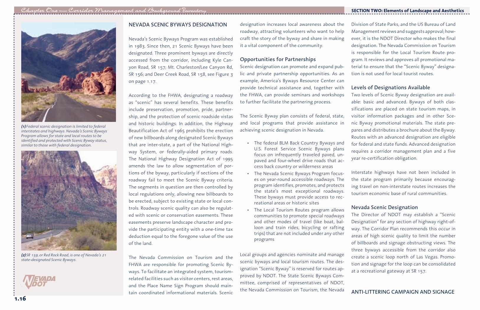
NEVADA SCENIC BYWAYS DESIGNATION
Nevada’s Scenic Byways Program was established in 1983. Since then, 21 Scenic Byways have been designated. Three prominent byways are directly accessed from the corridor, including Kyle Can-yon Road, SR 157; Mt. Charleston/Lee Canyon Rd, SR 156; and Deer Creek Road, SR 158, see Figure 3 on page 1.17. According to the FHWA, designating a roadway as “scenic” has several benefits. These benefits include preservation, promotion, pride, partner-ship, and the protection of scenic roadside vistas and historic buildings. In addition, the Highway Beautification Act of 1965 prohibits the erection of new billboards along designated Scenic Byways that are inter-state, a part of the National High-way System, or federally-aided primary roads. The National Highway Designation Act of 1995 amends the law to allow segmentation of por-tions of the byway, particularly if sections of the roadway fail to meet the Scenic Byway criteria. The segments in question are then controlled by local regulations only, allowing new billboards to be erected, subject to existing state or local con-trols. Roadway scenic quality can also be regulat-ed with scenic or conservation easements. These easements preserve landscape character and pro-vide the participating entity with a one-time tax deduction equal to the foregone value of the use of the land. The Nevada Commission on Tourism and the FHWA are responsible for promoting Scenic By-ways. To facilitate an integrated system, tourism-related facilities such as visitor centers, rest areas, and the Place Name Sign Program should main-tain coordinated informational materials. Scenic
designation increases local awareness about the roadway, attracting volunteers who want to help craft the story of the byway and share in making it a vital component of the community. Opportunities for PartnershipsScenic designation can promote and expand pub-lic and private partnership opportunities. As an example, America’s Byways Resource Center can provide technical assistance and, together with the FHWA, can provide seminars and workshops to further facilitate the partnering process. The Scenic Byway plan consists of federal, state, and local programs that provide assistance in achieving scenic designation in Nevada.
• The federal BLM Back Country Byways and U.S. Forest Service Scenic Byways plans focus on infrequently traveled paved, un-paved and four-wheel drive roads that ac-cess back country or wilderness areas
• The Nevada Scenic Byways Program focus-es on year-round accessible roadways. The program identifies, promotes, and protects the state’s most exceptional roadways. These byways must provide access to rec-reational areas or historic sites
• The Local Tourism Routes program allows communities to promote special roadways and other modes of travel (like boat, bal-loon and train rides, bicycling or rafting trips) that are not included under any other programs
Local groups and agencies nominate and manage scenic byways and local tourism routes. The des-ignation “Scenic Byway” is reserved for routes ap-proved by NDOT. The State Scenic Byways Com-mittee, comprised of representatives of NDOT, the Nevada Commission on Tourism, the Nevada
Division of State Parks, and the US Bureau of Land Management reviews and suggests approval; how-ever, it is the NDOT Director who makes the final designation. The Nevada Commission on Tourism is responsible for the Local Tourism Route pro-gram. It reviews and approves all promotional ma-terial to ensure that the “Scenic Byway” designa-tion is not used for local tourist routes. Levels of Designations Available Two levels of Scenic Byway designation are avail-able: basic and advanced. Byways of both clas-sifications are placed on state tourism maps, in visitor information packages and in other Sce-nic Byway promotional materials. The state pre-pares and distributes a brochure about the Byway. Routes with an advanced designation are eligible for federal and state funds. Advanced designation requires a corridor management plan and a five year re-certification obligation. Interstate highways have not been included in the state program primarily because encourag-ing travel on non-interstate routes increases the tourism economic base of rural communities. Nevada Scenic Designation The Director of NDOT may establish a “Scenic Designation” for any section of highway right-of-way. The Corridor Plan recommends this occur in areas of high scenic quality to limit the number of billboards and signage obstructing views. The three byways accessible from the corridor also create a scenic loop north of Las Vegas. Promo-tion and signage for the loop can be consolidated at a recreational gateway at SR 157.
ANTI-LITTERING CAMPAIGN AND SIGNAGE
(2) SR 159, or Red Rock Road, is one of Nevada’s 21 state-designated Scenic Byways.
SECTION TWO: Elements of Landscape and Aesthetics
(1) Federal scenic designation is limited to federal interstates and highways. Nevada’s Scenic Byways Program allows for state and local routes to be identified and protected with Scenic Byway status, similar to those with federal designation.

1.17
Chapter One — Corridor Management and Background Inventory
(1) Scenic Byway signage should include custom icons related to the place.
Figure 3 - Existing Nevada Scenic Byways near the Southern US 95 and US 93 Corridor
Red Rock Road
Valley of FireMt. Charleston / Lee Canyon Road
Deer Creek Road
Kyle Canyon Road
South Las Vegas StripNorth Las Vegas Strip
City of Las Vegas, Las Vegas Boulevard
SECTION TWO: Elements of Landscape and Aesthetics
LakeMead
Colorado River
BoulderCity
Las Vegas
Henderson
Indian Springs
Lake Mohave
Searchlight
Cal Nev Ari
LaughlinSR 163
US 95
SR 164
SR 165
Hoover Dam
Nelson
SR 157
SR 156
SR 159
I-15
I-15
US 95
Arizona
Nevada
US 93
Cactus Springs
Clark County
Nye County
SR 157
SR 158
Existing Scenic Byway
LEGEND

1.18
Chapter One — Corridor Management and Background Inventory
Fast food containers, bottles, trash bags, and rusty kitchen appliances found alongside the road are distracting and imply an attitude of general ne-glect and disregard for the environment. A state-wide anti-littering campaign would represent a significant step towards maintaining and improv-ing Nevada’s highways. The campaign should be advertised in such a way as to command the at-tention of residents and travelers. Similar to the “Don’t Mess with Texas” anti-littering campaign, this program could become a marketing show-piece for the state of Nevada. The program would be promoted through roadway signage, magazine advertisements, and bumper stickers. Distribution of campaign materials would be fo-cused at travel-oriented locations such as wel-come centers, rest areas, and truck stops. Coupled with promotional materials, a “Sponsor-A-High-way” program would engage residents of Nevada, encouraging active participation in maintaining clean and beautiful highways. This plan recom-mends implementing an anti-littering campaign using highly visible signage, easily distributed collateral materials, and an active volunteer clean-up program.
MAIN STREET APPROACH
(4) (5) (6)
(1) Trash within the right-of-way significantly impacts the scenic quality of the entire Southern US 95 and US 93 corridor.
(2) An edgy and provocative campaign against litter keeps the issue visible to travelers.
(3) Highway graphics and signage posted along the highway at key locations is proposed as part of the anti-littering program.
SECTION TWO: Elements of Landscape and Aesthetics

1.19
Chapter One — Corridor Management and Background Inventory
Vibrant main streets are a critical component of all communities. Rural communities are especially dependent upon vital commercial districts. Bisect-ed and altered by the interstate highway system and suburban sprawl, main streets across America have declined both economically and physically, to a point where they are no longer viable com-munity centers. Vacant buildings and declining businesses often line the highway. In some areas, revitalized commercial districts indicate contin-ued community growth. Main Street Approach, developed by the National Trust for Historic Preservation, assists in revital-izing the older, traditional business districts while simultaneously preserving the history and char-acter of downtowns. The program combines “his-toric preservation with economic development to restore prosperity and vitality to downtowns and neighborhood business districts.” The Main Street Approach does not promote a “quick fix.” It is a long-term, comprehensive strat-egy designed to meet local needs and opportu-nities. The strategy is based on a four-point ap-proach that includes organization, promotion, design, and economic restructuring. It is a vol-unteer-based program that relies on community support. Volunteers form the governing board and standing committees, and a paid program manag-er coordinates and supports the operation. The National Main Street Center, or the local coor-dinating agency, provides assistance in the form of technical services, networking, training, and in-formation. The Center can provide direct fee-for-service technical assistance to cities and towns, both independently and in conjunction with state
and citywide main street programs. Revitalization programs funded largely by local sources are more likely to succeed than those relying solely on state or federal funds. The Main Street Program offers educational sessions related to facilitating local support and generating public and private part-nerships. Local involvement in, and coordination with, the program helps communities find solu-tions that work best for them. The accomplishments of Main Street organiza-tions are many: improving aesthetics and safety of downtown areas, restoring historic buildings, and revitalizing economic viability. The organization identifies potential economic niches, assists with promotional and fund-raising efforts, supports joint marketing efforts among local businesses, encourages and trains new business owners, and finds grants for facade, streetscape, and landscap-ing improvements. Reduced vacancy rates, and renovation and restoration in the downtown are a few examples of its results. Physical improvements are quickly evident. Long-term economic improvements may take up to three years to accomplish. However, the program’s impact on communities nationwide is indisputably positive and long-lasting. Communi-ties have experienced net gains in new business-es and job generation, and a surge in local invest-ment. Most importantly, community pride grows as personal involvement in the volunteer-driven program increases. As an example of the success of this program, seven communities in rural Iowa participated in the program for ten years. On average, each town renovated 97 downtown buildings, gained 24 business starts, and saw $1.6 million in private
sector reinvestment. Anyone can start a Main Street Program in their community. The first step is to contact the state-wide coordinating program for support, technical assistance, training, networking, and encourage-ment. Because Nevada does not currently have a coordinating program, contact should be made with the National Main Street Center in Washing-ton D.C. A self-initiated program may be created without a state program. The National Main Street Center provides contacts to assist in networking with other independent programs and nearby state programs. Communities are welcome to uti-lize principles and tools from the Main Street Ap-proach regardless of whether they qualify for the program or wish to follow it exactly. The program incorporates historic preservation with commu-nity revitalization. Communities like Goldfield, which was recently designated as a National His-toric District, now qualify for more assistance through the program. Additional information can be obtained by visiting the Main Street Program’s website at www.mainstreet.org.
SECTION TWO: Elements of Landscape and Aesthetics
(1) The Main Street Approach was developed by the National Trust for Historic Preservation and assists in revitalizing traditional business districts while preserving their unique history and character.
(2) Simple enhancements like varied paving materials and pedestrian-scaled lighting create a safe and friendly environment and help invigorate commercial districts.

1.20
Chapter One — Corridor Management and Background Inventory
SECTION THREE: Background Inventory
SOCIAL RESOURCES
Community Settlement Patterns and GrowthUrban PatternsSettlement patterns in the Southern US 95 and US 93 corridor are characterized by small towns and unincorporated communities that offer an alter-native to the large and densely populated Las Ve-gas Valley. These communities range in size from about 1,100 people in the town of Searchlight, to approximately 15,000 in Boulder City. Much of the settlement of Clark County is tied to Native American heritage, mining discoveries, and the gaming industry. Boulder City is unique because it was developed as a planned community during the construction of the Hoover Dam. As the Las Vegas Valley and communities such as Laughlin continue to grow rapidly, bedroom communities will grow to meet the needs of new residents and travelers. For example, Kyle Can-yon, north of Las Vegas, is a dense residential development centered around community trails, open space, and outdoor recreation. Existing rural communities such as Cal Nev Ari, Searchlight, and Indian Springs will likely see an increase in retail and service industries to support the anticipated growth. Boulder City’s proximity to the Las Vegas Valley exposes it to extreme growth pressure, however, the town has taken steps to control the impacts. Residents approved a growth control ordinance limiting expansion to 3% per year. The goal of this ordinance is to preserve the sense
of place and quality of life that currently exists. The growth of Clark County will translate into greater use of the existing highway corridor by both tourists and residents, creating a need for both community-level and neighborhood-level aesthetic treatments. Land OwnershipThe State of Nevada contains the highest per-centage of federal lands, almost 83%, among the contiguous 48 states (BLM, 2000). The Bureau of Land Management (BLM) controls the bulk of the federal lands which include in-holdings of varying sizes owned by other public agencies and private landowners. In southern Nevada, this is true along most of the Southern US 95 and US 93 corridor except for private lands around municipalities such as Boulder City and Indian Springs, Nation-al Park Service ownership at Lake Mead National Recreation Area, and the Las Vegas Paiute Indian Reservation north of Las Vegas. Land ownership affects both land use and the vi-sual character of the landscape. Much of the ru-ral areas of the Nevada landscape maintain their natural beauty by remaining under federal con-trol. Contributing to Nevada’s open landscape aesthetic is the predominance of low occupancy uses such as grazing, farming, material produc-tion, and mining. In order to preserve rural char-acter, existing and proposed developments must have a common vision, coordinated by all land-owners. NDOT’s jurisdictional influence over the landscape only extends to the edge of the right-of-way; however, agreements with other public agencies make it possible for NDOT to develop a common vision that will shape visual character and land use decisions for areas adjacent to the roadway.
Implications to the Southern US 95 and US 93 CorridorOver the next 20 years, many anticipated changes will likely influence the corridor. Since September 11, 2001, all truck traffic has been re-routed away from Hoover Dam for national security reasons. The completion of the Hoover Dam Bypass bridge will allow truck traffic to return to US 93 through Boulder City. To combat increased traffic and the overall growth of the region, the Boulder City By-pass route is currently under design. Continued growth and expansion in the Las Vegas Valley will place additional pressure on outlying communi-ties and the existing highway corridor. Applying the Landscape and Aesthetics program to these projects will connect the communities of south-ern Nevada with a consistent aesthetic approach to the roadway. Travel and TourismTravel PatternsSouthern Nevada is world-renowned for the vol-ume and variety of tourism opportunities. The Nevada Commission on Tourism refers to the area around Las Vegas as the “Las Vegas Territory”, of-fering a variety of resorts and recreational ameni-ties. The Las Vegas Territory generally includes the Las Vegas Metropolitan Area, I-15 Corridor, Boul-der City, Hoover Dam, Searchlight, and Laughlin. Overview of Existing Travel FacilitiesHighways play an important role in connecting people to their surroundings. Visitor centers, view points, and community signage help travelers un-derstand the natural and cultural features that make a place unique. The state highways could improve their role in promoting and facilitating travel to key local, state, and national tourism destinations. For example, it is not easy for travel-
SECTION THREE: Background Inventory
(1) A wide-open vista greets travelers at the state border with California along US 95 as the road crests the hill. This location should be considered for an iconic gateway feature to enhance the entry into the state.
(2) Searchlight reveals the difficulty of balancing the needs of a highway and a community main street along the same stretch of road.
(3) The state-sponsored welcome center located on Nevada Highway in Boulder City often goes unnoticed. A more powerful architectural statement and directional signage could help attract visitors.

1.21
Chapter One — Corridor Management and Background Inventory
ers to discern the fact that they are driving along a Death Valley-Manley historic trail or through the oldest town in Nevada. Signage notifying drivers of upcoming viewpoints can be more consistent. Signs pointing to historic markers can be updated to provide proper direction to the marker, and the sign color can be modified to minimize the impacts of fading. Enhancements should make markers easier to notice and give the driver advance warn-ing of turn-offs. Marker sites should be reviewed as the surrounding development changes in order to minimize signs in unattractive locations. Travel and tourism facilities consist of rest areas and information centers. These facilities can have the dual responsibility of providing traveler ser-vices and information regarding historical, cul-tural, and environmental features in the region, as well as providing important information about tourist destinations. Only a few highway services (such as formal rest areas, truck stops, and/or pull-outs) accommodate highway travelers along the corridor. The existing facilities can be improved by taking full advantage of an area’s unique fea-tures and incorporating an enhanced overall de-sign and architectural consistency.
Travel and tourism generate a large part of south-ern Nevada’s transportation requirements and the highways serve the important role of con-necting people to their surroundings and destina-tions. Visitor centers, view points, and community signage help travelers understand the natural and cultural features that make this place unique. Cur-rently, the state highway’s role in promoting and facilitating travel to key local, state, and national tourism destinations is minimal.
Opportunities to Enhance Travel and TourismSouthern Nevada’s history is rich with legends and unique spectacles that are prime interpretive opportunities for travelers. A more consistent and regional program of signage could improve the visitor’s understanding of the region. Proper placement of signs is important for travelers to find and process the information quickly. Travel and tourism facilities, such as rest areas, viewpoints, and information centers, can have the dual responsibility of providing services for travel-ers while describing historical, cultural, entertain-ment, and environmental features in the region. Rest areas should be planned and designed in a consistent and comprehensive manner. Regional architecture that is sensitive to the desert envi-ronment should be encouraged for all structures and facilities. In addition, where landscape treat-ments are implemented, drought tolerant plant materials are not only sensible, but essential to their success. Adequate rest areas typically in-clude restrooms, picnic areas, pet exercise areas, paved parking areas, fresh drinking water, inter-pretive exhibits, and local area information. NATURAL RESOURCES
Topography and Surface HydrologyThe landscape character of this region is domi-nated by alternating mountain ranges and valleys typical of the rest of the Basin and Range physio-graphic province. The Southern US 95 and US 93 corridor lies within the Mojave Desert and is char-acterized by wide valleys, bordered by arid north-south mountain ranges. The mountain ranges typically exhibit weathered and exposed bedrock at higher elevations.
The corridor crosses two of the state’s 14 hydro-graphic regions: the Central Region and the Colo-rado River Basin. Nevada’s central hydrographic region is the largest in the state, covering most of central and eastern Nevada. It is primarily char-acterized by isolated basins that do not drain into major river systems. Surface waters are chan-neled through a network of ephemeral streams and washes into playas, where the water gradu-ally percolates into the water table. The Colorado River Basin region, however, is unlike most of the other hydrographic regions in Nevada. Surface runoff that flows into the Colorado River even-tually travels out of the Great Basin, toward the Gulf of California. The Colorado River, at the east-ernmost margin of the corridor forming the state boundary between Nevada and Arizona, is the pri-mary source of water for the Las Vegas Valley and surrounding areas. Lake Mead, likely the most vis-ible body of water along the corridor, is a direct beneficiary of the Colorado River Basin system. Vegetation Most of the land along the highway corridor is arid. This area falls within the boundaries of the Mojave Desert, characterized by extreme variation in daily temperature and an average annual precipitation of less than five inches. The Mojave Desert serves as the transition between the hot Sonoran Desert and the cooler, higher Great Basin. The segment of US 95 south of Las Vegas is within the Sonoran Desert section of the Basin and Range geologic province, however, the vegetation and landscape characteristics of this area are more consistent with the Mojave Desert. Elevation changes influ-ence the occurrence of plant communities where Blackbrush/Joshua Tree sites occur at higher ele-vations and the Southern Desert Shrub sites occur on the valley floors. Blackbrush/Joshua Tree areas
SECTION THREE: Background Inventory
(2) Expansive valleys bordered by north-south mountain ranges are typical of this region of Nevada. Although it is classified as the Sonoran Desert section of the Basin and Range geologic province, the vegetation of the area is more consistent with the Mojave Desert.
(1) New bypass construction near Hoover Dam and Lake Mead is an opportunity to provide enhanced roadside services such as a welcome center and safe viewpoint pull-offs.

1.22
Chapter One — Corridor Management and Background Inventory
may also include Spanish Bayonet and an under-story of Desert Needle Grass. Southern Desert Shrub sites are the most prevalent landscape type and include plants adapted to very hot and dry conditions such as Creosote and Bursage. Understanding these different vegetation com-munity types is critical, particularly during revegetation activities associated with high-way improvement projects. Each community has unique soil and hydrologic characteristics that must be considered to ensure successful revegetation.
Wildlife Habitat and MigrationNevada is home to a large variety of wildlife. Be-cause much of rural Nevada is under federal own-ership, it is open and undeveloped, and provides excellent wildlife habitat for a number of species. Specially designated areas have been established to protect and preserve the ecological, natural, and cultural resources of specified areas. The South McCullough Wilderness Area, North McCullough Wilderness Area, Sloan Canyon National Conser-vation Area, and El Dorado Wilderness Area are within close proximity to this corridor. Another important feature is an Area of Critical Environ-mental Concern (ACEC) located in the Eldorado Valley. This area, designated by the BLM, was cre-ated to protect critical desert tortoise habitat. Bighorn sheep are a species of high concern with-in the Southern US 95 and US 93 Corridor. In order to avoid predation, bighorn sheep inhabit rugged, steep terrain segmented by intermittent canyons and washes. The sheep also require access to open water during summer months, and in drought conditions may search for water throughout the year. Bighorn sheep movement corridors that ex-
tend across the valley and cross the highway ex-ist north of Searchlight and east of Indian Springs. Another area with high levels of bighorn sheep movement is near Boulder City and US 93 toward Hoover Dam. A portion of the wildlife corridor runs parallel to the highway and has resulted in docu-mented accidents involving collisions with sheep. ENVIRONMENTAL CONSIDERATIONS
Mapping of Environmental FeaturesThe landscape of northern Nevada has many special environmental features, including plant communities, rivers, lakes, playas, wildlife, rock outcroppings, cliffs, and mountain ranges. These resources provide opportunities to create view-points, preserve natural systems, and enhance wildlife movement corridors. The following fea-tures are representative of potential opportuni-ties to preserve or enhance the traveler’s under-standing of the environmental resource or feature from the highway:
• Bighorn sheep herd viewing at Hemenway Park in Boulder City
• Joshua tree forests outside of Searchlight offer visual contrast to the common Creo-sote-Bursage vegetation type
• The River Canyon and Black Mountains surrounding Lake Mead provide visual interest outside of Boulder City to the Hoover Dam
• Long, distant views into the Eldorado Val-ley and surrounding ranges from US 95 / US 93 intersection
To assess the environmental features, data was gathered from a variety of sources and analyzed according to its relationship to the corridor high-ways. Data included in the analysis includes wild-
life habitats, lakes and playas, and riparian systems. Additional data obtained from the BLM identifies unique features of significant influence that are visible from the highway and include: Sand Dunes, Wildlife Refuges, National Conservation Areas, and ACEC. The BLM uses the ACEC designation to preserve areas with unique biological, geologi-cal, historical, or scenic features. The boundaries shown are taken from the BLM database.
Wilderness areas and ACEC are specially desig-nated areas that should be carefully considered with all highway construction projects. Stands of Joshua trees are unique plant communities that should also be considered. Stands visible from the highway were mapped.
SECTION THREE: Background Inventory
(1) Wildlife crossings should be incorporated along the Boulder City Bypass to allow for bighorn sheep and other wildlife to migrate safely between habitat areas.

CON
SULT
AN
T TE
AM DESIGN WORKSHOP
Sand County StudiosJW Zunino & AssociatesPLACES CH2MHill 1.23
Southern US 95 and US 93 landscape and aesthetics corridor plan
UNLVLANDSCAPE ARCHITECTURE & PLANNING RESEARCH
ENVIRONMENTAL CONSIDERATIONSCALIFORNIA STATE LINE TO SEARCHLIGHT
New
berry Mountains
Colorado River
CONTINUE ON MAP EC2
Lake Mohave
Searchlight
Cal Nev Ari
Laughlin
NevadaCalifornia
Nevada
Arizona
1
2
4
0
5
6
7
8
9
10
11
12
13
14
3
15
16
17
18
19
20
21
22
US 95
SR 163
SR 162
SR 164SR 164SR 164
HISTORIC
MAPEC1
LEGENDSouthern US 95 and US 93 Corridor with Mile MarkersInterstatesHighways / State Routes
Local Roads
RailroadsRailroads (historic)
Streams / RiversLakes
Playas
National Conservation Area
Desert National Wildlife Refuge
Sand Dunes
Area of Critical Environmental Concern
Nevada Wilderness Area
Wildlife Management Area
Joshua Tree Plant Communities Visible from the Highway
0 1.5 3 6
SCALE: 1 inch equals 3 milesNORTH
Antelope
Bighorn Sheep
WILDLIFE CORRIDORS
Elk
5 6
CRITICAL TORTOISE HABITAT / PAIUTE-ELDORADO VALLEY

DESIGN WORKSHOPSand County StudiosJW Zunino & AssociatesPLACES CH2MHill CO
NSU
LTA
NT
TEA
M
1.24
Southern US 95 and US 93 landscape and aesthetics corridor plan
UNLVLANDSCAPE ARCHITECTURE & PLANNING RESEARCH
ENVIRONMENTAL CONSIDERATIONSSEARCHLIGHT TO ELDORADO VALLEY
Eldorado Mountains
Colorado River
Eldorado Valley
McCullough Range
NelsonA
rizona
NevadaNevada
California
46
47
48
49
50
40
41
42
43
44
45
39
38
37
36
35
34
33
32
31
30
29
28
27
26
25
24
23
22
US
95
SR 165
CONTINUE ON MAP EC3
CONTINUE ON MAP EC1
ROCK ART SITE
SLOAN CANYON NATIONAL CONSER-
VATION AREA
ROCK ART SITE
MAPEC2
CRITICAL TORTOISE HABITAT / PAIUTE-ELDORADO VALLEY
LEGENDSouthern US 95 and US 93 Corridor with Mile MarkersInterstatesHighways / State Routes
Local Roads
RailroadsRailroads (historic)
Streams / RiversLakes
Playas
National Conservation Area
Desert National Wildlife Refuge
Sand Dunes
Area of Critical Environmental Concern
Nevada Wilderness Area
Wildlife Management Area
Joshua Tree Plant Communities Visible from the Highway
0 1.5 3 6
SCALE: 1 inch equals 3 milesNORTH
Antelope
Bighorn Sheep
WILDLIFE CORRIDORS
Elk
5 6

CON
SULT
AN
T TE
AM DESIGN WORKSHOP
Sand County StudiosJW Zunino & AssociatesPLACES CH2MHill 1.25
Southern US 95 and US 93 landscape and aesthetics corridor plan
UNLVLANDSCAPE ARCHITECTURE & PLANNING RESEARCH
ENVIRONMENTAL CONSIDERATIONSELDORADO VALLEY TO HOOVER DAM
Lake Mead
McC
ullo
ugh
Rang
e
Eldorado Valley
River Mountains
Eldorado Mountains
Colorado River
Alunite
Hoover Dam
Paradise EAST LAS VEGAS
Arizona
Nevada
55
53
54
56
52
51
50
11 109
8
7
6
54 3 2
1
57
58
59
6061
62
63
US 95
Lakeside Road
Buchanan Blvd
US
95US 93
US 95
SR 564
SR 582
I - 215
I - 1
5
/ US 95 / U
S 93
I - 515
CONTINUE ON MAP EC2
CONTINUE ON MAP EC4
ROCK ART SITE
HISTORICSITE
SCENICRESOURCE
north las vegas
LAS VEGAS
henderson
bouldercity
MAPEC3
SLOAN CANYON NATIONAL CONSERVATION AREA
LEGENDSouthern US 95 and US 93 Corridor with Mile MarkersInterstatesHighways / State Routes
Local Roads
RailroadsRailroads (historic)
Streams / RiversLakes
Playas
National Conservation Area
Desert National Wildlife Refuge
Sand Dunes
Area of Critical Environmental Concern
Nevada Wilderness Area
Wildlife Management Area
Joshua Tree Plant Communities Visible from the Highway
0 1.5 3 6
SCALE: 1 inch equals 3 milesNORTH
Antelope
Bighorn Sheep
WILDLIFE CORRIDORS
Elk
5 6
FUTURE BOULDER CITY BYPASS
GEOLOGIC / SCENIC

DESIGN WORKSHOPSand County StudiosJW Zunino & AssociatesPLACES CH2MHill CO
NSU
LTA
NT
TEA
M
1.26
Southern US 95 and US 93 landscape and aesthetics corridor plan
UNLVLANDSCAPE ARCHITECTURE & PLANNING RESEARCH
ENVIRONMENTAL CONSIDERATIONSKYLE CANYON TO CLARK COUNTY LINE
Las Vegas Valley
Lee Canyon
Kyle Canyon
Spot
ted
Rang
e
Indi
an S
prin
gs V
alle
y
Pint
wat
er R
ange
Ranger Mountains
Indi
an Ridge
Indian Springs
Cactus Springs
Clark CountyN
ye County
92
93
94
95
100
101
102
96
97
98
99
103
104
105
106
107
108
109
110
111
112
113
114
115
116
117
118119120121122123124125126127128129130
131132
US 95
SR 157
SR 156
I - 2
15
I - 215
CONTINUE ON MAP EC3
DESERT NATIONAL WILDLIFE REFUGE
RED ROCK CANYON NATIONAL
CONSERVATION AREA
LAS VEGAS
MAPEC4
LEGENDSouthern US 95 and US 93 Corridor with Mile MarkersInterstatesHighways / State Routes
Local Roads
RailroadsRailroads (historic)
Streams / RiversLakes
Playas
National Conservation Area
Desert National Wildlife Refuge
Sand Dunes
Area of Critical Environmental Concern
Nevada Wilderness Area
Wildlife Management Area
Joshua Tree Plant Communities Visible from the Highway
0 1.5 3 6
SCALE: 1 inch equals 3 milesNORTH
Antelope
Bighorn Sheep
WILDLIFE CORRIDORS
Elk
5 6

1.27
Chapter One — Corridor Management and Background Inventory
VISUAL RESOURCES
Viewsheds and Distance ZonesViewsheds refer to all the areas that are visible from a section of highway. Similar to the bound-aries of a watershed, the boundaries of viewsheds are usually high points in the landscape, such as ridges and hills. Viewsheds are determined by an-alyzing digital elevation models in a Geographic Information System (GIS) program. All areas that are visible from the highway are combined to cre-ate the viewshed. Areas within a viewshed are perceived by drivers with varying levels of detail. The detail that a driver perceives is related to the distance between the driver and the feature being observed. Distance zones, including foreground zones, middleground zones and background zones, define the traveler’s viewing distances. Distance zones are delineated through a process developed by the USFS that re-lates the detail and importance of distance to the driver on the highway. Identifying the portions of a viewshed that are most frequently seen helps de-termine what portions of the landscape are most critical to establishing the highway’s visual charac-ter and what areas are most sensitive to change. Foreground ZonesViewers can perceive details such as forms, lines and colors up to one-quarter mile away. Changes to the landscape are most significant within the fore-ground view because they are immediate to the viewpoint. This zone can be most easily manipulat-ed through the Landscape and Aesthetic Program, in part because it includes the highway right-of-way.
Middleground ZonesViewers can perceive details such as forms, lines, and colors in masses located from one-quarter mile to three miles away.
Background ZonesBackground is the area beyond the middleground, extending to the horizon or limit of the area that is seen. For this Corridor Plan the background ex-tends up to 25 miles from the centerline of the highway. Viewers can perceive broad forms, lines, wide valleys, distant hills, and mountains. Viewshed and Distance Zones MappingViewsheds and Distance Zones along the corridor are shown on the maps beginning on page 1.28. This analysis sets the foundation for visual quality man-agement along the corridor. Darker shading denotes an area that can be seen most often from points on the highway. These areas usually coincide with land-scapes of high visual quality and scenic values such as mountain ranges. Management of these areas through multi-jurisdictional cooperation can protect them from billboards and other land uses that ob-struct views and detract from the travel experience.
Scenic ResourcesThe Southern US 95 and US 93 corridor offers some of the most scenic views found in the state. Depending on the sequence of travel, views range from rugged cliffs in close proximity, wide-open spans of arid land bordered by mountain back-drops, and rural small towns, to engineering mar-vels such as the Hoover Dam. The combination of scenic and contrasting landscapes provides visi-tors with a memorable impression and applies a strong sense of identity to the southern corridor.
Visual AnalysisA visual analysis was conducted along the corri-dor to evaluate the viewsheds and rank them rela-tive to their scenic quality. Scenic features were identified and highly visible landforms, such as mountain ranges and exposed cliffs, were located. Verified with site visits, the areas of highest sce-nic value include:
• The Eldorado Valley bordered by the McCullough Range, Highland Range, and Eldorado Mountains along US 95. The con-trast between the valley floor and distant mountain backdrop has a striking visual depth.
• Views to Lake Mead and the surrounding River and Black Mountains from US 93 near Boulder City
• The visual contrast between the Hoover Dam and Black Mountains
• The architecture of the Hoover Dam at the Nevada-Arizona state line
• The view of the entire Las Vegas Valley that becomes visible at approximately mile marker 57 along US 95 at Railroad Pass.
• Views of the Spring Mountains along US 95 from the Clark County line to the Las Vegas Valley.
• Views of Mt. Charleston near SR157 outside of the Las Vegas Valley
SECTION THREE: Background Inventory
(1) Views of Eldorado Valley and the distant mountain ranges were identified as having some of the highest scenic quality in the corridor and should be managed for scenic preservation.
(2) The scenic value of Lake Mead along US 93 should be promoted through a series of viewpoints.
(3) This illustration describes the concept of a viewshed and how a viewshed analysis is conducted.
Area of landscape seen from two viewpoints.
Area of landscape seen from multiple viewpoints.
Viewpoint located along the highway.
Area of landscape seen from one viewpoint.

DESIGN WORKSHOPSand County StudiosJW Zunino & AssociatesPLACES CH2MHill CO
NSU
LTA
NT
TEA
M
1.28
Southern US 95 and US 93 landscape and aesthetics corridor plan
UNLVLANDSCAPE ARCHITECTURE & PLANNING RESEARCH
VIEWSHEDSCALIFORNIA STATE LINE TO SEARCHLIGHT
New
berry Mountains
Colorado River
CONTINUE ON MAP VS2
Lake Mohave
Searchlight
Cal Nev Ari
Laughlin
NevadaCalifornia
Nevada
Arizona
1
2
4
0
5
6
7
8
9
10
11
12
13
14
3
15
16
17
18
19
20
21
22
US 95
SR 163
SR 162
SR 164SR 164
SR 164
MAPVS1
LEGEND
VIEWSHEDS
Streams / Rivers
Lakes
Playas
Southern US 95 and US 93 Corridor with Mile MarkersInterstatesHighways / State Routes
Major Roads
Railroads
Railroads (historic)
0 1.5 3 6
SCALE: 1 inch equals 3 milesNORTH
VISIBLE FROM LARGE PORTIONS OF THE HIGHWAY
VISIBLE FROM ONE TO SEVERAL POINTS ALONG THE HIGHWAY
VISIBLE FROM MULTIPLE POINTS ALONG THE HIGHWAY
AREAS NOT VISIBLE FROM THE HIGHWAY
City Boundary
BLM Public Lands Disposal Boundary
MIDDLEGROUND DISTANCE ZONE
FOREGROUND DISTANCE ZONE
5 6

CON
SULT
AN
T TE
AM DESIGN WORKSHOP
Sand County StudiosJW Zunino & AssociatesPLACES CH2MHill 1.29
Southern US 95 and US 93 landscape and aesthetics corridor plan
UNLVLANDSCAPE ARCHITECTURE & PLANNING RESEARCH
VIEWSHEDSSEARCHLIGHT TO ELDORADO VALLEY
Eldorado Mountains
Colorado River
Eldorado Valley
McCullough Range
NelsonA
rizona
NevadaNevada
California
46
47
48
49
50
40
41
42
43
44
45
39
38
37
36
35
34
33
32
31
30
29
28
27
26
25
24
23
22
US 95
Boul
der
City
Lim
its
SR 165
CONTINUE ON MAP VS3
CONTINUE ON MAP VS1
Erie
MAPVS2
LEGEND
VIEWSHEDS
Streams / Rivers
Lakes
Playas
Southern US 95 and US 93 Corridor with Mile MarkersInterstatesHighways / State Routes
Major Roads
Railroads
Railroads (historic)
0 1.5 3 6
SCALE: 1 inch equals 3 milesNORTH
VISIBLE FROM LARGE PORTIONS OF THE HIGHWAY
VISIBLE FROM ONE TO SEVERAL POINTS ALONG THE HIGHWAY
VISIBLE FROM MULTIPLE POINTS ALONG THE HIGHWAY
AREAS NOT VISIBLE FROM THE HIGHWAY
City Boundary
BLM Public Lands Disposal Boundary
MIDDLEGROUND DISTANCE ZONE
FOREGROUND DISTANCE ZONE
5 6

DESIGN WORKSHOPSand County StudiosJW Zunino & AssociatesPLACES CH2MHill CO
NSU
LTA
NT
TEA
M
1.30
Southern US 95 and US 93 landscape and aesthetics corridor plan
UNLVLANDSCAPE ARCHITECTURE & PLANNING RESEARCH
VIEWSHEDSELDORADO VALLEY TO HOOVER DAM
Lake Mead
McC
ullo
ugh
Rang
e
Eldorado Valley
River Mountains
Eldorado Mountains
Colorado River
Alunite
Hoover Dam
Paradise EAST LAS VEGAS
Arizona
Nevada
55
53
54
56
52
51
50
11 109
8
7
6
54 3 2
1
57
58
59
6061
62
63
US 95
Lakeside Road
Buchanan Blvd
US
95US 93
US 95
Boul
der
City
City
Lim
its
SR 5
64
SR 582
I - 215
/ US 95 / U
S 93
I - 515
I - 1
5
CONTINUE ON MAP VS2
CONTINUE ON MAP VS4
north las vegas
LAS VEGAS
henderson
bouldercity
MAPVS3
LEGEND
VIEWSHEDS
Streams / Rivers
Lakes
Playas
Southern US 95 and US 93 Corridor with Mile MarkersInterstatesHighways / State Routes
Major Roads
Railroads
Railroads (historic)
0 1.5 3 6
SCALE: 1 inch equals 3 milesNORTH
VISIBLE FROM LARGE PORTIONS OF THE HIGHWAY
VISIBLE FROM ONE TO SEVERAL POINTS ALONG THE HIGHWAY
VISIBLE FROM MULTIPLE POINTS ALONG THE HIGHWAY
AREAS NOT VISIBLE FROM THE HIGHWAY
City Boundary
BLM Public Lands Disposal Boundary
MIDDLEGROUND DISTANCE ZONE
FOREGROUND DISTANCE ZONE
5 6

CON
SULT
AN
T TE
AM DESIGN WORKSHOP
Sand County StudiosJW Zunino & AssociatesPLACES CH2MHill 1.31
Southern US 95 and US 93 landscape and aesthetics corridor plan
UNLVLANDSCAPE ARCHITECTURE & PLANNING RESEARCH
Las Vegas Valley
Lee Canyon
Kyle Canyon
Spot
ted
Rang
e
Indi
an S
prin
gs V
alle
y
Pint
wat
er R
ange
Ranger Mountains
Indi
an Ridge
Indian Springs
Cactus Springs
Clark CountyN
ye County
92
93
94
95
100
101
102
96
97
98
99
103
104
105
106
107
108
109
110
111
112
113
114
115
116
117
118119120121122123124125126127128129130
131132
US 95
SR 157
SR 156
I - 2
15
I - 215
CONTINUE ON MAP VS3
VIEWSHEDSKYLE CANYON TO CLARK COUNTY LINE
LAS VEGAS
MAPVS4
LEGEND
VIEWSHEDS
Streams / Rivers
Lakes
Playas
Southern US 95 and US 93 Corridor with Mile MarkersInterstatesHighways / State Routes
Major Roads
Railroads
Railroads (historic)
0 1.5 3 6
SCALE: 1 inch equals 3 milesNORTH
VISIBLE FROM LARGE PORTIONS OF THE HIGHWAY
VISIBLE FROM ONE TO SEVERAL POINTS ALONG THE HIGHWAY
VISIBLE FROM MULTIPLE POINTS ALONG THE HIGHWAY
AREAS NOT VISIBLE FROM THE HIGHWAY
City Boundary
BLM Public Lands Disposal Boundary
MIDDLEGROUND DISTANCE ZONE
FOREGROUND DISTANCE ZONE
5 6

DESIGN WORKSHOPSand County StudiosJW Zunino & AssociatesPLACES CH2MHill CO
NSU
LTA
NT
TEA
M
1.32
Southern US 95 and US 93 landscape and aesthetics corridor plan
UNLVLANDSCAPE ARCHITECTURE & PLANNING RESEARCH
New
berry Mountains
Colorado River
CONTINUE ON MAP VA2
Lake Mohave
VISUAL ANALYSISCALIFORNIA STATE LINE TO SEARCHLIGHT
Searchlight
Cal Nev Ari
Laughlin
NevadaCalifornia
Nevada
Arizona
1
2
4
0
5
6
7
8
9
10
11
12
13
14
3
15
16
17
18
19
20
21
22
US 95
SR 163
SR 162
SR 164SR 164
SR 164
MAPVA1
LEGEND
VIEWSHEDS
Streams / Rivers
Lakes
Playas
InterstatesHighways / State Routes
Major Roads
Railroads
Railroads (historic)
0 1.5 3 6
SCALE: 1 inch equals 3 milesNORTH
City Boundary
BLM Public Lands Disposal Boundary
HIGHEST VISUAL QUALITY
MODERATE VISUAL QUALITY
HIGH VISUAL QUALITY
AREAS NOT VISIBLE FROM THE HIGHWAY
HIGHLY VISIBLE LANDFORMS
Southern US 95 and US 93 Corridor with Mile Markers
5 6

CON
SULT
AN
T TE
AM DESIGN WORKSHOP
Sand County StudiosJW Zunino & AssociatesPLACES CH2MHill 1.33
Southern US 95 and US 93 landscape and aesthetics corridor plan
UNLVLANDSCAPE ARCHITECTURE & PLANNING RESEARCH
Eldorado Mountains
Colorado River
Eldorado Valley
McCullough Range
VISUAL ANALYSISSEARCHLIGHT TO ELDORADO VALLEY
NelsonA
rizona
NevadaNevada
California
46
47
48
49
50
40
41
42
43
44
45
39
38
37
36
35
34
33
32
31
30
29
28
27
26
25
24
23
22
US 95
Boul
der
City
Lim
its
SR 165
CONTINUE ON MAP VA3
CONTINUE ON MAP VA1
Erie
MAPVA2
LEGEND
VIEWSHEDS
Streams / Rivers
Lakes
Playas
InterstatesHighways / State Routes
Major Roads
Railroads
Railroads (historic)
0 1.5 3 6
SCALE: 1 inch equals 3 milesNORTH
City Boundary
BLM Public Lands Disposal Boundary
HIGHEST VISUAL QUALITY
MODERATE VISUAL QUALITY
HIGH VISUAL QUALITY
AREAS NOT VISIBLE FROM THE HIGHWAY
HIGHLY VISIBLE LANDFORMS
Southern US 95 and US 93 Corridor with Mile Markers
5 6

DESIGN WORKSHOPSand County StudiosJW Zunino & AssociatesPLACES CH2MHill CO
NSU
LTA
NT
TEA
M
1.34
Southern US 95 and US 93 landscape and aesthetics corridor plan
UNLVLANDSCAPE ARCHITECTURE & PLANNING RESEARCH
Lake Mead
McC
ullo
ugh
Rang
e
Eldorado Valley
River Mountains
Eldorado Mountains
Colorado River
Alunite
Hoover Dam
Paradise EAST LAS VEGAS
Arizona
Nevada
55
53
54
56
52
51
50
11 109
8
7
6
54 3 2
1
57
58
59
6061
62
63
US 95
Lakeside Road
Buchanan Blvd
US
95US 93
US 95
Boul
der
City
City
Lim
its
SR 5
64
SR 582
I - 215
/ US 95 / U
S 93
I - 515
I - 1
5
CONTINUE ON MAP VA2
CONTINUE ON MAP VA4
VISUAL ANALYSISELDORADO VALLEY TO HOOVER DAM
north las vegas
LAS VEGAS
henderson
bouldercity
MAPVA3
LEGEND
VIEWSHEDS
Streams / Rivers
Lakes
Playas
InterstatesHighways / State Routes
Major Roads
Railroads
Railroads (historic)
0 1.5 3 6
SCALE: 1 inch equals 3 milesNORTH
City Boundary
BLM Public Lands Disposal Boundary
HIGHEST VISUAL QUALITY
MODERATE VISUAL QUALITY
HIGH VISUAL QUALITY
AREAS NOT VISIBLE FROM THE HIGHWAY
HIGHLY VISIBLE LANDFORMS
Southern US 95 and US 93 Corridor with Mile Markers
5 6

CON
SULT
AN
T TE
AM DESIGN WORKSHOP
Sand County StudiosJW Zunino & AssociatesPLACES CH2MHill 1.35
Southern US 95 and US 93 landscape and aesthetics corridor plan
UNLVLANDSCAPE ARCHITECTURE & PLANNING RESEARCH
Las Vegas Valley
Lee Canyon
Kyle Canyon
Spot
ted
Rang
e
Indi
an S
prin
gs V
alle
y
Pint
wat
er R
ange
Ranger Mountains
Indi
an Ridge
Indian Springs
Cactus Springs
Clark CountyN
ye County
92
93
94
95
100
101
102
96
97
98
99
103
104
105
106
107
108
109
110
111
112
113
114
115
116
117
118119120121122123124125126127128129130
131132
US 95
SR 157
SR 156
I - 2
15
I - 215
CONTINUE ON MAP VA3
VISUAL ANALYSISKYLE CANYON TO CLARK COUNTY LINE
LAS VEGAS
MAPVA4
LEGEND
VIEWSHEDS
Streams / Rivers
Lakes
Playas
InterstatesHighways / State Routes
Major Roads
Railroads
Railroads (historic)
0 1.5 3 6
SCALE: 1 inch equals 3 milesNORTH
City Boundary
BLM Public Lands Disposal Boundary
HIGHEST VISUAL QUALITY
MODERATE VISUAL QUALITY
HIGH VISUAL QUALITY
AREAS NOT VISIBLE FROM THE HIGHWAY
HIGHLY VISIBLE LANDFORMS
Southern US 95 and US 93 Corridor with Mile Markers
5 6