core strategy & development management policies 2011- 2028€¦ · the development plan for...
TRANSCRIPT

Core Strategy &Development Management Policies 2011- 2028
Adopted February 2012
Great Place • Great Community • Great Future


1
Core Strategy and Development Management Policies Development Plan
Document
Adopted February 2012

Regional Strategy
At the time of drafting this document the government had clearly signalled its intention to abolish Regional Strategies (RS). The RS for the south east is the “South East Plan”. Whilst the announcement of intention to abolish is a material consideration, the South East Plan remains at this time a part of the development plan for Surrey Heath. In taking the Core Strategy and Development Management Policies Development Plan Document forward the Council has had regard to the announcement by the Secretary of State and advice from the Planning Inspectorate. Accordingly it has considered which of its policies turn on or refer to South East Plan policy. In respect of policies for the economy, employment, retail, infrastructure, green infrastructure and biodiversity whilst these may rest on South East Plan policy the evidence base behind those policies together with the Councils own evidence base, is considered sufficient to support and justify on a local basis the policy approach being taken in this document in respect of these matters.
In respect of housing land supply the Council has decided to continue with the housing targets contained in the South East Plan. In so doing, however, the Council is mindful of the need to avoid harm to the Thames Basin Heaths Special Protection Area. The ability of the Borough to accommodate further housing is dependent upon the ability to deliver sufficient avoidance measures. The availability of suitable sites for housing and the avoidance measures (SANGs) needed to support this will be explored further through the Site Allocations Development Plan Document. At that time any changes in national guidance on delivery of housing land will be reflected in the approach taken to the identification of suitable sites and the capacity of those sites.
This document was produced by:
The Planning Policy and Conservation TeamPlanning, Development & HomesSurrey Heath Borough CouncilSurrey Heath HouseKnoll RoadCamberleySurrey GU15 3HD
E-mail: [email protected]
Telephone 01276 707100
If you require this document to be transferred to another format such as Braille, a large text version, on audiotape or another language please contact the Planning Policy and Conservation Team at the above address.
2
Surrey Heath Core Strategy and Development Management Policies Document 2012

Surrey Heath Core Strategy and Development Management Policies Document 2012
3
Foreword
The Council has adopted this Core Strategy and Development Management Policies Document to provide the overarching strategy for planning in Surrey Heath in the period up to 2028. This document will influence where you shop, where you work, where new development will take place and what it will look like. It also addresses our local response to important national issues such as economic development and the environment we live in.
In preparing this document the Council has been faced with the challenge of addressing the often conflicting needs of enabling economic growth and new development whilst protecting the environment and quality of life within the Borough. In particular, it sets out the Council’s approach on key local issues such as development of a new community at the Princess Royal Barracks at Deepcut, the protection of the heathland which is of European importance for biodiversity and rare species of birds, plants and animals that it supports and aspirations for Camberley Town Centre.
This Core Strategy was subject to extensive consultation with residents and other stakeholders and also to an examination in public by an independent inspector who found it to be “sound”.
The Core Strategy and Development Management Policies Document was adopted by Full Council on 1st February 2012.
Councillor Moira Gibson, Leader of the Council
Surrey Heath Core Strategy and Development Management Policies Document 2012

4
Contents
1 Introduction to the Core Strategic and Development Management
Policies Pre-Submission Development Plan Document
2 District Profile
3 The Challenges
Key Challenges
4 Vision and Objectives
The Vision
The Objectives
5 Core Policies
Sustainable Development
CP1: Spatial Strategy
CP2: Sustainable Development and Design
Housing
CP3: Scale And Distribution Of New Housing
Princess Royal Barracks, Deepcut
CP4: Deepcut
Housing Mix and Type
CP5: Affordable Housing
CP6: Dwelling Size and Type
CP7: Gypsies and Travellers and Travelling Showpeople
Employment and the Local Economy
CP8 Employment
CP9 Hierarchy and Role of Centres
CP10 Camberley Town Centre
CP11 Movement
CP12 Infrastructure Delivery and Implementation
CP13 Green Infrastructure
CP14 Biodiversity and Nature Conservation
6 Development Management Policies
Implementation, Delivery and Monitoring of new Development
DM1 The Rural Economy
DM2 Development within Chobham
6
9
1617
191920
23232325
2626
2828
31313233
3435373840424446
50505152
Surrey Heath Core Strategy and Development Management Policies Document 2012

Surrey Heath Core Strategy and Development Management Policies Document 2012
DM3 Equestrian Related Development
DM4 Replacement, Extension or Alteration of Existing Residential
Dwellings in the Countryside beyond the Green Belt
DM5 Rural Exception Sites
DM6 Gypsy & Traveller and Travelling Showpeople Accommodation
DM7 Facilitating Zero Carbon Development
DM8 Stand Alone Decentralised, Renewable and Low Carbon
Energy Schemes
DM9 Design Principles
DM10 Development & Flood Risk
DM11 Traffic Management and Highway Safety
DM12 District and Local Centres and Neighbourhood Parades
DM13 Employment Development Outside Core Employment
Areas & Camberley Town Centre
DM14 Community & Cultural Facilities
DM15 Protection of Green Spaces and Recreational Facilities
DM16 Provision of Open Space and Recreation Facilities
DM17 Heritage
APPENDICES
APPENDIX 1 Saved Policies of the Surrey Heath Local Plan 2000
to be replaced by or deleted upon adoption of the
Core Strategy and Development Management
Policies and changes to the Proposals
Map arising
APPENDIX 2 Changes to the Proposals Map arising from the
Core Policies
APPENDIX 3 Monitoring and Delivery Framework
APPENDIX 4 Glossary of Terms
5353
54555657
5859606162
63646566
67
68
95
98
111
5

6
Surrey Heath Core Strategy and Development Management Policies Document 2012
1.1 This document sets out the strategy and policies to address the future development of the Borough in the period up to 20281 The Core Strategy and Development Management Policies Development Plan Document explains what changes are needed, when, where and how they should happen.
Policy Context1.2 In producing this document the aims
of national planning policy have been incorporated, in particular sustainable development which is at the heart of national planning policy. The goal of sustainable development is to enable people to satisfy basic needs and enjoy a better quality of life without compromising the quality of life of future generations. The aims of the 2005 UK Government Sustainable Development Strategy ‘Securing the Future’ are reflected in PPS1: Delivering Sustainable Development. PPS1 establishes the governments overarching planning agenda which aims to achieve “a sustainable, innovative and productive economy that delivers high levels of employment, and a just society that promotes social inclusion, sustainable communities and personal well being, in ways that protect and enhance the physical environment and optimise resource and energy use”. National planning policies are not repeated and should be read alongside this document.
1.3 At the time of writing, the status of regional guidance was under review. However, the evidence base for the regional guidance is useful in setting the context within which many of the issues within the Borough should be viewed and the Council will continue to have regard to that evidence. The key issues for Surrey Heath arising from the South East Plan and the local evidence base are considered to be as follows:
1 Introduction to the Core Strategic and Development Management Policies Pre-Submission Development Plan Document
(i) The Borough lies within two of the major sub-regional growth areas, the Western Corridor / Blackwater Valley and the London Fringe.
(ii) The focus in both areas is on growth with the Western Corridor /Blackwater Valley also identified for regeneration.
(iii) The focus for development is the regional hubs (examples are Guildford, Reading and Woking), there are no regional hubs in Surrey Heath.
(iv) Camberley is identified as a Secondary Regional Centre, part of the strategic network of town centres. Such centres should be the focus for continued growth to stimulate investment and longer term sustainability.
(v) Within Surrey Heath, provision should be made for 3,240 new homes in the period 2011 – 2028.
(vi) New development should be concentrated in existing towns and villages
(vii) That 35% of new housing should be ‘Affordable’, that is non-market housing.
(viii) That wherever possible new housing development should aim to achieve a density of at least 40 dwellings per hectare.
(ix) A recognition of the need for protection of the Thames Basin Heaths Special Protection Area from the effects of new residential development.
(x) That the Borough is not required to undertake a review of the general extent of its Green Belt to accommodate new development.
(xi) That the former DERA site, a small part of which lies within Surrey Heath be brought forward for a mix of uses.
1 End date of 2028 is to ensure a 15 year housing land supply from the date of adoption.

7
Surrey Heath Core Strategy and Development Management Policies Document 2012
(xii) That the Aldershot Urban Extension and DERA site both of which lie outside of the Borough are major housing sites. This will have implications for the transport network and shared services such as hospitals and schools.
(xiii) That housing provision for areas within the catchment of the Blackwater Sewage Treatment works will need to be informed by a Water Cycle Study.
(xiv) That there should be joint working on planning issues between the Blackwater Valley authorities.
1.4 In addition, the Surrey Heath Sustainable Community Strategy sets the local context for this document reflecting the aspirations of the local community. The Vision of the Sustainable Community Strategy is: “To sustain and constantly improve Surrey Heath as a desirable place to live, learn, work and play; and, to support individuals to achieve their full potential as a part of the local community”. This takes forward the Surrey Sustainable Community strategy through five thematic areas:
Children and Young people
Health and Wellbeing
Housing, Infrastructure and Environment
Safer and Stronger Communities
Economic Development
1.5 These thematic areas have been picked up by the objectives for the Core Strategic Policies.
1.6 The Local Strategic Partnership has identified 3 key themes that affect all of the partners. These are as follows:
n Development – recognition of the significant development that could occur locally and the impact on local service provision
n Communication – to ensure that local people know what is going on and have access to up to date information
n Targeted Work – although this is an attractive, safe and prosperous area
there are still communities that need support. The work and resources of partners will be focussed to where it has the greatest impact.
Consultation1.7 The Borough Council has previously
produced an Issues and Options and a Preferred Options document for the Core Strategy. However, the time taken to put in place measures to ensure that new housing would not cause harm to sites of European importance for biodiversity has meant that it has not been possible to submit the Core Strategy to the Secretary of State for approval as a “sound” document until now. At the same time work on the subsequent Development Plan Documents dealing with Housing Needs and Development Control policies has also been unable to progress further because of the delay to the Core Strategy. Those documents have now been combined into this single document. In June 2008 the government amended the Development Plan procedures and this document has been prepared in accordance with the regulations as amended.
1.8 In preparing this revised Core Strategy and Development Management Policies Development Plan Document the responses received through past public participation exercises for the Core Strategy, Housing Needs and Development Control documents have been incorporated where appropriate.The Issues and Options consultation for this document included the option to not meet the requirement for new housing as set out within the Surrey Structure Plan and the then emerging South East Plan.
1.9 The information gathered during the process outlined above has provided the basis for preparing this document. The Core Strategic Policies shape the future of the Borough which means deciding what sort of place it should be in 2028. This has been done within the context of national and regional guidance together with a local evidence base. This document looks at the current position in the Borough setting out a District profile and identifying the key

8
Surrey Heath Core Strategy and Development Management Policies Document 2012
opportunities and needs emerging from an analysis of the strengths and weaknesses. Arising from this analysis a Vision and Objectives have been developed.
1.10 The main components of this document are
n District portrait and Issues and Challenges
n The Vision, Strategy and Objectives
n The Core Policies – these are essential to the delivery of the strategy and relate to strategic allocations, monitoring and implementation.
n The Development Management Policies – these support the implementation of the strategy.
1.11 The objectives follow a thematic approach derived from the Sustainable Community Strategy. The Community Strategy themes have been adapted for the purposes of the Local Development Framework process. The policy approach has also been informed by the Sustainability Appraisal that accompanies this document. The strategy set out in this document will be expanded upon by further guidance. In particular a Camberley Town Centre Area Action Plan, Site Allocations Development Plan Document and further guidance for the area in the Western Camberley/Frimley area will be prepared.

Surrey Heath Core Strategy and Development Management Policies Document 2012
9
Geography2.1 Surrey Heath lies in the north west corner
of Surrey and adjoins the counties of Berkshire and Hampshire. The River Blackwater forms the western boundary of the Borough. From here the land rises gradually to the north and east leading to the areas of heathland which give the Borough its name. The River Bourne (also known as the Addlestone Bourne) flows through the east of the Borough and out toward the River Wey. The other important waterway is the Basingstoke Canal that flows through the southern part of the Borough. The heathland areas are recognised as being of national and international importance and form part of the Thames Basin Heaths Special Protection Area and the Thursley, Ash, Pirbright and Chobham Common Special Areas of Conservation.
2.2 The western half of the Borough is mainly urban in character and comprises: Camberley and Frimley linked to the villages of Frimley Green, Mytchett and Deepcut. Camberley is the main centre within the Borough. The eastern half of the Borough is mostly countryside but includes the larger villages of Bisley, Bagshot, Lightwater, West End and Windlesham (including Snows Ride) and the smaller village of Chobham. Major towns around the Borough include Bracknell (14km)2, Guildford (26km), Reading (27km) and Woking (17km). In total the Borough covers an area of some 9,507 hectares.
Natural Assets Landscape
2.3 The main geological deposit in the Borough is sand and this determines both its topography and key landscape characteristics. The Borough can be divided into three main landscape areas.
2.4 The western edge of the Borough is defined by the Blackwater Valley which differs substantially from the rest of the Borough, being lower lying and based on alluvial
2 District Profile
deposits. The valley lies on the western edge of the Borough. The landscape of this area has been altered by the legacy of sand and gravel extraction and its role as a major north – south transport route for both road and rail, extensive restoration of the mineral workings has been undertaken. Both sides of the valley have been subject to extensive urban development in the last 50 years.
2.5 The central part of the Borough (outside of the Blackwater Valley) is characterised by an elevated ridge landscape on plateau gravels, known as Chobham Ridges. The top of the ridges afford extensive views across the Borough. The eastern part of Camberley lies within this area. The central line of the ridge is closely followed by The Maultway. The acidic soils support a predominantly heathland type vegetation. Heathland vegetation comprises mostly low shrubs such as heather, and gorse with some areas of coniferous or mixed deciduous woodland. This area is separated from the largely similar Chobham Common and Ribs Down area to the east, by the valleys of the Windlebrook/Halebourne/Millbourne and The Bourne which flow in a south easterly direction. The isolation of the Chobham Common and Ribs Down area emphasises their topgraphical and vegetation characteristics and hence their landscape value.
2.6 The third area encompasses the valleys of the Windlebrook/Halebourne/Millbourne and The Bourne. This area includes the main rural settlements as well as large areas of pasture land and woodland. In the eastern extreme of this area, around Chobham, there are extensive low lying meadowlands associated with the alluvial deposits in the river valleys.
2.7 From the above it can be seen that the Borough is drained by a stream network with limited capacity, which in times of heavy run-off results in flooding in lower lying areas. This is particularly a problem in the valleys of the Windlebrook or Halebourne
2 Distances given are from Camberley town centre

10
Surrey Heath Core Strategy and Development Management Policies Document 2012
and The Bourne where they run through villages.
2.8 The Borough has no significant natural resources of economic significance. The soils are classified as grade 3 or 4 by the Agricultural Land Classification. This land has little value for food production but is well suited to the needs of the horticultural industry. However, the horticultural industry in the Borough has declined in recent years and is no longer a major user of land. The easily winnable mineral deposits within the Blackwater Valley have been extracted. Remaining deposits are in the plateau gravels along Chobham Ridges which are important heathland habitat areas and close to residential areas. The sandy heathland areas of the Borough provide an important habitat for birds and other species of flora and fauna that are endangered. In this context, heathland is now the Borough’s most important natural resource.
Biodiversity2.9 Biodiversity is now a key issue within the
Borough. The Borough contains four extensive Sites of Special Scientific Interest as follows: Ash to Brookwood Heaths; Broadmoor to Bagshot Woods and Heaths; Chobham Common; and Colony Bog to Bagshot Heaths. These four areas between them cover approximately 23% of the Borough. These areas have been designated as sites of international importance for biodiversity under the European Habitats Regulations. The Basingstoke Canal is also a Site of Special Scientific Interest. Much of their area is in unfavourable condition.
Green Infrastructure2.10 The Borough has large amounts of green
infrastructure much of it in the east of Borough where there are extensive areas of common land across the heathland and permitted public access on parts of the military training areas and a country park. In addition across the Borough there are parks, playing fields and other public open spaces. Whilst this represents a rich resource there is a conflict between the use
of heathland for public recreation and the need to restrict recreational use in order to protect biodiversity.
Countryside2.11 The countryside within the Borough
performs a number of roles: as Green Belt in the east of the Borough; as an area of importance for biodiversity in the central heathland areas much of it being military training area; and in the west as a strategic gap maintaining the separation of the settlements along the Blackwater Valley. These countryside areas also have a major role to play as a leisure resource for the Borough and contribute to the defence of the nation as a location for army barracks, military ranges, training areas and test tracks. The future of these defence establishments is key to the future well being of the Borough’s countryside, and in particular the protection of its biodiversity.
Historic Development2.12 In the east of the Borough, small early
settlements such as Bagshot began to develop with the growth of the coaching routes from London. Other villages in the east of the Borough on better soils, e.g. Chobham, were farming hamlets. In the 19th century, horticulture developed on the well drained soils in the east and south of the Borough.
2.13 Historically the area around Camberley was part of the open heathland surrounding the village of Frimley. In the 19th century the poor soils of the heathland were planted up for forestry. The area was also used for military training. With the establishment of the Royal Military College in 1812, the areas of Cambridge Town and Yorktown grew up to serve it. These service areas became Camberley.
2.14 Camberley is therefore a relatively recent settlement. The scale and character of the town and its buildings reflect its Victorian origins. Many of the Victorian terraced houses of “Cambridge Town” were lost during the redevelopment of the town

11
Surrey Heath Core Strategy and Development Management Policies Document 2012
centre in the 1960’s. Most of the housing in Camberley now left from this period reflects the pattern of development established by retired army officers who moved to the south of the town. Much of the housing now seen in the town is a product of the 1960’s and 1970’s. Camberley and Frimley now form part of the larger urban area that has developed around the edges of the Blackwater Valley.
2.15 The first small-scale industrial areas moved to Camberley in the 1930’s. Subsequently industrial development occurred at Yorktown and Frimley. Much of the housing development in the Camberley/ Frimley area occurred during the 1970’s and 80’s when this area was identified as part of a major growth area in the South East. This growth can be seen in areas such as Heatherside. The traditional manufacturing industries have given way to information and technology based industries with strong linkages to the Thames Valley. Most of the former village of Frimley has now been redeveloped as has Frimley Green although at its centre there is still a village atmosphere around The Green. The villages in the east of the Borough, have largely retained their historic character although all took some growth during the 1970’s and 80’s.
Population 2.16 The 2001 Census revealed a population
of 80,314, broken down to 39,701 males
and 40,613 females. Just over 95% of the population are white, with a number of ethnic groups completing the resident population, the largest of which is the Asian or Asian British group at just over 2%. There are within the Borough, some concentrations of ethnic minorities which the low Borough-wide figure disguises. In comparison with other Surrey districts and the national average, Surrey Heath has a younger age profile. In the period 1991 – 2001 the population increased by some 1,200 people. The populations is projected to rise to approximately 87,5003 by 2026. Over that time period there is expected to be a small reduction in the number of young people and a more significant increase in the numbers of older people.
2.17 A high percentage of the population in Surrey Heath are married or co-habiting compared to the national average, but at 23.7%, the level of single person households is low compared to the national average of 30%. However, this may hide a number of concealed households who cannot afford their own homes.
2.18 The graphs below show the anticipated changes in the population4 from 2001 to 2026. From these the ageing of the population and reduction in numbers of that age range within the population that will be economically active, are particularly apparent.
2001 Population by Age Category
8,000
6,000
4,000
2,000
0
0-4
5-9
10-1
4
15-1
9
20-2
4
25-2
8
30-3
4
35-3
9
40-4
4
45-4
9
50-5
4
55-5
9
60-6
4
65-6
9
70-7
4
75-7
9
80-8
4
85+
Age (years)
Po
pu
lati
on
3 Produced by Surrey County Council using the Chelmer Population and Housing Model4 ONS trend-based projections based on the revised 2008 mid-year population estimate.

12
Surrey Heath Core Strategy and Development Management Policies Document 2012
5 Annual Survey of Hours and Earnings 2009
Housing2.19 Within Surrey Heath 46.9% of the housing
stock comprises detached houses as compared to 22.8% overall in England and Wales. The largest area of need for smaller properties is in the urban areas mainly in and around Camberley. Surrey Heath is ranked 267th out of 376 districts in England and Wales for affordability of housing. This reflects the relative wealth of the area, but also contributes to the difficulty of attracting lower paid skilled workers into the area, due to the shortage of smaller cheaper homes. In 20095 the Land Registry identified the average property price in the Borough as being £250,000 which is approximately 8 times the average household income of £29,446.
Economy2.20 The local economy is buoyant with low levels
of unemployment and high rates of business formation, particularly small businesses. Since 1995 there has been a dramatic increase in the number of jobs created in the high technology, knowledge based sector. Many of the firms, such as those at Watchmoor Business Park, form part of a larger business cluster based in and around the Blackwater Valley towns. Surrey Heath is ranked 20th of 408 local authorities for having knowledge based local economies. This has offset the decline in industrial and manufacturing jobs. In addition, like many areas, Surrey Heath has seen a recent downturn in the demand for office premises. The result is large numbers of empty offices in central locations. Much of the Boroughs
2016 Population by Age Category
8,000
6,000
4,000
2,000
0
0-4
5-9
10-1
4
15-1
9
20-2
4
25-2
8
30-3
4
35-3
9
40-4
4
45-4
9
50-5
4
55-5
9
60-6
4
65-6
9
70-7
4
75-7
9
80-8
4
85+
Age (years)
Po
pu
lati
on
2026 Population by Age Category
8,000
6,000
4,000
2,000
0
0-4
5-9
10-1
4
15-1
9
20-2
4
25-2
8
30-3
4
35-3
9
40-4
4
45-4
9
50-5
4
55-5
9
60-6
4
65-6
9
70-7
4
75-7
9
80-8
4
85+
Age (years)
Po
pu
lati
on

13
Surrey Heath Core Strategy and Development Management Policies Document 2012
6 Office for National Statistics - Labour Market Statistics7 Source: Annual Population Survey 20078 Source: 2001 Census.9 Dept of Energy and Climate Change figures for 2008
employment is located in Camberley and Frimley. These areas are gradually undergoing regeneration but are physically constrained with little room for expansion.
2.21 The Ministry of Defence is a major landowner and employer in the Borough but this role is changing. The heathland areas to the east of Camberley are firing ranges or test tracks and there are a number of large barracks in the Borough.
2.22 The level of unemployment has risen from 0.6% in March 2006 to 2.1% in April 20106 (based on claimants at April 2010). This is below the national average claimant rate of 4.1% at April 2010. Surrey Heath has high levels of economic activity, with some 90.6%7 of the working age population aged 16 – 74 being economically active as compared to 82% in the South East.
2.23 Years of strong economic growth have also brought problems. The rising pressure on housing and employment markets with rising house prices makes Surrey Heath one of the most expensive areas to live outside of London. The gap between incomes and house prices has widened over the last decade.
Transport2.24 There are almost equal flows of commuters
entering and leaving the Borough each day. Rail services from Bagshot, Camberley and Frimley are slow and usage by local people is at a low level. Rail connections to other towns in the Blackwater Valley are either poor or non-existent. There is no regular direct link to London: passengers have to change trains at Ascot, Ash Vale or Aldershot. Many local residents drive out of the Borough to Brookwood, Farnborough or Sunningdale to catch a direct rail service to London Waterloo. Bus services are improving from centres like Camberley but are still poor in the villages. The major road network within the Borough comprises the M3 motorway, the A30, A322 and A331 (Blackwater Valley Relief Road). The M3
suffers from heavy peak time congestion, which is projected to worsen. This in turn has lead to increasing congestion on local roads. The A322 provides a link from the M3 to the M4 and to a lesser extent the A3.
2.25 Surrey Heath has the second highest rate of car ownership in the South East with 1.63 cars per household8. Surrey Heath has the highest rate of car ownership in Surrey. Within Surrey Heath the highest rate of car ownership is in the Parkside, St Pauls and Town Wards (1.88 cars per household). The lowest level of car ownership is in Old Dean Ward (1.29 cars per household). Watchetts and St Michaels Wards have the highest proportion of households with no car or van.
2.26 There is a small airport in the Borough, at Fairoaks to the east of Chobham. The number of flights is currently very low and well within the limits set by the licence. Farnborough Aerodrome is located outside of the Borough to the west. The aerodrome is now a civil airfield used for business aviation purposes and the number of flights is expected to increase in the lifetime of the Core Strategy. The flight path crosses Mytchett and is a source of noise complaints from local residents. A Public Safety Zone has been designated for Farnborough Aerodrome and this extends into part of Mytchett.
Water and Energy2.27 Water supply is an issue in the Borough,
although at present there is an adequate supply of drinking water and it is not anticipated that this will be a problem during the plan period although there is a growing problem in other parts of the South East. Water quality is an issue with all rivers showing high levels of pollution from Phosphates and the River Blackwater also suffering pollution from Ammonia.
2.28 Energy usage9 in the Borough is higher than that for the rest of the South East and the UK. In particular household electricity consumption is nearly 20% higher than for the UK average.

14
Surrey Heath Core Strategy and Development Management Policies Document 2012
Community Facilities2.29 Surrey Heath has no major community
facilities other than Frimley Park Hospital, which is the biggest Accident and Emergency facility in Surrey and serves north west Hampshire and parts of Berkshire as well. Frimley Park Hospital is also a major employer within the Borough, employing some 4,500 people.
2.30 The Borough has a leisure centre in Camberley. There are also country parks in Frimley Green and Lightwater. There are day centres in Camberley and Bagshot that serve the needs of local elderly and disabled residents. Camberley Library provides a full range of services. Libraries at Bagshot, Frimley Green and Lightwater are smaller and have limited opening hours. Camberley Theatre provides a local venue for Arts, Film, Drama and Conference facilities. The Surrey Heath Museum is in Camberley, the Royal Logistics Corps Museum is at Deepcut and there is a small local museum in Chobham. In addition the Surrey Heath Archaeological and Heritage Trust are based in Bagshot and the Basingstoke Canal Visitor Centre is at Mytchett.
2.31 The village halls are as follows: Briars Community Centre, Connaught Pavilion, Frimley Community Centre, Heatherside Community Centre, Mytchett Community Centre, Bagshot Playing Field Association, Deepcut Village Centre, Chobham Community Centre, Bisley Village Hall and Tringham Hall, West End. These are a focus for the local community and support local activities and sustainability.
Towns and Villages Camberley, Frimley, Frimley Green
and Mytchett
2.32 Camberley is the largest town in the Borough. As a result of development since the 1950’s it has gradually merged with Frimley, Frimley Green and Mytchett to form a large linear urban area on the
western edge of the Borough. Together these have the services and infrastructure that the rural settlements lack, although the outer edges are poorly served by public transport. This area has close physical links with Farnborough in Hampshire.
2.33 Camberley has a medium sized town centre, offering a good range of shops and other services. However, like other towns in the Blackwater Valley, it does not offer the full range of shops, leisure, employment and other services that its catchment population requires. The Atrium which opened in 2008 has improved the retail and leisure facilities available. A key issue for the town centre remains the need for the redevelopment and regeneration of the London Road/ A30 frontage and with this the enhancement of the public realm in other parts of the town centre. Outside of the town centre the bulk of the town has a high quality environment with prosperous residents. There are, however, small pockets of deprivation in which health is poorer and crime levels are higher than for the rest of the Borough. Camberley has its origins in a service settlement for the Staff College and Royal Military Academy. This is reflected in the Victorian/ Edwardian character of much of the existing built fabric, street scene and pattern.
2.34 Both Camberley and Frimley have railway stations. The current rail service functions largely as a branch line with limited main line service but is capable of improvement. Many residents drive to Farnborough Station and use the faster more direct train service to London.
2.35 Frimley is physically separated from Camberley by the M3 motorway. Frimley functions as a District centre with a good range of shops and services, including a secondary school, and some major employers. In particular Frimley Park Hospital a major sub-regional health facility is located here. The hospital is the biggest employer in the Borough. Frimley is older than Camberley but very little of the older village origins now remain.

15
Surrey Heath Core Strategy and Development Management Policies Document 2012
2.36 Frimley Green has a good range of local services including a primary school, a library, doctors surgery but no bank. It still has a village green but other reminders of its village origins are concealed amongst newer development.
2.37 Mytchett lies to the south of Frimley Green. The area is served by a primary school, has a doctors surgery and a small range of local shops. Railway stations at Ash Vale and North Camp (Farnborough) are just within walking distance. The settlement area is partly covered by the Farnborough Aerodrome Public Safety Zone.
2.38 Parts of this area are at risk from flooding from the River Blackwater and its tributaries.
Lightwater
2.39 Lightwater was originally a largely Victorian village based around local farms, very little of the original character now remains. It has no secondary school, or railway station, but does have a bank, primary school, sub post office and supermarket and regular but infrequent bus services. Part of Lightwater is at risk from flooding caused in part by surface water run off from the heathland.
Bagshot
2.40 Bagshot is a very old village and parts of this still remain, although it has the outward appearance of a largely Victorian settlement. It has a railway station, local bus services, a day centre for the elderly, a building society and a supermarket, but no bank or secondary school. Bagshot is the most sustainable of the rural settlements with a good range of local services and shops. Moreover it is possible that infrastructure improvements to meet a wider need, in particular improved rail and bus services for commuters, may be achievable in Bagshot. Part of central Bagshot is at risk from flooding of the Windlebrook and surface water run-off has also been a problem in recent years.
Deepcut
2.41 The small settlement of Deepcut lies to the east of Frimley Green and developed to serve the military establishment. Deepcut has recently accommodated new housing on surplus Ministry of Defence land. The Ministry of Defence owns large tracts of land around the village as part of its training estate, of which the Princess Royal Barracks is now identified for disposal. Deepcut has a local supermarket and bus services which are regular but infrequent. However, the local school has closed, there is no bank or doctors surgery, the local shopping parade offers a very limited range of shops and requires environmental improvement. There is some local employment in small local factories.
Bisley, Chobham, West End and Windlesham
2.42 The smaller rural settlements in the east of the Borough are Bisley, Chobham, West End and Windlesham. Chobham in particular retains many of its old buildings and much of its character. They each have a population of less than 5,000. All have a sub post office, primary school and regular but infrequent bus services. There is a small voluntary aided senior school in West End but most children aged 11 – 16 travel to Camberley, Knaphill or Woking. None has a bank, supermarket or railway station; Bisley has no doctors surgery in the village. Most villagers wishing to use the train travel to stations outside of the Borough. There are no direct bus connections from some of the villages to the stations and only limited parking. These settlements all have small local employment sites. The risk of flooding from the Mill Bourne (Halebourne) and The Bourne is a problem in parts of Bisley, Chobham and West End.

16
Surrey Heath Core Strategy and Development Management Policies Document 2012
3 The Challenges
3.1 Surrey Heath is located in a prosperous area of the South East. It is located on the edge of Surrey and borders both Hampshire and Berkshire and lies within the prosperous arc around the western edge of the South East.
3.2 The main characteristics of the Borough are:
• Highqualityoflife,rankedthirdinthewhole of the UK10
• Average property prices have fallenfrom £280,345 in 2004 to £250,000 in 2009. However affordability is still a major concern
• Average gross weekly11 pay is £590 compared with the £466 national average
• Highlevelsofeconomicactivity73.9%of 16-74 year olds compared with 66.5% nationally12
• Lowlevelsofunemploymentwith2.1%of economically active population claiming Job Seekers allowance as compared with 4.1% nationally
• A strong local economy but withlimited room for growth of employment floorspace
• Over a quarter of adult residentsare educated to degree or similar professional level compared with 20%13 nationally
• 18% of adults have no qualificationcompared with 29% nationally
• Highlevelsofcarownership,89.5%ofhouseholds own one or more vehicles (the highest in Surrey) compared with 73% nationally
• High levels of in and out commutingmuch of it by road, of those who use rail many drive out of the Borough to use mainline rail services in neighbouring districts
• 44%oftheBoroughisGreenBelt
• 23% of the Borough is covered byEuropean designations protecting biodiversity
• NowhereintheBoroughismorethan3km from the Thames Basin Heaths Special Protection Area (SPA)
• Growingculturaldiversity
• High life expectancy and an ageingpopulation
• One of the lowest crime rates inEngland although residents fear of crime remains a concern
• The Borough is also split in half incharacter terms with the western half being predominantly built area and the east being countryside
• AsmallnumberofwardsinCamberleyin which life expectancy is notably lower than the Borough average, crime rates are higher, health is poorer and ethnic minority populations slightly higher.
• The military training estate is thebiggest landowner in the Borough.
• Strong economic, housing marketand transport linkages with Hart and Rushmoor districts.
3.3 The overriding challenge for the Borough is to deliver additional development and infrastructure that benefits the changing population but does not compromise the quality of life of existing residents or cause harm to the environment, in particular the SPA.
3.4 This is not an easy challenge to address, the Borough Council will work with key service providers, residents and businesses to address the issues and concerns that arise. We will maximise opportunities for
10 Halifax Quality of Life Survey 200911 2009 Annual Survey of Hours and Earnings (ASHE) – mean average weekly pay excluding overtime12 2001 Census13 2001 Census

17
Surrey Heath Core Strategy and Development Management Policies Document 2012
investment in better services and facilities offered by new development. In particular we will look to improve and enhance the green infrastructure network of the Borough to address the need to move pressure for recreational use away from the SPA.
Key Challenges3.5 Key challenges that we need to address in
the lifetime of the Plan are as follows.
3.6 The bulk of development will continue to occur in the west of the Borough. The military training estate and the SPA limit any opportunity for expansion so we must plan for growth in a way that makes the most efficient use of land and buildings, but at the same time protect and enhance the quality of the built environment, open space and the public realm.
3.7 Good design makes places better to live in and helps create sustainable communities. Through good design new development represents an opportunity to improve and enhance the urban area making it more attractive, accessible and safer for residents.
3.8 Development must be focussed in the right places and land used wisely. Town and district centres need to be supported to deliver the right balance of uses and continue to be attractive to residents and businesses.
3.9 Nearly half of the Borough is Green Belt. The success in protecting this area over the years has shaped the rural settlements however there is still a need to plan for local growth. The availability of suitable sites is constrained by the Green Belt and as a consequence making best use of available land is a key challenge.
3.10 Biodiversity is a major issue and a constraint on development in the Borough, particularly new housing. There is a need to develop a comprehensive approach to avoidance measures. A key measure in this approach will be the provision of new or improved green spaces and the development of a green infrastructure strategy.
3.11 The high cost of housing and cost of living means that affording a place to live is a problem even for those on average incomes. The North West Surrey and North East Hampshire Strategic Housing Market Assessment identified a net annual shortfall of 632 affordable units per annum in Surrey Heath. The greatest need is for social rented housing.
3.12 The ageing population will present a challenge for housing, health, employment and social support. By 2026 the proportion of over 55’s will be 33.9% compared to 32.8% nationally.
3.13 The role of the military within the Borough is changing. Whilst it continues to be a major landowner with military ranges and training areas, as military training facilities are centralised, barracks will close. Those areas and communities dependent on these establishments will need support. The opportunities for regeneration that this presents must be centred upon creating and shaping sustainable new communities whilst respecting the views and meeting the needs of the existing local communities. This is a particular issue for Deepcut following the announcement of the intention to dispose of Princess Royal Barracks.
3.14 High levels of car ownership reflect not only the prosperity of the area but also the historically poor public transport facilities. Bus services are improving but many operate infrequently and not in the evening. Train services are poor with few direct mainline services and this affects the type of businesses that want to locate in the Borough.
3.15 The implications of climate change are recognised by residents. We must plan for the future and make better use of resources to minimise the Boroughs contribution to this problem.
3.16 Ensuring that for those issues which cross local authority boundaries, particularly within the Blackwater Valley, there is an integrated cross-boundary approach.

18
Surrey Heath Core Strategy and Development Management Policies Document 2012
Strengths Weaknesses• Highqualityoflife• Distinctsenseofplace• Athrivinglocaleconomy• Highqualitynaturalenvironmentand
significant amounts of open space• Highearnings• Lowunemployment• Goodhealth• Lowcrimerate• Highlyqualifiedpopulation• Goodeducationalattainment• Activevoluntarysector• Articulate,effectiveandwellorganised
community groups in villages• Highqualitybuiltenvironment• Goodaccessbyroad• Highqualityandwidevarietyofsportand
recreational facilities.
• Largecarbonfootprint• Highpropertypricesandlandvalues• Ageingpopulation• Growinggapbetweenpopulationneedsand
infrastructure provision.• Highofficevacancyratesandlossoffirmsto
surrounding areas• Smalllocalpocketsofdeprivation• Lackofaffordablehousing• Locallysignificantpressureonschoolplaces• Lacksarticulate,effectiveandwellorganised
community groups in towns• Highcardependence• Poorqualityrailprovision• Poorlocaltransportprovisionoutsideof
Camberley.
Opportunities Threats• Investmentinbetterservicesand
infrastructure• Partnershipworking,providingbettervalue
for money • Improveeconomicperformancethrough
regeneration of sites particularly offices• Increaseroleofsitesforindustrialuseclose
to primary road network• Maximiseuseofurban,brownfieldlandin
sustainable locations• Reinforcelocalcharacteranddistinctiveness
through ‘place shaping’ and the promotion of high quality design
• Increaseprotectiontoareasofhighnatureconservation value
• Promotionofwalking,cyclingandsustainabletransport
• Reducetheneedtotravelanduseoftheprivate car to grow
• Improvefacilitiesforsportandplay• Providefortheneedsofagrowingand
ageing population• Reducethelevelandfearofcrime• Increaseprovisionofaffordablehousing• Reducefloodrisk• Adoptmeasurestofacilitatethereduction
of the Borough’s ecological footprint• Provideanappropriatemixofhousingto
address local needs• Increaseinvestmentinourhistoric
environment• Improveareasofopenspaceand
opportunities for informal recreation and healthy lifestyles
• Impactofreducingpublicandprivatefinancesto deliver adequate infrastructure and services
• Thegapbetweeninfrastructureprovisionandpopulation growth widens
• Pooreconomicperformancethreatensdevelopment viability and consequent financing of infrastructure through developer contributions
• Growthofnewemploymentfloorspaceinad-joining areas
• Lackofopportunityfornewemploymentsites• Excessivedevelopmentintheurbanarea• PressureonGreenBeltandurbanopen
spaces in search of lower land prices• Lackofschoolplaceslocallyandincreasingneed
to travel longer distances for the ‘school run’• Trafficcongestionincreases• Cardependencycontinuestogrow• Anageingandincreasinglydependant
population• Growinglevelsoftrafficcongestion• Floodriskincreasesduetoclimatechange• Theborough’scarbonfootprintcontinuesto
increase• Negativeimpactofpopulationgrowthonareas
of high nature conservation interest

19
Surrey Heath Core Strategy and Development Management Policies Document 2012
4 Vision and Objectives
The Vision4.1 The Vision has been informed by an
analysis of the characteristics of the Borough, the key challenges and issues facing it in the period up to 2028 and the views of the local community on how they should be dealt with. It also delivers the Sustainable Community Strategy vision of Surrey Heath as a desirable place to live, learn, work and play.
By 2028 residents will continue to enjoy a prosperous and high quality of life based around sustainable growth and a strong economy supporting a healthy, safe and diverse society that enjoys a high quality environment in which the natural heathland environment and character of towns and villages (with their green areas) is protected and enhanced. New development will be climate change resilient and continue to be well designed and of a high quality. This will include housing that meets the needs and aspirations of all sectors of the local community. The community will continue to have good access to high quality employment, healthcare and education. Rates of economic activity will remain high, the local community will be more active with improved access to leisure and recreational facilities and a network of green infrastructure.
4.2 To deliver continuing economic success and prosperity, the regeneration and enhancement of the core employment areas in Camberley and Frimley will be promoted and supported. The Council will work with major employers in the Borough and others to attract new investment into the area, regenerate existing important employment areas, and support employers in adapting to changes in the economy with the benefit of a highly skilled workforce to support it. The Council will continue to support Frimley Park Hospital in its role as a major local employer and as a provider of high quality and wide ranging health care for the local area. The continuing need for
some of the smaller employment sites will be reviewed to help meet the Boroughs housing needs.
4.3 Camberley town centre will remain the key retail and commercial centre within the Borough and a secondary regional town centre. The town centre’s role as a successful and popular shopping destination will be enhanced by increases in retail floorspace particularly along the London Road frontage and the refurbishment of the central shopping area in Main Square. Its role as a main office based employment centre will continue but regeneration will present opportunities for housing. The town centres growing role as a leisure and cultural destination will be supported. Accessibility will be enhanced through improvements to public transport.
4.4 As the role of the military within the Borough changes the Council will work with them to find appropriate alternative uses for military land. In particular Deepcut will become the focus of a new sustainable community in place of the Princess Royal Barracks.
4.5 Elsewhere the strategy will be to make the best use of urban land and address as far as possible local development needs. New development will be prioritised in the most sustainable areas. New development will be required to protect and where the opportunity arises enhance the built and natural environment in the Boroughs towns and villages. Good quality design will be the key to achieving this. New development will be expected to support measures to reduce the need to travel and alternatives to travel by car. New development will be expected to enable the reduction of energy usage and promote behavioural change that will deliver more sustainable communities.
4.6 Frimley and Bagshot will continue in their roles as important local service centres and offer some opportunities for new development. The smaller centres of Frimley Green and Mytchett will maintain their current roles. New development will continue to be in the form of infill and

20
Surrey Heath Core Strategy and Development Management Policies Document 2012
redevelopment on previously developed land within the existing settlement areas.
4.7 Within the remaining rural villages of Bisley, Chobham, Lightwater, West End and Windlesham local employment opportunities will continue to be supported. Nonetheless, the role of these villages as dormitory settlements is expected to increase. The need to support and enhance local services will remain. The historic character and assets of these villages will continue to be protected.
4.8 Countryside will continue to be protected from inappropriate development. In particular the Green Belt will continue to be preserved and enhanced. The dominant land use will continue to be for military training purposes and public open space on the common land. The economic importance of agriculture and horticulture will continue to decline with fragmentation of farms and a corresponding growth in equine establishments.
4.9 The European importance of the heathland for biodiversity will continue to be a dominating factor for new development in the Borough. The development of a co-ordinated approach to measures to protect these areas from harm caused by recreational use is a priority for the Council. Developing a co-ordinated approach to green infrastructure including new public open space and enhanced links to improve access to and enjoyment of the countryside will be a key feature of the measures to protect the heathland.
The Objectives4.10 The objectives represent the key outcomes
required to deliver the Vision for the Borough. The objectives have been grouped within the 5 key themes of the Sustainable Community Strategies for Surrey and Surrey Heath with an overarching objective of achieving sustainable development.
1 To promote and deliver sustainable development in the Borough.
“Housing, Infrastructure and Environment”
2 To provide sufficient new housing to meet the Boroughs need without causing harm to areas of importance for biodiversity.
3 Provide housing that meets the needs of all sections of the community.
4 Through the regeneration of the Princess Royal Barracks site, to deliver a sustainable rural community set within a high quality built and natural environment at Deepcut.
5 Protect and enhance biodiversity within the Borough including sites of local importance for biodiversity and aim to deliver Surrey Biodiversity Action Plan (BAP) targets.
6 Ensure that new development contributes to environmental, infrastructure and service improvements and minimises impacts upon both the natural and built environment.
7 Ensure new development respects the essential character of the local area, including historic structures and environment.
8 Maintain and protect the Countryside and Green Spaces in settlement areas and provide an integrated green infrastructure network.
9 To support the development of a waste strategy that improves levels of recycling and minimises waste production.
10 To minimise impact on climate change and to minimise the effect of climate change upon the Borough through a reduction of greenhouse gas emissions and adoption of more environmentally friendly technologies and practices in both new and existing developments.
11 Improve travel choice and transport services to encourage sustainable travel patterns and, in particular, reduce reliance on the private car.

21
Surrey Heath Core Strategy and Development Management Policies Document 2012
“Economic Development”
12 Maintain the economic role of the Borough within the Western Corridor and Blackwater Valley sub-region.
13 Promote the role of Camberley town centre as a secondary regional centre and as a safe and attractive retail, cultural and entertainment centre with a high quality of environment.
14 Maintain the role of Bagshot and Frimley as district centres for local shops, services and community facilities and protect these uses elsewhere in the Borough.
15 Identify sites on which employment use should be maintained and growth encouraged.
“Children and Young People”, “Health and Well Being” and “Safer and Stronger Communities”
16 Support the community through: protection from crime and the fear of crime, reflection of cultural diversity, improved facilities for health, well being and life-long learning.
17 Provide and support high quality leisure and cultural facilities that are accessible to all.

22
Surrey Heath Core Strategy and Development Management Policies Document 2012

23
Surrey Heath Core Strategy and Development Management Policies Document 2012
CP1: Spatial Strategy
New development will be directed in accordance with the spatial strategy which provides the most sustainable approach to accommodating growth making the best use of infrastructure and services whilst respecting the character of the Borough.
New development will come forward largely through redevelopment of previously developed land in the western part of the Borough.
Camberley (as shown on the Proposals Map), has scope for residential development across the area. Employment growth will be achieved through redevelopment of existing sites and will be largely focussed on the town centre and the nearby Core Employment Areas in Yorktown and off Frimley Road. In addition to new housing and redevelopment of the station area, Camberley Town Centre will also be the focus for major new retail development particularly on the London Road frontage.
Frimley is a sustainable location but with limited potential for housing growth. The town centre will continue to serve as district wide service centre supporting a wide range of local services. Employment growth will be largely focussed on the Core Employment areas off Frimley Road, within Frimley Town Centre, other large employment sites close by and at Frimley Park Hospital.
Frimley Green and Mytchett (as shown on the Proposals Map) offer limited opportunities for housing and employment growth through redevelopment of existing sites.
The larger villages of Bagshot and Lightwater (as shown on the Proposals Map) will continue in their respective roles as district and local centres but have limited capacity to accommodate new development and this will be achieved primarily through redevelopment of existing sites.
At Deepcut, the land at Princess Royal Barracks, Deepcut represents a major redevelopment opportunity that will enlarge the village and provide a major new housing area as well as the opportunity to improve local services.
The smaller villages of Bisley, West End and Windlesham (including Snows Ride) and are inset within the Green Belt (as shown on the Proposals Map). These villages have limited capacity to accommodate development and this will be achieved primarily through redevelopment of existing sites.
The settlement of Chobham is “washed over” by Green Belt (as shown on the Proposals Map). This village has limited capacity to accommodate any new development.
Within the countryside the current extent of the Green Belt (as shown on the Proposals Map) will be maintained. Any change to the boundaries of the Major Developed Sites will be considered through the site allocations DPD. Development in the Countryside beyond the Green Belt (as shown on the Proposals Map) which results in the coalescence of settlements will not be permitted.
5 Core Policies
Sustainable Development5.1 Achieving sustainable development is the
guiding principle behind this Core Strategy.
5.2 The best definition of Sustainable Development remains that drawn up by the World Commission on Economic Development in 1987, and is “development that meets the needs of the present
without compromising the ability of future generations to meet their own needs”. The Council will apply this principle by seeking to protect the environment, by encouraging the prudent use of natural resources, by encouraging social progress which recognises the needs of everyone, and by maintaining stable levels of economic growth.

24
Surrey Heath Core Strategy and Development Management Policies Document 2012
5.3 The Spatial Strategy for the Borough seeks to deliver development in a sustainable manner. New development will be concentrated in locations which are or can be made sustainable. Concentrating development in the western part of the Borough accords with the identification of that area as part of the Western Corridor/ Blackwater valley sub-regional growth area and the identification of Camberley as a secondary regional town centre which is expected to accommodate major developments. This part of the Borough also has access to the best rail and bus links either within the Borough or within neighbouring Farnborough which is identified as a Transport Interchange in the South East Plan. Development in this part of the Borough also has the best access to local services and is most likely to make use of previously developed land.
5.4 To support the Spatial Strategy the Borough Council will prepare an Area Action Plan (AAP) for Camberley Town Centre and further guidance for the western area of the Borough around Camberley and Frimley, including Frimley Town Centre and the Core Employment Areas. The approach for the Camberley Town Centre AAP is set out in Policy CP10. Further guidance for the western area around Camberley and Frimley will address the issues around the regeneration of the Core Employment Areas, regeneration of the A30 west of Camberley Town Centre, the role of Frimley Town Centre, Frimley Park Hospital, the quality of the urban environment, new housing sites, localised pockets of deprivation, needs of ethnic minorities in this area and tackling key infrastructure needs.
5.5 The bulk of new development that will occur in the Borough will be in the form of new housing. The overriding constraint that will determine how much, where and
when most new housing development takes place within the Borough will be the need to avoid or mitigate for adverse effects upon the Thames Basin Heaths Special Protection Area and Thursley, Pirbright, Ash and Chobham Common Special Area of Conservation, both of which are protected under European and national legislation. A green infrastructure strategy will be central to addressing this constraint.
5.6 Inappropriate development within the Countryside will include proposals that cause harm to its intrinsic character and beauty, landscape diversity, heritage and wildlife. In considering proposals for development regard will be had to national guidance14 as appropriate.
5.7 Major Developed Sites in the Green Belt within the Borough are: the DERA site, Chobham; Fairoaks Airport, Chobham; and Gordons School, West End. A review of the specific policies for these sites and boundaries will be undertaken through a Site Allocations Development Plan Document. Further policies relating to the control of development in the countryside are included in the Development Management Policies.
5.8 This policy addresses the Vision of the Sustainable Community Strategy to sustain and constantly improve Surrey Heath as a desirable place to live, learn, work and play. It supports delivery of the objectives of the Sustainable Community Strategy to ensure that, in particular, new development ensures that residents live in attractive towns and villages, have a range of diverse leisure facilities and good access to well maintained open spaces, have good public transport systems available and access to affordable housing that enhances communities. This policy also addresses the overarching theme of the impact of development on local services.
14 Planning Policy Guidance Note 2: Green Belts (January 1995), Planning Policy Statement 4: Planning for Sustainable Economic Growth (2009) and Planning Policy Statement 7: Sustainable Development in Rural Areas (2004)

25
Surrey Heath Core Strategy and Development Management Policies Document 2012
CP2: Sustainable Development and Design
The Borough Council will require development to:
(i) Contribute to a reduction in the Borough’s own carbon dioxide emissions and thus to the targets for reducing carbon dioxide emissions in the South East.
(ii) Include installed capacity for decentralised renewable and low carbon energy to aid achievement of sub-regional targets of 209MW by 2016;
(iii) Secure water efficiency in new development or improve on existing efficiencies within existing development;
(iv) Ensure that all land is used efficiently within the context of its surroundings and respect and enhance the quality of the urban, rural, natural and historic environments;
(v) Create sustainable communities with a strong sense of place that are safe and have easy access to a range of high quality services;
(vi) Promote healthy communities through improved access and opportunities for formal and informal recreation through use of green infrastructure;
(vii) Be climate change resilient, in particular reducing the risk from all types of flooding and improving water quality;
(viii) Promote smart economic growth which aims to supply a range of accessible employment opportunities, life long learning and skills training and which enables flexible working practices.
5.9 In promoting a strategy for sustainable development not only will development be directed to the most sustainable locations but development will be expected to promote a safe, healthy and sustainable lifestyle. This will be achieved through sustainable design including measures to achieve the promotion of energy efficiency, water efficiency, promoting the use of sustainable materials, and the creation of communities that have easy access to high quality local services that are easily accessible without the use of the car. The Council will promote
high quality design in new developments and access to high quality open space and leisure facilities. The Council will prepare an SPD addressing the issue of sustainable development to support the implementation of this policy and the related Development Management Policies.
5.10 This policy addresses the Vision of the Sustainable Community Strategy to sustain and constantly improve Surrey Heath as a desirable place to live, learn, work and play.

26
Surrey Heath Core Strategy and Development Management Policies Document 2012
Housing
5.11 For the purposes of this policy housing land supply is calculated up to 2028 to ensure a 15 year supply of land after adoption. ‘Infilling’ is defined as the development of a small gap in an otherwise continuous frontage, or the small scale redevelopment of existing properties within such a frontage but not backland development. ‘Rural exception sites’ are defined as small sites specifically for 100% affordable housing provided in perpetuity on land adjoining rural settlements upon which housing development would not normally be permitted. These sites seek to address the
needs of the rural community to ensure that they continue to develop as sustainable mixed and inclusive communities by providing accommodation for households who are either current residents or have an existing family or employment connection. The terms housing and dwelling includes flats.
5.12 The ability of the Borough to provide new housing is dependent upon its ability to ensure that no harm is caused to the European sites. Some 22% of the Borough is covered by such sites and much of the area immediately around the Borough is
15 Please note figures may not sum due to rounding
CP3: Scale And Distribution Of New Housing
Within the period 2011-2028 the Borough Council will make provision for 3,240 (net) additional dwellings. This will be provided by:
(i) Promoting the use of previously developed land in settlement areas and ensuring the most effective use of that land;
(ii) Allocating the Princess Royal Barracks, Deepcut for redevelopment for some 1200 new homes
(iii) After 2025 if insufficient sites have come forward within settlement areas release of sustainable sites in the Countryside beyond the Green Belt
(iv) Small scale affordable housing schemes as rural exception sites outside of settlement boundaries of the rural villages;
(v) Resisting any development that involves a net loss of housing unless it can be demonstrated that the benefits outweigh the harm.
Within the period 2011-2025 the provision of 2,730 (net) additional dwellings will generally be distributed as follows:
Frimley Green 20 (1%)
Lightwater 40 (1%)
Mytchett 55 (2%)
West End 20 (1%)
Windlesham 20 (1%)
Total 2,730 (100%)15
Bagshot 270 (10%)
Bisley 45 (2%)
Camberley 860 (31%)
Chobham* 55 (2%)
Deepcut† 1235 (45%)
Frimley 120 (4%)
* The figure for Chobham includes allowance for rural exceptions† The figure for Deepcut includes 1,200 units allocated to Princess Royal Barracks
Within the period 2026-2028 the Borough Council will make provision for 510 dwellings within settlement areas or if insufficient sites come forward then through the release of sustainable sites within the Countryside beyond the Green Belt.
The Council will not permit development which, either alone or in-combination with other development, has an adverse effect upon the integrity of the European Sites.

27
Surrey Heath Core Strategy and Development Management Policies Document 2012
also covered by this designation. As a result all net new residential development in the Borough must contribute toward mitigation and avoidance measures.
5.13 The agreed approach to avoidance (and mitigation) arises from the Habitat Regulations and the approach agreed with Natural England, namely the provision of areas of Suitable Alternative Natural Greenspace (SANGs) and the setting up of an Access Management Project is set out in South East Plan Policy NRM 6. The Council is working toward providing sufficient SANGs to enable the Council to deliver its housing allocation up to 2028 and will continue to explore further opportunities to provide SANGs beyond that date. The Council has adopted an Interim Avoidance strategy to address this issue which will be updated and adopted as an SPD in 2011. The matter is dealt with further in policies CP13 and CP14. The Council has identified the need to provide for an additional large SANG in the west of the Borough. The Council has identified land off Lake Road/ St Catherine’s Road, Frimley Green as the most suitable site and indicated its intention to acquire this site. The need for and use of this site as a SANG will be explored further as part of the work on the Site Allocations Development Plan Document.
5.14 If after the first 10 years of the plan it is clear that insufficient housing sites are coming forward, in line with the housing trajectory the Council will seek to release sites in the Countryside beyond the Green Belt prior to 2028. The trigger for such a release will be a 10% shortfall of the estimated housing delivery in Years 1-10. In considering the release of sites in the Countryside beyond the Green Belt, the overriding concern will be the need to avoid significant effect upon the European sites. The phasing of sites in the Countryside beyond the Green Belt will be considered in a Site Allocations Development Plan Document.
Housing Land Supply
5.15 The progress being made to meeting the districts housing requirement is set out top right.
No of Units (net)
Dwelling Requirement from South East Plan 2006-2026
3,740
Additional Years Annual SEP Requirement to 2028
374
Completions between 1st April 2006 and 31st March 2011
875
Remaining Requirement for period 1st April 2011 to 31st March 2028
3,240 (rounded
from 3,239)
5.16 In the period 1st October 2005 to 31st March 2010 the Borough Council has issued new planning permissions16 for 834 net new additional dwellings. This is because of the difficulty in providing SANGs. As a result the housing land supply of the Borough had dwindled such that at 1st April 2011 only an 2.37 year land supply existed (including soft commitments). The land supply is unlikely to increase within the next few years until the numbers of units coming forward exceeds build rates. Thus for the first time a Development Plan for Surrey Heath will not have a front loaded housing land supply. Moreover it is anticipated that it will take at least 5 years for an adequate land supply to accumulate. As such the Borough Council anticipates the phasing of housing delivery over the plan period as set out in the table below.
5.17 This policy addresses delivery of development in the local area and impact upon infrastructure which is one of the overarching themes within the Sustainable Community Strategy.
16 Excludes renewals and reserve matters
PeriodAnticipated Delivery of
Dwellings (net)
1st April 2011 - 31st March 2016 700
1st April 2016 - 31st March 2021 1,055
1st April 2021 - 31st March 2026 975
1st April 2026 - 31st March 2028 510
Total 3,240

28
Surrey Heath Core Strategy and Development Management Policies Document 2012
Princess Royal Barracks, Deepcut
5.18 Princess Royal Barracks has been declared surplus to requirement by the Ministry of Defence. The Barracks is currently occupied by the Royal Logistics Corps who are expected to remain on site until 2013. It is not anticipated that housebuilding will commence on this site until 2016 at the earliest. The site represents a substantial opportunity for redevelopment within the Borough.
5.19 The site is located at Deepcut, a small settlement with poor local facilities and declining environmental quality. The site is not a highly sustainable location due to the poor local facilities, distance from local centres and poor accessibility by public transport and other non-car modes. However, there are no alternative sites of a similar size available in the Borough. Development of other greenfield sites to release a similar number of dwellings would result in development on sites that are no more sustainable but are too small to deliver the services and infrastructure required and are thus in reality less sustainable.
CP4: Deepcut
Provision will be made for new housing development on land at Princess Royal Barracks, Deepcut (as shown on the Proposals Map). This site will provide some 1200 net new dwellings and is anticipated to deliver housing from 2016 onward.
New development on land at Princess Royal Barracks and on other sites within Deepcut should contribute toward the delivery of an expanded rural settlement at Deepcut which will create a new community that is vibrant, sustainable, comprehensive and well designed. In particular new development will be required to contribute toward delivery of the following:
(i) A safe and high quality environment reflecting the rural nature of Deepcut’s setting
(ii) A target of 35% of housing provision to be affordable. Housing mix shall reflect identified need in accordance with Policy CP6.
(iii) Opportunities for local employment which may include provision of small business units
(iv) Improved provision of retail and associated Class A uses to create sustainable shopping patterns
(v) An enhanced or new village centre
(vi) Community infrastructure including a new primary school, new health facilities, enhanced library provision, enhanced community hall provision and possibly a place of worship.
(vii) Physical infrastructure that is climate change resilient in particular addressing the issue of ground and surface water flood risk
(viii) Residential development shall achieve CO2 reduction and water efficiency in line with Code Level 6 of the Code for Sustainable Homes
(ix) New commercial or industrial development should achieve zero carbon and efficient use and recycling of other resources in line with national requirements
(x) Measures to reduce the impact of traffic upon and arising from Deepcut which will include reducing demand for travel, improved public transport provision, a safe integrated footpath/cycle route network linking to neighbouring settlements and key services and improvements to the surrounding highway network .
(xi) Measures to avoid new development having an impact upon the European Sites.
(xii) Measures to avoid new development having an impact upon the features and sites of local importance for biodiversity
(xiii) Maintain the countryside gap between Deepcut and Heatherside and Deepcut and Frimley Green
(xiv) Open space as part of a wider green infrastructure network to include formal public open space and informal open space, including Suitable Alternative Natural Green Space (SANGs).
(xv) Enhancement of the setting of and improved linkages to the Basingstoke Canal.
(xvi) Measures to avoid new development having an impact upon the features and sites of heritage importance, including the Basingstoke Canal and St Barbara’s Church.’

29
Surrey Heath Core Strategy and Development Management Policies Document 2012
5.20 Redevelopment of the Princess Royal Barracks site represents an opportunity to regenerate Deepcut village itself and enhance the provision of local facilities and services. This should include provision of local services such as the primary school and enhancement of existing facilities in particular retail. The scheme also represents an opportunity to revitalise and enhance the Basingstoke Canal, which is a Conservation Area and a SSSI. The canal is both a leisure opportunity and a possible cycle route/ footpath link to the railway station and local services in Brookwood. Any such scheme must recognise the need to protect and enhance the biodiversity of the canal. In addition there may be opportunities to use the drainage system to provide an additional water supply for the Canal, which lacks a suitable supply of water at this point in its course.
5.21 The bulk of the redevelopment is likely to be for housing and the major issues for sustainability will be transport and the provision of measures to avoid any impact upon the European sites. It is considered that the location is large enough to incorporate avoidance measures17 to ensure that there is no adverse effect upon the European sites, as such it is not constrained by this issue but this will be a key determinant of eventual housing numbers.
5.22 The Borough Council has been working with the local community to develop a Vision for the new development as follows:
The Deepcut area will accommodate a sustainable expanded settlement, formed out of the former PRB site and the existing Deepcut village. This will be distinct and separate from the urban areas to the west and north but linked to them in a sustainable manner The expanded Deepcut will be characterised by the rural heathland landscape within which it sits. Open space will thread through the built up area, as well as providing much of the setting of the village. The Basingstoke Canal will play a more significant role providing a recreational and landscape resource and a major walking and cycling
link to nearby centres and rail facilities. The expanded settlement will be a socially vibrant community supporting a sustainable lifestyle, where occupants can live, work and play whilst allowing for organic change and flexibility. The quality of design and the general environment will be high, reflecting a contemporary interpretation of Surrey village patterns, incorporating local features of character, especially those having a military or canal association as well as reflecting the heathland setting.
5.23 For the purposes of this policy Code Level 6 of the Code for Sustainable Homes should be interpreted as a requirement to achieve zero carbon emissions over a year and water consumption not exceed 80 litres per person per day. This requirement reflects the Councils belief that housing completions will not come forward before 2016. In the event that completions do come forward before 2016 the Council will work with developers to achieve high levels of energy and water efficiency.
5.24 The Council is working to produce a bespoke solution for open space on this site. This reflects the need to incorporate both Suitable Alternative Natural Green Space and Accessible Natural Green Space provision as part of the development as well as provision for sports pitches with changing rooms and facilities, other formal open space, informal open space, allotments and amenity space.
5.25 Further guidance in relation to this policy and the future development of the site will be provided in SPD including guidance on design and layout and mix of uses. A small part of the site on its eastern edge lies within Guildford Borough. The Borough Council will prepare this document jointly with Guildford Borough Council. The SPD will cover a wider area than the Princess Royal Barracks and will address key offsite requirements, impacts and linkages.
5.26 This policy seeks to ensure that new development at Deepcut meets the objectives of the Sustainable Community Strategy.
17 Avoidance measures will include both SANGs (Suitable Alternative Natural Green Space) and Access Management measures

30
Surrey Heath Core Strategy and Development Management Policies Document 2012
Plan of boundary for Deepcut SPD

31
Surrey Heath Core Strategy and Development Management Policies Document 2012
Housing Mix and Type
CP5 – Affordable Housing
Over the lifetime of the Core Strategy, the Borough Council will seek a target of 35% of all net additional housing as affordable, split evenly between social rented and intermediate.
The Borough Council will negotiate the overall quantity and type of on-site affordable housing on a site by site basis, based on the following thresholds and targets: -
Developments of 5-9 units (net) – 20% on-site provision
Developments of 10-14 units (net) – 30% on site provision
Developments of 15 or more units (net) – 40% on site provision
The Borough Council will also negotiate a 20% affordable housing equivalent financial contribution on sites of 3-4 units (net).
In seeking affordable housing provision the Borough Council will assess scheme viability, including assessing the overall mix of affordable unit size and tenure, other development scheme costs and any Housing Corporation grant subsidy secured.
A financial contribution in lieu of provision for affordable housing on developments of 5 or more units (net) will only be acceptable where on-site provision is not achievable and where equivalent provision cannot readily be provided by the developer on an alternative site. The approach to seeking financial contributions in lieu of on-site provision will be set out in an Affordable Housing SPD.
The requirement to provide affordable housing will apply to all residential development including private retirement homes, sheltered accommodation and Extra Care schemes where these fall within Use Class C3.
Schemes will be refused, where as a means of avoiding affordable housing provision, a development site is sub-divided or is not developed to its full potential.
5.27 The North West Surrey and North East Hampshire Strategic Housing Market Assessment 2009 suggested a target for Surrey Heath of 40% of all new housing to be affordable, of which 50% should be social rented and 50% other forms. The study found an annual net shortfall of 632 units of affordable housing for Surrey Heath.
5.28 The 2008 Affordable Housing – Financial Viability Study indicated that 35-40% affordable housing may be achievable on sites of 15 or more units. However, that report recognised that viability varies within the Borough and even on a site by site basis. In addition, that study was undertaken at a time when the housing market was at its peak. An update of that study in 2010 suggests that this approach is still reasonable. However, given the current problems in the housing market
with financial institutions unwilling to lend to developers the Council is of the view that in the short term a more cautious approach should be taken to viability and as a result overall a lower target for affordable housing sought. In the period 2006-2009, the Borough Council had an average of 65 units per year of affordable housing completed. However, as the effect on housing land supply of the SPA coupled with the current economic downturn is reflected in diminishing numbers of new homes being started, this rate of completions will not be maintained. For this reason a figure of 35% which would deliver 1,134 affordable homes in the period 2011 – 2028 is considered to be an ambitious target for Surrey Heath.
5.29 Applicants, who cite non-viability as a reason for not complying with the policy, must support their case with financial

32
Surrey Heath Core Strategy and Development Management Policies Document 2012
1-bed 2-bed 3-bed 4+ bed
Market 10% 40% 40% 10%
Intermediate 20% 40% 40% -
Social Rented 35% 30% 20% 15%
evidence which they should submit with a planning application. The evidence will be open to public scrutiny and audited by external experts at the cost of the developer. Where the Council is satisfied that the affordable housing target cannot be provided in line with the policy a cascade approach to negotiations will take place including consideration of securing public subsidy. As part of this the Council will also consider the relative merits of the various planning obligations in choosing which to prioritise.
5.30 There can be issues relating to the very dispersed nature of affordable housing stock which can result from it being secured singly, or perhaps in groups of 2 or 3 units. Relatively dispersed affordable housing stock can also result from an affordable housing requirement on small sites, which can present management problems for Registered Social Landlords and lead to a tenant feeling of isolation and other problems. For these reasons the study did not recommend the on-site provision of affordable housing on sites below 5 units but instead suggested the seeking
of carefully judged financial contributions from sites of 3 and 4 units.
5.31 Whilst the policy applies to all residential development it is recognised that it may be difficult to provide affordable housing in private retirement homes, sheltered accommodation and extra care schemes. For such schemes the Council will on a case by case basis have regard to the requirements of registered social landlords in considering whether it is reasonable to seek affordable housing.
5.32 Further details will be set out in an Affordable Housing SPD to support the implementation of this policy. Subject to individual site characteristics, the targets and thresholds expressed in this policy will be used as the basis for considering affordable housing provision in a Site Allocations DPD
5.33 This policy supports the Vision of the Sustainable Community strategy to sustain and improve Surrey Heath as a desirable place to live, supporting individuals to achieve their full potential as part of the community and providing affordable housing.
CP6 – Dwelling Size and Type
The Borough Council will promote a range of housing types and tenures which reflect the demand for market housing and need for affordable housing, including accommodation for specialised needs.
The Borough Council will encourage market housing and unless evidence of housing need or viability suggests otherwise, generally expect intermediate affordable and social rented units to be provided in accordance with the Strategic Housing Market Assessment or other subsequent assessments.
5.34 In Surrey Heath only 10% of all household spaces are classed as ‘small dwellings’ compared with 36% across the South East. 47% of the Borough’s housing stock is in the form of detached dwellings, more than twice the national level of 22% and the stock of entry level properties (flats/maisonettes/terraces) is 27% compared with the national average of 45%.
5.35 The mix of housing in Surrey Heath is therefore significantly out of balance with the South East and the UK. In addition, there is an increased level of household formation made up principally of smaller households due to increasing levels of divorce, separation and a rising birth rate, a trend that is set to continue into the future. The likely result is longer travel distances for those

33
Surrey Heath Core Strategy and Development Management Policies Document 2012
who work in the Borough but are unable to secure appropriate accommodation within the Borough, and an unbalanced population structure within the community.
5.36 The effect of having an imbalance in the mix of housing is that the housing needs of certain groups go unmet. Those seeking small dwellings in the Borough for reasons of affordability, convenience or simply personal preference are likely to experience far more difficulty in Surrey Heath than in surrounding Boroughs. There is a need for small dwellings to enable smaller and newly forming households to access the housing market and current provision is not enough to keep pace with predicted demand whilst also addressing the historic imbalance. There is also a need for more specialised forms of accommodation such as those for older persons, which has been identified in the Council’s Older & Disabled Persons
Housing Needs Study (2007) and Strategic Housing Market Assessment (2009). The provision of specialised accommodation will be considered within a Site Allocations DPD.
5.37 The Council’s Strategic Housing Market Assessment (SHMA 2009) identified the need for market and affordable dwellings by size and tenure. These have been reproduced in the table on page 32, but may be subject to change following subsequent assessments. When allocating sites through a Site Allocations DPD, the Borough Council will have regard to housing mix as set out within this policy whilst taking into account site characteristics and viability.
5.38 This policy supports the Vision of the Sustainable Community strategy to sustain and improve Surrey Heath as a desirable place to live.
CP7 – Gypsies and Travellers and Travelling Showpeople
The Borough Council will seek to provide an additional 19 pitches for Gypsies and Travellers in the period up to 2027. Any additional requirements arising from further reviews of the evidence of need will be planned for in the period up to 2027.
Provision shall be made for Travelling Showpeople in accordance with the review of the Gypsy and Traveller Accommodation Assessment.
The criteria for assessing applications and site allocations to come forward in a Site Allocations DPD are contained within the Development Management Policies.
5.39 Within Surrey Heath there are currently two publicly managed sites for Gypsies and Travellers providing a total of 30 pitches. There are no authorised private sites for Gypsies and Travellers or Travelling Showpeople.
5.40 In 2008 the Council undertook a joint Gypsy and Traveller Accommodation Assessment with Guildford and Waverley Borough Councils. The GTAA identified a need within the Borough for additional pitches for Gypsies, Travellers and Travelling Showpeople in line with the following:
19 pitches for Gypsies and Travellers between 2006 and 2011;
10 pitches for Travelling Showpeople between 2006 and 2011
5.41 The Council will review the Gypsy and Traveller Accommodation Assessment in 2011 and make further provision accordingly.
5.42 This policy supports the Sustainable Community Strategy vision of supporting individuals to achieve their full potential as part of the community.

34
Surrey Heath Core Strategy and Development Management Policies Document 2012
Employment and the Local Economy
5.43 Surrey Heath straddles two sub-regional growth areas, the Western Corridor/Blackwater Valley sub-region which is the sub-region identified in the South East Plan for the largest increase in jobs in the South East and the London Fringe also identified for some growth. Much of this growth will be centred on the regional hubs of Basingstoke, Guildford, Reading and Woking with Surrey Heath located in the area between. The proximity to these growth hubs and the major transport corridors that serve them and Heathrow Airport is reflected in Surrey Heaths relatively strong local economy. The Council is working with both the Surrey Economic Partnership and the North East Hampshire and M3 Corridor Economic Board to address its functional economic area and the cross-boundary issues that arise from this.
5.44 The Borough Council has undertaken a joint Employment Land Review18 (ELR) with Hart and Rushmoor District Councils. The ELR concluded that overall the study area has a relatively strong local economy. The service and knowledge based sectors are strongly represented with only a modest manufacturing base. The economic strengths of the area, which influence its ability to support new employment space in future, are its good transport accessibility within the buoyant western corridor close to London, high levels of skills, entrepreneurship and representation of knowledge based growth sectors. These along with the good quality of life factors have led to reasonable levels of inward investment. Weaknesses and potential threats include potential constraints on future supply of employment sites from Green Belt and environmental factors, high housing and wage costs and high levels of out-commuting that potentially limit local labour supply.
5.45 A market analysis of the current supply of employment land in the Borough shows
that some 19% is of lower quality, which is a higher proportion than in the rest of the study area.
5.46 Surrey Heath has the highest amount of industrial space in the study area, 65% of the total stock, but the lowest supply of office space. It was the only district in the study area to experience an overall loss of employment space during the period 1999 – 2009. Surrey Heath has only a small office market and this is declining as new and better located business parks are constructed in Hart and Rushmoor. Consequently, high vacancy levels have persisted in Camberley Town centre for a number of years, with the town’s relatively poor rail connectivity adding to the problem. Surrey Heath has the highest proportion of vacant office floor space (21%) in the study area. In respect of industrial floorspace, there is a reasonable supply of modern accommodation close to the M3 and levels of demand are sufficient to maintain low vacancy levels at 5%, similar to that across the study area.
5.47 As with the other authorities, however, Surrey Heath would appear to have more than enough office floorspace to meet its future needs under all forecasts of future demand. Much of this potential supply is on one large site in Lyon Way, Frimley. There are, however, a number of other smaller redevelopment opportunities in Camberley and Frimley.
5.48 There are some major companies located within the Borough such as Johnson and Johnson, Merril Lynch and Toshiba. The majority of companies are based within either the service or the knowledge sector. The number of jobs in the Borough increased by 12.5% in the period 1995 to 2000 but has subsequently declined by 9.3% in the period to 200819. The decline has occurred mostly in full time employment and mainly within the manufacturing sector. Jobs in manufacturing now represent only 6.9% of jobs as compared with a peak of 16.5% in 1999. However, at 2.3%20 unemployment remains significantly below the national and
18 Surrey Heath, Hart and Rushmoor Employment Land Review November 200919 Nomis Official Labour Market Statistics20 January 2010 Claimant Statistics

35
Surrey Heath Core Strategy and Development Management Policies Document 2012
regional average. The target of 7,500 new jobs is derived from the Experian projections for 2008-2026 prepared for the South East Plan (2009).
5.49 The advantages of the Borough that will shape its economic role are:
• goodtransportaccessibility by motorway and air services;
• closetogoodrailservices;
• locatedwithinaneconomicallybuoyantsub-region and is close to London;
• generally high rates of newbusinessformation and high job skills;
• locatedinanareawithstronggrowthin business, financial and other service activities and with high proportion of knowledge based industries;
• goodbroadbandprovision;and
• the Borough benefits from attractivecountryside and a good quality of life.
5.50 The principal disadvantages are:
• a constrained future supply of sitesdue to Green Belt and other factors;
• thehighcostofhousingandwages;
• highlevelsofout-commuting;and
• limitedlocallaboursupply.
5.51 Working with partners to support businesses in the area21 is a key aim for the Council and part of maintaining a strong economy and high employment. The Core Strategy will support this by ensuring sufficient supply of housing land to provide housing that meets the needs of the skilled labour supply required and policies that are flexible enough to accommodate the changing demands of the local economy.
21 Sustainable Community Strategy for Surrey Heath 2009
CP8 Employment
The Borough Council will seek to make provision for up to 7,500 new jobs in the period up to 2027. It will do this by ensuring a flexible supply of high quality employment floorspace utilising existing employment areas and promoting a more intensive use of these sites through the recycling, refurbishment and regeneration of existing older or vacant stock and promotion of flexible working practices.
Core Employment Areas, as identified upon the Proposals Map, will be retained for employment use and along with Camberley Town Centre will be the focus for economic regeneration and inward investment.
In particular new development in Core Employment Areas should not result in an overall loss of industrial floorspace (Use Classes B1c or B2) with start-up industrial and incubation units for high technology sectors encouraged. Proposals for uses (Use Class B8 or sui generis with similar characteristics) dependent on having good access to the strategic road network will be encouraged to locate within these areas. Proposals for alternative uses within the Core Employment Areas will only be permitted where these support their integrity and function as centres of employment.
On other employment sites redevelopment to provide small flexible B1 units will be promoted. Loss of employment land on these sites will only be permitted where wider benefits to the community can be shown.
Within Camberley Town Centre mixed use development which makes a positive contribution to the economic role of the town centre and does not reduce provision of retail floorspace will be promoted. In particular, schemes which upgrade the quality of the existing office stock (B1a) will be encouraged even where overall this results in a net loss of floorspace.
The Borough Council will continue to work with the Surrey Heath Partnership and the local business community to promote growth and ensure infrastructure is provided to support business needs.

36
Surrey Heath Core Strategy and Development Management Policies Document 2012
5.52 There is sufficient land in employment use22 to meet foreseeable future needs through redevelopment and intensification of existing sites on Core Employment Areas and other employment sites. If lost from employment use during times of economic recession this land is unlikely to revert to employment use in times of prosperity and it is for this reason that its loss is resisted.
5.53 The Core Employment Areas are located in the west of the Borough at Camberley and Frimley and are well located to take advantage of major road links and the main rail and bus routes. The key issues for these areas are the need to regenerate existing floorspace to meet the needs of occupiers and congestion on the local highway network. It is considered that no new sites in similarly sustainable locations exist elsewhere in the Borough. The Borough Council is working with local businesses in these areas to look at opportunities for regeneration and enhancement. The issue of congestion is being explored through a joint study with neighbouring local authorities in Hart and Rushmoor, the county highways authorities for Hampshire and Surrey and the Highways Agency.
5.54 For the purposes of this policy ‘employment uses’ are those falling under Use Class B of the Use Classes Order 2005 (or any subsequent amendment) and uses which perform similar employment generating uses or functions (non-retail). ‘Alternative uses’ are activities such as crèches and coffee shops which support the needs of businesses within the Core Employment Areas.
5.55 Within Camberley Town Centre23 there is a longstanding surplus of office floorspace much of it unsuited to the needs of modern office users. Evidence of long term vacancy rates and changing needs of occupiers suggest that there is no need for the current level of office floorspace within the town centre. Redevelopment of such sites as part of mixed use schemes to provide modern good quality office floorspace will be encouraged. Employment growth within the retail sector, over the long term, is expected
to replace that lost within the offices.
5.56 The biggest predicted growth24 in employment is within the Business Services and Health Sectors. Business Services is a broad sector which include a range of specialist financial, insurance and general business service activities. The existing Business Services sector is located predominantly in Camberley Town centre and on the Core Employment Areas within Camberley and Frimley. Future growth in this sector will be affected by the ageing supply of town centre office stock, limited choice of business park premises and increasing competition from areas with improving transport links and these issues will need to be addressed.
5.57 The growth in the Health Sector seems likely to reflect growth in employment at Frimley Park Hospital rather than immediate links to centres with medical or bioscience research and development.
5.58 In addition sectors with future growth potential within Surrey Heath could include ICT and Creative Industries/Media. There is already an above regional average level of representation of the ICT sector in the Borough. Maintaining a good level of provision of small, managed business premises will help support this sector and retain the Boroughs competitive edge. The Creative Industries/Media sector has reasonable prospects for growth although its presence is currently small. Its short/medium term space requirements are modest being not dissimilar to those of the ICT sector but with many staff working at home.
5.59 The Borough Council is currently preparing an Economic Strategy which will be published in late 2010. The approach outlined above is considered to support the overarching objective of PPS4 to achieve sustainable economic growth.25
5.60 This policy supports the Sustainable Community Strategy Vision of sustaining and constantly improving Surrey Heath as a desirable place to work and supporting businesses in the area.
22 Surrey Heath, Hart and Rushmoor Employment Land Review November 2009 23 Policy CP10 Camberley Town Centre24 Source is Experian Business Strategies 200925 Planning Policy Statement 4: Planning for Sustainable Economic Growth (December 2009)

37
Surrey Heath Core Strategy and Development Management Policies Document 2012
CP9 Hierarchy and Role of Centres
The Town and Village centres, as shown on the Key diagram, will continue to have a multi functional role as centres for local services, local employment and in particular as retail centres in the period up to 2027. The hierarchy of centres will be as follows: -
Town – Camberley
District – Bagshot and Frimley
Local – Chobham, Deepcut, Frimley Green, Lightwater and Windlesham
Neighbourhood – Bisley, West End and other neighbourhood parades
Retail centre boundaries, primary and secondary frontages will be identified in a Site Allocations DPD or Area Action Plan and defined on the Proposals Map.
5.61 This policy defines the network and hierarchy of centres that will meet the future employment, community and retail needs of the Borough in the period up to 2026. The policy approach is set within the wider sub-regional context with Surrey Heath straddling the boundaries of the London Fringe and Western Corridor Blackwater Valley sub-regions. Whilst the Borough has only one main town centre in Camberley which is a secondary regional town centre26 it is close to other similar centres such as Bracknell and Farnborough and a number of primary regional centres and thus has a polycentric sub-regional context. A supporting technical background paper has been prepared which sets out how the hierarchy was defined. In defining the hierarchy regard has been had to the guidance in PPS4.27
5.62 The identified need for retail growth will be largely accommodated within Camberley Town Centre.28 Other centres, with the exception of Deepcut, are not identified as needing to expand to accommodate additional growth although there may be minor changes to primary and secondary frontages. Similarly the Employment Land Review did not indicate any need for growth in the smaller centres.
5.63 In accordance with the Spatial Strategy29 Deepcut will experience some growth to support the housing development of the Princess Royal Barracks and as a result by 2026 will have changed its role within the hierarchy to become a local centre. The village centre will change in function and the precise location of the centre and the
26 South East Plan Policy TC1: Strategic Network of Town Centres 27 Planning Policy Statement 4: Planning for Sustainable Economic Growth (December 2009) Annex B28 See Policy CP10 Camberley Town Centre’29 Policy CP1 Spatial Strategy
retail frontages within it will be addressed through an SPD. Studies have been undertaken to examine the employment, retail and infrastructure needs of Deepcut.
5.64 The Surrey Heath Retail Study 2007 found that Camberley fulfils the role of a major town centre and that there was further capacity for growth. This is addressed in further detail in Policy CP10. The study found that Bagshot and Frimley successfully filled their roles as district shopping centres. There was no indication that these centres could support any major expansion of retail uses. The study also looked at Chobham, Frimley Green, Lightwater and Windlesham and found that these functioned as local centres. Bisley and West End were found to function only as neighbourhood centres. The study did not look at Deepcut.
5.65 This study was updated in early 2010 to consider the impact of the economic recession on retail need and recent changes in government guidance to incorporate supplementary work undertaken for Deepcut into the Borough wide picture.
5.66 The Town, District and Local Centres are shown on the Key Diagram. Further work to review and identify the boundaries of these centres and the primary and secondary frontages within them, will be undertaken through either an Area Action Plan in the case of Camberley Town Centre and for the rest of the Borough through a Site Allocations DPD.
5.67 This policy supports the Sustainable Community Strategy Vision of sustaining

38
Surrey Heath Core Strategy and Development Management Policies Document 2012
and constantly improving Surrey Heath as a desirable place to live, learn, work and play.
Camberley Town Centre
5.68 Camberley is identified in the South East Plan as part of the strategic network of town centres in the south east, specifically a secondary regional centre. These centres have a role as the focus for continued growth, in particular: major retail developments; uses which attract large numbers of people; employment particularly large scale leisure and offices and a range of housing, where possible as part of mixed use developments.
5.69 A number of studies have been carried out for Camberley Town Centre: Blackwater Valley Shopping Study 1989; Camberley Town Centre Retail study (by Donaldsons) 1994 and Retail and Leisure Assessment Report for Camberley (MVM) 1999. The 1989 study found that Camberley competes with a number of similarly sized centres within the Blackwater Valley at Aldershot, Farnborough and Farnham. That study identified 3 major development proposals
in Camberley and considered that these would meet the retail needs of Camberley for the then foreseeable future.
1. Refurbishment of Main Square (completed 1990)
2. Redevelopment of Land West of Park Street ( completed 2009 “The Atrium”)
3. Redevelopment of the London Road/ High Street frontage ( still outstanding)
5.70 In 2007 the Surrey Heath Retail Study and subsequent supplementary report looked at the current market share of Camberley within its catchment area and found that to maintain its current market share Camberley would need to enhance and expand its retail floorspace beyond that coming forward in The Atrium. In particular a need for further comparison goods floorspace was identified. Again it was felt that this growth could be accommodated within the existing town centre boundary with refurbishment of parts of Main Square utilising some of the service areas and redevelopment of the London Road block. The study looked at the period up to 2026. This study was updated in 2010.
CP10 Camberley Town Centre
The role of Camberley as a secondary regional town centre will be consolidated and enhanced through measures to improve shopping, business, leisure, cultural and community activities. Regeneration of the town centre to sustain vitality and viability and in particular address the high level of office vacancies within the town and the poor environmental quality along the London Road frontage will be promoted by the Borough Council. It is anticipated that up to 200 new homes could be delivered alongside some 41,000 square metres of gross retail floorspace in the period up to 2028.
New development should contribute toward some or all of the following as appropriate:
• Servetheretailneedsof theresidentpopulationandtheworkingpopulationwithinthecatchment area for comparison and convenience goods
• Supporttheroleofthetowncentreasacentreforemployment • EnhancetheroleofthetowncentreasacentreforleisureandculturalactivitywithintheBorough • Contribute to the enhancement of public transport services for the town centre and
improvements to the local highway network including pedestrian and cycling facilities. • Createahighqualitywelldesignedenvironment • MeetingthehousingneedsoftheBorough • Aspire,inresidentialschemes,toachieveCO2reductionandwaterefficiencyinlinewith
Code 6 of the Code for Sustainable Homes • Seek toachievezerocarbonandefficientuseand recyclingofother resources innew
commercial or retail development • AvoidhavinganimpactupontheEuropeanSites. • ProtectingandenhancingPublicOpenSpace
An Area Action Plan for Camberley Town Centre will be prepared to address the delivery of the strategy.

39
Surrey Heath Core Strategy and Development Management Policies Document 2012
5.71 The Vision for Camberley Town Centre that has been developed with the local community, local businesses and other key partners is as follows:
“Camberley town centre will be a thriving town centre offering a wide range of shops, excellent leisure facilities, high quality office premises and residential opportunities, and a full range of community services for the local and wider community.
There will be a high quality of design with an attractive streetscene and a range of natural and civic open spaces for use by the public. There will be easy access to the centre with a good public transport system and an emphasis on pedestrian priority.”
5.72 Camberley Town Centre will continue to be a focus for major growth. The town centre contains significant opportunities for regeneration for commercial development in particular long term office floorspace vacancies, to address poor environmental quality and improve the quality of the shops. It is not anticipated that new office floorspace will be required although replacement floorspace will be sought where appropriate. In addition redevelopment opportunities could provide up to 200 new homes and enhance the leisure and cultural role of the town centre.
5.73 The focus for growth will be in retail floorspace with continuing retailer interest in the town centre which has performed well against comparable centres. The demand for growth remains despite the current recession but it is recognised that this may defer aspirations for growth. The demand for growth for comparison goods floorspace without any increase in market share within the current catchment area is estimated at some 39,500 square metres (gross)30. In addition there is some demand for a limited amount of convenience floorspace.
5.74 The Council’s strategy for the town centre will be addressed through an Area Action Plan for Camberley Town Centre and other Council projects such as the Camberley Town Centre partnerships including a community interest company.
5.75 The town centre has an important role as a centre for employment. However, the vacancy levels within the office market have been high in recent years as many buildings no longer meet modern needs. There are a number of opportunities for redevelopment within the town centre and a flexible approach to uses will be taken to facilitate redevelopment.
5.76 Within the town centre many of the flats above shops are being lost as the needs of retailers change and also environmental conditions make such units unattractive. However, the town centre represents an opportunity to achieve high density housing in a sustainable location. In addition the town centre contains a number of edge of centre employment locations which may be better suited to residential use.
5.78 This policy supports the Sustainable Community Strategy Vision of sustaining and constantly improving Surrey Heath as a desirable place to live, learn, work and play.
30 Surrey Heath Retail Needs Study 2010

40
Surrey Heath Core Strategy and Development Management Policies Document 2012
Infrastructure
CP11 Movement
The Council will support proposals to improve public transport in the Borough, particularly that serving Camberley Town Centre and Deepcut. We will work with partners including Central Government, Highways Agency, Surrey County Council, Network Rail, bus and rail operators and developers, to achieve such improvements.
Where appropriate, land will be safeguarded and developer contributions sought.
The Council will work with the highway authority to seek improvements to and better integration of walking and cycling routes and facilities, the efficient and safe operation of the highway network while seeking to reduce the need to travel, encourage the use of sustainable modes of transport and reduce the impact of traffic on residential areas.
New development that will generate a high number of trips will be directed toward previously developed land in sustainable locations or will be required to demonstrate that it can be made sustainable to reduce the need to travel and promote travel by sustainable modes of transport. All new development should be appropriately located in relation to public transport and the highway network and comply with the Council’s car parking standards.
5.79 Whilst one of the strengths of the Surrey Heath transport system is its good access from the highway network this also brings associated problems of high car dependency leading to traffic congestion and unsustainable travel patterns. Without intervention, this is likely to worsen over time, posing a risk to economic growth and the strategic and local highway infrastructure.
5.80 Policy CP11 looks to address these issues by seeking improvements to public transport and seeking modal shift as well as reducing the need to travel. Working with partners the Borough Council is actively involved in trying to address the transport weaknesses in the Borough through a variety of mechanisms.
5.81 The Government White Paper ‘Creating Growth, Cutting Carbon (January 2011) emphasises the need to encourage sustainable local transport choices based on local solutions. To achieve this, the Borough Council working with Surrey County Council has set up “Transport for Surrey Heath” as part of the “Transport for Surrey” initiative. This group will work to identify transport and traffic issues around the Borough and ensure better
co-ordinated working between the two Councils and transport providers within the Borough. In particular it will work to ensure that the Boroughs needs are reflected in future Local Transport Plans and the network, service development and investment strategies of transport network providers and operators. As part of this work, the Council will where appropriate require the use of travel plans by new development and promote their use within other areas.
5.82 Taking forward the themes of the White Paper, Surrey County Council submitted a Local Sustainable Transport Fund (LSTF) bid to government in June 2011 to support the Surrey TravelSMART project. The aim of TravelSMART is to promote economic growth and sustainable travel throughout Surrey. Although not included in the initial LSTF bid the Borough Council and Transport for Surrey Heath will continue to work with Surrey County Council on future LSTF bids for sustainable travel projects in and around the Borough.
5.83 The Borough Council is also undertaking a Camberley Town Centre Access Strategy as part of its work on the Camberley Town Centre Area Action Plan. The Strategy

41
Surrey Heath Core Strategy and Development Management Policies Document 2012
will explore how access to services and facilities within the town centre can be improved by use of sustainable transport modes.
5.84 The Council’s Transport Assessment (2010) undertaken by Surrey County Council which includes development at Deepcut does not highlight a need for any major highways infrastructure on the local highway network to support the development set out in this Core Strategy but identifies a need to undertake more detailed studies to confirm whether mitigation measures are required for localised impacts. Any schemes identified through further study or project transport assessments will be included within updates to the Infrastructure Delivery Plan and funding secured through financial contributions where appropriate.
5.85 Building on the work undertaken for the DaSTS initiative and TVMMS the Borough Council working with the Highways Agency, Surrey County Council, Hampshire County Council, Rushmoor Borough and Hart District Councils has assessed the cumulative impact of development on the Strategic Road Network (SRN) through a ‘Transport Assessment for the M3 Corridor J3-4A’ (2011). The assessment shows that by 2026 the cumulative level of development planned within the M3 study area may require mitigation measures on the SRN although this is not seen as a bar to development.
5.86 The Borough Council will continue to work with the M3 study group to identify mitigation measures, funding streams and delivery mechanisms to enable joint delivery of schemes on the SRN. Any such schemes will be included within updates of the Infrastructure Delivery Plan and an appropriate level of funding relative to the level of development in Surrey Heath sought through financial contributions. Where appropriate, developers should consider the impacts of their development on the SRN through project transport assessments and travel plans and liaise
with the M3 study group, in particular, working with the Highways Agency to secure appropriate mitigation on the SRN.
5.87 The Councils Car Parking Standards will be set out in SPD.
5.88 This policy supports the Sustainable Community Strategy Vision of sustaining and constantly improving Surrey Heath as a desirable place to live, learn, work and play and the objective of improved traffic flows.
Aviation
5.89 The future of aviation within the South East is addressed in the government White Paper on “The Future of Aviation” (December 2003). The White Paper provides a national context for the development of airport capacity over the next 30 years. The White Paper advises that regional and local planning frameworks should take account of the benefits that development at smaller airports could provide and consider policies which facilitate the delivery of growth at these airports. Fairoaks and Farnborough are both identified as having the potential to provide additional capacity to cater for business aviation demand.
5.90 Farnborough Aerodrome lies just outside of the Borough, but flight paths cross the Borough. The flight path across Mytchett has been designated a Public Safety Zone by the Department for Transport.
5.91 The role of Fairoaks Airport both as a provider of business aviation services and an important local employer will be supported. Fairoaks Airport is identified as a Major Developed Site within the Green Belt. The Borough Council expects the future development needs of the site to be addressed through an airport masterplan to support its identification as a Major Developed Site within the Green Belt as set out in Policies RE17 and M21 of the Surrey Heath Local Plan 2000. Those policies will be updated and reviewed through the Site Allocations DPD.

42
Surrey Heath Core Strategy and Development Management Policies Document 2012
31 South East Plan (May 2009) Policy CC7: Infrastructure and Implementation
CP12 Infrastructure Delivery and Implementation
Working with partners, the Borough Council will ensure that sufficient physical, social and community infrastructure is provided to support the development identified in this Core Strategy and subsequent DPDs through use of integrated demand and asset management or new infrastructure provision.
The Borough Council’s Infrastructure Delivery Plan will be used to identify the timing, type and number of infrastructure projects required to support the objectives and policies of the strategy as well as the main funding mechanisms and lead agencies responsible for their delivery.
Where funding gaps for infrastructure projects have been identified, the Borough Council will, subject to viability, require developers to make a contribution toward the shortfall in funding by way of either a financial or in-kind contribution. In the short-term contributions will take the form of S106 contributions set out in a Developer Contributions SPD and in the longer term as a Community Infrastructure Levy (CIL) charging schedule.
Where the delivery of development is dependent upon key infrastructure provision, that development will be phased to coincide with the release of additional infrastructure or service capacity as set out in the Infrastructure Delivery Plan. Capacity in infrastructure and services will be monitored through regular updates of the Infrastructure Delivery Plan and future infrastructure needs assessments.
5.92 Infrastructure planning and delivery fulfil a key role in the plan making process. It can identify where or when deficits or surpluses of capacity exist and predict future capacity issues brought about by development. The delivery of the right infrastructure at the right time is integral to the success of the Core Strategy and Local Development Framework as a whole, this approach is in accordance with regional policy.31
5.93 The Borough Council will ensure that development is supported by sufficient physical, social and community infrastructure to meet the needs of future Surrey Heath residents brought about by development set out within this Core Strategy and other Development Plan Documents.
5.94 In line with the spatial strategy, the Borough Council considers that the urban west of the Borough and the Princess Royal Barracks, Deepcut, offer the best opportunity to secure necessary infrastructure and service improvements to support additional development either through better demand or asset
management or through the provision of additional infrastructure.
5.95 The Borough Council has produced an Infrastructure Delivery Plan (IDP), which highlights the key infrastructure projects that will be required to deliver the objectives and policies of this Core Strategy. The IDP sets out which projects are required, where they are required and by when, who will lead their delivery and how projects will be funded.
5.96 Rather than being incorporated into the Core Strategy document, the IDP sits outside of but alongside the Core Strategy as a living document which can be updated on a regular basis to take account of changing circumstances such as project completions, start dates and funding streams. Projects identified in the IDP in the latter period of the LDF will be more fluid at this stage and will evolve and strengthen over time as greater certainty emerges.
5.97 The IDP that accompanies this Core Strategy is a product of partnership working with the Surrey Heath Partnership and other infrastructure providers. As

43
Surrey Heath Core Strategy and Development Management Policies Document 2012
such, governance arrangements are in place to facilitate regular updates of the IDP through the Surrey Heath Partnership, aided by annual monitoring and future infrastructure needs assessments. This arrangement has the benefit of bringing together a number of local service providers, business representation and the voluntary and community sectors that can assist in the timing and delivery of infrastructure projects.
5.98 Where the delivery of development is dependent upon key infrastructure projects, that development should be phased to coincide with the release of additional infrastructure capacity whether through better demand or asset management or provision of new infrastructure and services. The IDP sets out which infrastructure projects are critical to the successful delivery of the Core Strategy and contains a range of contingencies should infrastructure projects be delayed or cancelled.
5.99 The Borough Council realises that in some circumstances there will be gaps in funding for the provision of necessary improvements or additions to the infrastructure and service network which will need to be addressed in order for a project to proceed. Through the IDP, the Borough Council will identify such gaps and, subject to viability, expect new development whether individually or cumulatively to contribute either financially or in-kind towards enhanced or new infrastructure provision.
5.100 In the short-term any financial or in-kind contributions will be sought through S106 obligations or unilateral undertakings with a long-term view to securing such contributions through a Community Infrastructure Levy (CIL). In the event that the CIL scheme is superceded by an alternative approach, then the policy should also be read as applying to any such alternative approach.
5.101 For the purposes of this policy infrastructure is defined as:
Transport
Airports, ports, road network, cycling and walking infrastructure, rail network
Housing Affordable housing
Education
Further and higher education, secondary and primary education, nursery schools and early years education
Health
Acute care and general hospitals, mental health hospitals, health centres/primary care trusts, ambulance services
Social Infrastructure
Supported accommodation, social and community facilities, sports centres, open spaces, parks and play space
Green Infrastructure See Policy CP13
Public Services
Waste management and disposal, libraries, cemeteries, emergency services (police, fire, ambulance) places of worship, prisons, drug treatment centres.
Utility services
Gas supply, electricity supply, heat supply, water supply, waste water treatment, telecommunications infrastructure
Flood Defences
5.102 This policy supports the Sustainable Community Strategy Vision of sustaining and constantly improving Surrey Heath as a desirable place to live, learn, work and play.

44
Surrey Heath Core Strategy and Development Management Policies Document 2012
CP13 Green Infrastructure
The Borough Council, in partnership with other organisations, will plan for a network of accessible and integrated green infrastructure across the Borough of Surrey Heath and linked to neighbouring areas. The Council will seek to strengthen the role of the Green Infrastructure network.
In considering proposals for any new development the Borough Council will encourage schemes which contribute toward, or provide, opportunities to enhance the function of existing green infrastructure, increase provision and improve connectivity. Development which results in the loss, fragmentation or isolation of green infrastructure will be resisted.
Green infrastructure of strategic importance will include those areas designated as European sites and Suitable Alternative Natural Greenspace (SANGs) required to avoid and mitigate impacts to the European sites.
5.103 Green Infrastructure is the network of open spaces within the Borough and the links between them and into surrounding areas.
5.104 National guidance32 recognises that open spaces and the activities they support underpin people’s quality of life. The South East Plan introduced a new policy for Green Infrastructure which advises that designation and management of green infrastructure will be particularly important in areas close to sites of international ecological importance.
5.105 Within and immediately surrounding the Borough are large areas of international ecological importance, in particular those areas forming part of the Thames Basin Heaths Special Protection Area (SPA). In considering proposals for new development within the Borough, the Council will ensure that no harm will arise to these internationally important sites. The Borough Council is working as part of a Joint Strategic Partnership of other local authorities affected by the SPA, together with Natural England, the local wildlife trusts and other organisations to find ways of ensuring harm does not occur to the SPA. Within Surrey Heath much of
32 PPG17: Planning for Open Space, Sport and Recreation (2002)
the SPA is Common Land and accessible to the public. The effect of increased recreational use of these areas arising from new development is a particular concern. The approach being adopted is to identify Suitable Alternative Natural Greenspaces (SANGs) to act as alternative recreational resources to the SPA. Alongside this, the green infrastructure network will be enhanced.
5.106 In addition to Green Spaces already identified, types of areas that are identified as possibly forming part of the Green Infrastructure Network, include:
• Parks and gardens, including urbanparks, country parks and large formal gardens.
• Naturalandsemi-naturalurbangreenspaces, including woodlands urban forestry, scrub, grasslands (e.g. downlands, commons and meadows), wetlands, open and running water, wastelands and derelict open land.
• Green corridors, including river andcanal banks, cycleways and rights of way.

45
Surrey Heath Core Strategy and Development Management Policies Document 2012
• Outdoorsportsfacilities(withnaturalor artificial surfaces and either publicly or privately owned) – including tennis courts, bowling greens, sports pitches, golf courses, athletics tracks, school and other institutional playing fields, and other outdoor sports areas.
• Amenitygreenspace(mostcommonly,but not exclusively in housing areas) – including informal recreation spaces, green spaces in and around housing, domestic gardens and village greens.
• Provisionforchildrenandteenagers,including play areas, skateboard parks, outdoor basketball hoops, and other more informal areas (e.g. “hanging out” areas, teenage shelters).
• Allotmentsandcommunitygardens
• Cemeteriesandchurchyards.
• Accessiblecountrysideinurbanfringeareas.
• Riverandcanalcorridors.
• Areas that act as corridors betweenimportant habitat areas for key species of birds and animals.
5.107 This policy will be supported by the identification of Green Spaces and SANGs in the Site Allocations DPD together with a supporting SPD to address other aspects of this policy. The SPD will take forward work on a Green Infrastructure Strategy for the Blackwater Valley currently being undertaken with the adjoining local authorities for Bracknell, Guildford, Hart, Rushmoor, Waverley and Wokingham together with Natural England, Hampshire County Council and the Blackwater Valley Countryside Service. The Strategy will
identify existing green infrastructure assets, the roles and functions of these, improvements or enhancements that are needed, the links between them, links that need to be developed, gaps in the network and an agreed approach to addressing these issues. The green infrastructure strategy will address not only issues relating to biodiversity but also the important social and cultural benefits that arise for local residents and businesses.
5.108 Standards for the provision of open space within new developments are set out in the Development Management policies.
5.109 This policy supports the Sustainable Community Strategy Vision of sustaining and constantly improving Surrey Heath as a desirable place to live, learn, work and play. It also supports the objectives of having good access to well maintained open spaces and providing opportunities for promoting and encouraging good health and an active lifestyle.
Biodiversity
5.110 A simple definition of biodiversity is “the variety of life forms, the ecological roles they play, and the genetic diversity they contain” (Wilcox 1984)33.
5.111 Biodiversity is a major issue in the Borough. The heathland in the east of the Borough is of European importance and preventing harm to these areas arising from recreational activity has constrained the development of new housing.
33 Wilcox, B.A. (1984) In situ conservation of genetic resources: Determinants of minimum area requirements. P 640 in J. A McNeely and K. R. Miller, eds. National parks Conservation, Congress on National Parks, Bali, Indonesia 11-22 October 1982. Smithsonian Institution Press, Washington D.C.

46
Surrey Heath Core Strategy and Development Management Policies Document 2012
CP14A Biodiversity and Nature Conservation
The Borough Council will seek to conserve and enhance biodiversity within Surrey Heath. Working with partners, new opportunities for habitat creation and protection will be explored in particular on biodiversity opportunity areas. Development that results in harm to or loss of features of interest for biodiversity will not be permitted.
Particular regard will be had to the following hierarchy of important sites and habitats within the Borough (as identified upon the Proposals Map): -
(i) Special Protection Areas (SPA) and Special Areas of Conservation (SAC) (European)
(ii) Sites of Special Scientific Interest (SSSI) and National Nature Reserves (National)
(iii) Sites of Nature Conservation Importance (SNCI), Local Nature Reserves (LNR), other Ancient Woodland not identified in (ii) above (Local)
Outside of these areas, new development will where appropriate be required to contribute to the protection, management and enhancement of biodiversity. On locally designated sites this will include those habitats and species listed in the Surrey Biodiversity Action Plan (BAP).
Within locally designated sites development will not be permitted unless it is necessary for appropriate on site management measures and can demonstrate no adverse impact to the integrity of the nature conservation interest. Development adjacent to locally designated sites will not be permitted where it has an adverse impact on the integrity of the nature conservation interest.
The Council will work in partnership to restore and enhance Biodiversity Opportunity Areas in particular those also designated as SPA or SAC which are of strategic importance.
CP14B European Sites
The Council will only permit development where it is satisfied that this will not give rise to likely significant adverse effect upon the integrity of the Thames Basin Heaths Special Protection Area and/or the Thursley, Ash, Pirbright & Chobham Common Special Area of Conservation.
All new residential (net) development within 5km of the Thames Basin Heaths Special Protection Area is considered to give rise to the possibility of likely significant effect. Accordingly only new development that complies with the following requirements will be permitted.
(i) No (net) new residential development will be permitted within 400m of the SPA.
(ii) Non-residential development within 400m of the SPA will be required to demonstrate that it is not likely to have a significant effect either alone or in combination with other plans or projects.
Proposals for residential development elsewhere in the Borough will be required to provide appropriate measures to avoid adverse effects upon the Thames Basin Heath Special Protection Area in accordance with the Borough Councils adopted Avoidance Strategy (or as subsequently amended)

Surrey Heath Core Strategy and Development Management Policies Document 2012
Such measures shall include:
(iii) All net new residential development shall provide or contribute toward the provision of Suitable Alternative Natural Greenspaces(SANGs)
(iv) SANGS will be provided at a standard of at least 8ha per 1,000 new occupants.
(v) Developments of 10 or more net new dwellings will only be permitted within the identified catchment areas of SANGs
(vi) All net new residential development shall contribute toward strategic access management and monitoring (SAMM) measures
The effective avoidance of any identified adverse effects must be demonstrated and secured prior to approval of the development.’
5.112 In order to conserve and enhance biodiversity within the Borough, the damage and fragmentation of habitats and species must be avoided. This includes habitats and species within parts of the Borough that have not been designated or identified as significant. New developments will be expected, where appropriate, to incorporate nature conservation interests and provide opportunities for the enhancement of habitats and species.
5.113 Sites of Special Scientific Interest (SSSI’s) within the Borough are as follows:
Ash to Brookwood Heath
Basingstoke Canal
Broadmoor to Bagshot Woods and Heaths
Chobham Common ( also National Nature Reserve)
Colony Bog to Bagshot Heath
5.114 Sites of Special Scientific Interest are designated under the Wildlife and Countryside Act 1981 (as amended) by Natural England. Development affecting these areas is also assessed under that legislation.
5.115 Of the types of sites listed in the policy, only Sites of Nature Conservation Importance and Local Nature Reserves are designated by Surrey Heath Borough Council. These areas are important both in their own right and as part of the matrix of wildlife sites across the Borough, providing corridors
for wildlife to travel along. Identification of sites is carried out in accordance with the Surrey County Council draft Supplementary Planning Guidance “Biodiversity and Nature Conservation”. Sites are designated by the Borough Council in consultation with the Surrey Wildlife Trust and Surrey Nature Conservation Liaison Group. Sites will be reviewed as part of the work on the Site Allocations Development Plan Document. Regard will also be had to the best practice guidance being developed by DEFRA on the development and management of local sites systems.
5.116 Within the Borough the following Biodiversity Opportunity Areas34 have been identified:
Blackwater River and floodplain
Chobham Common North Heaths (SPA/SAC)
Chobham South Heaths (SPA/SAC)
Colony Bog, Bagshot Heath and Deepcut Heaths (SPA)
Camberley and Broadmoor Heaths (SPA)
5.117 However, it is considered that this list fails to address the need to improve biodiversity on the wider matrix of heathland that provides a corridor for wildlife between these areas. The need to broaden the identification of such opportunity areas will be addressed through the work on Sites of Nature Conservation Importance and the Green Infrastructure Strategy.
34 Biodiversity Opportunity Area Statements (South East England Biodiversity Forum)47

5.118 In respect of development on locally designated sites, appropriate on-site management measures could include works necessary for access, enhancement works and visitor facilities.
European Sites and SANGs
5.119 In particular there is a need to protect the habitat of three species of birds, these are the Dartford warbler, the woodlark and the nightjar which nest upon the heathland. The sites designated35 as European sites cover approximately 23% of the Borough and much of the area surrounding the Borough. European and national legislation requires that “any plan or project” should not give rise to any likely significant effect upon these areas. In order to avoid any likely significant effect proposals for development are required to demonstrate that they can avoid or mitigate any such effect. The significant effect of most concern is disturbance to wildlife and its habitat arising from the recreational usage of the SPA. In particular dog walking on these areas during the breeding season has been identified as a concern. The approach that has been agreed to offset this effect where it arises from new development is the provision of SANGs to provide alternative areas for recreation.
5.120 Within Surrey Heath, the European sites are the Thames Basin Heaths Special Protection Area (SPA) and the Thursley, Ash, Pirbright and Chobham Special Area of Conservation (SAC).
5.121 The Examination in Public for the South East Plan incorporated a parallel set of Assessor hearings to consider the evidence put forward in respect of the effect of new development upon the Thames Basins Heaths SPA and matters arising from the need to avoid significant effect to the SPA. The Assessor supported the views of Natural England concerning the need to provide avoidance measures to ensure no likely significant effect arose from new development. These measures include the identification of a 400 metre buffer around the Thames Basins Heaths SPA within which residential development will not be permitted and the need to provide Suitable Alternative Natural Greenspaces (SANGs).
5.122 In accordance with the recommendations from these hearings, a joint forum of local authorities affected by the Thames Basins Heaths SPA has been set up, together with other interested groups such as Natural England, the Wildlife Trusts and major landowners to develop a joint agreed approach to avoidance and mitigation measures, in particular the methodology and standards for SANGs. Alongside this, a Strategic Access Management and Monitoring Strategy has also been developed.
5.123 Arising out of this work the Borough Council has prepared an Interim Avoidance Strategy. The Avoidance Strategy is a living document which will be updated as new avoidance and mitigation measures are identified. This document will eventually be incorporated into SPD. The location and size of SANGs will be a significant influence on housing sites identified in a Site Allocations DPD.
35 Relevant legislation is the Wild Birds Directive (79/409/EEC), the Habitats Directive (92/43/EEC) and the Conservation (Natural Habitats, &c) Regulations 1994 (as amended in 2007)48

5.124 To date the Borough Council has experienced difficulty in identifying sufficient SANGs to enable development. The development industry has similarly experienced difficulty in providing its own solutions. As a result from October 2005 to September 2008 no planning permissions for net new residential development were granted. The Borough Council does not presently own or have agreements over use of sufficient land to achieve a sufficient supply of SANGs. Achieving the preferred spatial distribution requires sufficient SANGs to be provided in the western part of the Borough. The Council is continuing to undertake further work to identify new SANGs and working with adjoining local authorities to address cross boundary issues. The Council is of the view that in the longer term a large SANGs is needed to secure the Boroughs ability to meet housing need in the longer term beyond 2028. The Borough has indicated its interest in acquiring land off Lake Road/ St Catherines Road Frimley Green for this purpose.
5.125 SANGs enable development on small and medium sites that cannot provide an on-site solution, within the western portion of the Borough. This will ensure a five year supply of housing land and the delivery of housing sites in accordance with the preferred spatial strategy. Larger sites will be expected to provide their own SANGs.
5.126 Key issues around the provision of SANGs are:
• That these must be provided andmaintained “in perpetuity” and legal advice has indicated that this requirement means that provision must in practice be provided and managed by a public body or similar and public access be unrestricted.
• That these must be to a standardappropriate to the development concerned (that is at least 8ha per 1,000 new occupants) sufficient to ensure that they represent an effective avoidance measure.
• The provision must be availablebefore the dwellings are occupied
• That a sufficient supply of SANGsmust be readily available to maintain a five year supply and minimise risks to developers of refusal on SPA grounds
• That there is sufficient certainty ofSANGs availability over the lifetime of the LDF to suggest that overall the district housing allocation can be achieved.
5.127 This policy supports the Sustainable Community Strategy Vision of sustaining and constantly improving Surrey Heath as a desirable place to live, learn, work and play. It also supports the objectives of having good access to well maintained open spaces and providing opportunities for promoting and encouraging good health and an active lifestyle.
49

50
Surrey Heath Core Strategy and Development Management Policies Document 2012
6 Development Management Policies
6.1 This section of the DPD sets out the Development Management Policies. The purpose of the policies are to: -
1) Support the strategic objectives and deliver the Vision of the Core Strategy by promoting and enabling development that delivers the Spatial Strategy;
2) Along with the Core Policies, set criteria by which planning applications and site allocations will be considered and determined.
6.2 The Development Management Policies have been kept to a minimum to avoid repetition of national and regional planning policy guidance. As such where there is no Development Management Policy for certain topic areas, national and regional policies will be relied on for decision making purposes.
6.3 The Development Management Policies should not be used in isolation. The LDF should be read as a whole and as such the Core Strategy policies and policies within other adopted DPD’s, AAP’s and guidance within adopted SPD’s should be taken into account.
6.4 The policies are both generic, covering a number of issues and criteria that can be applied to all developments and topic based for specific issues related to Surrey Heath. Some policies give positive support to development where it would help to achieve strategic objectives and core policy outcomes, whilst others are more generally restrictive.
6.5 Some policies contain a number of criteria by which applications will be considered and these should be given due regard when forming any development proposal. However, the criteria will not be used as a checklist approach to considering applications, as there may be occasions when a broad balance between criteria has to be struck as well as other material considerations.
Implementation, Delivery and Monitoring and new Development
6.6 Proposals for new development will be judged against all relevant policies in the Development Plan. The Council encourages applicants to enter into pre-application discussions to help to identify all key issues surrounding a planning application and matters that should be the subject of infrastructure contributions and legal agreements. This will help to avoid unnecessary delay in the decision making process and cost to applicants.
6.7 Implementation and delivery of the Development Management policies will in the main be through the grant or refusal of planning permission and where necessary through planning obligations as part of Section 106 agreements.
6.8 Monitoring allows the local planning authority to assess whether the objectives of the LDF are being achieved. Clear targets must be set in place which allows the local planning authority to make a decision as to whether a policy requires adjustment or replacement.
6.9 The local planning authority is required to produce an Annual Monitoring Report (AMR) each year which sets out the performance and effectiveness of policies within the LDF. The AMR will highlight whether a review of the development management policies is required. The key indicators, targets and delivery mechanism are set out in the monitoring framework (see Appendix 3).

51
DM1 The Rural Economy
Within the countryside, including the Green Belt, the Borough Council will support farm diversification proposals and the re-use, adaptation or conversion of buildings for economic purposes where: -
(i) The agricultural diversification is subordinate to the primary agricultural use and gives priority to the re-use of an existing building(s);
(ii) The existing building is appropriate in a rural location, is of permanent construction, structurally sound and capable of conversion without major alterations, adaptations or reconstruction to bring it into its desired use;
(iii) The scale and use of any diversification or economic purpose including cumulative impact and any associated ancillary development does not conflict with wider countryside and Green Belt objectives.
Where justified, replacement buildings for farm diversification or economic purposes in the countryside beyond the Green Belt will be supported where:
(iv) The building to be replaced is of a permanent construction and is currently or was last in use for non-residential purposes;
(v) The replacement building would not be materially larger than the existing building;
(vi) Priority is given to siting the replacement building on previously developed land.
The conversion or re-use of buildings for residential purposes will be considered against criteria (ii) and (iii) above after having established that use for economic purposes is not feasible or appropriate. The Borough Council will consider applying conditions which restrict permitted development rights for residential conversions or re-use.
6.13 As such the Borough Council will support the rural economy, through positive support for appropriate farm diversification schemes and the re-use or adaptation of existing buildings or where appropriate, replacement buildings for economic purposes. Diversification or economic development could include allowing re-use or replacement buildings for small scale employment opportunities in traditional skills or crafts, green waste recycling activities, small scale offices, small scale light industrial, low impact storage as well as for community and public uses.
6.14 However, it is recognised that conflicts between economic objectives and maintaining the character and function of rural areas can arise, especially within the open countryside and Green Belt. In these circumstances development for economic purposes will not be permitted where it is considered to be an inappropriate form of development or where its scale or use conflicts with wider countryside or Green Belt objectives.
6.10 There are a number of businesses located within the rural areas of Surrey Heath which make a positive contribution toward the rural economy including small rural based enterprises and a number of larger employers.
6.11 Although small in number, there are a few farmsteads operating within the rural area of Surrey Heath and their contribution towards the rural economy should be recognised. Diversification of an agricultural use can help to promote entrepreneurship, maintain or increase household income and provide new employment opportunities.
6.12 The re-use and adaptation of non-residential buildings in countryside and Green Belt locations can have a positive role to play in maintaining stewardship of rural areas and in providing opportunities for bringing redundant buildings into productive economic use, especially where these lie within the rural fringe.

52
Surrey Heath Core Strategy and Development Management Policies Document 2012
accepts that there may be occasions where conversion or re-use for residential purposes is more appropriate. However, the Borough Council will expect to see evidence of ‘no interest’ to use the building for economic purposes where marketing over a reasonable period of time and at a reasonable cost have been undertaken prior to giving consideration for residential use. If residential use is permitted, the Borough Council will seek to apply planning conditions which restrict the permitted development rights of the new dwelling. The Borough Council does not consider the replacement of non-residential buildings for residential use to be an appropriate form of development in rural locations.
6.17 This policy supports strategic objectives 1,7,8 and 12 and Core Policy CP1
DM2 Development within Chobham
Development within the settlement of Chobham as defined on the Proposals Map will be limited to appropriate Green Belt uses and small scale development for: -
(i) Extensions, alterations or adaptations of existing employment or community uses and new opportunities for employment or community uses giving priority to re-use of existing non-residential buildings; and
(ii) Replacement of non-residential buildings for economic purposes where re-use or conversion is not feasible, appropriate or when replacement would improve and enhance environmental performance; and
(iii) Change of use or redevelopment of units within the village centre as defined on the proposals map which maintain or enhance its retail function.
6.18 The area around Chobham was first designated as Green Belt in 1958 and consequently the village is ‘washed over’ by the Green Belt. As such opportunities for development are restricted to those in accordance with national planning policy guidance (Planning Policy Guidance Note 2: Green Belts). This includes development for agriculture, forestry, essential facilities for outdoor sport and recreation, cemeteries and limited extension, alteration or replacement of existing dwellings as well as limited infilling and redevelopment for 100% affordable housing. The centre of Chobham village was also designated as a conservation area in 1972.
6.19 The Borough Council considers that the rural and historic character of the village warrants its continued designation as a settlement washed over by the Green Belt. However the Borough Council recognises that in order to ensure Chobham remains a sustainable and vibrant settlement, support will be required for its employers, community facilities and village centre. Further opportunities for limited development will therefore be permitted provided that such development is small in scale and respects the historic and rural village character.
6.20 This policy supports strategic objectives 1,7 and 12 and Core Policies CP1, CP2, CP8, CP9 and CP12
6.15 The Borough Council is unlikely to support applications which seek to convert or re-use buildings which are poorly sited, poorly designed and which detract from the character of its rural setting. Buildings which are temporary or structurally unsound and require significant alterations to bring them into their desired use are also unlikely to be supported. Although preference will be given to the re-use or adaptation of existing permanent buildings in the first instance, replacement buildings will be supported in the countryside beyond the Green Belt where re-use is not achievable or appropriate and where replacement buildings can make a positive contribution to the rural environment.
6.16 Although the re-use or conversion of existing buildings for economic purposes will be preferable, the Borough Council

53
Surrey Heath Core Strategy and Development Management Policies Document 2012
DM3 Equestrian Related Development
Equestrian related development in the countryside and Green Belt will be supported provided that:
(i) In the first instance priority is given to the re-use of existing buildings for stabling, tack rooms, feed stores or any other ancillary use which requires a non-residential building; and
(ii) Where new buildings or ancillary development are justified these are well related to existing buildings and are small in scale; and
(iii) Where replacement buildings are justified, the replacement(s) are well related to existing buildings and are not materially larger than the building(s) to be replaced; and
(iii) The overall size, siting and scale of development including any cumulative impact should not be harmful to the character and openness of the countryside or Green Belt.
development, including cumulative impacts, is appropriate to its current or proposed operation, whether private facilities or commercial businesses. The Borough Council considers that equestrian related development should retain or maintain a compact form and will resist proposals which would lead to dispersed forms of development. As such the Borough Council will seek to ensure that any stabling and ancillary development is appropriately sited in order to maintain the open and rural character of the countryside and Green Belt.
6.24 This policy supports strategic objectives 6,7,8 and 12 and Core Policies CP1 and CP8.
6.21 Within the rural areas of Surrey Heath there are numerous equine related businesses and facilities ranging from large scale livery stables and stud to small scale private equestrian facilities.
6.22 Equine related development can impact upon rural areas through the proliferation of associated ancillary development, overgrazing of pasture and over use of bridleways. However, the Borough Council recognises the positive role that equestrian use can play in the rural environment if properly managed and the positive role it has to play in the rural economy and access to recreational opportunities.
6.23 The Borough Council will seek to ensure that the scale of any equestrian related
DM4 Replacement, Extension or Alteration of Existing Residential Dwellings in the Countryside beyond the Green Belt
Replacement, extension of or alterations to residential dwellings in the countryside beyond the Green Belt will be supported where: -
(i) The proposal would not have a detrimental impact on rural character through its siting or design; and
(ii) The extension or alteration is not disproportionate in size and scale, including its overall floorspace, bulk and height, when compared to the original dwelling; or
(iii) The replacement dwelling is not materially larger than the existing dwelling it replaces, taking into account increases in overall floorspace, bulk and height.

54
Surrey Heath Core Strategy and Development Management Policies Document 2012
DM5 Rural Exception Sites
Development consisting of 100% affordable housing within the countryside or Green Belt will be permitted where:
(i) There is a proven local need for affordable housing for people with a local connection to the area; and
(ii) The need cannot be met within the settlement boundary; and
(iii) The development will provide affordable housing for local people in perpetuity; and
(iv) The development site immediately adjoins an existing settlement and is accessible to public transport, walking or cycling and services sufficient to support the daily needs of new residents
6.25 There are a number of dwellings located within the rural fringe and open countryside beyond the Green Belt. The Borough Council considers that the countryside should be protected for its own sake and as such will seek to restrain development within these areas. The extension, alteration and replacement of dwellings in the countryside beyond the Green Belt is not inappropriate, provided the scale of development does not harm its open, rural and undeveloped character.
6.26 The starting point for consideration of proposals for extensions to or alterations of existing residential dwellings in the countryside beyond the Green Belt will be the size of the ‘original’ dwelling. When considering proposals for replacement dwellings, the starting point will be the size and scale of the existing dwelling.
6.27 When assessing whether the proposed extension represents a disproportionate addition, the Borough Council will compare the size of the ‘original’ dwelling with the proposed extended dwelling, taking account of siting, floorspace, bulk and height.
6.28 When assessing whether a replacement dwelling is materially larger than the one it replaces, the Borough Council will compare the size of the existing dwelling with that proposed, taking account of siting, floorspace, bulk and height. When considering increases in floorspace of replacement dwellings the Borough Council will not normally consider the floorspace of existing outbuildings as counting towards the floorspace of the existing dwelling.
6.29 The Borough Council will also consider applying conditions which remove permitted development rights for replacement dwellings and dwellings as extended.
6.30 For the purpose of replacement, extension or alterations to existing dwellings within the Green Belt the Borough Council will rely on advice contained within Planning Policy Guidance Note 2: Green Belts.
6.31 This policy supports strategic objectives 7,8 and 12 and Core Policy CP1 and CP2.

55
Surrey Heath Core Strategy and Development Management Policies Document 2012
6.32 The Borough Council recognises the need to provide affordable housing within the rural areas of the Borough. Affordable housing in rural settlements can help to provide accommodation for local people, who often have a connection through employment or from growing up in the area and still have family who reside in the locality. Affordable housing in these settlements can also help to maintain the viability of local services and avoid dormitory communities.
6.33 The Borough Council recognises that there will be limited opportunities to provide housing within these settlements at a scale which will deliver significant levels of affordable units. As such the Borough Council will consider permitting development in Countryside and Green Belt locations outside of defined rural
settlements and within the settlement of Chobham, provided that a need can be demonstrated that cannot be met within defined settlement boundaries and which constitute 100% affordable housing.
6.34 The Borough Council does not wish to see unsustainable patterns of development. The Borough Council considers that rural exception sites located in the open countryside or Green Belt are likely to lead to an increased dependence on the private car, lead to isolated communities and would not benefit from the services needed on a day to day basis. In this respect, rural exception sites should be located in areas which immediately adjoin existing rural settlements.
6.35 This policy supports strategic objectives 3 and 8 and Core Policies CP1, CP3 and CP5.
DM6 Gypsy & Traveller and Travelling Showpeople Accommodation
In assessing applications and site allocations for Gypsies and Travellers and Travelling Showpeople accommodation the Borough Council will have regard to the following criteria:-
(i) Sites should promote the effective use of land within settlement areas in particular previously developed land; and
(ii) Sites should be accessible to public transport, cycling or pedestrian networks and facilities capable of meeting day to day needs such as education, healthcare and shopping;
The Borough Council will also consider applications or allocations in rural locations outside of the Green Belt giving priority to rural fringe locations that comprise previously developed land and meets criterion (ii) above.
Any proposals within the Green Belt will have to demonstrate very special circumstances. The loss of existing authorised pitches and sites will be resisted.
6.36 There are two authorised Gypsy and Traveller sites within the Borough accommodating 30 pitches both of which are managed by the Borough Council. There are no private authorised sites for either Gypsies and Travellers or Travelling Showpeople.
6.37 The Borough Council recognises the need to identify additional pitches for Gypsies and Travellers and to set out the criteria by which site allocations and individual planning applications will be considered. To date the Council has not accepted the need to identify sites for Travelling Showpeople.

56
Surrey Heath Core Strategy and Development Management Policies Document 2012
DM7 Facilitating Zero Carbon Development
Until carbon dioxide emission improvements are introduced through the Building Regulations, all non-residential development will be expected to achieve a BREEAM ‘very good’ emissions rating. Development which reduces carbon dioxide emissions beyond the national timetable for residential or non-residential development will be promoted.
In the longer term and in order to support and facilitate the highest standards of carbon dioxide emission reductions and zero carbon development, the Borough Council will, in the first instance, seek reductions through carbon compliance which go beyond minimum standards including through the use of imported heat/cooling from existing decentralised sources. Where this is not possible, practical or viable the Borough Council will require development to implement allowable solutions which: -
(i) Contribute to local heat or combined heat and power (CHP) networks, by providing over sized on-site decentralised, renewable or low carbon heat for export to existing development which is also designed to allow future development to connect to it; or
(ii) Contribute, by way of a financial contribution, toward local heat or combined heat and power infrastructure, especially within identified opportunity areas, at a level commensurate to the level of residual carbon dioxide emissions; or
(iii) Make improvement to the carbon dioxide emission performance of the existing built stock through incorporation of energy efficiency measures commensurate to the level of residual carbon dioxide emissions.
Where development comprises a non-residential extension, adaptation or refurbishment under 1,000sqm or a householder extension, the Borough Council will seek improvement in the whole building’s energy performance, subject to a 5% capped cost of the total build cost and a pay-back period no longer than 5 years.
and facilities which meet day to day needs. The Borough Council will consider the accessibility of sites when allocating pitches and in determining planning applications.
6.40 The Borough Council will resist granting permission for new pitches in rural areas where need can be met within existing allocated sites or where a mixed use form of development is proposed. The Borough Council will also resist the loss of authorised pitches in order to maintain an adequate supply of sites.
6.41 This policy supports strategic objectives 3, 7 & 8 and Core Policies CP1 & CP3
6.38 The Borough Council is committed to ensuring a sustainable pattern of growth in the Borough and as such will seek additional pitches in settlement areas. However, the Borough Council also recognises that sites cannot always be sited within settlement areas and as such will consider allocations or new pitches within rural locations outside of the Green Belt. In assessing such locations the Borough Council will consider sites within the rural fringe, prior to considering sites in the open countryside.
6.39 Gypsy and Traveller sites should also have adequate access to a range of public transport provision and essential services
6.42 From 2010 onwards the Building Regulations will set out minimum levels of carbon compliance to be achieved by all new residential dwellings. These compliance levels will require a reduction in carbon dioxide emissions of 25%
over current (2006) Building Regulation standards. From 2013, this compliance level will increase to a 44% reduction and from 2016 a zero carbon standard will come into force representing a 100% reduction from all sources of emissions.

57
Surrey Heath Core Strategy and Development Management Policies Document 2012
6.43 The Government has also indicated its desire to achieve zero carbon status in all non-residential buildings by 2019, with an indication that emission reductions should be sought from 2013 onwards, in a similar ‘stepping stone’ approach to emission reduction targets as with residential dwellings.
6.44 Whilst the Borough Council will rely on the national timetable for introducing standards in carbon dioxide emission reductions from residential development; in the short-term the Borough Council will expect non-residential development to achieve a BREEAM ‘very good’ emissions rating until such time as an emissions improvement is introduced through the Building Regulations.
6.45 In the long term, it is highly unlikely that both residential and non-residential development will be able to achieve higher carbon dioxide emission reductions or zero carbon status through energy efficiency and carbon compliance alone. As such, a
range of mechanisms to allow development to offset residual emissions known as ‘allowable solutions’ will be prioritised by the Borough Council.
6.46 The Borough Council has identified opportunity areas where combined heat & power (CHP) or decentralised heat energy may be feasible and has undertaken heat mapping over the entire Borough. The identification of opportunity areas and the results of the heat mapping exercise will be used to ensure that local allowable solutions have the greatest impact on securing emission reductions.
6.47 The Borough Council also wishes to improve the emissions performance of the existing built stock by encouraging householders and developers of non-residential development to improve whole building performance when extending or converting property. This will be aided by the Borough Council’s heat mapping data.
6.48 This policy supports strategic objectives 1,6 & 10 and Core Policy CP2
DM8 Stand Alone Decentralised, Renewable and Low Carbon Energy Schemes
Proposals for stand alone decentralised, renewable and low-carbon schemes will be supported unless the social, economic and environmental benefits are outweighed by adverse impacts to the immediate and wider environment.
Small scale community led initiatives will be actively encouraged especially where this helps to facilitate low and zero carbon development through the export of heat or energy.
6.49 There are currently no large scale stand alone renewable schemes in the Borough and there have been no short term indications or interest from energy companies to develop such schemes in the future.
6.50 However, this is not to say that stand alone schemes will not be forthcoming over the lifetime of the DPD and as such a policy is required to consider such schemes should they be forthcoming.
6.51 Certain renewable resources in the Borough of Surrey Heath are not of a scale which would make stand alone renewable schemes viable or feasible on a large scale. Wind resource is low and there are no real opportunities to develop hydro power, although biomass is considered to be a feasible and viable resource for decentralised or low carbon schemes. However, over the lifetime of this DPD, technologies may improve such that schemes could become feasible and these should not be discounted at this moment in time.

58
Surrey Heath Core Strategy and Development Management Policies Document 2012
DM9 Design Principles
Development will be acceptable where it achieves the following design principles: -
(i) High quality design with layouts that maximise opportunities for linkages to the surrounding area and local services; and
(ii) Respects and enhances the local, natural or historic character of the environment be it in an urban or rural setting, paying particular regard to scale, materials, massing, bulk and density; and
(iii) Provide sufficient private and public amenity space and respect the amenities of occupiers of neighbouring property and uses; and
(iv) Protect trees and other vegetation worthy of retention and provide high quality hard and soft landscaping where appropriate; and
(v) Design to reduce the potential for crime and fear of crime; and
(vi) Incorporate measures for the storage of waste including recyclable waste and where appropriate waste collection through provision of bring sites; and
(vii) Be accessible to all and be flexible towards future adaptation in response to changing life needs; and
(viii) Facilitate provision of IT and other communications technology which allow flexible working practices including employees working from home or from remote locations; and
(ix) Reduce potable water consumption in residential development to water efficiency standards equivalent to Code for Sustainable Homes level 3-4 between 2011 and 2015, and code level 5-6 from 2016 onwards with provision for measures to reduce external water use.
Development will be expected to incorporate and reflect design and character measures as set out in either general or area specific SPD.
6.55 The Borough Council considers good design as being indivisible from good planning. High quality design can enhance the quality of people’s lives, create a sense of place, improve the attractiveness of a location and reduce the potential for crime and disorder.
6.56 High quality design plays an essential role in the functioning of places. It can add to distinctiveness but also has the ability to integrate well within existing built patterns and forms. High quality design should respect and enhance the character of an
area through positive contribution towards architecture, public spaces and natural and historic environments, without a need to stifle innovation.
6.57 High quality design is not just about how well a development fits into its surroundings and context. It is also about ensuring development provides space for amenity, space for waste storage, incorporation of sustainable drainage systems and providing built forms which are accessible to all and can be easily adapted to changing life needs.
6.52 This should not however preclude opportunities for smaller scale stand alone schemes from coming forward, especially community led initiatives which may benefit from feed-in tariffs and renewable heat incentives and which could make a vital contribution to new low carbon homes and businesses.
6.53 The east of the Borough is designated as Green Belt or Countryside Beyond
the Green Belt and extensive areas are covered by international designations for habitat protection. Any proposals in these areas will therefore have to demonstrate no adverse impact either on the character of the area or on conservation objectives.
6.54 This policy supports strategic objectives 1,6 & 10 and Core Policy CP2

59
Surrey Heath Core Strategy and Development Management Policies Document 2012
6.58 Poor design on the other hand has the potential to detract from people’s day to day lives through poor building relationships, car dominant layouts and substandard public realms which add little to a sense of place.
6.59 The Borough Council has produced design guidance in the form of Supplementary Planning Documents (SPD) for Lightwater and the Yorktown area of Camberley, and may produce more SPD’s for specific areas of the Borough which reflect their individual
characteristics. These should be taken into account at the outset when considering design aspects.
6.60 The Borough also contains 9 conservation areas, 174 statutorily listed buildings ranging from Grade I to Grade II and 198 locally listed buildings all of which add to the character of the built environment.
6.61 This policy supports strategic objectives 7, 9, 10 and 11and Core Policies CP1& CP2.
DM10 Development & Flood Risk
In order to manage flood risk, the Borough Council will take a sequential approach to the allocation of sites in a Site Allocation DPD and to determining planning applications.
Development within flood risk zones 2 & 3 or on sites of 1ha or greater in zone 1 and sites at medium or high risk from other sources of flooding as identified by the Borough Council’s SFRA, will not be supported unless: -
(i) In fluvial flood risk areas, the sequential and exception tests have been applied and passed and is a form of development compatible with the level of risk; and
(ii) For all sources of risk, it can be demonstrated through a site FRA that the proposal would, where practicable, reduce risk both to and from the development or at least be risk neutral; and
(iii) Where risks are identified through an FRA, flood resilient and resistant design and appropriate mitigation and adaptation can be implemented so that the level of risk is reduced to acceptable levels.
The Borough Council will expect development to reduce the volume and rate of surface water run-off through the incorporation of appropriately designed Sustainable Drainage Systems (SuDS) at a level appropriate to the scale and type of development.
Development which seeks to restore areas of functional floodplain will be encouraged, especially where this would provide opportunities for recreation, habitat restoration/enhancement and green infrastructure opportunities.
6.62 Some areas of the Borough are particularly prone to flooding from a variety of sources. The River Blackwater has been a historic source of flooding affecting western areas of Mytchett, Frimley, Frimley Green and Camberley. The rivers Addlestone Bourne and Mill Bourne all pose flood risks within the central and eastern areas of the Borough particularly affecting the settlements of Bagshot, Chobham and the southern tip of West End. Chobham has suffered from serious flood events in recent years including 47 reported incidents in July 2007.
6.63 Whilst the majority of locations within the Borough affected by fluvial flood zones lie in
undeveloped rural and semi-rural locations, there are developed areas of the Borough which lie within fluvial flood risk zones and the functional floodplain including residential and commercial property.
6.64 Other sources of flooding within the Borough have also caused disruption and damage to residential property and businesses in the past. These other sources of flooding have been identified through a Strategic Flood Risk Assessment and include surface water run-off, groundwater intrusion, sewer inundation and possible breach of the Basingstoke Canal.

60
Surrey Heath Core Strategy and Development Management Policies Document 2012
6.65 In order to manage the risks associated with flooding, the Borough Council considers that development within areas of fluvial flood risk should be restricted. As such there will be a general presumption against inappropriate forms of development within fluvial flood risk areas. The Borough Council will also adopt a sequential approach to considering risks from other sources of flooding and when considering the allocation of sites through a Site Allocations DPD.
6.66 As such, the Borough Council will expect a site flood risk assessment (FRA) to be undertaken and submitted with an application where development is proposed within a fluvial flood risk zone. The Borough Council will also require an FRA where other sources of flooding have been identified by the Strategic Flood Risk Assessment (SFRA), although these will only need
to consider localised impacts. The FRA should demonstrate how flood risk is to be mitigated, development adapted and, where practicable, risk reduced including the consideration of risks from other sources where appropriate. The content and scope of the FRA should be commensurate with the scale of development and be agreed by the Borough Council in consultation with the Environment Agency.
6.67 The Borough Council considers the design and integration of sustainable drainage systems (SuDS) as an integral tool in managing surface water run-off. All schemes should therefore demonstrate how they will implement SuDS at a level appropriate to the scale and type of development.
6.68 This policy supports strategic objectives 1 and 10 and Core Policy CP2.
DM11 Traffic Management and Highway Safety
Development which would adversely impact the safe and efficient flow of traffic movement on the highway network will not be permitted unless it can be demonstrated that measures to reduce and mitigate such impacts to acceptable levels can be implemented.
All development should ensure safe and well designed vehicular access and egress and layouts which consider the needs and accessibility of all highway users including cyclists and pedestrians.
The Borough Council will expect development to protect existing footways, cycleways and bridleways and facilitate improvements to existing or provide new connections to these routes, especially where such schemes have been identified in the Local Transport Plan.
6.69 Effective traffic management is essential to the safe and free flow of movement on the highway network and can improve accessibility and potentially reduce congestion by understanding flows of traffic at peak and non-peak periods. Ensuring adequate car parking facilities are provided to cater for new residents or businesses can also aid in the safe and free-flow of traffic.
6.70 Proposals should consider their impact on the highway network and where necessary provide mitigation which reduces this impact and which improves traffic management and highway safety. Regard should also be had to any parking standards produced by the Borough Council.
6.71 Surrey County Council is the highways authority for the Borough of Surrey Heath and is the authority responsible for the implementation of the Local Transport Plan (LTP). The Highways Agency is the highways authority for the strategic road network (SRN), which in Surrey Heath covers the M3. The County Council as the highways authority may require Transport Statements, Assessments and Travel Plans to be submitted with any proposal. Advice from Surrey County Council will also be sought for other traffic related issues for example, design of vehicular access and egress, road, cycle and pedestrian layouts in new development and consideration of Section 278 and Section 38 agreements to undertake highway works or adoption of highways by a third party.

61
Surrey Heath Core Strategy and Development Management Policies Document 2012
6.72 However, effective traffic management is also about encouraging travel by other modes of transport through protecting and improving connectivity between places, especially through walking and cycling networks.
6.73 As such, the Borough Council will work with Surrey County Council and other partners in seeking to manage impacts on the highway
and public transport network and to improve connectivity between people and places by a variety of transport modes. The Borough Council will work with the County Council in implementing projects and plans identified in the Local Transport Plan for the Surrey Heath area.
6.74 This policy supports strategic objective 11 and Core Policies CP2 and CP11.
DM12 District and Local Centres and Neighbourhood Parades
The Borough Council will encourage development that offers environmental improvements and which supports and enhances the viability, vitality and retail function of District and Local centres and Neighbourhood Parades as identified on the Proposals Map.
Development should: -
(i) Be appropriate in size and scale, taking into account the hierarchy of retail centres as set out in Core Policy CP9; and
(ii) Unless exceptional circumstances can be demonstrated, development at ground floor level should not lead to an over proliferation of non-retail uses comprising Class A2, A3, A4 or A5 uses such that less than 50% of the total shopping area and less than 75% of a primary shopping area contains non-retail uses.
Non A Class uses will not normally be permitted at ground floor level, although development for community uses and sui generis uses with a strong retail element will be permitted provided that such uses meet criteria (i) and (ii) above.
Development at first floor level or above within District and Local Centres and neighbourhood parades should in the first instance consider residential accommodation. Where it has been demonstrated that environmental or amenity impacts prevent residential use, community or B1a office uses may be acceptable at first floor level or above.
The Borough Council will consider alterations to District and Local Centre and Neighbourhood Parade boundaries, changes to primary and secondary frontages and allocation of sites in a Site Allocations DPD.
6.75 The Borough’s District and Local Centres and Neighbourhood Parades provide retail and other services which cater for the daily needs of the local population and are vital to achieving sustainable patterns of behaviour.
6.76 The District and Local Centres contain a variety of non-retail uses which adds to their variety and viability and often provide healthcare, library facilities and other community uses as well as financial services, employment opportunities, eating and drinking establishments and residential accommodation.
6.77 Neighbourhood Parades in the Borough are often a small row of retail and non-retail
uses with a few essential convenience stores and occasionally post office services.
6.78 The Borough Council considers that over proliferation of non-retail uses within these centres and parades is damaging to their overall vitality, viability and retail function and could lead to unsustainable patterns of behaviour. The Borough Council will therefore resist the loss of retail uses where this leads to adverse impacts on vitality, viability and retail function.
6.79 However, it is recognised that where units have been vacant for long periods, it would be better for overall vitality and viability to bring them into use. In these circumstances,

62
Surrey Heath Core Strategy and Development Management Policies Document 2012
DM13 Employment Development Outside Core Employment Areas & Camberley Town Centre
Outside Core Employment Areas and Camberley Town Centre development for B class uses will generally be restricted to: -
(i) Extension, alteration or addition to an existing building or operation in employment use; or
(ii) Redevelopment of an existing building or operation in employment use; or
(iii) Specific sites allocated for employment or mixed use development in a Site Allocations DPD.
The loss of employment sites outside of Core Employment Areas and Camberley Town Centre may be permitted or allocated for other uses in a Site Allocations DPD provided that: -
(i) It would not adversely affect the overall sustainability or employment opportunities of the settlement where the loss occurs; and
(ii) It would not result in the loss of a strategically important sector for regional, national or global competitiveness; and
(iii) It would not result in the loss of units capable of use by small business or industry unless it can be demonstrated that there is no longer a need for such units.
6.82 Employment uses outside of Core Employment Areas and Camberley Town Centre play an important role in the Borough’s economy. These often comprise large bespoke sites housing individual companies or small sites of office and industrial accommodation which are important in housing small business. These types of site and uses are not just confined to the urban west of the Borough but are also found within the smaller village settlements and in the countryside and Green Belt locations.
6.83 The Borough Council recognises the opportunities these sites give for small scale and new start up business and in developing entrepreneurship, but also recognises that employment sites can give rise to adverse impacts on amenity, especially where they are located within residential areas. The Borough Council will seek to retain sites in employment use outside of the Core Employment Areas and Camberley Town Centre and promote redevelopment or expansion where this would improve environmental and residential amenity.
6.84 However, there may be occasions where the Borough Council would allow the loss of such sites either due to long term vacancy or because the quantity and quality of existing employment sites is sufficient to cater for employment needs over the LDF period. In permitting applications or designating site allocations resulting in the loss of an employment site or use, the Borough Council will need to be satisfied that its loss would not be harmful to the local economy, that a need to retain the site in employment use is no longer required as demonstrated through an appropriate marketing exercise and would not result in the loss of a key sector or units capable of occupation by small business or industry where demand has been identified.
6.85 This policy supports strategic objectives 1, 12 & 16 and Core Policy CP1 and CP8.
evidence will be required which supports such an exception, for example, length of time on the market, type of lease offered and rent levels requested.
6.80 The Borough Council will also explore opportunities to extend the boundaries of
centres and parades as well as securing environmental improvements.
6.81 This policy supports strategic objectives 1 & 14 and Core Policy CP1 and CP9.

63
Surrey Heath Core Strategy and Development Management Policies Document 2012
DM14 Community & Cultural Facilities
Working in partnership, the Borough Council will seek to identify opportunities to enhance and improve community and cultural facilities within the Borough, whether through the provision of co-located or new facilities.
Where demand for facilities arising from new development occurs, the Borough Council will, in the first instance, explore opportunities to provide additional community and cultural facilities through enhancement of existing or co-located facilities. Where this is not achievable or feasible new community and cultural facilities will be required.
The loss of existing community and cultural facilities will be resisted unless:
(i) Demand can be met from alternative provision in the local area whether through new or co-located facilities; or
(ii) There is no demand for such facilities and no other community or cultural service can make use of such facilities.
6.86 The Borough enjoys a wide range of community and cultural facilities which provide a variety of roles and functions, often through the dual use or co-location of facilities. The Borough Council considers the provision and maintenance of community and cultural facilities as essential to achieving sustainable communities.
6.87 Opportunities may arise in the future which can deliver improvements and enhancements to existing community and cultural facilities and services through the co-location of facilities by managing assets in a more integrated manner. This will be informed by the Infrastructure Delivery Plan which sits alongside this DPD.
6.88 As such, working with partners, the Borough Council will seek to manage community and cultural assets and facilities by identifying opportunities where co-location can contribute toward enhanced community and cultural facilities. This may provide opportunities to create additional infrastructure capacity by housing several services or facilities in one location and may prevent the need for new facilities arising from development.
6.89 However, unless such existing community or cultural facilities are to be co-located in a way which would improve or enhance infrastructure provision, the loss of existing community or cultural facilities will be resisted.
6.90 In considering the need for new community or cultural facilities arising from development the Borough Council will, in the first instance, seek provision of community and cultural facilities through the possible co-location of facilities, although where this is not achievable new facilities will be required.
6.91 For the purposes of this policy community and cultural facilities may include community centres, village halls, healthcare facilities, education facilities, childcare facilities, the voluntary sector, public service providers, places of worship, theatres, art galleries and museums.
6.92 This policy supports strategic objective 16 and Core Policy CP12

64
Surrey Heath Core Strategy and Development Management Policies Document 2012
DM15 Protection of Green Spaces and Recreational Facilities
Green spaces in settlement areas as identified on the Proposals Map will be protected by restricting development to appropriate informal recreation uses or recreation facilities that are of a scale commensurate with the size of the space.
The Borough Council will resist the loss or fragmentation of small open amenity areas not identified on the proposals map where this would result in adverse impacts on the attractiveness and quality of the built environment.
Existing formal recreation facilities will be protected unless it can be demonstrated that such facilities are to be co-located in dual use facilities, are to be provided within appropriate replacement facilities or are surplus to requirements and there is no demand for any other recreational purpose.
The green spaces as identified on the proposals map will be subject to review with any deletions, amendments or additions set through a Site Allocations DPD.
6.93 The Borough of Surrey Heath contains numerous areas of green space within its urban areas, smaller settlements and rural villages. The green spaces perform several functions such as serving as incidental areas of amenity, opportunities for informal and formal recreation, playing fields and allotments. The green spaces also add to the physical and visual attractiveness and quality of settlement areas and are a highly valued asset.
6.94 The Borough Council considers that the retention and continued protection of these areas is vital to ensuring healthy communities and in maintaining the attractiveness and quality in the built environment.
6.95 Development will be limited in areas of green space to opportunities which provide new or improved facilities for informal or formal recreation, such as WC
and changing facilities, new equipped children’s playspace provision and teen facilities, site enhancements or formal recreation facilities that do not significantly reduce the quantity or quality of open space provision for informal recreational use.
6.96 Existing formal recreation uses also play an important role in the health of the Borough’s residents and will be maintained and protected. Only where it can be demonstrated that there is no longer a need for a formal recreation use or where new facilities are to be provided in replacement, whether purpose built or through co-location in dual use facilities, will the Borough Council consider the loss of such facilities.
6.97 This policy supports strategic objectives 8 and 17 and Core Policies CP1 & CP13

65
Surrey Heath Core Strategy and Development Management Policies Document 2012
DM16 Provision of Open Space and Recreation Facilities
Working with partners, the Borough Council will encourage new and enhanced opportunities for formal and informal recreation including promotion of dual use facilities or through the provision of new green infrastructure.
New residential development will be expected to provide or contribute towards open space, equipped playspaces including teen facilities and outdoor sports facilities to the following standards: -
Open Space – 9sqm per person (urban) and 5sqm per person (rural); and
Equipped Playspaces – 0.8sqm per person; and
Outdoor Sports Facilities – 27.5sqm per person
The Local Planning Authority will expect playspaces to conform to the following minimum size standards: -
Local Area of Play (LAP) – 100sqm
Local Equipped Area of Play (LEAP) – 400sqm
Neighbourhood Equipped Area of Play (NEAP) – 1,000sqm
Section 106 contributions toward the maintenance of facilities will also be required.
The Borough Council will consider applying different standards at the strategic locations for development or other allocated sites as set out in a Site Allocations DPD, in line with identified needs.
6.98 New development can provide opportunities to create or enhance areas of open space and new or improved informal and formal recreation facilities either through on-site measures or by contributing to off-site facilities. The Borough Council considers that open space and recreation facilities will play an important role in maintaining the health of new communities, provide opportunities for improving visual amenity, create positive environments in the public realm and provide opportunities for green infrastructure.
6.99 The Borough Council will therefore expect new residential development to provide or contribute toward open space provision, informal and formal recreation facilities including amenity land and green infrastructure projects where a need arises. The standards required for open space and recreation facilities will be used as the basis for negotiation on a case by case basis.
6.100 This policy supports strategic objectives 8 and 17 and Core Policies CP1 & CP13

66
Surrey Heath Core Strategy and Development Management Policies Document 2012
DM17 Heritage
Development which affects any Heritage Asset should first establish and take into account its individual significance, and seek to promote the conservation and enhancement of the Asset and its setting. In determining proposals for development affecting Heritage Assets or their setting, regard will be had as to whether the Asset is a Designated Heritage Asset or a Local Heritage Asset in determining whether the impact of any proposed development is acceptable.
Within Areas of High Archaeological Potential, as identified on the Proposals Map, or outside of these areas on any major development site of 0.4ha or greater, applicants are required to undertake prior assessment of the possible archaeological significance of the site and the implications of their proposals, and may be required to submit, as a minimum, a desk-based assessment to accompany any application. Where desk-based assessment suggests the likelihood of archaeological remains, the Planning Authority will require the results of an archaeological evaluation in order to inform the determination of the application.
The Borough Council will from time to time review the Heritage Assets included on the Local Lists, with regard to the Historic Environment Record, in consultation with Surrey County Council.
6.101 Within Surrey Heath, Designated Heritage Assets comprise the following: Scheduled Monuments; Listed Buildings; Registered Parks and Gardens and Conservation Areas. Other Heritage Assets identified by the Borough Council are those buildings and structures identified as being of local importance, currently some 198 buildings and structures.
6.102 The Borough Council will in due course revise its criteria for identification of buildings, structures and sites (such as parks and gardens and Areas of High Archaeological Potential) of local importance for inclusion in an SPD. The amended list of buildings, structures and sites of local importance will be included on the Historic Environment Record accordingly. The Council recognises
that Heritage Assets with previously unassessed archaeological significance may exist within the Borough. Such sites will be assessed for possible physical preservation in-situ and therefore inclusion on the Local List upon discovery.
6.103 Following assessment, where the physical preservation of any Heritage Asset (or element thereof) is not considered possible or necessary, the Council will require potential developers to record and enhance understanding of the significance of the Asset prior to its loss, and to make this information publicly available through the Historic Environment Record as a minimum.
6.104 This policy supports strategic objective 7 and Core Policy CP2.

67
Surrey Heath Core Strategy and Development Management Policies Document 2012
APPENDICES

Surrey Heath Core Strategy and Development Management Policies Document 2012
APPENDIX 1Saved Policies of the Surrey Heath Local Plan 2000to be replaced by or deleted upon adoption of the
Core Strategy and Development Management Policies and changes to the Proposals Map arising
68

Surrey Heath Core Strategy and Development Management Policies Document 2012
Policies contained in the Surrey Heath Local Plan 2000 (as saved) to be replaced by or deleted upon adoption of the Core Strategy and Development Management Policies.
Policy Number
Policy Title/Purpose Superceded by Policy
G1 Making the best use of urban landCP2 Sustainable Development and Design
G3 Planning BenefitsCP12 Infrastructure Delivery and Implementation
G4 Design Principles DM9 Design Principles
G5 Design principles for Residential Areas DM9 Design Principles
G6 Design against crime DM9 Design Principles
G8 Telecommunications masts and antennas Deleted
G9 Energy Conservation
DM7 Facilitating Zero Carbon Development, DM8 Stand Alone Decentralised, Renewable and Low Carbon Energy Schemes
G10 Art in the Built environment Deleted
G11 Advertisements in commercial areas Deleted
G12 Illuminated Advertisements Deleted
G13 Advertisements on hoardings Deleted
G14 Areas liable to floodCP2 Sustainable Development and Design, DM10 Development and Flood Risk
G16 Development impact on watercoursesCP2 Sustainable Development and Design, DM10 Development and Flood Risk
G17 Surface water run offCP2 Sustainable Development and Design, DM10 Development and Flood Risk
G18 Notifiable installations Deleted
G21 Light pollution Deleted
G23 Green Corridors (see maps 1A and 1B) Deleted
G24 Retention of trees DM9 Design Principles
G25 Renewable energy schemes
CP2 Sustainable Development and Design, DM7 Facilitating Zero Carbon Development, DM8 Stand Alone Decentralised, Renewable and Low Carbon Energy Schemes
G26 Availability of water resourcesCP2 Sustainable Development and Design,
UE1 Green Spaces within Settlement AreasDM15 Protection of Green Spaces and Recreational Facilities
UE2Areas of urban landscape policy (see maps 2A – 2D)
Deleted to be replaced by Character Area SPD
69

Surrey Heath Core Strategy and Development Management Policies Document 2012
Policy Number
Policy Title/Purpose Superceded by Policy
UE3Low density policy area (see maps 3A – 3B)
Deleted to be replaced by Character Area SPD
UE4Areas of good urban character (see maps 4A – 4B)
Deleted to be replaced by Character Area SPD
UE5West of Frimley Road enhancement area (see map 5)
Deleted to be replaced by Character Area SPD
HE1 Development in conservation areasCP2 Sustainable Development and Design, DM17 Heritage
HE2 Changes of use in conservation areasCP2 Sustainable Development and Design, DM17 Heritage
HE3Demolition and replacement of buildings in conservation areas
CP2 Sustainable Development and Design, DM17 Heritage
HE5Advertisements and shop fronts in conservation areas
CP2 Sustainable Development and Design, DM17 Heritage
HE10 Structures of local significanceCP2 Sustainable Development and Design, DM17 Heritage
HE11Advertisements and shop fronts on Listed Buildings
CP2 Sustainable Development and Design, DM17 Heritage
HE12 Shop blinds and security grillesCP2 Sustainable Development and Design, DM17 Heritage
HE14 Areas of high archaeological potentialCP2 Sustainable Development and Design, DM17 Heritage
HE15Sites outside areas of high archaeological potential
CP2 Sustainable Development and Design, DM17 Heritage
HE16 Historic parks and gardensCP2 Sustainable Development and Design, DM17 Heritage
RE1 The Green BeltCP1 Spatial Strategy, DM 2 Development within Chobham
RE2 Development within the Green BeltCP1 Spatial Strategy, DM 1 The Rural Economy
RE3 Countryside beyond the Green BeltCP1 Spatial Strategy, DM 1 The Rural Economy
RE4Blackwater Valley Strategic Gap (see map 6)
CP1 Spatial Strategy, DM 1 The Rural Economy
RE5Extension, Alteration and Replacement of dwellings in the countryside
DM4 Replacement, Extension or Alteration of existing residential dwellings in the Countryside and Green Belt
RE6 Re-use and adaptation of rural buildingsDM4 Replacement, Extension or Alteration of existing residential dwellings in the Countryside and Green Belt
RE7 Agriculture Deleted
RE8 New horse related development DM3 Equestrian Related Development
RE9 Nurseries and Garden Centres DM1 The Rural Economy
70

Surrey Heath Core Strategy and Development Management Policies Document 2012
Policy Number
Policy Title/Purpose Superceded by Policy
RE12 Sites of Nature Conservation ImportanceCP14A & B Biodiversity and nature Conservation
RE13 Nature conservation interestCP14A & B Biodiversity and nature Conservation
RE14 Landscape character Deleted
RE15Areas of landscape importance (see maps 7A – 7E)
Deleted
RE16 Basingstoke Canal (see map 8) Deleted
R1 Retention of recreation facilitiesDM15 Protection of Green Spaces and Recreational Facilities
R2 Development for recreationDM15 Protection of Green Spaces and Recreational Facilities, DM16 Provision of Open Space and Recreation Facilities
R3 Enhancement of outdoor playing spaceDM16 Provision of Open Space and Recreation Facilities
R4 Use of informal public open space Deleted
R5 Lightwater Country Park Deleted
R6Recreation facilities in the Blackwater Valley
Deleted
R8 AllotmentsDM15 Protection of Green Spaces and Recreational Facilities
R9 Golf Deleted
R10 Noisy Sports Deleted
R11 Hotels and Guest Houses Deleted
H1 New housing provision CP3 Scale and Distribution of new housing
H7 Flexible phasing of sites Deleted
H9 New Housing in Green Belt settlements CP1 Spatial Strategy
H10 Affordable housing within settlement areas CP5 Affordable Housing
H11Provision of small dwellings in new developments
CP6 Dwelling Size and Type
H12Retention of a stock of small dwellings in rural areas
DM4 Replacement, Extension or Alteration of existing residential dwellings in the Countryside beyond the Green Belt
H13 Housing for special needs Deleted
H14Retention of the stock of residential accommodation
CP3 Scale and Distribution of New Housing
H15 Conversion of housing to institutional uses DM9 Design Principles
H16Conversion to houses in multiple occupancy
DM9 Design Principles
H17 House extensions DM9 Design Principles
71

Surrey Heath Core Strategy and Development Management Policies Document 2012
Policy Number
Policy Title/Purpose Superceded by Policy
H18Residential development in settlement areas
DM9 Design Principles
H19 Car parking residential developmentsCP11 Movement, DM11 Traffic Management and Highway Safety
H20Children’s playing space within large housing developments
DM16 Provision of Open Space and Recreation Facilities
H21Provision of outdoor playing space on new housing developments
DM16 Provision of Open Space and Recreation Facilities
H22Commutation of direct children’s playing space provision
DM16 Provision of Open Space and Recreation Facilities
H23 Provision of amenity space DM9 Design Principles
H25 Gypsy sites
CP7 Gypsies and Travellers and Travelling Showpeople, DM6 Gypsy and Traveller and Travelling Showpeople Accommodation
E1Existing industrial and commercial sites outside Core Employment Areas, Camberley Town Centre and Chobham
DM13 Employment Development outside Core Employment Areas and Camberley Town Centre
E2 Core Employment Areas CP8 Employment
E3Site for small firms at Linsford Farm, Mytchett (see map 9)
DM13 Employment Development outside Core Employment Areas and Camberley Town Centre
E4 Loss of Industrial and commercial sitesCP8 Employment, DM13 Employment Development outside Core Employment Areas and Camberley Town Centre
E5Existing industrial and commercial sites within the settlement of Chobham
DM2 Development within Chobham
E7 Unsuitably located activitiesDM13 Employment Development outside Core Employment Areas and Camberley Town Centre
S1 Provision for Retail floorspace CP9 Hierarchy and Role of Centres
S3 Local shopping provisionCP9 Hierarchy and Role of Centres, DM12 District and Local Centres and Neighbourhood Parades
S4 District CentresCP9 Hierarchy and Role of Centres, DM12 District and Local Centres and Neighbourhood Parades
S5 Local Shopping centres and paradesCP9 Hierarchy and Role of Centres, DM12 District and Local Centres and Neighbourhood Parades
S6 Proposals for A3 usesCP9 Hierarchy and Role of Centres, DM12 District and Local Centres and Neighbourhood Parades
72

Surrey Heath Core Strategy and Development Management Policies Document 2012
Policy Number
Policy Title/Purpose Superceded by Policy
S7 Residential accommodation over shopsDM12 District and Local Centres and Neighbourhood Parades
M5 Impact on travel demand CP11 Movement
M6Development related transport improvements
CP11 Movement
M7 Off-Street car parking CP11 Movement
M8 Highway design standardsDM11 Traffic Management and Highway Safety
M10Development alongside the M3 motorway and the primary route network
Deleted
M11 Rights of wayDM11 Traffic Management and Highway Safety
M12 Improved pedestrian facilitiesCP11 Movement , DM11 Traffic Management and Highway Safety
CS1 Loss of community buildings and uses DM14 Community and Cultural Facilities
CS3Provision of community facilities within settlements
DM9 Design Principles, DM14 Community and Cultural Facilities
CS5 Health facilities DM9 Design Principles
CS6Use of residential premises for medical treatment
DM9 Design Principles
CS8 Dual use of facilities DM9 Design Principles
CS9Land at Burrow Hill School, Frimley (see map 10)
Deleted
TC19 Land west of Park Street (see map 11) Deleted
73

Surrey Heath Core Strategy and Development Management Policies Document 2012
Map 1A – Policy G23 Green Corridors (west of Borough)
74

Surrey Heath Core Strategy and Development Management Policies Document 2012
Map 1B – Policy G23 Green Corridors (east of Borough)
75

Map 2A – Policy UE2 Area of Urban Landscape Policy - Bagshot
76
Surrey Heath Core Strategy and Development Management Policies Document 2012

Map 2B – Policy UE2 Area of Urban Landscape Policy - Camberley
77
Surrey Heath Core Strategy and Development Management Policies Document 2012

Map 2C – Policy UE2 Area of Urban Landscape Policy - Frimley
78
Surrey Heath Core Strategy and Development Management Policies Document 2012

Map 2D – Policy UE2 Area of Urban Landscape Policy - Frimley Green
79
Surrey Heath Core Strategy and Development Management Policies Document 2012

Map 3A – Policy UE3 Low Density Policy Area - Camberley
80
Surrey Heath Core Strategy and Development Management Policies Document 2012

Map 3B – Policy UE3 Low Density Policy Area - Windlesham
81
Surrey Heath Core Strategy and Development Management Policies Document 2012

Map 4A – Policy UE4 Areas of Good Urban Character - Bagshot
82
Surrey Heath Core Strategy and Development Management Policies Document 2012

Map 4B – Policy UE4 Areas of Good Urban Character - Camberley
83
Surrey Heath Core Strategy and Development Management Policies Document 2012

Map 5 – Policy UE5 West of Frimley Road Enhancement Area
84
Surrey Heath Core Strategy and Development Management Policies Document 2012

Map 6 – Policy RE4 Blackwater Valley Strategic Gap
85
Surrey Heath Core Strategy and Development Management Policies Document 2012

Map 7A – Policy RE15 Areas of Landscape Importance Bagshot Park, Bagshot
86
Surrey Heath Core Strategy and Development Management Policies Document 2012

Map 7B – Policy RE15 Areas of Landscape Importance Windlesham
87
Surrey Heath Core Strategy and Development Management Policies Document 2012

Map 7C – Policy RE15 Areas of Landscape Importance Chobham Place
88
Surrey Heath Core Strategy and Development Management Policies Document 2012

Map 7D – Policy RE15 Areas of Landscape Importance Pennyhill Park, Bagshot
89
Surrey Heath Core Strategy and Development Management Policies Document 2012

Map 7E – Policy RE15 Areas of Landscape Importance Windlesham Arboretum, Lightwater
90
Surrey Heath Core Strategy and Development Management Policies Document 2012

Map 8 – Policy RE16 Basingstoke Canal
91
Surrey Heath Core Strategy and Development Management Policies Document 2012

Map 9 – Policy E3 Site for small firms at Linsford Lane Mytchett
92
Surrey Heath Core Strategy and Development Management Policies Document 2012

Map 10 – Policy CS9 Land at Burrow Hill School Frimley
93
Surrey Heath Core Strategy and Development Management Policies Document 2012

Surrey Heath Core Strategy and Development Management Policies Document 2012
Map 11 – Policy TC19 Land West of Park Street, Camberley
94

95
APPENDIX 2Changes to the Proposals Map arising from the Core
Policies
Surrey Heath Core Strategy and Development Management Policies Document 2012

96
Surrey Heath Core Strategy and Development Management Policies Document 2012
Map 12 – Camberley Town Centre AAP Boundary

Map 13 – Princess Royal Barracks Site Boundary
Surrey Heath Core Strategy and Development Management Policies Document 2012
97

APPENDIX 3Monitoring and Delivery Framework
98
Surrey Heath Core Strategy and Development Management Policies Document 2012

Co
re S
trat
egy
Ob
ject
ive
Del
iver
y P
olic
ies
Ind
icat
or
Targ
etR
epo
rtin
gL
ead
A
gen
cyD
eliv
ery
Mec
han
ism
Ob
ject
ive
1
To p
rom
ote
and
deliv
er
sust
aina
ble
deve
lopm
ent
in th
e B
orou
gh.
CP
1, C
P2,
C
P11
, CP
12,
DM
7, D
M8,
D
M9,
DM
10
New
& c
onve
rted
dw
ellin
gs
on P
DL
(cor
e in
dica
tor
H3)
w
ithin
pla
n pe
riod
Ach
ieve
60%
of a
ll ne
w &
con
vert
ed
dwel
lings
on
PD
L
AM
RS
HB
CD
evel
opm
ent m
anag
emen
t pr
oces
s
Site
Allo
catio
ns D
PD
Per
cent
age
of d
wel
ling
com
plet
ions
with
in 5
min
ute
wal
k tim
e or
400
m w
alki
ng
dist
ance
of a
des
igna
ted
empl
oym
ent a
rea,
ret
ail
cent
re, G
P, H
ospi
tal,
Prim
ary
Sch
ool,
Sec
onda
ry S
choo
l or
Maj
or H
ealth
Cen
tre
(loca
l)
Aim
to a
chie
ve
60%
acr
oss
all
cate
gorie
s w
ithin
pl
an p
erio
d
AM
RS
HB
CD
evel
opm
ent m
anag
emen
t pr
oces
s
Site
Allo
catio
ns D
PD
No
of d
wel
lings
com
plet
ed b
y se
ttlem
ent l
ocat
ion
(loca
l)A
chie
ve
perc
enta
ge o
f co
mpl
etio
ns in
lin
e w
ith h
ousi
ng
dist
ribut
ion
targ
ets.
AM
RS
HB
CD
evel
opm
ent m
anag
emen
t pr
oces
s
Site
Allo
catio
ns D
PD
Ho
usi
ng
, In
fras
tru
ctu
re a
nd
En
viro
nm
ent
Surrey Heath Core Strategy and Development Management Policies Document 2012
99
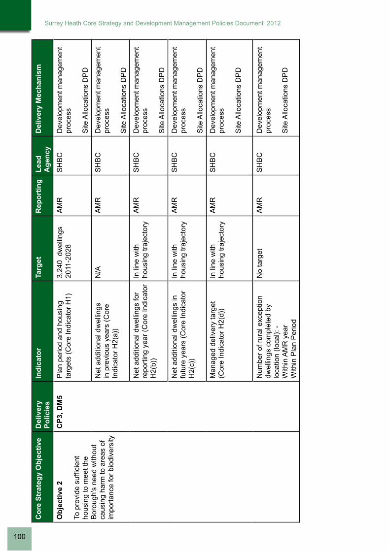
Co
re S
trat
egy
Ob
ject
ive
Del
iver
y P
olic
ies
Ind
icat
or
Targ
etR
epo
rtin
gL
ead
A
gen
cyD
eliv
ery
Mec
han
ism
Ob
ject
ive
2
To p
rovi
de s
uffic
ient
ho
usin
g to
mee
t the
B
orou
gh’s
nee
d w
ithou
t ca
usin
g ha
rm to
are
as o
f im
port
ance
for
biod
iver
sity
CP
3, D
M5
Pla
n pe
riod
and
hous
ing
targ
ets
(Cor
e In
dica
tor
H1)
3,
240
dw
ellin
gs
2011
-202
8A
MR
SH
BC
Dev
elop
men
t man
agem
ent
proc
ess
Site
Allo
catio
ns D
PD
Net
add
ition
al d
wel
lings
in
pre
viou
s ye
ars
(Cor
e In
dica
tor
H2(
a))
N/A
AM
RS
HB
CD
evel
opm
ent m
anag
emen
t pr
oces
s
Site
Allo
catio
ns D
PD
Net
add
ition
al d
wel
lings
for
repo
rtin
g ye
ar (
Cor
e In
dica
tor
H2(
b))
In li
ne w
ith
hous
ing
traj
ecto
ryA
MR
SH
BC
Dev
elop
men
t man
agem
ent
proc
ess
Site
Allo
catio
ns D
PD
Net
add
ition
al d
wel
lings
in
futu
re y
ears
(C
ore
Indi
cato
r H
2(c)
)
In li
ne w
ith
hous
ing
traj
ecto
ryA
MR
SH
BC
Dev
elop
men
t man
agem
ent
proc
ess
Site
Allo
catio
ns D
PD
Man
aged
del
iver
y ta
rget
(C
ore
Indi
cato
r H
2(d)
) In
line
with
ho
usin
g tr
ajec
tory
AM
RS
HB
CD
evel
opm
ent m
anag
emen
t pr
oces
s
Site
Allo
catio
ns D
PD
Num
ber
of r
ural
exc
eptio
n dw
ellin
gs c
ompl
eted
by
loca
tion
(loca
l): -
With
in A
MR
yea
rW
ithin
Pla
n P
erio
d
No
targ
et
AM
RS
HB
CD
evel
opm
ent m
anag
emen
t pr
oces
s
Site
Allo
catio
ns D
PD
100
Surrey Heath Core Strategy and Development Management Policies Document 2012

Co
re S
trat
egy
Ob
ject
ive
Del
iver
y P
olic
ies
Ind
icat
or
Targ
etR
epo
rtin
gL
ead
A
gen
cyD
eliv
ery
Mec
han
ism
Ob
ject
ive
3
Pro
vide
Hou
sing
that
m
eets
the
need
of a
ll se
ctio
ns o
f the
com
mun
ity
CP
5, C
P6,
C
P7,
DM
6G
ross
affo
rdab
le h
ousi
ng
com
plet
ions
and
num
ber
of n
et c
ompl
etio
ns a
s a
perc
enta
ge o
f tot
al h
ousi
ng
com
plet
ions
(C
ore
Indi
cato
r H
5)
Ach
ieve
35%
of
pro
ject
ed
annu
al h
ousi
ng
requ
irem
ent a
s af
ford
able
, 17.
5%
as in
term
edia
te
and
17.5
% a
s so
cial
ren
ted
AM
RS
HB
C,
RS
L’s,
H
CA
SH
BC
Hou
sing
Str
ateg
y
Dev
elop
men
t man
agem
ent
proc
ess
Site
Allo
catio
ns D
PD
Per
cent
age
of a
fford
able
and
m
arke
t uni
ts c
ompl
eted
by
type
and
siz
e (lo
cal)
Aim
to a
chie
ve
1 be
d dw
ellin
gs –
10
% m
arke
t, 20
%
inte
rmed
iate
, 35%
so
cial
ren
ted
2 be
d dw
ellin
gs –
40
% m
arke
t, 40
%
inte
rmed
iate
, 30%
so
cial
ren
ted
3 be
d dw
ellin
gs –
40
% m
arke
t, 40
%
inte
rmed
iate
, 20%
so
cial
ren
ted
4+ b
ed d
wel
lings
–
10%
mar
ket,
15%
soc
ial r
ente
d
AM
RS
HB
C,
Hou
se
Bui
lder
s,
RS
L’s
SH
BC
Hou
sing
Str
ateg
y
Dev
elop
men
t man
agem
ent
proc
ess
Site
Allo
catio
ns D
PD
Net
add
ition
al p
itche
s fo
r G
ypsy
& T
rave
ller
acco
mm
odat
ion
(Cor
e In
dica
tor
H4)
19 G
ypsy
and
T
rave
ller
pitc
hes
by 2
027
AM
RS
HB
CD
evel
opm
ent m
anag
emen
t pr
oces
s
Site
Allo
catio
ns D
PD
Num
ber
of h
ousi
ng r
egis
try
appl
icat
ions
rec
eive
dN
o ta
rget
SH
BC
co
rpor
ate
mon
itorin
g
SH
BC
SH
BC
Hou
sing
Str
ateg
y
Surrey Heath Core Strategy and Development Management Policies Document 2012
101

Co
re S
trat
egy
Ob
ject
ive
Del
iver
y P
olic
ies
Ind
icat
or
Targ
etR
epo
rtin
gL
ead
A
gen
cyD
eliv
ery
Mec
han
ism
Ob
ject
ive
4
Thr
ough
the
rege
nera
tion
of th
e P
rince
ss R
oyal
B
arra
cks
site
, to
deliv
er
a su
stai
nabl
e ru
ral
com
mun
ity s
et w
ithin
a
high
qua
lity
built
and
na
tura
l env
ironm
ent
CP
4Im
plem
enta
tion
of n
ew
hous
ing
Con
stru
ctio
n to
co
mm
ence
201
6A
MR
SH
BC
an
d D
efen
ce
Est
ates
Dee
pcut
SP
D
Net
add
ition
al d
wel
lings
1,20
0 P
hasi
ng a
s se
t out
in S
PD
AM
RS
HB
C
and
Dev
elop
er
Dev
elop
men
t man
agem
ent
proc
ess
Dee
pcut
SP
D
No
of a
fford
able
uni
ts
prov
ided
To a
chie
ve 3
5%
over
all
AM
RS
HB
C
and
Dev
elop
er
Dev
elop
men
t man
agem
ent
proc
ess
Dee
pcut
SP
D
Tota
l am
ount
(gr
oss)
and
of
reta
il flo
orsp
ace
com
plet
edIm
plem
enta
tion
as
per
stan
dard
s se
t ou
t in
SP
D
AM
RS
HB
C
and
Dev
elop
er
Dev
elop
men
t man
agem
ent
proc
ess
Dee
pcut
SP
D
Am
ount
of S
AN
Gs
and
AN
GS
pro
vide
d (h
a)Im
plem
enta
tion
as
per
stan
dard
s se
t ou
t in
SP
D
AM
RS
HB
C
and
Dev
elop
er
Dev
elop
men
t man
agem
ent
proc
ess
Dee
pcut
SP
D
Pro
visi
on o
f im
prov
ed p
ublic
tr
ansp
ort
Impl
emen
tatio
n as
pe
r st
anda
rds
set
out i
n S
PD
AM
RS
HB
C
and
Dev
elop
er
LTP
3
Dee
pcut
SP
D
102
Surrey Heath Core Strategy and Development Management Policies Document 2012

Co
re S
trat
egy
Ob
ject
ive
Del
iver
y P
olic
ies
Ind
icat
or
Targ
etR
epo
rtin
gL
ead
A
gen
cyD
eliv
ery
Mec
han
ism
Ob
ject
ive
5
Pro
tect
and
enh
ance
bi
odiv
ersi
ty w
ithin
the
Bor
ough
Incl
udin
g si
tes
of lo
cal i
mpo
rtan
ce fo
r bi
odiv
ersi
ty a
nd a
im to
de
liver
Sur
rey
Bio
dive
rsity
A
ctio
n P
lan
(BA
P)
Targ
ets
CP
14C
hang
e in
are
a of
bi
odiv
ersi
ty im
port
ance
(C
ore
Indi
cato
r E
2)
Mai
ntai
n 10
0%
land
are
a of
all
desi
gnat
ed s
ites
AM
RS
HB
C,
Nat
ural
E
ngla
nd,
Sur
rey
Wild
life
Tru
st
Dev
elop
men
t man
agem
ent
proc
ess
Site
Allo
catio
ns D
PD
Con
ditio
n st
atus
of S
PA
, SA
C
and
SS
SI’s
Ta
rget
set
by
Nat
ural
Eng
land
A
MR
Nat
ural
E
ngla
nd
and
land
owne
rs
Ste
war
dshi
p ag
reem
ents
Vis
itor
num
ber
surv
eys
for
SP
A/S
AC
N
o in
crea
se in
vi
sito
r nu
mbe
rsov
er p
lan
perio
d’
AM
RS
HB
C,
Nat
ural
E
ngla
nd,
Sur
rey
Wild
life
Tru
st
Str
ateg
ic A
cces
s M
anag
emen
t and
M
onito
ring
Pro
ject
Con
ditio
n st
atus
of S
NC
I’s
and
LNR
’s (
loca
l)M
aint
ain
100%
of
loca
l site
s in
favo
urab
le
cond
ition
ove
r pl
an p
erio
d
AM
RS
HB
C,
SC
C,
Sur
rey
Wild
life
Tru
st
SN
CI r
evie
w
Ob
ject
ive
6
Ens
ure
that
new
de
velo
pmen
t con
trib
utes
to
env
ironm
enta
l, in
fras
truc
ture
and
ser
vice
im
prov
emen
ts a
nd
min
imis
es im
pact
s up
on
both
the
natu
ral a
nd b
uilt
envi
ronm
ent
CP
2, C
P12
, D
M9
List
of i
nfra
stru
ctur
e pr
ojec
ts
com
mitt
ed o
r co
mpl
eted
du
ring
AM
R y
ear
(loca
l)
To a
chie
ve
deliv
ery
in li
ne
with
IDP
AM
RS
HB
C,
SC
C,
Ser
vice
pr
ovid
ers
IDP
S10
6 or
CIL
Surrey Heath Core Strategy and Development Management Policies Document 2012
103

Co
re S
trat
egy
Ob
ject
ive
Del
iver
y P
olic
ies
Ind
icat
or
Targ
etR
epo
rtin
gL
ead
A
gen
cyD
eliv
ery
Mec
han
ism
Ob
ject
ive
7
Ens
ure
that
new
de
velo
pmen
t res
pect
s th
e es
sent
ial c
hara
cter
of
the
loca
l are
a, in
clud
ing
hist
oric
str
uctu
res
and
envi
ronm
ent
CP
1, D
M9,
D
M17
Hou
sing
Qua
lity
– B
uild
ing
for
life
asse
ssm
ents
(C
ore
Indi
cato
r H
6)
Ach
ieve
‘goo
d’
or h
ighe
r ra
ting
on q
ualif
ying
de
velo
pmen
ts
AM
RS
HB
CD
evel
opm
ent m
anag
emen
t pr
oces
s
Num
ber
and
deta
ils o
f ar
chae
olog
ical
find
s w
ithin
ar
eas
of h
igh
arch
aeol
ogic
al
pote
ntia
l and
with
in
deve
lopm
ent s
ites
of 0
.4ha
or
abov
e (lo
cal)
No
targ
et -
co
ntex
tual
AM
RS
HB
C,
SC
CD
evel
opm
ent m
anag
emen
t pr
oces
s
Num
ber
of b
uild
ings
and
st
ruct
ures
mai
ntai
ned,
add
ed
or d
elet
ed fr
om th
e lo
cal l
ist
(loca
l)
No
targ
et -
co
ntex
tual
AM
RS
HB
C,
SC
CU
pdat
es to
list
of l
ocal
ly
liste
d bu
ildin
gs a
nd
stru
ctur
es.
Ob
ject
ive
8
Mai
ntai
n an
d pr
otec
t the
C
ount
rysi
de a
nd G
reen
S
pace
s in
set
tlem
ent
area
s an
d pr
ovid
e an
inte
grat
ed g
reen
in
fras
truc
ture
net
wor
k
CP
1, C
P13
, D
M4,
DM
16A
mou
nt o
f lan
d (h
a) in
S
urre
y H
eath
des
igna
ted
as S
ettle
men
t, C
ount
rysi
de
beyo
nd th
e G
reen
Bel
t or
Gre
en B
elt (
loca
l)
Ach
ieve
no
net
loss
of G
reen
Bel
t la
nd
AM
RS
HB
CD
evel
opm
ent m
anag
emen
t pr
oces
s
Site
Allo
catio
ns D
PD
Am
ount
of l
and
(ha)
im
plem
ente
d as
SA
NG
s (lo
cal):
-D
urin
g A
MR
yea
rD
urin
g P
lan
Per
iod
8ha
per
100
0 ne
t ne
w p
opul
atio
n.A
MR
SH
BC
, N
atur
al
Eng
land
, S
urre
y W
ildlif
e T
rust
Tha
mes
Bas
in H
eath
s D
eliv
ery
Fra
mew
ork
Site
Allo
catio
ns D
PD
Am
ount
of o
pen
spac
e or
re
crea
tiona
l are
as w
ithin
ur
ban
area
s an
d ru
ral
settl
emen
ts lo
st to
oth
er u
ses
(loca
l): -
Dur
ing
AM
R y
ear
Dur
ing
Pla
n P
erio
d
Aim
to a
chie
ve n
o gr
eate
r lo
ss th
an
10%
ove
r pl
an
perio
d
AM
RS
HB
CD
evel
opm
ent m
anag
emen
t pr
oces
s
Site
Allo
catio
ns D
PD
104
Surrey Heath Core Strategy and Development Management Policies Document 2012

Co
re S
trat
egy
Ob
ject
ive
Del
iver
y P
olic
ies
Ind
icat
or
Targ
etR
epo
rtin
gL
ead
A
gen
cyD
eliv
ery
Mec
han
ism
Ob
ject
ive
9
To s
uppo
rt th
e de
velo
pmen
t of a
was
te
stra
tegy
that
impr
oves
le
vels
of r
ecyc
ling
and
min
imis
es w
aste
pr
oduc
tion
DM
9P
erce
ntag
e of
was
te s
ent
for
reus
e, r
ecyc
ling
and
com
post
ing
40%
of a
ll w
aste
re
used
, rec
ycle
d or
com
post
ed p
a
Tens
SH
BC
Sur
rey
Was
te S
trat
egy
Ob
ject
ive
10
To m
inim
ise
impa
ct o
n cl
imat
e ch
ange
and
to
min
imis
e th
e ef
fect
of
clim
ate
chan
ge u
pon
the
Bor
ough
thro
ugh
a re
duct
ion
of g
reen
hous
e ga
s em
issi
ons
and
adop
tion
of m
ore
envi
ronm
enta
lly fr
iend
ly
tech
nolo
gies
and
pra
ctic
es
both
in n
ew a
nd e
xist
ing
deve
lopm
ents
CP
2, D
M7,
D
M8,
DM
9,
DM
10
Car
bon
Dio
xide
Em
issi
ons
(ton
nes
per
annu
m)
Red
uce
CO
2 em
issi
ons
by 3
4%
belo
w 1
990
leve
ls
by 2
020
1990
bas
elin
e =
67
0 to
nnes
AM
RS
HB
C,
SC
CS
urre
y C
limat
e C
hang
e P
artn
ersh
ip
Dev
elop
men
t Man
agem
ent
Pro
cess
Num
ber
of b
uild
ings
pe
rmitt
ed to
pre
scrib
ed
stan
dard
s fo
r en
ergy
and
w
ater
effi
cien
cy a
nd n
umbe
r of
bui
ldin
gs p
erm
itted
whi
ch
exce
ed p
resc
ribed
sta
ndar
ds
for
ener
gy a
nd w
ater
ef
ficie
ncy
(lo
cal)
100%
of b
uild
ings
to
be
cons
truc
ted
to p
resc
ribed
st
anda
rds
AM
RS
HB
CD
evel
opm
ent m
anag
emen
t pr
oces
s
Site
Allo
catio
ns D
PD
Ren
ewab
le e
nerg
y ge
nera
tion
(Cor
e In
dica
tor
E3)
No
targ
etA
MR
SH
BC
Dev
elop
men
t man
agem
ent
proc
ess
Site
Allo
catio
ns D
PD
Num
ber
of d
evel
opm
ents
co
mpl
eted
with
SU
DS
m
easu
res
impl
emen
ted
(loca
l)
Ach
ieve
SU
DS
in
all d
evel
opm
ent
whe
re fl
ood
risk
iden
tified
AM
RS
HB
CD
evel
opm
ent m
anag
emen
t pr
oces
s
Site
Allo
catio
ns D
PD
Num
ber
of p
lann
ing
perm
issi
ons
gran
ted
cont
rary
to
Env
ironm
ent A
genc
y ad
vice
on
flood
ing
and
wat
er
grou
nds
(Cor
e In
dica
tor
E1)
0% o
f app
licat
ions
to
be
gran
ted
cont
rary
to E
A
advi
ce
AM
RS
HB
C, E
AD
evel
opm
ent m
anag
emen
t pr
oces
s
Site
Allo
catio
ns D
PD
Surrey Heath Core Strategy and Development Management Policies Document 2012
105

Co
re S
trat
egy
Ob
ject
ive
Del
iver
y P
olic
ies
Ind
icat
or
Targ
etR
epo
rtin
gL
ead
A
gen
cyD
eliv
ery
Mec
han
ism
Ob
ject
ive
11
Impr
ove
trav
el c
hoic
e an
d tr
ansp
ort s
ervi
ces
to
enco
urag
e su
stai
nabl
e tr
avel
pat
tern
s an
d, in
pa
rtic
ular
, red
uce
relia
nce
on th
e pr
ivat
e ca
r
CP
1, C
P11
, D
M11
Per
cent
age
of d
wel
lings
or
B
Cla
ss fl
oors
pace
com
plet
ed
with
in 4
00m
or
5 m
inut
e w
alk
time
of a
hal
f hou
rly b
us
serv
ice
in u
rban
are
as a
nd
with
in 8
00m
or
a 10
min
ute
wal
k tim
e of
an
hour
ly b
us
serv
ice
in r
ural
are
as (
loca
l)
To a
chie
ve 8
0%
of a
ll de
velo
pmen
t ov
er p
lan
perio
d
AM
RS
HB
CD
evel
opm
ent m
anag
emen
t pr
oces
s
Site
Allo
catio
ns D
PD
Per
cent
age
of d
wel
lings
or
B
Cla
ss fl
oors
pace
com
plet
ed
with
in 1
0 m
inut
e w
alk
time
or
800m
of r
ail s
ervi
ce (
loca
l)
To a
chie
ve 5
0%
over
pla
n pe
riod
AM
RS
HB
CD
evel
opm
ent m
anag
emen
t pr
oces
s
Site
Allo
catio
ns D
PD
Num
ber
of tr
avel
pla
ns
impl
emen
ted
in a
ssoc
iatio
n w
ith m
ajor
dev
elop
men
ts
(loca
l)
Aim
to a
chie
ve
trav
el p
lans
in
50%
of a
ll m
ajor
de
velo
pmen
ts
AM
RS
HB
C,
SC
CD
evel
opm
ent m
anag
emen
t pr
oces
s
Site
Allo
catio
ns D
PD
106
Surrey Heath Core Strategy and Development Management Policies Document 2012

Eco
no
mic
Dev
elo
pm
ent
Co
re S
trat
egy
Ob
ject
ive
Del
iver
y P
olic
ies
Ind
icat
or
Targ
etR
epo
rtin
gL
ead
A
gen
cyD
eliv
ery
Mec
han
ism
Ob
ject
ive
12
Mai
ntai
n th
e ec
onom
ic
role
of t
he B
orou
gh w
ithin
th
e W
este
rn C
orrid
or a
nd
Bla
ckw
ater
Val
ley
sub-
regi
on
CP
8, D
M1,
D
M2,
DM
3,
DM
13
Tota
l am
ount
of a
dditi
onal
em
ploy
men
t floo
rspa
ce b
y ty
pe (
Cor
e In
dica
tor
BD
1)
Ach
ieve
no
net l
oss
of
empl
oym
ent
floor
spac
e ov
er
plan
per
iod
(run
ning
tota
l)
AM
RS
HB
CD
evel
opm
ent m
anag
emen
t pr
oces
s
Site
Allo
catio
ns D
PD
Tota
l am
ount
of e
mpl
oym
ent
floor
spac
e on
pre
viou
sly
deve
lope
d la
nd b
y ty
pe (
Cor
e In
dica
tor
BD
2)
Ach
ieve
80%
of
empl
oym
ent l
and
on P
DL
over
pla
n pe
riod
AM
RS
HB
CD
evel
opm
ent m
anag
emen
t pr
oces
s
Site
Allo
catio
ns D
PD
Em
ploy
men
t lan
d av
aila
ble
(Cor
e In
dica
tor
BD
3)M
aint
ain
suffi
cien
t la
nd to
mee
t de
man
d
AM
RS
HB
CD
evel
opm
ent m
anag
emen
t pr
oces
s
Site
Allo
catio
ns D
PD
Tota
l am
ount
of fl
oors
pace
fo
r to
wn
cent
re u
ses
(Cor
e In
dica
tor
BD
4)
No
targ
etA
MR
SH
BC
Dev
elop
men
t man
agem
ent
proc
ess
Site
Allo
catio
ns D
PD
Cam
berle
y To
wn
Cen
tre
AA
P
Tota
l am
ount
(gr
oss)
an
d pe
rcen
tage
of r
etai
l flo
orsp
ace
com
plet
ed in
to
wn
cent
res,
edg
e of
cen
tre
loca
tions
and
out
side
cen
tres
(lo
cal)
Ach
ieve
75%
of
tow
n ce
ntre
us
es w
ithin
Tow
n,
Dis
tric
t and
Loc
al
cent
res
over
pla
n pe
riod
AM
RS
HB
C
Dev
elop
men
t man
agem
ent
proc
ess
Site
Allo
catio
ns D
PD
Cam
berle
y To
wn
Cen
tre
AA
P
Surrey Heath Core Strategy and Development Management Policies Document 2012
107

Co
re S
trat
egy
Ob
ject
ive
Del
iver
y P
olic
ies
Ind
icat
or
Targ
etR
epo
rtin
gL
ead
A
gen
cyD
eliv
ery
Mec
han
ism
Ob
ject
ive
13
Pro
mot
e th
e ro
le o
f C
ambe
rley
Tow
n C
entr
e as
a s
econ
dary
reg
iona
l ce
ntre
and
as
a sa
fe a
nd
attr
activ
e re
tail,
cul
tura
l an
d en
tert
ainm
ent c
entr
e w
ith a
hig
h qu
ality
of
envi
ronm
ent
CP
8, C
P9,
C
P10
Tota
l am
ount
of (
gros
s)
reta
il flo
orsp
ace
com
plet
ed
or lo
st w
ithin
bou
ndar
y of
C
ambe
rley
Tow
n C
entr
e: -
Dur
ing
AM
R y
ear
Dur
ing
Pla
n P
erio
d
To b
e se
t thr
ough
th
e C
ambe
rley
TC
A
AP
AM
RS
HB
CC
ambe
rley
Tow
n C
entr
e A
AP
Tota
l am
ount
of (
gros
s)
new
em
ploy
men
t (B
Use
) flo
orsp
ace
com
plet
ed o
r lo
st w
ithin
bou
ndar
y of
C
ambe
rley
Tow
n C
entr
e: -
Dur
ing
AM
R y
ear
Dur
ing
Pla
n P
erio
d
To b
e se
t thr
ough
th
e C
ambe
rley
TC
A
AP
AM
RS
HB
CC
ambe
rley
Tow
n C
entr
e A
AP
Tota
l am
ount
of (
gros
s)
com
mun
ity a
nd le
isur
e (D
us
es)
floor
spac
e co
mpl
eted
or
lost
with
in b
ound
ary
of
Cam
berle
y To
wn
Cen
tre:
-
Dur
ing
AM
R y
ear
Dur
ing
Pla
n P
erio
d
To b
e se
t thr
ough
th
e C
ambe
rley
TC
A
AP
AM
RS
HB
CC
ambe
rley
Tow
n C
entr
e A
AP
Am
ount
of fl
oors
pace
st
andi
ng a
s ‘v
acan
t’ at
tim
e of
A
MR
for:
-R
etai
lE
mpl
oym
ent
To b
e se
t thr
ough
th
e C
ambe
rley
TC
A
AP
AM
RS
HB
CC
ambe
rley
Tow
n C
entr
e A
AP
108
Surrey Heath Core Strategy and Development Management Policies Document 2012

Co
re S
trat
egy
Ob
ject
ive
Del
iver
y P
olic
ies
Ind
icat
or
Targ
etR
epo
rtin
gL
ead
A
gen
cyD
eliv
ery
Mec
han
ism
Ob
ject
ive
14
Mai
ntai
n th
e ro
le o
f B
agsh
ot a
nd F
rimle
y as
dis
tric
t cen
tres
for
loca
l sho
ps, s
ervi
ces
and
com
mun
ity fa
cilit
ies
and
prot
ect t
hese
use
s el
sew
here
in th
e B
orou
gh.
CP
9, D
M12
Per
cent
age
of u
nits
in A
1 re
tail
use
over
pla
n pe
riod
in
(loca
l): -
Bag
shot
prim
ary
shop
ping
ar
ea (
fron
tage
)B
agsh
ot s
econ
dary
sho
ppin
g fr
onta
geF
rimle
y pr
imar
y sh
oppi
ng
area
(fr
onta
ge)
Frim
ley
seco
ndar
y sh
oppi
ng
fron
tage
Nei
ghbo
urho
od p
arad
es
(fro
ntag
e)
Mai
ntai
n or
ac
hiev
e 75
% o
f un
its a
s A
1 in
pr
imar
y sh
oppi
ng
area
s an
d 50
% o
f un
its a
s A
1 in
all
othe
r fr
onta
ges
AM
RS
HB
CD
evel
opm
ent m
anag
emen
t pr
oces
s
Site
Allo
catio
ns D
PD
Ob
ject
ive
15
Iden
tify
site
s on
whi
ch
empl
oym
ent u
se s
houl
d be
mai
ntai
ned
and
grow
th
enco
urag
ed
CP
8, D
M13
Am
ount
of (
gros
s) B
Cla
ss
floor
spac
e pe
rmitt
ed o
r lo
st to
oth
er u
ses
outs
ide
of C
ore
Em
ploy
men
t Are
as
and
Cam
berle
y To
wn
Cen
tre
(loca
l)
No
targ
etA
MR
SH
BC
Dev
elop
men
t man
agem
ent
proc
ess
Site
Allo
catio
ns D
PD
Surrey Heath Core Strategy and Development Management Policies Document 2012
109

Ch
ildre
n a
nd
Yo
un
g P
eop
le, H
ealt
h a
nd
Wel
l Bei
ng
an
d S
afer
an
d S
tro
ng
er C
om
mu
nit
ies
Cor
e S
trat
egy
Obj
ectiv
eD
eliv
ery
Pol
icie
sIn
dica
tor
Targ
etR
epor
ting
Lead
A
genc
yD
eliv
ery
Mec
hani
sm
Ob
ject
ive
16
Sup
port
the
com
mun
ity
thro
ugh:
pro
tect
ion
from
crim
e an
d th
e fe
ar
of c
rime,
refl
ectio
n of
cu
ltura
l div
ersi
ty, i
mpr
oved
fa
cilit
ies
for
heal
th,
wel
l bei
ng a
nd li
fe-lo
ng
lear
ning
.
CP
2, C
P10
, C
P12
, DM
9,
DM
12, D
M15
Tota
l floo
rspa
ce (
net s
quar
e m
etre
s) fo
r co
mm
unity
and
cu
ltura
l fac
ilitie
s ga
ined
or
lost
by
type
(lo
cal)
-D
urin
g A
MR
yea
rD
urin
g P
lan
Per
iod
No
targ
etA
MR
SH
BC
Dev
elop
men
t man
agem
ent
proc
ess
Site
Allo
catio
ns D
PD
Vio
lent
crim
e pe
r 1,
000
popu
latio
nN
o ta
rget
SH
BC
co
rpor
ate
mon
itorin
g
SH
BC
, S
urre
y P
olic
e
Am
ount
of n
ew o
pen
spac
e pr
ovid
ed o
n m
ajor
hou
sing
de
velo
pmen
t (ha
):D
urin
g A
MR
yea
rD
urin
g pl
an p
erio
d
Ach
ieve
ope
n sp
ace
stan
dard
s on
maj
or s
ites
AM
RS
HB
CD
evel
opm
ent m
anag
emen
t pr
oces
s
Site
Allo
catio
ns D
PD
Ob
ject
ive
17
Pro
vide
and
sup
port
hi
gh q
ualit
y le
isur
e an
d cu
ltura
l fac
ilitie
s th
at a
re
acce
ssib
le to
all.
CP
2, C
P4,
C
P10
, CP
12,
CP
13, D
M14
, D
M15
, DM
16
See
Obj
ectiv
e 8,
Obj
ectiv
e 13
, Obj
ectiv
e 16
No
targ
etA
MR
SH
BC
co
rpor
ate
mon
itorin
g
SH
BC
Dev
elop
men
t Man
agem
ent
Pro
cess
Site
Allo
catio
ns D
PD
110
Surrey Heath Core Strategy and Development Management Policies Document 2012

APPENDIX 4Glossary of Terms
Surrey Heath Core Strategy and Development Management Policies Document 2012
111

Accessibility - The ability of people to move around an area and reach places and facilities, including elderly and disabled people, those with young children and those encumbered with luggage or shopping.
Affordability - A measure of whether households can access or sustain the costs of private sector housing.
Affordable housing - Housing, whether for rent, shared ownership or outright purchase, provided at a cost considered affordable in relation to incomes that are average or below average, or in relation to the price of general market housing.
Air Quality Management Areas - Areas established by borough and district councils following local assessment of air quality where individual pollutants are forecast to exceed standards defined in the National Air Quality Strategy.
Allocated sites - Sites allocated on the proposals map
Annual Monitoring Report (AMR) - A report that assesses the impact of policies and whether targets are being met against a set of core indicators, and where necessary, identifies adjustments or revisions to policies/proposals.
Appropriate Assessment - Required under the European Habitats Directive to assess the impact of plans on ‘European Sites’ of nature conservation importance. The Appropriate Assessment of the Surrey Heath Core Strategy and Development Management Policies has been published as a background document.
Biodiversity - The whole variety of life encompassing all genetic, species and ecosystem variations, including plants and animals.
Biodiversity Action Plan (BAP) - A strategy prepared for a local area aimed at conserving and enhancing biological diversity.
Building Research Establishments Environmental Assessment Method (BREEAM) - Used to assess the environmental performance of both new and existing buildings.
Brownfield Land - Previously developed land which is, or was, occupied by a permanent structure, including the curtilage of the developed land and any associated fixed surface infrastructure.
Carbon Dioxide (CO2) - A gas found naturally in the Earth’s atmosphere and also produced as a result of the burning of wood and fossil fuels.
Carbon Footprint - A measure of the impact human activities have on the environment in terms of the amount of greenhouse gases produced, measured in units of carbon dioxide.
Climate Change - Is the variation in the Earth’s global climate or in regional climates over time
Code for Sustainable Homes - An environmental rating scheme for housing in England, under which new homes will be given a ‘star rating’ to indicate their environmental impact, ranging from level 1 to level 6 (high sustainability).
Combined heat and power (CHP) - A system which generates electricity and utilises the heat produced as a by-product in a cost effective and environmentally responsible way.
Commuted payments - Payments made through a legal agreement with the Council, which are ring-fenced to pay for specific improvements, e.g. developers can sign a legal agreement that they will pay for highway improvements, for example a pedestrian crossing, or the provision of affordable housing.
Compulsory Purchase Order – A notice issued by the government or local authority to compulsorily acquire land to help deliver social or economic change that is in the public interest, where the land owner or occupier is not willing to sell by agreement.
112
Surrey Heath Core Strategy and Development Management Policies Document 2012

Conservation Area - An area designated under the Town and Country Planning (Listed Buildings and Conservation Areas) Act 1990 on account of its special architectural or historic interest, the character and appearance of which it is intended to preserve and enhance.
Contaminated Land - Land that has been polluted or harmed in some way making it unfit for safe development and usage unless cleaned.
Core Employment Land - Designated as protected land in employment uses in the Borough.
Core Output Indicator (COI) - A measurement of performance local planning authorities are required to collect.
Core Strategy Development Plan Document – Sets out the long–term vision for the future of the area, the spatial objectives and strategic policies to deliver that vision.
Cumulative Effect - A number of developments in a locality or a continuous activity over time that, together, may have an increased impact on the environment, local infrastructure and services, or the economy.
Development Plan - The South East Plan 2009 and the Surrey Heath Local Plan 2000 (saved policies) form the statutory Development plan for the Borough. The LDF will progressively replace saved policies.
Development Plan Documents (DPDs) - These will replace the Local Plan and have the same status for decision-making. More than one DPD can be used to provide for the Development Plan at the local level. Types of DPDs include the Core Strategy, Site Specific Allocations and Area Action Plans.
Ecological Footprint - Compares human consumption of natural resources with planet Earth’s ecological capacity to regenerate them.
Ecology - The distribution and abundance of living organisms and the interactions among organisms and between organisms and their environment.
Ecosystem – A system formed by the interaction of a community of organisms with their environment.
Employment Land - That which is in use for the following purposes – office, industrial and warehousing.
Energy Conservation - The practice of minimising the quantity of energy used, thereby improving energy efficiency.
Energy Efficiency - How well used energy is as a ratio of the energy used to the energy wasted, decreasing wasted energy will thus produce a higher energy efficiency ratio.
Energy Recovery - The use of waste as a source for energy, for example making use of the methane emitted from landfill.
English Heritage - Government advisors with responsibility for all aspects of protecting and promoting the historic environment. English Heritage is responsible for advising the government on the listing of historic buildings.
Environment Agency - A government body that aims to prevent or minimise the effects of pollution on the environment and issues permits to monitor and control activities that handle or produce waste. It also provides up-to-date information on waste management matters and deals with other matters such as water issues including flood protection advice.
Surrey Heath Core Strategy and Development Management Policies Document 2012
113

Evidence Base - The information and data gathered by local authorities to justify the “soundness” of the approach set out in Local Development Documents, including physical, economic, and social characteristics of an area.
Extra Care Housing - Housing designed with the needs of older people in mind and with varying levels of care and support available on site. People who live in Extra Care housing have their own self contained homes and benefit from communal facilities being available. Properties can be rented, owned or part owned/ part rented. Extra Care is also know as very sheltered housing, assisted living, or simply as ‘housing with care’.
Government Office for the South East (GOSE) – One of nine regional offices. They represent central government in the region and their role is to promote better and more effective integration of Government policies and programmes at a regional and local level.
Green Belt - A designation for land around certain cities and large built-up areas, which aims to keep this land permanently open or largely undeveloped. The purposes of including land in the Green Belt is to:• checktheunrestrictedsprawloflargebuiltupareas• preventneighbouringtownsfrommerging• safeguardthecountrysidefromencroachment• preservethesettingandspecialcharacterofhistorictowns• assisturbanregenerationbyencouragingtherecyclingofderelictandotherurbanlandGreen Belts are defined in a local planning authority’s development plan.
Green Infrastructure - A network of multi-functional private and public green spaces and natural elements (including water) and the links between them within and between the built environment.
Greenfield land or site - Greenfield land is land which has never previously been developed. This could be both within and outside built-up areas.
Greenhouse Gas Emissions - The production of gases which naturally form in the atmosphere and serve to insulate the earth including water vapour, Carbon Dioxide (CO2), methane, nitrous oxide and ozone.
Housing Associations - Independent, not-for-profit organisations registered with and regulated by the Homes and Communities Agency (HCA).
Housing ‘trajectory’ - An evaluation of housing delivery compared to delivery targets.
Infill development - Development of a vacant site in a substantially developed frontage or area.
Infrastructure - The basic requirements for the satisfactory development of an area which include such things as roads, footpaths, sewers, schools, open space and other community facilities.
Intensification - More frequent usage, e.g. a tennis court at a school could be used by other community groups outside school hours.
Intermediate Housing - Housing at prices and rents above those of social rent, but below market prices or rents. These can include shared equity products for example Homebuy.
Issues, Options and Preferred Options - Previous consultation stages on Development Plan Documents with the objective of adopting the most appropriate and sustainable approach ahead of submission to government for independent examination.
114
Surrey Heath Core Strategy and Development Management Policies Document 2012

Listed Building - A building of special architectural or historic interest as designated by English Heritage on behalf of the Department for Culture, Media and Sport. This is a statutory listing.
Low-Carbon energy - Comes from sources that produce fewer greenhouse gases than do traditional means of power generation, includes zero carbon power generation sources as well as sources with lower-level emissions such as natural gas, and technologies that prevent carbon dioxide from being emitted into the atmosphere, such as carbon capture and storage.
Local Area Agreement (LAA) - an agreement between central and local government to deliver improvements against selected national indicators.
Local Development Document (LDD) -These include Development Plan Documents (which form part of the statutory development plan) and Supplementary Planning Documents (which do not form part of the statutory development plan). LDDs collectively deliver the spatial planning strategy for the local planning authority’s area.
Local Development Framework (LDF) - A portfolio of Local Development Documents that will replace the Local Plan. Together these documents will provide the framework for delivering the spatial planning strategy for the Local Planning Authority area.
Local Development Scheme (LDS) - A document setting out the programme for the preparation of Development Plan Documents. It sets out a 3-year programme and includes information on consultation dates.
Local Distinctiveness - The particular positive feature of a locality that contributes to its special character and sense of place. Distinguishes one local area from another
Local Nature Reserve (LNR) - An area designated by local authorities, in consultation with Natural England, under the National Parks and Access to the Countryside Act 1949, to provide opportunities for educational use and public enjoyment, in addition to protecting wildlife or geological and physiographical features of special interest.
Local Plan - Saved policies from the adopted Surrey Heath Local Plan 2000.
Local Transport Plan (LTP) - A five-year integrated transport strategy, prepared by local authorities in partnership with the community, seeking funding to help provide local transport projects. The plan sets out the resources predicted for delivery of the targets identified in the strategy. Local transport plans should be consistent with the policies and priorities set out in the Regional Transport Strategy as an integral part of the Regional Spatial Strategy
Market Housing - Private housing for rent or for sale, where the price is set in the open market.
Maximum Parking Standards - A maximum number of off-street car parking spaces permitted for a development by land use type.
Mitigation Measures - Those which are put into place to reduce or eliminate any harm caused eg. Contributions to the provision of Suitable Accessible Natural Green space (SANG) / access management and monitoring with regards to Thames Basin Heaths SPA.
Mixed Tenure - An area of housing consisting of mix of different tenures, normally social rented housing and privately owned housing.
Mixed Use – Area or site where a mixture of commercial, retail and residential uses predominates.
Natural England - Government advisors on nature conservation issues in England.
Surrey Heath Core Strategy and Development Management Policies Document 2012
115

National Indicators (NI) - A set of 198 measures chosen by central government to assess performance in local areas.
Perpetuity - In an affordable housing context, homes secured as affordable into the future, for example by planning restrictions on the resale of affordable housing so that it cannot be lost to the market.
Planning Obligations and Agreements - Legal agreements between a planning authority and a developer, or undertakings offered unilaterally by a developer, that ensure that certain extra works related to a development are undertaken. For example, the provision of highways. Sometimes called “Section 106” agreements.
Planning Policy Guidance (PPG) / Planning Policy Statement (PPS) – Statements setting out the Government’s policy framework at the national level on planning issues such as housing, employment, Green Belt. PPSs will replace existing Planning Policy Guidance (PPG).
Previously Developed Land - For the purposes of housing policy in PPS3, land which is or was occupied by a permanent (non-agricultural) structure and associated fixed surface infrastructure, including the curtilage of the development, in urban and rural areas. It excludes land and buildings that have been used for agricultural purposes, forest and woodland, and land in built-up areas such as private residential gardens, parks, recreation grounds and allotments, which has not been developed previously.
Ramsar Site - A wetland site of international importance (especially as a waterfowl habitat) designated by the Secretary of State for the Environment, Food and Rural Affairs.
Regional Economic Strategy for South East England (RES) - Sets a 10 year framework for delivering economic aspirations and vision within the broader context of sustainable development.
Regional Spatial Strategy (RSS) - Documents setting out the planning framework at the regional level, the South East Plan.
Registered Social Landlord (RSL) - A body registered with the Homes and Communities Agency who own or manage affordable homes, both social rented and intermediate.
Renewable Energy - Renewable energy is energy flows that occur naturally and repeatedly in the environment, for example from the wind, water flow, tides or the sun.
Scheduled Ancient Monument - A building or structure above or below ground whose preservation is of national importance, in a schedule compiled by the Secretary of State for Culture, Sport and Recreation.
Section 106 agreement - A legal agreement under section 106 of the 1990 Town & Country Planning Act. Section 106 agreements are legal agreements between a planning authority and a developer, or undertakings offered unilaterally by a developer, that ensure that certain extra works related to a development are undertaken.
Shared Ownership - A scheme aimed at providing first time buyers, who cannot afford to buy outright, a home suited to their needs. The buyer purchases a part of the equity, paying rent on the remainder, which is usually retained by a RSL.
Sheltered Housing - Housing specifically for older and/or disabled people. Includes a block or group of houses with resident or visiting warden, and individual houses, bungalows and flats, which receive support from a mobile warden or pendant (emergency) alarm service.
116
Surrey Heath Core Strategy and Development Management Policies Document 2012

Site of Special Scientific Interest(SSSI) -A site designated in the UK to be of importance for nature conservation due to the presence of a rare or good example of fauna and flora.
Site of Nature Conservation Importance (SNCI) - An area (non statutory) designated as being of county or local wildlife value.
Smart growth - The Regional Economic Strategy defines “Smart Growth” as - lifting under performance through increasing the region’s stock of businesses; maximising the number of people ready for employment at all skills levels, and ensuring they are equipped to progress in the labour market; increasing the participation of South East businesses in tendering for public sector contracts; reducing road congestion and pollution levels by improving travel choice, promoting public transport, managing demand and facilitating modal shifts; ensuring sufficient and affordable housing and employment space of the right type and size to meet the needs of the region and create the climate for long-term investment through efficient use of land resources, including mixed-use developments; and improving the productivity of the workforce and increasing economic activity.
Social Rented Housing- Affordable housing provided for rent at below market levels to eligible groups on housing waiting lists.
Soundness - A Development Plan Document (DPD) is considered sound if it is based upon good evidence and has been prepared in accordance with all the necessary procedures including the measures set out in the local authority’s Statement of Community Involvement.
South East Plan (SEP) - The regional spatial strategy for the South East.
Spatial Planning -Spatial planning goes beyond traditional land use planning to bring together and integrate policies for the development and use of land with other policies and programmes which influence the nature of places and how they function. This will include policies which can impact on land use by influencing the demands on, or needs for, development, but which are not capable of being delivered solely or mainly through the granting or refusal of planning permission and which may be implemented by other means.
Special Area of Conservation (SAC) - SACs are areas which have been given special protection under the European Union’s Habitats Directive. They provide increased protection to a variety of wild animals, plants and habitats and are a vital part of global efforts to conserve the world’s biodiversity.
Special Needs Housing - Housing to meet the needs of groups of people who may be disadvantaged, such as elderly, the disabled, students, young single people, rough sleepers, the homeless, those needing hostel accommodation, key workers, travellers and occupiers of mobile homes and houseboats.
Special Protection Area (SPA) - European designated area warranting special protection for the importance of its fauna. The area will comprise a number of sites that are also designated Sites of Special Scientific Interest (SSSI) in the UK. For example, the Natura 2000 designated Thames Basin Heaths Special Protection Area comprises 13 SSSIs across Surrey, Hampshire and Berkshire, protected principally for its rare species of ground-nesting birds.
Statement of Community Involvement (SCI) - Sets out the ways in which the Local Planning Authority will consult the community and stakeholders, not only on other LDDs but also on major planning applications.
Strategic Flood Risk Assessment (SFRA) - An assessment of the likelihood of flooding in a particular area so that development needs and mitigation measures can be carefully considered.
Strategic Housing Land Availability Assessment (SHLAA) - An assessment that identifies sites with potential for housing. The assessment is an important evidence source to inform plan making, but does not in itself determine whether a site should be allocated for housing development.
Surrey Heath Core Strategy and Development Management Policies Document 2012
117

Strategic Housing Market Assessment (SHMA) - An assessment of the estimated demand for market housing and need for affordable housing in a defined geographical area, in terms of distribution, house types and sizes and the specific requirements of particular groups and which considers future demographic trends.
Supplementary Planning Documents (SPDs) - These can be produced to provide guidance to supplement the policies and proposals in DPDs. However they do not form part of the Development Plan although they must undergo a formal process of consultation.
Surrey County Council (SCC) - the upper tier local authority in Surrey with statutory responsibility or education, social services, highways, libraries, minerals planning and waste planning.
Surrey Heath Partnership (SHP) - a partnership of local public, private and voluntary organisation that has responsibility for the production and delivery of the Sustainable Community Strategy
Sustainability Appraisal (SA)/ Strategic Environmental Assessment (SEA) - Local Planning Authorities are required to assess the environmental and sustainability impact of policies and proposals in Development Plan Documents. This is a tool for appraising policies to ensure that they reflect sustainable development objectives, i.e. Social, environmental and economic factors.
Sustainable communities - Places that meet the diverse needs of existing and future residents, are sensitive to their environment, and contribute to a high quality of life. They are safe and inclusive, well planned, built and run, and offer equality of opportunity and good services for all.
Sustainable Community Strategy (SCS) - A strategy developed by a local authority in partnership with other public, private and community sector organisations, to promote economic, social and environmental well being of the area and to contribute to the achievement of sustainable development.
Sustainable construction - Construction which has due reference to the environment, for example in the materials it uses, the methods of construction and the installation of energy efficient and water conservation systems, e.g use of solar panels and SUDS.
Sustainable Development - Development, which meets the needs of the present without compromising the ability of future generations to meet their own needs, ensuring a better quality of life for everyone now and for generations to come.
Sustainable location - For example, is a location with good transport links with good access to community and local facilities.
Sustainable transport – Often meaning walking, cycling and use of public transport, which is considered to be less damaging to the environment and which contributes less to traffic congestion than one-person car journeys.
Sustainable (urban) Drainage Systems (SuDS) – Include a range of different drainage systems that are designed to promote the filtration and evaporation of water as close to the source as possible and to break down pollutants. SUDS are an alternative to drainage through pipes directly to a water course and will help enhance water quality and biodiversity, maintain groundwater levels and reduce the risk of flooding.
Tenure -The nature by which people own or rent their home. Categories are usually broken down as follows: Owner Occupied, Private Rented, Registered Social Landlord or Council Rented.
Threshold - The number of units that triggers the affordable housing requirement on market schemes.
118
Surrey Heath Core Strategy and Development Management Policies Document 2012

Travel Plan - A travel plan aims to promote sustainable travel choices (for example, cycling) as an alternative to single occupancy car journeys that may impact negatively on the environment, congestion and road safety. Travel plans can be required when granting planning permission for new developments.
Windfall sites - Those sites which have not been specifically identified. They comprise previously developed sites that have unexpectedly become available.
Zero Carbon Development - A building or set of buildings with net zero carbon emissions over the course of one year.
Surrey Heath Core Strategy and Development Management Policies Document 2012
119