core strategy and development plan 2015-2033
TRANSCRIPT
Core Strategy and Development Plan 2015-2033 January 2020

Foreword 3
List of policies 5
List of figures 7
List of tables 8
1. Introduction 13
Sunderland’s Local Plan 13
Preparing the Plan 14
Structure of this Plan 14
2. Sunderland today 17
Sunderland 17
Spatial areas 17
Population of Sunderland 20
Healthy safe communities 21
Homes 21
Economic growth 24
Built and historic environment 26
Natural environment 26
Waste, water and energy 26
Sustainable transport 27
Minerals 27
3. Spatial vision and strategic priorities 31
Spatial vision 32
Strategic priorities 32
4. Spatial strategy 35
Urban Core 40
Washington 42
North Sunderland 47
South Sunderland 49
The Coalfield 52
5. Healthy and safe communities 59
6. Homes 63
7. Economic growth 73
8. Vitality of centres 81
9. Built and historic environment 89
10. Natural environment 99
11. Water, waste and energy 111
12. Sustainable transport 121
13. Minerals 127
14. Infrastructure and delivery 133
Appendices
Appendix 1 – Saved and deleted UDP policies 139
Appendix 2 – Evidence base 147
Appendix 3 – Areas for landscape protection and landscape enhancement 151
Appendix 4 – Minerals Safeguarding Areas 152
Appendix 5 – Mineral safeguarding exceptions 153
Appendix 6 – Issues to be addressed through restoration 154
Appendix 7 – Implementation table 155
Appendix 8 – Monitoring Framework 160
Glossary 187
Policies map 201
Core Strategy and Development Plan 2015-2033
Page 1
Contents


Sunderland is undergoing huge change, building on our great history of enterprise and endeavor to become a modern and prosperous 21st century city.
Through the ambition, intelligence and drive of our people, we are creating an exciting vision of how the city could look in future years. This vision is focused on securing Sunderland’s long-term economic future, encouraging inward investment and new employment opportunities by building on our strengths and ensuring the right infrastructure is in place.
By targeting our investment and the delivery of large-scale capital projects, we strongly believe we can create the conditions needed to support the development of a city with a reputation for vibrancy and creativity that matches and complements our success as a manufacturing and business hub.
Ensuring that the city has robust, effective and up-to-date planning policies that continue to adapt and embrace changing circumstances will be key to our long term ambition. Sunderland’s Plan sets out a framework for this, capturing a clear understanding of how our city’s land and property assets need to be developed to meet the opportunities and challenges facing our city over the coming years to 2033.
Cllr Graeme Miller Leader of Sunderland City Council
Core Strategy and Development Plan 2015-2033
Page 3
Foreword


SP1 Development strategy 35
SP2 Urban Core 40
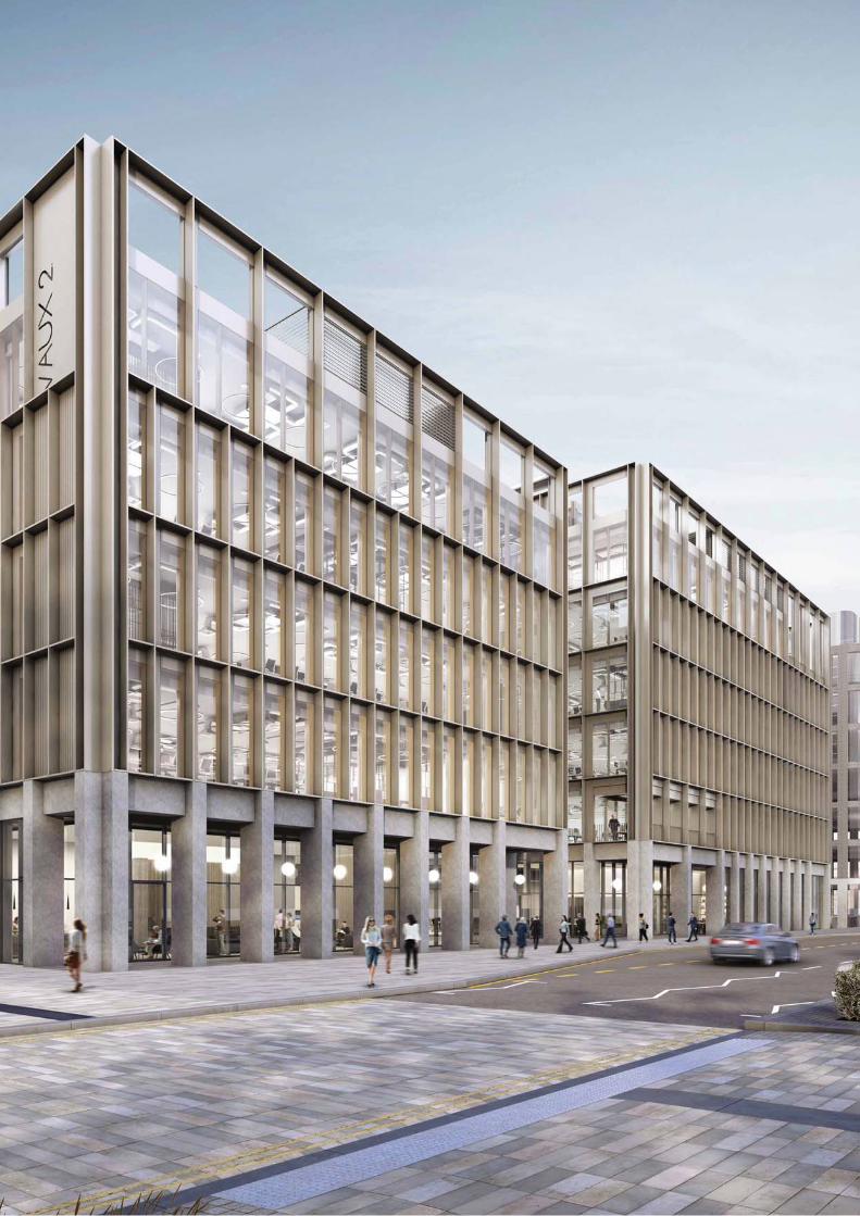
SS1 The Vaux (5.8ha) 41
SP3 Washington 42
SS2 Washington Housing Growth Areas 43
SS3 Safeguarded land 45
SP4 North Sunderland 47
SS4 North Sunderland Housing Growth Area 47
SP5 South Sunderland 49
SS5 The Port of Sunderland 50
SS6 South Sunderland Growth Area 50
SP6 The Coalfield 52
SS7 The Coalfield Housing Growth Areas 53
SP7 Healthy and safe communities 59
HS1 Quality of life and amenity 60
HS2 Noise-sensitive development 60
HS3 Contaminated land 61
HS4 Health and safety executive areas and hazardous substances 61
SP8 Housing supply and delivery 63
H1 Housing mix 65
H2 Affordable homes 66
H3 Student accommodation 67
H4 Travelling Showpeople, Gypsies and Travellers 68
H5 Existing homes and loss of homes 70
H6 Homes in Multiple Occupation (HMOs) 71
H7 Backland and tandem development 71
EG1 Primary employment areas 75
EG2 Key employment areas 76
EG3 Other employment sites 76
EG4 New employment areas 77
EG5 Offices 77
EG6 Trade counters 78
VC1 Main town centre uses and retail hierarchy 81
SP9 Comparison retail 83
VC2 Retail impact assessments 83
VC3 Primary shopping areas & frontages 84
VC4 Hot food takeaways 85
VC5 Protection and delivery of community facilities and local services 87
VC6 Culture, leisure and tourism 87
BH1 Design quality 89
BH2 Sustainable design and construction 90
BH3 Public realm 91
BH4 Advertisements 92
BH5 Shop fronts 92
BH6 Quality communications 92
BH7 Historic environment 93
BH8 Heritage assets 94
BH9 Archaeology and recording of heritage assets 96
NE1 Green and blue infrastructure 99
NE2 Biodiversity and geodiversity 100
NE3 Woodlands/hedgerows and trees 102
NE4 Greenspace 103
NE5 Burial space 104
NE6 Green Belt 105
NE7 Settlement Breaks 106
NE8 Development in the open countryside 106
NE9 Landscape character 108
NE10 Heritage coast 108
Core Strategy and Development Plan 2015-2033
Page 5
List of policies
NE11 Creating and protecting views 109
NE12 Agricultural land 109
WWE1 Decentralised, renewable and low carbon energy 111
WWE2 Flood risk and coastal management 112
WWE3 Water management 113
WWE4 Water quality 114
WWE5 Disposal of foul water 115
WWE6 Waste management 115
WWE7 Waste facilities 117
WWE8 Safeguarding waste facilities 118
WWE9 Open waste facilities 119
WWE10 Energy from waste 120
SP10 Connectivity and transport network 121
ST1 Urban core accessibility and movement 123
ST2 Local road network 124
ST3 Development and transport 125
SP11 Mineral extraction 127
M1 Minerals Safeguarding Areas and infrastructure 128
M2 Surface coal extraction 129
M3 Land instability and minerals legacy 129
M4 Restoration and aftercare 129
ID1 Delivering infrastructure 133
ID2 Planning obligations 134
Core Strategy and Development Plan 2015-2033
Page 6
Figure 1 Administrative boundary of Sunderland 13
Figure 2 Location of Sunderland 17
Figure 3 The Urban Core 18
Figure 4 Washington 18
Figure 5 South Sunderland 19
Figure 6 North Sunderland 19
Figure 7 The Coalfield 20
Figure 8 Population change within Sunderland 20
Figure 9 Job growth and working age population change (2000-2012) 21
Figure 10 Median House Prices 22
Figure 11 Sunderland Council Tax 22
Figure 12 Housing Delivery 23
Figure 13 Proportion of Housing Completions on Previously Developed Land 23
Figure 14 Workforce Jobs 24
Figure 15 Key Diagram 34
Figure 16 Urban Core Key Diagram 40
Figure 17 The Vaux 41
Figure 18 Washington Key Diagram 42
Figure 19 South West Springwell 43
Figure 20 North of High Usworth 44
Figure 21 North of Usworth Hall 44
Figure 22 Fatfield 45
Figure 23 Safeguarded Land 45
Figure 24 North Sunderland Key Diagram 47
Figure 25 Fulwell 48
Figure 26 South Sunderland Key Diagram 49
Figure 27 The Port of Sunderland 49
Figure 28 SSGA 50
Figure 29 The Coalfield Key Diagram 52
Figure 30 Penshaw 53
Figure 31 New Herrington 54
Figure 32 Philadelphia 54
Figure 33 Potential Housing Supply 63
Figure 34 Housing Trajectory 65
Figure 35 Station Road North Travelling Showpeople Site 69
Figure 36 Land at Market Place Travelling Showpeople Site 70
Figure 37 Employment Areas 75
Figure 38 Retail Hierarchy 81
Figure 39 City Centre 84
Figure 40 Washington Town Centre 84
Figure 41 Houghton Town Centre 84
Figure 42 Green Infrastructure 100
Figure 43 Settlement Breaks 106
Figure 44 Open Countryside 107
Figure 45 Waste Hierarchy 116
Figure 46 Local Road Hierarchy 124
Figure 47 Local Road Network 125
Core Strategy and Development Plan 2015-2033
Page 7
List of figures
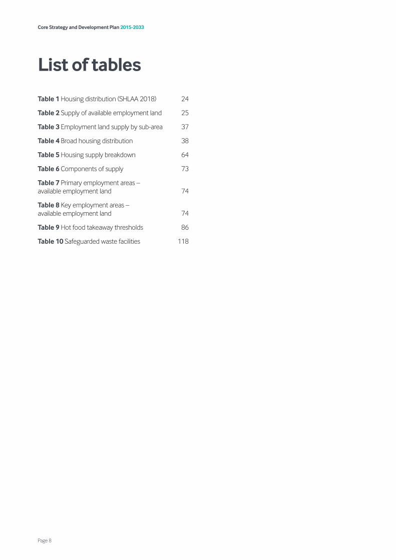
Table 1 Housing distribution (SHLAA 2018) 24
Table 2 Supply of available employment land 25
Table 3 Employment land supply by sub-area 37
Table 4 Broad housing distribution 38
Table 5 Housing supply breakdown 64
Table 6 Components of supply 73
Table 7 Primary employment areas – available employment land 74
Table 8 Key employment areas – available employment land 74
Table 9 Hot food takeaway thresholds 86
Table 10 Safeguarded waste facilities 118
Core Strategy and Development Plan 2015-2033
Page 8
List of tables


Setting the scene Introduction


1.1 Planning affects us all. The homes we live in, the places we work, the greenspaces where we relax and the roads we travel on, are all a result of planning decisions that have been made. All Local Planning Authorities have a statutory duty to prepare a Local Plan. The Sunderland Local Plan will seek to continue the transformation of Sunderland, by ensuring that we have a framework to develop and protect the city’s land and property assets.
1.2 This policy framework guides and shapes development in Sunderland for the next 18 years and sets the parameters for growth. It ensures that Sunderland is a city that is open for business; providing jobs and economic growth; delivering housing to meet community needs and aspirations; assisting in the tackling of health inequalities and deprivation and protects the city’s important natural and historic environmental assets.
1.3 The Local Plan is the starting point for the determination of planning applications. It sets a clear strategy for bringing land forward to address objectively assessed needs in line with the presumption in favour of sustainable development. It includes broad locations, land use designations and allocations to deliver this strategy.
1.4 The Local Plan is an important tool to give certainty and transparency to residents and businesses as to how the city will develop by 2033. It will enable the city to attract more funding and investment. The purpose of the Local Plan is to create a sustainable, attractive, healthy and prosperous Sunderland where people choose to live and work.
Figure 1: Administrative Boundary of Sunderland
Sunderland’s Local Plan 1.5 Sunderland’s Local Plan is in three parts:
Part One – Core Strategy and Development Plan (hereafter referred to as This Plan); This Plan sets an overarching strategy, strategic policies and strategic allocations and designations for the future change and growth of Sunderland. This Plan also includes local policies for development management purposes. This Plan covers the period from 2015 to 2033 and covers all land within Sunderland’s administrative boundary (Figure 1).
Part Two – Allocations and Designations Plan (hereafter referred to as the A&D Plan); will set out local policies including site-specific policy designations and allocations for the development, protection and conservation of land in the city in order to deliver the overall strategy set out within this Plan. The A&D Plan will cover all land within Sunderland’s administrative boundary.
Core Strategy and Development Plan 2015-2033
Page 13
1. Introduction
Part Three – International Advanced Manufacturing Park (IAMP) Area Action Plan (AAP) 2017-2032 (hereafter referred to as the IAMP AAP); was adopted by Sunderland City Council and South Tyneside Council in November 2017. This part of the Local Plan sets out site specific policies for the comprehensive development of the IAMP.
1.6 This Plan and the IAMP AAP have superseded saved policies of the Sunderland Unitary Development Plan (UDP) 1998 and UDP Alteration No. 2 (2007). However, a number of policies will remain as saved policies and part of the Development Plan until such time as the A&D Plan is adopted. These saved policies will continue to be applied and be a consideration in the determination of planning applications, until they are replaced by policies in the A&D Plan. Appendix 1 sets out the saved policies which should be read alongside this Plan.
1.7 All policies in the Local Plan will be monitored regularly and reviewed (in accordance with the Monitoring Framework) and updated if necessary, to ensure that the Plan is up-to-date. The council’s Local Development Scheme provides details of timescales for preparing and reviewing the Local Plan. The Local Plan may also be supplemented by Neighbourhood Plans, Area Action Plans, Housing Delivery Plans and Supplementary Planning Documents where appropriate.
1.8 The council has a number of SPDs in place which provide more detail in relation to specific policies. It is anticipated that these will be updated where necessary to reflect the policies of this Plan. A number of draft SPDs are also in place which provide more detail for specific policies within this Plan and the intention is to adopt these following adoption of this Plan. The council also has proposals for a number of new SPDs which will expand upon policies of this Plan and will be prepared in due course. The programme for the preparation of SPDs is included within the council’s Local Development Scheme. Upon adoption of the this Plan a number of SPDs have been deleted.
Preparing the Plan 1.9 The Core Strategy and Development Plan
Compliance Statement sets out how the council has positively prepared the Plan in accordance with legislation, regulations and national policy. It also includes justification how this Plan has met the legal and regulatory requirements and meets the test of soundness. This document should be read alongside the Plan.
Structure of this Plan 1.10 This Plan comprises of four sections:
Setting the scene This section sets out the background to the preparation of this Plan and provides the context to the type of place that Sunderland is today, the challenges it faces and the opportunities for the future.
Vision, strategic priorities and spatial strategy This section sets out our vision and strategic priorities for Sunderland by 2033. It outlines the spatial strategy for how and where the future growth of Sunderland will be delivered and contains strategic allocations which are fundamental to the delivery of the Plan.
Strategic and local policies This section includes chapters that will guide and manage development covering a range of themes including; Healthy and Safe Communities; Homes; Economic Growth; Vitality of Centres; Built and Historic Environment; Natural Environment; Water, Waste and Energy; Sustainable Transport; and Minerals.
This Plan includes different types of policies “SP” policies are strategic policies, “SS” are strategic site allocations and all other policies are considered to be local.
Implementation This section sets out how the policies in the Plan will be implemented including Infrastructure and Delivery. The Monitoring Framework set out in Appendix 8 details how the policies will be monitored.
Core Strategy and Development Plan 2015-2033
Page 14


2.1 This planning framework for the future development of Sunderland is based on a comprehensive understanding of the area as it is now, the challenges that need to be addressed and the opportunities that exist. This chapter is an executive summary of the evidence (Appendix 2) that has been prepared to support this Plan. It summarises the key features and characteristics of Sunderland today and highlights some of the challenges and opportunities the city may face by 2033.
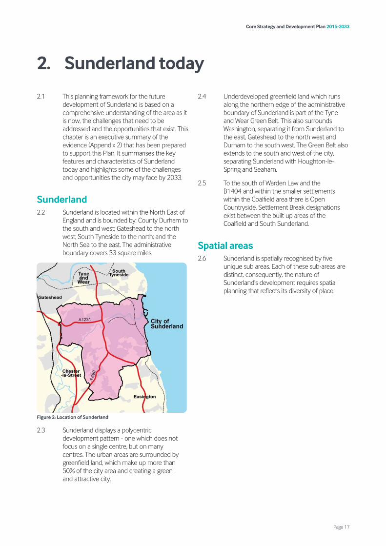
Sunderland 2.2 Sunderland is located within the North East of
England and is bounded by: County Durham to the south and west; Gateshead to the north west; South Tyneside to the north; and the North Sea to the east. The administrative boundary covers 53 square miles.
Figure 2: Location of Sunderland
2.3 Sunderland displays a polycentric development pattern - one which does not focus on a single centre, but on many centres. The urban areas are surrounded by greenfield land, which make up more than 50% of the city area and creating a green and attractive city.
2.4 Underdeveloped greenfield land which runs along the northern edge of the administrative boundary of Sunderland is part of the Tyne and Wear Green Belt. This also surrounds Washington, separating it from Sunderland to the east, Gateshead to the north west and Durham to the south west. The Green Belt also extends to the south and west of the city, separating Sunderland with Houghton-le-Spring and Seaham.
2.5 To the south of Warden Law and the B1404 and within the smaller settlements within the Coalfield area there is Open Countryside. Settlement Break designations exist between the built up areas of the Coalfield and South Sunderland.
Spatial areas 2.6 Sunderland is spatially recognised by five
unique sub areas. Each of these sub-areas are distinct, consequently, the nature of Sunderland’s development requires spatial planning that reflects its diversity of place.
Core Strategy and Development Plan 2015-2033
Page 17
2. Sunderland today

The Urban Core
Figure 3: The Urban Core
2.7 The Urban Core is the main administrative centre of the city and includes wide diversity such as the city centre, both campuses of the University of Sunderland and a number of key leisure and tourism facilities, including the Stadium of Light, the Empire Theatre, the Aquatics Centre and the Beacon of Light. The Urban Core is a heavily urbanised area close to the mouth of the River Wear covering an area of approximately 180 hectares.
2.8 The Urban Core is a highly accessible location with a transport interchange located at Park Lane providing access to a range of bus routes and metro services to Gateshead, Newcastle and Newcastle Airport. The Urban Core also contains Sunderland Station which provides rail connections to Newcastle, Carlisle and Teesside, in addition to Grand Central Services which provide connectivity to York and London.
2.9 Due to its wide diversity of uses, the Urban Core contains a relatively modest population base of approximately 3,200 residents.
Washington
Figure 4: Washington
2.10 Washington is a highly sustainable location, with excellent transport links to the city centre, Durham, Gateshead, Newcastle and significant job opportunities at the IAMP, Follingsby Park and within Washington.
2.11 Washington is a planned New Town with a population of circa 65,000 people. It accommodates a main town centre at The Galleries, a district centre at Concord and a series of smaller village centres. It is a principal location for jobs and continues to have the strongest employment market within the city. Washington is also typified by having large amounts of greenspace, parkland and tree cover.
2.12 Washington has an estimated 25,000 dwellings which equates to nearly 20% of the housing stock in Sunderland. The development of additional homes in this area has been constrained by Green Belt on all sides as well as the lack of available urban sites for development. During the period 2007 to 2015, only 652 homes or 93 homes per annum were built in the Washington area. The latest Strategic Housing Land Availability Assessment (SHLAA) identifies land available to accommodate only 951 homes on 13 sites during the plan period. This equates to 9% of the total land supply in Sunderland.
Core Strategy and Development Plan 2015-2033
Page 18
South Sunderland
Figure 5: South Sunderland
2.13 The South Sunderland sub-area covers an area of 4,284 hectares and is the most populated sub-area of the city, with a population of 116,000. It is bounded by Green Belt to the south and west, coastline to the east and the River Wear to the north.
2.14 Although South Sunderland is oriented towards the city centre, the sub-area is also served by a number of district and local centres. It incorporates the Port of Sunderland and Doxford International as well as other key employment centres along the riverside, A19 and towards the coast.
2.15 South Sunderland is a popular residential area. The area contains the largest proportion of the city’s housing stock and contains 43% of all deliverable and developable housing sites within the SHLAA, including the South Sunderland Growth Area (SSGA), which will constitute the largest urban extension in the city over the plan period.
2.16 Despite being the most densely developed sub-area, the area contains a range of built and natural features which add to its character. The area has a distinct urban history and rich architectural heritage.
North Sunderland
Figure 6: North Sunderland
2.17 The Sunderland North sub-area is highly urbanised with just over 55,100 residents and limited opportunities for development. It is bounded by Green Belt to the north, coastline to the east, the A19 to the west and River Wear to the south.
2.18 Like South Sunderland, the sub-area is also oriented towards the city centre but it is also served by strong district centres at Southwick, Sea Road and Monkwearmouth, together with local centres further west. It incorporates a number of primary and key employment areas along the riverside/A1231 corridor and A19.
2.19 In recent years, housing regeneration has taken place that has delivered an increased choice of tenure and an improved quality and mix of homes. The highly developed nature of the sub-area means that new residential development opportunities will remain limited, but further urban regeneration will take place.
2.20 Greenspace in North Sunderland is limited in places, but further improvements will take place to further enhance the quality and accessibility of parkland, riverside and coast.
Core Strategy and Development Plan 2015-2033
Page 19
The Coalfield
Figure 7: The Coalfield
2.21 The Coalfield is the largest of the sub-areas in the city by area, covering over 5,500 hectares, approximately 42% of the city. It is made up of a number of former mining towns and villages that include Houghton-le-Spring and Hetton-le-Hole. It is the least densely populated of the sub-areas with some 46,000 residents (17% of the city’s population). It is bounded by Green Belt to the north, west and east, with open countryside surrounding the south, which extends into County Durham.
2.22 Houghton-le-Spring Town Centre serves as the principal centre in the Coalfield, with separate centres in Hetton-le-Hole to the south and Shiney Row to the north.
2.23 The principal employment area in the Coalfield is Rainton Bridge Industrial Estate and the area is also served by 4 smaller key employment areas. A key issue for Coalfield residents is the need for improved public transport connections to employment opportunities elsewhere in the city.
2.24 The Coalfield has been the focus for new housing and housing regeneration over the past 20 years and will remain so within the plan period. However, supporting infrastructure is being increasingly impacted upon and will need significant investment.
2.25 Although some greenfield land has been lost to development in recent years, the sub-area retains some of the highest levels of greenspace in the city. This has been increased in recent decades by reclamation of former industrial land and the creation of high quality country parks.
Population of Sunderland 2.26 It is estimated that Sunderland has a
population of 277,9621 (as shown in Figure 8). Following decades of population decline, population is growing and it is expected to continue to grow over the plan period.
Figure 8: Population change within Sunderland
2.27 Our population is also changing. Over recent decades Sunderland has experienced a trend of net out- migration to surrounding neighbouring authorities and other parts of the UK. Between 2002 and 2012 the net out-migration from the city averaged -1,119 people per annum. This has been particularly pronounced within the younger age cohorts of the working age population.
2.28 However, more recent evidence demonstrates that this trend is changing and the net out-migration has been reducing significantly averaging -625 over the 5 year period (2011-2016).
2.29 Projections also estimate that the population of Sunderland is ageing. Population projections estimate that the number of people aged 65
1 ONS 2016 Mid-Year Population Estimate
260,000
1981
1983
1985
1987
1989
1991
1993
1995
1997
1999
2001
2003
2005
2007
2009
2011
2015
265,000
270,000
275,000
280,000
285,000
290,000
295,000
300,000
305,000
Year
Popu
lati
on
Core Strategy and Development Plan 2015-2033
Page 20
or over will increase by 36.8% by 2033. The ageing population of the city, combined with a net out-migration of residents, has led to a reduction in the number of working age residents living within the city. ONS Mid-Year Population Estimates show that, between 2000 and 2012, the size of the working age population in the city declined by 2.7%. Without intervention the working age population would likely shrink further. This means that commuting rates to the city would likely need to increase to support jobs growth in Sunderland.
Figure 9: Job growth and working age population change (2000-2012)2
2.30 Ethnic diversity in the city is relatively low, with 95.8% of the city’s population describing themselves as ‘White British’3. The largest minority groups within the city are ‘Asian/Asian British’ and ‘White Other’ with 1.8% and 1.1% of the population respectively describing themselves as falling within these ethnic groups.
2.31 The proportion of the Sunderland population with higher level qualifications (NVQ4 or above) is just 27.3%, which is lower than both the regional and national figures4. Despite this, the proportion of the population with higher level qualifications has increased significantly in Sunderland in recent years. The proportion of the population with no qualifications has also reduced noticeably and now stands at just 8.6%, which is lower than the regional average.
Healthy safe communities 2.32 Residents of Sunderland generally experience
a higher level of social and economic disadvantage than the England average and there is a strong link between high levels of socio-economic disadvantage and poor health. The 2015 Indices of Deprivation ranked Sunderland as the 37th most deprived local authority out of the 326 local authority areas in England. Whilst the average life expectancy at birth has improved, Sunderland continues to lag behind and residents live, on average, shorter lives than the England average5. They also live, on average, a greater part of their lives with illness or disability which limits their daily activities.
2.33 Unhealthy lifestyles remain a key cause for our increased rates of premature death. Many people in Sunderland continue to follow unhealthy lifestyle behaviours when compared with England as a whole6. This is directly linked to a range of social, economic and environmental factors. Childhood obesity rates within the city are higher than the national average with 24% of Year 6 children being classified as obese when compared to the national average of 19.8%7.
2.34 We have a relatively high number of hot food takeaways, with 17 of the 25 wards within the city having a higher concentration of hot food takeaways per head of population than the national average8.
Homes 2.35 Housing plays a fundamental role in
supporting the health and wellbeing of its residents and it is vital to ensure more housing choice is available to support the needs of our residents.
2.36 We currently have approximately 126,000 dwellings, with the vast majority of these being houses (76.7%)9. The remaining housing stock comprises of 12.1% flats and maisonettes,
2 Sunderland Employment Land Review (2016)3 Census 20114 ONS Annual Population Survey 2016
5 Life expectancy at birth and at age 65 by local areas in England and Wales, 1991-93 to 2012-14
6 Local Alcohol Profiles for England. Local Authority Indicators for Crime and Consumption (Updated September 2014). Public Health England: September 2014; 2012 Lifestyle Survey for Gateshead, South Tyneside and Sunderland. NHS South of Tyne and Wear
7 Public Health England: Sunderland Health Profile 20178 Public Health England: Density of Fast Food Outlets (2016)9 Sunderland SHMA Update (2017)
Core Strategy and Development Plan 2015-2033
Page 21
10.5% bungalows, with the remaining 0.7% being other types of property including park homes and caravans.
2.37 The Strategic Housing Market Assessment Update (SHMA) indicates that the median house price within the city was just £107,000 based on Land Registry data from 2014, making the city the second lowest authority in terms of house prices within the North East of England (Figure 10). Sunderland has a disproportionate supply of lower Council Tax banded properties, with over 61% of dwellings falling within Council Tax band A (Figure 11).
Figure 10: Median house prices
Figure 11: Sunderland Council Tax
2.38 The vast majority of dwellings are 2 and 3 bedroom properties (76%), which is a notably higher proportion when compared to other areas. As identified in the SHMA, there is a shortage of 3 and 4 bedroom houses to meet families’ needs, bungalows and other accommodation to meet older person’s needs.
2.39 Within the city there are a number of empty properties, whilst most of these are short term in nature, there is a relatively small number of long-term empty properties (over 6 months), approximately 2% of the city’s housing stock. The council continues to assist in bringing empty properties back into use.
2.40 There continues to be a demand for affordable housing units across the city. Particularly with the impact of welfare reform where there is an increased demand from young people, families, vulnerable people and older people. The SHMA identifies an imbalance of 542 affordable units (both for affordable rent and affordable home ownership) per annum over the next 5 years.
2.41 There are some neighbourhoods that are not as prosperous as others, have a lack of good quality housing, poor physical environments and have higher levels of crime and anti-social behaviour. There are some places in the city already showing symptoms of housing decline and anti-social behaviour: these are most prevalent in parts of Hendon, Sulgrave, Millfield, Pallion, Eden Vale, Silksworth, Hetton Downs and other pockets of the Coalfield area10.
2.42 The city has a resident student population, due to the presence of the University of Sunderland, which is spread across two campuses. The University of Sunderland has over 9,000 full-time students enrolled11.
2.43 Student numbers may rise over the plan period due to demographic shift and the University’s intention to target students in its key growth areas and those of the region, namely health sciences and wellbeing, advanced manufacturing, engineering and computing software and big data.
2.44 The expectations of some students for better quality, self-contained accommodation has seen an increase in new, purpose-built student accommodation within the city over recent years. It is recognised however, that there is not always a linear relationship between increasing student numbers and demand for student residential accommodation, given the local demographic of students attending the University of Sunderland.
10 Sunderland Private Housing Condition Survey (2014)11 Information provided by University of Sunderland
0
50,000
250,000
200,000
150,000
100,000
Sunderland North East Great Britain
2000
2001
2002
2003
2004
2005
2006
2007
2008
2009
2010
2011
2012
2013
2014
2015
Band A
Band B
Band C
Band D
Band E
Band F
Band G
Core Strategy and Development Plan 2015-2033
Page 22

2.45 Sunderland has an established community of Travelling Showpeople with a total of 100 plots on four sites, mainly within the Coalfield area (1 small site in Washington).
2.46 The city does encounter unauthorised encampments by Gypsies and Travellers, however these are small and temporary in nature with Gypsies and Travellers passing through the city and not wanting to live here permanently.
2.47 In terms of delivering new homes, Sunderland has recently experienced higher delivery than a decade ago as illustrated in Figure 12. This is in part due to the amount of demolitions between 2000 and 2013 and the recession. However, this trend during the past five years has started to change, with an average net additional dwellings completion of 817 per year.
Figure 12: Housing delivery
2.48 Historically, we have been very successful at developing previously developed land. In fact, between 1995 and 2019, 82% of new housing development in Sunderland was built on previously developed land (PDL) (brownfield) (see Figure 13).
Figure 13: Proportion of housing completions on previously developed land
2.49 The council’s latest SHLAA identifies only 41% of new homes will be delivered on brownfield land. This is because the supply of brownfield sites that is considered to be deliverable is considered to be relatively low. This is in part due to viability. The council’s Viability Assessment concluded that Sunderland has challenging areas and previously developed land will be difficult to deliver and therefore sites in the Urban Core should not be heavily relied upon in the housing supply.
2.50 The spatial distribution of housing supply in recent years varies across the city. For example, between 2008 and 2019, 34% of housing completions in the city were in the Coalfield, sub-area compared to 14% in the Washington sub-area. Consequently, the Coalfield settlements have become particularly saturated with housing development and increasingly, infrastructure including the road network and school capacity has been put under pressure. On the other hand, other parts of city such as Washington and Sunderland North have experienced lower levels of housing growth, in part, due to the lack of available sites for development and these areas being tightly surrounded by Green Belt.
1,000
800
600
400
200
0
-200
-400
-600
-800
Demolitions
Dwellings gained
New Build
Dwellings lost Net Gain
2000
-200
1
2001
-200
2
2002
-200
3
2003
-200
4
2004
-200
5
2005
-200
6
2006
-200
7
2007
-200
8
2008
-200
9
2009
-201
0
2010
-201
1
2011
-201
2
2012
-201
3
2013
-201
4
2014
-201
5
2015
-201
6
2016
-201
7
2017
-201
8
2018
-201
9
95/9696/9797/9898/99
00/0199/00
01/0202/0303/0404/0505/0606/0707/0808/0909/1010/1111/1212/1313/1414/1515/16
17/1816/17
% of new homes on previously developed land (Brownfield)
% of new homes on previously developed land (Greenfield)
0% 10% 20% 30% 40% 50% 60% 70% 80% 90% 100%
Core Strategy and Development Plan 2015-2033
Page 23
2.51 Table 1 below illustrates the expected distribution of housing growth across the city during the plan period based on the SHLAA.
Table 1: Housing distribution (SHLAA 2018)
Economic growth 2.52 We have a strong track record of attracting
investment and growth directly into the city, as well as benefitting from being ideally placed in terms of the wider regional economy.
2.53 Experian data suggests that there were 130,150 workforce jobs registered in Q1 of 2015, representing an increase of 9,630 jobs (8%) compared to 1997. Despite this, unemployment within the city remains at 6.3%, compared to the regional average of 6.2% and the national average of 4.4%. 12
Figure 14: Workforce jobs
2.54 Key sectors that have experienced strong employment growth over the last 15 years include health & care, utilities, food & finance, accommodation and insurance & pensions. The business base accommodates a slightly lower share of smaller firms and a higher share of larger firms compared with regional and national averages. It is also characterised by relatively low levels of business start-ups and self-employment.
2.55 Advanced manufacturing and particularly the automotive sector are a key part of the local economy, centred around the Nissan plant, which produces more than 500,000 vehicles a year and supports a thriving supply chain extending along the A19 and A1 corridors. The sector employs 30,000 people regionally. To support the continued growth of this sector, the IAMP will be developed on land to the north of the existing Nissan plant. It is anticipated that the IAMP would create approximately 7,850 new jobs and would be a significant driver for the regional economy and the automotive sector within the UK.
2.56 Workplace wages also exceed resident wages, indicating that the types of jobs available locally are well paid, however many of these are filled by workers who live outside of the administrative boundaries of Sunderland. As a result, Sunderland is a net importer of labour, with a net inflow in the order of 5,670 workers each day 13. Over the last ten years, the city’s self-containment rate has reduced by 3%, as a
12 ONS Annual Population Survey 2016 13 Experian (2011) Workforce jobs
Sub
area
0-5
year
s (2
018-
2023
)
6-10
yea
rs (2
023-
2028
)
11-1
5 ye
ars
(202
8-20
33)
Tota
l
%Coalfield 1,491 1,107 535 3,133 30%
Sunderland North
785 214 227 1,226 12%
Sunderland South
1,467 1,702 1,350 4,519 43%
Urban Core 216 363 151 730 7%
Washington 353 448 150 951 9%
Total City Area
4,312 3,834 2,413 10,559 100%
0
1997
1998
1999
2000
2001
2002
2003
2004
2005
2006
2007
2008
2009
2010
2011
2012
2013
2014
2015
2016
2017
20
40
60
80
100
120
140
160
Core Strategy and Development Plan 2015-2033
Page 24
result of jobs growth outstripping growth in the working age population. Census data also points to a slight skills mismatch, with in-commuters more likely to be employed within higher skilled occupations.
2.57 We have a wide range of existing industrial estates and business parks. The employment land requirements for the period 2015 to 2033 have been calculated to be between 95ha to 115ha. There are significant variations in supply within the different sub-areas (as shown in Table 2). Washington continues to experience the strongest demand for industrial development.
Table 2: Supply of available employment land14
2.58 Office development historically has been focussed within the Urban Core and town centres. However, over recent decades there has been a significant shift in the location of offices, with more choosing to locate to out-of-centre facilities on purpose-built business parks. This trend has been particularly pronounced within Sunderland, with the creation of new business parks at Doxford International, Hylton Riverside and Rainton Bridge. Business parks have been the primary focus for office development over the past couple of decades.
2.59 There are three main centres in Sunderland. The Urban Core (which contains the city centre retail boundary) is the main location for shopping with 99,990sqm15 of floorspace. Washington Centre contains 58,000sqm16 of
floorspace and has a wide range of shops and facilities, including a leisure centre, two large supermarkets and a number of national multiple retailers. While Houghton Town Centre is much smaller in scale, it remains the main centre within the Coalfield area and includes a number of shops and services including a library, sports centre and health centre. There are also a number of other district and local centres throughout the city, which are important in meeting the day-to-day needs of their local residents.
2.60 The amount of market share and revenue of the city centre has declined over recent years. The council’s Retail Needs Assessment (2016) indicates that the comparison retail revenue of the city centre has declined from £335m in 2008 to £272m by 2016, which represents a 19% fall. This is a national trend and partly due to changing shopping habits, such as the growth of out-of-centre retail and online retailing, but also due to increased competition between centres.
2.61 The number and concentration of hot food takeaways within the city is becoming an increasing concern, not only in relation to health, but also due to the adverse impact that an over concentration of such uses can have on the vitality and viability of designated centres, whilst also changing the overall retail character of designated centres and reducing the diversity of uses. Many hot food takeaways are only open during evening hours resulting in inactive frontages during normal daytime trading hours, which can have an adverse impact on the vitality and general attractiveness of shopping centres.
2.62 Sunderland’s cultural and leisure offer is extensive and varied, including two high quality beach resorts, accessible open spaces, leisure centres, a dry ski slope, the only 50m Olympic-sized swimming pool in the North East, Sunderland AFC football stadium, the Empire Theatre, a cinema, plus many music venues, restaurants and bars. In addition, Sunderland plays host to a number of events throughout the year including the annual International Air Show.
14 Sunderland Employment Land Review 201615 Experian Goad Survey September 2015 16 Experian Goad Survey September 2015
Sub-area Available land (ha)
Employment Mixed use
Total
Washington 46.8 0 46.8
Sunderland North
2 1.5 3.5
Sunderland South
45.31 6.92 52.23
Coalfield 28.34 0 28.34
Total 122.44 8.42 130.86
Core Strategy and Development Plan 2015-2033
Page 25
Built and historic environment 2.63 Sunderland contains a wide range of heritage
assets, including nine Scheduled Ancient Monuments and 692 listed buildings. Sunderland has a strong historical heritage with iconic structures within the city, such as Fulwell Mill, Hylton Castle, Penshaw Monument and St Peter’s Church, together with quality townscapes, including 14 conservation areas that are protected throughout the city.
2.64 There are 9 Scheduled Ancient Monuments or Grade I and II* Listed Buildings and 2 conservation areas on Historic England’s At-Risk Register in 2015. These include the Old Sunderland and Old Sunderland Riverside Conservation Areas, Bowes Railway Museum, Hylton Castle, Doxford House and Monkwearmouth Station Museum. In addition, there are numerous Grade II Listed Buildings and non-designated heritage assets across the city, the condition and vacancy of which also places them at risk.
Natural environment 2.65 The natural environment is one of our greatest
assets and includes a network of identified wildlife and geological sites as well as priority species and habitats which in turn contributes to our economy, our health and wellbeing whilst enriching our lives. Designated sites in the city comprise:
• International – 1 Special Area of Conservation (SAC), 1 Special Protection Area (SPA) and 1 RAMSAR;
• National – 17 Sites of Special Scientific Interest, 5 Local Nature Reserves; and
• Local – 6 Local Geological Sites, 63 Local Wildlife Sites and 14 proposed Local Wildlife Sites.
2.66 Our natural environment is highly diverse, offering coastal, riverside and limestone landscapes, interspersed with a rich heritage. There are two National Character Area classifications; namely the Tyne and Wear Lowlands and the Durham Magnesian Limestone Plateau. Due to the Magnesian Limestone geology of the city and association with the North Sea coast and River Wear estuary, Sunderland has many sites of botanical interest and a variety of habitats of value to wildlife.
2.67 Whilst Sunderland forms part of the Tyne and Wear conurbation, it benefits from wide green infrastructure corridors to the north, west and south of the main built-up area, as well as Open Countryside to the west and east of Houghton and Hetton and a green corridor along the River Wear that runs through the heart of the city. There are more than 3,800 hectares of formal and natural greenspace, including 42 parks. Approximately half of the city’s residents can reach a quality natural greenspace within 300m of their homes.
Waste, water and energy 2.68 The main rivers in the city are the River Wear,
which flows north-eastwards to the sea at Sunderland, the River Don which flows along the northern council boundary and the Lumley Park Burn/Hetton Burn, which is a westward draining tributary of the Wear. The topography of the area is characterised by the River Wear valley in the north and east of the city.
2.69 There are 5 Critical Drainage Areas identified within the city, which are areas that the Environment Agency (EA) has identified as having notable flood risk and drainage problems. In these locations, there is a need for surface water to be managed to a higher standard than normal to ensure that any new development will contribute to a reduction in the risk of flooding. These higher standards are determined by the Environment Agency.
2.70 The city’s drinking supply emanates from a combination of reservoirs, treatment works and boreholes, including the Magnesian Limestone aquifer, which lies beneath the eastern part of the city and is protected through source protection zones.
2.71 Sunderland is well served by waste infrastructure and is net self-sufficient in the management of waste. The area has significant built waste management capacity which provides for the needs of Sunderland and a number of other authorities across the North East region.
2.72 Local authority waste is managed under the South Tyne and Wear Waste Management Partnership (STWWMP) which is a collaboration between Sunderland, Gateshead and South Tyneside Councils and covers the management of this waste for the duration of the plan period.
Core Strategy and Development Plan 2015-2033
Page 26
Sustainable transport 2.73 Sunderland benefits from good public
transport infrastructure, with a comprehensive network of bus routes, whilst the Tyne and Wear Metro provides frequent services connecting to destinations throughout Tyne and Wear. In terms of rail access, Sunderland has a train station providing frequent links (up to eight trains an hour including both Northern Rail and Metro services) to Newcastle Central Station, from where East Coast Mainline services can be accessed. Grand Central provides a direct rail service (five times a day) to York and London from Sunderland Station.
2.74 Key road connections include:
• The A19 – a key strategic route connecting to North Tyneside, Northumberland and the A1 in the north and to Teesside and North Yorkshire in the south;
• The A183 – running east to west and connecting Sunderland to Chester-le-Street and the A1;
• The A1018 – running south from the Urban Core to Seaham and the A19;
• The A182 – running south and south-east from Washington to Houghton-le-Spring, County Durham and the A19;
• The A690 – running north east to south west and connecting Sunderland to Durham and the A1; and
• The A1231 – running east to west and connecting Sunderland to the A1 and the A19.
2.75 Recent improvement schemes have been implemented at key junctions along the A19 to improve connectivity and the council is bringing forward the Sunderland Strategic Transport Corridor, which will improve connectivity to the sites along the southern edge of the River Wear, the city centre and the Port. Improvements are also proposed at the Downhill junction to support the proposed IAMP.
2.76 The majority of journeys within Sunderland continue to be made by private car, however bus and metro patronage is strong and growing. Bus travel is the most commonly used form of public transport, representing approximately 75% of journeys made by public
transport. This reflects the lack of rail and metro services in most of the city. There are over 150km of dedicated cycle routes in Sunderland, with more than 80km off-road. There are also three routes on the National Cycle Network which pass through the city; with sections of National Cycle Routes 1, 7 and 70.
Minerals 2.77 Sunderland possesses a variety of valuable
mineral resources which play a part in meeting local, regional and national requirements. Sunderland currently has one operational quarry at Eppleton Quarry, Hetton-le-Hole, which is extracting Permian yellow sand and Magnesian Limestone. The limestone is crushed before sale for use as roadstone and fill. Magnesian Limestone from the area is also used for agricultural purposes. There are also surface coal resources present across roughly the western half of Sunderland, although coal is no longer extracted.
2.78 Sunderland is reliant on imports of minerals from authorities within the North East and further afield. The need for aggregates for built development is addressed through the Local Aggregate Assessment which is prepared jointly with the 8 North East Mineral Planning Authorities (MPAs). The Local Aggregates Assessment (LAA) has identified that the Tyne and Wear authorities jointly do not provide sufficient minerals to meet their needs, and resources will be depleted during the plan period. Sunderland is the main contributor to the supply of aggregates in Tyne and Wear and an extension to Eppleton Quarry will assist in meeting future needs.
Core Strategy and Development Plan 2015-2033
Page 27

Vision, strategic priorities and spatial strategy
3.1 To enable Sunderland to take hold of the opportunities available to it and address the strategic challenges outlined in the previous chapter, this Plan sets out a spatial vision for Sunderland by 2033. This vision describes where the city wants to be by 2033 and has been influenced by a number of other council plans and strategies and their visions including:
Sunderland Economic Masterplan
Aim 1: A new kind of University City
Aim 2: A national hub of the low carbon economy
Aim 3: A connected waterfront city centre
Aim 4: A whole-life, inclusive city economy
Aim 5: Entrepreneurial in economic leadership
Sunderland Housing Strategy
Our vision is for a greater choice of good quality homes which meet the needs and the aspirations of our residents, so individually and as a city we can grow and prosper. These homes will be based in thriving neighbourhoods where everyone feels part of their community.
Sunderland City Council’s Corporate Plan
“Sunderland will be a welcoming, internationally recognised city where people have the opportunity to fulfil their aspirations for a healthy, safe and prosperous future”.
Sunderland Transforming our City: The 3,6,9 Vision
By 2024, Sunderland will deliver:
• over £1bn of investment into the city’s infrastructure and industrial assets;
• about 20,000 new jobs created across a range of sectors, increasing the city’s productivity and reducing unemployment levels;
• a more vibrant and attractive city with more happening in terms of events, entertainment and culture; and
• a significant increase in our levels of education and skills.
A Housing Strategy forSunderland 2017-2022Growth, choice, quality
Corporate Plan 2016-2020
1
June
201
7
Core Strategy and Development Plan 2015-2033
Page 31
3. Spatial vision and strategic priorities

City Plan - Sunderland 2019-2030
By 3030 “Sunderland will be a connected, international city with opportunities for all”
Spatial vision 3.2 Sunderland’s Local Plan is the spatial
manifestation of the wider ambitions and goals of the council and its partners. Through the implementation of the policies in the Local Plan the council will guide investment and development to 2033 and will deliver the following vision to continue the sustainable growth of Sunderland.
Strategic priorities 3.3 To assist in the delivery of this vision, the
following strategic priorities have been identified:
SUNDERLAND 2019-2030
Spatial Vision 2033
By 2033, Sunderland will be a place that:
• has a population in the order of 290,000 people;
• increased the working age population;
• is healthy, safe and prosperous, where people have the opportunity to fulfil their aspirations;
• is more socially, economically and environmentally sustainable;
• has improved its social infrastructure, with additional healthcare, education and community facilities;
• has easy access to useable open space, leisure and recreation;
• has vibrant, well supported, town, district and local centres that are places to meet as well as shop;
• offers a mix of good quality housing, both market and affordable of the types, sizes and tenures that meet the needs and demands of existing and future communities;
• offers residents the opportunity to live in sustainable communities accommodating all ages and abilities;
• has a Urban Core that is revitalised and has become a destination of choice, a place for people to live, work and spend their leisure time;
• is open to business and is responsive to the changing needs and demands of our growing economy;
• is vibrant and growing with excellent access to a range of job opportunities for all ages, abilities and skills;
• is entrepreneurial, a University City at the heart of a low carbon regional economy;
• which creates new and diverse job opportunities particularly in advanced manufacturing;
• values the University of Sunderland and Sunderland College who play a vital role in attracting the best minds and ensuring a skilled workforce that choose to live here;
• has a high quality natural, built and historic environment;
• has a network of green infrastructure, supporting and protecting our biodiversity and wildlife, whilst also improving access to greenspace for all;
• is resilient to climate change, has maximised the opportunities for renewable energy, embraced sustainable design principles and has reduced the impacts of flooding on homes and businesses; and
• has excellent transport links and sustainable access for visitors, business and residents.
Core Strategy and Development Plan 2015-2033
Page 32

Core Strategy and Development Plan 2015-2033
Page 33
Theme Strategic priority Policy
Spatial strategy Strategic priority 1 To deliver sustainable economic growth and to meet objectively assessed needs for employment and housing, in particular through providing opportunities for young economically active age groups and graduates.
SP1, SP2, SS1, SP3, SS2, SS3, SS4, SS5, SS6, SS7, SP7, SP8, H1, H2, H3, H4, H6, EG1, EG2, EG4, EG5, VC1, VC5, WWE6, WWE7, SP11
Strategic priority 2 To identify land we need for development in the right locations so we can protect our most vulnerable assets and while ensuring we meet our sustainable growth ambitions.
SP1, SP2, SS1, SP3, SS2, SS3, SP4, SS4, SP5, SS5, SS6, SP6, SS7, SP8, H1, H2, H3, H4, H6, EG1, EG2, EG3, EG4, EG5, VC1, VC3, VC4, NE1, NE2, NE4, NE6, NE7, NE8, NE9, NE11, NE12, WWE6, WWE7, WWE8, WWE9, SP11, M1
Healthy and safe communities
Strategic priority 3 To promote healthy lifestyles and ensuring the development of safe and inclusive communities, with facilities to meet daily needs that encourage social interaction and improve health & wellbeing for all.
SP1, SP2, SP3, SP4, SP7, HS1, HS3, HS4, H1, VC1, VC4, VC5, BH1, BH2, NE1, NE4, NE6, NE8, WWE1, WWE2, WWE3, WWE4, WWE10, SP10, ST1, ST3, ID1, ID2
Homes Strategic priority 4 To provide a range and choice of accommodation, house types and tenures to meet the diverse needs of current and future residents.
SP1, SP2, SS1, SP3, SS2, SS3, SP4, SS4, SP5, SS6, SP6, SS7, SP7, SP8, H1, H2, H3, H4, H5, H6, H7, SP11
Economic growth
Strategic priority 5 To provide a wide portfolio of employment sites to support the development of key employment sectors and expand the opportunities for new office development..
SP1, SP2, SS1, SP3, SP4, SS5, SP5, SP6, EG1, EG2, EG3, EG4, EG5, EG6, SP11
Vitality of centres
Strategic priority 6 To support and improve the vitality and economic performance of the Urban Core and designated centres.
SP1, SP2, SS1, SP3, SP6, EG5, VC1, SP9, VC2, VC3, VC4
Built and historic environment
Strategic priority 7 To protect, sustain and enhance the quality of our built and historic environment and the delivery of distinctive and attractive places.
SP2, VC1, BH1, BH3, BH7, BH8, ID1, ID2
Natural environment
Strategic priority 8 To protect and enhance the city’s biodiversity, geological resource, countryside and landscapes whilst ensuring that all homes have good access to a range of interlinked green infrastructure.
SP1, SP5, SS6, SP6, BH1, BH2, NE1, NE2, NE3, NE4, NE6, NE7, NE8, NE9, NE10, NE11, NE12, WWE2, WWE4, WWE5, M4, ID1, ID2
Water, waste and energy
Strategic priority 9 To adapt to and minimise the impact of climate change by reducing carbon emissions, maximising the use of low carbon energy solutions and seeking to reduce the risk/impact of flooding.
BH1, BH2, NE1, WWE1, WWE2, WWE3, WWE4, WWE5, WWE10
Strategic priority 10 To manage waste as a resource and minimise the amount produced and sent to landfill.
WWE5, WWE6, WWE7, WWE8, WWE9, WWE10
Sustainable transport
Strategic priority 11 To promote sustainable and active travel and seek to improve transport infrastructure to ensure efficient, sustainable access.
SS5, SS6, SP10, ST1, ST2, ST3, ID1, ID2
Minerals Strategic priority 12 To manage the city’s mineral resources ensuring the maintenance of appropriate reserves to meet needs.
SP11, M1, M2, M3
Infrastructures Strategic priority 13 To ensure that the city has the infrastructure in place to support its future growth and prosperity.
ID1, ID2
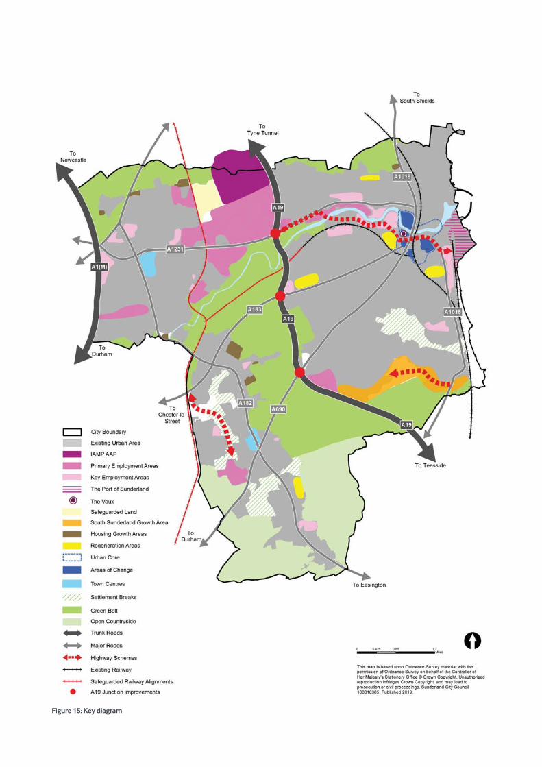
Figure 15: Key diagram
4.1 The underlying principle of national policy is to deliver sustainable development to secure a better quality of life for everyone now and for future generations. All the policies within this Plan contribute towards achieving sustainable development.
4.2 Sustainable development is considered to be the golden thread running through this Plan. For the purposes of this Plan, the definition of sustainable development is contained in the National Planning Policy Framework (NPPF). The NPPF emphasises the economic, social and environmental roles which the planning system must perform in order that sustainable development can be delivered. The three roles cannot be undertaken in isolation as they are mutually dependent and this Plan will seek to ensure that these roles are sought jointly and concurrently wherever possible. This Plan will positively seek opportunities to meet the development needs of Sunderland unless the adverse impacts of doing so would significantly and demonstrably outweigh the benefits.
4.3 This Plan seeks to provide a flexible policy framework to remove obstacles where appropriate and encourage sustainable development. The Plan should be read as whole and all policies taken into consideration if relevant.
4.4 Climate change is recognised as one of the most significant threats facing the 21st Century and as such, there are unprecedented challenges to the environment, economy and the future security of energy. Sunderland Partnership and the council recognise that climate change is one of the greatest environmental challenges and the Climate Change Action Plan sets out how the city is going to reduce its energy consumption, emissions of carbon dioxide (CO2) and other greenhouse gases, which are known to be the main cause of climate change. The spatial strategy and all policies in the Plan will seek to reduce the impacts of climate change.
4.5 This spatial strategy chapter sets out policies for the overall strategy for development, growth and investment in Sunderland to 2033. It also contains policies for each of the spatial
sub- areas, for strategic allocations and it identifies locations where development should take place in order to create sustainable neighbourhoods and deliver our vision and objectives. This strategy is based on a number of considerations:
• national planning policy;
• this Plan’s Strategic Priorities and Vision;
• our environmental constraints; and
• the availability and viability of land for development.
4.6 Each of the allocations in this Plan has been subject to a Sustainability Appraisal (SA) as detailed within the SA report.
4.7 The Key Diagram (Figure 15) illustrates the spatial policies contained in this Plan.
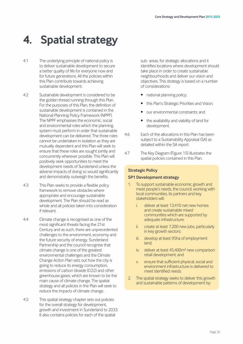
Strategic Policy
SP1 Development strategy
1. To support sustainable economic growth and meet people’s needs, the council, working with local communities, its partners and key stakeholders will:
i. deliver at least 13,410 net new homes and create sustainable mixed communities which are supported by adequate infrastructure;
ii. create at least 7,200 new jobs, particularly in key growth sectors;
iii. develop at least 95ha of employment land;
iv. deliver at least 45,400m² new comparison retail development; and
v. ensure that sufficient physical, social and environment infrastructure is delivered to meet identified needs.
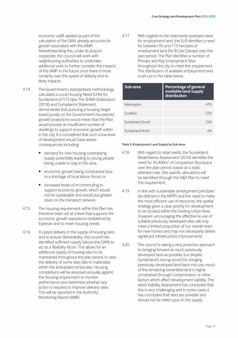
2. The spatial strategy seeks to deliver this growth and sustainable patterns of development by:
Core Strategy and Development Plan 2015-2033
Page 35
4. Spatial strategy
4.8 In order to meet identified development needs, the development strategy sets out the scale and distribution of new development for the plan period up to 2033.
4.9 Through the spatial strategy, the Plan seeks to enable sustainable economic growth. By 2033, it is the aim of the strategy to ensure that the city offers the right type of new homes in the right places and creates opportunities for job growth. The strategy seeks to align economic growth in the city with the housing offer, to ensure that past trends of out-migration are rebalanced. This will ensure the sustainability of our area in the future as a place to both live and work.
4.10 As required by the NPPF, this Plan must define the overall level of growth over the plan period (2015 to 2033), based on the requirement to meet the city’s objectively assessed needs (OAN). Determining the OAN for housing has been assisted by the SHMA17. The SHMA has
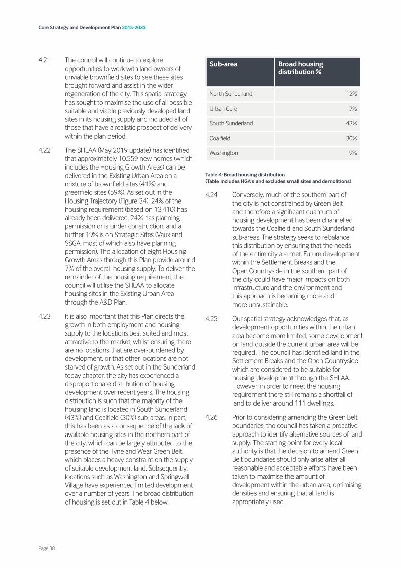
identified the OAN for housing in Sunderland to be an average of 745 net additional dwellings per annum (dpa) each year, equating to a total housing requirement of at least 13,410 net additional dwellings over the plan period. The 13,410 net dwellings figure should not be seen as a ceiling, but rather the level of growth which is both needed and anticipated to take place over the plan period.
4.11 In accordance with Planning Practice Guidance (PPG) paragraph 2a-018, the OAN includes an economic uplift. When calculating an authority’s OAN, the local planning authority should consider and assess the likely change in the number of jobs over the plan period based on an economic forecast. The Experian jobs growth forecast, which was utilised for the demographic modelling work within this Plan, assumes a total of 7,200 net additional workforce jobs being created in Sunderland over the plan period. This economic forecast is considered to be realistic as over the past 18 years (1997-2015) 9,630 new jobs have been created in Sunderland18.
4.12 Within this jobs forecast, 3,400 of the predicted jobs growth is anticipated to be within the Transport Equipment and Machinery & Equipment sectors, which are the employment sectors that are most likely to be represented on the IAMP. It is therefore anticipated that the majority of the forecast growth in these sectors will take place on the IAMP. Given the priority and support to the IAMP, we are confident that the projected job growth will be delivered.
4.13 The IAMP is an important driver for economic growth and this will have a consequential impact on the demand for new housing in the northern part of the city. The evidence associated with the IAMP AAP establishes a very clear link between the development of the IAMP and the need for additional housing to support the anticipated workforce, in particular a need for more larger family homes. The background reports to the IAMP AAP suggest that there is a particular need to increase the proportion of detached 4-bedroom and semi-detached 3-bedroom properties to reflect the profile of dwellings required to support the anticipated influx of workers. The council considers that the
17 SHMA Addendum 2018 18 Sunderland Employment Land Review (2016)
i. supporting the sustainability of existing communities through the growth and regeneration of Sunderland’s sub areas including: the Urban Core (Policy SP2); Washington (Policy SP3); North Sunderland (Policy SP4); South Sunderland (Policy SP5); and the Coalfield (Policy SP6);
ii. delivering the majority of development in the Existing Urban Area;
iii. emphasising the need to develop in sustainable locations in close proximity to transport hubs;
iv. encouraging higher density development around and in close proximity to transport hubs;
v. delivering the right homes in the right locations through the allocation of homes in the A&D Plan, the allocation of South Sunderland Growth Area and The Vaux and amending the Green Belt boundary to allocate Housing Growth Areas;
vi. protecting Sunderland’s character and environmental assets including Settlement Breaks, greenspaces, Open Countryside and Green Belt; and
vii. minimising and mitigating the likely effects of climate change.
Core Strategy and Development Plan 2015-2033
Page 36
economic uplift applied as part of the calculation of the OAN, already accounts for growth associated with the IAMP. Notwithstanding this, under its duty-to-cooperate, the council will work with neighbouring authorities to undertake additional work to further consider the impacts of the IAMP in the future once there is more certainty over the speed of delivery and its likely impacts.
4.14 The Government’s standardised methodology calculates a Local Housing Need (LHN) for Sunderland of 573 dpa. The SHMA Addendum (2018) and Compliance Statement, demonstrate that pursuing a housing target based purely on the Government’s household growth projections would mean that the Plan would provide an insufficient number of dwellings to support economic growth within in the city. It is considered that such a low level of development would have severe consequences including:
• demand for new housing outstripping supply potentially leading to young people being unable to stay in the area;
• economic growth being constrained (due to a shortage of local labour force); or
• increased levels of in-commuting to support economic growth, which would not be sustainable and would put greater strain on the transport network.
4.15 The housing requirement within this Plan has therefore been set at a level that supports the economic growth aspirations established by Experian and to meet housing needs.
4.16 To assist delivery in the supply of housing sites and to ensure deliverability, the council has identified sufficient supply (above the OAN) to act as a flexibility factor. This allows for an additional supply of housing sites to be maintained throughout the plan period, in case the delivery of some sites fails to materialise within the anticipated timescales. Housing completions will be assessed annually against the housing requirement to monitor performance and determine whether any action is required to improve delivery rates. This will be reported in the Authority Monitoring Report (AMR).
4.17 With regards to the objectively assessed need for employment land, the ELR identifies a need for between 95 and 115 hectares of employment land (for B Use Classes) over the plan period. The Plan identifies a number of Primary and Key Employment Sites throughout the city to meet this requirement. The distribution of available employment land is set out in the table below.
Table 3: Employment Land Supply by Sub-Area
4.18 With regard to retail needs, the Sunderland Retail Needs Assessment (2016) identifies the need for 45,400m2 of comparison floorspace over the plan period, based on a static retention rate. Site specific allocations will be identified through the A&D Plan to meet this requirement.
4.19 In line with sustainable development principles (as defined in the NPPF) and the need to make the most efficient use of resources, the spatial strategy gives a clear priority for development to be located within the Existing Urban Area. However, encouraging the effective re-use of suitable previously developed sites will only meet a limited proportion of our overall need for new homes and may not necessarily deliver significant infrastructure improvements.
4.20 The council is taking a very proactive approach to bringing forward as much previously developed land as possible, but despite Sunderland’s strong record for bringing previously developed land back into use, much of the remaining brownfield land is highly constrained through contamination or other factors which affect development viability. The latest Viability Assessment has concluded that this is very challenging and in some cases it has concluded that sites are unviable and should not be relied upon in the supply.
Sub-area Percentage of general available land supply distribution
Washington 47%
Coalfield 22%
Sunderland South 25%
Sunderland North 6%
Core Strategy and Development Plan 2015-2033
Page 37
4.21 The council will continue to explore opportunities to work with land owners of unviable brownfield sites to see these sites brought forward and assist in the wider regeneration of the city. This spatial strategy has sought to maximise the use of all possible suitable and viable previously developed land sites in its housing supply and included all of those that have a realistic prospect of delivery within the plan period.
4.22 The SHLAA (May 2019 update) has identified that approximately 10,559 new homes (which includes the Housing Growth Areas) can be delivered in the Existing Urban Area on a mixture of brownfield sites (41%) and greenfield sites (59%). As set out in the Housing Trajectory (Figure 34), 24% of the housing requirement (based on 13,410) has already been delivered, 24% has planning permission or is under construction, and a further 19% is on Strategic Sites (Vaux and SSGA, most of which also have planning permission). The allocation of eight Housing Growth Areas through this Plan provide around 7% of the overall housing supply. To deliver the remainder of the housing requirement, the council will utilise the SHLAA to allocate housing sites in the Existing Urban Area through the A&D Plan.
4.23 It is also important that this Plan directs the growth in both employment and housing supply to the locations best suited and most attractive to the market, whilst ensuring there are no locations that are over-burdened by development, or that other locations are not starved of growth. As set out in the Sunderland today chapter, the city has experienced a disproportionate distribution of housing development over recent years. The housing distribution is such that the majority of the housing land is located in South Sunderland (43%) and Coalfield (30%) sub-areas. In part, this has been as a consequence of the lack of available housing sites in the northern part of the city, which can be largely attributed to the presence of the Tyne and Wear Green Belt, which places a heavy constraint on the supply of suitable development land. Subsequently, locations such as Washington and Springwell Village have experienced limited development over a number of years. The broad distribution of housing is set out in Table 4 below.
Table 4: Broad housing distribution (Table includes HGA’s and excludes small sites and demolitions)
4.24 Conversely, much of the southern part of the city is not constrained by Green Belt and therefore a significant quantum of housing development has been channelled towards the Coalfield and South Sunderland sub-areas. The strategy seeks to rebalance this distribution by ensuring that the needs of the entire city are met. Future development within the Settlement Breaks and the Open Countryside in the southern part of the city could have major impacts on both infrastructure and the environment and this approach is becoming more and more unsustainable.
4.25 Our spatial strategy acknowledges that, as development opportunities within the urban area become more limited, some development on land outside the current urban area will be required. The council has identified land in the Settlement Breaks and the Open Countryside which are considered to be suitable for housing development through the SHLAA. However, in order to meet the housing requirement there still remains a shortfall of land to deliver around 111 dwellings.
4.26 Prior to considering amending the Green Belt boundaries, the council has taken a proactive approach to identify alternative sources of land supply. The starting point for every local authority is that the decision to amend Green Belt boundaries should only arise after all reasonable and acceptable efforts have been taken to maximise the amount of development within the urban area, optimising densities and ensuring that all land is appropriately used.
Sub-area Broad housing distribution %
North Sunderland 12%
Urban Core 7%
South Sunderland 43%
Coalfield 30%
Washington 9%
Core Strategy and Development Plan 2015-2033
Page 38
4.27 Whilst increasing densities has been considered as an option, the SHMA indicates that the main shortfalls in house types within the city are for larger detached family dwellings and bungalows. Increasing densities would therefore not assist the council in meeting the housing needs of the city. The council also considered alternative sources of land supply including assessing employment land, greenspaces and greenfield land for potential suitability. In addition, the council through its Duty to Cooperate conversations with neighbouring authorities has asked other councils in the area if they can accommodate this shortfall without the need to develop within their own Green Belt.
4.28 To meet the identified shortfall, the council has concluded that the most sustainable solution requires us to amend the Green Belt boundary. The council has undertaken an extensive Green Belt assessment to identify land which would cause the least harm to the purposes of the Green Belt, is suitable for development and could create a new defensible Green Belt boundary. Through this work, the council has also established the exceptional circumstances to justify amending the Green Belt boundary. Without alterations to the Green Belt boundaries, the Plan would not be able to accommodate housing needs, especially in the north of the city (Washington and North Sunderland sub-areas).
4.29 The spatial strategy allocates 8 Housing Growth Areas (HGAs) (Policies SS2, SS4 and SS7) and amends the Green Belt boundary (as defined on the Policies Map). These HGAs will be able to deliver approximately 930 new homes during the plan period. These sites range in size from 30 homes to 400 homes. These sites are considered to be the most appropriate and suitable locations for the future expansion of our Existing Urban Area.
4.30 Furthermore, and in line with the NPPF, the council has identified ‘Safeguarded Land’ in order to provide a degree of permanence to the Green Belt boundaries in the longer term, so that they should be capable of enduring beyond the plan period.
4.31 The spatial strategy seeks to protect greenspaces in the city, including the Settlement Breaks, which form valuable breaks between distinct settlements within Sunderland. The spatial strategy proposes to continue their designation and prevent further encroachment.
4.32 In order to deliver this level of growth, the strategy will ensure that necessary infrastructure, services and facilities are delivered. An Infrastructure Delivery Plan (IDP) has been prepared alongside this Plan, which identifies the key infrastructure requirements, anticipated costs and expected delivery. The IDP is a ‘live’ document that the council will monitor and review on a regular basis to reflect the current circumstances and to inform the Development Management process. The Infrastructure Schedule contained within the IDP sets out an overview of the key infrastructure requirements necessary to deliver this Plan.
4.33 The following section sets out how the spatial strategy relates to each sub-area in Sunderland.
Core Strategy and Development Plan 2015-2033
Page 39

Urban core
Figure 16: Urban core key diagram
4.34 The Urban Core, as designated on the Policies Map, is the main administrative centre of Sunderland. It is the focus for a wide range of civic, retail, cultural and leisure functions and is also home to both campuses of the University of Sunderland. It is a highly accessible location by a range of public transport options including rail, metro and bus services.
4.35 Policy SP2 sets the strategic policy approach for the Urban Core. The strategy seeks to transform the Urban Core into a more attractive and vibrant place, a place where people gather to socialise, work, live and play. A new revitalised Urban Core will be the catalyst for the city’s wider economic growth and will help Sunderland retain and attract more highly skilled workers and increased population and visitor numbers.
4.36 The Urban Core should be a focus for main town centre uses, especially retail and office use. Within the Urban Core the council has identified a number of Areas of Change. These are identified on Figure 16, and also include the Heritage Action Zone (HAZ), which is a five-year initiative encompassing the Old Sunderland Conservation Area, the Old Sunderland Riverside Conservation Area and part of the Sunniside Conservation Area and focusses on reconnecting Fawcett Street, Church Street, High Street East and High Street West with the modern city centre. These areas offer opportunities to transform the Urban Core. Policy SP2 seeks to direct different forms of development to the most appropriate locations to consolidate and improve these distinct areas within the Urban Core.
Strategic Policy
SP2 Urban Core
The Urban Core will be regenerated and transformed into a vibrant and distinctive area by:
1. increasing the range and type of office accommodation, prioritising this at The Vaux (Policy SS1);
2. concentrating retail development in the Primary Shopping Area, (as defined on the Policies Map) (Policy VC3);
3. supporting the development of higher and further education facilities at University Campus;
4. promoting mixed use development in the Areas of Change:
i. Sunniside – residential led mixed use;
ii. Heritage Action Zone – heritage led mixed use development;
iii. Minster Quarter – culture led mixed use;
iv. Holmeside – civic and commercial led mixed use; and
v. Stadium Village – leisure led mixed use;
5. growing the leisure, tourism and cultural economy; and
6. diversifying the residential offer to create sustainable mixed communities.
Development in the Urban Core should:
i. make improvements to connectivity and pedestrian movement in the Urban Core;
ii. provide a high quality of public realm to create attractive and usable spaces;
iii. protect and enhance heritage assets; and
iv. ensure high standard of design that integrates well with the existing urban fabric.
Core Strategy and Development Plan 2015-2033
Page 40
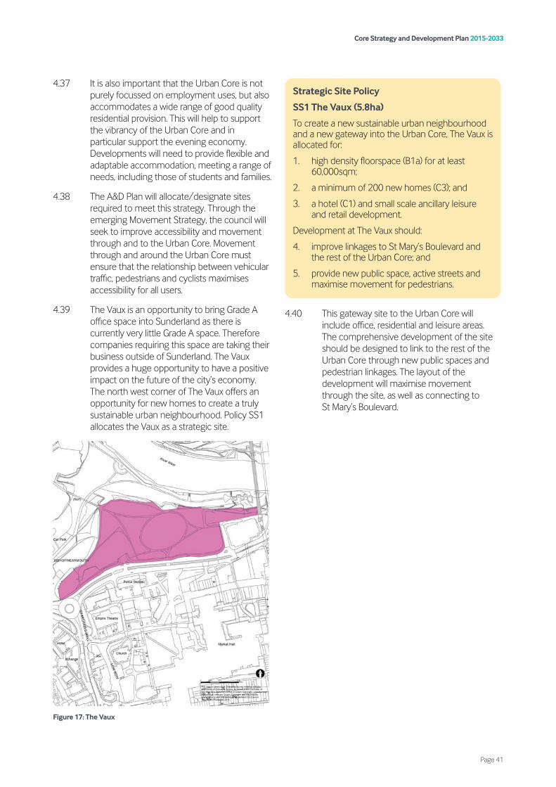
4.37 It is also important that the Urban Core is not purely focussed on employment uses, but also accommodates a wide range of good quality residential provision. This will help to support the vibrancy of the Urban Core and in particular support the evening economy. Developments will need to provide flexible and adaptable accommodation, meeting a range of needs, including those of students and families.
4.38 The A&D Plan will allocate/designate sites required to meet this strategy. Through the emerging Movement Strategy, the council will seek to improve accessibility and movement through and to the Urban Core. Movement through and around the Urban Core must ensure that the relationship between vehicular traffic, pedestrians and cyclists maximises accessibility for all users.
4.39 The Vaux is an opportunity to bring Grade A office space into Sunderland as there is currently very little Grade A space. Therefore companies requiring this space are taking their business outside of Sunderland. The Vaux provides a huge opportunity to have a positive impact on the future of the city’s economy. The north west corner of The Vaux offers an opportunity for new homes to create a truly sustainable urban neighbourhood. Policy SS1 allocates the Vaux as a strategic site.
Figure 17: The Vaux
4.40 This gateway site to the Urban Core will include office, residential and leisure areas. The comprehensive development of the site should be designed to link to the rest of the Urban Core through new public spaces and pedestrian linkages. The layout of the development will maximise movement through the site, as well as connecting to St Mary’s Boulevard.
Strategic Site Policy
SS1 The Vaux (5.8ha)
To create a new sustainable urban neighbourhood and a new gateway into the Urban Core, The Vaux is allocated for:
1. high density floorspace (B1a) for at least 60,000sqm;
2. a minimum of 200 new homes (C3); and
3. a hotel (C1) and small scale ancillary leisure and retail development.
Development at The Vaux should:
4. improve linkages to St Mary’s Boulevard and the rest of the Urban Core; and
5. provide new public space, active streets and maximise movement for pedestrians.
Core Strategy and Development Plan 2015-2033
Page 41
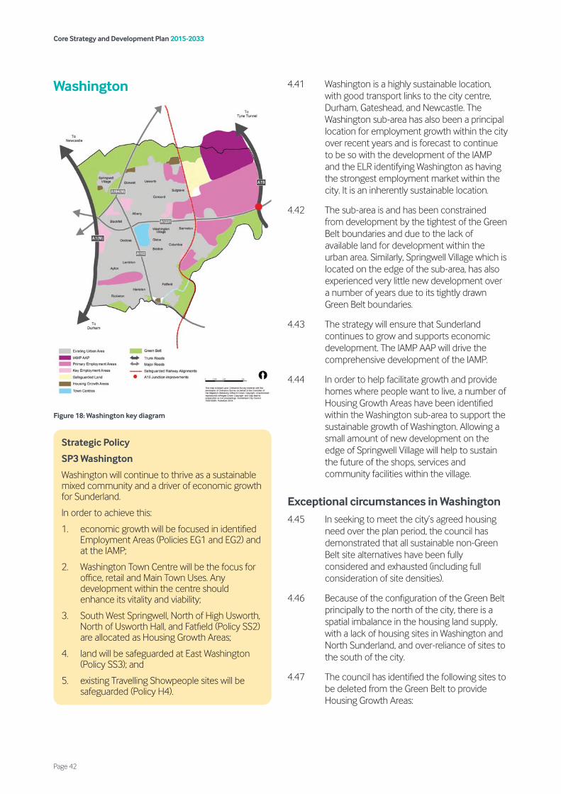
Washington
Figure 18: Washington key diagram
4.41 Washington is a highly sustainable location, with good transport links to the city centre, Durham, Gateshead, and Newcastle. The Washington sub-area has also been a principal location for employment growth within the city over recent years and is forecast to continue to be so with the development of the IAMP and the ELR identifying Washington as having the strongest employment market within the city. It is an inherently sustainable location.
4.42 The sub-area is and has been constrained from development by the tightest of the Green Belt boundaries and due to the lack of available land for development within the urban area. Similarly, Springwell Village which is located on the edge of the sub-area, has also experienced very little new development over a number of years due to its tightly drawn Green Belt boundaries.
4.43 The strategy will ensure that Sunderland continues to grow and supports economic development. The IAMP AAP will drive the comprehensive development of the IAMP.
4.44 In order to help facilitate growth and provide homes where people want to live, a number of Housing Growth Areas have been identified within the Washington sub-area to support the sustainable growth of Washington. Allowing a small amount of new development on the edge of Springwell Village will help to sustain the future of the shops, services and community facilities within the village.
Exceptional circumstances in Washington 4.45 In seeking to meet the city’s agreed housing
need over the plan period, the council has demonstrated that all sustainable non-Green Belt site alternatives have been fully considered and exhausted (including full consideration of site densities).
4.46 Because of the configuration of the Green Belt principally to the north of the city, there is a spatial imbalance in the housing land supply, with a lack of housing sites in Washington and North Sunderland, and over-reliance of sites to the south of the city.
4.47 The council has identified the following sites to be deleted from the Green Belt to provide Housing Growth Areas:
Strategic Policy
SP3 Washington
Washington will continue to thrive as a sustainable mixed community and a driver of economic growth for Sunderland.
In order to achieve this:
1. economic growth will be focused in identified Employment Areas (Policies EG1 and EG2) and at the IAMP;
2. Washington Town Centre will be the focus for office, retail and Main Town Uses. Any development within the centre should enhance its vitality and viability;
3. South West Springwell, North of High Usworth, North of Usworth Hall, and Fatfield (Policy SS2) are allocated as Housing Growth Areas;
4. land will be safeguarded at East Washington (Policy SS3); and
5. existing Travelling Showpeople sites will be safeguarded (Policy H4).
Core Strategy and Development Plan 2015-2033
Page 42
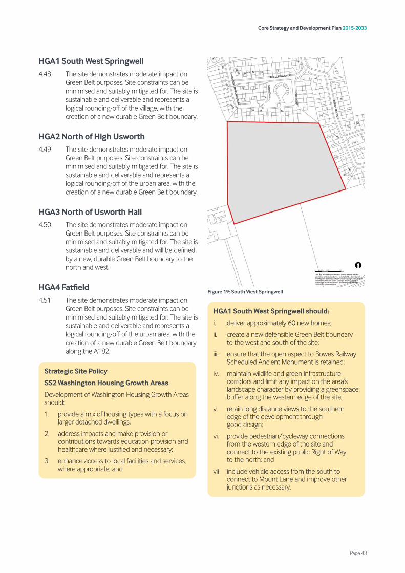
HGA1 South West Springwell 4.48 The site demonstrates moderate impact on
Green Belt purposes. Site constraints can be minimised and suitably mitigated for. The site is sustainable and deliverable and represents a logical rounding-off of the village, with the creation of a new durable Green Belt boundary.
HGA2 North of High Usworth 4.49 The site demonstrates moderate impact on
Green Belt purposes. Site constraints can be minimised and suitably mitigated for. The site is sustainable and deliverable and represents a logical rounding-off of the urban area, with the creation of a new durable Green Belt boundary.
HGA3 North of Usworth Hall 4.50 The site demonstrates moderate impact on
Green Belt purposes. Site constraints can be minimised and suitably mitigated for. The site is sustainable and deliverable and will be defined by a new, durable Green Belt boundary to the north and west.
HGA4 Fatfield 4.51 The site demonstrates moderate impact on
Green Belt purposes. Site constraints can be minimised and suitably mitigated for. The site is sustainable and deliverable and represents a logical rounding-off of the urban area, with the creation of a new durable Green Belt boundary along the A182.
Figure 19: South West Springwell
Strategic Site Policy
SS2 Washington Housing Growth Areas
Development of Washington Housing Growth Areas should:
1. provide a mix of housing types with a focus on larger detached dwellings;
2. address impacts and make provision or contributions towards education provision and healthcare where justified and necessary;
3. enhance access to local facilities and services, where appropriate, and
HGA1 South West Springwell should:
i. deliver approximately 60 new homes;
ii. create a new defensible Green Belt boundary to the west and south of the site;
iii. ensure that the open aspect to Bowes Railway Scheduled Ancient Monument is retained;
iv. maintain wildlife and green infrastructure corridors and limit any impact on the area’s landscape character by providing a greenspace buffer along the western edge of the site;
v. retain long distance views to the southern edge of the development through good design;
vi. provide pedestrian/cycleway connections from the western edge of the site and connect to the existing public Right of Way to the north; and
vii include vehicle access from the south to connect to Mount Lane and improve other junctions as necessary.
Core Strategy and Development Plan 2015-2033
Page 43
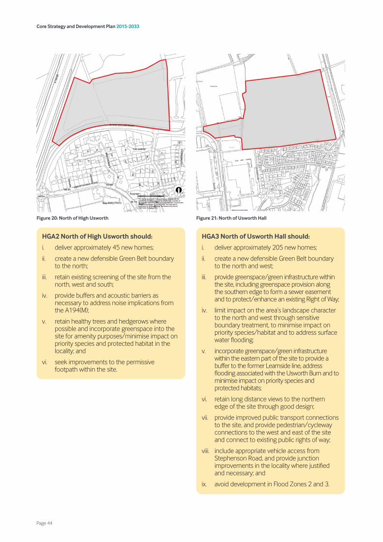
Figure 20: North of High Usworth
Figure 21: North of Usworth Hall
HGA2 North of High Usworth should:
i. deliver approximately 45 new homes;
ii. create a new defensible Green Belt boundary to the north;
iii. retain existing screening of the site from the north, west and south;
iv. provide buffers and acoustic barriers as necessary to address noise implications from the A194(M);
v. retain healthy trees and hedgerows where possible and incorporate greenspace into the site for amenity purposes/minimise impact on priority species and protected habitat in the locality; and
vi. seek improvements to the permissive footpath within the site.
HGA3 North of Usworth Hall should:
i. deliver approximately 205 new homes;
ii. create a new defensible Green Belt boundary to the north and west;
iii. provide greenspace/green infrastructure within the site, including greenspace provision along the southern edge to form a sewer easement and to protect/enhance an existing Right of Way;
iv. limit impact on the area’s landscape character to the north and west through sensitive boundary treatment, to minimise impact on priority species/habitat and to address surface water flooding;
v. incorporate greenspace/green infrastructure within the eastern part of the site to provide a buffer to the former Leamside line, address flooding associated with the Usworth Burn and to minimise impact on priority species and protected habitats;
vi. retain long distance views to the northern edge of the site through good design;
vii. provide improved public transport connections to the site, and provide pedestrian/cycleway connections to the west and east of the site and connect to existing public rights of way;
viii. include appropriate vehicle access from Stephenson Road, and provide junction improvements in the locality where justified and necessary; and
ix. avoid development in Flood Zones 2 and 3.
Core Strategy and Development Plan 2015-2033
Page 44
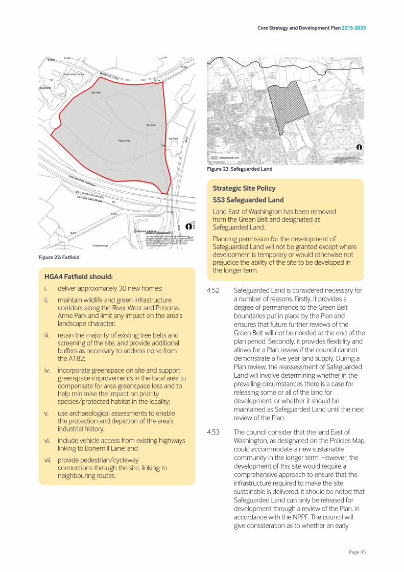
Figure 22: Fatfield
Figure 23: Safeguarded Land
4.52 Safeguarded Land is considered necessary for a number of reasons. Firstly, it provides a degree of permanence to the Green Belt boundaries put in place by the Plan and ensures that future further reviews of the Green Belt will not be needed at the end of the plan period. Secondly, it provides flexibility and allows for a Plan review if the council cannot demonstrate a five year land supply. During a Plan review, the reassessment of Safeguarded Land will involve determining whether in the prevailing circumstances there is a case for releasing some or all of the land for development, or whether it should be maintained as Safeguarded Land until the next review of the Plan.
4.53 The council consider that the land East of Washington, as designated on the Policies Map, could accommodate a new sustainable community in the longer term. However, the development of this site would require a comprehensive approach to ensure that the infrastructure required to make the site sustainable is delivered. It should be noted that Safeguarded Land can only be released for development through a review of the Plan, in accordance with the NPPF. The council will give consideration as to whether an early
HGA4 Fatfield should:
i. deliver approximately 30 new homes;
ii. maintain wildlife and green infrastructure corridors along the River Wear and Princess Anne Park and limit any impact on the area’s landscape character;
iii. retain the majority of existing tree belts and screening of the site, and provide additional buffers as necessary to address noise from the A182;
iv. incorporate greenspace on site and support greenspace improvements in the local area to compensate for area greenspace loss and to help minimise the impact on priority species/protected habitat in the locality;
v. use archaeological assessments to enable the protection and depiction of the area’s industrial history;
vi. include vehicle access from existing highways linking to Bonemill Lane; and
vii. provide pedestrian/cycleway connections through the site, linking to neighbouring routes.
Strategic Site Policy
SS3 Safeguarded Land
Land East of Washington has been removed from the Green Belt and designated as Safeguarded Land.
Planning permission for the development of Safeguarded Land will not be granted except where development is temporary or would otherwise not prejudice the ability of the site to be developed in the longer term.
Core Strategy and Development Plan 2015-2033
Page 45

release of the safeguarded land is justified through the emerging A&D Plan.
4.54 Although development will not generally be appropriate on Safeguarded Land, it is recognised that not all development will prejudice the function and the value of the land. It may therefore, be appropriate to permit development required in connection with established uses, or change of use to an alternative open land use or to temporary uses which would not prejudice the possibility of development after the Plan is reviewed, nor is detrimental to the character of the site and its surroundings.
Core Strategy and Development Plan 2015-2033
Page 46

North Sunderland
Figure 24: North Sunderland Key Diagram
4.55 North Sunderland is a heavily urbanised sub-area located between the River Wear to the south and is separated from the villages of South Tyneside to the north by Green Belt. The area contains the attractive beach resorts of Seaburn and Roker as well as Key Employment Areas along the river corridor.
4.56 Due to the tight boundary constraints of the North Sunderland sub-area, there is limited opportunity for growth. However, the area remains one of the most sustainable locations
within good public transport links to the city centre and metro linkages to Gateshead and Newcastle.
4.57 Two regeneration and renewal areas are identified in North Sunderland. These areas will be prioritised for redevelopment opportunities.
4.58 In order to support the sustainable growth of this area, the council has identified a Housing Growth Area at Fulwell in North Sunderland.
Exceptional circumstances in North Sunderland 4.59 In seeking to meet the city’s agreed housing
need over the plan period, the council has demonstrated that all sustainable non-Green Belt site alternatives have been fully considered and exhausted (including full consideration of site densities).
4.60 Because of the configuration of the Green Belt principally to the north of the city, there is a spatial imbalance in the housing land supply, with a lack of housing sites in Washington and North Sunderland, and over-reliance of sites to the south of the city.
4.61 The council has identified the following site to be deleted from the Green Belt to provide a Housing Growth Area:
HGA5 Fulwell 4.62 The site demonstrates moderate impact on
Green Belt purposes. Site constraints can be minimised and suitably mitigated for. The site is sustainable and deliverable (subject to the sports pitches being proven to be surplus to requirements – site was last used for this purpose in 2015) and provides an urban extension along the A1018, with the creation of a new durable Green Belt boundary to the west and north.
Strategic Policy
SP4 North Sunderland
North Sunderland will continue to be the focus for regenration and renewal whilst ensuring its future sustainability. In order to achieve this:
1. the council and its partners will work to secure regeneration and renewal at Marley Potts and Carley Hill;
2. a Housing Growth Area at Fulwell (Policy SS4) is allocated to ensure there is land for the future growth of North Sunderland; and
3. economic development will be focussed on identified Employment Areas (Policies EG1 and EG2).
Core Strategy and Development Plan 2015-2033
Page 47

Figure 25: Fulwell
HGA5 Fulwell should:
i. deliver approximately 80 new homes;
ii. create a new defensible Green Belt boundary to the west and north of the site;
iii. maintain wildlife and green infrastructure corridors to the north and limit any impact on the areas landscape character through sensitive boundary treatments;
iv. retain the mature tree belts on the western and southern edges of the site, and incorporate greenspace into the site for amenity purposes;
v. provide greenspace improvements to Fulwell Quarries to compensate for area greenspace loss in the locality;
Strategic Site Policy
SS4 North Sunderland Housing Growth Area
Development of the North Sunderland Housing Growth Area should:
1. provide a mix of housing types with a focus on larger detached dwellings;
2. address impacts and make provision or contributions towards education provision and healthcare where justified and necessary;
3. enhance access to local facilities and services, where appropriate, and
vi. ensure that a Habitats Regulations Assessment is undertaken and appropriate mitigation provided;
vii. respect the local vernacular and key views, including the setting of the WW1 Acoustic Mirror Scheduled Ancient Monument and Grade II Listed Buildings, Grade II* Listed Fulwell Mill and Grade II Listed Lime Kilns;
viii. provide pedestrian/cycleway connections through the site and link to routes to the west and the wider area; and
ix. include vehicle access to the east to connect to Newcastle Road, and carry out further highway improvements as necessary.
Development of the site can only take place subject to an up-to-date Playing Pitch Needs Assessment, prepared in consultation with Sport England, identifying the pitches as being surplus to requirement in accordance with Sport England’s playing field policy exception E1 or where the pitches can be re-provided in accordance with Sport England’s playing field policy exception E4.
Core Strategy and Development Plan 2015-2033
Page 48
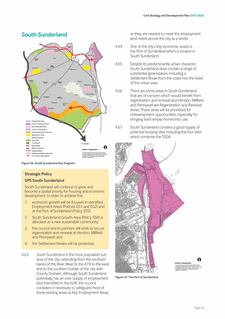
South Sunderland
Figure 26: South Sunderland Key Diagram
4.63 South Sunderland is the most populated sub-area of the city, extending from the southern banks of the River Wear to the A19 to the west and to the southern border of the city with County Durham. Although South Sunderland potentially has an over-supply of employment land (identified in the ELR), the council considers it necessary to safeguard most of these existing areas as Key Employment Areas,
as they are needed to meet the employment land needs across the city as a whole.
4.64 One of the city’s key economic assets is the Port of Sunderland which is located in South Sunderland.
4.65 Despite its predominantly urban character, South Sunderland does contain a range of substantial greenspaces, including a Settlement Break from the coast into the heart of the urban area.
4.66 There are some areas in South Sunderland that are of concern which would benefit from regeneration and renewal and Hendon, Millfield and Pennywell are Regeneration and Renewal Areas. These areas will be prioritised for redevelopment opportunities, especially for bringing back empty homes into use.
4.67 South Sunderland contains a good supply of potential housing sites including the four sites which comprise the SSGA.
Figure 27: The Port of Sunderland
Strategic Policy
SP5 South Sunderland
South Sunderland will continue to grow and become a spatial priority for housing and economic development. In order to achieve this:
1. economic growth will be focused in identified Employment Areas (Policies EG1 and EG2) and at the Port of Sunderland (Policy SS5);
2. South Sunderland Growth Area (Policy SS6) is allocated as a new sustainable community;
3. the council and its partners will work to secure regeneration and renewal at Hendon, Millfield and Pennywell; and
4. the Settlement Breaks will be protected.
Core Strategy and Development Plan 2015-2033
Page 49
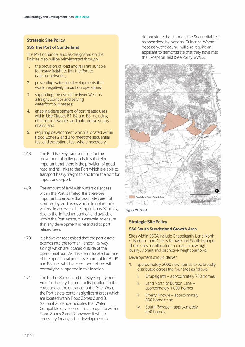
4.68 The Port is a key transport hub for the movement of bulky goods. It is therefore important that there is the provision of good road and rail links to the Port which are able to transport heavy freight to and from the port for import and export.
4.69 The amount of land with waterside access within the Port is limited. It is therefore important to ensure that such sites are not sterilised by land users which do not require waterside access for their operations. Similarly, due to the limited amount of land available within the Port estate, it is essential to ensure that any development is restricted to port related uses.
4.70 It is however recognised that the port estate extends into the former Hendon Railway sidings which are located outside of the operational port. As this area is located outside of the operational port, development for B1, B2 and B8 uses which are not port related will normally be supported in this location.
4.71 The Port of Sunderland is a Key Employment Area for the city, but due to its location on the coast and at the entrance to the River Wear, the Port estate contains significant areas which are located within Flood Zones 2 and 3. National Guidance indicates that Water Compatible development is appropriate within Flood Zones 2 and 3, however it will be necessary for any other development to
demonstrate that it meets the Sequential Test, as prescribed by National Guidance. Where necessary, the council will also require an applicant to demonstrate that they have met the Exception Test (See Policy WWE2).
Figure 28: SSGA
Strategic Site Policy
SS5 The Port of Sunderland
The Port of Sunderland, as designated on the Policies Map, will be reinvigorated through:
1. the provision of road and rail links suitable for heavy freight to link the Port to national networks;
2. preventing waterside developments that would negatively impact on operations;
3. supporting the use of the River Wear as a freight corridor and serving waterfront businesses;
4. enabling development of port related uses within Use Classes B1, B2 and B8, including offshore renewables and automotive supply chains; and
5. requiring development which is located within Flood Zones 2 and 3 to meet the sequential test and exceptions test, where necessary.
Strategic Site Policy
SS6 South Sunderland Growth Area
Sites within SSGA include Chapelgarth, Land North of Burdon Lane, Cherry Knowle and South Ryhope. These sites are allocated to create a new high quality, vibrant and distinctive neighbourhood.
Development should deliver:
1. approximately 3000 new homes to be broadly distributed across the four sites as follows:
i. Chapelgarth – approximately 750 homes;
ii. Land North of Burdon Lane – approximately 1,000 homes;
iii. Cherry Knowle – approximately 800 homes; and
iv. South Ryhope – approximately 450 homes;
Core Strategy and Development Plan 2015-2033
Page 50

4.72 The SSGA will be an example of sustainable development and a destination of choice for families wishing to live in Sunderland. The development will achieve high standards of sustainability, design and provide a range of supporting facilities to help foster a strong sense of community. The creation of well-connected, integrated and sustainable transport links will be essential to making this a sustainable neighbourhood. Development will also protect and enhance existing heritage assets in the area and provide a network of connected greenspaces (depending on the form that the Suitable Alternative Natural Greenspace (SANG) takes, it may be possible for part of this to also be used for public open space). This new sustainable neighbourhood will provide for a mix of housing sizes, types
and tenures, including affordable housing. The site is allocated for 3,000 homes but it is expected that approximately 2,305 will be delivered in the plan period.
4.73 In order to ensure the comprehensive development of the sites and ensure that the necessary infrastructure is delivered at the right time, the council is preparing the South Sunderland Growth Area Supplementary Planning Document (SPD). Once adopted, all development on the SSGA should be in accordance with this document.
2. 10% affordable housing;
3. a neighbourhood centre within Land North of Burdon Lane to provide a focal point within the SSGA and complement nearby existing centres which will comprise:
i. a range of appropriate uses from the following use classes; A1, A3, A4, D1 and D2;
ii. a new 1.5 form entry primary school which will also serve as a community hub;
iii. wheeled Sports Area;
iv. formal play space;
v. Multi Use Games Area;
vi. 3G pitch;
vii. appropriate parking facilities and served by bus service;
4. extensions to two existing primary schools in close proximity to SSGA;
5. public open space;
6. allotments provided on-site or off-site via a financial contribution;
7. suitable ecological mitigation in line with HRA requirements;
8. cycleways and footpaths;
9. new and improved public transport services and infrastructure; and
10. contributions to support the completion of the Ryhope-Doxford Link Road by either direct delivery as part of development or via a financial contribution.
All development should be in accordance with the SSGA SPD.
Core Strategy and Development Plan 2015-2033
Page 51
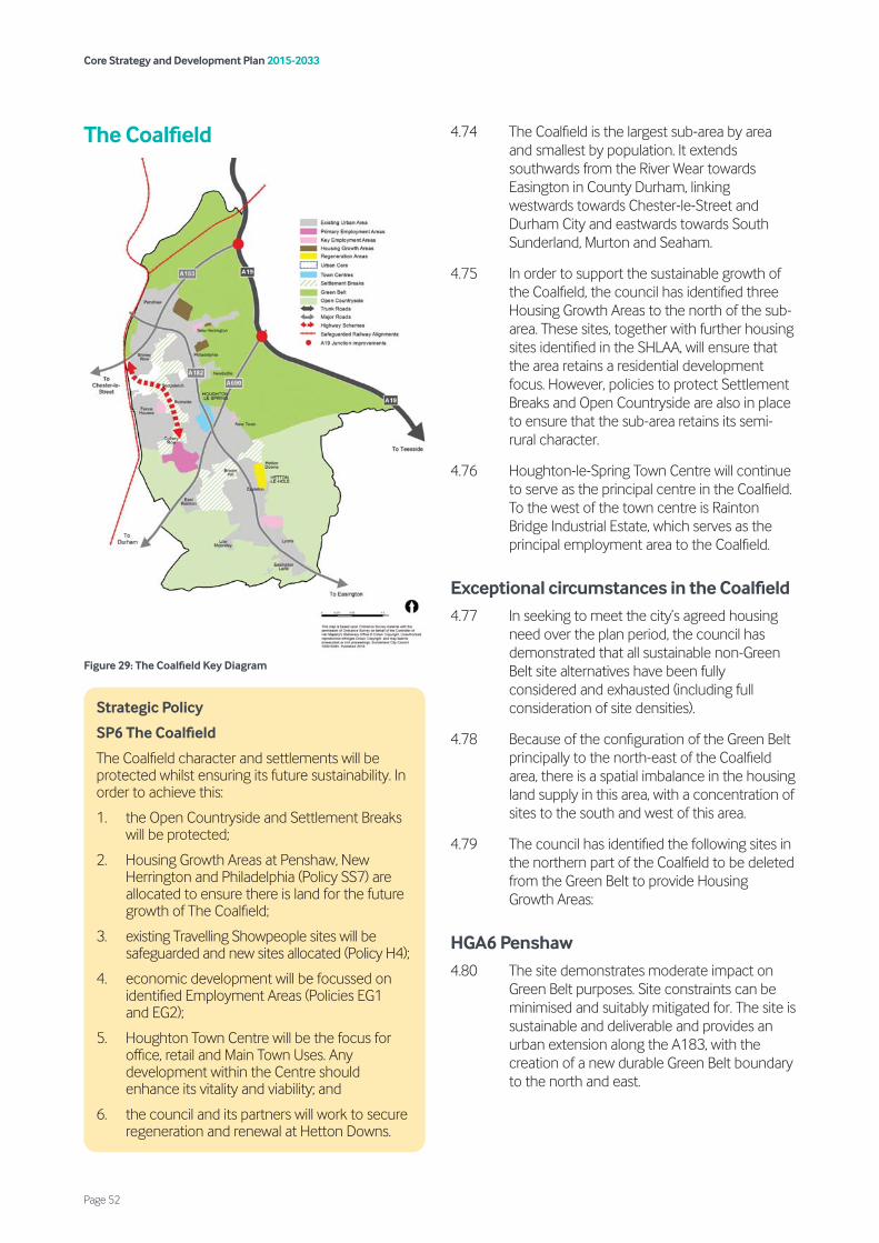
The Coalfield
Figure 29: The Coalfield Key Diagram
4.74 The Coalfield is the largest sub-area by area and smallest by population. It extends southwards from the River Wear towards Easington in County Durham, linking westwards towards Chester-le-Street and Durham City and eastwards towards South Sunderland, Murton and Seaham.
4.75 In order to support the sustainable growth of the Coalfield, the council has identified three Housing Growth Areas to the north of the sub-area. These sites, together with further housing sites identified in the SHLAA, will ensure that the area retains a residential development focus. However, policies to protect Settlement Breaks and Open Countryside are also in place to ensure that the sub-area retains its semi-rural character.
4.76 Houghton-le-Spring Town Centre will continue to serve as the principal centre in the Coalfield. To the west of the town centre is Rainton Bridge Industrial Estate, which serves as the principal employment area to the Coalfield.
Exceptional circumstances in the Coalfield 4.77 In seeking to meet the city’s agreed housing
need over the plan period, the council has demonstrated that all sustainable non-Green Belt site alternatives have been fully considered and exhausted (including full consideration of site densities).
4.78 Because of the configuration of the Green Belt principally to the north-east of the Coalfield area, there is a spatial imbalance in the housing land supply in this area, with a concentration of sites to the south and west of this area.
4.79 The council has identified the following sites in the northern part of the Coalfield to be deleted from the Green Belt to provide Housing Growth Areas:
HGA6 Penshaw 4.80 The site demonstrates moderate impact on
Green Belt purposes. Site constraints can be minimised and suitably mitigated for. The site is sustainable and deliverable and provides an urban extension along the A183, with the creation of a new durable Green Belt boundary to the north and east.
Strategic Policy
SP6 The Coalfield
The Coalfield character and settlements will be protected whilst ensuring its future sustainability. In order to achieve this:
1. the Open Countryside and Settlement Breaks will be protected;
2. Housing Growth Areas at Penshaw, New Herrington and Philadelphia (Policy SS7) are allocated to ensure there is land for the future growth of The Coalfield;
3. existing Travelling Showpeople sites will be safeguarded and new sites allocated (Policy H4);
4. economic development will be focussed on identified Employment Areas (Policies EG1 and EG2);
5. Houghton Town Centre will be the focus for office, retail and Main Town Uses. Any development within the Centre should enhance its vitality and viability; and
6. the council and its partners will work to secure regeneration and renewal at Hetton Downs.
Core Strategy and Development Plan 2015-2033
Page 52
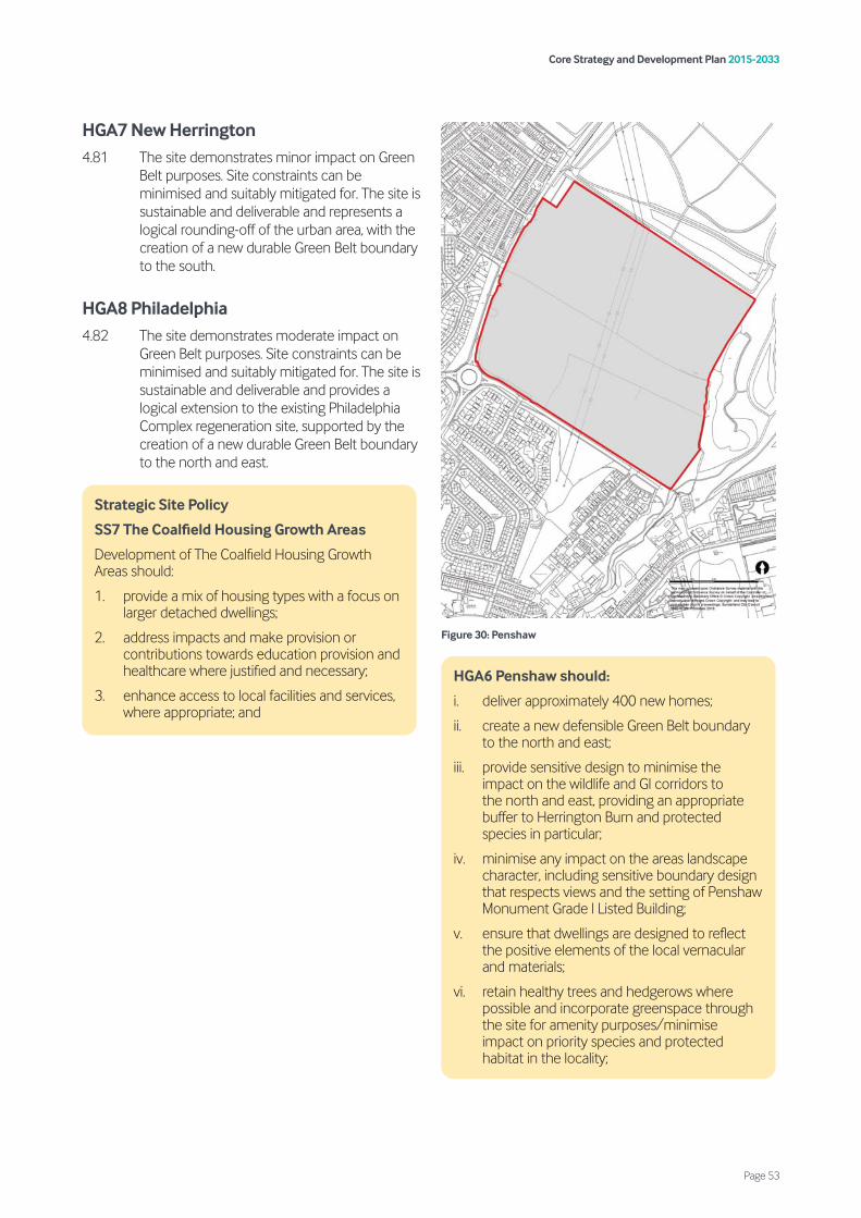
HGA7 New Herrington 4.81 The site demonstrates minor impact on Green
Belt purposes. Site constraints can be minimised and suitably mitigated for. The site is sustainable and deliverable and represents a logical rounding-off of the urban area, with the creation of a new durable Green Belt boundary to the south.
HGA8 Philadelphia 4.82 The site demonstrates moderate impact on
Green Belt purposes. Site constraints can be minimised and suitably mitigated for. The site is sustainable and deliverable and provides a logical extension to the existing Philadelphia Complex regeneration site, supported by the creation of a new durable Green Belt boundary to the north and east.
Figure 30: Penshaw
Strategic Site Policy
SS7 The Coalfield Housing Growth Areas
Development of The Coalfield Housing Growth Areas should:
1. provide a mix of housing types with a focus on larger detached dwellings;
2. address impacts and make provision or contributions towards education provision and healthcare where justified and necessary;
3. enhance access to local facilities and services, where appropriate; and
HGA6 Penshaw should:
i. deliver approximately 400 new homes;
ii. create a new defensible Green Belt boundary to the north and east;
iii. provide sensitive design to minimise the impact on the wildlife and GI corridors to the north and east, providing an appropriate buffer to Herrington Burn and protected species in particular;
iv. minimise any impact on the areas landscape character, including sensitive boundary design that respects views and the setting of Penshaw Monument Grade l Listed Building;
v. ensure that dwellings are designed to reflect the positive elements of the local vernacular and materials;
vi. retain healthy trees and hedgerows where possible and incorporate greenspace through the site for amenity purposes/minimise impact on priority species and protected habitat in the locality;
Core Strategy and Development Plan 2015-2033
Page 53
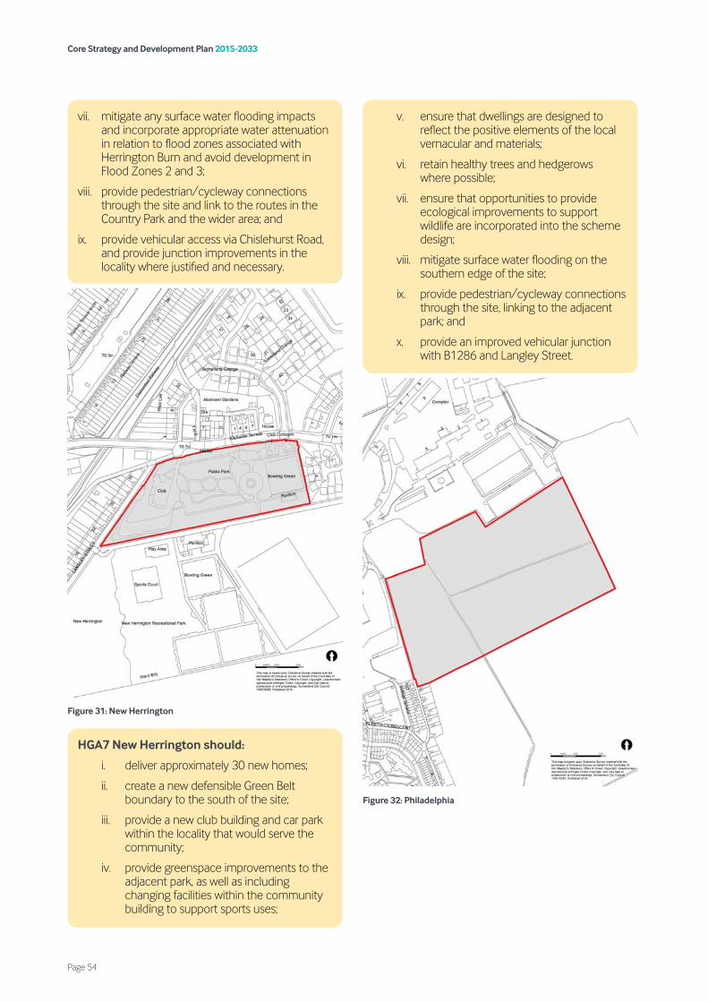
Figure 31: New Herrington
Figure 32: Philadelphia
vii. mitigate any surface water flooding impacts and incorporate appropriate water attenuation in relation to flood zones associated with Herrington Burn and avoid development in Flood Zones 2 and 3;
viii. provide pedestrian/cycleway connections through the site and link to the routes in the Country Park and the wider area; and
ix. provide vehicular access via Chislehurst Road, and provide junction improvements in the locality where justified and necessary.
HGA7 New Herrington should:
i. deliver approximately 30 new homes;
ii. create a new defensible Green Belt boundary to the south of the site;
iii. provide a new club building and car park within the locality that would serve the community;
iv. provide greenspace improvements to the adjacent park, as well as including changing facilities within the community building to support sports uses;
v. ensure that dwellings are designed to reflect the positive elements of the local vernacular and materials;
vi. retain healthy trees and hedgerows where possible;
vii. ensure that opportunities to provide ecological improvements to support wildlife are incorporated into the scheme design;
viii. mitigate surface water flooding on the southern edge of the site;
ix. provide pedestrian/cycleway connections through the site, linking to the adjacent park; and
x. provide an improved vehicular junction with B1286 and Langley Street.
Core Strategy and Development Plan 2015-2033
Page 54
HGA8 Philadelphia should:
i. deliver approximately 195 new homes;
ii. create a new defensible Green Belt boundary to the east and south of the site;
iii. provide sensitive design that relates to the development of the Philadelphia Complex by providing a buffer to the west between the residential development and the proposed commercial development and incorporates design that relates to the area’s historic past including listed buildings in the locality and protecting long distance views southwards towards Newbottle Village Conservation Area;
iv. provide greenspace on the northern edge of the site to provide a gas main easement and to mitigate the impacts of a natural swale and associated surface water flooding;
v. provide greenspace buffers to the south and east of the site in order to support the adjacent wildlife and green infrastructure corridor and limit any impact on the areas landscape character;
vi. protect the Local Wildlife Site located on the north eastern edge of the site and minimise impact on priority species and habitat in the locality;
viii. provide pedestrian and cycle links through the site and along the southern and eastern boundaries to link to neighbouring residential areas and nearby parkland; and
viii. include vehicle access from the Philadelphia Complex redevelopment and provide junction improvements in the locality where justified and necessary.
Core Strategy and Development Plan 2015-2033
Page 55


Strategic and local policies
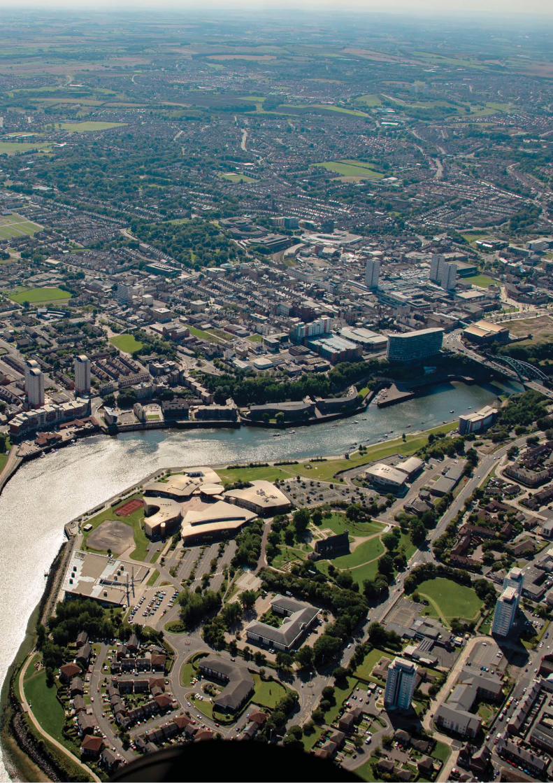
5.1 Many factors influence our health, including the lifestyles we lead, the environment we live in and the opportunities we have to exercise and access health and other facilities. A wider sense of wellbeing is influenced by a variety of factors such as opportunities for work and recreation, attractive environments, personal relationships and feelings of safety and being part of a community.
5.2 The link between planning and health outcomes is long established and most recently reinforced by the NPPF, PPG and the Government’s public health strategy ‘Healthy Lives, Healthy People’.
5.3 Health and wellbeing is a cross cutting theme and this chapter includes policies to deliver Strategic Priority 3 and promote healthy and safe communities by:
• supporting the delivery of the strategic priorities (Policy SP7);
• protecting the amenity and quality of life of residents (Policy HS1);
• directing noise-sensitive development to appropriate locations (Policy HS2);
• ensuring appropriate remediation is undertaken when developing contaminated land (Policy HS3); and
• giving careful consideration to potential risks associated with development of or near to ‘notifiable installations’ (Policy HS4).
5.4 The applicant should set out within their Design and Access Statement how the proposals have been designed to take account of the requirements of this policy. Applicants are also encouraged to utilise the design principles set out within Sport England’s ‘Active Design’ guide when preparing a development scheme in order to promote active, healthy and stronger communities.
5.5 In order to ensure that health impacts are considered at the very outset, a Health Impact Assessment (HIA) will be required to be submitted in support of large-scale development. For clarity, large-scale
Strategic Policy
SP7 Healthy and safe communities
The council will seek to improve health and wellbeing in Sunderland by:
1. working with the NHS to improve health outcomes, particularly in areas with the poorest health and reduce health inequalities generally;
2. protecting existing health facilities and/or supporting the provision of new or improved facilities (Policy VC5);
3. promoting and facilitating active and healthy lifestyles;
4. supporting the integration of health facilities and services with other community uses (education, sport, cultural and leisure) through multi-purpose buildings;
5. managing the location/number of and access to unhealthy eating outlets (Policy VC4);
6. ensuring that new developments:-
i. are age friendly, inclusive, safe, attractive and easily accessible on foot or by bicycle;
ii. have a strong sense of place which encourages social interaction;
iii. are designed to promote active travel and other physical activities through the arrangement of buildings, location of uses and access to open space;
iv. promote improvements and enhance accessibility to the city’s natural, built and historic environments;
v. do not have unacceptable adverse impacts upon amenity which cannot be adequately mitigated (Policies HS1 and HS2);
vi. appropriately address any contaminated land to an acceptable level (Policy HS3); and
vii. submit a Health Impact Assessment (HIA) as part of any application for large-scale development. Where significant adverse health impacts are identified, development should be resisted unless appropriate mitigation can be provided.
Core Strategy and Development Plan 2015-2033
Page 59
5. Healthy and safe communities
development within the context of this policy is considered to be residential schemes for 100 dwellings or more, student accommodation schemes for 100 bed spaces or more, or any other form of development which has the potential to have a significant impact on health. The HIA should be proportionate to the scale of development proposed and can be incorporated into other appropriate submission documents, such as a Design and Access Statement. Where a submitted HIA indicates that a development would have a significant adverse impact upon health and wellbeing, development will be resisted unless evidence is submitted to demonstrate to the council’s satisfaction that the impacts can be adequately mitigated. Further guidance on what detail should be contained within an HIA will be set out within a developer guidance note.
5.6 Development can remedy environmental deficiencies and contribute to the quality of life of residents. New development should take into account the amenities of adjoining
properties, with particular attention being paid to the scale of new buildings in relation to existing surrounding development, daylight, sunlight effects, siting, elevational treatments and the use of appropriate materials. Where a site is affected by land stability issues (including mineral legacy issues as set out in Policy M3), the responsibility for securing a safe development rests with the developer and/or landowner. Affected development must incorporate remediation and management measures. Cumulative impacts should also be considered. Any new developments will be expected to follow the “agent of change” principles (i.e. person or business responsible for the change must also be responsible for managing the impact of the change).
5.7 Sources of noise include roads, railway lines, aerodromes, industrial/commercial developments, waste, recycling and energy plant, sporting, recreation and leisure facilities.
Policy
HS1 Quality of life and amenity
1. Development must demonstrate that it does not result in unacceptable adverse impacts which cannot be addressed through appropriate mitigation, arising from the following sources:
i. air quality;
ii. noise;
iii. dust;
iv. vibration;
v. odour;
vi. emissions;
vii. land contamination and instability;
viii. illumination;
ix. run-off to protected waters; or
x. traffic;
2. development must ensure that the cumulative impact would not result in unacceptable adverse impacts on the local community; and
3. development will not normally be supported where the existing neighbouring uses would unacceptably impact on the amenity of future occupants of the proposed development.
Policy
HS2 Noise-sensitive development
Development sensitive to noise or which would result in noise impacts (including vibration) will be controlled by implementing the following measures:
1. noise sensitive development will be directed to the most appropriate locations and protected against existing and proposed sources of noise through careful design, layout and uses of materials;
2. noise-sensitive development affected by existing sources of noise should submit an appropriate noise assessment and where necessary, a detailed schedule of mitigation. In assessing such mitigation, account will be taken of:
i. the location, design and layout of the proposed development; and
ii. measures to reduce noise within the development to acceptable levels, including external areas.
3. In areas of existing low levels of noise, proposals for development which may generate noise should be accompanied by a noise assessment, provide details of the noise levels on the site and quantify the impact on the existing noise environment and noise sensitive receptors. Where necessary an appropriate scheme of mitigation shall detail any measures required to ensure that noise does not adversely impact on these receptors.
Core Strategy and Development Plan 2015-2033
Page 60
5.8 Noise and associated vibration can affect and have a direct impact on noise sensitive uses, particularly housing, but also other sensitive uses such as schools and hospitals and impact upon people’s health and wellbeing. Any development (including new development, conversion, extension and changes of use) for a noise generating development close to noise sensitive uses will be assessed to determine the impact of the proposed development in relation to these existing uses.
5.9 Issues of noise will be considered on a site-by-site basis having regard to the development, site context and surrounding uses in the context of related policies and guidelines.
5.10 In a heavily built up area such as Sunderland where there has been a history of heavy industry, land contamination is known to exist. It is important therefore that any land that is known or suspected of being contaminated, or where a sensitive use is proposed, is dealt with appropriately before the development takes place.
5.11 Any potential risks associated with contaminated land should be identified and assessed at the pre-application planning stage. Applicants also need to consider that sites may be contaminated as a result of being in the vicinity of a contaminated site. The risk of this contamination depends on ground conditions and the type of contamination. Where necessary, developers will be required to carry out remediation works and satisfy the council that their development can be safely built and occupied without posing any unacceptable risks to human health or the environment.
5.12 Where a site is affected by contamination, the responsibility for securing a safe development rests with the developer and/or landowner. In such cases, the applicant must submit a report to demonstrate remediation and management measures to deal with risks of water pollution, contamination from site works, and health risks for end users. This report should be submitted with a planning application and the council will consult the Environment Agency and take account of the council’s Environmental Health Officers advice in assessing such reports.
5.13 Where contaminants are identified and it is determined that remediation is required, the developer must also demonstrate that a method of treatment necessary to deal with any hazards found, has been agreed or conditions requiring such measures to be implemented, can be attached. Such measures must ensure that water resources and other environmental resources are not adversely affected, further migration of gases and substances is prevented, and that appropriate remediation takes place on-site to secure a safe development that is suitable for its proposed use.
Policy
HS3 Contaminated land
When development is considered to be on contaminated land, development should:
1. ensure all works, including investigation of the nature of any contamination, can be undertaken without the escape of contaminants which could cause unacceptable risk to health or to the environment;
2. identify any existing contaminated land and the level of risk that contaminants pose in relation to the proposed end use and future site users are adequately quantified and addressed;
3. ensure appropriate mitigation measures are identified and implemented which are suitable for the proposed use and that there is no unacceptable risk of pollution within the site or in the surrounding area; and
4. demonstrate that the developed site will be suitable for the proposed use without risk from contaminants to people, buildings, services or the environment including the apparatus of statutory undertakers.
Core Strategy and Development Plan 2015-2033
Page 61
5.14 Sites and installations which have quantities of hazardous substances present on site are designated as notifiable installations by the Health and Safety Executive (HSE). Consultation zones are defined around these hazardous installations and the council is required to consult with the HSE on certain proposals for development within such zones. The council will be guided by HSE advice in determining whether a proposed development may proceed as submitted or whether protection measures could overcome any safety objections. Further information can be found at www.hse.gov.uk
5.15 The siting of new notifiable installations will be managed with the aim of keeping the installations separate from housing and other sensitive land uses with which the installations would be incompatible. The council will consult the HSE and the Environment Agency about the siting of proposals for new notifiable installations.
5.16 Hazardous substances consent is required for the presence of certain quantities of hazardous substances. This is a key part of the controls for storage and use of hazardous substances which could, in quantities at or above specified limits, present a major off-site risk.
Policy
HS4 Health and safety executive areas and hazardous substances
1. Development within the specified distances from sites identified as ‘notifiable installations’, must take account of any risks involved and the need for appropriate separation between hazardous installations and incompatible uses.
2. The development of new notifiable installations must be located in appropriate areas and take account of any risks involved and the need for appropriate separation between hazardous installations and incompatible uses.
3. Development involving the introduction, storage or use of hazardous substances which would create potential risk and could not be acceptably mitigated against, will not be permitted.
Core Strategy and Development Plan 2015-2033
Page 62
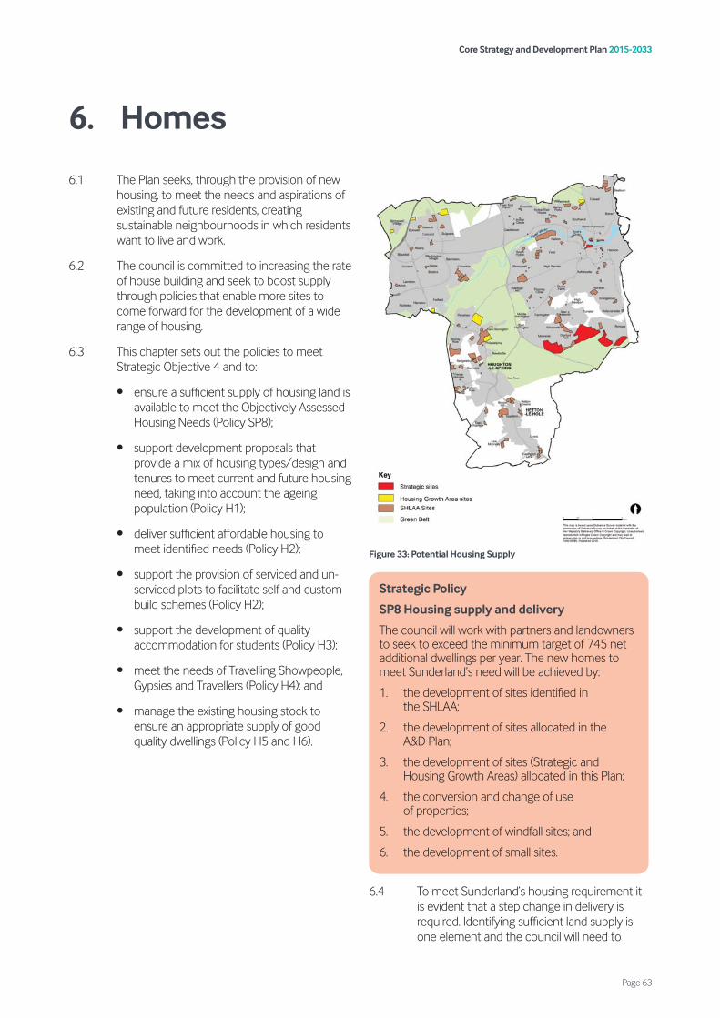
6.1 The Plan seeks, through the provision of new housing, to meet the needs and aspirations of existing and future residents, creating sustainable neighbourhoods in which residents want to live and work.
6.2 The council is committed to increasing the rate of house building and seek to boost supply through policies that enable more sites to come forward for the development of a wide range of housing.
6.3 This chapter sets out the policies to meet Strategic Objective 4 and to:
• ensure a sufficient supply of housing land is available to meet the Objectively Assessed Housing Needs (Policy SP8);
• support development proposals that provide a mix of housing types/design and tenures to meet current and future housing need, taking into account the ageing population (Policy H1);
• deliver sufficient affordable housing to meet identified needs (Policy H2);
• support the provision of serviced and un-serviced plots to facilitate self and custom build schemes (Policy H2);
• support the development of quality accommodation for students (Policy H3);
• meet the needs of Travelling Showpeople, Gypsies and Travellers (Policy H4); and
• manage the existing housing stock to ensure an appropriate supply of good quality dwellings (Policy H5 and H6).
Figure 33: Potential Housing Supply
6.4 To meet Sunderland’s housing requirement it is evident that a step change in delivery is required. Identifying sufficient land supply is one element and the council will need to
Strategic Policy
SP8 Housing supply and delivery
The council will work with partners and landowners to seek to exceed the minimum target of 745 net additional dwellings per year. The new homes to meet Sunderland’s need will be achieved by:
1. the development of sites identified in the SHLAA;
2. the development of sites allocated in the A&D Plan;
3. the development of sites (Strategic and Housing Growth Areas) allocated in this Plan;
4. the conversion and change of use of properties;
5. the development of windfall sites; and
6. the development of small sites.
Core Strategy and Development Plan 2015-2033
Page 63
6. Homes
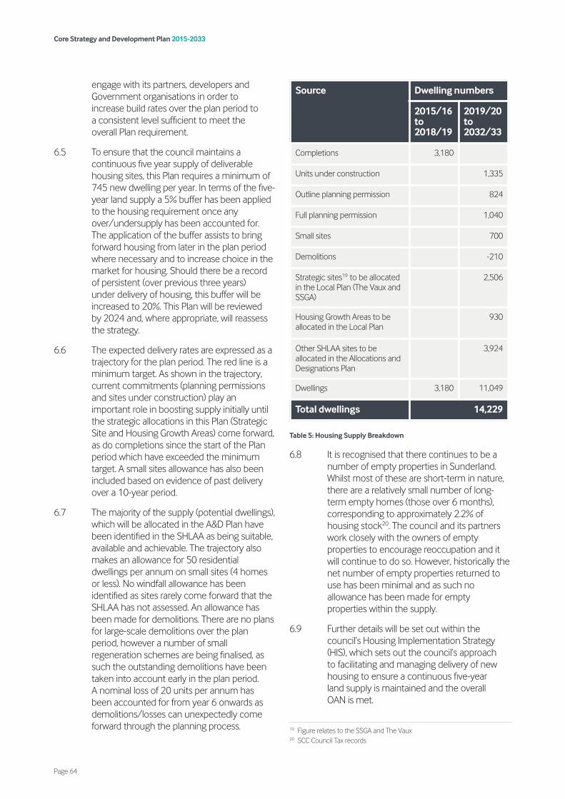
engage with its partners, developers and Government organisations in order to increase build rates over the plan period to a consistent level sufficient to meet the overall Plan requirement.
6.5 To ensure that the council maintains a continuous five year supply of deliverable housing sites, this Plan requires a minimum of 745 new dwelling per year. In terms of the five-year land supply a 5% buffer has been applied to the housing requirement once any over/undersupply has been accounted for. The application of the buffer assists to bring forward housing from later in the plan period where necessary and to increase choice in the market for housing. Should there be a record of persistent (over previous three years) under delivery of housing, this buffer will be increased to 20%. This Plan will be reviewed by 2024 and, where appropriate, will reassess the strategy.
6.6 The expected delivery rates are expressed as a trajectory for the plan period. The red line is a minimum target. As shown in the trajectory, current commitments (planning permissions and sites under construction) play an important role in boosting supply initially until the strategic allocations in this Plan (Strategic Site and Housing Growth Areas) come forward, as do completions since the start of the Plan period which have exceeded the minimum target. A small sites allowance has also been included based on evidence of past delivery over a 10-year period.
6.7 The majority of the supply (potential dwellings), which will be allocated in the A&D Plan have been identified in the SHLAA as being suitable, available and achievable. The trajectory also makes an allowance for 50 residential dwellings per annum on small sites (4 homes or less). No windfall allowance has been identified as sites rarely come forward that the SHLAA has not assessed. An allowance has been made for demolitions. There are no plans for large-scale demolitions over the plan period, however a number of small regeneration schemes are being finalised, as such the outstanding demolitions have been taken into account early in the plan period. A nominal loss of 20 units per annum has been accounted for from year 6 onwards as demolitions/losses can unexpectedly come forward through the planning process.
Table 5: Housing Supply Breakdown
6.8 It is recognised that there continues to be a number of empty properties in Sunderland. Whilst most of these are short-term in nature, there are a relatively small number of long-term empty homes (those over 6 months), corresponding to approximately 2.2% of housing stock20. The council and its partners work closely with the owners of empty properties to encourage reoccupation and it will continue to do so. However, historically the net number of empty properties returned to use has been minimal and as such no allowance has been made for empty properties within the supply.
6.9 Further details will be set out within the council’s Housing Implementation Strategy (HIS), which sets out the council’s approach to facilitating and managing delivery of new housing to ensure a continuous five-year land supply is maintained and the overall OAN is met.
19 Figure relates to the SSGA and The Vaux20 SCC Council Tax records
Source Dwelling numbers
2015/16 to 2018/19
2019/20 to 2032/33
Completions 3,180
Units under construction 1,335
Outline planning permission 824
Full planning permission 1,040
Small sites 700
Demolitions -210
Strategic sites19 to be allocated in the Local Plan (The Vaux and SSGA)
2,506
Housing Growth Areas to be allocated in the Local Plan
930
Other SHLAA sites to be allocated in the Allocations and Designations Plan
3,924
Dwellings 3,180 11,049
Total dwellings 14,229
Core Strategy and Development Plan 2015-2033
Page 64
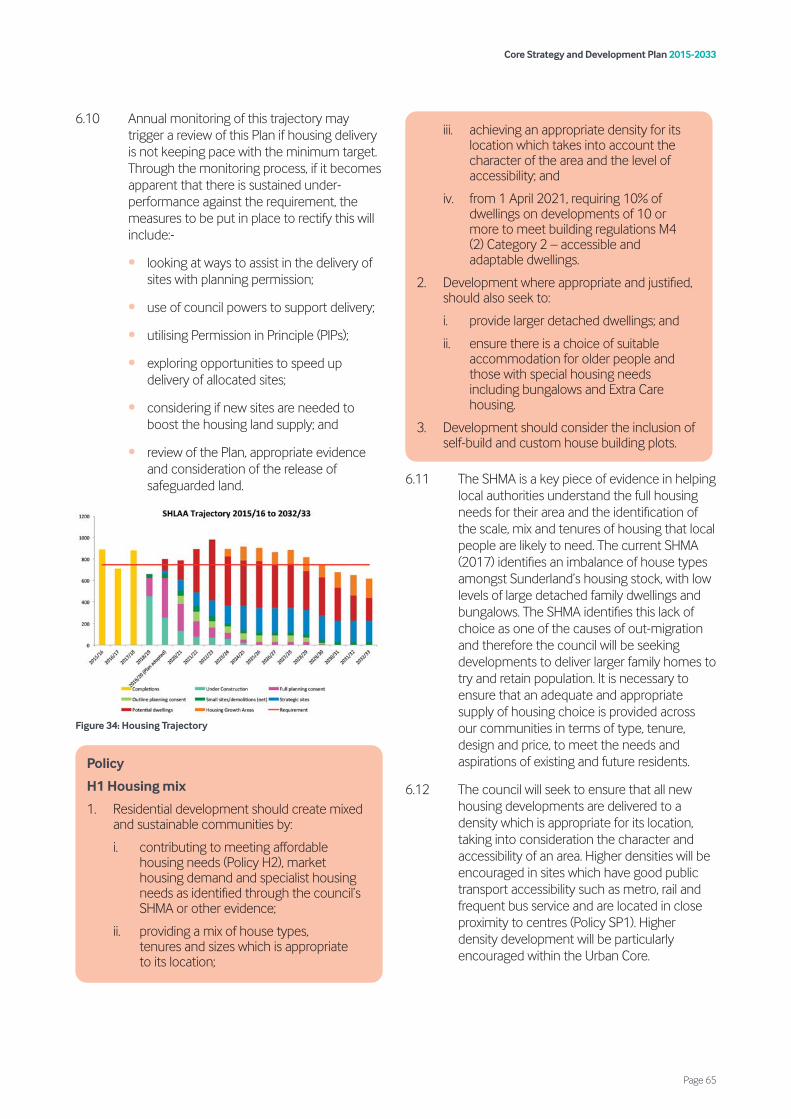
6.10 Annual monitoring of this trajectory may trigger a review of this Plan if housing delivery is not keeping pace with the minimum target. Through the monitoring process, if it becomes apparent that there is sustained under-performance against the requirement, the measures to be put in place to rectify this will include:-
• looking at ways to assist in the delivery of sites with planning permission;
• use of council powers to support delivery;
• utilising Permission in Principle (PIPs);
• exploring opportunities to speed up delivery of allocated sites;
• considering if new sites are needed to boost the housing land supply; and
• review of the Plan, appropriate evidence and consideration of the release of safeguarded land.
Figure 34: Housing Trajectory
6.11 The SHMA is a key piece of evidence in helping local authorities understand the full housing needs for their area and the identification of the scale, mix and tenures of housing that local people are likely to need. The current SHMA (2017) identifies an imbalance of house types amongst Sunderland’s housing stock, with low levels of large detached family dwellings and bungalows. The SHMA identifies this lack of choice as one of the causes of out-migration and therefore the council will be seeking developments to deliver larger family homes to try and retain population. It is necessary to ensure that an adequate and appropriate supply of housing choice is provided across our communities in terms of type, tenure, design and price, to meet the needs and aspirations of existing and future residents.
6.12 The council will seek to ensure that all new housing developments are delivered to a density which is appropriate for its location, taking into consideration the character and accessibility of an area. Higher densities will be encouraged in sites which have good public transport accessibility such as metro, rail and frequent bus service and are located in close proximity to centres (Policy SP1). Higher density development will be particularly encouraged within the Urban Core.
Policy
H1 Housing mix
1. Residential development should create mixed and sustainable communities by:
i. contributing to meeting affordable housing needs (Policy H2), market housing demand and specialist housing needs as identified through the council’s SHMA or other evidence;
ii. providing a mix of house types, tenures and sizes which is appropriate to its location;
iii. achieving an appropriate density for its location which takes into account the character of the area and the level of accessibility; and
iv. from 1 April 2021, requiring 10% of dwellings on developments of 10 or more to meet building regulations M4 (2) Category 2 – accessible and adaptable dwellings.
2. Development where appropriate and justified, should also seek to:
i. provide larger detached dwellings; and
ii. ensure there is a choice of suitable accommodation for older people and those with special housing needs including bungalows and Extra Care housing.
3. Development should consider the inclusion of self-build and custom house building plots.
Core Strategy and Development Plan 2015-2033
Page 65
6.13 In order to ensure choice in the housing stock for the city’s ageing population, developments should consider alternative designs and layouts to provide for those older people who may want to stay within their own home and take on board appropriate evidence to ensure suitable accommodation for older people and those with special housing needs is provided, where a need is demonstrated, particularly in highly accessible locations.
6.14 Policy H1 seeks to ensure that new housing supply meets the needs of an ageing population, in recognition that almost a quarter of Sunderland’s population is forecast to be aged 65 or over by the end of the plan period. The SHMA recognises a significant preference for people to stay in their own home and homes that are designed from the outset to be flexible and accessible to avoid the need for ‘special’ adaptions which are often costly to install and remove for future occupiers. As such, the council will require developers to ensure at least 10% of dwellings on sites of 10 or more, meet building regulations M4 (2) Category 2 – accessible and adaptable dwellings. However, low-rise non-lifted serviced flats will be excluded due to not being able to achieve step-free access. The council does recognise that in some instances, it may not be possible to deliver the accessible and adaptable dwellings requirement in full. In this instance the applicant will be expected to submit a detailed viability assessment in line with the requirements of the PPG to clearly demonstrate how the requirement set out within Policy H1 (iv) would make the scheme unviable.
6.15 In order to allow for an appropriate transitional period, the standard relating to accessible and adaptable dwellings will only be applied to outline or full applications approved after 1 April 2021. It will not be applied retrospectively to those applications for reserved matters where the outline permission was determined or is subject to a resolution to grant permission (including subject to planning obligations) before 1 April 2021.
6.16 The council established its own Self-Build and Custom Build Register in April 2016 in accordance with the provisions of the Act. To assist people who want to build their own home, the council will support appropriate self build developments as well as seek to identify
appropriate small sites to assist in the delivery of self-build/custom house building plots.
6.17 Development should consider the inclusion of self-build and custom house build plots on schemes, utilising the Self-Build and Custom Build Register. If provision is made for this type of housing within a development and it can be demonstrated to the council’s satisfaction that no demand exists, the land will revert back to the developer to deliver general housing instead.
6.18 Providing sufficient homes that everyone in the community can afford is a key priority for the council and this Plan. The council’s strategy is to maximise affordable housing delivery from viable sites over the plan period alongside exploring other opportunities to maximise the delivery of affordable housing. Should a need be identified for a rural exception site, consideration will be given to Policy NE8 of this plan and national policy.
6.19 Policy H2 sets out the council’s approach for the delivery of affordable housing when developments propose more than 10 dwellings. Policy SS6 sets out the affordable housing requirements for the South Sunderland Growth Area (SSGA).
Policy
H2 Affordable homes
All developments of 10 dwellings or more, or on sites of 0.5ha or more, should provide at least 15% affordable housing. This affordable housing should:
1. be provided on-site in order to help achieve mixed and balanced communities. However, exceptionally, off site provision or a financial contribution made in lieu may be considered acceptable where it can be justified;
2. be retained in affordable use in perpetuity;
3. when part of a mixed housing scheme should be grouped in clusters throughout the site;
4. be indistinguishable in terms of appearance from the market housing; and
5. reflect the latest available evidence with regards the tenure split and size of dwelllings.
A viability assessment should be submitted in line with the requirements of the PPG where it is not proposed to deliver the affordable housing requirement in full.
Core Strategy and Development Plan 2015-2033
Page 66
6.20 Affordable housing should be provided on-site in order to ensure that developments contribute towards creating mixed and balanced communities. In some circumstances, the council may accept delivery of affordable housing off-site, for example where the off-site provision would have wider regeneration benefits. Where it can be demonstrated to the council’s satisfaction that neither on-site nor off-site provision would be appropriate, the payment of a financial contribution in lieu of on-site provision may be acceptable.
6.21 In accordance with the current 2017 SHMA, the council will seek a tenure split of 80% affordable rent and 20% intermediate tenure. Current identified needs are for 1-2 bedroom properties followed by 3+ bedroom properties and 1-2 bedroom properties for older people. The SHMA will be updated regularly and applicants need to consider this as the starting point with regards to tenure split and affordable housing mix. Other evidence, where appropriate will be considered to ensure the right tenure split and mix is delivered on sites.
6.22 Affordable housing should be available as an affordable unit in perpetuity to ensure the city offers choice in tenure for existing and future residents. Depending on the type of affordable housing provided this could entail recycling subsidy for alternative affordable provision or retention of discounts for future households.
6.23 The council will use any commuted sum payments in partnership with other agencies and partners to:
• provide affordable housing on council or Registered Social Landlord (RSL) owned sites;
• bring empty housing back into use for affordable housing;
• work with developers or other affordable housing providers, to increase affordable housing provision on their sites;
• purchase housing on the open market; and
• any other initiative that will deliver affordable housing.
6.24 In order to create balanced, mixed and sustainable communities, the provision of affordable housing on-site should be dispersed amongst the market housing in clusters of a
size proportionate to the scale of the development. Therefore all affordable housing provision should be indistinguishable from other development on the site. The type and size of affordable housing units provided should also reflect those that are built to be sold on the housing market.
6.25 Developments should be in accordance with the Planning Obligations SPD.
6.26 The council does recognise that in some instances, it may not be possible to deliver the affordable housing requirement in full. In this instance the applicant will be expected to submit a detailed Viability Assessment to clearly demonstrate how the affordable housing requirement set out within Policy H2 would make the scheme unviable. Further details on viability is set out within the council’s Planning Obligations SPD.
6.27 It is recognised that students and the University make an important contribution to the economy, by increasing demand for services, shops and housing whilst studying. Providing choice in accommodation and ensuring students reside in the city and do not feel isolated from the University and its activities, will help create the qualities and characteristics of a “University City”.
Policy
H3 Student accommodation
Development of student accommodation should be located within the Urban Core and must demonstrate that:
1. there is a need for additional student accommodation;
2. it is of a scale and appearance appropriate to its surroundings;
3. it is located within close proximity to local facilities and is accessible to the university by foot, cycle and by public transport;
4. it provides high quality living accommodation in terms of design, layout, and facilities provided within the development, in accordance with the Student Accommodation SPD; and
5. the layout of the accommodation is designed in such a way that it is capable of being re-configured through internal alterations to meet general needs housing in the future.
Core Strategy and Development Plan 2015-2033
Page 67
6.28 To assist in the regeneration of the Urban Core and the creation of a ‘University City’, the council will support proposals for purpose-built student accommodation or the conversion of existing buildings for student accommodation within the Urban Core.
6.29 Should a proposal come forward that is not located within the Urban Core, the developer will need to demonstrate there are no suitable and available sites to accommodate the proposed development within the Urban Core and that the proposal will not result in an over concentration of student or shared accommodation.
6.30 The quality of the student accommodation provision is also fundamental. Students expect high quality accommodation with a range of facilities included. As such, all student accommodation should be developed to high standards, but the offer should ensure choice and value for money so students can opt for different types of accommodation depending on their circumstances.
6.31 Notwithstanding the above, student accommodation numbers need to be managed in line with projected student numbers to ensure the city does not end up with an oversupply of accommodation, which cannot be easily converted to other uses. Further information on need is set out in detail within the Student Accommodation SPD.
Policy
H4 Travelling Showpeople, Gypsies and Travellers
1. The needs of Travelling Showpeople will be met by:
i. allocating land for new Travelling Showpeople sites at Station Road North, and Land at Market Place Industrial Estate, to accommodate 15 plots in the short term. Development of allocated Travelling Showpeople Sites should:
Station Road North
• accommodate at least 3 plots;
• provide a suitable vehicular access to the site from the industrial estate to the south;
• be laid out as such to avoid living accommodation on the land to the northern part of the site;
• utilise the northern part of the site for storage;
• provide adequate screening to the existing allotments to the west of the site; and
• not impact upon the pedestrian footpath to the north and east of the site.
Market Place Industrial Estate
• accommodate at least 12 plots;
• provide a suitable vehicular access to the site from Gravel Walks;
• give consideration to additional vehicle access from Balfour Street for cars only;
• provide adequate screening to the east of the site to protect the amenities of residents living on the site;
• provide an adequate screening/buffer to the south of the site adjoining Gravel Walks, to reduce any noise impact on existing residents of Gravel Walks/Lake Road;
• provide adequate screening of the site to protect the amenities of residents living on the site;
• ensure that fairground equipment is stored and maintained to the eastern most part of the site to avoid any noise impact on residential properties to the west and south of the site; and
• give consideration to the location of fairground equipment within individual plots, in order to protect the amenity of both residents living on the site and residents in nearby residential properties.
In order to ensure adequate provision is made for Travelling Showpeople within the city the council has allocated two sites within the Coalfield sub-area. Site criteria is in place to ensure a suitable form of development can be provided and any impacts on the amenity of existing and proposed residents are mitigated.
ii. identifying broad locations at Station Road/Pearsons Industrial Estate and Market Place Industrial Estate to accommodate 18 plots to meet medium and longer term needs; and
iii. safeguarding the existing Travelling Showpeople sites at Pearson Industrial Estate, Sunniside/Grasswell, Stephenson Industrial Estate and Herrington Burn, unless it can be demonstrated that:
Core Strategy and Development Plan 2015-2033
Page 68
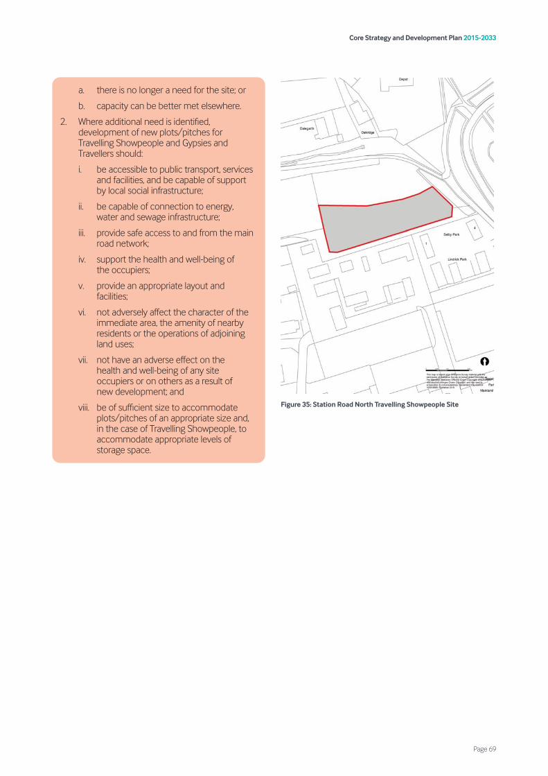
Figure 35: Station Road North Travelling Showpeople Site
a. there is no longer a need for the site; or
b. capacity can be better met elsewhere.
2. Where additional need is identified, development of new plots/pitches for Travelling Showpeople and Gypsies and Travellers should:
i. be accessible to public transport, services and facilities, and be capable of support by local social infrastructure;
ii. be capable of connection to energy, water and sewage infrastructure;
iii. provide safe access to and from the main road network;
iv. support the health and well-being of the occupiers;
v. provide an appropriate layout and facilities;
vi. not adversely affect the character of the immediate area, the amenity of nearby residents or the operations of adjoining land uses;
vii. not have an adverse effect on the health and well-being of any site occupiers or on others as a result of new development; and
viii. be of sufficient size to accommodate plots/pitches of an appropriate size and, in the case of Travelling Showpeople, to accommodate appropriate levels of storage space.
Core Strategy and Development Plan 2015-2033
Page 69
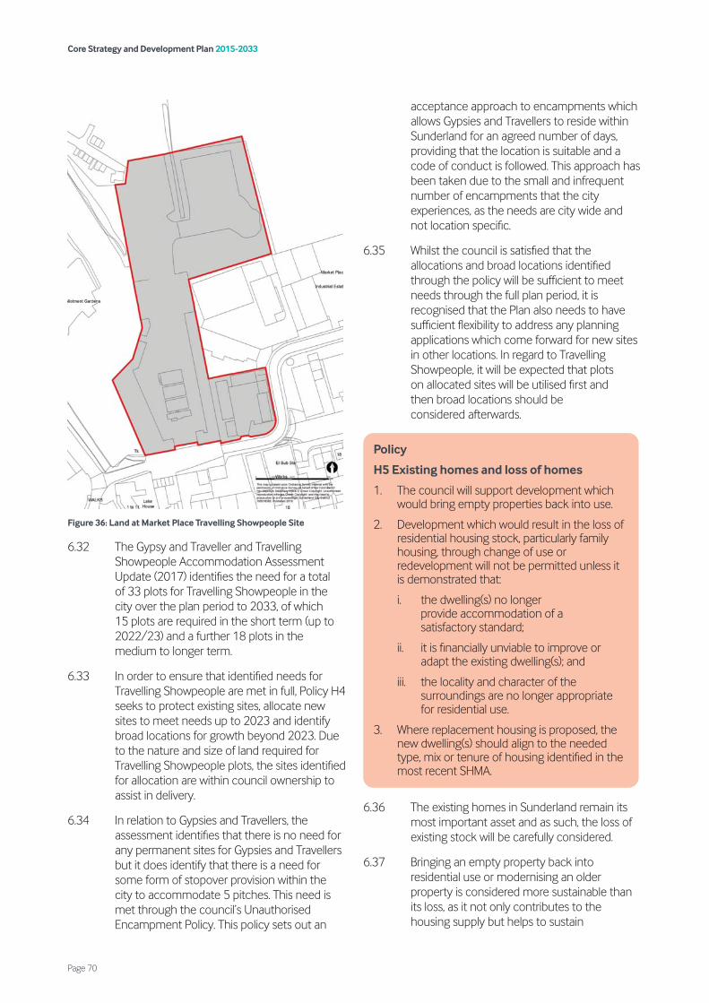
Figure 36: Land at Market Place Travelling Showpeople Site
6.32 The Gypsy and Traveller and Travelling Showpeople Accommodation Assessment Update (2017) identifies the need for a total of 33 plots for Travelling Showpeople in the city over the plan period to 2033, of which 15 plots are required in the short term (up to 2022/23) and a further 18 plots in the medium to longer term.
6.33 In order to ensure that identified needs for Travelling Showpeople are met in full, Policy H4 seeks to protect existing sites, allocate new sites to meet needs up to 2023 and identify broad locations for growth beyond 2023. Due to the nature and size of land required for Travelling Showpeople plots, the sites identified for allocation are within council ownership to assist in delivery.
6.34 In relation to Gypsies and Travellers, the assessment identifies that there is no need for any permanent sites for Gypsies and Travellers but it does identify that there is a need for some form of stopover provision within the city to accommodate 5 pitches. This need is met through the council’s Unauthorised Encampment Policy. This policy sets out an
acceptance approach to encampments which allows Gypsies and Travellers to reside within Sunderland for an agreed number of days, providing that the location is suitable and a code of conduct is followed. This approach has been taken due to the small and infrequent number of encampments that the city experiences, as the needs are city wide and not location specific.
6.35 Whilst the council is satisfied that the allocations and broad locations identified through the policy will be sufficient to meet needs through the full plan period, it is recognised that the Plan also needs to have sufficient flexibility to address any planning applications which come forward for new sites in other locations. In regard to Travelling Showpeople, it will be expected that plots on allocated sites will be utilised first and then broad locations should be considered afterwards.
6.36 The existing homes in Sunderland remain its most important asset and as such, the loss of existing stock will be carefully considered.
6.37 Bringing an empty property back into residential use or modernising an older property is considered more sustainable than its loss, as it not only contributes to the housing supply but helps to sustain
Policy
H5 Existing homes and loss of homes
1. The council will support development which would bring empty properties back into use.
2. Development which would result in the loss of residential housing stock, particularly family housing, through change of use or redevelopment will not be permitted unless it is demonstrated that:
i. the dwelling(s) no longer provide accommodation of a satisfactory standard;
ii. it is financially unviable to improve or adapt the existing dwelling(s); and
iii. the locality and character of the surroundings are no longer appropriate for residential use.
3. Where replacement housing is proposed, the new dwelling(s) should align to the needed type, mix or tenure of housing identified in the most recent SHMA.
Core Strategy and Development Plan 2015-2033
Page 70

communities. However, the council does understand that retention is not always appropriate and in certain instances losses are unavoidable. When clearance does occur, the redevelopment of residential areas can also help contribute to creating improved living environments by new stock being better aligned to the required house types and sizes of the area.
6.38 The loss of existing housing stock as part of large-scale housing area renewal schemes will be supported where a detailed feasibility study or neighbourhood assessment is provided to inform a Housing Delivery Plan, alternatively, Masterplans may be used to guide future development.
6.39 Development for HMOs will need to demonstrate that they would not have a detrimental effect on the character and function of the locality, its local amenity or neighbouring properties. When considering whether there is an over concentration of HMO properties within the locality, the council will consider each proposal on its individual merits, taking account of the number of existing HMOs, clustering and the character of the area. As shared accommodation tends to provide smaller living accommodation than single dwelling houses, particular attention will be given to ensure that a good standard of
amenity is in place for future occupiers of the HMOs. The council will require development proposals to retain acceptable levels of privacy and protect amenity.
6.40 Article 4 Directions have been implemented where the numbers of HMOs in an area are having a detrimental effect on the character and function of that area. In Sunderland five wards across the city, namely Barnes, Hendon, Millfield, St Michael’s and St Peter’s are subject to an Article 4 Direction. These remove permitted development rights and prevent the change of use to HMOs without planning approval. HMOs proposed within an area covered by an Article 4 Direction will be subject to Policy H6 and other relevant policies within this plan.
6.41 The spacious nature and low density of some of Sunderland’s mature suburbs has led to development pressure for the intensification of existing housing areas through development of backland plots. This can have a significant impact on local distinctiveness and conservation by the erosion of the unique character that makes these places special, particularly if the principles of good design are not taken into account. It is essential therefore, if development takes place in these areas, that it is appropriate in all respects and that it makes a positive contribution to the environment and community within which it is located, to ensure the local distinctiveness and character of these areas is maintained.
Policy
H6 Homes in Multiple Occupation (HMOs)
Development for HMOs should ensure that:
1. the property is located where increased traffic and activity would not be detrimental to local amenity;
2. the intensity of use would not adversely affect the character and function of the locality;
3. the proposal would not be detrimental to the amenities of neighbouring properties by causing undue noise and disturbance;
4. adequate provision for parking, servicing, refuse, recycling arrangements and the management and maintenance of the property can be demonstrated through the submission of a management plan;
5. the proposal would not result in an over concentration of HMOs within the locality; and
6. the accommodation provides a good standard of living space and amenity for occupiers of the HMO.
Policy
H7 Backland and tandem development
The development of residential new build within the curtilage of an existing dwelling should:
1. be of a form and scale that respects the local character of the area with regard to density, size and massing of existing buildings;
2. have a plot depth that is appropriate in size and would offer an adequate level of separation between dwellings;
3. ensure that an acceptable level of amenity is retained;
4. demonstrate suitable access, having regard to existing dwelling frontages and street scenes; and
5. ensure existing landscape and streetscape features (e.g. mature trees or other landscape features), are integrated into the development.
Core Strategy and Development Plan 2015-2033
Page 71
7.1 The council is committed to supporting sustainable economic growth in order to attract inward investment and help existing businesses thrive. Sustainable economic growth is essential to maintaining and enhancing the overall prosperity of the city. This Plan will help to build on Sunderland’s inherent strengths to meet the twin challenges of global competition and a low carbon future.
7.2 This chapter includes policies to meet Strategic Priorities 1 and 5 and supports economic growth by:
• supporting the redevelopment of The Vaux for office-led regeneration (Policy SS1);
• ensuring an attractive and flexible supply of general employment land over the plan period (Policies EG1 and EG2);
• supporting developments which enhance automotive industries and advanced manufacturing, particularly at the IAMP; and
• supporting development of key sectors such as education, health, high-tech and knowledge-based industries.
7.3 These policies will support the growth ambitions identified through the council’s Economic Masterplan, the Economic Leadership Board’s 3,6,9 Vision and the NELEP’s Strategic Economic Plan.
7.4 Primary Employment Areas and Key Employment Areas make up the city’s designated general employment land portfolio. Totalling 1,073 hectares (rounded), these designated employment sites play an important role in meeting economic growth and employment needs. Overall, 30 sites have been designated as either Primary Employment Areas (13 sites) or Key Employment Areas (17 sites). As of 31 March 2019, there is an estimated 84.07 hectares of general available employment land 21. Completions between the start of the plan period to the 31 March 2019 totalled 13.42
hectares. Table 6 identifies components of supply. Tables 7 and 8 below set out designated employment sites by overall size and available employment land on each of the 30 designated allocations.
7.5 Some small scale ancillary uses will be supported in Primary Employment Areas where this meets the day to day needs of workers on the employment sites.
Table 6: Components of supply
21 Please note that general available employment land is made up of the following components, available employment land on Primary Employment Areas and Key Employment Areas plus known commitments at the Port and elsewhere (other sources).
Source Size (ha)
Primary Employment Areas 48.42
Key Employment Areas 26.53
Other Sources 9.12
Completions (2015 – 2018) 13.42
Total 97.49
Core Strategy and Development Plan 2015-2033
Page 73
7. Economic growth
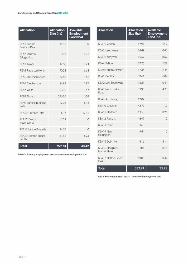
Table 7: Primary employment areas – available employment land
Table 8: Key employment areas – available employment land
Allocation Allocation Size (ha)
Available Employment Land (ha)
KEA1: Hendon 47.91 14.2
KEA2: Leechmere 24.49 0.42
KEA3: Pennywell 15.62 0.62
KEA4: Pallion 27.20 1.29
KEA5: Pallion Shipyard 17.34 2.44
KEA6: Deptford 32.61 6.02
KEA7: Low Southwick 15.21 0.41
KEA8: North Hylton Road
33.99 4.75
KEA9: Armstrong 12.04 0
KEA10: Crowther 43.72 1.9
KEA11: Hertburn 13.55 0.21
KEA12: Parsons 16.97 0
KEA13: Swan 3.63 0
KEA14: New Herrington
4.44 0
KEA15: Dubmire 8.16 3.14
KEA16: Houghton Market Place
1.81 0.16
KEA17: Hetton Lyons East
19.05 0.37
Total 337.74 35.93
Allocation Allocation Size (ha)
Available Employment Land (ha)
PEA1: Sunrise Business Park
14.13 0
PEA2: Rainton Bridge North
23.01 4.71
PEA3: Glover 42.58 0.24
PEA4: Patterson North 90.23 6.63
PEA5: Patterson South 32.63 1.62
PEA6: Stephenson 34.92 1.97
PEA7: Wear 53.96 1.47
PEA8: Nissan 296.26 6.58
PEA9: Turbine Business Park
22.08 6.16
PEA10: Hillthorn Farm 26.17 12.81
PEA11: Doxford International
57.19 0
PEA12: Hylton Riverside 34.76 0
PEA13: Rainton Bridge South
31.81 6.23
Total 759.73 48.42
Core Strategy and Development Plan 2015-2033
Page 74
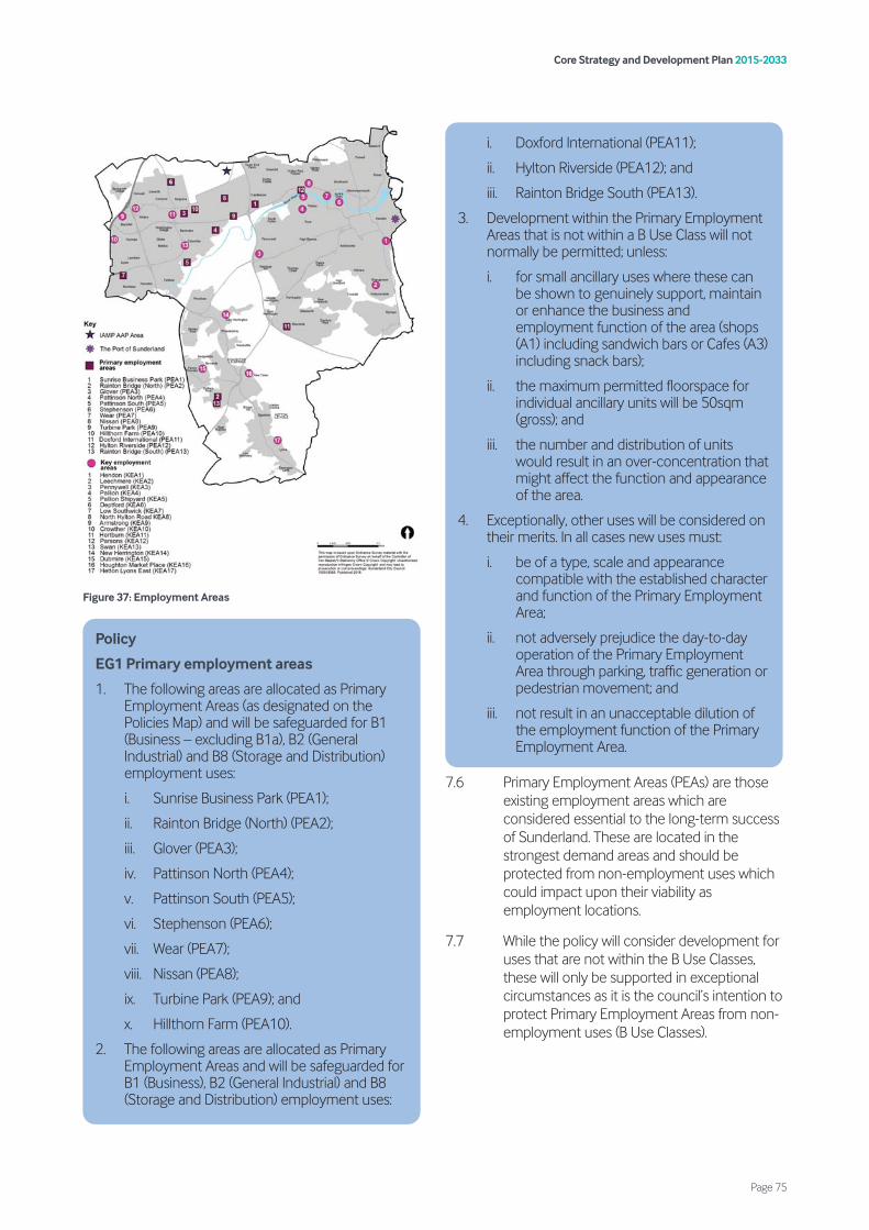
Figure 37: Employment Areas
7.6 Primary Employment Areas (PEAs) are those existing employment areas which are considered essential to the long-term success of Sunderland. These are located in the strongest demand areas and should be protected from non-employment uses which could impact upon their viability as employment locations.
7.7 While the policy will consider development for uses that are not within the B Use Classes, these will only be supported in exceptional circumstances as it is the council’s intention to protect Primary Employment Areas from non- employment uses (B Use Classes).
i. Doxford International (PEA11);
ii. Hylton Riverside (PEA12); and
iii. Rainton Bridge South (PEA13).
3. Development within the Primary Employment Areas that is not within a B Use Class will not normally be permitted; unless:
i. for small ancillary uses where these can be shown to genuinely support, maintain or enhance the business and employment function of the area (shops (A1) including sandwich bars or Cafes (A3) including snack bars);
ii. the maximum permitted floorspace for individual ancillary units will be 50sqm (gross); and
iii. the number and distribution of units would result in an over-concentration that might affect the function and appearance of the area.
4. Exceptionally, other uses will be considered on their merits. In all cases new uses must:
i. be of a type, scale and appearance compatible with the established character and function of the Primary Employment Area;
ii. not adversely prejudice the day-to-day operation of the Primary Employment Area through parking, traffic generation or pedestrian movement; and
iii. not result in an unacceptable dilution of the employment function of the Primary Employment Area.
Policy
EG1 Primary employment areas
1. The following areas are allocated as Primary Employment Areas (as designated on the Policies Map) and will be safeguarded for B1 (Business – excluding B1a), B2 (General Industrial) and B8 (Storage and Distribution) employment uses:
i. Sunrise Business Park (PEA1);
ii. Rainton Bridge (North) (PEA2);
iii. Glover (PEA3);
iv. Pattinson North (PEA4);
v. Pattinson South (PEA5);
vi. Stephenson (PEA6);
vii. Wear (PEA7);
viii. Nissan (PEA8);
ix. Turbine Park (PEA9); and
x. Hillthorn Farm (PEA10).
2. The following areas are allocated as Primary Employment Areas and will be safeguarded for B1 (Business), B2 (General Industrial) and B8 (Storage and Distribution) employment uses:
Core Strategy and Development Plan 2015-2033
Page 75
7.8 Key Employment Areas (KEAs) are those existing employment areas which are still required to meet anticipated needs for employment floorspace over the plan period, but are recognised as older and less effective employment areas, in locations of weaker demand.
7.9 To avoid the long term protection of employment land where there is no reasonable prospect of it being used for that purpose, the council has adopted a more flexible approach. Key Employment Areas can be used for alternative uses where it can be demonstrated that they are no longer required to meet employment needs and the proposed alternative development would be appropriate in that location.
7.10 In respect of point iv), the council will require a statement of the efforts that have been made to market the land or premises for employment development (within Use Classes B1, B2 and/or B8). The statement shall include clear and genuine evidence demonstrating that the land/premises has been widely marketed through an agent/surveyor dealing in commercial property at a price that reflects its current market value for B Use Class employment purposes for at least the last 24 months continuously and that no reasonable offer has been refused. Statements will be considered by the in-house property team whom regularly monitor the employment market and local land values.
iv. the site has been unused for employment uses for at least 24 months, despite having been properly marketed on reasonable terms.
Policy
EG3 Other employment sites
For non-designated employment sites, development will be supported for:
1. new employment uses or extensions to existing employment uses; and
2. the change of use or redevelopment of land or premises that are presently in employment uses if there are regeneration benefits or there is no reasonable prospect of the land being used for employment uses, and the development is considered to be acceptable.
Policy
EG2 Key employment areas
1. The following are allocated as Key Employment Areas (as designated on the Policies Map) and will be safeguarded for B1 (Business – excluding B1a), B2 (General Industrial) and B8 (Storage and Distribution) employment uses:
i. Hendon (KEA1);
ii. Leechmere (KEA2);
iii. Pennywell (KEA3);
iv. Pallion (KEA4);
v. Pallion Shipyard (KEA5);
vi. Deptford (KEA6);
vii. Low Southwick (KEA7);
viii. North Hylton Road (KEA8);
ix. Armstrong (KEA9);
x. Crowther (KEA10);
xi. Hertburn (KEA11);
xii. Parsons (KEA12);
xiii. Swan (KEA13);
xiv. New Herrington (KEA14);
xv. Dubmire (KEA15);
xvi. Houghton Market Place (KEA16); and
xvii. Hetton Lyons East (KEA17).
2. The release of vacant land or premises within Key Employment Areas to uses outside the B Use Classes will only be considered acceptable where it can be demonstrated that:
i. the council’s current Employment Land Review recommends its release for another purpose, or it can be demonstrated through alternative evidence to the council’s satisfaction that a site is no longer needed or capable of accommodating B Use Class employment uses;
ii. the integrity, function and operation of the remaining Key Employment Area for employment purposes is not adversely affected;
iii. the site is of an insufficient quality and/or suitability to accommodate existing types of industrial demand; and
Core Strategy and Development Plan 2015-2033
Page 76
7.11 There are also a number of existing employment sites which are not designated as Primary or Key Employment Areas. These tend to be older, less marketable employment sites close to, or within residential areas, where proposals for redevelopment for other uses – could give rise to significant regeneration benefits.
7.12 Whilst the council will continue to support these existing businesses, it is also necessary for the Plan to allow flexibility for them to be reused for alternative forms of appropriate development.
7.13 Policy EG3 applies to existing employment land which does not fall within a Primary Employment Area, Key Employment Area, the Port of Sunderland, the IAMP, or the strategic allocation at The Vaux.
7.14 Whilst the established employment areas will be the most appropriate location for businesses, it is acknowledged that in order to maximise opportunities to grow the local economy and be responsive to changing market conditions, there may be occasions where a certain use requires a location outside of these areas. Policy EG4 seeks to provide this additional flexibility by supporting such development where it would be acceptable in all other regards.
7.15 Designated employment areas are considered to be the Primary Employment Areas, Key Employment Areas, the Port of Sunderland and the IAMP. The council will require applicants to provide a detailed statement justifying why the proposals cannot be accommodated within designated employment areas. This should include evidence that the proposal would not adversely impact upon the functionality of existing employment areas.
7.16 Office development (Use Class B1a) is considered to be a main town centre use, which should be directed to designated centres in accordance with the NPPF. Policy EG4 therefore does not apply to proposals for office development.
7.17 In order to improve the vitality and viability of the Urban Core, Policy EG5 seeks to direct most new office development to The Vaux, which is identified as a strategic allocation for office-led development under Policy SS1.
7.18 Office development is recognised as a main town centre/Urban Core use therefore, it is considered to be appropriate development within designated centres. The development of new office floorspace in designated centres, as identified within the retail hierarchy set out in Policy VC1 will generally be supported.
7.19 It is also recognised that some of the Primary Employment Areas are also business parks which contain predominantly office uses, therefore it would be appropriate to continue to support the development of offices in these locations. The Primary Employment Areas where office development will continue to be supported are at Doxford International, Hylton Riverside and Rainton Bridge South.
7.20 The development of new office floorspace in other locations (including Primary Employment Areas and Key Employment Areas not specified under Policy EG5 criterion 2) will normally be resisted unless they are ancillary to the principal use, or it can be demonstrated to the council’s satisfaction that it is necessary for the development to be located there for operational reasons.
Policy
EG5 Offices
Development for offices (Use Class B1a) should be prioritised within the following locations:
1. The Vaux strategic site allocation (Policy SS1);
2. Primary Employment Areas at Doxford International, Hylton Riverside and Rainton Bridge South (PEA11, PEA12 and PEA13); and
3. within other designated centres as identified within the retail hierarchy set out in Policy VC1.
Policy
EG4 New employment areas
Development for new employment uses (B1 – (excluding B1a), B2 and B8 uses) outside of designated employment areas must demonstrate that the proposed use:
1. cannot be accommodated within the designated employment areas;
2. can be provided with appropriate vehicular access; and
3. would not be detrimental to local amenity.
Core Strategy and Development Plan 2015-2033
Page 77
7.21 Certain business uses found in employment areas require an ancillary trade counter for the sale of goods.
7.22 In order to retain the employment character of these employment areas, it is important that the retailing element does not become over-dominant. To ensure that this is the case, Policy EG6 seeks to ensure that a maximum of 15% of internal floorspace may be permitted to be used for sales.
7.23 In order to protect the vitality and viability of existing centres, it should be ensured that any trade counter development is not of a sufficient scale that is likely to have a significant adverse impact upon the designated centres. The policy therefore establishes an upper limit of 500m2 for ancillary retail use, which is consistent with the lowest of the locally set impact assessment thresholds in Policy VC2.
7.24 For clarity, in circumstances where the proposed trade counter/factory shop would be over 500m2 but less than 15% of the internal floorspace of the unit, the lower threshold will apply.
Policy
EG6 Trade counters
1. Where industrial users within a Primary Employment Area or Key Employment Area require a ‘trade counter/factory shop’ this should be limited to a maximum of 500m² or 15% of the existing industrial floorspace and only be used for the sale of goods made or stored on the premises.
2. Developments for a trade counter/factory shop should not:
i. compromise the industrial nature of the site or area in question;
ii. attract customers in such large numbers so as to impede the access arrangements; and
iii. cause significant operational difficulties for other neighbouring occupants.
Core Strategy and Development Plan 2015-2033
Page 78
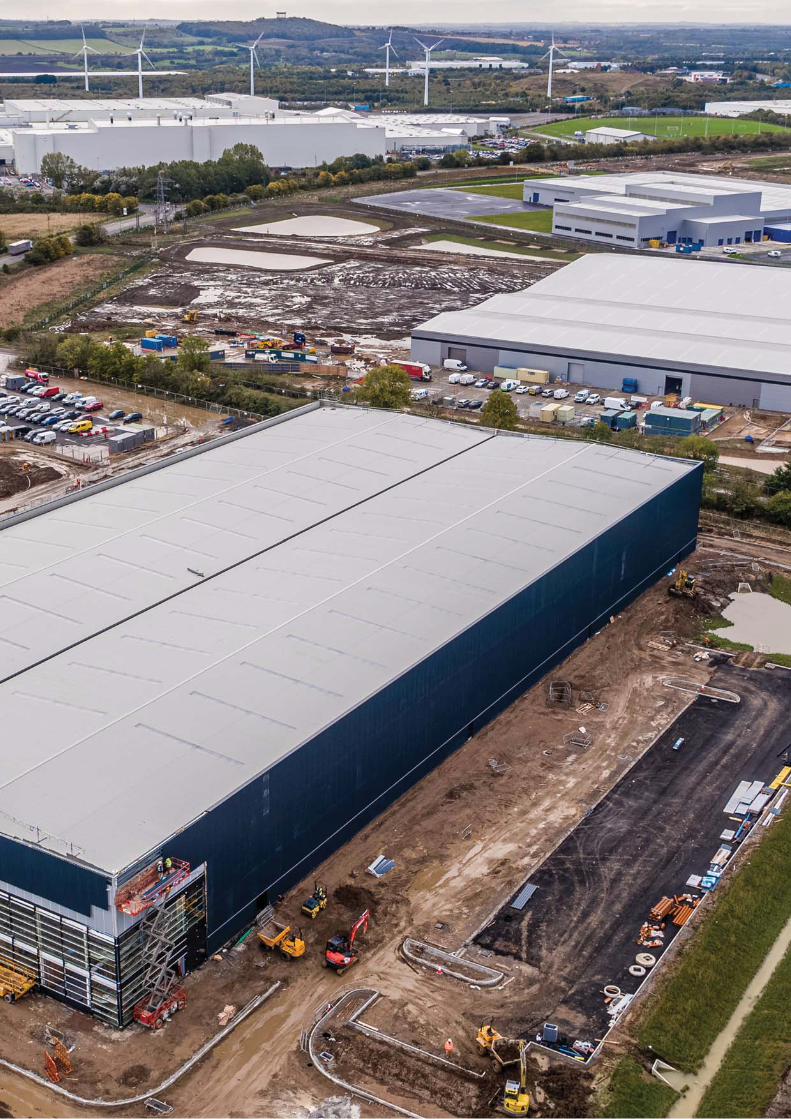

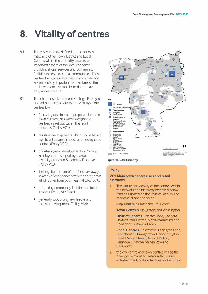
8.1 The city centre (as defined on the policies map) and other Town, District and Local Centres within the authority area are an important aspect of the local economy, providing shops, services and community facilities to serve our local communities. These centres help give areas their own identity and are particularly important to members of the public who are less mobile, or do not have easy access to a car.
8.2 This chapter seeks to meet Strategic Priority 6 and will support the vitality and viability of our centres by:-
• focussing development proposals for main town centres uses within designated centres, as set out within the retail hierarchy (Policy VC1);
• resisting developments which would have a significant adverse impact upon designated centres (Policy VC2);
• prioritising retail development in Primary Frontages and supporting a wider diversity of uses in Secondary Frontages (Policy VC3);
• limiting the number of hot food takeaways in areas of over-concentration and/or areas which suffer from poor health (Policy VC4);
• protecting community facilities and local services (Policy VC5); and
• generally supporting new leisure and tourism development (Policy VC6).
Figure 38: Retail Hierarchy
Policy
VC1 Main town centre uses and retail hierarchy
1. The vitality and viability of the centres within the network and hierarchy identified below (and designated on the Policies Map) will be maintained and enhanced:
City Centre: Sunderland City Centre;
Town Centres: Houghton, and Washington;
District Centres: Chester Road, Concord, Doxford Park, Hetton, Monkwearmouth, Sea Road and Southwick Green;
Local Centres: Castletown, Easington Lane, Fencehouses, Grangetown, Hendon, Hylton Road, Market Street (Hetton), Pallion, Pennywell, Ryhope, Shiney Row and Silksworth;
2. the city centre and town centres will be the principal locations for major retail, leisure, entertainment, cultural facilities and services;
Core Strategy and Development Plan 2015-2033
Page 81
8. Vitality of centres
8.3 One of the characteristics of Sunderland is its extensive network of centres, which provide a focus for growth in the retail, office and leisure sectors. Centres also act as a focus for local community life and ensure that services are available in accessible locations. The network and hierarchy of centres will be the preferred location for retail and office development over the plan period.
8.4 For the purpose of main town centre uses, the city centre, which is within the Urban Core, is defined on the Policies Map. The city centre, Washington and Houghton Town Centres are recognised as the three most important centres. All three perform significant retail, social and public functions and are important centres for the local transport network in the respective sub-areas. The District Centres feature significant retail facilities and services such as banks, whilst the much smaller Local Centres primarily cater for day-to-day shopping needs.
8.5 These centres are the primary locations for shopping facilities and they also play important roles as “hubs” of the local community, providing for wider social needs.
8.6 Whilst not identified within the retail hierarchy, neighbourhood shops, services and community facilities located outside of the designated centres provide a valuable service to local communities in helping to meet their day-to-day needs. It is therefore necessary for these to be protected in order to promote sustainable patterns of development.
8.7 Development proposals for main town centre uses should be focused within the designated centres, as set out within the retail hierarchy and should be of a scale and format that is appropriate to the position of the centre within the hierarchy. A definition of main town centre uses is provided within the glossary.
8.8 Development of main town centre uses in edge and out-of-centre locations will be expected to follow the sequential assessment approach, prioritising locations which are accessible and well connected to designated centres. For clarity, for the city centre and town centres, the Primary Shopping Area (as defined on the Policies Map) forms the centre boundary for sequential assessment purposes. For all other centres, it is the centre boundary (as defined in the Policies Map) which should be used. Out-of-centre developments for main town centre uses will only be supported where they can demonstrate that they have satisfactorily met the sequential test and would not have a significant adverse impact upon the vitality and viability of designated centres.
8.9 Whilst development will be focused within designated centres, it is recognised that established out-of-centre retail parks have a role to play in meeting the needs of residents. These are not considered to form part of the retail hierarchy but where out-of-centre development is considered acceptable and the sequential test has been met, there are merits in co-locating new developments within or alongside existing retail parks. These are often already well integrated into the public transport network and can offer sustainability benefits over standalone out-of-centre schemes. The council considers the following to represent established out-of-centre retail parks within the city for the purposes of this policy:
• Salterfen;
• Hylton Retail Park;
• Pallion Retail Park; and
• Peel Centre, Washington.
3. the District Centres will have a role in providing key services including shopping, commercial, leisure, public and community facilities;
4. the Local Centres will provide a focus for essential community services and small- scale retail facilities to meet day-to-day needs, thereby supporting the wellbeing of local people;
5. neighbourhood shops, services and community facilities located outside of the designated centres will be protected where they are important in meeting day-to-day needs;
6. the development of main town centre uses, will be focused within existing designated centres, as set out within the retail hierarchy. Development outside of existing centres will be expected to follow the sequential assessment approach; and
7. established out-of-centre retail parks – whilst not considered part of the retail hierarchy, will be considered to be sequentially preferable to other out-of-centre locations when considering development proposals for main town centre uses.
Core Strategy and Development Plan 2015-2033
Page 82
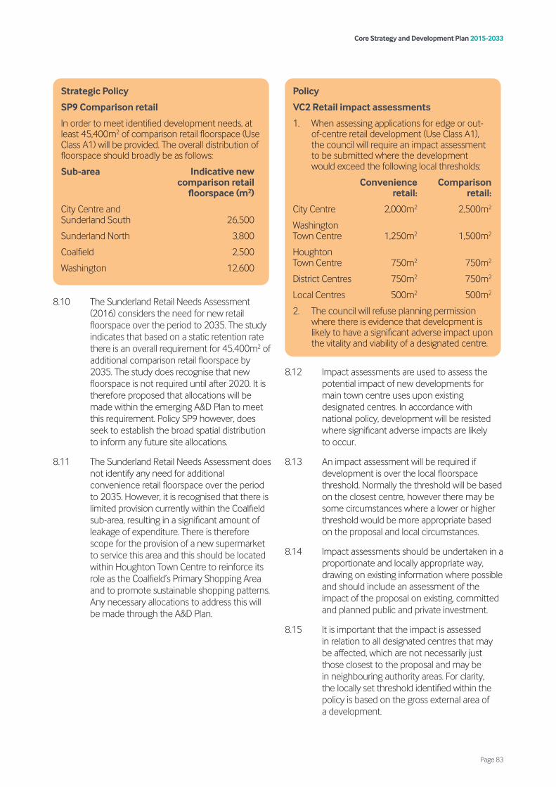
8.10 The Sunderland Retail Needs Assessment (2016) considers the need for new retail floorspace over the period to 2035. The study indicates that based on a static retention rate there is an overall requirement for 45,400m2 of additional comparison retail floorspace by 2035. The study does recognise that new floorspace is not required until after 2020. It is therefore proposed that allocations will be made within the emerging A&D Plan to meet this requirement. Policy SP9 however, does seek to establish the broad spatial distribution to inform any future site allocations.
8.11 The Sunderland Retail Needs Assessment does not identify any need for additional convenience retail floorspace over the period to 2035. However, it is recognised that there is limited provision currently within the Coalfield sub-area, resulting in a significant amount of leakage of expenditure. There is therefore scope for the provision of a new supermarket to service this area and this should be located within Houghton Town Centre to reinforce its role as the Coalfield’s Primary Shopping Area and to promote sustainable shopping patterns. Any necessary allocations to address this will be made through the A&D Plan.
8.12 Impact assessments are used to assess the potential impact of new developments for main town centre uses upon existing designated centres. In accordance with national policy, development will be resisted where significant adverse impacts are likely to occur.
8.13 An impact assessment will be required if development is over the local floorspace threshold. Normally the threshold will be based on the closest centre, however there may be some circumstances where a lower or higher threshold would be more appropriate based on the proposal and local circumstances.
8.14 Impact assessments should be undertaken in a proportionate and locally appropriate way, drawing on existing information where possible and should include an assessment of the impact of the proposal on existing, committed and planned public and private investment.
8.15 It is important that the impact is assessed in relation to all designated centres that may be affected, which are not necessarily just those closest to the proposal and may be in neighbouring authority areas. For clarity, the locally set threshold identified within the policy is based on the gross external area of a development.
Policy
VC2 Retail impact assessments
1. When assessing applications for edge or out-of-centre retail development (Use Class A1), the council will require an impact assessment to be submitted where the development would exceed the following local thresholds:
Convenience Comparison retail: retail:
City Centre 2,000m2 2,500m2
Washington Town Centre 1,250m2 1,500m2
Houghton Town Centre 750m2 750m2
District Centres 750m2 750m2
Local Centres 500m2 500m2
2. The council will refuse planning permission where there is evidence that development is likely to have a significant adverse impact upon the vitality and viability of a designated centre.
Strategic Policy
SP9 Comparison retail
In order to meet identified development needs, at least 45,400m2 of comparison retail floorspace (Use Class A1) will be provided. The overall distribution of floorspace should broadly be as follows:
Sub-area Indicative new comparison retail floorspace (m2)
City Centre and Sunderland South 26,500
Sunderland North 3,800
Coalfield 2,500
Washington 12,600
Core Strategy and Development Plan 2015-2033
Page 83
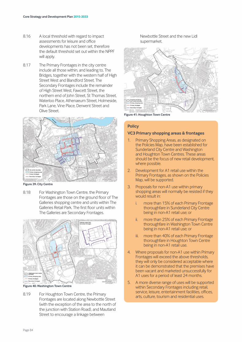
8.16 A local threshold with regard to impact assessments for leisure and office developments has not been set, therefore the default threshold set out within the NPPF will apply.
8.17 The Primary Frontages in the city centre include all those within, and leading to, The Bridges, together with the western half of High Street West and Blandford Street. The Secondary Frontages include the remainder of High Street West, Fawcett Street, the northern end of John Street, St Thomas Street, Waterloo Place, Athenaeum Street, Holmeside, Park Lane, Vine Place, Derwent Street and Olive Street.
Figure 39: City Centre
8.18 For Washington Town Centre, the Primary Frontages are those on the ground floor of The Galleries shopping centre and units within The Galleries Retail Park. The first floor units within The Galleries are Secondary Frontages.
Figure 40: Washington Town Centre
8.19 For Houghton Town Centre, the Primary Frontages are located along Newbottle Street (with the exception of the area to the north of the junction with Station Road), and Mautland Street to encourage a linkage between
Newbottle Street and the new Lidl supermarket.
Figure 41: Houghton Town Centre
Policy
VC3 Primary shopping areas & frontages
1. Primary Shopping Areas, as designated on the Policies Map, have been established for Sunderland City Centre and Washington and Houghton Town Centres. These areas should be the focus of new retail development, where possible.
2. Development for A1 retail use within the Primary Frontages, as shown on the Policies Map, will be supported.
3. Proposals for non-A1 use within primary shopping areas will normally be resisted if they would result in:
i. more than 15% of each Primary Frontage thoroughfare in Sunderland City Centre being in non-A1 retail use; or
ii. more than 25% of each Primary Frontage thoroughfare in Washington Town Centre being in non-A1 retail use; or
iii. more than 40% of each Primary Frontage thoroughfare in Houghton Town Centre being in non-A1 retail use.
4. Where proposals for non-A1 use within Primary Frontages will exceed the above thresholds, they will only be considered acceptable where it can be demonstrated that the premises have been vacant and marketed unsuccessfully for A1 uses for a period of least 24 months.
5. A more diverse range of uses will be supported within Secondary Frontages including retail, service, leisure, entertainment facilities, offices, arts, culture, tourism and residential uses.
Core Strategy and Development Plan 2015-2033
Page 84
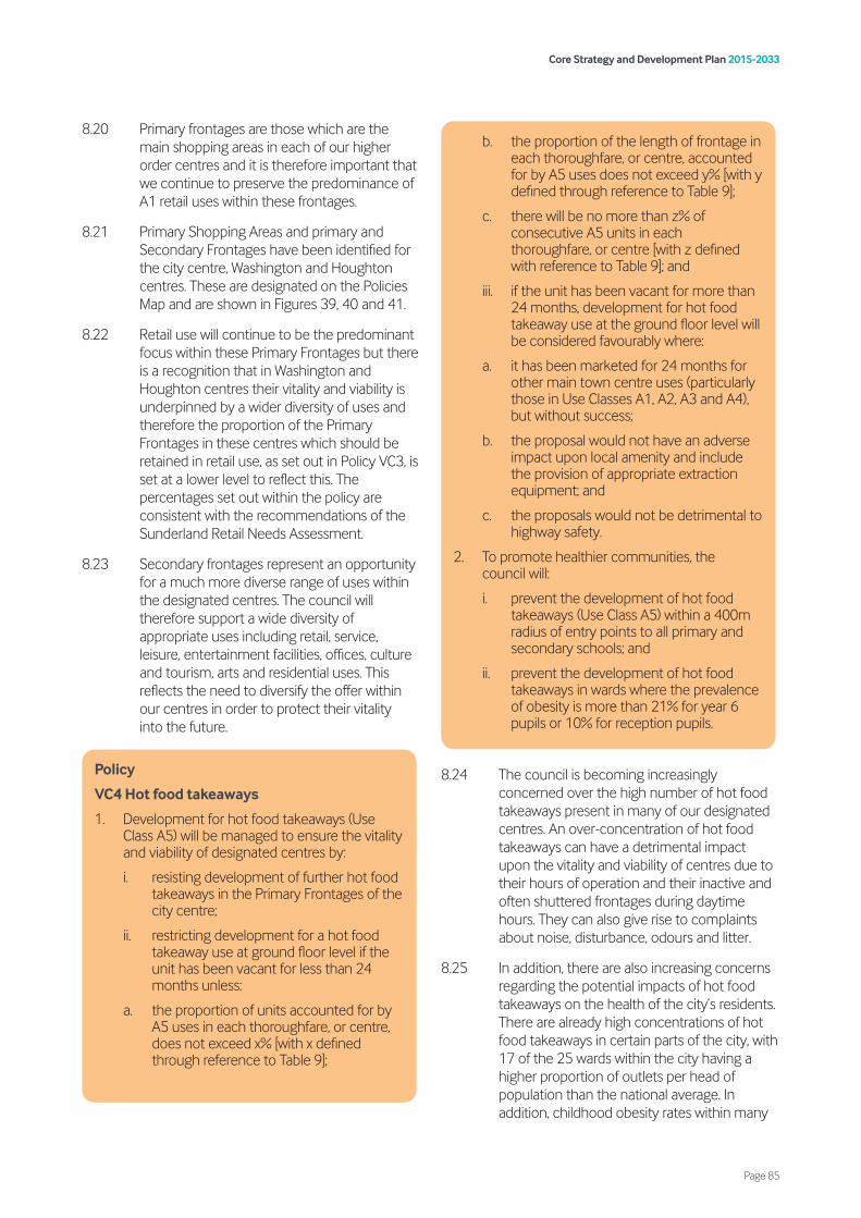
8.20 Primary frontages are those which are the main shopping areas in each of our higher order centres and it is therefore important that we continue to preserve the predominance of A1 retail uses within these frontages.
8.21 Primary Shopping Areas and primary and Secondary Frontages have been identified for the city centre, Washington and Houghton centres. These are designated on the Policies Map and are shown in Figures 39, 40 and 41.
8.22 Retail use will continue to be the predominant focus within these Primary Frontages but there is a recognition that in Washington and Houghton centres their vitality and viability is underpinned by a wider diversity of uses and therefore the proportion of the Primary Frontages in these centres which should be retained in retail use, as set out in Policy VC3, is set at a lower level to reflect this. The percentages set out within the policy are consistent with the recommendations of the Sunderland Retail Needs Assessment.
8.23 Secondary frontages represent an opportunity for a much more diverse range of uses within the designated centres. The council will therefore support a wide diversity of appropriate uses including retail, service, leisure, entertainment facilities, offices, culture and tourism, arts and residential uses. This reflects the need to diversify the offer within our centres in order to protect their vitality into the future.
8.24 The council is becoming increasingly concerned over the high number of hot food takeaways present in many of our designated centres. An over-concentration of hot food takeaways can have a detrimental impact upon the vitality and viability of centres due to their hours of operation and their inactive and often shuttered frontages during daytime hours. They can also give rise to complaints about noise, disturbance, odours and litter.
8.25 In addition, there are also increasing concerns regarding the potential impacts of hot food takeaways on the health of the city’s residents. There are already high concentrations of hot food takeaways in certain parts of the city, with 17 of the 25 wards within the city having a higher proportion of outlets per head of population than the national average. In addition, childhood obesity rates within many
b. the proportion of the length of frontage in each thoroughfare, or centre, accounted for by A5 uses does not exceed y% [with y defined through reference to Table 9];
c. there will be no more than z% of consecutive A5 units in each thoroughfare, or centre [with z defined with reference to Table 9]; and
iii. if the unit has been vacant for more than 24 months, development for hot food takeaway use at the ground floor level will be considered favourably where:
a. it has been marketed for 24 months for other main town centre uses (particularly those in Use Classes A1, A2, A3 and A4), but without success;
b. the proposal would not have an adverse impact upon local amenity and include the provision of appropriate extraction equipment; and
c. the proposals would not be detrimental to highway safety.
2. To promote healthier communities, the council will:
i. prevent the development of hot food takeaways (Use Class A5) within a 400m radius of entry points to all primary and secondary schools; and
ii. prevent the development of hot food takeaways in wards where the prevalence of obesity is more than 21% for year 6 pupils or 10% for reception pupils.
Policy
VC4 Hot food takeaways
1. Development for hot food takeaways (Use Class A5) will be managed to ensure the vitality and viability of designated centres by:
i. resisting development of further hot food takeaways in the Primary Frontages of the city centre;
ii. restricting development for a hot food takeaway use at ground floor level if the unit has been vacant for less than 24 months unless:
a. the proportion of units accounted for by A5 uses in each thoroughfare, or centre, does not exceed x% [with x defined through reference to Table 9];
Core Strategy and Development Plan 2015-2033
Page 85

of the city’s wards are significantly higher than both the national and regional averages.
8.26 In assessing proposals for new hot food takeaways within designated centres, consideration will be given to the detrimental impact that an over-provision of A5 uses may have upon the vitality and viability the centre.
8.27 Whilst it is recognised that an oversupply of hot food takeaways within a designated centre can adversely impact upon its vitality and viability, the council also recognise that a significant number of vacant units within a centre can also have a negative impact. Policy VC4 therefore seeks to support proposals for hot food takeaways within designated centres where they would bring a long term vacant unit (vacant for 24 months or more) back into active use. This would be subject to the applicant demonstrating to the council’s satisfaction that the property has been vacant for a continuous period of at least 24 months and that the unit has been genuinely marketed for main town centre uses (particularly those in Use Classes A1, A2, A3 and A4) at a realistic market value for a continuous period of at least 24 months without success. This will however not apply to hot food takeaways in the Primary Frontages of the city centre, where proposals for hot food takeaways will normally be resisted.
8.28 When considering proposals that have met the above requirement, the council will carefully consider the potential impacts of the proposals on local amenity and highways safety, together with all other material planning considerations. Applications for new hot food takeaways or significant amendments to an existing hot food takeaway should be accompanied by a noise and impact assessment which quantifies the impact that may arise from activities taking place and mitigates these to a level that would not be unacceptable at the nearest sensitive receptor.
8.29 Where a unit has not been vacant for a continuous period of at least 24 months, Policy VC4 seeks to limit the number of hot food takeaways located within each centre in order to protect their vitality and viability. The proportion and concentration of hot food takeaways considered acceptable is dependent on their position within the retail hierarchy.
Table 9: Hot Food Takeaway Thresholds
8.30 With regard to the health aspects of the policy, a 400m buffer to school access points has been defined. Within these buffer zones no development proposals for hot food takeaways will be supported. For clarity, the 400m buffer will not apply when the application site is within a designated centre.
8.31 Childhood obesity data is gathered as part of the National Childhood Measurement Programme. The latest childhood obesity data at ward level can be accessed from the council’s website at www.sunderland.gov.uk/planningpolicy.
x y z
Centre
Max
imum
pro
port
ion
of A
5 un
its in
eac
h th
orou
ghfa
re,
or c
entre
(%)
Max
imum
Pro
port
ion
of
the
Leng
th o
f Fro
ntag
e in
ea
ch th
orou
ghfa
re, o
r ce
ntre
in A
5 us
es (%
)
Max
imum
Clu
ster
of
Adja
cent
A5
Uni
ts in
eac
h th
orou
ghfa
re, o
r cen
tre
(No.
of u
nits
)
City centre – Primary frontage thoroughfares
No further A5 uses
City centre – Secondary frontage thoroughfares
5 5 3
Washington Town Centre – Primary and secondary frontage thoroughfares
5 5 3
Houghton-le-Spring – Primary and secondary frontage thoroughfares
10 10 3
District centres 10 10 2
Local centres 15 15 2
Core Strategy and Development Plan 2015-2033
Page 86

8.32 Community facilities and local services (as defined in the glossary) provide opportunities for residents to meet and share their interests and access essential services such as education, health care (SP7) and family support. It is therefore important that these facilities are protected where possible.
8.33 When assessing the impact of new community facilities the council will consider:
• accessibility to their respective neighbourhoods;
• the likely number of future occupants; and
• the impact on existing community facilities that are accessible to the development and their available capacity.
8.34 Evidence that may be required to support a proposal which would lead to a loss of community facilities could include:
• the nature and condition of the building or site and the cost of repairs, renovations or improvements needed to allow the facility to continue in operation;
• the nature and location of comparable facilities;
• the potential to relocate the use into other premises or to another site in the area; and/or
• evidence that the local community has been notified in writing of the intention to close the facility and detail of representations received.
8.35 It is important to protect viable facilities so far as is practicable, unless there is an overriding justification for their loss or exceptional benefits deriving from alternative forms of development. The council will require any application involving the loss of any community facility or land last used for community purposes to be supported by written evidence to justify its loss. The applicant will be required to provide written evidence that they have marketed the facility for at least 24 months and consulted with the Local Voluntary and Community Sector and advertised in the local press. The level of detail will depend upon the nature of the proposal; the applicant should contact the council at the earliest stage to discuss this.
8.36 Exceptions to this policy will be considered where the proposals are part of the rationalisation of the estates of key public services, such as the Emergency Services, the Clinical Commissioning Group (or replacement body) and the Learning Trust.
Policy
VC6 Culture, leisure and tourism
1. Development of cultural, leisure and tourism proposals will generally be supported, particularly:
i. the development of Music, Arts and Culture proposals within the Minster Quarter, including a new auditorium;
ii. leisure and tourism proposals at Seaburn and Roker seafront;
iii. new hotel development in the Urban Core;
iv. the delivery of cinema and ancillary food and beverage units at Washington Town Centre;
v. the development of new sports hubs at Washington, Sunderland North and Sunderland South as part of the Football Association’s Parklife programme;
vi. leisure development which contribute to healthy lifestyles; and
Policy
VC5 Protection and delivery of community facilities and local services
Community facilities and local services will be protected and enhanced by:
1. resisting their loss, unless a replacement facility that meets the needs of the community is provided, or the community facility is no longer required in its current use and it has been demonstrated that it is not suitable for any other community uses;
2. supporting development of new and extended community facilities. Developments for new community facilities should be located in accessible neighbourhood and centre locations; and
3. supporting the shared use of facilities, provided that it can be demonstrated that such shared use will not adversely affect the level of social and community provision.
Core Strategy and Development Plan 2015-2033
Page 87
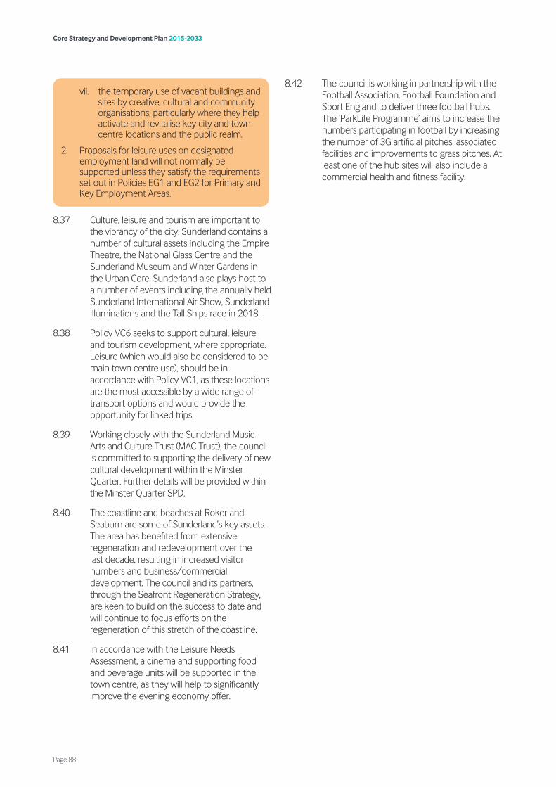
8.37 Culture, leisure and tourism are important to the vibrancy of the city. Sunderland contains a number of cultural assets including the Empire Theatre, the National Glass Centre and the Sunderland Museum and Winter Gardens in the Urban Core. Sunderland also plays host to a number of events including the annually held Sunderland International Air Show, Sunderland Illuminations and the Tall Ships race in 2018.
8.38 Policy VC6 seeks to support cultural, leisure and tourism development, where appropriate. Leisure (which would also be considered to be main town centre use), should be in accordance with Policy VC1, as these locations are the most accessible by a wide range of transport options and would provide the opportunity for linked trips.
8.39 Working closely with the Sunderland Music Arts and Culture Trust (MAC Trust), the council is committed to supporting the delivery of new cultural development within the Minster Quarter. Further details will be provided within the Minster Quarter SPD.
8.40 The coastline and beaches at Roker and Seaburn are some of Sunderland’s key assets. The area has benefited from extensive regeneration and redevelopment over the last decade, resulting in increased visitor numbers and business/commercial development. The council and its partners, through the Seafront Regeneration Strategy, are keen to build on the success to date and will continue to focus efforts on the regeneration of this stretch of the coastline.
8.41 In accordance with the Leisure Needs Assessment, a cinema and supporting food and beverage units will be supported in the town centre, as they will help to significantly improve the evening economy offer.
8.42 The council is working in partnership with the Football Association, Football Foundation and Sport England to deliver three football hubs. The ‘ParkLife Programme’ aims to increase the numbers participating in football by increasing the number of 3G artificial pitches, associated facilities and improvements to grass pitches. At least one of the hub sites will also include a commercial health and fitness facility.
vii. the temporary use of vacant buildings and sites by creative, cultural and community organisations, particularly where they help activate and revitalise key city and town centre locations and the public realm.
2. Proposals for leisure uses on designated employment land will not normally be supported unless they satisfy the requirements set out in Policies EG1 and EG2 for Primary and Key Employment Areas.
Core Strategy and Development Plan 2015-2033
Page 88
9.1 The policies in this chapter seek to meet Strategic Priority 7 to protect and enhance the built and historic environment. The policies in this chapter will:
• require development to achieve a high quality standard of design (Policy BH1); and where possible incorporate sustainable design and construction methods (Policy BH2);
• ensure that existing and proposed areas of public realm are well designed and accessible (Policy BH3);
• ensure that new advertisements and shop fronts are well-designed and appropriate to their surroundings (Policies BH4 and BH5);
• support the development of high quality communications infrastructure (Policy BH6);
• require development to respect and respond positively to the historic environment and any heritage assets within it (Policies BH7 and BH8); and
• preserve, protect and enhance, where possible, the city’s archaeological heritage (Policy BH9).
9.2 The council is committed to delivering excellence in development quality. It expects all new development to embrace the principles of sustainable design, positively respond to the character and setting, as well as avoiding
Policy
BH1 Design quality
To achieve high quality design and positive improvement, development should:
1. create places which have a clear function, character and identity based upon a robust understanding of local context, constraints and distinctiveness;
2. maximise opportunities to create sustainable, mixed-use developments which support the function and vitality of the area in which they are located;
3. be of a scale, massing, layout, appearance and setting which respects and enhances the positive qualities of nearby properties and the locality;
4. retain acceptable levels of privacy and ensure a good standard of amenity for all existing and future occupiers of land and buildings;
5. promote natural surveillance and active frontages, including the provision of appropriate lighting, to assist in designing out crime;
6. clearly distinguish between public and private spaces, including appropriate use of hard and soft boundary treatments which reflect the character of the area;
7. create visually attractive and legible environments through provision of distinctive high quality architecture, detailing, building materials;
8. provide landscaping as an integral part of the development including retaining landscape features and reflecting surrounding landscape character and where appropriate and viable, the enhancement and upgrading of public realm and existing green infrastructure;
9. maximise the opportunities for buildings and spaces to gain benefit from sunlight and passive solar energy;
10. avoid, where possible, disruption to established views of important buildings, structures and landscape features;
11. in the case of tall buildings, form a positive relationship with the skyline and topography of the site and the surrounding area;
12. create safe, convenient and visually attractive areas for servicing and parking which does not dominate the development and its surroundings;
13. encourage durability and adaptability throughout the lifetime of the development to accommodate a range of uses; and
14. from 1 April 2021, meet national spaces standards as a minimum (for residential).
Large-scale developments should be supported by detailed Masterplans or development frameworks, and where appropriate, design codes.
Core Strategy and Development Plan 2015-2033
Page 89
9. Built and historic environment

harmful and/or cumulative impacts to the amenity of neighbouring buildings, local character and heritage assets.
9.3 Good design is crucial to achieving attractive and durable places to live. This Plan therefore encourages high quality design and development in terms of new buildings and spaces and their setting in the built and rural landscape. This policy sets out the design principles that should be applied across the city to all forms and scales of development.
9.4 New residential development needs to ensure that homes are built with enough indoor and outdoor space to meet the needs of the intended residents. This will be achieved through new housing meeting nationally described space standards as a minimum.
9.5 In order to allow for an appropriate transitional period, the standard relating to Nationally Described Space Standards will only be applied to outline or full applications approved after 1 April 2021. It will not be applied retrospectively to those applications for reserved matters where the outline permission was determined or is subject to a resolution to grant permission (including subject to planning obligations) before 1 April 2021.
9.6 Masterplans or development frameworks should be prepared for large-scale development, in particular those which will be phased. For clarity, large-scale development within the context of this policy is considered to be that which exceeds 250 dwellings for residential development or 5 hectares for non-residiential development. This will ensure that development creates high quality sustainable places based on sound urban design principles. Design codes should also be prepared for large-scale, phased development and accompany outline planning applications. The code should set out mandatory and non-mandatory aspects of design and include regulatory plans. The need for design codes should be identified at the pre-application stage of development. Development should take into consideration SPDs on design which will be a material consideration in the determination of planning applications for relevant proposals.
9.7 Development provides an opportunity for reducing energy consumption and enabling more efficient use of energy, both of which are important for reducing carbon emissions and wasteful use of finite natural resources. It is important that developments are designed to mitigate climate change, and to withstand its effects. This will help to minimise the impact of development on the global environment, and ensure that buildings and spaces endure. Sustainable design also includes the sustainable use of resources, which is an important part of conserving materials and natural resources that are likely to become scarcer. This includes considering how existing buildings can be re-used, and how new buildings might be used in different ways in the future. Sustainable materials include those that are degradable, have low embedded energy, are easily renewed, or are recyclable.
Policy
BH2 Sustainable design and construction
Sustainable design and construction should be integral to development. Where possible, major development (as defined in the 2019 Framework) should:
1. maximise energy efficiency and integrate the use of renewable and low carbon energy;
2. reduce waste and promote recycling during construction and in operation;
3. conserve water resources and minimise vulnerability to flooding;
4. provide details of the type of materials to be used at the appropriate stage of development;
5. provide flexibility and adaptability, where appropriate, allowing future modification of use or layout, facilitating future refurbishment and retrofitting;
6. include opportunities to incorporate measures which enhance the biodiversity value of development, such as green roofs;
7. include a sustainability statement setting out how the development incorporates sustainable resource management and high environmental standards; and
8. maintain an appropriate buffer between sensitive development and existing waste water treatment works to ensure amenity and operational continuity, in accordance with Government Code of Practice guidance.
Core Strategy and Development Plan 2015-2033
Page 90
9.8 In order to ensure that the energy efficiency of properties is maximised, where appropriate, the layout of developments should be designed to reduce dependence on energy for heat and lighting through maximising the southern orientation of buildings and enabling passive solar gain and the use of microgeneration technologies such as photovoltaic (PV) panels.
9.9 For major development a Sustainability Statement should be submitted which sets out how the development:
• is designed with regard given to sustainable development principles, taking into account the effects of climate change;
• delivers carbon reduction and energy efficiency levels required by relevant government guidance/schemes;
• reuses and recycles materials and other resources from all stages of development, design, demolition, construction and operation;
• maximises energy efficiency through internal and external layout, orientation, massing, materials, insulation, heat recovery, construction techniques, natural ventilation, shading and landscaping;
• protects existing water and sewage infrastructure. Where development increases the demands for off-site service infrastructure, it must be demonstrated that sufficient capacity already exists or that extra capacity (or a financial contribution towards capacity) will be provided; and
• will connect to/or be ready to connect to any forthcoming decentralised heat or energy scheme, where feasible.
9.10 Since not all development involves new buildings, extensions and alterations are also required to demonstrate how the proposals will achieve resource efficiency and environmental standards. Applicants should also consider incorporating simple cost effective energy efficiency measures into the existing building.
9.11 The public realm comprises the streets, footpaths and open spaces of the city. These in turn are defined and contained by buildings, other elements and structures. The relationship between buildings and the public realm should ensure that streets and spaces are busy, overlooked by the fronts of buildings and perceived to be safe throughout the day and into the evening. The quality of the public realm shapes people’s perceptions of place and contributes to the character and identity of an area, helping to instil a strong sense of place.
9.12 The construction of high quality areas of public realm with a clear function will aid in creating a distinctive city with its own identity whilst providing wider community benefits. The standard of the public realm provided should reflect the surrounding context of the local area.
9.13 High quality public realm can act as a catalyst for regenerating the city, by making it a more attractive place to invest, work, live and visit. Improvements to public realm are also vital to our town centres and local neighbourhoods to support local economies and also to improve people’s health by creating inclusive environments that encourage people to walk, cycle and socially interact.
9.14 Public art has a major role to play in providing the distinctive identity, enlivening the environment, creating a sense of place and the potential to attract inward investment. Development proposals in the city should respond positively to opportunities to introduce public art and work collaboratively with the community.
Policy
BH3 Public realm
Existing and proposed areas of public realm will:
1. create attractive, safe, legible, functional and accessible public spaces;
2. be constructed of quality, sustainable and durable materials which enhance the surrounding context; and
3. where appropriate, incorporate public art in development.
Core Strategy and Development Plan 2015-2033
Page 91

9.15 Further guidance is provided within the council’s Design and Access SPD.
9.16 Advertisements can play a helpful role in promoting the city’s businesses and provide direction to locations. However, they can sometimes have a negative impact upon the amenity of an area as well as public safety. As such, consideration must be given to local characteristics and features of the street scene. The council aims to ensure that advertisements are designed to a high standard and contribute to a safe and attractive environment. It considers that poorly designed, very bright or inappropriately sited advertisements can detract from the visual quality of the street or local area and so will be resisted.
9.17 In relation to public safety it is necessary to consider the effect of an advertisement upon the safe use of vehicles and operation of traffic flow, including pedestrian traffic. Control over outdoor advertisements should be efficient, effective and simple in concept and operation.
9.18 A shop frontage contributes to the overall appearance of the street scene and as such proposals for this type of development need to ensure the changes positively enhance the appearance of the building as well as the immediate area and do not detract from it.
9.19 Care needs to be taken in the choice of shutters, as solid shutters, particularly bare galvanised or mill finished aluminium ones, can have a detrimental environmental effect, making areas feel desolate and forbidding once trading hours have ceased. Recessed shutter boxes can also assist in avoiding clutter to fascias.
9.20 There are particularly sensitive areas of Sunderland where extra care should be taken over the design and materials used within new shop fronts, such as where they would affect a listed building or where they would be located within a conservation area. Proposals in such areas would therefore be required to sustain and enhance the significance of designated Heritage Assets and take account of any other appropriate planning guidance such as relevant Character Appraisal and Management Strategies (CAMS).
Policy
BH4 Advertisements
Development for advertisements should:
1. be well designed and sympathetic to the character and appearance of their location and the building to which they relate, having regard to matters such as size, materials, construction, location, level of illumination and cumulative impact with other signage on the building and within the vicinity; and
2. for illuminated advertisements and signs, not adversely affect the amenity and/or safety of the surrounding area.
Policy
BH5 Shop fronts
1. Development for shop fronts and signs will be supported where the following criteria is satisfied:
i. the design is well related to the scale and appearance of the building to which the proposal relates; and
ii. the design respects the character and appearance of the location.
2. Solid shutters which present a blank frontage to shopping streets will not be permitted.
3. Proposals relating to listed buildings, within conservation areas and in areas of special advertisement control will be subject to the requirements of the relevant designation and appropriate planning policy guidance.
Policy
BH6 Quality communications
1. Development should include high quality digital infrastructure, providing access to services from a range of providers.
2. Development for the installation of new telecommunications infrastructure must demonstrate that:
i. there would be no significant adverse effect on the external appearance of the building or on the space in which they are to be located;
ii. there would be no significant adverse impact on the special character and appearance of heritage assets
Core Strategy and Development Plan 2015-2033
Page 92
9.21 Digital technologies have been a major driving force in influencing and shaping industry and society in the last few years. Changes that are currently transforming our working, learning, leisure and community environments will need to be integrated into future developments.
9.22 The council will seek to ensure that the development of modern telecommunications equipment is sympathetic to our townscape and countryside. The aim is to ensure that telecommunications equipment is kept to a minimum through encouraging the sharing of existing and/or proposed facilities where this is technically possible. The visual impact of telecommunications equipment can be minimised through careful design, placement, colouring and landscaping. This will help to protect the character of an area and the appearance of property.
9.23 Policy BH6 applies to planning applications or prior notification applications for the installation of satellite dishes, microwave antennae, radio masts, cabinet boxes and other types of telecommunications apparatus which require planning permission. When considering such applications the council will also have regard to the legal requirements placed upon telecommunications operators to provide an adequate service, and any technical and operational constraints that may be faced.
9.24 The historic environment of Sunderland is an irreplaceable resource, providing assets of significant cultural, social, economic and environmental value. Sunderland benefits from a rich, diverse and distinctive historic environment that makes a fundamental contribution to the quality of the environment and provides a sense of place and belonging for its local communities. The historic
iii. the applicant has explored the possibility of sharing facilities, such as masts, cabinet boxes, satellite dishes and antennae on existing buildings or other structures;
iv. opportunities to miniaturise and camouflage any telecommunications apparatus have been explored;
v. they are appropriately designed, coloured and landscaped to take account of their setting; and
vi. there would be no significant adverse impact on the visual amenities of neighbouring occupiers.
Policy
BH7 Historic environment
The council will ensure that the historic environment is valued, recognised, conserved and enhanced, sensitively managed and enjoyed for its contribution to character, local distinctiveness and sustainable communities by:
1. giving great weight to the conservation of heritage assets (designated and non-designated) based on their significance in accordance with national policy;
2. supporting new development which makes a positive contribution to the character and townscape quality of the historic environment;
3. supporting and developing innovative initiatives that identify, maintain, conserve and sustain or return to beneficial usage designated or non-designated heritage assets;
4. capitalising in an appropriate and sensitive manner on the regeneration and tourism potential of heritage assets;
5. taking a positive and proactive approach to securing the conservation and re-use of heritage assets at risk, including working with owners and partner organisations to develop schemes that will address the at-risk status of the assets and exploring opportunities for grant-funding to deliver viable schemes;
6. reviewing existing local heritage designations, such as conservation areas, and making new designations to protect and conserve built heritage assets, where justified, by appropriate surveys and evidence;
7. using Article 4 Directions, where appropriate, to protect features of historic/architectural importance; and
8. improving access and enjoyment of the historic environment where appropriate, by supporting proposals that retain, create or facilitate public access to heritage assets to increase understanding, appreciation and enjoyment of their significance, special qualities and cultural values.
Core Strategy and Development Plan 2015-2033
Page 93
environment includes archaeological remains, historic buildings, townscapes and landscapes, and includes locally significant assets and their settings in addition to designated and statutorily protected features.
9.25 The council acknowledges the value and importance of the city’s historic environment and recognises that its heritage assets should be conserved and enhanced in a manner appropriate to their significance.
9.26 Some of the city’s Heritage Assets are at risk, and addressing Heritage-at-Risk is a key priority of the council. It will focus on working with funding partners such as Historic England and Heritage Lottery Fund, other partner organisations, property owners and developers to develop solutions for assets at risk. For example, Sunderland’s ‘Historic High Streets ‘ Heritage Action Zone is a partnership initiative with Historic England and other local partners that seeks to revive historic Sunderland and reconnect it with the modern city centre.
9.27 The council will also seek to increase its knowledge and understanding of its historic environment, reviewing its local heritage designations, undertaking survey and appraisal work and commissioning specialist studies and research as opportunities arise. For instance, it will continue to produce Conservation Area Character Appraisals and Management Strategies (CAMS) to ensure that all its conservation areas are supported by adopted planning guidance. The use of Article 4 Directions will continue to be used as an effective way of conserving the character and appearance of conservation areas.
9.28 Access and enjoyment of the historic environment goes hand in hand with its conservation. Proposals should therefore, where appropriate to the use, demonstrate that all reasonable steps have been taken to ensure heritage assets are accessible to all user groups and that this can be achieved without harming the significance of the asset.
Policy
BH8 Heritage assets
1. Development affecting heritage assets (both designated and non-designated) or their settings should recognise and respond to their significance and demonstrate how they conserve and enhance the significance and character of the asset(s), including any contribution made by its setting where appropriate.
2. Development affecting a listed building, including alterations and additions should:
i. conserve and enhance its significance in regards to the protection, repair and restoration of its historic fabric, its features and plan form, its boundary enclosures, its setting and views of it, its group value and contribution to local character and distinctiveness; and
ii. be sympathetic and complimentary to its height, massing, alignment, proportions, form, architectural style, building materials, and its setting.
3. The demolition of and/or substantial harm to listed buildings will only be considered in exceptional circumstances and with clear and convincing justification.
4. To preserve or enhance the significance of conservation areas, including their diverse and distinctive character, appearance and their setting, development:
i. should be in accordance with the objectives and proposals of the adopted Character Appraisal and Management Strategy (CAMS) for the relevant conservation area;
ii. should make a positive contribution to the character and distinctiveness of the conservation area;
iii. should support proposals for the conversion and adaptive re-use of vacant and underused buildings and heritage/townscape value in a sensitive manner; and
iv. within and adjacent to conservation areas should be of high design quality, to respect and enhance the established historic townscape and built form, street plan and settings of conservation areas and important views and vistas into, within and out of the areas.
Core Strategy and Development Plan 2015-2033
Page 94

9.29 Sunderland’s historic environment has a large number of heritage assets, both designated and non-designated, including Scheduled Monuments, archaeological sites, Historic Parks and Gardens, listed buildings and conservation areas. Outside statutorily designated areas a diversity of townscapes and landscapes make up the remainder, containing buildings of local historic and architectural value. Policy BH8 will ensure that these are conserved and enhanced.
9.30 A Heritage Statement must accompany all applications that affect heritage assets, and should describe the significance of the heritage asset and the impact of the proposals on its significance.
9.31 A proposal to demolish a listed building, or to alter or extend it in a way that would affect its special character, requires Listed Building Consent. If the proposal also involves ‘development’, planning permission is required and, in that case, the local planning authority will wish to consider applications for Listed Building Consent and planning applications concurrently.
Proposals to alter or extend any listed building will be assessed against the need to preserve the special architectural or historic interest which led to the building being listed. There is a general presumption in favour of the preservation of listed buildings, and consent to demolish or partly demolish such buildings will only be granted in exceptional circumstances. Demolition of listed buildings will need to demonstrate through a feasibility study that all options to conserve the building have been considered and clearly justify the case for demolition. Consent for demolition will not be given until redevelopment proposals have also been agreed and a programme of recording of the listed building has been initiated.
9.32 Extensions to listed buildings or development that affects the setting of a listed building, (either by virtue of being within its curtilage or sited in the surrounding environment within which it is experienced) will be required to be supported by visual analysis (such as relevant perspectives and cross sections) and other technical material that enables the impact of the proposal to be properly assessed.
9.33 The council recognises the need in some cases to be flexible in the consideration of development to re-use listed buildings at risk, particularly those that have been vacant and deteriorating for long periods of time and are vulnerable. However, development that harms the significance of the listed building, including its setting, will not be considered acceptable unless the degree of harm is outweighed by the benefits of securing the repair and its re-use and the proposal sustains the overall significance of the asset into the future.
9.34 Development in conservation areas will be considered against the relevant CAMS or otherwise on the basis of whether they preserve and enhance the significance of the conservation area.
9.35 Demolition of unlisted buildings which are identified in the relevant CAMS as making a positive contribution to the conservation area will normally be refused. Applications will be expected to be accompanied by the same level of supporting information as those to demolish listed buildings. Proposals for the sympathetic and creative re-use and adaptation of vacant and underused historic buildings in conservation areas will be encouraged.
5. The demolition or unsympathetic alteration of buildings which make a positive contribution to a conservation area will only be acceptable in exceptional circumstances and must be robustly justified.
6. Development of open spaces and the loss of any trees that contribute to the essential character of conservation areas and the settings of individual buildings within them will be resisted unless there are clear heritage or environmental benefits that outweigh the loss.
7. Development within or adjacent to the Registered Historic Parks and Gardens and unregistered Parks and Gardens that are considered by the council to be of historic interest, will be required to protect and enhance their designed landscape character and setting and their natural and built features of historic, architectural and artistic importance.
8. Development affecting non-designated heritage assets should take account of their significance, features and setting.
9. In considering proposals affecting heritage assets identified as being at risk the council will support their conversion and adaptation where this secures their sympathetic repair, re-use in appropriate uses and sustains their significance into the future.
Core Strategy and Development Plan 2015-2033
Page 95
9.36 Developments within and otherwise affecting the settings of conservation areas should display high quality designs that respect and enrich their historic context and the fundamental character of the conservation area.
9.37 In considering development affecting non-designated heritage assets and where necessary their settings, the council will have regard to the conservation of the heritage asset and its contribution to local character and distinctiveness in weighing up the merits of the proposal.
9.38 In addition to the city’s Registered Parks and Gardens of Historic Interest there are several parks and gardens and other designed landscapes of historic interest in the city that whilst not currently registered, are considered by the council to be of sufficient significance to warrant being treated as if they were registered when considering development proposals that affect them.
9.39 For Heritage Assets at Risk, the council will work collaboratively with developers and funding organisations and take a balanced approach to secure the assets’ repair and restoration, whilst also developing innovative ways of adapting them to accommodate uses that secure their future in beneficial usage.
9.40 Proposed works that directly affects a Scheduled Ancient Monument (SAM) normally requires Scheduled Monument Consent; applications are determined by Historic England rather than the council. The council’s responsibilities in relation to SAMs consist of having regard to the effect of any development upon their settings.
9.41 The city’s archaeological remains are a rare record of the evolution of civilisation in Sunderland, giving people the opportunities to experience and learn about their past. The Tyne and Wear Historic Environment Record (HER) is compiled, maintained and continually updated by the County Archaeologist on behalf of the five Tyne and Wear authorities. The council is required in accordance with of the NPPF to make publicly available information on the significance of heritage assets gathered as part of plan-making or development management. The council takes a pro-active approach towards this gathering of information, for inclusion in the HER.
Policy
BH9 Archaeology and recording of heritage assets
1. Development which adversely affects the archaeological interest or setting of a Scheduled Ancient Monument (or non-designated heritage asset of equivalent significance) will be refused planning permission unless exceptional circumstances exist that satisfy the requirements of the NPPF.
2. The council will support the preservation, protection and where possible the enhancement of the city’s archaeological heritage by requiring that:
i. applications that may affect buried archaeological remains must be supported by an archaeological desk-based assessment and evaluation reports where appropriate;
ii. where development affects heritage assets of archaeological interest, preference will be given to preservation in situ. However where loss of the asset is justified in accordance with national policy, the remains should be appropriately archaeologically excavated and recorded, the findings assessed and analysed, the resulting archive report deposited with the Tyne and Wear Historic Environment Record and the physical archive deposited with the relevant collecting museum. Significant findings will also be published in an archaeological journal to make them publicly accessible and to enhance understanding; and
iii. where demolition or part demolition of a designated built heritage asset or non-designated building of significance has been justified, or substantive changes are to be made to the asset, works must not commence until archaeological building recording of the asset has been carried out and the results deposited with the Historic Environment Record and Tyne and Wear Archives.
Core Strategy and Development Plan 2015-2033
Page 96

9.42 Such opportunities arise in particular with development that seeks to demolish, remove, or make substantive physical changes to heritage assets. In such cases the council will require an appropriate level of archaeological assessment and evaluation, historic and architectural appraisal and other relevant analysis deemed necessary.
Core Strategy and Development Plan 2015-2033
Page 97


10.1 The provision of attractive, accessible areas of green infrastructure, open space, sports and community facilities helps to support physical activity and social interaction, allowing people to lead healthy lifestyles. Connecting up the different communities and facilities to ensure Sunderland functions effectively is essential to support sustainable lifestyles and enhance the quality of life for local people. This chapter includes policies to meet Strategic Priority 8 and will seek to protect and enhance the natural environment by:
• maintaining and improving the Green and Blue Infrastructure Network (Policy NE1);
• protecting biodiversity and geodiversity (Policy NE2);
• conserving trees, woodlands and hedgerows (Policy NE3);
• protecting and conserving the quality, community value, functionality and accessibility of greenspaces (Policy NE4);
• protecting the Green Belt from inappropriate development (Policy NE6);
• protecting Settlement Breaks from development (Policy NE7);
• limiting development within the Open Countryside (Policy NE8);
• protecting, conserving and enhancing the varied landscape character of the city (Policy NE9);
• conserving, protecting and enhancing the natural and cultural integrity of the designated Heritage Coast (Policy NE10);
• ensuring that development is designed to preserve or enhance key views and vistas (Policy NE11); and
• protecting the loss of the best and most versatile agricultural land, (Policy NE12).
Policy
NE1 Green and blue infrastructure
1. To maintain and improve the Green Infrastructure Network through enhancing, creating and managing multifunctional greenspaces and bluespaces that are well connected to each other and the wider countryside, development should:
i. incorporate existing and/or new green infrastructure features within their design and to improve accessibility to the surrounding area;
ii. address corridor gaps and areas of corridor weakness where feasible;
iii. support the management of existing wildlife corridors, including reconnecting vulnerable and priority habitats (see policy NE2);
iv. apply climate change mitigation and adaptation measures, including flood risk and watercourse management;
v. link walking and cycling routes to and through the corridors, where appropriate;
vi. include and/or enhance formal and natural greenspace and bluespace provision;
vii. protect and enhance landscape character;
viii. have regard to the requirements of the Green Infrastructure Delivery Plan and make contributions proportionate to their scale towards the establishment, enhancement and on-going management; and
ix. protect, enhance and restore watercourses, ponds, lakes and water dependent habitats.
2. Development that would sever or significantly reduce green infrastructure will not normally be permitted unless the need for and benefits of the development demonstrably outweigh any adverse impacts and suitable mitigation and/or compensation is provided.
Core Strategy and Development Plan 2015-2033
Page 99
10. Natural environment
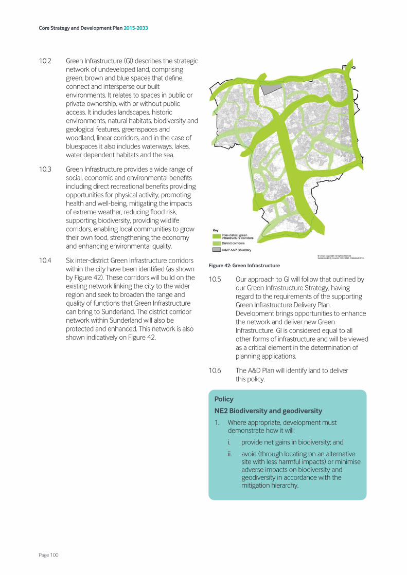
10.2 Green Infrastructure (GI) describes the strategic network of undeveloped land, comprising green, brown and blue spaces that define, connect and intersperse our built environments. It relates to spaces in public or private ownership, with or without public access. It includes landscapes, historic environments, natural habitats, biodiversity and geological features, greenspaces and woodland, linear corridors, and in the case of bluespaces it also includes waterways, lakes, water dependent habitats and the sea.
10.3 Green Infrastructure provides a wide range of social, economic and environmental benefits including direct recreational benefits providing opportunities for physical activity, promoting health and well-being, mitigating the impacts of extreme weather, reducing flood risk, supporting biodiversity, providing wildlife corridors, enabling local communities to grow their own food, strengthening the economy and enhancing environmental quality.
10.4 Six inter-district Green Infrastructure corridors within the city have been identified (as shown by Figure 42). These corridors will build on the existing network linking the city to the wider region and seek to broaden the range and quality of functions that Green Infrastructure can bring to Sunderland. The district corridor network within Sunderland will also be protected and enhanced. This network is also shown indicatively on Figure 42.
Figure 42: Green Infrastructure
10.5 Our approach to GI will follow that outlined by our Green Infrastructure Strategy, having regard to the requirements of the supporting Green Infrastructure Delivery Plan. Development brings opportunities to enhance the network and deliver new Green Infrastructure. GI is considered equal to all other forms of infrastructure and will be viewed as a critical element in the determination of planning applications.
10.6 The A&D Plan will identify land to deliver this policy.
Policy
NE2 Biodiversity and geodiversity
1. Where appropriate, development must demonstrate how it will:
i. provide net gains in biodiversity; and
ii. avoid (through locating on an alternative site with less harmful impacts) or minimise adverse impacts on biodiversity and geodiversity in accordance with the mitigation hierarchy.
Core Strategy and Development Plan 2015-2033
Page 100
10.7 Wildlife is not confined to designated sites and many features serve as wildlife corridors, links and stepping stones. Sunderland’s wildlife corridors coupled with our designated sites will be the means to deliver ecological networks and habitat connectivity within and beyond Sunderland. The location of new development will deliver sites that avoid, protect and/or enhance Sunderland’s wildlife and geology.
10.8 For the purpose of this policy the term biodiversity includes all statutory and non-statutory designated sites, protected species, priority habitats and species, wildlife corridors, and habitats and species outside designated sites and not identified as a conservation priority but which are considered locally important including water-dependent, aquatic and marine habits and species. Geodiversity relates to the variety of rocks, minerals, fossils, landforms, sediments and soils, together with the natural processes that form and alter them, which are considered nationally or locally important.
10.9 Any proposal that is likely to have a significant effect on a European site, either alone or in-combination with other plans or projects, will need to undertake a Habitats Regulations Assessment (HRA). Where necessary, planning obligations will be secured to implement avoidance and mitigation measures for strategic site HGA5. Mitigation measures will include a combination of Strategic Access Management and Monitoring (SAMM) and the provision of Suitable Alternative Natural Greenspace (SANG). Proposals for development or land use that would adversely affect a European Site, either individually or in combination with other plans or projects, will only be permitted where the developer can demonstrate that there are imperative reasons of overriding public interest, including those of a social or economic nature, and there is no alternative solution. Compensatory measures will be secured to ensure that the overall coherence of the network of European sites is maintained. Where a SANG is proposed as mitigation for HRA impacts, depending on the use and form that the SANG takes it may be possible for this to also be utilised as useable greenspace providing the uses are compatible.
10.10 It is expected that in the majority of cases, habitats and species of principal importance will have already been identified on a site-specific basis and are protected through national and local designations - however,
2. Development that would have an impact on the integrity of European designated sites that cannot be avoided or adequately mitigated will not be permitted other than in exceptional circumstances. These circumstances will only apply where there are:
i. no suitable alternatives;
ii. imperative reasons of overriding public interest;
iii. necessary compensatory provision can be secured to ensure that the overall coherence of the Natura 2000 network of European sites is protected; and
iv. development will only be permitted where the council is satisfied that any necessary mitigation is included such that, in combination with other development, there will be no significant effects on the integrity of European Nature Conservation Sites.
3. Development that would adversely affect a Site of Special Scientific Interest, either directly or indirectly, will be required to demonstrate that the reasons for the development, including the lack of an alternative solution, clearly outweigh the nature conservation value of the site and the national policy to safeguard the national network of such sites.
4. Development that would adversely affect a Local Wildlife Site or Local Geological Site, either directly or indirectly, will demonstrate that:
i. there are no reasonable alternatives; and
ii. the case for development clearly outweighs the need to safeguard the intrinsic value of the site.
5. Development that would adversely affect the ecological, recreational and/or educational value of a Local Nature Reserve that will demonstrate:
i. that there are no reasonable alternatives; and
ii. the case for development clearly outweighs the need to safeguard the ecological, recreational and/or educational value of the site.
6. Development that would have a significant adverse impact on the value and integrity of a wildlife corridor will only be permitted where suitable replacement land or other mitigation is provided to retain the value and integrity of the corridor.
Core Strategy and Development Plan 2015-2033
Page 101
species will not always be confined to a designated site boundary. Sites of Special Scientific Interest (SSSIs) are of national significance and receive statutory protection. Local Wildlife Sites (LWSs) are of regional or sub regional importance and are designated by a Local Wildlife Sites Partnership. They are non-statutory and rely on the planning system for their protection. Local Nature Reserves (LNRs) are designated by the council and receive statutory protection.
10.11 Where a development directly and/or indirectly impacts on a designated site, proposals should take account of appropriate buffer zones as a way of minimising potential adverse effects and where possible incorporate or enhance them as part of the development. Buffer zones will vary in size, dependent upon different types of species and habitat involved.
10.12 Development likely to have a significant direct or indirect impact on legally protected species and habitats of Principal Importance in England 22and those listed by the Local Nature Partnership will not be recommended for approval unless they incorporate appropriate measures that ensure the long term survival and enhancement of current populations and habitats to ensure the sustainability of an individual group, species or habitat.
10.13 Dependent on the biodiversity and geodiversity impact, the council may require developers to produce a management strategy to ensure the continued protection of the features of interest. Such management strategies may include monitoring programmes to provide up to date information which will shape future policy reviews as well as inform future site specific plans.
10.14 Wildlife corridors are strategic networks which transcend administrative boundaries and are instrumental in the movement of species within and beyond Sunderland. Wildlife corridors will be protected from intrusive developments, including certain recreational uses, though development that demonstrates significant enhancement and net gain may be considered appropriate. The nature conservation value of wildlife corridors should be maintained and enhanced as part of any planning approval.
10.15 Biodiversity does not just occur on undisturbed greenfield sites. Many brownfield sites and built features have biodiversity value, and many sites require management to retain their importance. Where possible, these areas will be enhanced and integrated into the functional network.
10.16 The forthcoming Biodiversity and Geodiversity SPD will support the natural environment policies, and this will include clarification regarding the types of development that require delivery of net gains in biodiversity. The A&D Plan will identify land to deliver this policy.
22 Section 41 of the Natural Environment and Rural Communities (NERC) Act 2006
Policy
NE3 Woodlands/hedgerows and trees
To conserve significant trees, woodlands and hedgerows, development should:
1. follow the principles below to guide the design of development where effects to ancient woodland, veteran/aged trees and their immediate surroundings have been identified:
i. avoid harm;
ii. provide unequivocal evidence of need and benefits of proposed development;
iii. provide biodiversity net gain;
iv. establish likelihood and type of any impacts;
v. implement appropriate and adequate mitigation and compensation;
vi. provide adequate buffers; and
vii. provide adequate evidence to support proposals;
2. retain, protect and improve woodland, trees subject to Tree Preservation Orders (TPOs), trees within conservation areas, and ‘important’ hedgerows as defined by the Hedgerows Regulations 1997;
3. give consideration to trees and hedgerows both on individual merit as well as their contribution to amenity and interaction as part of a group within the broader landscape setting; and
4. ensure that where trees, woodlands and hedgerows are impacted negatively by proposed development, justification, mitigation, compensation and maintenance measures are provided in a detailed management plan.
Core Strategy and Development Plan 2015-2033
Page 102
10.17 Woodlands and trees play an extremely important role in the landscape and environmental quality of Sunderland. Existing trees and landscaping can be a valuable resource and, where it is desirable to retain them (including any statutorily protected trees), the design and layout of new development must allow for this, including suitable buffer zones and details of measures to protect retained trees and landscaping.
10.18 Development which fails to make satisfactory arrangements for landscaping or the protection of retained trees will normally be refused unless the benefits of and development in that location clearly outweigh the loss. British Standard 5837:2012 Trees in Relation to Design, Demolition and Construction recognises that trees need to be properly protected during construction periods. This document provides guidance on planting and protecting trees during construction and the level of information required for full surveys.
10.19 Ancient woodland and aged or veteran trees are irreplaceable; therefore discussions over possible compensation should not form part of the assessment to determine whether the benefits of the development proposal outweigh the loss.
10.20 Tree Preservation Orders (TPOs) are particularly important in controlling the felling and pruning of trees or woodlands which make a significant contribution to the environment. New orders will continue to be made where trees of amenity value are at risk. The council will take enforcement action against those who deliberately damage or remove protected trees.
10.21 The provision of attractive, accessible and functional greenspace is an important component of the Green Infrastructure Network that adds significantly to environmental quality and helps to support physical activity and social wellbeing.
10.22 The council will seek to ensure that local residents have access to greenspace to meet their needs. The Greenspace Report sets out in detail the existing provision and where shortfalls exist. While the overall provision of open space is sufficient it does vary across Sunderland. To ensure sufficient open space is provided for future residents, the council will designate land in the A&D Plan.
Policy
NE4 Greenspace
The council will protect, conserve and enhance the quality, community value, function and accessibility of greenspace and wider green infrastructure, especially in areas of deficiency identified in the council’s Greenspace Audit and Report by:
1. designating greenspaces in the A&D Plan;
2. requiring development to contribute towards the provision of new and/or enhanced greenspace where there is an evidenced requirement;
3. requiring all major residential development to provide:
i. a minimum of 0.9ha per 1000 bedspaces of useable greenspace on site; unless
ii. a financial contribution for the maintenance/upgrading to neighbouring existing greenspace is considered to be more appropriate;
4. refusing development on greenspaces which would have an adverse effect on its amenity, recreational or nature conservation value unless it can be demonstrated that:
i. the proposal is accompanied by an assessment that clearly demonstrates that the provision is surplus to requirements; or
ii. a replacement facility which is at least equivalent in terms of usefulness, attractiveness, quality and accessibility, and where of an appropriate quantity, to existing and future users is provided by the developer on another site agreed with the council prior to development commencing; or
iii. replacement on another site is neither practicable or possible an agreed contribution is made by the developer to the council for new provision or the improvement of existing greenspace or outdoor sport and recreation facilities and its maintenance within an appropriate distance from the site or within the site.
The impact of development on greenspace provision will need to be considered on a case-by-case basis in terms of its potential impact on Natura 2000 (N2K) sites.
Core Strategy and Development Plan 2015-2033
Page 103
10.23 For the purposes of Policy NE4 we define greenspace as:
• amenity greenspace;
• provision for children and young people (fixed play equipment);
• natural and semi-natural greenspace;
• formal parks and country parks;
• allotments and community gardens;
• outdoor sports facilities;
• school playing fields and grounds;
• cemeteries and church grounds;
• civic spaces; and
• coast and estuary.
10.24 The Greenspace Audit should be used to inform development of the most suitable greenspace provision/improvement for each locality.
10.25 New or enhanced greenspaces will be sought where it can be justified, and must be publicly useable and available. Grass verges should not be included in any calculations, and heavily engineered SUDs solutions will not be considered acceptable within greenspace provision. This provision will be secured through on site provision or, if appropriate, elsewhere in the city. In some cases, a contribution to secure improvements in existing open space, rather than provision of new open space, will be appropriate.
10.26 Major new residential developments will be expected to provide amenity greenspace on site. For clarity, the council considers major development to be 10 or more houses, as per the NPPF. Bedspaces can be notionally equated with types of dwellings as follows:
10.27 There may be circumstances where onsite provision may not be the most appropriate option for the area in question, and this would need to be agreed with the council and in conjunction with the Greenspace Audit. For example:
• smaller developments may not be able to deliver sufficient greenspace that would provide genuine benefit to the development;
• alternatively, the Greenspace Audit may indicate that the development lies within an area with high or above average quantities of amenity greenspace, in which case local quality improvements to existing greenspace may be more beneficial.
10.28 In these circumstances, it may be more appropriate to provide a contribution in lieu for the maintenance/upgrading of existing greenspaces in the locality, or a combination of reduced levels of new greenspace together with a financial contribution to upgrade nearby local greenspaces. Where necessary, the applicant will be required to provide detailed information on how and when the greenspace will be implemented and, once implemented, how the greenspace will be maintained and managed throughout its lifetime. In certain cases, a proposed development might be able to offer the opportunity for alternative provision with comparable community benefit.
10.29 Any impact to the quality and/or quantity of greenspace could have an indirect impact on the N2K sites along the coast by virtue of the potential to increase trips to the coast. At present, this particularly affects sites within 6km of the coast, but may also impact on sites further afield. Further detail will be provided in the A&D Plan.
One bedroom dwelling 2 bedspaces
Two bedroom dwelling 3 bedspaces
Three bedroom dwelling 4 bedspaces
Above three bedrooms 1 additional bedspace per bedroom
Policy
NE5 Burial space
The council will protect all existing burial spaces and seek to re-use existing spaces for new burial spaces where appropriate. In determining any application for the provision of new burial spaces, applications should demonstrate the following:
1. the provision meets the burial requirements of the various ethnic and religious groups within the city;
Core Strategy and Development Plan 2015-2033
Page 104
10.30 Within the city, a total of 49 sites have been identified with some form of cemetery or church function, many of which are of historic interest and include designated heritage assets. This includes 10 municipal cemeteries, which are located throughout the city area. Based on grave capacity at these 10 municipal cemeteries and current grave purchase rates, it is estimated that there are 42 years of capacity remaining.
10.31 In spatial terms, however, there is no municipal burial space remaining in Washington. There has already been some initial site investigation regarding a new municipal cemetery to serve Washington. Ultimately however, the council must demonstrate an ability to provide for the disposal (by burial) for the dead and this is achieved through the spare capacity elsewhere across the city. If a new site is desired, consideration would also need to be given as to whether the new site should focus on the Washington area, or to provide a new central site aimed at serving the city as a whole. Further consideration will be given to this in the A&D Plan.
10.32 Sunderland’s Green Belt forms part of a much wider Tyne and Wear Green Belt to the north and north-west of the city, as well as adjoining County Durham Green Belt to the south and south-west of Sunderland.
10.33 The Green Belt purpose in relation to Sunderland is to check the unrestricted sprawl of the existing built-up area, which has been mapped to show such areas as Washington, Springwell Village, Houghton, Hetton and Shiney Row and the main built-up area of Sunderland (to the east of the A19).
10.34 Whilst most forms of development are considered inappropriate in the Green Belt, national planning policy lists certain exceptions which are not inappropriate. Very special circumstances are clarified in the NPPF.
2. the spaces are located within close proximity to the communities served by spaces to reduce the travelling distance to visit the deceased; and
3. any effect on the water table and the possibility of flooding or water logging caused by the new provision is minimised.
Policy
NE6 Green Belt
1. The Green Belt (as designated on the Policies Map) in Sunderland will serve the following purposes:
i. check the unrestricted sprawl of the built up areas of the city;
ii. assist in safeguarding the city’s countryside from further encroachment;
iii. assist in the regeneration of the urban area of the city;
iv. preserve the setting and special character of Springwell Village and Newbottle Village; and
v. prevent the merging of Sunderland with Tyneside, Washington, Houghton-le-Spring and Seaham, and the merging of Shiney Row with Washington, Chester-le-Street and Bournmoor.
2. In assessing development proposals, development that is inappropriate in the Green Belt will not be approved except in very special circumstances.
3. Development in the Green Belt will be permitted where the proposals are consistent with the exception list in national policy subject to all other criteria being acceptable.
4. Proposals in the Green Belt for increased opportunities for access to the Open Countryside and which provide opportunities for beneficial use such as outdoor sport and recreation, appropriate to the Green Belt, will be encouraged where it will not harm the objectives of the Green Belt and recognise the important role of the Green Belt as a biodiversity resource.
Core Strategy and Development Plan 2015-2033
Page 105
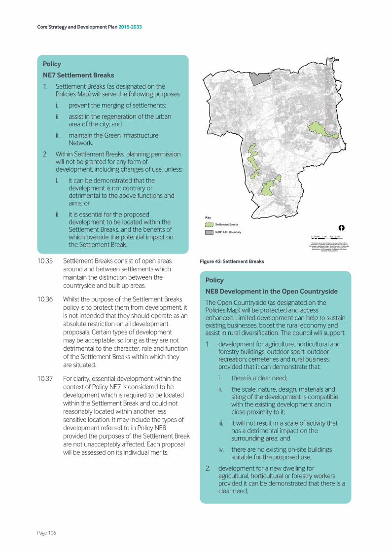
10.35 Settlement Breaks consist of open areas around and between settlements which maintain the distinction between the countryside and built up areas.
10.36 Whilst the purpose of the Settlement Breaks policy is to protect them from development, it is not intended that they should operate as an absolute restriction on all development proposals. Certain types of development may be acceptable, so long as they are not detrimental to the character, role and function of the Settlement Breaks within which they are situated.
10.37 For clarity, essential development within the context of Policy NE7 is considered to be development which is required to be located within the Settlement Break and could not reasonably located within another less sensitive location. It may include the types of development referred to in Policy NE8 provided the purposes of the Settlement Break are not unacceptably affected. Each proposal will be assessed on its individual merits.
Figure 43: Settlement Breaks
Policy
NE7 Settlement Breaks
1. Settlement Breaks (as designated on the Policies Map) will serve the following purposes:
i. prevent the merging of settlements;
ii. assist in the regeneration of the urban area of the city; and
iii. maintain the Green Infrastructure Network.
2. Within Settlement Breaks, planning permission will not be granted for any form of development, including changes of use, unless:
i. it can be demonstrated that the development is not contrary or detrimental to the above functions and aims; or
ii. it is essential for the proposed development to be located within the Settlement Breaks, and the benefits of which override the potential impact on the Settlement Break.
Policy
NE8 Development in the Open Countryside
The Open Countryside (as designated on the Policies Map) will be protected and access enhanced. Limited development can help to sustain existing businesses, boost the rural economy and assist in rural diversification. The council will support:
1. development for agriculture, horticultural and forestry buildings; outdoor sport; outdoor recreation; cemeteries and rural business, provided that it can demonstrate that:
i. there is a clear need;
ii. the scale, nature, design, materials and siting of the development is compatible with the existing development and in close proximity to it;
iii. it will not result in a scale of activity that has a detrimental impact on the surrounding area; and
iv. there are no existing on-site buildings suitable for the proposed use;
2. development for a new dwelling for agricultural, horticultural or forestry workers provided it can be demonstrated that there is a clear need;
Core Strategy and Development Plan 2015-2033
Page 106

10.38 Whilst a considerable part of the city’s Open Countryside is protected through either Green Belt or Settlement Break designations, there are significant areas of Open Countryside (particularly within the southern Coalfield area).
Figure 44: Open Countryside
10.39 Development in the Open Countryside can help sustain existing businesses and boost the rural economy. It is recognised that diversification into non-agricultural activities is vital to the continuing viability of many rural enterprises and as such the council will be supportive of well-conceived schemes for business purposes that contribute to sustainable development, help to sustain the rural enterprise and are consistent in scale with their rural location. Proposals will need to be compatible with the existing area and are of a scale and nature which does not detract from the surrounding area. In respect of proposed new buildings, existing buildings on-site must be considered first.
10.40 To support sustainable (but isolated) development in rural areas, exceptional circumstances are supported that follow national policy relating to rural exception sites, including sites that provide exceptional innovative quality and support historic assets.
10.41 It is recognised that in some limited circumstances there may be a need generated for new dwellings to solely serve workers engaged in agriculture, forestry and other rural activities. In such circumstances, the council will tightly control who occupies
3. housing development if rural exceptions in national policy can be met;
4. an isolated single dwelling if it is of exceptional quality and incorporates innovative design features and reflects the highest standards in architecture and sustainability;
5. development that is required to ensure the conservation and, where appropriate, enhancement of assets of historical significance;
6. the replacement of a building, where the development would not have a significantly greater impact on the rural environment than the original building it is proposed to replace, provided the new building:
i. would be in the same use;
ii. is not materially larger than the one it replaces; and
iii. is sited on or close to the position of the existing building;
7. extensions or alteration of a building provided that:
i. it would not result in disproportionate additions over and above the size of the original building; and
ii. it would not adversely affect the form and character of existing buildings and are designed to reflect and complement them;
8. the creation and extension of a residential curtilage, provided that it will not have a harmful impact on the character of the countryside;
9. limited infilling in villages or hamlets, subject to criteria 1ii and 1iii above being met; and
10. the redevelopment of previously developed land, provided that the site is not of high environmental value or landscape quality, and if the development will contribute to local housing needs or provide new jobs.
Core Strategy and Development Plan 2015-2033
Page 107
such dwellings through the use of planning conditions.
10.42 Limited infilling in villages and hamlets may be supported in Open Countryside areas, provided that the scale, nature, design, materials and siting of the development is compatible with the existing development and does not have a detrimental impact on the surrounding area.
10.43 Redevelopment of previously developed land will be considered against landscape quality, as outlined in the city’s Landscape Character Assessment. A site’s environmental value, whether it is afforded biodiversity or geodiversity protection and in terms of its impact to wildlife corridors will also be considered.
10.44 National policy provides strong support towards protecting and enhancing valued landscapes. It recognises the intrinsic character and beauty of the countryside as a core planning principle. Valued landscapes in Sunderland equate to those areas highlighted in the city’s Landscape Character Assessment (LCA) for ‘landscape protection’ only, which are also identified as areas of higher landscape value. These are shown on the Map in Appendix 3 as ‘Landscape Protection’ coloured yellow.
10.45 The UK Marine Policy Statement also recognises the importance of seascapes as part of any landscape consideration in the city. Seascapes are coastal landscapes which have views of the sea, and which have cultural, historical or perceptual associations with the marine environment. The city’s Landscape Character Assessment identifies the relevance of seascape to key landscape types, and seascape issues are being further investigated along the Durham Heritage Coast.
10.46 Where appropriate, applicants will be expected to submit a Landscape and Visual Impact Assessment to demonstrate that they have met the requirements of Policy NE9.
10.47 The Landscape Character Assessment provides guidance and strategy for the entire city area, which is split into 8 rural landscape types and 3 urban landscape types. The assessment should be used to guide development proposals. Consideration should also be given to the Tyne & Wear Historic Landscape Characterisation Report.
10.48 The Heritage Coast Partnership oversees management of the coastline by and for local communities, seeking to protect the natural and cultural integrity of the area whilst developing and meeting the area’s social and economic needs. In line with the Partnerships’ adopted Management Plan, the key objectives to guide management of the Heritage Coast are to:
• conserve, protect and enhance the natural beauty of the coast, its marine flora and fauna, and its heritage features;
Policy
NE9 Landscape character
1. To protect, conserve and enhance the varied landscape character (including seascape development) proposals should:
i. demonstrate a high quality of landscape design, implementation and management as an integral part of the new development; and
ii. demonstrate how the following elements identified in the city’s Landscape Character Assessment are taken into account:
a) the key characteristics, assets, sensitivities and vulnerabilities; and
b) measures to protect and/or enhance the landscape in the relevant locality.
2. Development that causes significant adverse impact on the distinctive landscape characteristics of an area will be not be supported unless the impacts are clearly and demonstrably outweighed by the benefits of the proposed development.
Policy
NE10 Heritage coast
1. The council and partners will seek to conserve, protect and enhance the natural and cultural integrity of the defined Heritage Coast, supporting the Magnesian Limestone landscape and seascape, biodiversity and quality of inshore waters, whilst accounting for the economic and social needs of adjacent coastal communities.
2. Development along or affecting the Heritage Coast will normally only be supported where it is aligned with all relevant key objectives within the adopted Heritage Coast Management Plan.
Core Strategy and Development Plan 2015-2033
Page 108

• facilitate and enhance its enjoyment, understanding and appreciation by the public;
• maintain and improve the environmental health of inshore waters affecting the Heritage Coast and its beaches through appropriate environmental measures;
• take account of the needs of agriculture, forestry and fishing, and of the economic and social needs of the communities on the coast;
• to promote community participation in the stewardship of the coast; and
• to integrate fully with adjoining areas and within the region to actively promote Integrated Coastal Zone Management.
10.49 The topography of the city varies widely, often permitting notable long distance and panoramic views (e.g. of the River Wear from various points along its length, or of Penshaw Monument). These views make a substantial contribution to a quality environment and thus should be protected from intrusive developments. The city’s Landscape Character Assessment provides guidance and strategy on open and panoramic views where relevant to localities and the Green Infrastructure Strategy also provides background to key viewpoints within corridors and at key localities including city gateways.
10.50 New developments can have a significant impact on existing public views, and this can adversely affect the design quality, attractiveness and functionality of an area unless carefully managed. Wherever possible, developments should be designed to have a positive impact on public views by introducing attractive features into the townscape, providing new landmarks that help people orientate themselves within the city, and using buildings to frame existing views. The A&D Plan will identify key local views and vistas to deliver this policy.
10.51 The best and most versatile land is defined as Grades 1, 2 and 3a, and is the land which is most flexible, productive and efficient in response to inputs and which can best deliver future crops for food and non-food uses such as biomass, fibres and pharmaceuticals.
10.52 When considering applications for planning permission that affects agricultural land, the implications upon farming and quality of land is to be considered together with the environmental and economic implications and a statement detailing how the benefits would outweigh the loss of best and most versatile agricultural land should accompany the application. For major developments where land classification is not available, we may require the applicant to undertake work to determine land quality. In assessing such factors, the council will bear in mind that once agricultural land is developed, even for “soft” users such as golf courses, its return to best quality land is seldom practicable. The need to control the rate at which land is taken for development will also be a factor in any assessment.
Policy
NE11 Creating and protecting views
1. All development should take account of views into, out of and within the development.
2. Development should be designed to preserve or enhance key local views and vistas (as identified in the council’s Landscape Character Assessment), and create new public views where possible.
3. Particular consideration should be given to views of significant buildings, including views to and from heritage assets, and views within landscapes which are more sensitive to change due to their open, exposed nature and extensive indivisibility from various viewpoints.
Policy
NE12 Agricultural land
Development which would result in the loss of best and most versatile agricultural land should be considered in the context of the agricultural land’s contribution in terms of economic and other benefits.
Core Strategy and Development Plan 2015-2033
Page 109

11.1 The policies in this chapter seek to meet strategic objectives 9 and 10 by:
• promoting decentralised, renewable and low carbon energy (Policy WWE1);
• reducing flood risk and implement appropriate coastal management (Policies WWE2 and WWE3);
• protecting the quantity and quality of surface water and groundwater bodies and quality of bathing water (Policies WWE3 and WWE4);
• ensuring that development utilises the drainage hierarchy (Policy WWE5);
• encouraging and supporting the minimisation of waste production and the re-use and recovery of waste materials (Policy WWE6);
• focusing the development of new waste facilities on previously developed employment land (Policy WWE7);
• safeguarding existing waste facilities (Policy WWE8); and
• ensuring energy from waste facilities would not have significant adverse impacts upon amenity (Policy WWE10).
11.2 Implementing renewable and low carbon energy is an important part of the response to the challenges of both climate change and security of energy supply. Renewable and low carbon energy sources are low or zero emission alternatives to fossil fuels as a source of energy. Renewable and low- carbon decentralised energy is an important component of meeting carbon reduction targets.
11.3 The purpose of the policy is to encourage the provision of renewable and low carbon energy through the planning system, but also to recognise the role of planning in setting the framework to allow assessment of potential impacts and to influence decision-making based on assessment.
11.4 The development of most standalone renewable energy installations will require careful consideration due to their potential visual and landscape impacts, especially in areas of high landscape value. The size, location and design of renewable energy schemes should be informed by a Landscape Character Assessment, alongside other key environmental issues.
11.5 The Sunderland Wind and Solar Landscape Sensitivity Assessment (2015) considers the sensitivity of different landscape character areas to potential wind turbine and solar development within the city and should form the basis of any assessments for these types of
Policy
WWE1 Decentralised, renewable and low carbon energy
1. The development of decentralised, renewable and low carbon energy will be supported subject to satisfactory resolution of all site specific constraints as follows:
i. decentralised, renewable and low-carbon energy development should be located and designed to avoid unacceptable significant adverse impacts on landscape, wildlife, heritage assets and amenity;
ii. appropriate steps should be taken to mitigate any unacceptable significant adverse impacts, such as noise nuisance, flood risk, shadow flicker, interference with telecommunications, air traffic operations, radar and air navigational installations through careful consideration of location, scale, design and other measures; and
iii. any adverse cumulative impacts of proposals.
2. Development that can provide combined heat and power must demonstrate that due consideration has been given to the provision of any heat produced as an energy source to any suitable adjacent potential heat customers.
Core Strategy and Development Plan 2015-2033
Page 111
11. Water, waste and energy

development. The impact of any other proposals for decentralised, renewable and low carbon energy development upon the landscape should be considered against the Sunderland Landscape Character Assessment (2015).
11.6 Significant weight is given to the wider environmental, social and economic benefits of renewable and low carbon energy generation and particularly, decentralised energy generation schemes. The impact on neighbouring residents and other sensitive receptors is also a significant consideration, but will vary, depending on the size, scale, location and type of technology proposed. Any potential cumulative impact of schemes within the area, including within and outside the city, will also be considered.
11.7 The A&D Plan will identify locations suitable for wind energy development if appropriate.
11.8 Applications for wind turbine installations will need to include details of associated infrastructure and connectivity, such as new access roads and overhead power lines, so that the council can fully assess the proposal.
11.9 Flooding is a key factor in determining the scale and location of development in Sunderland. It is important that inappropriate development is avoided in areas currently at risk from flooding, or likely to be at risk as a result of climate change, or in areas where development is likely to increase flooding elsewhere. Inappropriate development in areas at risk of flooding should be avoided by directing development away from areas at highest risk, but where it is necessary, without increasing flood risk elsewhere. The National Planning Practice Guidance (NPPG), together with the council’s latest Strategic Flood Risk Assessment (SFRA), Preliminary Flood Risk Assessment (PFRA) and latest Local Flood Risk Management Strategy (LFRMS) provides guidance in this respect. The SFRA provides a framework for the overall appraisal and management of risk. It allows the identification of land with the lowest probability of flooding that would be appropriate to the type of development or land use proposed.
11.10 Development should be directed towards locations which are at lowest risk from flooding. Where necessary, the applicant will be required to demonstrate that they have followed the sequential test.
11.11 Developers must consider flood risk from all sources as part of a SFRA and ensure they are utilising the most appropriate and up-to-date information in assessing the risk of flooding from all sources to the development site. Discussions should be held with the Lead Local Flood Authority (LLFA) when
Policy
WWE2 Flood risk and coastal management
1. To reduce flood risk and ensure appropriate coastal management, development:
i. should follow the sequential approach to determining the suitability of land for development, directing new development to areas at the lowest risk of flooding and where necessary applying the exception test, as outlined in national planning policy;
ii. will be required to demonstrate, where necessary, through an appropriate Flood Risk Assessment (FRA) that development will not increase flood risk on site or elsewhere, and if possible reduce the risk of flooding;
iii. will be required to include or contribute to flood mitigation, compensation and/or protection measures, where necessary, to manage flood risk associated with or caused by the development;
iv. should comply with the Water Framework Directive by contributing to the Northumbria River Basin Management Plan;
v. will maintain linear coastal flood defences north from Hendon Sea Wall to Seaburn, and managed coastal retreat on the Heritage Coast and north of Seaburn;
vi. which would adversely affect the quantity of surface or groundwater flow or ability to abstract water must demonstrate that no significant adverse impact would occur, or mitigation can be put in place to minimise this impact; and
vii. of additional river flood defences must demonstrate that the proposal represents the most sustainable response to a particular threat.
Core Strategy and Development Plan 2015-2033
Page 112

considering measures to mitigate flooding from different flood sources within development proposals. Conditions or planning obligations will be used as appropriate to secure flood risk mitigation measures.
11.12 Sunderland falls within the Northumbria River Basin Management Plan (RBMP) which provides cross-boundary guidance on good practice and measures for improvement. Drawn up by the Environment Agency, RBMPs aim to provide integrated management of surface and groundwater bodies across individual regions.
11.13 Built development can lead to increased surface water run-off; therefore new development is encouraged to incorporate mitigation techniques in its design, such as source control (interception) Sustainable Drainage Systems (SuDS) and attenuation SuDS. Where appropriate, SuDS should be used as part of the linked Green Infrastructure Network to provide multiple functions and benefits to landscape quality, recreation and biodiversity. This can be achieved through habitat creation, new open spaces and good design. SuDS should be designed to help cope with intense rainfall events as well as day-to-day rainfall events and to overcome any deterioration in water quality status. In determining the suitability of SuDS for individual development sites, developers should seek advice from the LLFA.
11.14 In line with the Sunderland Corporation Act 1972 and Shoreline Management Plan, coastal flood defences will be maintained (termed “holding the line”) at Hendon Beach, the Port of Sunderland, Sunderland Harbour, Roker and Seaburn Beaches. ‘Managed retreat’ (which monitors the coastline’s natural processes but with no active intervention) will be undertaken along the Heritage Coast to the south of Hendon as well as at South Bents and Whitburn Cliffs.
11.15 This policy should be read alongside the Marine Policy statement and the Marine Management Organisation’s developing North East Inshore and Offshore Plans.
Policy
WWE3 Water management
Development must consider the effect on flood risk, on-site and off-site, commensurate with the scale and impact. Development must:
1. be accompanied by a Flood Risk Assessment (where appropriate), to demonstrate that the development, including the access, will be safe, without increasing or exacerbating flood risk elsewhere and where possible will reduce flood risk overall;
2. demonstrate that they pass the Sequential Test and if necessary the Exceptions Test in Flood Zones 2 and 3;
3. discharge at greenfield run-off rates for the 1 in 1 and 1 in 100 flood events plus the relevant climate change allowance for greenfield and brownfield sites in accordance with the latest Local Flood Risk Management Strategy;
4. incorporate a Sustainable Drainage System (SuDS) to manage surface water drainage. Where SuDS are provided, arrangements must be put in place for their whole life management and maintenance;
5. separate, minimise and control surface water run-off by discharging in the following order:
i. to an infiltration or soak away system;
ii. to a watercourse (open or closed);
iii. to a surface water sewer.
However, if sites are within 250m of a tidal estuary or the sea, surface water can be discharged directly);
6. ensure adequate protection where sites may be susceptible to over land flood flows (as shown in the Strategic Flood Risk Assessment) or lie within a Surface Water Risk Area (as shown on the Environment Agency flood maps);
7. incorporate allowance for climate change in accordance with the latest Environment Agency Guidance;
8. make developer contributions, where needed, to ensure that the drainage infrastructure can cope with the capacity needed to support proposed new development;
9. demonstrate control of the quality of surface water run-off during construction and for the lifetime of the development. For all developments the management of water should be an intrinsic part of the overall development; and
Core Strategy and Development Plan 2015-2033
Page 113
11.16 Flooding from sewers is increasingly recognised as an issue in areas that are not necessarily at risk from fluvial flooding – whereby rainfall events, sometimes away from the area concerned, cause major surface water run-off to enter the sewerage system.
11.17 This policy seeks to minimise the risk that future development locations could be flooded from sewers or add to an existing risk by ensuring that surface water run-off entering the sewer system is kept to an absolute minimum. Other benefits of such an approach will include a much reduced risk to water quality.
11.18 To help adapt to expected climate change, the policy provides the broad framework for addressing the increased risk of flooding including a requirement for sustainable drainage systems.
11.19 Where appropriate, SuDS should contribute to the provision of Green Infrastructure whilst retaining acceptable levels of useable amenity space.
11.20 In order to protect the Magnesian Limestone aquifer and its ground source protection zones, the use of deep infiltration SUDS and other infiltration SuDS will not be supported where they are likely to have an adverse impact on drinking water supply. Ground investigations would need to be considered on a case by case basis and should be guided by the Environment Agency’s approach to groundwater protection.
11.21 This policy seeks to minimise the impact of development on the quality of surface water and the Magnesian Limestone aquifer and its ground source protection zones.
11.22 The potential to pollute our groundwater aquifers is significant. Intense rainfall can cause localised flooding and erosion, and storm sewage overflows are known to affect water quality, environmental quality and affect important wildlife sites. Furthermore, old mine workings within the city have the potential to release heavy metals into the groundwater aquifers, and in areas along the coast, over-pumping of the aquifer has resulted in saline intrusions. Increased use of fertilizers in the catchment by the agricultural industry is also resulting in increasing nitrite concentrations, and landfill sites also present a high risk to groundwater.
10. not have a detrimental impact on the city’s water resources, including the Magnesian Limestone aquifer and its ground source protection zones. Development along the River Wear and coast should take account of the Northumbria River Basin Management Plan, to deliver continuing improvements in water quality.
Policy
WWE4 Water quality
The quantity and quality of surface and groundwater bodies and quality of bathing water shall be protected and where possible enhanced in accordance with the Northumbria River Basin Management Plan.
1. Water quality assessments will be required for:
i. any physical modifications to a watercourse; and
ii. any development which could indirectly, adversely affect water bodies.
2. Development that discharges water into a watercourse will be required to incorporate appropriate water pollution control measures.
3. Development that incorporates infiltration based SuDS will be required to incorporate appropriate water pollution control measures.
4. Development adjacent to, over or in, a main river or ordinary watercourse should consider opportunities to improve the river environment and water quality by:
i. naturalising watercourse channels;
ii. improving the biodiversity and ecological connectivity of watercourses;
iii. safeguarding and enlarging river buffers with appropriate habitat; and
iv. mitigating diffuse agricultural and urban pollution.
Core Strategy and Development Plan 2015-2033
Page 114
11.23 The Environment Agency and the Coal Authority recommend a hydrogeological risk assessment is provided on the impact of development on the existing minewater ‘blocks’ (in terms of flood risk and water quality) as identified by the Coal Authority. Further advice should be sought from the local planning authority.
11.24 The council, in conjunction with the Environment Agency and the sewerage undertaker, will seek to resist development that threatens water quality and quantity, and will generally encourage initiatives that result in an improvement of water quality and the capacity of surface waters to support wildlife. The Water Framework Directive (WFD) became part of UK law in 2003 with the primary objectives of achieving good ecological status in water bodies, and providing protection for drinking water sources and protected sites (Habitats Directive Sites and Sites of Special Scientific Interest). These requirements are reflected in the Environment Agency’s Northumbria River Basin Management Plan, which covers the city area.
11.25 Early engagement with the local planning authority, the LLFA, Environment Agency and relevant water and sewerage companies can help to establish if water quality is likely to be a significant planning concern and, if it is, to clarify what assessment will be needed to support the application. Applicants should provide sufficient information for the council to be able to identify the likely impacts on water quality. The information supplied should be proportionate to the nature and scale of the development proposed and the level of concern about water quality.
11.26 Water quality at the designated bathing water sites at Roker and Seaburn is assessed by the Environment Agency. From May to September, weekly assessments measure current water quality, and at a number of sites daily pollution risk forecasts are issued. Both beaches have been rated as excellent for 2015, 2016 and 2017.
11.27 For further information regarding the drainage hierarchy and use of non-main methods of drainage, advice should be sought from Northumbrian Water.
Policy
WWE5 Disposal of foul water
1. Development should utilise the following drainage hierarchy:
i. connection to a public sewer;
ii. package sewage treatment plant (which can be offered to the Sewerage Undertaker for adoption); then
iii. septic tank.
2. Development involving the use of non-main methods of drainage in areas where public sewerage exists or the use of Cess Pits will not be permitted.
3. Development of new or extensions/ improvements to existing waste water, sludge or sewage treatment works, will normally be supported unless the adverse impact of the development significantly outweighs the need for greater capacity.
4. Where the development involves the disposal of trade effluent a foul Water Management Plan/drainage assessment will be required to demonstrate how the disposal of foul water is undertaken following the disposal hierarchy. This should include a trade effluent consent if connected to the sewerage system. Trade effluent is any liquid produced in the course of any trade or industry including car washes.
Policy
WWE6 Waste management
Development that encourages and supports the minimisation of waste production, and the re-use and recovery of waste materials including, for example, re-cycling, composting and Energy from Waste will normally be supported. Proposals for waste management facilities to deal with waste arisings will be encouraged based upon the following principles:
1. managing waste through the waste hierarchy in sequential order. Sites for the disposal of waste will only be permitted where it meets a need which cannot be met by treatment higher in the waste hierarchy;
Core Strategy and Development Plan 2015-2033
Page 115
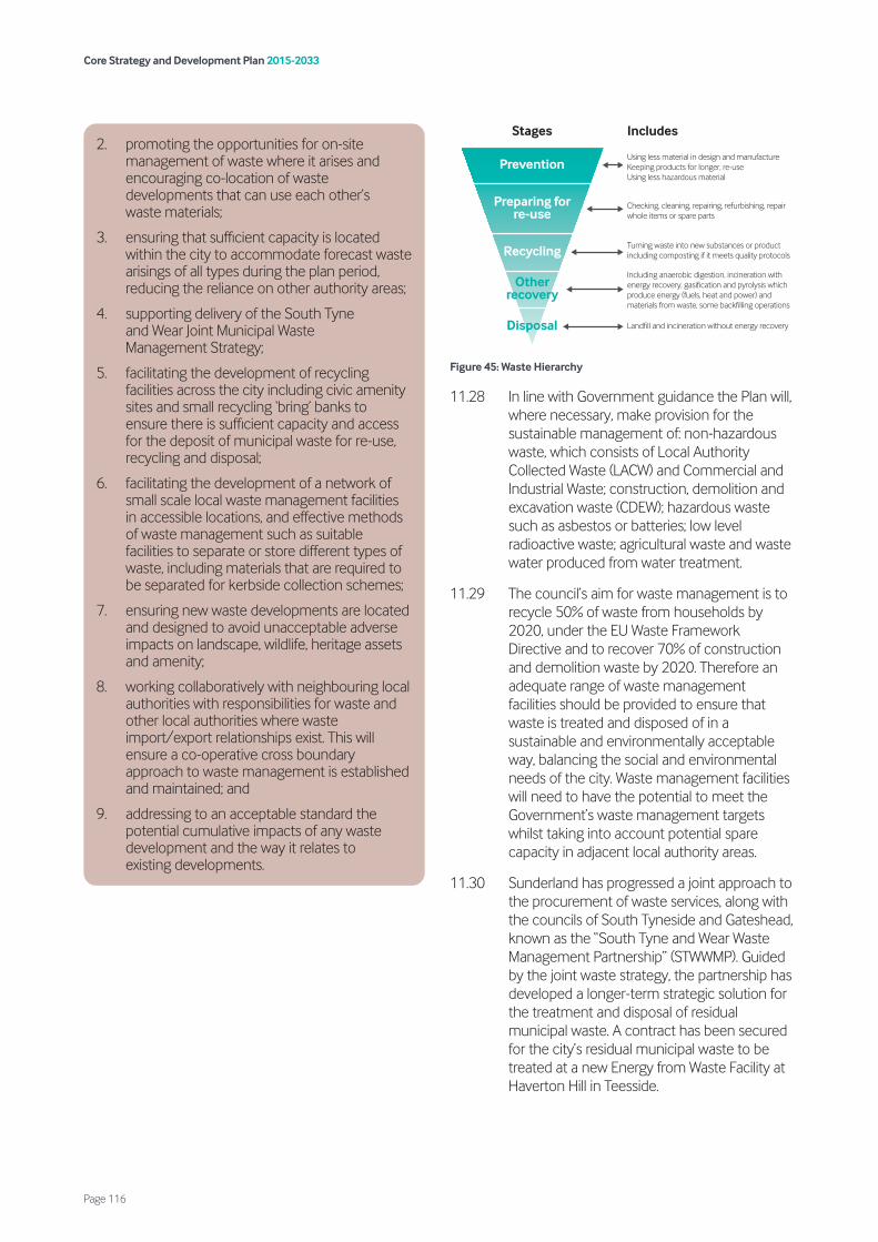
Figure 45: Waste Hierarchy
11.28 In line with Government guidance the Plan will, where necessary, make provision for the sustainable management of: non-hazardous waste, which consists of Local Authority Collected Waste (LACW) and Commercial and Industrial Waste; construction, demolition and excavation waste (CDEW); hazardous waste such as asbestos or batteries; low level radioactive waste; agricultural waste and waste water produced from water treatment.
11.29 The council’s aim for waste management is to recycle 50% of waste from households by 2020, under the EU Waste Framework Directive and to recover 70% of construction and demolition waste by 2020. Therefore an adequate range of waste management facilities should be provided to ensure that waste is treated and disposed of in a sustainable and environmentally acceptable way, balancing the social and environmental needs of the city. Waste management facilities will need to have the potential to meet the Government’s waste management targets whilst taking into account potential spare capacity in adjacent local authority areas.
11.30 Sunderland has progressed a joint approach to the procurement of waste services, along with the councils of South Tyneside and Gateshead, known as the “South Tyne and Wear Waste Management Partnership” (STWWMP). Guided by the joint waste strategy, the partnership has developed a longer-term strategic solution for the treatment and disposal of residual municipal waste. A contract has been secured for the city’s residual municipal waste to be treated at a new Energy from Waste Facility at Haverton Hill in Teesside.
2. promoting the opportunities for on-site management of waste where it arises and encouraging co-location of waste developments that can use each other’s waste materials;
3. ensuring that sufficient capacity is located within the city to accommodate forecast waste arisings of all types during the plan period, reducing the reliance on other authority areas;
4. supporting delivery of the South Tyne and Wear Joint Municipal Waste Management Strategy;
5. facilitating the development of recycling facilities across the city including civic amenity sites and small recycling ‘bring’ banks to ensure there is sufficient capacity and access for the deposit of municipal waste for re-use, recycling and disposal;
6. facilitating the development of a network of small scale local waste management facilities in accessible locations, and effective methods of waste management such as suitable facilities to separate or store different types of waste, including materials that are required to be separated for kerbside collection schemes;
7. ensuring new waste developments are located and designed to avoid unacceptable adverse impacts on landscape, wildlife, heritage assets and amenity;
8. working collaboratively with neighbouring local authorities with responsibilities for waste and other local authorities where waste import/export relationships exist. This will ensure a co-operative cross boundary approach to waste management is established and maintained; and
9. addressing to an acceptable standard the potential cumulative impacts of any waste development and the way it relates to existing developments.
Prevention
Stages Includes
Preparing for re-use
Recycling
Otherrecovery
Disposal
Using less material in design and manufactureKeeping products for longer, re-useUsing less hazardous material
Checking, cleaning, repairing, refurbishing, repair whole items or spare parts
Turning waste into new substances or product including composting if it meets quality protocols
Including anaerobic digestion, incineration with energy recovery, gasification and pyrolysis which produce energy (fuels, heat and power) and materials from waste, some backfilling operations
Landfill and incineration without energy recovery
Core Strategy and Development Plan 2015-2033
Page 116

11.31 The contract involved building an Energy from Waste facility which will burn the waste to create electricity. A new waste transfer facility station has also been granted consent and has been developed at Jack Crawford House depot, in Hendon. Both sites are now operational.
11.32 The contract commenced April 2014 and will run for 23 years. It provides for three waste transfer stations, with some limited front end recycling of bulky waste with the majority of residual household waste transferred by bulk road haulage to a dedicated EFW facility at the Haverton Hill waste complex. The plant will be able to deal with up to 256,000 tonnes of waste each year and is capable of exporting 18.84MW of electricity to the national grid. The facility is supported by a Visitor and Education Centre at Gateshead’s waste transfer facility, which is located within Sunderland’s boundary at the Campground site in Springwell Village.
11.33 Policy WWE6 puts in place the principles of identifying appropriate locations for waste management facilities. These principles are key to ensuring much needed waste management infrastructure is delivered in the most sustainable and effective way for the treatment of waste and the avoidance of potential negative impacts.
11.34 Applicants will be expected to submit a supporting statement to demonstrate that the proposals would not have any unacceptable adverse impacts upon the landscape, wildlife, heritage assets and amenity.
11.35 When considering the potential impacts of a scheme, applicants will also be expected to consider cumulative impacts and how the proposals may impact upon existing nearby land uses and/or other committed development proposals. Each application will be considered on a site by site basis.
11.36 The A&D Plan will identify land to deliver this policy, where necessary.
11.37 A Waste Needs Assessment (WNA) has been undertaken to review the existing operating capacity of waste infrastructure across Sunderland and to assess future requirements over the plan period. However, because the LACW contract is in place, this assessment has not sought to assess this waste stream as there are no anticipated requirements for managing residual waste.
11.38 Applicants will be expected to demonstrate the need for the facility in terms of the type of facility and taking account of the capacity findings. To ensure waste management sites
Policy
WWE7 Waste facilities
Development for new built waste facilities should be focused on previously developed employment land (excluding land within Primary Employment Sites) and will be required to meet the following criteria:
1. demonstrate the need for the facility, if there is a clear conflict with other policies of the Development Plan;
2. all waste processes and operations must be contained, processed and managed within buildings unless there are acceptable operational reasons why these processes cannot be contained within buildings;
3. proposals must accord with all other policies in relation to the protection of the environment and public amenity or demonstrate that other material considerations outweigh any policy conflict;
4. consideration will be given to the potential impacts of waste management proposals from:
i. harmful materials entering the public highway;
ii. generation of odours, litter, light, dusts, flies, rodents, birds and other infestation;
iii. noise, excessive traffic and vibration;
iv. risk of serious fires through combustion of accumulated wastes;
v. harm to water quality and resources and flood risk management;
vi. land instability;
vii. land use conflict; and
viii. where necessary, mitigation measures should be identified to ameliorate any negative impacts to an acceptable level.
Core Strategy and Development Plan 2015-2033
Page 117
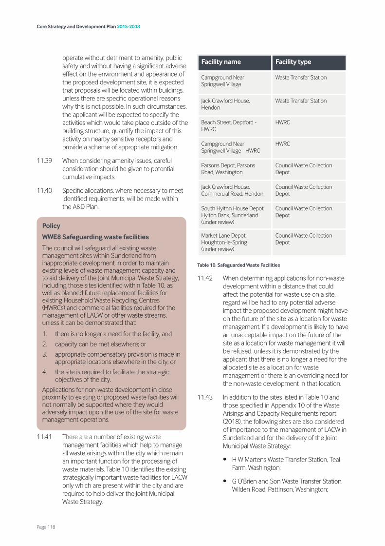
operate without detriment to amenity, public safety and without having a significant adverse effect on the environment and appearance of the proposed development site, it is expected that proposals will be located within buildings, unless there are specific operational reasons why this is not possible. In such circumstances, the applicant will be expected to specify the activities which would take place outside of the building structure, quantify the impact of this activity on nearby sensitive receptors and provide a scheme of appropriate mitigation.
11.39 When considering amenity issues, careful consideration should be given to potential cumulative impacts.
11.40 Specific allocations, where necessary to meet identified requirements, will be made within the A&D Plan.
11.41 There are a number of existing waste management facilities which help to manage all waste arisings within the city which remain an important function for the processing of waste materials. Table 10 identifies the existing strategically important waste facilities for LACW only which are present within the city and are required to help deliver the Joint Municipal Waste Strategy.
Table 10: Safeguarded Waste Facilities
11.42 When determining applications for non-waste development within a distance that could affect the potential for waste use on a site, regard will be had to any potential adverse impact the proposed development might have on the future of the site as a location for waste management. If a development is likely to have an unacceptable impact on the future of the site as a location for waste management it will be refused, unless it is demonstrated by the applicant that there is no longer a need for the allocated site as a location for waste management or there is an overriding need for the non-waste development in that location.
11.43 In addition to the sites listed in Table 10 and those specified in Appendix 10 of the Waste Arisings and Capacity Requirements report (2018), the following sites are also considered of importance to the management of LACW in Sunderland and for the delivery of the Joint Municipal Waste Strategy:
• H W Martens Waste Transfer Station, Teal Farm, Washington;
• G O’Brien and Son Waste Transfer Station, Wilden Road, Pattinson, Washington;
Policy
WWE8 Safeguarding waste facilities
The council will safeguard all existing waste management sites within Sunderland from inappropriate development in order to maintain existing levels of waste management capacity and to aid delivery of the Joint Municipal Waste Strategy, including those sites identified within Table 10, as well as planned future replacement facilities for existing Household Waste Recycling Centres (HWRCs) and commercial facilities required for the management of LACW or other waste streams, unless it can be demonstrated that:
1. there is no longer a need for the facility; and
2. capacity can be met elsewhere; or
3. appropriate compensatory provision is made in appropriate locations elsewhere in the city; or
4. the site is required to facilitate the strategic objectives of the city.
Applications for non-waste development in close proximity to existing or proposed waste facilities will not normally be supported where they would adversely impact upon the use of the site for waste management operations.
Facility name Facility type
Campground Near Springwell Village
Waste Transfer Station
Jack Crawford House, Hendon
Waste Transfer Station
Beach Street, Deptford - HWRC
HWRC
Campground Near Springwell Village - HWRC
HWRC
Parsons Depot, Parsons Road, Washington
Council Waste Collection Depot
Jack Crawford House, Commercial Road, Hendon
Council Waste Collection Depot
South Hylton House Depot, Hylton Bank, Sunderland (under review)
Council Waste Collection Depot
Market Lane Depot, Houghton-le-Spring (under review)
Council Waste Collection Depot
Core Strategy and Development Plan 2015-2033
Page 118

• Timberpak waste timber processing/transfer station, Pattinson; and
• JBT Waste Services Waste Transfer Station – Westline Industrial Estate (located within County Durham).
11.44 In order to ensure that there is sufficient capacity within the city to deal with waste arisings, other than those which are to be sent to the EFW plant at Haverton Hill, Policy WWE8 seeks to protect these facilities. However, it is recognised that in some circumstances there may no longer be a need for the facility. In such circumstances, the loss of waste management sites will be supported where the capacity can be met elsewhere, appropriate compensatory provision is made in appropriate locations elsewhere, or the site is required to facilitate the strategic objectives of the city.
11.45 The purpose of this policy is to safeguard those sites required for the delivery of the Joint Municipal Waste Management Strategy and other strategically important sites to protect them against potential future conflict with incompatible uses, as well as protecting existing waste management infrastructure in Sunderland to ensure sufficient capacity is maintained to manage expected levels of waste over the plan period. This is important because the predicted future need for additional waste management capacity assumes existing capacity is available (except where known closure has been identified within the plan period). Should the continuation or potential expansion of sites be affected by non-waste development this would impact on the ability of Sunderland to manage its waste. Policy HS1 of this Plan sets out the material planning considerations in this regard.
11.46 It is also important to note that HWRCs are often located relatively near to residential areas to ensure they are accessible to the public for whom they are intended. NPPW states that the need to ensure that ‘waste management is considered alongside other spatial planning concerns, such as housing and transport, recognising the positive contribution that waste management can make to the development of sustainable communities’. This statement is clear that waste development needs should be considered alongside other development and the importance of the future need for waste facilities should be considered when determining non-waste applications.
Policy
WWE9 Open waste facilities
1. Development for new open waste management facilities will be permitted where:
i. the waste site allocations and existing waste facilities are shown to be unsuitable and/or unavailable for the proposed development;
ii. a need for the capacity of the proposed development has been demonstrated to manage waste arising from within the administrative area of Sunderland; and
iii. it is demonstrated that the site is at least as suitable for such development as Site Allocations, with reference to the overall spatial strategy and site assessment methodology associated with the Development Plan.
2. Where acceptable, proposals should be located at or on:
i. redundant farm land (in the case of green waste and/or biological waste); or
ii. demolition and construction sites, where the inert waste materials are to be used on the construction project on that site; or
iii. existing permitted waste management sites or co-located with other waste management development; or
iv. the curtilages of Waste Water Treatment Works (in the case of biological waste); or
v. mineral and landfill sites where waste material is used in conjunction with restoration or proposed waste operations are temporary and linked to the completion of the mineral/landfill operation; or
vi. areas of previously developed land; or
vii. employment areas that are existing or allocated in the Development Plan for general industry (B2) and storage and distribution (B8), with the exception of Primary Employment Areas, the Port of Sunderland or the IAMP, where waste development will not be supported.
3. Any proposals that come forward on land use types not identified above will be assessed on their merits, based on the other policies in the Development Plan. Such locations will be considered less favourably than those set out within this Policy.
Core Strategy and Development Plan 2015-2033
Page 119

11.47 Open waste management facilities are those that deal with waste in the open air. Open waste operations also include aggregate recycling facilities and open window composting. Open waste facilities can give rise to specific impacts such as noise, dust and odour which can influence where such development should take place. Therefore careful consideration needs to be taken when dealing with planning applications for such developments.
11.48 Applicants will be expected to demonstrate the need for the facility and proposals should only be supported where existing waste management facilities are incapable of dealing with the proposed waste streams. Development should be focused on previously developed sites and those in previous compatible uses, as set out in Policy WWE9 above.
11.49 Energy from waste development has the potential to have significant adverse impacts upon the environment, public health and/or public amenity, if not directed to appropriate locations. The applicant will be expected to submit supporting evidence to demonstrate that proposals for energy from waste developments would not have unacceptable significant adverse impacts. Where significant adverse impacts are recognised, appropriate mitigation must be identified and implemented to ensure that proposals are acceptable.
11.50 Energy from waste developments have the opportunity to provide combined heat and power to other nearby users. Applicants will be expected to generate and distribute combined heat and power, unless a clear justification is provided to explain why this is not possible.
Policy
WWE10 Energy from waste
1. Energy from waste development, together with any ancillary buildings and infrastructure must demonstrate that they will have no unacceptable significant adverse impacts that cannot be mitigated for, particularly with regard to the protection of the environment, public health and public amenity.
2. Energy from Waste development will be required to provide combined heat and power unless it can be demonstrated that this would prevent the development of waste management facilities that have the potential to deliver important waste infrastructure.
Core Strategy and Development Plan 2015-2033
Page 120
12.1 A strategic priority is to improve public transport and accessibility across our area, while reducing the adverse impact of road traffic and traffic congestion. The level of population and employment growth proposed over the next 18 years will necessitate increased investment in public transport to improve transport accessibility for all users, and the council will work with partners, transport operators and developers to ensure that this takes place. Focusing on sustainable transport development will not only improve accessibility but will also help to support other crucial initiatives in Sunderland such as helping to improve traffic congestion, air quality, road safety and supporting increased levels of physical activity and overall health.
12.2 The council will also seek to ensure that major new development is located in areas with high levels of public transport accessibility, thereby reducing the need to travel by private car, to minimise energy use and to increase opportunities for walking and cycling.
12.3 This chapter seeks to address Strategic Priority 11 and to improve transportation provision, accessibility and air quality by:
• ensuring development has no severe adverse impact on the local road network; is close to public transport links (or where new links could be provided); and enhances opportunities for walking and cycling (Policies ST1, ST2 and ST3);
• enhancing the transport network to improve connectivity from homes to employment areas, designated centres, and to other key trip generators (Policies SP10 and ST1);
• utilising traffic management measures in order to manage congestion and mitigate against the environmental and health impacts of traffic (Policies SP10 and HS1);
• ensuring that transport initiatives support the development of safer, cleaner and more inclusive centres and neighbourhoods (Policy ST1); and
• working with the North East Combined Authority (NECA), neighbouring councils and other partners to promote cross-boundary transport initiatives.
12.4 Sustainable transport will be guided by the Local Transport Plan and NECA including development of cross boundary transport initiatives.
Strategic Policy
SP10 Connectivity and transport network
To improve connectivity and enhance the city’s transport network, the council, working with its partners and utilising developer contributions will seek to:
1. deliver the following new highways schemes and initiatives:
i. Sunderland Strategic Transport Corridor (remaining phases);
ii. Ryhope to Doxford Park Link Road;
iii. Central Route section of Coalfield Regeneration Route; and
iv. Improvements to the mainline and key junctions on the A19, including providing access to the IAMP;
2. improve the following transport routes and bus corridors to encourage walking and cycling and to reduce congestion:
i. A183 Chester Road;
ii. A690 Durham Road;
iii. A1231 Sunderland Highway (west of the A19);
iv. A1018 Newcastle Road;
v. B1522 Ryhope Road;
vi. Washington Road/North Hylton Road (east of A19); and
vii. A182 Houghton/Hetton Road.
3. improve the operating conditions for buses, in particular through securing improvements to the major bus corridors identified above; and exploring park and ride opportunities;
4. support improvements to the Metro and rail network including new stations and routes where deliverable;
Core Strategy and Development Plan 2015-2033
Page 121
12. Sustainable transport

12.5 Improving connectivity and the transport network is a key principle which will support the growth of the city. In order to facilitate this growth there will need to be improvements to the road network, public transport network and cycle network.
12.6 A number of specific new highway schemes and initiatives have been identified to deliver this plan, including:
• the Sunderland Strategic Transport Corridor (SSTC) which will provide a high-quality route between the A19 and the Port, taking in the Urban Core as well as improving accessibility to development sites along the river corridor. Both the initial section of this road (St Mary’s Boulevard) and Phase 2 including the Northern Spire Bridge are complete. Further phases to follow include:
– Phase 3 (South Bridgehead to St Michael’s Way); and
– Phase 4 and 5 Commercial Links (Wessington Way and Port Access improvements).
The delivery of SSTC4 will better manage traffic to and from the A19 and assist in managing potential queuing on the Strategic Road Network (SRN) off slip roads at the Wessington Way junction. The council will continue to work with Highways England to deliver a junction improvement scheme at the Wessington Way junction with the A19. This scheme, along with the delivery of the full length of SSTC4, aim to control and manage traffic flow on the local road network, with the specific intention of helping to better manage traffic flow on the SRN. The council will also consider the delivery of new links on the local road network to mitigate capacity and safety concerns with the A19. Any proposals and delivery timescales will be agreed through a Memorandum of Understanding (MOU) with both parties:
• the council is proposing a major area of housing growth, known as the SSGA (Policy SS6). The key transport infrastructure requirement needed to support the development of SSGA is the Ryhope-Doxford link road;
• the Central Route in the Coalfield will link the A182 at Biddick Woods via Sedgeletch and Dubmire south to Rainton Bridge Industrial Estate. The road will support housing and employment regeneration and improve connectivity in the Coalfield. Developer contributions will be sought to fund completion of this road; and
• key junctions on the A19 at Downhill, Ferryboat Lane and A690. The IAMP AAP Infrastructure Delivery Plan contains the road improvement works that are required to specifically support the IAMP.
12.7 The existing highway network will continue to fulfil an important role in the future prosperity of Sunderland. Traffic congestion on several strategic roads and junctions is a cause of delays, with consequent lost time for employees and other travellers and additional costs for bus operators. Initial schemes include, for example, major improvements to the A183 Chester Road corridor. Other major road corridors, as set out within Policy SP10 will be improved as finances and circumstances permit. Improvements to these corridors will include provision to improve public transport, walking, cycling and disabled access.
12.8 The efficient operation of both the local and SRN (A19 and A194(M)) is vital to support the growth and long term viability of the Sunderland economy whilst also limiting the environmental effect of excessive congestion and minimising road safety concerns. In conjunction with Highways England it is anticipated that in the future a number of key junctions on the SRN will require improvement by major schemes, notably the A19 junctions with the A1231, A183 and the A690. In addition, traffic growth will result in traffic constraints on the A19 itself and widening of some sections will also be required. Nevertheless, whilst supporting improvements to the SRN, highway infrastructure is important, managing existing and future commuting patterns and reducing congestion by improved public transport provision and implementation of more travel planning management
5. safeguard the following disused railway alignments for future use:
i) Leamside line; and
ii) South Hylton to Penshaw;
6. improve and extend the cycle network.
Core Strategy and Development Plan 2015-2033
Page 122
measures to reduce single car occupancy is essential. Working together, the council and Highways England will also, during the lifetime of the Plan, identify potential schemes to address capacity and road safety concerns on the SRN.
12.9 The vast majority of public transport trips in Sunderland are made by bus and it is likely that this will continue into the future. The council will work with the bus operators and Nexus to improve operating conditions for buses on the bus corridors within the city as outlined in Policy SP10.
12.10 The Metro (and the wider local rail system) is a significant public transport asset for the city but the network will need to be expanded and updated to meet future needs. The council will work with Nexus and other stakeholders to secure improvements to the Metro and local rail network. Future expansion plans for the Metro and the local rail network are not known at this point and new route possibilities will also depend on the flexibility of the new rolling stock chosen for the Metro.
12.11 The former Leamside railway line provides opportunities for a range of railway uses including improving connectivity between Washington and Sunderland (by taking in the former Penshaw-Pallion line) and southwards into the Coalfield area. The council will continue to work with its sub-regional partners and transport infrastructure stakeholders to investigate the potential of this line and will support proposals that benefit the city. The council will ensure that the location and design of new development does not conflict with the potential for the Leamside Line’s re-instatement.
12.12 Increasing the opportunities for accessible and safe walking and cycling in Sunderland will have a number of benefits, ranging from improving people’s health, improving air quality and reducing traffic congestion. As well as strategic walking and cycling routes, the council will seek local improvements, including convenient and safe walking routes.
12.13 The city is crossed by a network of footpaths, national cycle ways and equestrian routes, partly as a result of former railway lines that have been successfully reclaimed in recent years. These ensure sustainable off-road networks providing access to many parts of
the city and a variety of destinations. Further routes will be pursued that will help to form a grid pattern that enable longer or shorter circuits to be used for commuting or recreational purposes.
12.14 In accordance with the NECA Transport Manifesto and emerging Transport Plan, the council is committed to improving accessibility to and movement within the Urban Core.
12.15 Key improvements will involve avoiding conflicts between pedestrians and vehicular traffic, making improvements to the physical infrastructure within the Urban Core such as Park Lane Station and the southern concourse of Sunderland Station and improving connectivity between the Urban Core and other major centres within the UK.
12.16 The A&D Plan will identify land to deliver this policy, where necessary.
Policy
ST1 Urban Core accessibility and movement
Accessibility to and movement through the Urban Core will be enhanced by:
1. discouraging the use of streets by through-vehicular traffic;
2. increasing priority for pedestrians and cyclists in the Primary Shopping Area;
3. improving the cycle network;
4. improving ‘legibility’ and signage for pedestrians;
5. providing for operational access for businesses;
6. improving the provision of car parks around the ring road;
7. reducing the ‘barrier’ effect of the ring road in relation to adjacent areas;
8. improving the attractiveness of Park Lane Interchange; and
9. working with rail industry partners to:
i. improve the connectivity of Sunderland to other major centres; and
ii. supporting redevelopment and improvement of Sunderland Station.
Core Strategy and Development Plan 2015-2033
Page 123

Figure 46: Local Road Hierarchy
12.17 Whilst the Strategic Road Network is important in providing connections between Sunderland and the wider area, the vast majority of roads within Sunderland form part of the Local Road Network. Policy ST2 sets out the local road network hierarchy, which will be used when considering development. It will be ensured that the function of all roads within the Local Road Network are to be protected in accordance with their position within the road hierarchy to ensure the safe and efficient movement of traffic for all.
12.18 Developers must demonstrate that proposals will not have a severe impact on the safe operation and management of the Local Road Network for all highway users. This will be subject to scoping and agreement with the Local Highway Authority.
Policy
ST2 Local road network
1. The Local Road Network will be protected for safe and efficient movement in accordance with the following road hierarchy:
i. Distributor Roads;
ii. Category 1 Roads;
iii. Category 2A Roads; and
iv. Category 3 Roads.
2. To ensure that development has no unacceptable adverse impact on the Local Road Network, proposals must ensure that:
i. where a new vehicular access is accepted in principle, the number of access points will be kept to a minimum and new access points will be designed and constructed in accordance with the current highway design standards;
ii. they have safe and adequate means of access, egress and internal circulation/turning arrangements for all modes of transport relevant to the proposal;
iii. where an existing access is to be used, substandard accesses will be improved and/or upgraded in accordance with the current standards for the category of road;
iv. they are assessed and determined against current standards for the category of road having regard to the capacity, safety and geometry of the highway network;
v. they have safe and convenient access for sustainable transport modes relevant to its location; and
vi. they will not create a severe impact on the safe operation of the highway network; resulting in potential risk to all highway users with specific consideration given to vulnerable road users.
DISTRIBUTOR ROAD
CATEGORY 2A ROADMINOR ACCESS
CATEGORY 1 ROADMAJOR ACCESS
CATEGORY 3 ROADSHARED SURFACE/CUL-DE-SAC
Core Strategy and Development Plan 2015-2033
Page 124
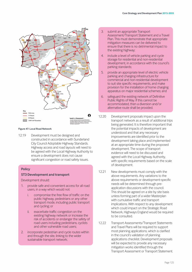
Figure 47: Local Road Network
12.19 Development must be designed and constructed in accordance with Sunderland City Council Adoptable Highway Standards. Highway access and road layouts will need to be agreed with the Local Highway Authority to ensure a development does not cause significant congestion or road safety issues.
12.20 Development proposals impact upon the transport network as a result of additional trips being generated. It is therefore important that the potential impacts of development are understood and that any necessary improvements are identified prior to the development taking place and implemented at an appropriate time during the proposed development. The scope of transport evidence will need to be discussed and agreed with the Local Highway Authority, with specific requirements based on the scale of development.
12.21 New developments must comply with the above requirements. Any variations to the above requirements or development-specific needs will be determined through pre-application discussions with the council. This should be agreed on a site by site basis unless forming part of a wider Masterplan with cumulative traffic and transport implications. With respect to any development which could impact on the Strategic Road Network, Highways England would be required to be consulted.
12.22 Transport Assessments/Transport Statements and Travel Plans will be required to support most planning applications, which is clarified in the council’s validation of planning applications checklist. Development proposals will be expected to provide any necessary mitigation works identified through the Transport Assessment or Transport Statement.
Policy
ST3 Development and transport
Development should:
1. provide safe and convenient access for all road users, in a way which would not:
i. compromise the free flow of traffic on the public highway, pedestrians or any other transport mode, including public transport and cycling; or
ii. exacerbate traffic congestion on the existing highway network or increase the risk of accidents or endanger the safety of road users including pedestrians, cyclists and other vulnerable road users;
2. incorporate pedestrian and cycle routes within and through the site, linking to the wider sustainable transport network;
3. submit an appropriate Transport Assessment/Transport Statement and a Travel Plan. This must demonstrate that appropriate mitigation measures can be delivered to ensure that there is no detrimental impact to the existing highway;
4. include a level of vehicle parking and cycle storage for residential and non-residential development, in accordance with the council’s parking standards;
5. provide an appropriate level of electric vehicle parking and charging infrastructure for commercial and non-residential development to suit site specific requirements, and make provision for the installation of home charging apparatus on major residential schemes; and
6. safeguard the existing network of Definitive Public Rights of Way. If this cannot be accommodated, then a diversion and/or alternative route shall be provided.
Core Strategy and Development Plan 2015-2033
Page 125
The development proposals will need to comply with the council’s guidance on parking standards for residential and non-residential development.
12.23 Development will also need to provide an appropriate level of electric vehicle parking and charging infrastructure to suit development requirements. These are to be determined on a site by site basis and agreed with the council. Major residential schemes of 50 dwellings or more will be expected to make provision for the installation of home charging apparatus.
12.24 The existing network of Definitive Public Rights of Way must be safeguarded where affected by development, ensuring that it remains protected and open for use by the public. Where Definitive Public Rights of way exist through a development site, it should be retained on its existing alignment and the development designed and laid out to accommodate it. In the event that there is no alternative and the development cannot accommodate the existing Definitive Public Right of Way, a diversion and/or alternative route shall be provided. Any such diversion and/or alternative must be approved as convenient and suitable in all respects by the council and will be constructed in accordance with current standards.
12.25 A travel plan is a long-term management strategy for an organisation or site that seeks to deliver sustainable transport objectives through an action plan that is regularly reviewed. The travel plan should set targets, objectives and monitoring requirements. The travel plan should include a series of measures, management and funding details that aim to deliver the stated objectives and targets. The travel plan should be secured by a planning obligation and have regular ongoing management. A Transport Assessment will be required for any development where the council anticipates that the development will generate a level of trips that impact on the existing highways arrangement. In line with the PPG, the need for a Transport Assessment will be assessed on a case-by-case basis and will be at the discretion of the council.
12.26 The council will require developer support for upgrades and improvements to capacity on public transport services and the associated infrastructure and facilities, through financial contributions, where these improvements are
necessary to enable the development to take place. The council will also expect that appropriate mitigation is provided by the developer for any impacts expected on the public highway or local network.
12.27 Sufficient car parking will need to be provided to meet the essential needs of developments. Parking space is often an inefficient and unattractive use of land and its impact on local environmental quality should be minimised where car parking is provided in new developments.
Core Strategy and Development Plan 2015-2033
Page 126

13.1 Minerals are an important resource and are an essential requirement to support sustainable economic growth. It is necessary that there is a sufficient supply of minerals to provide the infrastructure, buildings, energy, and goods that an area needs. Where materials are not available locally, Sunderland will work with neighbouring authorities and other Mineral Planning Authorities to ensure that the continued need for aggragates can be met. Minerals are a finite resource and can only be worked where they are found, and therefore it is important to make the best use of them and to secure their long-term conservation. This chapter includes policies to meet Strategic Priority 12 and will support proposals for mineral development by:
• supporting minerals extraction, where the impacts of doing so would not be unacceptable (Policy SP11);
• protecting Minerals Safeguarding Areas and minerals infrastructure from non-mineral development (Policy M1);
• carefully controlling any proposals for surface coal extraction (Policy M2);
• ensuring development gives consideration to any land instability and minerals legacy issues (Policy M3); and
• requiring restoration and aftercare to improve the quality of the environment to at least the same standard as before mineral extraction took place (Policy M4).
13.2 Policy SP11 sets out the approach for dealing with planning applications for mineral extraction, which should be considered in line with other relevant policies in this Plan. The policy focuses on the key criteria that will be used to judge applications. Proposals for mineral extraction (including extensions to existing sites), will be required to robustly justify the requirement for extraction, specifically in relation to the need for the site to maintain supply in line with the latest Local Aggregate Assessment, sub-regional apportionment figure and the maintenance of a landbank of at least 7 years for sand and gravel and at least 10 years for crushed rock. In order to protect against the potential risks of groundwater flooding and protect water quality, proposals which involve dewatering will require a Water Management Plan. Any site specific allocations will be made through the Allocations and Designations Plan.
13.3 The possibility of significant environmental and social effects associated must be fully understood before consideration can be given as to whether the development is acceptable. The applicant will be expected to provide detailed information of the likely significant effect of the development on human beings, flora, fauna, soil, water, air, climate, landscape, material assets and cultural and historical heritage. Potential cumulative impacts must also be considered. The council encourage applicants to engage with local communities at an early stage when preparing development proposals and where appropriate, consider establishing liaison committees with representatives from the local communities.
Strategic Policy
SP11 Mineral extraction
1. Development for mineral extraction must demonstrate the extent, quality, significance and need for the resources to be extracted and must ensure that:
i. the natural and historic environment, highway safety and human health is conserved, managed and enhanced as appropriate;
ii. residential amenity and human health is protected from issues such as noise, vibration and air quality;
iii. workings will not increase the potential of flood risks or surface water flooding;
iv. essential infrastructure is protected; and
v. the transportation of minerals makes use of sustainable modes of transport wherever possible.
Core Strategy and Development Plan 2015-2033
Page 127
13. Minerals
13.4 There is currently no evidenced demand for the extraction of hydrocarbons such as the hydraulic fracturing of shale rocks for oil and gas within the city and no Petroleum Exploration and Development Licenses (PEDL) have been granted. It is therefore not considered necessary to provide specific policy coverage for this within the Plan. Any proposals will be determined in accordance with the relevant national policy and guidance.
13.5 Sunderland has a limited supply of mineral resources; therefore it is necessary to safeguard known minerals resources from other development that could sterilise their eventual extraction. However, it is a Government requirement that proven resources are not needlessly sterilised by non-mineral development, and that there should be prior extraction of the mineral if it is necessary for such development to take place.
13.6 Sunderland’s Minerals Safeguarding Areas (MSAs) have been developed in accordance with guidance published by the British Geological Survey and by using mineral resource information provided by the British Geological Survey and the Coal Authority. It is also a requirement to safeguard existing, planned and potential mineral infrastructure such as rail heads, wharfs, depots, coating and batching plants. The MSAs and safeguarded infrastructure are shown on the Policies Map and are identified in Appendix 4.
13.7 With regard to development proposals within Coal MSAs, where it can be accommodated in an environmentally acceptable manner, and provided that the proposed development is not prejudiced or delayed significantly, coal resources should be extracted prior to development commencing. In order to avoid
Policy
M1 Minerals Safeguarding Areas and infrastructure
1. Planning permission will only be granted for incompatible non-mineral development within a Minerals Safeguarding Area, as defined on the Policies Map (Appendix 4), where it is demonstrated that either:
i. the mineral is not of economic value or potential value, or does not exist; or
ii. that extraction of the mineral would not be physically viable or practicable; or
iii. the mineral can be extracted satisfactorily, having regard to Policy SP11, prior to the non-minerals development taking place without adversely affecting the viability or deliverability of the non-minerals development; or
iv. the incompatible development is of a temporary nature that can be completed and the site returned to a condition that would not prevent future mineral extraction; or
v. material considerations indicate that the need for the development overrides the presumption for mineral safeguarding such that sterilisation of the mineral can be permitted following the exploration of opportunities for prior extraction; or
vi. it constitutes development that is exempt from the mineral safeguarding policy (see the list of exempt criteria in Appendix 4).
2. Planning permission will only be granted for development that is incompatible with safeguarded minerals management, transportation or waste management facilities, where it is demonstrated that either:
i. it constitutes exempt development as set out in Appendix 5; or
ii. replacement capacity, of the similar type, is available at a suitable alternative site, which is at least equivalent or better than that offered by the facility that it is replacing; or
iii. it is for a temporary period and will not compromise its potential in the future for minerals transportation; or
iv. material considerations indicate that the need for development overrides the presumption for safeguarding; or
v. it has been demonstrated that the capacity of the facility to be lost, is not required.
3. Planning applications for development within 100m of safeguarded facilities need to demonstrate that impacts, e.g. noise, dust, light and air emissions, that may legitimately arise from the activities taking place at the safeguarded sites would not be experienced to an unacceptable level by occupants of the proposed development and that vehicle access to and from the facility would not be constrained by the development proposed.
Core Strategy and Development Plan 2015-2033
Page 128
potential problems of delay, any potential surface coal working should be included in an overall programme for the development.
13.8 Surface coal extraction is a particularly intrusive method for accessing and utilising it as a resource. The council will therefore carefully consider the potential adverse impacts associated with surface coal extraction, when considering any such planning application.
13.9 Applicants will be expected to submit detailed supporting evidence as part of any application for surface coal extraction to clearly demonstrate that the policy requirements have been satisfied.
13.10 Mineral extraction has been one of the most significant activities shaping the development of the city over the past two centuries. Consequently, there are approximately 290 recorded mine entries listed in the city, potentially resulting in land instability.
13.11 Whilst land instability is not a complete constraint on development, careful consideration needs to be given to its potential
impacts as part of the determination of planning applications in areas with a mining legacy.
13.12 For development sites within the Coal Authority’s most up-to-date ‘Development High Risk Areas’, developers will be required to prepare a Coal Mining Risk Assessment and/or carry out site investigations and submit this alongside the planning application, unless the planning application type or nature of proposed development is included within the Coal Authority’s most up-to-date list of exemptions.
13.13 The nature of restoration activity depends on the choice of after-use, which is influenced by a variety of factors including the aspirations of the landowner(s) and the local community, the present characteristics of the site and its environs, any strategies for the area (e.g. biodiversity priorities), the nature, scale and duration of the proposed development and the availability and quality of soil resources.
13.14 Where the development is to restore the site to agricultural use at existing ground levels, ensuring the availability of clean inert fill material is important to the deliverability of the scheme, as is the availability of suitable topsoil. Quarries have been restored through importation of non-hazardous and/or hazardous waste and the acceptability of this in principle would be considered against Policy M4. It may be appropriate to retain some industrial archaeological features, geological exposures or landscapes within a quarry.
Policy
M2 Surface coal extraction
The extraction of surface coal will only be acceptable where:
1. the proposal is environmentally acceptable, or can be made so through agreed mitigation or through planning conditions or legal obligations; or
2. the proposal can provide national, local or community benefits which clearly outweigh the likely adverse impacts to justify the granting of planning permission; and
3. the applicant can satisfy the criteria set out within Policy SP11.
Policy
M3 Land instability and minerals legacy
1. Development should give consideration to hazards arising from past coal mining, in particular land instability and mine gas.
2. Where a development is located within an area with a mining legacy, an applicant will be required to prepare and submit a Coal Mining Risk Assessment and/or carry out site investigations, as necessary.
Policy
M4 Restoration and aftercare
1. Development for minerals extraction and temporary waste management facilities will be granted where satisfactory provision has been made for high standards of restoration and aftercare such that the intended after-use of the site is achieved in a timely manner, including where necessary for its long-term management, including the management, treatment and monitoring of surface water, leachates, ground waste landfill gases, engineering containment systems below and above ground in compliance with the relevant waste permit to deposit waste.
2. Restoration plans should be submitted with the planning application which reflect the proposed after-use.
Core Strategy and Development Plan 2015-2033
Page 129
13.15 Restoration, aftercare and after-use will usually seek to assure that the land is restored back to a quality that is at a level at least equivalent to that which it was prior to development commencing and wherever possible, provide for the enhancement of the quality of the landscape, local environment or the setting of historic assets to the benefit of the local or wider community. Wherever possible, restoration schemes should include measures to improve biodiversity interests whatever the proposed after-use of the site. Restoration, aftercare and after-use may be secured through planning conditions.
13.16 Appendix 6 sets out the issues which should be addressed through restoration.
Core Strategy and Development Plan 2015-2033
Page 130
Implementation

14.1 Having set out a clear direction how Sunderland will develop and the planning policies and proposals that will help achieve this, it will be important that there are tools in place to help implement these policies and ensure the successful delivery of the overall vision for this Plan. This chapter will seek to deliver Strategic Priority 13 by:
• Ensuring that development contributes to the timely delivery of any necessary infrastructure (Policy ID1); and
• Securing Section 106 planning obligations to fund any necessary infrastructure (Policy ID2)
14.2 While the council has a key role to play in delivering the policies and proposals, responsibility does not rest solely with the council and it will require the combined efforts and investment of a range of partners. The successful implementation will require a wide range of organisations to work together. The council will have a vital role in coordinating the actions and activities of these partners.
14.3 Appendix 7 includes a table which provides a summary of the key mechanisms that will be used to support each policy’s implementation.
14.4 Over the lifetime of this Plan it is likely that new initiatives, partnerships and sources of funding will emerge that will play a new role in helping to implement proposals and deliver growth.
14.5 Sunderland’s future growth and environmental sustainability cannot be achieved without a wide array of essential infrastructure. The council will work with its partners to ensure that much needed infrastructure, including community facilities and services are provided for local communities.
14.6 The term infrastructure can be taken to include roads and other transport facilities, flood defences, schools and other educational facilities, health facilities, sporting and recreational facilities and open spaces. This is not an exhaustive list and there may be a range of other services and facilities that could constitute infrastructure, which will be required to deliver this Plan.
14.7 This Plan is supported by an Infrastructure Delivery Plan (IDP) which provides detail of the infrastructure that is essentially necessary to enable growth to occur and delivery issues in relation to key proposals. The IDP also includes a number of infrastructure projects, which although not essential to the delivery of this Plan, are desirable. Their inclusion within the IDP will assist the council in its attempts to secure funding for these projects. The council will keep these documents under review to measure progress. It should be noted that the IDP principally identifies high level strategic infrastructure and does not include site specific infrastructure requirements, which will be dealt with through individual planning applications.
14.8 This Plan has been developed alongside continued consultation with the bodies responsible for infrastructure delivery in order to ensure that essential infrastructure will be delivered in a timely manner, where appropriate. The views of these bodies have been used in testing and underpinning the strategy, although there remain some areas, which will require on-going consultation with the responsible bodies and agencies to identify future, unforeseen needs.
14.9 Where necessary, the timing of provision of infrastructure will be linked directly to the phasing of development, taking account of viability. This will be secured either through planning conditions, or where this is not appropriate, by planning obligations or other
Policy
ID1 Delivering infrastructure
1. Development will be expected to provide, or contribute towards the provision of:
i. measures to directly mitigate the impacts of the development and make it acceptable in planning terms; and
ii. contribute towards the delivery of essential infrastructure identified in the IDP.
2. The timing and prioritisation in the delivery of essential infrastructure will accord with the priority needs established through the IDP.
Core Strategy and Development Plan 2015-2033
Page 133
14. Infrastructure and delivery
similar infrastructure tariffs in accordance with the planning obligation tests set out in parpagraph 14.11, to ensure that the planned and necessary infrastructure is available to serve the development when it is first required. The cumulative impact of developments will be taken into account.
14.10 Where it is not possible to address any unacceptable impacts of development through planning conditions, the use of planning obligations will be considered to mitigate and/or compensate these impacts.
14.11 Planning obligations must be:
• necessary to make the development acceptable in planning terms;
• directly related to the development; and
• fairly and reasonably related in scale and kind to the development.
14.12 The council will seek to secure fair and reasonable developer contributions that are proportionate to the development proposed, without adversely affecting the viability of development. Examples of requirements which may be needed to make a development acceptable include:
• provision of physical infrastructure; whether; transport, education, health, sport and leisure, waste collection and recycling and cultural and community provision;
• local public realm improvements including streetscape, local public open space, green infrastructure, play facilities and community safety;
• sustainable mitigation and/or compensation and enhancements for priority species and habitats;
• mitigation of impacts on and/or enhancement of heritage assets or to compensate for their loss; and
• transport improvement including highways and traffic works; local walking and cycling improvements and public transport provision.
14.13 It is recognised that some development proposals may be unable to meet all of the relevant policy and planning obligation requirements while remaining economically viable and deliverable, either in whole or in part.
14.14 In such circumstances the council will consider requests to reduce the level of planning obligations to a level which ensures that a scheme remains viable. The council will, where possible, work with applicants to prevent planned developments stalling.
14.15 In these instances, preference will be given to the needs and priorities of an area and the wider benefits of development, such as, for example, regeneration and meeting housing need.
14.16 The Planning Obligations SPD provides greater detail on when planning obligations will be sought, how this will be calculated and give further details on viability.
Implementation and Monitoring 14.17 The successful implementation of the Local
Plan relies on a coherent, robust and flexible monitoring process which will enable the council to respond to changing circumstances. The principal mechanism for monitoring the performance of the Local Plan will be through the Authority’s Monitoring Report (AMR). The Localism Act 2011 requires Local Authorities to prepare AMRs to assess the implementation of the Local Development Scheme (LDS), and the extent to which policies and proposals set out in local development documents are being successfully implemented.
Policy
ID2 Planning obligations
1. Section 106 planning obligations will be sought to facilitate the delivery of:
i. affordable housing (see Policy H2); and
ii. local improvements to mitigate the direct or cumulative impact of development, where evidenced, and/or additional facilities and requirements made necessary by the development, in accordance with the Planning Obligations SPD.
Where it is not possible to deliver the policy requirements in full, a viability assessment should be submitted in line with the requirements of the PPG.
Core Strategy and Development Plan 2015-2033
Page 134
14.18 The Implementation and Monitoring Framework is set out in the CSDP Monitoring Framework (2018). The Framework is structured according to the composition of the CSDP, enabling for easy and direct comparison with the policies, proposals and overall objectives. The implementation of the Local Plan will be monitored through a schedule of Monitoring Indicators on an annual basis. These will provide an accurate indication of the performance of the Local Plan against the objectives and the Local Plan policies. Through the monitoring process, the AMR will identify any issues that need to be rectified.
14.19 There are several key triggers identified throughout the CSDP which would lead to a partial or full review of the Local Plan23. Further set out in the Monitoring Framework (2018) are specific triggers for each Policy. This approach ensures that appropriate and proportionate triggers and actions can be set for each Policy and Monitoring Indicator due to a failure to meet key targets.
23 A plan review refers to any part of the Local Plan i.e. CSDP, IAMP AAP and A&D Plan
Core Strategy and Development Plan 2015-2033
Page 135


Appendices
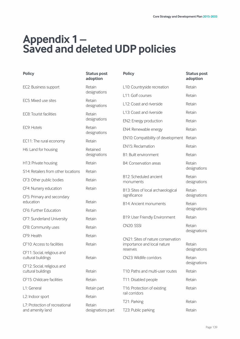
Policy Status post adoption
EC2: Business support Retain designations
EC5: Mixed use sites Retain designations
EC8: Tourist facilities Retain designations
EC9: Hotels Retain designations
EC11: The rural economy Retain
H6: Land for housing Retained designations
H13: Private housing Retain
S14: Retailers from other locations Retain
CF3: Other public bodies Retain
CF4: Nursery education Retain
CF5: Primary and secondary education Retain
CF6: Further Education Retain
CF7: Sunderland University Retain
CF8: Community uses Retain
CF9: Health Retain
CF10: Access to facilities Retain
CF11: Social, religious and cultural buildings Retain
CF12: Social, religious and cultural buildings Retain
CF15: Childcare facilities Retain
L1: General Retain part
L2: Indoor sport Retain
L7: Protection of recreational Retain and amenity land designations part
Policy Status post adoption
L10: Countryside recreation Retain
L11: Golf courses Retain
L12: Coast and riverside Retain
L13: Coast and riverside Retain
EN2: Energy production Retain
EN4: Renewable energy Retain
EN10: Compatibility of development Retain
EN15: Reclamation Retain
B1: Built environment Retain
B4: Conservation areas Retain designations
B12: Scheduled ancient Retain monuments designations
B13: Sites of local archaeological Retain significance designations
B14: Ancient monuments Retain designations
B19: User Friendly Environment Retain
CN20: SSSI Retain designations
CN21: Sites of nature conservation importance and local nature Retain reserves designations
CN23: Wildlife corridors Retain designations
T10: Paths and multi-user routes Retain
T11: Disabled people Retain
T16: Protection of existing Retain rail corridors
T21: Parking Retain
T23: Public parking Retain
Core Strategy and Development Plan 2015-2033
Page 139
Appendix 1 – Saved and deleted UDP policies
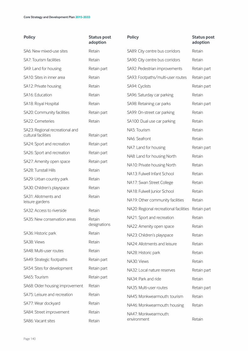
Policy Status post adoption
SA6: New mixed-use sites Retain
SA7: Tourism facilities Retain
SA9: Land for housing Retain part
SA10: Sites in inner area Retain
SA12: Private housing Retain
SA16: Education Retain
SA18: Royal Hospital Retain
SA20: Community facilities Retain part
SA22: Cemeteries Retain
SA23: Regional recreational and cultural facilities Retain part
SA24: Sport and recreation Retain part
SA26: Sport and recreation Retain part
SA27: Amenity open space Retain part
SA28: Tunstall Hills Retain
SA29: Urban country park Retain
SA30: Children’s playspace Retain
SA31: Allotments and Retain leisure gardens
SA32: Access to riverside Retain
SA35: New conservation areas Retain designations
SA36: Historic park Retain
SA38: Views Retain
SA48: Multi-user routes Retain
SA49: Strategic footpaths Retain part
SA54: Sites for development Retain part
SA65: Tourism Retain part
SA68: Older housing improvement Retain
SA75: Leisure and recreation Retain
SA77: Wear dockyard Retain
SA84: Street improvement Retain
SA86: Vacant sites Retain
Policy Status post adoption
SA89: City centre bus corridors Retain
SA90: City centre bus corridors Retain
SA92: Pedestrian improvements Retain part
SA93: Footpaths/multi-user routes Retain part
SA94: Cyclists Retain part
SA96: Saturday car parking Retain
SA98: Retaining car parks Retain part
SA99: On-street car parking Retain
SA100: Dual use car parking Retain
NA5: Tourism Retain
NA6: Seafront Retain
NA7: Land for housing Retain part
NA8: Land for housing North Retain
NA10: Private housing North Retain
NA13: Fulwell Infant School Retain
NA17: Swan Street College Retain
NA18: Fulwell Junior School Retain
NA19: Other community facilities Retain
NA20: Regional recreational facilities Retain part
NA21: Sport and recreation Retain
NA22: Amenity open space Retain
NA23: Children’s playspace Retain
NA24: Allotments and leisure Retain
NA28: Historic park Retain
NA30: Views Retain
NA32: Local nature reserves Retain part
NA34: Park and ride Retain
NA35: Multi-user routes Retain part
NA45: Monkwearmouth: tourism Retain
NA46: Monkwearmouth: housing Retain
NA47: Monkwearmouth: environment Retain
Core Strategy and Development Plan 2015-2033
Page 140
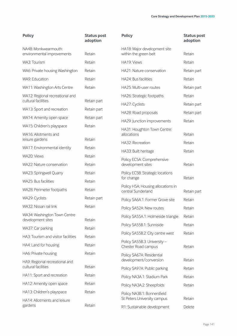
Policy Status post adoption
NA48: Monkwearmouth: environmental improvements Retain
WA3: Tourism Retain
WA6: Private housing Washington Retain
WA9: Education Retain
WA11: Washington Arts Centre Retain
WA12: Regional recreational and cultural facilities Retain part
WA13: Sport and recreation Retain part
WA14: Amenity open space Retain part
WA15: Children’s playspace Retain
WA16: Allotments and leisure gardens Retain
WA17: Environmental identity Retain
WA20: Views Retain
WA22: Nature conservation Retain
WA23: Springwell Quarry Retain
WA25: Bus facilities Retain
WA28: Perimeter footpaths Retain
WA29: Cyclists Retain part
WA32: Nissan rail link Retain
WA34: Washington Town Centre development sites Retain
WA37: Car parking Retain
HA3: Tourism and visitor facilities Retain
HA4: Land for housing Retain
HA6: Private housing Retain
HA9: Regional recreational and cultural facilities Retain
HA11: Sport and recreation Retain
HA12: Amenity open space Retain
HA13: Children’s playspace Retain
HA14: Allotments and leisure gardens Retain
Policy Status post adoption
HA18: Major development site within the green belt Retain
HA19: Views Retain
HA21: Nature conservation Retain part
HA24: Bus facilities Retain
HA25: Multi-user routes Retain part
HA26: Strategic footpaths Retain
HA27: Cyclists Retain part
HA28: Road proposals Retain part
HA29: Junction improvements Retain
HA31: Houghton Town Centre: allocations Retain
HA32: Recreation Retain
HA33: Built heritage Retain
Policy EC5A: Comprehensive development sites Retain
Policy EC5B: Strategic locations for change Retain
Policy H5A: Housing allocations in central Sunderland Retain part
Policy SA6A.1: Former Grove site Retain
Policy SA52A: New routes Retain
Policy SA55A.1: Holmeside triangle Retain
Policy SA55B.1: Sunniside Retain
Policy SA55B.2: City centre west Retain
Policy SA55B.3: University – Chester Road campus Retain
Policy SA67A: Residential development/conversion Retain
Policy SA97A: Public parking Retain
Policy NA3A.1: Stadium Park Retain
Policy NA3A.2: Sheepfolds Retain
Policy NA3B.1: Bonnersfield St Peters University campus Retain
R1: Sustainable development Delete
Core Strategy and Development Plan 2015-2033
Page 141
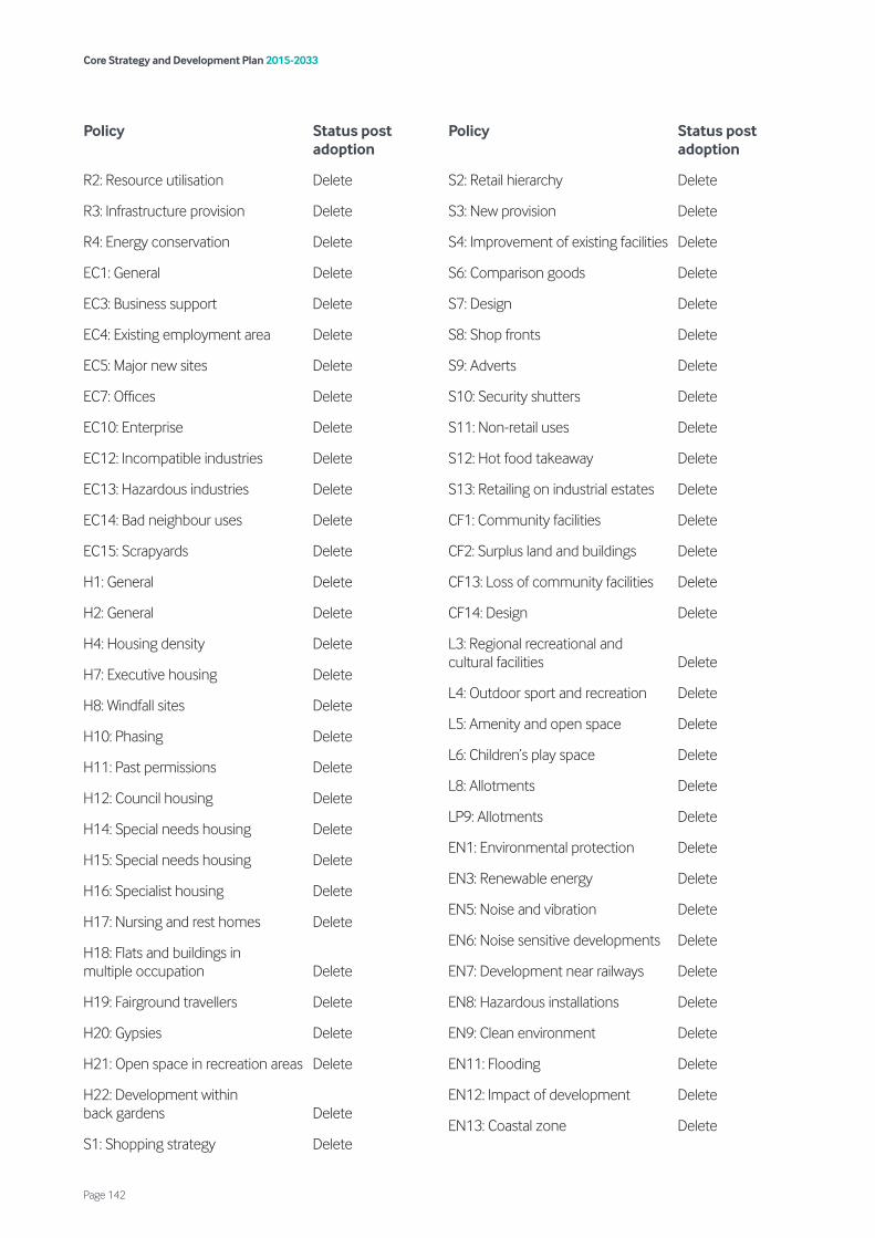
Policy Status post adoption
R2: Resource utilisation Delete
R3: Infrastructure provision Delete
R4: Energy conservation Delete
EC1: General Delete
EC3: Business support Delete
EC4: Existing employment area Delete
EC5: Major new sites Delete
EC7: Offices Delete
EC10: Enterprise Delete
EC12: Incompatible industries Delete
EC13: Hazardous industries Delete
EC14: Bad neighbour uses Delete
EC15: Scrapyards Delete
H1: General Delete
H2: General Delete
H4: Housing density Delete
H7: Executive housing Delete
H8: Windfall sites Delete
H10: Phasing Delete
H11: Past permissions Delete
H12: Council housing Delete
H14: Special needs housing Delete
H15: Special needs housing Delete
H16: Specialist housing Delete
H17: Nursing and rest homes Delete
H18: Flats and buildings in multiple occupation Delete
H19: Fairground travellers Delete
H20: Gypsies Delete
H21: Open space in recreation areas Delete
H22: Development within back gardens Delete
S1: Shopping strategy Delete
Policy Status post adoption
S2: Retail hierarchy Delete
S3: New provision Delete
S4: Improvement of existing facilities Delete
S6: Comparison goods Delete
S7: Design Delete
S8: Shop fronts Delete
S9: Adverts Delete
S10: Security shutters Delete
S11: Non-retail uses Delete
S12: Hot food takeaway Delete
S13: Retailing on industrial estates Delete
CF1: Community facilities Delete
CF2: Surplus land and buildings Delete
CF13: Loss of community facilities Delete
CF14: Design Delete
L3: Regional recreational and cultural facilities Delete
L4: Outdoor sport and recreation Delete
L5: Amenity and open space Delete
L6: Children’s play space Delete
L8: Allotments Delete
LP9: Allotments Delete
EN1: Environmental protection Delete
EN3: Renewable energy Delete
EN5: Noise and vibration Delete
EN6: Noise sensitive developments Delete
EN7: Development near railways Delete
EN8: Hazardous installations Delete
EN9: Clean environment Delete
EN11: Flooding Delete
EN12: Impact of development Delete
EN13: Coastal zone Delete
Core Strategy and Development Plan 2015-2033
Page 142
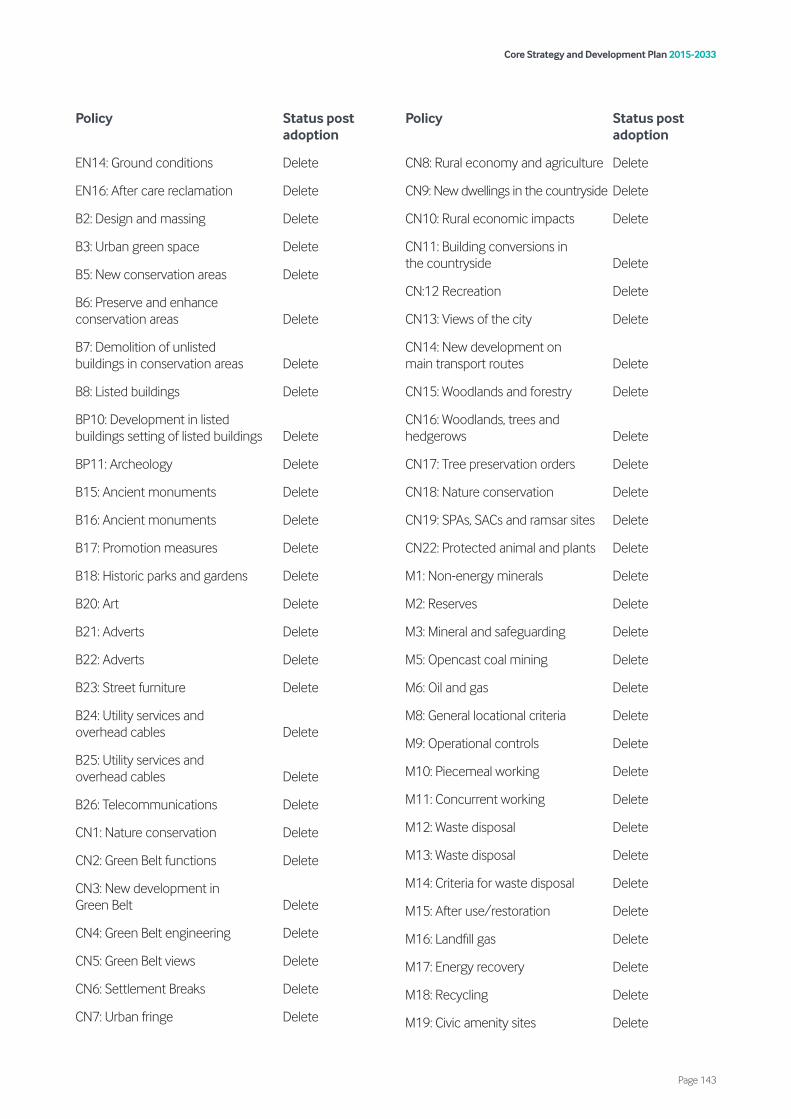
Policy Status post adoption
EN14: Ground conditions Delete
EN16: After care reclamation Delete
B2: Design and massing Delete
B3: Urban green space Delete
B5: New conservation areas Delete
B6: Preserve and enhance conservation areas Delete
B7: Demolition of unlisted buildings in conservation areas Delete
B8: Listed buildings Delete
BP10: Development in listed buildings setting of listed buildings Delete
BP11: Archeology Delete
B15: Ancient monuments Delete
B16: Ancient monuments Delete
B17: Promotion measures Delete
B18: Historic parks and gardens Delete
B20: Art Delete
B21: Adverts Delete
B22: Adverts Delete
B23: Street furniture Delete
B24: Utility services and overhead cables Delete
B25: Utility services and overhead cables Delete
B26: Telecommunications Delete
CN1: Nature conservation Delete
CN2: Green Belt functions Delete
CN3: New development in Green Belt Delete
CN4: Green Belt engineering Delete
CN5: Green Belt views Delete
CN6: Settlement Breaks Delete
CN7: Urban fringe Delete
Policy Status post adoption
CN8: Rural economy and agriculture Delete
CN9: New dwellings in the countryside Delete
CN10: Rural economic impacts Delete
CN11: Building conversions in the countryside Delete
CN:12 Recreation Delete
CN13: Views of the city Delete
CN14: New development on main transport routes Delete
CN15: Woodlands and forestry Delete
CN16: Woodlands, trees and hedgerows Delete
CN17: Tree preservation orders Delete
CN18: Nature conservation Delete
CN19: SPAs, SACs and ramsar sites Delete
CN22: Protected animal and plants Delete
M1: Non-energy minerals Delete
M2: Reserves Delete
M3: Mineral and safeguarding Delete
M5: Opencast coal mining Delete
M6: Oil and gas Delete
M8: General locational criteria Delete
M9: Operational controls Delete
M10: Piecemeal working Delete
M11: Concurrent working Delete
M12: Waste disposal Delete
M13: Waste disposal Delete
M14: Criteria for waste disposal Delete
M15: After use/restoration Delete
M16: Landfill gas Delete
M17: Energy recovery Delete
M18: Recycling Delete
M19: Civic amenity sites Delete
Core Strategy and Development Plan 2015-2033
Page 143

Policy Status post adoption
M20: Sewage treatment Delete
T1: General policy Delete
T2: Public transport Delete
T3: Metro extension Delete
T4: Buses Delete
T5: Railways Delete
T6: Interchanges Delete
T7: Taxis Delete
T8: Pedestrians Delete
T9: Cyclists Delete
T12: Strategic route network Delete
T13: Highway improvements Delete
T14: New development and transport Delete
T15: Protection of new and existing road corridors Delete
T17: Transport and environmental improvements Delete
T18: Highway improvements Delete
T19: Safety Delete
T20: Traffic management Delete
T22: Private parking Delete
T24: Freight movement Delete
T25: National communications Delete
T26: Transport and the Port Delete
SA1: Existing employment areas Delete
SA2: The Port Delete
SA3: Doxford International Delete
SA4: New employment sites Delete
SA5: Existing mixed-use sites Delete
SA11: Council housing Delete
SA13: East End Delete
SA14: Shopping centres Delete
Policy Status post adoption
SA17: Thornhill urban nature reserve Delete
SA19: Cherry Knowle Hospital Delete
SA21: Silksworth Branch Library Delete
SA25: Sport and recreation Delete
SA33: Coastal zone Delete
SA34: Improvements in transport corridors Delete
SA37: Green belt Delete
SA39: Trees and woodlands Delete
SA40: Tunstall Hills LNR Delete
SA42: Metro extension Delete
SA43: Railways Delete
SA45: South Dock Railway Delete
SA46: Bus facilities Delete
SA47: Cyclists Delete
SA50: Road proposals Delete
SA51: Junction improvement Delete
SA52: Safeguarding road routes Delete
SA53: Parking around Royal Hospital Delete
SA57: Industry & warehousing Delete
SA60: Offices Delete
SA61: Main office area Delete
SA62: Office properties Delete
SA63: Upper floor conversions Delete
SA64: Office development Delete
SA66: Housing city centre Delete
SA67: Housing On Upper Floors Delete
SA69: Principal shopping area Delete
SA70: Bulky goods Delete
SA71: Non-retail uses Delete
SA74: Leisure & recreation Delete
SA76: Allotments Delete
Core Strategy and Development Plan 2015-2033
Page 144

Policy Status post adoption
SA78: Environment Delete
SA79: Environment: floorscape Delete
SA80: Environment: amenity open space Delete
SA81: Environment: street furniture Delete
SA82: Environment: weather protection Delete
SA83: Environment: older properties Delete
SA85: Shop notices Delete
SA88: Safeguarding Hendon – Pallion Railway corridor Delete
SA95: Road proposals Delete
NA1: Existing employment sites Delete
NA2: New employment sites Delete
NA4: Mixed use sites Delete
NA9: Council housing North Delete
NA11: Shopping centres Delete
NA12: New shopping sites Delete
NA14: Redcar Road Campus Delete
NA16: Community centre Delete
NA25: Riverside Delete
NA26: Coastal and sea front zone Delete
NA27: Improvement in transport corridors Delete
NA29: Green belt Delete
NA31: Tree Planting Delete
NA36: Strategic footpaths Delete
NA37: Access across Wessington Way Delete
NA38: Cyclists Delete
NA39: Road proposals Delete
NA40: Seafront traffic management Delete
NA42: Car parking Delete
Policy Status post adoption
NA43: Monkwearmouth: economic development Delete
NA44: Monkwearmouth: economic development Delete
NA49: Monkwearmouth: Metro station Delete
NA50: Monkwearmouth: Newcastle Road cycle route Delete
NA51: Monkwearmouth: link road and footpath Delete
WA1: Existing employment sites Delete
WA2: New employment sites Delete
WA5: Council housing Washington Delete
WA7: Concord shopping centre Delete
WA8: Armstrong retail Delete
WA18: Conservation area Delete
WA19: Green belt Delete
WA21: Tree planting Delete
WA24: Minerals Delete
WA26: Multi-user routes Delete
WA27: Strategic footpaths Delete
WA30: Road proposals Delete
WA31: Washington Village traffic management Delete
WA33: Washington Town Centre improvement Delete
WA35: Community and leisure development Delete
WA36: Bus priority measures Delete
HA1: Existing employment sites Delete
HA2: New sites Delete
HA5: Council housing Delete
HA7: Shopping Delete
HA8: Educational facilities Delete
Core Strategy and Development Plan 2015-2033
Page 145
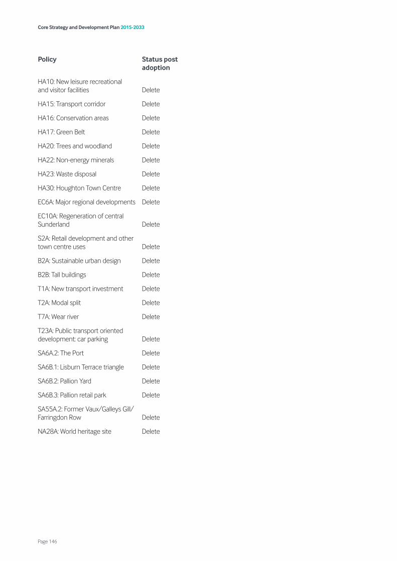
Policy Status post adoption
HA10: New leisure recreational and visitor facilities Delete
HA15: Transport corridor Delete
HA16: Conservation areas Delete
HA17: Green Belt Delete
HA20: Trees and woodland Delete
HA22: Non-energy minerals Delete
HA23: Waste disposal Delete
HA30: Houghton Town Centre Delete
EC6A: Major regional developments Delete
EC10A: Regeneration of central Sunderland Delete
S2A: Retail development and other town centre uses Delete
B2A: Sustainable urban design Delete
B2B: Tall buildings Delete
T1A: New transport investment Delete
T2A: Modal split Delete
T7A: Wear river Delete
T23A: Public transport oriented development: car parking Delete
SA6A.2: The Port Delete
SA6B.1: Lisburn Terrace triangle Delete
SA6B.2: Pallion Yard Delete
SA6B.3: Pallion retail park Delete
SA55A.2: Former Vaux/Galleys Gill/ Farringdon Row Delete
NA28A: World heritage site Delete
Core Strategy and Development Plan 2015-2033
Page 146
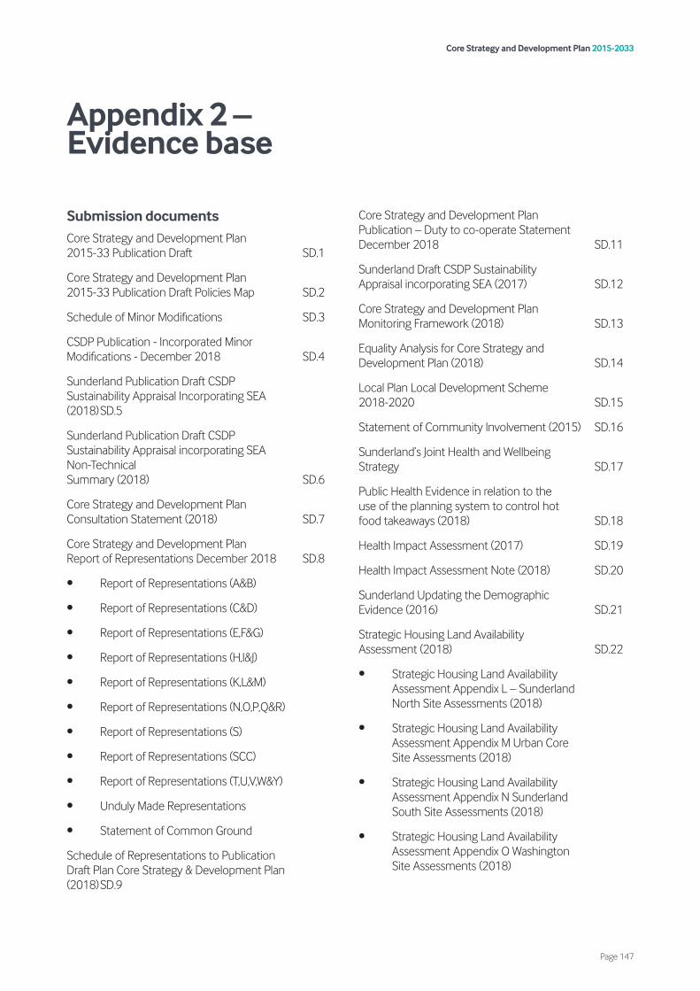
Submission documents Core Strategy and Development Plan 2015-33 Publication Draft SD.1
Core Strategy and Development Plan 2015-33 Publication Draft Policies Map SD.2
Schedule of Minor Modifications SD.3
CSDP Publication - Incorporated Minor Modifications - December 2018 SD.4
Sunderland Publication Draft CSDP Sustainability Appraisal Incorporating SEA (2018)SD.5
Sunderland Publication Draft CSDP Sustainability Appraisal incorporating SEA Non-Technical Summary (2018) SD.6
Core Strategy and Development Plan Consultation Statement (2018) SD.7
Core Strategy and Development Plan Report of Representations December 2018 SD.8
• Report of Representations (A&B)
• Report of Representations (C&D)
• Report of Representations (E,F&G)
• Report of Representations (H,I&J)
• Report of Representations (K,L&M)
• Report of Representations (N,O,P,Q&R)
• Report of Representations (S)
• Report of Representations (SCC)
• Report of Representations (T,U,V,W&Y)
• Unduly Made Representations
• Statement of Common Ground
Schedule of Representations to Publication Draft Plan Core Strategy & Development Plan (2018)SD.9
Core Strategy and Development Plan Publication – Duty to co-operate Statement December 2018 SD.11
Sunderland Draft CSDP Sustainability Appraisal incorporating SEA (2017) SD.12
Core Strategy and Development Plan Monitoring Framework (2018) SD.13
Equality Analysis for Core Strategy and Development Plan (2018) SD.14
Local Plan Local Development Scheme 2018-2020 SD.15
Statement of Community Involvement (2015) SD.16
Sunderland’s Joint Health and Wellbeing Strategy SD.17
Public Health Evidence in relation to the use of the planning system to control hot food takeaways (2018) SD.18
Health Impact Assessment (2017) SD.19
Health Impact Assessment Note (2018) SD.20
Sunderland Updating the Demographic Evidence (2016) SD.21
Strategic Housing Land Availability Assessment (2018) SD.22
• Strategic Housing Land Availability Assessment Appendix L – Sunderland North Site Assessments (2018)
• Strategic Housing Land Availability Assessment Appendix M Urban Core Site Assessments (2018)
• Strategic Housing Land Availability Assessment Appendix N Sunderland South Site Assessments (2018)
• Strategic Housing Land Availability Assessment Appendix O Washington Site Assessments (2018)
Core Strategy and Development Plan 2015-2033
Page 147
Appendix 2 – Evidence base

• Strategic Housing Land Availability Assessment Appendix P Coalfield Site Assessments (2018)
Sunderland Strategic Housing Market Assessment Update (2017) SD.23
Sunderland Strategic Housing Market Assessment Addendum (2018) SD.24
Internal Space Standards (2018) SD.25
Sunderland Gypsy and Traveller and Travelling Showperson Accommodation Assessment (2017) SD.26
Sunderland Gypsy and Traveller and Travelling Showperson Accommodation Assessment Addendum (2018) SD.27
Gypsy’s and Traveller’s Site Assessment Report (2017) SD.28
Green Belt Review Stage 1 – Core Strategy Growth Options Stage (2016) SD.29
Green Belt Assessment Stage 1 Updated and Stage 2 (2017) SD.30
Stage 3 Green Belt Site Selection Report (2017) SD.31
Green Belt Assessment 2018 Addendum SD.32
Review of the Sunderland Green Belt Part 1: Exceptional Circumstances for Releasing Land from the Green Belt SD.33
Review of the Sunderland Green Belt Part 2: Boundary Assessment and Recommendations (2018) SD.34
Sunderland Development Frameworks (2018) SD.35
Draft South Sunderland Growth Area SPD (2017) SD.36
Sunderland Employment Land Review (2016) SD.37
• Sunderland Employment Land Review (2016) Maps
Employment Land Review: Post EU Referendum Forecasting Analysis (2017) SD.38
Sunderland Retail Needs Assessment Volume 1 (2016) SD.39
Sunderland Retail Needs Assessment Volume 2 (2016) SD.40
Sunderland Retail Needs Assessment Volume 3 (2016) SD.41
Sunderland Retail Needs Assessment Executive Summary and Recommendations (2016) SD.42
Sunderland Leisure Needs Study (2016) SD.43
Sunderland City Council – Playing Pitch Plan (2018) SD.44
Sunderland City Council – Indoor Sports Facilities Assessment Report (2015) SD.45
Sunderland Green Infrastructure Strategy (2018) SD.46
Sunderland Greenspace Audit and Report (2018) SD.47
2018 Settlement Break Review SD.48
Sunderland City Council Level 1 – Strategic Flood Risk Assessment (2018) SD.49
• Sunderland City Council Level 1 – Strategic Flood Risk Assessment (2018) Appendix
• Sunderland City Council Level 1 – Strategic Flood Risk Assessment (2018) Interactive Maps
Sunderland Flood Risk Policy Level 2 Strategic Flood Risk Assessment – Site Screening (2018) SD.50
Sunderland Local Plan – Initial Assessment of Transport Impacts (2017) SD.51
Sunderland Local Plan – Assessment of Transport Impacts – Addendum One (April 2018) SD.52
Sunderland Local Plan – Assessment of Transport Impacts – Addendum Two (April 2018) SD.53
Minerals Safeguarding Areas in Sunderland - MSA Topic Paper (2017) SD.54
Sunderland City Council - Waste Arisings and Capacity Requirements (2018) SD.55
South Tyne & Wear Waste Management Partnership: Joint Municipal Waste Management Strategy (2007) SD.56
Core Strategy and Development Plan 2015-2033
Page 148

Joint Local Aggregates Assessment for County Durham, Northumberland and Tyne and Wear (2018) SD.57
Maintaining Levels of Minerals Supply Topic Paper (2018) SD.58
Core Strategy and Development Plan Infrastructure Delivery Plan Updated December 2018 SD.59
Whole Plan Viability Assessment (with CIL scoping) (2017) SD.60
Sunderland City Council Post Consultation/ Pre-submission Viability Note (2018) SD.61
Local Plan Education Planning Report (2018) SD.62
Planning Obligations Supplementary Planning Document Draft (2018) SD.63
South Tyne & Wear Waste Management Partnership: Joint Municipal Waste Management Strategy Review (2012) SD.64
Revised Habitats Regulations Assessment (2019) EX1.014
Sunderland City Council: North Sunderland Sites Report to inform Habitats Regulations Assessment (2019) EX1.015
Supporting documents Core Strategy and Development Plan 2015-2033 Draft (2017) SP.1
Core Strategy Growth Options Consultation Responses Report (2016) SP.2
LDF Key Issues & Options Consultation SP.3
LDF Alternative Approaches Consultation (2009) SP.4
Local Plan Core Strategy Growth Options Consultation (2016) SP.5
SLP - Core Strategy and Development Management Policies - Draft Revised Preferred Options (2013) SP.6
LDF Core Strategy Development Plan Document Preferred Options (2007) SP.7
LDF Draft Sustainability Appraisal Scoping Report (2009) SP.8
International Advanced Manufacturing Park Area Action Plan (2017) SP.9
Sunderland Objectively Assessed Need and Strategic Housing Market Assessment Update (2016) SP.10
Sunderland Demographic Analysis and Forecasts (2015)
SP.11
Impact Study – International Advanced Manufacturing Park – Topic Paper: Housing (2015) SP.12
Housing Strategy for Sunderland 2017-2022 (2017) SP.13
Economic Viability of Affordable Housing Requirements – Study for Sunderland City Council (2014) SP.14
Interim Student Accommodation Policy (2015) SP.15
Technical Paper: Optional Standards – Accessible and Adaptable Homes SP.16
Sunderland City Council – Unauthorised Encampment Policy (2018) SP.17
Strategic Land Review – Coalfield (2016) SP.18
Strategic Land Review – North (2016) SP.19
Strategic Land Review – West (2016) SP.20
Strategic Land Review – East (2016) SP.21
Strategic Land Review – Washington (2016) SP.22
South Sunderland Growth Area Draft Supplementary Planning Document - HRA Appropriate Assessment (2016) SP.23
South Sunderland Growth Area – Infrastructure Delivery Study (2016) SP.24
South Sunderland Growth Area Infrastructure Delivery Study – Viability Assessment (2014) SP.25
SSGA Ecological Assessment, Management Plan & Design Strategy (2014) SP.26
SHIM Model Testing and Appraisal of LPD Sites Including SSGA (2014) SP.27
South Sunderland Growth Area Landscape Character Assessment (2015) SP.28
South Sunderland Growth Area - Draft Supplementary Planning Document Sustainability Appraisal (2016) SP.29
Core Strategy and Development Plan 2015-2033
Page 149
Sunderland Economic Masterplan SP.30
Sunderland Transforming Our City – The 3,6,9 Vision SP.31
Sunderland Economic Update 2012 SP.32
More and Better Jobs: The North East Strategic Economic Plan (2017) SP.33
Sunderland Central Area Urban Design Strategy (2008) SP.34
Design and Access Statements SPD (2008) SP.35
Ashbrooke Conservation Area Character Study (2005) SP.36
Bishopwearmouth Conservation Area Character Appraisal and Management Plan (2018) SP.37
Houghton’s Conservation Areas Character Appraisal and Management Strategy (2007) SP.38
Newbottle Village Conservation Area Character Appraisal and Management Strategy (2009) SP.39
Roker Park Conservation Area Character Appraisal and Management Strategy (2007) SP.40
Ryhope Village Conservation Area Character Appraisal and Management Strategy (2010) SP.41
Silksworth Hall Conservation Area Character Appraisal and Management Strategy (2010) SP.42
Sunniside Conservation Area Character Appraisal and Management Strategy (2009) SP.43
The Cedars Conservation Area Character Appraisal and Management Strategy (2008) SP.44
Washington Village Conservation Area Character Appraisal and Management Strategy (2009) SP.45
Whitburn Bents Conservation Area Character Appraisal and Management Strategy (2007) SP.46
Sunderland Landscape Character Assessment (2015) SP.47
Sunderland Wind and Solar Landscape Sensitivity Assessment (2015) SP.48
Heritage Coast Management Plan 2018-2025 (Sunderland-Durham-Hartlepool) SP.49
Local Flood Risk Management Strategy (2016) SP.50
Sunderland City Council – Preliminary Flood Risk Assessment (2011) SP.51
Climate Change Action Plan for Sunderland – Progress Report (2010) SP.52
Keep Tyne and Wear Moving – LTP The Third Local Transport Plan for Tyne and Wear (2011) SP.53
Ryhope Tunstall Periphery Planning Guidance (1999) SP.54
Sunderland Strategic Transport Corridor – Adoption of Preferred Route (2005) SP.55
HMO Article 4 Direction SP.56
Sunderland Strategic Housing Land Availability Assessment Methodology (2016) SP.57
Impact Study – International Advanced Manufacturing Park – Topic Paper Update 2016 - Housing SP.58
Sunniside Planning and Design Framework (2008) SP.59
Sunderland Cultural Strategy SP.60
Minster Quarter Masterplan Supplementary Planning Document (2017) SP.61
Schedule of Representations to Draft Plan Core Strategy and Development Plan (January 2018) SP.62
Local Plan Sustainability Appraisal Scoping Report Consultation (2015) SP.63
Draft Sunderland Strategic Transport Corridor Commercial Links: Outline Business Case (2016) SP.64
County Archaeology Officer Email: Significance of Archaeology at Lambton D Pit Wooden Waggonway SP.65
Metro Futures: The combined future of Metro and local rail in the North East SP.66
North East Rail Statement: Our Aspirations for rail improvements and investments over the next 15 years SP.67
NECA Transport Manifesto SP.68
Development Control Guidelines - Parking Standards SP.69
Core Strategy and Development Plan 2015-2033
Page 150
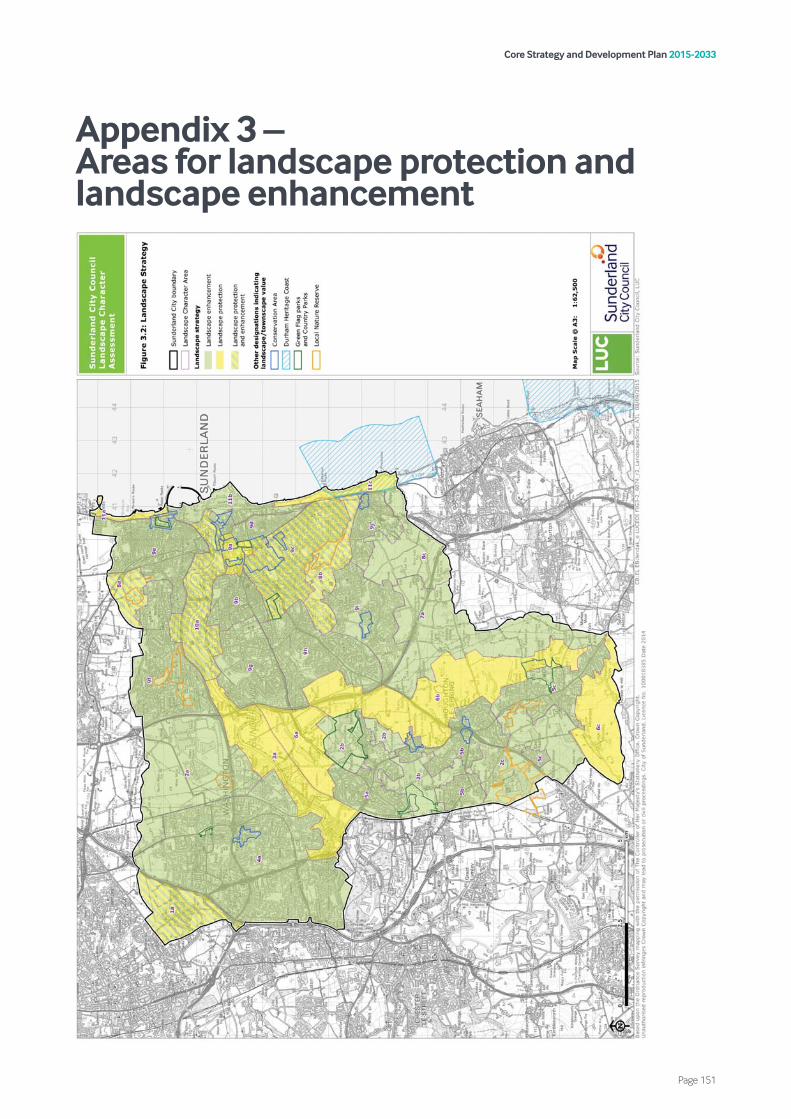
Core Strategy and Development Plan 2015-2033
Page 151
Appendix 3 – Areas for landscape protection and landscape enhancement

Core Strategy and Development Plan 2015-2033
Page 152
Appendix 4 – Minerals Safeguarding Areas

Safeguarding exception
List of exemption criteria 1. Applications for householder development.
2. Applications for extensions or alterations to existing buildings and for change of use of existing development which do not fundamentally change the scale and character of the building/use.
3. Applications that are in accordance with the local plan where the Plan took account of prevention of unnecessary mineral sterilisation and determined that prior extraction should not be considered when development applications in a Minerals Safeguarding Area came forward.
4. Applications for advertisement consent.
5. Applications for reserved matters including subsequent applications after outline consent has been granted.
6. Prior notifications (telecommunications; forestry; agriculture and demolition).
7. Certificates of lawfulness of existing or proposed use or development (CLEUDs and CXLOPUDs).
8. Applications for works to trees.
9. Applications for temporary planning permission.
10. Relevant demolition in a conservation area.
11. Applications for listed buildings consent.
Core Strategy and Development Plan 2015-2033
Page 153
Appendix 5 – Mineral safeguarding exceptions
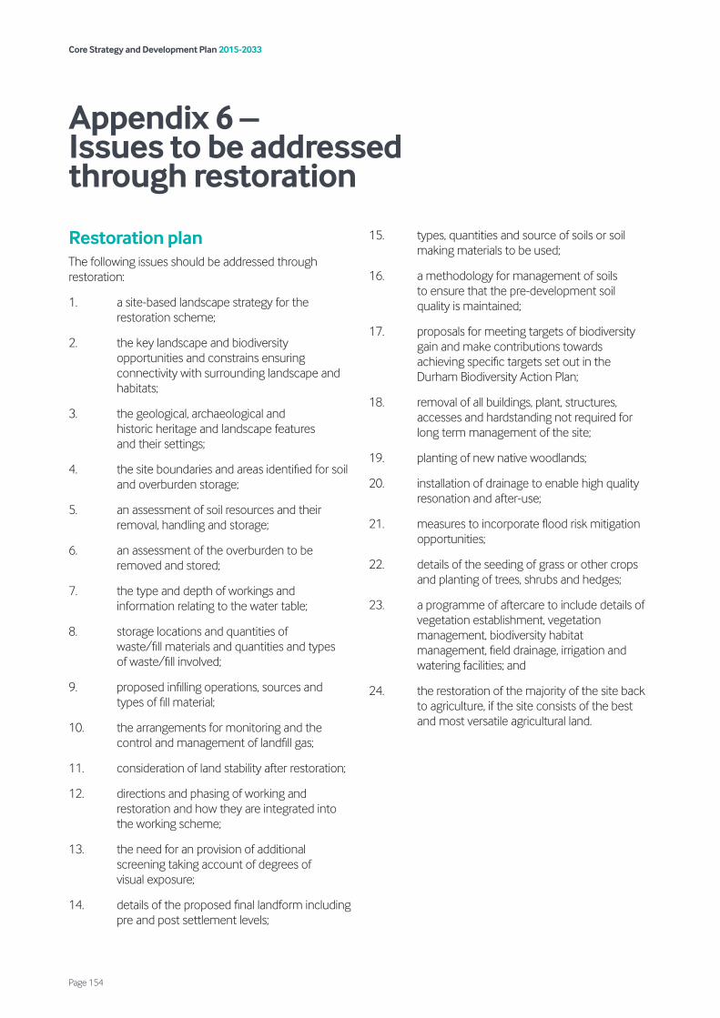
Restoration plan The following issues should be addressed through restoration:
1. a site-based landscape strategy for the restoration scheme;
2. the key landscape and biodiversity opportunities and constrains ensuring connectivity with surrounding landscape and habitats;
3. the geological, archaeological and historic heritage and landscape features and their settings;
4. the site boundaries and areas identified for soil and overburden storage;
5. an assessment of soil resources and their removal, handling and storage;
6. an assessment of the overburden to be removed and stored;
7. the type and depth of workings and information relating to the water table;
8. storage locations and quantities of waste/fill materials and quantities and types of waste/fill involved;
9. proposed infilling operations, sources and types of fill material;
10. the arrangements for monitoring and the control and management of landfill gas;
11. consideration of land stability after restoration;
12. directions and phasing of working and restoration and how they are integrated into the working scheme;
13. the need for an provision of additional screening taking account of degrees of visual exposure;
14. details of the proposed final landform including pre and post settlement levels;
15. types, quantities and source of soils or soil making materials to be used;
16. a methodology for management of soils to ensure that the pre-development soil quality is maintained;
17. proposals for meeting targets of biodiversity gain and make contributions towards achieving specific targets set out in the Durham Biodiversity Action Plan;
18. removal of all buildings, plant, structures, accesses and hardstanding not required for long term management of the site;
19. planting of new native woodlands;
20. installation of drainage to enable high quality resonation and after-use;
21. measures to incorporate flood risk mitigation opportunities;
22. details of the seeding of grass or other crops and planting of trees, shrubs and hedges;
23. a programme of aftercare to include details of vegetation establishment, vegetation management, biodiversity habitat management, field drainage, irrigation and watering facilities; and
24. the restoration of the majority of the site back to agriculture, if the site consists of the best and most versatile agricultural land.
Core Strategy and Development Plan 2015-2033
Page 154
Appendix 6 – Issues to be addressed through restoration
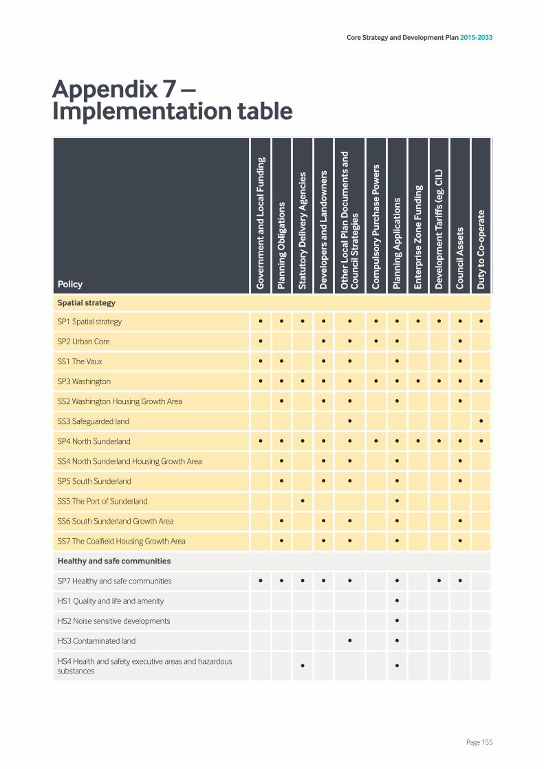
Core Strategy and Development Plan 2015-2033
Page 155
Appendix 7 – Implementation table
Policy Gov
ernm
ent a
nd L
ocal
Fun
ding
Plan
ning
Obl
igat
ions
Stat
utor
y D
eliv
ery
Age
ncie
s
Dev
elop
ers
and
Land
owne
rs
Oth
er L
ocal
Pla
n D
ocum
ents
and
C
ounc
il St
rate
gies
Com
puls
ory
Purc
hase
Pow
ers
Plan
ning
App
licat
ions
Ente
rpri
se Z
one
Fund
ing
Dev
elop
men
t Tar
iffs
(eg.
CIL
)
Cou
ncil
Ass
ets
Dut
y to
Co-
oper
ate
Spatial strategy
SP1 Spatial strategy • • • • • • • • • • •
SP2 Urban Core • • • • • •
SS1 The Vaux • • • • • •
SP3 Washington • • • • • • • • • • •
SS2 Washington Housing Growth Area • • • • •
SS3 Safeguarded land • •
SP4 North Sunderland • • • • • • • • • • •
SS4 North Sunderland Housing Growth Area • • • • •
SP5 South Sunderland • • • • •
SS5 The Port of Sunderland • •
SS6 South Sunderland Growth Area • • • • •
SS7 The Coalfield Housing Growth Area • • • • •
Healthy and safe communities
SP7 Healthy and safe communities • • • • • • • •
HS1 Quality and life and amenity •
HS2 Noise sensitive developments •
HS3 Contaminated land • •
HS4 Health and safety executive areas and hazardous substances • •

Core Strategy and Development Plan 2015-2033
Page 156
Policy Gov
ernm
ent a
nd L
ocal
Fun
ding
Plan
ning
Obl
igat
ions
Stat
utor
y D
eliv
ery
Age
ncie
s
Dev
elop
ers
and
Land
owne
rs
Oth
er L
ocal
Pla
n D
ocum
ents
and
C
ounc
il St
rate
gies
Com
puls
ory
Purc
hase
Pow
ers
Plan
ning
App
licat
ions
Ente
rpri
se Z
one
Fund
ing
Dev
elop
men
t Tar
iffs
(eg.
CIL
)
Cou
ncil
Ass
ets
Dut
y to
Co-
oper
ate
Homes
SP8 Housing supply delivery • • • • •
H1 Housing mix • • • • •
H2 Affordable housing • • • • • •
H3 Student accommodation • • •
H4 Travelling Showpeople, Gypsies and Travellers • • • • •
H5 Existing homes and loss of homes • • •
H6 Homes in Multiple Occupation • • •
H7 Backland and tandem development •
Economic growth
EG1 Primary employment areas • • • • • •
EG2 Key employment areas • •
EG3 Other employment sites • •
EG4 New employment areas • • • •
EG5 Offices •
EG6 Trade counters •
Vitality of centres
VC1 Main town centre uses and retail hierarchy • • • • • • • • •
SP9 Comparison retail • • •
VC2 Retail impact assessments •
VC3 Primary shopping areas and frontages • •
VC4 Hot food takeaways • •
VC5 Protection and delivery of community facilities and local services • • • • • • • •
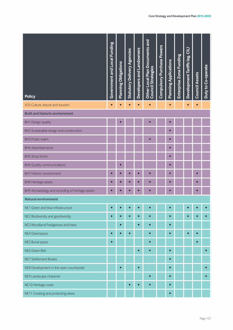
Core Strategy and Development Plan 2015-2033
Page 157
Policy Gov
ernm
ent a
nd L
ocal
Fun
ding
Plan
ning
Obl
igat
ions
Stat
utor
y D
eliv
ery
Age
ncie
s
Dev
elop
ers
and
Land
owne
rs
Oth
er L
ocal
Pla
n D
ocum
ents
and
C
ounc
il St
rate
gies
Com
puls
ory
Purc
hase
Pow
ers
Plan
ning
App
licat
ions
Ente
rpri
se Z
one
Fund
ing
Dev
elop
men
t Tar
iffs
(eg.
CIL
)
Cou
ncil
Ass
ets
Dut
y to
Co-
oper
ate
VC6 Culture, leisure and tourism • • • • • • • •
Built and historic environment
BH1 Design quality • • •
BH2 Sustainable design and construction •
BH3 Public realm • •
BH4 Advertisements •
BH5 Shop fronts •
BH6 Quality communications • •
BH7 Historic environment • • • • • • •
BH8 Heritage assets • • • • • • •
BH9 Archaeology and recording of heritage assets • • • • • • •
Natural environment
NE1 Green and blue infrastructure • • • • • • • • •
NE2 Biodiversity and geodiversity • • • • • • • • •
NE3 Woodland/hedgerows and trees • • • •
NE4 Greenspace • • • • • • •
NE5 Burial space • • •
NE6 Green Belt • • • •
NE7 Settlement Breaks •
NE8 Development in the open countryside • • • •
NE9 Landscape character • • •
NE10 Heritage coast • • • •
NE11 Creating and protecting views •
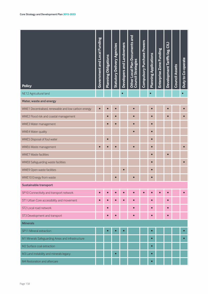
Core Strategy and Development Plan 2015-2033
Page 158
Policy Gov
ernm
ent a
nd L
ocal
Fun
ding
Plan
ning
Obl
igat
ions
Stat
utor
y D
eliv
ery
Age
ncie
s
Dev
elop
ers
and
Land
owne
rs
Oth
er L
ocal
Pla
n D
ocum
ents
and
C
ounc
il St
rate
gies
Com
puls
ory
Purc
hase
Pow
ers
Plan
ning
App
licat
ions
Ente
rpri
se Z
one
Fund
ing
Dev
elop
men
t Tar
iffs
(eg.
CIL
)
Cou
ncil
Ass
ets
Dut
y to
Co-
oper
ate
NE12 Agricultural land • • •
Water, waste and energy
WWE1 Decentralised, renewable and low carbon energy • • • • • • •
WWE2 Flood risk and coastal management • • • • • •
WWE3 Water management • • • •
WWE4 Water quality • •
WWE5 Disposal of foul water • •
WWE6 Waste management • • • • • •
WWE7 Waste facilities • •
WWE8 Safeguarding waste facilities • •
WWE9 Open waste facilities • •
WWE10 Energy from waste • • •
Sustainable transport
SP10 Connectivity and transport network • • • • • • • • • •
ST1 Urban Core accessibility and movement • • • • • • •
ST2 Local road network • • • •
ST3 Development and transport • • • • •
Minerals
SP11 Mineral extraction • • • • •
M1 Minerals Safeguarding Areas and infrastructure • •
M2 Surface coal extraction •
M3 Land instability and minerals legacy • •
M4 Restoration and aftercare •

Core Strategy and Development Plan 2015-2033
Page 159
Policy Gov
ernm
ent a
nd L
ocal
Fun
ding
Plan
ning
Obl
igat
ions
Stat
utor
y D
eliv
ery
Age
ncie
s
Dev
elop
ers
and
Land
owne
rs
Oth
er L
ocal
Pla
n D
ocum
ents
and
C
ounc
il St
rate
gies
Com
puls
ory
Purc
hase
Pow
ers
Plan
ning
App
licat
ions
Ente
rpri
se Z
one
Fund
ing
Dev
elop
men
t Tar
iffs
(eg.
CIL
)
Cou
ncil
Ass
ets
Dut
y to
Co-
oper
ate
Infrastructure and delivery
ID1 Delivering infrastructure • • • • • • • • • • •
ID2 Planning obligation • • • •
Core Strategy and Development Plan 2015-2033
Page 160
Appendix 8 – Monitoring Framework
Implementation and Monitoring Framework 8.1 The Implementation and Monitoring
Framework for the CSDP is set out in the section below. The Framework links directly to wider Local Plan, the Sustainability Appraisal (SA) and the
Authority Monitoring Report (AMR) 8.2 The Framework is structured according to the
composition of the CSDP, enabling for easy and direct comparison with the policies, proposals and overall objectives. As the plan period runs until 2033, and given the long-term aspiration and objectives of the overall strategy, it is likely that this framework will evolve and change over time, particularly in light of any new requirements over this timeframe. Therefore, this Framework will also be subject to a process of monitoring, review and amendment as part of the wider Local Plan.
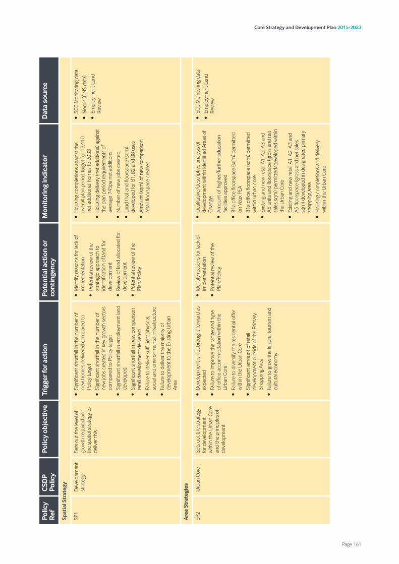
Core Strategy and Development Plan 2015-2033
Page 161
Polic
y R
efC
SDP
Polic
yPo
licy
obje
ctiv
eTr
igge
r for
act
ion
Pote
ntia
l act
ion
or
cont
inge
ncy
Mon
itor
ing
indi
cato
rD
ata
sour
ce
Spat
ial S
trat
egy
SP1
Dev
elop
men
t st
rate
gySe
ts o
ut th
e le
vel o
f gr
owth
requ
ired
and
the
spat
ial s
trate
gy to
de
liver
this
•Si
gnifi
cant
sho
rtfa
ll in
the
num
ber o
f ne
w h
omes
del
iver
ed c
ompa
red
to
Polic
y ta
rget
•Si
gnifi
cant
sho
rtfa
ll in
the
num
ber o
f ne
w jo
bs c
reat
ed in
key
gro
wth
sec
tors
co
mpa
red
to P
olic
y ta
rget
•Si
gnifi
cant
sho
rtfa
ll in
em
ploy
men
t lan
d de
velo
ped
•Si
gnifi
cant
sho
rtfa
ll in
new
com
paris
on
reta
il de
velo
pmen
t del
iver
ed
•Fa
ilure
to d
eliv
er s
uffic
ient
phy
sical
, so
cial
and
env
ironm
enta
l inf
rast
ruct
ure
•Fa
ilure
to d
eliv
er th
e m
ajor
ity o
f de
velo
pmen
t to
the
Exist
ing
Urb
an
Area
•Id
entif
y re
ason
s fo
r lac
k of
im
plem
enta
tion
•Po
tent
ial r
evie
w o
f the
st
rate
gic
appr
oach
to
iden
tifica
tion
of la
nd fo
r de
velo
pmen
t
•Re
view
of l
and
allo
cate
d fo
r de
velo
pmen
t
•Po
tent
ial r
evie
w o
f the
Pl
an/P
olic
y
•H
ousin
g co
mpl
etio
ns a
gain
st th
e ov
eral
l pla
n pe
riod
targ
et fo
r 13,
410
net a
dditi
onal
hom
es to
203
3
•H
ousin
g de
liver
y (n
et a
dditi
ons)
aga
inst
th
e pl
an p
erio
d re
quire
men
ts o
f av
erag
e 74
5pa
net a
dditi
ons
•N
umbe
r of n
ew jo
bs c
reat
ed
•La
nd (h
a) a
nd fl
oors
pace
(sqm
) de
velo
ped
for B
1, B
2 an
d B8
use
s
•Am
ount
(sqm
) of n
ew c
ompa
rison
re
tail
floor
spac
e cr
eate
d
•SC
C M
onito
ring
data
•N
omis
(ON
S da
ta)
•Em
ploy
men
t Lan
d Re
view
Are
a St
rate
gies
SP2
Urb
an C
ore
Sets
out
the
stra
tegy
fo
r dev
elop
men
t w
ithin
the
Urb
an C
ore
and
the
prin
cipl
es o
f de
velo
pmen
t
•D
evel
opm
ent i
s no
t bro
ught
forw
ard
as
expe
cted
•Fa
ilure
to im
prov
e th
e ra
nge
and
type
of
offi
ce a
ccom
mod
atio
n w
ithin
the
Urb
an C
ore
•Fa
ilure
to d
iver
sify
the
resid
entia
l offe
r w
ithin
the
Urb
an C
ore
•Si
gnifi
cant
am
ount
of r
etai
l de
velo
pmen
t out
side
of th
e Pr
imar
y Sh
oppi
ng A
rea
•Fa
ilure
to g
row
the
leisu
re, t
ouris
m a
nd
cultu
ral e
cono
my
•Id
entif
y re
ason
s fo
r lac
k of
im
plem
enta
tion
•Po
tent
ial r
evie
w o
f the
Pl
an/P
olic
y
•Q
ualit
ativ
e/de
scrip
tive
anal
ysis
of
deve
lopm
ent w
ithin
iden
tified
Are
as o
f Ch
ange
•Am
ount
of h
ighe
r/fu
rthe
r edu
catio
n fa
cilit
ies
appr
oved
•B1
a of
fice
floor
spac
e (s
qm) p
erm
itted
on
Vau
x PE
A
•B1
a of
fice
floor
spac
e (s
qm) p
erm
itted
w
ithin
urb
an c
ore
•Ex
istin
g an
d ne
w re
tail
A1, A
2, A
3 an
d A5
uni
ts a
nd fl
oors
pace
(gro
ss a
nd n
et
sale
s sq
m) p
erm
itted
/dev
elop
ed w
ithin
th
e U
rban
Cor
e
•Ex
istin
g an
d ne
w re
tail
A1, A
2, A
3 an
d A5
floo
rspa
ce (g
ross
and
net
sal
es
sqm
) dev
elop
ed in
des
igna
ted
prim
ary
shop
ping
are
a
•H
ousin
g co
mpl
etio
ns a
nd d
eliv
ery
with
in th
e U
rban
Cor
e
•SC
C M
onito
ring
data
•Em
ploy
men
t Lan
d Re
view

Core Strategy and Development Plan 2015-2033
Page 162
Polic
y R
efC
SDP
Polic
yPo
licy
obje
ctiv
eTr
igge
r for
act
ion
Pote
ntia
l act
ion
or
cont
inge
ncy
Mon
itor
ing
indi
cato
rD
ata
sour
ce
SS1
The
Vaux
Sets
out
the
mix
and
prin
cipl
es o
f de
velo
pmen
t ex
pect
ed o
n th
e
Vaux
Site
•Si
gnifi
cant
sho
rtfa
ll in
the
amou
nt o
f B1
a flo
orsp
ace
deliv
ered
com
pare
d to
Po
licy
targ
et
•Si
gnifi
cant
sho
rtfa
ll in
the
amou
nt o
f ne
w h
omes
del
iver
ed c
ompa
red
to
Polic
y ta
rget
•Fa
ilure
to d
eliv
er a
hot
el o
n th
e sit
e
•Id
entif
y re
ason
s fo
r lac
k of
im
plem
enta
tion
•Po
tent
ial r
evie
w o
f the
Pl
an/P
olic
y
•B1
a flo
orsp
ace
(sqm
) pe
rmitt
ed/d
evel
oped
on
site
•H
ousin
g co
mpl
etio
ns o
n Va
ux s
ite
•D
eliv
ery
of h
otel
on
site
•SC
C M
onito
ring
data
•Pl
anni
ng a
pplic
atio
ns
•Em
ploy
men
t Lan
d Re
view
•Re
tail
Hea
lth &
Cap
acity
St
udie
s
•Re
tail
Nee
ds
Asse
ssm
ent
SP3
Was
hing
ton
Sets
out
the
spat
ial
stra
tegy
for
Was
hing
ton
•Fa
ilure
to fo
cus
econ
omic
gro
wth
in
iden
tified
Em
ploy
men
t Are
as a
nd th
e IA
MP
•A
signi
fican
t am
ount
of o
ut-o
f- ce
ntre
of
fice,
reta
il an
d ot
her M
ain
Tow
n U
se
deve
lopm
ent
•Fa
ilure
to d
eliv
er n
ew h
omes
with
in
iden
tified
Hou
sing
Gro
wth
Are
as
•Id
entif
y re
ason
s fo
r lac
k of
im
plem
enta
tion
•Po
tent
ial r
evie
w o
f the
Pl
an/P
olic
y
•Po
tent
ial r
evie
w o
f the
st
rate
gic
appr
oach
to
iden
tifica
tion
of la
nd fo
r de
velo
pmen
t
•Em
ploy
men
t lan
d (h
a) a
nd fl
oors
pace
(s
qm) d
evel
oped
for B
1, B
2 an
d B8
us
es w
ithin
iden
tified
Em
ploy
men
t Ar
eas
•Em
ploy
men
t lan
d (h
a) a
nd fl
oors
pace
(s
qm) l
ost t
o de
velo
pmen
t for
non
-B
Clas
s us
es w
ithin
iden
tified
Em
ploy
men
t Are
as
•Ex
istin
g an
d ne
w re
tail
A1, A
2, A
3 an
d A5
uni
ts a
nd fl
oors
pace
(gro
ss a
nd n
et
sale
s sq
m) p
erm
itted
/dev
elop
ed w
ithin
de
signa
ted
tow
n ce
ntre
•Ex
istin
g an
d ne
w re
tail
A1, A
2, A
3 an
d A5
floo
rspa
ce (g
ross
and
net
sal
es
sqm
) dev
elop
ed in
des
igna
ted
prim
ary
shop
ping
are
as o
f tow
n ce
ntre
•Pe
rcen
tage
of p
rimar
y fro
ntag
es in
no
n-A1
use
in d
esig
nate
d to
wn
cent
re
•Le
ngth
of p
rimar
y fro
ntag
es in
A1,
A2,
A3
and
A5
reta
il us
es in
des
igna
ted
tow
n ce
ntre
•H
ousin
g co
mpl
etio
ns a
nd d
eliv
ery
with
in id
entifi
ed H
ousin
g G
row
th A
reas
•Pl
ots
crea
ted
on a
lloca
ted
trave
lling
show
peop
le s
ites
•SC
C M
onito
ring
data
•Pl
anni
ng a
pplic
atio
ns
•Em
ploy
men
t Lan
d Re
view
•Re
tail
Hea
lth &
Cap
acity
St
udie
s
•Re
tail
Nee
ds
Asse
ssm
ent

Core Strategy and Development Plan 2015-2033
Page 163
Polic
y R
efC
SDP
Polic
yPo
licy
obje
ctiv
eTr
igge
r for
act
ion
Pote
ntia
l act
ion
or
cont
inge
ncy
Mon
itor
ing
indi
cato
rD
ata
sour
ce
SS2
Was
hing
ton
hous
ing
grow
th a
reas
Iden
tifies
the
hous
ing
grow
th a
reas
in
Was
hing
ton
and
wha
t is
expe
cted
to b
e pr
ovid
ed/a
chie
ved
by
them
•Fa
ilure
to p
rovi
de a
mix
of h
ousin
g ty
pes
•Fa
ilure
to s
ecur
e co
ntrib
utio
ns fo
r ed
ucat
ion
and
heal
thca
re p
rovi
sion
•Id
entif
y re
ason
s fo
r lac
k of
im
plem
enta
tion
•Po
tent
ial r
evie
w o
f the
Pl
an/P
olic
y
•Po
tent
ial r
evie
w o
f the
st
rate
gic
appr
oach
to
iden
tifica
tion
of la
nd fo
r de
velo
pmen
t
•N
egot
iatio
n w
ith d
evel
oper
s to
ens
ure
deliv
ery
of
appr
opria
te h
ousin
g m
ix.
•Re
view
of s
106
cont
ribut
ion
colle
ctio
n pr
oces
s/Pl
anni
ng
Obl
igat
ions
SPD
•H
ousin
g co
mpl
etio
ns w
ithin
eac
h H
GA
•D
evel
oper
con
trib
utio
ns c
olle
cted
in
each
HG
A
•H
ousin
g m
ix in
eac
h H
GA
•SC
C M
onito
ring
data
•Pl
anni
ng a
pplic
atio
ns
•Su
nder
land
CCG
Dat
a
•SH
LAA
SS3
Safe
guar
ded
Land
Iden
tifies
and
pro
tect
s la
nd to
the
east
of
Was
hing
ton
for
deve
lopm
ent b
eyon
d th
e pl
an p
erio
d
•Fa
ilure
to d
eliv
er th
e am
ount
of
deve
lopm
ent p
ropo
sed
in th
e Pl
an•
Iden
tify
reas
ons
for l
ack
of
deve
lopm
ent
•Re
view
of l
and
allo
cate
d fo
r de
velo
pmen
t
•Po
tent
ial r
evie
w o
f the
Pl
an/P
olic
y
•H
ousin
g co
mpl
etio
ns a
gain
st th
e ov
eral
l pla
n pe
riod
targ
et fo
r 13,
410
net a
dditi
onal
hom
es to
203
3
•H
ousin
g de
liver
y (n
et a
dditi
ons)
aga
inst
th
e pl
an p
erio
d re
quire
men
ts o
f av
erag
e 74
5pa
net a
dditi
ons
•N
umbe
r of n
ew jo
bs c
reat
ed
•La
nd (h
a) a
nd fl
oors
pace
(sqm
) de
velo
ped
for B
1, B
2 an
d B8
use
s
•Am
ount
(sqm
) of n
ew c
ompa
rison
re
tail
floor
spac
e cr
eate
d
•SC
C M
onito
ring
data
•N
omis
(ON
S da
ta)
•Em
ploy
men
t Lan
d Re
view
SP4
Nor
th
Sund
erla
ndSe
ts o
ut h
ow N
orth
Su
nder
land
will
cont
inue
to b
e re
gene
rate
d
•Fa
ilure
to s
ecur
e re
new
al a
nd
rege
nera
tion
at M
arle
y Po
tts
or C
arle
y H
ill
•Fa
ilure
to d
eliv
er n
ew h
omes
with
in
iden
tified
hou
sing
Gro
wth
Are
as
•Si
gnifi
cant
am
ount
of e
mpl
oym
ent
uses
per
mitt
ed o
utsid
e of
iden
tified
Em
ploy
men
t Are
as
•Id
entif
y re
ason
s fo
r lac
k of
de
velo
pmen
t
•Re
view
of l
and
allo
cate
d fo
r de
velo
pmen
t
•Po
tent
ial r
evie
w o
f the
Pl
an/P
olic
y
•Pl
anni
ng a
pplic
atio
ns g
rant
ed fo
r re
gene
ratio
n an
d re
new
al a
t Mar
ley
Pott
s an
d/or
Car
ley
Hill
•H
ousin
g co
mpl
etio
ns a
nd d
eliv
ery
with
in id
entifi
ed H
ousin
g G
row
th A
reas
•Em
ploy
men
t lan
d (h
a) a
nd fl
oors
pace
(s
qm) d
evel
oped
for B
1, B
2 an
d B8
us
es
•Em
ploy
men
t lan
d (h
a) a
nd fl
oors
pace
(s
qm) l
ost t
o de
velo
pmen
t for
non
-B
Clas
s us
es
•SC
C M
onito
ring
data
•Pl
anni
ng a
pplic
atio
ns
•Em
ploy
men
t Lan
d Re
view
•Re
tail
Hea
lth &
Cap
acity
St
udie
s
•Re
tail
Nee
ds
Asse
ssm
ent

Core Strategy and Development Plan 2015-2033
Page 164
Polic
y R
efC
SDP
Polic
yPo
licy
obje
ctiv
eTr
igge
r for
act
ion
Pote
ntia
l act
ion
or
cont
inge
ncy
Mon
itor
ing
indi
cato
rD
ata
sour
ce
SS4
Nor
th
Sund
erla
nd
hous
ing
grow
th a
reas
Iden
tifies
the
hous
ing
grow
th a
reas
in N
orth
Su
nder
land
and
wha
t is
expe
cted
to b
e pr
ovid
ed/a
chie
ved
by
them
•Fa
ilure
to p
rovi
de a
mix
of h
ousin
g ty
pes
•Fa
ilure
to s
ecur
e co
ntrib
utio
ns fo
r ed
ucat
ion
and
heal
thca
re p
rovi
sion
•Id
entif
y re
ason
s fo
r lac
k of
im
plem
enta
tion
•Re
view
of l
and
allo
cate
d fo
r de
velo
pmen
t
•N
egot
iatio
n w
ith d
evel
oper
s to
ens
ure
deliv
ery
of
appr
opria
te h
ousin
g m
ix
•Po
tent
ial r
evie
w o
f the
Pl
an/P
olic
y
•Re
view
of s
106
cont
ribut
ion
colle
ctio
n pr
oces
s/Pl
anni
ng
Obl
igat
ions
SPD
•H
ousin
g co
mpl
etio
ns w
ithin
eac
h H
GA
•D
evel
oper
con
trib
utio
ns c
olle
cted
in
each
HG
A
•H
ousin
g m
ix in
eac
h H
GA
•SC
C M
onito
ring
data
•Pl
anni
ng a
pplic
atio
ns
•SH
LAA
SP5
Sout
h Su
nder
land
Sets
out
how
Sou
th
Sund
erla
nd w
ill co
ntin
ue to
dev
elop
•Fa
ilure
to s
ecur
e re
new
al a
nd
rege
nera
tion
at H
endo
n, M
illfiel
d or
Pe
nnyw
ell
•Si
gnifi
cant
am
ount
of e
mpl
oym
ent
deve
lopm
ent o
utsid
e of
iden
tified
Em
ploy
men
t Are
as a
nd T
he P
ort
•Ap
plic
atio
ns fo
r dev
elop
men
t app
rove
d w
ithin
Set
tlem
ent B
reak
s
•Id
entif
y re
ason
s fo
r lac
k of
de
velo
pmen
t
•Re
view
of l
and
allo
cate
d fo
r de
velo
pmen
t
•Po
tent
ial r
evie
w o
f the
Pl
an/P
olic
y
•Pl
anni
ng a
pplic
atio
ns g
rant
ed fo
r re
gene
ratio
n an
d re
new
al a
t Hen
don,
M
illfiel
d or
Pen
nyw
ell
•Em
ploy
men
t lan
d (h
a) a
nd fl
oors
pace
(s
qm) d
evel
oped
for B
1, B
2 an
d B8
us
es w
ithin
iden
tified
Em
ploy
men
t Ar
eas
and
The
Port
•Em
ploy
men
t lan
d (h
a) a
nd fl
oors
pace
(s
qm) l
ost t
o de
velo
pmen
t for
non
-B
Clas
s us
es w
ithin
iden
tified
Em
ploy
men
t Are
as a
nd T
he P
ort
•N
umbe
r of n
ew re
siden
tial u
nits
co
mpl
eted
; num
ber o
f affo
rdab
le
hom
es c
ompl
eted
; dev
elop
er
cont
ribut
ions
col
lect
ed; a
nd h
ousin
g m
ix de
liver
ed a
s pa
rt o
f the
SSG
A
•Pl
anni
ng a
pplic
atio
ns re
ceiv
ed/g
rant
ed
with
in S
ettle
men
t Bre
aks
•SC
C M
onito
ring
data
•Pl
anni
ng a
pplic
atio
ns
•Em
ploy
men
t Lan
d Re
view
•Re
tail
Hea
lth &
Cap
acity
St
udie
s
•Re
tail
Nee
ds
Asse
ssm
ent
•SS
GA
Mon
itorin
g

Core Strategy and Development Plan 2015-2033
Page 165
Polic
y R
efC
SDP
Polic
yPo
licy
obje
ctiv
eTr
igge
r for
act
ion
Pote
ntia
l act
ion
or
cont
inge
ncy
Mon
itor
ing
indi
cato
rD
ata
sour
ce
SS5
The
Port
of
Sund
erla
ndSe
ts o
ut h
ow th
e Po
rt
of S
unde
rland
will
be
rein
vigo
rate
d
•Fa
ilure
to d
eliv
er ro
ad a
nd ra
il lin
ks
suita
ble
for h
eavy
frei
ght t
o th
e Po
rt
•Si
gnifi
cant
wat
ersid
e de
velo
pmen
t im
pact
ing
on P
ort o
pera
tions
•Si
gnifi
cant
lack
in p
ort-
rela
ted
deve
lopm
ent c
omin
g fo
rwar
d
•Id
entif
y re
ason
s fo
r lac
k of
de
velo
pmen
t
•Po
tent
ial r
evie
w o
f the
Pl
an/P
olic
y
•N
ew ro
ad a
nd ra
il lin
ks to
the
Port
pe
rmitt
ed/d
eliv
ered
•Ap
plic
atio
ns g
rant
ed fo
r wat
ersid
e de
velo
pmen
t
•Em
ploy
men
t lan
d (h
a) a
nd fl
oors
pace
(s
qm) d
evel
oped
for B
1, B
2 an
d B8
us
es w
ithin
The
Por
t
•Em
ploy
men
t lan
d (h
a) a
nd fl
oors
pace
(s
qm) l
ost t
o de
velo
pmen
t for
non
-B
Clas
s us
es w
ithin
The
Por
t
•SC
C M
onito
ring
data
•Pl
anni
ng a
pplic
atio
ns
•Po
rt o
f Sun
derla
nd
•Em
ploy
men
t Lan
d Re
view
SS6
Sout
h Su
nder
land
gr
owth
are
a
Iden
tifies
the
sites
that
m
ake
up th
e So
uth
Sund
erla
nd g
row
th
area
and
wha
t is
expe
cted
to b
e pr
ovid
ed/a
chie
ved
by
them
•Si
gnifi
cant
sho
rtfa
ll in
num
ber o
f new
ho
mes
del
iver
ed c
ompa
red
to P
olic
y ai
m
•Fa
ilure
to d
eliv
er 1
0% p
ropo
rtio
n of
af
ford
able
uni
ts
•Fa
ilure
to d
eliv
er n
ew p
rimar
y sc
hool
•Fa
ilure
to d
eliv
er e
xten
sions
to e
xistin
g sc
hool
s
•Fa
ilure
to d
eliv
er n
ew lo
cal c
entre
•Fa
ilure
to d
eliv
er R
yhop
e- D
oxfo
rd li
nk
road
•Id
entif
y re
ason
s fo
r lac
k of
de
velo
pmen
t
•N
egot
iatio
n w
ith d
evel
oper
s to
ens
ure
deliv
ery
of
appr
opria
te h
ousin
g m
ix.
•Po
tent
ial r
evie
w o
f the
Pl
an/P
olic
y
•Re
view
of s
106
cont
ribut
ion
colle
ctio
n pr
oces
s/Pl
anni
ng
Obl
igat
ions
SPD
•H
ousin
g co
mpl
etio
ns o
n ea
ch s
ite
•N
umbe
r of a
fford
able
hom
es
com
plet
ed o
n ea
ch s
ite
•D
evel
oper
con
trib
utio
ns c
olle
cted
on
each
site
•H
ousin
g m
ix on
eac
h sit
e
•D
eliv
ery
of lo
cal c
entre
and
com
mun
ity
and
cultu
ral f
acilit
ies
•SC
C M
onito
ring
data
•Pl
anni
ng a
pplic
atio
ns
•SH
LAA
•SS
GA
Mon
itorin
g
SP6
The
Coal
field
Sets
out
how
the
Coal
field
s w
ill be
pr
otec
ted
•Si
gnifi
cant
incr
ease
in a
pplic
atio
ns
gran
ted
in a
reas
of O
pen
Coun
trys
ide
or s
ettle
men
t Bre
ak
•Fa
ilure
to d
eliv
er n
ew h
omes
with
in
iden
tified
hou
sing
Gro
wth
Are
as
•Lo
ss o
f exis
ting
Trav
ellin
g Sh
owpe
ople
sit
es/p
lots
•Si
gnifi
cant
am
ount
em
ploy
men
t de
velo
pmen
t out
side
of id
entifi
ed
Empl
oym
ent A
reas
•Si
gnifi
cant
am
ount
of o
ffice
, ret
ail, a
nd
Mai
n To
wn
cent
re d
evel
opm
ent
outs
ide
of th
e H
ough
ton
Tow
n ce
ntre
•Fa
ilure
to s
ecur
e re
gene
ratio
n at
H
etto
n D
owns
•Id
entif
y re
ason
s fo
r lac
k of
de
velo
pmen
t
•Po
tent
ial r
evie
w o
f the
Pl
an/P
olic
y
•Pl
anni
ng a
pplic
atio
ns g
rant
ed in
are
as
of O
pen
Coun
trys
ide
and
Sett
lem
ent
Brea
k co
ntra
ry to
Pol
icy
advi
ce
•H
ousin
g co
mpl
etio
ns a
nd d
eliv
ery
with
in id
entifi
ed H
ousin
g G
row
th A
reas
•Pl
ots
crea
ted
on a
lloca
ted
trave
lling
show
peop
le s
ites
•Tr
avel
ling
show
peop
le p
lots
cre
ated
on
unal
loca
ted
sites
•Em
ploy
men
t lan
d (h
a) a
nd fl
oors
pace
(s
qm) d
evel
oped
for B
1, B
2 an
d B8
us
es w
ithin
iden
tified
Em
ploy
men
t Ar
eas
•Em
ploy
men
t lan
d (h
a) a
nd fl
oors
pace
(s
qm) l
ost t
o de
velo
pmen
t for
non
-B
Clas
s us
es w
ithin
iden
tified
Em
ploy
men
t Are
as
•SC
C M
onito
ring
data
•Pl
anni
ng a
pplic
atio
ns
•Em
ploy
men
t Lan
d Re
view
•Re
tail
Hea
lth &
Cap
acity
Stud
ies
•Re
tail
Nee
ds
Asse
ssm
ent
Core Strategy and Development Plan 2015-2033
Page 166
Polic
y R
efC
SDP
Polic
yPo
licy
obje
ctiv
eTr
igge
r for
act
ion
Pote
ntia
l act
ion
or
cont
inge
ncy
Mon
itor
ing
indi
cato
rD
ata
sour
ce
SP6
•Ex
istin
g an
d ne
w re
tail
A1, A
2, A
3 an
d A5
uni
ts a
nd fl
oors
pace
(gro
ss a
nd n
et
sale
s sq
m) p
erm
itted
/dev
elop
ed w
ithin
H
ough
ton
tow
n ce
ntre
•Ex
istin
g an
d ne
w re
tail
A1, A
2, A
3 an
d A5
floo
rspa
ce (g
ross
and
net
sal
es
sqm
) dev
elop
ed in
des
igna
ted
prim
ary
shop
ping
are
as o
f Hou
ghto
n to
wn
cent
re
•Pe
rcen
tage
of p
rimar
y fro
ntag
es in
no
n-A1
use
in d
esig
nate
d to
wn
cent
re
•Le
ngth
of p
rimar
y fro
ntag
es in
A1,
A2,
A3
and
A5
reta
il us
es in
Hou
ghto
n to
wn
cent
re
SS7
The
Coal
field
ho
usin
g gr
owth
are
as
Iden
tifies
the
hous
ing
grow
th a
reas
in th
e Co
alfie
ld a
nd w
hat i
s ex
pect
ed to
be
prov
ided
/ach
ieve
d by
th
em
•Fa
ilure
to p
rovi
de a
mix
of h
ousin
g ty
pes
•Fa
ilure
to s
ecur
e co
ntrib
utio
ns fo
r ed
ucat
ion
and
heal
thca
re p
rovi
sion
•Id
entif
y re
ason
s fo
r lac
k of
de
velo
pmen
t
•Po
tent
ial r
evie
w o
f the
Pl
an/P
olic
y
•N
egot
iatio
n w
ith d
evel
oper
s to
ens
ure
deliv
ery
of
appr
opria
te h
ousin
g m
ix.
•Po
tent
ial r
evie
w o
f the
Pla
n
•Re
view
of s
106
cont
ribut
ion
colle
ctio
n pr
oces
s/Pl
anni
ng
Obl
igat
ions
SPD
•H
ousin
g co
mpl
etio
ns w
ithin
eac
h H
GA
•D
evel
oper
con
trib
utio
ns c
olle
cted
in
each
HG
A
•H
ousin
g m
ix in
eac
h H
GA
•SC
C M
onito
ring
data
•Pl
anni
ng a
pplic
atio
ns
•SH
LAA
Core Strategy and Development Plan 2015-2033
Page 167
Polic
y R
efC
SDP
Polic
yPo
licy
obje
ctiv
eTr
igge
r for
act
ion
Pote
ntia
l act
ion
or
cont
inge
ncy
Mon
itor
ing
indi
cato
rD
ata
sour
ce
Hea
lthy
and
saf
e co
mm
unit
ies
SP7
Hea
lthy
and
safe
co
mm
uniti
es
Sets
out
how
hea
lth
and
wel
lbei
ng w
ill be
im
prov
ed
•Si
gnifi
cant
dec
reas
e in
the
life
expe
ctan
cy o
f res
iden
ts
•Si
gnifi
cant
dec
reas
e in
hea
lthy
life
expe
ctan
cy o
f res
iden
ts
•In
crea
sing
pola
risat
ion
of h
ealth
ou
tcom
es
•In
crea
se in
obe
sity
leve
ls
•Si
gnifi
cant
dec
reas
e in
num
ber o
f he
alth
faci
litie
s
•Si
gnifi
cant
incr
ease
in n
umbe
r of h
ot
food
take
away
s
•Id
entif
y re
ason
s fo
r the
failu
re
to m
eet p
olic
y ai
ms
•Id
entif
y pr
ojec
ts/i
nter
vent
ions
to
addr
ess
issue
s
•Po
tent
ial r
evie
w o
f the
Pl
an/P
olic
y
•Li
fe E
xpec
tanc
y at
Birt
h
•O
besit
y Ra
tes
•Lo
ss o
f ope
n sp
ace
to d
evel
opm
ent
(ha)
•Ai
r qua
lity
•W
ater
qua
lity
•N
umbe
r of h
ot fo
od ta
keaw
ay u
nits
in
the
plan
are
a
•Pl
anni
ng a
pplic
atio
ns re
quiri
ng th
e su
bmiss
ion
of a
Hea
lth Im
pact
As
sess
men
t tha
t hav
e ha
d on
e su
bmitt
ed
•LA
Hea
lth P
rofil
es
•SC
C M
onito
ring
Dat
a
•Pu
blic
Hea
lth E
ngla
nd
Out
com
e Fr
amew
orks
•Ai
r Qua
lity
Annu
al
Stat
us R
epor
t
•N
atio
nal C
O2
emiss
ions
•En
viro
nmen
t Age
ncy
‘Cat
chm
ent D
ata
Expl
orer
’
•Pu
blic
Hea
lth E
ngla
nd
Hot
Foo
d Ta
keaw
ay
Dat
a
HS1
Qua
lity
of li
fe
and
amen
itySe
ts th
at
deve
lopm
ent s
houl
d no
t hav
e an
adv
erse
im
pact
on
neig
hbou
ring
uses
an
d ta
ke in
to a
ccou
nt
exist
ing
uses
that
may
ha
ve a
det
rimen
tal
impa
ct o
n de
velo
pmen
t
•Si
gnifi
cant
incr
ease
in n
umbe
rs o
f de
velo
pmen
ts a
dver
sely
impa
ctin
g on
qu
ality
of l
ife a
nd a
men
ity in
dica
tors
•D
esig
natio
n of
Air
Qua
lity
Man
agem
ent
Area
(AQ
MA)
•Si
gnifi
cant
dec
reas
e in
air
qual
ity
•Si
gnifi
cant
incr
ease
in e
miss
ions
•Si
gnifi
cant
dec
reas
e in
wat
er q
ualit
y
•Id
entif
y re
ason
s fo
r inc
reas
e in
pro
posa
ls fo
r ina
ppro
pria
te
deve
lopm
ent
•Re
view
Loc
al P
lan
polic
y re
quire
men
ts a
nd s
tand
ards
fo
r qua
lity
of li
fe a
nd a
men
ity
•Po
tent
ial r
evie
w o
f the
Pl
an/P
olic
y
•Ai
r qua
lity
•W
ater
qua
lity
•SC
C m
onito
ring
data
(E
nviro
nmen
tal H
ealth
)
•Pl
anni
ng a
pplic
atio
ns
•En
viro
nmen
t Age
ncy
•Ai
r Qua
lity
Annu
al
Stat
us R
epor
t
•W
ater
Fra
mew
ork
Dire
ctiv
e
HS2
Noi
se-
sens
itive
de
velo
pmen
t
Rela
tes
to m
itiga
tion
requ
irem
ents
rela
ting
to n
oise
-sen
sitiv
e de
velo
pmen
t
•Si
gnifi
cant
num
bers
of n
oise
- sen
sitiv
e de
velo
pmen
ts in
loca
tions
like
ly to
be
affe
cted
by
exist
ing
sour
ces
of n
oise
•Si
gnifi
cant
incr
ease
in n
umbe
rs o
f no
ise-g
ener
atin
g de
velo
pmen
ts in
ar
eas
of e
xistin
g lo
w le
vels
of n
oise
•Id
entif
y re
ason
s fo
r inc
reas
e in
pro
posa
ls fo
r ina
ppro
pria
te
deve
lopm
ent
•Re
view
Loc
al P
lan
polic
y re
quire
men
ts in
rela
tion
to
noise
sen
sitiv
ity
•Po
tent
ial r
evie
w o
f the
Pl
an/P
olic
y
•Pl
anni
ng a
pplic
atio
ns re
quiri
ng th
e su
bmiss
ion
of a
Noi
se A
sses
smen
t tha
t ha
ve h
ad o
ne s
ubm
itted
•SC
C m
onito
ring
data
(E
nviro
nmen
tal H
ealth
)
•Pl
anni
ng a
pplic
atio
ns
HS3
Cont
amin
ate
d la
ndSe
ts o
ut th
e re
quire
men
ts re
latin
g to
dev
elop
men
t on
cont
amin
ated
land
•Si
gnifi
cant
incr
ease
in in
appr
opria
tely
-m
itiga
ted
deve
lopm
ent o
n co
ntam
inat
ed la
nd
•Id
entif
y re
ason
s fo
r inc
reas
e in
pro
posa
ls fo
r ina
ppro
pria
te
deve
lopm
ent
•Re
view
Loc
al P
lan
polic
y re
quire
men
ts in
rela
tion
to
miti
gatin
g la
nd c
onta
min
atio
n
•Po
tent
ial r
evie
w o
f the
Pl
an/P
olic
y
•Ar
ea o
f pre
viou
sly- c
onta
min
ated
land
de
cont
amin
ated
, rec
laim
ed a
nd
brou
ght b
ack
into
use
(ha)
•SC
C m
onito
ring
data
(E
nviro
nmen
tal H
ealth
)
•Pl
anni
ng a
pplic
atio
ns
•Co
ntam
inat
ed L
and
Stra
tegy
•En
viro
nmen
t Age
ncy
Core Strategy and Development Plan 2015-2033
Page 168
Polic
y R
efC
SDP
Polic
yPo
licy
obje
ctiv
eTr
igge
r for
act
ion
Pote
ntia
l act
ion
or
cont
inge
ncy
Mon
itor
ing
indi
cato
rD
ata
sour
ce
HS4
Hea
lth a
nd
safe
ty
exec
utiv
e ar
eas
and
haza
rdou
s su
bsta
nces
Sets
out
the
key
requ
irem
ents
rela
ting
to d
evel
opm
ent w
ithin
H
SE a
reas
and
are
as
invo
lvin
g ha
zard
ous
subs
tanc
es
•Si
gnifi
cant
incr
ease
in h
azar
dous
su
bsta
nce
inst
alla
tions
in in
appr
opria
te
loca
tions
•Si
gnifi
cant
incr
ease
in in
com
patib
le
deve
lopm
ent u
ses
with
in c
lose
pr
oxim
ity to
haz
ardo
us s
ubst
ance
in
stal
latio
ns
•Id
entif
y re
ason
s fo
r inc
reas
e in
pro
posa
ls fo
r ina
ppro
pria
te
deve
lopm
ent
•Re
view
Loc
al P
lan
polic
y re
quire
men
ts in
rela
tion
to
haza
rdou
s su
bsta
nce
inst
alla
tions
•Po
tent
ial r
evie
w o
f the
Pl
an/P
olic
y
•Pl
anni
ng a
pplic
atio
ns a
ppro
ved
with
in
HSE
zon
es c
ontra
ry to
thos
e H
SE
zone
s
•SC
C m
onito
ring
data
(E
nviro
nmen
tal H
ealth
)
•Pl
anni
ng a
pplic
atio
ns
•H
ealth
& S
afet
y Ex
ecut
ive
(HSE
)
Hom
es
SP8
Hou
sing
supp
ly a
nd
deliv
ery
Sets
out
the
num
ber
of n
ew h
omes
to b
e de
velo
ped
and
how
it
will
be a
chie
ved
•5%
und
er d
eliv
ery
on th
e ta
rget
in th
e po
licy
•Su
stai
ned
unde
rper
form
ance
1 on
the
five
year
land
sup
ply
•Fa
iling
the
Hou
sing
Del
iver
y Te
st
•5%
und
er d
eliv
ery
on th
e ta
rget
in th
e po
licy,
the
Coun
cil w
ill pr
epar
e an
d pu
blish
an
actio
n pl
an, s
ettin
g ou
t the
key
reas
ons
and
the
actio
ns to
brin
g th
e bu
ildin
g ba
ck o
n tra
ck. 1
5% u
nder
the
auth
ority
will
appl
y a
20%
bu
ffer t
o its
5 y
ear h
ousin
g la
nd s
uppl
y
•Po
tent
ial r
evie
w o
f the
Pl
an/P
olic
y
•H
ousin
g co
mpl
etio
ns a
gain
st th
e ov
eral
l pla
n pe
riod
targ
et fo
r 13,
410
net a
dditi
onal
hom
es to
203
3
•H
ousin
g de
liver
y (n
et a
dditi
ons)
aga
inst
th
e pl
an p
erio
d re
quire
men
ts o
f av
erag
e 74
5pa
net a
dditi
ons
•W
indf
all d
eliv
ery
of n
ew h
omes
on
unal
loca
ted
sites
and
sm
all s
ites
•H
ousin
g co
nver
sions
– g
ross
and
net
ad
ditio
ns a
nd lo
sses
•H
ousin
g tra
ject
ory
•H
ousin
g la
nd a
vaila
bilit
y:
5-ye
ar s
uppl
y of
del
iver
able
site
s
15-y
ear s
uppl
y of
del
iver
able
and
de
velo
pabl
e sit
es (i
ncl. b
road
are
as)
•SC
C m
onito
ring
data
•Pl
anni
ng a
pplic
atio
ns
•SH
LAA
•SH
MA
H1
Hou
sing
mix
To e
nsur
e m
ixed
and
bala
nced
co
mm
uniti
es
•N
ot d
eliv
erin
g th
e ho
usin
g m
ix se
t out
in
the
curre
nt S
HM
A.
•Fa
ilure
to a
chie
ve 1
0% o
f dw
ellin
gs
mee
ting
Build
ing
Regu
latio
ns M
4 (2
) Ca
tego
ry 2
•N
o or
litt
le p
rovi
sion
of la
rger
(4+
bedr
oom
) det
ache
d dw
ellin
gs, h
ousin
g fo
r old
er p
eopl
e an
d sp
ecia
l nee
ds
hous
ing
•N
ot d
eliv
erin
g an
y se
lf-bu
ild o
r cus
tom
ho
use
build
ing
plot
s w
here
ther
e is
evid
ence
of d
eman
d
•Re
view
evi
denc
e ba
se in
re
latio
n to
hou
sing
mix
•N
egot
iatio
n w
ith d
evel
oper
s to
ens
ure
deliv
ery
of
appr
opria
te h
ousin
g m
ix.
•Id
entif
y pr
ojec
ts/i
nter
vent
ions
to
addr
ess
issue
s.
•Po
tent
ial r
evie
w o
f the
Pl
an/P
olic
y
•Si
ze (b
y nu
mbe
r bed
room
s), t
ype
(det
ache
d, s
emi-
deta
ched
, ter
race
d,
bung
alow
s, ex
tra c
are
hous
ing,
fla
ts/a
part
men
ts) a
nd te
nure
(hom
e ow
ners
hip/
priv
ate
rent
ed, s
ocia
l re
nted
, sha
red
owne
rshi
p) o
f new
ho
usin
g co
mpl
etio
ns
•N
umbe
r of c
usto
m a
nd s
elf-b
uild
plo
ts
appr
oved
•D
ensit
ies
of n
ew h
ousin
g de
velo
pmen
ts c
ompl
eted
with
in e
ach
spat
ial a
rea
(ave
rage
dw
ellin
gs/h
a)
•Pe
rcen
tage
of n
ew b
uild
dw
ellin
gs
whi
ch m
eet b
uild
ing
regu
latio
ns M
H4
(2) a
cces
sible
and
ada
ptab
le s
tand
ard
•SC
C m
onito
ring
data
•Pl
anni
ng a
pplic
atio
ns
•SH
MA

Core Strategy and Development Plan 2015-2033
Page 169
Polic
y R
efC
SDP
Polic
yPo
licy
obje
ctiv
eTr
igge
r for
act
ion
Pote
ntia
l act
ion
or
cont
inge
ncy
Mon
itor
ing
indi
cato
rD
ata
sour
ce
H2
Affo
rdab
le
hom
esTo
ens
ure
a su
pply
of
affo
rdab
le h
ousin
g of
m
ixed
type
and
te
nure
.
•Co
nsist
ent a
nd s
igni
fican
t sho
rtfa
ll in
th
e de
liver
y of
15%
affo
rdab
le h
ousin
g on
site
s of
mor
e th
an 1
0 dw
ellin
gs o
r on
site
s of
0.5
ha o
r mor
e.
•Co
nsist
ent a
nd s
igni
fican
t sho
rtfa
ll in
th
e te
nure
requ
irem
ents
set
out
in th
e SH
MA
•Id
entif
y re
ason
s fo
r the
failu
re
to d
eliv
er P
olic
y ai
ms
•Po
tent
ial r
evie
w o
f the
Pl
an/P
olic
y
•Id
entif
y pr
ojec
ts/i
nter
vent
ions
to
addr
ess
issue
s
•Re
view
of e
vide
nce
base
in
rega
rd to
affo
rdab
le h
ousin
g ne
eds
•Pe
rcen
tage
of a
fford
able
uni
ts
perm
itted
by
site
•Af
ford
able
tenu
re s
plit
of s
ite
perm
issio
ns (c
ompa
red
with
the
late
st
SHM
A re
quire
men
ts, e
g. 8
0% s
ocia
l re
nted
, 20%
inte
rmed
iate
)
•SC
C m
onito
ring
data
•Pl
anni
ng a
pplic
atio
ns
•SH
MA
H3
Stud
ent
acco
mm
odat
ion
To e
nsur
e ch
oice
fo
rstu
dent
s w
ithin
the
city
cen
tre
•Th
e nu
mbe
r of s
tude
nt b
ed- s
pace
s ou
tsid
e th
e U
rban
Cor
e
•Th
e nu
mbe
r of u
nits
reco
nfigu
red
to
mee
t gen
eral
hou
sing
need
•Id
entif
y re
ason
s fo
r the
failu
re
to d
eliv
er P
olic
y ai
ms
•Po
tent
ial r
evie
w o
f the
Pl
an/P
olic
y
•Id
entif
y pr
ojec
ts/i
nter
vent
ions
to
addr
ess
issue
s
•Id
entif
y th
e ap
prop
riate
site
s w
ithin
the
Urb
an C
ore
•N
umbe
r of s
tude
nts
•N
umbe
r of s
tude
nt b
ed- s
pace
s w
ith
the
Urb
an C
ore
•N
umbe
r of s
tude
nt b
ed- s
pace
s ou
tsid
e th
e U
rban
Cor
e
•SC
C m
onito
ring
data
•Pl
anni
ng a
pplic
atio
ns
•U
nive
rsity
of
Sund
erla
nd m
onito
ring
data
•SH
LAA
H4
Trav
ellin
g Sh
owpe
ople
, G
ypsie
s an
d Tr
avel
lers
To e
nabl
e th
e pr
ovisi
on o
f sui
tabl
e sit
es fo
r Tra
vellin
g Sh
owpe
ople
and
set
s th
e cr
iteria
aga
inst
w
hich
site
s fo
r Gyp
sies
and
Trav
elle
rs w
ill be
as
sess
ed
•Si
gnifi
cant
incr
ease
in u
naut
horis
ed
Gyp
sies
and
Trav
elle
r enc
ampm
ents
•Fa
ilure
to d
eliv
er 1
5 pl
ots
for t
rave
lling
show
peo
ple
by 2
023
and
a fu
rthe
r 18
plot
s by
203
3
•Si
gnifi
cant
loss
of e
xistin
g Tr
avel
ling
Show
peop
le s
ites/
plot
s
•Id
entif
y re
ason
s fo
r the
failu
re
to d
eliv
er P
olic
y ai
ms
•Po
tent
ial r
evie
w o
f the
Pl
an/P
olic
y
•Re
gula
r rev
iew
of e
vide
nce
base
to d
eter
min
e ne
ed a
nd
pote
ntia
l rev
iew
of t
he p
lan
•Pl
ots
crea
ted
on a
lloca
ted
Trav
ellin
g Sh
owpe
ople
site
s
•Tr
avel
ling
Show
peop
le p
lots
cre
ated
on
unal
loca
ted
sites
•G
ypsy
& T
rave
ller p
itche
s cr
eate
d on
un
allo
cate
d G
&T s
ites
•SC
C m
onito
ring
data
•Pl
anni
ng a
pplic
atio
ns
•G
ypsie
s, Tr
avel
lers
and
Tr
avel
ling
Show
peop
le
Acco
mm
odat
ion
Asse
ssm
ent (
GTA
A)
H5
Exist
ing
hom
es a
nd
loss
of
hom
es
To u
se th
e ex
istin
g ho
usin
g st
ock/
build
ings
as
effic
ient
ly a
s po
ssib
le
•Si
gnifi
cant
incr
ease
in v
acan
cy ra
te o
f ex
istin
g st
ock
•Si
gnifi
cant
incr
ease
in th
e nu
mbe
r of
dwel
lings
lost
thro
ugh
dem
oliti
on o
r ch
ange
of u
se
•Id
entif
y re
ason
s fo
r the
failu
re
to d
eliv
er P
olic
y ai
ms
•Po
tent
ial r
evie
w o
f the
Pl
an/P
olic
y
•W
ork
with
par
tner
s to
act
ivel
y br
ing
vaca
nt d
wel
lings
bac
k in
to u
se a
nd d
emol
ition
s an
d cl
eara
nce
or re
gene
ratio
n
•N
umbe
r of h
omes
lost
thro
ugh
dem
oliti
on, c
onve
rsio
ns a
nd c
hang
es
of u
se (g
ross
and
net
)
•N
umbe
r and
per
cent
age
of v
acan
t dw
ellin
gs a
nd e
mpt
y pr
oper
ties
•N
umbe
r of l
ong-
term
vac
ant d
wel
lings
(6
+ m
onth
s)
•SC
C m
onito
ring
data
•Pl
anni
ng a
pplic
atio
ns
•SH
LAA
•SH
MA

Core Strategy and Development Plan 2015-2033
Page 170
Polic
y R
efC
SDP
Polic
yPo
licy
obje
ctiv
eTr
igge
r for
act
ion
Pote
ntia
l act
ion
or
cont
inge
ncy
Mon
itor
ing
indi
cato
rD
ata
sour
ce
H6
Hom
es in
m
ultip
le
occu
patio
n
To e
nsur
e th
at H
MO
s do
not
hav
e a
detr
imen
tal i
mpa
ct o
n th
e su
rroun
ding
are
a
•Si
gnifi
cant
incr
ease
in th
e nu
mbe
r of
HM
Os
•Si
gnifi
cant
incr
ease
in th
e co
ncen
tratio
n of
HM
Os
in a
spe
cific
ar
ea
•Id
entif
y re
ason
s fo
r the
failu
re
to d
eliv
er P
olic
y ai
ms
•Po
tent
ial r
evie
w o
f the
Pl
an/P
olic
y
•Id
entif
y in
terv
entio
ns to
ad
dres
s iss
ues
•Re
view
exis
ting
and
cons
ider
th
e us
e of
new
Art
icle
4
Dire
ctio
ns
•Re
view
HM
O S
PD
•N
umbe
r of H
MO
uni
ts a
nd b
edsp
aces
pe
rmitt
ed
•N
umbe
r of l
icen
sabl
e H
MO
s
•N
umbe
r of l
icen
sabl
e H
MO
s in
eac
h el
ecto
ral W
ard
•SC
C m
onito
ring
data
•Pl
anni
ng a
pplic
atio
ns
•H
ousin
g Te
am d
ata
•SH
MA
•H
MO
SPD
H7
Back
land
and
ta
ndem
de
velo
pmen
t
To p
rote
ct th
e ch
arac
ter o
f Su
nder
land
’s m
atur
e su
burb
s
•In
crea
se in
num
ber o
f app
licat
ions
gr
ante
d fo
r bac
klan
d or
tand
em
deve
lopm
ent
•Si
gnifi
cant
incr
ease
in n
umbe
r of
dwel
lings
com
plet
ed o
n ba
ckla
nd o
r ta
ndem
site
s
•Id
entif
y re
ason
s fo
r the
failu
re
to d
eliv
er P
olic
y ai
ms
•Po
tent
ial r
evie
w o
f the
Pl
an/P
olic
y
•N
umbe
r of n
ew d
wel
lings
per
mitt
ed
with
in c
urtil
age
of e
xistin
g dw
ellin
gs•
SCC
mon
itorin
g da
ta
•Pl
anni
ng a
pplic
atio
ns
Eco
nom
ic G
row
th
EG1
Prim
ary
empl
oym
ent
area
s
To id
entif
y an
d pr
otec
t th
e pr
imar
y em
ploy
men
t are
as o
f th
e ci
ty
•Li
mite
d pr
ogre
ss a
nd d
eliv
ery
of
Prim
ary
Empl
oym
ent A
reas
•Si
gnifi
cant
dev
elop
men
t of a
lloca
ted
PEA
sites
for n
on- B
1/B2
/B8
uses
•Si
gnifi
cant
num
ber o
f anc
illary
use
s pe
rmitt
ed o
ver 5
0sqm
•Si
gnifi
cant
incr
ease
in a
pplic
atio
ns
gran
ted
for B
1/B2
/B8
use
outs
ide
of
iden
tified
Em
ploy
men
t Are
as
•Re
view
land
allo
catio
ns
iden
tified
in th
e Lo
cal P
lan
•Id
entifi
catio
n of
reas
ons
for
unde
r-de
liver
y
•Re
view
the
prov
ision
of l
and
for B
1, B
2 an
d B8
use
s in
the
Plan
per
iod
•U
pdat
e th
e em
ploy
men
t lan
d ev
iden
ce b
ase
•Po
tent
ial r
evie
w o
f the
Pl
an/P
olic
y
•PE
A la
nd (h
a) a
nd fl
oors
pace
(sqm
) de
velo
ped
for B
1, B
2 an
d B8
use
s
•PE
A la
nd (h
a) a
nd fl
oors
pace
(sqm
) los
t to
dev
elop
men
t for
non
-B C
lass
use
s
•Av
aila
ble
PEA
land
(ha)
•N
umbe
r of n
on-B
Cla
ss a
ncilla
ry u
nits
>5
0sqm
per
mitt
ed a
nd b
uilt
on P
EA
land
•SC
C m
onito
ring
data
•Pl
anni
ng a
pplic
atio
ns
•Em
ploy
men
t Lan
d Re
view
EG2
Key
empl
oym
ent
area
s
To id
entif
y th
e ke
y em
ploy
men
t are
as
and
set o
ut w
hen
alte
rnat
ive
uses
wou
ld
be c
onsid
ered
ac
cept
able
•Li
mite
d pr
ogre
ss a
nd d
eliv
ery
of K
ey
Empl
oym
ent A
reas
•Si
gnifi
cant
dev
elop
men
t of a
lloca
ted
KEA
sites
for n
on- B
1/B2
/B8
uses
•Si
gnifi
cant
incr
ease
in a
pplic
atio
ns
gran
ted
for B
1/B2
/B8
use
outs
ide
of
iden
tified
Em
ploy
men
t Are
as
•Re
view
land
allo
catio
ns
iden
tified
in th
e Lo
cal P
lan
•Id
entifi
catio
n of
reas
ons
for
unde
r-de
liver
y
•Re
view
the
prov
ision
of l
and
for B
1, B
2 an
d B8
use
s in
the
plan
per
iod
•U
pdat
e th
e em
ploy
men
t lan
d ev
iden
ce b
ase
•Po
tent
ial r
evie
w o
f the
Pl
an/P
olic
y
•KE
A la
nd (h
a) a
nd fl
oors
pace
(sqm
) de
velo
ped
for B
1, B
2 an
d B8
use
s
•KE
A la
nd (h
a) a
nd fl
oors
pace
(sqm
) los
t to
dev
elop
men
t for
non
-B C
lass
use
s
•KE
A la
nd lo
st to
non
-B C
lass
use
s co
ntra
ry to
pol
icy
•Av
aila
ble
KEA
land
(ha)
•SC
C m
onito
ring
data
•Pl
anni
ng a
pplic
atio
ns
•Em
ploy
men
t Lan
d Re
view
Core Strategy and Development Plan 2015-2033
Page 171
Polic
y R
efC
SDP
Polic
yPo
licy
obje
ctiv
eTr
igge
r for
act
ion
Pote
ntia
l act
ion
or
cont
inge
ncy
Mon
itor
ing
indi
cato
rD
ata
sour
ce
EG3
Oth
er
empl
oym
ent
sites
To s
et o
ut w
hen
deve
lopm
ent o
f non
- KE
A em
ploy
men
t lan
d w
ill be
con
sider
ed
acce
ptab
le
•Si
gnifi
cant
loss
of n
on- d
esig
nate
d em
ploy
men
t lan
d to
alte
rnat
ive
uses
•Re
view
land
allo
catio
ns
iden
tified
in th
e Lo
cal P
lan
•Re
view
the
prov
ision
of l
and
for B
1, B
2 an
d B8
use
s in
the
plan
per
iod
•U
pdat
e th
e em
ploy
men
t lan
d ev
iden
ce b
ase
•Po
tent
ial r
evie
w o
f the
Pl
an/P
olic
y
•O
ther
em
ploy
men
t lan
d (h
a) a
nd
floor
spac
e (s
qm) f
or B
1, B
2 an
d B8
us
es
•SC
C m
onito
ring
data
•Pl
anni
ng a
pplic
atio
ns
•Em
ploy
men
t Lan
d Re
view
EG4
New
em
ploy
men
t ar
eas
Supp
ort f
or n
ew
empl
oym
ent u
ses
outs
ide
of a
lloca
ted
area
s w
here
ap
prop
riate
•Si
gnifi
cant
dev
elop
men
t of n
ew
empl
oym
ent u
ses
outs
ide
ofde
signa
ted
empl
oym
ent a
reas
•Re
view
land
allo
catio
ns
iden
tified
in th
e Lo
cal P
lan
•Re
view
the
prov
ision
of l
and
for B
1, B
2 an
d B8
use
s in
the
plan
per
iod
•U
pdat
e th
e em
ploy
men
t lan
d ev
iden
ce b
ase
•Po
tent
ial r
evie
w o
f the
Pl
an/P
olic
y
•N
ew e
mpl
oym
ent l
and
(ha)
and
flo
orsp
ace
(sqm
) per
mitt
ed fo
r B1,
B2
and
B8 u
ses
outs
ide
of d
esig
nate
d em
ploy
men
t are
as
•SC
C m
onito
ring
data
•Pl
anni
ng a
pplic
atio
ns
•Em
ploy
men
t Lan
d Re
view
EG5
Offi
ces
Supp
ort f
or n
ew o
ffice
de
velo
pmen
ts in
sp
ecifi
c lo
catio
ns
•Si
gnifi
cant
dev
elop
men
t of n
ew B
1a
offic
e us
es o
utsid
e of
the
Vaux
, Dox
ford
In
tern
atio
nal, H
ylto
n Ri
vers
ide
and
Rain
tonB
ridge
Sou
th P
EAs
•Si
gnifi
cant
dev
elop
men
t of n
ew B
1a
offic
e us
es o
utsid
e of
des
igna
ted
reta
il ce
ntre
s co
ntra
ry to
the
reta
il hi
erar
chy
•Re
view
land
allo
catio
ns
iden
tified
in th
e Lo
cal P
lan
•Re
view
the
prov
ision
of l
and
for B
1a o
ffice
use
s in
the
plan
pe
riod
•U
pdat
e th
e em
ploy
men
t lan
d ev
iden
ce b
ase
•Po
tent
ial r
evie
w o
f the
Pl
an/P
olic
y
•B1
a of
fice
floor
spac
e (s
qm) p
erm
itted
on
the
Vaux
and
Dox
ford
Inte
rnat
iona
l, H
ylto
n Ri
vers
ide
and
Rain
ton
Brid
ge
Sout
h PE
As
•B1
a of
fice
floor
spac
e (s
qm) p
erm
itted
w
ithin
des
igna
ted
cent
res
•SC
C m
onito
ring
data
•Pl
anni
ng a
pplic
atio
ns
•Em
ploy
men
t Lan
d Re
view
•To
wn
cent
re &
Cap
acity
St
udie
s
EG6
Trad
e co
unte
rsSe
ts o
ut th
e ci
rcum
stan
ces
whe
re
trade
cou
nter
s w
ould
be
con
sider
ed
acce
ptab
le.
•Si
gnifi
cant
incr
ease
in tr
ade
coun
ter
and
fact
ory
shop
out
lets
in
inap
prop
riate
loca
tions
con
trary
to
polic
y (>
15%
of e
xistin
g flo
orsp
ace
or
>500
sqm
)
•Id
entif
y re
ason
s fo
r the
failu
re
to d
eliv
er P
olic
y ai
ms
•Po
tent
ial r
evie
w o
f the
Pl
an/P
olic
y
•Fl
oors
pace
(sqm
) per
mitt
ed fo
r anc
illary
tra
de c
ount
er a
nd fa
ctor
y sh
op u
ses
with
in in
divi
dual
indu
stria
l are
as
•Am
ount
of fl
oors
pace
per
mitt
ed fo
r re
tail
uses
with
in in
dust
rial a
reas
•SC
C m
onito
ring
data
•Pl
anni
ng a
pplic
atio
ns
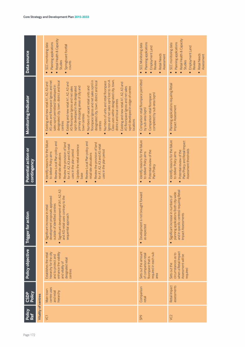
Core Strategy and Development Plan 2015-2033
Page 172
Polic
y R
efC
SDP
Polic
yPo
licy
obje
ctiv
eTr
igge
r for
act
ion
Pote
ntia
l act
ion
or
cont
inge
ncy
Mon
itor
ing
indi
cato
rD
ata
sour
ce
Vit
alit
y of
cen
tres
VC1
Mai
n to
wn
cent
re u
ses
and
reta
il hi
erar
chy
Esta
blish
es th
e re
tail
hier
arch
y fo
r the
city
an
d to
pro
tect
and
en
hanc
e th
e vi
abilit
y an
d vi
talit
y of
de
signa
ted
reta
il ce
ntre
s
•Si
gnifi
cant
incr
ease
in re
tail
deve
lopm
ent p
ropo
sals
appr
oved
ou
tsid
e of
iden
tified
cen
tres
•Si
gnifi
cant
dev
elop
men
t of (
A1, A
2, A
3 an
d A5
) ret
ail u
ses
cont
rary
to th
e se
quen
tial a
ppro
ach
•Id
entif
y re
ason
s fo
r the
failu
re
to d
eliv
er P
olic
y ai
ms
•Re
view
Loc
al P
lan
polic
y an
d re
tail
site
allo
catio
ns
•Re
view
the
prov
ision
of l
and
for A
1, A
2, A
3 an
d A5
reta
il us
es in
the
plan
per
iod
•U
pdat
e th
e re
tail
evid
ence
ba
se
•Re
view
Loc
al P
lan
polic
y an
d re
tail
site
allo
catio
ns
•Re
view
the
prov
ision
of l
and
for A
1, A
2, A
3 an
d A5
reta
il us
es in
the
plan
per
iod
•Ex
istin
g an
d ne
w re
tail
A1, A
2, A
3 an
d A5
uni
ts a
nd fl
oors
pace
(gro
ss a
nd n
et
sale
s sq
m) p
erm
itted
/dev
elop
ed in
de
signa
ted
city
, tow
n, d
istric
t and
loca
l ce
ntre
s
•Ex
istin
g an
d ne
w re
tail
A1, A
2, A
3 an
d A5
floo
rspa
ce (g
ross
and
net
sal
es
sqm
) dev
elop
ed in
the
desig
nate
d pr
imar
y sh
oppi
ng a
reas
of c
ity a
nd
tow
n ce
ntre
s
•N
umbe
rs o
f vac
ant r
etai
l uni
ts a
nd
floor
spac
e (g
ross
and
net
sal
es s
qm) i
n de
signa
ted
city
, tow
n, d
istric
t and
loca
l ce
ntre
s
•N
umbe
rs o
f uni
ts a
nd re
tail
floor
spac
e (g
ross
and
net
sal
es s
qm) l
ost t
o no
n-A
Clas
s us
es w
ithin
des
igna
ted
city
, tow
n,
dist
rict a
nd lo
cal c
entre
s
•Ex
istin
g an
d ne
w re
tail
A1, A
2, A
3 an
d A5
floo
rspa
ce (g
ross
and
net
sal
es
sqm
) dev
elop
ed in
edg
e-of
-cen
tre
loca
tions
•SC
C m
onito
ring
data
•Pl
anni
ng a
pplic
atio
ns
•Re
tail
Hea
lth &
Cap
acity
St
udie
s
•Sp
ringb
oard
foot
fall
coun
ts
SP9
Com
paris
on
reta
ilSe
ts o
ut th
e am
ount
of
com
paris
on re
tail
floor
spac
e th
at is
re
quire
d in
eac
h su
b ar
ea
•D
evel
opm
ent i
s no
t bro
ught
forw
ard
as
exp
ecte
d•
Iden
tify
reas
ons
for t
he fa
ilure
to
del
iver
Pol
icy
aim
s
•Po
tent
ial r
evie
w o
f the
Pl
an/P
olic
y
•Co
mpa
rison
reta
il flo
orsp
ace
perm
itted
by
sub
-are
a (s
qm)
•Co
mpa
rison
reta
il flo
orsp
ace
com
plet
ed b
y su
b-ar
ea (s
qm)
•SC
C M
onito
ring
data
•Pl
anni
ng a
pplic
atio
ns
•Em
ploy
men
t Lan
d Re
view
•Re
tail
Nee
ds
Asse
ssm
ent
VC2
Reta
il Im
pact
as
sess
men
tsSe
ts o
ut th
e ci
rcum
stan
ces
as to
w
hen
a Re
tail
Impa
ct
Asse
ssm
ent w
ill be
re
quire
d
•Si
gnifi
cant
incr
ease
in n
umbe
rs o
f pl
anni
ng a
pplic
atio
ns (b
oth
city
-wid
e an
d in
spe
cific
cen
tres)
requ
iring
Ret
ail
Impa
ct A
sses
smen
ts
•Id
entif
y re
ason
s fo
r the
failu
re
to d
eliv
er P
olic
y ai
ms
•Po
tent
ial r
evie
w o
f the
Pl
an/P
olic
y an
d Re
tail
Impa
ct
Asse
ssm
ent t
hres
hold
s
•Pl
anni
ng a
pplic
atio
ns re
quiri
ng R
etai
l Im
pact
Ass
essm
ent
•SC
C m
onito
ring
data
•Pl
anni
ng a
pplic
atio
ns
•Re
tail
Hea
lth &
Cap
acity
St
udie
s
•Em
ploy
men
t Lan
d Re
view
•Re
tail
Nee
ds
Asse
ssm
ent

Core Strategy and Development Plan 2015-2033
Page 173
Polic
y R
efC
SDP
Polic
yPo
licy
obje
ctiv
eTr
igge
r for
act
ion
Pote
ntia
l act
ion
or
cont
inge
ncy
Mon
itor
ing
indi
cato
rD
ata
sour
ce
VC3
Prim
ary
shop
ping
ar
eas
and
front
ages
To p
rote
ct p
rimar
y re
tail
front
ages
from
no
n-A1
use
s
•Si
gnifi
cant
incr
ease
in n
umbe
rs o
f pl
anni
ng a
pplic
atio
ns g
rant
ed fo
r non
- A1
reta
il us
es w
ithin
des
igna
ted
prim
ary
front
ages
•Si
gnifi
cant
incr
ease
s in
the
perc
enta
ge
of d
esig
nate
d pr
imar
y fro
ntag
es in
non
-A1
reta
il us
es (>
15%
in S
unde
rland
city
ce
ntre
, >25
% in
Was
hing
ton
tow
n ce
ntre
, >40
% in
Hou
ghto
n-le
-Spr
ing
tow
n ce
ntre
)
•Id
entif
y re
ason
s fo
r the
failu
re
to d
eliv
er P
olic
y ai
ms
•Re
view
Loc
al P
lan
polic
y an
d th
e ex
tent
s of
des
igna
tions
of
prim
ary
and
seco
ndar
y fro
ntag
es
•U
pdat
e th
e re
tail
evid
ence
ba
se
•Pe
rcen
tage
of p
rimar
y fro
ntag
es in
no
n-A1
use
in d
esig
nate
d ce
ntre
s
•Le
ngth
of p
rimar
y fro
ntag
es in
A1,
A2,
A3
and
A5
reta
il us
es in
des
igna
ted
city
an
d to
wn
cent
res
•SC
C m
onito
ring
data
•Pl
anni
ng a
pplic
atio
ns
•Re
tail
Hea
lth &
Cap
acity
St
udie
s
VC4
Hot
food
ta
keaw
ays
To p
rote
ct re
tail
vita
lity
and
viab
ility
from
in
crea
ses
in A
5 ho
t fo
od ta
keaw
ays
and
to p
rom
ote
heal
thie
r co
mm
uniti
es
•>5
0% in
crea
se in
the
num
ber o
f pl
anni
ng a
pplic
atio
ns fo
r A5
uses
gr
ante
d w
ithin
des
igna
ted
shop
ping
ce
ntre
s
•>5
0% in
crea
se in
the
num
ber o
f ap
plic
atio
ns fo
r A5
uses
with
in 4
00m
of
the
entr
y po
ints
of a
ll sc
hool
s
•>5
0% in
crea
se in
the
num
ber o
f ap
plic
atio
ns fo
r A5
uses
with
in a
war
d w
here
obe
sity
is pr
eval
ent
•Id
entif
y re
ason
s fo
r the
failu
re
to d
eliv
er P
olic
y ai
ms
•Po
tent
ial r
evie
w o
f the
Pl
an/P
olic
y
•U
pdat
e th
e re
tail
evid
ence
ba
se
•N
umbe
r of A
5 ho
t foo
d ta
keaw
ay u
nits
in
des
igna
ted
cent
res
•N
umbe
r of f
ront
ages
exc
eedi
ng th
e ta
ble
9 th
resh
old
in d
esig
nate
d ce
ntre
s
•N
umbe
rs a
nd p
erce
ntag
es o
f vac
ant
reta
il un
its a
nd fl
oors
pace
(gro
ss a
nd
net s
ales
sqm
) in
desig
nate
d ci
ty, t
own,
di
stric
t and
loca
l cen
tres
•N
umbe
r of p
erm
issio
ns g
rant
ed fo
r A5
use
cont
rary
to p
olic
y
•O
besit
y le
vels
in y
ear 6
and
rece
ptio
n ag
e pu
pils
byw
ard
•SC
C m
onito
ring
data
•Pl
anni
ng a
pplic
atio
ns
•Re
tail
Hea
lth &
Cap
acity
St
udie
s
•LA
Hea
lth P
rofil
es
•Pu
blic
Hea
lth E
ngla
nd
Out
com
e Fr
amew
orks
VC5
Prot
ectio
n an
d de
liver
y of
co
mm
unity
fa
cilit
ies
and
loca
l ser
vice
s
Ensu
re th
e pr
otec
tion
of e
xistin
g fa
cilit
ies
and
whe
re n
ew
faci
litie
s ar
e pr
opos
ed
ensu
re th
ey a
re in
the
right
loca
tions
and
ac
cess
ible
•Si
gnifi
cant
loss
of c
omm
unity
, soc
ial
and
cultu
ral f
acilit
ies
•Id
entif
y re
ason
s fo
r the
failu
re
to d
eliv
er P
olic
y ai
ms
•Po
tent
ial r
evie
w o
f the
Pl
an/P
olic
y
•Id
entif
y pr
ojec
ts/i
nter
vent
ions
to
addr
ess
issue
s
•Co
mm
unity
, soc
ial a
nd c
ultu
ral
deve
lopm
ent –
D1
and
D2
units
and
flo
orsp
ace
(sqm
) add
ition
s an
d lo
sses
•SC
C M
onito
ring
data
•Pl
anni
ng a
pplic
atio
ns
VC6
Cultu
re,
leisu
re a
nd
tour
ism
Supp
orts
the
deve
lopm
ent o
f cu
ltura
l, lei
sure
and
to
urism
faci
litie
s an
d se
ts o
ut w
here
they
w
ould
be
cons
ider
ed
acce
ptab
le
•Fa
ilure
to d
eliv
er d
evel
opm
ent w
ithin
th
e M
usic
, Art
s an
d Cu
lture
qua
rter
–
spec
ifica
lly a
new
aud
itoriu
m. F
ailu
re to
de
liver
a n
ew h
otel
in th
e U
rban
Cor
e
•Fa
ilure
to d
eliv
er a
cin
ema
in
Was
hing
ton
Tow
n ce
ntre
•Fa
ilure
to d
eliv
er th
ree
spor
ts h
ubs
acro
ss th
e ci
ty
•Id
entif
y re
ason
s fo
r the
failu
re
to d
eliv
er P
olic
y ai
ms
•Re
view
pol
icy
obje
ctiv
es w
ith
SCC
Rege
nera
tion
and
Econ
omic
Dev
elop
men
t
•Po
tent
ial r
evie
w o
f the
Pl
an/P
olic
y
•Co
mpl
etio
n of
the
spec
ific
prop
osed
cu
lture
, leisu
re a
nd to
urism
sch
emes
•Pl
anni
ng a
pplic
atio
ns fo
r lei
sure
sc
hem
es o
n de
signa
ted
empl
oym
ent
land
– a
mou
nt o
f los
t em
ploy
men
t la
nd a
rea
(ha)
and
floo
rspa
ce (s
qm)
•SC
C M
onito
ring
data
•Pl
anni
ng a
pplic
atio
ns
•Sp
ort E
ngla
nd/F
A
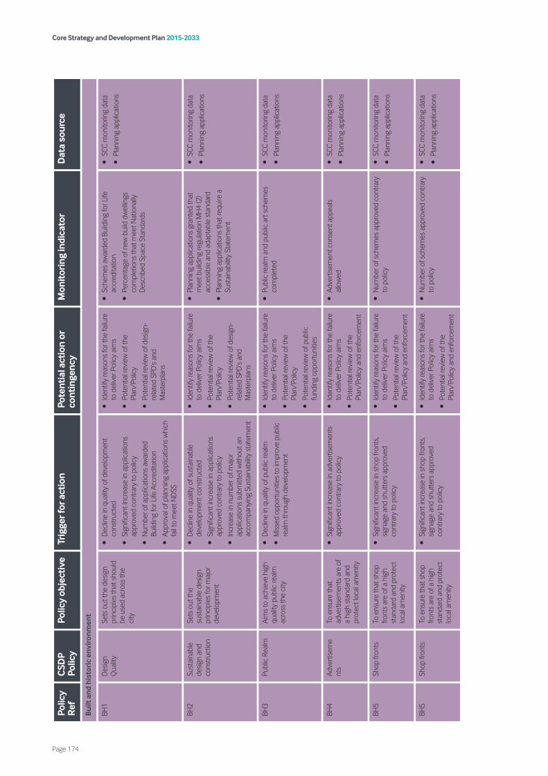
Core Strategy and Development Plan 2015-2033
Page 174
Polic
y R
efC
SDP
Polic
yPo
licy
obje
ctiv
eTr
igge
r for
act
ion
Pote
ntia
l act
ion
or
cont
inge
ncy
Mon
itor
ing
indi
cato
rD
ata
sour
ce
Bui
lt a
nd h
isto
ric
envi
ron
men
t
BH1
Des
ign
Qua
lity
Sets
out
the
desig
n pr
inci
ples
that
sho
uld
be u
sed
acro
ss th
e ci
ty
•D
eclin
e in
qua
lity
of d
evel
opm
ent
cons
truc
ted
•Si
gnifi
cant
Incr
ease
in a
pplic
atio
ns
appr
oved
con
trary
to p
olic
y
•N
umbe
r of a
pplic
atio
ns a
war
ded
Build
ing
for L
ife A
ccre
dita
tion
•Ap
prov
al o
f pla
nnin
g ap
plic
atio
ns w
hich
fa
il to
mee
t ND
SS
•Id
entif
y re
ason
s fo
r the
failu
re
to d
eliv
er P
olic
y ai
ms
•Po
tent
ial r
evie
w o
f the
Pl
an/P
olic
y
•Po
tent
ial r
evie
w o
f des
ign-
re
late
d SP
D’s
and
Mas
terp
lans
•Sc
hem
es a
war
ded
Build
ing
for L
ife
accr
edita
tion
•Pe
rcen
tage
of n
ew b
uild
dw
ellin
gs
com
plet
ions
that
mee
t Nat
iona
lly
Des
crib
ed S
pace
Sta
ndar
ds
•SC
C m
onito
ring
data
•Pl
anni
ng a
pplic
atio
ns
BH2
Sust
aina
ble
desig
n an
d co
nstr
uctio
n
Sets
out
the
sust
aina
ble
desig
n pr
inci
ples
for m
ajor
de
velo
pmen
t
•D
eclin
e in
qua
lity
of s
usta
inab
le
deve
lopm
ent c
onst
ruct
ed
•Si
gnifi
cant
incr
ease
in a
pplic
atio
ns
appr
oved
con
trary
to p
olic
y
•In
crea
se in
num
ber o
f maj
or
appl
icat
ions
sub
mitt
ed w
ithou
t an
acco
mpa
nyin
g Su
stai
nabi
lity
stat
emen
t
•Id
entif
y re
ason
s fo
r the
failu
re
to d
eliv
er P
olic
y ai
ms
•Po
tent
ial r
evie
w o
f the
Pl
an/P
olic
y
•Po
tent
ial r
evie
w o
f des
ign-
re
late
d SP
D’s
and
Mas
terp
lans
•Pl
anni
ng a
pplic
atio
ns g
rant
ed th
at
mee
t bui
ldin
g re
gula
tion
MH
4 (2
) ac
cess
ible
and
ada
ptab
le s
tand
ard
•Pl
anni
ng a
pplic
atio
ns th
at re
quire
a
Sust
aina
bilit
y St
atem
ent
•SC
C m
onito
ring
data
•Pl
anni
ng a
pplic
atio
ns
BH3
Publ
ic R
ealm
Aim
s to
ach
ieve
hig
h qu
ality
pub
lic re
alm
ac
ross
the
city
•D
eclin
e in
qua
lity
of p
ublic
real
m
•M
issed
opp
ortu
nitie
s to
impr
ove
publ
ic
real
m th
roug
h de
velo
pmen
t
•Id
entif
y re
ason
s fo
r the
failu
re
to d
eliv
er P
olic
y ai
ms
•Po
tent
ial r
evie
w o
f the
Pl
an/P
olic
y
•Po
tent
ial r
evie
w o
f pub
lic
fund
ing
oppo
rtun
ities
•Pu
blic
real
m a
nd p
ublic
art
sch
emes
co
mpl
eted
•SC
C m
onito
ring
data
•Pl
anni
ng a
pplic
atio
ns
BH4
Adve
rtise
me
nts
To e
nsur
e th
at
adve
rtise
men
ts a
re o
f a
high
sta
ndar
d an
d pr
otec
t loc
al a
men
ity
•Si
gnifi
cant
incr
ease
in a
dver
tisem
ents
ap
prov
ed c
ontra
ry to
pol
icy
•Id
entif
y re
ason
s fo
r the
failu
re
to d
eliv
er P
olic
y ai
ms
•Po
tent
ial r
evie
w o
f the
Pl
an/P
olic
y an
d en
forc
emen
t
•Ad
vert
isem
ent c
onse
nt a
ppea
ls al
low
ed•
SCC
mon
itorin
g da
ta
•Pl
anni
ng a
pplic
atio
ns
BH5
Shop
fron
tsTo
ens
ure
that
sho
p fro
nts
are
of a
hig
h st
anda
rd a
nd p
rote
ct
loca
l am
enity
•Si
gnifi
cant
incr
ease
in s
hop
front
s, sig
nage
and
shu
tter
s ap
prov
ed
cont
rary
to p
olic
y
•Id
entif
y re
ason
s fo
r the
failu
re
to d
eliv
er P
olic
y ai
ms
•Po
tent
ial r
evie
w o
f the
Pl
an/P
olic
y an
d en
forc
emen
t
•N
umbe
r of s
chem
es a
ppro
ved
cont
rary
to
pol
icy
•SC
C m
onito
ring
data
•Pl
anni
ng a
pplic
atio
ns
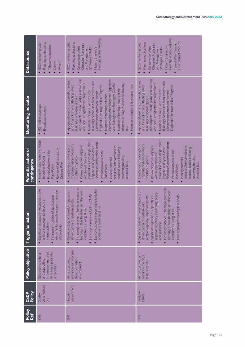
Core Strategy and Development Plan 2015-2033
Page 175
Polic
y R
efC
SDP
Polic
yPo
licy
obje
ctiv
eTr
igge
r for
act
ion
Pote
ntia
l act
ion
or
cont
inge
ncy
Mon
itor
ing
indi
cato
rD
ata
sour
ce
BH6
Qua
lity
com
mun
icat
ion
s
Sets
out
the
crite
ria
and
supp
ortin
g in
form
atio
n re
quire
d to
ass
ess
a pl
anni
ng
appl
icat
ion
•Si
gnifi
cant
incr
ease
in v
isual
ly o
btru
sive
and/
or in
appr
opria
te te
leco
ms
infra
stru
ctur
e
•In
crea
se in
num
ber o
f app
licat
ions
w
hich
fail
to p
rovi
de a
cces
s to
a ra
nge
of p
rovi
ders
•Id
entif
y re
ason
s fo
r the
failu
re
to d
eliv
er P
olic
y ai
ms
•Po
tent
ial r
evie
w o
f the
Pl
an/P
olic
y
•Re
view
of I
nfra
stru
ctur
e D
eliv
ery
Plan
•4G
mob
ile c
over
age
•Br
oadb
and
spee
ds
•SC
C m
onito
ring
data
•Pl
anni
ng a
pplic
atio
ns
•Te
leco
ms
prov
ider
s
•O
fcom
•W
hich
?
BH7
Hist
oric
En
viro
nmen
tAi
ms
to p
rote
ct,
enha
nce
and
man
age
the
city
’s hi
stor
ic
envi
ronm
ent
•Si
gnifi
cant
loss
of,
harm
ful i
mpa
cts
or
dete
riora
tion
of h
erita
ge a
sset
s
•In
crea
sed
num
ber o
f her
itage
ass
ets
on
Her
itage
at R
isk R
egist
er, o
r oth
erw
ise
iden
tified
as
bein
g at
risk
•La
ck o
f pro
gres
s in
ado
ptin
g CA
MS
•La
ck o
f suc
cess
in s
ecur
ing
fund
ing
for
addr
essin
g he
ritag
e at
risk
•Id
entif
y re
ason
s fo
r lac
k of
im
plem
enta
tion/
deci
sions
co
ntra
ry to
pol
icy
•Re
view
obj
ectiv
es o
f pol
icy
with
key
par
tner
s an
d st
akeh
olde
rs, in
clud
ing
Hist
oric
En
glan
d an
d Ty
ne &
Wea
r Sp
ecia
list C
onse
rvat
ion
Team
•Po
tent
ial r
evie
w o
f the
Pl
an/P
olic
y
•Id
entif
y po
tent
ial
activ
ities
/int
erve
ntio
ns to
ad
dres
s iss
ues,
incl
udin
g re
view
ing
fund
ing
oppo
rtun
ities
•Ap
peal
s al
low
ed in
con
serv
atio
n ar
eas,
and
for a
pplic
atio
ns a
ffect
ing
liste
d bu
ildin
gs, s
ched
ule
anci
ent
mon
umen
ts, h
istor
ic p
arks
and
gar
dens
an
d no
n- d
esig
nate
d he
ritag
e as
sets
•N
umbe
r of G
rade
I an
d II*
List
ed
Build
ings
, Sch
edul
ed M
onum
ents
and
Co
nser
vatio
n Ar
eas
on H
istor
ic
Engl
and’
s ‘H
erita
ge a
t Risk
’ Reg
ister
•N
umbe
r of f
orm
ally
ado
pted
Co
nser
vatio
n Ar
ea C
hara
cter
App
raisa
ls an
d M
anag
emen
t Stra
tegi
es (C
AMS)
•N
umbe
r of h
erita
ge a
sset
s at
risk
re
stor
ed th
roug
h su
cces
sful
fund
ing
bids
•N
umbe
r of A
rtic
le 4
Dire
ctio
ns u
sed
•SC
C m
onito
ring
data
•Pl
anni
ng a
pplic
atio
ns
•Co
nser
vatio
n Ar
ea
Char
acte
r App
raisa
ls an
d M
anag
emen
t St
rate
gies
(CAM
S)
•H
istor
ic E
ngla
nd’s
Her
itage
at R
isk R
egist
er
BH8
Her
itage
As
sets
Aim
s to
pro
tect
and
en
hanc
e th
e ci
ty’s
hist
oric
ass
ets
•Si
gnifi
cant
loss
of ,
har
mfu
l im
pact
s or
de
terio
ratio
n of
her
itage
and
ar
chae
olog
ical
ly- i
mpo
rtan
t ass
ets
•Si
gnifi
cant
num
ber o
f app
licat
ions
ap
prov
ed c
ontra
ry to
her
itage
pol
icy
and
guid
ance
•In
crea
sed
num
ber o
f her
itage
ass
ets
on
Her
itage
at R
isk R
egist
er, o
r oth
erw
ise
iden
tified
as
bein
g at
risk
•La
ck o
f pro
gres
s in
ado
ptin
g CA
MS
•Id
entif
y re
ason
s fo
r lac
k of
im
plem
enta
tion/
deci
sions
co
ntra
ry to
pol
icy
•Re
view
obj
ectiv
es o
f pol
icy
with
key
par
tner
s an
d st
akeh
olde
rs, in
clud
ing
Hist
oric
En
glan
d an
d Ty
ne &
Wea
r Sp
ecia
list C
onse
rvat
ion
Team
•Po
tent
ial r
evie
w o
f the
Pl
an/P
olic
y
•Id
entif
y po
tent
ial
activ
ities
/int
erve
ntio
ns to
ad
dres
s iss
ues,
incl
udin
g re
view
ing
fund
ing
oppo
rtun
ities
•Ap
peal
s al
low
ed in
con
serv
atio
n ar
eas,
and
for a
pplic
atio
ns a
ffect
ing
liste
d bu
ildin
gs, s
ched
ule
anci
ent
mon
umen
ts, h
istor
ic p
arks
and
gar
dens
an
d no
n- d
esig
nate
d he
ritag
e as
sets
•N
umbe
r of G
rade
I an
d II*
List
ed
Build
ings
, Sch
edul
ed M
onum
ents
and
Co
nser
vatio
n Ar
eas
on H
istor
ic
Engl
and’
s ‘H
erita
ge a
t Risk
’ Reg
ister
•SC
C m
onito
ring
data
•Pl
anni
ng a
pplic
atio
ns
•Co
nser
vatio
n Ar
ea
Char
acte
r App
raisa
ls an
d M
anag
emen
t St
rate
gies
(CAM
S)
•H
istor
ic E
ngla
nd –
H
erita
ge a
t Risk
Reg
ister
•Ty
ne &
Wea
r Hist
oric
En
viro
nmen
t Rec
ords
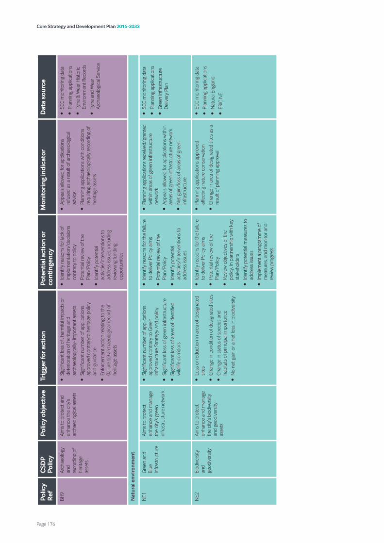
Core Strategy and Development Plan 2015-2033
Page 176
Polic
y R
efC
SDP
Polic
yPo
licy
obje
ctiv
eTr
igge
r for
act
ion
Pote
ntia
l act
ion
or
cont
inge
ncy
Mon
itor
ing
indi
cato
rD
ata
sour
ce
BH9
Arch
aeol
ogy
and
reco
rdin
g of
he
ritag
e as
sets
Aim
s to
pro
tect
and
en
hanc
e th
e ci
ty’s
arch
aeol
ogic
al a
sset
s
•Si
gnifi
cant
loss
of ,
har
mfu
l im
pact
s or
de
terio
ratio
n of
her
itage
and
ar
chae
olog
ical
ly- i
mpo
rtan
t ass
ets
•Si
gnifi
cant
num
ber o
f app
licat
ions
ap
prov
ed c
ontra
ryto
her
itage
pol
icy
and
guid
ance
•En
forc
emen
t act
ion
rela
ting
to th
e (fa
ilure
to) a
rcha
eolo
gica
l rec
ord
of
herit
age
asse
ts
•Id
entif
y re
ason
s fo
r lac
k of
im
plem
enta
tion/
deci
sions
co
ntra
ry to
pol
icy
•Po
tent
ial r
evie
w o
f the
Pl
an/P
olic
y
•Id
entif
y po
tent
ial
activ
itie/
inte
rven
tions
to
addr
ess
issue
s, in
clud
ing
revi
ewin
g fu
ndin
g op
port
uniti
es
•Ap
peal
s al
low
ed fo
r app
licat
ions
re
fuse
d as
a re
sult
of a
rcha
eolo
gica
l ad
vice
•Pl
anni
ng a
pplic
atio
ns w
ith c
ondi
tions
re
quiri
ng a
rcha
eolo
gica
lly re
cord
ing
of
herit
age
asse
ts
•SC
C m
onito
ring
data
•Pl
anni
ng a
pplic
atio
ns
•Ty
ne &
Wea
r Hist
oric
En
viro
nmen
t Rec
ords
•Ty
ne a
nd W
ear
Arch
aeol
ogic
al S
ervi
ce
Nat
ural
env
iron
men
t
NE1
Gre
en a
nd
Blue
In
frast
ruct
ure
Aim
s to
pro
tect
, en
hanc
e an
d m
anag
e th
e ci
ty’s
gree
n in
frast
ruct
ure
netw
ork
•Si
gnifi
cant
num
ber o
f app
licat
ions
ap
prov
ed c
ontra
ry to
Gre
en
Infra
stru
ctur
e St
rate
gy a
nd p
olic
y
•Si
gnifi
cant
loss
of g
reen
infra
stru
ctur
e
•Si
gnifi
cant
loss
of a
reas
of i
dent
ified
w
ildlif
e co
rrid
ors
•Id
entif
y re
ason
s fo
r the
failu
re
to d
eliv
er P
olic
y ai
ms
•Po
tent
ial r
evie
w o
f the
Pl
an/P
olic
y
•Id
entif
y po
tent
ial
activ
ities
/int
erve
ntio
ns to
ad
dres
s iss
ues
•Pl
anni
ng a
pplic
atio
ns re
ceiv
ed/g
rant
ed
with
in a
reas
of g
reen
infra
stru
ctur
e ne
twor
k
•Ap
peal
s al
low
ed fo
r app
licat
ions
with
in
area
s of
gre
en in
frast
ruct
ure
netw
ork
•N
et g
ain/
loss
of a
reas
of g
reen
in
frast
ruct
ure
•SC
C m
onito
ring
data
•Pl
anni
ng a
pplic
atio
ns
•G
reen
Infra
stru
ctur
e D
eliv
ery
Plan
NE2
Biod
iver
sity
and
geod
iver
sity
Aim
s to
pro
tect
, en
hanc
e an
d m
anag
e th
e ci
ty’s
biod
iver
sity
and
geod
iver
sity
asse
ts
•Lo
ss o
r red
uctio
n in
are
a of
des
igna
ted
sites
•Ch
ange
in c
ondi
tion
of d
esig
nate
d sit
es
•Ch
ange
in s
tatu
s of
spe
cies
and
ha
bita
ts o
f prin
cipa
l im
port
ance
•N
o ne
t gai
n or
a n
et lo
ss in
bio
dive
rsity
•Id
entif
y re
ason
s fo
r the
failu
re
to d
eliv
er P
olic
y ai
ms
•Po
tent
ial r
evie
w o
f the
Pl
an/P
olic
y
•Re
view
obj
ectiv
es o
f the
po
licy,
in p
artn
ersh
ip w
ith k
ey
stak
ehol
ders
•Id
entif
y po
tent
ial m
easu
res
to
addr
ess
issue
s
•Im
plem
ent a
pro
gram
me
of
mea
sure
s, an
d m
onito
r and
re
view
pro
gres
s
•Pl
anni
ng a
pplic
atio
ns a
ppro
ved
affe
ctin
g na
ture
con
serv
atio
n
•Ch
ange
in a
rea
of d
esig
nate
d sit
es a
s a
resu
lt of
pla
nnin
g ap
prov
al
•SC
C m
onito
ring
data
•Pl
anni
ng a
pplic
atio
ns
•N
atur
al E
ngla
nd
•ER
IC N
E

Core Strategy and Development Plan 2015-2033
Page 177
Polic
y R
efC
SDP
Polic
yPo
licy
obje
ctiv
eTr
igge
r for
act
ion
Pote
ntia
l act
ion
or
cont
inge
ncy
Mon
itor
ing
indi
cato
rD
ata
sour
ce
NE3
Woo
dlan
ds/
hedg
erow
s an
d tre
es
Aim
s to
reta
in a
nd
cons
erve
woo
dlan
ds,
hedg
erow
s an
d tre
es
•Lo
ss o
r red
uctio
n in
are
a or
qua
lity
of
woo
dlan
d, v
eter
an tr
ees,
hedg
erow
s, an
d tre
es o
f lan
dsca
pe v
alue
•Re
duct
ion
in th
e nu
mbe
r of T
ree
Pres
erva
tion
Ord
ers
and
hedg
erow
s co
vere
d by
the
Hed
gero
w R
egul
atio
ns
•Id
entif
y re
ason
s fo
r the
failu
re
to d
eliv
er P
olic
y ai
ms
•Po
tent
ial r
evie
w o
f the
Pl
an/P
olic
y
•Re
view
obj
ectiv
es o
f the
po
licy,
in p
artn
ersh
ip w
ithke
y st
akeh
olde
rs
•Id
entif
y po
tent
ial m
easu
res
to
addr
ess
issue
s
•Im
plem
ent a
pro
gram
me
of
mea
sure
s, an
d m
onito
r and
re
view
pro
gres
s
•Ch
ange
in a
rea
and
qual
ity o
f Anc
ient
Se
mi-n
atur
al W
oodl
and,
oth
er lo
cally
na
tive
broa
dlea
f woo
dlan
d an
d he
dger
ows
as a
resu
lt of
pla
nnin
g ap
prov
al
•Ch
ange
in n
umbe
r, qu
ality
and
sta
tus
of v
eter
an/a
ncie
nt tr
ees
and
trees
of
land
scap
e/am
enity
val
ue a
s a
resu
lt of
pl
anni
ng a
ppro
val
•N
umbe
r of T
ree
Pres
erva
tion
Ord
ers
and
hedg
es n
egat
ivel
y af
fect
ed a
s a
resu
lt of
pla
nnin
g ap
prov
als
•SC
C m
onito
ring
data
•Pl
anni
ng a
pplic
atio
ns
•W
oodl
and
Trus
t
•N
atur
al E
ngla
nd
•ER
IC N
E
NE4
Gre
ensp
ace
Aim
s to
pro
tect
, en
hanc
e an
d m
anag
e th
e qu
ality
and
qu
antit
y of
the
city
’s gr
eens
pace
and
set
st
anda
rds
for
gree
nspa
ce p
rovi
sion
with
in n
ew
deve
lopm
ent
•Si
gnifi
cant
num
ber o
f app
licat
ions
ap
prov
ed c
ontra
ry to
pol
icy
•Si
gnifi
cant
loss
of e
xistin
g gr
eens
pace
to
dev
elop
men
t
•Si
gnifi
cant
redu
ctio
n in
qua
lity
of
gree
nspa
ce
•Re
duct
ion
in g
reen
spac
e m
anag
ed to
G
reen
Fla
g st
anda
rds
•Id
entif
y re
ason
s fo
r the
failu
re
to d
eliv
er P
olic
y ai
ms
•Po
tent
ial r
evie
w o
f the
Pl
an/P
olic
y
•Re
view
obj
ectiv
es if
the
polic
y in
par
tner
ship
with
Cou
ncil
biod
iver
sity
and
key
stak
ehol
ders
•Id
entif
y po
tent
ial
activ
ities
/int
erve
ntio
ns to
ad
dres
s iss
ues
•Pl
anni
ng a
pplic
atio
ns fo
r dev
elop
men
t th
at a
re a
ppro
ved
cont
rary
to
Gre
ensp
ace
Audi
t
•N
umbe
r of g
reen
spac
es p
rovi
ded
•N
et g
ain/
loss
of g
reen
spac
e
•N
umbe
r of S
uita
ble
Alte
rnat
ive
Nat
ural
G
reen
spac
es (S
ANG
S) c
reat
ed
•D
evel
oper
con
trib
utio
n pa
ymen
ts
rece
ived
thro
ugh
plan
ning
obl
igat
ions
to
war
ds G
reen
spac
e or
out
door
spo
rt
and
recr
eatio
n fa
cilit
ies
•Ar
ea (h
a) o
f new
am
enity
gre
ensp
ace
crea
ted
with
in m
ajor
dev
elop
men
t sc
hem
es
•SC
C m
onito
ring
data
•Pl
anni
ng a
pplic
atio
ns
•N
atur
al E
ngla
nd
•W
oodl
and
Trus
t
•Sp
ort E
ngla
nd
•G
reen
spac
e Au
dit
•Pl
anni
ng o
blig
atio
ns
mon
itorin
g
NE5
Buria
l spa
ceAi
ms
to p
rote
ct a
nd
re-u
se th
e ci
ty’s
buria
l sp
aces
and
pro
vide
ne
w s
pace
s w
here
ap
prop
riate
•Si
gnifi
cant
dro
p in
num
ber o
f cem
eter
y pl
ots
avai
labl
e w
ithin
the
city
or w
ithin
ke
y ar
eas
•Id
entifi
ed re
quire
men
t for
new
bur
ial
spac
e fo
r spe
cific
eth
nic/
relig
ious
gr
oup
with
in th
e ci
ty
•Id
entif
y re
ason
s fo
r the
failu
re
to d
eliv
er P
olic
y ai
ms
•Po
tent
ial r
evie
w o
f the
Pl
an/P
olic
y
•Id
entif
y po
tent
ial
activ
ities
/int
erve
ntio
ns to
ad
dres
s iss
ues
•N
et g
ain/
loss
of b
uria
l spa
ces
•SC
C m
onito
ring
data
•An
nual
city
wid
e bu
rial
spac
e st
ockt
ake.
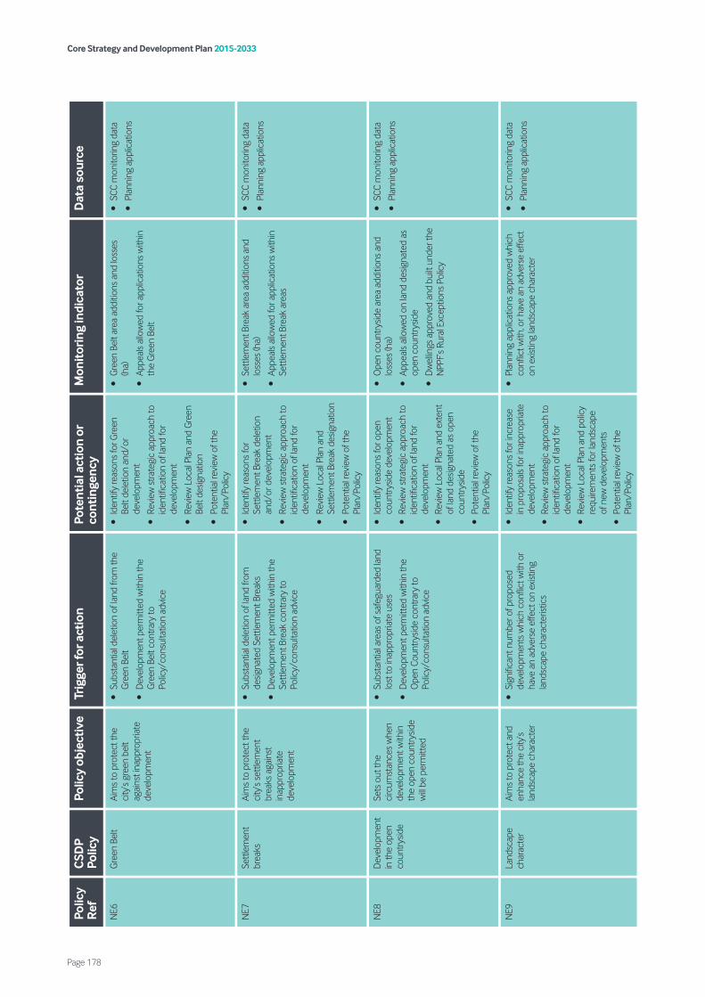
Core Strategy and Development Plan 2015-2033
Page 178
Polic
y R
efC
SDP
Polic
yPo
licy
obje
ctiv
eTr
igge
r for
act
ion
Pote
ntia
l act
ion
or
cont
inge
ncy
Mon
itor
ing
indi
cato
rD
ata
sour
ce
NE6
Gre
en B
elt
Aim
s to
pro
tect
the
city
’s gr
een
belt
agai
nst i
napp
ropr
iate
de
velo
pmen
t
•Su
bsta
ntia
l del
etio
n of
land
from
the
Gre
en B
elt
•D
evel
opm
ent p
erm
itted
with
in th
e G
reen
Bel
t con
trary
to
Polic
y/co
nsul
tatio
n ad
vice
•Id
entif
y re
ason
s fo
r Gre
en
Belt
dele
tion
and/
or
deve
lopm
ent
•Re
view
stra
tegi
c ap
proa
ch to
id
entifi
catio
n of
land
for
deve
lopm
ent
•Re
view
Loc
al P
lan
and
Gre
en
Belt
desig
natio
n
•Po
tent
ial r
evie
w o
f the
Pl
an/P
olic
y
•G
reen
Bel
t are
a ad
ditio
ns a
nd lo
sses
(h
a)
•Ap
peal
s al
low
ed fo
r app
licat
ions
with
in
the
Gre
en B
elt
•SC
C m
onito
ring
data
•Pl
anni
ng a
pplic
atio
ns
NE7
Sett
lem
ent
brea
ksAi
ms
to p
rote
ct th
e ci
ty’s
sett
lem
ent
brea
ks a
gain
st
inap
prop
riate
de
velo
pmen
t
•Su
bsta
ntia
l del
etio
n of
land
from
de
signa
ted
Sett
lem
ent B
reak
s
•D
evel
opm
ent p
erm
itted
with
in th
e Se
ttle
men
t Bre
ak c
ontra
ry to
Po
licy/
cons
ulta
tion
advi
ce
•Id
entif
y re
ason
s fo
r Se
ttle
men
t Bre
ak d
elet
ion
and/
or d
evel
opm
ent
•Re
view
stra
tegi
c ap
proa
ch to
id
entifi
catio
n of
land
for
deve
lopm
ent
•Re
view
Loc
al P
lan
and
Sett
lem
ent B
reak
des
igna
tion
•Po
tent
ial r
evie
w o
f the
Pl
an/P
olic
y
•Se
ttle
men
t Bre
ak a
rea
addi
tions
and
lo
sses
(ha)
•Ap
peal
s al
low
ed fo
r app
licat
ions
with
in
Sett
lem
ent B
reak
are
as
•SC
C m
onito
ring
data
•Pl
anni
ng a
pplic
atio
ns
NE8
Dev
elop
men
t in
the
open
co
untr
ysid
e
Sets
out
the
circ
umst
ance
s w
hen
deve
lopm
ent w
ithin
th
e op
en c
ount
rysid
e w
ill be
per
mitt
ed
•Su
bsta
ntia
l are
as o
f saf
egua
rded
land
lo
st to
inap
prop
riate
use
s
•D
evel
opm
ent p
erm
itted
with
in th
e O
pen
Coun
trys
ide
cont
rary
to
Polic
y/co
nsul
tatio
n ad
vice
•Id
entif
y re
ason
s fo
r ope
n co
untr
ysid
e de
velo
pmen
t •
Revi
ew s
trate
gic
appr
oach
to
iden
tifica
tion
of la
nd fo
r de
velo
pmen
t •
Revi
ew L
ocal
Pla
n an
d ex
tent
of
land
des
igna
ted
as o
pen
coun
trys
ide
•Po
tent
ial r
evie
w o
f the
Pl
an/P
olic
y
•O
pen
coun
trys
ide
area
add
ition
s an
d lo
sses
(ha)
•Ap
peal
s al
low
ed o
n la
nd d
esig
nate
d as
op
en c
ount
rysid
e
•D
wel
lings
app
rove
d an
d bu
ilt u
nder
the
NPP
F’s
Rura
l Exc
eptio
ns P
olic
y
•SC
C m
onito
ring
data
•Pl
anni
ng a
pplic
atio
ns
NE9
Land
scap
e ch
arac
ter
Aim
s to
pro
tect
and
en
hanc
e th
e ci
ty’s
land
scap
e ch
arac
ter
•Si
gnifi
cant
num
ber o
f pro
pose
d de
velo
pmen
ts w
hich
con
flict
with
or
have
an
adve
rse
effe
ct o
n ex
istin
g la
ndsc
ape
char
acte
ristic
s
•Id
entif
y re
ason
s fo
r inc
reas
e in
pro
posa
ls fo
r ina
ppro
pria
te
deve
lopm
ent
•Re
view
stra
tegi
c ap
proa
ch to
id
entifi
catio
n of
land
for
deve
lopm
ent
•Re
view
Loc
al P
lan
and
polic
y re
quire
men
ts fo
r lan
dsca
pe
of n
ew d
evel
opm
ents
•
Pote
ntia
l rev
iew
of t
he
Plan
/Pol
icy
•Pl
anni
ng a
pplic
atio
ns a
ppro
ved
whi
ch
confl
ict w
ith, o
r hav
e an
adv
erse
effe
ct
on e
xistin
g la
ndsc
ape
char
acte
r
•SC
C m
onito
ring
data
•Pl
anni
ng a
pplic
atio
ns
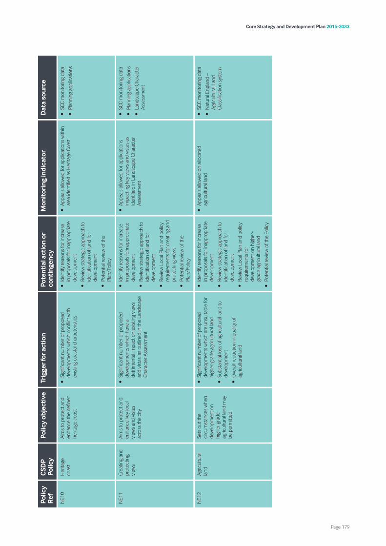
Core Strategy and Development Plan 2015-2033
Page 179
Polic
y R
efC
SDP
Polic
yPo
licy
obje
ctiv
eTr
igge
r for
act
ion
Pote
ntia
l act
ion
or
cont
inge
ncy
Mon
itor
ing
indi
cato
rD
ata
sour
ce
NE1
0H
erita
ge
coas
tAi
ms
to p
rote
ct a
nd
enha
nce
the
defin
ed
herit
age
coas
t
•Si
gnifi
cant
num
ber o
f pro
pose
d de
velo
pmen
ts w
hich
con
flict
with
ex
istin
g co
asta
l cha
ract
erist
ics
•Id
entif
y re
ason
s fo
r inc
reas
e in
pro
posa
ls fo
r ina
ppro
pria
te
deve
lopm
ent
•Re
view
stra
tegi
c ap
proa
ch to
id
entifi
catio
n of
land
for
deve
lopm
ent
•Po
tent
ial r
evie
w o
f the
Pl
an/P
olic
y
•Ap
peal
s al
low
ed fo
r app
licat
ions
with
in
area
iden
tified
as
Her
itage
Coa
st•
SCC
mon
itorin
g da
ta
•Pl
anni
ng a
pplic
atio
ns
NE1
1Cr
eatin
g an
d pr
otec
ting
view
s
Aim
s to
pro
tect
and
en
hanc
e ke
y lo
cal
view
s an
d vi
stas
ac
ross
the
city
•Si
gnifi
cant
num
ber o
f pro
pose
d de
velo
pmen
ts w
hich
hav
e a
detr
imen
tal i
mpa
ct o
n ex
istin
g vi
ews
and
vist
as, a
s ou
tline
d in
the
Land
scap
e Ch
arac
ter A
sses
smen
t
•Id
entif
y re
ason
s fo
r inc
reas
e in
pro
posa
ls fo
rinap
prop
riate
de
velo
pmen
t
•Re
view
stra
tegi
c ap
proa
ch to
id
entifi
catio
n of
land
for
deve
lopm
ent
•Re
view
Loc
al P
lan
and
polic
y re
quire
men
ts fo
r cre
atin
g an
d pr
otec
ting
view
s
•Po
tent
ial r
evie
w o
f the
Pl
an/P
olic
y
•Ap
peal
s al
low
ed fo
r app
licat
ions
im
pact
ing
key
view
s an
d vi
stas
as
iden
tified
in L
ands
cape
Cha
ract
er
Asse
ssm
ent
•SC
C m
onito
ring
data
•Pl
anni
ng a
pplic
atio
ns
•La
ndsc
ape
Char
acte
r As
sess
men
t
NE1
2Ag
ricul
tura
l la
ndSe
ts o
ut th
e ci
rcum
stan
ces
whe
n de
velo
pmen
t on
high
er g
rade
ag
ricul
tura
l lan
d m
ay
be p
erm
itted
•Si
gnifi
cant
num
ber o
f pro
pose
d de
velo
pmen
ts w
hich
are
uns
uita
ble
for
high
er-g
rade
agr
icul
tura
l lan
d
•Su
bsta
ntia
l los
s of
agr
icul
tura
l lan
d to
de
velo
pmen
t
•O
vera
ll re
duct
ion
in q
ualit
y of
ag
ricul
tura
l lan
d
•Id
entif
y re
ason
s fo
r inc
reas
e in
pro
posa
ls fo
r ina
ppro
pria
te
deve
lopm
ent
•Re
view
stra
tegi
c ap
proa
ch to
id
entifi
catio
n of
land
for
deve
lopm
ent
•Re
view
Loc
al P
lan
and
polic
y re
quire
men
ts fo
r de
velo
pmen
t on
high
er-
grad
e ag
ricul
tura
l lan
d
•Po
tent
ial r
evie
w o
f the
Pol
icy
•Ap
peal
s al
low
ed o
n al
loca
ted
agric
ultu
ral l
and
•SC
C m
onito
ring
data
•N
atur
al E
ngla
nd –
Ag
ricul
tura
l Lan
d Cl
assifi
catio
n sy
stem
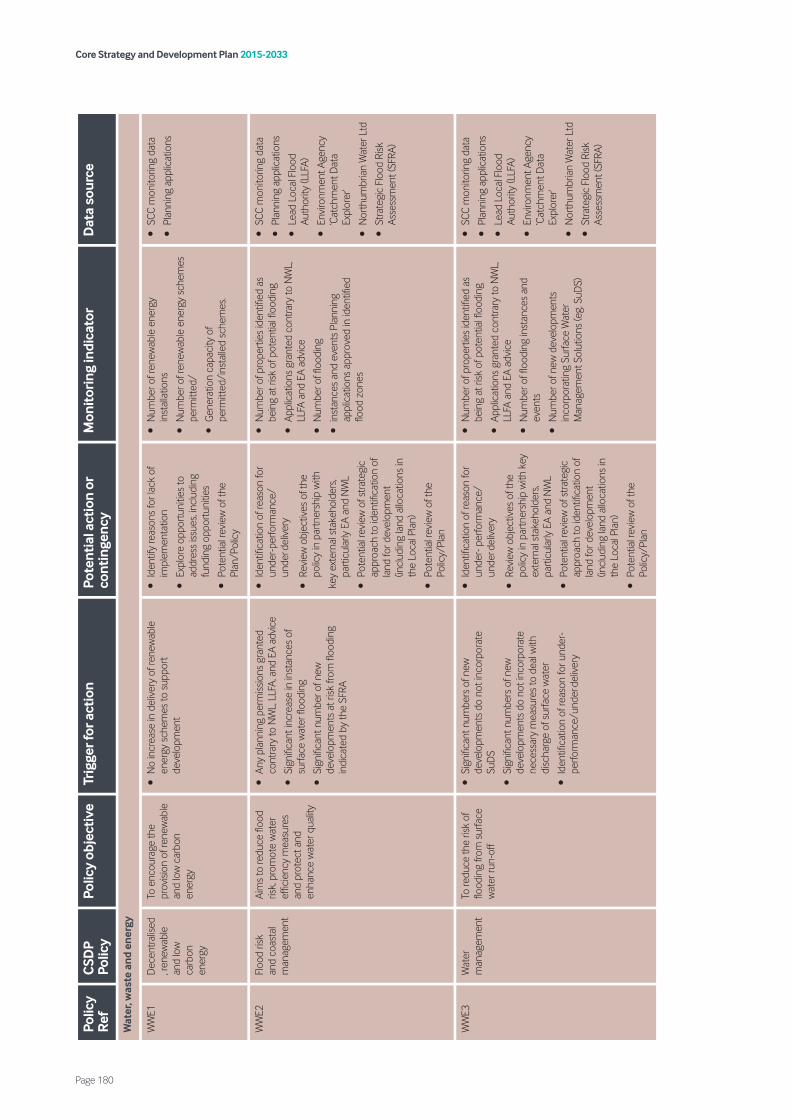
Core Strategy and Development Plan 2015-2033
Page 180
Polic
y R
efC
SDP
Polic
yPo
licy
obje
ctiv
eTr
igge
r for
act
ion
Pote
ntia
l act
ion
or
cont
inge
ncy
Mon
itor
ing
indi
cato
rD
ata
sour
ce
Wat
er, w
aste
an
d en
ergy
WW
E1D
ecen
tralis
ed, r
enew
able
an
d lo
w
carb
on
ener
gy
To e
ncou
rage
the
prov
ision
of r
enew
able
an
d lo
w c
arbo
n en
ergy
•N
o in
crea
se in
del
iver
y of
rene
wab
le
ener
gy s
chem
es to
sup
port
de
velo
pmen
t
•Id
entif
y re
ason
s fo
r lac
k of
im
plem
enta
tion
•Ex
plor
e op
port
uniti
es to
ad
dres
s iss
ues,
incl
udin
g fu
ndin
g op
port
uniti
es
•Po
tent
ial r
evie
w o
f the
Pl
an/P
olic
y
•N
umbe
r of r
enew
able
ene
rgy
inst
alla
tions
•N
umbe
r of r
enew
able
ene
rgy
sche
mes
pe
rmitt
ed/
•G
ener
atio
n ca
paci
ty o
f pe
rmitt
ed/i
nsta
lled
sche
mes
.
•SC
C m
onito
ring
data
•Pl
anni
ng a
pplic
atio
ns
WW
E2Fl
ood
risk
and
coas
tal
man
agem
ent
Aim
s to
redu
ce fl
ood
risk,
pro
mot
e w
ater
ef
ficie
ncy
mea
sure
s an
d pr
otec
t and
en
hanc
e w
ater
qua
lity
•An
y pl
anni
ng p
erm
issio
ns g
rant
ed
cont
rary
to N
WL,
LLF
A, a
nd E
A ad
vice
•Si
gnifi
cant
incr
ease
in in
stan
ces
of
surfa
ce w
ater
floo
ding
•Si
gnifi
cant
num
ber o
f new
de
velo
pmen
ts a
t risk
from
floo
ding
in
dica
ted
by th
e SF
RA
•Id
entifi
catio
n of
reas
on fo
r un
der-
perfo
rman
ce/
unde
r-del
iver
y
•Re
view
obj
ectiv
es o
f the
po
licy
in p
artn
ersh
ip w
ith
key
exte
rnal
sta
keho
lder
s, pa
rtic
ular
ly E
A an
d N
WL
•Po
tent
ial r
evie
w o
f stra
tegi
c ap
proa
ch to
iden
tifica
tion
of
land
for d
evel
opm
ent
(incl
udin
g la
nd a
lloca
tions
in
the
Loca
l Pla
n)
•Po
tent
ial r
evie
w o
f the
Po
licy/
Plan
•N
umbe
r of p
rope
rtie
s id
entifi
ed a
s be
ing
at ri
sk o
f pot
entia
l floo
ding
•Ap
plic
atio
ns g
rant
ed c
ontra
ry to
NW
L,
LLFA
and
EA
advi
ce
•N
umbe
r of fl
oodi
ng
•in
stan
ces
and
even
ts P
lann
ing
appl
icat
ions
app
rove
d in
iden
tified
flo
od z
ones
•SC
C m
onito
ring
data
•Pl
anni
ng a
pplic
atio
ns
•Le
ad L
ocal
Flo
od
Auth
ority
(LLF
A)
•En
viro
nmen
t Age
ncy
‘Cat
chm
ent D
ata
Expl
orer
’
•N
orth
umbr
ian
Wat
er L
td
•St
rate
gic
Floo
d Ri
sk
Asse
ssm
ent (
SFRA
)
WW
E3W
ater
m
anag
emen
tTo
redu
ce th
e ris
k of
flo
odin
g fro
m s
urfa
ce
wat
er ru
n-of
f
•Si
gnifi
cant
num
bers
of n
ew
deve
lopm
ents
do
not i
ncor
pora
te
SuD
S
•Si
gnifi
cant
num
bers
of n
ew
deve
lopm
ents
do
not i
ncor
pora
te
nece
ssar
y m
easu
res
to d
eal w
ith
disc
harg
e of
sur
face
wat
er
•Id
entifi
catio
n of
reas
on fo
r und
er-
perfo
rman
ce/u
nder
-del
iver
y
•Id
entifi
catio
n of
reas
on fo
r un
der-
per
form
ance
/ un
der-d
eliv
ery
•Re
view
obj
ectiv
es o
f the
po
licy
in p
artn
ersh
ip w
ith k
ey
exte
rnal
sta
keho
lder
s, pa
rtic
ular
ly E
A an
d N
WL
•Po
tent
ial r
evie
w o
f stra
tegi
c ap
proa
ch to
iden
tifica
tion
of
land
for d
evel
opm
ent
(incl
udin
g la
nd a
lloca
tions
in
the
Loca
l Pla
n)
•Po
tent
ial r
evie
w o
f the
Po
licy/
Plan
•N
umbe
r of p
rope
rtie
s id
entifi
ed a
s be
ing
at ri
sk o
f pot
entia
l floo
ding
•Ap
plic
atio
ns g
rant
ed c
ontra
ry to
NW
L,
LLFA
and
EA
advi
ce
•N
umbe
r of fl
oodi
ng in
stan
ces
and
even
ts
•N
umbe
r of n
ew d
evel
opm
ents
in
corp
orat
ing
Surfa
ce W
ater
M
anag
emen
t Sol
utio
ns (e
g. S
uDS)
•SC
C m
onito
ring
data
•Pl
anni
ng a
pplic
atio
ns
•Le
ad L
ocal
Flo
od
Auth
ority
(LLF
A)
•En
viro
nmen
t Age
ncy
‘Cat
chm
ent D
ata
Expl
orer
’
•N
orth
umbr
ian
Wat
er L
td
•St
rate
gic
Floo
d Ri
sk
Asse
ssm
ent (
SFRA
)
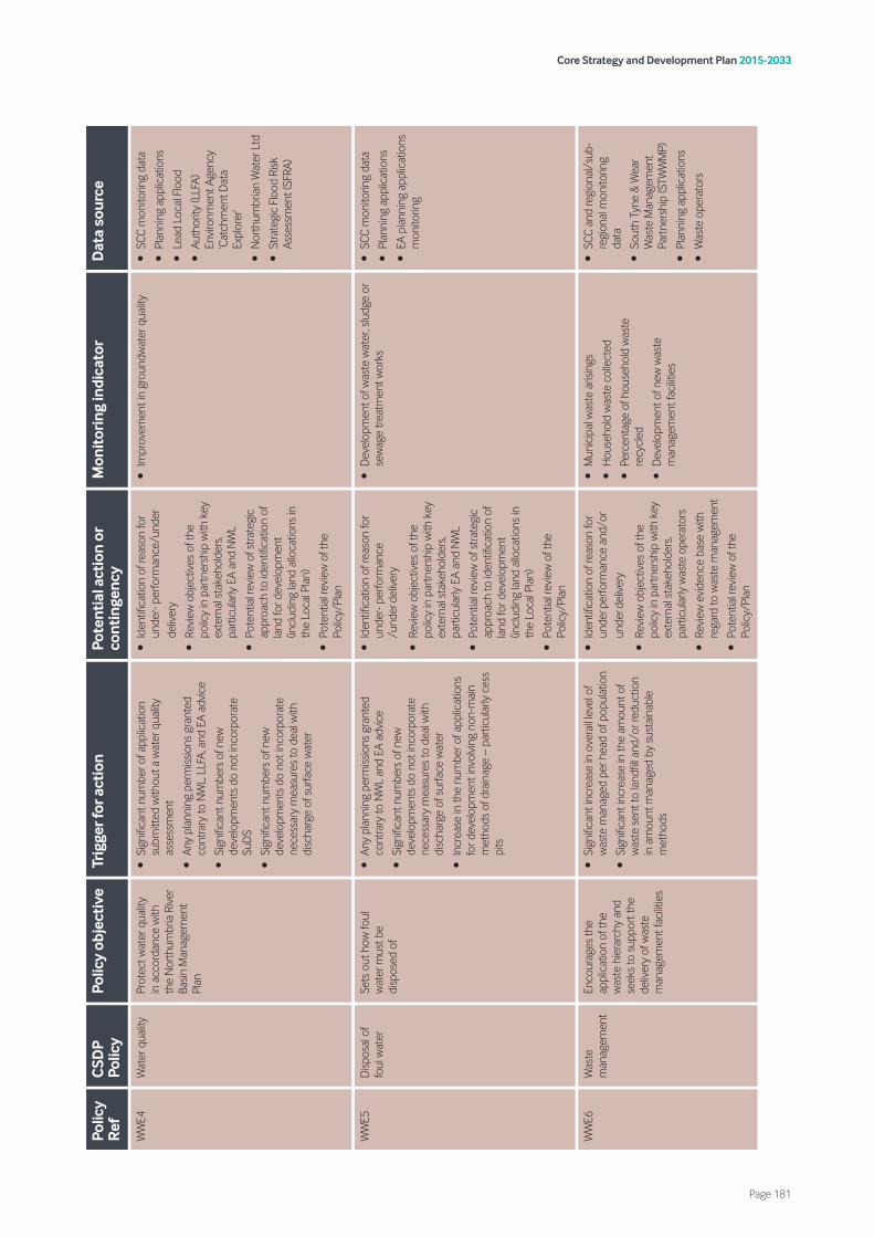
Core Strategy and Development Plan 2015-2033
Page 181
Polic
y R
efC
SDP
Polic
yPo
licy
obje
ctiv
eTr
igge
r for
act
ion
Pote
ntia
l act
ion
or
cont
inge
ncy
Mon
itor
ing
indi
cato
rD
ata
sour
ce
WW
E4W
ater
qua
lity
Prot
ect w
ater
qua
lity
in a
ccor
danc
e w
ith
the
Nor
thum
bria
Riv
er
Basin
Man
agem
ent
Plan
•Si
gnifi
cant
num
ber o
f app
licat
ion
subm
itted
with
out a
wat
er q
ualit
y as
sess
men
t
•An
y pl
anni
ng p
erm
issio
ns g
rant
ed
cont
rary
to N
WL,
LLF
A, a
nd E
A ad
vice
•Si
gnifi
cant
num
bers
of n
ew
deve
lopm
ents
do
not i
ncor
pora
te
SuD
S
•Si
gnifi
cant
num
bers
of n
ew
deve
lopm
ents
do
not i
ncor
pora
te
nece
ssar
y m
easu
res
to d
eal w
ith
disc
harg
e of
sur
face
wat
er
•Id
entifi
catio
n of
reas
on fo
r un
der-
per
form
ance
/und
er-
deliv
ery
•Re
view
obj
ectiv
es o
f the
po
licy
in p
artn
ersh
ip w
ith k
ey
exte
rnal
sta
keho
lder
s, pa
rtic
ular
ly E
A an
d N
WL
•Po
tent
ial r
evie
w o
f stra
tegi
c ap
proa
ch to
iden
tifica
tion
of
land
for d
evel
opm
ent
(incl
udin
g la
nd a
lloca
tions
in
the
Loca
l Pla
n)
•Po
tent
ial r
evie
w o
f the
Po
licy/
Plan
•Im
prov
emen
t in
grou
ndw
ater
qua
lity
•SC
C m
onito
ring
data
•Pl
anni
ng a
pplic
atio
ns
•Le
ad L
ocal
Flo
od
•Au
thor
ity (L
LFA)
En
viro
nmen
t Age
ncy
‘Cat
chm
ent D
ata
Expl
orer
’
•N
orth
umbr
ian
Wat
er L
td
•St
rate
gic
Floo
d Ri
sk
Asse
ssm
ent (
SFRA
)
WW
E5D
ispos
al o
f fo
ul w
ater
Sets
out
how
foul
w
ater
mus
t be
disp
osed
of
•An
y pl
anni
ng p
erm
issio
ns g
rant
ed
cont
rary
to N
WL
and
EA a
dvic
e
•Si
gnifi
cant
num
bers
of n
ew
deve
lopm
ents
do
not i
ncor
pora
te
nece
ssar
y m
easu
res
to d
eal w
ith
disc
harg
e of
sur
face
wat
er
•In
crea
se in
the
num
ber o
f app
licat
ions
fo
r dev
elop
men
t inv
olvi
ng n
on-m
ain
met
hods
of d
rain
age
– pa
rtic
ular
ly c
ess
pits
•Id
entifi
catio
n of
reas
on fo
r un
der-
per
form
ance
/u
nder
-del
iver
y
•Re
view
obj
ectiv
es o
f the
po
licy
in p
artn
ersh
ip w
ith k
ey
exte
rnal
sta
keho
lder
s, pa
rtic
ular
ly E
A an
d N
WL
•Po
tent
ial r
evie
w o
f stra
tegi
c ap
proa
ch to
iden
tifica
tion
of
land
for d
evel
opm
ent
(incl
udin
g la
nd a
lloca
tions
in
the
Loca
l Pla
n)
•Po
tent
ial r
evie
w o
f the
Po
licy/
Plan
•D
evel
opm
ent o
f was
te w
ater
, slu
dge
or
sew
age
treat
men
t wor
ks•
SCC
mon
itorin
g da
ta
•Pl
anni
ng a
pplic
atio
ns
•EA
pla
nnin
g ap
plic
atio
ns
mon
itorin
g
WW
E6W
aste
m
anag
emen
tEn
cour
ages
the
appl
icat
ion
of th
e w
aste
hie
rarc
hy a
nd
seek
s to
sup
port
the
deliv
ery
of w
aste
m
anag
emen
t fac
ilitie
s
•Si
gnifi
cant
incr
ease
in o
vera
ll le
vel o
f w
aste
man
aged
per
hea
d of
pop
ulat
ion
•Si
gnifi
cant
incr
ease
in th
e am
ount
of
was
te s
ent t
o la
ndfil
l and
/or r
educ
tion
in a
mou
nt m
anag
ed b
y su
stai
nabl
e m
etho
ds
•Id
entifi
catio
n of
reas
on fo
r un
der-p
erfo
rman
ce a
nd/o
r un
der-d
eliv
ery
•Re
view
obj
ectiv
es o
f the
po
licy
in p
artn
ersh
ip w
ith k
ey
exte
rnal
sta
keho
lder
s, pa
rtic
ular
ly w
aste
ope
rato
rs
•Re
view
evi
denc
e ba
se w
ith
rega
rd to
was
te m
anag
emen
t
•Po
tent
ial r
evie
w o
f the
Po
licy/
Plan
•M
unic
ipal
was
te a
risin
gs
•H
ouse
hold
was
te c
olle
cted
•Pe
rcen
tage
of h
ouse
hold
was
te
recy
cled
•D
evel
opm
ent o
f new
was
te
man
agem
ent f
acilit
ies
•SC
C an
d re
gion
al/s
ub-
regi
onal
mon
itorin
g da
ta
•So
uth
Tyne
& W
ear
Was
te M
anag
emen
t Pa
rtne
rshi
p (S
TWW
MP)
•Pl
anni
ng a
pplic
atio
ns
•W
aste
ope
rato
rs
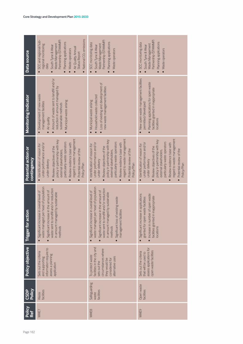
Core Strategy and Development Plan 2015-2033
Page 182
Polic
y R
efC
SDP
Polic
yPo
licy
obje
ctiv
eTr
igge
r for
act
ion
Pote
ntia
l act
ion
or
cont
inge
ncy
Mon
itor
ing
indi
cato
rD
ata
sour
ce
WW
E7W
aste
fa
cilit
ies
Sets
out
the
crite
ria
and
supp
ortin
g in
form
atio
n re
quire
to
asse
ss a
pla
nnin
g ap
plic
atio
n
•Si
gnifi
cant
incr
ease
in o
vera
ll le
vel o
f w
aste
man
aged
per
hea
d of
pop
ulat
ion
•Si
gnifi
cant
incr
ease
in th
e am
ount
of
was
te s
ent t
o la
ndfil
l and
/or r
educ
tion
in a
mou
nt m
anag
ed b
y su
stai
nabl
e m
etho
ds
•Id
entifi
catio
n of
reas
on fo
r un
der-p
erfo
rman
ce a
nd/o
r un
der-d
eliv
ery
•Re
view
obj
ectiv
es o
f the
po
licy
in p
artn
ersh
ip w
ith k
ey
exte
rnal
sta
keho
lder
s, pa
rtic
ular
ly w
aste
ope
rato
rs
•Re
view
evi
denc
e ba
se w
ith
rega
rd to
was
te m
anag
emen
t
•Po
tent
ial r
evie
w o
f the
Po
licy/
Plan
•D
evel
opm
ent o
f new
was
te
man
agem
ent f
acilit
ies
•Ai
r qua
lity
•Am
ount
of w
aste
sen
t to
land
fill a
nd/o
r re
duct
ion
in a
mou
nt m
anag
ed b
y su
stai
nabl
e m
etho
ds
•M
unic
ipal
was
te a
risin
g
•SC
C an
d re
gion
al/s
ub-
regi
onal
mon
itorin
g da
ta
•So
uth
Tyne
& W
ear
Was
te M
anag
emen
t Pa
rtne
rshi
p (S
TWW
MP)
•Pl
anni
ng a
pplic
atio
ns
•W
aste
ope
rato
rs
•Ai
r Qua
lity
Annu
al
Stat
us R
epor
t
•N
atio
nal C
O2 e
miss
ions
WW
E8Sa
fegu
ardi
ng
was
te
faci
litie
s
To p
rote
ct w
aste
fa
cilit
ies
in th
e ci
ty a
nd
sets
out
the
circ
umst
ance
s w
here
th
ey w
ould
be
cons
ider
ed fo
r al
tern
ativ
e us
es
•Si
gnifi
cant
incr
ease
in o
vera
ll le
vel o
f w
aste
man
aged
per
hea
d of
pop
ulat
ion
•Si
gnifi
cant
incr
ease
in th
e am
ount
of
was
te s
ent t
o la
ndfil
l and
/or r
educ
tion
in a
mou
nt m
anag
ed b
y su
stai
nabl
e m
etho
ds
•Si
gnifi
cant
loss
of e
xistin
g w
aste
m
anag
emen
t fac
ilitie
s
•Id
entifi
catio
n of
reas
on fo
r un
der p
erfo
rman
ce a
nd/o
r un
der d
eliv
ery
•Re
view
obj
ectiv
es o
f the
po
licy
in p
artn
ersh
ip w
ith k
ey
exte
rnal
sta
keho
lder
s, pa
rtic
ular
ly w
aste
ope
rato
rs
•Re
view
evi
denc
e ba
se w
ith
rega
rd to
was
te m
anag
emen
t
•Po
tent
ial r
evie
w o
f the
Po
licy/
Plan
•M
unic
ipal
was
te a
risin
g
•H
ouse
hold
was
te c
olle
cted
•Lo
ss o
f exis
ting
and
deve
lopm
ent o
f ne
w w
aste
man
agem
ent f
acilit
ies
•SC
C m
onito
ring
data
•So
uth
Tyne
& W
ear
Was
te M
anag
emen
t Pa
rtne
rshi
p (S
TWW
MP)
•Pl
anni
ng a
pplic
atio
ns
•W
aste
ope
rato
rs
WW
E9O
pen
was
te
faci
litie
sSe
ts o
ut th
e cr
iteria
th
at w
ill be
use
d to
as
sess
app
licat
ions
for
open
was
te fa
cilit
ies
•Si
gnifi
cant
incr
ease
in a
pplic
atio
ns
gran
ted
for o
pen
was
te fa
cilit
ies
•In
crea
se in
num
ber o
f ope
n w
aste
fa
cilit
ies
gran
ted
in in
appr
opria
te
loca
tions
•Id
entifi
catio
n of
reas
on fo
r un
der p
erfo
rman
ce a
nd/o
r un
der d
eliv
ery
•Re
view
obj
ectiv
es o
f the
po
licy
in p
artn
ersh
ip w
ith k
ey
exte
rnal
sta
keho
lder
s, pa
rtic
ular
ly w
aste
ope
rato
rs
•Re
view
evi
denc
e ba
se w
ith
rega
rd to
was
te m
anag
emen
t
•Po
tent
ial r
evie
w o
f the
Po
licy/
Plan
•N
ew o
pen
was
te m
anag
emen
t fac
ilitie
s pe
rmitt
ed/d
evel
oped
•Pl
anni
ng a
pplic
atio
ns fo
r ope
n w
aste
fa
cilit
ies
gran
ted
in in
appr
opria
te
loca
tions
•SC
C m
onito
ring
data
•So
uth
Tyne
& W
ear
Was
te M
anag
emen
t Pa
rtne
rshi
p (S
TWW
MP)
•Pl
anni
ng a
pplic
atio
ns
•W
aste
ope
rato
rs
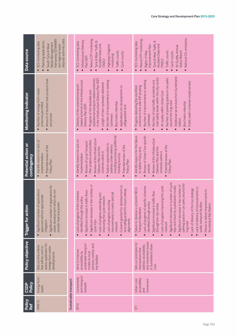
Core Strategy and Development Plan 2015-2033
Page 183
Polic
y R
efC
SDP
Polic
yPo
licy
obje
ctiv
eTr
igge
r for
act
ion
Pote
ntia
l act
ion
or
cont
inge
ncy
Mon
itor
ing
indi
cato
rD
ata
sour
ce
WW
E10
Ener
gy fr
om
was
teSe
ts o
ut th
e cr
iteria
th
at w
ill be
use
d to
as
sess
app
licat
ion
for
ener
gy fr
om w
aste
de
velo
pmen
ts
•Si
gnifi
cant
num
ber o
f app
licat
ions
ap
prov
ed w
ithou
t app
ropr
iate
m
itiga
tion
•Si
gnifi
cant
num
ber o
f app
licat
ions
for
was
te d
evel
opm
ent w
hich
do
not
prov
ide
heat
and
pow
er.
•Id
entif
y re
ason
s fo
r lac
k of
im
plem
enta
tion
•Po
tent
ial r
evie
w o
f the
Po
licy/
Plan
•N
umbe
r of e
nerg
y fro
m w
aste
sc
hem
es p
erm
itted
•Am
ount
of f
acilit
ies
that
pro
duce
hea
t an
d po
wer
•SC
C m
onito
ring
data
•Pl
anni
ng a
pplic
atio
ns
•So
uth
Tyne
& W
ear
Was
te M
anag
emen
t Pa
rtne
rshi
p (S
TWW
MP)
an
d re
gion
al w
aste
di
spos
al a
utho
rity
data
.
Sust
aina
ble
tran
spor
t
SP10
Conn
ectiv
ity
and
trans
port
ne
twor
k
Aim
s to
impr
ove
acce
ssib
ility
by
sust
aina
ble
trans
port
m
odes
to lo
cal
serv
ices
, cen
tres
and
key
faci
litie
s
•La
ck o
f pro
gres
s of
the
sche
mes
id
entifi
ed th
roug
h th
e po
licy
•Si
gnifi
cant
incr
ease
in tr
affic
flow
s
•Si
gnifi
cant
dec
reas
e in
the
num
ber o
f cy
cle
trip
s
•La
ck o
f pro
gres
s ex
tend
ing
and
impr
ovin
g th
e cy
cle
netw
ork
•La
ck o
f pro
gres
s se
curin
g im
prov
emen
ts to
met
ro a
nd ra
il ne
twor
k
•Co
nsen
t gra
nted
for d
evel
opm
ent o
n la
nd s
afeg
uard
ed fo
r fut
ure
railw
ay
alig
nmen
ts
•Id
entif
y re
ason
s fo
r lac
k on
im
plem
enta
tion
•Re
view
of L
ocal
Tra
nspo
rt
Plan
pro
ject
s an
d pr
iorit
ies
•Re
view
of t
he In
frast
ruct
ure
Del
iver
y Pl
an a
nd th
e sc
hem
es w
ithin
it
•Ex
plor
e op
port
uniti
es to
ad
dres
s un
der-
deliv
ery
incl
udin
g ac
cess
ing
addi
tiona
l fu
ndin
g so
urce
s
•Po
tent
ial r
evie
w o
f the
Po
licy/
Plan
•D
eliv
ery
of th
e es
sent
ial t
rans
port
-re
late
d sc
hem
es in
the
Infra
stru
ctur
e D
eliv
ery
Plan
(ID
P)
•Pr
ogre
ss o
f the
des
irabl
e an
d as
pira
tiona
l tra
nspo
rt re
late
d sc
hem
es
in th
e In
frast
ruct
ure
Del
iver
y Pl
an (I
DP)
•Le
ngth
of n
ew c
ycle
way
s de
liver
ed
•N
umbe
r of i
mpr
ovem
ents
to e
xistin
g cy
clew
ays
•Bu
s/m
etro
ride
rshi
p
•Ap
plic
atio
ns fo
r dev
elop
men
t on
safe
guar
ded
land
•SC
C m
onito
ring
data
•In
frast
ruct
ure
Del
iver
y Pl
an (I
DP)
•N
exus
/LTP
mon
itorin
g
•Ty
ne &
Wea
r Tra
ffic
& Ac
cide
nt D
ata
Uni
t (T
ADU
)
•H
ighw
ays
Engl
and
mon
itorin
g
•Tr
affic
cou
nts
•Cy
cle
coun
ts
ST1
Urb
an c
ore
acce
ssib
ility
and
mov
emen
t
Sets
out
prin
cipl
es fo
r in
terv
entio
ns th
at
addr
ess
acce
ssib
ility
and
mov
emen
t iss
ues
in S
unde
rland
Urb
an
Core
.
•Fa
ilure
to d
evel
op a
coh
eren
t NEC
A Tr
ansp
ort M
anife
sto
•La
ck o
f pro
gres
s of
spe
cific
sch
emes
id
entifi
ed th
roug
h po
licy
•Si
gnifi
cant
incr
ease
in tr
affic
flow
th
roug
h th
e ci
ty c
entre
•La
ck o
f pro
gres
s im
prov
ing
the
cycl
e ne
twor
k
•Si
gnifi
cant
dec
reas
e in
num
ber o
f cyc
le
trip
s an
d tra
vel b
y su
stai
nabl
e m
odes
•Si
gnifi
cant
dec
reas
e in
the
num
ber o
f pa
rkin
g sp
aces
in c
ar p
arks
aro
und
the
ring
road
•La
ck o
f del
iver
y of
the
bus
stra
tegy
•La
ck o
f del
iver
y of
impr
ovem
ents
to
publ
ic tr
ansp
ort f
acilit
ies
•Fa
ilure
to d
eliv
er im
prov
emen
ts to
Su
nder
land
Rai
l Sta
tion
•Id
entif
y re
ason
s fo
r the
failu
re
to d
eliv
er P
olic
y ai
ms
•Re
view
of U
rban
Cor
e sp
ecifi
c po
licie
s
•Re
view
of t
he In
frast
ruct
ure
Del
iver
y Pl
an a
nd th
e sc
hem
es w
ithin
it
•Po
tent
ial r
evie
w o
f the
Po
licy/
Plan
•Pr
ogre
ss d
eliv
erin
g th
e id
entifi
ed
sche
mes
in li
ne w
ith ID
P ph
asin
g
•N
umbe
r of i
mpr
ovem
ents
to e
xistin
g cy
clew
ays
•N
umbe
r of r
oad
traffi
c ac
cide
nts
and
road
saf
ety
leve
ls w
ithin
the
city
cen
tre
•Ai
r qua
lity
with
in U
rban
Cor
e
•N
umbe
r of p
arki
ng s
pace
s in
car
par
ks
arou
nd th
e rin
g ro
ad
•Ad
ditio
nal r
ail s
ervi
ces
from
Sun
derla
nd
stat
ion
•Bu
s/m
etro
ride
rshi
p
•Pu
blic
real
m s
chem
es im
plem
ente
d
•SC
C m
onito
ring
data
•N
exus
/LTP
mon
itorin
g
•Ri
ghts
of W
ay
Impr
ovem
ent P
lan
•Ty
ne &
Wea
r Tra
ffic
& Ac
cide
nt D
ata
Uni
t (T
ADU
)
•Tr
affic
cou
nts
•Cy
cle
coun
ts
•Ai
r Qua
lity
Annu
al
Stat
us R
epor
t
•N
atio
nal C
O2 e
miss
ions
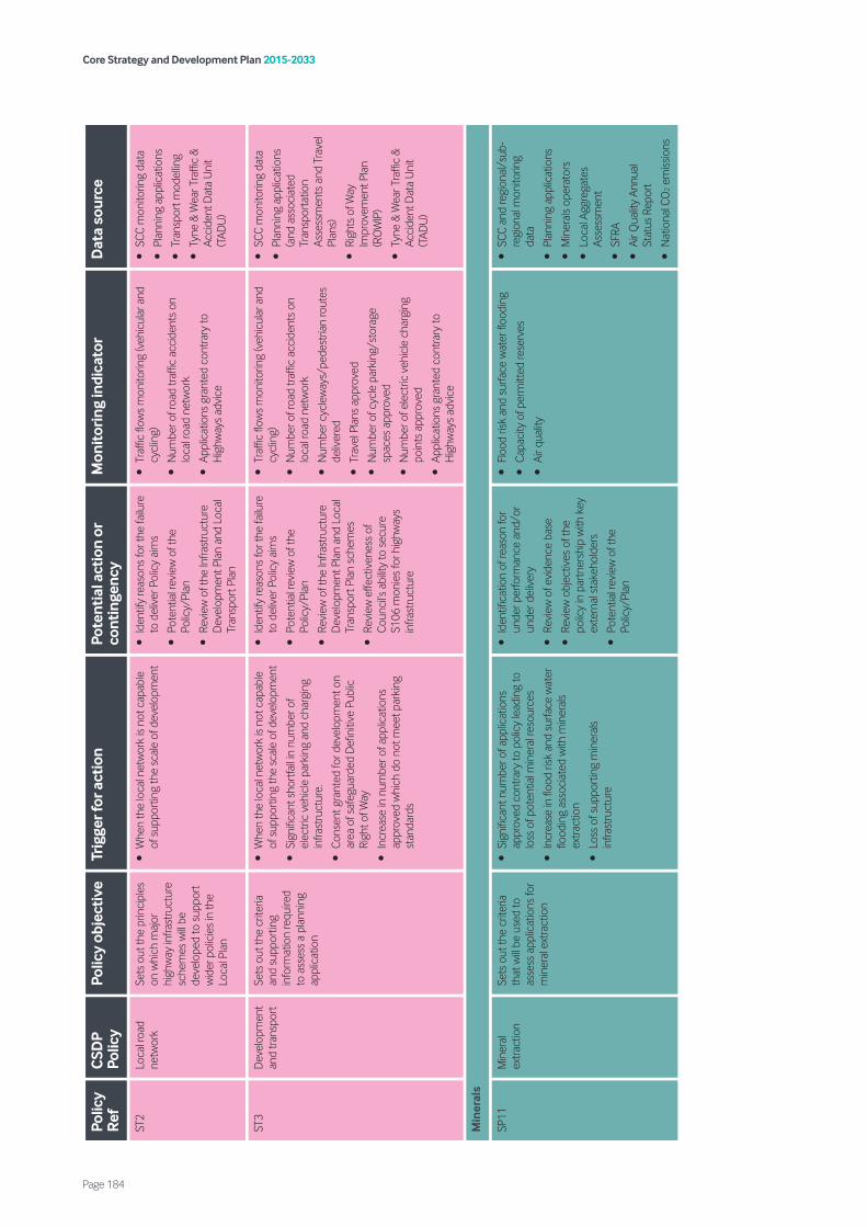
Core Strategy and Development Plan 2015-2033
Page 184
Polic
y R
efC
SDP
Polic
yPo
licy
obje
ctiv
eTr
igge
r for
act
ion
Pote
ntia
l act
ion
or
cont
inge
ncy
Mon
itor
ing
indi
cato
rD
ata
sour
ce
ST2
Loca
l roa
d ne
twor
kSe
ts o
ut th
e pr
inci
ples
on
whi
ch m
ajor
hi
ghw
ay in
frast
ruct
ure
sche
mes
will
be
deve
lope
d to
sup
port
w
ider
pol
icie
s in
the
Loca
l Pla
n
•W
hen
the
loca
l net
wor
k is
not c
apab
le
of s
uppo
rtin
g th
e sc
ale
of d
evel
opm
ent
•Id
entif
y re
ason
s fo
r the
failu
re
to d
eliv
er P
olic
y ai
ms
•Po
tent
ial r
evie
w o
f the
Po
licy/
Plan
•Re
view
of t
he In
frast
ruct
ure
Dev
elop
men
t Pla
n an
d Lo
cal
Tran
spor
t Pla
n
•Tr
affic
flow
s m
onito
ring
(veh
icul
ar a
nd
cycl
ing)
•N
umbe
r of r
oad
traffi
c ac
cide
nts
on
loca
l roa
d ne
twor
k
•Ap
plic
atio
ns g
rant
ed c
ontra
ry to
H
ighw
ays
advi
ce
•SC
C m
onito
ring
data
•Pl
anni
ng a
pplic
atio
ns
•Tr
ansp
ort m
odel
ling
•Ty
ne &
Wea
r Tra
ffic
& Ac
cide
nt D
ata
Uni
t (T
ADU
)
ST3
Dev
elop
men
t an
d tra
nspo
rtSe
ts o
ut th
e cr
iteria
an
d su
ppor
ting
info
rmat
ion
requ
ired
to a
sses
s a
plan
ning
ap
plic
atio
n
•W
hen
the
loca
l net
wor
k is
not c
apab
le
of s
uppo
rtin
g th
e sc
ale
of d
evel
opm
ent
•Si
gnifi
cant
sho
rtfa
ll in
num
ber o
f el
ectr
ic v
ehic
le p
arki
ng a
nd c
harg
ing
infra
stru
ctur
e.
•Co
nsen
t gra
nted
for d
evel
opm
ent o
n ar
ea o
f saf
egua
rded
Defi
nitiv
e Pu
blic
Ri
ght o
f Way
•In
crea
se in
num
ber o
f app
licat
ions
ap
prov
ed w
hich
do
not m
eet p
arki
ng
stan
dard
s
•Id
entif
y re
ason
s fo
r the
failu
re
to d
eliv
er P
olic
y ai
ms
•Po
tent
ial r
evie
w o
f the
Po
licy/
Plan
•Re
view
of t
he In
frast
ruct
ure
Dev
elop
men
t Pla
n an
d Lo
cal
Tran
spor
t Pla
n sc
hem
es
•Re
view
effe
ctiv
enes
s of
Co
unci
l’s a
bilit
y to
sec
ure
S106
mon
ies
for h
ighw
ays
infra
stru
ctur
e
•Tr
affic
flow
s m
onito
ring
(veh
icul
ar a
nd
cycl
ing)
•N
umbe
r of r
oad
traffi
c ac
cide
nts
on
loca
l roa
d ne
twor
k
•N
umbe
r cyc
lew
ays/
pede
stria
n ro
utes
de
liver
ed
•Tr
avel
Pla
ns a
ppro
ved
•N
umbe
r of c
ycle
par
king
/sto
rage
sp
aces
app
rove
d
•N
umbe
r of e
lect
ric v
ehic
le c
harg
ing
poin
ts a
ppro
ved
•Ap
plic
atio
ns g
rant
ed c
ontra
ry to
H
ighw
ays
advi
ce
•SC
C m
onito
ring
data
•Pl
anni
ng a
pplic
atio
ns
(and
ass
ocia
ted
Tran
spor
tatio
n As
sess
men
ts a
nd T
rave
l Pl
ans)
•Ri
ghts
of W
ay
Impr
ovem
ent P
lan
(RO
WIP
)
•Ty
ne &
Wea
r Tra
ffic
& Ac
cide
nt D
ata
Uni
t (T
ADU
)
Min
eral
s
SP11
Min
eral
ex
tract
ion
Sets
out
the
crite
ria
that
will
be u
sed
to
asse
ss a
pplic
atio
ns fo
r m
iner
al e
xtra
ctio
n
•Si
gnifi
cant
num
ber o
f app
licat
ions
ap
prov
ed c
ontra
ry to
pol
icy
lead
ing
to
loss
of p
oten
tial m
iner
al re
sour
ces
•In
crea
se in
floo
d ris
k an
d su
rface
wat
er
flood
ing
asso
ciat
ed w
ith m
iner
als
extra
ctio
n
•Lo
ss o
f sup
port
ing
min
eral
s in
frast
ruct
ure
•Id
entifi
catio
n of
reas
on fo
r un
der p
erfo
rman
ce a
nd/o
r un
der d
eliv
ery
•Re
view
of e
vide
nce
base
•Re
view
obj
ectiv
es o
f the
po
licy
in p
artn
ersh
ip w
ith k
ey
exte
rnal
sta
keho
lder
s
•Po
tent
ial r
evie
w o
f the
Po
licy/
Plan
•Fl
ood
risk
and
surfa
ce w
ater
floo
ding
•Ca
paci
ty o
f per
mitt
ed re
serv
es
•Ai
r qua
lity
•SC
C an
d re
gion
al/s
ub-
regi
onal
mon
itorin
g da
ta
•Pl
anni
ng a
pplic
atio
ns
•M
iner
als
oper
ator
s
•Lo
cal A
ggre
gate
s As
sess
men
t
•SF
RA
•Ai
r Qua
lity
Annu
al
Stat
us R
epor
t
•N
atio
nal C
O2 e
miss
ions

Core Strategy and Development Plan 2015-2033
Page 185
Polic
y R
efC
SDP
Polic
yPo
licy
obje
ctiv
eTr
igge
r for
act
ion
Pote
ntia
l act
ion
or
cont
inge
ncy
Mon
itor
ing
indi
cato
rD
ata
sour
ce
M1
Min
eral
s Sa
fegu
ardi
ng
Area
s an
d in
frast
ruct
ure
Sets
out
the
crite
ria
that
will
be u
sed
to
asse
ss a
pplic
atio
ns
subm
itted
with
in
min
eral
saf
egua
rdin
g ar
eas
•Si
gnifi
cant
num
ber o
f app
licat
ions
ap
prov
ed c
ontra
ry to
pol
icy
lead
ing
to
loss
of p
oten
tial m
iner
al re
sour
ces
•Lo
ss o
f sup
port
ing
min
eral
s an
d w
aste
in
frast
ruct
ure
•Ap
plic
atio
ns g
rant
ed fo
r non
-min
eral
de
velo
pmen
t with
in M
iner
al
Safe
guar
ding
Are
as
•Id
entifi
catio
n of
reas
on fo
r un
der p
erfo
rman
ce a
nd/o
r un
der d
eliv
ery
•Re
view
of e
vide
nce
base
•Re
view
obj
ectiv
es o
f the
po
licy
in p
artn
ersh
ip w
ith k
ey
exte
rnal
sta
keho
lder
s
•Po
tent
ial r
evie
w o
f the
Po
licy/
Plan
•Sa
fegu
ardi
ng a
nd s
teril
isatio
n of
m
iner
al re
sour
ces
•Ai
r qua
lity
leve
ls
•Pl
anni
ng a
pplic
atio
ns g
rant
ed in
clo
se
prox
imity
to e
xistin
g w
aste
m
anag
emen
t site
s
•N
umbe
r of a
pplic
atio
ns g
rant
ed in
MSA
fo
r non
- min
eral
dev
elop
men
t
•SC
C an
d re
gion
al/s
ub-
regi
onal
mon
itorin
g da
ta
•Pl
anni
ng a
pplic
atio
ns
•M
iner
als
oper
ator
s
•W
aste
ope
rato
rs
•Ai
r Qua
lity
Annu
al
Stat
us R
epor
t
•N
atio
nal C
O2 e
miss
ions
M2
Surfa
ce c
oal
extra
ctio
nSe
ts o
ut th
e cr
iteria
ag
ains
t whi
ch
appl
icat
ions
for
surfa
ce
•Si
gnifi
cant
num
ber o
f app
licat
ions
ap
prov
ed c
ontra
ry to
pol
icy
lead
ing
to
loss
of c
oal e
xtra
ctio
n w
ill be
ass
esse
d po
tent
ial m
iner
al re
sour
ces
•Id
entifi
catio
n of
reas
on fo
r un
der p
erfo
rman
ce a
nd/o
r un
der d
eliv
ery
•Re
view
of e
vide
nce
base
•Re
view
obj
ectiv
es o
f the
po
licy
in p
artn
ersh
ip w
ith k
ey
exte
rnal
sta
keho
lder
s
•Po
tent
ial r
evie
w o
f the
Po
licy/
Plan
•O
penc
ast c
oal a
pplic
atio
ns a
nd
perm
issio
ns•
SCC
and
regi
onal
/sub
- re
gion
al m
onito
ring
data
•Pl
anni
ng a
pplic
atio
ns
•M
iner
als
oper
ator
s
M3
Land
in
stab
ility
and
min
eral
s le
gacy
Ensu
re th
at
deve
lopm
ent t
akes
in
to a
ccou
nt la
nd
inst
abilit
y an
d m
iner
als
lega
cy
•Si
gnifi
cant
num
ber o
f app
licat
ions
ap
prov
ed c
ontra
ry to
pol
icy
•Si
gnifi
cant
incr
ease
in a
pplic
atio
ns
requ
iring
a C
oal m
inin
g Ri
sk
Asse
ssm
ent
•Id
entif
y re
ason
s fo
r the
failu
re
to d
eliv
er P
olic
y ai
ms
•Co
nsid
er re
view
of t
he
requ
irem
ents
of t
his
and
othe
r pol
icie
s w
here
they
pr
even
t effe
ctiv
e im
plem
enta
tion
of th
is po
licy
•Po
tent
ial r
evie
w o
f the
Po
licy/
Plan
•Pl
anni
ng a
pplic
atio
ns re
ceiv
ed a
nd
gran
ted
in C
oal A
utho
rity
high
-risk
ar
eas
and
area
s of
land
inst
abilit
y
•Pl
anni
ng a
pplic
atio
ns re
quiri
ng a
Coa
l M
inin
g Ri
sk A
sses
smen
t
•SC
C m
onito
ring
data
•Pl
anni
ng a
pplic
atio
ns
M4
Rest
orat
ion
and
afte
rcar
eSe
ts o
ut th
e st
anda
rd
of m
iner
als
and
was
te
afte
rcar
e/re
stor
atio
n th
at w
ill be
requ
ired
•Si
gnifi
cant
num
ber o
f app
licat
ions
ap
prov
ed c
ontra
ry to
pol
icy
•Id
entif
y re
ason
s fo
r the
failu
re
to d
eliv
er P
olic
y ai
ms
•Co
nsid
er re
view
of t
he
requ
irem
ents
of t
his
and
othe
r pol
icie
s w
here
they
pr
even
t effe
ctiv
e im
plem
enta
tion
of th
is po
licy
•Po
tent
ial r
evie
w o
f the
Po
licy/
Plan
•Re
stor
atio
n sc
hem
es im
plem
ente
d•
SCC
mon
itorin
g da
ta
•Pl
anni
ng a
pplic
atio
ns
•M
iner
als
oper
ator
s
•W
aste
ope
rato
rs
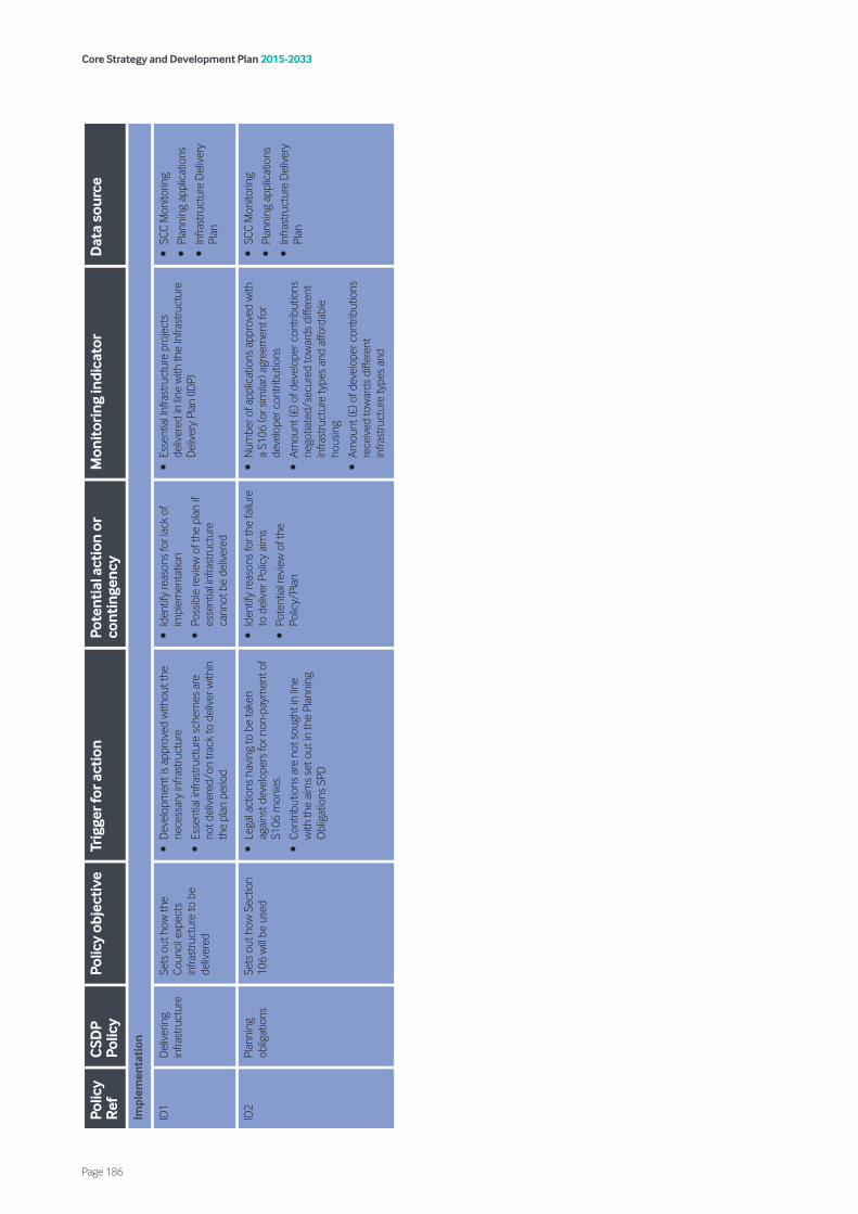
Core Strategy and Development Plan 2015-2033
Page 186
Polic
y R
efC
SDP
Polic
yPo
licy
obje
ctiv
eTr
igge
r for
act
ion
Pote
ntia
l act
ion
or
cont
inge
ncy
Mon
itor
ing
indi
cato
rD
ata
sour
ce
Impl
emen
tati
on
ID1
Del
iver
ing
infra
stru
ctur
eSe
ts o
ut h
ow th
e Co
unci
l exp
ects
in
frast
ruct
ure
to b
e de
liver
ed
•D
evel
opm
ent i
s ap
prov
ed w
ithou
t the
ne
cess
ary
infra
stru
ctur
e
•Es
sent
ial i
nfra
stru
ctur
e sc
hem
es a
re
not d
eliv
ered
/on
track
to d
eliv
er w
ithin
th
e pl
an p
erio
d
•Id
entif
y re
ason
s fo
r lac
k of
im
plem
enta
tion
•Po
ssib
le re
view
of t
he p
lan
if es
sent
ial i
nfra
stru
ctur
e ca
nnot
be
deliv
ered
•Es
sent
ial I
nfra
stru
ctur
e pr
ojec
ts
deliv
ered
in li
ne w
ith th
e In
frast
ruct
ure
Del
iver
y Pl
an (I
DP)
•SC
C M
onito
ring
•Pl
anni
ng a
pplic
atio
ns
•In
frast
ruct
ure
Del
iver
y Pl
an
ID2
Plan
ning
ob
ligat
ions
Sets
out
how
Sec
tion
106
will
be u
sed
•Le
gal a
ctio
ns h
avin
g to
be
take
n ag
ains
t dev
elop
ers
for n
on-p
aym
ent o
f S1
06 m
onie
s.
•Co
ntrib
utio
ns a
re n
ot s
ough
t in
line
with
the
aim
s se
t out
in th
e Pl
anni
ng
Obl
igat
ions
SPD
•Id
entif
y re
ason
s fo
r the
failu
re
to d
eliv
er P
olic
y ai
ms
•Po
tent
ial r
evie
w o
f the
Po
licy/
Plan
•N
umbe
r of a
pplic
atio
ns a
ppro
ved
with
a
S106
(or s
imila
r) ag
reem
ent f
or
deve
lope
r con
trib
utio
ns
•Am
ount
(£) o
f dev
elop
er c
ontr
ibut
ions
ne
gotia
ted/
secu
red
tow
ards
diff
eren
t in
frast
ruct
ure
type
s an
d af
ford
able
ho
usin
g
•Am
ount
(£) o
f dev
elop
er c
ontr
ibut
ions
re
ceiv
ed to
war
ds d
iffer
ent
infra
stru
ctur
e ty
pes
and
•SC
C M
onito
ring
•Pl
anni
ng a
pplic
atio
ns
•In
frast
ruct
ure
Del
iver
y Pl
an
Accessibility The ability to access services by a range of transport methods, including public transport.
Accessible location A location which, is relatively easy for people to get to by a choice of means of transport.
Accessible Natural Greenspace Standards (ANGST) A measure created by Natural England to measure how close people live to accessible greenspaces. The standards identify different standards depending on the scale of the greenspace.
Affordable housing Affordable housing is social rented, affordable rented and intermediate housing, provided to eligible households whose needs are not met by the market. Eligibility is determined with regard to local incomes and local house prices.
Affordable rent Affordable rented housing is let by local authorities or private registered providers of social housing to households who are eligible for social rented housing. Affordable Rent is subject to rent controls that require a rent of no more than 80 per cent of the local market rent (including service charges, where applicable).
Agricultural land classification The Agricultural Land Classification system forms part of the planning system in England and Wales. It classifies agricultural land in five categories according to versatility and suitability for growing crops. The top three grades, Grade 1, 2 and 3a, are referred to as ‘Best and Most Versatile’ land, and enjoy significant protection from development. Grades 3b, 4 and 5 are described as poor quality agricultural land and very poor quality agricultural land.
Agricultural waste Waste which has been created as a result of agricultural or farming practices.
Allocated site Sites which are identified for a specific use e.g. housing or Green Belt on the Local Plan Policies Map.
Authority Monitoring Report (AMR) A report produced each year that assesses progress against targets in the Local Development Scheme and how well policies in the Local Plan are being implemented.
Arboriculture report A report which is prepared to assess the quantity and quality of trees and identify any mitigation works which may be required to protect them from development.
Article 4 direction An article 4 direction is made by the local planning authority. It restricts the scope of permitted development rights either in relation to a particular area or site, or a particular type of development anywhere in the authority’s area. Where an article 4 direction is in effect, a planning application may be required for development that would otherwise have been permitted development. Article 4 directions are used to control works that could threaten the character of an area of acknowledged importance, such as a conservation area.
Backland development A potential development site which is located to the rear of existing development and has little or no frontage to an existing street.
Best and most versatile agricultural land Best and most versatile agricultural land is that land which falls into Grades 1, 2 and 3a of the Agricultural Land Classification. See Agricultural Land Classification.
Biodiversity Biodiversity is the variability among living organisms from all sources, including terrestrial, marine, and other aquatic ecosystems and the ecological complexes of which they are part; this includes diversity within species, between species, and of eco systems.
Core Strategy and Development Plan 2015-2033
Page 187
Glossary

Bluespace Bluespace refers to visible water within open spaces and includes beaches, rivers, streams, ponds, lakes, canals and fountains.
Brownfield land Land that has previously been developed.
Building For Life 12 (BfL 12) Design criteria established by the Design Council to try and improve the design quality of new residential development.
Building regulations Building regulations are statutory instruments that seek to ensure that the policies set out in the relevant legislation are carried out. Building regulations approval is required for most building work in the UK.
Built environment The term built environment refers to the man-made surroundings that provide the setting for human activity, ranging in scale from buildings to parks.
Category 1 constraint A very significant constraint which would restrict development taking place on a site.
Central business district A term used to define the main business and commercial area of a town or city.
Circular economy A circular economy is a regenerative system in which resource input and waste, emission and energy leakage are minimised by slowing, closing and narrowing material and energy loops. This can be achieved through long-lasting design, maintenance, repair, reuse, remanufacturing, refurbishing and recycling.
City centre The main administrative area of the city, which is the main location for retail, offices, cultural and other community facilities.
Click and collect A new form of retail where a purchase is made online, however the goods are collected from an arranged location, such as a retail outlet.
Climate change A large-scale, long-term shift in the planet’s weather patterns or average temperatures.
Coal Mining Risk Assessment An assessment to consider the risk that former coal mining works may have upon development proposals. Coal mining development risk plans are only required to support planning applications in areas that are considered to be at high risk.
Coalescing The merging of two distinct built up areas.
Code for Sustainable Homes The Code for Sustainable Homes measures the sustainability of a new home against nine categories of sustainable design, rating the ‘whole home’ as a complete package. The Code for Sustainable Homes is no longer in use, with the Government committed to driving up the sustainability of new homes through changes to the Building Regulations.
Commercial and industrial waste (C&I) Waste which is generated as a result of commercial and/or industrial processes.
Community facilities A facility in which health care, childcare, educational, cultural or social services are provided e.g. community centre, libraries, leisure centres.
Conservation area Parts of the city that are of special architectural or historic interest, the character and appearance of which it is desirable to preserve or enhance. Conservation area designation introduces a general control over the demolition of unlisted buildings and provides a basis for planning policies whose objective is to conserve all aspects of character or appearance, including landscape and public spaces, that define an area’s special interest.
Core Strategy and Development Plan 2015-2033
Page 188
Conservation Area Management Strategy A strategy which has been prepared to identify what contributes positively or contributes to the character and appearance of conservation area and identifies actions to improve and enhance its character and appearance.
Construction, Demolition and Excavation Waste (CD&E) Waste materials generated from construction, demolition and waste operations including a wide range of surplus waste construction materials generated by the demolition of old buildings and soils and sub-soils from excavation.
Critical Drainage Areas (CDAs) Areas that the Environment Agency (EA) has identified as having notable flood risk and drainage problems.
Cumulative impact An area within Flood Zone 1 which has critical drainage problems and which has been notified to the local planning authority by the Environment Agency.
Curtilage A term often used to define the boundaries of a house or dwelling and refers to the land immediately surrounding it, including any closely associated buildings and structures but excluding any associated ‘open fields beyond’.
Decentralised energy Energy that is produced close to where it will be used, rather than at a large plant elsewhere and sent through the national grid.
Definitive Public Rights of Way Footpaths and bridleways on which the public have a legally protected right to pass and re-pass.
Deliverable The ability for a development proposal to take place taking into account development costs and constraints. For housing, in order to be considered deliverable sites should be available now, offer a suitable location for development now, and be achievable with a realistic prospect that housing will be delivered on the site within five years and in particular that development of the site is viable. Sites with planning permission should be
considered deliverable until permission expires, unless there is clear evidence that schemes will not be implemented within five years, for example they will not be viable, there is no longer a demand for the type of units or sites have long term phasing plans.
Demographic forecasts Forecasts which have been prepared to predict future population change, including changes to the age and gender profile of the population.
Density The amount of development which takes place on a development plot. Density is commonly used for residential development and is generally measured in the number of dwellings built per hectare.
Design and access statement Design and Access Statements are documents that explain the design thinking behind a planning application. For example, they should show that the person applying for permission (the applicant) has thought carefully about how everyone, including disabled people, older people and very young children, will be able to use the places they want to build.
Designated centres A general term which refers to any main administrative centres identified within the retail hierarchy.
Designated heritage assets Buildings or other features which have been designated for protection as a result of their architectural quality or historic significance. Examples of designated heritage assets include listed buildings, Scheduled monuments and registered parks and gardens.
Developer contributions Payments which are made to the local authority to deliver infrastructure, which is required to make a development acceptable in planning terms.
Development The carrying out of building, engineering, mining or other operations in, on, over or under land, or the marking of any material change in the use of any buildings or other land.
Core Strategy and Development Plan 2015-2033
Page 189

Development plan This includes adopted Local Plans, neighbourhood plans and the London Plan, and is defined in section 38 of the Planning and Compulsory Purchase Act 2004. (Regional strategies remain part of the development plan until they are abolished by Order using powers taken in the Localism Act. It is the government’s clear policy intention to revoke the regional strategies outside of London, subject to the outcome of the environmental assessments that are currently being undertaken).
District centre Groups of shops, separate from the town centre, usually containing at least one food supermarket or superstore and non-retail service uses such as banks, building societies and restaurants.
Duty to cooperate The duty to cooperate is a legal test that requires cooperation between local planning authorities and other public bodies to maximise the effectiveness of policies for strategic matters in Local Plans.
Economic development Development, including those within the B Use Classes, public and community uses and main town centre uses (but excluding housing development).
Edge of centre For shopping retail purposes, a location that is well connected to and up to 300 metres of the primary shopping area. For all other main town centre uses, a location within 300 metres of a town centre boundary. For office development, this includes locations outside of the town centre but within 500 metres of a public transport interchange. In determining whether a site falls within the definition of edge of centre, account should be taken of local circumstances. Is considered to be a location within easy walking distance (i.e. 200 - 300 metres) of the town centre.
Energy from waste The process of generating energy in the form of electricity and/or heat from the primary treatment of waste.
Enterprise Zone Enterprise zones are designated areas across England that provide tax breaks and Government support to support economic growth.
Equalities Impact Assessment A process designed to ensure that a policy, project or scheme does not discriminate against any disadvantaged or vulnerable people.
Ethnic diversity The range and diversity of different ethnic groups within a particular area.
EU Birds and Habitats Directive A legal framework under which member states of the European Union must protect all wild birds within the EU, including their habitats.
European Landscape Convention Convention aimed at the protection, management and planning of all landscapes and raising awareness of the value of a living landscape across all EU Member states.
Exceptions test (flood risk) A test that must be undertaken when development is proposed in areas at high risk of flooding. The test must consider the vulnerability of a particular development to flooding and demonstrate that the sustainability benefits of the development to the community would outweigh the flood risk.
Family housing Homes that contain three or more bedrooms and have access to outdoor space.
Fauna The collective term for all of the animals within a particular area.
Flood risk A term to define the risk that particular areas are at from flooding.
Flood Risk Assessment An assessment of flood risk within a particular area. Flood risk assessments can be prepared at a range of different levels, for example a strategic flood risk assessment of the whole city, or at a more local level to assess the flood risk within a particular development site.
Core Strategy and Development Plan 2015-2033
Page 190

Flood Zone 1 Areas which are at lowest risk from flooding and have less than a 0.1% chance of flooding in any given year.
Flood Zone 2 Areas which have been shown to have between 0.1% - 1% chance of flooding from rivers in any given year.
Flood Zone 3 Flood zone 3 is split into 2 separate zones; 3a and 3b. Areas within flood zone 3a have been shown to be at a
1% or greater probability of flooding from rivers or 0.5% flooding from the sea in any given year. Flood zone 3b is classified as functional floodplain and is deemed to be the most at risk from flooding from rivers or the sea.
Flora A collective term for all of the plants within a particular area.
Fluvial flooding Flooding as a result of a river bursting its banks.
Geodiversity The range of rocks, minerals, fossils, soils and landforms.
Green Belt A policy designation which aims to prevent urban sprawl by keeping land permanently open and restricting inappropriate development.
Green infrastructure A network of multi-functional greenspace, urban and rural, which is capable of delivering a wide range of environmental and quality of life benefits for local communities.
Green roofs A green roof or living roof is a roof of a building that is partially or completely covered with vegetation and a growing medium, planted over a waterproofing membrane.
Greenfield land Land which has not previously been developed.
Greenspace A collective term for green and open space, which may or may not be publicly accessible. This includes parks and gardens, outdoor sports facilities, allotments, playing fields, cemeteries and churchyards.
Gross The total area of a development.
Gross external area The total area of building when measured externally, including the structure of a building.
Groundwater source protection zones An area from which groundwater is sourced for public drinking water supply and therefore careful consideration needs to be given to ensure that development does not contaminate the groundwater. These areas are identified by the Environment Agency.
Gypsies and Travellers (‘Travellers’) Defined by DCLG Planning policy for traveller sites (August 2015) as “Persons of nomadic habit of life whatever their race or origin, including such persons who on grounds only of their own or their family’s or dependants’ educational or health needs or old age have ceased to travel temporarily, but excluding members of an organised group of Travelling Showpeople or circus people travelling together as such”. The planning policy goes on to state that, “In determining whether persons are “gypsies and travellers” for the purposes of this planning policy, consideration should be given to the following issues amongst other relevant matters: a) whether they previously led a nomadic habit of life b) the reasons for ceasing their nomadic habit of life c) whether there is an intention of living a nomadic habit of life in the future, and if so, how soon and in what circumstances”.
Gypsies and Traveller Pitches A pitch is an area of land which is occupied by a single gypsy or traveller household.
Habitats Regulations Assessment (HRA) An assessment which must be undertaken to assess the potential impacts of plans or projects upon European designated habitats and species.
Core Strategy and Development Plan 2015-2033
Page 191

Hazardous substance consent A consent which is required where it is proposed to hold certain quantities of hazardous substances at or above defined limits.
Health Impact Assessment An assessment of the potential impacts of a plan or project upon the health of a population and the distribution of those effects within the population.
Heritage assets A building, monument, site, place, area or landscape identified as having a degree of significance meriting consideration in planning decisions, because of its heritage interest. Heritage asset includes designated heritage assets and assets identified by the local planning authority (including local listing).
Heritage statement A statement submitted in support of a planning application which outlines the significance of the heritage assets which would be affected by a development and how the proposals have been designed taking account of their potential impact upon these heritage assets.
Heritage-at-risk Heritage assets which are at risk of damage or loss. Historic England publishes an annual Heritage at Risk Register which lists the most important heritage assets at risk.
Houses in Multiple Occupation (HMO) Housing where at least 3 tenants live there, forming more than 1 household and where they share toilet, bathroom or kitchen facilities with other tenants.
Health and Safety Executive consultation area (HSE Areas) Areas identified around major hazardous installations and pipelines, which require the Health and Safety Executive to be consulted on some planning applications.
Historic Environment Record Information services that seek to provide access to comprehensive and dynamic resources relating to the historic environment of a defined geographic area for public benefit and use.
Inclusive design Designing the built environment, including buildings and their surrounding spaces, to ensure that they can be accessed and used by everyone.
Infrastructure A collective term for services such as roads and railways, underground utilities such as electricity, sewerage and water, children’s services, health facilities, recycling and refuse facilities.
Infrastructure Delivery Plan Identifies the infrastructure projects required to deliver the Plan and its policies including, physical, social and green infrastructure outlining how and when it is anticipated that infrastructure will be funded. It is a live document that the council will monitor and review on a regular basis to reflect the current circumstances and inform the development management process.
Interim Planning Guidance (IPG) Planning guidance prepared to give advice on development areas or sites pending approval of statutory policy.
Intermediate housing Intermediate housing is homes for sale and rent provided at a cost above social rent, but below market levels subject to the criteria in the Affordable Housing definition above. These can include shared equity (shared ownership and equity loans), other low cost homes for sale and intermediate rent, but not affordable rented housing.
International Advanced Manufacturing Park (IAMP) The IAMP Area Action Plan (AAP) will form a statutory part of our new Local Plan, which will set out how Sunderland will develop and grow over the next 15-20 years and form the basis for the assessment of all planning applications and other development proposals.
Joint Strategic Needs Assessment (JSNA) A Joint Strategic Needs Assessment (JSNA) looks at the current and future health and care needs of local populations to inform and guide the planning and commissioning (buying) of health, well-being and social care services within a local authority area.
Core Strategy and Development Plan 2015-2033
Page 192
Key diagram A diagrammatic interpretation of the vision and policies within a Local Development Document.
Landscape Character Assessment (LCA) Grouping landscape into areas with similar character, based on physical and human influences. The assessment describes the physical, cultural and perceptual character of the landscape and identifies important or sensitive features. LCAs often identify objectives in respect of landscape planning, design and management of the areas.
Lifetime homes The Lifetime Homes design criteria are widely recognised by local authorities, developers and partners and provide a mechanism to ensure that new housing development is suitable for the changing needs of individuals and families over the course of a lifetime. The Lifetime Homes standard is awarded to schemes which meet all sixteen of the Lifetime Homes design criteria.
Lifetime neighbourhoods Places where you can live regardless of age. They contain a range of houses from your first home to supported housing for your latter years and the services, facilities and transport options that you need day to day for each and every stage of your life.
Listed buildings A building that has been placed on the Statutory List of Buildings of Special Architectural or Historic Interest. A listed building may not be demolished, extended or altered without consent from the local planning authority.
Local aggregates assessment An annual report by local planning authorities assessing the historic sales with the planned requirement for aggregates in a Local Plan.
Local centre A small group of shops and perhaps limited service outlets of a local nature (for example, a suburban housing estate) serving a small catchment.
Local Biodiversity Action Plan (LBAP) National term use to describe county or district/borough/unitary biodiversity action plans.
Local Development Order An order made by a local planning authority (under the Town and Country Planning Act 1990) that grants planning permission for a specific development proposal or classes of development.
Local Development Scheme The Local Development Scheme sets out the Council’s three year project plan, including timetables, for the preparation of Local Development Documents.
Local Enterprise Partnership A body, designated by the Secretary of State for Communities and Local Government, established for the purpose of creating or improving the conditions for economic growth in an area.
Local Nature Partnership A body, designated by the Secretary of State for Environment, Food and Rural Affairs, established for the purpose of protecting and improving the natural environment in an area and the benefits derived from it.
Local Plan The plan for the future development of the local area, drawn up by the local planning authority in consultation with the community. In law this is described as the development plan documents adopted under the Planning and Compulsory Purchase Act 2004. Current core strategies or other planning policies, which under the regulations would be considered to be development plan documents, form part of the Local Plan. The term includes old policies which have been saved under the 2004 Act.
Local planning authority The public authority whose duty it is to carry out specific planning functions for a particular area. All references to local planning authority apply to the district council, London Borough Council, County Council, Broads Authority, National Park Authority and the Greater London Authority, to the extent appropriate to their responsibilities.
Core Strategy and Development Plan 2015-2033
Page 193

Local services A facility that provides a valuable local service to the community such as a small convenience store, post office or public house.
Local Wildlife Sites Locally important sites of nature conservation adopted by local authorities for planning purposes. These were formerly called Sites of Nature Conservation Importance (SNCI).
Magnesian Limestone aquifer The eastern part of the city is built on Magnesian Limestone. This contains an aquifer (or underground layer of water-bearing permeable rock). This aquifer is extensively exploited for public water supply and is to be protected from contamination and pollution.
Main town centre uses Retail development (including warehouse clubs and factory outlet centres); leisure, entertainment facilities and the more intensive sport and recreation uses (including cinemas, restaurants, drive- through restaurants, bars and pubs, night-clubs, casinos, health and fitness centres, indoor bowling centres, and bingo halls); offices; arts, culture and tourism development (including theatres, museums, galleries and concert halls, hotels and conference facilities).
Market housing Housing to rent or buy on the open market.
Minerals Safeguarding Areas (MSAs) An area designated by Minerals Planning Authorities which covers known deposits of minerals which are desired to be kept safeguarded from unnecessary sterilisation by non-mineral development.
Mitigation Efforts to reduce or prevent the impact of an action.
Mitigation hierarchy Involves doing everything possible to first avoid and then minimise impacts of development on biodiversity. Only as a last resort and in agreement with the Council, compensate for losses that cannot be avoided. If compensating for losses within the development footprint is not possible or does not generate the most benefits for nature conservation, then offset biodiversity losses by gains elsewhere.
National Planning Policy Framework The framework acts as guidance for local planning authorities and decision-takers, both in drawing up plans and making decisions about planning applications.
N2K or Natura 2000 Sites Natura 2000 is a network of marine and land-based areas of international importance designed to conserve natural habitats and species of plants and animals. These include Special Protection Areas (SPAs) and Special Areas of Conservation (SACs).
Neighbourhood Plans A plan prepared by a Parish Council or Neighbourhood Forum for a particular neighbourhood area (made under the Planning and Compulsory Purchase Act 2004).
Net Net refers to the amount remaining after certain adjustments have been made for debts, deductions or expenses.
Non-designated heritage assets These are buildings, monuments, sites, places, areas or landscapes identified as having a degree of significance that merit consideration in planning decisions but which are not formally designated heritage assets.
North East Local Enterprise Partnership The North East Local Enterprise Partnership (LEP) is a public, private, and education sector partnership that covers Durham, Gateshead, Newcastle, Northumberland, North Tyneside, South Tyneside and Sunderland local authority areas.
Notifiable installation Sites and installations which have quantities of hazardous substances present on site are designated as notifiable installations by the Health and Safety Executive (HSE).
Objectively assessed needs Relates to the objective assessment of need for future housing and associated infrastructure. For a full definition, see Paragraph 159 of the NPPF.
Core Strategy and Development Plan 2015-2033
Page 194

Older people People over retirement age, including the active, newly-retired through to the very frail elderly, whose housing needs can encompass accessible, adaptable general needs housing for those looking to downsize from family housing and the full range of retirement and specialised housing for those with support or care needs.
Opencast A form of surface mining to win minerals, where the overburden (see definition below) is literally ‘cast’ from the working face to the rear as the mineral is exposed.
Open Countryside Open Countryside relates to all land beyond the urban area, including Green Belt, Settlement Break and non- designated land.
Open waste facilities Open waste management facilities are those that deal with waste in the open air.
Out of centre A location which is not in or on the edge of a centre but not necessarily outside the urban area.
Out of town centre A location out of centre that is outside the existing urban area.
Out-migration The process of people permanently leaving a place in order to live in another place.
Pepper potting The term ‘pepper-potting’ is a form mixed tenure development. It relates to a strategy in which poorer and more affluent residents live in a mixed community through the ‘sprinkling’ of social housing amongst privately-owned housing.
Photovoltaic (PV) panels Conversion of solar radiation (the sun’s rays) to electricity by the effect of photons (tiny packets of light) on the electrons in a solar cell. For example, a solar-powered car or a calculator.
Pitch/Plot Area of land on a Gypsy/Traveller site occupied by one resident family; sometimes referred to as a plot, especially when referring to Travelling Showpeople. DCLG Planning policy for traveller sites (August 2015) states that “For the purposes of this planning policy, “pitch” means a pitch on a “gypsy and traveller” site and “plot” means a pitch on a “Travelling Showpeople” site (often called a “yard”). This terminology differentiates between residential pitches for “gypsies and travellers” and mixed-use plots for “Travelling Showpeople”, which may/will need to incorporate space or to be split to allow for the storage of equipment”.
Planning conditions A condition imposed on a grant of planning permission (in accordance with the Town and Country Planning Act 1990) or a condition included in a Local Development Order or Neighbourhood Development Order.
Planning obligations A legally enforceable obligation entered into under section 106 of the Town and Country Planning Act 1990 to mitigate the impacts of a development proposal.
Planning Practice Guidance (PPG) The National Planning Practice Guidance (NPPG) is a web-based resource which brings together planning guidance on various topics into one place.
Policies map An Ordnance Survey based map, which geographically explains the key policies including designations and allocations.
Previously developed land Land which is or was occupied by a permanent structure, including the curtilage of the developed land (although it should not be assumed that the whole of the curtilage should be developed) and any associated fixed surface infrastructure. This excludes: land that is or has been occupied by agricultural or forestry buildings; land that has been developed for minerals extraction or waste disposal by landfill purposes where provision for restoration has been made through development control procedures; land in built-up areas such as private residential gardens, parks, recreation grounds and allotments; and land that was previously-developed but where the remains of the permanent structure or fixed surface structure have blended into the landscape in the process of time.
Core Strategy and Development Plan 2015-2033
Page 195

Primary frontage Primary frontages are likely to include a high proportion of retail uses which may include food, drinks, clothing and household goods.
Primary shopping area Defined area where retail development is concentrated (generally comprising the primary and those Secondary Frontages which are adjoining and closely related to the primary shopping frontage).
Public realm Those parts of a village, town or city (whether publicly or privately owned) available, for everyone to use. This includes streets, squares and parks.
Ramsar sites Wetlands of international importance, designated under the 1971 Ramsar Convention.
Renewable and low carbon energy Includes energy for heating and cooling as well as generating electricity. Renewable energy covers those energy flows that occur naturally and repeatedly in the environment – from the wind, the fall of water, the movement of the oceans, from the sun and also from biomass and deep geothermal heat. Low carbon technologies are those that can help reduce emissions (compared to conventional use of fossil fuels).
Remediation The work needed to raise the quality of land to an acceptable level before it is used or developed. For example, contaminated land may need pollutants removing.
Restoration Steps to return land to its original or former condition following mineral working by using subsoil, topsoil or soil-making material.
Retail hierarchy Relates to a hierarchy of centres in Sunderland, with the city centre at the top of the hierarchy, followed by town centres, district centres, local centres, and finally neighbourhood shops, services and communities.
Retail impact assessment An assessment undertaken for an application for retail use (normally on developments over 2,500 square metres gross floorspace, but they may occasionally be necessary for smaller developments, such as those likely to have a significant impact on smaller centres) on the impact of the proposal on the vitality and viability of existing centres within the catchment area of the proposed development. The assessment includes the likely cumulative effect of recent permissions, developments under construction and completed developments.
River Basin Management Plan (RBMP) Sunderland falls within the Northumbria River Basin Management Plan (RBMP) which provides cross-boundary guidance on good practice and measures for improvement. Drawn up by the Environment Agency and updated every 6 years, RBMPs aim to provide integrated management of surface and groundwater bodies across individual regions.
Rural exception sites Small sites used for affordable housing in perpetuity where sites would not normally be used for housing. Rural exception sites seek to address the needs of the local community by accommodating households who are either current residents or have an existing family or employment connection. Small numbers of market homes may be allowed at the local authority’s discretion, for example where essential to enable the delivery of affordable units without grant funding.
Scheduled Ancient Monuments (SAM) Scheduled monument means any monument which is for the time being included in the schedule (compiled and maintained by the Secretary of State for Digital, Culture, Media and Sport).
Secondary frontage Secondary frontages provide greater opportunities for a diversity of uses such as restaurants, cinemas and businesses.
Self-build and custom-build Housing built by an individual, a group of individuals, or persons with or for them, to be occupied by that individual. Such housing can be either market or affordable housing.
Core Strategy and Development Plan 2015-2033
Page 196
Sequential assessment approach A planning principle that seeks to identify, allocate or develop certain types or locations of land before others.
Sequential test (flooding) A proposed development site may require a sequential test. The sequential test compares a site proposed for development with other available sites to find out which has the lowest flood risk.
Settlement Breaks Settlement Breaks consist of open areas around and between parts of a settlement or settlements which maintain the distinction between the countryside and built up area. Their function is to: prevent the merging of settlements; assist in the regeneration of the urban area of the city, and maintain the Green Infrastructure Network.
Shadow flicker Shadow flicker (caused by wind turbines) is defined as alternating changes in light intensity caused by the moving turbine blade casting shadows on the ground and stationary objects, such as a window at a dwelling.
Significant trees Trees that of significant size and quality and that could potentially be protected by a Tree Preservation Order.
Sites of Special Scientific Interest (SSSI) Sites designated by Natural England under the Wildlife and Countryside Act 1981.
Social rented housing Social rented housing is owned by local authorities and private registered providers (as defined in section 80 of the Housing and Regeneration Act 2008), for which guideline target rents are determined through the national rent regime. It may also be owned by other persons and provided under equivalent rental arrangements to the above, as agreed with the local authority or with the Homes and Communities Agency.
South Tyneside and Tyne and Wear waste management partnership In April 2011, SITA UK signed a 25-year contract with the South Tyne and Wear Waste Management Partnership to manage household waste from Gateshead, South Tyneside and Sunderland. The three councils have a priority to reduce, reuse and recycle as much of their residents’ waste as possible.
Special Area of Conservation A Special Area of Conservation (or SAC) is a site designated under the Habitats Directive. These sites, together with Special Protection Areas (or SPAs), are called Natura sites and they are internationally important for threatened habitats and species.
Special Protection Area A Special Protection Area (or SPA) is a site designated under the Birds Directive. These sites, together with Special Areas of Conservation (or SACs), are called Natura sites and they are internationally important for threatened habitats and species.
Stop over site An authorised area of land with basic facilities that can be accessed by Gypsies and Travellers on a temporary basis with a limit on the length of stay.
Strategic Environmental Assessment A procedure (set out in the Environmental Assessment of Plans and Programmes Regulations 2004) which requires the formal environmental assessment of certain plans and programmes which are likely to have significant effects on the environment.
Strategic Flood Risk Assessment (SFRA) A document which is normally produced by a local planning authority in consultation with the Environment Agency and which forms the basis for preparing appropriate policies for flood risk management at the local level.
Strategic Housing Land Availability Assessment (SHLAA) Assessments of land available for housing development, the potential of these sites and the likely timeframe for their development. This assists with demonstrating a sufficient supply of land for housing to meet the identified need.
Core Strategy and Development Plan 2015-2033
Page 197

Strategic Housing Market Assessment (SHMA) Assesses the housing needs and demands by type (including affordable housing) for the plan area and informs the housing mix required over the plan period.
Strategic Land Review (SLR) An assessment to identify the most appropriate sites to meet our future housing need.
Student accommodation En-suite single rooms in self-catered halls are now the most common form of purpose built student accommodation.
Sunderland Economic Leadership Board The Economic Leadership Board (ELB) was set up to lead the city’s Economic Masterplan work and to ensure a joined-up approach in both the decision making and the delivery.
Supplementary planning documents Documents which add further detail to the policies in the Local Plan. They can be used to provide further guidance for development on specific sites, or on particular issues, such as design. Supplementary planning documents are capable of being a material consideration in planning decisions but are not part of the development plan.
Surface water flooding Flooding which occurs when heavy rainfall exceeds the drainage capacity of the local area.
Surface water risk area Areas that are susceptible to surface water flooding, as shown on the Environment Agency flood maps.
Surface water run-off Surface water run-off (also known as overland flow) is the flow of water that occurs when excess storm-water, meltwater, or other sources flows over the landscape.
Sustainability Appraisal (SA) The sustainability appraisal considers the social, environmental and economic effects of a plan from the outset, to help ensure that decisions are made that contribute to achieving sustainable development.
Sustainability statement A sustainability statement should demonstrate the environmental benefits/impacts of any proposal.
Sustainable development Sustainable development is defined by the NPPF as: “living within the planet’s environmental limits, ensuring a strong, healthy and just society; achieving a sustainable economy; promoting good governance; and using sound science responsibly”.
Sustainable drainage systems These water management systems are designed to control the quantity and improve the quality of run-off water from developments through the use of rills, swales, porous membranes/surfaces, gravel filters, water bodies, balancing ponds and reedbeds. Positive benefits include improved flood control and enhancements for wildlife, landscape and amenity value of developments.
Sustainable transport modes Any efficient, safe and accessible means of transport with overall low impact on the environment, including walking and cycling, low and ultra-low emission vehicles, car sharing and public transport.
Tandem development Consists of one house immediately behind another and sharing the same access.
Town centre Area defined on the proposal map, including the primary shopping area and areas predominantly occupied by main town centre uses within or adjacent to the primary shopping area. References to town centres or centres apply to city centres, town centres, district centres and local centres but exclude small parades of shops of purely neighbourhood significance.
Transport Assessment A comprehensive and systematic process that sets out transport issues relating to a proposed development. It identifies what measures will be required to improve accessibility and safety for all modes of travel, particularly for alternatives to the car such as walking, cycling and public transport and what measures will need to be taken to deal with the anticipated transport impacts of the development.
Core Strategy and Development Plan 2015-2033
Page 198
Transport Statement A simplified version of a transport assessment where it is agreed the transport issues arising out of development proposals are limited and a full transport assessment is not required.
Travelling Showpeople Defined by DCLG Planning policy for traveller sites (August 2015) as “Members of a group organised for the purposes of holding fairs, circuses or shows (whether or not travelling together as such). This includes such persons who on the grounds of their own or their family’s or dependants’ more localised pattern of trading, educational or health needs or old age have ceased to travel temporarily, but excludes Gypsies and Travellers as defined above”.
Travel plan A long-term management strategy for an organisation or site that seeks to deliver sustainable transport objectives through action and is articulated in a document that is regularly reviewed.
Traffic Impact Assessment (TIA) An assessment of the effects upon the surrounding area by traffic as a result of a development, such as increased traffic flows that may require highway improvements.
Tree Preservation Order (TPO) A mechanism for securing the preservation of single or groups of trees of acknowledged amenity value. A tree subject to a tree preservation order may not normally be topped, lopped or felled without the consent of the local planning authority.
Unitary Development Plan (UDP) Pre-dating this Local Plan, Sunderland’s UDP was adopted in 1998 that brought together structure plan and local policies into one document.
Viability Viability in terms of retailing, a centre that is capable of commercial success.
Vitality Vitality in terms of retailing, the capacity of a centre to grow or develop its likeliness and level of activity.
Waste data interrogator All operators of regulated waste management facilities have to provide the Environment Agency with details of the quantities and types of waste they deal with. This data is used to monitor compliance but has historically been used by government authorities to assist in planning for new waste facilities and for monitoring against statutory targets.
Waste hierarchy A framework that has become a cornerstone of sustainable waste management, setting out the order in which options for waste management should be considered based on environmental impact.
Water Framework Directive (WFD) The Water Framework Directive (WFD) became part of UK law in 2003 with the primary objectives of achieving good ecological status in water bodies and providing protection for drinking water sources and protected sites (Habitats Directive Sites and Sites of Specific Scientific Interest).
White land A general expression used to mean land (and buildings) without any specific proposal for allocation in a development plan, where it is intended that for the most part, existing uses shall remain undisturbed and unaltered.
Wildlife corridors Areas of habitat connecting wildlife populations.
Windfall sites Sites which have not been specifically identified as available in the Local Plan process. They normally comprise previously-developed sites that have unexpectedly become available.
Workforce jobs The number of jobs is measured by Workforce Jobs and is the sum of employee jobs from employer surveys, self-employment jobs (identified from the Labour Force Survey), those in HM Forces and Government-Supported Trainees.
Core Strategy and Development Plan 2015-2033
Page 199

Working Age Population The working age population is defined as those aged 15 to 64. The basic indicator for employment is the proportion of the working age population aged 15-64 who are employed.
Core Strategy and Development Plan 2015-2033
Page 200
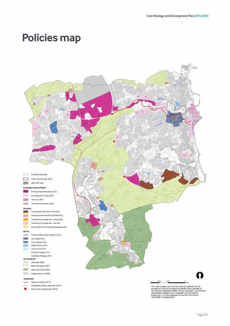
Core Strategy and Development Plan 2015-2033
Page 201
Policies map

Core Strategy and Development Plan 2015-2033
Page 202


oce21157