core management plan including conservation objectives · page 1 of 91 cyngor cefn gwlad cymru...
TRANSCRIPT

Page 1 of 91
CYNGOR CEFN GWLAD CYMRU COUNTRYSIDE COUNCIL FOR WALES
CORE MANAGEMENT PLAN INCLUDING CONSERVATION OBJECTIVES
FOR
RIVER DEE AND BALA LAKE/AFON DYFRDWY A LLYN TEGID SAC
Version: 10 - David Hatcher and Heather Garrett Date: 13.3.08 Approved by: NR Thomas – 15th April 2008

Page 2 of 91
CONTENTS Preface: Purpose of this document 1. Vision For The Site 2. Site Description
2.1 Area and Designations Covered by this Plan 2.2 Outline Description 2.3 Outline of Past and Current Management 2.4 Management Units
3. The Special Features 3.1 Confirmation of Special Features 3.2 Special Features and Management Units
4. Conservation Objectives
Background to Conservation Objectives: 4.1 Conservation Objective for water courses (Rivers): 4.2 Conservation Objective for Feature 1: Water courses of plain to montane
levels with the Ranunculion fluitantis and Callitricho-Batrachion vegetation
4.3 Conservation Objective for Feature : 2 Atlantic salmon Salmo salar 4.4 Conservation Objective for Feature 3 Floating water-plantain Luronium
natans 4.5 Conservation Objective for Features 4, 5, and 6: Sea lamprey Petromyzon
marinus, Brook lamprey Lampetra planeri, River lamprey Lampetra fluviatilis
4.6 Conservation Objective for Feature 7: Bullhead Cottus gobio 4.7 Conservation Objective for Feature 8: European otter Lutra lutra 4.8 Conservation Objectives for lake and marginal wetland SAC & Ramsar
features 9 and 10: The lake and aquatic /emergent vegetation, Lake fen/swamp inc. wet woodland
4.9 Conservation Objective for Feature 11 Gwyniad Coregonus lavaretus 4.10 Conservation Objective for Feature 12: Glutinous snail Myxas glutinosa
5. Assessment of Conservation Status and Management Requirements
5.1 Conservation status and management requirements of Feature 1: Water courses of plain to montane levels with the Ranunculion fluitantis and Callitricho-Batrachion vegetation
5.2 Conservation status and management requirements of Feature 2: Atlantic salmon Salmo salar
5.3 Conservation Status and Management Requirements of Feature 3 Floating water-plantain Luronium natans (Code: 1831)
5.4 Conservation status and management requirements of Feature 4: Sea lamprey Petromyzon marinus
5.5 Conservation status and management requirements of Feature 5: Brook lamprey Lampetra planeri
Page 3 of 91
5.6 Conservation status and management requirements of Feature 6: River Lamprey Lampetra fluviatilis
5.7 Conservation status and management requirements of Feature 7: Bullhead Cottus gobio
5.8 Conservation status and management requirements of Feature 8: European otter Lutra lutra
5.9 Conservation Status and Management Requirements of Feature 9: The lake & aquatic / emergent vegetation (Ramsar)
5.10 Conservation Status and Management Requirements of Feature 10: Lake fen / swamp (Ramsar)
5.11 Conservation Status and Management Requirements of Feature 11: Gwyniad / Coregonus lavaretus (Ramsar)
5.12 Conservation Status and Management Requirements of Feature 12: Glutinous snail / Myxas glutinosa (Ramsar)
6. Action Plan: Summary 7. Glossary 8. References and Annexes
PREFACE This document provides the main elements of CCW’s management plan for the River Dee & Bala Lake SAC. It sets out what needs to be achieved on the site, the results of monitoring and advice on the action required. This document is made available through CCW’s web site and may be revised in response to changing circumstances or new information. This is a technical document that supplements summary information on the web site. One of the key functions of this document is to provide CCW’s statement of the Conservation Objectives for the relevant Natura 2000 site. This is required to implement the Conservation (Natural Habitats, &c.) Regulations 1994, as amended (Section 4). As a matter of Welsh Assembly Government Policy, the provisions of those regulations are also to be applied to Ramsar sites in Wales.

Page 4 of 91
1. VISION FOR THE SITE
This is a descriptive overview of what needs to be achieved for conservation on the site. It brings together and summarises the Conservation Objectives (part 4) into a single, integrated statement about the site. Our vision for the River Dee and Bala Lake SAC is that it will be maintained at, or where necessary restored to, high ecological status with all its features at favourable conservation status. Factors under human control that may significantly affect its feature species or populations in or outside of the site, will be controlled in such a way that the features will sustain themselves as part of a functioning ecosystem. This will be true both for plants and animals whose life cycles remain entirely within the site’s boundaries, and for migratory species that only spend certain stages of their lives in the SAC. Water is clearly fundamental to a riverine SAC. Therefore the quality, quantity and flow variability of water, plus the quality of adjacent habitats, will be maintained or adjusted to a level necessary to maintain the features in favourable condition for the foreseeable future. Natural processes of erosion and deposition will operate without interference. The protected aquatic and emergent plant communities will continue to characterise parts of the river and lake. In addition to enhancing its appearance, such communities provide a good indication of the overall quality of the river and lake environment and provide important habitats for fish and invertebrates. The protected fish species found in this SAC, both those that are resident all year round, such as the bullhead and brook lamprey, and migratory species such as the Atlantic salmon, sea and river lampreys, swim up river to spawn and go through their juvenile stages in the river. These species will be present in numbers that reflect a healthy and sustainable population supported by well-distributed good quality habitat. The migratory fish will be able to complete their migrations and life cycles largely unhindered. Either by artificial barriers such as weirs, disturbance and pollution, or by external factors such as being caught in the by-catch of fishing operations at sea. Llyn Tegid is the largest natural lake in Wales. It will have a healthy ecosystem that is not suffering from nutrient enrichment or acidification, and where use as a reservoir does not impinge on its wildlife interest. As a result, it supports flourishing populations of three rare species: gwyniad, glutinous snail, and floating water-plantain. The abundance of prey and widespread availability of undisturbed resting and breeding sites, will allow a large otter population to thrive. Otters will be found throughout the SAC and in adjacent, supporting habitat.
Page 5 of 91
2. SITE DESCRIPTION
2.1 Area and Designations Covered by this Plan
Grid reference(s): SH887311 to SJ287710 Unitary authority(ies): Gwynedd Council,
Denbighshire County Council, Wrexham County Borough Council, Flintshire County Council, Snowdonia National Park Authority
Area (hectares): 1151 ha Designations covered:
Llyn Tegid SSSI Llyn Tegid Ramsar Site
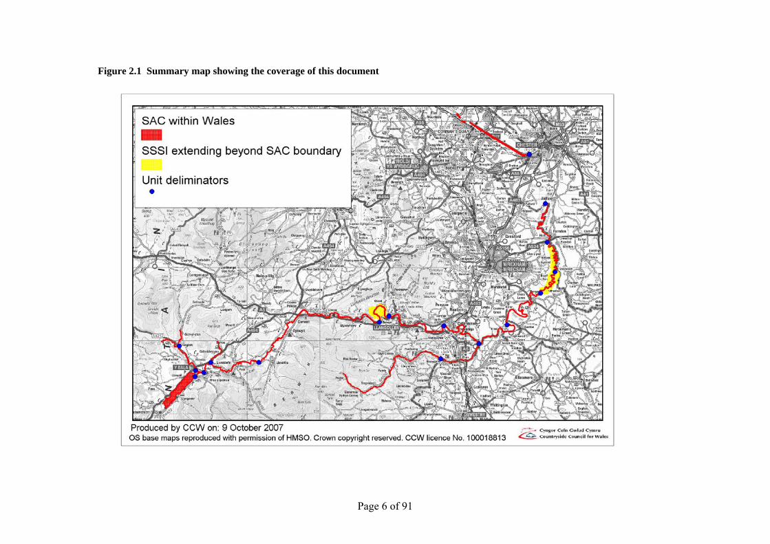
Afon Dyfrdwy (River Dee) SSSI Detailed maps of the designated sites are available through CCW’s web site: www.ccw.gov.uk/sites (address tbc) A summary map showing the coverage of this document is shown below in Figure 2.1
Page 6 of 91
Figure 2.1 Summary map showing the coverage of this document

Page 7 of 91

Page 8 of 91
2.2 Outline Description
The source of the River Dee lies within the Snowdonia National Park and its catchment contains a wide spectrum of landscapes from high mountains around Bala, steep-sided wooded valleys, near Llangollen, to the rich agricultural plains of Cheshire and north Shropshire and the vast mudflats of the estuary. The course and topography of the River Dee and its tributaries were strongly influenced and modified during the last Ice Age. The underlying geology of the Dee ranges from impermeable Cambrian and Ordovician shales in the west, through Silurian to Carboniferous Limestone outcrop at Llangollen to Coal Measures and thick boulder clay overlying the Triassic sandstones of the Lower Dee valley. The site extends from the western extremity of Llyn Tegid taking in the entire lake and its banks to its outfall into the River Dee. It then takes in the river and its banks downstream to where it joins the Dee Estuary SSSI. A number of the Dee’s tributaries are also included, these being the Ceiriog, Meloch, Tryweryn, and Mynach. In its swifter upper reaches, the Dee flows through the broad valley near Corwen, and the spectacular Vale of Llangollen before entering the Cheshire plain at Erbistock where it meanders northwards through the Cheshire plain to Chester. Below Chester Weir, the river is largely Estuarine in character. However there is a tidal influence as far upstream as Farndon, as high tides regularly exceed the weir’s height. In its slower, more mature reaches the river is characteristic of a floodplain river with meanders, oxbows and other river-formed landscape features. Llyn Tegid, the Tryweryn and the Dee form part of the River Dee Regulation System. The flow of water is controlled by Environment Agency Wales (EAW), primarily in order to minimise flooding and for the transportation of water to abstraction points down stream. The level of control is such that the Dee itself is said to be the most regulated river in Europe. However, of the water that reaches Chester, only about a third is regulated by EAW (This is based on an average.,the proportion varies depending on conditions and operational requirements). Of the tributaries within the SAC and SSSI, the only regulated tributary is the Afon Tryweryn,. Parts of the Rivers Dee and Ceiriog lie within both Wales and England. They have therefore been notified as two separate SSSIs – the Afon Dyfrdwy (River Dee) SSSI in Wales and the River Dee (England) SSSI in England. However, the features for which the SSSIs are notified, in particular migratory fish, depend upon the whole river ecosystem.
2.3 Outline of Past and Current Management
The River Dee is probably the most regulated river in Western Europe, providing drinking water for a large population in NW England and NE Wales, in addition to providing water for the Shropshire Union Canal and flood control. Several major lakes and storage reservoirs are situated in the upper part of the basin, including Llyn Tegid; the largest natural lake in Wales.
Llyn Tegid was first used for river regulation in the early 1800s when Thomas Telford constructed a weir at the outlet to permit controlled releases to sustain flows into the Shropshire Union Canal at Llangollen. The most significant changes however occurred in 1956 when the Dee and Clwyd River Board constructed the Bala Lake Scheme, creating the present regulation facilities. The natural lake outlet was lowered by approximately 2 metres, sluice gates were built and the Afon Tryweryn was diverted to join the River Dee, downstream of the lake.

Page 9 of 91
The river is an important fishing and tourist facility. In recent years there have been several pollution incidents arising from industrial and agricultural activity that have caused fish kills.
Llyn Tegid has also been vulnerable to blue-green algal blooms, related to phosphate enrichment from the surrounding catchment. This is being tackled through a multi-agency/ local community initiative.
Further improvement will hopefully be achieved through the Catchment Management Plan being developed by EAW under the Water Framework Directive.
2.4 Management Units
The site has been divided into management units to enable practical communication about features, objectives, and management. This will also allow us to differentiate between the different designations where necessary. In this plan the management unit divisions have been based on the following:
• SSSI boundaries • Tributary confluences • Natural hydromorphology • Artificial barriers where they mark a change in river character • National boundaries • Unitary Authority Boundaries • The tidal and navigational limit • The units include one or more of EA’s River Basin Management Plan water bodies; as far as
is practicable unit boundaries coincide with these water body boundaries.
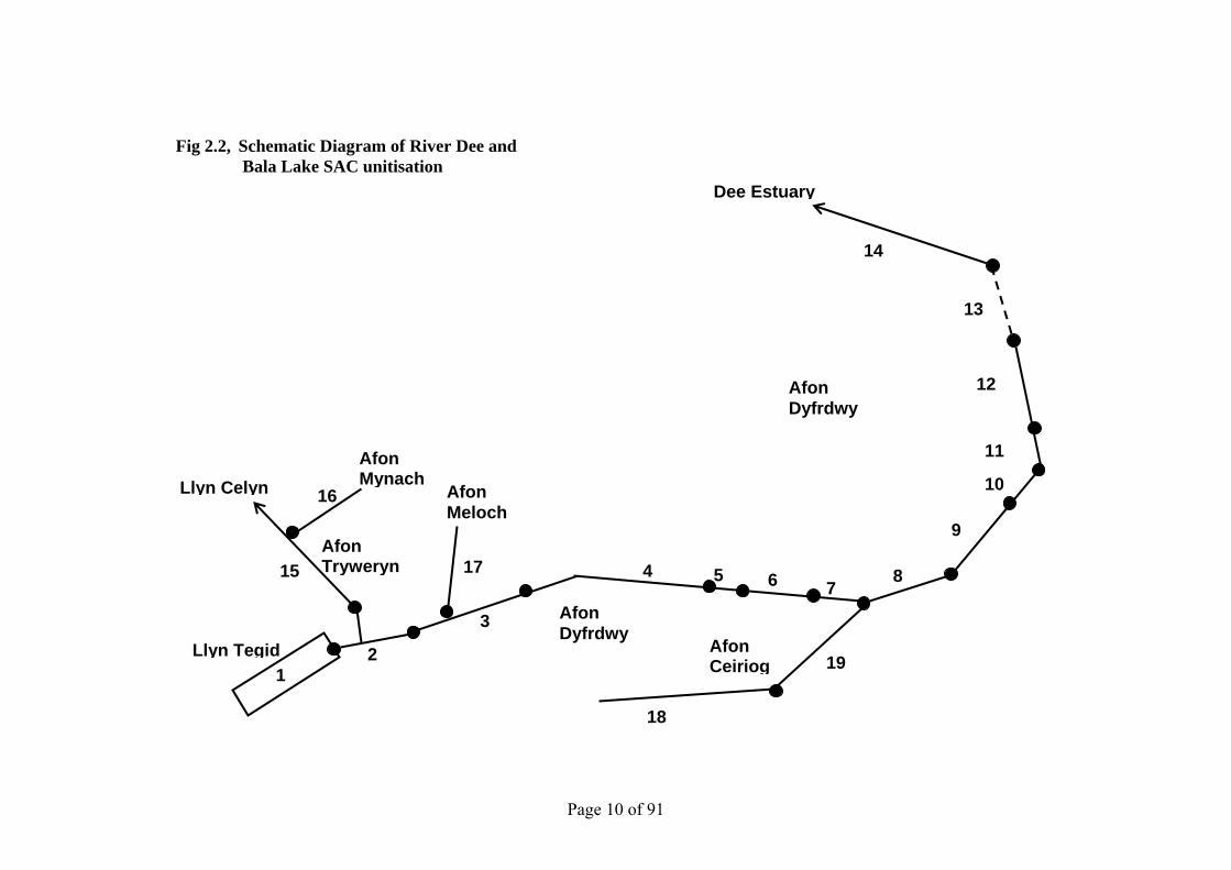
A map and schematic diagram showing the management units referred to in this plan is shown above in Figure 2.1 and below in Figure 2.2. Section 2.4.1 gives a brief description of each unit and the reasoning for the location of its deliminators.
Page 10 of 91
Fig 2.2, Schematic Diagram of River Dee and Bala Lake SAC unitisation
Dee Estuary
11
18
17
16
15
21
10
3
19
4
9
8765
Llyn Celyn
Afon Tryweryn
Afon Ceiriog
Afon Dyfrdwy
Afon Mynach
Afon Meloch
Llyn Tegid
12
13
Afon Dyfrdwy
14

Page 11 of 91
Table 2.1 Management Unit Descriptions
Ref Unique
Unit No Title Description
1 1768 Llyn Tegid All of Bala lake to its outfall
2 1769 Tegid outfall to gauging weir
The impounded sections of the Dee and and lower Treweryn down to the gauging weir just to the west of Bala. These sections are largely canalised and comprise the sluices controlling the water entering the Dee downstream.
3 1770 Gauging weir to Gwynedd exit
From the gauging weir just to the west of Bala to the Unitary Authority boundary where the river leaves the area administered by Gwynedd Council and enters that of Denbighshire County Council. Note that for the last approximately 1200m the river forms the boundary itself.
4 1771 Denbighshire C C entry to the start of the Rhewl Section
Denbighshire County Council Unitary Authority boundary to the start of the “Rhewl Section” of the Dee SSSI.
5 1772 Rhewl Section to Horseshoe falls
Primarily the Rhewl Section of the Dee SSSI which, prior to the notification of the river, this was a SSSI in its own right for geomorphological reasons (these will be explained later in Section 3.2). However the down stream end of this unit reaches a little beyond this to end at Horseshoe falls. This is for ecological reasons (Also explained later in Section 3.2).
6 1773 Horseshoe falls to Denbighshire CC end
From the Horseshoe falls to the Unitary Authority boundary where the river leaves the area administered by Denbighshire County Council and enters that of Wrexham County Borough Council (Note that for the last approximately 2000m the river forms the boundary between these authorities). The down stream limit of this unit coincides with the location of the B5434 Cysyllte Bridge
7 1774 Wrexham C B Council entry to the Afon Ceiriog confluence
From the point at which the Dee enters Wrexham County Borough Council Unitary Authority to the confluence with the Afon Ceiriog. At the downstream limit of this unit the Dee becomes the boundary between Wales and England.
8 1775 Afon Ceiriog confluence to Erbistock Weir
From the confluence with the Afon Ceiriog to Erbistock Weir. For most of this section the Dee forms the Welsh national boundary. The river is also an SSSI in England, where this unit abuts part of Unit 3 of the River Dee (England) SSSI
The weir largely demarcates a change in the nature of the river. Above it the river is relatively steep, flowing through entrenched meanders and gorges, to loose approximately 130m in height from Bala. Below the weir the gradient tends to be much lower as the Dee

Page 12 of 91
flows across the Cheshire Plain. Here it is characterised by complex, sometimes active meanders as it falls only another 25m or so before reaching Chester.
9 1776 Erbistock Weir to start of Holt to Worthenbury Section
From Erbistock Weir to the start of the “Holt to Worthenbury Section”. This unit is only separated from that downstream of it because the latter is another former geomorphological SSSI where the SSSI boundary reaches out into the floodplain.
10 1777 Holt to Worthenbury Section wholly within Wales
Holt to Worthenbury Section is wholly within Wales, from just north of Bangor on Dee to west of Shocklatch, where site reaches the Welsh/English border. Prior to the notification of the rive Dee, the Holt to Worthenbury Section was a cross-border SSSI, in its own right, for geomorphological reasons (these will be explained later in Section 3.2). It is now split along the national boundary with what was the English part of the site now forming Unit 2 of the River Dee (England) SSSI.
11 1778 Holt to Worthenbury Section from Shocklatch to Holt
Continuation of what was the Holt to Worthenbury SSSI from Shocklatch to Holt. In this section, the river largely forms the Wales/England border. Prior to the notification of the rive Dee, the Holt to Worthenbury Section was a cross-border SSSI, in its own right, for geomorphological reasons (these will be explained later in Section 3.2). It is now split along the national boundary with what was the English part of the site now forming Unit 2 of the River Dee (England) SSSI.
12 1779 End of Holt to Worthenbury Section to England
From the northern, downstream end of the Holt to Worthenbury section to where both banks of the Dee are in England. For all most all of this unit the river forms the border between Wales and England. The river is also a SSSI in England, so this unit abuts part of Unit 1 of the River Dee (England) SSSI
13 1780 Section Entirely Within England
See Natural England (NE) for details on this section.
Section where the Dee is entirely within England. It includes the city of Chester and significantly, Chester Weir. There is a limited tidal influence upstream to somewhere near the town of Holt but Chester Weir marks the major transition between a largely non-tidal, freshwater environment and that of a tidal, saline, canalised river. The river is also an SSSI in England with this unit forming part of Unit 1 of the River Dee (England) SSSI.
14 1781 English Border to Dee Estuary SSSI
Where the Dee emerges from England to where it joins the Dee Estuary SSSI, SAC etc. This is a predominately canalised section. At its north-western limit there are two small unconnected parts of the site. These were areas not included in the Dee Estuary SSSI which was notified some time before the river. It was therefore necessary to notify them as part of the River Dee site.
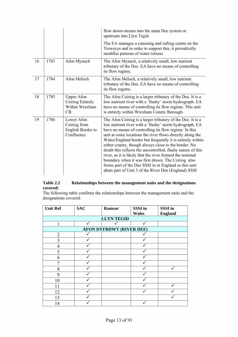
15 1782 Afon Treweryn The Afon Treweryn. This carries water from Llyn Celyn to Section R1 from which it may either be allowed to
Page 13 of 91
flow down-stream into the main Dee system or upstream into Llyn Tegid.
The EA manages a canoeing and rafting centre on the Treweryn and in order to support this, it periodically modifies patterns of water release
16 1783 Afon Mynach The Afon Mynach, a relatively small, low nutrient tributary of the Dee. EA have no means of controlling its flow regime.
17 1784 Afon Meloch The Afon Meloch, a relatively small, low nutrient tributary of the Dee. EA have no means of controlling its flow regime.
18 1785 Upper Afon Ceiriog Entirely Within Wrexham CB
The Afon Ceiriog is a larger tributary of the Dee. It is a low nutrient river with a ‘flashy’ storm hydrograph. EA have no means of controlling its flow regime. This unit is entirely within Wrexham Connty Borough.
19 1786 Lower Afon Ceiriog from English Border to Confluence
The Afon Ceiriog is a larger tributary of the Dee. It is a low nutrient river with a ‘flashy’ storm hydrograph. EA have no means of controlling its flow regime. In this unit at some locations the river flows directly along the Wales/England border but frequently it is entirely within either county, though always close to the border. No doubt this reflects the uncontrolled, flashy nature of this river, as it is likely that the river formed the notional boundary when it was first drawn. The Ceiriog also forms part of the Dee SSSI in in England so this unit abuts part of Unit 3 of the River Dee (England) SSSI
Table 2.2 Relationships between the management units and the designations covered: The following table confirms the relationships between the management units and the designations covered:
Unit Ref SAC Ramsar SSSI in
Wales SSSI in England
LLYN TEGID 1
AFON DYFRDWY (RIVER DEE) 2 3 4 5 6 7 8 9
10 11 12 13 14

Page 14 of 91
15 16 17 18 19
Page 15 of 91
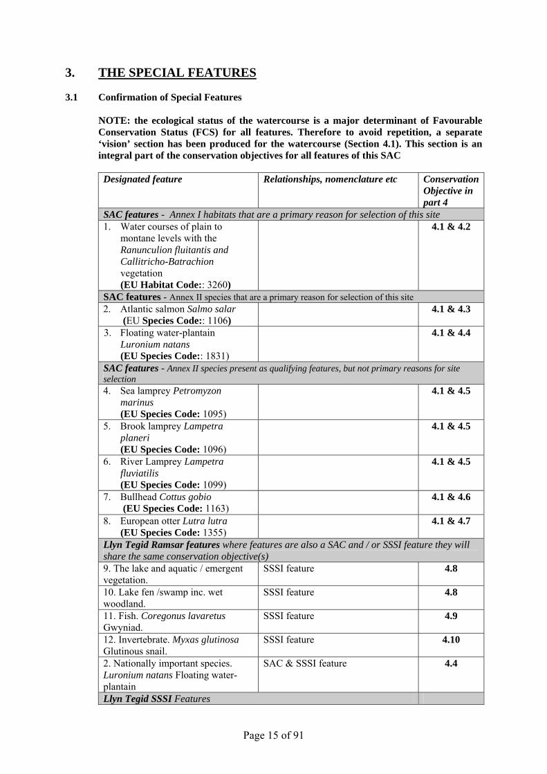
3. THE SPECIAL FEATURES 3.1 Confirmation of Special Features NOTE: the ecological status of the watercourse is a major determinant of Favourable
Conservation Status (FCS) for all features. Therefore to avoid repetition, a separate ‘vision’ section has been produced for the watercourse (Section 4.1). This section is an integral part of the conservation objectives for all features of this SAC
Designated feature Relationships, nomenclature etc Conservation
Objective in part 4
SAC features - Annex I habitats that are a primary reason for selection of this site 1. Water courses of plain to
montane levels with the Ranunculion fluitantis and Callitricho-Batrachion vegetation (EU Habitat Code:: 3260)
4.1 & 4.2
SAC features - Annex II species that are a primary reason for selection of this site 2. Atlantic salmon Salmo salar
(EU Species Code:: 1106) 4.1 & 4.3
3. Floating water-plantain Luronium natans (EU Species Code:: 1831)
4.1 & 4.4
SAC features - Annex II species present as qualifying features, but not primary reasons for site selection 4. Sea lamprey Petromyzon
marinus (EU Species Code: 1095)
4.1 & 4.5
5. Brook lamprey Lampetra planeri (EU Species Code: 1096)
4.1 & 4.5
6. River Lamprey Lampetra fluviatilis (EU Species Code: 1099)
4.1 & 4.5
7. Bullhead Cottus gobio (EU Species Code: 1163)
4.1 & 4.6
8. European otter Lutra lutra (EU Species Code: 1355)
4.1 & 4.7
Llyn Tegid Ramsar features where features are also a SAC and / or SSSI feature they will share the same conservation objective(s) 9. The lake and aquatic / emergent vegetation.
SSSI feature 4.8
10. Lake fen /swamp inc. wet woodland.
SSSI feature 4.8
11. Fish. Coregonus lavaretus Gwyniad.
SSSI feature 4.9
12. Invertebrate. Myxas glutinosa Glutinous snail.
SSSI feature 4.10
2. Nationally important species. Luronium natans Floating water-plantain
SAC & SSSI feature 4.4
Llyn Tegid SSSI Features
Page 16 of 91
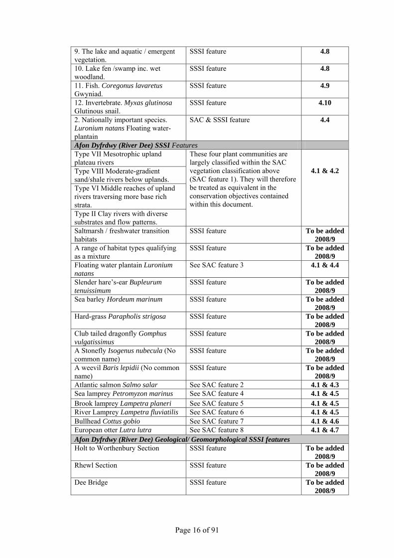
9. The lake and aquatic / emergent vegetation.
SSSI feature 4.8
10. Lake fen /swamp inc. wet woodland.
SSSI feature 4.8
11. Fish. Coregonus lavaretus Gwyniad.
SSSI feature 4.9
12. Invertebrate. Myxas glutinosa Glutinous snail.
SSSI feature 4.10
2. Nationally important species. Luronium natans Floating water-plantain
SAC & SSSI feature 4.4
Afon Dyfrdwy (River Dee) SSSI Features Type VII Mesotrophic upland plateau rivers Type VIII Moderate-gradient sand/shale rivers below uplands. Type VI Middle reaches of upland rivers traversing more base rich strata. Type II Clay rivers with diverse substrates and flow patterns.
These four plant communities are largely classified within the SAC vegetation classification above (SAC feature 1). They will therefore be treated as equivalent in the conservation objectives contained within this document.
4.1 & 4.2
Saltmarsh / freshwater transition habitats
SSSI feature To be added 2008/9
A range of habitat types qualifying as a mixture
SSSI feature To be added 2008/9
Floating water plantain Luronium natans
See SAC feature 3 4.1 & 4.4
Slender hare’s-ear Bupleurum tenuissimum
SSSI feature To be added 2008/9
Sea barley Hordeum marinum SSSI feature To be added 2008/9
Hard-grass Parapholis strigosa SSSI feature To be added 2008/9
Club tailed dragonfly Gomphus vulgatissimus
SSSI feature To be added 2008/9
A Stonefly Isogenus nubecula (No common name)
SSSI feature To be added 2008/9
A weevil Baris lepidii (No common name)
SSSI feature To be added 2008/9
Atlantic salmon Salmo salar See SAC feature 2 4.1 & 4.3 Sea lamprey Petromyzon marinus See SAC feature 4 4.1 & 4.5 Brook lamprey Lampetra planeri See SAC feature 5 4.1 & 4.5 River Lamprey Lampetra fluviatilis See SAC feature 6 4.1 & 4.5 Bullhead Cottus gobio See SAC feature 7 4.1 & 4.6 European otter Lutra lutra See SAC feature 8 4.1 & 4.7 Afon Dyfrdwy (River Dee) Geological/ Geomorphological SSSI features Holt to Worthenbury Section SSSI feature To be added
2008/9 Rhewl Section SSSI feature To be added
2008/9 Dee Bridge SSSI feature To be added
2008/9

Page 17 of 91
3.2 Special Features and Management Units This section sets out the relationship between the special features and each management unit. This is intended to provide a clear statement about what each unit should be managed for, taking into account the varied needs of the different special features. All special features are allocated to one of seven classes in each management unit. These classes are:
Key Features KH - a ‘Key Habitat’ in the management unit, i.e. the habitat that is the main driver of management and focus of monitoring effort, perhaps because of the dependence of a key species (see KS below). There will usually only be one Key Habitat in a unit but there can be more, especially with large units. KS – a ‘Key Species’ in the management unit, often driving both the selection and management of a Key Habitat. Geo – an earth science feature that is the main driver of management and focus of monitoring effort in a unit. Other Features Sym - habitats, species and earth science features that are of importance in a unit but are not the main drivers of management or focus of monitoring. These features will benefit from management for the key feature(s) identified in the unit. These may be classed as ‘Sym’ features because: a) they are present in the unit but may be of less conservation importance than the key
feature; and/or b) they are present in the unit but in small areas/numbers, with the bulk of the feature in
other units of the site; and/or c) their requirements are broader than and compatible with the management needs of the key
feature(s), e.g. a mobile species that uses large parts of the site and surrounding areas. Nm - an infrequently used category where features are at risk of decline within a unit as a result of meeting the management needs of the key feature(s), i.e. under Negative Management. These cases will usually be compensated for by management elsewhere in the plan, and can be used where minor occurrences of a feature would otherwise lead to apparent conflict with another key feature in a unit. Mn - Management units that are essential for the management of features elsewhere on a site.g. livestock over-wintering area included within designation boundaries, buffer zones around water bodies, etc. x – Features not known to be present in the management unit.
The tables below sets out the relationship between the special features and management units identified in this plan:
Llyn Tegid SSSI Management Unit L1 SAC Ramsar SAC features 1. Atlantic salmon Salmo salar KS 2. Floating water-plantain Luronium natans KS 5. Brook lamprey Lampetra planeri KS 7. Bullhead Cottus gobio KS 8. Otter Lutra lutra KS Llyn Tegid Ramsar features (but not SAC features) 9. The lake and aquatic / emergent vegetation. KS / KH 10. Lake fen /swamp inc. wet woodland. KS 11. Fish. Coregonus lavaretus Gwyniad. KS 12. Invertebrate. Myxas glutinosa Glutinous snail. KS

Page 18 of 91

Page 19 of 91
Afon Dyfrdwy (River Dee) Management Unit 2 3 4 5 6 7 8 9 10 11 12 13 14 15 16 17 18 19 SAC SSSI in Wales SSSI in England SAC features 1. Water courses of plain to montane levels
with the Ranunculion fluitantis and Callitricho-Batrachion vegetation
sym KH KH KH KH KH KH KH KH KH KH KH x KH KH KH KH KH
2. Atlantic salmon Salmo salar KS KS KS KS KS KS KS KS KS KS KS KS KS KS KS KS KS KS 3. Floating water-plantain Luronium
natans KS x x x x x x x x x x x x x x x x x
4. Sea lamprey Petromyzon marinus x x x x x x x KS KS KS KS KS KS x x x sym sym 5. Brook lamprey Lampetra planeri KS KS KS KS KS KS KS KS KS KS KS KS sym KS KS KS KS KS 6. River Lamprey Lampetra fluviatilis x x x KS KS KS KS KS KS KS KS KS KS x x x KS KS 7. Bullhead Cottus gobio KS KS KS KS KS KS KS KS KS KS KS KS x KS KS KS KS KS 8. European otter Lutra lutra KS KS KS KS KS KS KS KS KS KS KS KS sym KS KS KS KS KS SSSI Afon Dyfrdwy (River Dee). Not covered by management to SAC features
To be added SSSI in England features To be added

Page 20 of 91
4. CONSERVATION OBJECTIVES
Background to Conservation Objectives:
a. Outline of the legal context and purpose of conservation objectives.
Conservation objectives are required by the 1992 ‘Habitats’ Directive (92/43/EEC). The aim of the Habitats Directives is the maintenance, or where appropriate the restoration of the ‘favourable conservation status’ of habitats and species features for which SACs and SPAs are designated (see Box 1). In the broadest terms, 'favourable conservation status' means a feature is in satisfactory condition and all the things needed to keep it that way are in place for the foreseeable future. CCW considers that the concept of favourable conservation status provides a practical and legally robust basis for conservation objectives for Natura 2000 and Ramsar sites.
Achieving these objectives requires appropriate management and the control of factors that may cause deterioration of habitats or significant disturbance to species. As well as the overall function of communication, Conservation objectives have a number of specific roles: • Conservation planning and management.
The conservation objectives guide management of sites, to maintain or restore the habitats and species in favourable condition.
• Assessing plans and projects.
Box 1 Favourable conservation as defined in Articles 1(e) and 1(i) of the Habitats Directive “The conservation status of a natural habitat is the sum of the influences acting on it and its typical species that may affect its long-term natural distribution, structure and functions as well as the long term survival of its typical species. The conservation status of a natural habitat will be taken as favourable when:
• Its natural range and areas it covers within that range are stable or increasing, and • The specific structure and functions which are necessary for its long-term
maintenance exist and are likely to continue to exist for the foreseeable future, and • The conservation status of its typical species is favourable.
The conservation status of a species is the sum of the influences acting on the species that may affect the long-term distribution and abundance of its populations. The conservation status will be taken as ‘favourable’ when:
• population dynamics data on the species indicate that it is maintaining itself on a
long-term basis as a viable component of its natural habitats, and • the natural range of the species is neither being reduced nor is likely to be reduced
for the foreseeable future, and • There is, and will probably continue to be, a sufficiently large habitat to maintain
its populations on a long-term basis.”

Page 21 of 91
Article 6(3) of the ‘Habitats’ Directive requires appropriate assessment of proposed plans and projects against a site's conservation objectives. Subject to certain exceptions, plans or projects may not proceed unless it is established that they will not adversely affect the integrity of sites. This role for testing plans and projects also applies to the review of existing decisions and consents.
• Monitoring and reporting.
The conservation objectives provide the basis for assessing the condition of a feature and the status of factors that affect it. CCW uses ‘performance indicators’ within the conservation objectives, as the basis for monitoring and reporting. Performance indicators are selected to provide useful information about the condition of a feature and the factors that affect it.
The conservation objectives in this document reflect CCW’s current information and understanding of the site and its features and their importance in an international context. The conservation objectives are subject to review by CCW in light of new knowledge. b. Format of the conservation objectives There is one conservation objective for each feature listed in part 3. Each conservation objective is a composite statement representing a site-specific description of what is considered to be the favourable conservation status of the feature. These statements apply to a whole feature as it occurs within the whole plan area, although section 3.2 sets out their relevance to individual management units. Each conservation objective consists of the following two elements:
1. Vision for the feature 2. Performance indicators
As a result of the general practice developed and agreed within the UK Conservation Agencies, conservation objectives include performance indicators, the selection of which should be informed by JNCC guidance on Common Standards Monitoring1. There is a critical need for clarity over the role of performance indicators within the conservation objectives. A conservation objective, because it includes the vision for the feature, has meaning and substance independently of the performance indicators, and is more than the sum of the performance indicators. The performance indicators are simply what make the conservation objectives measurable, and are thus part of, not a substitute for, the conservation objectives. Any feature attribute identified in the performance indicators should be represented in the vision for the feature, but not all elements of the vision for the feature will necessarily have corresponding performance indicators. As well as describing the aspirations for the condition of the feature, the Vision section of each conservation objective contains a statement that the factors necessary to maintain those desired conditions are under control. Subject to technical, practical and resource constraints, factors which have an important influence on the condition of the feature are identified in the performance indicators.
1 Web link: http://www.jncc.gov.uk/page-2199

Page 22 of 91
4.1 Conservation Objective for water courses (Rivers): While not a feature in its own right the ecological status of the water course is a major factor in determining FCS for all of the site features. The vision for the water course is therefore described below. This section is an integral part of the conservation objectives for all features of this SAC Vision For the Water Course The vision for the water course is for it to be in favourable conservation status, where all of the following conditions are satisfied: 1. The ecological status of the water environment should be sufficient to maintain a stable or
increasing population of each feature. This will include elements of water quantity and quality, physical habitat and community composition and structure (It is anticipated that these limits will concur with the relevant standards used by the Review of Consents process).
2. There will be no deterioration in water quality other than that temporarily generated by natural variations in water flow or by man made variations occurring as a result of operating the River Dee flow control regime within its normal operating parameters.
3. The Dee flow regime should remain within 10% of ‘recent actual flow’ as described by Bethune (2006).
4. The river planform and profile should be predominantly unmodified. Physical modifications having an adverse effect on the integrity of the SAC will be avoided.
5. Artificial factors impacting on the capability of each feature to occupy the full extent of its potential range should be modified where necessary to allow passage, eg. weirs, bridge sills, or other forms of barrier.
6. Natural limiting factors such as waterfalls, which may limit the natural range of a feature or its dispersal between naturally isolated populations, should not be modified.
7. Flow objectives for assessment points in the Dee Catchment Abstraction Management Strategy will be agreed between EA and CCW as necessary.
8. Levels for nutrients, in particular phosphate, will be agreed between EA and CCW for each Water Framework Directive water body in the River Dee and Bala Lake SAC, and measures taken to maintain nutrients below these levels (It is anticipated that these limits will concur with the standards used by the Review of Consents process).
9. The levels of water quality parameters, in addition to those deemed to be nutrients and including levels of suspended solids, that may affect the distribution and abundance of SAC features will be agreed between EA and CCW for each Water Framework Directive water body in the River Dee and Bala Lake SAC, and measures taken to maintain them below these levels (It is anticipated that these limits will concur with the standards used by the Review of Consents process).
10. Potential sources of pollution, nutrient enrichment and/or suspended solids that have not been addressed in the Review of Consents such as, but not confined to, diffuse pollution or disturbance to sediments, will be considered in assessing plans and projects.

Page 23 of 91
4.2 Conservation Objective for Feature 1:
Water courses of plain to montane levels with the Ranunculion fluitantis and Callitricho-Batrachion vegetation (EU Habitat Code: 3260) Vision for feature 1 The vision for this feature is for it to be in a favourable conservation status, where all of the following conditions are satisfied: 1. The conservation objective for the water course as defined in 4.1 above must be met 2. The extent of this feature within its potential range in this SAC should be stable or increasing 3. The extent of the sub-communities that are represented within this feature should be stable or
increasing. 4. The conservation status of the feature’s typical species should be favourable. 5. All known, controllable factors, affecting the achievement of these conditions are under control
(many factors may be unknown or beyond human control). Performance indicators for Feature 1 The performance indicators are part of the conservation objective, not a substitute for it. Assessment of plans and projects must be based on the entire conservation objective, not just the performance indicators. Performance indicators for feature condition Attribute Attribute rationale and other comments Specified limits A1. Distribution within catchment
Though surveys have identified this feature at various sample sites, the feature’s extent, or the extent of suitable habitat for it, within the protected site has never been mapped (The fluvial audit of the Dee (Hill and Emery, 2004) recorded vegetation cover of the river bed and looked at statistical associations with certain other variables. They did not however identify this SAC feature vegetation community)
Upper limit: Insufficient information Lower limit: Insufficient information May occur in all site units except 1 and 14
Typical species Should conform to Plant community: species composition and abundance targets in Table 1a of the current version of JNCC’s Common Standards Monitoring Guidance for Rivers (Current version – March 2005)
Upper limit: Insufficient information Lower limit: See Table 1a of the current version of JNCC’s Common Standards Monitoring Guidance for Rivers
Plant community Reproduction
For this attribute, the ‘Targets’, ‘Method of assessment’, and ‘Comments’ criteria are as those described in Table 1a of the current version of JNCC’s Common Standards Monitoring Guidance for Rivers (Current version – March 2005), except for the lower limit. In the guidance, the ‘minimum value is defined in terms of the “total habitat / macrophyte population that should be left uncut”. For the Dee percentages of total habitat area or total macrophyte population cannot be expressed because
See comments (to the left) for details of when cutting can occur. Upper limit: at least 50% of the habitat / macrophyte population should be left uncut for the full duration of the remaining growing season and there should be no further cutting at the same location for at least two further growing seasons. Lower limit: Nil

Page 24 of 91
the total area covered by the habitat is not known. Therefore in this SAC, the value expressed applies to a percentage of the width of channel, but only at locations where control measures such as weed cutting are an established practice as agreed by CCW. In all other locations there should be no cutting of feature vegetation.
Performance indicators for factors affecting the feature Factor Factor rationale and other comments Operational Limits
Bank and riparian zone vegetation
In addition to being integral to SSSI river habitat (plant community) types, it is clear that the various types of semi-natural bank and riparian zone vegetation each contribute to the ecological well being of the site and its features in different ways. Examples include: -
• Fallen leaves - these provide of a source of allochthonous vegetative input to the aquatic food web.
• Fallen trees and branches –
woody debris in the water provides cover for fish and invertebrates, and may generate eddies that aid their movement within the site.
• Fringing and emergent
vegetation at the waters edge provides cover for juvenile fish and invertebrates
• Dense vegetation on river banks
provides a buffer between intensively farmed land and the river
• Ground layer, dense scrub and
woodland vegetation on river banks provide a range of terrestrial habitat for otter.
Conversely, dense woodland excludes light from the river and may limit the extent of this feature. In view of these and other known and unknown associated factors, the “mosaic” objective should ensure that all the wide-ranging interactions between bank-side
Upper limit : None set Lower limit: Bank and riparian zone vegetation should form a semi-natural mosaic. However, where it forms part of a plant community classified as a qualifying SSSI habitat feature, it should remain within its notified classification
Page 25 of 91
vegetation and the in-river ecosystem can continue to take place.
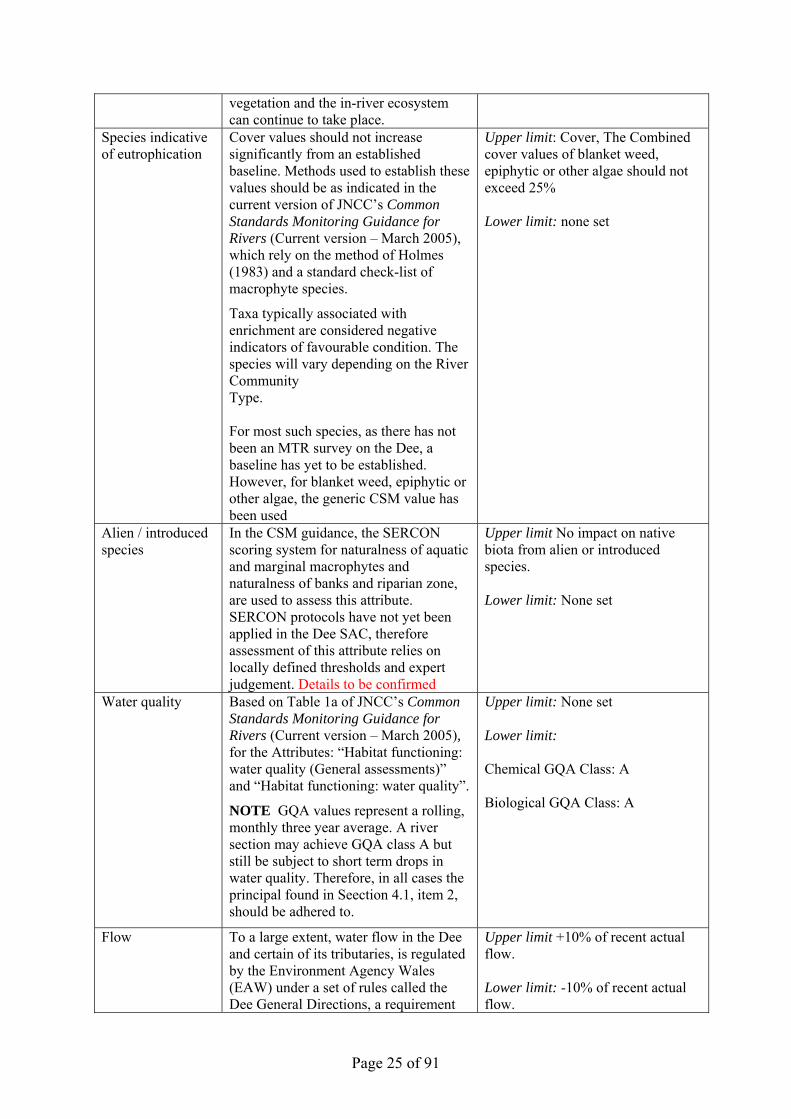
Species indicative of eutrophication
Cover values should not increase significantly from an established baseline. Methods used to establish these values should be as indicated in the current version of JNCC’s Common Standards Monitoring Guidance for Rivers (Current version – March 2005), which rely on the method of Holmes (1983) and a standard check-list of macrophyte species.
Taxa typically associated with enrichment are considered negative indicators of favourable condition. The species will vary depending on the River Community Type. For most such species, as there has not been an MTR survey on the Dee, a baseline has yet to be established. However, for blanket weed, epiphytic or other algae, the generic CSM value has been used
Upper limit: Cover, The Combined cover values of blanket weed, epiphytic or other algae should not exceed 25% Lower limit: none set
Alien / introduced species
In the CSM guidance, the SERCON scoring system for naturalness of aquatic and marginal macrophytes and naturalness of banks and riparian zone, are used to assess this attribute. SERCON protocols have not yet been applied in the Dee SAC, therefore assessment of this attribute relies on locally defined thresholds and expert judgement. Details to be confirmed
Upper limit No impact on native biota from alien or introduced species. Lower limit: None set
Water quality Based on Table 1a of JNCC’s Common Standards Monitoring Guidance for Rivers (Current version – March 2005), for the Attributes: “Habitat functioning: water quality (General assessments)” and “Habitat functioning: water quality”.
NOTE GQA values represent a rolling, monthly three year average. A river section may achieve GQA class A but still be subject to short term drops in water quality. Therefore, in all cases the principal found in Seection 4.1, item 2, should be adhered to.
Upper limit: None set Lower limit: Chemical GQA Class: A Biological GQA Class: A
Flow To a large extent, water flow in the Dee and certain of its tributaries, is regulated by the Environment Agency Wales (EAW) under a set of rules called the Dee General Directions, a requirement
Upper limit +10% of recent actual flow. Lower limit: -10% of recent actual flow.

Page 26 of 91
of the Dee and Clwyd River Authority Act 1973. The Dee was made a SSSI and SAC with these directions in place. Therefore any change to the flow regime would require assessment under Regulation 48 of the Habitats Regulations 1994. The meaning of “recent actual flow” is as described by Bethune (2006)
Light levels This factor is partly addressed above in relation to “Bank and riparian zone vegetation” and “Species indicative of eutrophication”. However, light levels reaching this feature vegetation community may be affected by other factors such as buildings, bridges or other structures. The specific ranges and values of light parameters beyond which this feature would be significantly effected is not known and therefore in all cases of doubt, the precautionary principal should apply
Upper limit: Insufficient information Lower limit: Insufficient information
4.3 Conservation Objective for Feature : 2 Atlantic salmon Salmo salar (EU Species Code : 1106) Vision for feature 2 The vision for this feature is for it to be in a favourable conservation status, where all of the following conditions are satisfied: 1. The parameters defined in the vision for the water course as defined in 4.1 above must be met 2. The SAC feature populations will be stable or increasing over the long term. 3. The natural range of the features in the SAC is neither being reduced nor is likely to be reduced
for the foreseeable future. 4. There will be no reduction in the area or quality of habitat for the feature populations in the SAC
on a long-term basis 5. All known, controllable factors, affecting the achievement of these conditions are under control
(many factors may be unknown or beyond human control). Performance indicators for fish feature species. The performance indicators are part of the conservation objective, not a substitute for it. Assessment of plans and projects must be based on the entire conservation objective, not just the performance indicators. Performance indicators for feature condition Attribute Attribute rationale and other comments Specified limits

Page 27 of 91
A1. Adult run size CSM guidance states: Total run size at least matching an agreed reference level, including a seasonal pattern of migration characteristic of the river and maintenance of the multi-sea-winter component.
For the river Dee the Conservation Limit (CL) is 5100 spawning adults per year and the Management Limit (ML) is 6300 spawning adults per year (from Davidson (2005) but details also given in Pisces Conservation Ltd, (2007).
Upper limit: None Set Lower limit: Conservation Limit 5100 spawning adults per year complied with at least four years in five.
A2. Juvenile densities
CSM guidance states: These should not differ significantly from those expected for the river type/reach under conditions of high physical and chemical quality.
Assessed using electrofishing data.
Upper limit: Lower limit: Expected densities for each sample site using HABSCORE (Cowx and Fraser, 2003).
Performance indicators for factors affecting the feature Factor Factor rationale and other comments Operational Limits
Water Quality Based on JNCC’s Common Standards Monitoring Guidance for Freshwater Fauna, 2005
NOTE GQA values represent a rolling, monthly three year average. A river section may achieve GQA class A but still be subject to short term drops in water quality. Therefore, in all cases the principal found in Seection 4.1, item 2, should be adhered to.
Phosphorous levels are not included within the Chemical RE classification but EA has a separate classification system for these using levels from 1 “Very low” to 6 “Excessively High”. The targets have been agreed between EA and CCW. Suspended solids limits are those specified in the current version of JNCC’s Common Standards Monitoring Guidance for Freshwater Fauna 2005
Assessment of general chemical quality Upper limit: None set Lower limit: ChemicaL GQA Class A Assessment of general Biological quality Upper limit: None set Lower limit: Biological GQA Class A Soluble Reactive Phosphorous Class Upper limit: None set Lower limit: Values for individual stretches to be agreed between EA and CCW as part of the Review of consents process Annual Mean Suspended Solids for nursery grounds Upper limit: None set Lower limit: <10 mg L -1 Annual Mean Suspended Solids for migratory passage Upper limit: None set Lower limit: <25 mg L -1
Flow To a large extent, water flow in the Dee and certain of its tributaries, is regulated by the Environment Agency Wales (EAW) under a set of rules called the Dee General Directions, a requirement of the Dee and Clwyd River Authority
Upper limit +10% of recent actual flow. Lower limit: -10% of recent actual flow.

Page 28 of 91
Act 1973. The Dee was made a SSSI and SAC with these directions in place. Therefore any change to the flow regime would require assessment under Regulation 48 of the Habitats Regulations 1994. The meaning of “recent actual flow” is as described by Bethune (2006)
a)Artificial barriers Upper limit: No artificial barriers preventing significant numbers of adults from reaching existing and historical spawning grounds, and smolts from reaching the sea. Lower limit: Nil
River morphology
b)Characteristic physical features
“The characteristic channel morphology provides the diversity of water depths, current velocities and substrate types necessary to fulfil the spawning, juvenile and migratory requirements of Atlantic salmon. The close proximity of different habitats facilitates movement to new preferred habitats with age. Operations that widen, deepen and/or straighten the channel reduce variations in habitat. New operations that would have this impact are not acceptable within an SAC, whilst restoration may be needed in some reaches.” (Extract from the current version of JNCC’s Common Standards Monitoring Guidance for Freshwater Fauna). This offers specific guidance to the habitat requirements of some of this species’ life stages
Upper limit Lower limit: Maintain characteristic physical features
Compensation stocking of salmon populations by EA
Salmon stocking must only occur in order to compensate for the loss of habitat upstream of the Llyn Celyn dam. Stocking beyond the 200,000 target from the existing compensation scheme or any form or enhancement stocking should not occur
Upper limit : 200,000 Lower limit: None set
4.4 Conservation Objective for Feature 3:Luronium natans / Floating water plantain Vision for feature 3 The conservation objective for the lake water body as defined in conservation objective number 10 must be met. The vision for this feature is for it be in favourable conservation status, where all of the following conditions are satisfied:
1. There will be no contraction of the current L. natans extent and distribution, and the populations will be viable throughout their current distribution & will be able to maintain

Page 29 of 91
themselves on a long-term basis. Each L. natans population must be able to complete sexual and/or vegetative reproduction successfully.
2. The lake will have sufficient habitat to support existing L. natans populations within their current distribution and for future expansion.
3. All factors affecting the achievement of these conditions are under control. Performance indicators for Feature 3 The performance indicators are part of the conservation objective, not a substitute for it. Assessment of plans and projects must be based on the entire conservation objective, not just the performance indicators. Performance indicators for feature condition: L.natans Attribute Attribute rationale and other comments Specified limits A1. Population extent and abundance
Presence of Luronium natans recorded as plants that are attached to substrate. Detached fragments (unless obviously detached during monitoring) will not be counted.
Abundant L. natans should be found in at least, the pools at Glanllyn, Dolfawr bay and near the River Dee outfall.
A2 Sufficient habitat.
Submerged populations of L . natans require substrates comprising of mud or stable fine gravel or silt in depths of clear water up to 3m.
Sufficient good quality habitat should exist to support the expansion of existing populations. Extent of good quality habitat should not be reduced.
Performance indicators for factors affecting the feature F1. Dredging Dredging could directly damage L.
natans. No dredging likely to affect L. natans. should occur at Glanllyn and Dolfawr bays.
F2. Disturbance by motorised craft
Motorised craft could directly damage L. natans.
Number and usage of motorised craft should not rise from current level of warden’s use, emergency craft and as consented for research.
F3. Water quality L. natans is recorded elsewhere across a spectrum of nutrient levels including fairly eutrophic canals.
4.5 Conservation Objective for Features 4, 5, and 6 Sea lamprey Petromyzon marinus (EU Species Code: 1095) Brook lamprey Lampetra planeri (EU Species Code : 1096) River lamprey Lampetra fluviatilis (EU Species Code : 1099) Vision for features 4, 5, and 6 The vision for this feature is for it to be in a favourable conservation status, where all of the following conditions are satisfied:
1. The parameters defined in the vision for the water course as defined in 4.1 above must be met 2. The SAC feature populations will be stable or increasing over the long term. 3. The natural range of the features in the SAC is neither being reduced nor is likely to be
reduced for the foreseeable future. 4. There will be no reduction in the area or quality of habitat for the feature populations in the
SAC on a long-term basis 5. All factors affecting the achievement of these conditions are under control.

Page 30 of 91
Performance indicators for features 4, 5, and 6 The performance indicators are part of the conservation objective, not a substitute for it. Assessment of plans and projects must be based on the entire conservation objective, not just the performance indicators. Performance indicators for feature condition Attribute Attribute rationale and other
comments Specified limits
A1. Age Structure (Lampetra sp. only)
Electrofishing of suitable habitat using quadrats. Suitable habitat includes silt and sand beds in the river, either at the margins or in the main channel. Age structure Lamprey ammocoetes grow at a reasonably steady rate and distinct size classes are usually apparent. Ammocoetes typically range from 10 – 150 mm, corresponding to up to six year classes. The largest ammocoetes are usually brook lampreys (river lampreys metamorphose at about 100 – 120 mm), while the smallest individuals are likely to be young-of-year sea lampreys, since this species spawns later in the year than Lampetra. The full range of age classes of ammocoete larvae, from 0+ up to metamorphosis should be present. However, sampling error may make these difficult to discern unless large samples are taken.
Upper limit: Lower limit: For samples of 50 or less, at least two distinct size classes should normally be present. If more than 50 ammocoetes are collected, at least three size classes should be present. l
A2 Distribution within catchment
Distribution in the catchment should be appropriate to the natural geomorphology. Any accessible silt beds should be expected to contain ammocoetes of Lampetra spp, although in practice some beds are likely to be naturally unoccupied (e.g. due to washout). Any silt beds adjacent to or downstream of known Petromyzon spawning sites should contain Petromyzon ammocoetes. Where barriers to migration or pollution issues are thought to be a problem, the population should be classed as being in unfavourable condition and targets for an appropriate increase should be set.
Upper limit: Lower limit: Lampreys should be present at not less than 2/3 of sites surveyed. As a minimum, there should be no reduction in the distribution of ammocoetes within the catchment.

Page 31 of 91
A2. Ammocoete density
Lampetra ammocoetes cannot be distinguished in the field, so it will not normally be possible to set separate targets for L. fluviatilis and L. planeri. Petromyzon ammocoetes can be distinguished in the field, but typically occur at very much lower densities than Lampetra – in UK rivers using conventional, shallow water, electro-fishing survey methods, approximately 1 ammocoete in 50 is normally Petromyzon. The setting of density targets for this species using such survey methods is therefore impractical.
Upper limit: Lampetra spp: None set Lower limit: Lampetra spp: Optimal habitat: >10 m-2 Overall catchment mean: >5m-2 Upper limit: Petromyzon spp: None set Lower limit: Petromyzon: Ammocoetes should be present in at least four sampling sites, each not less than 5 km apart.
A3. Spawning Activity (Petromyzon only)
Direct observation or redd counts - sea lamprey ammocoetes are typically much less numerous than river / brook lamprey ammocoetes, so this may be the only cost-effective means of determining that a healthy spawning population is present. They are usually easily observed at traditional spawning sites (Common Standards Monitoring Guidance for Freshwater fauna, 2005).
Upper Limit: None set Lower Limit: No reduction in extent of spawning activity year on year
Flow To a large extent, water flow in the Dee and certain of its tributaries, is regulated by the Environment Agency Wales (EAW) under a set of rules called the Dee General Directions, a requirement of the Dee and Clwyd River Authority Act 1973. The Dee was made a SSSI and SAC with these directions in place. Therefore any change to the flow regime would require assessment under Regulation 48 of the Habitats Regulations 1994. The meaning of “recent actual flow” is as described by Bethune (2006)
Upper limit +10% of recent actual flow. Lower limit: -10% of recent actual flow.
Performance indicators for factors affecting the feature Factor Factor rationale and other comments Operational Limits Water quality Values fromrom JNCC’s Common
Standards Monitoring Guidance for Freshwater fauna (2005)
NOTE GQA values represent a rolling, monthly three year average. A river section may achieve GQA class A but still be subject to short term drops in water quality. Therefore, in all
Upper limit: None set Lower limit: Chemical GQA Class: B Biological GQA Class: B

Page 32 of 91
cases the principal found in Seection 4.1, item 2, should be adhered to.
Hydromorphology a) Barriers The impact of barriers should be
assessed on a case-by-case basis. Physical modification of barriers is required where depth/velocity/ duration of flows is unsuitable to allow passage.
The impact of acoustic (ie noise/vibration) and sediment/chemical barriers should also be assessed on a case by case basis. When arising from construction or other development related activities it may be necessary to restrict the timing of such activities
Upper limit: No artificial barriers significantly impairing adults from reaching existing and historical spawning grounds Lower limit: None set impact of existing structures needs to be evaluated
b) Spawning site availability
The location and extent of the actual and/or potential area of the SAC that is/ could be spawning habitat is currently unknown
Upper limit: None set Lower limit: Insufficient information
c) Spawning habitat Spawning habitat usually consists of well-oxygenated gravel/pebble substrate of >10cm depth in a range of water depths (0.2 to 1.5m). Sea and river lamprey tend to spawn in deeper water than brook lamprey
Elevated levels of fines (particles <0.83mm) can interfere with egg survival
Upper limit: None set Lower limit: No significant reduction in spawning habitat
Exploitation Exploitation can directly on impact population dynamics through reduced recruitment and survival rates
Upper limit : Zero exploitation of sea lamprey until further notice Lower limit: nil
4.6 Conservation Objective for Feature 7: Bullhead Cottus gobio (EU Species Code : 1163). Vision for feature 7 The vision for this feature is for it to be in a favourable conservation status, where all of the following conditions are satisfied:
1. The parameters defined in the vision for the water course as defined in 4.1 above must be met 2. The SAC feature populations will be stable or increasing over the long term. 3. The natural range of the features in the SAC is neither being reduced nor is likely to be
reduced for the foreseeable future. 4. There will be no reduction in the area or quality of habitat for the feature populations in the
SAC on a long-term basis 5. All factors affecting the achievement of these conditions are under control

Page 33 of 91
Performance indicators for Feature 7 The performance indicators are part of the conservation objective, not a substitute for it. Assessment of plans and projects must be based on the entire conservation objective, not just the performance indicators. Performance indicators for feature condition Attribute Attribute rationale and other comments Specified limits Population Single-pass electrofishing in August /
September. Data analysis as in a-c. below. For details see the LIFE in UK Rivers Project protocol
Upper limit: Lower limit: see sub-attributes in a-c below
a) Population densities
CSM guidance states that densities should be no less than 0.2 m-2 in upland rivers (source altitude >100m) and 0.5 m-2 in lowland rivers (source altitude ≤100m). A significant reduction in densities may also lead to an unfavourable condition assessment.
Upper limit: Lower limit: No less than 0.2 m-2 in sampled reaches
b) Distribution In the UK, bullhead are widespread in any flowing water at an altitude of less than 300 m. Well oxygenated water over a gravel / pebble / cobble substrate is preferred (and is essential for successful reproduction). Riffles are a favoured microhabitat. Very sluggish water with a clay / silt substrate or cold, steep-gradient upland sections with numerous cascades and boulder / bedrock substrate should be viewed as sub-optimal. Bullheads can occur in very small channels (<1 m wide) where they may be the only fish species present. Bullhead are very poor colonists, to the extent that catchments may contain many individual subpopulations. It is not feasible to assess each of these individually, but it is very important that there is no loss of these populations, and that access routes between them are not impeded
Upper limit Lower limit: Bullheads should be present in all suitable reaches. As a minimum, no decline in distribution from current
c) Reproduction / age structure
This gives an indication of successful recruitment and a healthy population structure.
Upper limit Lower limit: Young-of-year fish should occur at densities at least equal to adults
Performance indicators for factors affecting the feature Factor Factor rationale and other comments Operational Limits Water quality Values from JNCC’s Common
Standards Monitoring Guidance for Freshwater fauna (2005)
Upper limit: None set Lower limit:

Page 34 of 91
NOTE GQA values represent a rolling, monthly, three year average. A river section may achieve GQA class A but still be subject to short term drops in water quality. Therefore, in all cases the principal found in Seection 4.1, item 2, should be adhered to.
Chemical GQA Class: B Biological GQA Class: B
Flow To a large extent, water flow in the Dee and certain of its tributaries, is regulated by the Environment Agency Wales (EAW) under a set of rules called the Dee General Directions, a requirement of the Dee and Clwyd River Authority Act 1973. The Dee was made a SSSI and SAC with these directions in place. Therefore any change to the flow regime would require assessment under Regulation 48 of the Habitats Regulations 1994. The meaning of “recent actual flow” is as described by Bethune (2006)
Upper limit +10% of recent actual flow. Lower limit: -10% of recent actual flow.
Hydromorphology a) Barriers CSM guidance: Vertical drops of >18-
20 cm are sufficient to prevent upstream movement of adult bullheads. They will therefore prevent recolonisation of upper reaches affected by lethal pollution episodes, and will also lead to constraints on genetic interactions that may have adverse consequences. New in stream structures should be avoided, whilst the impact of existing structures needs to be evaluated
Upper limit: No significant artificial barriers to essential fish movement between reaches Lower limit: None set Impact of existing structures needs to be evaluated
b) Woody debris removal
Bullheads are particularly associated with woody debris in lowland reaches, where it is likely that it provides an alternative source of cover from predators and floods. It may also be used as an alternative spawning substrate. Debris dams and woody debris should be retained where characteristic of the river/reach
Upper limit: Woody debris removal should be restricted to essential activities such as flood risk management. Lower limit: Nil

Page 35 of 91
f) Bankside tree cover
Maintenance of intermittent tree cover in conjunction with retention of woody debris ensures that habitat conditions are suitable.
Some reaches may naturally have lower tree cover. Cover may also be lower in urban reaches In reaches without any riparian trees or where bullhead may be more reliant on woody debris, it may be desirable to introduce a limited amount of cover.
Upper limit : None set. Any proposed change to bankside tree cover must be considered individually taking into account factors mentioned in the comments column (see left) and any other significant local factors Lower limit: Nil
a) Non-native crayfish
Bullhead densities have been found to be negatively correlated with densities of non-native crayfish, suggesting competitive and/or predator prey inter-actions.
Upper Limit: none set Lower Limit: Non-native crayfish should be absent
b) Stocking of other fish
The presence of artificially high densities of salmonids and other fish will create unacceptably high levels of predatory and competitive pressure on juvenile and adult bullhead
Escapes from fish farms are a form of uncontrolled introduction and should be prevented by effective screening on all intakes and discharges
Upper limit : Introductions or restocking should not adversely impact populations. Lower limit: Nil
c) Stocking / transfers
Bullheads are relatively sedentary and interactions between populations in different parts of the catchment and in different catchments are likely to be limited, suggesting the existence of genetically discrete populations. Since they are of no angling interest, deliberate transfers between sites are unlikely to have been undertaken in the past, such that the genetic integrity of populations is likely to be intact
Upper limit : Stocking / transfers of bullhead should not adversely impact populations. Lower limit: Nil
4.7 Conservation Objective for Feature 8: European otter Lutra lutra (EU Species Code: 1355) Vision for feature 8 The vision for this feature is for it to be in a favourable conservation status, where all of the following conditions are satisfied:
1. The parameters defined in the vision for the water course as defined in 4.1 above must be met. 2. The SAC otter population is stable or increasing over the long term, both within the SAC and
within its catchment. 3. There will be no loss of otter breeding or resting sites other than by natural means (such as
naturally occurring river processes) within the SAC or its catchment.
Page 36 of 91
4. There number of potential resting sites within the SAC will not be a factor limiting that limits the otter population’s size or extent
5. There should be no reduction of fish biomass within the SAC or its tributaries except for that attributable to natural fluctuations
6. There should be no loss of amphibian habitat likely to provide a source of prey for members of the SAC otter population.
7. The potential range of otters in the within the SAC or its catchment is neither being reduced nor is likely to be reduced for the foreseeable future.
8. All known or potential access or dispersal routes within the catchement for otters that might be considered part of the SAC population should be maintained such that their function is not impaired including the incorporation of measures or features required to avoid disturbance.
9. Off site habitats likely to function as ‘stepping stones’ within the catchment for members of the SAC otter population will be maintained for migration, dispersal, foraging and genetic exchange purposes.
10. All man-made structures within or likely to be used by otters from the SAC population must incorporate effective measures to facilitate the safe movement and dispersal of otters.
11. All known, controllable factors, affecting the achievement of these conditions are under control (many factors may be unknown or beyond human control).
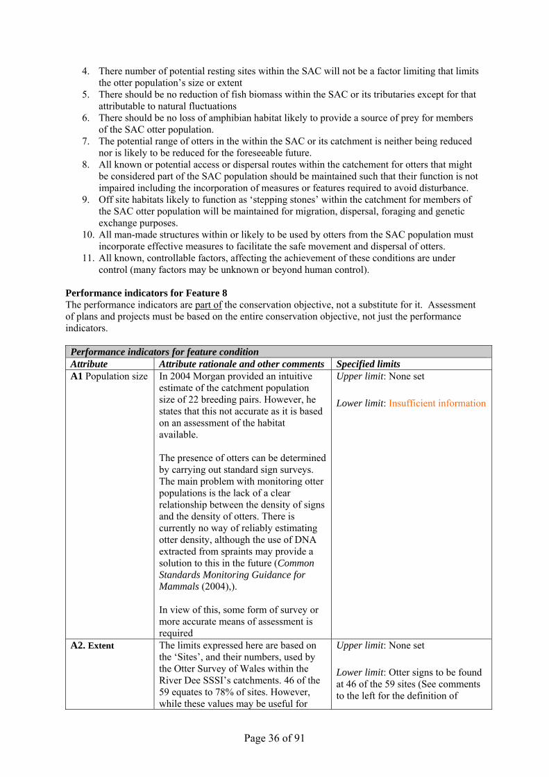
Performance indicators for Feature 8 The performance indicators are part of the conservation objective, not a substitute for it. Assessment of plans and projects must be based on the entire conservation objective, not just the performance indicators. Performance indicators for feature condition Attribute Attribute rationale and other comments Specified limits A1 Population size In 2004 Morgan provided an intuitive
estimate of the catchment population size of 22 breeding pairs. However, he states that this not accurate as it is based on an assessment of the habitat available. The presence of otters can be determined by carrying out standard sign surveys. The main problem with monitoring otter populations is the lack of a clear relationship between the density of signs and the density of otters. There is currently no way of reliably estimating otter density, although the use of DNA extracted from spraints may provide a solution to this in the future (Common Standards Monitoring Guidance for Mammals (2004),). In view of this, some form of survey or more accurate means of assessment is required
Upper limit: None set Lower limit: Insufficient information
A2. Extent The limits expressed here are based on the ‘Sites’, and their numbers, used by the Otter Survey of Wales within the River Dee SSSI’s catchments. 46 of the 59 equates to 78% of sites. However, while these values may be useful for
Upper limit: None set Lower limit: Otter signs to be found at 46 of the 59 sites (See comments to the left for the definition of

Page 37 of 91
monitoring purposes, it is highly likely that otters range throughout the SAC and beyond. Therefore extensive survey work is required in order to adequately determine the extent, distribution and mobility of the SAC otter population. The use of artificial sprainting sites may be necessary in parts of the SAC, and beyond, where natural sprainting sites appear to be sparse.
‘sites’) More extensive survey work required
A3. Breeding Success
Morgan (2004) identified 77 potential ‘Otter Sites’. Of these he could confirm only five as being actual breeding sites but no natal holts were actually identified. A number of live sightings were reported but few of these were of cubs and their survivorship is unknown In view of this, clearly further survey or research is required
Upper limit: None set Lower limit: Insufficient information
A4. Age structure In order to properly assess the favourable conservation statues of this feature it would clearly be beneficial to have some understanding of age structure. The only information currently available for this it that of Morgan (2004), based on road deaths and live sightings. However, the numbers involved were very low. Therefore further information is required
Upper limit: None set Lower limit: Insufficient information
A5 Dispersal and recruitment
Little is currently known of the extent, rate or direction of dispersal of otters from the SAC population, either within the SAC or in the wider catchmment. Similarly, little is known of the of recruitment into the population, either from births within it or from otters dispersing from other populations. Such knowledge would enable assessment of the robustness of the population and its potential ability to recover from losses. It would provide some knowledge of its likely genetic diversity.
Upper limit: None set Lower limit: Insufficient information
A4. Good quality vegetation for breeding otters
Good quality vegetation for breeding otters includes dense scrub (e.g. bramble, blackthorn and gorse); reed-beds; deciduous woodland with an under-story; young conifer plantations; Rhododendron thickets; and wetlands (particularly with areas of Molinia caerulea ).
Upper limit: None set Lower limit: No reduction in the quality of or extent of suitable otter habitat

Page 38 of 91
Performance indicators for factors affecting the feature Factor Factor rationale and other comments Operational Limits
F1 Potential Breeding Sites:
Though clearly the presence of sites where otters can breed is a critical factor for any population, the Common Standards Monitoring Guidance for Mammals (2004), specifically excludes breeding sites as a factor or attribute for assessing conservation status of otter. It does so because “It would also be extremely difficult to decide on a reasonable target and a means of measuring the attribute.” However, as the survey of Morgan (2004) collected such data, the number of potential breeding sites has been included here as a factor.
Upper limit: None set Lower limit :There should be an increase in the number of known potential (in addition to actual) breeding sites on the River Dee from 72 to 76. Lakeside habitat that could provide potential breeding sites for otter should be retained at current levels.
F2 Potential resting sites
Otters use a range of types of resting or laying up sites, and these may vary in type or location depending on conditions and availability. Surveys within the Dee SAC have found many potential sites but there are sections where few have been found. Where these coincide with sections of the site where little otter activity has been detected, research should be undertaken to determine whether the presence of resting sites is a limiting factor. If it is, measures should be undertaken to increase the number of potential resting sites. In addition, where potential resting sites are few, otters may travel further to find them. This may lead to a greater risk of death due to anthropogenic mortality, particularly where road crossing may occur.
Upper limit: None set Lower limit: Insufficient information
F2 Food availability
Otters depend on food that comes from a range of aquatic environments, such as streams, marshes, ponds and backwaters. Their diet may, among other things, include fish, amphibians and crustaceans Eels are thought to be particularly favoured though at times prey, such as frogs, can assume a greater importance than that of fish. Data should be sought on fish stocks from EAW. Specific assessment limits have yet to be devised
Upper limit: None set Lower limit: Fish biomass stays within expected natural fluctuations There should be no loss of amphibian habitat likely to be used by otters from the SAC population. More specific limits to be devised
F3 Dispersal and access routes
Little is currently known of dispersal or access routes used by otters from the SAC population, either within the SAC
Upper limit: None set Lower limit: No loss or impairment
Page 39 of 91
or in the wider catchmment. However, such routes are essential for the dynamics of a healthy population. Therefore further information is required
of any such routes More specific limits to be devised
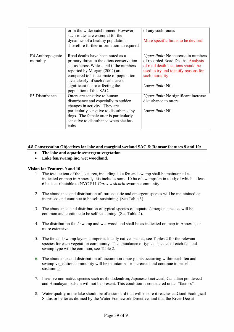
F4 Anthropogenic mortality
Road deaths have been noted as a primary threat to the otters conservation status across Wales, and if the numbers reported by Morgan (2004) are compared to his estimate of population size, clearly of such deaths are a significant factor affecting the population of this SAC.
Upper limit: No increase in numbers of recorded Road Deaths. Analysis of road death locations should be used to try and identify reasons for such mortality Lower limit: Nil
F5 Disturbance Otters are sensitive to human disturbance and especially to sudden changes in activity. They are particularly sensitive to disturbance by dogs. The female otter is particularly sensitive to disturbance when she has cubs.
Upper limit: No significant increase disturbance to otters. Lower limit: Nil
4.8 Conservation Objectives for lake and marginal wetland SAC & Ramsar features 9 and 10:
• The lake and aquatic /emergent vegetation • Lake fen/swamp inc. wet woodland.
Vision for Features 9 and 10
1. The total extent of the lake area, including lake fen and swamp shall be maintained as indicated on map in Annex 1, this includes some 10 ha of swamp/fen in total; of which at least 6 ha is attributable to NVC S11 Carex vesicaria swamp community.
2. The abundance and distribution of rare aquatic and emergent species will be maintained or
increased and continue to be self-sustaining. (See Table 3).
3. The abundance and distribution of typical species of aquatic /emergent species will be common and continue to be self-sustaining. (See Table 4).
4. The distribution fen / swamp and wet woodland shall be as indicated on map in Annex 1, or
more extensive.
5. The fen and swamp layers comprises locally native species, see Tables 2 for the relevant species for each vegetation community. The abundance of typical species of each fen and swamp type will be common, see Table 2.
6. The abundance and distribution of uncommon / rare plants occurring within each fen and
swamp vegetation community will be maintained or increased and continue to be self-sustaining.
7. Invasive non-native species such as rhododendron, Japanese knotweed, Canadian pondweed
and Himalayan balsam will not be present. This condition is considered under “factors”.
8. Water quality in the lake should be of a standard that will ensure it reaches at Good Ecological Status or better as defined by the Water Framework Directive, and that the River Dee at
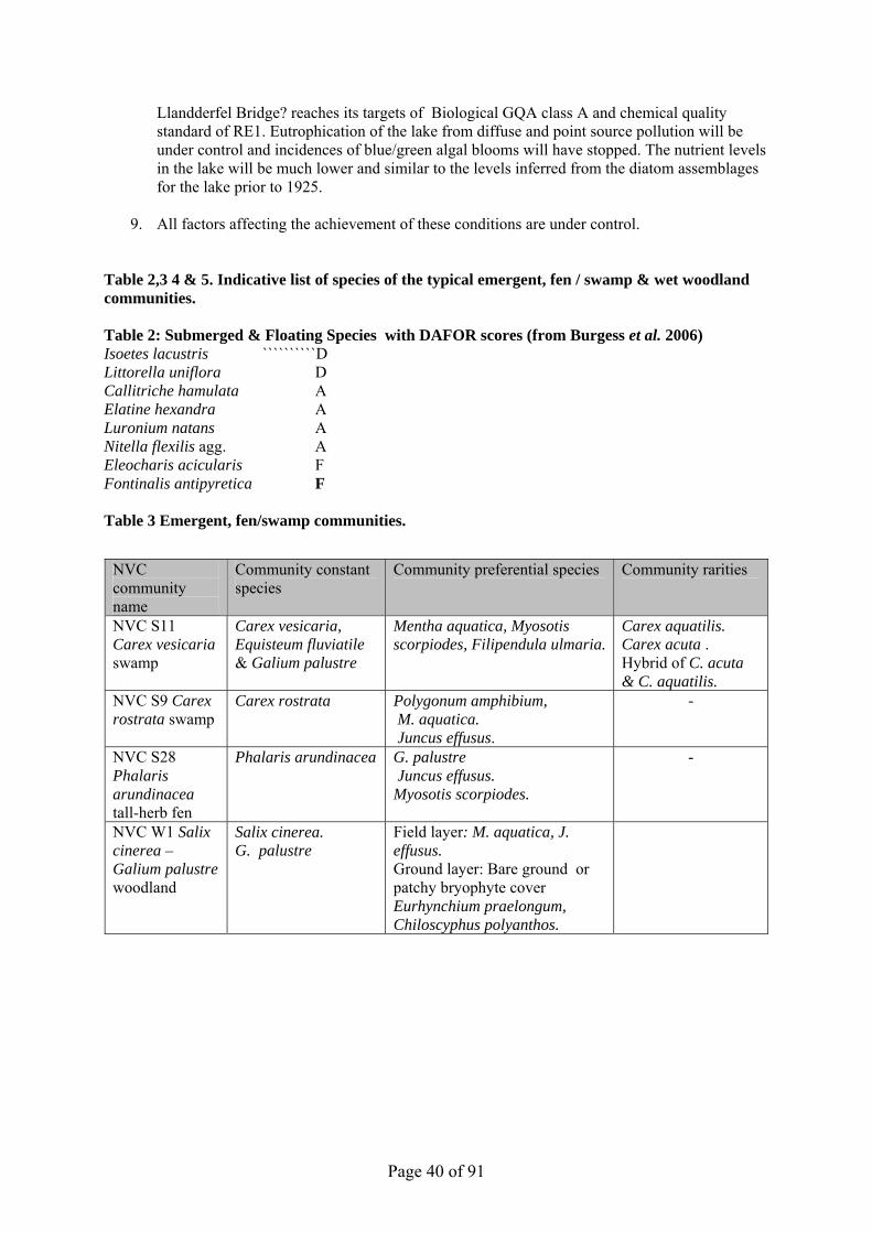
Page 40 of 91
Llandderfel Bridge? reaches its targets of Biological GQA class A and chemical quality standard of RE1. Eutrophication of the lake from diffuse and point source pollution will be under control and incidences of blue/green algal blooms will have stopped. The nutrient levels in the lake will be much lower and similar to the levels inferred from the diatom assemblages for the lake prior to 1925.
9. All factors affecting the achievement of these conditions are under control.
Table 2,3 4 & 5. Indicative list of species of the typical emergent, fen / swamp & wet woodland communities. Table 2: Submerged & Floating Species with DAFOR scores (from Burgess et al. 2006) Isoetes lacustris ``````````D Littorella uniflora D Callitriche hamulata A Elatine hexandra A Luronium natans A Nitella flexilis agg. A Eleocharis acicularis F Fontinalis antipyretica F Table 3 Emergent, fen/swamp communities.
NVC community name
Community constant species
Community preferential species Community rarities
NVC S11 Carex vesicaria swamp
Carex vesicaria, Equisteum fluviatile & Galium palustre
Mentha aquatica, Myosotis scorpiodes, Filipendula ulmaria.
Carex aquatilis. Carex acuta . Hybrid of C. acuta & C. aquatilis.
NVC S9 Carex rostrata swamp
Carex rostrata Polygonum amphibium, M. aquatica. Juncus effusus.
-
NVC S28 Phalaris arundinacea tall-herb fen
Phalaris arundinacea G. palustre Juncus effusus. Myosotis scorpiodes.
-
NVC W1 Salix cinerea – Galium palustre woodland
Salix cinerea. G. palustre
Field layer: M. aquatica, J. effusus. Ground layer: Bare ground or patchy bryophyte cover Eurhynchium praelongum, Chiloscyphus polyanthos.

Page 41 of 91
Table 4. Indicative list of rare species of the aquatic / emergent communities.
Table 5. Indicative list of typical aquatic /emergent vascular plant species Vascular plant species name Lesser marshwort Apium inundatum Pedunculate / Intermediate water starwort Callitriche brutia / hammulata C. stagnalis Needle spike-rush Eleocharis acicularis Water mint Mentha aquatica Water forget-me-not Myosotis scorpiodes Alternate water milfoil Myrophyllum alterniflorum Water pepper Persicaria hydropiper Reed canary grass Phalaris arundinacea Broad leaved pond weed Potamogetan natans Marsh cinquefoil Potentilla palustris Common water crowfoot Ranunuculus aquatilis Round leaved crowfoot R. omniophyllus Water horsetail Equisetum fluviatile Small sweet-grassGlyceria declinata Floating sweet-grass G. fluitans Quillwort Isoetes lacustris Performance indicators for Features 9 & 10 The performance indicators are part of the conservation objective, not a substitute for it. Assessment of plans and projects must be based on the entire conservation objective, not just the performance indicators. Performance indicators for feature condition: The lake and aquatic /emergent vegetation. Lake fen/swamp inc. wet woodland. Attribute Attribute rationale and other comments Specified limits where applicable A.1 Extent of communities / assemblages A1.1. Extent of aquatic /emergent macrophyte assemblages
See Table 4 which lists aquatic /emergent species. The use of the lake as a reservoir & flood defence has substantially affected the marginal community.
The collated data in Evans and Benoit (1996) provides the lower limit acceptable. Need to monitor to ensure no further deterioration
Feature species Mudwort Limosella aquatica Six stamened-waterwort Elatine hexandra Floating water plantain Luronium natans Small water-pepper Polygonum minus Needle spike-rush Eleocharis acicularis Slender-tufted sedge Carex acuta Water sedge Carex aquatilis Hybrid sedge C. acuta x aquatilis

Page 42 of 91
A1.2. Extent of fen /swamp communities
The location of fen / swamp was mapped at Phase 1 level in early 1990s. Evans & Benoit (1996) also mapped some other areas of swamp (including Carex vesicaria swamp/fen). A compilation 1996 Map has been drafted. It appears that the area of swamp has reduced during the period 1996-2008.
Lower limit of extent for fen/ swamp communities is based on the map in annex 1(1996). Sufficient expansion areas for fen /swamp communities should be maintained.
A.2 Distribution of communities / assemblages A2.1 Distribution of aquatic /emergent macrophyte assemblages
The extent of aquatic macrophytes is a good indicator of the health of the lake. Growth in deeper water indicates good light penetration through the water column. A full CSM was carried out in 2004, and Llyn Tegid is scheduled for regular EA / CCW monitoring. The use of hydroacoustic techniques for mapping vegetation is currently being trialled on the lake.
The collated data in Evans and Benoit (1996) provides the lower limit acceptable. Lower Limit: Maximum depth of plant growth should not be less than 2.5m.
A2.2. Distribution of fen / swamp types
Refer to Map in annex 1for the distribution of the fen / swamp communities. NVC S11 Carex vesicaria lower limit is based on 1996 survey map by Evans & Benoit. It appears that the area of Carex vesicaria swamp has reduced during the period 1996-2008.
The lower limit of distribution for fen/ swamp communities is based on Map in annex 1 (1996).
A.3 Frequency and abundance of typical & key species A3.1 Typical species of aquatic /emergents & fen / swamp
Dominant species or community constant species will continue to be recorded at the expected frequency and abundance for their community. Refer to Table 4 for aquatic /emergents and Table 2 for fen / swamp. Refer also to Rodwell (1995) and Evans & Benoit (1996).
Typical species of aquatic /emergents & fen / swamp should continue to be present at previously recorded frequency and abundance. The wet woodland that has developed on swamp should include sedges and a wetland under storey. Aquatic Species Lower Limit: 90% or more of sample points should have one or more of the following species recorded: Isoetes spp; Littorella uniflora; Luronium natans; Elatine hexandra; Nitella spp; Callitriche hamulata.

Page 43 of 91
A3.2. Uncommon/key species aquatic /emergents & fen / swamp
Refer to Table 3 Luronium natans has separate conservation objectives. (See feature 2).
Uncommon/key species aquatic /emergents & fen / swamp species should continue to be present at previously recorded frequency and abundance. Evans & Benoit (1996).
A3.3. Non- native species
Non- native species can out compete native species and reduce the natural biodiversity of the vegetation.
Invasive non-native species should be absent (NB Elodea nuttalli present but rare)
Performance indicators for factors affecting the feature: The lake and aquatic /emergent vegetation. Lake fen/swamp inc. wet woodland. F1. Water quality Refer to section 5.9 for details of the
research carried out on water quality and actions taken to tackle point and diffuse sources of pollution in the catchment.
Water quality should allow lake to be classed as an oligo-mesotrophic water body.
F2. Water level fluctuations
Water levels in the lake are regulated and the current regime ensures that a “conservation” level is imposed and this arrangement should be continued.
Continue existing regime unless evidence of a negative impact or adverse trend.
F3. Shoreline substrates
Shoreline substrate should be allowed to accrete and erode under the natural influence of the lake’s tributaries. The wildly fluctuating lake level, including very high levels, results in gravels being washed up the shore including onto tracks in places. Severe winter storms promotes roller wave action leading to buffeting and erosion of the swamp communities on the north east shoreline.
Map and photograph existing constraints (2008) on natural erosion/accretion and ensure this does not increase and that opportunity is taken to remove constraints.
F4. Water sports Extent or distribution of marginal wetland should not be compromised by recreational infrastructure.
Map and photograph existing infrastructure (2008) and ensure this does not increase and that opportunity is taken to restore habitats as appropriate.
F5. Dredging Dredging took place in Glanllyn Bay in 1951, 1984 & there was another proposal to dredge in 1997. Small-scale excavation of gravel takes place at a number of locations around the lake. Such operations are only acceptable where the impact on the special interest has been fully assessed and is considered not to be significant.
There is a presumption against dredging.
F6. Flood defence work incl. works on tributaries and re-routing rivers.
Flood embankments maintenance work can result in loss of swamp and damage to the marshy grassland and other grassland if heavy machinery is driven within the SSSI and ruts are left, soil is compacted, disturbed, and/or moved.
No further damage should take place through flood defence or other engineering works. Previously damaged stands should be restored.
F7. Scrub control control is often needed at Llyn Tegid, particularly at the northern end, as the fluctuating water level, natural changes
A scrub control programme should continue.

Page 44 of 91
in the vegetation as well as lack of grazing all tend to result in scrub growth and encroachment onto grassland and drier fen swamp. The Bala Lake Railway Company regularly fell/coppice trees and scrub along the edge of the railway line in order to maintain views and also as a health and safety measure.
F8. Mowing Mowing including rush topping can be a good way of controlling ranker vegetation growth and increasing diversity. An area of the site at the northern end was managed as meadow in the past and the rushes growing on part of the southern marshy grassland are regularly topped. Mowing or rush topping may however adversely affect the bladder sedge fen if it is too frequent so it is important that this vegetation is monitored.
Consented mowing as appropriate.
F9. Grazing Grazing can help prevent sedge swamp communities and other wetland from developing into willow scrub as well as promoting plant diversity in these habitats and grassland. Some plants are however particularly grazing sensitive and will benefit from grazing exclusion or periods without grazing. Marshy grassland, fen and swamp continues to be cattle and sheep grazed at the southern end of the site. The Bala end was horse grazed until the late 1980s-early 1990s after which grazing ceased.
Zoned grazing with some areas not grazed and others lightly summer grazed.
4.9 Conservation Objective for Feature 11 Fish. Gwyniad Coregonus lavaretus. Vision for feature 11 There are fewer than 10 recorded populations of whitefish in the British Isles and the Llyn Tegid population is the only one in Wales. Dwelling mainly in the deeper and cooler offshore waters this carnivorous fish feeds on microscopic animals floating in the water. Each year, between January and February, it moves into the shallower waters of the lake to spawn in clean gravel beds. Between 2004 and 2007 an attempt was made to establish a ‘refuge’ population at Llyn Arenig Fawr, an upland oligotrophic lake in Migneint-Arenig-Dduallt SAC (Refer to Migneint-Arenig-Dduallt SAC plan). The conservation objective for the lake water body as defined in conservation objective number 9 & 10 must be met. The vision for this feature is for it to be in a favourable conservation status, where all of the following conditions are satisfied:
1. The population of the feature in the SAC is stable or increasing over the long term.
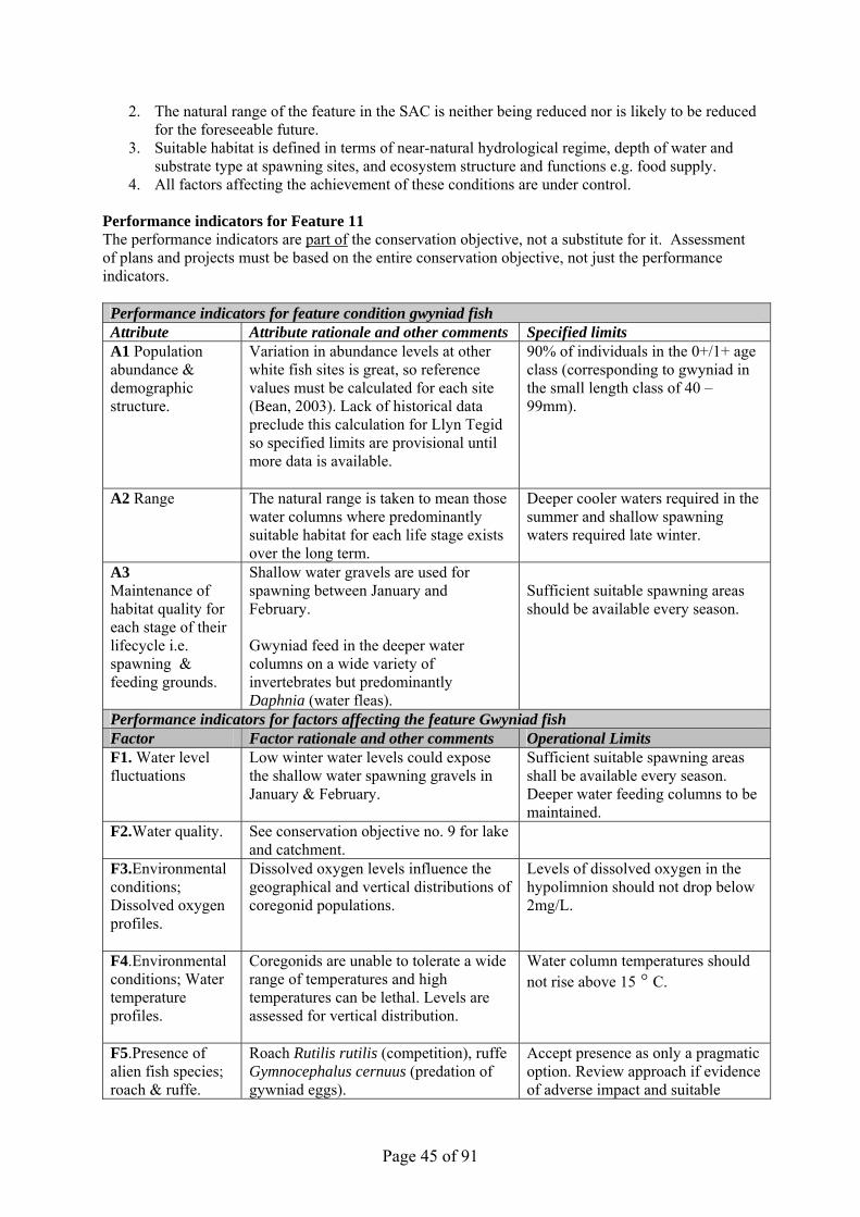
Page 45 of 91
2. The natural range of the feature in the SAC is neither being reduced nor is likely to be reduced for the foreseeable future.
3. Suitable habitat is defined in terms of near-natural hydrological regime, depth of water and substrate type at spawning sites, and ecosystem structure and functions e.g. food supply.
4. All factors affecting the achievement of these conditions are under control. Performance indicators for Feature 11 The performance indicators are part of the conservation objective, not a substitute for it. Assessment of plans and projects must be based on the entire conservation objective, not just the performance indicators. Performance indicators for feature condition gwyniad fish Attribute Attribute rationale and other comments Specified limits A1 Population abundance & demographic structure.
Variation in abundance levels at other white fish sites is great, so reference values must be calculated for each site (Bean, 2003). Lack of historical data preclude this calculation for Llyn Tegid so specified limits are provisional until more data is available.
90% of individuals in the 0+/1+ age class (corresponding to gwyniad in the small length class of 40 – 99mm).
A2 Range The natural range is taken to mean those water columns where predominantly suitable habitat for each life stage exists over the long term.
Deeper cooler waters required in the summer and shallow spawning waters required late winter.
A3 Maintenance of habitat quality for each stage of their lifecycle i.e. spawning & feeding grounds.
Shallow water gravels are used for spawning between January and February. Gwyniad feed in the deeper water columns on a wide variety of invertebrates but predominantly Daphnia (water fleas).
Sufficient suitable spawning areas should be available every season.
Performance indicators for factors affecting the feature Gwyniad fish Factor Factor rationale and other comments Operational Limits F1. Water level fluctuations
Low winter water levels could expose the shallow water spawning gravels in January & February.
Sufficient suitable spawning areas shall be available every season. Deeper water feeding columns to be maintained.
F2.Water quality. See conservation objective no. 9 for lake and catchment.
F3.Environmental conditions; Dissolved oxygen profiles.
Dissolved oxygen levels influence the geographical and vertical distributions of coregonid populations.
Levels of dissolved oxygen in the hypolimnion should not drop below 2mg/L.
F4.Environmental conditions; Water temperature profiles.
Coregonids are unable to tolerate a wide range of temperatures and high temperatures can be lethal. Levels are assessed for vertical distribution.
Water column temperatures should not rise above 15 ° C.
F5.Presence of alien fish species; roach & ruffe.
Roach Rutilis rutilis (competition), ruffe Gymnocephalus cernuus (predation of gywniad eggs).
Accept presence as only a pragmatic option. Review approach if evidence of adverse impact and suitable

Page 46 of 91
control methods are available. F6. Nutrient state & sediment input.
See conservation objective no. 9 for lake and catchment.
See feature 9.
F8. Dredging Dredging can directly damage gwyniad spawning areas.
No dredging likely to affect gwyniad spawning areas to be consented between January – end of May.
4.10 Conservation Objective for Feature 12: Glutinous snail . Myxas glutinosa Vision for feature 12 The conservation objective for the lake water body as defined in conservation objective number 9 & 10 must be met. The vision for this feature is for it to be in a favourable conservation status, where all of the following conditions are satisfied:
1. This population will continue to thrive and colonise all suitable areas of habitat in the marginal zone. The species will have been extensively studied and its ecology, especially its response to fluctuating water levels, will be better understood so that its niche requirements can continue to be met. In addition, we will fully understand whether the apparently different mean growth rates in snail populations at different locations around the lake is due to minor habitat variance or to isolated sub-population differences.
2. Maintenance of the quality and extent of suitable habitat.
3. All factors affecting the achievement of these conditions are under control.
Performance indicators for Feature 12 The performance indicators are part of the conservation objective, not a substitute for it. Assessment of plans and projects must be based on the entire conservation objective, not just the performance indicators. Performance indicators for feature condition Attribute Attribute rationale and other comments Specified limits A1 Population abundance & extent.
These are the targets to maintain the population at a Favourable Conservation Status – separate targets have been compiled should the status change and the population needs to be restored – see Willing, M.J., (2006) Condition assessment of the glutinous snail Myxas glutinosa in Llyn Tegid in 2005. CCW Contract Science Report No. 726. Bangor. CCW.
Lower limit: The combined total number of semi-grown snails at the 8 monitoring sites is 40 and where the snail is recorded at 6 of the 8 monitoring sites (Map Y showing monitoring stations in Appendix X).
A2 Maintenance of habitat extent and quality.
In water depths of Om - ca 2.5 m (with lake levels between 0.75 - 1.35m) the habitat consists predominantly of cobbles and boulders lying on varying mixtures of sand, gravel and cobbles (but not noticeable amounts of mud or silt). There is little organic detritus between the stones and filamentous and slime forming algal species are scarce or absent from the rock surfaces. The lower
Lower limit: Cobbles and boulders at 6 of the 8 monitoring stations give no more than 20% of the rock surface covered in silt and/or slime forming algae. Lower limit: Still, calm lake water should have clarity to 1.5m depth.
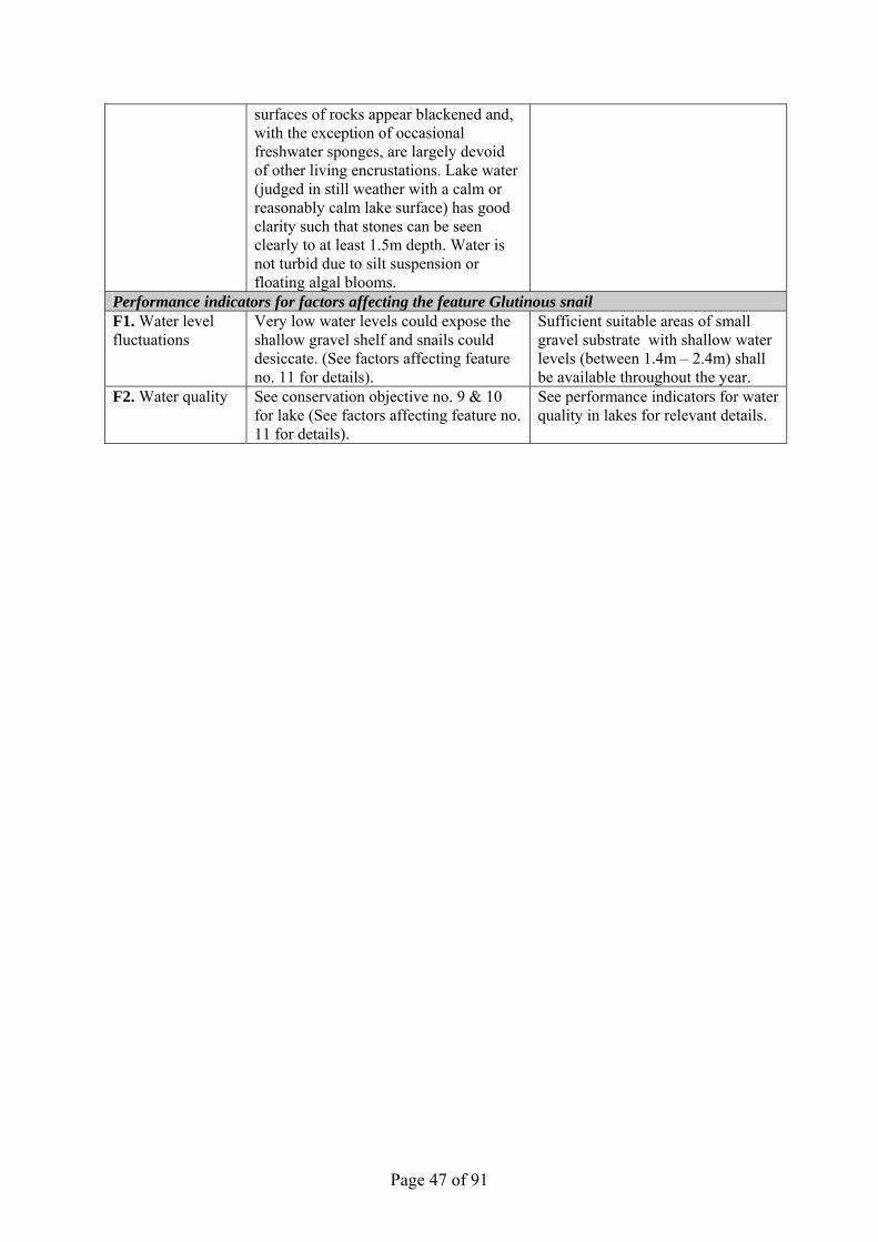
Page 47 of 91
surfaces of rocks appear blackened and, with the exception of occasional freshwater sponges, are largely devoid of other living encrustations. Lake water (judged in still weather with a calm or reasonably calm lake surface) has good clarity such that stones can be seen clearly to at least 1.5m depth. Water is not turbid due to silt suspension or floating algal blooms.
Performance indicators for factors affecting the feature Glutinous snail F1. Water level fluctuations
Very low water levels could expose the shallow gravel shelf and snails could desiccate. (See factors affecting feature no. 11 for details).
Sufficient suitable areas of small gravel substrate with shallow water levels (between 1.4m – 2.4m) shall be available throughout the year.
F2. Water quality See conservation objective no. 9 & 10 for lake (See factors affecting feature no. 11 for details).
See performance indicators for water quality in lakes for relevant details.

Page 48 of 91
5. ASSESSMENT OF CONSERVATION STATUS AND MANAGEMENT REQUIREMENTS This part of the document provides: • A summary of the assessment of the conservation status of each feature. • A summary of the management issues that need to be addressed to maintain or restore each feature. However, it should be noted that the ‘on the ground’ management options available for river sites such as this are largely limited to fencing the river banks and tree works. 5.1 Conservation status and management requirements of Feature 1: Water courses of plain to montane levels with the Ranunculion fluitantis and Callitricho-Batrachion vegetation Conservation status: Unfavourable unclassified. This site’s most recent vegetation survey was that of Scarlett et al in 2003. Data was collected from twenty three field sites and an attempt was made to classify each site as a ‘CB type’ (a sub-type of the feature) using the method of Hatton-Ellis and Grieve (2003). Only seven sites conformed to a CB type. However the authors state that “The majority or sites are rather atypical and could not be placed into any of the CB group. This may be partly attributed to the absence of Myriophyllum spicatum and the scarcity of some species due to recent flooding”. In view of these difficulties the condition assessment was based upon a preliminary study undertaken in June 04, which only looked at a small amount of the resource across the site. During the next monitoring cycle (2007-2012) the feature will be monitored against JNCC guidelines, probably using revised methods. This will provide CCW with an improved condition assessment but will not give a clear indication of the extent of the feature throughout the site. It is therefore likely that there will also be some form of rapid, walk over (or rather next to) survey, to provides an indication of where the feature is likely to be present. Management requirements As discussed above, it is important that further knowledge of the condition and extent of this feature is acquired in order to better inform decisions about its management. However, as stated by Hatton-Ellis and Grieve (2003) “There remain many gaps in understanding of the reproductive biology of individual species, the identification and distribution of subspecies, and the ecological tolerances of plant assemblages”. So until there is a greater understanding of the requirements of this feature the emphasis will be on promoting and retaining a mosaic of bank-side and emergent vegetation, and of resisting changes to the aquatic environment unless they can be shown as being unlikely to have a significant effect. Actions currently identified: - CCW - Map extent of this feature and any of its sub-types within the SAC CCW – Identify units where substrate problems may be restricting the extent or quality of this feature from existing fluvial audit or other sources. EAW – Raise water quality to required standards

Page 49 of 91
5.2 Conservation status and management requirements of Feature 2: Atlantic salmon Salmo salar Conservation status: Unfavourable. Justification – According to Pisces Conservation Ltd (2007), the Dee fails on the criteria listed as failing on the following table
Attribute Pass Fail Not determined
Population Adult run X
Juvenile population densities X Water quality
Biological GQA X Chemical GQA X
Soluble reactive phosphorus X Suspended solids X
Flow (see below) X River morphology
Artificial barriers X Maintaining characteristic physical features X
River substrate Spawning sites X
Negative indicators Stocking of other species X
Environmental disturbance Management objectives of SAC salmon
populations X
Screening X Sustainable exploitation X
OVERALL ASSESSMENT X (Except for ‘Flow’ result, table copied from Pisces Conservation Ltd, 2007).
Flow: Pisces Conservation Ltd (2007) based their result on Naturalised Daily Flow. For the Dee this is not applicable because of the nature of its regulation scheme. Therefore for this river the criterion for being in favourable condition is that flows should, as far as climatic conditions allow, remain within 10% of ‘Recent Actual flow’ as described by Bethune (2006), (See Conservation Objectives for Salmon, Section 4.3 and vision for Water Courses, Section 4.1.3). Management requirements Attribute Requirement Population
Adult run Increase to Conservation Limit Juvenile population densities Maintain Water quality
Biological GQA Improve to required standard Chemical GQA Improve to required standard
Soluble reactive phosphorus Improve to required standard Suspended solids Improve to required standard

Page 50 of 91
Flow Maintain River morphology
Artificial barriers Maintain or improve Maintaining characteristic
physical features Maintain or improve
River substrate Spawning sites Location and extent to be determined
Negative indicators Stocking of other species Before any such stocking can take place, it must first be determined
whether or not it is likely to have a significant effect on the river’s salmon population (or on any other).
Environmental disturbance
Management objectives of SAC salmon populations
Salmon stocking must only occur in order to compensate for the loss of habitat upstream of the Celyn dam. Stocking beyond this should not be required.
Screening Screening must be of a standard sufficient to prevent any significant effect on the Salmon population
Sustainable exploitation Any form of exploitation detrimental to salmon successfully completing their reproductive cycle is difficult to justify until the following criteria have been met:-
The salmon population is consistently reaching its targets,
There is no salmon stocking, other that compensating for the habitat loss caused by to the construction of Llyn Celyn.
Pisces Conservation Ltd, 2007 also recommend that “Data on spawning site substrates and screening required”. Actions currently identified: - EAW – Raise water quality to required standards EAW – Prevent exploitation until population criteria are met EAW – Ensure screening is of a standard sufficient to prevent any significant effect on the Salmon
population CCW and EAW – improve habitat for feature by managing/fencing off bankside vegetation 5.3 Conservation Status and Management Requirements of Feature 3 Floating water-plantain Luronium natans (Code: 1831) Conservation Status of Feature 3: Favourable Un-classified The floating water-plantain is assessed as Favourable Un-classified on the basis of existing survey data. A population has been known from Llyn Tegid since 1780 and again in 1805, but only recently in the 1990s was it realised that a more extensive submerged population was present within Dolfawr and Glanllyn bays at the SW end of the lake. As there is therefore only partial baseline data it is not possible to distinguish trends. Floating water-plantain can thrive in quite eutrophic water conditions in the U.K. There is no reason therefore to suppose, because of current factors operating, that the population has declined over recent years. Monitoring submerged lake populations of Luronium natans is difficult without using diving techniques although there has been some recent exploratory work conducted by Ian Winfield of CEH into using new and more sensitive hydroacoustic survey equipment to monitor submerged vegetation communities.

Page 51 of 91
• A baseline survey of Luronium natans should be carried out.
Management Requirements of Feature 3: Luronium natans 1. Physical damage to floating plants and their habitat from motorised craft should continue to be
controlled by limiting the number of motorised boats to emergency craft operated by SNPA wardening staff.
2. No lake bottom sediment should be dredged because it could disturb submerged populations and
/or destroy suitable substrate for Luronium natans to colonise. 3. The pools at Glanllyn, where Luronium natans has long been recorded, are now dominated by
the alien species Elodea canadensis Canadian pondweed. Some control such as light mechanical harvesting should be considered if observation/research elsewhere indicates that this management is likely to be successful.
5.4 Conservation status and management requirements of Feature 4: Sea lamprey Petromyzon marinus Conservation status: Unfavourable un-classified This species failed its ammocoete density target, as monitored by APEM (2006). The performance indicator in Section 4 (above), and the Common Standards Monitoring Guidance (JNCC 2005) state that “ammocoetes should be present in at least 4 sampling sites each not less than 5km apart”. Sea lamprey were only caught in 3 sites. The low numbers recorded by APEM (2006) make it difficult to draw any firm conclusions as to the distribution of the species within the site but report also expresses concerns over barriers to migration for sea lamprey. This suggests that the river morphology attribute would also fail. In addition the river also fails its Biological GQA and soluble reactive phosphorus targets (Pisces Conservation Ltd., 2007). Management requirements Currently, we don’t have sufficient information about Petromyzon marinus in the Dee SAC to know the size or dynamics of its population, the amount of habitat available for its spawning and subsequent development, or the other main factors that limit its development. In view of this, the management requirements are: Identification of spawning sites Undertake research to try and determine what is required by way of resources for there to be a sustainable population of this species within the Dee catchment. Identify which resources are limiting the development of the current population. Undertake measures to improve the availability of limiting resources. This is relevant to Units R4 and R5, the deliminator between which is the Horseshoe Falls weir. The weir is believed to present a barrier to the upstream migration of lampey. The structure should therefore be modified to enable such fish to reach the river beyond it.

Page 52 of 91
Entrainment in water abstractions directly impacts on population dynamics through reduced recruitment and survival rates. Information on likely rates of entrainment of lamprey ammocoetes is required before acceptable levels can be assessed. In addition, screening must be of a standard sufficient to prevent any significant effect on the Lamprey population.
Fish stocking can be damaging to ecosystem structure and function through competition, predation and introduction of disease – ensure any fish stocking is very carefully controlled to avoid these problems, and subject to an appropriate assessment. Actions currently identified: - CCW– instigate surveys as described above EAW – Ensure screening is of a standard sufficient to prevent any significant effect on the Lamprey
population 5.5 Conservation status and management requirements of Feature 5: Brook lamprey Lampetra planeri Conservation status: Unfavourable un-classified APEM (2006) report that Lampetra spp. were caught at 36 out of 59 sites (25 out of 29 optimal sites and 11 out of 30 sub-optimal sites). This provides a value for distribution within the catchment of 61% which fails the 66% JNCC target (JNCC 2005). The river fails the Biological GQA and soluble reactive phosphorus targets (Pisces Conservation Ltd, 2007). It is not normally possible to distinguish between river and brook lamprey in the field. Results are reported for lampetra spp. Therefore, even if population levels for lampetra spp. appear to be acceptable, they cannot be considered as being in favourable condition until values for the individual species can be obtained. Management requirements Currently, we cannot identify Lampetra planeri in the field, we don’t have sufficient information about the species in the Dee SAC to know the size or dynamics of its population, the amount of habitat available for its spawning and subsequent development (The Dee Fluvial Audit may be of use here), or the other main factors that limit its development. In view of this, the management requirements are: To instigate a survey that, if necessary includes the destructive sampling of a small numbers of ammocoetes, in order to gain some understanding of the distribution and abundance of the species within the SAC. To instigate a survey that identifies spawning sites To instigate research that attempts to determine what is required by way of resources for there to be a sustainable population of this species within the Dee catchment. Identify which resources are limiting the development of the current population. Undertake measures to improve the availability of limiting resources. This is relevant to Units R4 and R5, the deliminator between which is the Horseshoe Falls weir. The weir is believed to present a barrier to the upstream migration of lampey. The structure should therefore be modified to enable such fish to reach the river beyond it.

Page 53 of 91
Entrainment in water abstractions directly impacts on population dynamics through reduced recruitment and survival rates. Information on likely rates of entrainment of lamprey ammocoetes is required before acceptable levels can be assessed. In addition, screening must be of a standard sufficient to prevent any significant effect on the Lamprey population.
Fish stocking can be damaging to ecosystem structure and function through competition, predation and introduction of disease – ensure any fish stocking is very carefully controlled to avoid these problems, and subject to an appropriate assessment. Actions currently identified: - CCW– instigate surveys as described above EAW – Ensure screening is of a standard sufficient to prevent any significant effect on the Lamprey
population 5.6 Conservation status and management requirements of Feature 6: River Lamprey Lampetra fluviatilis Conservation status: Unfavourable un-classified APEM (2006) report that Lampetra spp. were caught at 36 out of 59 sites (25 out of 29 optimal sites and 11 out of 30 sub-optimal sites). This provides a value for distribution within the catchment of 61% which fails the 66% JNCC target (JNCC 2005). Also the river fails the Biological GQA and soluble reactive phosphorus targets (Pisces Conservation Ltd, 2007). It is not normally possible to distinguish between river and brook lamprey in the field. Results are reported for lampetra spp. Therefore, even if population levels for lampetra spp. appear to be acceptable, they cannot be considered as being in favourable condition until values for the individual species can be obtained. Management requirements Currently, We cannot identify Lampetra planeri in the field, we don’t have sufficient information about the species in the Dee SAC to know the size or dynamics of its population, the amount of habitat available for its spawning and subsequent development (The Dee Fluvial Audit may be of use here), or the other main factors that limit its development. In view of this, the management requirements are: To instigate a survey that, if necessary includes the destructive sampling of a small numbers of ammocoetes, in order to gain some understanding of the distribution and abundance of the species within the SAC. To instigate a survey that identifies spawning sites To instigate research that attempts to determine what is required by way of resources for there to be a sustainable population of this species within the Dee catchment. Identify which resources are limiting the development of the current population. Undertake measures to improve the availability of limiting resources. This is relevant to Units R4 and R5, the deliminator between which is the Horseshoe Falls weir. The weir is believed to present a barrier to the upstream migration of lampey. The structure should therefore be modified to enable such fish to reach the river beyond it.

Page 54 of 91
Entrainment in water abstractions directly impacts on population dynamics through reduced recruitment and survival rates. Information on likely rates of entrainment of lamprey ammocoetes is required before acceptable levels can be assessed. In addition, screening must be of a standard sufficient to prevent any significant effect on the Lamprey population.
Fish stocking can be damaging to ecosystem structure and function through competition, predation and introduction of disease – ensure any fish stocking is very carefully controlled to avoid these problems, and subject to an appropriate assessment. Actions currently identified: - CCW– instigate surveys as described above EAW – Ensure screening is of a standard sufficient to prevent any significant effect on the lamprey
population 5.7 Conservation status and management requirements of Feature 7: Bullhead Cottus gobio Conservation status: Unfavourable un-classified.
Attribute Pass Fail Not determined
Population Adult pop. densities X
Distribution within SAC X Reproduction / Age structure X
Water quality Biological GQA X Chemical GQA X
Soluble reactive phosphorus X Suspended solids X
Flow (See below) X River morphology
Weed cutting X Woody debris X
Impediments to fish movement between reaches X SSSI features in favourable condition X
Reduction in extent of slack water refuges, etc. X Negative indicators
Non-native crayfish X Stocking of other species X
Aspects of environmental disturbance Bullhead stocking X
Screening X OVERALL ASSESSMENT X (Except for ‘Flow’ result, table copied from Pisces Conservation Ltd, 2007).
Flow: Pisces Conservation Ltd (2007) based their result on Naturalised Daily Flow. For the Dee this is not applicable because of the nature of its regulation scheme. Therefore for this river the criterion for being in favourable condition is that flows should, as far as climatic conditions allow, remain within 10% of ‘recent actual flow’ as described by Bethune (2006), (See Conservation Objectives for Billhead, Section 4.6 and vision for Water Courses, Section 4.1.3).

Page 55 of 91
In the Pisces Conservation Ltd (2007) survey, two of the population targets for this species (adult population density and distribution within the SAC) fail. The river also fails the Biological GQA and soluble reactive phosphorus targets (Pisces Conservation Ltd 2007). Management requirements Attribute Requirement Population
Adult pop. densities Increase to CSM target Distribution within
SAC Increase distribution to all areas of potential habitat. Pisces Conservation Ltd (2007) state that “Distribution within the SAC revealed considerable differences between sites with the species absent from some areas within the SAC”. However the Pisces survey only looked a five field sites within the SAC so more data will be required before this opinion can be verified with confidence.
Reproduction / Age structure
Maintain
Water quality Biological GQA Improve to required standard Chemical GQA Maintain or improve Soluble reactive
phosphorus Improve to required standard
Suspended solids Maintain or improve Flow (See below) River morphology Submerged macrophytes
The importance of submerged higher plants to bullhead survival is unclear, but it is likely that where such vegetation occurs it is used by the species for cover against predators. JNCC’s Common Standards Monitoring Guidance for Freshwater fauna (2005) states that “Weed cutting should be limited to no more than half of the channel width in a pattern of cutting creating a mosaic of bare substrate and beds of submerged plants”. However, in view of the lack of clarity as to the importance of such plants to this species, and as much of the aquatic vegetation is a protected feature of this site in its own right, the precautionary principal should apply. Therefore, there should be no cutting of submerged macrophytes other than that specified in Section 4.2.
Woody debris Maintain existing position Impediments to fish movement between
reaches
Maintain existing position
SSSI features in favourable condition
Maintain existing position
Reduction in extent of slack water
refuges, etc.
Slack-water areas provide important refuges against high flow conditions. Suitable refuges include pools, submerged tree root systems and marginal vegetation with >5 cm water depth
Spawning habitat Defined as unsilted coarse (gravel / pebble / cobble) dominated substrate: males guard sticky eggs on the underside of stones. Larger stones on a hard substrate providing clear spaces between the stream bed and the underside of pebbles / cobbles are therefore important. Elevated levels of fines can interfere with egg and fry survival (See also ‘ Woody debris’ above)
Negative indicators Non-native crayfish Maintain existing position
Stocking of other Maintain existing position

Page 56 of 91
species Aspects of environmental disturbance
Bullhead stocking Maintain existing position
Screening To be determined
Pisces Conservation Ltd (2007) also make recommendations for the following: Further data on any reductions in extent of slack water refuges, etc. required. Clarification of the extent and timing of brown trout stocking, and its potential effects on bullhead populations is required. Information on screening of intakes and discharges is required. Information on the status of the bullhead populations needs to be focused in future within the area of the SAC. Actions currently identified: - EAW – Raise water quality to required standards CCW – Instigate more detailed survey than that of Picies to clarify the current status CCW – Instigate reasons for distribution problems identified by Picies survey eg survey slack water refuges, substrate quality, woody debris in units where substrate is sub-optimal 5.8 Conservation status and management requirements of Feature 8:European otter Lutra lutra Conservation status: Favourable: Un-classified The status of “Favourable” is based on the results of a survey by Philip Morgan undertaken in 2003 (Morgan 2004). However, this survey could not make a reliable estimate of population size nor, on its own, identify any trend in population change. i.e. is the population decreasing, stable or increasing? Therefore, until the site can be re-surveyed, the “un-classified” suffix is likely remain in place. Management requirements Most of the following requirements are based on the main recommendations of Morgan (2004): Further survey work is needed in order to better estimate the number of otters in the SAC population. Morgan (2004) states that “It is impossible to judge just how many otters are present on the Dee catchment today. DNA analysis of spraints to identify individual animals is probably the only way by which this might be ascertained with some certainty”. Establish a procedure to undertake an appraisal of road kill sites. The object being to attempt to identify reasons for otters being on the road – at least 14 otters were killed on roads in the Dee catchment in the six years prior to the survey. Undertake further survey work to specifically identify holts and in particular natal holts – Morgan states that such information is particularly sparse but suggest that it is best gathered by dedicated volunteer groups and suggest that a volunteer survey/monitoring group be established in North East Wales. Fencing of river banks with a suitable buffer should be considered a high priority – This will encourage the establishment of areas with a dense understorey of shrub close to the river – a habitat favoured by otters. It will also reduce grazing pressure and disturbance.

Page 57 of 91
Actions currently identified: - CCW – Instigate research in order to more accurately determine:
• the size of the SAC otter population • the extent of the SAC otter population • its level of breeding success • its age structure • the extent of its dispersal and recruitment • the routes commonly used for its dispersal and recruitment • whether the availability of potential resting sites is a limiting the population size or
extent, or whether it is increasing the risk of anthropogenic mortality CCW/EA/Unitary Authorities – Analyse road death locations to try and identify reasons for otter mortality. 5.9 Conservation Status and Management Requirements of Feature 9: The lake & aquatic / emergent vegetation (Ramsar) Conservation Status : Unfavourable The lake & aquatic / emergent vegetation is assessed as Unfavourable as the water quality is unfavourable. There is no evidence to suggest that the aquatic/emergent vegetation is unfavourable although there has not been a recent quantitative survey. Good quality presence and absence data from around the lake exists over a long time period. There is no evidence to suggest, that the aquatic/emergent vegetation or the rare plants adapted to the fluctuating water levels, have declined over recent years. We are however concerned that there may be gradual changes in the flora and ecology of the lake as it continues to become more eutrophic.
• A survey of the aquatic / emergent vegetation should be carried out. A project commissioned by the then National Rivers Authority (now Environment Agency Wales) in the early 1990s, aimed at producing a lake classification system, concluded that Llyn Tegid’s enrichment or “degree of eutrophication” had increased almost six fold, compared with presumed conditions in 1930. In January 1995 a project was initiated to assess the current nutrient inputs to the lake with a view to using a predictive algal growth model and to determine appropriate management options. A succession of blue/green algal blooms dating from August 1995 has reinforced the urgency of this work. In 2006 there were around 10 blooms but no severe ones and once the wind picked up, such blooms dispersed within about 2 hours. The health concerns for people and livestock have further raised the profile of the study and focused the attention of local people, business users as well as conservationists.
Llyn Tegid should naturally be a low nutrient level lake but human activities in the catchment have increased the level of nutrients such as phosphates. The current nutrient level is too high and any increase beyond current levels is likely to have an increasingly adverse effect on its wildlife. Eutrophication may promote growth of a narrower range of plant species at the expense of the desired species. It also encourages the development of algal “blooms” which smother natural plant populations, de-oxygenate the water and in extreme cases lead to loss of fish or other animal species and nitrates. Enrichment or eutrophication can potentially affect the whole ecology of the lake including the balance of plants and animals living within it. During the winter the water levels fluctuate widely, from 0.6m to 2.6m (or higher in severe flood) above the sluice cill. Once the rain ceases and the water level downstream of Bala starts to fall, the excess storage in Llyn Tegid is released by raising the sluices clear of the water in order to empty the

Page 58 of 91
flood storage prior to the next flood event. During the summer the fluctuations are smaller and less frequent because the lake level is maintained between 1.1m and 1.5 m above the sluice gate cill level by EAW. In summary the lake level is highly regulated between two seasonal band levels with a cill level 2m below the natural pre 1956 level. There are 12 agreed release dates from Llyn Celyn down the Afon Tryweryn for canoeing at Canolfan Tryweryn. On such occasions the water level of Llyn Tegid can rise by 3 inches.
After a prolonged drought there can be a need to ensure water supply to the Dee, so proposals involving pumping water to the Dee and/or supplementing the two other reservoirs which are part of the Dee Regulation Scheme, Llyn Celyn and Llyn Brenig, may be developed, as happened in 1996. Such proposals if implemented could result in a drop in water level in Llyn Tegid (a two metre drop was part of one proposed scheme in 1996). Such major changes in water regulation would be very likely to have a significant effect. The original drop in water level since 1956 has resulted in a drying out of the swamp and loss of water sedge, which is particularly noticeable at the boathouse, on the north eastern shore. Management Requirements of Feature 9: The lake & aquatic / emergent vegetation 1. To reduce/halt point and diffuse sources of pollution (enrichment) in the catchment. 2. Within the catchment, forestry managers should be encouraged to adhere to guidelines for
applying fertilisers and the suggestions for minimising the release of sediment at all stages of forestry practice from ground preparation to harvesting.
These sources give rise to the following pollution issues: • Nitrate is very soluble and excessive application can lead to fertiliser seeping through to
groundwater, or being washed into rivers through drains or subsurface flow;
• Phosphorus can also be carried in this way, but more commonly binds tightly to soil and is lost through surface run-off or erosion from ploughed or eroded land;
• Agrochemicals such as sheep dip, fungicides and insecticides can be washed into surface or ground waters if not correctly handled and applied;
• Microbial pathogens from manure can be washed into surface waters by rain or where livestock have direct access to watercourses; and
• River sediment levels can be increased by soil erosion due to inadequate livestock or soil management and when livestock damage riverbanks or churn up sediment within the riverbed.
Efforts have been made to tackle point sources of enrichment such as from sewerage treatment and other discharges within the catchment and more diffuse sources including land run-off. A pilot ‘catchment sensitive farming project’ for two tributary rivers, the Afon Llafar and the Afon Twrch, was initiated in 2005 with the aim of improving water quality by reducing diffuse pollution from agricultural operations. Landowners joining the scheme are offered a farm audit which highlights opportunities for improving nutrient planning, soil erosion control, loss of soil structure and organic matter, manure management and sheep dipping. The Welsh Assembly Government, through a partnership with CCW, Environment Agency Wales and SNPA, is leading the project, with funding by all partners and European Union Objective 1 funds. This pilot project will finish in 2008 and analysis of the success of the scheme is yet to be published but we can be confident that a similar scheme for the whole catchment of Llyn Tegid would greatly improve water quality and reduce eutrophication and the frequency of blue-green algal blooms. In the absence of such a project, then eutrophication can only be addressed by land owners in the catchment joining other voluntary agri-environment schemes such as Tir Gofal. Within the boundary

Page 59 of 91
of the SSSI / SAC, operations that may contribute to eutrophication may be mitigated at a very localised level through the consultation for consent process. 5.10 Conservation Status and Management Requirements of Feature 10: Lake fen / swamp (Ramsar) Conservation Status : Unfavourable The lake fen/swamp is assessed as Unfavourable as the Carex vesicaria swamp was damaged in 1996 by the Environment Agency when they carried out flood bank maintenance work. The land has never been adequately restored, so mounds of spoil stand proud of the level of the swamp. The area of the swamp, from air photos and site visits, has also reduced since 1996 for unknown reasons.
• A survey of the fen / swamp should be carried out. Management Requirements Grazing can help prevent sedge swamp communities and other wetland from developing into willow scrub as well as promoting plant diversity in these habitats and grassland. Some plants are however particularly grazing sensitive and will benefit from grazing exclusion or periods without grazing. Marshy grassland, fen and swamp continues to be cattle and sheep grazed at the southern end of the site. The Bala end was horse grazed until the late 1980s-early 1990s after which grazing ceased.
1. Fen/swamp requires grazing of different zones with some areas not grazed and others lightly
summer grazed by cattle/ponies.
Mowing including topping rushes can be a good way of controlling ranker vegetation growth and increasing diversity. An area of the site at the northern end was managed as meadow in the past and the rushes growing on part of the southern marshy grassland are regularly topped. Mowing or rush topping may however adversely affect the bladder sedge fen if it is too frequent so it is important that this vegetation is monitored.
2. Mowing/topping may continue as appropriate.
Scrub control is often needed at Llyn Tegid, particularly at the northern end, as the fluctuating water level, natural changes in the vegetation as well as lack of grazing all tend to result in scrub growth and encroachment onto grassland and drier fen swamp.
3. A programme of scrub control should continue.
Water sports and other recreation, including swimming, sailing, canoeing, wind surfing, canoeing and sail boarding, are enjoyed by many visitors to the lake. The use of powerboats at Llyn Tegid is however restricted to rescue craft by SNPA. Water sports have resulted in the development of supporting infrastructure, including boat storage areas, slipways and boathouses and the creation of launching points. Sometimes the creation of launching points involves moving boulders, an operation that may damage the special interest in some locations, so this aspect needs to be carefully assessed before it is consented. Water sports can also result in a demand for dredging (see below), excavating channels and shoreline modifications. It is important that development does not spread further along the foreshore creating extensive areas bare of vegetation and that construction of infrastructure is controlled.
Car parking and amenity areas were formalised in 1995-97 and measures were put in place at the Bala end of the lake to control cars driving onto adjacent grassland. Part of northern end of the shore is managed by SNPA as an amenity area and a car park with picnic benches. Such facilities are important in enabling a range of visitors to enjoy the countryside at Llyn Tegid. Appropriate planning
Page 60 of 91
of visitor infrastructure including paths can ensure development without significant damage to the wildlife interest.
4. Recreational activity and infrastructure needs to be managed.
Dredging took place in Glanllyn Bay in 1951 and in 1984 when part of the lake area (6700 sq m) was deepened to permit launching of canoes from Glanllyn at times of lower lake levels. An estimated 10,000 tons of sediment was removed from the bay and dumped in an offshore area of the lake. There was another proposal to dredge in 1997. There has also been a proposal to reroute the Afon Llafar, so that it would enter the lake to the east of Glanllyn Bay, presumably to try to reduce sedimentation. Dredging releases nutrients from the sediments and can therefore impact negatively on the nutrient levels of the lake and on the water quality. Small-scale excavation of gravel takes place at a number of locations around the lake. Such operations are only acceptable where the impact on the special interest has been fully assessed and is considered not to be significant.
5. There should be a presumption against dredging.
Invasive alien plants such as Japanese knotweed, which was mapped in 1990 and has been controlled by SNPA since then, should not be allowed to re-colonise and spread. New Zealand stone crop and other aliens should not be allowed to establish themselves adjacent to or in feeder streams or the lake itself.
6. Control of Japanese knotweed should continue and local agencies should monitor and be notified of the occurrence of any new invasive species.
5.11 Conservation Status and Management Requirements of Feature 11: Gwyniad / Coregonus lavaretus (Ramsar) Conservation Status: Unfavourable The gwyniad population of Llyn Tegid is assessed as Unfavourable (2007 survey) as it has been considered for a number of years to be threatened by deteriorating environmental conditions, especially those associated with eutrophication. Further research is required to collate more data to inform specific management prescriptions. These have been identified by Winfield (2001) as;
• The continuation of oxygen and temperature profiling.
• An investigation of gwyniad spawning grounds,
• An investigation of the fish community,
• A monitoring programme for gwyniad,
• The management of allochthonous sediment sources.
A refuge population was set up in Llyn Arenig Fawr between 2003 – 2007 and it remains to be seen how many of the fertilised eggs hatched and have attained adulthood. Refer to the Migneint-Arenig-Dduallt management plan. Management requirements The management requirements of the lake also apply to the gwyniad (see feature 9 above).
1. To reduce point and diffuse sources of pollution (enrichment and sediments) in the catchment. Refer to feature 9.

Page 61 of 91
2. During the spawning season, January – end February the lake water levels should be sufficiently high to ensure that gwyniad fish eggs which are laid in the shallows around the edge of the lake are not exposed.
There should be a presumption against fish introductions into the lake.
3. There should be a presumption against significant dredging or any in-lake works between the end of October and the end of May.
5.12 Conservation Status and Management Requirements of Feature 12: Glutinous snail / Myxas glutinosa (Ramsar) Conservation Status : Favourable The glutinous snail Myxas glutinosa is assessed as Favourable based on the 2006 survey and current trends. Myxas glutinosa has been known in Llyn Tegid since at least 1852. There was a hiatus in recorded presence in the lake between 1953 and 1998 when a CCW/Snowdonia National Park Authority funded survey relocated the species. The snail was found to be widely distributed around about 8.5km of lake margin (>80% of the total shore margin), but was not found in the silted bay where the River Dee enters the south-western end of the lake. Where present, the snail was found almost exclusively on the lower surface of cobbles and small boulders lying on sand, gravel, cobbles or boulders. Survey sampling undertaken by divers at several of the monitoring stations in November 1999 found that Myxas only lives in the littoral regions of Llyn Tegid, extending to depths of only about 2.4m at 'winter' lake levels (1.4m for low summer levels). This reliance of the snail upon the shallow margins of the lake may make it particularly vulnerable to sudden or extreme lake level changes. Subsequent surveys and studies undertaken at different times of the year between 1998 and 2001 suggest that the snail has an annual life cycle. The adult snails appear to reach maturity in late winter, mostly dying off after reproducing in February/March. In the period April - June snails are very difficult to locate. By August, partially grown snails are relatively easy to locate around most of the lake margins (at sites previously shown to support the snail). These grow throughout the autumn, whilst population numbers decline due to predation and/or other factors. When populations of the snail were monitored in September 2001 the whole lake was affected by a 'blue-green algal' bloom which lasted several weeks. Total numbers of snails recorded during the monitoring programme was significantly lower than in the years 1998 - 2001, but, given the increase in numbers in 2002, this is likely, at least in part, to be a consequence of poor visibility hampering searches rather than fluctuating population levels. Monitoring visits should therefore avoid episodes of algal bloom if at all possible. At the time of writing this Conservation Objective, Llyn Tegid supports the only known extant population of Myxas on the British mainland and this makes the implementation and regular review of this Conservation Objective of the utmost importance. This small snail is found at locations in the shallow shoreline with rock substrates of cobbles (100 – 200mm) to boulder (>200mm) grade particle sizes. The snail dwells on the undersides of rocks in shallow waters (15 – 50cm) of the lake marginal zone. The literature suggests that Myxas has an annual life cycle with individuals reaching full size in winter and breeding in spring, although this creatures’ habits in the UK are poorly understood. Management Requirements Water quality
4. To reduce point and diffuse sources of pollution (enrichment) in the catchment. Refer to feature 9.

Page 62 of 91
Maintenance of habitat extent and quality 1. Sufficient supply of cobbles and boulders in the marginal zone will be maintained by allowing
natural processes to deposit and erode the accretion of substrate materials. Substrate materials should not be added or removed from the marginal zone by human activity. Existing habitats should not be allowed to silt over as a result of human induced activity.
Water level fluctuations 2. The winter water level should not be so low as to expose the snail’s habitat for very long
periods which may lead to animals desiccating.

Page 63 of 91
6. ACTION PLAN: SUMMARY This section takes the management requirements outlined in Section 5 a stage further, assessing the specific management actions required on each management unit. This information is a summary of that held in CCW’s Actions Database for sites, and the database will be used by CCW and partner organisations to plan future work to meet the Wales Environment Strategy targets for sites. Unit Number
CCW Database Number
Unit Name Summary of Conservation Management Issues
Action needed?
01a 001768 LLyn Tegid Atlantic salmon: Water quality & levels. Spawning site availability. Freshwater fish stocking. Floating water-plantain: Dredging. Disturbance from motorised craft. Water quality. Brook lamprey: Water quality & levels. Spawning site availability. Nursery habitat. Bullhead: Water quality & levels. Submerged macrophytes. Woody debris. Spawning site availability.Bank side tree cover. Freshwater fish stocking. European otter: Water quality. Food availability. Riparian habitat. Disturbance. Ramsar features to be added at a later date.
Yes

Page 64 of 91
Unit Number
CCW Database Number
Unit Name Summary of Conservation Management Issues
Action needed?
02 001769 Tegid outfall to gauging weir
In general, for this SAC there is currently insufficient data to identify management requirements specific to individual units. In view of this, much of the text in this section makes general points about the features on a whole site basis. In the future, as our knowledge improves, management requirements will be developed that are more tailored for each unit. Please note that only requirements for features that have been identified as `Key habitats? or `Key species? for this unit are included here. FEATURE 2: Atlantic salmon Salmo salar Conservation status: Unfavourable unclassified. Management Requirements Actions currently identified: - Where necessary, raise water quality to required standards Prevent exploitation until population criteria are met Improve the habitat for feature by managing/fencing off bankside vegetation FEATURE 3: Floating water-plantain Luronium natans Conservation status: Favourable Un-classified. Management Requirements In this unit there is only anecdotal evidence of the existence Luronium natans. However this was from a very reliable aquatic botanist and, as the unit is immediately down-stream of Llyn Tegid and water velocity above the sluices normally low, the species is likely to be found growing there. It should therefore always be considered when activates likely to affect the river bed or other aspects of its habitat are being planned. FEATURE 5: Brook lamprey Lampetra planeri And FEATURE 6: River Lamprey Lampetra fluviatilis Conservation status: Unfavourable un-classified Actions currently identified: - To instigate a survey that, if necessary includes the destructive sampling of a small numbers of ammocoetes, in order to gain some understanding of the distribution and abundance of the species within the SAC. To instigate a survey that identifies spawning sites
Yes

Page 65 of 91
Unit Number
CCW Database Number
Unit Name Summary of Conservation Management Issues
Action needed?
03 001770 Gauging weir to Gwynedd exit
In general, for this SAC there is currently insufficient data to identify management requirements specific to individual units. In view of this, much of the text in this section makes general points about the features on a whole site basis. In the future, as our knowledge improves, management requirements will be developed that are more tailored for each unit. Please note that only requirements for features that have been identified as `Key habitats? or `Key species? for this unit are included here. FEATURE 1: Water courses of plain to montane levels with the Ranunculion fluitantis and Callitricho-Batrachion vegetation Conservation status: Unfavourable unclassified Management Requirements Actions currently identified Map extent of this feature and any of its sub-types within the SAC Identify units where substrate problems may be restricting the extent or quality of this feature from existing fluvial audit or other sources. Raise water quality to required standards FEATURE 2: Atlantic salmon Salmo salar Conservation status: Unfavourable unclassified. Management Requirements Actions currently identified: - Where necessary, raise water quality to required standards Prevent exploitation until population criteria are met Improve the habitat for feature by managing/fencing off bankside vegetation FEATURE 5: Brook lamprey Lampetra planeri And FEATURE 6: River Lamprey Lampetra fluviatilis Conservation status: Unfavourable un-classified Actions currently identified: - To instigate a survey that, if necessary includes the destructive sampling of a small numbers of ammocoetes, in order to gain some understanding of the distribution and abundance of the species within the SAC. To instigate a survey that identifies spawning sites T i ti t h th t tt t t d t i
Yes

Page 66 of 91
Unit Number
CCW Database Number
Unit Name Summary of Conservation Management Issues
Action needed?
04 001771 Denbighshire C C entry to the start of the Rhewl Section
In general, for this SAC there is currently insufficient data to identify management requirements specific to individual units. In view of this, much of the text in this section makes general points about the features on a whole site basis. In the future, as our knowledge improves, management requirements will be developed that are more tailored for each unit. Please note that only requirements for features that have been identified as `Key habitats? or `Key species? for this unit are included here. FEATURE 1: Water courses of plain to montane levels with the Ranunculion fluitantis and Callitricho-Batrachion vegetation Conservation status: Unfavourable unclassified Management Requirements Actions currently identified Map extent of this feature and any of its sub-types within the SAC Identify units where substrate problems may be restricting the extent or quality of this feature from existing fluvial audit or other sources. Raise water quality to required standards FEATURE 2: Atlantic salmon Salmo salar Conservation status: Unfavourable unclassified. Management Requirements Actions currently identified: - Where necessary, raise water quality to required standards Prevent exploitation until population criteria are met Improve the habitat for feature by managing/fencing off bankside vegetation FEATURE 5: Brook lamprey Lampetra planeri And FEATURE 6: River Lamprey Lampetra fluviatilis Conservation status: Unfavourable un-classified Actions currently identified: - To instigate a survey that, if necessary includes the destructive sampling of a small numbers of ammocoetes, in order to gain some understanding of the distribution and abundance of the species within the SAC. To instigate a survey that identifies spawning sites T i ti t h th t tt t t d t i
Yes

Page 67 of 91
Unit Number
CCW Database Number
Unit Name Summary of Conservation Management Issues
Action needed?
05 001772 Rhewl Section to Horseshoe falls
In general, for this SAC there is currently insufficient data to identify management requirements specific to individual units. In view of this, much of the text in this section makes general points about the features on a whole site basis. In the future, as our knowledge improves, management requirements will be developed that are more tailored for each unit. Please note that only requirements for features that have been identified as `Key habitats? or `Key species? for this unit are included here. FEATURE 1: Water courses of plain to montane levels with the Ranunculion fluitantis and Callitricho-Batrachion vegetation Conservation status: Unfavourable unclassified Management Requirements Actions currently identified Map extent of this feature and any of its sub-types within the SAC Identify units where substrate problems may be restricting the extent or quality of this feature from existing fluvial audit or other sources. Raise water quality to required standards FEATURE 2: Atlantic salmon Salmo salar Conservation status: Unfavourable unclassified. Management Requirements Actions currently identified: - Where necessary, raise water quality to required standards Prevent exploitation until population criteria are met Improve the habitat for feature by managing/fencing off bankside vegetation FEATURE 5: Brook lamprey Lampetra planeri And FEATURE 6: River Lamprey Lampetra fluviatilis Conservation status: Unfavourable un-classified Actions currently identified: - To instigate a survey that, if necessary includes the destructive sampling of a small numbers of ammocoetes, in order to gain some understanding of the distribution and abundance of the species within the SAC. To instigate a survey that identifies spawning sites T i ti t h th t tt t t d t i
Yes

Page 68 of 91
Unit Number
CCW Database Number
Unit Name Summary of Conservation Management Issues
Action needed?
06 001773 Horseshoe falls to Denbighshire CC end
In general, for this SAC there is currently insufficient data to identify management requirements specific to individual units. In view of this, much of the text in this section makes general points about the features on a whole site basis. In the future, as our knowledge improves, management requirements will be developed that are more tailored for each unit. Please note that only requirements for features that have been identified as `Key habitats? or `Key species? for this unit are included here. FEATURE 1: Water courses of plain to montane levels with the Ranunculion fluitantis and Callitricho-Batrachion vegetation Conservation status: Unfavourable unclassified Management Requirements Actions currently identified Map extent of this feature and any of its sub-types within the SAC Identify units where substrate problems may be restricting the extent or quality of this feature from existing fluvial audit or other sources. Raise water quality to required standards FEATURE 2: Atlantic salmon Salmo salar Conservation status: Unfavourable unclassified. Management Requirements Actions currently identified: - Where necessary, raise water quality to required standards Prevent exploitation until population criteria are met Improve the habitat for feature by managing/fencing off bankside vegetation FEATURE 5: Brook lamprey Lampetra planeri And FEATURE 6: River Lamprey Lampetra fluviatilis Conservation status: Unfavourable un-classified Actions currently identified: - To instigate a survey that, if necessary includes the destructive sampling of a small numbers of ammocoetes, in order to gain some understanding of the distribution and abundance of the species within the SAC. To instigate a survey that identifies spawning sites T i ti t h th t tt t t d t i
Yes
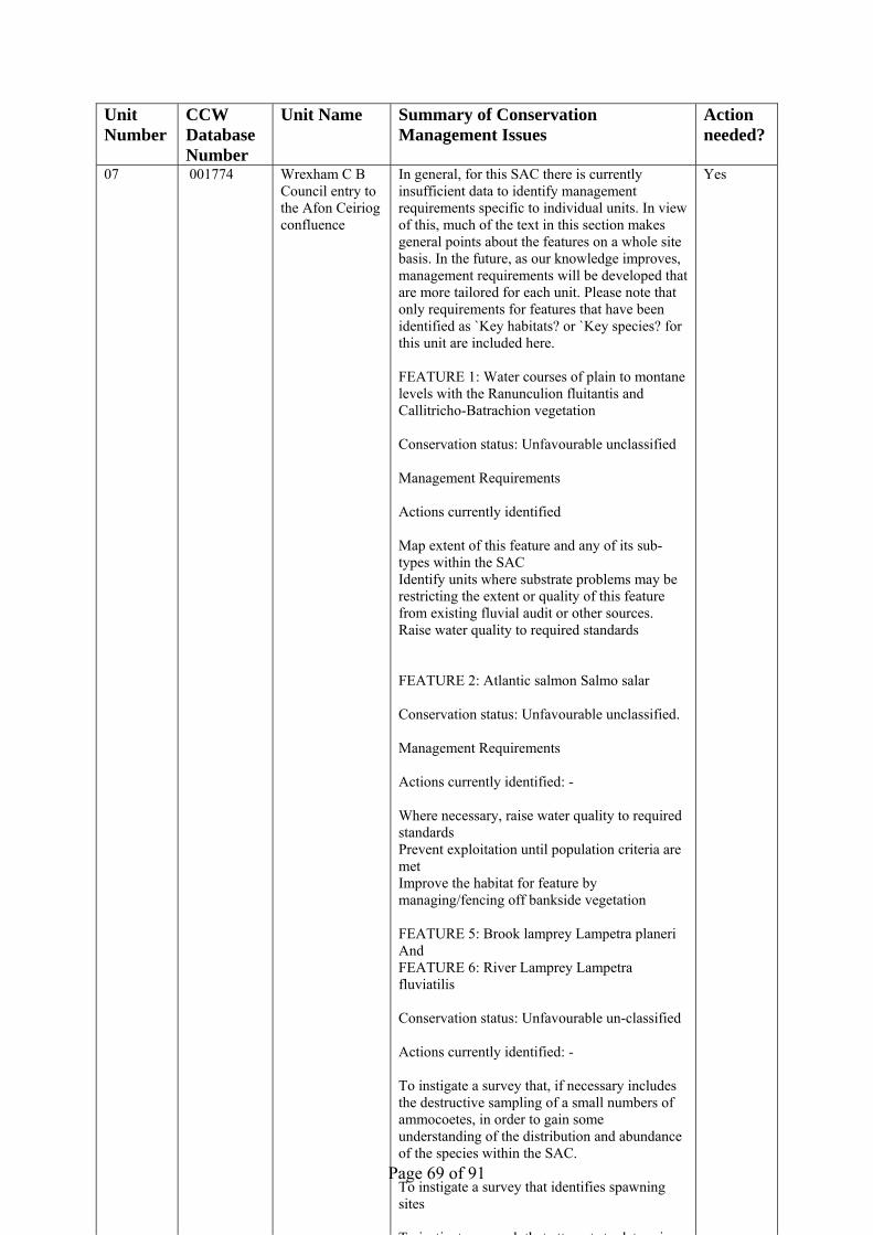
Page 69 of 91
Unit Number
CCW Database Number
Unit Name Summary of Conservation Management Issues
Action needed?
07 001774 Wrexham C B Council entry to the Afon Ceiriog confluence
In general, for this SAC there is currently insufficient data to identify management requirements specific to individual units. In view of this, much of the text in this section makes general points about the features on a whole site basis. In the future, as our knowledge improves, management requirements will be developed that are more tailored for each unit. Please note that only requirements for features that have been identified as `Key habitats? or `Key species? for this unit are included here. FEATURE 1: Water courses of plain to montane levels with the Ranunculion fluitantis and Callitricho-Batrachion vegetation Conservation status: Unfavourable unclassified Management Requirements Actions currently identified Map extent of this feature and any of its sub-types within the SAC Identify units where substrate problems may be restricting the extent or quality of this feature from existing fluvial audit or other sources. Raise water quality to required standards FEATURE 2: Atlantic salmon Salmo salar Conservation status: Unfavourable unclassified. Management Requirements Actions currently identified: - Where necessary, raise water quality to required standards Prevent exploitation until population criteria are met Improve the habitat for feature by managing/fencing off bankside vegetation FEATURE 5: Brook lamprey Lampetra planeri And FEATURE 6: River Lamprey Lampetra fluviatilis Conservation status: Unfavourable un-classified Actions currently identified: - To instigate a survey that, if necessary includes the destructive sampling of a small numbers of ammocoetes, in order to gain some understanding of the distribution and abundance of the species within the SAC. To instigate a survey that identifies spawning sites T i ti t h th t tt t t d t i
Yes

Page 70 of 91
Unit Number
CCW Database Number
Unit Name Summary of Conservation Management Issues
Action needed?
08 001775 Afon Ceiriog confluence to Erbistock Weir
In general, for this SAC there is currently insufficient data to identify management requirements specific to individual units. In view of this, much of the text in this section makes general points about the features on a whole site basis. In the future, as our knowledge improves, management requirements will be developed that are more tailored for each unit. Please note that only requirements for features that have been identified as `Key habitats? or `Key species? for this unit are included here. FEATURE 1: Water courses of plain to montane levels with the Ranunculion fluitantis and Callitricho-Batrachion vegetation Conservation status: Unfavourable unclassified Management Requirements Actions currently identified Map extent of this feature and any of its sub-types within the SAC Identify units where substrate problems may be restricting the extent or quality of this feature from existing fluvial audit or other sources. Raise water quality to required standards FEATURE 2: Atlantic salmon Salmo salar Conservation status: Unfavourable unclassified. Management Requirements Actions currently identified: - Where necessary, raise water quality to required standards Prevent exploitation until population criteria are met Improve the habitat for feature by managing/fencing off bankside vegetation FEATURE 5: Brook lamprey Lampetra planeri And FEATURE 6: River Lamprey Lampetra fluviatilis Conservation status: Unfavourable un-classified Actions currently identified: - To instigate a survey that, if necessary includes the destructive sampling of a small numbers of ammocoetes, in order to gain some understanding of the distribution and abundance of the species within the SAC. To instigate a survey that identifies spawning sites T i ti t h th t tt t t d t i
Yes
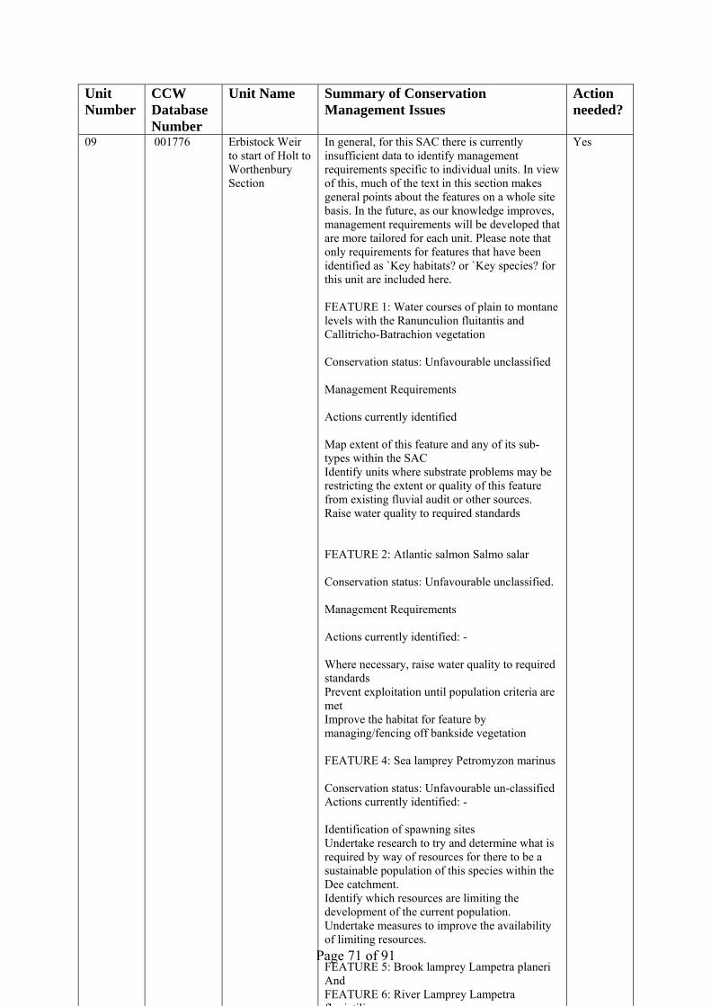
Page 71 of 91
Unit Number
CCW Database Number
Unit Name Summary of Conservation Management Issues
Action needed?
09 001776 Erbistock Weir to start of Holt to Worthenbury Section
In general, for this SAC there is currently insufficient data to identify management requirements specific to individual units. In view of this, much of the text in this section makes general points about the features on a whole site basis. In the future, as our knowledge improves, management requirements will be developed that are more tailored for each unit. Please note that only requirements for features that have been identified as `Key habitats? or `Key species? for this unit are included here. FEATURE 1: Water courses of plain to montane levels with the Ranunculion fluitantis and Callitricho-Batrachion vegetation Conservation status: Unfavourable unclassified Management Requirements Actions currently identified Map extent of this feature and any of its sub-types within the SAC Identify units where substrate problems may be restricting the extent or quality of this feature from existing fluvial audit or other sources. Raise water quality to required standards FEATURE 2: Atlantic salmon Salmo salar Conservation status: Unfavourable unclassified. Management Requirements Actions currently identified: - Where necessary, raise water quality to required standards Prevent exploitation until population criteria are met Improve the habitat for feature by managing/fencing off bankside vegetation FEATURE 4: Sea lamprey Petromyzon marinus Conservation status: Unfavourable un-classified Actions currently identified: - Identification of spawning sites Undertake research to try and determine what is required by way of resources for there to be a sustainable population of this species within the Dee catchment. Identify which resources are limiting the development of the current population. Undertake measures to improve the availability of limiting resources. FEATURE 5: Brook lamprey Lampetra planeri And FEATURE 6: River Lamprey Lampetra fl i tili
Yes

Page 72 of 91
Unit Number
CCW Database Number
Unit Name Summary of Conservation Management Issues
Action needed?
10 001777 Holt to Worthenbury Section wholly within Wales
In general, for this SAC there is currently insufficient data to identify management requirements specific to individual units. In view of this, much of the text in this section makes general points about the features on a whole site basis. In the future, as our knowledge improves, management requirements will be developed that are more tailored for each unit. Please note that only requirements for features that have been identified as `Key habitats? or `Key species? for this unit are included here. FEATURE 1: Water courses of plain to montane levels with the Ranunculion fluitantis and Callitricho-Batrachion vegetation Conservation status: Unfavourable unclassified Management Requirements Actions currently identified Map extent of this feature and any of its sub-types within the SAC Identify units where substrate problems may be restricting the extent or quality of this feature from existing fluvial audit or other sources. Raise water quality to required standards FEATURE 2: Atlantic salmon Salmo salar Conservation status: Unfavourable unclassified. Management Requirements Actions currently identified: - Where necessary, raise water quality to required standards Prevent exploitation until population criteria are met Improve the habitat for feature by managing/fencing off bankside vegetation FEATURE 4: Sea lamprey Petromyzon marinus Conservation status: Unfavourable un-classified Actions currently identified: - Identification of spawning sites Undertake research to try and determine what is required by way of resources for there to be a sustainable population of this species within the Dee catchment. Identify which resources are limiting the development of the current population. Undertake measures to improve the availability of limiting resources. FEATURE 5: Brook lamprey Lampetra planeri And FEATURE 6: River Lamprey Lampetra fl i tili
Yes

Page 73 of 91
Unit Number
CCW Database Number
Unit Name Summary of Conservation Management Issues
Action needed?
11 001778 Holt to Worthenbury Section from Shocklatch to Holt
In general, for this SAC there is currently insufficient data to identify management requirements specific to individual units. In view of this, much of the text in this section makes general points about the features on a whole site basis. In the future, as our knowledge improves, management requirements will be developed that are more tailored for each unit. Please note that only requirements for features that have been identified as `Key habitats? or `Key species? for this unit are included here. FEATURE 1: Water courses of plain to montane levels with the Ranunculion fluitantis and Callitricho-Batrachion vegetation Conservation status: Unfavourable unclassified Management Requirements Actions currently identified Map extent of this feature and any of its sub-types within the SAC Identify units where substrate problems may be restricting the extent or quality of this feature from existing fluvial audit or other sources. Raise water quality to required standards FEATURE 2: Atlantic salmon Salmo salar Conservation status: Unfavourable unclassified. Management Requirements Actions currently identified: - Where necessary, raise water quality to required standards Prevent exploitation until population criteria are met Improve the habitat for feature by managing/fencing off bankside vegetation FEATURE 4: Sea lamprey Petromyzon marinus Conservation status: Unfavourable un-classified Actions currently identified: - Identification of spawning sites Undertake research to try and determine what is required by way of resources for there to be a sustainable population of this species within the Dee catchment. Identify which resources are limiting the development of the current population. Undertake measures to improve the availability of limiting resources. FEATURE 5: Brook lamprey Lampetra planeri And FEATURE 6: River Lamprey Lampetra fl i tili
Yes

Page 74 of 91
Unit Number
CCW Database Number
Unit Name Summary of Conservation Management Issues
Action needed?
12 001779 End of Holt to Worthenbury Section to England
In general, for this SAC there is currently insufficient data to identify management requirements specific to individual units. In view of this, much of the text in this section makes general points about the features on a whole site basis. In the future, as our knowledge improves, management requirements will be developed that are more tailored for each unit. Please note that only requirements for features that have been identified as `Key habitats? or `Key species? for this unit are included here. FEATURE 1: Water courses of plain to montane levels with the Ranunculion fluitantis and Callitricho-Batrachion vegetation Conservation status: Unfavourable unclassified Management Requirements Actions currently identified Map extent of this feature and any of its sub-types within the SAC Identify units where substrate problems may be restricting the extent or quality of this feature from existing fluvial audit or other sources. Raise water quality to required standards FEATURE 2: Atlantic salmon Salmo salar Conservation status: Unfavourable unclassified. Management Requirements Actions currently identified: - Where necessary, raise water quality to required standards Prevent exploitation until population criteria are met Improve the habitat for feature by managing/fencing off bankside vegetation FEATURE 4: Sea lamprey Petromyzon marinus Conservation status: Unfavourable un-classified Actions currently identified: - Identification of spawning sites Undertake research to try and determine what is required by way of resources for there to be a sustainable population of this species within the Dee catchment. Identify which resources are limiting the development of the current population. Undertake measures to improve the availability of limiting resources. FEATURE 5: Brook lamprey Lampetra planeri And FEATURE 6: River Lamprey Lampetra fl i tili
Yes

Page 75 of 91
Unit Number
CCW Database Number
Unit Name Summary of Conservation Management Issues
Action needed?
13 001780 Section Entirely Within England
This unit is entirely within England so actions normally assigned to CCW have been omitted (they cannot be assigned to NE as NE is not on the list of organisations). In general, for this SAC there is currently insufficient data to identify management requirements specific to individual units. In view of this, much of the text in this section makes general points about the features on a whole site basis. In the future, as our knowledge improves, management requirements will be developed that are more tailored for each unit. Please note that only requirements for features that have been identified as `Key habitats? or `Key species? for this unit are included here. FEATURE 1: Water courses of plain to montane levels with the Ranunculion fluitantis and Callitricho-Batrachion vegetation Conservation status: Unfavourable unclassified Management Requirements Actions currently identified Map extent of this feature and any of its sub-types within the SAC Identify units where substrate problems may be restricting the extent or quality of this feature from existing fluvial audit or other sources. Raise water quality to required standards FEATURE 2: Atlantic salmon Salmo salar Conservation status: Unfavourable unclassified. Management Requirements Actions currently identified: - Where necessary, raise water quality to required standards Prevent exploitation until population criteria are met Improve the habitat for feature by managing/fencing off bankside vegetation FEATURE 4: Sea lamprey Petromyzon marinus Conservation status: Unfavourable un-classified Actions currently identified: - Identification of spawning sites Undertake research to try and determine what is required by way of resources for there to be a sustainable population of this species within the Dee catchment. Identify which resources are limiting the development of the current population. Undertake measures to improve the availability
f li iti
Yes

Page 76 of 91
Unit Number
CCW Database Number
Unit Name Summary of Conservation Management Issues
Action needed?
14 001781 English Border to Dee Estuary SSSI
In general, for this SAC there is currently insufficient data to identify management requirements specific to individual units. In view of this, much of the text in this section makes general points about the features on a whole site basis. In the future, as our knowledge improves, management requirements will be developed that are more tailored for each unit. Please note that only requirements for features that have been identified as `Key habitats? or `Key species? for this unit are included here. FEATURE 2: Atlantic salmon Salmo salar Conservation status: Unfavourable unclassified. Management Requirements Actions currently identified: - Where necessary, raise water quality to required standards Prevent exploitation until population criteria are met FEATURE 4: Sea lamprey Petromyzon marinus Conservation status: Unfavourable un-classified Actions currently identified: - Undertake research to try and determine what is required by way of resources for there to be a sustainable population of this species within the Dee catchment. Identify which resources are limiting the development of the current population. Undertake measures to improve the availability of limiting resources. FEATURE 6: River Lamprey Lampetra fluviatilis Conservation status: Unfavourable un-classified Actions currently identified: - To instigate research that attempts to determine what is required by way of resources for there to be a sustainable population of this species within the Dee catchment. Identify which resources are limiting the development of the current population. Undertake measures to improve the availability of limiting resources. FEATURE 8: European otter Lutra lutra Conservation status: Favourable: Un-classified Actions currently identified: - Research or surveys are required in order to
t l d t i
Yes

Page 77 of 91
Unit Number
CCW Database Number
Unit Name Summary of Conservation Management Issues
Action needed?
15 001782 Afon Treweryn In general, for this SAC there is currently insufficient data to identify management requirements specific to individual units. In view of this, much of the text in this section makes general points about the features on a whole site basis. In the future, as our knowledge improves, management requirements will be developed that are more tailored for each unit. Please note that only requirements for features that have been identified as `Key habitats? or `Key species? for this unit are included here. FEATURE 1: Water courses of plain to montane levels with the Ranunculion fluitantis and Callitricho-Batrachion vegetation Conservation status: Unfavourable unclassified Management Requirements Actions currently identified Map extent of this feature and any of its sub-types within the SAC Identify units where substrate problems may be restricting the extent or quality of this feature from existing fluvial audit or other sources. Raise water quality to required standards FEATURE 2: Atlantic salmon Salmo salar Conservation status: Unfavourable unclassified. Management Requirements Actions currently identified: - Where necessary, raise water quality to required standards Prevent exploitation until population criteria are met Improve the habitat for feature by managing/fencing off bankside vegetation FEATURE 5: Brook lamprey Lampetra planeri Conservation status: Unfavourable un-classified Actions currently identified: - To instigate a survey that, if necessary includes the destructive sampling of a small numbers of ammocoetes, in order to gain some understanding of the distribution and abundance of the species within the SAC. To instigate a survey that identifies spawning sites To instigate research that attempts to determine what is required by way of resources for there to be a sustainable population of this species within th D t h t
Yes

Page 78 of 91
Unit Number
CCW Database Number
Unit Name Summary of Conservation Management Issues
Action needed?
16 001783 Afon Mynach In general, for this SAC there is currently insufficient data to identify management requirements specific to individual units. In view of this, much of the text in this section makes general points about the features on a whole site basis. In the future, as our knowledge improves, management requirements will be developed that are more tailored for each unit. Please note that only requirements for features that have been identified as `Key habitats? or `Key species? for this unit are included here. FEATURE 1: Water courses of plain to montane levels with the Ranunculion fluitantis and Callitricho-Batrachion vegetation Conservation status: Unfavourable unclassified Management Requirements Actions currently identified Map extent of this feature and any of its sub-types within the SAC Identify units where substrate problems may be restricting the extent or quality of this feature from existing fluvial audit or other sources. Raise water quality to required standards FEATURE 2: Atlantic salmon Salmo salar Conservation status: Unfavourable unclassified. Management Requirements Actions currently identified: - Where necessary, raise water quality to required standards Prevent exploitation until population criteria are met Improve the habitat for feature by managing/fencing off bankside vegetation FEATURE 5: Brook lamprey Lampetra planeri Conservation status: Unfavourable un-classified Actions currently identified: - To instigate a survey that, if necessary includes the destructive sampling of a small numbers of ammocoetes, in order to gain some understanding of the distribution and abundance of the species within the SAC. To instigate a survey that identifies spawning sites To instigate research that attempts to determine what is required by way of resources for there to be a sustainable population of this species within th D t h t
Yes
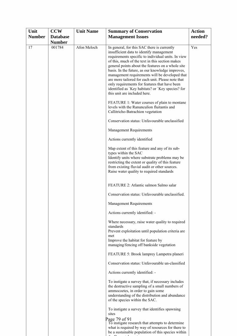
Page 79 of 91
Unit Number
CCW Database Number
Unit Name Summary of Conservation Management Issues
Action needed?
17 001784 Afon Meloch In general, for this SAC there is currently insufficient data to identify management requirements specific to individual units. In view of this, much of the text in this section makes general points about the features on a whole site basis. In the future, as our knowledge improves, management requirements will be developed that are more tailored for each unit. Please note that only requirements for features that have been identified as `Key habitats? or `Key species? for this unit are included here. FEATURE 1: Water courses of plain to montane levels with the Ranunculion fluitantis and Callitricho-Batrachion vegetation Conservation status: Unfavourable unclassified Management Requirements Actions currently identified Map extent of this feature and any of its sub-types within the SAC Identify units where substrate problems may be restricting the extent or quality of this feature from existing fluvial audit or other sources. Raise water quality to required standards FEATURE 2: Atlantic salmon Salmo salar Conservation status: Unfavourable unclassified. Management Requirements Actions currently identified: - Where necessary, raise water quality to required standards Prevent exploitation until population criteria are met Improve the habitat for feature by managing/fencing off bankside vegetation FEATURE 5: Brook lamprey Lampetra planeri Conservation status: Unfavourable un-classified Actions currently identified: - To instigate a survey that, if necessary includes the destructive sampling of a small numbers of ammocoetes, in order to gain some understanding of the distribution and abundance of the species within the SAC. To instigate a survey that identifies spawning sites To instigate research that attempts to determine what is required by way of resources for there to be a sustainable population of this species within th D t h t
Yes

Page 80 of 91
Unit Number
CCW Database Number
Unit Name Summary of Conservation Management Issues
Action needed?
18 001785 Upper Afon Ceiriog Entirely Within Wrexham CB
In general, for this SAC there is currently insufficient data to identify management requirements specific to individual units. In view of this, much of the text in this section makes general points about the features on a whole site basis. In the future, as our knowledge improves, management requirements will be developed that are more tailored for each unit. Please note that only requirements for features that have been identified as `Key habitats? or `Key species? for this unit are included here. FEATURE 1: Water courses of plain to montane levels with the Ranunculion fluitantis and Callitricho-Batrachion vegetation Conservation status: Unfavourable unclassified Management Requirements Actions currently identified Map extent of this feature and any of its sub-types within the SAC Identify units where substrate problems may be restricting the extent or quality of this feature from existing fluvial audit or other sources. Raise water quality to required standards FEATURE 2: Atlantic salmon Salmo salar Conservation status: Unfavourable unclassified. Management Requirements Actions currently identified: - Where necessary, raise water quality to required standards Prevent exploitation until population criteria are met Improve the habitat for feature by managing/fencing off bankside vegetation FEATURE 5: Brook lamprey Lampetra planeri And FEATURE 6: River Lamprey Lampetra fluviatilis Conservation status: Unfavourable un-classified Actions currently identified: - To instigate a survey that, if necessary includes the destructive sampling of a small numbers of ammocoetes, in order to gain some understanding of the distribution and abundance of the species within the SAC. To instigate a survey that identifies spawning sites T i ti t h th t tt t t d t i
Yes
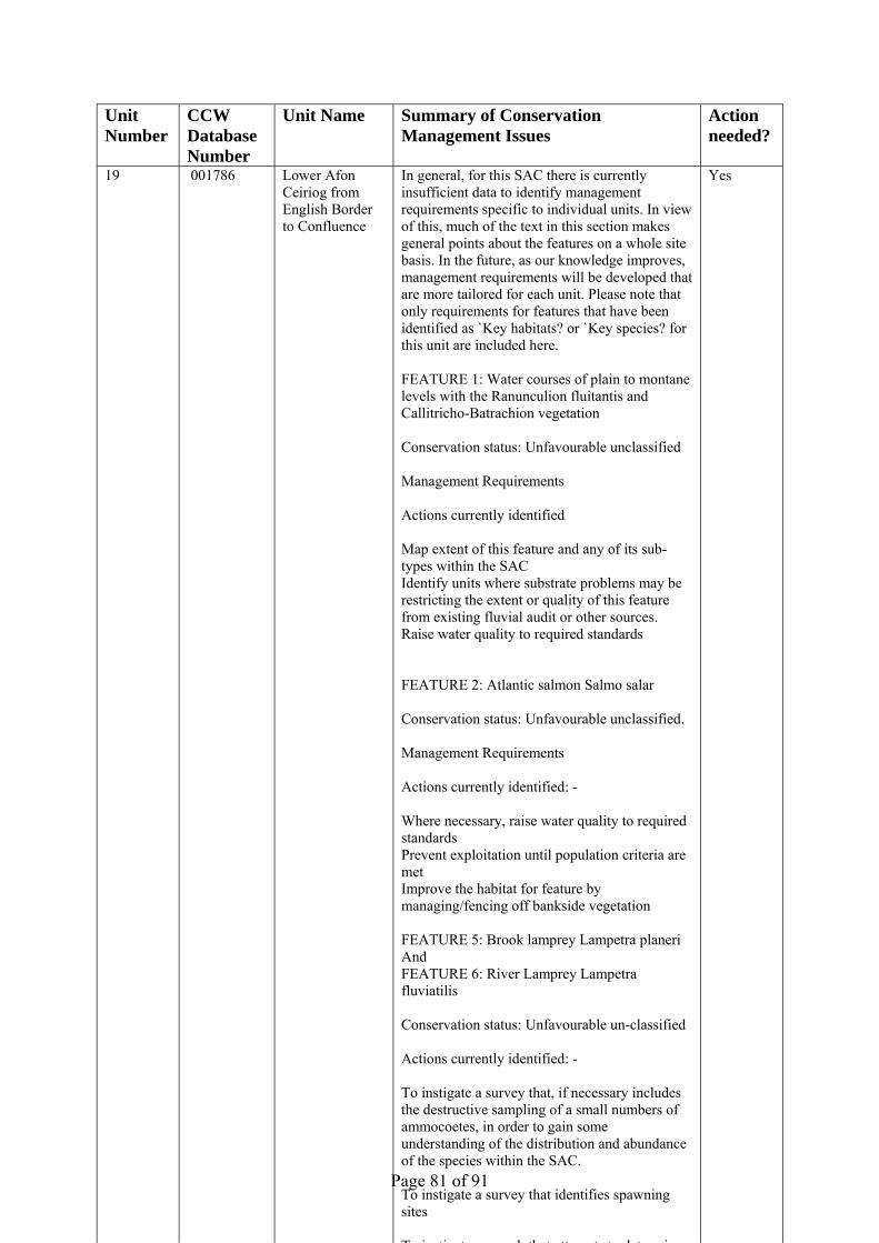
Page 81 of 91
Unit Number
CCW Database Number
Unit Name Summary of Conservation Management Issues
Action needed?
19 001786 Lower Afon Ceiriog from English Border to Confluence
In general, for this SAC there is currently insufficient data to identify management requirements specific to individual units. In view of this, much of the text in this section makes general points about the features on a whole site basis. In the future, as our knowledge improves, management requirements will be developed that are more tailored for each unit. Please note that only requirements for features that have been identified as `Key habitats? or `Key species? for this unit are included here. FEATURE 1: Water courses of plain to montane levels with the Ranunculion fluitantis and Callitricho-Batrachion vegetation Conservation status: Unfavourable unclassified Management Requirements Actions currently identified Map extent of this feature and any of its sub-types within the SAC Identify units where substrate problems may be restricting the extent or quality of this feature from existing fluvial audit or other sources. Raise water quality to required standards FEATURE 2: Atlantic salmon Salmo salar Conservation status: Unfavourable unclassified. Management Requirements Actions currently identified: - Where necessary, raise water quality to required standards Prevent exploitation until population criteria are met Improve the habitat for feature by managing/fencing off bankside vegetation FEATURE 5: Brook lamprey Lampetra planeri And FEATURE 6: River Lamprey Lampetra fluviatilis Conservation status: Unfavourable un-classified Actions currently identified: - To instigate a survey that, if necessary includes the destructive sampling of a small numbers of ammocoetes, in order to gain some understanding of the distribution and abundance of the species within the SAC. To instigate a survey that identifies spawning sites T i ti t h th t tt t t d t i
Yes

Page 82 of 91
Unit Number
CCW Database Number
Unit Name Summary of Conservation Management Issues
Action needed?
01b 003004 Llyn Tegid SAC not SSSI
This unit is considered to be under appropriate conservation management.
No
20 003005 River Dee SAC not SSSI
This unit is considered to be under appropriate conservation management.
No
7. GLOSSARY This glossary defines the some of the terms used in this Core Management Plan. Some of the definitions are based on definitions contained in other documents, including legislation and other publications of CCW and the UK nature conservation agencies. None of these definitions is legally definitive. Additional terms used in individual plans can be added to these definitions, but these definitions should not be changed or removed. Action A recognisable and individually described act, undertaking or project of any
kind, specified in section 6 of a Core Management Plan or Management Plan, as being required for the conservation management of a site.
Attribute A quantifiable and monitorable characteristic of a feature that, in combination
with other such attributes, describes its condition. Common Standards Monitoring A set of principles developed jointly by the UK
conservation agencies to help ensure a consistent approach to monitoring and reporting on the features of sites designated for nature conservation, supported by guidance on identification of attributes and monitoring methodologies.
Condition A description of the state of a feature in terms of qualities or attributes that
are relevant in a nature conservation context. For example the condition of a habitat usually includes its extent and species composition and might also include aspects of its ecological functioning, spatial distribution and so on. The condition of a species population usually includes its total size and might also include its age structure, productivity, relationship to other populations and spatial distribution. Aspects of the habitat(s) on which a species population depends may also be considered as attributes of its condition.
Condition assessment The process of characterising the condition of a feature with
particular reference to whether the aspirations for its condition, as expressed in its conservation objective, are being met.
Condition categories The condition of feature can be categorised, following
condition assessment as one of the following2:
2 See JNCC guidance on Common Standards Monitoring http://www.jncc.gov.uk/page-2272

Page 83 of 91
Favourable: maintained; Favourable: recovered;
Favourable: un-classified Unfavourable: recovering; Unfavourable: no change; Unfavourable: declining; Unfavourable: un-classified Partially destroyed; Destroyed. Conservation management Acts or undertaking of all kinds, including but not necessarily
limited to actions, taken with the aim of achieving the conservation objectives of a site. Conservation management includes the taking of statutory and non-statutory measures, it can include the acts of any party and it may take place outside site boundaries as well as within sites. Conservation management may also be embedded within other frameworks for land/sea management carried out for purposes other than achieving the conservation objectives.
Conservation objective The expression of the desired conservation status of a feature,
expressed as a vision for the feature and a series of performance indicators. The conservation objective for a feature is thus a composite statement, and each feature has one conservation objective.
Conservation status A description of the state of a feature that comprises both its
condition and the state of the factors affecting or likely to affect it. Conservation status is thus a characterisation of both the current state of a feature and its future prospects.
Conservation status assessment The process of characterising the conservation status of
a feature with particular reference to whether the aspirations for it, as expressed in its conservation objective, are being met. The results of conservation status assessment can be summarised either as ‘favourable’ (i.e. conservation objectives are met) or unfavourable (i.e. conservation objectives are not met). However the value of conservation status assessment in terms of supporting decisions about conservation management, lies mainly in the details of the assessment of feature condition, factors and trend information derived from comparisons between current and previous conservation status assessments and condition assessments.

Page 84 of 91
Core Management Plan A CCW document containing the conservation objectives for a site and a summary of other information contained in a full site Management Plan.
Factor Anything that has influenced, is influencing or may influence the condition of
a feature. Factors can be natural processes, human activities or effects arising from natural process or human activities, They can be positive or negative in terms of their influence on features, and they can arise within a site or from outside the site. Physical, socio-economic or legal constraints on conservation management can also be considered as factors.
Favourable condition See condition and condition assessment Favourable conservation status See conservation status and conservation status
assessment.3 FCS See Favourable Conservation Status (above) Feature The species population, habitat type or other entity for which a site is
designated. The ecological or geological interest which justifies the designation of a site and which is the focus of conservation management.
Habitat Classified plant community Integrity See site integrity Key Feature The habitat or species population within a management unit that is the
primary focus of conservation management and monitoring in that unit. Management Plan The full expression of a designated site’s legal status, vision, features,
conservation objectives, performance indicators and management requirements. A complete management plan may not reside in a single document, but may be contained in a number of documents (including in particular the Core Management Plan) and sets of electronically stored information.
Management Unit An area within a site, defined according to one or more of a range of
criteria, such as topography, location of features, tenure, patterns of land/sea use. The key characteristic of management units is to reflect the spatial scale at which conservation management and monitoring can be most effectively organised. They are used as the primary basis for differentiating priorities for conservation management and monitoring in different parts of a site, and for facilitating communication with those responsible for management of different parts of a site.
Monitoring An intermittent (regular or irregular) series of observations in time, carried out
to show the extent of compliance with a formulated standard or degree of deviation from an expected norm. In Common Standards Monitoring, the
3 A full definition of favourable conservation status is given in Section 4.

Page 85 of 91
formulated standard is the quantified expression of favourable condition based on attributes.
Operational limits The levels or values within which a factor is considered to be
acceptable in terms of its influence on a feature. A factor may have both upper and lower operational limits, or only an upper limit or lower limit. For some factors an upper limit may be zero.
Performance indicators The attributes and their associated specified limits, together
with factors and their associated operational limits, which provide the standard against which information from monitoring and other sources is used to determine the degree to which the conservation objectives for a feature are being met. Performance indicators are part of, not the same as, conservation objectives. See also vision for the feature.
Plan or project Project: Any form of construction work, installation, development or
other intervention in the environment, the carrying out or continuance of which is subject to a decision by any public body or statutory undertaker. Plan: a document prepared or adopted by a public body or statutory undertaker, intended to influence decisions on the carrying out of projects. Decisions on plans and projects which affect Natura 2000 and Ramsar sites are subject to specific legal and policy procedures.
Site integrity The coherence of a site’s ecological structure and function, across its whole
area, that enables it to sustain the habitat, complex of habitats and/or the levels of populations of the species for which it is designated.
Site Management Statement (SMS) The document containing CCW’s views about the
management of a site issued as part of the legal notification of an SSSI under section 28(4) of the Wildlife and Countryside Act 1981, as substituted.
Special Feature See feature. Specified limit The levels or values for an attribute which define the degree to which
the attribute can fluctuate without creating cause for concern about the condition of the feature. The range within the limits corresponds to favourable, the range outside the limits corresponds to unfavourable. Attributes may have lower specified limits, upper specified limits, or both.
Unit See management unit. Vision for the feature The expression, within a conservation objective, of the
aspirations for the feature concerned. See also performance indicators.

Page 86 of 91
Vision Statement The statement conveying an impression of the whole site in the state that is intended to be the product of its conservation management. A ‘pen portrait’ outlining the conditions that should prevail when all the conservation objectives are met. A description of the site as it would be when all the features are in favourable condition.
8. REFERENCES AND ANNEXES
References for river units APEM (Unpublished), River Dee Fish Entrainment Study undertaken for United Utilities, Dee Valley Water and Dwr Cymru (Welsh Water) Cowx IG & Fraser D (2003). Monitoring the Atlantic Salmon. Conserving Natura 2000 Rivers Monitoring Series No.7, English Nature, Peterborough. http://www.english-nature.org.uk/LIFEinUKRivers/species/salmon_monitoring.pdf Harvey JP & Cowx IG (2003). Monitoring the River, Brook and Sea Lamprey, Lampetra fluviatilis, L. planeri and Petromyzon marinus. Conserving Natura 2000 Rivers Monitoring Series No.5, English Nature, Peterborough. http://www.english-nature.org.uk/LIFEinUKRivers/species/lamprey_monitoring.pdf
Hatton-Ellis TW & Grieve N (2003). Ecology of Watercourses Characterised by Ranunculion fluitantis and Callitricho-Batrachion Vegetation. Conserving Natura 2000 Rivers Ecology Series No. 11. English Nature, Peterborough. Scarlett, P. M., Shirley, C. L. R., Henville, P., Hornby, D.D. and Dawson, F. H., (2003), A Resurvey of the Afon Dyfrdwy / River Dee and Selected Tributaries for Aquatic Macrophytes, CCW. JNCC (Jount Nature Conservation Committee), (August 2004), Common Standards Monitoring Guidance for Mammals Version Updated from (February 2004) JNCC (Jount Nature Conservation Committee), (2005), Common Standards Monitoring Guidance For Freshwater fauna, Version August 2005 (online) JNCC, (Jount Nature Conservation Committee), (March 2005),Common Standards Monitoring Guidance for Rivers, on line version. Morgan, P. L., (2004), Current and Potential Distribution, Condition and Breeding Success of the Otter (Lutra lutra) in the River Dee Catchment, CCW 2004. Feature 3: Floating water plantain Evans, F. and Benoit, P., (1997) Wetland and aquatic plants on the margins of Llyn Tegid. In: Duigan, C. Gritten, R. and Millband, H. (Eds) Llyn Tegid Symposium. The Ecology conservation and

Page 87 of 91
environmental history of the largest natural lake in Wales. Maentwrog, University of Liverpool, 79 -92. Jones, A. (1994) File note. Countryside Council for Wales. (2007b) Llyn Tegid SSSI Scientific files SH93.1.1. Unpublished public documents held at CCW office, Dolgellau. Turner, D. & Dilwyn, L.W. (1805) The botanist’s guide through England and Wales. Volume 2. Phillips & Farndon, London, 394 pp. Wood, W. (1780) ex. Herbarium University of Leeds. Feature 9: The Lake and Aquatic/Emergent Vegetation Evans, F. and Benoit, P., (1997) Wetland and aquatic plants on the margins of Llyn Tegid. In: Duigan, C. Gritten, R. and Millband, H. (Eds) Llyn Tegid Symposium. The Ecology conservation and environmental history of the largest natural lake in Wales. Maentwrog, University of Liverpool, 79 -92. Forestry Authority (1993) Forest and water guidelines. Third Edition. HMSO. London. Pearsall, W.H. (1920).The aquatic vegetation of the English lakes. Journal of Ecology, Vol.8, No. 3, pp.163 - 201. Rodwell, J. S. (ed.) (1991) British Plant Communities. Volume 1. Woodlands and scrub. Cambridge: Cambridge University Press
Rodwell, J. S. (ed.) (1995) British Plant Communities. Volume 4. Aquatic communities, swamps and tall-herb fens. Cambridge: Cambridge University Press.
Welsh Assembly Government (WAG) (2207) Catchment Sensitive Farming [online]. www.new.wales.gov.uk/topics/environmentcountryside/env_cons_management/cs_farming. [Accessed 1 July 2007]. Winfield, I. (2006) Pers comm. to Heather Garrett, CCW, Dolgellau. Feature 10; Lake Fen/Swamp Burgess, A., Goldsmith, B., Hatton-Ellis, T. (2006). Site condition assessments of Welsh SAC and SSSI standing water features. CCW Science Report (705). Countryside Council for Wales (CCW). Bangor. Evans, F. and Benoit, P., (1997) Wetland and aquatic plants on the margins of Llyn Tegid. In: Duigan, C. Gritten, R. and Millband, H. (Eds) Llyn Tegid Symposium. The Ecology conservation and environmental history of the largest natural lake in Wales. (Maentwrog, November 1997.) University of Liverpool, Liverpool 79 -92. Garrett, H. (2007) The NVC S11 Carex vesicaria swamp community of Llyn Tegid, Merioneth: Is grazing a suitable conservation management technique for maintaining the species composition of this sedge community? MSc Thesis. University of Birmingham. Rodwell, J. S. (ed.) (1991) British Plant Communities. Volume 1. Woodlands and scrub. Cambridge: Cambridge University Press. Rodwell, J. (ed.) (1992) National Vegetation Classification. Swamps and tall-herb fens. Pre-publication draft: Peterborough: Nature Conservancy Council.

Page 88 of 91
Rodwell, J. S. (ed.) (1995) British Plant Communities. Volume 4. Aquatic communities, swamps and tall-herb fens. Cambridge: Cambridge University Press. Feature 11: Gwyniad Bean, C.W. (2003) A standardised survey and monitoring protocol for the assessment of white fish (Coregonus alba (L.) & C. lavaretus (L.), populations in the UK. SNH Research & Monitoring Report. Duigan, C., Gritten, R. and Millband, H. (Eds) (1997) Llyn Tegid Symposium. The Ecology, conservation and environmental history of the largest natural lake in Wales. Maentwrog: University of Liverpool. Winfield, I.J. ; Centre for Ecology and Hydrology (CEH) (2001). A risk assessment for the Gwyniad (Coregonus lavaretus) population in Llyn Tegid. (CCW Science Report; 424). Bangor : Countryside Council for Wales (CCW). Winfield, I.J. ; Fletcher, J.M. (2001). Gwyniad translocation project plan. [Confidential]. (CEH Report; WI/C01860/2) (CCW Science Report; 487). Bangor : Countryside Council for Wales (CCW). Winfield, I.J. ; Fletcher, J.M. ; Cubby, P.R. ; Cragg-Hine, D. ; Institute Of Freshwater Ecology (1996). Echo-sounding studies of Coregonus albula and C. lavaretus in England and Wales, with particular reference to dissolved oxygen levels. (NRA R&D Note). Bristol : National Rivers Authority (NRA). Winfield, I.J. ; Fletcher, J.M. ; James, B. (2006). Llyn Tegid hydroacoustic surveys 2005. (CCW Science Report; 713). Bangor : Countryside Council for Wales (CCW). Winfield, I.J. ; Fletcher, J.M. ; James, J.B. (2003). Gwyniad translocation project : phase two : a dietary study of the Gwyniad. (CCW Science Report; 598). Bangor : Countryside Council for Wales (CCW). Winfield, I.J. ; Fletcher, J.M. ; James, J.B. (2003). Gwyniad translocation project : Phase one : a condition assessment of the potential donor population in Llyn Tegid. (CCW Science Report; 597). Bangor : Countryside Council for Wales (CCW). Winfield, I.J. ; Fletcher, J.M. ; James, J.B. (2005). Gwyniad translocation project 2004-05 : translocation attempt. (CCW Science Report; 703). Bangor : Countryside Council for Wales (CCW). Winfield, I.J. ; Fletcher, J.M. ; James, J.B. (2006). Llyn Tegid gwyniad translocation advice 2005-2006. (CCW Science Report; 748). Bangor : Countryside Council for Wales (CCW). Winfield, I.J. ; Fletcher, J.M. ; James, J.B. (2007). Llyn Tegid hydroacoustic surveys 2006. (CCW Science Report; 763). Bangor : Countryside Council for Wales (CCW). Winfield, I.J. ; Fletcher, J.M. ; James, J.B. ; Centre for Ecology and Hydrology (CEH) (2005). Gwyniad translocation project 2004 - 05 : hydroacoustic survey of Llyn Tegid. (CCW Science Report; 618). Bangor : Countryside Council for Wales (CCW). Winfield, I.J. ; Fletcher, J.M. ; James, J.B. ; Lyle, A.A. ; Centre for Ecology and Hydrology (CEH) (2003). Gwyniad trial translocation 2002 - 2003. (CCW Science Report; 576). Bangor : Countryside Council for Wales (CCW).

Page 89 of 91
Winfield, I.J. ; Institute Of Freshwater Ecology (1996). Intraspecific variation among the Coregonus albula and C. lavaretus populations of England and Wales. (NRA R&D Note). Bristol : National Rivers Authority ( Feature 12: Glutinous Snail Holyoak, D.T. ; Willing, M.J. (1998). Status and ecology of the glutinous snail Myxas glutinosa at Llyn Tegid. . (CCW Science Report; 338). Bangor : Countryside Council for Wales (CCW). Willing, M. (2004). Condition assessment of the glutinous snail Myxas glutinosa in Llyn Tegid in 2005. (CCW Science Report; 726). Bangor : Countryside Council for Wales (CCW). Willing, M. (2004). Condition assessment of the glutinous snail Myxas glutinosa in Llyn Tegid, 2002. (CCW Science Report; 557). Bangor : Countryside Council for Wales (CCW).
END

Page 90 of 91
Annex X
Removed to increase speed of transfer during editing

Page 91 of 91
Map X: Map showing location of fen /swamp at Llyn Tegid Fen / swamp areas shown in areas with black stippling on a yellow background.
Removed to increase speed of transfer during editing