core management plan including conservation …
TRANSCRIPT

CYNGOR CEFN GWLAD CYMRU COUNTRYSIDE COUNCIL FOR WALES
CORE MANAGEMENT PLAN INCLUDING CONSERVATION OBJECTIVES
FOR
CERNYDD CARMEL SAC (SPECIAL AREA OF
CONSERVATION)
More detailed maps of management units can be provided on request. A Welsh version of all or part of this document can be made available on request.
Versions Date Approved by: Notes 11 21 February
2011 Charlotte Gjerlov Current version
10 20 January 2011
Charlotte Gjerlov Now superseded by version 11 (February 2011)
9 5 April 2008
Tracey Lovering Now superseded by version 10 (January 2011)

CONTENTS Preface: Purpose of this document 1. Vision for the Site 2. Site Description
2.1 Area and Designations Covered by this Plan 2.2 Outline Description 2.3 Outline of Past and Current Managemen2.4 Management Units
3. The Special Features
3.1 Confirmation of Special Features 3.2 Special Features and Management Units
4. Conservation Objectives Background to Conservation Objectives 4.1 Conservation Objective for Feature 1:
Turloughs 4.2 Conservation Objective for Feature 2:
Tilio-Acerion forests of slopes, screes and ravines 4.3 Conservation Objective for Feature 3:
Northern Atlantic wet heaths with Erica tetralix 4.4 Conservation Objective for Feature 4:
European dry heaths 4.5 Conservation Objective for Feature 5:
Active raised bogs
. Assessment of Conservation Status and Management Requirements: re 1:
5.2 Conservation Status and Management Requirements of Feature 2: Tilio-Acerion forests of slopes, screes and ravines 5.3 Conservation Status and Management Requirements of Feature 3: Northern Atl Eric
Conservation Status and Management Requirements of Feature 4: European dry heaths
nservation Status and Management Requirements of Feature 5: ive raised bogs
6. Action Plan: Summary 7. Glossary 8. References and Annexes
t
5
5.1 Conservation Status and Management Requirements of FeatuTurloughs
a tetralix antic wet heaths with 5.4
5.5 CoAct
2

PREFACE This document provides the main elements of CCW’s management plan for the site named. It sets out
hat needs to be achieved on the site, the results of monitoring and advice on the action required. able through CCW’s web site and may be revised in response to changing
ircumstances or new information. This is a technical document that supplements summary rmation on the web site.
One of is to provide CCW’s statement of the Conservation Objectives for t o implement the Conservation (Natural Habitat ed (Section 4). As a matter of Welsh Assembly
overnment Policy, the provisions of those regulations are also to be applied to Ramsar sites in Wales.
wThis document is made availcinfo
the key functions of this document he relevant Natura 2000 site. This is required t
s, &c.) Regulations 1994, as amendG
3

1. VISION FOR THE SITE
land,
The turlough will continue to fill and empty on a seasonal basis, with the basin typically filling with water during autumn and winter, and drying out in summer. It will be fed by clean, unpolluted water filtering in from the limestone aquifer below. Any scrub encroachment in the turlough basin will be controlled, allowing its specialist flora and fauna to thrive. The ash woodland will remain as a distinct patchwork of wooded blocks, occupying the many limestone knolls at the site. It will form a characteristic element of the historic woodland-grassland landscape pattern of Carmel. The woodland canopy will be largely dominated by ash, over a rich under-storey of young trees and shrubs including hazel, hawthorn, spindle and buckthorn. The ground flora will include a rich mixture of woodland herbs including bluebell, dog’s mercury, wood anemone, wild garlic and hart’s tongue fern, as well as rarities such as lily of the valley, mezereon and herb paris. Heathland will be prevalent on the southern Millstone Grit ridge. Stands of dry heath will occupy the more freely draining parts of the ridge, with wet heath on the damper soils. The heathland should be lightly grazed by cattle and ponies, to encourage a high cover of heather and other dwarf shrubs, whilst preventing encroachment by scrub or bracken. Raised bog vegetation will occupy the series of peaty depressions within the Millstone Grit ridge. The natural hydrology of these bogs will be unaffected by artificial drainage or other modifying factors. The mire surfaces should display a natural ‘hummock and hollow’ topography and support a specialist bog flora including hare’s-tail cotton-grass, deergrass, cross-leaved heath and bog mosses. Species-rich neutral grassland should cover most of the freely draining land at Pwll Edrychiad. This vegetation will include a range of meadow flowers including common knapweed, bird’s-foot-trefoil, red clover and whorled caraway; there should also be a large population of greater butterfly-orchid in most years. Stands of previously improved grassland elsewhere at the site (notably in the NNR units) will support more species-rich vegetation, a consequence of grassland restoration management. Marshy grassland will cover the damper soils at Pwll Edrychiad and other wet parts of the site. These areas will support a typical range of wetland plants including purple moor-grass, sharp-flowered rush, carnation sedge, tormentil and devil’s-bit scabious. Finally the important geological exposures at Carmel should remain visible and available for continued study.
This is a descriptive overview of what needs to be achieved for conservation on the site. It brings together and summarises the Conservation Objectives (part 4) into a single, integrated statement about the site.
Cernydd Carmel SAC will support a wide range of habitats, including woodland, heathraised bog and grassland, as well as the seasonal lake – or turlough – at the eastern end of the site.
4

2. SITE DESCRIPTION
2.1 Area and Designations Covered by this Plan
nitary authority: Caerfyrddin / Carmarthenshire
nations covered:
Site t.
) is also designated as Carmel National Nature Reserve (NNR).
Grid reference: SN 592 161 U Area (hectares): 361.14 ha Desig Cernydd Carmel Special Area of Conservation (SAC) is also notified as Cernydd Carmelof Special Scientific Interest (SSSI). The SAC and SSSI boundaries are entirely coinciden Approximately 85 ha of the site (mainly the Glangwenlais Quarry, Pwll Edrychiad and Garn land holdings Detailed maps of the designated sites are available through CCW’s web site: http://www.ccw.gov.uk/interactive-maps/protected-areas-map.aspx For a summary map showing the coverage of this document see attached Unit Map. Outline Description 2.2
ernydd Carmel is situated immediately south of the village of Carmel in south
,
he distribution of habitats is, to a large extent, determined by the underlying geology. Much th
asonal lake with no natural inlet or outflow streams. It is d entirely by groundwater from the underlying limestone aquifer, with its water level
nex I
ork of small woods with reas of grassland between, giving the landscape a distinctive mosaic pattern. Most of the
drychiad holding.
oth dry and wet heath occurs on the acidic Millstone Grit ridge. The dry heath corresponds to the Annex I habitat ‘European dry heaths’, while the wet heath is referable to ‘Northern Atlantic wet heaths with Erica tetralix’.
CCarmarthenshire. A diverse range of habitats is represented, including woodland, grasslandheathland and bog. Of particular interest is the seasonal lake – or turlough – situated next to the small hamlet of Pantllyn at the eastern end of the site. Tof the site is located on a thin band of Carboniferous Limestone, which is overlain to the souby acidic Millstone Grit; linear bands of softer shales also occur within the Millstone Grit strata. Pant-y-llyn turlough is an unusual sefedetermined by seasonal variation in the groundwater table. The turlough fills to a depth of approximately 3 metres during the autumn-spring period and empties in summer. Discharge and recharge seemingly occurs through a swallow hole at the northern end of the basin, although other sinks and springs could also be involved. Pant-y-llyn turlough is thought to be the only known example of its kind in mainland Britain and is recognised as the SAC Anhabitat type ‘Turloughs’. Ash woodland occurs extensively at Cernydd Carmel, generally occupying the many limestone knolls at the site. This woodland corresponds to the Annex I habitat ‘Tilio-Acerion forests of slopes, screes and ravines’. It typically occurs as a patchwagrassland at Carmel is agriculturally improved, but stands of semi-natural neutral grassland occur in the Pwll E B
5

The bands of softer shale withinsupporting mire vegetation. These stands are re
the Millstone Grit have given rise to linear depressions cognised as the Annex I habitat ‘Active raised
2.3 nd Cu ement
gnificant historical land use at med tha d mainly as pasture, but
ary evidence that arable farming was also carried out in the past (Dyfed rust, 19
ries, lime kilns, spoil heaps and routeways indicate that quarrying
t
e.g. Stringer & avies, 1989). Various studies have shown that woodland management was also widely
ing fuel r the numerous lime kilns, it has been suggested that most of the timber was used to produce
ron forges (Dyfed Archaeological Trust, 1992). Indeed the discovery of anthracite remains in many of the old spoil heaps indicates that anthracite was the principal
st structure in the absence of any
anagement. Apart from some recent (2001/02) coppicing and thinning in the woodland
the grassland at Carmel is now grazed by either cattle, ponies or, to a lesser extent, heep. Much of this agriculture is fairly non-intensive. Indeed the grassland within the NNR
other
willow and alder scrub was undertaken in the turlough basin in 003.
2.4
ary. In this plan the management units have been ased mainly on tenure, but also with reference to features and land management
bogs’.
Outline of Past a rrent Manag With its rural setting, agriculture has inevitably been a si
armel. It is presu t most of the grassland has been manageCthere is document
rchaeological T 92). A
he abundance of old quarTwas widely practised, probably from about the sixteenth century (Dyfed Archaeological Trust, 1992). Much of the quarried limestone would have been burnt in the numerous lime kilns to
roduce lime as an agricultural fertiliser. It is thought that small-scale quarrying and lime pburning had largely ceased by the early 1900s, to be replaced by larger operations at Glangwenlais Quarry and Pwllymarch Quarry. A large gritstone quarry was also developed a
llt y Garn. Each of these quarries, however, has now ceased operating. A The long-established mosaic of woodland and grassland is well documented (Dpractised, especially coppicing (Rackham, 1992; Peterken, 1999). Rather than providfocharcoal for the local i
fuel for the lime kilns, rather than charcoal. Rackham (1992) estimates that regular coppicing of the woods ceased about 1920. Since thenmost of the woods have developed an even-aged, high foremaround Glangwenlais Quarry, the majority of woods at Carmel have received very little woodland management in recent decades. Most ofsparts of the site is managed principally for nature conservation, with the intention of maintaining the existing areas of semi-natural grassland at Pwll Edrychiad and restoringmore improved swards through appropriate grassland restoration methods. A number of private holdings in the Carmel SAC are also managed under agri-environment agreements. There is evidence that part of the turlough was managed as a meadow in the nineteenth century (Blackstock et al., 1993), but no such management has taken place in recent times. Some clearance of mature2 Management Units The plan area has been divided into management units to enable practical communication about features, objectives, and management. This will also allow us to differentiate between the different designations where necessbrequirements.
6

It should be clarified here that some of the NNR units are managed by CCW, with other umanaged by The Grasslands Trust. A small section of the NNR is also in private ownership but is s
nits
ubject to a Nature Reserve Agreement with CCW. The remainder of the SAC is in multiple private ownership.
he following table confirms the relationships between the management units and the
managed s
Trust managed
Tdesignations covered: Unit number
SAC SSSI NNR CCW Grassland
Cernydd Carmel 1 a a 2 a a 3 a a 4 a a 5 a a 6 a a 7 a a 8 a a 9 a a 10 a a 11 a a 12 a a 13 a a14 a a 15 a a a 16 a a 17 a a 18 a a 19 a a a 20 a a 21 a a 22 a a 23 a a 24 a a 25 a a 26 a a 27 a a 28 a a 29 a a 30 a a 31 a a a a 32 a a 33 a a a 34 a a 35 a a 36 a a a a 37 a a 38 a a 39 a a 40 a a a a
7

Unit number
SAC SSSI NNR CCW managed
Grasslands Trust managed
Cernydd Carmel 41 a a 42 a a 43 a a 44 a a 45 a a a 46 a a 47 a a 48 a a 49 a a 50 a a 51 a a 52 a a a a 53 a a 54 a a 55 a a 56 a a 57 a a 58 a a 59 a a 60 a a 61 a a a a
8

3. THE SPECIAL FEATURES 3.1 Confirmation of Special Features
Designated feature Relationships, nomenclature etc Conservation Objective in part 4
SAC features Annex I habitats that a primary arereason for selection is site
of th
1. Turloughs (EU habitat code 3180)
quates to sta ing water – easonal/ temp rary waters SSSI ature
1 E nds ofe
Annex I habitats present as a qualifying feature, bu t a primaryt no reason for site select
ion
2. Tilio-Acerion forests of slopes, screes and ravines
art of broad ved woodla SSI ature
2 P -lea nd Sfe
3. Northern Atlantic wet heaths with Erica tetralix (EU habitat code 4010)
quates to we eath SSSI fea re 3 E t h tu
4. European dry heaths (EU habitat code 4030)
quates to dry heath SSSI feature 4 E
5. Active raised bog U habitat s (Ecode 7110)
quates to low and raised bog SSI ature
5 E l Sfe
SPA features Not applicable Ramsar features Not applicable SSSI features Note: Conservation objectives for the SSSI features will be developed at a later stage. 6. Standing water – seasonal/ temporary waters
Equates to turlough SAC feature 1
7. Broad-leaved woodland Includes Tilio-Acerion SAC feature To be developed
8. Wet heath Equates to Northern Atlantic wet heaths SAC feature
3
9. Dry heath Equates to European dry heaths SAC feature
4
10. Lowland raised bog Equates to active raised bogs SAC feature
5
11. Neutral grassland No equivalent SAC feature To be developed
12. Lily of the valley No equivalent SAC feature To be developed
13. Mezereon No equivalent SAC feature To be developed
14. Pebbly sandstones No equivalent SAC feature To be developed
15. Karst No equivalent SAC feature To be developed
9

10
Units
This section sets out the relationship between the spe manT ovide a clear statemen e mantaking into account the varied needs of the different special features. All specialallocated to one of seven classes in each management unit. These classes are:
Key Features Kmanage ence a key s see KS below). There will usually only be nit but there can be m s. KS n often driving both the selection and management of a KeyG s monitoring effort in a unit. Other FSym ce features that are of importance in a unit but are not t cus ll ben it from manage nt sed m’ fa) ay be of n key
/or b) ent in the unit but in sm reas/numbers, with the bulk of the feature in
the site; and/or c) nts are broader than and compatible with the management needs of the key
. a mobile species that uses large parts of the site and surrounding areas. N ently used category where features are at risk of decline within unit as a result of meeting the m ative M These cases will usually be compensated for by management elsewhere in the plan, and can or occu se lead to apparent c r key feature in a unit. M sential for the m wh a site e.g. livestock over-wintering area included within designation boundaries, buffe nd water bodies, etc. x – Features not known to be present in the manage
The table below sets out the relationship between pecial features and management units identified in t
3.2 Special Features and Management
cial features and each t about what each unit should b
agement unit. aged for,
features are his is intended to pr
H - a ‘Key Habitat’ in the managemenment and focus of monitoring effort,
pecies (
t unit, i.e. the habitat that is the main driver of perhaps because of the depend
one Key Habitat in a u of
ore, especially with large unit – a ‘Key Species’ in the manageme
Habitat. t unit,
eo – an earth science feature that is the main driver of management and focu of
eatures - habitats, species and earth scien
he main drivers of management or foment for the key feature(s) ide
of monitoring. These features wiified in the unit. These may be clas
efas ‘Sy
eatures because: they are present in the unit but m
feature; a less conservation importance tha the
nd they are pres
other units ofall a
their requireme
feature(s), e.gm - an infrequ a
anagement needs of the key feature(s), i.e. under Neganagement.
be used where minonflict with anothe
rrences of a feature would otherwi
n - Management units that are es anagement of features else ere onr zones arou
ment unit.
the shis plan:

11
Cernydd Carmel Management Units 1 2 3 4 5 6 7 8 9 10 11 12 13 14 15 16 17 18 19 20 21 22 23 24 25 26 27 28 29 30 31 SAC a a a a a a a a a a a a a a a a a a a a a a a a a a a a a a a SSSI a a a a a a a a a a a a a a a a a a a a a a a a a a a a a a a NNR a CCW managed Grasslands Trust managed a a a
SAC features 1. Turloughs KH KH KH KH KH KH KH KH KH KH x KH KH KH KH KH KH KH KH x KH x KH KH KH x x x KH KH KH 2. Tilio-Acerion forests of slopes, screes and ravines
x x x x x x x x x x x x x x x x x x x x x x x x x x x x x x KH
3. North Atlantic wet heaths with Erica tetralix
x x x x KH xx x x x KH x x x x x x x x x x Sym x x x x Sym KH x x x
4. European dry heaths x x x x KH xx x x x KH x x x x x x x x KH x Sy x m x x KH Sym KH x x x
5. Active raised bogs x x x x x x x x x x x x x x x x x x x x x K H x x x x KH x x x x SSSI features 6. Standing water KH KH KH KH KH K K K H KH K x HKH H KH KH H x KH KH H KH K KH KH x H KH K KH x x x KH KH KH 7. Broadleaved Woodland x x Sym x x S y x y x x x x S x x x ym S m Sym x x x x x S m x x x x x ym x x KH
8. Wet Heath x x x x KH x x x x x KH x x x x x y x x x x x S m x x x x Sym KH x x x 9. Dry Heath x x x x KH x x x x x KH x x x x x x x x KH x Sy x m x x KH Sym KH x x x 10. Lowland Raised Bog x x x x x x x x x x x x x x x x x x x x x K H x x x x KH x x x x
11. Neutral Grassland x x x x x x x x x x x S x x x x x x x x x x x x x x x ym x x KH KH
12. Lily of the valley x x x x x x x x x x x x x x x x x x x x x x x x x x x x x x x
13. Mezereon x x x x x x x x x x x x x x x x x x x x x x x x x x x x x x x 14. Pebbly Sandstones x x x x x x x x x x x x x x x x x x x x x x x x x x x x x x x
15. Karst Geo Geo Geo Geo Geo G Geo Ge G G Geo Geo x Geo Geo x Geo Geo Geo eo o Geo eo x Geo Geo eo Geo Geo Geo Geo x Geo x x

x x x x x Sym x
12
Cernydd Carmel Ma e nt ninag me U ts 32 33 34 35 36 37 1 2 3 4 5 6 7 8 49 50 5 5 53 54 0 6138 39 40 4 4 4 4 4 4 4 4 1 2 55 56 57 58 59 6 SACT a a a a aa a a a a a a a a a a a a a a a a a a a a a a a a SSSI a a a a a a a a a a a a a a a a a a a a a a a a a a a a a a NNR a a a a aCCW managed a a Grasslands Trust managed a a a
SAC features 1. Turloughs x x x KH KH KH KH KH x KH KH KH KH KH KH x x KH KH KH KH KH KH x x KH KH KH KH KH 2. Tilio-Acerion forests of slopes,
s screes and ravinex x x x KH x x x x x KH KH KH KH KH x x x KH KH KH KH x x x x x x x x
3. North Atlantic wet heaths with Erica tetralix
x x x x x Sym x x Sym x x x x x x x x x Sym x x x x x x x x x x x
4. Euro ry pean dheaths KH KH Sym x x x ym x x x x x x x S x KH x x x x x x x x x x x x x x
5. Active raised bogs x S m y KH x x x x x KH x x KH x x x x x x x x x x x xx x x x x x
SSSI features 6. Standing water x x x KH KH KH KH KH x KH KH KH KH KH KH x x KH KH KH KH KH KH x x KH KH KH KH KH 7. Broadleaved Woodland x x x Sym KH x x x x x KH KH KH KH KH x x x KH KH KH KH Sym
8. Wet Heath x Sym x m x ym x x x x x x x x x x x x x x x x Sy x S x x x x x x x 9. Dry Heath KH KH Sym x x Sym x x x x x x x x x KH x x x x x x x x x x x x x x 10. LowlandBog
Raised x Sym KH x x x x x KH x x KH x x x x x x x x xx x x x x x x x x
11. Neutral Grassland x x x x Sym x x x x x x x x x x x x x x x x x x x x x x x x x
12. Lily of the valley x x x x KS x x x x x x KS x KS x x x x x x x x x x x x x x x x
13. Mezereon x x x x x x x x x x x KS x x x x x x x x x x x x x x x x x x
x 14. PebblySandstones
x x x x x x x x x x x x x x x x x x x x x x x x x x x Geo x
15. Karst x x x Geo Geo Geo Geo Geo x Geo Geo Geo Geo Geo Geo x x Geo Geo Geo Geo Geo Geo x x Geo Geo Geo Geo Geo

13
4. ERVATION OBJECTIVESCONS
u se tion ect :
al text pu se c
D 2 E he Habitats Directives is the maintenance, or where appropriate the restoration of the
vourable conse tio tatus’ of habit which SACs ignated (see B 1)
' urab ns ti e r in iscondition and all the things needed to keep it that way are in place for the foreseeable future.
n th ncep fav b t s r e r robust basis for conservation objectives for Natura 2000 and Ramsar sites.
Achieving these objectives requires appropriate man m t and the control of factors that io habitats or significant disturbance to species.
e l tion mm ic e e e e u e
• Conservation planning and management.
n at ui a em s, to m in or re e s n n
Backgro nd to Con rva Obj ives
a. Outline of the leg con and rpo of onservation objectives.
Conservation objectives are required by the 1992 ‘Habitats’ irective (9 /43/E C). The aim of t‘fa rva n s ats and species features for and SPAs are des
ox .
In the broadest terms, favo le co erva on status' m ans a featu e is sat factory
CCW co siders that e co t of oura le conserva ion tatus p ovid s a p actical and legally
age enmay cause deteriorat n of
As well as th overal func of co un ation, Cons rvation obj ctiv s hav a n mb r ofspecific roles:
Thhab
e coitat
serv and
ion objececies in
tives gfavourab
de mle co
nagditio
en.
t of site ainta stor the sp
Box 1 Favourable conservation status as defined in Articles 1(e) and 1(i) of the Habitats
o r st of a ral ita t s ng
pical species that may affect its long-term natural distributio ructure and functions as ell as the long m survival of its ty al
w n vourable when:
a and a it r t t o cr • The specific structure and functions which are necessary for its long-term
t and lik to t e e bl t • The conservation status of its ic ec s
n a f a species i o n o e h affect the -t distribution and abundan f populations. The conservation
a vour ’ w :
u d ics data on sp a t glong-term component of its natural habitats, and
• the natural range of the species is neither being reduce kel to be reduced t se le fu an
• There is, and will probably continue to be fficiently large habitat to maintain o n a lo term si
Directive
“The c nse vation atus natu hab t is he sum of the influence acti on it and its tyw
n, st ter pic species. The conservation status of a natural
habitat ill be take as fa
• Its natural r nge reas cove s wi hin tha range are stable r in easing, and
maintenance exis are ely con inue to exist for th for seea e fu ure, and typ al sp ies i favourable.
Tmay
he co servation stlong
tus oerm
s the sum f the ice o
flue its
nces acting n th species t at
status will be taken s ‘fa able hen
• pop lation ynam the ecies indic te that it is main ainin itself on a basis as a viable
d nor is li yfor he fore eab ture, d
, a suits populati ns o ng- ba s.”

• Assessing plans and projects.
Article 6(3) of the ‘Habitats’ Directive requires appropriate assessment of proposed
certain exceptions,
re and
and
e conservation objectives are subject to review by CCW in light of new
feature listed in part 3. Each conservation bject e onsi ehole aleva e
s a result f the general practice developed and agreed within the UK Conservation gen s
hould be
here is a e role of performance indicators within the onse tature, h ently of the performance indicators, and is
re than the sum of the performance indicators. The performance indicators are simply hat make the conservation objectives measurable, and are thus part of, not a substitute for, e conservation objectives. Any feature attribute identified in the performance indicators
ons are under control. Subject to technical, practical and resource constraints, he condition of the feature are identified in the
plans and projects against a site's conservation objectives. Subject to plans or projects may not proceed unless it is established that they will not adverselyaffect the integrity of sites. This role for testing plans and projects also applies to the review of existing decisions and consents.
• Monitoring and reporting.
The conservation objectives provide the basis for assessing the condition of a featuthe status of factors that affect it. CCW uses ‘performance indicators’ within the conservation objectives, as the basis for monitoring and reporting. Performance indicators are selected to provide useful information about the condition of a feature and the factors that affect it.
The conservation objectives in this document reflect CCW’s current information
nderstanding of the site and its features and their importance in an internationalntext. Th
ucoknowledge.
. Format of the conservation objectives
here is on conservation objective for each
b T e
ao iv is composite statement representing a site-specific description of what is der d to be the favourable conservation status of the feature. These statements apply to a c
w fe ture as it occurs within the whole plan area, although section 3.2 sets out their to individual management units. re nc
Each conservation objective consists of the following two elements:
1. Vision for the feature 2. Performance indicators
A oA cie , conservation objectives include performance indicators, the selection of which
informed by JNCC guidance on Common Standards Monitoring1. s T critical need for clarity over th
rva ion objectives. A conservation objective, because it includes the vision for the as meaning and substance independ
cfemowthshould be represented in the vision for the feature, but not all elements of the vision for the feature will necessarily have corresponding performance indicators. As well as describing the aspirations for the condition of the feature, the Vision section of each conservation objective contains a statement that the factors necessary to maintain those
esired conditidfactors which have an important influence on tperformance indicators.
p://www.jncc.gov.uk/page-21991 Web link: htt
14

4.1 Conservation Objective for Feature 1: Turloughs (EU habitat code 3180) Vision for fe The vision fo g conditions ar • The r ording to natural seasonal fluctuations in the underlying
quifer. Imonths.
• A natural as determinehole.
• The ollo gether with typical associated species, will be present: hydaru
• Alie ticum and
• All factors affecting the achievement of the above conditions, including water quality, water levels and
ature 1
r this feature is for it to be in a favourable conservation status, where all of the followine satisfied:
tu lough will fill and empty acca t will typically fill with water in the autumn-spring period and empty during the summer
pattern of vegetation zones will be apparent during the dry phase of the turlough,d by micro-topographical variation in the turlough basin in relation to the main swallow
wing vegetation zones, to frophytic bryophyte zone; Equisetum fluviatile zone; Carex vesicaria zone; Phalaris ndinacea zone; Salix cinerea-Galium palustre woodland zone. n plant species such as Crassula helmsii, Hydrocotyle ranuculoides, Myriophyllum aquaAzolla filiculoides will be absent.
scrub development, will be under control.
15

he performance indicators are part of
Performance indicators for Feature 1 T the conservation objective, not a substitute for it. Assessment
ust be based on the entire conservation objective, not just the performance of plans and projects mdicators. in
Performance indicators for feature condition Attribute Attribute rationale and other Specified limits
comments A1.Ext
This attribute can be monitored via simple visual checks of winter water levels.
ent
This attribute was developed by CCW’s SAC monitoring team
Upper limit: Not required Lower limit: Turlough basin will fill with water
(Lovering, 2006). The lower limit is based on extent during the wet phase. It assumes that in winter the
during wet phase
water level will reach the upper limits of inundation, approx. 3.5 m above the swallow hole to the marginal Salix woodland zone. No upper limit has been set, as the extent is naturally limited by the size of the turlough basin.
A2. Quality
This attribute was developed by CCW’s SAC monitoring team (Lovering, 2006). The lower limit is based mainly on the continued presence of a number of vegetation zones in the turlough basin during the dry phase. The various zones were originally identified by Blackstock, et al. (1993). No upper limit is required in this case. Monitoring of this attribute should be carried out in during the dry phase, ideally in July. Full monitoring should be undertaken on a six-year cycle, although brief checks for non-native arrivals etc can be carried out more regularly.
Upper limit: Not required Lower limit: Each of the following vegetation zones should be present: 1. Hydrophytic bryophyte zone – currently occurs
in the immediate vicinity of the swallow hole. 2. Equisetum fluviatile zone – currently occurs c.
0.6 m above and to the south of the swallow hole.
3. Carex vesicaria zone – currently dominates most of the turlough basin, c. 1.2-2.2 m above the swallow hole.
4. Phalaris arundinacea zone – currently occupies the northern end of the basin, c. 2.2 m above the swallow hole.
5. Salix cinerea-Galium palustre woodland zone – extends as a narrow zone around the edge of the turlough basin, up to c. 3.5 m above the swallow hole.
And associated species for each vegetation zone are present. Associated species for each zone include:
Performance indicators for feature condition (cont.d) Attribute Attribute rationale and other
comments Specified limits
A2. Quality (cont.d)
1. Hydrophytic bryophyte zone – Fontinalis antipyretica, Drepanocladus aduncus.
2. Equisetum fluviatile zone – Galium palustre,
16

Mentha aquatica, Veronica scutellata, Persicaria hydropiper, P. maculosa, Fontinalis antipyretica, Drepanocladus aduncus, Calliergon cordifolium.
Fontinalis antipyretica, Drepanocladus aduncus, Calliergon cordifolium.
4. Phalaris arundinacea zone – Solanum alium palustre, Fontinalis
antipyretica, Drepanocladus aduncus. lustre woodland zone –
tis
And
3. Carex vesicaria zone – Mentha aquatica, Phalaris arundinacea, Solanum dulcamara,
dulcamara, G
5. Salix cinerea-Galium paMentha aquatica, Solanum dulcamara, Agrosstolonifera.
alien plant species are absent. Potentially invasive non-native species include Crassula helmsii, Hydrocotyle ranunculoides, Myriophyllum aquaticum and Azolla filiculoides.
Performan g the feature ce indicators for factors affectinFactor Operational Limits Factor rationale and other
comments F1-2. Water quality factors
ood water quality is essential to
els uld be detrimental to
of ds
–
water uality parameters. Initial limits for
developed in future following further water quality sampling.
See below Gthe ecological integrity of the turlough. Increased nutrient levin particular cothe characteristic flora and fauna the turlough. Common StandarMonitoring guidance states that, forturloughs, water quality determinands and limits should be defined on a site-by-site basis, ideally following collection of a data-set of readings over timerefer to Lovering (2006) for a fuller review of potentially relevantqpH and conductivity were proposedby Lovering (2006), based on readings taken in 1992 by Blackstock et al. (1993). Performance indicators for additional parameters (including nutrient determinands) will be
17

Performance indicators for factors affecting the feature (cont.d) Factor Factor rationale and other
comments Operational Limits
F1. Water quality: pH
Limits are based on pH measurements taken in 1992 (see above). Water sampling should take place during the wet phase, ideally in March to enable monitoring of both dry and wet phases in the same reporting year.
Upper limit: pH 7.1 Lower limit: pH 6.7
F2. Water quality: conductivity
Limits are based on conductivity measurements taken in 1992 (see above). Water sampling should take place during the wet phase, ideally in March to enable monitoring of both dry and wet phases in the same reporting year.
275 µs cm Upper limit: 634 µs cm Lower limit:
F3. The turlough is fed entirely by
rbidity is kely to arise from
ce ld
Upper limit: Not required r limit: Entire bed of turlough should be
phase. Turbidity groundwater and its waters are Lowe
visible during wet normally very clear. Tumost lipollution, either via the groundwater or from surfawater runoff. Monitoring shoutake place during the wet phase,and may be undertaken throughout the monitoring cycle.
F4. Water levels
nal
r ifer.
l ould
Limits relating to water levels in the turlough are addressed in Attributes A1 and A2 above. Any concerns highlighted through monitoring of Attributes A1 and A2 should trigger investigations into Factor F4. Simple visual checks of water levels can also be carried out at various stages of the annual fill-drain cycle.
The hydrology of the turlough isdetermined by seasofluctuations in the groundwatetable of the underlying aquAny alterations to the cyclicafluctuation of water levels chave a detrimental impact on theecological and hydrological integrity of the turlough.
F5. Scrub encroachm
r is a
d fauna of
upper s been
Upper limit: 5% scrub cover Lower limit: Not required ent
Development of willow and aldescrub in the turlough basinpotential threat to the characteristic flora anthe turlough. Scrub encroachment in the turloughbasin is unacceptable and alimit of 5% scrub cover haset.
18

4.2 Conservation Objective for Feature 2: Tilio-Acerion fo avines 80) rests of slopes, screes and r (EU habitat code 91
g c y considers for ‘high forest’ Tilio-dla n woodland at present.
Nonetheless active consideration is being given to the reinstatement of coppice management at Carmel, at least lio-Acerion conservation objective will therefore be amended shortly tributes for coppice woodland, once the desired location, extent and condition of coppice woodland has been agreed. The following conservation objective should therefore be considered as provisional at present.
r featu
The vision for th rable conservation status, where all of the following conditions are sa • Tilio-Acerio tely 44 ha of Cernydd Carmel SAC.
he Tilio-Ac patc areas of grassland n, fo the
The distribu n 994. • Within the h land will be maintained as far as possible by natural
processes. • Within the h nd 25% of the woodland will comprise open glades or
canopy gaps nopy gaps may vary over time. • Trees and sh sizes should be present, including functionally
mature cano shrub layer. • ratio l b
opy loelsior, oa ix ca
glabra. Typ ude monogyna, le Ecatharticus.sylvatica wi
• The field lay wCircaea lute um ursinum, Hyacinthoides non-scripta, Mercurialis
, Co a, nopodium majus, o A
us c paeus, Convallaria majalis, Par eum will continue to be present.
• Dense bram• Within the h ll be present in the form of standing and fallen
trunks/limbs• All factors a ove conditions, including grazing and browsing,
will be unde
The followinAcerion woo
onservation objective onlnd at Cernydd Carmel. Little refere
in certain woodland units. The Ti to incorporate additional at
the desired conditionce is made to coppice
Vision fo
re 2
is feature is for it to be in a favoutisfied:
n woodland will occupy approxima• T
betweeerion woodland will occur as a
rming a characteristic element oftion of woods will mirror the patterigh forest areas, the wood
igh forest areas, between 10 a, although the location of glades/carubs of a wide range of ages and py trees, young trees and an activen of locally native trees/shrubs wil
hwork of small woods with historic landscape pattern of Cernydd Carmel. of woodland mapped in 1
Regene• The can
exc
e plentiful. cally native species including ash Fraxinus prea, yew Taxus baccata and wych elm Ulmus
hazel Corylus avellana, hawthorn Crateagusuonymus europaeus and dogwood Rhamnus ore Acer pseudoplatanus and beech Fagus
oodland herbs including Ranunculus ficaria,
will comprise varying mixtures ofk Quercus spp., goat willow Salical shrub layer species will incl
blackthorn Prunus spinosa, spind Non-native species including sycamll be largely absent. er will comprise a rich mixture oftiana, Galium odoratum, Allinopodium majus, Paris quperennis
Phyllitis sc• Locally unc
adrifolilopendrium, Arum maculatum and ommon species including Rhamnis quadrifolia and Daphne mezerble will be largely absent. igh forest areas, dead wood wi. ffecting the achievement of the abr control.
Lamiastrum galeobdolon, Conemone nemorosa. atharticus, Euonymus euro
19

Performance indicators for Feature 2 The performance indicators are part of the conservation objective, not a substitute for it. Assessment
f plans and projects must be based on the entire conservation objective, not just the performance oindicators. Performance indicators for feature condition Attribute Attribute rationale and other comments Specified limits A1. Extent of Tilio-Acerion woodland
The Tilio-Acerion feature at Cernydd Carmel is analogous to W8 woodland, the extent of which (43.9 ha) was
Upper limit: Not required Lower limit: As mapped in 1994
mapped by Mileto & Castle (1994). The lower limit is based on total extent mapped in 1994. To achieve favourable
ch individual wood mapped in 1994 must also be maintained. No upper limit
constrained by limits relating to other
conservation status, the spatial extent of ea
has been set as the potential for expansion of Tilio-Acerion woodland is naturally limited by underlying geology and topography. In certain cases expansion of Tilio-Acerion will also be
important features (e.g. neutral grassland) and the need to preserve the characteristic woodland-grassland landscape pattern. Repeat monitoring will be achieved by field-checks of baseline maps of individual woodland stands, reference to aerial photos, or a combination of both.
A2wi
on
opy
py
. Canopy cover thin Tilio-
This attribute has been developed specifically to cater for the open
Upper limit: Open glades or cangaps will comprise 25% of the
Acerion woodland [high forest areas
ly]
structure of the Tilio-Acerion woodland at Carmel. A glade or canopy gap is defined as an
woodland area Lower limit: Open glades or canogaps will comprise 10% of the woodland area
open area whose distance across is equal to or greater than the height of the tallest
area of between 15 adjacent tree, or an and 30 m across.
20

Performance indicators for feature condition (cont.d) Attribute Attribute rationale and other comments Specified limits A3. Structure of Tilio-Acer
This attribute is based on the standard Upper limit: Not required ion
woodland [high Common Standards Monitoring (CSM) attribute for this feature, but has been
-specific
such
de
,
lmus
e
Lower limit: Within a 25 m radius of at least 80% of sample points, the following
e met: mature
ent • At least 1 young tree is present • An active shrub layer with at
least 5 locally native trees/ shrubs of between 1 and 3 m is present.
forest only] modified according to siterequirements. Functionally mature trees are defined asthose which show signs of maturityas holes and hollows, rot columns, dead branches, etc. Relevant species incluash Fraxinus excelsior, oak Quercus spp., goat willow Salix caprea, yew Taxus baccata, rowan Sorbus aucupariadowny birch Betula pubescens, alder Alnus glutinosa and wych elm Uglabra. Young trees are defined as any tregreater than 3 m in height, with a girth of at least 15 cm at chest height.
conditions will b• At least 5 functionally
canopy-forming trees are pres
A4. Tree regeneration within Tilio-Acerion woodland
ndard
cific
Upper limit: Not required Lower limit: Within a 25 m radius of at least 80% of sample points, at least 10 saplings of any of the following species will be present: ash Fraxinus excelsior, oak Quercus spp., goat willow Salix caprea, yew Taxus baccata, downy birch Betula pubescens or wych elm
This attribute is based on the staCSM attribute for this feature, but has been modified according to site-sperequirements. A sapling is defined as a young tree between 1 and 2 m in height.
Ulmus glabra. A5. Species composition of Tilio-Acerion woodland: canopy and shrub layers
ied according to site-specific
Taxus baccata and
wych elm Ulmus glabra. The main native shrub species are hazel Corylus avellana, hawthorn Crataegus monogyna, blackthorn Prunus spinosa, spindle Euonymus europaeus, buckthorn Rhamnus catharticus, holly Ilex aquifolium and rowan Sorbus aucuparia.
ies,
• Non-native canopy-forming
trees, including beech and sycamore, make up no more than 5% of the canopy.
• Non-native species, including
beech and sycamore, make up no more than 5% of the shrub layer.
This attribute is based on the standard CSM attribute for this feature, but has
een modifbrequirements. At Cernydd Carmel the main native canopy species are ash Fraxinus excelsior, oak Quercus spp., goat willowSalix caprea, yew
Upper limit: Not required Lower limit: The canopy and shrub layers will be comprised of locally native specwhere:
21

Performance indicators for feature condition (cont.d) Attribute Attribute rationale and other comments Specified limits A6. Species composition ofTilio-Acerion woodland: fi
eld and ground layers
c
ense bramble is defined as stands of
nd
•
ercurialis perennis, Convallaria majalis, Paris quadrifolia, Lamiastrum galeobdolon, Conopodium majus, Phyllitis scolopendrium, Arum maculatum, Anemone nemorosa, Listera ovata, Sanicula europaea
• Dense bramble is absent
This attribute is based on the standard CSM attribute for this feature, but has been modified according to site-specifirequirements. Dbramble with greater than 50% cover and a radius of 5 m or more. Bare ground is defined as patches greater than 5 x 5 m, where bare grouexceeds 75% cover.
Upper limit: Not required Lower limit: Within a 3 m radius of at least 80% of sample points, the following conditions will be met:
At least 5 of the following species are present: Ranunculusficaria, Circaea lutetiana, Galium odoratum, Allium ursinum, Hyacinthoides non-scripta, M
• Bare ground is absent. A7. Species composition Tilio-Acerion
of
woodland: locally distinctive species
und in the Tilio-Acerion oodland at Carmel.
ot required This attribute has been developed in recognition of the various uncommon plant species fow
Upper limit: NLower limit: Rhamnus catharticus, Euonymus europaeus, Convallaria majalis, Paris quadrifolia and Daphne mezereum will continue to be present at locations recorded in past surveys.
A8. Dead wood [high forest areas
This attribute is based on the standard CSM attribute for this feature, but has
c ithin a 25 m radius of
ts, at ood trunks/limbs,
nt.
Upper limit: Not required Lower limit: W
only] been modified according to site-specifirequirements.
at least 80% of sample poinleast 2 dead wstanding or lying, of >20 cm diameter and at least 3 m long will be prese
22

Performance indicators for factors affecting the feature Factor Factor rationale and other comments Operational Limits F1. Grazing Excessive grazing is a potential threat t
the Tilio-Acerion feature, leading to losor change of ground flora species, reduced regene
o s
ration, excessive bare round or poaching. Light grazing,
d oodland. Excessive grazing is not
y
ally deters regular cursions by cattle and ponies. Future
grazing by sheep should be discouraged. Similarly browsing (notably by deer) can have a detrimental impact on the shrub layer, but again browsing is not considered a significant issue at present. Deer are not common at Carmel at the current time, although numbers could
r acts are addressed in
h butes should
igger investigation and/or 1
ghowever, can be beneficial in terms of suppressing bramble dominance, especially in recently coppicewconsidered a major issue in the majoritof woods at present, as the rocky woodland floor generin
increase in future.
Limits relating to grazing obrowsing impAttributes A4, A6 and A7 above. Any concerns highlighted througmonitoring of these attritrmanagement control of Factor F
F2. Non-native species
Spread of non-native species can fundamentally alter the species composition of the Tilio-Acerion feature. Of particular relevance at Carmel is the presence of sycamore and, to a lesser extent, beech. Although their native
rticular can respond vigorously to increased light levels and may require specific control in any coppiced areas.
.
gh
ontrol of Factor F2. status at Carmel can be debated (e.g. Peterken, 1999), any spread of these species is viewed as undesirable. Sycamore in pa
Limits relating to non-native speciesare addressed in Attribute A5 aboveAny concerns highlighted throumonitoring of Attribute A5 should trigger investigation and/or management c
23

4.3 Conservation Objective for Feature 3: Northern Atlantic we t cot heaths with Erica tetralix (EU habita de 4010) Vision for feature 3 The vision for this feat rvatio conditions are satisfied • Northern Atlantic of Cerny• The wet heath will hrubs, including heather Calluna vulgaris,
cross-leaved heath myrtillus. • Typical associates Molinia caerulea, but not at high
cover. • Bog mosses Sphag • Scrub and bracken• All factors affectin luding grazing and scrub/bracken
encroachment, are Performance indicato The performance indic
ure is for it to be in a favourable conse:
wet heath will occupy at least 6 ha have a high cover (>25%) of dwarf sErica tetralix and bilberry Vaccinium
will include western gorse Ulex gallii and
num spp. will be prominent in the sward. will be largely absent.
the achievement of these conditions, inc
n status, where all of the following
dd Carmel SAC.
g under control.
rs for Feature 3
ators are part of the conservation objectiveust be based on the entire conservation
, not a substitute for it. Assessment of plans and projects m objective, not just the performance indicators. Performance indicators for feature condition Attribute Attribute rationale and other comments Specified limits A1. Extent This a
(2004) elimit is rox. 5and po d in – refer 4). No upper xpansion of wet edaphic factors ion of wet he ating to other i bog).
ath and n 2003.
ttribute was developed by Crowther & Groo, with guidance from CCW staff. The low based on the extent of wet heath (apptential wet heath (approx. 1 ha) mappe to map 2 in Crowther & Groome (200limit has been set as the potential for e heath is generally limited by natural and topography. In certain cases expansath may also be constrained by limits relmportant features (e.g. active raised
me r ha)
03
Upper limit: Not required Lower limit: Extent of wet hepotential wet heath mapped i 20
A2. Quality This attribute was developed by Crowther & Groome (2004), with guidance from CCW staff. Minor amendments were made following further monitoring by CCW in 2008 (Wilkinson, 2008). The lower limit requires 60% of sample points in a series of representative plots (plots J-L) to be ‘good condition wet heath’. Plots J-L are shown in map 5 in Crowther & Groome (2004). No upper limit is required in this case. Good condition wet heath is defined as vegetation where, within a 1 m radius of any sample point: • Dwarf shrub cover is >25% • Ulex gallii cover is <25% • Molinia cover is <40% • Sphagnum cover is >10% • <3 fronds of bracken are present
Upper limit: Not required Lower limit: At least 60% of sample points in plots J-L will be referable to ‘good condition wet heath’.
24

• Trees, saplings or scrub (excluding Ulex gallii) is absent.
25

Performance indicators for factors affecting the feature Factor Factor rationale and other comments Operational Limits F1. Grazing
An appropriate grazing regime is necessary to maintain wet heath vegetation in good condition. Under-grazing can lead to a rank growth of Molinia and encroachment of scrub and bracken. Conversely over-grazing can lead to loss of ericoids, poaching and damage to Sphagnum carpets.
Limits relating to the effects of grazing are addressed in Attribute A2 above. Any concerns highlighted through monitoring of Attribute 2 should trigger investigation and/or management control of Factor F1.
F2. Scrub/bracken encroachment
Although encroachment of scrub and bracken is essentially a consequence of under-grazing (see Factor F1 above), it is treated as a separate factor here due to the distinct management techniques involved in the control of scrub and bracken.
Limits relating to spread of scrub and bracken are addressed in Attribute A2 above. Any concerns highlighted through monitoring of Attribute 2 should trigger investigation and/or management control of Factor F2, with cross-reference to Factor 1.
F3. Burning
Burning is not considered an appropriate management tool for wet heath as it can damage Sphagnum mats and peat soils.
Upper limit: Not required Lower limit: No burning will be tolerated in the wet heath areas.
4.4 Conservation Objective for Feature 4: European dry heaths (EU habitat code 4030) Vision for feature 4 The vision for this feature is for it to be in a favourable conservation status, where all of the following conditions are satisfied: • European dry heath will occupy at least 19 ha of Cernydd Carmel SAC. • The dry heath will be dominated by varying mixtures of heather Calluna vulgaris, bilberry
Vaccinium myrtillus and western gorse Ulex gallii, although U. gallii itself should not exceed 50% cover.
• Scrub, bracken, bramble, thistles, tall rushes, large docks and nettles will be largely absent. • Bare ground will not exceed 10% cover. • All factors affecting the achievement of these conditions, including grazing and scrub/bracken
encroachment, are under control.
26

Performance indicators for Feature 4 The performance indicators are part of the conservation objective, not a s ssment of plans and pro bjective, indicators.
ubstitute for it. Assejects must be based on the entire conservation o not just the performance
Performance indicators for feature condition Attribute comments SpAttribute rationale and other ecified limits A1. Extent This attribute was developed by Crowther &
.
4). No upper limit has been set as the potential for expansion of dry heath is generally limited by natural edaphic factors and topography.
Up Lo
o 03.
per limit: Not requiredwer limit: Extent of dry heath and tential dry heath mapped in 20
Groome (2004), with guidance from CCW staffThe lower limit is based on the extent of dry heath (approx. 16.5 ha) and potential dry heath (approx. 2.5 ha) mapped in 2003 – refer to map 2 in Crowther & Groome (200
p
A2. Quality
it requires 70% of sample points in a series of representative plots (plots E-I) to be ‘good condition dry heath’. Plots E-I are shown in map 5 in Crowther & Groome (2004). No
re, within a 1 m radius of any sample point: Dwarf shrub (ericoids + Ulex gallii) cover is
eous species Erica
pLo ple po e to ‘good condition dry heath’.
This attribute was developed by Crowther & Groome (2004), with guidance from CCW staff. The lower lim
U per limit: Not required wer limit: At least 70% of samints in plots E-I will be referabl
upper limit is required in this case. Good condition dry heath is defined as vegetation whe•
>75% • Ulex gallii cover is <50% • At least 2 of the ericac
cinerea, Calluna and Vaccinium spp. are present, with a combined cover of >25%
• <3 fronds of bracken are present • Bare ground cover is <10% • Trees, scrub, bramble, thistles, tall Juncii,
absent. large docks or nettle arePerformance indicators for factors affecting the feature F ctor Factor rationale and other comments Operational Limits aF1. to
maintain dry heath vegetation in good condition. Under-grazing can lead to a tall, even-aged sward of mature and over-mature Calluna, or dense Ulex gallii. Lack of grazing will also result in scrub and bracken encroachment. Conversely over-grazing can lead to loss of ericoids, increased grass cover or excessive bare ground.
Limits relating to the effects of grazing are addressed in Attribute A2 above. Any concerns highlighted through monitoring of Attribute 2 should trigger investigation and/or management control of Factor F1.
Grazing An appropriate grazing regime is necessary
F2. Scrub/bracken encroachment
Although encroachment of scrub and bracken is essentially a consequence of under-grazing (see Factor F1 above), it is treated as a separate factor here due to the distinct management techniques involved in the control of scrub and bracken.
Limits relating to spread of scrub and bracken are addressed in Attribute A2 above. Any concerns highlighted through monitoring of Attribute 2 should trigger investigation and/or management control of Factor F2, with
27

cross-reference to Factor F1. Performance indicators for factors affecting the feature (cont.d) Factor Factor rationale and other comments Operational Limits F3. Burning Burning of the dry heath areas may have been Upper limit: Not required
historically practised, but it has not been carried out in the recent past. Careful consideration would need to be given to any future proposals
Lower limit: No burning should take place without prior consideration and approval.
for burning of the dry heath. 4.5 Conservation Objective for Feature 5: Active raised bogs (EU habitat code 7110) Vision for featur The vision for thi status, where all of the following conditions are sat • ed AC• At least five r a
within the Mi• The mires wil al
heath Erica te tton-grass Eriophorum vaginatum, common cotto cium ossifragum and round-leaved sundew Dros
• Bog mosses S -grass Molinia caerulea and other grasses will b
• The mire surf llow topography, with lawns of Sphagnum mo d
• Scrub and bra• All factors aff i luding water levels, nutrient levels
and grazing, w b Performance ind t The performance i
e 5
s feature is for it to be in a favourable conservationisfied:
Active rais bog will cover at least 13 ha of Cernydd Carmel Saised bog peatland units will be present, occupyingllstone Grit ridge. l support a specialist bog flora including heather Ctralix, deergrass Scirpus cespitosus, hare’s-tail con-grass E. angustifolium, bog asphodel Narthea rotundifolia.
. series of peaty depressions
luna vulgaris, cross-leaved
erphagnum spp. will be abundant, while purple moore scarce. aces will display a characteristic hummock and hoss ominating the wet hollows. cken will be largely absent. ect ng the achievement of these conditions, incill e under control.
ica ors for Feature 5
ind cators are part of the conservation objectiveust be based on the entire conservation ob
, not a substitute for it. Assessment of plans and projects m jective, not just the performance i ndicators.
Perfo ance rm indicators for feature condition Attribute Attribute rationale and other comments Specified limits A1. Extent T
GThe lower limit is based on the extent of raised bog ( in C b g it
Upper limit: Not required Lower limit: Extent of raised bog mapped in 2003.
his attribute was developed by Crowther & roome (2004), with guidance from CCW staff.
approx. 13 ha) mapped in 2003 – refer to map 2rowther & Groome (2004). No upper limit haseen set as the potential for expansion of raised bos generally limited by natural edaphic factors and opography.
A2. Quality TGC y Cmonitoring was repeated by CCW’s SAC
mple ble to
his attribute was developed by Crowther & roome (2004), with guidance from CCW staff. ertain inconsistencies in % cover values quoted browther & Groome were also clarified when
Upper limit: Not required Lower limit: At least 60% of sapoints in plots A-D will be refera‘good condition raised bog’.
28

monitoring team in 2008 (Wilkinson, 2008).
T oints in a s ood c5 it is r
he lower limit requires 60% of sample peries of representative plots (plots A-D) to be ‘gondition raised bog’. Plots A-D are shown in map in Crowther & Groome (2004). No upper limequired in this case.
Performance in dicators for feature conditionAttribute Attribute rationale and other comments Specified limits A2. Quality Good condition raised bog is defined as vegetation
any sample point: wing species are
present: Eriophorum vaginatum, E. olium, Calluna vulgaris, Erica tetralix,
l cover of Sphagna is >20% • cover of Molinia and other grasses is <10%
(cont.d) where, within a 1 m radius of
• Five or more of the follo
angustifScirpus cespitosus, Narthecium ossifragum, Drosera rotundifolia, Rhynchospora alba
• tota
Trees, scrub and bracken are absent. Performance indicators for factors affecting the feature F ctor Factor rationale ana d other comments Operational Limits F1. Water l els
A high and stable water table is fundamental for the long-term conservation of the raised bogs at Cernydd Carmel. In an active, peat-forming system, the water table would normally be at or close to
Limits to be determined fofuture hydrological investigatioev
ant evidence of
ed, to try to establish the drying out.
llowing ns.
(within 10 cm) the mire surface throughout the year. Recent monitoring work by Crowther & Groome (2004) suggested that the unfavourable condition assessment was principally due to a drying out of the
nificmire surfaces, although no sigdrainage was noted within the individual bogs. Further investigation into the hydrology of the raised bogs is therefore requircause(s) of the perceived
F2. Water As an ombrotrophic (rainquality are characterised by very low nutrient levels in the
mire surface. Key species (notably peat-forming Sphagna) are highly susceptible to increases in
Lower limit: surface water pH-fed) habitat, raised bogs
nutrient levels, either from run-off from surrounding spheric deposition
s the
Upper limit: surface water pH 4.5 2.7
agricultural land or through atmo(see Factor F3 below). As an indicator ofoligotrophic conditions, pH has been chosen amain criterion for assessing nutrient levels in the raised bogs at Carmel. Upper and lower limits specified here are based on a range of pH 2.7-4.5, which is typical for active raised bogs.
Performance indicators for factors affecting the feature (cont.d) Factor Operational Limits Factor rationale and other comments F3.
deposition
, s from
or
ice,
Upper limit: 10 kg N/ha/yr Atmospheric nutrient
In the absence of any inputs from surrounding landraised bogs receive all their inorganic nutrientprecipitation or dry deposition. The critical load fraised and blanket bogs is 5-10 kg N/ha/yr. Current N deposition at this site is estimated at 19.2 kg N/ha/yr (source: Air Pollution Information Serv
Lower limit: Not required
29

www.apis.ac.uk). Continued N deposition at this te will encourage a spread of Molinia and a ra
reduction in peat-forming Sphagnum spp. Local air quality should be regulated through rigorous development control measures, as well as wider environmental policies.
F4. Scrub largely devoid of scrub due to wever, scrub can
here the l
rm
Limits relating to scrub are addressed in Attribute A2 above. Any concerns
gh monitoring of ttribute A2 should trigger
investigation and/or management of Factor F4, with cross-reference to Factor F1.
Intact raised bogs are the high surface water table. Ho
highlighted throudevelop in certain situations, especially wmire surface is drying out. Scrub encroachment wiltherefore not be tolerated in the raised bogs at Ca el.
A
F5. Grazing Gra in th but
ised on some
eful in ntial
ne
Grazing limits to be determined following future hydrological/ grazing studies.
zing is not generally regarded as an essential toole conservation of pristine raised bog habitats,
does have a role on impacted sites such as Cernydd Carmel. It is currently practof the raised bogs at Carmel and is presumably a historical activity. Grazing can be ussuppressing Molinia growth, although pote
ld be borinput of nutrients through dunging shouin mind.
F6. Burning
tolerated in the raised bog areas.
Many specialist bog species are intolerant of burning. Peat is combustible and fire has the potential to destroy a significant proportion of the mire substrate.
Upper limit: Not required Lower limit: No burning will be
30

5. ASSESSM S AND MANAGEMENT ENT OF CONSERVATION STATUREQUIREMENTS
document provides: f the assessment of the conservation status of eac
This part of the • A summary o h feature. • ry o m 5.1 Conservati tur
A summa f the management issues that need to be addressed to
on Status and Management Requirements of Fea
aintain or restore each feature.
e 1: Turloughs (EU habitat code 3180) Conservation Status of Feature 1 T a inThe feature was tionprovisional asse to lack of historic information on water quality at ain parameters, namely phosphate levels, alkalinity vide a fuller understanding of the turlough’s water ent of feature condition to be made. Aside from poss t concerns over seasonal water levels or vegetation att M Protection of the he lofeature. Any alterations to the cyclical fluctuation of the groundwater table could have a detrimental
pact on the ecological and h gical integrity of the turlough. Potential threats to its hydrology uld arise through the construction of artificial drainage channels or culverts at the edge of the
turlough itself, or through any lowering of the water table in the underlying aquifer by means of water abstraction or quarrying activities. The last two activities have the potential to impact upon the turlough if carried out anywhere within the catchment of the aquifer, not just in the immediate environs of the turlough. Any future proposals that could affect the hydrology of the turlough will therefore need to be carefully assessed and regulated. The other main factor which could affect the conservation status of the tulough is water quality. Increased nutrient levels in particular could have a detrimental effect on its characteristic flora and fauna. Again this factor needs to be considered on a catchment scale and not just in the immediate vicinity of the turlough. Agriculture is the most likely potential source of any eutrophication in the aquifer, be it through direct application of fertiliser or slurry to farmland, or through accidental pollution from poorly maintained silage effluent or slurry systems. Low-intensity farming should therefore be encouraged throughout the aquifer’s catchment. This should be achieved through direct management of farmland within NNR units, continued uptake of agri-environment agreements and other statutory mechanisms. Good agricultural practices should also be followed through appropriate regulatory means. Occasional scrub control should be carried out in the turlough basin as required. 5.2 Conservation Status and Management Requirements of Feature 2:
he turlough fe ture was monitored by CCW’s SAC monitoring team judged to be in Unfavourable: un-classified condissment, based on a precautionary approach due the site. Some concerns have been raised about cert and ionic levels, but future investigations will pro chemistry, enabling a more informed assessmible water quality parameters, there are no currenributes.
2005/06 (Lovering, 2006). . This, however, was a
anagement Requirements of Feature 1
turlough’s hydrological regime is fundamental to t
ydrolo
ng-term conservation of the
imco
Tilio-Acerion forests of slopes, screes and ravines (EU habitat code 9180) Conservation Status of Feature 2 The Tilio-Acerion forest feature was monitored by CCW in 2007 (Lucas, 2008). The feature was judged to be in Unfavourable: declining condition. This was mainly due to structural elements
31

including a shortage of mature trees, canopy gaps and deadwood; the feature also failed on the localised presence of dense bramble. On the positive side, the feature easily met the required criteria or species composition, incf luding its characteristic ground flora and associated uncommon species.
st forms
oodland units, due to the long history of coppicing at the site. The Tilio-Acerion conservation es for coppice woodland,
of coppice woodland has been agreed. The conservation bjective, and by definition the above condition assessment, must therefore be considered as
scape pattern. Such management is ongoing, notably in The Grasslands Trust NR units.
oodland structure
ral
for ith
canopy trees around older specimen oaks, to rolong their longevity.
its as
ns
hat these proposals will form the basis for future coppice management at Carmel.
he characteristic species composition of the Carmel Tilio-Acerion is one of its key attributes. In common species should
at the site. During the 007 monitoring, the ground flora was found to meet the required criteria in the great majority of
urrent stage of woodland development (i.e. high forest) allows a pecies-rich ground flora to persist.
It must be stressed that the conservation objective in its current form only considers high foreof Tilio-Acerion. No reference is made to coppice woodland at present. Nonetheless active consideration is being given to the reinstatement of coppice management at Carmel, at least in certain wobjective will therefore be amended shortly to incorporate additional attributonce the desired extent and conditionoprovisional at present. Management Requirements of Feature 2 Distribution and extent To maintain the current extent of Tilio-Acerion woodland, no management as such is required, other than to ensure that none of the woodland is felled. However, excessive spread of scrub around the edges of individual woodland blocks should be controlled as required, to maintain the historic woodland-grassland landN W The current unfavourable condition assessment is largely a reflection of the relatively young structureof the Tilio-Acerion woodland. Although Carmel is regarded as an ancient woodland site (Lister & Whitbread, 1988), the woods have been regularly harvested for timber in the past. Hence structuelements such as mature and over-mature trees, canopy gaps and deadwood are under-represented at the site. However, as the woodland develops as high forest, these features should become more prevalent through natural dynamic processes. It is anticipated that the desired structural criteriahigh forest could probably be achieved over time through a simple minimum-intervention regime, wmanagement largely limited to light thinning of youngp The current structural criteria in the Tilio-Acerion conservation objective largely relate to a desired state for high forest. Obviously these criteria are not compatible with the structural composition of coppice woodland, so the conservation objective will need to be revised to take account of future coppice management, once a coppice plan has been agreed. It is likely that certain woodland unwill be earmarked for the reintroduction of coppicing, while other units will be allowed to develop high forest. The current structural criteria can then be applied solely to the high forest areas, with newstructural criteria developed specifically for the coppice plots. Various management recommendatio– including proposed locations for reintroduction of coppicing – have been put forward by Peterken (1999); it is likely t Woodland species composition Tparticular, the conservation of its species-rich ground flora and associated unbe a fundamental consideration in the planning of any woodland management 2woodland units, suggesting that the cs
32

Despite the high frequency of key woodland herbs, dense bramble was a concern at a number ofsample points. It should be noted that bramble has responded vigorously to increased light levels following the recent (2001/02) thinning and coppicing of the woodland around Glangwenlais Quarry,
ith a corresponding decline in typical woodland herbs. This bramble infestation might be an early
ous
ation
on-native species
eech and sycamore are treated as non-native species at Cernydd Carmel and their spread is viewed as ies should be controlled within the Tilio-Acerion as required, to maintain the
ative species composition of the canopy and shrub layers. It should be noted there has been
e
dland blocks are ungrazed, notably the Glangwenlais Quarry unit, the majority f woods at Cernydd Carmel are open to livestock. Indeed Rackham (1992) considers that most
ristic
hat light grazing by cattle and ponies should continue in most of the Tilio-cerion units at Carmel. As stated above, this grazing may be especially beneficial in any areas where
d
wtransitional phase in the coppice cycle, or it could be a consequence of complete stock exclusion in theGlangwenlais Quarry unit. Coppicing combined with light grazing may result in a less vigorgrowth of bramble, allowing the typical ash woodland herbs to flourish under coppice conditions. However, in view of the current bramble dominance at Glangwenlais, it is advised that no furthercoppicing is undertaken in any ungrazed woods at Carmel, at least not until the effects on the Glangwenlais ground flora are examined throughout the current coppice cycle. Further consideris given to the effects of grazing below. N Bundesirable. These specnconsiderable regeneration of sycamore in the Glangwenlais Quarry 2001/02 coppice plots. It is therefore likely that additional sycamore control will be necessary in any stands where future coppicmanagement is undertaken. Grazing Although certain wooowoods have not excluded stock for at least 100 years, if they ever did so. Nonetheless most of the Tilio-Acerion woodland appears to be only lightly grazed. Cattle and ponies are the predominant grazers in the area, and the rocky limestone floor in most woods seems to provide a natural deterrentto regular incursions by livestock. Certainly the rich ground flora and abundant regeneration in most woods suggests that the current grazing regime does not have a detrimental effect on the charactespecies composition of the Tilio-Acerion woodland. Indeed it may be beneficial in suppressing bramble growth and maintaining species-richness. It is therefore proposed tAcoppicing is reinstated, as light grazing can inhibit bramble response in such situations. The introduction of sheep grazing, however, should be discouraged. It is likely that sheep would find therocky woodland terrain less of an obstacle, and could have a potentially damaging effect on grounflora species and regeneration. 5.3 Conservation Status and Management Requirements of Feature 3: Northern Atlantic wet heaths with Erica tetralix (EU habitat code 4010) Conservation Status of Feature 3
08 s
e
n sample points.
The Northern Atlantic wet heath feature was last monitored by CCW’s SAC monitoring team in 20(Wilkinson, 2008). The feature was judged to be in Unfavourable: unchanged condition, with lesthan 2% of sample points meeting the definition of good condition wet heath. The main basis for this assessment was the relatively high cover of Molinia. Low cover of ericoids and Sphagnum spp. was another contributory factor. It is proposed that under-grazing in some of the wet heath stands is thprincipal factor responsible, although grazing at inappropriate times of year (i.e. winter) may account for the low cover of ericoids at certai
33

Management Requirements of Feature 3 An appropriate grazing regime is necessary to deliver favourable conservation status for the Northern Atlantic wet heath feature. Shortage of grazing can result in a high cover of Molinia, together with encroachment by scrub and bracken. The high cover of Molinia in the Carmel wet heath vegetation is the principal reason for its current unfavourable condition. Insufficient grazing, at least in certain stands, is considered to be the maincausal factor. To address this issue, a suitable grazing regime should be implemented across thMost of the wet heath stands are grazed by ponies or cattle, which are the preferred grazers for this type of habitat. Grazing by sheep should
e site.
be discouraged due to their selective grazing habits.
nits, slightly higher stocking rates should therefore be considered, although razing should not be increased to a level where the cover of dwarf shrubs is reduced. Furthermore
ese
scrub and/or bracken encroachment has not been identified as a problem at the current time, crub or bracken control may become necessary at some stage, if future monitoring highlights any
Within the grazed uggrazing outside of the spring and summer period should be avoided, as grazing during the winter months can result in the preferential grazing of ericoids in the absence of other palatable vegetation. A few of the wet heath stands are currently ungrazed (e.g. unit 22). Introduction of grazing to thstands should be encouraged, to reduce the rank growth of Molinia and prevent any future scrub or bracken development. Althoughssuch requirement. 5.4 Conservation Status and Management Requirements of Feature 4: European dry heaths (EU habitat code 4030) Conservation Status of Feature 4 The European dry heath feature was last monitored by CCW’s SAC monitoring team in 2008. The
ature was judged to be in Unfavourable: un-classified condition, with only 10% of sample points
d plot
anagement Requirements of Feature 4
, an appropriate grazing azing will result in a
duced cover of dwarf shrubs; lack of grazing will lead to scrub and bracken encroachment, together ny or cattle grazing is preferential to sheep, due to the selective
razing habits of sheep.
dry heath areas is necessary to prevent further crub and bracken encroachment, which has been identified as a problem in certain stands (e.g. units 6 and 27). Scrub and bracken control should also be carried out where required.
femeeting the definition of good condition dry heath. The main reason for this was a failure to reach >75% combined cover for ericoids and Ulex gallii. Excessive grazing in certain units is thought to be the main factor responsible for the relatively low ericoid/U. gallii cover, although one ungraze(H) also failed on this criterion, perhaps because the sward is still developing in a former quarry situation. Other ungrazed plots (G and I) failed due to a high frequency of bracken and scrub. M To achieve favourable conservation status for the European dry heath featureregime is required, both in terms of stocking rates and grazing times. Overgrrewith rank, leggy heather growth. Pog The monitoring carried out in 2008 showed that some of the grazed dry heath stands are exhibiting localised signs of overgrazing (e.g. units 5 and 11). Reduced stocking levels in these units should enable recovery of the sward and a shift towards favourable condition. Again winter grazing should be discouraged to avoid preferential grazing of ericoids. Reintroduction of grazing to the currently unmanaged s2
34

5.5 Conservation Status and Management Requirements of Feature 5: Active raised bogs (EU habitat code 7110) Conservation Status of Feature 5 The active raised bog feature was last monitored in 2008 by CCW’s SAC monitoring team. The feature was judged to be in Unfavourable: unchanged condition. Less than 11% of sample points met the definition of good condition raised bog. The main reason for this assessment was the low cover of Sphagna and the relatively high cover of Molinia and other grasses. Management Requirements of Feature 5 High Molinia cover and a shortage of Sphagna in raised bogs is often attributable to surface or peripheral drainage. However, the lack of any obvious drainage affecting the Carmel mires suggests another factor could be involved.
h phagnum growth. Indeed the one stand that is currently grazed is of markedly
Lack of grazing in most of the raised bog stands could be resulting in a dominance of Molinia, whicin turn is suppressing Sbetter quality than the ungrazed units. Efforts should therefore be made to reintroduce grazing to the currently unmanaged stands. Investigations might also be required to establish whether any hydrological or atmospheric deposition problems are affecting the raised bog vegetation.
35

6. ACTION PLAN: SUMMARY
e further, assessing the management unit. This information is a summary of
at held in CCW’s Actions Database for sites, and the database will be used by CCW and partner meet the Wales Environment Strategy targets for sites.
n ?
This section takes the management requirements outlined in Section 5 a stagspecific management actions required on eachthorganisations to plan future work to Unit Number
CCW Database Number
Unit Name
Summary of Conservation Management Issues
Actioneeded
1 001613 Unit 1 Low intensity farming and good agricultural practices encouraged to minimise nutrient inputs to the .
No will beaquifer
2 001614 Unit 2 Low intensity farming and good agricultural practices No will be encouraged to minimise nutrient inputs to the aquifer.
3 001615 Unit 3 Low intensity farming and good agricultural practices will be encouraged to minimise nutrient inputs to the
No
aquifer. 4 001616 Unit 4 Low intensity farming and good agricultural practices
will be encouraged to minimise nutrient inputs to the aquifer.
No
5 001617 Unit 5 An appropriate light grazing regime, based on ponies or horses, is necessary to ensure favourable condition of the
Yes
wet and dry heath features. 6 001618 Unit 6 Potential input of nutrients to the aquifer should be
avoided. No
7 001619 Unit 7 Low intensity farming and good agricultural practices will be encouraged to minimise nutrient inputs to the aquifer
No
8 001620 Unit 8 Potential input of nutrients to the aquifer should be avoided.
No
9 001621 Unit 9 Potential input of nutrients to the aquifer should be avoided.
No
10 001622 Unit 10 Low intensity farming and good agricultural practices will be encouraged to minimise nutrient inputs to the aquifer.
No
11 001623 Unit 11 An appropriate light grazing regime, based on ponies or horses, is necessary to ensure favourable condition of the wet and dry heath features.
Yes
12 001624 Unit 12 Low intensity farming and good agricultural practices will be encouraged to minimise nutrient inputs to the aquifer.
No
13 001625 Unit 13 Low intensity farming and good agricultural practices will be encouraged to minimise nutrient inputs to the aquifer.
No
14 001626 Unit 14 Potential input of nutrients to the aquifer should be avoided.
No
15 001627 Unit 15 Potential input of nutrients to the aquifer should be avoided.
No
16 001628 Unit 16 Low intensity farming and good agricultural practices will be encouraged to minimise nutrient inputs to the aquifer.
No
17 001629 Unit 17 Low intensity farming and good agricultural practices will be encouraged to minimise nutrient inputs to the aquifer.
No
36

Unit CCW Unit SummNumber Database Name
ary of Conservation Management Issues
Action needed?
Number 18 001630 Unit 18 Low intensity farming and good agricultural practices
will be encouraged to minimise nutrient inputs to the aquifer.
No
19 001631 Unit 19 Low intensity farming and good agricultural practices will be encouraged to minimise nutrient inputs to the aquifer.
No
20 001632 Unit 20 An appropriate light grazing regime, based on ponies or horses, is necessary to ensure favourable condition of the dry heath feature.
Yes
21 001633 Unit 21 couraged to minimise nutrient inputs to the
No Low intensity farming and good agricultural practices will be enaquifer.
22 001634 Unit 22 te the hydrological problems affecting these
ed s or horses, is also necessary to ensure
Yes Further studies of the raised bogs are needed to investigahabitats, before instigating restorative conservation management. An appropriate light grazing regime, bason poniefavourable condition of the wet and dry heath features.
23 001635 Unit 23 couraged to minimise nutrient inputs to the
No Low intensity farming and good agricultural practices will be enaquifer.
24 001636 Unit 24 ise nutrient inputs to the
No Low intensity farming and good agricultural practices will be encouraged to minimaquifer.
25 001637 Unit 25 ty farming and good agricultural practices No Low intensiwill be encouraged to minimise nutrient inputs to the aquifer.
26 001638 Unit 26 priate light grazing regime, based on ponies or f the
feature. Scrub and bracken control may also be
Yes An approhorses, is necessary to ensure favourable condition odry heath required.
27 001639 Unit 27 dies of the raised bogs are needed to
ent. An appropriate light grazing regime, based
Yes Further stuinvestigate the hydrological problems affecting these habitats, before instigating restorative conservation managemon ponies or horses, is also necessary to ensure favourable condition of the wet and dry heath features.
28 001640 Unit 28 regime, based on ponies or e
Yes An appropriate light grazinghorses, is necessary to ensure favourable condition of thwet and dry heath features.
29 001641 Unit 29 input of nutrients to the aquifer should be No Potentialavoided.
30 001642 Unit 30 couraged to minimise nutrient inputs to the
wed n the species-rich neutral grassland.
No Low intensity farming and good agricultural practices will be enaquifer. Traditional farming practices should be folloto maintai
31 001643 Unit 31 Low intensity farming and good agricultural practicewill be en
s couraged to minimise nutrient inputs to the
d shy
The ash woodland should be managed under
lots within SAC still to be agreed).
aquifer. Traditional farming practices should be followeto maintain the species-rich neutral grassland and margrassland. a minimum-intervention regime, apart from where coppice management is to be reinstated (location of coppice p
No
37

Unit Number
CCW Database Number
Unit Name
Summary of Conservation Management Issues
Action needed?
32 001644 Unit 32 An appropriate light grazing regime, based on ponies ohorses, is necessary to ensure favourable condition of thdry heath
r e
feature.
Yes
33 001645 Unit 33 An appropriate light grazing regime, based on ponies ohorses, is necessary to ensure favourable condition of thwet and dry he
r e
ath features. Further studies of the raised
gement.
bogs are needed to investigate the hydrological problemsaffecting this habitat, before instigating restorative conservation mana
Yes
34 001646 Unit 34 Further studies of the raised bogs are needed to investigate the hydrological problems affecting this habitat, b
Yes
efore instigating restorative conservation e, based management. An appropriate light grazing regim
on ponies or horses, is also necessary to ensure favourable condition of the dry heath feature.
35 001647 Unit 35 No Potential input of nutrients to the aquifer should be avoided.
36 001648 Unit 36
-intervention regime, apart from where coppice
ts
No Low intensity farming and good agricultural practices will be encouraged to minimise nutrient inputs to the aquifer. The ash woodland should be managed under aminimummanagement is to be reinstated (location of coppice plowithin SAC still to be agreed).
37 001649 Unit 37 input of nutrients to the aquifer should be No Potentialavoided.
38 001650 Unit 38 couraged to minimise nutrient inputs to the
No Low intensity farming and good agricultural practices will be enaquifer.
39 001651 Unit 39 No Low intensity farming and good agricultural practices will be encouraged to minimise nutrient inputs to the aquifer.
40 001652 Unit 40 Further studies of the raised bogs are needed to investigate the hydrological problems affecting these habitats, before instigating restorative conservation management. An appropriate light grazing regime, based on ponies or horses, is also necessary to ensure favourable condition of the wet heath feature. Suitable grazing has just been reinstated here.
Yes
41 001653 Unit 41 ise nutrient inputs to the
No Low intensity farming and good agricultural practices will be encouraged to minimaquifer.
42 001654 Unit 42 oodland should be managed under a minimum-
ots
No The ash wintervention regime, apart from where coppice management is to be reinstated (location of coppice plwithin SAC still to be agreed). Potential input of nutrients to the aquifer should be avoided.
38
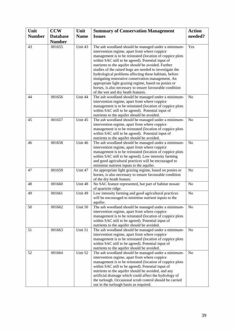
Unit Number
CCW Database Number
Unit Name
Summary of Conservation Management Issues
Action needed?
Yes 43 001655 Unit 43 The ash woodland should be managed under a minimum-intervention regime, apart from where coppice management is to be reinstated (location of coppice plots
ime, based on ponies or
ndition
within SAC still to be agreed). Potential input of nutrients to the aquifer should be avoided. Further studies of the raised bogs are needed to investigate the hydrological problems affecting these habitats, before instigating restorative conservation management. Anappropriate light grazing reghorses, is also necessary to ensure favourable coof the wet and dry heath features.
44 001656 Unit 44 mum-
ice plots
No The ash woodland should be managed under a miniintervention regime, apart from where coppice management is to be reinstated (location of coppwithin SAC still to be agreed). Potential input of nutrients to the aquifer should be avoided.
45 001657 Unit 45 oodland should be managed under a minimum-
ots
No The ash wintervention regime, apart from where coppice management is to be reinstated (location of coppice plwithin SAC still to be agreed). Potential input of nutrients to the aquifer should be avoided.
46 001658 Unit 46 oppice
plots C still to be agreed). Low intensity farming
No The ash woodland should be managed under a minimum-intervention regime, apart from where cmanagement is to be reinstated (location of coppice within SAand good agricultural practices will be encouraged to minimise nutrient inputs to the aquifer.
47 001659 Unit 47 priate light grazing regime, based on ponies or
No An approhorses, is also necessary to ensure favourable conditionof the dry heath feature.
48 001660 Unit 48 ure represented, but part of habitat mosaic No No SAC featof quartzite ridge.
49 001661 Unit 49 No Low intensity farming and good agricultural practices will be encouraged to minimise nutrient inputs to the aquifer.
50 001662 Unit 50 inimum-
on of coppice plots
No The ash woodland should be managed under a mintervention regime, apart from where coppice management is to be reinstated (locatiwithin SAC still to be agreed). Potential input of nutrients to the aquifer should be avoided.
51 001663 Unit 51 oodland should be managed under a minimum-
ice plots
No The ash wintervention regime, apart from where coppice management is to be reinstated (location of coppwithin SAC still to be agreed). Potential input of nutrients to the aquifer should be avoided.
52 001664 Unit 52 a minimum-intervention regime, apart from where coppice management is to be reinstated (location of coppice plots within SAC still to be agreed). Potential input of nutrients to the aquifer should be avoided, and any artificial drainage which could affect the hydrology of the turlough. Occasional scrub control should be carried out in the turlough basin as required.
No The ash woodland should be managed under
39

Unit Number
CCW Database Number
Unit Name
Summary of Conservation Management Issues
Action needed?
53 001665 Unit 53 The ash woodland should be managed under a minimum-intervention regime, apart from where coppice management is to be reinstated (location of coppice plots within SAC still to be agreed). Low intensity farmand good agricultural practices will be encouraged tminimise nutrient inputs to the aquifer.
No
ing o
54 001666 Unit 54 No Low intensity farming and good agricultural practices will be encouraged to minimise nutrient inputs to the aquifer.
55 001667 Unit 55 No No SAC feature represented, but part of habitat mosaic of quartzite ridge.
56 001668 Unit 56 No SAC feature represented, but part of habitat mosaic of quartzite ridge.
No
57 001669 Unit 57 he
No Low intensity farming and good agricultural practices will be encouraged to minimise nutrient inputs to taquifer.
58 001670 Unit 58 Potential input of nutrients to the aquifer should be avoided.
No
59 001671 Unit 59 No Potential input of nutrients to the aquifer should be avoided.
60 001672 Unit 60 l practices No Low intensity farming and good agriculturawill be encouraged to minimise nutrient inputs to the aquifer.
61 001673 Unit 61 No Potential input of nutrients to the aquifer should be avoided.
40

7. GLOSSARY This glossary defines the some of the terms used in this Core Management Plan. Some of the
nitions a on def co publications of CCW and the UK nat finitions is legally definitive. Action A recognisable and in y kind,
fied in 6 an, as being red fo s
ribute antifia ati ith
other such attributes, ition.
Common Standards Monitoring ples developed jointly by the UK conservation monitoring
ed for nature rvation, supported by guidance on identification of
dition cripti s es thatant in c a ha ly inc e de a ts of
its ecological functiolation n e structure,
ty nhabitat(s) on which a species population depends may also be considered as attributes of its condition.
Condition assessment The process of characterising the condition of a feature with
particular reference to whether the aspirations for its condition, as expressed in its conservation objective, are being met.
Condition categories The condition of feature can be categorised, following condition
assessment as one of the following2: Favourable: maintained; Favourable: recovered;
Favourable: un-classified Unfavourable: recovering; Unfavourable: no change; Unfavourable: declining; Unfavourable: un-classified Partially destroyed; Destroyed. Conservation management Acts or undertaking of all kinds, including but not necessarily limited
to actions, taken with the aim of achieving the conservation objectives of a site. Conservation management includes the taking of statutory and non-statutory measures, it can include the acts of any party and it may take place outside site boundaries as well as within sites. Conservation management may also be embedded within other
defi re based initions ntained in other documents, including legislation andure conservation agencies. None of these de
dividually described act, undertaking or project of an
other
specirequi
section r the con
of a Core Management Plan or Management Plervation management of a site.
Att A qu ble and monitorable characteristic of a feature that, in combin describes its cond
on w
A set of princiagencies to help ensure a consistent approach toand reporting on the features of sites designatconseattributes and monitoring methodologies.
Con A des on of the tate of a feature in terms of qualities or attribut are
relevusual
a nature ludes its
onservation context. For example the condition of xtent and species composition and might also incluning, spatial distribution and so on. The condition of a species
bitatspec
popuproductivi
usually i, relatio
cludes its total size and might also include its agship to other populations and spatial distribution. Aspects of the
2 See JNCC guidance on Common Standards Monitoring http://www.jncc.gov.uk/page-2272
41

frameworks for land/sea management carried out for purposes other than achieving the conservation objectives.
composite statement, and each feature has one conservation objective.
vation s
ature and its future
onservation st sing the conservation status of a
the
Core Managem
of other information contained in a full site
Factor Anything that hfeature. Factors can be natural processes, hum
ir
Physical, socio-econom anagement can also
e which is
ri Key Feature The habitat or s s
of conservation
Conservation objective The expression of the desired conservation status of a feature,
expressed as a vision for the feature and a series of performance indicators. The conservation objective for a feature is thus a
Conser tatus A description of the state of a feature that comprises both its condition and
the state of the factors affecting or likely to affect it. Conservation status is thus a characterisation of both the current state of a feprospects.
atus assessment The process of characteriC
feature with particular reference to whether the aspirations for it, as expressed in its conservation objective, are being met. The results of conservation status assessment can be summarised either as ‘favourable’ (i.e. conservation objectives are met) or unfavourable (i.e. conservation objectives are not met). However the value of conservation status assessment in terms of supporting decisions aboutconservation management, lies mainly in the details of assessment of feature condition, factors and trend information derived from comparisons between current and previous conservation status assessments and condition assessments.
ent Plan A CCW document containing the conservation objectives for a site and a summaryManagement Plan.
as influenced, is influencing or may influence the condition of a
an activities or effects arising fromnatural process or human activities, They can be positive or negative in terms of theinfluence on features, and they can arise within a site or from outside the site.
ic or legal constraints on conservation mbe considered as factors.
Favourable condition See con sment dition and condition asses
avourable conservation statu d conservation status F s See conservation status anassessment.3
ated. ThFeature The species population, habitat type or other entity for which a site is design
site andecological or geological interest which justifies the designation of athe focus of conservation management.
Integrity See site integ ty
pecies population within a management unit that is the primary focu management and monitoring in that unit.
3 A full definition of favourable conservation status is given in Section 4.
42

Management Plan The fullconserv nd management requirements. A complete management plan may not reside in a single
ocumeparticulinforma
anagement Unit An area within a site, defined according to one or more of a range of criteria,
hey are used as the primary basis for differentiating priorities for conservation management and monitoring in different parts of a site, and for
different parts o
expression of a designated site’s legal status, vision, features, ation objectives, performance indicators a
d nt, but may be contained in a number of documents (including in ar the Core Management Plan) and sets of electronically stored tion.
Msuch as topography, location of features, tenure, patterns of land/sea use. Thekey characteristic of management units is to reflect the spatial scale at whichconservation management and monitoring can be most effectively organised. T
facilitating communication with those responsible for management of f a site.
Monitoring An intermittent (regular or irregular) series of observations in time, carried out to
show the extent of comp on from liance with a formulated standard or degree of deviatian expected norm. In Co rd is mmon Standards Monitoring, the formulated standathe quantified expression of favourable condition based on attributes.
Operational limits The levels or va
terms of its influ d lower operational limiupper limit may
erformance indicators The attributes and their associated specified limits, together with
her ermine the degree to which the conservation
objectives for a feature are being met. Performance indicators are for
Plan or project other
on by any public body or statutory undertaker. Plan: a document prepared or adopted by a public body or statutory
arrying out of projects. Decisions on plans and projects which affect Natura 2000 and Ramsar sites
Site integrity The coherence of a site’s ecological structure and function, across its whole area, that
ite Management Statement (SMS) The document containing CCW’s views about the management
of a site issued as part of the legal notification of an SSSI under section 28(4) of the Wildlife and Countryside Act
pecial Feature See feature.
Specified limit The levels or values for an attribute which define the degree to which the
se for concern about the condition
lues within which a factor is considered to be acceptable in ence on a feature. A factor may have both upper an
ts, or only an upper limit or lower limit. For some factors an be zero.
Pfactors and their associated operational limits, which provide the standard against which information from monitoring and otsources is used to det
part of, not the same as, conservation objectives. See also vision the feature.
Project: Any form of construction work, installation, development or intervention in the environment, the carrying out or continuance of which is subject to a decisi
undertaker, intended to influence decisions on the c
are subject to specific legal and policy procedures.
enables it to sustain the habitat, complex of habitats and/or the levels of populations of the species for which it is designated.
S
1981, as substituted.
S
attribute can fluctuate without creating cau
43

of the feature. The range within the limits corresponds to favourable, thrange outside the limits corresponds to unfavourable. Attributes may hlower specified limits, upper specified limits, or both.
See management unit.
e ave
Unit
ision for the feature The expression, within a conservation objective, of the aspirations
Vision Statement
ortrait’
8. REFERE
Vfor the feature concerned. See also performance indicators.
The statement conveying an impression of the whole site in the state that is intended to be the product of its conservation management. A ‘pen poutlining the conditions that should prevail when all the conservation objectives are met. A description of the site as it would be when all the features are in favourable condition.
NCES AND ANNEXES
., Duigan, C.A., Stevens, D.P. & Yeo, M. (1993). Vegetation zoning an
lackstock, T.H d invertebrate an unusual seasona
Crowther, K. & Groome
, European d bog habitats within the Cernydd Carmel cSAC.
Dyfed Archaeological Trust (19historical and archaeological su Lister, J. & Whitbread, A. (1988NCC, Peterborough.
Cernydd Carmel SAC monitoring report: turlough. .
Lucas, A. (2008). Cern d ravines. Unpublished C Mileto, R. & Castle, G.
9). M report to CCW.
tringer, R.H. &
Wilkinson, K. (2008). Cernydd Carmel a tetralix, European dry heath and Active
Bfauna in Pant-y-llyn, l lake in South Wales, UK. Aquatic Conservation: Marine and Freshwater Ecosystems, Vol. 3, 253-268.
, G. (2004). Condition assessment of the Northern Atlantic wet heath with dry heath and active raiseErica tetralix
CCW Environmental Monitoring Report No. 4. CCW, Bangor.
92). Past land-use at Carmel Woods, near Llandybie, Dyfed: an rvey. Unpublished report to CCW.
). Carmarthenshire Inventory of Ancient Woodland. CSD Report.
Lovering, T. (2006). Unpublished CCW report
ydd Carmel SAC monitoring report: Tilio-Acerion forests of slopes, screes anCW report.
(1994). Carmel Woods NVC woodland survey. Unpublished report to CCW.
anagement of Carmel Woods, Dyfed. UnpublishedPeterken, G.F. (199 Rackham, O. (1992). Carmel Woods. Unpublished report to CCW.
Davies, R.H. (1989). A botanical survey of Carmel Woods, Dyfed, Wales.SUnpublished report.
SAC monitoring report: North Atlantic wet heath with Ericraised bog. Unpublished CCW report.
44

45