coral reef habitiat assessment for u.s. marine protected ... · guam coral reef habitat assessment...
TRANSCRIPT

National Oceanic and Atmospheric Administration NOAA’s National Ocean Service
Management & Budget OfficeSpecial Projects
February 2009
Coral Reef Habitat Assessment for U.S. Marine Protected Areas:
U.S. Territory of Guam


Guam Coral Reef Habitat Assessment i
Project Overview
About this Effort
The United States Coral Reef Task Force (USCRTF), in both its National Action Plan to Conserve Coral Reefs (2000) and its National Coral Reef Action Strategy (2002), established a key conservation objective of pro-tecting at least 20% of U.S. coral reefs and associated habitat types in no-take marine reserves. NOAA’s Coral Reef Conservation Program has been supporting efforts to assess current protection levels of coral reefs within Marine Protected Areas (MPAs) and quantify the area of U.S. coral reef ecosystems protected in no-take reserves. The official federal defini-tion of an MPA, signed into law by Executive Order 13158, is “any area of the marine environment that has been reserved by federal, state, tribal, territorial, or local laws or regulations to provide lasting protection for part or all of the natural and cultural resources therein.” A significant source of information for these assessments has been the National MPA Center’s In-ventory of Marine Managed Areas (MMAs) in the U.S (2006a)1. This report provides a preliminary assessment of the areal extent of coral reef habitat and associated habitat types within MPAs, as well as the level of protection afforded them, by using GIS-based MPA boundaries from the MMA Inven-tory–MPA Classification System (2006a,b), and U.S. Coral Jurisdiction benthic habitat data developed by NOAA’s National Centers for Coastal Ocean Science Biogeography Team (2005).
More information on the state and territory sites included in this assess-ment, including their goals and objectives and how they are established and managed is available in the NOAA Coral Reef Conservation Program Technical Memorandum, Report on the Status of Marine Protected Areas in Coral Reef Ecosystems of the United States: Volume 1 Marine Pro-tected Areas Managed by U.S. States, Territories and Commonwealths (Wusinich-Mendez, D and C. Trappe. 2007). This document (pdf, 5.26 MB) is available for download at http://www.coralreef.noaa.gov/Library/Publica-tions/cr%5Fmpa%5Freport%5Fvol%5F1.pdf.
� Data for the MMA Inventory were collected by many individuals from a variety of sources. As a result, the content and level of detail of the overview text may vary from site to site.
NCCOS Habitat Mapping Effort
The National Oceanic and Atmospheric Administration (NOAA) National Ocean Service (NOS) initiated a coral reef research program in 1999 to map, assess, inventory, and monitor U.S. coral reef ecosystems (Monaco et al. 2001). These activities were implemented in response to require-ments outlined in the Mapping Implementation Plan developed by the Map-ping and Information Synthesis Working Group (MISWG) of the Coral Reef Task Force (CRTF) (MISWG 1999). NOS’s National Centers for Coastal Ocean Science (NCCOS) Biogeography Team was charged with the de-velopment and implementation of a plan to produce comprehensive digital coral-reef ecosystem maps for all U.S. States, Territories, and Common-wealths within five to seven years. In response to Executive Order 13089 and the Coral Reef Conservation Act of 2000, NOS is conducting research to digitally map biotic resources and coordinate a long-term monitoring program that can detect and predict change in U.S. coral reefs and their associated habitats and biological communities (Monaco et al. 2001).
AcknowledgmentsGuam / Department of Agriculture / Division of Aquatic and Wildlife Resources
Guam / Coastal Management Program
National Park ServiceNOAA / Coral Reef Conservation Program
NOAA / NOS / Special ProjectsNOAA / NOS / NCCOS / Biogeography Team
NOAA / NOS / Ocean and Coastal Resource ManagementNOAA / NOS / National Marine Protected Areas Center
U.S. Fish & Wildlife ServiceU.S. Navy

Guam Coral Reef Habitat Assessment ii
Contents
Project Overview.................................................................................................................................................................................... i
Map of Guam Marine Protected Areas ................................................................................................................................................. 1
Introduction ........................................................................................................................................................................................... 2
Methods ................................................................................................................................................................................................ 3
Territory Marine Protected Areas .......................................................................................................................................................... 4 1. Achang Reef Flat Marine Preserve ................................................................................................................................................................................. 4 2. Pati Point Marine Preserve ............................................................................................................................................................................................. 5 3. Piti Bomb Holes Marine Preserve ................................................................................................................................................................................... 6 4. Sasa Bay Marine Preserve ............................................................................................................................................................................................. 7 5. Tumon Bay Marine Preserve .......................................................................................................................................................................................... 8
Federal Marine Protected Areas ........................................................................................................................................................... 9
6. Guam National Wildlife Refuge: Ritidian Unit .................................................................................................................................................................. 9 7. Haputo Ecological Reserve Area ................................................................................................................................................................................... 10 8. Orote Point Ecological Reserve Area ............................................................................................................................................................................ 11 9. War in the Pacific National Historic Park: Agat Unit ...................................................................................................................................................... 12 10. War in the Pacific National Historic Park: Asan Beach Unit .......................................................................................................................................... 13
Appendix A: National MPA Classification System................................................................................................................................ 14Appendix B: Guam MPA Classification................................................................................................................................................ 15Appendix C: Benthic Cover by Site...................................................................................................................................................... 16References.......................................................................................................................................................................................... 17

Guam Coral Reef Habitat Assessment 1

Guam Coral Reef Habitat Assessment 2
U.S. Territory of GuamCover Types and CharacterizationCoral Substrates colonized by live reef building corals and other organisms. Habitats
within this category have at least 10% live coral cover.
Coralline Algae
An area with 10% or greater coverage of any combination of numerous species of encrusting or coralline algae. May occur along reef crest, in shallow back reef, relatively shallow waters on the bank/shelf zone, and at depth.
Emergent Vegetation
Composed primarily of red mangrove and hau trees. Generally found in areas sheltered from high-energy waves, such as shoreline/intertidal or reef flat zones.
Macroalgae Substrates with 10% or greater coverage of any combination of numerous spe-cies of red, green, or brown macroalgae. Usually occurs in shallow backreef and deeper waters on the bank/shelf zone.
Seagrass Habitat with 10% or more of seagrass.
Turf A community of low lying species of marine algae composed of any or a combi-nation of algal divisions dominated by filamentous species lacking upright fleshy macroalgal thali.
Unclassified Areas differentiated from other biological cover types because the major geomor-phological structure is primarily terrestrial or artificially created (i.e., artificial).
Uncolonized Substrates not covered with a minimum of 10% of any of the above biological cover types. This habitat is usually on sand or mud structures. Overall uncolonized cover is estimated at 90%-100% of the bottom.
Unknown Cover uninterpretable due to turbidity, cloud cover, water depth, etc.
Introduction
The U.S Territory of Guam is the southernmost island of the Mariana Archipelago and the largest and most populated island in Micronesia. Guam is surrounded by offshore banks, as well as fringing, patch, submerged, and barrier reefs. Traditionally, fishing on coral reefs had been an important part of local Chamorro culture, and fish were valued as an important food source. While dependence on the fishery has decreased, these resources remain economically and culturally important today (Gombos et al. 2007). Currently there are 10 MPAs established in the territory (see map on page 1) with 1 site designated as a No-take area (Appendix B)1. No-take MPAs allow human access and even some potentially harmful uses, but totally prohibit the extraction or significant destruction of natural or cultural resources.
The table below shows the total area of each biological benthic cover type: 1) for all of Guam, 2) for all MPAs in Guam, and 3) for only No-take MPAs in Guam. The percentages of the mapped benthic habitat within Guam’s MPAs and Guam’s No-take MPAs are also listed. Approximately 28% of the 76 square kilometers of mapped coral reef ecosystem (defined below) in Guam is within MPAs and 3% is within No-take MPAs. To view the totals for each individual site, see Appendix C.
� Inthisreport,“No-take”MPAsareMPAsthathaveoneofthefollowing“LevelsofProtection”undertheU.S.MPAClassification System:�)NoTake,2)NoImpact,3)NoAccess,or4)ZonedMultiple-UseWithNo-TakeArea(s).Outof�2‘ZonedMultiple-UseWith No-TakeAreas’intheU.S.CoralJurisdictionsonly4haddelineatedNo-takezonesandthusweretheonlysitesfromthiscategorytobe includedinthe“No-take”calculations:EastEndMarinePark(VI),KealakekuaBayMLCD(HI),LapakahiMLCD(HI),andMolokini ShoalMLCD(HI).
Benthic Cover Type Total Mapped Benthic Habitat (km2)
Total Mapped within All MPAs (km2)
Percent of Mapped Area within all MPAs
Total Mapped within No-take MPAs (km2)
Percent of Mapped Area within No-take MPAs
Coral 26.161 5.752 21.99% 0.018 0.07%Coralline Algae 3.838 1.237 32.23% 0.000 0.00%Emergent Vegetation 0.206 0.169 82.04% 0.148 71.84%Macroalgae 16.406 3.937 24.00% 0.136 0.83%Seagrass 3.729 1.573 42.18% 0.544 14.59%Turf 25.721 8.360 32.50% 1.205 4.68%Unclassified 547.360 4.285 0.78% 1.086 0.20%Uncolonized 29.118 3.964 13.61% 0.000 0.00%Unknown 308.680 18.534 6.00% 3.137 1.02%Coral Reef Ecosystem* 76.061 21.028 27.65% 2.051 2.70%
* Coral Reef Ecosystem is defined as mapped coral, coralline algae, emergent vegetation, macroalgae, seagrass, and turf.
Guam Coral Reef Habitat Assessment 3
U.S. Territory of GuamMethods
The Coral Reef Habitat Assessment for U.S. Marine Protected Areas in Guam was conducted between August 2005 and August 2007 through the following ac-tions:
1. Created a Coral Jurisdiction MPA GIS Database utilizing the U.S. Marine Managed Areas Inventory
The Marine Managed Areas (MMA) Inventory contains information on more than 1,500 sites, and is the only such comprehensive dataset in the nation. The term “marine managed area,” which was defined through a public comment process, generally refers broadly to an area of the marine environment with a marine resource conservation purpose. The MMA Inventory data collection is a joint collaboration between the National Oceanic and Atmospheric Administration (NOAA) and the Department of the Interior that began in 2001. Its purpose is to gather and make publicly available comprehensive information on place-based marine conservation efforts under U.S. federal, state, territorial, local, and tribal jurisdiction. For more information on the MMA Inventory, visit http://www.mpa.gov/helpful_resources/inventory.html.
2. Identified which MPAs are No-Take Reserves utilizing the MPA Classifica- tion System
The National Marine Protected Areas Center has developed a Classifi-cation System that provides agencies and stakeholders with a straight-forward means to describe MPAs in purely functional terms using five objective characteristics common to most MPAs: Conservation Focus – legally established goals, conservation objectives and intended purpose(s). Level of Protection – level and type of legal protections afforded to the site’s natural and cultural resources and ecological processes. Permanence of Protection – length of time protections remain in effect. Constancy of Protection – year-round, seasonal or rotating. Ecological Scale of Protection – range from entire ecosystems and their associated biophysical processes, to focal habitats, species, or other resources deemed to be of economic or ecological importance.
For most MPAs in the U.S. and elsewhere, these five functional char-acteristics provide an accurate picture of why the site was established, what it is intended to protect, how it achieves that protection, and how it may affect local ecosystems and local human uses.
3. Used GIS software to identify area of spatial overlap between benthic ha- bitat data and Coral Jurisdiction MPA boundaries
The National Oceanic and Atmospheric Administration (NOAA) National Ocean Service (NOS) initiated a coral reef research program in 1999 to map, assess, inventory, and monitor U.S. coral reef ecosystems (Monaco et al. 2001). These activities were implemented in response to requirements outlined in the Mapping Implementation Plan developed by the Mapping and Information Synthesis Working Group (MISWG) of the Coral Reef Task Force (CRTF) (MISWG 1999). NOS’s Biogeogra-phy Team was charged with the development and implementation of a plan to produce comprehensive digital coral-reef ecosystem maps for all U.S. States, Territories, and Commonwealths within five to seven years. In response to Executive Order 13089 and the Coral Reef Conservation Act of 2000, NOS is conducting research to digitally map biotic re-sources and coordinate a long-term monitoring program that can detect and predict change in U.S. coral reefs and their associated habitats and biological communities. For more information on benthic habitat data produced by the NOS Biogeography Team, visit http://ccma.nos.noaa.gov/about/biogeography/proj_theme.html.
4. Calculated areal extent of benthic habitat data within Coral Jurisdiction MPA GIS boundaries
The areal extent of benthic habitat data within MPAs was calculated in the Eckert IV WGS84 projection, using the polygon area calculation operation in XTools Pro 3.2.0 extension for ArcMap™ 9.1 GIS software.

Guam Coral Reef Habitat Assessment 4
Achang Reef Flat Marine Preserve
economic benefit. Five marine pre-serves were established including Achang Reef Flat.
Source of Overview: U.S. Marine Managed Areas Inventory (2006a), NOAA’s National Marine Protected Areas Center.
Achang Reef Flat Marine Preserve
Guam
Percent Benthic Cover
OverviewLocated in Merizo, the preserve consists of inner and outer reef flats, which are exposed at low tide and seperated by a depressed middle-reef flat and a low-tide moat. There are estuarine habitats including mangroves. Sea-grass beds are also present on the site.
In 1986, the Division of Aquatic and Wildlife Resources determined that fish stocks were beginning to show signs of degradation. Over a 15-year period there had been a 70% decline in harvest and catch per unit effort (CPUE) values. Thus actions were taken to reverse the decline of the coral reef fishery. An evaluation of practical approaches was conducted to identify suitable sites for the establishment of marine preserves. The study looked at 60 sites with the ultimate goal of protecting 10% of the shoreline and adjacent reef. The results of this study were based on criteria that included habitat diversity, species richness, enforceability, cultural practices, and
Management Agency: Guam Department of Agriculture
This site contains 10.1% of the total area
of Guam’s MPAs
Guam Coral Reef Habitat Assessment 5
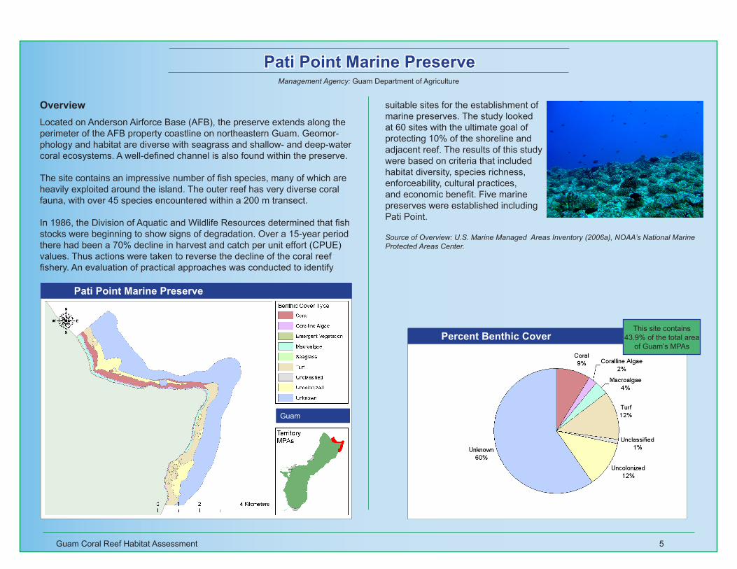
Pati Point Marine Preserve
suitable sites for the establishment of marine preserves. The study looked at 60 sites with the ultimate goal of protecting 10% of the shoreline and adjacent reef. The results of this study were based on criteria that included habitat diversity, species richness, enforceability, cultural practices, and economic benefit. Five marine preserves were established including Pati Point.
Source of Overview: U.S. Marine Managed Areas Inventory (2006a), NOAA’s National Marine Protected Areas Center.
Pati Point Marine Preserve
Guam
Percent Benthic Cover
OverviewLocated on Anderson Airforce Base (AFB), the preserve extends along the perimeter of the AFB property coastline on northeastern Guam. Geomor-phology and habitat are diverse with seagrass and shallow- and deep-water coral ecosystems. A well-defined channel is also found within the preserve.
The site contains an impressive number of fish species, many of which are heavily exploited around the island. The outer reef has very diverse coral fauna, with over 45 species encountered within a 200 m transect.
In 1986, the Division of Aquatic and Wildlife Resources determined that fish stocks were beginning to show signs of degradation. Over a 15-year period there had been a 70% decline in harvest and catch per unit effort (CPUE) values. Thus actions were taken to reverse the decline of the coral reef fishery. An evaluation of practical approaches was conducted to identify
Management Agency: Guam Department of Agriculture
This site contains 43.9% of the total area
of Guam’s MPAs

Guam Coral Reef Habitat Assessment 6
Piti Bomb Holes Marine Preserve
adjacent reef. The results of this study were based on criteria that in-cluded habitat diversity, species rich-ness, enforceability, cultural practices, and economic benefit. Five marine preserves were established including Piti Bomb Holes.
Source of Overview: U.S. Marine Managed Areas Inventory (2006a), NOAA’s National Marine Protected Areas Center.
Piti Bomb Holes Marine Preserve
Guam
Percent Benthic Cover
OverviewLocated on the west coast of Guam, Piti Bomb Holes Marine Preserve is a shallow lagoon complex that resembles a barrier reef. Within the preserve are percolation pits at depths of 25–30 ft. where fresh water enters the reef flat. Two species of mollusks and one species of sea urchin are found in these holes that are found nowhere else in the world. Out of all the marine preserves in Guam, Piti Bomb Holes has the most diverse habitat.
In 1986, the Division of Aquatic and Wildlife Resources determined that fish stocks were beginning to show signs of degradation. Over a 15-year period there had been a 70% decline in harvest and catch per unit effort (CPUE) values. Thus actions were taken to reverse the decline of the coral reef fishery. An evaluation of practical approaches was conducted to identify suitable sites for the establishment of marine preserves. The study looked at 60 sites with the ultimate goal of protecting 10% of the shoreline and
Management Agency: Guam Department of Agriculture
This site contains 8.1% of the total area
of Guam’s MPAs

Guam Coral Reef Habitat Assessment 7
Sasa Bay Marine Preserve
Sasa Bay Marine Preserve
Guam
Percent Benthic Cover
OverviewLocated in Piti, the Sasa Bay Marine Preserve contains a mangrove swamp which skirts the coastline in a narrow band. The bay is a Hawksbill Turtle foraging area and provides habitat for a number of oyster and clam species. Four to five strings of patch reef can also be found within the deeper waters of the embayment.
In 1986, the Division of Aquatic and Wildlife Resources determined that fish stocks were beginning to show signs of degradation. Over a 15-year period there had been a 70% decline in harvest and catch per unit effort (CPUE) values. Thus actions were taken to reverse the decline of the coral reef fishery. An evaluation of practical approaches was conducted to identify suitable sites for the establishment of marine preserves. The study looked at 60 sites with the ultimate goal of protecting 10% of the shoreline and adjacent reef. The results of this study were based on criteria that included
habitat diversity, species richness, enforceability, cultural practices, and economic benefit. Five marine preserves were established including Sasa Bay.
Source of Overview: U.S. Marine Managed Areas Inventory (2006a), NOAA’s National Marine Protected Areas Center.
Management Agency: Guam Department of Agriculture
This site contains 7.0% of the total area
of Guam’s MPAs

Guam Coral Reef Habitat Assessment 8
Tumon Bay Marine Preserve
Tumon Bay Marine Preserve
Guam
Percent Benthic Cover
OverviewLocated in Tumon, the preserve is a broad crescent shaped limestone plat-form stretching from the cliffs of Ypao Point in the southwest to “Gun Point” in the northeast. The bay is 2 miles in length and the reef platform is up to 1,450 feet in width. A major road parallels the beach approximately 1,000 feet from the high water mark making Tumon Bay a center for recreational activity.
In 1986, the Division of Aquatic and Wildlife Resources determined that fish stocks were beginning to show signs of degradation. Over a 15-year period there had been a 70% decline in harvest and catch per unit effort (CPUE) values. Thus actions were taken to reverse the decline of the coral reef fishery. An evaluation of practical approaches was conducted to identify suitable sites for the establishment of marine preserves. The study looked at 60 sites with the ultimate goal of protecting 10% of the shoreline and
adjacent reef. The results of this study were based on criteria that included habitat diversity, species richness, enforceability, cultural practices, and economic benefit. Five marine preserves were established including Tumon Bay.
Source of Overview: U.S. Marine Managed Areas Inventory (2006a), NOAA’s National Marine Protected Areas Center.
Management Agency: Guam Department of Agriculture
This site contains 9.2% of the total area
of Guam’s MPAs

Guam Coral Reef Habitat Assessment 9
Guam National Wildlife Refuge: Ritidian Unit
Guam National Wildlife Refuge: Ritidian Unit
Guam
Percent Benthic Cover
OverviewThe Guam National Wildlife Refuge: Ritidian Unit is located on the north-ernmost point of Guam and includes submerged lands out to the 30-misobath. The Ritidian Unit which is owned by the U.S. Fish and Wildlife Service (USFWS), was created from a small decommissioned, specialized U.S. Naval installation. The transfer of ownership from the U.S. Navy to the USFWS included structures as well as habitat. The refuge was established in 1993, to protect and recover endangered and threatened species, protect habitat, control non-native species with emphasis on the brown tree snake, protect cultural resources, and provide recreational and educational opportunities to the public where possible.
Source of Overview: U.S. Marine Managed Areas Inventory (2006a), NOAA’s National Marine Protected Areas Center.
Management Agency: U.S. Fish and Wildlife Service
This site contains 7.2% of the total area
of Guam’s MPAs
Guam Coral Reef Habitat Assessment 10
Haputo Ecological Reserve Area
Haputo Ecological Reserve Area
Guam
Percent Benthic Cover
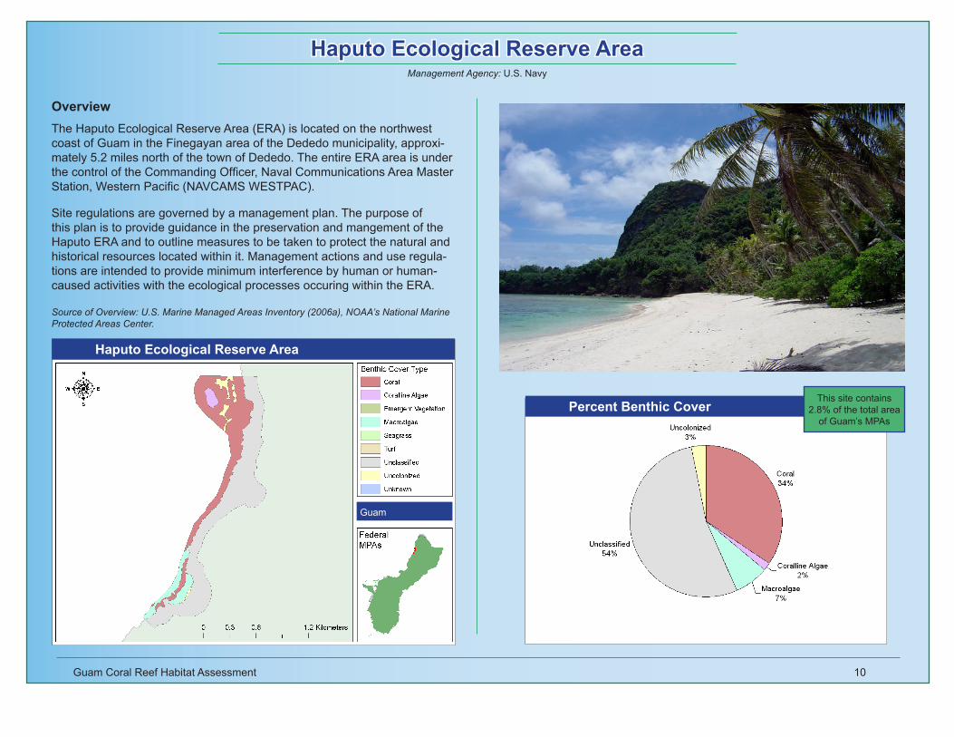
OverviewThe Haputo Ecological Reserve Area (ERA) is located on the northwest coast of Guam in the Finegayan area of the Dededo municipality, approxi-mately 5.2 miles north of the town of Dededo. The entire ERA area is under the control of the Commanding Officer, Naval Communications Area Master Station, Western Pacific (NAVCAMS WESTPAC).
Site regulations are governed by a management plan. The purpose of this plan is to provide guidance in the preservation and mangement of the Haputo ERA and to outline measures to be taken to protect the natural and historical resources located within it. Management actions and use regula-tions are intended to provide minimum interference by human or human-caused activities with the ecological processes occuring within the ERA.
Source of Overview: U.S. Marine Managed Areas Inventory (2006a), NOAA’s National Marine Protected Areas Center.
Management Agency: U.S. Navy
This site contains 2.8% of the total area
of Guam’s MPAs

Guam Coral Reef Habitat Assessment 11
Orote Peninsula Ecological Reserve Area
Orote Peninsula Ecological Reserve Area
Guam
Percent Benthic Cover
Source of Overview: U.S. Marine Managed Areas Inventory (2006a), NOAA’s National Marine Protected Areas Center.
OverviewThe Orote Peninsula Ecological Reserve Area (ERA) is located on the southern coast of the Orote Peninsula in the Santa Rita municipality, ap-proximately 0.4 miles north northwest of Apuntua Point. The entire ERA area is under the control of the Commanding Officer, Naval Station, Guam (NAVSTA GUAM).
Site regulations are governed by a management plan. The purpose of this plan is to provide guidance in the preservation and mangement of the Orote Peninsula Ecological Reserve Area (ERA) and to outline measures to be taken to protect the natural and historical resources located within it. Management actions and use regulations are intended to provide minimum interference by human or human-caused activities with the ecological pro-cesses occuring within the ERA.
Management Agency: U.S. Navy
This site contains 1.7% of the total area
of Guam’s MPAs

Guam Coral Reef Habitat Assessment 12
War in the Pacific National Historic Park: Agat Unit
War in the Pacific National Historic Park: Agat Unit
Guam
Percent Benthic Cover
Source of Overview: U.S. Marine Managed Areas Inventory (2006a), NOAA’s National Marine Protected Areas Center.
OverviewThe War in the Pacific National Historic Park: Agat Unit is located on the west coast of Guam bordering the village of Agat. Primarily an offshore area, the land is a series of small parcels between the coastal road and the shoreline. Terrain is generally composed of coral outcroppings interspersed with low-lying areas. A coral reef parallels the shoreline and extends 1,000 to 1,500 feet from the beach. Several small islets and two larger islands, Alutan and Bangi, are also included in the unit. Water inside the reef is one to four feet deep and during low tide some of the reef formation is exposed. A wide variety of plants, coral, and marine life can be seen in park waters.
The park was set aside to commemorate the bravery and sacrifice of those participating in the campaigns of the Pacific theater of World War II and to conserve and interpret outstanding natural, scenic, and historic values and objects on the island of Guam for the benefit and enjoyment of present and future generations.
Management Agency: National Park Service
This site contains 5.5% of the total area
of Guam’s MPAs

Guam Coral Reef Habitat Assessment 13
War in the Pacific National Historic Park: Asan Beach Unit
War in the Pacific National Historic Park: Asan Beach Unit
Guam
Percent Benthic Cover
conserve and interpret outstanding natural, scenic, and historic values and objects on the island of Guam for the benefit and enjoyment of present and future generations.
Source of Overview: U.S. Marine Managed Areas Inventory (2006a), NOAA’s National Marine Protected Areas Center.
OverviewThe War in the Pacific National Historic Park: Asan Unit is located on the west coast of Guam bordering the village of Asan. Occupying mostly offshore area, this unit includes all lands on the ocean side of Marine Drive between Adelup Point and Asan Point. Except for the limestone promonto-ries of these two points, the land is a flat, coastal plain with a sandy beach, 15- to 30-feet wide, fronting the shoreline. The offshore area encompasses extensive reef formations, up to 1,000 feet wide, paralleling the entire shoreline. Water inside the reef varies from one to four feet deep and dur-ing low tide many areas of the reef are exposed. There is one small islet, Camel Rock,near Asan Point. A wide variety of plants, coral, and marine life can be seen in park waters.
The park was set aside to commemorate the bravery and sacrifice of those participating in the campaigns of the Pacific theater of World War II and to
Management Agency: National Park Service
This site contains 4.5% of the total area
of Guam’s MPAs

Guam Coral Reef Habitat Assessment 14
Appendix A: National MPA Classification SystemThe National Classification System was developed by the National MPA Center in an effort to develop a “straightforward and consistent language to accurately describe the many types of MPAs occurring in our waters and to understand their effects on ecosystems and the people that use them” (NOAA National MPA Center, 2006b). A full description of the classification system is available at www.mpa.gov. The system describes MPAs in purely functional terms using five objective characteristics common to most MPAs:
1) Conservation Focus – each site was assigned one or more of the following three attributes:
a. Natural Heritage – established and managed to sustain, conserve, restore and understand the biodiversity, populations, communities, habitats, ecosystems, processes and services of an MPA or MPA zoneb. Cultural Heritage – established and managed to protect and under stand submerged cultural resourcesc. Sustainable Production – established and managed to support the continued extraction of renewable living resources
2) Level of Protection Afforded – each site was assigned one of the following six attributes:
a. Uniform Multiple-Use – Consistent level of protection and allowable activities throughout the MPAb. Zoned Multiple-Use – Some extractive activities allowed through- out entire site, but use marine zoning to allocate specific uses to compatible places or timesc. Zoned Multiple-Use with No-Take Areas – Multiple-use MPAs that contain one or more zones where resource extraction is prohibitedd. No-Take – MPA sites that allow human access but prohibit resource extraction throughout the areae. No Impact – MPAs that allow human access but prohibit all activi- ties that could harm the site’s resources or disrupt the service they provide f. No Access – MPAs that restrict all human access to the area unless specifically permitted for designated special uses
3) Permanence of Protection – each site was assigned one of the following three attributes:
a. Permanent – MPAs whose legal authorities provide protection in perpetuityb. Conditional – MPAs that have the potential to persist over time but
whose legal authority has a finite duration and must be actively renewedc. Temporary – MPAs that are designed to address relatively short- term conservation and management needs by protecting a specific habitat or species for a finite duration with no expectation or mechanism for renewal
4) Constancy of Protection – each site was assigned one of the following three attributes:
a. Year-round – MPAs that provide constant protection throughout the yearb. Seasonal – MPAs that protected specific habitats and resources during fixed seasons or periodsc. Rotating – MPAs that cycle among a set of fixed geographic areas in order to meet short-term conservation and management goals
5) Ecological Scale of Protection – each site was assigned one of the follow- ing two attributes:
a. Ecosystem – MPAs whose legal authorities and management mea- sures are intended to protect all of the components and processes of the ecosystem(s) within its boundariesb. Focal Resource – MPAs whose legal authorities and management measures specifically target a particular habitat, species complex, or single resource

Guam Coral Reef Habitat Assessment 15
Appendix B: Guam MPA Classification
Site Name Conservation Goal Level of Protection
Permanence of Protection
Constancy of Protection
Scale of Protection
Management Plan
1. Achang Reef Flat Marine Preserve
Sustainable Production
Zoned Multiple Use
Permanent Year Round Ecosystem No
2. Pati Point Marine Reserve
Sustainable Production
Zoned Multiple Use
Permanent Year Round Ecosystem No
3. Piti Bomb Holes Marine Preserves
Sustainable Production
Zoned Multiple Use
Permanent Year Round Ecosystem No
4. Sasa Bay Marine Preserve
Sustainable Production
No Take Permanent Year Round Ecosystem No
5. Tumon Bay Marine Preserve
Sustainable Production
Zoned Multiple Use
Permanent Year Round Ecosystem No
6. Guam National Wildlife Ref-uge: Ritidian Unit**
Natural Heritage & Sus-tainable Production
Zoned with No Take Areas
Permanent Year Round Ecosystem Yes
7. Haputo Ecological Reserve Area**
Natural Heritage & Cul-tural Heritage
Uniform Multiple Use
Permanent Year Round Ecosystem Yes
8. Orote Peninsula Ecological Reserve Area Unit**
Natural Heritage Uniform Multiple Use
Permanent Year Round Ecosystem Yes
9. War in the Pacific National Historic Park: Agat Unit**
Natural Heritage & Cul-tural Heritage
Uniform Multiple Use
Permanent Year Round Ecosystem No
10. War in the Pacific National Historic Park: Asan Beach Unit**
Natural Heritage & Cul-tural Heritage
Uniform Multiple Use
Permanent Year Round Ecosystem No
* Territory MPA ** Federal MPA

Guam Coral Reef Habitat Assessment 16
Appendix C: Benthic Cover (km2) by Site
Coral Coralline Algae
Emergent Vegetation
Macroalgae Seagrass Turf Unclassified Uncolonized Unknown Total
1. Achang Reef Flat Marine Preserve*
0.441 0.045 0.021 0.721 0.655 0.856 0.111 0.466 1.211 4.527
2. Pati Point Marine Preserve* 1.764 0.441 0.000 0.709 0.000 2.451 0.192 2.333 11.723 19.6133. Piti Bomb Holes Marine Preserve* 1.250 0.072 0.000 0.288 0.085 0.769 0.085 0.251 0.795 3.5944. Sasa Bay Marine Preserve* 0.018 0.000 0.148 0.136 0.544 1.205 1.086 0.000 3.137 3.1375. Tumon Bay Marine Preserve* 0.727 0.000 0.000 0.404 0.038 1.288 0.039 0.319 1.294 4.1106. Guam National Wildlife Refuge: Ritidian Unit**
0.294 0.607 0.000 0.623 0.000 0.113 1.501 0.087 0.000 3.226
7. Haputo Ecological Reserve Area**
0.428 0.022 0.000 0.088 0.000 0.000 0.667 0.038 0.000 1.243
8. Orote Peninsula Ecological Reserve Area**
0.000 0.000 0.000 0.000 0.000 0.453 0.086 0.000 0.217 0.756
9. War in the Pacific National Historic Park: Agat Unit**
0.397 0.043 0.000 0.296 0.250 0.885 0.174 0.406 0.000 2.452
10. War in the Pacific National Historic Park: Asan Beach Unit**
0.433 0.007 0.000 0.672 0.001 0.340 0.344 0.064 0.157 2.019
* Territory MPA ** Federal MPA
Note: Area calculated in Eckert IV, WGS84 using XTools Pro 3.2.0 extension for ArcMap™ 9.1

Guam Coral Reef Habitat Assessment 17
ReferencesGombos, M., J. Gutierrez, V. Brown. 2007. Guam Coral Reef MPA Summary. pp. 89-96. In Wusinich-Mendez, D. and C. Trappe (ed.), 2007. Report on the Status of Marine Protected Areas in Coral Reef Ecosystems of the United States Volume 1: Marine Protected Areas Managed by U.S. States, Territories and Commonwealths: 2007. NOAA Technical Memorandum NOS. NOAA Coral Reef Conservation Program. Silver Spring, MD. 153 pp.
Environmental Systems Research Institute (ESRI) ® ArcMap™ Copyright © ESRI Inc. All Rights Reserved.
Mapping and Information Synthesis Working Group. 1999. Coral Reef Mapping Implementation Plan (2nd Draft). U.S. Coral Reef Task Force. Washington, DC, NOAA, NASA and USGS (Work Group Co-chairs). 17 pp.
Monaco, M.E., J.D. Christensen, and S.O, Rohmann. 2001. Mapping and Monitoring of U.S. Coral Reef Ecosystems. Earth System Monitor. Vol. 12(1):1-16.
NCRAS (National Coral Reef Action Strategy). 2002. A National Coral Reef Action Strategy: Report to Congress on implementation of the Coral Reef Conser-vation Act of 2002 and the National Action Plan to Conserve Coral Reefs in 2002-2003. NOAA. Silver Spring, Maryland. 120pp. + appendix.
NOAA National Centers for Coastal Ocean Science (NCCOS). 2005. Shallow-Water Benthic Habitats of American Samoa, Guam, and the Commonwealth of the Northern Mariana Islands (CD-ROM). NOAA Technical Memorandum NOS NCCOS 8, Biogeography Team. Silver Spring, MD.
NOAA National Marine Protected Areas Center. 2006a. U.S. Marine Managed Areas Inventory. http://www.mpa.gov/helpful_resources/inventory.html
NOAA National Marine Protected Areas Center. 2006b. U.S. MPA Classification System. http://www.mpa.gov/helpful_resources/fact_sheets.html
USCRTF (United States Coral Reef Task Force). 2000. The National Action Plan to Conserve Coral Reefs. USCRTF. Washington, D.C. 33pp. + appendices.
XTools Pro extension for ArcGIS ® Copyright © Data East, LLC. All Rights Reserved.
For More InformationNOAA Coral Reef Conservation Program
1305 East-West Highway, 10th Floor Silver Spring, MD 20910-3281
Photo CreditsBurdick, D. Guam Coastal Management Program. pg. 4, 5, 6, 7, 8, 10
Murray, J. NOAA. pg. 9, 12, 13, Cover Photo
U.S. Navy Personnel Support Activity Detachment GILS Registration #005124 (PSA Pacific). Maintained by: PSD Guam Webmaster. Approved for Release by: OIC PSD Guam. pg. 11