copperfield drive technical study
TRANSCRIPT

Copperfield Drive Technical Study
NSW Department of Planning, Industry and EnvironmentSeptember 2021

Acknowledgement of CountryNSW Department of Planning, Industry and Environment acknowledges the Traditional Custodians of the land and pays respect to all Elders past, present and future.
Published by NSW Department of Planning, Industry and Environment
dpie.nsw.gov.au
Title: Copperfield Drive technical study
This document is part of the Rosemeadow Demonstration Project completed in collaboration with Campbelltown City Council. Research, analysis, project planning, design and graphics to prepare this study were undertaken by Realm Studios in partnership with E2DesignLab and Cred Consulting in July 2020.
Copyright notice
© State of New South Wales through Department of Planning, Industry and Environment 2021. You may copy, distribute, display, download and otherwise freely deal with this publication for any purpose, provided that you attribute the Department of Planning, Industry and Environment as the owner. However, you must obtain permission if you wish to charge others for access to the publication (other than at cost); include the publication in advertising or a product for sale; modify the publication; or republish the publication on a website. You may freely link to the publication on a departmental website.
ISBN: 978-1-76058-475-7
Disclaimer
The information contained in this publication is based on knowledge and understanding at the time of writing (September 2021) and may not be accurate, current or complete. The State of New South Wales (including the NSW Department of Planning, Industry and Environment), the author and the publisher take no responsibility, and will accept no liability, for the accuracy, currency, reliability or correctness of any information included in the document (including material provided by third parties). Readers should make their own inquiries and rely on their own advice when making decisions related to material contained in this publication.
Illustration: Credit Nikita Ridgeway


Introduction 055 Million Trees Program 07Demonstration Project Objectives 08Copperfield Drive Design Objectives 08Study Area 09Methodology 10
Part 1:Site analysis
11Strategic Context 13Site Appreciation 18

Part 2:Design
23
Design Principles 25Tree Canopy 29Copperfield South 30Copperfield Middle 34Copperfield North 38Retrofitting Open Channels for Tree Planting 41Where to plant trees 43Tree Toolkit 46Material Palette 59


Introduction

5 Million Trees ProgramThe Department of Planning, Industry and Environment’s 5 Million Trees for Greater Sydney Program (5MT) aims to plant trees in both the public and private realm to expand urban tree canopy to 40% across 33 local government areas within the Greater Sydney metropolitan area.
The overall objectives of 5MT are:
• Plant five million more trees in Greater Sydney by 2030• Increase Greater Sydney’s urban tree canopy towards 40%• Assist in the amelioration of climate extremes by providing shade
and cooling of urban areas through tree planting• Create a healthier, more liveable and greener Greater Sydney.The 5MT program aims to support the delivery of two NSW Premier’s Priorities:
Greening our city – Increase the tree canopy and green cover across Greater Sydney by planting 1 million trees by 2022.
Greener public spaces – Increase the proportion of homes in urban areas within 10 minutes’ walk of quality green, open and public space by 10 per cent by 2023.
NSW Department of Planning, Industry and Environment07

Demonstration project objectives Rosemeadow has been selected as an initial demonstration project for the 5MT program for a variety of reasons: a substantial open space network, challenging hydraulic site conditions, community demographics and a low existing canopy cover of 5.63%.
The Rosemeadow Demonstration Project aims to:
• increase canopy cover across Rosemeadow towards 40% using both public and private land
• demonstrate Campbelltown City Council’s commitment to achieving a vibrant, liveable city
• demonstrate how to achieve 40% canopy cover in constrained urban environments
• improve the amenity and walkability of Rosemeadow by increasing the shading and cooling of streets and parks
• investigate the role of trees in stormwater management systems
• establish a healthy tree canopy supported by water-sensitive urban design (WSUD) approaches to mitigate nuisance flooding and urban heat island effects
• educate and advocate to the community and stakeholders on the benefits of urban canopy and increase stewardship to ensure the retention of existing and newly planted trees
• encourage local residents to plant trees in their own yards to increase tree canopy across the private realm
• increase habitat for urban wildlife• incorporate leading-edge plant species and
diversity research• achieve best-practice collaborative outcomes
with project stakeholders.The intention is to use Rosemeadow as a case study and share the methodology, learnings and outcomes to create a useful framework for future urban canopy projects for use across Greater Sydney.
Copperfield Drive design objectivesThe Copperfield Drive concept design has six key objectives:
Improve the walkability of Copperfield Drive by increasing the shading and cooling of streets and supporting the Walk Safely to School program.
Establish a healthy tree canopy supported by water-sensitive urban design (WSUD) approaches to mitigate nuisance flooding and urban heat island effects, and to demonstrate that urban canopy can be integrated with stormwater management systems.
Improve the amenity of Copperfield Drive by increasing shade and cooling to link housing, schools, shops and community services.
Increase habitat for urban wildlife and incorporate leading-edge plant species and diversity research.
Reconfigure the spatial hierarchy of Copperfield Drive to create space for healthy tree growth.
Achieve best practice collaborative outcomes with project stakeholders and the community to create ‘Safe Active Streets’.
Copperfield Drive Technical Study – September 2021 08

N
Rosemeadow Public School
Rosemeadow Market Place
Haydon Park
Copperfield Drive
Study areaThis study demonstrates the design and technical requirements to integrate trees into streets and stormwater management systems.
Copperfield Drive has been identified as the study area for tree planting, as it:
• has minimal existing canopy cover• provides opportunity to integrate tree
planting into the open channel stormwater system running adjacent to Copperfield Drive
• has existing drainage infrastructure that can be retrofitted for passive tree irrigation and storm water filtration
• provides opportunity to integrate tree canopy shade along routes for improved walking/cycling amenity
• is a significant neighbourhood connector street that links housing, schools, shops, community services and is an important bus route connection
• provides sufficient carriageway width, that can accommodate tree stand outs within the kerb side lane
• provides opportunity to reduce speed limits with the introduction of street tree planting.
Figure 1: Rosemeadow study area – Copperfield Drive and key surrounding public infrastructure.
NSW Department of Planning, Industry and Environment09

Site AnalysisFinal
Concept Report
TRADITIONAL OWNERS
Draft Concept Report
Project Objectives
Stakeholder Inputs
Vision + Principles
STATE GOVERNMENT
LOCAL COUNCIL
COMMUNITY
ENGAGEMENT DESIGN
Technical Tree Species
Research
Technical Stormwater
Testing
Detailed Costing
STRATEGIC CONTEXT
SITE ANALYSIS
SITE ENGAGEMENT
TRADITIONAL OWNERS
STATE GOVERNMENT
LOCAL COUNCIL
COMMUNITY
DESIGN
01 02PRE-DESIGNDRAFT
CONCEPT
MethodologyThe Copperfield Drive design is informed by two defined processes as described and illustrated below. These processes also inform the structure of this report.
01 Site
The first part of this study outlines a number of studies, strategies and reports that have been undertaken by the NSW Government and Campbelltown City Council. On-site analysis and stakeholder engagement furthers the understanding of the site and helps inform the constraints, opportunities and future requirements for tree planting.
02 Design
The second part of this study outlines the spatial arrangements and system toolkits that make up the proposed Copperfield Drive design. The design is refined through stakeholder engagement, technical testing and research and cost analysis.
Copperfield Drive Technical Study – September 2021 10


Part 1: Site analysis

Strategic contextA number of studies, strategies and reports have been undertaken across NSW Government departments that explore constraints, opportunities and future requirements for green and blue infrastructure through the lens of urban growth and conservation. Campbelltown City Council strategies locate priorities within the Campbelltown and Rosemeadow context. These strategies are key to understanding the broad and detailed visions proposed for the study area and are summarised on the following pages.
Key themes stemming from this work show a significant emphasis on:
• future-proofing communities from the effects of climate change
• improving everyday life through sustainable urban and natural systems
• enriching the overall experience, quality and offering of place.
NSW Government
NSW Government Premier’s Priorities
The Hon Gladys Berejiklian, Premier of NSW, June 2019
The Premier has set priorities that aim to tackle tough community challenges, lift the quality of life for all citizens and put people at the heart of creating a better environment.
Greener public spaces – Increase the proportion of homes in urban areas within 10 minutes’ walk of quality green, open and public space by 10 per cent by 2023.
Greening our city – Increase the tree canopy and green cover across Greater Sydney by planting 1 million trees by 2022.
NSW Department of Planning, Industry and Environment13

Greater Sydney Region Plan
Greater Sydney Commission, 2018
The vision for A Metropolis of Three Cities sets out how residents will live within 30 minutes of jobs, education and health facilities, services and great places. The regional plan focuses on supporting a growing community through land use and transport to boost liveability, productivity and sustainability. Of relevance to this manual, the Greater Sydney Regional Plan sets to achieve:
‘Urban tree canopy will be valued for its economic, social and environmental benefits – a network of walking and cycling links will become increasingly important.
• The coast and waterways are protected and healthier
• Biodiversity is protected, urban bushland and remnant vegetation is enhanced
• Scenic and cultural landscapes are protected
• Urban tree canopy cover is increased• Public open space is accessible, protected
and enhanced• The Green Grid links parks, open spaces,
bushland and walking and cycling paths• Heatwaves and extreme heat are
managed’
Western City District Plan
Greater Sydney Commission, 2018
The Western City District Plan sets out the 20-year vision for the Western Parkland City, which draws on the strength of the new Western Sydney Airport and the first stage of a North-South Rail Link. The Western Parkland City will capitalise on the established centres including Campbelltown. Of relevance to this study, the following planning priorities have been considered;
‘Planning Priority W15: Increasing urban tree canopy cover and delivering Green Grid connections
• Objective 30: Urban tree canopy cover is increased.
• Objective 32: The Green Grid links parks, open spaces, bushland and walking and cycling paths.
Planning Priority W18: Delivering high quality open space
• Objective 31: Public open space is accessible, protected and enhanced.’
The Green Grid - Creating Sydney’s Open Space Network
The NSW Government Architect’s Office, 2018
An integrated approach to the green infrastructure of the district – waterways, bushland, urban tree canopy and open spaces – will improve sustainability.
The Greater Sydney Green Grid will provide cool, green links and a network of high-quality open spaces to support waking, cycling and community access to open space.
‘A spatial framework for regional planning providing:
• Opportunity to put policy into action • Adds value to urban development • Increases access to open space • Promotes healthy living • Improves sustainable travel connections • Conserves and enhances biodiversity and
increase access to nature facilitates • Adaptation to climate extremes and
promotes urban greening • Enhances distinctive destinations and
boosts the visitor economy’
14Copperfield Drive Technical Study – September 2021

Greener Places: An urban green infrastructure design framework for New South Wales
Government Architect NSW’s Office, 2020
Greener Places is a green infrastructure policy produced by the Government Architect NSW to guide the planning, design and delivery of green infrastructure in urban areas across NSW. It aims to create a healthier, more liveable and sustainable urban environment by improving community access to recreation and exercise, supporting walking and cycling connections, and improving the resilience of urban areas.
Flood risk management in NSW
The Floodplain Development Manual and the Flood-prone Land Policy guide local government in managing flood risk in their communities as it pertains to land development. The manual and policy is targeted at a strategic management level:
• 1.1: Flood-prone Land Policy for New South Wales recognises that ‘flood prone land is a valuable resource that should not be sterilised by unnecessarily precluding its development’.
• 1.1.1: The Floodplain Development Manual policy objective is ‘to reduce the impact of flooding and flood liability on individual owners and occupiers of flood prone property, and to reduce private and public losses resulting from floods, utilising ecologically positive methods wherever possible’.
The manual includes information on the preparation of flood studies, floodplain risk management studies and plans, and guidance regarding flood planning levels and areas.
While the manual and policy apply at a strategic level and for land development projects, meaning at a policy level they are not applicable for projects such as this, the principles of the manual and policy remain relevant and should be followed. The key principle is about protecting the safety of people and property within and outside the project boundaries. Other principles include taking into account social, economic and ecological factors; these factors are primary drivers for the Rosemeadow Demonstration Project and others like it.
NSW Department of Planning, Industry and Environment15

Safe Active Streets
Integrated Services Plan, 2018–2024
Transport for NSW is currently carrying out work to deliver ‘Safe Active Streets’ that promote active transport including cycling and walking across areas of Greater Sydney.
It aims to create an ‘interconnected network of active pathways which connect residents to Metro, transport and retail hubs, schools, recreational facilities, and suburban points of interest. Provides a safe network for current users and creates future users by focusing on developing confidence amongst younger residents.’
Integrating the principles developed in the plan will help the community understand how tree planting can:
• promote healthier alternatives to driving• facilitate safe streets for children that
encourage independent trips over short distances and other street uses (playing on street)
• connect transport hubs and points of interest to create safe and efficient routes between destinations
• calm traffic and create a safe active environment for active travel modes
• incorporate branding so residents know when they are entering an Active Zone
• be developed in collaboration with street communities.
Growing Healthy Kids in South West Sydney
NSW Department, 2018
Campbelltown City Council and South Western Sydney Local Health District’s ‘Growing Healthy Kids in South West Sydney’ strategic plan for the prevention and management of childhood obesity in South West Sydney aims to:
• ‘Monitor the extent to which active living principles are incorporated into design of urban centres and local housing.
• Increase the extent to which councils adopt recommended actions to facilitate active living (e.g. improving recreation opportunities)’
There is an opportunity to demonstrate how urban tree canopy implementation can create walkable and convivial streets that encourage kids and families to be more active by walking or riding to school.
16Copperfield Drive Technical Study – September 2021

Campbelltown City Council
Reimagining Campbelltown CBD – Sydney’s Southern Gateway
Campbelltown City Council, 2018
Reimagining Campbelltown sets out a vision for a sustainable Campbelltown CBD, responding to the future pressures of climate change and population growth.
The proposals in Reimagining Campbelltown have direct relevance to Rosemeadow and the contents of this study and include:
• Re-purposing of existing infrastructure, particularly of drainage infrastructure, to provide broader benefits
• Creation of a network of blue and green infrastructure through improvement of open spaces
• Improved biodiversity across the urban area• Reduction in urban heat island effect• Improved amenity of open spaces for play and
leisure‘Blue and Green Infrastructure [is] an integrated network [that] will assist in transforming the urban structure through improved and increased natural areas of open space ...significantly reduce the temperature of local spaces and the effects of heat island by providing increased shade and canopy cover, while also bringing the “bush” back into the centre.’
Campbelltown 2027 – Community Strategic Plan
Campbelltown City Council, 2018
‘Strategies:
• Implement and advocate for initiatives that conserve the city’s natural environment
• Activate the city’s natural bushland and open spaces, fostering enhanced community stewardship of these areas
• Conserve and care for our city’s biodiversity
• Plan for and ensure that development in our city is sustainable and resilient’
Campbelltown 2025 – Looking Forward
Campbelltown City Council, 2004
Campbelltown 2025 – Looking Forward (2004) highlights the importance of redefining the role of infrastructure in providing a healthy urban environment into the future.
‘Not only should infrastructure facilitate sustainable urban living, it must in itself be economically, socially and ecologically sustainable.’
Campbelltown Bicycle Plan
Campbelltown City Council, 2018
The Bicycle Plan sets out a vision for cycling across Campbelltown, that looks to increase the number of residents who ride for recreation, education, shopping, travel to work or any other purpose.
• ‘Improve cyclist safety, especially for vulnerable cyclists such as children;
• Increase the range of people who cycle in the area;
• Facilitate healthy communities through increased physical activity and fun;
• Improve the liveability of neighbourhoods and increase social connections;
• Increase opportunities for local cycling trips that support Campbelltown’s economy (e.g. cycling to shops, reserves, schools etc.).’
NSW Department of Planning, Industry and Environment17

Copperfield North
Copperfield South
Copperfield Central
Site appreciationFor the purposes of clarity, the analysis and design drawings have been split into Copperfield North, Copperfield Central and Copperfield South.
Figure 2: Satellite image of Copperfield Drive. Source: NearMap.com, accessed September 2019.
Figure 3: Pedestrian crossing on Copperfield Drive near the Market Place.
Figure 4: Looking north up Copperfield Drive.
Figure 5: Drainage channel crossing from Copperfield Drive to Rosemeadow Public School.
18Copperfield Drive Technical Study – September 2021

1 1
2
3
4
5
6
7
1
2
3
4
5
6
7
Copperfield North
Figure 6: Satellite image of Copperfield Drive. Source: NearMap.com, accessed September 2019.
Lack of street trees
Opportunity: reconfigure Copperfield Drive to provide shade for thermal comfort of active transport users
Easement outlet into underground pipe
Opportunity: capture surface flows in sandy soaks to recharge soil moistures for tree growth and create a tree grove.
Poor pedestrian crossing
Opportunity: improve quality of pedestrian crossing
Existing trees adjacent to residential rear fences provide some of the best tree canopy in the study area
Opportunity: protect and infill with further tree planting to screen unattractive fences
Bus stop (route 888 & 887) connecting the local area with Campbelltown centre
Opportunity: provide shade canopy from bus stops to community amenities
Copperfield Drive easement provides an mono-functional encumbered linear green space
Opportunity: utilise stormwater for passive tree irrigation and integrate further open space amenity
Limited boundary fences interfacing Copperfield Drive creating ambiguity of where the boundary between public and private land sits.
Opportunity: plant trees on private land for public benefit. Responsibility of planting, ownership and maintenance will need to be resolved with Campbelltown Council and the property owners.
NSW Department of Planning, Industry and Environment19

1
3
2
4
5
6
8
7
3
1
2
4
5
6
7
8
Copperfield Central
Figure 7: Satellite image of Copperfield Drive. Source: NearMap.com, accessed September 2019.
Copperfield Drive easement
Opportunity: plant riparian tree species in the easement. Daylight lateral inflows into the easement as a passive watering source for new trees.
The Rosemeadow Anglican Church holds morning and evening Sunday congregations.
Opportunity: provide urban tree canopy to the church for thermal comfort of active transport users.
Pedestrian crossing.
Opportunity: improve quality of pedestrian crossing.
Pedestrian footpath to both sides. Due to lack of existing canopy, the footpaths are exposed to the elements creating an uncomfortable environment for walking or active transport uses.
Opportunity: use urban tree canopy to provide a shaded path along Copperfield Drive for both walking and cycling.
Lack of street trees.
Opportunity: reconfigure Copperfield Drive to provide shade for thermal comfort of active transport users.
It is anticipated that the series of pits will surcharge during, at the least, a 20% Annual Exceedance Probability (AEP) event bubbling up into the grass open channel.
Opportunity: utilise surcharge stormwater to recharge soil moistures for tree growth.
Pedestrian crossing.
Opportunity: improve quality of pedestrian crossing.
Easement culvert under Anthony Drive
Opportunity: capture surface flows in sandy soaks to recharge soil moistures for tree growth and create a tree grove.
20Copperfield Drive Technical Study – September 2021

3
3
Copperfield South
Figure 10: Satellite image of Copperfield Drive. Source: NearMap.com, accessed September 2019.
Impermeable road surface.
Opportunity: harvest stormwater run-off for passive tree irrigation. Inclusion of street tree-pits would have no impact on the flood protection level of service.
Sediment accumulation increasing surface levels by at least 100mm to 300mm higher than the concrete at several surcharge pits.
Opportunity: increase cross-sectional area for flood conveyance and create further volume to introduce vegetation and tree planting.
School entry crosses the open channel via a bridge. This creates a poor school gateway and pinch point.
Opportunity: Create a gateway to the school with feature trees and improve crossing point across Copperfield Drive.
Existing trees in nature strip.
Opportunity: protect and infill with further passively irrigated tree planting.
Significant trees on school grounds.
Opportunity: to protect existing trees and enhance with additional infill planting.
Haydon Park basin outlet pit draining into 600mm low flow pipe and surcharges into the Copperfield Drive open channel.
Opportunity: harvest water for passive tree irrigation along the open channel.
1
1
2
2
4
4
5
5
6
6
NSW Department of Planning, Industry and Environment21

1
2
3
4
5 6
6
5
4
3
2
1
Existing stormwater infrastructureThe understanding of the site hydraulics is based on constructed drawings, GIS data, and flood maps provided for the 1% Annual Exceedance Probability (AEP) and 20% AEP events.
Total catchment area of 104ha entering the Copperfield Drive open channel at the Fitzgibbon Lane downstream discharge point. Major catchment inflow points are from the Haydon Park retarding basin, and approximately in-line with each side street (Regan St, Anthony Dr, and Hamlet Cres).
Copperfield Drive is situated downstream from the Haydon Park retarding basin and acts as the major conveyance channel for a series of catchments in the local area.
Velocities during the 20% AEP flood event vary from 0.3-1m/s at the upstream end of the channel, to 1-2m/s at the downstream end. Velocities are highest around culvert and bridge structures, as well as within the northern downstream end of the channel, where the slope of the channel is greatest.
Opportunity: Prioritise tree planting in low velocity areas where erosion risks are lowest.
The drainage easement consists of a grass open channel, 675mm low flow pipe and a series of surcharge pits along the length of the open channel. The series of pits connect lateral piped inflows from the Copperfield Drive road network to the east and steep
adjacent catchments to the west. The 675mm pipe also conveys water from the 47.5ha upstream catchment that connects to the Haydon Park retarding basin. The existing 675mm pipe under the drainage open channel has an estimated flow capacity (0.72m3/s) less than the Q3 month (1.3m3/s) flow of the upstream catchment, meaning the pits surcharge under at least the Q3 month event, flowing into the open channel.
Opportunity: Plant trees within open channel, irrigated by surcharged flows and surface flows. Use gravel drains to maximise retention of surface flows and excess water from Copperfield Drive tree systems.
Sediment accumulation is occurring along the length of the open channel. Surface levels of the channel are now at least 100mm to 300mm higher than the surface of the concrete at several surcharge pits.
Opportunity: Reprofile surface levels during tree planting works to improve hydraulic capacity.
Copperfield Drive road reserve has a mostly uniform two-way cross-fall and longitudinal slope (1.5-2.5% slope), with pits along both sides of the road (unevenly spaced).
Opportunity: Direct road runoff into passively watered trees on either side of road.
22Copperfield Drive Technical Study – September 2021

Part 2: Design

Regan St.
Anthony Dr.
Hamlet Cr.
Fitzgibbon Ln.
Julius Rd.
Informal CrossingBus Stop
Bus Stop
Crossing
Crossing
School Entry
Shar
e Pa
th
Foot
path
Crossing
Crossing
Crossing
Design principles Six design principles have been developed to ensure that the project objectives and opportunities are achieved. These are layered to create a functional, resilient and liveable street design.
Access and movement
Entry points to and from surrounding spaces, desire lines, pedestrian paths, bike paths, street crossings, delivery and service routes, pick-up and drop-off points, parking.
Project Objective 1: Improve the walkability of Copperfield Drive by increasing the shading and cooling of streets and supporting the Walk Safely to School program.
NSW Department of Planning, Industry and Environment25
Regan St.
Anthony Dr.
Hamlet Cr.
Fitzgibbon Ln.
Julius Rd.
Passive Street Rainwater
Harvesting
Rain Gardens
Floo
d Co
nvey
ance
Soaks
Gravel Reservoirs
Bubble Ups
Water Cleansing
Increased soil moisture
Regan St.
Hamlet Cr.
Julius Rd.
School
Marketplace
5min walk
5min walk
Anthony Dr.
Fitzgibbon Ln.
Hydrology
A multifunctional stormwater system including improved water quality, flood management, passive irrigation and potential alternative urban water sources (i.e. stormwater harvesting).
Project Objective 2: Establish a healthy tree canopy supported by water-sensitive urban design (WSUD) approaches to mitigate nuisance flooding and urban heat island effects.
Social infrastructure
Physical structures or fabric that reinforces occupation of the street, such as community services linked by streets including, schools, shops, community centres.
Project Objective 3: Improve the amenity of Copperfield Drive by increasing shade and cooling to link housing, schools, shops and community services.
26Copperfield Drive Technical Study – September 2021

Regan St.
Anthony Dr.
Hamlet Cr.
Fitzgibbon Ln.
Julius Rd.
Shad
e C
anop
y
Bio-
conn
ectio
n
Riparian Ecologies
Cumberland Plains Natives
Exotic Broadleaf trees
Tree Clumps
Regan St.
Anthony Dr.
Hamlet Cr.
Fitzgibbon Ln.
Julius Rd.
Line
ar C
orrid
or
Informal Groves
Junction
Junction
Waiting Space
Junction
Junction
Meeting/Learning Space
Junction
Ecology
Not just trees, but a series of spatial and structural elements that are central to the implementation of the Green Grid and ecological habitat.
Project Objective 4: Increase habitat for urban wildlife and incorporate leading-edge plant species and diversity research.
Spatial hierarchy
A range of spaces (both existing and proposed) to establish in Copperfield Drive or link to along Copperfield Drive, such as bus waiting area, school meeting space etc.
Project Objective 5: Reconfigure the spatial hierarchy of Copperfield Drive to create space for healthy tree growth.
NSW Department of Planning, Industry and Environment27

Regan St.
Anthony Dr.
Hamlet Cr.
Fitzgibbon Ln.
Julius Rd.
The Story of Country
Outdoor Learning
Community Planting Day
Activities and events
Not necessarily built or physical – a catalogue of existing activities, compiled along the street as a means of visualising the street network in operation.
Project Objective 6: Achieve best-practice collaborative outcomes with project stakeholders and the community to create ‘Safe Active Streets’.
28Copperfield Drive Technical Study – September 2021

Rosemeadow Marketplace
Rosemeadow Public School
Haydon Park
Co
pp
erfie
ld D
rive
100 50 25 0mN
Tree canopyThe community will benefit from the planting of trees in Copperfield Drive. Extensive tree planting will reduce the urban heat island effect, encourage the use of active transport and bring healthy ecosystems into Rosemeadow.
Approximately 250 trees will be planted along Copperfield Drive and the parallel open channel, which are anticipated to create well over 40% tree canopy cover across the study area. These follow a rhythm of clumped tree copses that echo a natural formation and will provide an overlapping canopy that maximises shade and minimises heat trap underneath the canopy with breaks providing ventilation.
A mix of tree species with different canopy forms are planted to optimise cooling outcomes and selected to match the range of growing conditions. Trees indigenous to the Cumberland Plains are planted as a priority for habitat, with exotic broad leaf trees introduced to maximise shade canopy, supporting urban cooling and promoting active transport connection between the school and Rosemeadow Marketplace.
Tree species selection is also informed by the volume of water made available through passive irrigation and drainage characteristics of subsoils, ensuring drier zones are matched with appropriate drought-tolerant species, and likewise for wetter zones with species that can handle inundation.
Providing good soil volumes, soil condition and access to water will:
• double tree growth rates (Grey, V. et.al 2018)• create healthier tree canopies up to 8–10 times larger
(Hitchmough, J. 1994)• increase the lifespan of the trees to a possible 50 years (Skiera, B.
and G. Moll. 1992) Figure 12: Conceptual Plan of Copperfield Drive.
NSW Department of Planning, Industry and Environment29

Legend:
Feature tree planting
In street tree planting
Nature strip tree planting
Gravel channel tree planting
Soak tree planting
Existing trees
School entry space with meeting tree and bridge
Upgrade of existing crossing
New shared path – 3m
New footpath – 1.5m
Pedestrian crossing subject to further investigation
Passive irrigation flow
1
1
2
2
3
3
4
4
5
5
5
A
B
Rosemeadow Public School
Haydon Park
Regan Street
Cop
per
field
Dri
ve
Anthony Drive
50 20 10 0m
N
Hor
atio
St
Copperfield South
Figure 13: Concept Plan of southern portion of Copperfield Drive.
30Copperfield Drive Technical Study – September 2021

FOOTPATHPEDESTRIAN
CROSSINGSCHOOL ARRIVAL
EXISTING CULVERT ENHANCED CROSSING
FEATURE TREESCHOOL GROUNDS
Future feature tree for meeting Future school entry space Proposed school crossing
Existing low flow pipeAdditional volumetric area achieved with rock retention
Figure 14: Section A – Rosemeadow Public School Entrance.NSW Department of Planning, Industry and Environment31
NATURE STRIP TREE PLANTING AND FOOTPATH
OPEN TREE PITSHARE PATH
ROAD SURFACEMOWN EASEMENTDRY SOAKEXISTING BACK
FENCE
Connected to infiltration trench
Water held in subsoil as water supply for trees
Proposed nature stripProposed open tree pitProposed dry soak
Existing low flow pipe
Additional volumetric area achieved with rock retention
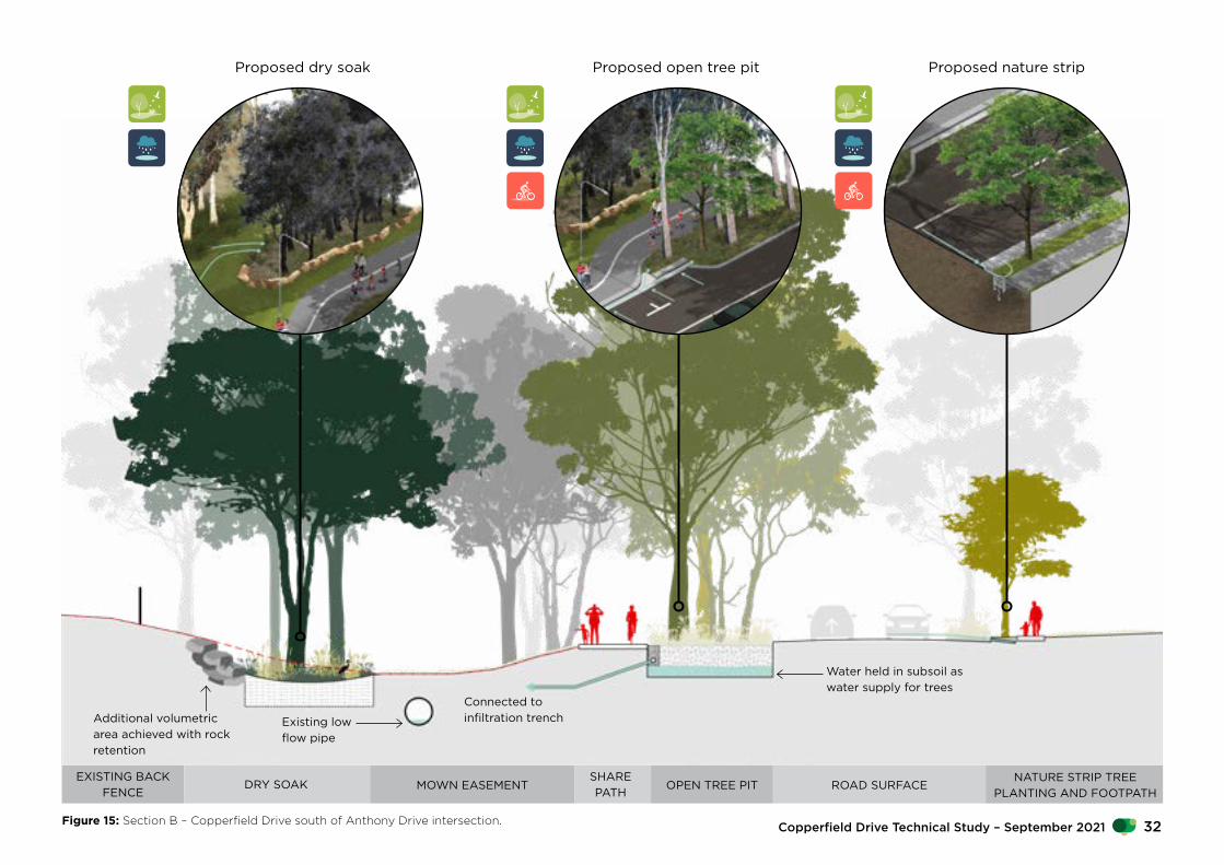
Figure 15: Section B – Copperfield Drive south of Anthony Drive intersection. 32Copperfield Drive Technical Study – September 2021

Combining nature, local community and smart flood management solutions to build upon Rosemeadow’s existing qualities and unique local spirit.
Figure 16: Perspective illustration of Copperfield Drive and Rosemeadow Public School interface on a dry day.
NSW Department of Planning, Industry and Environment33

C
D
Copp
erfie
ld D
rive
Anthony Drive
Hamlet Crescent
Rosemeadow Anglican Church
1
1
2
2
3
3
3
50 20 10 0mN
Rom
eo C
res
Legend:
In street tree planting
Nature strip tree planting
Gravel channel tree planting
Soak tree planting
Existing trees
New shared path – 3m
New footpath – 1.5m
Pedestrian crossing subject to further investigation
Passive irrigation flow
Copperfield Central
Figure 17: Concept plan of central portion of Copperfield Drive.
34Copperfield Drive Technical Study – September 2021
EXISTING DRIVEWAYOPEN
TREE PITSHARE PATH
ROAD SURFACE
MOWN EASEMENTWET SOAKEXISTING PRIVATE
GARDEN
Proposed wet soak Proposed open tree pit
Water held in subsoil as water supply for treesBubble-up pit supplies
water to wet soakAdditional volumetric area achieved with rock retention
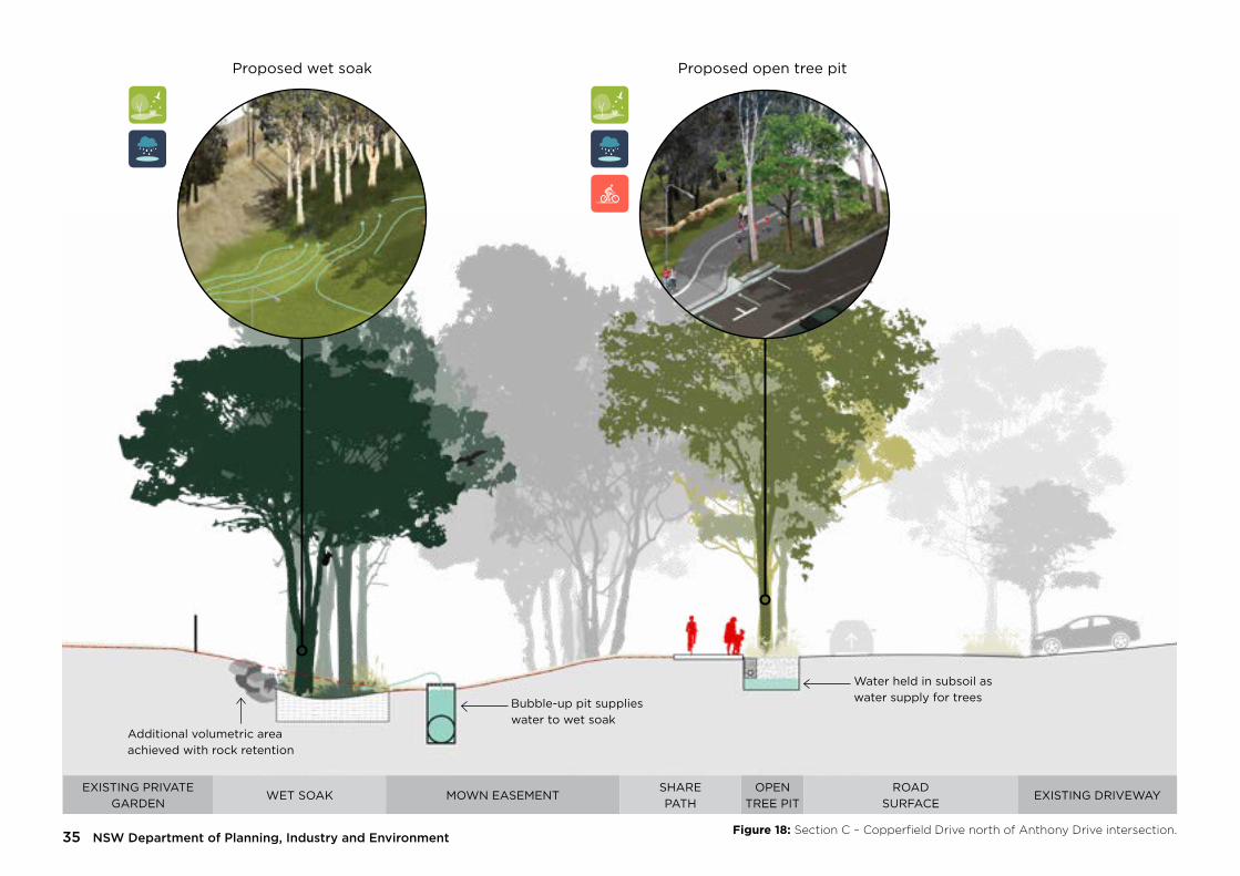
Figure 18: Section C – Copperfield Drive north of Anthony Drive intersection.NSW Department of Planning, Industry and Environment35

EXISTING FOOTPATH
OPEN TREE PIT
SHARE PATH
ROAD SURFACE
GRAVEL CHANNEL INFILTRATION TRENCH TREE PLANTING
EXISTING PRIVATE GARDEN
Proposed infiltration trench Future open tree pitFuture share path
Water held in subsoil as water supply for trees
Existing low flow pipe
Linear water reservoir
Figure 19: Section D – Copperfield Drive South of Hamlet Crescent intersection. 36Copperfield Drive Technical Study – September 2021
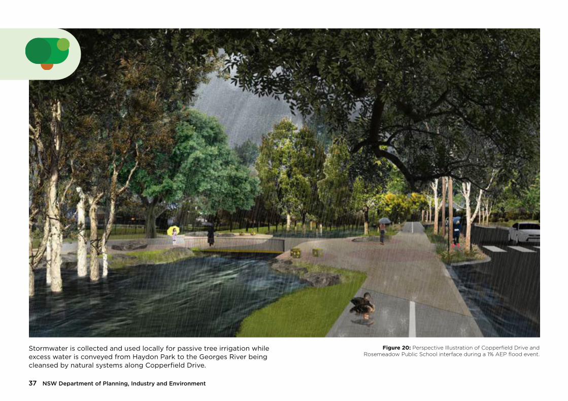
Stormwater is collected and used locally for passive tree irrigation while excess water is conveyed from Haydon Park to the Georges River being cleansed by natural systems along Copperfield Drive.
Figure 20: Perspective Illustration of Copperfield Drive and Rosemeadow Public School interface during a 1% AEP flood event.
NSW Department of Planning, Industry and Environment37

Legend:
In street tree planting
Nature strip tree planting
Gravel channel tree planting
Soak tree planting
Existing trees
Existing bus stop retained
Stone riffle
Informal stepping stones
Existing easement outlet
New shared path – 3m
New footpath – 1.5m
Pedestrian crossing subject to further investigation
Passive irrigation flow
E
F
Rosemeadow Market Place
Julius Road
Balthasar Close1
1
2
2
3
3
4
45
5
6
6
7
7 50 20 10 0mN
Copperfield North
Figure 21: Concept Plan of northern portion of Copperfield Drive.
38Copperfield Drive Technical Study – September 2021

ROAD SURFACEOPEN TREE
PITNATURE
STRIP TREESHARE PATH
EASEMENT WITH INFORMAL STEPPING STONES
DRY SOAKEXISTING
INFORMAL PATH
Proposed open tree pitProposed dry soak Proposed nature strip
Water held in subsoil as water supply for trees
Existing low flow pipeAdditional volumetric area achieved with rock retention
Figure 22: Section E – Copperfield Drive at Balthasar Close pedestrian access point.NSW Department of Planning, Industry and Environment39

SHARE PATH
WET SOAKEASEMENT STONE
RIFFLEWET SOAK
Future informal stepping stones Proposed dry soak
Existing low flow pipe Additional volumetric area achieved with rock retention
Figure 23: Section F – Copperfield Drive near drainage channel outlet.
Figure 24: Section F – Copperfield Drive near drainage channel outlet.40Copperfield Drive Technical Study – September 2021
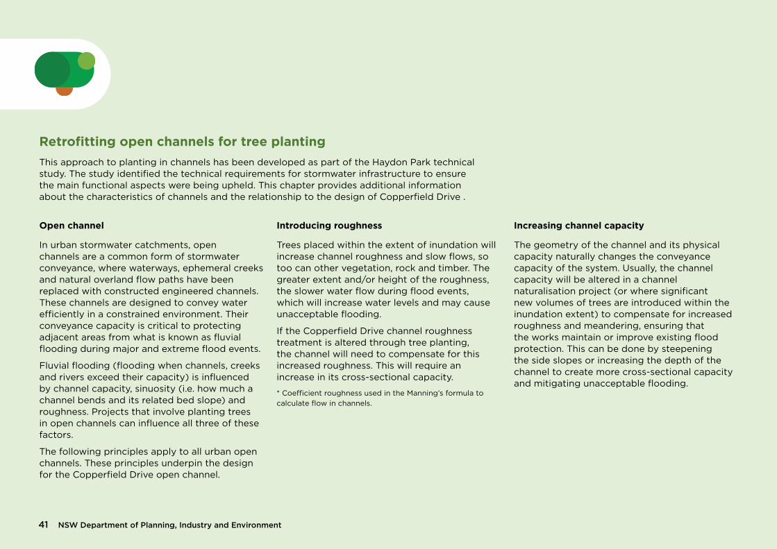
Retrofitting open channels for tree planting This approach to planting in channels has been developed as part of the Haydon Park technical study. The study identified the technical requirements for stormwater infrastructure to ensure the main functional aspects were being upheld. This chapter provides additional information about the characteristics of channels and the relationship to the design of Copperfield Drive .
Open channel
In urban stormwater catchments, open channels are a common form of stormwater conveyance, where waterways, ephemeral creeks and natural overland flow paths have been replaced with constructed engineered channels. These channels are designed to convey water efficiently in a constrained environment. Their conveyance capacity is critical to protecting adjacent areas from what is known as fluvial flooding during major and extreme flood events.
Fluvial flooding (flooding when channels, creeks and rivers exceed their capacity) is influenced by channel capacity, sinuosity (i.e. how much a channel bends and its related bed slope) and roughness. Projects that involve planting trees in open channels can influence all three of these factors.
The following principles apply to all urban open channels. These principles underpin the design for the Copperfield Drive open channel.
Introducing roughness
Trees placed within the extent of inundation will increase channel roughness and slow flows, so too can other vegetation, rock and timber. The greater extent and/or height of the roughness, the slower water flow during flood events, which will increase water levels and may cause unacceptable flooding.
If the Copperfield Drive channel roughness treatment is altered through tree planting, the channel will need to compensate for this increased roughness. This will require an increase in its cross-sectional capacity.
* Coefficient roughness used in the Manning’s formula to calculate flow in channels.
Increasing channel capacity
The geometry of the channel and its physical capacity naturally changes the conveyance capacity of the system. Usually, the channel capacity will be altered in a channel naturalisation project (or where significant new volumes of trees are introduced within the inundation extent) to compensate for increased roughness and meandering, ensuring that the works maintain or improve existing flood protection. This can be done by steepening the side slopes or increasing the depth of the channel to create more cross-sectional capacity and mitigating unacceptable flooding.
NSW Department of Planning, Industry and Environment41

Desired outcomeExisting scenario
Figure 25: Diagram demonstrating the relationship between channel roughness and flow capacity.
42Copperfield Drive Technical Study – September 2021

Where to plant treesThe placement of trees within open channels is essentially dictated by the relationship between the site’s spatial and hydraulic constraints. The more free space for stormwater conveyance capacity, the more freedom to plant trees while maintaining flood protection. Other site factors such as underground and overhead services will also influence where trees can be located.
Table 1: Planting trees in open channel, avoid trees within the low flow path to reduce conveyance of leaf litter and fallen limbs.
Open channel location Trees Species selection
Outside flood inundation extent
yes Locally appropriate
Batter slopes yes Wet/dry tolerant species
Base of channel (provide clearance for low flow path, width will vary for each site/design)
yes Riparian species
Note: Hydraulic conveyance capacity checks needed. Excavation may be required to maintain flood performance.
NSW Department of Planning, Industry and Environment43

Channel baseBatter slopes Batter slopesOutside inundation Outside inundation
Riparian species
Wet/dry tolerant species
Wet/dry tolerant species
Locally appropriate species
Locally appropriate species
Low flow path clearance (varies)
Flood inundation level
Figure 26: Diagram demonstrating suitable location for trees within a typical drainage channel.
44Copperfield Drive Technical Study – September 2021

Case study: Small Creek
Small Creek was once a meandering stream surrounded by large iconic tree species and an under storey of native grasses and rushes. During the early 1980s, the creek was replaced with a concrete open channel. The local council is currently in the process of transforming Small Creek into a living waterway once again, with native vegetation and trees, pools and riffles of shallow running water. The project is delivering a large stream of benefits for the environment and community, including water quality improvement, improved aesthetics, habitat for native fish and animals, and a cooler thermal corridor for people to enjoy. In 2019, a fish survey confirmed that Small Creek had become a functioning ecosystem with numerous native fish and other aquatic species detected.
These images show Small Creek in its early weeks, months and years of establishment, following construction and planting of tube stock. While there are no trees visible in the photo, the saplings are a mixture of groundcovers and tree species, which are designed to eventually form a closed canopy over the creek as the trees mature.
Context: urban stormwater drain converted into forested creek and linear park.
Design: existing concrete drain removed and replaced with meandering flow path. The cross-section was widened to compensate for the increase in roughness.
Demonstration: Trees, plants and channel bends can be introduced in urban stormwater channels by using compensatory earthworks to maintain flood conveyance capacity. The result is a win for the environment and provides a highly valued community asset, shady park (as trees mature) and a cooler walking and cycling route to connect students to the nearby school.
Figure 27: Small Creek. Source: E2 Design Lab
Figure 28: Small Creek shortly after renaturalization. Source: E2 Design Lab
NSW Department of Planning, Industry and Environment45

Tree toolkit
Stormwater and passive irrigation
Although the open channel is subject to periodic flooding, drought is a significant site constraint to tree establishment and canopy growth.
In 2017, all of NSW was declared in drought and for much of the state this has continued up until 2020. Climate models predict a hotter and drier climate into the future and it is anticipated that the changes in climate will bring prolonged periods of drought. Therefore, water conservation and management is both timely and critical.
Utilizing all available water to increase soil moisture for trees requires a creative re-imagining of how trees are planted and maintained in urban environments.
Objectives
• More sustainable water management that will assist with ameliorating climate extremes i.e cooling urban environments, efficient use of water etc
• Demonstrate how to integrate urban canopy into drainage land as a means of unlocking open space for community use and greater ecological benefits in greater Western Sydney
• Develop creative and integrated solutions to convey, capture and store stormwater in soil for trees - passive irrigation.
• Use a systems-based approach to integrate landscape and public realm solutions with necessary water management infrastructure.
• Integrate tree planting and water management to cultivate healthy tree canopies and a more resilient urban forest.
46Copperfield Drive Technical Study – September 2021

Passive irrigation – system toolkit
There are a number of ways to incorporate water-sensitive urban design solutions into streetscapes and open channels. Factors such as site conditions, catchment sizes, land availability and budget all influence the appropriate solution.
The Copperfield Drive tree toolkit incorporates a suite of innovative systems that vary in scale and cost, and represent a broad range of solutions that could be adopted at other sites.
The suite of tree planting tools take into account the varying available water catchments (street, Haydon Park and open channel) and existing hard drainage system to create a set of interventions that can be deployed along Copperfield Drive and the open channel length.
Together, the individual tools create a comprehensive system toolkit that is applicable to the specific site conditions. However, these tools can be applied in isolation from each other, across various different site conditions and environments.
Harvested stormwater will pass through the system toolkit to irrigate trees and recharge soil moisture, while also filtering and removing stormwater pollutants.
Each passive irrigation system is linked to provide sequential water treatment and maximum use of the stormwater before entering the downstream stormwater system. These systems maintain the hydraulic function of the street and open channel, ensuring the network conveyance capacity is maintained.
At street level, runoff enters a series of open tree pits, which function similarly to rain gardens - capturing, holding and filtering stormwater before excess water is discharged.
The open tree pit discharge then flows into a series of gravel trenches along the open channel via small underground pipes. These gravel trenches provide a second opportunity for soil moisture recharge and irrigating trees planted within the open channel.
Surcharge stormwater entering the open channel from the Haydon Park basin is also captured within the open channel through a series of surface soaks. These are located to infiltrate the surcharge water and use it to irrigate more trees planted within the open channel.
This combination of these systems are estimated to:
• Reduce total suspended solids (TSS) by more than 380 kg/y
• Reduce total nitrogen (TN) by more than 3.4kg/y
• Reduce total phosphorus (TP) by more than 0.74kg/y
• Reduce total annual surface runoff by more than 1.6ML/y
These estimates are based on a MUSIC model (modelling tool) for the open tree pits on the western side of Copperfield Drive and the gravel infiltration trenches within the open channel. Further detail is provided in the following pages.
Despite passive irrigation, as with any tree planting, all trees within this project should be directly irrigated during the first growing season to support the trees’ healthy establishment.
NSW Department of Planning, Industry and Environment47

Open tree pit Nature strip Infiltration trench Wet soak Dry soak In-fill
1.2m
20–30 years later – tree maturity
Day 1 – tree planting
1.4m2.5m
3.5m3.5m
3.9m1.2m
22m
Potential future bi-directional shared path retrofitted into street
7
7
1
1
4
45 5
3
3
66
2
2
0.72m3/s Capacity
Q3 month = 1.3m3/s
Figure 29: Top – Axonometric illustration of typical tree planting solutions along Copperfield Drive and drainage channel when planted.Figure 30: Bottom – Axonometric illustration of typical tree planting solutions along Copperfield Drive and drainage channel when mature.
48Copperfield Drive Technical Study – September 2021

NSW Department of Planning, Industry and Environment49

Open tree pit The open tree pit captures runoff from the road via the kerb and channel. The design features a tilted kerb inlet from the road edge, and ‘broken’ kerb on the road-side. As the soil surface is lower than the channel invert, water is able to pond temporarily and infiltrate into the growing media. A drainage connection will be required to prevent water logging.
Open tree pits with large soil volumes, overflow pits and underground drainage provide a best practice solution to supporting large street tree canopies. These are high-cost solutions that fall within the top-end of streetscape passively watered trees.
Location
The open tree pit has a back of kerb ag-drain which can connect to the existing stormwater drainage. In Copperfield Drive, the open tree pits have been located along the west side of the road besides the open channel drainage corridor. This reduces the cost to install underground drainage and connections to the infiltration trenches within the open channel.
Predicted water availability
• Event inflow rate: 150L/event/tree. This varies along the channel. Typically these events would occur every three days subject to seasonal patterns.
• Well-watered, drained, and aerated soil/horticultural soil
Figure 31: Open tree pit detail (1:25 at A3)
50Copperfield Drive Technical Study – September 2021

NSW Department of Planning, Industry and Environment51

300 1200
1500
400
EXISTING SOIL
ROADFOOT PATH
KERB ADAPTER WITHØ100MM AG-PIPE GRADEDMIN. 1:10 TOWARD TRENCH
GRAVEL TRENCH BEHIND BACK OF KERB TO400MM DEEP. EVEN GRADED HARD ROCK MIX.(E.G. RAILWAY BALLAST)
PERMEABLE GEOTEXTILESURROUNDING TRENCH
NATURE STRIP INFILTRATION TRENCHSCALE 1:202.2
300 1200
3000
ROAD KERB NATURE STRIP FOOT PATH
KERB ADAPTER ANDAG-PIPE LOOP
LOOP ALLOWSSEDIMENTS AND OTHERDEBRIS TO BE FLUSHEDFROM PIPE USING HIGHPRESSURE HOSE.
TRENCH PROVIDESAPPROX. 120LWATER STORAGE
NATURE STRIP INFILTRATION PLANSCALE 1:502.1
300 1200
1500
400
EXISTING SOIL
ROADFOOT PATH
KERB ADAPTER WITHØ100MM AG-PIPE GRADEDMIN. 1:10 TOWARD TRENCH
GRAVEL TRENCH BEHIND BACK OF KERB TO400MM DEEP. EVEN GRADED HARD ROCK MIX.(E.G. RAILWAY BALLAST)
PERMEABLE GEOTEXTILESURROUNDING TRENCH
NATURE STRIP INFILTRATION TRENCHSCALE 1:202.2
300 1200
3000
ROAD KERB NATURE STRIP FOOT PATH
KERB ADAPTER ANDAG-PIPE LOOP
LOOP ALLOWSSEDIMENTS AND OTHERDEBRIS TO BE FLUSHEDFROM PIPE USING HIGHPRESSURE HOSE.
TRENCH PROVIDESAPPROX. 120LWATER STORAGE
NATURE STRIP INFILTRATION PLANSCALE 1:502.1
Nature strip Nature strip gravel trenches support trees planted within the nature strip on the residential side of the road. The gravel trenches feature an ‘in-and-out’ flexible, ag-pipe loop installed using kerb adapters that direct inflows into the gravel trench, where water can soak into the surrounding soils for the tree. This solution is innovative in how it minimises costly underground services and pavement works. It provides a lower-cost solution to get water to trees.
Predicted water availability
• Event inflow rate: ~150 L/event/tree. Based on Western Sydney’s rainfall events, these would typically occur every three days subject to seasonal patterns.
• Drier soil
Figure 32: Nature strip plan detail (1:50 at A3) Figure 33: Nature strip detail (1:25 at A3)
52Copperfield Drive Technical Study – September 2021

NSW Department of Planning, Industry and Environment53

Infiltration trench Infiltration trenches in the drainage easement consist of gravel infiltration zones that collect overflow from the open tree pits. These are simple, low-cost solutions that recharge soil moisture in the drainage easement. As the trees within the lower portions of the batter slopes mature, their roots can draw water from the soils around the gravel trench, supporting their long-term growth and resilience.
Predicted water availability
• Event inflow rate: ~180-900 L/event. This varies along the channel. Based on Western Sydney’s rainfall events, these would typically occur every three days subject to seasonal patterns.
• Upper bank - Native soil with moisture at depth
• Lower bank - Native soil with moisture close to soil surface
Figure 34: Infiltration trench detail (1:25 at A3)
54Copperfield Drive Technical Study – September 2021

NSW Department of Planning, Industry and Environment55

MAX.
1000
200
EXISTING Ø600MM STORMWATER PIPE
MIN. 2500
EXCAVATION TO BECLEAR OF EXISTINGSTORMWATER PIPE.
VARIES (TYP. 3 - 6M)
MINIMUM OF 2500MM BETWEENTREE PLANTING AND CENTRE LINEOF DRAINAGE CORRIDOR
EXISTING SURFACELEVEL
GRAVEL SURFACETREATMENT.D50 = 100MM
RL -0.2RL 0
ROCK EDGE, WELL GRADEDANGULAR ROCK.D50 = 150MMBACKFILLED AND PLANTED.
IMPORTED SANDY LOAM MEDIA, UPTO 500MM DEEP.NOTE: NO GEOTEXTILE REQUIRED.
MAX. FALL 1:1
RL 0.8
ROCK EDGE, WELL GRADEDANGULAR ROCK.D50 = 150MMBACKFILLED AND PLANTED.
EXISTING SURFACELEVEL
GRAVEL SURFACETREATMENT.D50 = 100MM
LAY BASE FLAT TO ALLOW WATERTO EVENLY SPREAD ANDINFILTRATE.
DRY AND WET SOAK SECTIONSCALE 1:505.1
DRY AND WET SOAK LONGITUDINAL SECTIONSCALE 1:505.2
IMPORTED SANDY LOAM MEDIA, UPTO 500MM DEEP.NOTE: NO GEOTEXTILE REQUIRED.
VARIES (TYP. 5 - 10M)
TYP. FALL 1 - 2%
100
200
100MM DETENTION DEPTH.
Wet and dry soaks Wet and dry soaks are sandy depressions within the drainage easement that capture excess flows from the infiltration trenches, surcharged flows from the underground pipe, and any overland flows within the channel. These holes periodically fill up and drain through infiltration and evapo-transpiration. Wet soaks are located closest to the infiltration trenches and surcharge pits, with more frequent access to water. Dry soaks are located further downstream between these elements, and receive water less frequently. The soaks are excavated into the landscape, to ensure the channel maintains hydraulic conveyance capacity.
Wet soak predicted water availability
• Event inflow rate: ~40L to 250L/event. This varies along the channel. Based on Western Sydney’s rainfall events, these would typically occur every three days subject to seasonal patterns.
• Wetter – Sandy loam filled holes• Dry soak predicted water availability • Inflow frequency: water from the existing
stormwater pits will surcharge under at least the Q3 month event
• Drier – Sandy loam filled holes
Figure 35: Wet and dry soak transverse section detail (1:25 at A3)
Figure 36: Wet and dry soak longitudinal section detail (1:25 at A3)
56Copperfield Drive Technical Study – September 2021
100
35025
100 15
0
75MM MULCH DEPTH FROM EDGE OF THEROOTBALL TO THE EDGE OF THE PLANTING PIT.DO NOT PLACE MULCH AROUND THE TRUNKMAINTAINING A SEPARATION OF MULCH ANDTRUNK TO PREVENT COLLAR ROT.
PLANTING HOLE SHALL BE FILLED TO 75% OFTHE TOTAL PLANTING DEPTH BY WORKING INWITH A SPADE, THEN SOIL LIGHTLY TAMPED ANDWATERED. THE REMAINING 25% OF THEPLANTING HOLE SHOULD THEN BE FILLED INWITH SOIL, WATERED AND SETTLED SO THATTHE FINAL PLANTING LEVEL IS ACHIEVED.
HARDWOOD STAKES. MINIMUM DEPTH INGROUND 300MM TO 600MM. STAKES MUST BEPLACED OUTSIDE OF THE ROOTBALL.DRIVEN INTO VIRGIN GROUND. TREESTAKES ARE TO BE UNIFORM HEIGHT FROMFSL ACROSS WORKS.
PLANTING HOLE DEPTH SHALL BE100MM BELOW THE DEPTH OF THEROOTBALL AND BACKFILLED WITHLIGHTLY TAMPED ORGANICMATERIAL. IN CIRCUMSTANCESWHERE WATER LOGGING MAY BE ANISSUE THE SUPERINTENDENT SHALLBE NOTIFIED PRIOR TOINSTALLATION.
100MM HIGH SOIL SAUCER SHAPED BASINFORMED AROUND THE ROOT BALL.
50MM WIDE NYLON TIES FIXED TO STAKE,PLACED AT 300MM SPACING, NO GREATERTHAN 12 TREE HEIGHT. TIES ARE TO BE LOOSEFIT AND ALLOW FOR SAFE MOVEMENT OFTREE CANOPY.
BREAK UP SIDES AND BASE OF EXCAVATIONTO 100MM. PLANTING HOLE SHALL BEWATERED PRIOR TO THE SETTING OF TREES.
TO PROMOTE LATERAL ROOT GROWTH THE PLANTINGHOLE SHALL BE NO LESS THAN THREE (3) TIMES THEDIAMETER OF THE ROOT BALL. IF SPACE RESTRICTIONSEXIST STAKE SPACING SHALL BE REDUCED TO NO LESSTHAN TWO (2) TIMES THE DIAMETER OF THE ROOT BALL.SLOPE ALL SIDES AT 45 DEGREES.
TREE PLANTING NOTE:- TREES SHALL HAVE A WELL DEVELOPED TAPERAND BE SELF SUPPORTING- TREES SHALL BE OF GOOD HEALTH AND VIGOUR- ENSURE ALL LABELS, WIRES, TWINE AND OTHERBINDING MATERIALS ARE REMOVED FROMPLANTING MATERIAL, INCLUDING ROOTBALLSPRIOR TO BACKFILLING- WATER IMMEDIATELY FOLLOWING PLANTING,SAUCER TO BE FILLED TWICE- SITE TO BE LEFT CLEAN AND TIDY ONCOMPLETION OF PLANTING, REMOVE WEEDS ANDBUILDING SPOIL FROM TREE PLANTING ZONE.
75MM DEPTH OF APPROVEDSEMI-DECOMPOSED WEED-FREEEUCALYPTUS MULCH TO BEAPPLIED AFTER PLANTING.
RIPPED SUBGRADE
100MM SITE IMPROVED TOPSOIL.
450MM x 350MM REVEGETATION GUARD
750MM x 25MM x 25MM HARDWOODSTAKES
ROOTBALL
ADVANCED TREE INFILL PLANTINGSCALE 1:206.2TUBESTOCK INFILL PLANTING
SCALE 1:206.1NSW Department of Planning, Industry and Environment57

100
35025
100 15
0
75MM MULCH DEPTH FROM EDGE OF THEROOTBALL TO THE EDGE OF THE PLANTING PIT.DO NOT PLACE MULCH AROUND THE TRUNKMAINTAINING A SEPARATION OF MULCH ANDTRUNK TO PREVENT COLLAR ROT.
PLANTING HOLE SHALL BE FILLED TO 75% OFTHE TOTAL PLANTING DEPTH BY WORKING INWITH A SPADE, THEN SOIL LIGHTLY TAMPED ANDWATERED. THE REMAINING 25% OF THEPLANTING HOLE SHOULD THEN BE FILLED INWITH SOIL, WATERED AND SETTLED SO THATTHE FINAL PLANTING LEVEL IS ACHIEVED.
HARDWOOD STAKES. MINIMUM DEPTH INGROUND 300MM TO 600MM. STAKES MUST BEPLACED OUTSIDE OF THE ROOTBALL.DRIVEN INTO VIRGIN GROUND. TREESTAKES ARE TO BE UNIFORM HEIGHT FROMFSL ACROSS WORKS.
PLANTING HOLE DEPTH SHALL BE100MM BELOW THE DEPTH OF THEROOTBALL AND BACKFILLED WITHLIGHTLY TAMPED ORGANICMATERIAL. IN CIRCUMSTANCESWHERE WATER LOGGING MAY BE ANISSUE THE SUPERINTENDENT SHALLBE NOTIFIED PRIOR TOINSTALLATION.
100MM HIGH SOIL SAUCER SHAPED BASINFORMED AROUND THE ROOT BALL.
50MM WIDE NYLON TIES FIXED TO STAKE,PLACED AT 300MM SPACING, NO GREATERTHAN 12 TREE HEIGHT. TIES ARE TO BE LOOSEFIT AND ALLOW FOR SAFE MOVEMENT OFTREE CANOPY.
BREAK UP SIDES AND BASE OF EXCAVATIONTO 100MM. PLANTING HOLE SHALL BEWATERED PRIOR TO THE SETTING OF TREES.
TO PROMOTE LATERAL ROOT GROWTH THE PLANTINGHOLE SHALL BE NO LESS THAN THREE (3) TIMES THEDIAMETER OF THE ROOT BALL. IF SPACE RESTRICTIONSEXIST STAKE SPACING SHALL BE REDUCED TO NO LESSTHAN TWO (2) TIMES THE DIAMETER OF THE ROOT BALL.SLOPE ALL SIDES AT 45 DEGREES.
TREE PLANTING NOTE:- TREES SHALL HAVE A WELL DEVELOPED TAPERAND BE SELF SUPPORTING- TREES SHALL BE OF GOOD HEALTH AND VIGOUR- ENSURE ALL LABELS, WIRES, TWINE AND OTHERBINDING MATERIALS ARE REMOVED FROMPLANTING MATERIAL, INCLUDING ROOTBALLSPRIOR TO BACKFILLING- WATER IMMEDIATELY FOLLOWING PLANTING,SAUCER TO BE FILLED TWICE- SITE TO BE LEFT CLEAN AND TIDY ONCOMPLETION OF PLANTING, REMOVE WEEDS ANDBUILDING SPOIL FROM TREE PLANTING ZONE.
75MM DEPTH OF APPROVEDSEMI-DECOMPOSED WEED-FREEEUCALYPTUS MULCH TO BEAPPLIED AFTER PLANTING.
RIPPED SUBGRADE
100MM SITE IMPROVED TOPSOIL.
450MM x 350MM REVEGETATION GUARD
750MM x 25MM x 25MM HARDWOODSTAKES
ROOTBALL
ADVANCED TREE INFILL PLANTINGSCALE 1:206.2TUBESTOCK INFILL PLANTING
SCALE 1:206.1
In-fill Trees will be planted outside the inundation extent in some areas to create a connected canopy. These trees will not be passively irrigated; therefore, they will be slower growing than other trees along Copperfield Drive, with a potentially higher mortality rate. However they will require minimal investment to plant.
Predicted water availability
• Trees will rely on direct rainfall (plus any manual irrigation, greater maintenance burden due to manual watering through establishment period)
• Drier soil
Figure 37: Tube stock planting detail (1:25 at A3) Figure 38: Tree planting detail (1:25 at A3)
58Copperfield Drive Technical Study – September 2021

Planting palette
Trees palette
The tree palette was developed in collaboration with leading research and industry experts from the University of Western Sydney, Mt Annan Botanic Gardens, Campbelltown City Council forestry team and Urban Forestry Australia. An intensive workshop brought together research and knowledge to develop a tree palette which aims to find a balance between diversity, indigeneity, performance and aesthetics. This aims to increase the resilience of the future urban forest, cool the surrounding environment and create a sense of place for the local community.
Twenty-five species from 16 genus and 10 families have been selected. Many of the species are from the Myrtaceae family as they are commonly found in the Cumberland Plains bioregion and are ideal for the proposed Copperfield Drive growing conditions. Additional urban forest species diversity should be considered in the future when investigating surrounding tree planting projects.
The plant list is also based on performance – how the tree performs in a given soil type, soil volume and water availability. This is important
to increase tree health and increase potential canopy cover area and the additional benefits that trees bring.
Finally, aesthetics were considered. Based on the consultation with the Rosemeadow community certain traits were selected, specifically around foliage and flowers.
Trees will be planted out in different sizes, to introduce age diversity, economic viability and a natural aesthetic emulating successional growth patterns.
Material paletteFor the first phase of the project, a simple palette of robust, economic and locally sourced materials have been selected. The functionality of concrete provides a base for the application of stone in more specialized locations like the drainage channel and tree pits. The fundamental approach is to facilitate efficient maintenance, support a sense of place and make the trees the hero. Sandstone boulders for retaining
walls and landscape featuresConcrete footpath
and kerbOrganic eucy-mulch
NSW Department of Planning, Industry and Environment59

Ground cover palette
The ground cover planting palette is dominated by mowed grass for maintenance ease and familiarity. Pockets of tussock grasses, sedges and shrubs will be planted below discrete clumps of trees. These pockets will consist of species that feature in the Cumberland Plains as well as species with favourable aesthetic qualities, availability and longevity.
Sandstone screenings Granitic gravel
60Copperfield Drive Technical Study – September 2021

Table 2: Copperfield Drive concept plant species schedule. SPECIES MIX COMMENTS
Latin Name Common Name Family Height Width Slow Medium Fast Evergreen Deciduous %
Typology 1: Open tree pit
Trees
Acer buergeranum Trident Maple Sapindaceae 10 6 • • 10%
Brachychiton acerifolius Illawarra Flame Tree Malvaceae 10 6 • • 10%
Cercis siliquastrum Judas Tree Fabaceae 8 6 • • 10%
Corymbia exima Yellow Bloodwood Myrtaceae 15 8 • • 20% Shown good reults locally
Eucalyptus melanophloia Silver-leafed Ironbark Myrtaceae 20 8 • • 20% Shown good reults locally
Eucalyptus sclerophylla Scribbly Gum Myrtaceae 15 8 • • 20% Not good shade
Malus floribunda Japanese Crabapple Rosaceae 5 6 • • 10%
Ground Cover
Chrysocephalum apiculatum Common Everlasting Asteraceae 0.2 1.0 • • 10% Colour
Dianella longifolia Blue flax-lily Asphodelaceae 0.8 0.6 • • 20%
Eremophila debilis Winter Apple Scrophulariaceae 0.5 2.0 • • 20% Cumberland Plains, scrambling
Lomandra filiformis Wattle Mat-rush Asparagaceae 0.5 0.5 • • 10%
Lomandra longifolia 'Verday' Lomandra Verday Asparagaceae 0.6 0.6 • • 20%
Pultenaea villosa Hairy Bush-pea Fabaceae 1.0 2.0 • • 10%
Stypandra glauca Nodding Blue Lily Asphodelaceae 1.0 1.0 • • 10%
Typology 2: Nature Strip
Trees
Brachychiton populneus Kurrajong Malvaceae 10 8 • • 20% Local native
Calodendron capense Cape Chestnut Rutaceae 10 6 • • 20%
Lagerstroemia indica x L. fauriei Crepe Myrtle Lythraceae 7 6 • • 10%
Maclura pomifera Osage Orange Rosaceae 10 8 • • 20% Male only
Pistacia chinensis Chinese Pistachio Anacardiaceae 10 8 • • 20%
Pyrus calleryana Callery Pear Rosaceae 15 10 • • 10%
Typology 3: Infiltration trench
Trees
Upper Bank
Eucalyptus crebra Narrow-leaved Ironbark Myrtaceae 25 25 • • 30%
Eucalyptus fibrosa Red Ironbark Myrtaceae 35 25 • 30%
Eucalyptus moluccana Grey Box Myrtaceae 25 15 • • 40%
Lower Bank
Casuarina glauca Swamp She-oak Casuarinaceae 20 5 • • 50% Suckering and exploritory roots can cause maintenance issues
Eucalyptus benthamii Camden White Gum Myrtaceae 20 15 • • 20% Local native that has lost much of its range to development
Eucalyptus longifolia Woollybutt Myrtaceae 20 15 • • 20% Local native that has lost much of its range to development
Eucalyptus robusta Swamp Mahogany Myrtaceae 20 15 • • 10% Attractive to flying fox. Locate away from paths and school
Typology 4: Wet Soak
Trees
Angophora subvelutina Broad-leaved Apple Myrtaceae 18 15 • 10%
Eucalyptus amplifolia Cabbage Gum Myrtaceae 30 15 • • 10%
Melaleuca linariifolia Narrow-leaved Paperbark Myrtaceae 6 7 • • 60% Roots may be invasive
Melaleuca styphelioides Prickly-leaved Paperbark Myrtaceae 10 8 • • 20% Roots may be invasive
Ground Cover
Carex appressa Tall Sedge Cyperaceae 0.9 0.8 • • 30%
Juncus usitatus Common Rush Juncaceae 1.2 1.5 • • 20%
Lachnagrostis aemula Blown Grass Poaceae 0.8 0.2 • • 10%
Schoenus melanostachys Black Bog-rush Cyperaceae 1.2 1.5 • • 30% Weeping habit
Xanthorrhoea minor Small Grass Tree Asphodelaceae 1.0 1.0 • • 10%
Typology 5: Dry Soak
Trees
Melaleuca decora White Feather Honeymyrtle Myrtaceae 12 5 • • 100%
Ground Cover
Aristida ramosa Purple Wire-grass Poaceae 0.8 0.8 • 20%
Austrostipa rudis Veined Spear-grass Poaceae 1.0 0.5 • • 20%
Indigofera australis Austral Indigo Fabaceae 2.0 2.0 • • 5%
Lepidosperma laterale Variable Swordsedge Cyperaceae 0.4 0.6 • • 10%
Microlaena stipoides Weeping Grass Poaceae 0.2 indefinite • • 25%
Themida triandra Kangaro Grass Poaceae 0.9 0.8 • • 20%
Typology 6: In-fill
TreesAcacia binervia Coastal Myall Fabaceae 15 10 • • 40% Long lived acaciaAllocasuarina littoralis Black Sheoak Casuarinaceae 15 8 • • 30% Local sheoakAllocasuarina luehmannii Buloke Casuarinaceae 15 8 • • 10%
Callitris rhomboidea Port Jackson Pine Cupressaceae 5 5 • • 20%
PLANT INFORMATION
SeasonalitySuggested Species Maturity Size Growth RateSuggested Species Maturity Size Growth Rate Seasonality Species Mix Comments
Latin Name Common Name Family Height Width Slow Medium Fast Evergreen Deciduous %
Typology 1: Open Tree Pit
Typology 2: Nature Strip
Trees
Trees
Ground Cover
SPECIES MIX COMMENTS
Latin Name Common Name Family Height Width Slow Medium Fast Evergreen Deciduous %
Typology 1: Open tree pit
Trees
Acer buergeranum Trident Maple Sapindaceae 10 6 • • 10%
Brachychiton acerifolius Illawarra Flame Tree Malvaceae 10 6 • • 10%
Cercis siliquastrum Judas Tree Fabaceae 8 6 • • 10%
Corymbia exima Yellow Bloodwood Myrtaceae 15 8 • • 20% Shown good reults locally
Eucalyptus melanophloia Silver-leafed Ironbark Myrtaceae 20 8 • • 20% Shown good reults locally
Eucalyptus sclerophylla Scribbly Gum Myrtaceae 15 8 • • 20% Not good shade
Malus floribunda Japanese Crabapple Rosaceae 5 6 • • 10%
Ground Cover
Chrysocephalum apiculatum Common Everlasting Asteraceae 0.2 1.0 • • 10% Colour
Dianella longifolia Blue flax-lily Asphodelaceae 0.8 0.6 • • 20%
Eremophila debilis Winter Apple Scrophulariaceae 0.5 2.0 • • 20% Cumberland Plains, scrambling
Lomandra filiformis Wattle Mat-rush Asparagaceae 0.5 0.5 • • 10%
Lomandra longifolia 'Verday' Lomandra Verday Asparagaceae 0.6 0.6 • • 20%
Pultenaea villosa Hairy Bush-pea Fabaceae 1.0 2.0 • • 10%
Stypandra glauca Nodding Blue Lily Asphodelaceae 1.0 1.0 • • 10%
Typology 2: Nature Strip
Trees
Brachychiton populneus Kurrajong Malvaceae 10 8 • • 20% Local native
Calodendron capense Cape Chestnut Rutaceae 10 6 • • 20%
Lagerstroemia indica x L. fauriei Crepe Myrtle Lythraceae 7 6 • • 10%
Maclura pomifera Osage Orange Rosaceae 10 8 • • 20% Male only
Pistacia chinensis Chinese Pistachio Anacardiaceae 10 8 • • 20%
Pyrus calleryana Callery Pear Rosaceae 15 10 • • 10%
Typology 3: Infiltration trench
Trees
Upper Bank
Eucalyptus crebra Narrow-leaved Ironbark Myrtaceae 25 25 • • 30%
Eucalyptus fibrosa Red Ironbark Myrtaceae 35 25 • 30%
Eucalyptus moluccana Grey Box Myrtaceae 25 15 • • 40%
Lower Bank
Casuarina glauca Swamp She-oak Casuarinaceae 20 5 • • 50% Suckering and exploritory roots can cause maintenance issues
Eucalyptus benthamii Camden White Gum Myrtaceae 20 15 • • 20% Local native that has lost much of its range to development
Eucalyptus longifolia Woollybutt Myrtaceae 20 15 • • 20% Local native that has lost much of its range to development
Eucalyptus robusta Swamp Mahogany Myrtaceae 20 15 • • 10% Attractive to flying fox. Locate away from paths and school
Typology 4: Wet Soak
Trees
Angophora subvelutina Broad-leaved Apple Myrtaceae 18 15 • 10%
Eucalyptus amplifolia Cabbage Gum Myrtaceae 30 15 • • 10%
Melaleuca linariifolia Narrow-leaved Paperbark Myrtaceae 6 7 • • 60% Roots may be invasive
Melaleuca styphelioides Prickly-leaved Paperbark Myrtaceae 10 8 • • 20% Roots may be invasive
Ground Cover
Carex appressa Tall Sedge Cyperaceae 0.9 0.8 • • 30%
Juncus usitatus Common Rush Juncaceae 1.2 1.5 • • 20%
Lachnagrostis aemula Blown Grass Poaceae 0.8 0.2 • • 10%
Schoenus melanostachys Black Bog-rush Cyperaceae 1.2 1.5 • • 30% Weeping habit
Xanthorrhoea minor Small Grass Tree Asphodelaceae 1.0 1.0 • • 10%
Typology 5: Dry Soak
Trees
Melaleuca decora White Feather Honeymyrtle Myrtaceae 12 5 • • 100%
Ground Cover
Aristida ramosa Purple Wire-grass Poaceae 0.8 0.8 • 20%
Austrostipa rudis Veined Spear-grass Poaceae 1.0 0.5 • • 20%
Indigofera australis Austral Indigo Fabaceae 2.0 2.0 • • 5%
Lepidosperma laterale Variable Swordsedge Cyperaceae 0.4 0.6 • • 10%
Microlaena stipoides Weeping Grass Poaceae 0.2 indefinite • • 25%
Themida triandra Kangaro Grass Poaceae 0.9 0.8 • • 20%
Typology 6: In-fill
TreesAcacia binervia Coastal Myall Fabaceae 15 10 • • 40% Long lived acaciaAllocasuarina littoralis Black Sheoak Casuarinaceae 15 8 • • 30% Local sheoakAllocasuarina luehmannii Buloke Casuarinaceae 15 8 • • 10%
Callitris rhomboidea Port Jackson Pine Cupressaceae 5 5 • • 20%
PLANT INFORMATION
SeasonalitySuggested Species Maturity Size Growth Rate
Typology 3: Infiltration Trench
Trees
NSW Department of Planning, Industry and Environment61

SPECIES MIX COMMENTS
Latin Name Common Name Family Height Width Slow Medium Fast Evergreen Deciduous %
Typology 1: Open tree pit
Trees
Acer buergeranum Trident Maple Sapindaceae 10 6 • • 10%
Brachychiton acerifolius Illawarra Flame Tree Malvaceae 10 6 • • 10%
Cercis siliquastrum Judas Tree Fabaceae 8 6 • • 10%
Corymbia exima Yellow Bloodwood Myrtaceae 15 8 • • 20% Shown good reults locally
Eucalyptus melanophloia Silver-leafed Ironbark Myrtaceae 20 8 • • 20% Shown good reults locally
Eucalyptus sclerophylla Scribbly Gum Myrtaceae 15 8 • • 20% Not good shade
Malus floribunda Japanese Crabapple Rosaceae 5 6 • • 10%
Ground Cover
Chrysocephalum apiculatum Common Everlasting Asteraceae 0.2 1.0 • • 10% Colour
Dianella longifolia Blue flax-lily Asphodelaceae 0.8 0.6 • • 20%
Eremophila debilis Winter Apple Scrophulariaceae 0.5 2.0 • • 20% Cumberland Plains, scrambling
Lomandra filiformis Wattle Mat-rush Asparagaceae 0.5 0.5 • • 10%
Lomandra longifolia 'Verday' Lomandra Verday Asparagaceae 0.6 0.6 • • 20%
Pultenaea villosa Hairy Bush-pea Fabaceae 1.0 2.0 • • 10%
Stypandra glauca Nodding Blue Lily Asphodelaceae 1.0 1.0 • • 10%
Typology 2: Nature Strip
Trees
Brachychiton populneus Kurrajong Malvaceae 10 8 • • 20% Local native
Calodendron capense Cape Chestnut Rutaceae 10 6 • • 20%
Lagerstroemia indica x L. fauriei Crepe Myrtle Lythraceae 7 6 • • 10%
Maclura pomifera Osage Orange Rosaceae 10 8 • • 20% Male only
Pistacia chinensis Chinese Pistachio Anacardiaceae 10 8 • • 20%
Pyrus calleryana Callery Pear Rosaceae 15 10 • • 10%
Typology 3: Infiltration trench
Trees
Upper Bank
Eucalyptus crebra Narrow-leaved Ironbark Myrtaceae 25 25 • • 30%
Eucalyptus fibrosa Red Ironbark Myrtaceae 35 25 • 30%
Eucalyptus moluccana Grey Box Myrtaceae 25 15 • • 40%
Lower Bank
Casuarina glauca Swamp She-oak Casuarinaceae 20 5 • • 50% Suckering and exploritory roots can cause maintenance issues
Eucalyptus benthamii Camden White Gum Myrtaceae 20 15 • • 20% Local native that has lost much of its range to development
Eucalyptus longifolia Woollybutt Myrtaceae 20 15 • • 20% Local native that has lost much of its range to development
Eucalyptus robusta Swamp Mahogany Myrtaceae 20 15 • • 10% Attractive to flying fox. Locate away from paths and school
Typology 4: Wet Soak
Trees
Angophora subvelutina Broad-leaved Apple Myrtaceae 18 15 • 10%
Eucalyptus amplifolia Cabbage Gum Myrtaceae 30 15 • • 10%
Melaleuca linariifolia Narrow-leaved Paperbark Myrtaceae 6 7 • • 60% Roots may be invasive
Melaleuca styphelioides Prickly-leaved Paperbark Myrtaceae 10 8 • • 20% Roots may be invasive
Ground Cover
Carex appressa Tall Sedge Cyperaceae 0.9 0.8 • • 30%
Juncus usitatus Common Rush Juncaceae 1.2 1.5 • • 20%
Lachnagrostis aemula Blown Grass Poaceae 0.8 0.2 • • 10%
Schoenus melanostachys Black Bog-rush Cyperaceae 1.2 1.5 • • 30% Weeping habit
Xanthorrhoea minor Small Grass Tree Asphodelaceae 1.0 1.0 • • 10%
Typology 5: Dry Soak
Trees
Melaleuca decora White Feather Honeymyrtle Myrtaceae 12 5 • • 100%
Ground Cover
Aristida ramosa Purple Wire-grass Poaceae 0.8 0.8 • 20%
Austrostipa rudis Veined Spear-grass Poaceae 1.0 0.5 • • 20%
Indigofera australis Austral Indigo Fabaceae 2.0 2.0 • • 5%
Lepidosperma laterale Variable Swordsedge Cyperaceae 0.4 0.6 • • 10%
Microlaena stipoides Weeping Grass Poaceae 0.2 indefinite • • 25%
Themida triandra Kangaro Grass Poaceae 0.9 0.8 • • 20%
Typology 6: In-fill
TreesAcacia binervia Coastal Myall Fabaceae 15 10 • • 40% Long lived acaciaAllocasuarina littoralis Black Sheoak Casuarinaceae 15 8 • • 30% Local sheoakAllocasuarina luehmannii Buloke Casuarinaceae 15 8 • • 10%
Callitris rhomboidea Port Jackson Pine Cupressaceae 5 5 • • 20%
PLANT INFORMATION
SeasonalitySuggested Species Maturity Size Growth Rate
Suggested Species Maturity Size Growth Rate Seasonality Species Mix Comments
Latin Name Common Name Family Height Width Slow Medium Fast Evergreen Deciduous %
Typology 3: Infiltration Trench
Typology 4: Wet Soak
Typology 5: Dry Soak
Typology 6: In-fill
Trees
Trees
Trees
Trees
Ground Cover
Ground Cover
62Copperfield Drive Technical Study – September 2021

dpie.nsw.gov.au